9
Walking Bristol Routes in Central and South Bristol Walk 1 - Plaques of Central Bristol

Walk
ing
Bri
sto
lRoutes in Central and South BristolWalk 1 - Plaques of Central Bristol

As members of the Ramblers we promote walking, protect therights of way, campaign for access to open country and thecoastline and defend the beauty of the countryside.
We have regular walks of varying distance and difficulty onSaturday mornings, Sundays and Wednesdays. In the Spring andSummer we have shorter walks on Tuesday and Thursdayevenings. Our walks on Wednesdays and Tuesday evenings areusually accessible by public transport.
Non-members are most welcome. After a few walks they will beinvited to join the Bristol Ramblers Group. We have amembership of almost 1000 walkers in Bristol and over 2000 inthe West of England area.
For details of membership and our walks programme visitwww.bristolramblers.org.uk. Then just choose a walk tosuit your ability and contact the walk leader to introduce yourselfand obtain further details.
Even though these walks are within the city, suitable footwearand a waterproof are still advised. All of the walks are accessibleby public transport. The times for buses and trains can be
checked at www.travelinesw.com. We have done our best toprovide accurate and up to date information, but services areliable to alteration at short notice.
Whilst every effort has been made to check the routes in thisbook, mistakes do happen and the city is subject to changes, soneither Bristol City Council or the Ramblers can acceptresponsibility for any inconvenience this may cause. To advise ofmistakes or recommend new walks for future editions contactBristol City Council at [email protected] or0117 9036701.
Neither Bristol City Council or the Ramblers necessarily endorsethe opinions expressed by the authors of the walks.
All rights reserved. No parts of this publication may bereproduced, stored in a retrieval system, or transmitted in anyform or by any means, electronic, mechanical, photocopying,recording or otherwise, without the prior permission of thepublishers.
Bristol Group Ramblers

Walking is the simplest and cheapest form of travel and also oneof the best forms of exercise. It helps you to feel good, reducesstress, increases your energy levels, reduces blood pressure andhelps you to sleep better at night. It is a very good way to helpyou to lose weight.
Walking also helps you to appreciate the city that you live in.Other forms of transport race you past those lovely views or smallpoints of historic interest. They make it more difficult to pop in tothat small shop or stop off for a drink and a bite to eat. Walkinglets you appreciate all of these at a leisurely pace.
In 2002 Bristol City Council and Bristol Group Ramblerscollaborated to produce a delightful publication called ‘BristolBacks – Discovering Bristol on Foot’. This book contained 27walks around the city, all over varying length and all taking invarious features of this great city.
The book was intended to be sold, as it had been lovinglyproduced to a high quality. Unfortunately, this meant that whenstocks began to run low, the cost of re-production proved to beprohibitive.
It seemed a real shame that access to these walks could bedenied to so many people, so it was decided to re-produce aselection of these in a smaller format. The beauty of this newpublication is that it will be free for all to enjoy.
Trying to decide which walks to exclude was very difficult andthis led us to producing two booklets, one for the north and eastof the city and the other for the south and central. You may wishto pick up the one that is local to you or both of them to exploreother parts of the city. Although a number of walks are in orclose to the city centre a conscious effort has been made to takethese walks to the majority of the population out in the suburbs.There are some little gems in the most unexpected of places.
So please, go out and walk around your city and enjoy its littlehidden pleasures and explore those alleys and lanes that youmight not have known existed and if it means that youoccasionally leave the car at home, it will have all been worth it.
Introduction
KING
SDO
WN
PARAD
E
MYRTLE RD WALKER ST
TYNDALL AVENUE
UN
IVER
SITY W
A L K
R OY
AL
FO
RT R
D
UN
IVER
SITY R
OAD
QU
AY ST
EN
UE
PR IORY ROAD
B A CK OF K
INGSDOW
N P
AR.
TERREL S
T
SOU
THW
ELL ST
LOD
GE ST
TRENCH
ARD S
T
ST MICHAELS PARK
ALFR
ED PLA
CE
MARLBOROUGH H ILL
ALFRED HILL
LEW
INS
MEAD
PARK STREET CO
LSTO
N
AV
ENU
E
LOW
ER C
HU
RCH
L
ANE
WO
OD
LAN
D RO
AD
WO
OD
LAN
D R
OA
D
COT HAM HILL
ELTON ROAD
TYNDALLS PAR K A
VENUE
A
D
CO
TH
AM
R
D
STH
HO
RF
IELD
RO
AD
COTHAM ROAD
ST MICH
AEL’S
HI LL
ST MICH
AEL’S HILL
CO
LST
ON
S
TR
EE
T
QU EEN’S ROAD PARK ROW
PERRY R
OA
D
UPP
ER M
AU
DLI
N S
T
JohnnyBall Lane
Robin Hood Lane
High Kingsdown
Royal Fort Gardens
Berkeley Square
ChristmasSteps
Start
DD
EE
FF
CC
GG
HH
II
JJ
KK
LL
MM
AA
BB
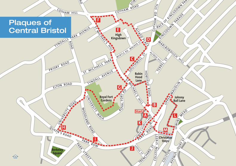
Plaques ofCentral Bristol
N
St Michael’s Church is mostlyGeorgian with a fifteenth centurytower, unfortunately the church hasbeen redundant for many years.
From the west door ofSt Michael’s Church,go to St Michael’s Hill
Most houses date from sixteenth andseventeenth centuries. Nearly all arelisted. The bottom stand of four aretimber framed and built in 1637 by afamily from Axbridge. George Pocock,who lived near the church,experimented with kites to power boatsand carriages. In a good wind, a tricycle
carrying four people could reach twentyfive miles an hour. Better still, it wasexempt from turnpike tolls. Aschoolmaster, Pocock also designed aflogging machine. Surely he deserves aplaque with a citation for greentransport and old fashioned values.
Cross to Horfield Road.
Note the plaque to Sir MichaelRedgrave , born in theatrical digsat No 4 and named after theChurch.
Bengough’s almshouses were built in1818. Bengough was unlucky. On his
last day in office as Lord Mayor in1793, at a demonstration against thetoll on Bristol Bridge, the HerefordMilitia whose assistance he hadenlisted without regard for properprocedure, shot and killed an innocentbystander. Bengough’s last official actswere attempts to regularise the use oftroops in retrospect and to rig theinquest. (Under his successor, 14 morerioters were killed.)
Turn left up steps intoRobin Hood Lane. Goright past St Michael’sHospital and right intoSouthwell Street.
B
A
Description: A short but steep walk taking in the ‘blue plaques’ near the centre.
Length: 2 miles.( 1- 1.5hours )
Refreshments: Pubs and cafés en route.
Transport: Buses to Centre. Walk up Colston Avenue, cross Perry Road to St Michaels Hill.
Plaques of Central Bristol - Walk 1

The University Veterinary College occupies an Edwardian school building.The Bristol School Board had previouslyhad a special school for truants on thesite, subjecting them to two hours militarystyle drill a day.
Turn left into AlfredPlace - note colourfuldisplay of lateseventeenth centuryhouses. At the end goleft into HighKingsdown and rightinto Oxford Street toemerge in CothamRoad. Turn left toCotham ParishChurch.
Above eye level on the last house inAlfred Place , backing onMontague Place, a small sculpturedepicts a few of the workers on therestoration project. High Kingsdown
was a prize winning 1974
housing scheme, attempting to combinehigh density, low rise and privacy. TheKings Arms, a Victorian pub wasrefurbished for its ‘village green’. Noteplaque on the outside wall of the church,denoting the boundary stone of themediaeval City of Bristol. It was rescuedand repositioned when the chapel was built.
Note: the Arts and Crafts movementWestern College and the HomeopathicHospital by Oatley. Just down Cotham Hill,Cotham House on the left, with a frieze ofCotham Landscape Marble, was thehome of George White who ran the tramsystem and founded the Bristol AeroplaneCompany.
Turn left into StMichael’s Hill see wallplaque .
This is the site of one of the city’s placesof public execution. The nimby’s of 1773complained that the crowds at thisentertainment were damaging theirproperty and asked that the gallows beremoved to Brandon Hill instead.
Continue for 300 yardsdown the hill, past theold Childrens Hospitalwith its listed facade andturn right into RoyalFort Road.
D
E
C
F

The Corporation began to fortify the city in1642, nevertheless it was captured byPrince Rupert in 1643. The Royalistsreinforced the Windmill Hill Fort whichwas used as Rupert’s Headquarters andrenamed Royal Fort. The City wasrecaptured in 1645 and the fortstrengthened again. The defences werebuilt by conscript labour and paid for bylocal taxation and forced loans. After theParliamentary victory, in 1655, Cromwellmade the citizens of Bristol meet the costof destroying the works. Of the Royal Fort,only the gate house remains. Note Plaqueon Prince Rupert’s gate .
Exit into Woodland Roadand cross to UniversityRoad, walking down pastthe Grammar School andleft into Queen’s Road.
Note the Bristol Byzantine façade ofBrown’s Restaurant , formerly the CityMuseum, then the University Refectory.
Read the plaque on the wall of thepresent Museum and Art Gallerydedicated to Colonel Henry Washington -an ancestor of George Washington. Manyskirmishes were fought along this roadduring the Civil War.
Pass the Wills Towerwith its fine views downPark Street and stop bythe University EngineeringBuilding.
Oatley’s Wills Tower was not erected untilafter the First World War, which mustmake it the last public building in its style.The construction, however, was modernsteel frame. Note façade of a cinemaincorporated into the building and readthe plaque to Nipper the HMV dog .Opposite, by the garage, is a plaque toremind us that the Princes Theatre stoodthere. Opened in 1867, as the NewTheatre, it seated 2,400. Two years, latera disastrous crush on Boxing Day, killing
fourteen people, had a calamitous effecton the theatre’s fortunes until its namewas changed. Famous for its pantomime,which Bernard Shaw praised, the Princes,not the Royal, was Bristol’s principletheatre until it was destroyed in theSecond World War. Note the fine fin desiècle loos on the corner of Woodland andPark Row, now sadly closed.
Proceed along Park Rowand where this becomesPerry Road, turn left upLower Church Lane.
The Elizabethan Red Lodge on theright was built as a retreat for the familywho lived in a much grander house onthe site of the Colston Hall. The RedLodge has stunning panelling and arestored knot garden. Note plaques onthe front of the building. On the left ofLower Church Lane is a fine Victorianschool. The Old Rectory is partly built inStrawberry Hill Gothic .
H
G
I
J
K
Cross at lights, go leftdown Upper MaudlinStreet, with theChildren’s Hospital onthe left. Here, cross theroad at the lights, findJohnny Ball Lane signedand slightly to your rightbeside Jameson’sRestaurant and wanderdown. Then turn right.
Note the St James’ Parish Boundary stoneeight foot up the right-hand wall and atthe bottom the restored sugar refinery,now the Hotel du Vin. Note the fine statueof a horseman by David Backhouse andthe twelfth century St Bartholomew’sHospital. The Hospital was founded in1240 the remaining ruins renovated in1984. The informative Plaque is somewhat obscured by overgrown ivy. Here wasthe original establishment of Bristol
Grammar School(1532-1767) andsubsequently Queen Elizabeth HospitalSchool(1767-1847)
Climb Christmas Stepsto the right.
A plaque on the wall to the rightcommemorates Colonel Lunsford, aRoyalist shot through the heart whenPrince Rupert took the city. (For a while,the street was known as Lunsford’sSteps.) An inscription above the almsgatherers’ niche at the top of the steps,commemorates the ‘steppering down’ ofthe street. Foster’s Almshouses, with theChapel of the Three Kings of Cologne arebuilt in Burgundian style and are in directcontrast with the tram sheds opposite,built in 1888 to provide a horsedrawntram service to Clifton. The tram shedshave been well restored and nowcomprise a micro brewery and restaurant.
Go up the steep BristolSteps, cross Perry Roadand return to St Michael’schurchyard.
Refresh yourself at the Scotchman andhis Pack. One explanation of the namederives it from a ‘scotch’, a portablebrake which the scotchman applied tocarts descending the hill to prevent themgetting out of control. Sometimes thescotch glowed red from the frictioncreated. Another more plausible theory isthat the pub, at one of the mainentrances to the city, tried to attract thecustom of pedlars. Traditionally, Scots,besides living on oatmeal and sufferingfrom the itch, made their living asitinerant tradesman, carrying their waresin packs.
A walk that touches on a mass of history- perhaps to be explored again and inmore depth.
Walk devised by Gillian Davies, Bristol Ramblers
LM

Christmas Steps Browns Restaurant - Queens RoadH
St Michaels Hill
Plaque Bewells Cross
Prince Ruperts Gate G


