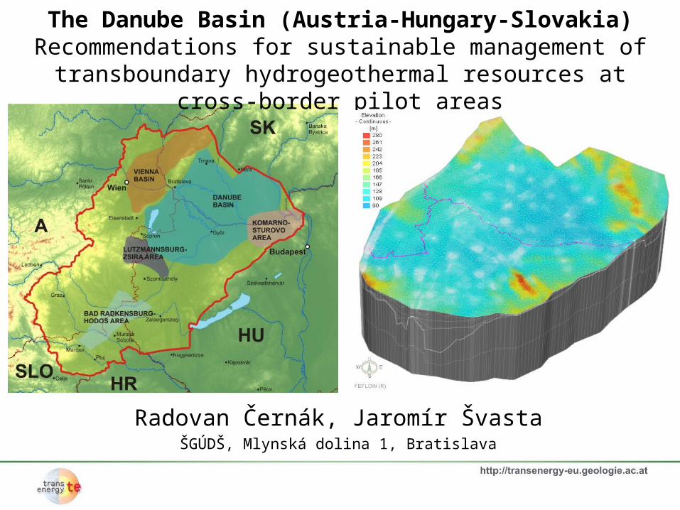
Radovan Černák, Jaromír Švasta ŠGÚDŠ, Mlynská dolina 1, Bratislava The Danube Basin (Austria-Hungary-Slovakia) Recommendations for sustainable management of transboundary hydrogeothermal resources at cross-border pilot areas
Transcript
Radovan Černák, Jaromír ŠvastaŠGÚDŠ, Mlynská dolina 1, Bratislava
The Danube Basin (Austria-Hungary-Slovakia)Recommendations for sustainable management of transboundary
hydrogeothermal resources at cross-border pilot areas
Contents
• Introduction to the Danube Basin Pilot Area
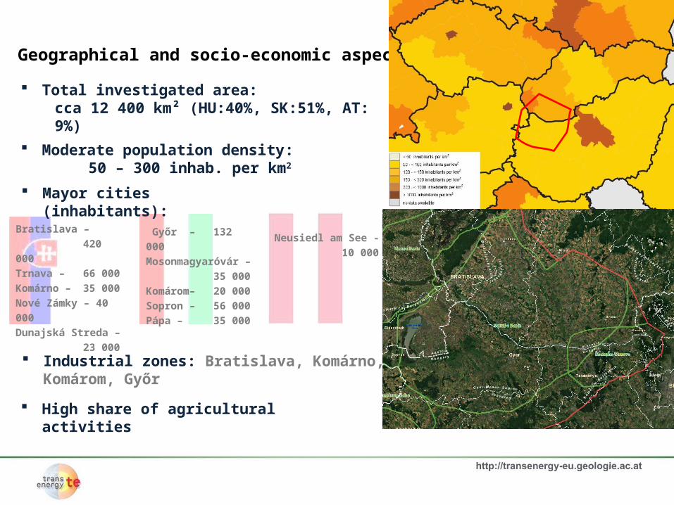
Geographical and socio-economic aspects
Hydrogeological overview
Geothermal Overview
Utilization of geothermal water
• Present and future hydrogeothermal resources
Modeling results
Evaluation of sustainability of current use of thermal ground water
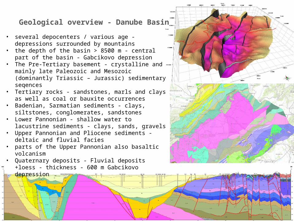
• Lower Pannonian - shallow water to lacustrine sediments - clays, sands, gravels
• Upper Pannonian and Pliocene sediments - deltaic and fluvial facies
• parts of the Upper Pannonian also basaltic volcanism• Quaternary deposits - Fluvial deposits +loess - thickness -
600 m Gabcikovo depression
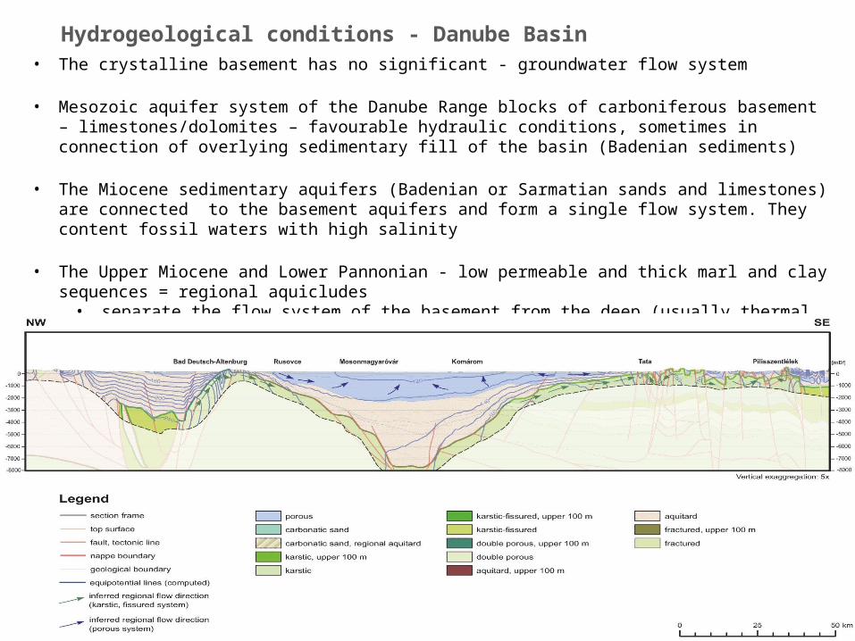
Hydrogeological conditions - Danube Basin • The crystalline basement has no significant - groundwater flow system
• Mesozoic aquifer system of the Danube Range blocks of carboniferous basement – limestones/dolomites – favourable hydraulic conditions, sometimes in connection of overlying sedimentary fill of the basin (Badenian sediments)
• The Miocene sedimentary aquifers (Badenian or Sarmatian sands and limestones) are connected to the basement aquifers and form a single flow system. They content fossil waters with high salinity
• The Upper Miocene and Lower Pannonian - low permeable and thick marl and clay sequences = regional aquicludes
• separate the flow system of the basement from the deep (usually thermal water) flow system of the porous formations characterized the Pannonian reservoir.
Hydrogeological conditions - Danube Basin
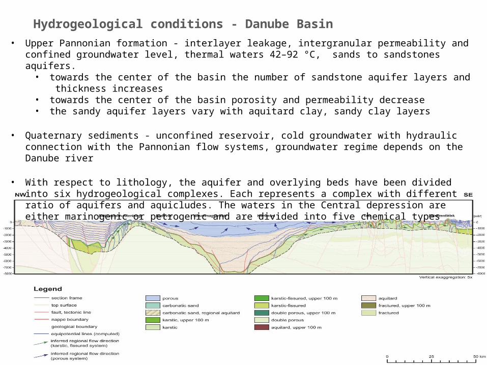
• Upper Pannonian formation - interlayer leakage, intergranular permeability and confined groundwater level, thermal waters 42–92 °C, sands to sandstones aquifers.
• towards the center of the basin the number of sandstone aquifer layers and thickness increases • towards the center of the basin porosity and permeability decrease • the sandy aquifer layers vary with aquitard clay, sandy clay layers
• Quaternary sediments - unconfined reservoir, cold groundwater with hydraulic connection with the Pannonian flow systems, groundwater regime depends on the Danube river
• With respect to lithology, the aquifer and overlying beds have been divided into six hydrogeological complexes. Each represents a complex with different ratio of aquifers and aquicludes. The waters in the Central depression are either marinogenic or petrogenic and are divided into five chemical types
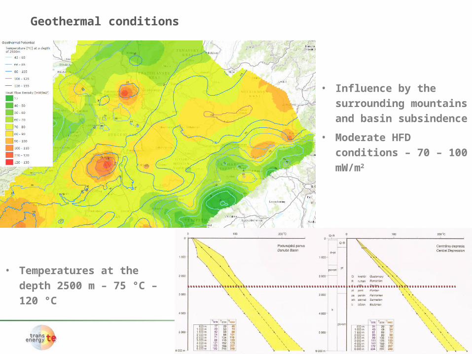
Geothermal conditions
• Influence by the
surrounding mountains
and basin subsindence
• Moderate HFD conditions
– 70 – 100 mW/m2
• Temperatures at the depth
2500 m – 75 °C – 120 °C
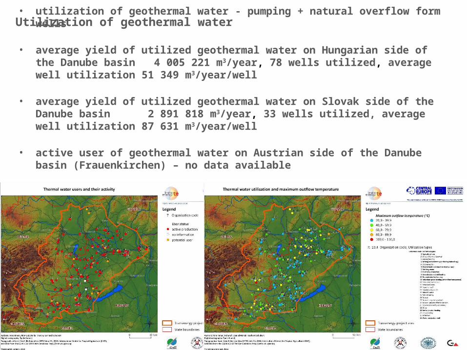
• utilization of geothermal water - pumping + natural overflow form wells
• average yield of utilized geothermal water on Hungarian side of the Danube basin 4 005 221 m3/year, 78 wells utilized, average well utilization 51 349 m3/year/well
• average yield of utilized geothermal water on Slovak side of the Danube basin 2 891 818 m3/year, 33 wells utilized, average well utilization 87 631
m3/year/well
• active user of geothermal water on Austrian side of the Danube basin (Frauenkirchen) – no data available
• use: bathing and balneology, heating (greenhouse and district)
Utilization of geothermal water
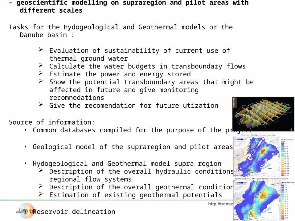
For the evaluation in the project TRANSENERGY – geoscientific modelling on supraregion and pilot areas with different scales
Tasks for the Hydogeological and Geothermal models or the Danube basin :
Evaluation of sustainability of current use of thermal ground water Calculate the water budgets in transboundary flows Estimate the power and energy stored Show the potential transboundary areas that might be affected in
future and give monitoring recomnedations Give the recomendation for future utization
Source of information:• Common databases compiled for the purpose of the project
• Geological model of the supraregion and pilot areas
• Hydogeological and Geothermal model supra region Description of the overall hydraulic conditions and regional flow
systems Description of the overall geothermal conditions Estimation of existing geothermal potentials
• Reservoir delineation
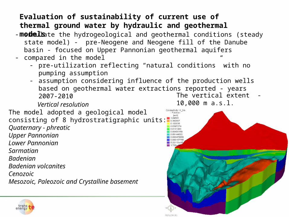
Evaluation of sustainability of current use of thermal ground water by hydraulic and geothermal models
- simulate the hydrogeological and geothermal conditions (steady state model) - pre-Neogene and Neogene fill of the Danube basin - focused on Upper Pannonian geothermal aquifers
- compared in the model - pre-utilization reflecting “natural conditions” with no pumping assumption - assumption considering influence of the production wells based on geothermal
water extractions reported - years 2007-2010
The vertical extent -10,000 m a.s.l. Vertical resolution
The model adopted a geological model consisting of 8 hydrostratigraphic units:Quaternary - phreaticUpper PannonianLower PannonianSarmatianBadenianBadenian volcanitesCenozoicMesozoic, Paleozoic and Crystalline basement
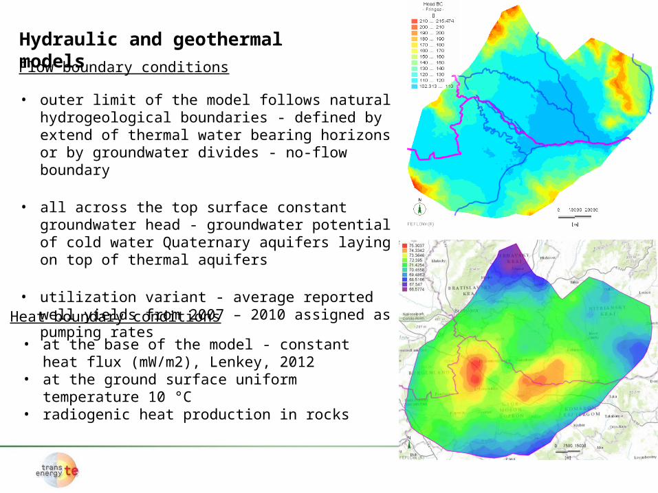
Flow boundary conditions
Heat boundary conditions
• at the base of the model - constant heat flux (mW/m2), Lenkey, 2012
• at the ground surface uniform temperature 10 °C• radiogenic heat production in rocks
Hydraulic and geothermal models
• outer limit of the model follows natural hydrogeological boundaries - defined by extend of thermal water bearing horizons or by groundwater divides - no-flow boundary
• all across the top surface constant groundwater head - groundwater potential of cold water Quaternary aquifers laying on top of thermal aquifers
• utilization variant - average reported well yields from 2007 – 2010 assigned as pumping rates
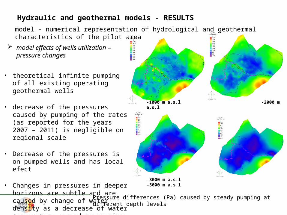
-1000 m a.s.l -2000 m a.s.l
-3000 m a.s.l -5000 m a.s.l
Pressure differences (Pa) caused by steady pumping at different depth levels
Hydraulic and geothermal models - RESULTS
model - numerical representation of hydrological and geothermal characteristics of the pilot area
model effects of wells utilization – pressure changes
• theoretical infinite pumping of all existing operating geothermal wells
• decrease of the pressures caused by pumping of the rates (as reported for the years 2007 – 2011) is negligible on regional scale
• Decrease of the pressures is on pumped wells and has local efect
• Changes in pressures in deeper horizons are subtle and are caused by change of water density as a decrease of water temperature casued by pumping
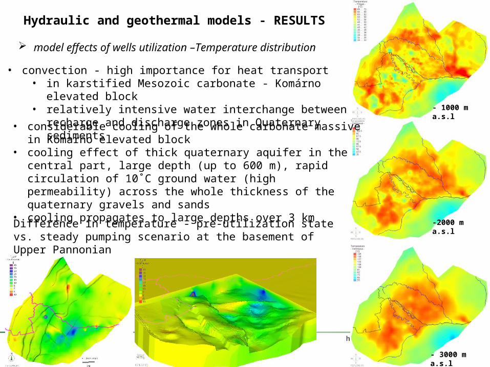
model effects of wells utilization –Temperature distribution
• convection - high importance for heat transport• in karstified Mesozoic carbonate - Komárno elevated block• relatively intensive water interchange between recharge and
discharge zones in Quaternary sediments
• considerable cooling of the whole carbonate massive in Komarno elevated block
• cooling effect of thick quaternary aquifer in the central part, large depth (up to 600 m), rapid circulation of 10˚C ground water (high permeability) across the whole thickness of the quaternary gravels and sands
• cooling propagates to large depths over 3 km
- 3000 m a.s.l
- 1000 m a.s.l
-2000 m a.s.lDifference in temperature - pre-utilization state vs. steady pumping scenario at the basement of Upper Pannonian
Hydraulic and geothermal models - RESULTS
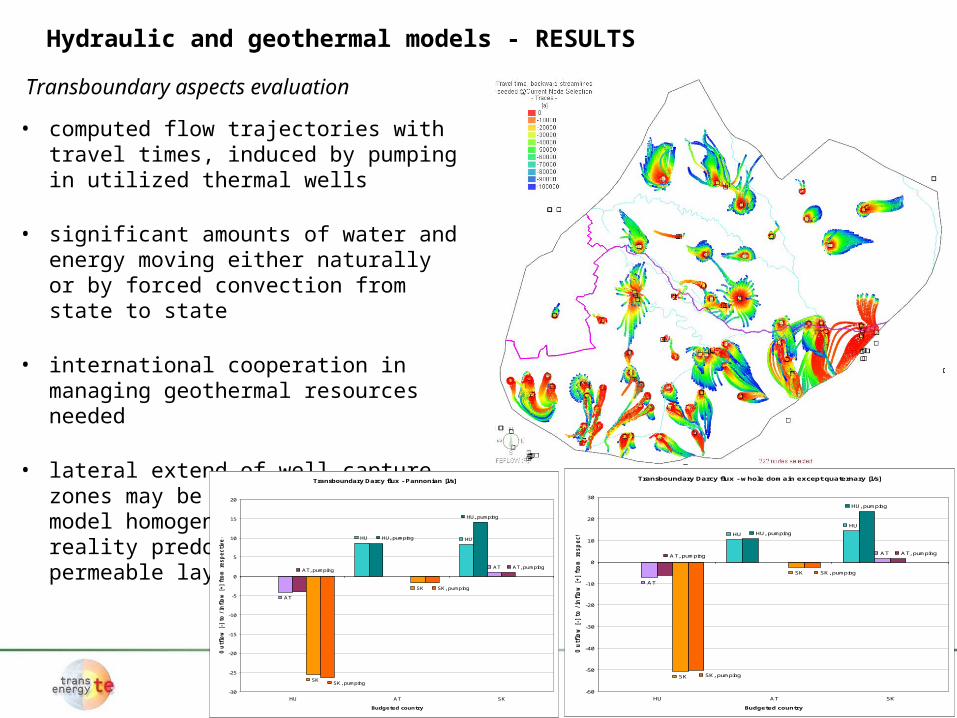
Transboundary aspects evaluation
Hydraulic and geothermal models - RESULTS
• computed flow trajectories with travel times, induced by pumping in utilized thermal wells
• significant amounts of water and energy moving either naturally or by forced convection from state to state
• international cooperation in managing geothermal resources needed
• lateral extend of well capture zones may be underestimated, in model homogeneous aquifers, in reality predominantly from more permeable layers
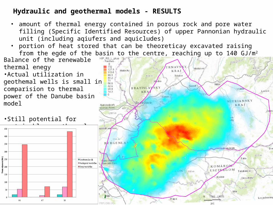
Balance of the renewable thermal enegy•Actual utilization in geothemal wells is small in comparision to thermal power of the Danube basin model
•Still potential for sustainable geothermal energy utilization
0
50
100
150
200
250
300
350
400
450
HU AT SK
Ther
mal
pow
er [M
W]
Geothermal w ells
Radiogenic heat inflow
Deep heat inflow
• amount of thermal energy contained in porous rock and pore water filling (Specific Identified Resources) of upper Pannonian hydraulic unit (including aqiufers and aquicludes)
• portion of heat stored that can be theoreticay excavated raising from the egde of the basin to the centre, reaching up to 140 GJ/m2
Hydraulic and geothermal models - RESULTS
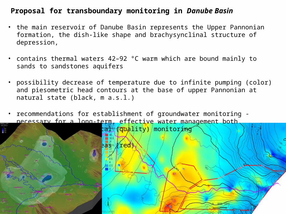
• the main reservoir of Danube Basin represents the Upper Pannonian formation, the dish-like shape and brachysynclinal structure of depression,
• contains thermal waters 42–92 °C warm which are bound mainly to sands to sandstones aquifers
• possibility decrease of temperature due to infinite pumping (color) and piesometric head contours at the base of upper Pannonian at natural state (black, m a.s.l.)
• recommendations for establishment of groundwater monitoring - necessary for a long-term, effective water management both quantitative and chemical (quality) monitoring
• proposed monitoring areas (red)
Proposal for transboundary monitoring in Danube Basin
Proposal for transboundary monitoring in Danube Basin
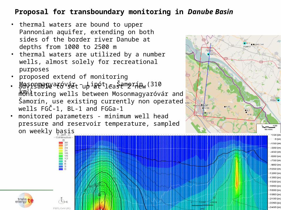
• thermal waters are bound to upper Pannonian aquifer, extending on both sides of the border river Danube at depths from 1000 to 2500 m
• thermal waters are utilized by a number wells, almost solely for recreational purposes
• proposed extend of monitoring Mosonmagyaróvár – Lipót – Šamorín (310 km2)
• advisable to set up at least 2 new monitoring wells between Mosonmagyaróvár and Šamorín, use existing currently non operated wells FGČ-1, BL-1 and FGGa-1
• monitored parameters - minimum well head pressure and reservoir temperature, sampled on weekly basis
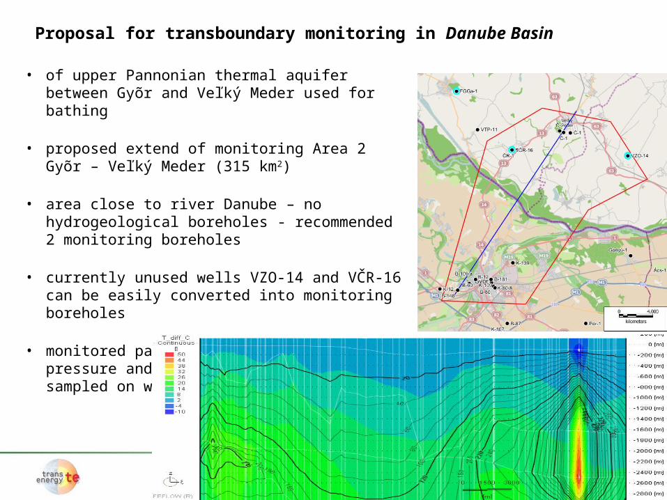
• of upper Pannonian thermal aquifer between Gyõr and Veľký Meder used for bathing
• proposed extend of monitoring Area 2 Gyõr – Veľký Meder (315 km2)
• area close to river Danube – no hydrogeological boreholes - recommended 2 monitoring boreholes
• currently unused wells VZO-14 and VČR-16 can be easily converted into monitoring boreholes
• monitored parameters - minimum well head pressure and reservoir temperature, sampled on weekly basis
Proposal for transboundary monitoring in Danube Basin