Page 1
In: Mangrove Ecosystems ISBN: 978-1-62808-714-7
Editors: Gerard Gleason and Thomas R. Victor © 2013 Nova Science Publishers, Inc.
Chapter 2
MANGROVE CONSERVATION
IN TRINIDAD AND TOBAGO, WEST INDIES
Rahanna A. Juman and Kahlil Hassanali Institute of Marine Affairs, Hilltop Lane Chaguaramas,
Trinidad and Tobago
ABSTRACT
Located at the southernmost end of the Caribbean island chain on the continental
shelf of South America, Trinidad and Tobago are continental islands (4,828 km2 and 300
km2 in area respectively), which were separated from the South American mainland in
recent historical times. As a consequence, their flora and fauna are relicts of the South
American biota, with minor variation, and are rich in biodiversity. Trinidad and Tobago‟s
mangroves fall within the Amazon-Orinoco-Maranhão mangrove complex in the Orinoco
bioregion. Mangrove forests are found on all coasts of Trinidad particularly the Atlantic
and Gulf and Paria coasts, while in Tobago, mangroves are mainly concentrated in the
southwest end of the island. Current estimates of mangrove coverage are 91.46 km2 in
Trinidad and 2.23 km2 in Tobago. Estuarine mangroves are the dominant type, but there
also are lagoonal and coastal fringe.
Mangrove forests in Trinidad and Tobago have been negatively impacted by land
conversion to accommodate population growth, thereby increasing urbanization,
industrialization and tourism in coastal areas, and the associated catchments. The
remaining systems are threatened by proposed coastal development, pollution from land–
based sources and coastal erosion. They are also projected to be adversely affected by
sea-level rise especially where they are constrained on the landward side by built
development or where they are starved of sediment. Attempts have been made to protect
certain mangrove forests by gazetting parts of the Prohibited Areas and Wildlife
Sanctuaries through national legislation. Subsequently, Trinidad and Tobago acceded to
the RAMSAR Convention in 1993, and three sites were designated Wetlands of
International Importance (Ramsar Sites). In 2001, a National Policy and Programmes on
Wetlands Conservation for Trinidad and Tobago was adopted which includes the concept
of “no net loss of wetlands and values and functions on publicly owned lands and
WI Tel # (868) 634-4292-4 Fax # (868) 634-4433 email [email protected] .
No part of this digital document may be reproduced, stored in a retrieval system or transmitted commercially in any form or by any means. The publisher has taken reasonable care in the preparation of this digital document, but makes no expressed or implied warranty of any kind and assumes no responsibility for any errors or omissions. No liability is assumed for incidental or consequential damages in connection with or arising out of information contained herein. This digital document is sold with the clear understanding that the publisher is not engaged in rendering legal, medical or any other professional services.
Page 2
Rahanna A. Juman and Kahlil Hassanali 36
waters”. But has the rate of mangrove loss decreased or has ecosystem health improved
through these interventions? This chapter assesses the effectiveness of these and other
conservation strategies by examining both „protected forests‟ in Caroni and Nariva
(Trinidad) and the Bon Accord Lagoon (Tobago) and „non-protected forests‟ in
Godineau, Point Lisas and Los Blanquizales (Trinidad) and Kilgwyn (Tobago). Based on
the assessment, this chapter provides recommendations of cost effective management
interventions on mangrove conservation
Keywords: Mangrove forest, conservation strategies, management intervention,
protected areas
INTRODUCTION
Mangroves are not a single genetic group but represent genetic adaptation of a large
variety of plant families to a particular environment [1, 2]. Most of the true mangrove species
occur in the Indo-Pacific region where plants are believed to have acquired the mangrove
habitat and evolved the physiological and morphological adaptations to brackish water about
100 to 80 million years ago [3]. Through radiate dispersal during the Pliocene Epoch,
mangroves were dispersed throughout most of the tropics. Mangroves crossed through the
still open Atlantic Ocean to the Caribbean by the early Eocene (55-50 million years) also
jumping the then flooded Panama isthmus to the Pacific coast of the Americas [3]. From the
original Indo-Pacific pool, eight species belonging to five genera presently constitute the
mangrove flora in the Caribbean. They are Rhizophora mangle (L.), R. racemosa (G.F.W.
Meyer), R. harrisonii (Leechman), Avicennia germinans (L.) Stearn, A. schaueriana (Stapf &
Leechman), Laguncularia racemosa (L.) Gaernt, Conocarpus erectus and Acrostichum
aureum (L.) [4].
Mangrove coverage in the Insular Caribbean was estimated at about 785 km2 [4], and
although there have been attempts to protect these forests by implementing coastal
management and planning programs, and declaring some of them Wetlands of International
Importance under the Ramsar Convention, there is still a net loss [4,5]. Impacts include:-
landfill and solid waste dumping; vegetation clearing for timber and/or charcoal production;
reclamation for agriculture, marina, hotels and harbours; hydrological alteration, particularly
by roadways, or flood diversion schemes; and pollution by factory and domestic effluent.
Global climate change and attendant sea level rise is expected to exacerbate loss and
degradation of mangrove forests and loss or decline of their associated species [6]. The
Caribbean has experienced an average mean relative sea-level rise of 1 mm year-1
during the
20th century, although there is extensive local variation. Sea-level is projected to rise between
0.18 – 0.59 m by 2099 [7]. Small island developing states have limited capacity to adapt to
relative sea level rise, including accommodating landward migration of mangroves and other
coastal ecosystems. This is a result of their small land mass, high population densities and
growth rates, poorly developed infrastructure, and susceptibility to damage from natural
disasters [8].
Loss of these ecosystems translates to degradation and loss of their ecosystem services,
consequently jeopardising the potential health and well-being of individuals and local
communities [6]. Reduced mangrove area will result in increase damage to shorelines from
Page 3
Mangrove Conservation in Trinidad and Tobago, West Indies 37
coastal hazards such as erosion, flooding, and storm waves and surges thereby increasing
threat to human safety. It will diminish coastal water quality, reduce biodiversity, eliminate
fish and crustacean nursery habitat and adversely affect adjacent coastal habitats [9, 10, 11].
Furthermore, mangrove destruction can release large quantities of stored carbon and
exacerbate global warming trends [12, 13, 14].
TRINIDAD AND TOBAGO
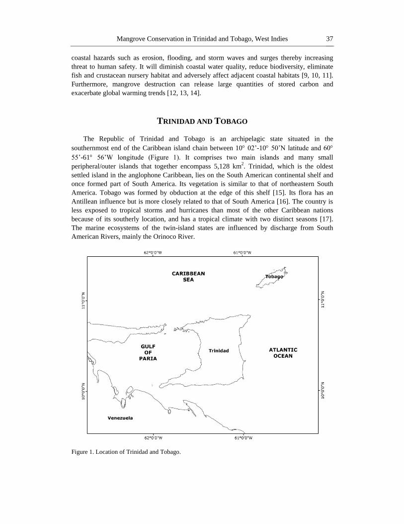
The Republic of Trinidad and Tobago is an archipelagic state situated in the
southernmost end of the Caribbean island chain between 10 02‟-10 50‟N latitude and 60
55‟-61 56‟W longitude (Figure 1). It comprises two main islands and many small
peripheral/outer islands that together encompass 5,128 km2. Trinidad, which is the oldest
settled island in the anglophone Caribbean, lies on the South American continental shelf and
once formed part of South America. Its vegetation is similar to that of northeastern South
America. Tobago was formed by obduction at the edge of this shelf [15]. Its flora has an
Antillean influence but is more closely related to that of South America [16]. The country is
less exposed to tropical storms and hurricanes than most of the other Caribbean nations
because of its southerly location, and has a tropical climate with two distinct seasons [17].
The marine ecosystems of the twin-island states are influenced by discharge from South
American Rivers, mainly the Orinoco River.
Figure 1. Location of Trinidad and Tobago.
Page 4
Rahanna A. Juman and Kahlil Hassanali 38
Mangrove forests in Trinidad and Tobago fall within the Amazon-Orinoco-Maranhão
mangrove complex in the Orinoco bioregion [18]. They are found on all coasts of Trinidad
particularly the Atlantic, Gulf and Paria coasts, while in Tobago, mangroves are mainly
concentrated in the southwest end of the island.
Current estimates of mangrove coverage are 91.46 km2 in Trinidad and 2.23 km
2 in
Tobago. All eight mangrove species recorded in the Caribbean are found in Trinidad, while
four species (R. mangle, A. germinans, L. racemosa and C. erectus) are found in Tobago.
Mangrove forests have been identified and classified according to six community types based
on forest appearance, geological nature and flow of water through the system [19]. In
Trinidad and Tobago, the mangrove forests are generally riverine/ estuarine, fringe or basin
systems [20].
The citizens of Trinidad and Tobago have always depended on the marine and coastal
environment for economic, social, nutritional and cultural well-being. Approximately 70% of
the population and 80% of economic activities are concentrated along the coast and the
economy is supported by activities in the coastal and marine environment ranging from oil
and gas to fisheries to tourism. Most of the country‟s current and proposed developments are
situated along the coast, which puts pressure on the already degraded ecosystems caused by
land-based pollution, land-use changes, habitat loss, coastal erosion and over-exploitation.
Major alterations to mangrove forests in Trinidad were recorded as far back as 1787,
when a major river through the city of Port of Spain was diverted and mangroves were
reclaimed for the city‟s expansion [21]. Since then mangrove forests have been reclaimed for
the construction of roads, sewage ponds, landfills, for agriculture and to provide land for high
density housing, recreational and port facilities. In 1979, 5 km2 ha of mangroves were
reclaimed for the construction of the Point Lisas Industrial Park and deep-water port. In
Tobago, mangroves were reclaimed to facilitate government buildings, hotel development and
for the expansion of the international airport.
Management of mangrove forests in Trinidad and Tobago falls under the ambit of the
Forestry Division and there have been some interventions by the State to arrest degradation
and decline. Parts of wetlands were declared Prohibited Areas and Wildlife Sanctuaries under
the Forests Act Chap 66:01 of 1915.
In 1993, Trinidad and Tobago acceded to the International Convention on Wetlands
(Ramsar Convention) whereby Nariva Swamp was designated a Wetlands of International
Importance. Caroni Swamp and Buccoo Reef / Bon Accord Lagoon were later designated
Ramsar Sites in 2005. In addition, in 2001, a National Policy and Programmes on Wetland
Conservation for Trinidad and Tobago was adopted which includes the concept of “no net
loss of wetlands and values and functions on publicly owned lands and waters”.
Although the government has signalled its intention to conserve wetlands through its
policies, the question remains as to whether the strategies used have been effective. This
chapter assesses the effectiveness of these conservation strategies by examining the state of
mangrove communities in both „protected forests‟ in Caroni and Nariva in Trinidad and the
Bon Accord Lagoon in Tobago; and „non-protected forests‟ in Godineau, Point Lisas and Los
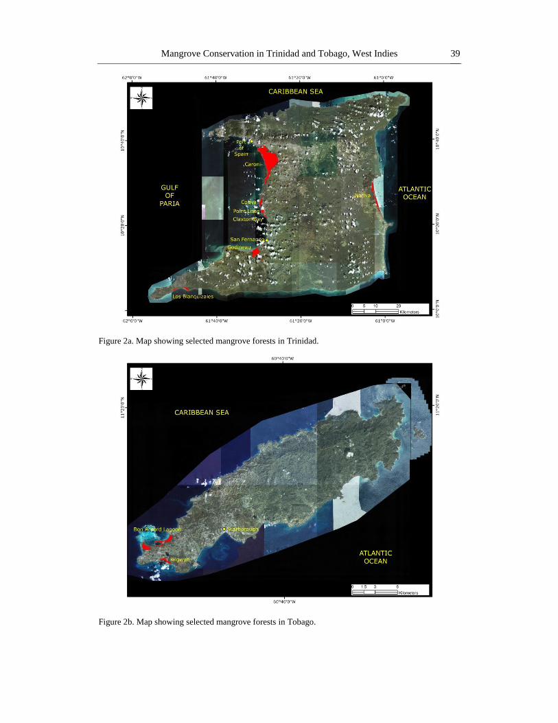
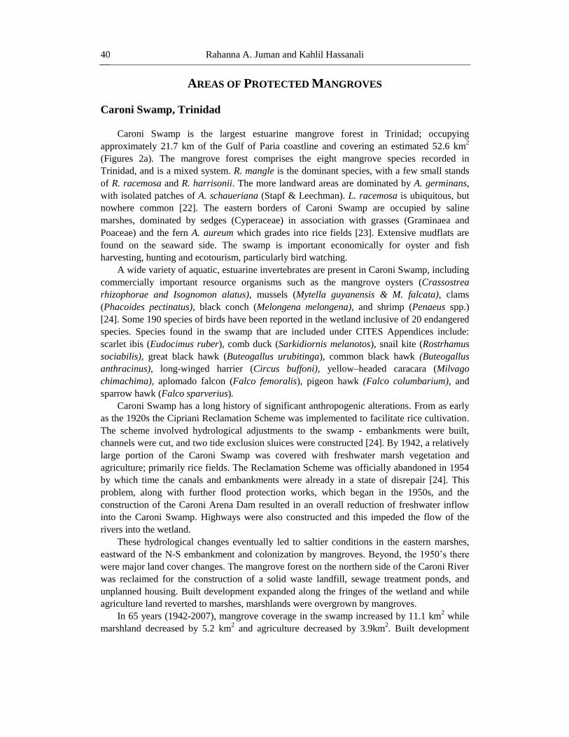
Blanquizales (Trinidad) and Kilgwyn (Tobago) (Figures 2a and 2b). Based on the assessment,
recommendations are provided for cost effective management interventions.
Page 5
Mangrove Conservation in Trinidad and Tobago, West Indies 39
Figure 2a. Map showing selected mangrove forests in Trinidad.
Figure 2b. Map showing selected mangrove forests in Tobago.
Page 6
Rahanna A. Juman and Kahlil Hassanali 40
AREAS OF PROTECTED MANGROVES
Caroni Swamp, Trinidad
Caroni Swamp is the largest estuarine mangrove forest in Trinidad; occupying
approximately 21.7 km of the Gulf of Paria coastline and covering an estimated 52.6 km2
(Figures 2a). The mangrove forest comprises the eight mangrove species recorded in
Trinidad, and is a mixed system. R. mangle is the dominant species, with a few small stands
of R. racemosa and R. harrisonii. The more landward areas are dominated by A. germinans,
with isolated patches of A. schaueriana (Stapf & Leechman). L. racemosa is ubiquitous, but
nowhere common [22]. The eastern borders of Caroni Swamp are occupied by saline
marshes, dominated by sedges (Cyperaceae) in association with grasses (Graminaea and
Poaceae) and the fern A. aureum which grades into rice fields [23]. Extensive mudflats are
found on the seaward side. The swamp is important economically for oyster and fish
harvesting, hunting and ecotourism, particularly bird watching.
A wide variety of aquatic, estuarine invertebrates are present in Caroni Swamp, including
commercially important resource organisms such as the mangrove oysters (Crassostrea
rhizophorae and Isognomon alatus), mussels (Mytella guyanensis & M. falcata), clams
(Phacoides pectinatus), black conch (Melongena melongena), and shrimp (Penaeus spp.)
[24]. Some 190 species of birds have been reported in the wetland inclusive of 20 endangered
species. Species found in the swamp that are included under CITES Appendices include:
scarlet ibis (Eudocimus ruber), comb duck (Sarkidiornis melanotos), snail kite (Rostrhamus
sociabilis), great black hawk (Buteogallus urubitinga), common black hawk (Buteogallus
anthracinus), long-winged harrier (Circus buffoni), yellow–headed caracara (Milvago
chimachima), aplomado falcon (Falco femoralis), pigeon hawk (Falco columbarium), and
sparrow hawk (Falco sparverius).
Caroni Swamp has a long history of significant anthropogenic alterations. From as early
as the 1920s the Cipriani Reclamation Scheme was implemented to facilitate rice cultivation.
The scheme involved hydrological adjustments to the swamp - embankments were built,
channels were cut, and two tide exclusion sluices were constructed [24]. By 1942, a relatively
large portion of the Caroni Swamp was covered with freshwater marsh vegetation and
agriculture; primarily rice fields. The Reclamation Scheme was officially abandoned in 1954
by which time the canals and embankments were already in a state of disrepair [24]. This
problem, along with further flood protection works, which began in the 1950s, and the
construction of the Caroni Arena Dam resulted in an overall reduction of freshwater inflow
into the Caroni Swamp. Highways were also constructed and this impeded the flow of the
rivers into the wetland.
These hydrological changes eventually led to saltier conditions in the eastern marshes,
eastward of the N-S embankment and colonization by mangroves. Beyond, the 1950‟s there
were major land cover changes. The mangrove forest on the northern side of the Caroni River
was reclaimed for the construction of a solid waste landfill, sewage treatment ponds, and
unplanned housing. Built development expanded along the fringes of the wetland and while
agriculture land reverted to marshes, marshlands were overgrown by mangroves.
In 65 years (1942-2007), mangrove coverage in the swamp increased by 11.1 km2 while
marshland decreased by 5.2 km2 and agriculture decreased by 3.9km
2. Built development
Page 7
Mangrove Conservation in Trinidad and Tobago, West Indies 41
increased by 8.3 km2 between 1942 and 2007 [25]. Generally, natural wetland communities
(mangrove, marshes and open water/pond) increased between 1942 and 2003, as agriculture
lands reverted to marsh and mangroves colonized new areas – the mudflats and deposited
dredged spoilt. However, between 2003 and 2007, natural wetland coverage declined by
about 3.5km2 as built development and agriculture lands increased [25].
The Caroni River Basin, the hydrometric area that encompasses the Caroni Swamp, also
experienced extensive land-use/land cover changes within the past few decades and this had
serious consequences for the Caroni Swamp; the receiving environment for the land-based
runoff. In addition to saltwater penetration, Caroni Swamp receives sediment-laden water
polluted with sewage, wastewater from industry and agriculture run-off [26, 27]. This has
affected the quality of the habitat, and shellfish that are harvested in the swamp. Fish kills and
mangrove dieback seem to be a regular occurrence [24, 28]. Frequent hydrological work to
mitigate flooding in the associated catchment have negatively impacted the wetland, since
channels are widened and dredged, mangrove trees are removed, and the dredged spoilt
placed on the bank inhibits the natural flushing of the system, resulting in hyper-saline
conditions.
Management
Portions of Caroni Swamp have been delimited protected areas for just under eight
decades. The Caroni Swamp Forest Reserve (28.3 km2) was proclaimed in 1936 and in 1953,
a further 1.4 km2 was designated a Wildlife Sanctuary for breeding Scarlet Ibis; the national
bird of Trinidad and Tobago. Fishing, oyster collecting and hunting had been permitted in all
areas except the Wildlife Sanctuary. In 1987, the major part of Caroni Swamp, south of the
Blue River, was declared a Prohibited Area (Forests Act, Chap 66:01). This meant that all
fishing, oyster collecting and other extractive activities (including cutting mangrove bark,
stakes, poles) became illegal and, with the exception of licensed tour guides, local
communities were no longer permitted to use the resources of Caroni Swamp. Although these
interventions were made, poaching of scarlet ibises and harvesting of oysters still continue.
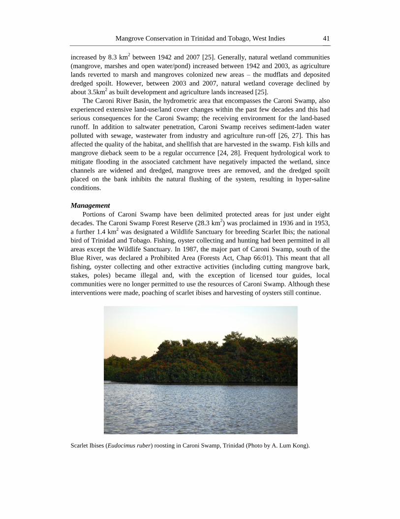
Scarlet Ibises (Eudocimus ruber) roosting in Caroni Swamp, Trinidad (Photo by A. Lum Kong).
Page 8
Rahanna A. Juman and Kahlil Hassanali 42
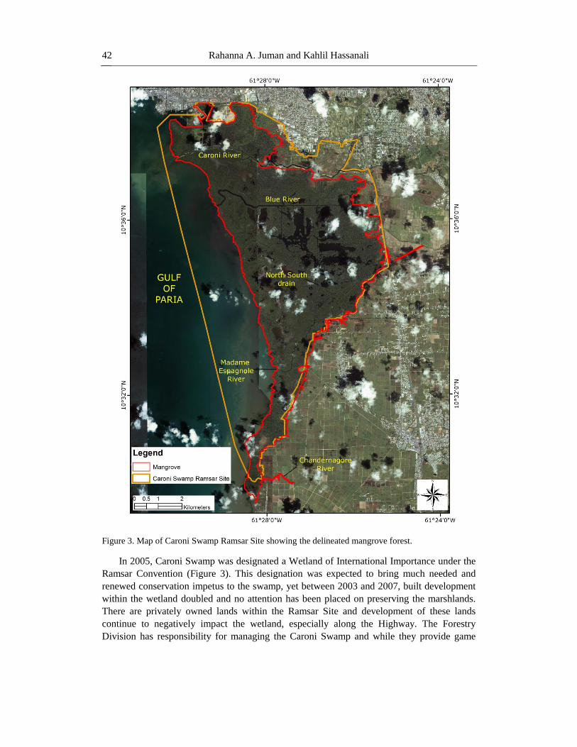
Figure 3. Map of Caroni Swamp Ramsar Site showing the delineated mangrove forest.
In 2005, Caroni Swamp was designated a Wetland of International Importance under the
Ramsar Convention (Figure 3). This designation was expected to bring much needed and
renewed conservation impetus to the swamp, yet between 2003 and 2007, built development
within the wetland doubled and no attention has been placed on preserving the marshlands.
There are privately owned lands within the Ramsar Site and development of these lands
continue to negatively impact the wetland, especially along the Highway. The Forestry
Division has responsibility for managing the Caroni Swamp and while they provide game
Page 9
Mangrove Conservation in Trinidad and Tobago, West Indies 43
wardens to patrol the swamp to discourage poaching, there is no comprehensive management
plan for the conservation and restoration of this wetland.
Nariva Swamp, Trinidad
Nariva Swamp is the largest wetland (approximately 113.4 km2), as well as the largest
freshwater swamp system in Trinidad and Tobago. The swamp is found along the Atlantic
coast of Trinidad (Figure 2a) and is an ecologically diverse system with an association of
mangroves, freshwater marsh, freshwater swamp forest, palm forest and small sections of
upland forest interspersed within its boundary (Figure 4).
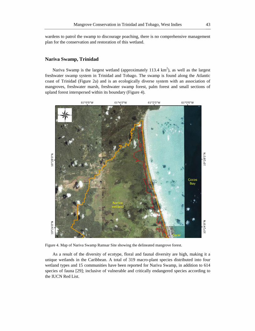
Figure 4. Map of Nariva Swamp Ramsar Site showing the delineated mangrove forest.
As a result of the diversity of ecotype, floral and faunal diversity are high, making it a
unique wetlands in the Caribbean. A total of 319 macro-plant species distributed into four
wetland types and 15 communities have been reported for Nariva Swamp, in addition to 614
species of fauna [29]; inclusive of vulnerable and critically endangered species according to
the IUCN Red List.
Page 10
Rahanna A. Juman and Kahlil Hassanali 44
Nariva Swamp consists of a series of north-south running ridges with depressions
between; thought to have been formed as beach ridges and lagoons during successive stages
in the retreat of the sea from the area during marine regression which began ca. 6000 to 5000
years ago. The Cocal represents the present beach barrier, with a narrow lagoon trapped
behind it to the west [29]. The lagoon is colonised by mangroves, while the depressions
between the ridges have been occupied by herbaceous vegetation (Figure 4). The mangrove
forest in Nariva is approximately 5.8 km2, representing 5 % of the entire wetland. It is a
mixed estuarine/ basin system on the eastern side of the wetland with seven of the eight
mangrove species reported in Trinidad. The forest is mixed, with red mangrove (R. mangle)
being dominant, black mangrove being abundant and white mangrove common. A. aureum is
found growing amongst the brackish marsh while C. erectus is found among the littoral
woodlands near the coast.
Management
Although Nariva Swamp was protected under Forestry and Wildlife legislation, the
wetland experienced severe ecological changes in the 1980s as a large area was used for
illegal rice farming. Between 1986 and 1995, 13 illegal rice farmers were found occupying
some 9.5 km2 of swamp land. These large-scale rice farmers altered the hydrology of the
wetland by cutting canals for drainage and for irrigation purposes. This hydrological
alteration resulted in salt water intruding further inland, affecting freshwater marsh and palm
communities. In 1993, after relentless lobbying by environmental non-governmental
organizations and the Forestry Division, Nariva Swamp was declared a Wetland of
International Importance under the Ramsar Convention, and shortly afterward the large scale
rice farming was stopped. A number of initiatives were undertaken by the Government to
demonstrate its commitment to the Convention, including a request to include the Nariva
Swamp in the Montreux Record and to initiate a Ramsar Advisory Mission. Arising out of the
Advisory Mission was a series of recommendations aimed at reversing degenerative trends
and improving the management of the wetland [30]. These recommendations included:
undertaking an environmental impact assessment (EIA) of heavily impacted areas;
development of a management plan for the area; and commissioning a hydrological and
aquatic vegetation restoration program.
The EIA and the management plan were completed in 1998 and 1999 respectively. In
1999, a restoration initiative for Nariva Swamp was commissioned but it was decided that
before any extensive restoration work could be effectively undertaken, a historical analysis of
the land use/land cover changes using GIS and remote sensing technology was needed. In
2003, a historical change detection analysis was conducted [31]. In this study mangrove forest
was classed together with freshwater swamp, wood and palms as swamp forest. The study
showed a decrease in swamp forest from 1942 to 1969 and a slight increase in 1994; by the
1980‟s mangroves had started to progress into marsh areas on the eastern edges [31]. Bacon
(1993) estimated the mangrove forest in Nariva Swamp to be approximately 2.8km2; this is
less than half of the 5.8 km2 reported in 2007 estimates [32]. The mangrove community in
Nariva Swamp has expanded and this may be due to the hydrological alteration that resulted
in salt water intruding further inland, and/or sea level rise.
The 1999 restoration initiative outlined two major programs; a hydrology and aquatic
vegetation restoration program of heavily impacted areas, and a fire-fighting program. These
programs are currently being implemented by the Forestry Division. In 2006, Nariva Swamp
Page 11
Mangrove Conservation in Trinidad and Tobago, West Indies 45
was also declared an Environmentally Sensitive Area (ESA) under the Environmentally
Sensitive Areas Rules, 2001 of Section 26 (e) and 41 of the Environmental Management Act,
2000. This Act seeks to award protection to certain areas of Trinidad and Tobago that contain
threatened and remarkable representations of this country‟s biodiversity.
In 2011, the Environmental Management Authority (EMA) in conjunction with the
University of the West Indies (UWI), the Forestry Division, and Community-based
Organisations (CBOs) in the area commenced the Nariva Swamp Restoration, Carbon
Sequestration, and Livelihoods Project. The objective of the Project was to restore forest
cover in the Nariva Swamp, maximising the capacity of this cover for carbon sequestration
and wildlife habitat while creating sustainable livelihood opportunities for neighbouring
communities. Activities under the project included: reforestation of degraded areas; tending
and fire suppression in replanted areas; seedling production; communications, education and
public awareness (CEPA); and research into Carbon sequestration by indigenous tropical tree
species. Another significant management objective was to build capacity and knowledge of
stakeholders for the long-term management of the Nariva Swamp.
The Project has successfully completed the reforestation of 0.026 km2 of land and
approximately 0.05 km2 have been identified for replanting. This Project engaged 11 CBOs in
the neighboring communities and has provided training in land preparation and planting,
nursery operation, seedling production and health and safety operations. The government
agencies involved are working in tandem with the project CBOs in providing continuous
institutional strengthening. These developing CBOs have thus increased their levels of
communication and operational efficiency while providing opportunities for employment and
sustainable development. Although game wardens and foresters patrol this wetland, wildlife
poaching and fire still remains a problem.
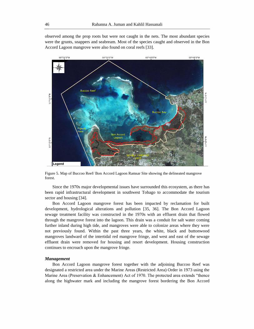
Bon Accord Lagoon, Tobago
The mangrove forest in Bon Accord Lagoon covers 0.91 km2 inclusive of open water
lagoons, and is the largest such forest in Tobago. Located on the leeward coast of southwest
Tobago (Figure 2b), it is a fringed mangrove forest contiguous with a seagrass community
and coral reef (Figure 5). R. mangle dominates the intertidal zone, while L. racemosa, C.
erectus and a few A. germinans are found in the drier landward side. The lower intertidal zone
of the forest is subjected to tidal flushing twice a day. There is no direct riverine inflow into
the swamp but two drains carry land-based runoff through the mangroves into the main
lagoon. Landward of the mangrove forest is a brackish marsh community dominated by
sedges (Eleocharis sp).
Bon Accord Lagoon mangrove forest supports a variety of animal species. The
mangroves not only supply organic matter, but its structural complexity provides a wide range
of habitats for both resident and migrant species, with a range of feeding habits. Detrital
feeders in the mangrove include crabs such as Uca spp., Cardisoma guanhumi, Ucides
cordatus and Aratus pisonni, and the Coffee snail, Melampus coffeus. The bivalves
Isognomon alatus, I. radiatus, the mussel Brachidontes sp., the barnacles Balanus sp. and
sponge colonize the prop roots. A number of reef fish and invertebrates use the lagoon as an
alternative habitat (33). Twenty-five fish species were caught in faunal surveys using trammel
and gill nets set in the Bon Accord Lagoon near the mangrove, while many more species were
Page 12
Rahanna A. Juman and Kahlil Hassanali 46
observed among the prop roots but were not caught in the nets. The most abundant species
were the grunts, snappers and seabream. Most of the species caught and observed in the Bon
Accord Lagoon mangrove were also found on coral reefs [33].
Figure 5. Map of Buccoo Reef/ Bon Accord Lagoon Ramsar Site showing the delineated mangrove
forest.
Since the 1970s major developmental issues have surrounded this ecosystem, as there has
been rapid infrastructural development in southwest Tobago to accommodate the tourism
sector and housing [34].
Bon Accord Lagoon mangrove forest has been impacted by reclamation for built
development, hydrological alterations and pollution [35, 36]. The Bon Accord Lagoon
sewage treatment facility was constructed in the 1970s with an effluent drain that flowed
through the mangrove forest into the lagoon. This drain was a conduit for salt water coming
further inland during high tide, and mangroves were able to colonize areas where they were
not previously found. Within the past three years, the white, black and buttonwood
mangroves landward of the intertidal red mangrove fringe, and west and east of the sewage
effluent drain were removed for housing and resort development. Housing construction
continues to encroach upon the mangrove fringe.
Management
Bon Accord Lagoon mangrove forest together with the adjoining Buccoo Reef was
designated a restricted area under the Marine Areas (Restricted Area) Order in 1973 using the
Marine Area (Preservation & Enhancement) Act of 1970. The protected area extends “thence
along the highwater mark and including the mangrove forest bordering the Bon Accord
Page 13
Mangrove Conservation in Trinidad and Tobago, West Indies 47
Lagoon and its environment”. This ecosystem complex remains the only designated Marine
Protected Area (MPA) in the country.
In 1994, a management plan was formulated for this MPA by the Institute of Marine
Affairs, and accepted by the Tobago House of Assembly (THA)1, the local governing body in
Tobago. The plan, however, did not address impacts that emanated from outside the boundary
of the park such as land-based pollution, and was never fully implemented. In 2005, the
Buccoo / Bon Accord Lagoon MPA was designated a Wetland of International Importance
under the Ramsar Convention because of its rich biological diversity and the fact that it was
habitat for threatened and endangered species.
It was hoped that by having it declared a Ramsar Site, the MPA would receive the much
needed management interventions to arrest degradation but this, thus far, has not been
realised. Although environmental non-government organisations have attempted to
implement projects to improve the health of the ecosystems, they remain degraded.
AREAS OF UNPROTECTED MANGROVES
Godineau Swamp/ Oropuche Lagoon, Trinidad
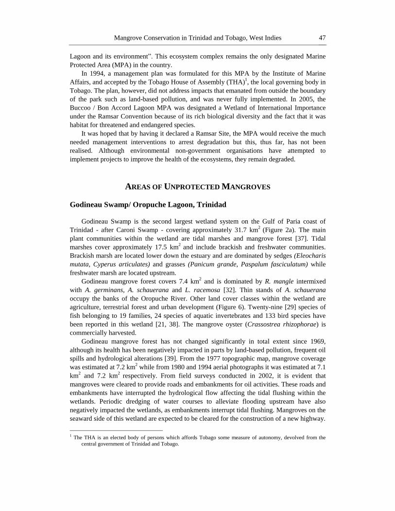
Godineau Swamp is the second largest wetland system on the Gulf of Paria coast of
Trinidad - after Caroni Swamp - covering approximately 31.7 km2
(Figure 2a). The main
plant communities within the wetland are tidal marshes and mangrove forest [37]. Tidal
marshes cover approximately 17.5 km2
and include brackish and freshwater communities.
Brackish marsh are located lower down the estuary and are dominated by sedges (Eleocharis
mutata, Cyperus articulates) and grasses (Panicum grande, Paspalum fasciculatum) while
freshwater marsh are located upstream.
Godineau mangrove forest covers 7.4 km2 and is dominated by R. mangle intermixed
with A. germinans, A. schauerana and L. racemosa [32]. Thin stands of A. schauerana
occupy the banks of the Oropuche River. Other land cover classes within the wetland are
agriculture, terrestrial forest and urban development (Figure 6). Twenty-nine [29] species of
fish belonging to 19 families, 24 species of aquatic invertebrates and 133 bird species have
been reported in this wetland [21, 38]. The mangrove oyster (Crassostrea rhizophorae) is
commercially harvested.
Godineau mangrove forest has not changed significantly in total extent since 1969,
although its health has been negatively impacted in parts by land-based pollution, frequent oil
spills and hydrological alterations [39]. From the 1977 topographic map, mangrove coverage
was estimated at 7.2 km2 while from 1980 and 1994 aerial photographs it was estimated at 7.1
km2 and 7.2 km
2 respectively. From field surveys conducted in 2002, it is evident that
mangroves were cleared to provide roads and embankments for oil activities. These roads and
embankments have interrupted the hydrological flow affecting the tidal flushing within the
wetlands. Periodic dredging of water courses to alleviate flooding upstream have also
negatively impacted the wetlands, as embankments interrupt tidal flushing. Mangroves on the
seaward side of this wetland are expected to be cleared for the construction of a new highway.
1 The THA is an elected body of persons which affords Tobago some measure of autonomy, devolved from the
central government of Trinidad and Tobago.
Page 14
Rahanna A. Juman and Kahlil Hassanali 48
Figure 6. Map of Godineau Swamp/ Oropouche Lagoon, Trinidad.
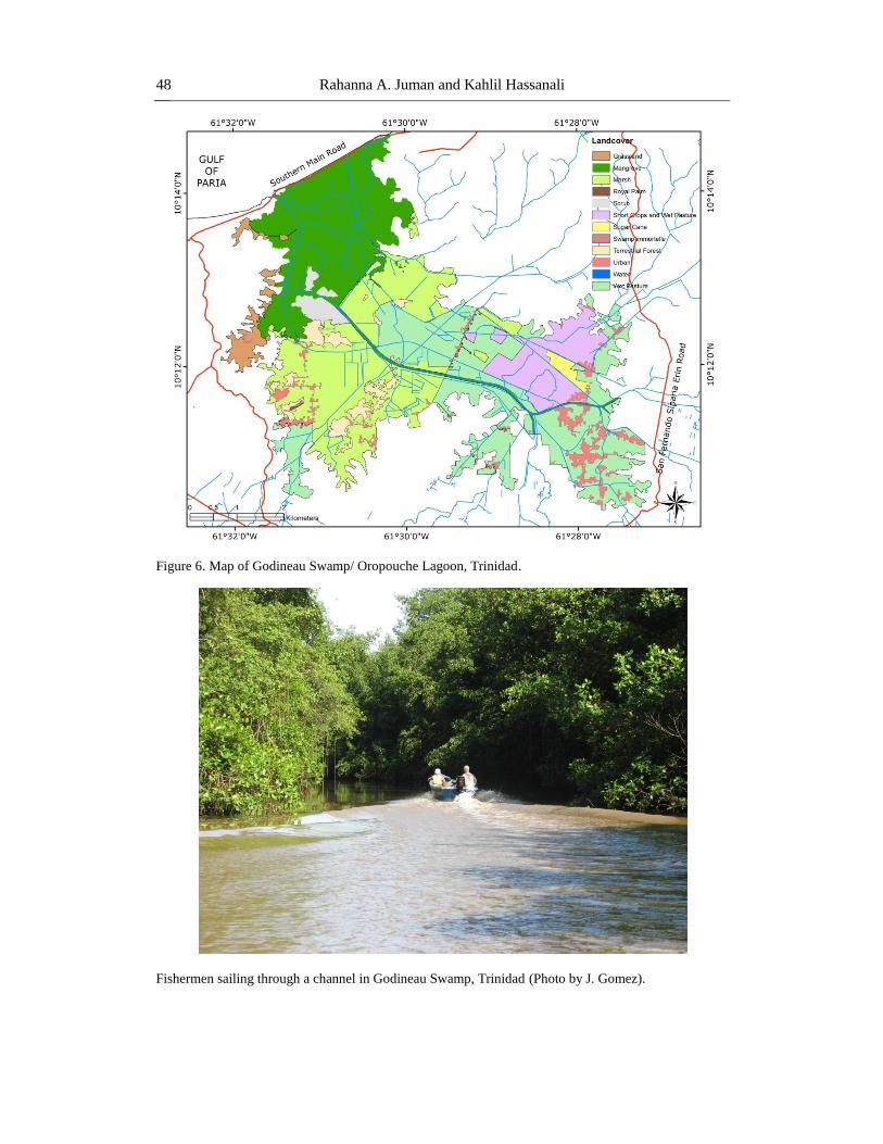
Fishermen sailing through a channel in Godineau Swamp, Trinidad (Photo by J. Gomez).
Page 15
Mangrove Conservation in Trinidad and Tobago, West Indies 49
Godineau Swamp/ Oropuche Lagoon has a long history of human occupation and
activity. Several archaeological sites have been discovered in this wetland, and the artifacts
found revealed an Amerindian (Saladiod group) presence thousands of years ago [40]. These
indigenous people were known to have occupied hilltop locations and engaged in hunting,
fishing, farming and pottery making. In describing the area in 1881, de Verteuil (2000)
identified the Swamp as “an inexhaustible source of malaria”. In 1852, a two-mile long road,
which included a “fine iron structure” across the Godineau River, was laid closely parallel to
the sea shore.
Agriculture has been an important activity in the wetland. Rice cultivation began in the
early 1890s and by the 1920s, Oropuche became the most important rice growing area in
Trinidad, sometimes at the expense of mangroves. Between 1962 and 1969, 1.9 km2 of
mangrove forest was cleared for the establishment of rice paddies through a system of
embankments and sluice gates. However, water control devices subsequently failed and the
scheme had to be abandoned because of saltwater intrusion. This cleared mangrove area was
transformed into a brackish marsh community that is currently used as a feeding ground by a
number of water birds. Still, in the late 1960s, over 14 km2 of the Oropuche wetland was
under rice cultivation and rice remained an important crop until the early 1990s when
cultivation ceased owing to a combination of environmental factors and Government policies.
Cocoa was also cultivated and Oropuche had become an important cocoa area by 1915 [40].
Godineau Swamp has also had oil activities since the early part of the twentieth century.
To facilitate operations, oil companies laid over 320 km of roads in South Trinidad [41]. The
oil rights over the Oropuche Lagoon concession were held by the British Controlled Oilfields
company. The Oropuche Lagoon concession covered more than 16.2 km2
in the area known
as Mosquito Creek, on the northwest end of the swamp. Before exploration could begin, the
company planned to drain the Lagoon at an estimated cost of £80,000. They considered that
even if the ensuing oil explorations were unsuccessful, the value of the reclaimed land would
be over twice the capital value of the company. They had just raised the money when a world-
wide depression affecting oil exploration set in during 1919-20 [41]. However, the Trinidad
Lands and Reclamation Ltd. was formed in 1920 with £100,000 capital and was to receive a
10% royalty on all crude oil won from the drained area. Cipriani and Company of Port of
Spain was contracted to drain the lagoon and the work was finally completed in 1924. The
work included raising/elevating the road across the seaward side of the lagoon to stop the sea
flowing into the lagoon except at the highest of tides. A dredger was used to cut several 40
feet wide drainage channels and since that time the recurrent flooding of the area has been
minimized even in the worst of rainy seasons [41].
A geological survey of the reclaimed area was conducted and well sites selected. The first
well, drilled in 1923 within 200 yards (180 m) of the San Francique Road eventually
produced 80,000 barrels of oil, but was the only success. The second well, close to the
Southern Main Road and about 50 yards from the coast and the Godineau River, as well as six
others, were abandoned as dry holes. At the time, as far as oil exploration was concerned, the
costly drainage scheme was a failure, though a technical success. Maintenance of the
reclamation was taken over by the Government in 1925. By the end of 1982, the area had
produced over 6 million barrels of oil from 128 wells – the depths ranging from several 100s
to 4000 feet [41].
To protect oil facilities upstream from salt water, the Trinidad Bank, the Trinidad Sluice
and the St. John Sluice were constructed in 1924. These constructions and the work to drain
Page 16
Rahanna A. Juman and Kahlil Hassanali 50
the lagoon were very significant changes to the hydrological regime of the swamp. In an
attempt to further improve drainage in the lagoon, thereby making more lands available for
agriculture, the Food and Agriculture Organization of the United Nations (1957)
recommended the construction of a central drain. By 1962, a drain was cut in the lower
catchment area. This drain did not solve the flooding problem and allowed salt water to
penetrate further inland [42].
Today, traditional uses, such as fishing, recreation, housing and religious activities,
continue in swamp and its environs. Eco-tours are also conducted. Recreational/Boating,
picnic and religious facilities have been constructed to aid some of these traditional uses. The
range of activities in the Godineau swamp imply a range of stakeholders including residents,
farmers, fishers, non-government organizations, community-based groups and a multitude of
State agencies. Most activities, however, remain unmanaged and largely unregulated.
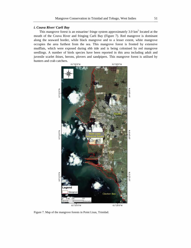
Point Lisas, Trinidad
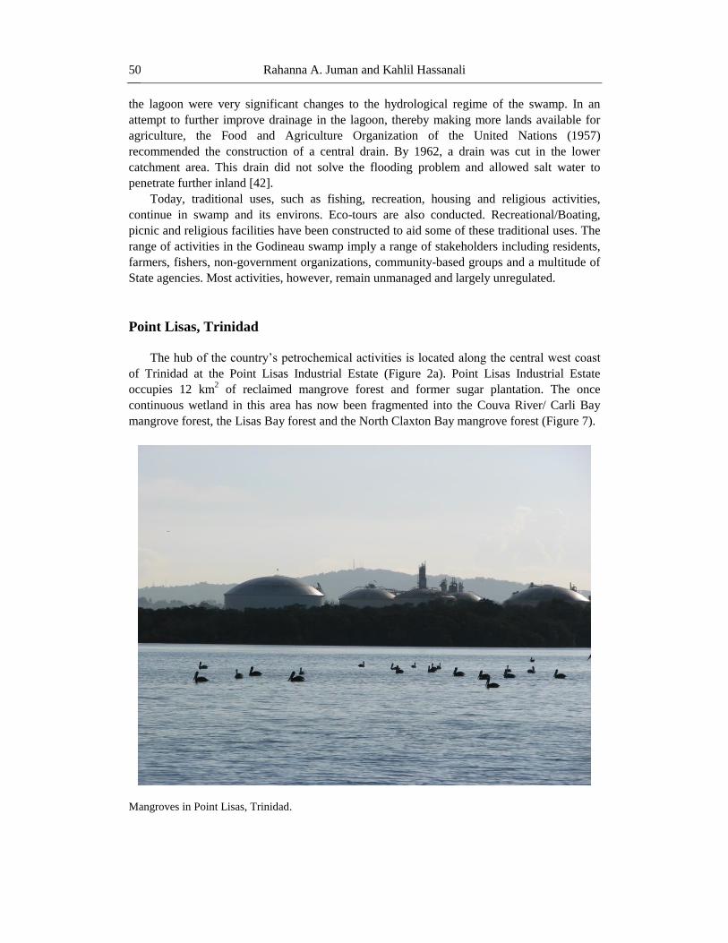
The hub of the country‟s petrochemical activities is located along the central west coast
of Trinidad at the Point Lisas Industrial Estate (Figure 2a). Point Lisas Industrial Estate
occupies 12 km2 of reclaimed mangrove forest and former sugar plantation. The once
continuous wetland in this area has now been fragmented into the Couva River/ Carli Bay
mangrove forest, the Lisas Bay forest and the North Claxton Bay mangrove forest (Figure 7).
Mangroves in Point Lisas, Trinidad.
Page 17
Mangrove Conservation in Trinidad and Tobago, West Indies 51
i. Couva River/ Carli Bay
This mangrove forest is an estuarine/ fringe system approximately 3.0 km2 located at the
mouth of the Couva River and fringing Carli Bay (Figure 7). Red mangrove is dominant
along the seaward border, while black mangrove and to a lesser extent, white mangrove
occupies the area furthest from the sea. This mangrove forest is fronted by extensive
mudflats, which were exposed during ebb tide and is being colonised by red mangrove
seedlings. A number of birds species have been reported in this area including adult and
juvenile scarlet ibises, herons, plovers and sandpipers. This mangrove forest is utilised by
hunters and crab catchers.
Figure 7. Map of the mangrove forests in Point Lisas, Trinidad.
Page 18
Rahanna A. Juman and Kahlil Hassanali 52
In 2007, approximately 0.4 km2 of black and white mangroves had died north of Couva
River, but has since regenerated. The cause of this dieback was not determined. Prior to this,
in 2003, mangrove die-off was recorded in the same general area and this was due to
diseases/infestation, but by 2005 there was some regeneration. In 1998, mangrove die-off was
reported south of the Couva River and the cause of this die-off was believed to be hot water
being released from a nearby industrial installation. This system later regenerated after the
situation was rectified. This forest seems to undergo a frequent cycle of die-off and re-growth.
The Couva / Carli Bay mangrove system is also impacted by reclamation and river
diversion. In 1979, 5 km2 of mangrove from the Couva to Claxton Bay area were reclaimed
for the construction of the Point Lisas Industrial Park and a deep-water port (21). In addition,
mangrove and marsh were lost through cutting and dredging of the new river channel and
dumping of dredge spoil when the Couva River was diverted.
Bacon (1993) reported this system to be 1.7 km2 however; the 2007 estimate of 3.0 km
2
shows a 1.3 km2 increase in mangrove coverage [32]. It appears that while the landward edge
of this system is being encroached upon by industrial development and impacted by pollution
from the Couva River, the system seems to be extending seaward upon extensive mudflats.
ii. Lisas Bay
This is a broad fringe of mangroves approximately 1.4 km2 located in the southern side of
Lisas Bay (Figure 7). The forest is dominated by red mangroves with the occasional white
and black mangroves associated with sedges and grass. Bacon (1993) reported this system to
be approximately 0.3 km2
and stated that the size at that time represented a significant loss of
wetlands as a result of land reclamation for the Point Lisas Industrial Estates and port
construction. Alleng (1997) indicated that in the reclaimed area there was a pond which was
used as a resting ground for a large number of seabirds. The reclaimed area is now being
colonized by mangroves and grasses. Just south of the main Lisas Bay wetland, a thin fringe
of scrubby black mangrove less than 5m in height can be found on the periphery of the
turning basin for the port. This mangrove stand is approximately 0.14 km2. No faunal species
were observed in this mangrove during field surveys in 2009 as the water within the turning
basin was hot; way above the ambient water temperature of 29°C.
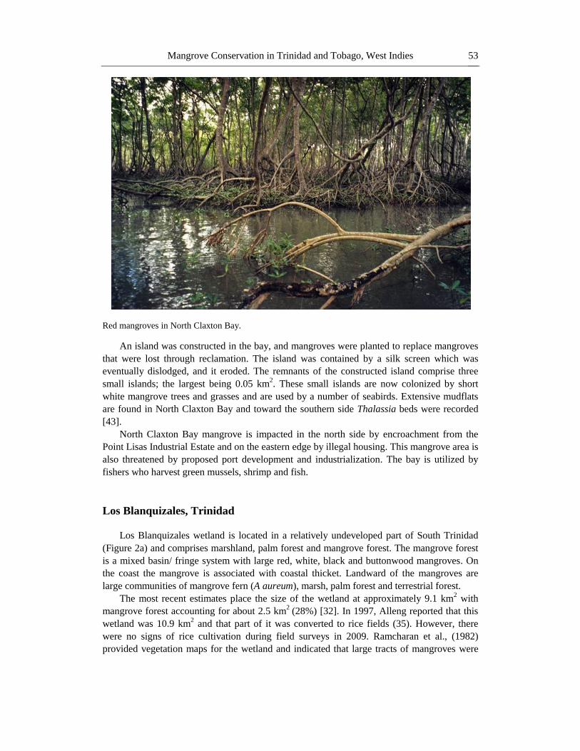
iii. North Claxton Bay
North Claxton Bay mangrove forest forms the southern sector of the once continuous
mangrove fringe seaward of the Point Lisas Industrial Estate (Figure 7). This mangrove fringe
is approximately 0.9 km2. The northern section is dominated by shrubby black mangroves
interspersed with a few white mangrove trees. Towards the centre of the mangrove system
there was a large area of dead mangroves which has now resulted in an open water area.
Bordering this open water area on the landward side are numerous short black mangroves.
Seaward of the pond is a narrow sand bar 15 m wide with short white and black mangroves
(≈3 m in height), grasses (Panicum spp., Paspalum spp), and Sesuvium portulascastrum. At
the southern end, large red mangroves fringe the coast. These trees have a well established
prop root faunal community. Mangrove oyster (Crassostrea rhizophorae), barnacle (Balanus
spp.) and Periwinkle snail (Littorina angulifera) are abundant on the roots.
The North Claxton Bay mangrove forest was initially impacted in 1979 when part of it
was reclaimed for the Point Lisas Industrial Estates [21]. Again in the latter part of the 1990s
the mangroves were impacted by reclamation activities.
Page 19
Mangrove Conservation in Trinidad and Tobago, West Indies 53
Red mangroves in North Claxton Bay.
An island was constructed in the bay, and mangroves were planted to replace mangroves
that were lost through reclamation. The island was contained by a silk screen which was
eventually dislodged, and it eroded. The remnants of the constructed island comprise three
small islands; the largest being 0.05 km2. These small islands are now colonized by short
white mangrove trees and grasses and are used by a number of seabirds. Extensive mudflats
are found in North Claxton Bay and toward the southern side Thalassia beds were recorded
[43].
North Claxton Bay mangrove is impacted in the north side by encroachment from the
Point Lisas Industrial Estate and on the eastern edge by illegal housing. This mangrove area is
also threatened by proposed port development and industrialization. The bay is utilized by
fishers who harvest green mussels, shrimp and fish.
Los Blanquizales, Trinidad
Los Blanquizales wetland is located in a relatively undeveloped part of South Trinidad
(Figure 2a) and comprises marshland, palm forest and mangrove forest. The mangrove forest
is a mixed basin/ fringe system with large red, white, black and buttonwood mangroves. On
the coast the mangrove is associated with coastal thicket. Landward of the mangroves are
large communities of mangrove fern (A aureum), marsh, palm forest and terrestrial forest.
The most recent estimates place the size of the wetland at approximately 9.1 km2 with
mangrove forest accounting for about 2.5 km2
(28%) [32]. In 1997, Alleng reported that this
wetland was 10.9 km2 and that part of it was converted to rice fields (35). However, there
were no signs of rice cultivation during field surveys in 2009. Ramcharan et al., (1982)
provided vegetation maps for the wetland and indicated that large tracts of mangroves were
Page 20
Rahanna A. Juman and Kahlil Hassanali 54
destroyed along this coast by erosion [21]. There is still evidence of erosion occurring in this
area especially on the western side.
Most of the Los Blanquizales wetland is remote and inaccessible by road. There are a few
roads in the area and these roads lead to oil facilities and houses. There is minor agriculture
landward of the mangrove forest. The major impact on the mangrove forest at Los
Blanquizales has been and still remains coastal erosion. There have been concerns that this
erosion may be associated with land subsidence since oil exploration and extraction activities
have been occurring in this part of the country for more than 50 years.
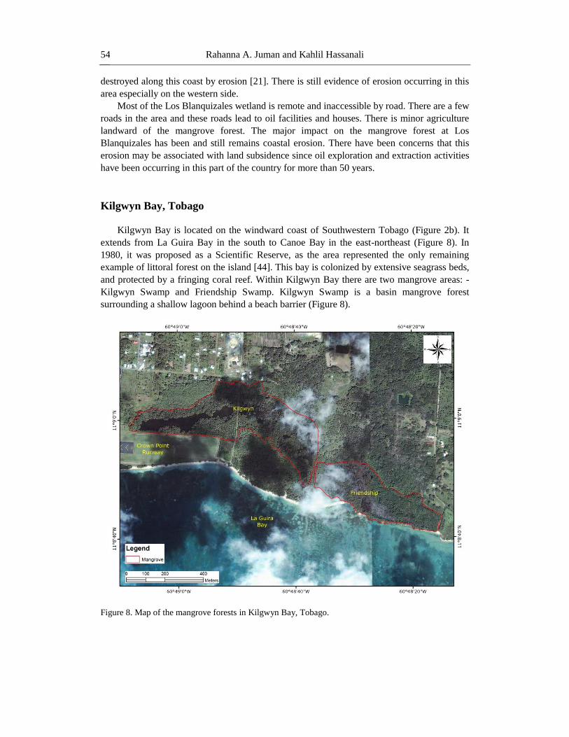
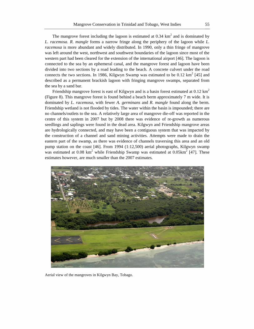
Kilgwyn Bay, Tobago
Kilgwyn Bay is located on the windward coast of Southwestern Tobago (Figure 2b). It
extends from La Guira Bay in the south to Canoe Bay in the east-northeast (Figure 8). In
1980, it was proposed as a Scientific Reserve, as the area represented the only remaining
example of littoral forest on the island [44]. This bay is colonized by extensive seagrass beds,
and protected by a fringing coral reef. Within Kilgwyn Bay there are two mangrove areas: -
Kilgwyn Swamp and Friendship Swamp. Kilgwyn Swamp is a basin mangrove forest
surrounding a shallow lagoon behind a beach barrier (Figure 8).
Figure 8. Map of the mangrove forests in Kilgwyn Bay, Tobago.
Page 21
Mangrove Conservation in Trinidad and Tobago, West Indies 55
The mangrove forest including the lagoon is estimated at 0.34 km2 and is dominated by
L. racemosa. R. mangle forms a narrow fringe along the periphery of the lagoon while L.
racemosa is more abundant and widely distributed. In 1990, only a thin fringe of mangrove
was left around the west, northwest and southwest boundaries of the lagoon since most of the
western part had been cleared for the extension of the international airport [46]. The lagoon is
connected to the sea by an ephemeral canal, and the mangrove forest and lagoon have been
divided into two sections by a road leading to the beach. A concrete culvert under the road
connects the two sections. In 1986, Kilgwyn Swamp was estimated to be 0.12 km2 [45] and
described as a permanent brackish lagoon with fringing mangrove swamps, separated from
the sea by a sand bar.
Friendship mangrove forest is east of Kilgwyn and is a basin forest estimated at 0.12 km2
(Figure 8). This mangrove forest is found behind a beach berm approximately 7 m wide. It is
dominated by L. racemosa, with fewer A. germinans and R. mangle found along the berm.
Friendship wetland is not flooded by tides. The water within the basin is impounded; there are
no channels/outlets to the sea. A relatively large area of mangrove die-off was reported in the
centre of this system in 2007 but by 2008 there was evidence of re-growth as numerous
seedlings and saplings were found in the dead area. Kilgwyn and Friendship mangrove areas
are hydrologically connected, and may have been a contiguous system that was impacted by
the construction of a channel and sand mining activities. Attempts were made to drain the
eastern part of the swamp, as there was evidence of channels traversing this area and an old
pump station on the coast [46]. From 1994 (1:12,500) aerial photographs, Kilgwyn swamp
was estimated at 0.08 km2 while Friendship Swamp was estimated at 0.05km
2 [47]. These
estimates however, are much smaller than the 2007 estimates.
Aerial view of the mangroves in Kilgwyn Bay, Tobago.
Page 22
Rahanna A. Juman and Kahlil Hassanali 56
The beach vegetation between Friendship and Kilgwyn Swamps comprises tree species
such as Machineel (Hippomane mancinella), buttonwood (Conocarpus erectus), seagrape
(Coccoloba uvifera), and Seaside Mahoe (Hibiscus tiliaceus, Thespesia populnea), and grass
species such as Ipomoea pre capres, Wedelia tribolata, Sporobolus sp., Paspalum spp.,
Panicum spp. This area of coast has been affected by sand mining, resulting in the formation
of small ponds that are colonized by sedges (Eleocharis spp, Cyperus spp, and
Fimbristylis spp).
LEGISLATIVE AND POLICY ENVIRONMENT
FOR MANGROVE MANAGEMENT
Currently, the most common strategy in Trinidad and Tobago employed to conserve
mangrove forests and/or their constituents is by designating them protected areas with
restricted access. Four varying forms of protected mangrove areas exist in the country:
Game Sanctuary through the Conservation of Wildlife Act Chapter 67:01 (Act 16 0f
1958). This was done for parts of Nariva and Caroni swamps.
Prohibited Area through the Forests (Prohibited Areas) Order which is subsidiary
legislation to the Forests Act Chapter. 66:01 (1995). This was done for parts of
Nariva and Caroni swamps.
Restricted Area through the Marine Areas (Restricted Areas) Order which is
subsidiary legislation of the Marine (Preservation and Enhancement) Act Chapter
37:01 (Act 1 of 1970). This was done for the mangrove system bordering the Bon
Accord lagoon in Tobago.
Environmentally Sensitive Area through the Environmentally Sensitive Areas
(ESA) Rules (2001) which is subsidiary legislation to the Environmental
Management Act (2000). The Nariva Swamp Managed Resource Protected Area was
designated under the ESA Rules in 2006.
Game Sanctuaries in Trinidad and Tobago are more concerned with protecting fauna
within their boundaries and offer no specific protection to mangroves themselves or
restrictions to access except when hunting. However, where portions of Caroni and Nariva
were designated Game Sanctuaries, they were subsequently given an additional Prohibited
Area designation which seeks to restrict access and also makes it an offence to cut or damage
flora associated with the mangrove ecosystem. Therefore, especially through the latter, these
regions were brought more in line with ecosystem based conservation approaches. The
Restricted Area in Tobago, which includes Bon Accord Lagoon mangroves, also attempts to
limit access and provide specific protection for both flora and fauna. With respect to the ESA
Rules, they allow designation across the range of IUCN Protected Areas categories2. In
Nariva Swamp, the Managed Resource Protected Area designation allows practices that
encourage “sustainable use and management to ensure long term protection and maintenance
2 http://www.iucn.org/about/work/programmes/gpap_home/gpap_quality/gpap_pacategories/
Page 23
Mangrove Conservation in Trinidad and Tobago, West Indies 57
of biological diversity, while providing at the same time a sustainable flow of natural
products and services to meet community needs” (ESA Rules, 2001, p. 105)
In both Trinidad and Tobago, however, having an area of mangrove forest designated as
protected has not effectively stemmed destruction or degradation of those particular
mangrove ecosystems. In many cases outdated legislation does not provide sufficient
disincentives, in the form of fines and penalties, to deter illegal activities in protected areas.
Apart from this, and perhaps more importantly, the institutions tasked with managing
protected areas lack capacity to adequately perform their duties. Thus, essential components
required in the successful administration of protected areas, such as regular patrols to enhance
enforcement and prosecution, are lacking. In Trinidad, the Forestry Division, which
responsible for managing areas of protected mangroves, is understaffed and under-resourced.
The same can be said for the THA‟s Department of Marine Resources and Fisheries which is
responsible for managing the Buccoo Reef Marine Protected Area and the mangrove forests
that it contains.
As alluded to earlier, it was hoped that the accession of Trinidad and Tobago to the
Ramsar Convention on 21st April 1993 would result in more resources being directed towards
fulfilling the commitments involving wetland conservation. Although the country now has
three sites designated as Wetlands of International Importance, with a total surface area of
159.2 km2, Ramsar has not proven to be the conservation “silver bullet”. Without national
legislation to give effect to fulfilling the obligations of the international convention, it holds
little weight. An illustrative case is the reversal of a decision taken in 2002 by Trinidad and
Tobago‟s Environmental Management Authority (EMA) to refuse granting a Certificate of
Environmental Clearance (CEC) to an international oil exploration company, Talisman
Petroleum Ltd., to carry out works in Nariva, based on the fact that it was designated a
Ramsar site. The CEC was requested by the company to conduct 3 Dimensional seismic
surveys in areas of the swamp. The decision to refuse the CEC was overturned by the
country‟s Environmental Commission because there was no Act of Parliament applying
provisions of the Ramsar Convention to Nariva Swamp specifically. Thus, the terms of
Ramsar could not be enforced locally. As a result the CEC was eventually granted to
Talisman Petroleum, albeit with the imposition of strict rules regarding the company‟s
conduct in the wetland. The ESA Rules, which became law after this ruling, are now meant to
give effect to the Ramsar Convention and other similar multilateral environmental
agreements. However, to date, Nariva Swamp is the only Ramsar site to be designated an
ESA.
The most recent National Protected Areas Policy of Trinidad and Tobago (2011), seeks to
treat with some of the observed shortcomings in protected area management in the country. It
proposes the establishment of a new institutional arrangement – a Forest and Protected Areas
Management Authority. This Authority is envisaged to be less bureaucratic and more
politically and financially independent than the Forestry Division. The policy also
recommends a suite of provisions intended to boost the human, technical and financial
capacity of this Authority and thus its effectiveness. Combined with this are
recommendations for revised/new legislative arrangements that would provide a framework
for better achieving conservation objectives. In addition, the policy proposes mechanisms,
such as incentives and voluntary compliance, for sustainable use and management of private
lands which have been identified as sensitive or critical areas and encourages more
participatory and community based processes for protected area management.
Page 24
Rahanna A. Juman and Kahlil Hassanali 58
Indeed the importance of encouraging and institutionalizing community based natural
resource management of mangroves cannot be overstated. In Trinidad and Tobago,
surrounding communities do exhibit dependence on mangrove forests. Although degrees of
dependence vary among areas of mangroves, communities and even community constituents
the recognition that conservation of mangroves cannot take place without the support and
input of these communities is increasingly coming to the fore. The preservationist approach to
conservation that seeks to prevent humans from accessing resources within the confines of
protected areas is giving way to conservation that is more cognizant of human needs with
sustainable resource use being the focus alongside ecosystem based management.
Given the resource constraints of the bodies tasked with managing protected areas in
Trinidad and Tobago, the many long established and intimate mangrove-community
interactions that already exist in the country and the stated need to conserve wider areas of
mangrove nationally, community based conservation is perhaps the more feasible option.
While strict protected areas that, inter alia, restrict access to human populations and their
activities do have their place, they should be now be made the exception rather than the rule.
Community based conservation approaches are now increasingly being employed in Nariva
Swamp with some degree of success. More initiatives employing these approaches should be
undertaken in unprotected areas of mangroves and wetlands around the country and steps
should be taken to ground these arrangements legislatively.
In keeping with the commitment stated in the 2001 National Programme and Policy for
Conservation of Wetlands regarding the objective of “no net loss of wetlands and their values
and function, on publicly-owned lands and waters” it is also important to synchronise and
regulate the activities of private enterprises and governmental ministries, agencies and
departments when they have the potential to impact wetlands on state lands. Several situations
have been highlighted, which post date this “no net loss” recommendation, where wetland
habitat was degraded or destroyed through, for example, agricultural schemes, road
construction and oil and gas extraction initiatives. On most occasions the established policy
was flaunted as loss was not adequately compensated for. Where wetland loss takes place it is
important that requisite rehabilitation or replanting is conducted elsewhere that equates to no
net loss of wetlands and their services. At present no proper mechanism exists for co-
ordinating and guiding the activities of private and public enterprises operating in the coastal
zone to ensure that their activities are in line with national policy prescriptions. Development
and implementation of an Integrated Coastal Zone Management (ICZM) Policy will go some
way in filling this identified gap.
ICZM will also have additional benefits as it relates to mangrove conservation. It will
lead to a more ecosystem based approach to management by confronting, inter alia, pollution
issues emanating from the hydrometric areas that encompass, and which therefore affect, the
respective wetlands. ICZM is also concerned with instituting climate change mitigation and
adaptation measures throughout the process. Therefore it will seek to treat with vulnerability
and boost resilience of mangrove ecosystems, thereby minimising habitat loss due to climate
change induced coastal erosion. In 2012, the Government of Trinidad and Tobago appointed a
Multi-sectoral Steering Committee tasked with formulating an ICZM Framework Policy,
Strategies and Action Plan for the country.
The last issue that needs to be tackled in policy that relates to the conservation of
mangroves and their ecosystem services is the creation of a clearly defined set of rules, in
terms of setback distances, when proposals for development in close proximity to wetlands
Page 25
Mangrove Conservation in Trinidad and Tobago, West Indies 59
are received by the bodies responsible. The Town and Country Planning Act Chapter 35:01
(1977) does call for special provisions to be made in planning proposals as it relates to
preservation or protection of the environment. However, something more concrete is
advisable. In several wetlands, conduits now exist that allow salt water to intrude further
inland than in the past. This, along with sea level rise, is leading to the landward migration of
mangrove assemblages in many areas of the country and the consequent loss of freshwater
wetlands. However, infrastructural development for housing and roads at the very edge of
mangroves, is leading to coastal squeeze as migrating mangroves are blocked from advancing
landward. For conservation purposes, as well as avoidance of the potential hazards - health
and otherwise - that may be associated with living in close proximity to mangroves; it is
prudent to establish definitive rules that govern planning in these areas. These rules should
try, as far as possible, to be cognizant of the need for uninhibited avenues for natural
adaptation of mangrove assemblages to environmental change.
CONCLUSION
From the observed trends it is evident that challenges exist with regard to effectively
achieving mangrove, and indeed wetland conservation in Trinidad and Tobago. The existing
laws and institutional arrangements are inadequate for carrying out its intentions, as the rate
of mangrove degradation and/or loss has not decreased since their implementation. This is so
in both protected and unprotected mangrove forests. In areas where legislated protection
regimes have long existed for mangroves, maintaining ecosystem integrity has been
problematic due to institutional and resource inadequacies, as well as failure to manage
impacts that emanate from outside the protected areas. In other areas, where there is no
protective area designation, these inadequacies coupled with a myriad of unmitigated
anthropogenic impacts make the conservation problem even more difficult to address. Lastly,
even in less populated, more remote areas of the country where competing land uses and
human influences on mangrove ecosystems are not as pronounced e.g. Los Blanquizales on
the Southern coast of Trinidad, coastal erosion, be it through natural phenomena or changes
due to climate change, also hinders preservation of mangroves.
There is a definite need for an ecosystem-based approach to management that addresses
impacts emanating from outside wetlands, such as land–based pollution, to negative impacts
within the boundaries of wetlands. As an island state, this requires integrated management
across the watershed to ocean continuum. River basins in Trinidad and Tobago are
comparatively small and thus there is a short lag time from when basin development activities
occur to coastal responses. Also needed is a shift away from a sectoral approach to
management of mangroves. Currently, there are plethoras of Acts that make provisions for
direct and indirect regulation of habitats and natural resources, while several agencies have
concurrent responsibility for managing aspects of the natural environment. This sectoral
approach has resulted in poor coordination and limited enforcement of policies and laws.
The development of an Integrated Coastal Zone Management (ICZM) Policy Framework
will support ecosystem-based management, and provide a platform for coordination and
integration of activities across space, agencies, organizations, and jurisdictions thereby
capitalizing on human, technical, and financial resources and avoiding unnecessary
Page 26
Rahanna A. Juman and Kahlil Hassanali 60
redundancies and wastage. ICZM will also promote co-management, where stakeholders
share aspects of governance with the state, and community participation is an essential part of
the management process.
To give effect to a co-management approach, laws will have to be enacted or amended.
The implementation of an effective public education and awareness programme that targets
specifically the varied stakeholder groups would be imperative. Stakeholders would more
likely participate in the management process if they feel empowered, and increasing
knowledge level is an avenue of empowerment. All new management approaches would be
based on sound science, which suggests an increased role for the scientific community. Apart
from a revolutionized management framework, more pointedly, if effective mangrove
conservation is to take place, clearly defined rules with regards to building set back and
development in and near to areas of mangroves would be required. Finally, the need to adapt
to impending climate change impacts by building resilience of mangrove forests would be
critical.
REFERENCES
[1] Van Lavieren, H., Spalding, M., Alongi, D., Kainuma, M., Clüsener-Godt, M. and
Adeel, Z. 2012. Securing the Future of Mangroves. A Policy Brief. UNU-INWEH,
UNESCO-MAB with ISME, ITTO, FAO, UNEP-WCMC and TNC. 53pp.
[2] Field, C. D. 1995. Journey amongst mangrove. International Society for Mangrove
Ecosystems, Okinawa, Japan.
[3] De Lacerda, L.D. 2010. Neotropical Mangroves (Sample Chapter).Tropical Biology
and Conservation Management Vol IV UNESCO-Encyclopedia of Life Support
Systems OLSS http://www.eolss.net/Eolss-sample.
[4] Food and Agriculture Organisation (FAO) 2007. The world‟s mangrove 1980-2005.
FAO Forestry Paper 153.
[5] Bacon, P. R. 2000. Redefining Tropical Coastal Wetlands, Intercoast, Fall 2000.
[6] Millennium Ecosystem Assessment 2005. Ecosystems and Human Well-being:
Wetlands and Water Synthesis. World Resource Institute, Washington D.C.
[7] Intergovernmental Panel on Climate Change (IPCC), Working Group II, 2007 Climate
Change Impacts, Adaptation and Vulnerability- Summary for Policy Maker, Fourth
Assessment Report; 23pp.
[8] Nurse, L., Sem, G., Hay, J., Suarez, A., Wong, P., Briguglio, L., and Ragoonaden, S.
2001. Chapter 17. Small Island States. Pp. 843-875 In: McCarthy, J., O. Canziani, N.
Leary, D. Dokken, K. White, eds. Climate Change 2001: Impacts, Adaptation, and
Vulnerability. Published for the Intergovernmental Panel on Climate Change.
Cambridge University Press, Cambridge, United Kingdom, and New York, NY, USA.
[9] Ewel K.C., R.R. Twilley & J.E. Ong. 1998. Different kinds of mangrove forest provide
different goods and services. Global Ecol. Biog. Let. 7: 83-94.
[10] Mumby, P. J., Alasdair J. Edwards, J. Ernesto Arias-Gonzalez, Kenyon C. Lindeman,
Paul G. Blackwell, A. G., Malgosia I. Gorczynska, Alastair R. Harborne1, Claire L.
Pescod, Henk Renken, Colette C. C. Wabnitz & Ghislane Llewellyn. 2004. Mangroves
Page 27
Mangrove Conservation in Trinidad and Tobago, West Indies 61
enhances the biomass of coral reef fish communities in the Caribbean. Nature 427:533-
536.
[11] Victor, S., Y. Golbuu, E. Wolanski, RH Richmond. 2004. Fine sediment trapping in
two mangrove-fringed estuaries exposed to contrasting land-use intensity, Palau,
Micronesia. Wetlands Ecol. and Mgmt. 12: 277-283.
[12] Kauppi, P., R. Sedjo, M. Apps, C. Cerri, T. Fujimori, H. Janzen, O. Krankina, W.
Makundi, G. Marland, O. Masera, G. Nabuurs, W. Razali, N. Ravindranath. 2001.
Technological and economic potential of options to enhance, maintain, and manage
biological carbon reservoirs and geo-engineering. Chapter 4. In: Intergovernmental
Panel on Climate Change. Climate Change 2001: Mitigation. A report of Working
Group III of the Intergovernmental Panel on Climate Change. Geneva.
[13] RAMSAR Secretariat, 2001 Convention on Wetlands Draft Strategic Plan 2003-2008.
To be submitted to the 8th
Meeting of the Conference of the Contracting Parties
(COP8), Valencia, Spain, 18-26 November 2002. 43 pp
[14] Chmura, G.L., S.C. Anisfeld, D.R. Cahoon, J.C. Lynch. 2003. Global carbon
sequestration in tidal, saline wetland soils. Global Biogeochemical Cycles 17(4): 1111-
121.
[15] Snoke, A.W., Rowe, D.W., Yule, J.D., Wadge, G., 2001a. Petrologic and structural
history of Tobago, West Indies: a fragment of the accreted esozoic oceanic arc of the
southern Caribbean. Geological Society of America Special Papers 354, 1–54.
[16] Oatham, M.P., Boodram, N., 2006. The dry forest vegetation communities of Little
Tobago Island, West Indies: floristic affinities. Tropical Ecology 47, 211–228.
[17] Henry, E. B., 1990. Climate variability and climate change- the role of Small Island
states, for instance Trinidad and Tobago. Trinidad and Tobago Climate Document.
Meteorological Services, Trinidad and Tobago; 20pp.
[18] Dinerstein, E., Olson, D. M., Graham, D. J., Webster, A. L., Primm, S. A., Bookbinder,
M. P., and Ledec, G., 1995. A Conservation Assessment of the Terrestrial Ecoregions of
Latin America and the Caribbean. The World Bank, Washington D.C.; 129 pp.
[19] Lugo, A. E. & Snedaker, S. C. 1974. The ecology of mangrove. Annual Review of
Ecological System 5: 39-64.
[20] Bacon, P. R. 1993 Mangroves in the Lesser Antilles, Jamaica and Trinidad and Tobago.
In L. D. Lacerda (Project Co-ordinator)- Conservation and Sustainable Utilization of
Mangrove Forests in Latin America and Africa Regions. International Tropical Timber
Organization/ International Society of Mangrove Ecosystems, Technical Reports Vol.
2: Part 1- Latin America 272pp.
[21] Ramcharan, E.K., De Souza, G. And Ffrench, R. 1982 Inventory of the living resources
of coastal wetlands of Trinidad. Draft technical report, Institute of Marine Affairs,
Trinidad and Tobago, July 1982. 91 pp.
[22] Juman, R., Bacon, P. and Gerald, L. 2002. Caroni Basin Case Study, Caribbean Basins,
LOICZ (Land-Ocean Interaction in the Coastal Zone) Global Change Assessment and
Synthesis of River Catchment / Island Coastal Sea Interaction and Human Dimensions,
with a desktop study of Oceania Basins.
[23] Bacon, P. R., Bissessar, V. & Cuffy, G., 1997. Study of the Feasibility of Marsh
Restoration in the Caroni Swamp, Trinidad- Wetland Ecology. Report to the Inter
American Development Bank and the Wildlife Section, Forestry Division, Government
of Trinidad and Tobago, on the UWI- Zoology/ IDB Project; 84pp.
Page 28
Rahanna A. Juman and Kahlil Hassanali 62
[24] Bacon, P. R., 1970. The Ecology of Caroni Swamp, Trinidad. Central Statistical Office.
Trinidad and Tobago. 68 pp.
[25] Juman, R.A and Ramsewak, D. 2013. Land cover changes in the Caroni Swamp
Ramsar Site, Trinidad (1942 and 2007): implications for management. Journal Coastal
Conservation Volume 17:133-141
[26] Phelps, H. O., 1997. Caroni Swamp Rehabilitation Study- Hydrology and Engineering.
Report to the Inter American Development Bank; 61pp.
[27] Institute of Marine Affairs (IMA) (1999) Trinidad and Tobago Water Sector
Institutional Strengthening Design and Implementation of the Surface Water Quality
Monitoring Programme for the Caroni River Basin Draft Final Report - Surface Water
Quality in the Caroni River Basin. Trinidad and Tobago.
[28] Siung-Chang AM, Norman PE, Dalipsingh R (1987) Caroni River Study - Organic
Pollution. Institute of Marine Affairs, Chaguaramas, Trinidad.
[29] Bacon, P.R., Kenny, J.S., Alkins, M.E., Mootoosingh, S.N., Ramcharan, E.K. and
Seeberan, G.S.B., 1979. Studies on the biological resources of Nariva Swamp, Trinidad.
Vol. I & II. Occasional Papers No.4, Zoology Department, University of the West
Indies, St. Augustine, Trinidad.
[30] Ramsar Convention Bureau,1996. Ramsar Convention Monitoring Procedure - Final
Report: Nariva Swamp, Trinidad and Tobago. Ramsar Convention, Gland, Switzerland.
102 pp.
[31] Ducks Unlimited, 2005. Nariva Swamp Restoration Initiative-Historical Change
Detection Analysis, Restoration Scenario and Workplans. Documents submitted to the
Ministry of Environment and National Wetlands Committee of Trinidad and Tobago;
82pp.
[32] Juman, R and Ramsewak, D. 2010. The Status of mangrove forest in Trinidad and
Tobago. Research Report, Institute of Marine Affairs, Hilltop Lane Chaguaramas,
Trinidad and Tobago; 124pp.
[33] Juman, R. A 2004. The characterisation and ecology of the Bon Accord Lagoon,
Tobago, West Indies Ph.D Thesis, University of the West Indies, St Augustine,
Trinidad, 261pp.
[34] Hassanali, K. (2013), Towards sustainable tourism: The need to integrate conservation
and development using the Buccoo Reef Marine Park, Tobago, West Indies. Natural
Resources Forum 37: 90-102.
[35] Alleng G.P. 1997 Coastal wetlands in Trinidad and Tobago- Status and trends. Institute
of Marine Affairs, Chaguaramas. Trinidad and Tobago 59pp.
[36] Juman, R. A. 2005 Biomass, litterfall and decomposition rates for the fringed
Rhizophora mangle forest lining the Bon Accord Lagoon, Tobago. Revista de Biologìa
53 (Suppl. 1): 207-217.
[37] Juman, R. A & Sookbir, 2006a. Description of the present ecological characteristics of
the Godineau Swamp. Research Report, Institute of Marine Affairs, Hilltop Lane,
Chaguaramas, Trinidad and Tobago.
[38] Ramsundar, H. 2003. Adundance, distribution and exploitation of the ichthyofaunal
resources of the Godineau Swamp. Research Report, Institute of Marine Affairs, Hilltop
Lane, Chaguaramas, Trinidad and Tobago.
Page 29
Mangrove Conservation in Trinidad and Tobago, West Indies 63
[39] Juman, R. A. & Sookbir, S. 2006b. Description of the present hydrological regime in
the Godineau Swamp. Research Report, Institute of Marine Affairs, Hilltop Lane,
Chaguaramas, Trinidad and Tobago.
[40] De Verteuil, A. 2000. Great Estates of Trinidad. The Litho Press, Port of Spain.
[41] Higgins, E. George. 1996. A History of Trinidad Oil. Trinidad Express Newspapers
Limited, Port of Spain.
[42] Landell Mills Limited, 1991. Oropuche Area Development Study. Preliminary Report.
[43] Juman. R. A. and James, K. 2006. An inventory of seagrass communities around
Trinidad and Tobago. Research Report, Institute of Marine Affairs, Hilltop Lane,
Chaguaramas
[44] Thelen, K. D and Faizool, S. 1980. Plan for a system of National Parks and other
Protected Areas in Trinidad and Tobago. Technical Report Forestry Division, Ministry
of Agriculture, Land and Fisheries, 106pp
[45] Scott, D. A. & Carbonell, M. (Compilers) 1986. A Directory of Neotropical Wetlands,
IUCN Cambridge and IWRB Slimbridge.
[46] Institute of Marine Affairs (IMA), 1990 Environmental impact assessment of the
extension of Crown Point Airport Runway, Tobago; 123pp.
[47] IMA, 1996. Report of Phase 1- An Assessment of the Biophysical Environment of
Southwest Tobago. Institute of Marine Affairs. Document prepared for the Organization
of American States. IMA, Trinidad; 182pp.