35
Rio Felix (HUC8 13060009) Rapid Watershed Assessment Rio Felix Watershed

Rio Felix (HUC8 13060009)
1
Rapid Watershed Assessment Rio Felix Watershed

Rio Felix (HUC8 13060009)
2
The U.S. Department of Agriculture (USDA) prohibits discrimination in all its programs and activities on the basis of race, color, national origin, age, disability, and where applicable, sex, marital status, familial status, parental status, religion, sexual orientation, genetic information, political beliefs, reprisal, or because all or a part of an individual's income is derived from any public assistance program. (Not all prohibited bases apply to all programs.) Persons with disabilities who require alternative means for communication of program information (Braille, large print, audiotape, etc.) should contact USDA's TARGET Center at (202) 720-2600 (voice and TDD). To file a complaint of discrimination write to USDA, Director, Office of Civil Rights, 1400 Independence Avenue, S.W., Washington, D.C. 20250-9410 or call (800) 795-3272 (voice) or (202) 720-6382 (TDD). USDA is an equal opportunity provider and employer.

Rio Felix (HUC8 13060009)
3
Table of Contents Overview ............................................................................................................................. 5 Physical Setting ................................................................................................................... 8 Precipitation ...................................................................................................................... 11 Land Ownership ................................................................................................................ 12 Land Use / Land Cover ..................................................................................................... 13 Hydrology ......................................................................................................................... 16 Threatened and Endangered Species ................................................................................ 19 Invasive Species ................................................................................................................ 20 Common Resource Areas ................................................................................................. 21 Conservation ..................................................................................................................... 23 Soil Resource Inventory .................................................................................................... 25 Socioeconomic .................................................................................................................. 29 References ......................................................................................................................... 30 List of Tables Table 1. Rio Felix watershed acreage distribution. ............................................................. 6 Table 2. Geomorphic characteristics. ................................................................................ 10 Table 3. Land ownership acreage distribution. Reported to the nearest hundred acres. ... 12 Table 4. Extent of NLCD classes. Reported to the nearest hundred acres. ...................... 13 Table 5. Extent of SW ReGAP ecosystems. Reported to the nearest hundred acres. ....... 15 Table 6. NMWQCC designated uses and 303(b) assessments. ........................................ 16 Table 7. NMNH tracked plant and animal species. Field Descriptions are listed in Appendix A. ...................................................................................................................... 19 Table 8. SWEMP listed plant species, including 20 mile buffer. ..................................... 20 Table 9. 2008 planned conservation practices. Reported in acres. ................................... 23 Table 10. Location specific 2008 planned conservation practices. .................................. 24 Table 11. Soil erosion model criteria. ............................................................................... 26 Table 12. Potential soil erosion model results. ................................................................. 28 Table 13. Socioeconomic data for counties within the watershed. ................................... 29

Rio Felix (HUC8 13060009)
4
List of Figures Figure 1. Rio Felix watershed overview. ............................................................................ 5 Figure 2. Hydrologic Soil Group ........................................................................................ 9 Figure 3. Rio Felix shaded relief....................................................................................... 10 Figure 4. Annual precipitation. ......................................................................................... 11 Figure 5. Land Ownership. ............................................................................................... 12 Figure 6. Subset of the NLCD over the Rio Felix watershed. .......................................... 13 Figure 7. Subset of the SW ReGAP. The 12 dominant ecosystems are shown in the legend. ............................................................................................................................... 14 Figure 8. National Hydrology Dataset and 303(b) assessed reaches. ............................... 17 Figure 9. Groundwater basins and their extents. ............................................................... 18 Figure 10. Common Resource Areas. ............................................................................... 21 Figure 11. National Cooperative Soil Survey coverage. ................................................... 25 Figure 12. Rio Felix watershed soil erosion potential. ..................................................... 27

Rio Felix (HUC8 13060009)
5
Overview Figure 1. Rio Felix watershed overview.
Rio Felix (HUC8 13060009)
6
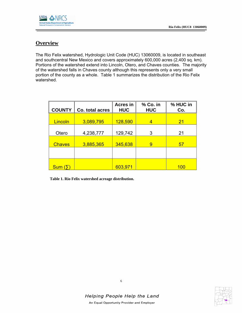
Overview The Rio Felix watershed, Hydrologic Unit Code (HUC) 13060009, is located in southeast and southcentral New Mexico and covers approximately 600,000 acres (2,400 sq. km). Portions of the watershed extend into Lincoln, Otero, and Chaves counties. The majority of the watershed falls in Chaves county although this represents only a very small portion of the county as a whole. Table 1 summarizes the distribution of the Rio Felix watershed.
Table 1. Rio Felix watershed acreage distribution.
COUNTY Co. total acresAcres in
HUC % Co. in
HUC % HUC in
Co.
Lincoln 3,089,795 128,590 4 21
Otero 4,238,777 129,742 3 21
Chaves 3,885,365 345,638 9 57
Sum (∑) 603,971 100

Rio Felix (HUC8 13060009)
7
General History of the area: Castano de Sosa's Route - In 1590-91 Gaspar Castano de Sosa, a Portuguese by birth, took an expedition up the Pecos River in an attempt to establish a colony in New Mexico. His venture was a failure, but it led to a permanent settlement under Don Juan de Onate in 1598. Castano de Sosa passed near here in winter of 1590, as he pushed north along the Pecos River, the group passed along this route in the vicinity of present-day Artesia and Roswell. The county was named for Colonel José Francisco Chaves a military leader during the U.S. Civil War, and also served as a delegate-elect to Congress for NM in 1865. He served three terms as a congressman for NM and also served as speaker of the Lower House of the “New Mexico Territorial Legislature” which represented southeastern NM. John Chisum's cattle drives along the Pecos River started in 1866. Mr. Chisum's cowboys often used the springs at Artesia to water their cattle. In the 1890's, a former Union soldier, John F. Truitt, homesteaded along the Chisum Trail, just a few blocks from what is today Artesia's business district. John Chisum's niece, Sally Chisum Robert, also filed a homestead claim in the area and lived on her property for many years. A stage stop, "Blake's Spring" was established in 1894. When the Pecos Valley Railroad built a siding, they named it "Miller's Siding". In 1889, Captain Joseph Lea, for whom Lea County is named, successfully persuaded the New Mexico legislature to create a new county from Lincoln County lands. Captain Lea insisted that the new county be named for his close friend and political ally Colonel José Francisco Chaves. Hagerman in Chaves County was first laid out to be on the new PV&NE railroad (Pecos Valley and Northeastern) in 1894. Initially, it was known as Felix for the River Felix, which enters the Pecos River just north of the town. The name was shortly changed to on or J. J. Hagerman, builder of the railroad. Though Hagerman's railroad was later acquired by the AT&SF railroad, his name remains on the town. Mr. Hagerman later bought the Old Chisum Ranch which, after his death, was sold to Cornell University. Hagerman is on NM 2 about 17 miles southeast of Roswell. It's a tranquil farming town now. A man named Stegman, a land promoter, married Sally Chisum Robert. He established the first post office 1899 as the Stegman Post Office. In 1903, the Artesia Homesite Co. was formed to promote real estate in the expanding community. A special feature was the many artesian wells that were supplying water. "Stegman" finally became "Artesia". Oil was discovered in 1924 and added a profitable income to the area's ranching and farming businesses.

Rio Felix (HUC8 13060009)
8
Physical Setting Geology: The Sacramento Mountains, together with Sierra Blanca and the Capitan Mountains at the northern end of the range, constitute one of the largest and most conspicuous mountain ranges in southern New Mexico. The profile of the Sacramento’s eastward from the crest of the mountains, the land surface merges almost imperceptibly with the Pecos slope, a flat, nearly treeless plain that slopes gently downward toward the Pecos River, 80 miles away and 6,000 feet lower in elevation. Most of the crest and eastern slope of the Sacramento’s is capped by limestone of the San Andres Formation. San Andres limestone constitute most of the artesian aquifer that provides water for irrigation in the Roswell artesian basin of Chaves and northern Eddy Counties. Where it is exposed at the surface, the San Andres is charged with fresh water by rainfall and ephemeral streams flowing across the Pecos slope. Recharge of the aquifer is facilitated by the Pecos buckles, a series of parallel faults and folds that extend as far as 80 miles in a northeast direction across the slope. Fractures are commonly associated with the Pecos buckles, providing conduits for surface water to flow downward into the aquifer. A few miles west of Roswell, near Six Mile Hill, the San Andres Formation dips into the subsurface and extends eastward beneath the Pecos River valley. At greater depths east of the Pecos River, the San Andres is an important oil and gas reservoir. The Rio Felix is located in the Pecos Valley Section of the Great Plains Province. It has a drainage area of about 17 square miles. The stream heads on Permian aged San Andres Limestone. The limestone covers a large amount of area and dips to the east from the flanks of the Sacramento Mountains. The stream flows across Quaternary sediments along its lower reaches before joining the Pecos River near Hagerman. Soils: Hydrologic soil groups are based on estimates of runoff potential. Soils are assigned to one of four groups according to the rate of water infiltration when the soils are not protected by vegetation, are thoroughly wet, and receive precipitation from long-duration storms. The soils in the Rio Felix Watershed are assigned to four groups (A, B, C, and D).
Group A. Soils having a high infiltration rate (low runoff potential) when thoroughly wet. These consist mainly of deep, well drained to excessively drained sands or gravelly sands. These soils have a high rate of water transmission.

Rio Felix (HUC8 13060009)
9
Group B. Soils having a moderate infiltration rate when thoroughly wet. These consist chiefly of moderately deep or deep, moderately well drained or well drained soils that have moderately fine texture to moderately coarse texture. These soils have a moderate rate of water transmission.
Group C. Soils having a slow infiltration rate when thoroughly wet. These consist chiefly of soils having a layer that impedes the downward movement of water or soils of moderately fine texture or fine texture. These soils have a slow rate of water transmission.
Group D. Soils having a very slow infiltration rate (high runoff potential) when thoroughly wet. These consist chiefly of clays that have a high shrink-swell potential, soils that have a high water table, soils that have a claypan or clay layer at or near the surface, and soils that are shallow over nearly impervious material. These soils have a very slow rate of water transmission.
Figure 2. Hydrologic Soil Group

Rio Felix (HUC8 13060009)
10
Elevation ranges from about 8,675 ft. (2,645 m) at the summit of Harley Mtn. in northeast Otero Co. to 3,385 ft. (1,030 m) at the confluence of the Rio Felix and Pecos River. The watershed is characterized with low relief with more than half of the area sloping less than 10%. Geomorphic characteristics are given in Table 2. Figure 3. Rio Felix shaded relief. Table 2. Geomorphic characteristics.
% Slope
% of HUC Aspect
% of HUC
0 - 5 33 Flat 5 5 - 10 23 North 23 10 - 15 15 East 31 15 - 25 17 South 26 > 25 12 West 15

Rio Felix (HUC8 13060009)
11
Precipitation 1 Figure 4. Annual precipitation.
Annual Precipitation

Rio Felix (HUC8 13060009)
12
Land Ownership 2
Figure 5. Land Ownership. Table 3. Land ownership acreage distribution. Reported to the nearest hundred acres.
County BLM State Private Tribal
Lincoln 24,500 5,400 98,700
Otero 129,700
Chaves 136,600 20,800 188,200
Sum (∑) 161,100 26,200 286,900 129,700
% of Watershed 27 4 48 21
Land Ownership

Rio Felix (HUC8 13060009)
13
Land Use / Land Cover 3,4
Figure 6. Subset of the NLCD over the Rio Felix watershed. Table 4. Extent of NLCD classes. Reported to the nearest hundred acres.
The U.S. Geological Survey (USGS) produced the National Land Cover Dataset (NLCD) as part of a cooperative project between the USGS and the U.S. Environmental Protection Agency (USEPA). The goal of this project was to produce a consistent land cover data layer for the conterminous United States. The Multiresolution Land Characterization (MRLC) Consortium collected the data used to compile the NLCD. The MRLC Consortium is a partnership of Federal agencies that produce or use land cover data; partners include the UNITED STATES GEOLOGICAL SURVEY (National Mapping, Biological Resources, and Water Resources Divisions), USEPA, the U.S. Forest Service, and the National Oceanic and Atmospheric Administration.
Land Use \ Land Cover Acres % of Watershed
commercial,industrial,transportion 100 <1 bare rock, sand, clay 600 <1 small grains 900 <1 pasture, hay 1000 <1 deciduous forest 1,200 <1 row crops 3800 <1 evergreen forest 87,000 14 shrubland 229300 38 grasslands, herbaceous 281,400 46
National Land Cover Dataset

Rio Felix (HUC8 13060009)
14
Land Use / Land Cover Figure 7. Subset of the SW ReGAP. The 12 dominant ecosystems are shown in the legend.
Southwest Region GAP Analysis

Rio Felix (HUC8 13060009)
15
Land Use / Land Cover Table 5. Extent of SW ReGAP ecosystems. Reported to the nearest hundred acres.
The land cover mapping effort for the Southwest Region Gap Analysis Project was a coordinated multi-institution endeavor. This dataset was created for regional terrestrial biodiversity assessment. Additional objectives were to establish a coordinated mapping approach to create detailed, seamless maps of land cover, all native terrestrial vertebrate species, land stewardship, and management status, and to analyze this information to identify those biotic elements that are underrepresented on lands managed for their long term conservation.
Ecosystem Acres % of Watershed
Apacherian-Chihuahuan Piedmont Semi-Desert Grassland and Steppe 190,300 31
Western Great Plains Shortgrass Prairie 94,500 16
Madrean Pinyon-Juniper Woodland 84,300 14
Chihuahuan Creosotebush, Mixed Desert and Thorn Scrub 58,200 10
Madrean Pine-Oak Forest and Woodland 38,000 6
Southern Rocky Mountain Juniper Woodland and Savanna 21,500 4
Southern Rocky Mountain Pinyon-Juniper Woodland 18,600 3
Rocky Mountain Gambel Oak-Mixed Montane Shrubland 14,600 2
Southern Rocky Mountain Montane-Subalpine Grassland 14,400 2
Madrean Juniper Savanna 13,700 2
Apacherian-Chihuahuan Mesquite Upland Scrub 12,000 2
Rocky Mountain Ponderosa Pine Woodland 11,900 2
Agriculture 6,800 1
Madrean Encinal 3,700 1
Rocky Mountain Lower Montane-Foothill Shrubland 2,900 < 1
Western Great Plains Sandhill Shrubland 2,700 < 1
Inter-Mountain Basins Semi-Desert Shrub Steppe 2,300 < 1
Western Great Plains Cliff and Outcrop 2,300 < 1
North American Warm Desert Bedrock Cliff and Outcrop 2,000 < 1
Madrean Upper Montane Conifer-Oak Forest and Woodland 1,800 < 1
Rocky Mountain Lower Montane Riparian Woodland and Shrubland 1,600 < 1
Chihuahuan Sandy Plains Semi-Desert Grassland 1,400 < 1
Chihuahuan Mixed Salt Desert Scrub 1,000 < 1
North American Warm Desert Playa 800 < 1
Mogollon Chaparral 800 < 1
Western Great Plains Foothill and Piedmont Grassland 600 < 1
Recently Burned 500 < 1
North American Warm Desert Riparian Woodland and Shrubland 400 < 1
Inter-Mountain Basins Semi-Desert Grassland 400 < 1
Rocky Mountain Subalpine-Montane Limber-Bristlecone Pine Woodland 200 < 1
North American Warm Desert Lower Montane Riparian Woodland and Shrubland 200 < 1
North American Arid West Emergent Marsh 200 < 1
North American Warm Desert Wash 100 < 1
Rocky Mountain Cliff and Canyon 100 < 1 Open Water 100 < 1

Rio Felix (HUC8 13060009)
16
Hydrology 4,6,7,8
Under section 303(d) of the Clean Water Act, states, territories, and authorized tribes, are required to develop lists of impaired waters. These are waters for which technology-based regulations and other required controls are not stringent enough to meet the water quality standards set by states. The law requires that states establish priority rankings for waters on the lists and develop Total Maximum Daily Loads (TMDLs), for these waters. A TMDL is a calculation of the maximum amount of a pollutant a water body can receive and still safely meet water quality standards. The New Mexico Water Quality Control Commission (NMWQCC) is the issuing agency of water quality standards for interstate and intrastate waters. In this role, it is the responsibility of the NMWQCC to assess the waters in New Mexico for compliance with the Clean Water Act. The NMWQCC has subdivided the Rio Felix watershed into 1 reach (Table 6). Table 6. NMWQCC designated uses and 303(b) assessments.
Reach Irrigation Livestock Watering
Secondary Contact
Warmwater Aquatic
Life Wildlife Habitat
Rio Felix (Pecos River to headwaters) x x x x x x = Designated Use Not Assessed Fully Supporting

Rio Felix (HUC8 13060009)
17
Hydrology
Within the 2008 - 2010 New Mexico Integrated Clean Water Act Report, the listed reach within the Rio Felix watershed was evaluated for compliance with Section 303(d) of the Clean Water Act. This reach, Rio Felix (Pecos River to headwaters) did not have any impairments for which it was assessed. It is graphically represented in Figure 7.
Figure 8. National Hydrology Dataset and 303(b) assessed reaches.
303(b) Assessed Waters

Rio Felix (HUC8 13060009)
18
Hydrology There are three declared groundwater basins within the Rio Felix watershed. These basins cover 100% of the area within the watershed. A declared groundwater basin is an area of the state proclaimed by the State Engineer to be underlain by a groundwater source having reasonably ascertainable boundaries. By such proclamation the State Engineer assumes jurisdiction over the appropriation and use of groundwater from the source. Figure 8 summarizes groundwater basins in the Rio Felix watershed.
Figure 9. Groundwater basins and their extents.
Groundwater Basins

Rio Felix (HUC8 13060009)
19
Threatened and Endangered Species 9
Endangered species are those that are at risk of extinction throughout all or a significant portion of its native range. A threatened species is one that is likely to become endangered in the foreseeable future. The New Mexico Natural Heritage Program (NMNH), a division of the Museum of Southwestern Biology, collects data on the biology, status and location of the New Mexico’s biological resources. In addition, NMNH keeps track of any legal or informal status applied to biological resources with respect to rarity or conservation priority by both governmental and non-governmental agencies. As such, NMNH maintains a tracking list of about 600 Threatened, Endangered, and Sensitive (TES) animal and plant species of particular concern or sensitivity in New Mexico. Table 7 lists those species which are currently listed and tracked in the Rio Felix watershed. Table 7. NMNH tracked plant and animal species. Field Descriptions are listed in Appendix A.
Common Name
Scientific Name
Taxonomic Class
Family Fed
StatusState
Status Global Rank
State Rank
Ferruginous Hawk
Buteo regalis Aves Accipitridae G4 S2B,S4N
Northern Goshawk
Accipiter gentilis
Aves Accipitridae G5 S2B,S3N
Mexican Spotted Owl
Strix occidentalis lucida
Aves Strigidae LT G3T3 S2B,S2N
Sacramento Groundsel
Senecio sacramentanus
Dicotyledoneae Asteraceae G3 S3
Tall Bitterweed
Hymenoxys brachyactis
Dicotyledoneae Asteraceae G3 S3
Grama Grass Cactus
Sclerocactus papyracanthus
Dicotyledoneae Cactaceae G4 S4
A Milk-vetch
Astragalus siliceus
Dicotyledoneae Fabaceae G3 S3
Santa Fe Milk-vetch
Astragalus feensis
Dicotyledoneae Fabaceae G3 S3
New Mexico Scorpion-weed
Phacelia neomexicana
Dicotyledoneae Hydrophyllaceae G5 S3?
Gunnison's Prairie Dog
Cynomys gunnisoni
Mammalia Sciuridae G5 S2
Merriam's Shrew
Sorex merriami Mammalia Soricidae G5 S2

Rio Felix (HUC8 13060009)
20
Invasive Species 10 Invasive species are those which have been introduced into a region or ecosystem and have the ability to out-compete native species for resources (i.e. water, nutrients, sunlight, etc.) The Southwest Exotic Plant Mapping Program (SWEMP) is a collaborative effort between the United States Geological Survey and federal, tribal, state, county and non-government organization partners in the southwest which maintains ongoing efforts to compile and distribute regional data on the occurrence of non-native invasive plants in the southwestern United States. Within the Rio Felix watershed, the SWEMP has identified and cataloged the occurrence of 1invasive plant species. While other invasive species are likely present, cooperating partners to the SWEMP simply can’t cover the entire landscape. Species that have been identified within 20 miles of the Rio Felix watershed are listed in Table 8. These species are defined as non-native by the USDA PLANTS database.
Table 8. SWEMP listed plant species, including 20 mile buffer.
Scientific Name Common Name
Acroptilon repens hardheads
Carduus nutans nodding plumeless thistle
Centaurea melitensis Maltese star-thistle
Centaurea stoebe ssp. micranthos spotted knapweed
Dactylis glomerata orchardgrass
Peganum harmala African rue
Poa pratensis Kentucky bluegrass
Tamarix species tamarisk

Rio Felix (HUC8 13060009)
21
Common Resource Areas
A Common Resource Area (CRA) is defined as a geographical area where resource concerns, problems, or treatment needs are similar. It is considered a subdivision of an existing Major Land Resource Area (MLRA) designation. Landscape conditions, soil, climate, human considerations, and other natural resource information are used to determine the geographic boundaries of a Common Resource Area.
Each Common Resource Area will have multiple Conservation System Guides associated with it. A Conservation System Guide associates, for a given CRA and land use, different components of Resource Management Systems and their individual effect on conserving soil and water resources.
Figure 10. Common Resource Areas.
Common Resource Areas

Rio Felix (HUC8 13060009)
22
Common Resource Areas
42.3 – Chihuahuan Desert Grasslands This unit occurs within the Basin and Range Physiographic Province and is characterized by valley plains and alluvial fans broken by the Pecos River. Drainage divides are low and inconspicuous forming one great plain. Elevations range from 2800 to 5000 feet. Precipitation ranges from 8 to 13 inches per year. The soil temperature regime is thermic. The soil moisture regime is aridic. Vegetation includes tobosa, alkali sacaton, black grama, burrograss, creosote bush, tarbush, soaptree yucca, catclaw, fourwing saltbush, winterfat, mesquite and desert willow.
39.2 – Central New Mexico Highlands This unit occurs within the Colorado Plateau Physiographic Province and is characterized by volcanic fields and gently dipping sedimentary rocks eroded into plateaus, valleys and deep canyons. Elevations range from 7000 to 12000 feet. Precipitation ranges 17 to 25 inches per year. The soil temperature regime ranges from mesic to frigid. Vegetation includes corkbark, Douglas and white fir, Englemann spruce, pinyon and southwestern white pine, and aspen. Grasslands include tufted hairgrass, sedges, and Arizona and Thurber fescue.
70C – Central New Mexico Highlands Tablelands and mesas separated by broad plains and small terraces characterize this area. Elevation is 5,000 to 7,200 feet and precipitation is 12 to 17 inches. The soil moisture regime is aridic to ustic and the soil temperature regime is mesic. Pinyon-juniper savannah and pinyon juniper woodlands at higher elevations, and broad mid- to short-grass prairies and basins at lower elevations dominate the area. Current land use is livestock grazing. The soils formed in Quaternary alluvium, eolian sands, and sedimentary rocks of Permian age. (Old CP-3)
70D - Southern New Mexico Foothills This unit is characterized by nearly level to steep limestone hills with steep, narrow drainageways. Elevation ranges from 4,000 to 7,000 feet and average annual precipitation is 13 to 18 inches. Native vegetation is sparse and consists of pinyon, juniper, algerita, agave, yucca and cacti. Grasses include blue and black grama, little bluestem, and muhly species. Shrubs include catclaw, ocotillo, sotol and fourwing saltbush. Much of the area is federally owned. Federal and private lands are used for grazing, wildlife habitat, and military training.

Rio Felix (HUC8 13060009)
23
Conservation The USDA-Natural Resources Conservation Service (NRCS) focuses on the development and delivery of high quality products and services that enable agricultural producers to be good stewards of our Nation’s soil, water, and related natural related resources on non-Federal lands. The Natural Resources Conservation Service’s conservation programs aid producers in their efforts to reduce soil erosion, enhance water supplies, improve water quality, increase wildlife habitat, and reduce damages caused by floods and other natural disasters. Public benefits include enhanced natural resources that help sustain agricultural productivity and environmental quality while supporting continued economic development, recreation, and scenic beauty. In fiscal year 2008, nearly 100 planned conservation practices sought to address resource concerns on more than 120,000 acres in the Rio Felix watershed. These programs were administered from the Carrizozo, Roswell, and Alamogordo USDA-NRCS Service Centers. Tables 9 and 10 summarize these practices.
Table 9. 2008 planned conservation practices. Reported in acres.
Conservation Practice Chaves Lincoln Otero
Brush Management 582 108 ---
Conservation Crop Rotation 107 --- ---
Irrigation System, Sprinkler 111 --- ---
Irrigation Water Management 107 --- ---
Nutrient Management 107 --- ---
Pest Management 107 --- ---
Prescribed Grazing 20,082 27,678 12,126
Residue Management, Seasonal 107 --- ---
Upland Wildlife Habitat Management 20,195 27,678 12,126
Forest Stand Improvement --- --- 146

Rio Felix (HUC8 13060009)
24
Conservation Table 10 lists planned conservations practices that are location specific (one dimensional) within the Rio Felix watershed. There were no planned conservations in the Otero County portion of the watershed.
Table 10. Location specific 2008 planned conservation practices.
County Practice # of Plans Total
Co
un
t P
ract
ices
Chaves Comprehensive Nutrient Management Plan 1 1
Chaves Pumping Plant 1 1
Chaves Structure for Water Control 1 1
Chaves Watering Facility 6 6
Lincoln Watering Facility 1 1
Dis
tan
ce P
ract
ices
Chaves Irrigation Water Conveyance, Pipeline, High-Pressure, Underground, Plastic
2 3,100 ft.
Lincoln Fence 1 13,300 ft.
Lincoln Pipeline 2 9,900 ft.

Rio Felix (HUC8 13060009)
25
Soil Resource Inventory All of the ~ 600,000 acres in the Rio Felix watershed have a certified Soil Survey Geographic Database - National Cooperative Soil Survey inventory. Soil resource inventories have been conducted on 3 distinct areas including lands managed by the Bureau of Land Management and the State of New Mexico, as well as those that are privately held.
Figure 11. National Cooperative Soil Survey coverage.
Soil Survey Areas

Rio Felix (HUC8 13060009)
26
Soil Resource Inventory In order to evaluate the susceptibility of erosion within the Rio Felix watershed, a model was developed using Soil Survey Geographic Database (SSURGO) information. The soil properties saturated hydraulic conductivity, soil loss tolerance, and wind erodibility group were used in conjunction with slope to assess soil mapunit potential for erosion. Saturated hydraulic conductivity and slope are reported in SSURGO databases as interval/ratio data whereas wind erodibility and soil loss tolerance are ordinal data. Data transformations for the model are listed -
Table 11. Soil erosion model criteria.
SSURGO Value Nominal Description Model Rank Saturated Hydraulic
Conductivity µm / s
705.0 - 100.0 Very High 0 100.0 - 10.0 High 1
10.0 - 1.0 Moderately High 2 1.0 - 0.1 Moderately Low 3 0.1 - 0.01 Low 4
Slope % 0 - 5 0 5 - 10 1
10 - 15 2 15 - 25 3
> 25 4
Soil Loss Tolerance 5 High Tolerance For loss 0 4 ↓ 1 3 ↓ 2 2 ↓ 3 1 Low Tolerance For Loss 4
Wind Erodibility Group 1 Very High 4 2 Very High 4 3 High 3 4 High 3 4L High 3 5 Moderate 2 6 Moderate 2 7 Moderate 1 8 Slight 0

Rio Felix (HUC8 13060009)
27
Soil Resource Inventory For each soil map unit (discrete delineation), the soil properties (named above) of the dominant soil type was used as the condition to be evaluated in the susceptibility to erosion model. Miscellaneous areas such as gravel pits, water, riverwash, etc. were excluded from evaluation. Possible range of values for each map unit are 0 – 16. Increasing values represent a higher susceptibility to soil erosion. Figure 12. Rio Felix watershed soil erosion potential.
Soil Erosion Susceptibility

Rio Felix (HUC8 13060009)
28
Soil Resource Inventory Table 12. Potential soil erosion model results.
Rank Acres % of Watershed
3 4,289 1
4 5,156 1
5 77,159 13
6 111,834 19
7 36,355 6
8 16,595 3
9 198,428 33
10 74,802 12
11 321 < 1
12 78,978 13

Rio Felix (HUC8 13060009)
29
Socioeconomic 11 Table 13. Socioeconomic data for counties within the watershed.
County Total pop.
Total Urban
Total Rural
Total Rural; Farm
Total Rural;
Nonfarm
Total Hispanic
or Latino
Total White
Total Black or African
American
Total American
Indian and
Alaska Native
Total Asian
Total Native
Hawaiian and
Other Pacific
Islander
Total Some other race
Total Two or
more races
Family median income in 1999
Chaves 61,382 47,158 14,224 1,044 13,180 27,016 44,175 1,226 621 387 50 12,810 2,113 $32,532 Lincoln 19,411 9,251 10,160 309 9,851 4,978 16,298 65 311 57 9 2,149 522 $40,035 Otero 62,298 43,703 18,595 530 18,065 19,980 45,840 2,211 3,624 714 17 6,993 2,899 $34,781

Rio Felix (HUC8 13060009)
30
References Regional Geology of the Pecos Country, New Mexico, Lewis A. Land, New Mexico Bureau of Geology and Mineral Resources 1. Parameter-elevation Regressions on Independent Slopes Model (PRISM).PRISM is a unique knowledge-based system that uses point measurements of precipitation, temperature, and other climatic factors to produce continuous, digital grid estimates of monthly, yearly, and event-based climatic parameters. http://www.prism.oregonstate.edu/ 2. Bureau of Land Management – New Mexico State Office http://www.blm.gov/nm/st/en/prog/more/geographic_sciences/spatial_data_metadata.html 3. United States Geological Survey – National Land Cover Dataset http://landcover.United States Geological Survey.gov/ 4. Southwest Region Gap Analysis Project (SWReGAP). http://earth.gis.usu.edu/swgap/ 5. United States Geological Survey - National Hydrography Dataset http://nhd.United States Geological Survey.gov/ 6. United States Environmental Protection Agency http://www.epa.gov/owow/tmdl/ 7. New Mexico Environment Department – Water Quality Control Comission http://www.nmenv.state.nm.us/wqcc/index.html 8. New Mexico Office of the State Engineer http://www.ose.state.nm.us/index.html
9. New Mexico Natural Heritage http://nhnm.unm.edu/ 10. Southwest Exotic Plant Mapping Program - http://www.invasiveweeds.com/mapping/welcome.html 11. United States Census Bureau - http://factfinder.census.gov/home/saff/main.html?_lang=en

Rio Felix (HUC8 13060009)
31
Appendix A
BASIC FEDERAL STATUS DESIGNATIONS
LE = Listed Endangered Species for which a final rule has been published in the Federal Register to list the species as endangered. Species is legally protected by the Endangered Species Act.
LT = Listed Threatened Species for which a final rule has been published in the Federal Register to list the species as threatened. Species is legally protected by the Endagered Species Act.
PE = Proposed Endangered Species for which a proposed rule has been published in the Federal Register to list the species as endangered
PT = Proposed Threatened Species for which a proposed rule has been published in the Federal Register to list the species as threatened.
C or CN = Candidate for Listing Substantial information exists in U.S. Fish and Wildlife Service files on biological vulnerability to support proposals to list as endangered or threatened.
SC = Species of Concern The terms "Species of Concern" or "Species at Risk" should be considered as terms-of-art that describe the entire realm of taxa whose conservation status may be of concern to the US Fish and Wildlife Service, but neither term has official status (currently all former C2 species).
PDL = Proposal for delisting Species for which a final rule has been published in the Federal Register to delist the species.
XN = Non-essential Experimental Population Species for which a population has been artificially established in the wild which is not essential to the survival of the species in the wild.
T(S/A) = Listed as Threatened Due to Similarity of Appearance

Rio Felix (HUC8 13060009)
32
Appendix A
STATE STATUS DESIGNATIONS FOR ANIMALS
E = Endangered Any species or subspecies whose prospects of survival or recruitment in New Mexico are in jeopardy.
T = Threatened Any species or subspecies that is likely to become endangered within the foreseeable future throughout all or a significant portion of its range in New Mexico.
STATE STATUS DESIGNATIONS FOR PLANTS
E = Endangered - The taxon is listed as threatened or endangered under the provisions of the Federal Endangered Species Act (16 U.S.C. Sections 1531 et seq.), or is considered proposed under the tenets of the act [10-29-85,]; or the taxon is a rare plant across its range within the state, and of such limited distribution and population size that unregulated taking could adversely impact it and jeopardize its survival in New Mexico. [10-29-85, 8-31-95]
SoC = Species of Concern - A New Mexico plant species, which should be protected from land use impacts when possible because it is a unique and limited component of the regional flora.
Appendix A

Rio Felix (HUC8 13060009)
33
BASIC GLOBAL RANKS
GX = Presumed Extinct Believed to be extinct throughout its range. Not located despite intensive searches and virtually no likelihood that it will be rediscovered.
GH = Possibly Extinct Known only from historical occurrences. Still some hope of rediscovery.
G1 = Critically Imperiled Critically imperiled globally because of extreme rarity or because of some factor(s) making it especially vulnerable to extinction. Typically 5 or fewer occurrences or very few remaining individuals (<1,000).
G2 = Imperiled Imperiled globally because of extreme rarity or because of some factor(s) making it especially vulnerable to extinction. Typically 6 to 20 occurrences or few remaining individuals (1,000 to 3,000).
G3 = Vulnerable Vulnerable globally either because very rare and local throughout its range, found only in a restricted range (even if abundant at some locations) , or because of other factors making it vulnerable to extinction. Typically 21 to 100 occurrences or between 3,000 and 10,000 individuals
G4 = Apparently Secure Uncommon but not rare, and usually widespread. Possibly cause for longterm concern. Typically more than 100 occurrences globally or more than 10,000 individuals.
G5 = Secure Common, typically widespread and abundant.

Rio Felix (HUC8 13060009)
34
Appendix A
BASIC STATE RANKS
SX = Presumed Extirpated Believed to be extirpated. Not located despite intensive searches and virtually no likelihood that it will be rediscovered.
SH = Possibly Extirpated Known only from historical occurrences. Still some hope of rediscovery.
S1 = Critically Imperiled Critically imperiled in the state because of extreme rarity or because of some factor(s) making it especially vulnerable to extirpation. Typically 5 or fewer occurrences or very few remaining individuals (<1,000).
S2 = Imperiled Imperiled in the state because of extreme rarity or because of some factor(s) making it especially vulnerable to extirpation. Typically 6 to 20 occurrences or few remaining individuals (1,000 to 3,000).
S3 = Vulnerable Vulnerable in the state either because very rare and local throughout its range, found only in a restricted range (even if abundant at some locations) , or because of other factors making it vulnerable to extirpation. Typically 21 to 100 occurrences or between 3,000 and 10,000 individuals
S4 = Apparently Secure Uncommon but not rare, and usually widespread. Possibly cause for longterm concern. Typically more than 100 occurrences in the state or more than 10,000 individuals.
S5 = Secure Common, typically widespread and abundant.
VARIANT STATE RANKS
S#S# = Range Rank A numeric range rank (e.g., S2S3) is used to indicate uncertainty about the exact status of a taxon.
SA = Accidental Accidental or casual in NM. In other words, infrequent and outside usual range. Includes species (usually birds or butterflies) recorded once or only a few times at a location.

Rio Felix (HUC8 13060009)
35
Appendix A
SE = Exotic An exotic established in state; may be native elsewhere in North America; includes fish native to NM but introduced into watersheds where the species is non-native. An exotic established in NM may be assigned a numeric rank (e.g. SE2) to indicate its status, as defined for S1 through S5.
SU = Unrankable Currently unrankable due to lack of available information about status or trends.
HYB = Hybrid
SRF = False Report Element reported in NM but the report is known to be invalid.
SNR = Not Ranked State conservation status not yet assessed.
S? = Unranked Rank not yet assessed.
RANK QUALIFIERS
? = Inexact numeric rank Denotes inexact numeric rank.
Q = Questionable taxonomy Taxonomic status is questionable; numeric rank may change with taxonomy.
C = Captive or cultivated only Taxon at present is extant only in captivity or cultivation, or as a reintroduced population not yet established.
B = Breeding The associated rank refers to breeding occurrences of mobile animals.
N = Non-breeding The associated rank refers to non-breeding occurrences of mobile animals.
Z = Moving Occurs in the state, but as a diffuse, usually moving population; difficult or impossible to map static occurrences.


