January 14, 2020 Mr. Yaniv Cohen E.A.Y.C. Investments, LLC 4021 N. Andrews Avenue, Suite #5 Oakland Park, Florida 33309 Re: 914 Marseille Drive, Miami Beach Traffic Statement Dear Yaniv: Per your request, Traf Tech Engineering, Inc. has prepared a traffic statement associated with the proposed residential development planned to be located on the south side of Marseille Drive approximately 75 feet west of Bay Drive in the City of Miami Beach, Miami-Dade County, Florida. More specifically, the subject site (i.e. Site 1) is located at 914 Marseille Drive and the Folio Number is 02-3210-013-0311. This project also incorporates an adjacent property (i.e. Site 2) located at 7116 Bay Drive (Folio Number 02-3210-013-0330). Figure 1 on the following page shows the location of both properties and surveys for these parcels are contained in Attachment A to this memorandum. This report documents the projected trip generation characteristics for the existing and proposed development as well as the anticipated driveway volume assignment at full build-out. The following is a summary of our findings. Trip Generation Analysis A trip generation analysis was performed using the trip generation rates and equations published in the Institute of Transportation Engineer’s (ITE) Trip Generation Manual (10 th Edition). The trip generation analysis was undertaken for daily and PM peak hour conditions. The analysis was based on the following assumptions: EXISTING DEVELOPMENT (Site 2 – 7116 Bay Drive) o 6 multifamily (low-rise) residential dwelling units (to remain) PROPOSED DEVELOPMENT (Site 1 – 914 Marseille Drive) o 6 multifamily (mid-rise) residential dwelling units (refer to site plan contained in Attachment B)
Transcript
January 14, 2020 Mr. Yaniv Cohen E.A.Y.C. Investments, LLC 4021 N. Andrews Avenue, Suite #5 Oakland Park, Florida 33309 Re: 914 Marseille Drive, Miami Beach
Traffic Statement Dear Yaniv: Per your request, Traf Tech Engineering, Inc. has prepared a traffic statement associated with the proposed residential development planned to be located on the south side of Marseille Drive approximately 75 feet west of Bay Drive in the City of Miami Beach, Miami-Dade County, Florida. More specifically, the subject site (i.e. Site 1) is located at 914 Marseille Drive and the Folio Number is 02-3210-013-0311. This project also incorporates an adjacent property (i.e. Site 2) located at 7116 Bay Drive (Folio Number 02-3210-013-0330). Figure 1 on the following page shows the location of both properties and surveys for these parcels are contained in Attachment A to this memorandum. This report documents the projected trip generation characteristics for the existing and proposed development as well as the anticipated driveway volume assignment at full build-out. The following is a summary of our findings. Trip Generation Analysis A trip generation analysis was performed using the trip generation rates and equations published in the Institute of Transportation Engineer’s (ITE) Trip Generation Manual (10th Edition). The trip generation analysis was undertaken for daily and PM peak hour conditions. The analysis was based on the following assumptions: EXISTING DEVELOPMENT (Site 2 – 7116 Bay Drive)
o 6 multifamily (low-rise) residential dwelling units (to remain) PROPOSED DEVELOPMENT (Site 1 – 914 Marseille Drive)
o 6 multifamily (mid-rise) residential dwelling units (refer to site plan contained in Attachment B)
FIGURE 1914 Marseille Drive
Miami Beach, FloridaProject Location MapTraf Tech
ENGINEERING, INC.
N
LEGEND
Subject Site
Site 1Site 2
3
According to referenced ITE Trip Generation Manual, the trip generation rates and equations used for the existing and proposed development are: MULTIFAMILY HOUSING (LOW-RISE) (ITE Land Use 220)
Daily Trip Generation: T = 7.32 (X) where T = number of daily trips, X = number of dwelling units
PM Peak Hour of Generator: T = 0.66(X) + 1.41 (59% in / 41% out)
where T = number of peak hour trips, X = number of dwelling units MULTIFAMILY HOUSING (MID-RISE) (ITE Land Use 221)
Daily Trip Generation: T = 5.44 (X) where T = number of daily trips, X = number of dwelling units
PM Peak Hour of Generator: Ln(T) = 0.83 Ln(X) – 0.05 (60% in / 40% out)
where T = number of peak hour trips, X = number of dwelling units Using the above-listed trip generation rates and equations from the referenced ITE manual, a trip generation analysis was undertaken for the existing and proposed residential development. The results of this effort are documented in Table 1 below. Excerpts from the ITE Trip Generation Manual are presented in Attachment C to this memorandum.
DailyLand Use Trips In Out Total
Existing DevelopmentMultifamily Housing (Low-Rise) 6 DU 44 3 2 5
Total 44 3 2 5
Proposed DevelopmentMultifamily Housing (Low-Rise) 6 DU 44 3 2 5Multi-Family Housing (Mid-Rise) 6 DU 33 2 2 4
As indicated in Table 1, the proposed 914 Marseille Drive project is projected to generate approximately 33 net new daily vehicle trips and approximately four (4) net new PM peak hour (of the generator) trips (2 inbound and 2 outbound). Therefore, the proposed residential development is anticipated to have a de-minimis traffic impact to the surrounding street system (i.e. one new peak hour trip every 15 minutes). Driveway Assignment As indicated in the site plan contained in Attachment B, a parking lot with eight (8) parking spaces will be provided on the western portion of Site 2 (i.e. 7116 Bay Drive) and to the south of Site 1 (i.e. 914 Marseille Drive). This parking lot will be located along Normandy Court – a one-way (eastbound) alley between Rue Versailles Drive and Bay Drive. It is noted that on-street parking along the surrounding streets will be available to the residents of this development (as they are today); however, for the purposes of this driveway assignment task, all entering and exiting traffic have been assigned to the driveway serving the subject parking lot. The resulting assignment is presented in Attachment D to this memorandum. If you have any questions or require additional information, please do not hesitate to contact me. Sincerely, TRAF TECH ENGINEERING, INC. Joaquin E. Vargas, P.E. Senior Transportation Engineer
FLOOD ZONE: AEMAP & PANEL= 12086C0307COMMUNITY No.: 120651SUFFIX: LDATE OF FIRM: 09-11-2009BASE ELEV.= +8.00 NGVD 1929 NOT VALID WITHOUT THE SIGNATURE AND THE
ORIGINAL RAISED SEAL OF A FLORIDA LICENSEDSURVEYOR AND MAPPER.
SURVEYOR'S NOTES: 1) NOT VALID UNLESS SIGNATURE IS EMBOSSED WITH THE REGISTERED LAND SURVEYOR'S SEAL. 2) LEGAL DESCRIPTION PROVIDED BY OTHERS. 3) PROPERTIES SHOWN HEREON WERE NOT ABSTRACTED FOR EASEMENTS OR OTHER RECORDEDENCUMBRANCES NOT SHOWN ON THE PROPERTY PLAT OF RECORD. 4) MEASUREMENTS TO WOOD FENCES ARE TO OUTSIDE OF WOOD. 5) UNDERGROUND UTILITIES, FOUNDATIONS, OR OTHER IMPROVEMENTS, IF ANY, WERE NOTLOCATED. 6) ELEVATIONS, IF SHOWN ARE BASED ON NATIONAL GEODETIC VERTICAL DATUM 1929. 7) FENCE OWNERSHIP NOT DETERMINED UNLESS OTHERWISE NOTED. 8) MEASUREMENTS TO WIRE FENCES ARE TO CENTER OF WIRE. 9) WALL MEASUREMENTS ARE TO/FROM FACE OF WALL.10) DRAWING DISTANCE BETWEEN WALLS AND/OR FENCES AND PROPERTY LINES MAY BEEXAGGERATED FOR CLARITY.11) FLOOD ZONE INFORMATION WAS DERIVED FROM FEDERAL EMERGENCY MANAGEMENT AGENCYFLOOD INFORMATION RATE MAPS12) BEARINGS IF ANY SHOWN ARE BASED ON ASSUMED PLAT MERIDIAN AT: SOUTH LINE OF SUBJECTLOT = WEST
IRRIGATION CONTROL VALVEIRON PIPEFLORIDA POWER & LIGHTFOUND IRON PIPEFOUND IRON RODFOUNDARC LENGTHLEGALLIGHT POLELICENSED BUSINESSLAND SURVEYORMEASUREDNORTH AMERICAN VERTICAL DATUMNATIONAL GEODETIC VERTICAL DATUMNOT IDENTIFIABLENUMBERNOT TO SCALEOFFICIAL RECORD BOOKON PROPERTY LINEOVERHEAD UTILITY LINESPOINT OF CURVATUREPOINT OF COMPOUND CURVATURE
PERMANENT CONTROL POINTPROFESSIONAL LAND SURVEYORPROFESSIONAL SURVEYOR AND MAPPERPROPERTY LINEPOINT OF BEGINNINGPOINT OF COMMENCEMENTPOINT OF REVERSE CURVATUREPERMANENT REFERENCE MONUMENTPOINT OF TANGENCYRADIUSRECORDRIM ELEVATIONRIGHT-OF-WAYSANITARYSET IRON PIPESET IRON RODSTREETTANGENTTEMPORARY BENCH MARKTELEPHONETYPICALUTILITY EASEMENT
CERTIFIED TO:RAPID TITLE SERVICES COMPANY,OLD REPUBLIC NATIONAL TITLE INSURANCEEAYC INVESTMENTS, LLC.,
I HEREBY CERTIFY THAT THIS BOUNDARY SURVEYWAS MADE UNDER MY SUPERVISION AND MEETSSTANDARDS OF PRACTICE SET FORTH BY THEFLORIDA BOARD OF PROFESSIONAL SURVEYORS ANDMAPPERS IN CHAPTER 5J-17.050 THROUGH 5J-17.052,FLORIDA ADMINISTRATIVE CODE, PURSUANT TOSECTION 472.027, FLORIDA STATUTES, AND, THAT THESKETCH HEREON IS TRUE AND CORRECT TO THEBEST OF MY KNOWLEDGE AND BELIEF. SUBJECT TONOTES AND NOTATIONS SHOWN HEREON.
FRANCISCO F. FAJARDOFLORIDA PROFESSIONAL SURVEYOR AND MAPPERREGISTRATION NO. 4767.
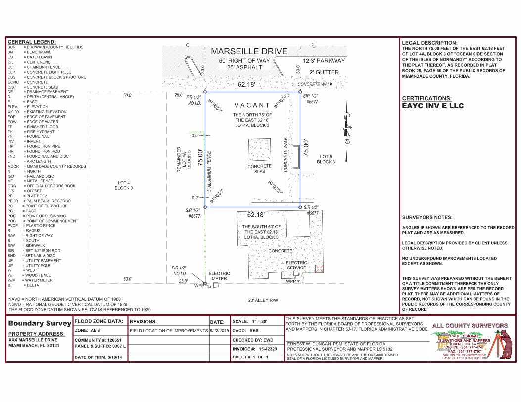
LEGAL DESCRIPTION:SOUTH 50 FEET OF LOT 5 AND SOUTH 50 FEET OF THE EAST 62.18 FEET OF LOT4 A, BLOCK 3, "OCEAN SIDE SECTION OF THE ISLE OF NORMANDY",ACCORDING TO THE PLAT THEREOF AS RECORDED IN PLAT BOOK 25, PAGE 60,OF THE PUBLIC RECORDS OF MIAMI-DADE COUNTY, FLORIDA.
PROPERTY OF: EAYC INVESTMENTS, LLC.,
7116 BAY DRIVE,MIAMI BEACH, FLORIDA 33141
SURVEYOR'S NOTERECORDED PLAT HAS MEASUREMENT
DISCREPANCIES. SUBJECT LOT BASED UPONFOUND FIELD MONUMENTATION.
ATTACHMENT B
Site Plan
914 Marseille Drive
7'-9"SIDE
SETBACK
7'-9"SIDE
SETBACK
1
2
3
4
8
7
6
5
Normandy Court
W/D
A/C
W/DA
/C
EXISTING2 STORIESBUILDING
Marseille Drive
Bay Drive
+9.0
0(N
GVD
)
+8.10(NGVD)
+4.10(NGVD)
+8.10(NGVD)
+4.10(NGVD)
+4.1
0(N
GVD
)
+4.1
0(N
GVD
)
+4.1
0(N
GVD
)
+9.0
0(N
GVD
)
+9.0
0(N
GVD
)+4
.10
(NG
VD)
+9.0
0(N
GVD
)+4
.10
(NG
VD)
+9.0
0(N
GVD
)
+4.1
0(N
GVD
)
+4.1
0(N
GVD
)
+4.1
0(N
GVD
)
+4.1
0(N
GVD
)
+4.1
0(N
GVD
)
RText (RText)
9 1 4 M A R S E I L L E D R I V EMIAMI BEACH, FLORIDA
Scale:
15-805BUS
2020-01-08
www.absolute-idea.com
IMPORTANT: PLEASE NOTE THAT THE INFORMATION ON THESE PLANS IS FOR CONCEPTUAL PURPOSES ONLY AND IS SUBJECT TO CHANGE.THE DRAWINGS ARE THE INTELLECTUAL PROPERTY OF INTERNATIONAL DESIGN ENGINEERING & ARCHITECTURE AND MAY NOT BE REPRODUCED, REPUBLISHED,DISTRIBUTED, TRANSMITTED, DISPLAYED, BROADCAST OR OTHERWISE EXPLOITED IN ANY MANNER WITHOUT THE EXPRESS PRIOR WRITTEN PERMISSION i.d.e.a.
ALL RIGHTS RESERVEDidea 2019C
3323 NE 163 Street, Suite 200North Miami Beach, Florida 33160
Tel.: (305) 792-0015Fax: (305) 931-0279
ARCH LICENSE NBR AA26001856ENG. CA No. 28787
NNSCALE:
01A-16
SITE PLAN1" = 20'-0"
SITE PLAN
161" = 20'-0"
ATTACHMENT C
ITE Trip Generation Manual Excerpts
ATTACHMENT D
Driveway Assignment
Attachment D-1914 Marseille Drive
Miami Beach, FloridaTraf TechENGINEERING, INC.
N
Driveway Traffic Assignment(PM Peak Hour of the Generator)