RE-Konnect Risk Engineering Bulletin October 2017 Vol. 2 | Issue 1 Did You Know? Interesting facts Disasters Hurricane Andrew, cyclones in India Formation of Cyclones Understanding the mechanism Loss Prevention Cyclone preparedness Resources Further reading Engage Answer and win prizes In Focus: Hurricanes/Cyclones
Transcript
RE-Konnect
Risk Engineering Bulletin October 2017 Vol. 2 | Issue 1
Did You Know?
Interesting facts
Disasters
Hurricane Andrew, cyclones in India
Formation of Cyclones
Understanding the mechanism
Loss Prevention
Cyclone preparedness
Resources
Further reading
Engage
Answer and win prizes
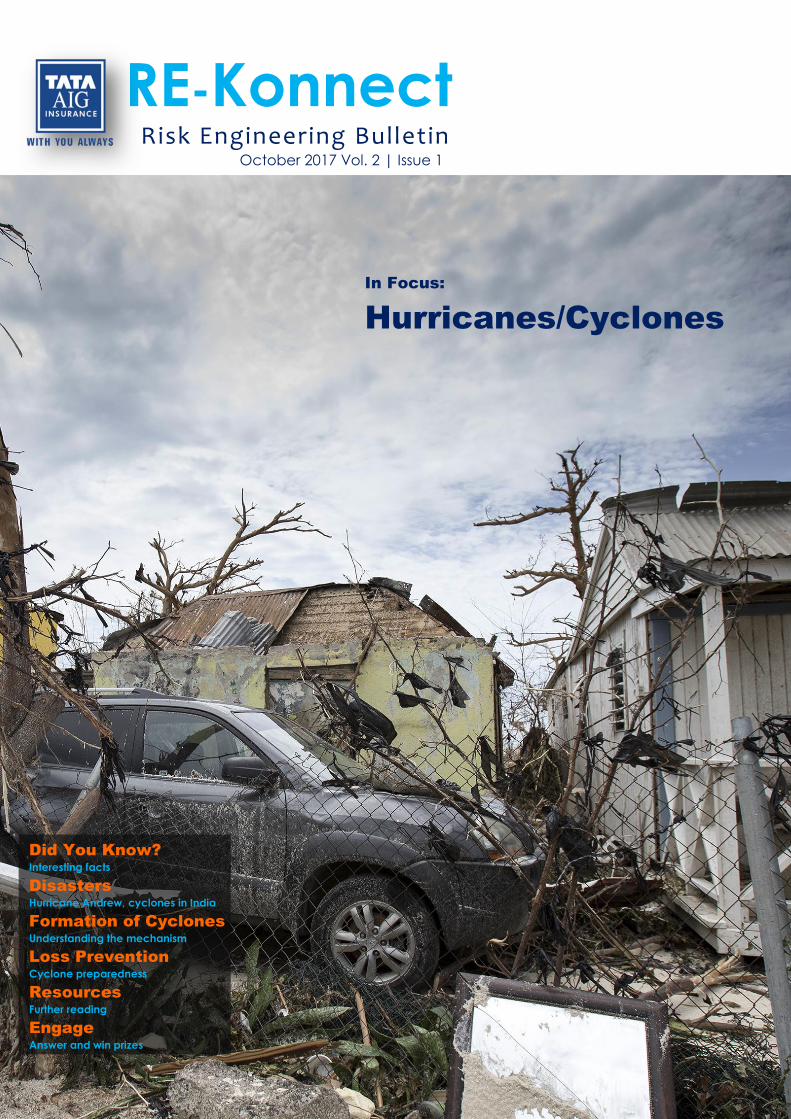
In Focus:
Hurricanes/Cyclones
Tata AIG RE-Konnect | Vol 2, Issue 1
2
Preface
Depending on location, they can be called Hurricanes, Cyclones or Typhoons; but they are all the
result of same weather phenomenon. The scientific term for all these storms is tropical cyclone.
With so much media coverage of recent Hurricane Harvey and Hurricane Irma, this is the right
time to know more about hurricanes, their dangers and loss prevention measures.
There are several steps a property or plant owner can take to minimize damage to their assets and
interruption to business in the wake of such natural disasters. In this issue of RE-Konnect, we take
a deep dive into the devastating nature of tropical cyclones and learn how we, as Insurers and
property owners, can build more resilience against them.
Did You Know?
Cyclone Bhola, which stuck West Bengal and Bangladesh in 1970 and lead to about 500000 deaths, remains one of the deadliest natural disasters ever.
Tropical cyclones are the only weather disasters that are given their own names.
Although disastrous, tropical cyclones help in moving equatorial heat towards the poles. Without them the equator would be considerably warmer and poles would be significantly cooler.
Sometimes misinterpreted, a hurricane makes “landfall” when its centre, not its edge, crosses the coastline. A hurricane can hit the land hours before its makes a “landfall”.
The hurricane with most significant economic impact is believed to be Hurricane Katrina, with damage estimates of over 100 Billion dollars.
Project Stormfury was an organization that tried to control hurricanes by seeding them with silver iodide, which would cool the hurricanes. However, the project had little success, and most scientists now have abandoned the idea of controlling hurricanes.
Hurricanes produce enough energy in one day to run the lights of a big city for many years.
Hurricane-generated waves frequently toss tons of fish onto beaches. The eyes of many of the fishes pop out because of sudden changes in pressure.
How different geographical regions refer to tropical cyclones is shown in the map below.
Tata AIG RE-Konnect | Vol 2, Issue 1
3
Disasters
Hurricane Andrew: The Haunting Legend
Hurricane Andrew hit Bahamas and the Southeast Cost of USA in the mid of August 1992. It tore
through South Florida in the middle of night, levelling entire neighbourhoods, tossing around
boats and cars, and leaving millions of people without power or hope. Andrew's legacy would be
far-reaching, as the storm exposed shoddy construction practices and a broken emergency
response system.
Andrew was the strongest and costliest
hurricane to ever hit United States until it
was surpassed by Hurricane Katrina in
2005. It was a Category 5 hurricane with
sustained wind speeds as high as 280
km/h. Many homes were left with
nothing but their concrete foundations.
Not only did it completely destroy more
than 63000 homes but also damaged
more than 124000 others. Total damage
was in excess of $26.5 billion with
insurance payouts of more than $15.5
billion (in 1992 USD). Prior to Andrew,
insurance veterans, who based their judgement on experience data only, had estimated the
maximum damage to be only about one-third of the actual loss. Eight insurance companies
became insolvent duet to payouts, while some other companies became technically insolvent and
required transfer of funds from parent companies.
Property owners and Insurers were taken by complete surprise as the event brought a harsh
awakening and forced them to come to grips with the necessity of preparing for unprecedented
disasters. It led to rapid evolution of complex catastrophic modelling, strong building codes and
better risk management and emergency preparedness for large scale disasters. Andrew’s legendary
impact now forms part of several papers and technical and business case studies. The tragedy
struck about 25 years ago, but in reality Andrew never really left.
Costliest Cyclones in India
India’s eartern costline has been specially vulnerable to some of the worst tropical cyclones. These
have led to devastating results owing to densely populated coastlines coupled with relatively poor
infrastructure and inadequate disaster
preparedness and emergency
response. We collated a list of some of
the costliest cyclones that have hit
India over the last decade. Overall
damage includes damages to
countries other than India. Peak wind
speed refers to highest 3-minute
average sustained wind speeds.
Cyclone YearAffected Indian
Coastlines
Peak Wind
Speed km/h
Overall Damage
(million USD)
Damage in India
(million USD)
Vardah 2016 TN 130 5100 1000
Hudhud 2014 Odisha and AP 185 3400 3400
Phailin 2013 Odisha and AP 215 696 696
Nilam 2012 TN and AP 85 57 57
Thane 2011 TN and AP 140 235 235
Jal 2010 Odisha and AP 110 1730 54
Laila 2010 TN and AP 100 118 118
Phyan 2009 MH and GJ 85 300 300
Nisha 2008 TN 85 800 800
TN= Tamil Nadu, AP= Andhra Pradesh, MH= Maharashtra, GJ= Gujajrat
Tata AIG RE-Konnect | Vol 2, Issue 1
4
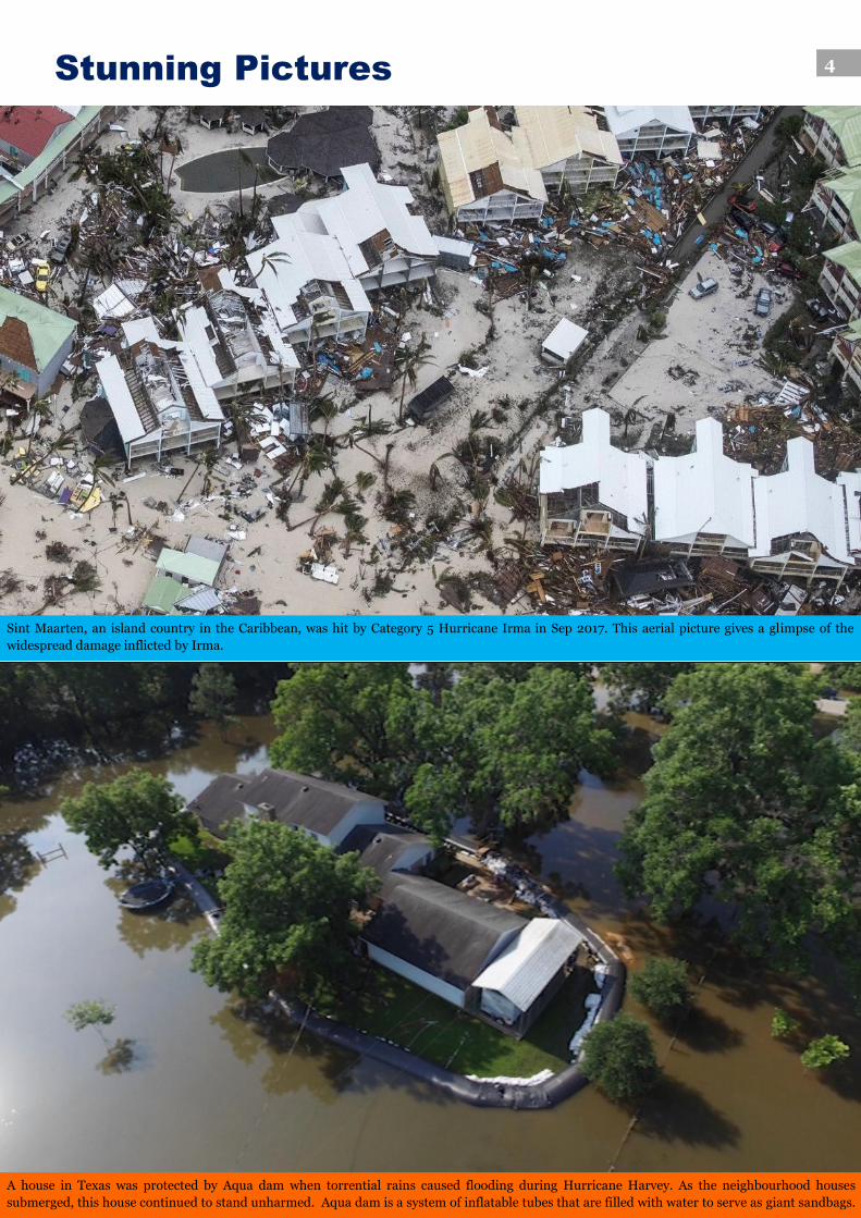
A house in Texas was protected by Aqua dam when torrential rains caused flooding during Hurricane Harvey. As the neighbourhood houses
submerged, this house continued to stand unharmed. Aqua dam is a system of inflatable tubes that are filled with water to serve as giant sandbags.
Sint Maarten, an island country in the Caribbean, was hit by Category 5 Hurricane Irma in Sep 2017. This aerial picture gives a glimpse of the
widespread damage inflicted by Irma.
Stunning Pictures
Tata AIG RE-Konnect | Vol 2, Issue 1
5
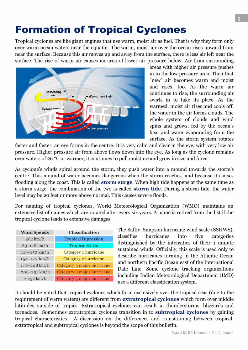
Formation of Tropical Cyclones
Tropical cyclones are like giant engines that use warm, moist air as fuel. That is why they form only
over warm ocean waters near the equator. The warm, moist air over the ocean rises upward from
near the surface. Because this air moves up and away from the surface, there is less air left near the
surface. The rise of warm air causes an area of lower air pressure below. Air from surrounding
areas with higher air pressure pushes
in to the low pressure area. Then that
"new" air becomes warm and moist
and rises, too. As the warm air
continues to rise, the surrounding air
swirls in to take its place. As the
warmed, moist air rises and cools off,
the water in the air forms clouds. The
whole system of clouds and wind
spins and grows, fed by the ocean's
heat and water evaporating from the
surface. As the storm system rotates
faster and faster, an eye forms in the centre. It is very calm and clear in the eye, with very low air
pressure. Higher pressure air from above flows down into the eye. As long as the cyclone remains
over waters of 26 °C or warmer, it continues to pull moisture and grow in size and force.
As cyclone’s winds spiral around the storm, they push water into a mound towards the storm’s
centre. This mound of water becomes dangerous when the storm reaches land because it causes
flooding along the coast. This is called storm surge. When high tide happens at the same time as
a storm surge, the combination of the two is called storm tide. During a storm tide, the water
level may be 20 feet or more above normal. This causes severe floods.
For naming of tropical cyclones, World Meteorological Organization (WMO) maintains an
extensive list of names which are rotated after every six years. A name is retired from the list if the
tropical cyclone leads to extensive damages.
The Saffir–Simpson hurricane wind scale (SSHWS),
classifies hurricanes into five categories
distinguished by the intensities of their 1 minute
sustained winds. Officially, this scale is used only to
describe hurricanes forming in the Atlantic Ocean
and northern Pacific Ocean east of the International
Date Line. Some cyclone tracking organizations
including Indian Meteorological Department (IMD)
use a different classification system.
It should be noted that tropical cyclones which form exclusively over the tropical seas (due to the
requirement of warm waters) are different from extratropical cyclones which form over middle
latitudes outside of tropics. Extratropical cyclones can result in thunderstorms, blizzards and
tornadoes. Sometimes extratropical cyclones transition in to subtropical cyclones by gaining
tropical characteristics. A discussion on the differences and transitioning between tropical,
extratropical and subtropical cyclones is beyond the scope of this bulletin.
Wind Speeds Classification
≤62 km/h Tropical Depression
63–118 km/h Tropical Storm
119–153 km/h Category 1 hurricane
154–17 7 km/h Category 2 hurricane
17 8–208 km/h Category 3 major hurricane
209–251 km/h Category 4 major hurricane
≥ 252 km/h Category 5 major hurricane
Tata AIG RE-Konnect | Vol 2, Issue 1
6
Loss Prevention
While nothing can be done to stop cyclones, there are actions you can take to maintain your safety and minimize the damage to your property or business. Tropical cyclones affect in two ways: 1) blow impact due to strong winds and 2) floods due to sudden heavy precipitation and/or storm surge. Analyzing your property in view of these risks is important to arrive at a customized preparedness and emergency response plan. Management of cyclones can be broadly discussed in three phases: before, during and after the event. These are more or less as applicable to a normal home owner as to a large manufacturing plant, only the scales are different. These are elaborated below:
1. PLAN As for any disaster, cyclone preparedness should start long before the event occurs. This is the most important phase and thoroughness of this step often dictates how efficiently the property owner comes out unscathed or at least with reduced damage. This is the time to research, brainstorm and prepare a well defined Emergency Response Plan and Business Continuity Plan. These should have following considerations: Know if you have tropical cyclone exposure. India’s eastern and southern coasts are
especially vulnerable. Contact district disaster management authority or ask your insurer. Understand the various hazards associated with tropical cyclones. Check the integrity of your property – inspect and review if various structures can
withstand your zone specific heavy wind blows; modify and revamp if required. Know which facilities/stored materials are vulnerable to flooding. Raise the plinth level and provide flood barriers to protect valuable electronics and raw/finished products.
Back-up programmes – verify critical data is backed-up regularly and stored in servers which won’t be affected in case of local damage. Review emergency power back-ups and sizing issues as cyclones will often result in complete grid failure. Identify business critical documents for relocation.
Review your insurance policies – ensure you have adequate coverage for damage to property and loss of profit due to business interruption.
Have a written Evacuation Plan – include alternative routes, communication channels, clearly defined roles/responsibilities, checklists and understand how local weather/disaster forecasting works.
Emergency Supply Kit – have it ready well in advance, enough for minimum one week supply. These should include food/water, first-aid, extra batteries/back-up power and cash.
Consider forming Emergency Response Team (ERT). Make sure all stakeholders are properly trained in the emergency response and mock drills are conducted periodically.
2. EXECUTE If the previous step of planning has been done right, the situation will be much easier to manage during the actual event without causing any panic or alarms. Stay up to date with local warnings and review your response should the situation
escalate. Be prepared to seize all production activities and evacuate. Estimate loss of utilities such as electricity and water and review available back-ups. Determine if the well trained Emergency Response Team consisting of volunteer
members can remain at the site following a thorough review of predicted scenarios, building integrity and refuge alternatives.
Relocate business critical electronics/data and valuables to secure locations. Turn off electrical supply to circuits and equipments that can be flooded. Facilities and equipments should be thoroughly secured and closed.
Once the cyclone arrives, all personnel should move to a safe location.
Tata AIG RE-Konnect | Vol 2, Issue 1
7
Win Speeds IMD Classificaiton
63-88 km/h Cy clonic Storm
89-1 1 7 km/h Sev ere Cy clonic Storm
1 1 8-1 65 km/h Very Sev ere Cy clonic Storm
1 66-220 km/h Extremely Sev ere Cy clonic Storm
≥ 221 km/h Super Cy clonic Storm
3. RESURRECT Remember that even if the event is over, the risk is not completely gone. If the electrical systems or equipments have been exposed to flood water or wind damage, there is a risk of their failure. Survey the site for hazards such as live wires, flammable gas/liquid leakage, and
weakened walls. Document the findings and take pictures. Verify status of fire protection systems such as fire pumps, sprinklers and fire alarms and
give primary importance to their repair. Do not operate the equipments or electrical systems without thorough examination and
restoration. Methodically drain, dry, clean and lubricate the equipments before energizing. Engage the equipment manufacturer for recommendations and repairs.
Maintain a parallel communication with your insurer for inspection and claim reporting. Begin salvage of goods and materials as soon as possible. Get utilities and hazardous
processes checked by qualified personnel before taking them back in service.
Resources
Regional Specialized Meteorological Centre for Tropical Cyclones over North Indian Ocean: Cyclone awareness and warning division of IMD. Various documents, standard operating procedures and alerts can be referred from this website - http://www.rsmcnewdelhi.imd.gov.in
National Hurricane Centre: Division of United State’s National Weather Service. Various alerts, satellite imagery and educational resources are available on the website -http://www.nhc.noaa.gov
Engage
Answer the following question and win Amazon coupons worth Rs 500 each. Send the answer to
[email protected] . Five winners for this quiz will be announced in the next issue.
Q. Indian Meteorological Department (IMD)
uses a different classification system for
cyclones than Saffir-Simpson scale. This is
shown on right (for peak 3-min average
sustained wind speeds).
A hypothetical tropical cyclone, TCHYPO, forms and has both peak 1-min and 3-min average
sustained wind speeds of 150 miles/h. According to Saffir-Simpson and IMD scales, TCHYPO
would be classified as (1 mile ~ 1.61 km):
A) Category 3; Very severe cyclonic storm
B) Category 4; Super cyclonic storm
C) Category 5; Extremely severe cyclonic storm
D) Category 4; Very severe cyclonic storm
Winners of the previous issue are as follows:
Abhishek Negi – Marsh India Insurance Brokers
V Ganesan – Marsh India Insurance Brokers
Girish G – GIC of India, Mumbai
Prashant Muta – Aditya Birla Insurance Brokers, Mumbai
Yogesh Ghorpade – Thermax Limited
Answers to previous questions: 1. 16 ft high: un-layered and un-compacted, high grade coal 2. Adsorption 3. Compaction
For feedback or comment related to the bulletin please contact: [email protected]
To download previous issues of the bulletin, please visit the following link: http://www.tataaiginsurance.in/taig/taig/tata_aig/resources/knowledge-center/energy-and-property-insurance/lcb.html
Tata-AIG General Insurance Company Limited
Peninsula Business Park, Tower A, 15th Floor
G. K. Marg, Lower Parel, Mumbai 400013
www.tataaiginsurance.in
Disclaimer
The publication is for private circulation only. The comments and suggestions presented should not be taken as a substitute for advice about any specific situation. Editors do not own any responsibility legally or otherwise. Though due care is taken to give accurate information, the readers are advised to verify independently the correctness of the information given.
A satellite image of Hurricane Katrina as it moves towards United States’ southeast coastline