1 Bock AIST-08-0079 Real Time GPS/Seismic and EEW Results from El Mayor Cucapah and Tohoku-oki Earthquakes Yehuda Bock, Brendan Crowell, Diego Melgar Institute of Geophysics and Planetary Physics Scripps Institution of Oceanography, UCSD Earthquake Early Warning Summit: Delivering Earthquake Warnings to the U.S. West Coast UC Berkeley April 4-5, 2011
Transcript
1Bock AIST-08-0079
Real Time GPS/Seismic and EEW Results from El Mayor Cucapah and Tohoku-oki Earthquakes
Yehuda Bock, Brendan Crowell, Diego MelgarInstitute of Geophysics and Planetary Physics
Scripps Institution of Oceanography, UCSD
Earthquake Early Warning Summit:Delivering Earthquake Warnings to the U.S. West Coast
UC BerkeleyApril 4-5, 2011
2Bock AIST-08-0079
Real-Time Seismic Monitoring: Background• Geodetic and seismic networks have evolved
independently and there is still somewhat of a disconnect between seismologists and geodesists
• Seismic networks of broadband seismometers & accelerometers are much more sensitive to ground motion than geodetic networks (GPS/GNSS)
• Determination of displacement seismograms from seismic velocity or acceleration measurements is problematic (especially in real time)
• Near-source broadband seismometers clip during large earthquakes; accelerometers do not clip but require double integration and are affected by instrument tilts and drifts
• GPS networks can measure high-rate displacements directly & do not clip but have accuracy & precision limitations, particularly for real-time applications
3Bock AIST-08-0079
Next-Generation Networks• Analyzed together, GPS and accelerometers provide a
precise and true broadband record of displacements across the entire frequency range of surface motion, including the static component, which can be estimated in near real time (seconds) and is very effective in the near field during large earthquakes
• Next-generation geodetic networks should include (at least) high-rate GPS/GNSS instruments and very-high-rate strong motion accelerometers
• Some seismic applications:– Earthquake early warning (EEW)– Fast centroid (CMT) moment tensor inversions– Rapid slip inversions
• Integrated geodetic/seismic approach can provide improved performance compared with seismic-only or geodetic-only networks, and “false positives” can be minimized for EEW
4Bock AIST-08-0079
Real Time (temp. down)Real Time (Active)
California Real Time GPS Network (CRTN)
Real Time (planned)
Started in 2003, there are now 184 CRTN stations streaming 1Hz data to a server at SIO with a latency of ~0.4 s. Data are collected from SCIGN/PBO stations via UCSD’s HPWREN wireless communications and dedicated radio links, and from servers at UNAVCO, USGS Pasadena, UCB, Caltrans, Orange County, San Diego County and Metropolitan Water District servers. Displacements are computed on-the-fly with a total latency less than ~1 s.
5Bock AIST-08-0079
Background –CRTN GPS Equipment and Telemetry
Ramona Airport
Banner Facility
Typical real-time CRTN station with receiver and power enclosure, using Ethernet-based 2.4 GHz radios and microwave for data telemetry Typical CGPS
anchored monument and antenna with cover
6Bock AIST-08-0079
April 4, 2010 Mw 7.2 El Mayor Cucapah Earthquake in Northern Baja California
• 105 1 Hz CRTN stations recorded the earthquake in southern California
• We estimated 1 Hz displacements from GPS data alone
• Using a Kalman filter we estimated 100 Hz displacements using 1 Hz GPS and 100 Hz accelerometer data from 12 collocated GPS/seismic stations
1 Hz 100 Hz
+
P494/WESP494/WES
GNPS
7Bock AIST-08-0079
Summary of Kalman Filter Algorithms Used in GPS/Seismic Integration for EEW
8Bock AIST-08-0079
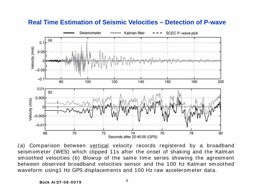
(a) Comparison between vertical velocity records registered by a broadbandseismometer (WES) which clipped 11s after the onset of shaking and the Kalmansmoothed velocities (b) Blowup of the same time series showing the agreementbetween observed broadband velocities sensor and the 100 hz Kalman smoothedwaveform using1 Hz GPS displacements and 100 Hz raw accelerometer data.
Real Time Estimation of Seismic Velocities – Detection of P-wave
9Bock AIST-08-0079
Comparison of single integration of the seismometer record at WES, 100Hz smoothed Kalman filter displacements (GPS/accelerometer), anddouble integration of the accelerometer. We can recover P-waverecordings with the Kalman filter of 1 Hz GPS & 100 Hz accelerometerdata. This is important because in a more realistic early warning scenariowe may not have 12 s of seismometer recordings and we would have torely completely on accelerometer data, if no high rate GPS were recorded.
Real Time Estimation of Displacements – Detection of P-wave
10Bock AIST-08-0079
Total east displacement waveforms for (a) GPS only @ 1 Hz and (b) Kalmansmoothed @ 100 Hz for 12 collocated GPS/seismic stations in southernCalifornia (separations < 1.5 km). Notice the artifact introduced by thenetwork adjustment at 95 s in (a) which is absent in (b), and the moreprecise values in (b). All waveforms have been normalized for clarity of theplot.
Displacement Waveforms at Collocated Stations
1 Hz
1 Hz 100 Hz
+
11Bock AIST-08-0079
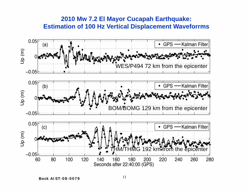
WES/P494 72 km from the epicenter
BOM/BOMG 129 km from the epicenter
THM/THMG 192 km from the epicenter
2010 Mw 7.2 El Mayor Cucapah Earthquake:Estimation of 100 Hz Vertical Displacement Waveforrms
12Bock AIST-08-0079
Elements of GPS-Only Earthquake Early Warning System
California Real Time Network
CRTN Server
Network Adjustment
1 Hz Total Displacement
Waveforms (RYO)
Data
CGPS Network
GPS Station Communications
Data
Early Warning Decision Filter First RespondersNotify
1 Hz Total Displacement
Waveforms (RYO)
Note: RYO is an open binary format designed to stream real-time high-rate displacements
13Bock AIST-08-0079
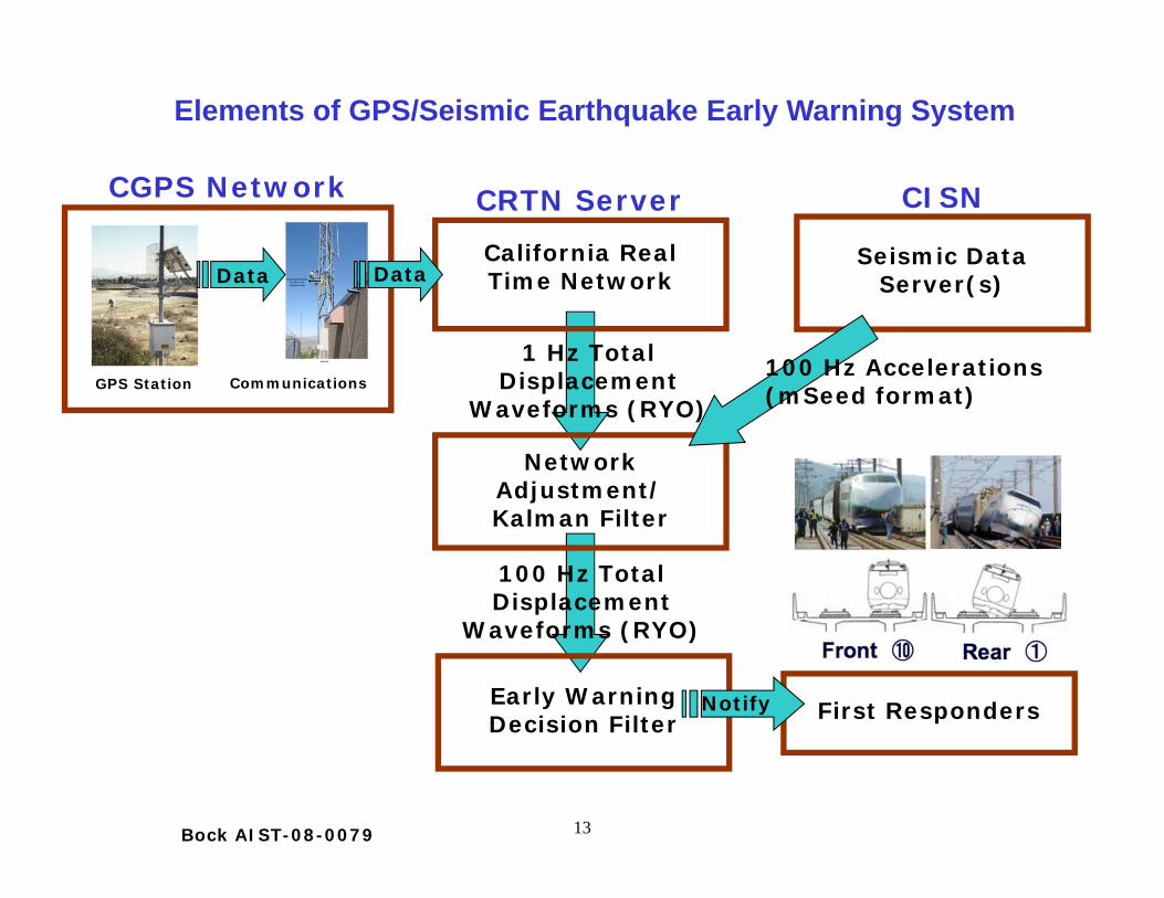
Elements of GPS/Seismic Earthquake Early Warning System
California Real Time Network
CRTN Server
Network Adjustment/ Kalman Filter
1 Hz Total Displacement
Waveforms (RYO)
Seismic Data Server(s)
100 Hz Accelerations (mSeed format)
CISN
Data
CGPS Network
GPS Station Communications
Data
Early Warning Decision Filter First RespondersNotify
100 Hz Total Displacement
Waveforms (RYO)
14Bock AIST-08-0079
Elements of GPS/Seismic Integration: Conversion to Seismic Formats
California Real Time Network
CRTN Server
Network Adjustment/ Kalman Filter
1 Hz Total Displacement
Waveforms (RYO)
Seismic Data Server(s)
Accelerations (mSeed format)
CISN
Data
CGPS Network
GPS Station Communications
Data
Early Warning Decision Filter First RespondersNotify
100 Hz Total Displacement
Waveforms (RYO)
Convert RYO to seismic formats
(Caltech)
SACmSeed
RYO
RYO
Southern California Earthquake Data Center (SCEDC)
15Bock AIST-08-0079
2003 Mw 8.0 Tokachi –oki earthquake
For the Tokachi-oki earthquake, seismic wave propagation took 70-100 s to travel across Hokkaido Island. This is very similar to the ShakeOut scenario for Southern California, where the southern San Andreas fault ruptures around Bombay Beach and takes 70-90 s to be felt in the Los Angeles Basin.
Demonstration (movie) of Prototype EEW System (GPS-only)
16Bock AIST-08-0079
Shown in figure are collocated GEONET (GPS, 1 Hz) and accelerometer stations: 71 KiKnet (200 Hz) & 260 Knet (100 Hz) stations. “Collocated” indicates that the stations are within 2 km of each other.
Test events: Sept 26, 2003 Tokachi-oki (Mw 8.3) earthquake & March 11, 2011 Mw 9.0 Tohoku-oki earthquake
GPS/Seismic “Collocations” in Japan
17Bock AIST-08-0079
A Few Examples: 100 Hz 2003 Tokachi-oki Earthquake Displacement Waveforms Derived by GPS/Seismic Integration
18Bock AIST-08-0079
Shown in figure are coseismic displacements in the epicentral region computed from Japan’s 1200+ station CGPS network (GEONET) by ARIA group at Caltech/JPL (courtesy of Susan Owen, JPL). Maximum surface displacement on land was 5.24 meters at GEONET station 0550 on coast.
5.4 m
epicenter
Fukushima Nuclear Plant
Tokyo
Maximum surface slip
March 11, 2011 Mw 9.0 Tohoku-oki Earthquake:Coseismic Displacements from 30 s GPS data
19Bock AIST-08-0079
North Component
March 11, 2011 Mw=9.0 Tohoku-oki Earthquake:S-wave & surface wave observed by 1Hz CRTN data (replayed)
Time Span of Waveforms: 05:46:23 + 4000 secondsEarthquake Date/Time: Friday, March 11, 2011, 05:46:23 UTC
Surface wave (~2000 s)
20Bock AIST-08-0079
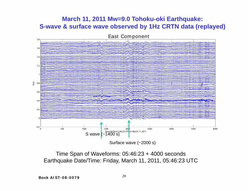
S wave (~1400 s)
Surface wave (~2000 s)
Time Span of Waveforms: 05:46:23 + 4000 secondsEarthquake Date/Time: Friday, March 11, 2011, 05:46:23 UTC
East Component
March 11, 2011 Mw=9.0 Tohoku-oki Earthquake:S-wave & surface wave observed by 1Hz CRTN data (replayed)
21Bock AIST-08-0079
March 11, 2011 Mw=9.0 Tohoku-oki EarthquakeComparison of GPS & Seismic Broadband Displacements at PIN1
S: S-wave; L: Love wave; R: Rayleigh wave
22Bock AIST-08-0079
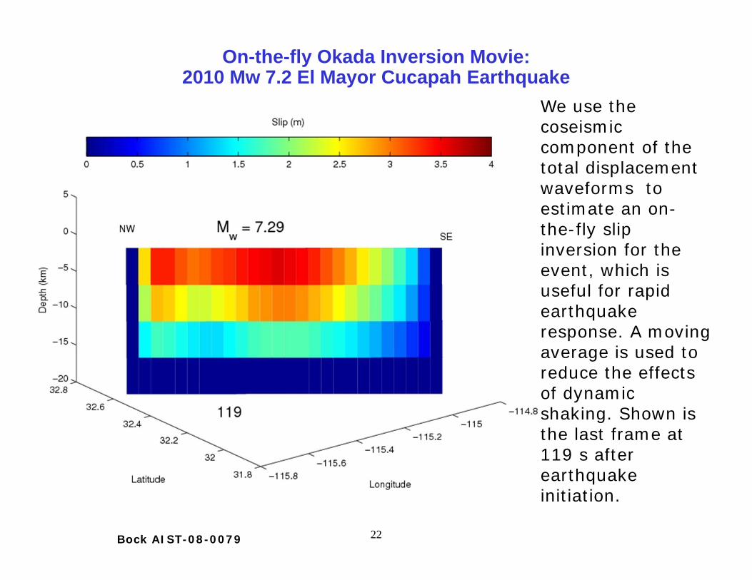
On-the-fly Okada Inversion Movie:2010 Mw 7.2 El Mayor Cucapah Earthquake
We use the coseismic component of the total displacement waveforms to estimate an on-the-fly slip inversion for the event, which is useful for rapid earthquake response. A moving average is used to reduce the effects of dynamic shaking. Shown is the last frame at 119 s after earthquake initiation.
23Bock AIST-08-0079
http://igppweb.ucsd.edu/~fialko/baja.html
1 Hz
15 s
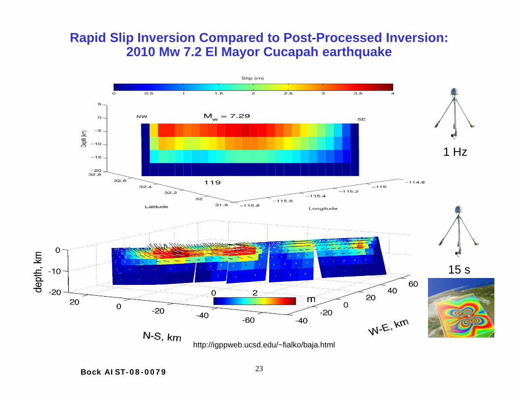
Rapid Slip Inversion Compared to Post-Processed Inversion: 2010 Mw 7.2 El Mayor Cucapah earthquake
24Bock AIST-08-0079
Fast CMT inversion at local distances: 2010 Mw 7.2 El Mayor Cucapah earthquake
We uses the coseismic component of the total displacement waveforms to estimate a fast centroid moment tensor (CMT) solutions (“beach ball”). A moving average is used to reduce the effects of dynamic shaking.
25Bock AIST-08-0079
Play Movie
At local and regional distances moment tensor inversion of large events can be complicated or impossible, requiring use of teleseismic waves. Using GPS/seismic integration, one can quickly obtain near-source coseismic offsets that can be used to invert for centroid moment tensors. The inversion has a unique solution, one can resolve unequivocally between fault plane and nodal plane and we demonstrate for this earthquake that the time required to get a robust estimate is significantly smaller than traditional seismic approaches (a few minutes instead of 20-30 minutes)
Movie of fast centroid moment tensor inversion at local distances: 2010 Mw 7.2 El Mayor Cucapah earthquake
26Bock AIST-08-0079
Project with Instituto de Geofísica, Universidad Nacional Autónoma de México (UNAM): Earthquake Early Warning System in Mexico with
Collocated GPS & Seismic Instruments
27Bock AIST-08-0079
Map of existing Real-Time GPS (425grey squares), and proposed Real-Time GPS (175 black squares) andaccelerometers (40 white squares) ofthe 600-station next-generationgeodetic network for the activewestern margins of the continentalU.S. designed to monitor areas withhighest probability of strong motions.Based on July, 2010 proposal byIGPP/SIO (Y. Bock, PI), BSL/UCB (R.Allen, PI) and UNAVCO, Inc. (M.Jackson, PI) to NSF EarthScopeProgram. Not funded, but encouragedto resubmit in July 2011. Proposals toUSGS and SCEC involving EEW andGPS/Seismic integration were also notfunded.
Proposal to NSF EarthScope Program
28Bock AIST-08-0079
Development of Earthquake Early Warning in California: Adding a GPS Component
UC Berkeley
U.S. Geological
Survey
Caltech
CISNCalifornia Integrated Seismic Network
the seismic networks
• Ongoing effort since 2006 to develop earthquake early warning in California under the auspices of CISN, with funding from USGS
• Testing three methodologies using strictly seismic data(1) ElarmS (UC Berkeley)(2) Virtual Seismologist (Caltech/ETH)(3) Onsite warning (Caltech/National Taiwan University)
• Results from 2010 Mw 7.2 El Mayor Cucapah earthquake indicate that earthquake early warning should integrate geodetic methods, since most broadband seismic instruments clipped during this event
• One of our NASA project goals is to contribute directly to this effort
Courtesy of Richard Allen
29Bock AIST-08-0079
Publications
• Crowell, B., Y. Bock, and M. Squibb (2009), Demonstration of earthquake early warning using total displacement waveforms from real time GPS networks, Seismo. Res. Lett., 80(5), 772-782, doi: 10.1785/gssrl.80.5.772 (Special Issue on Earthquake Early Warning Systems).
• Bock, Y., D. Melgar, B. W. Crowell (2011), Total displacement waveforms from geodetic and seismic networks, Bull. Seismo. Soc. Am., in review.
30Bock AIST-08-0079
Summary
• Next-generation earthquake monitoring networks will include geodetic (high-rate GPS/GNSS) and seismic (very-high-rate strong-motion accelerometers, broadband velocity) instruments
• Analyzed together using a Kalman filter, they provide a precise and true broadband record of displacements across the entire frequency range of surface motion, including the static component, which can be estimated in near real time and is particularly suited for capturing near-source large earthquakes
• Fast centroid moment tensor inversion at local distances, rapid static slip inversions and even total displacement waveform inversion can be automated and can be performed in sufficient time for earthquake early warning and faster than performed today with seismic-only or geodetic-only networks, and “false positives” can be minimized.