133
January 2015

REDUCING
A NEW APPROACH TO INCREASING MOBILITY
PART OF THE GALVIN PROJECT TO END CONGESTIONBY BARUCH FEIGENBAUM
CONGESTION
I NDENVER
Policy Study 442 January 2015
REASON FOUNDATION

Reason FoundationReason Foundation’s mission is to advance a free society by developing, applying
and promoting libertarian principles, including individual liberty, free markets and
the rule of law. We use journalism and public policy research to influence the frame-
works and actions of policymakers, journalists and opinion leaders.
Reason Foundation’s nonpartisan public policy research promotes choice, compe-
tition and a dynamic market economy as the foundation for human dignity and
progress. Reason produces rigorous, peer-reviewed research and directly engages the
policy process, seeking strategies that emphasize cooperation, flexibility, local knowl-
edge and results. Through practical and innovative approaches to complex problems,
Reason seeks to change the way people think about issues, and promote policies that
allow and encourage individuals and voluntary institutions to flourish.
Reason Foundation is a tax-exempt research and education organization as defined
under IRS code 501(c)(3). Reason Foundation is supported by voluntary contribu-
tions from individuals, foundations and corporations. The views are those of the
author, not necessarily those of Reason Foundation or its trustees.
Acknowledgement: This policy study is the independent work product of Reason
Foundation, a nonprofit, tax-exempt research institute headquartered in Los Angeles. It
forms part of the Galvin Project to End Congestion, a project producing the solutions
that will end traffic congestion as a regular part of life. To learn more about the Galvin
Project, visit www.reason.org/areas/topic/mobility-project.
Copyright © 2014, Reason Foundation. All rights reserved.

R e a s o n F o u n d a t i o n
Reducing Congestion in Denver:
A New Approach to Increasing Mobility
By Baruch Feigenbaum Executive Summary Productive cities are mobile cities, and Denver’s productivity is seriously threatened by a lack of mobility. Congestion is increasingly clogging the arteries of metro Denver and threatens to strangle the region over the long term. The ability to move goods and services efficiently, combined with the need to provide a high quality of life for employees and their families, should put eliminating serious traffic congestion at the top of Denver’s priorities. While the cost of doing this would be significant, the consequences of ignoring this growing problem would be severe. Denver is already plagued by significant traffic congestion, the direct cost of which is estimated at more than $1.6 billion per year. But if the current long-range transportation plan is implemented, by 2035 congestion will be much worse. A rush-hour trip that today takes 27% longer than at off-hours (a travel time index of 1.27) will take 86% longer in 2035 (a travel-time index of 1.86), according to the Denver Region Council of Governments (DRCOG). That is far worse than what Los Angeles experiences today. This study examines metro Denver’s congestion problem in detail. Our analysis concludes that Denver’s current transportation approach, of investing heavily in fixed-rail transit and land-use changes to reduce the extent of driving, will not significantly reduce traffic congestion in greater Denver. The current long-range plan will lead to a negligible increase in the 9% of commute trips made by carpool, and only a modest two percentage point increase in transit’s market share—while overall congestion would soar. Transit, particularly a well-designed bus network, certainly has a role to play, but it is not the key to significantly reducing congestion.

The new approach we recommend addresses the two major sources of congestion. For the half of congestion that is caused by incidents (accidents, work zones, weather, etc.), Denver should expand efforts under way such as quicker identification of, response to, and clearance of incidents. On arterial streets, improvements in traffic signal coordination and access management will also help. For the other half of congestion—the kind that occurs every day during rush hours because demand greatly exceeds roadway capacity—the only alternative to increasing the capacity of the roadway system is to significantly reduce trips, which carries substantial social and economic costs that could irreparably damage Denver’ economy. Conversely, expanding capacity without regard to return on investment is a poor use of taxpayer resources. Therefore, expanding capacity in a smart and sustainable way will produce the greatest benefits. Such an approach calls for using variable pricing on most new freeway lanes to keep them free from congestion, as is the case with the I-25 reversible express lanes, which opened to toll-paying traffic in 2006. Our goal is to create a network of these priced lanes. We also recommend adding electronically priced bridges and/or tunnels to allow motorists to bypass signalized intersections on selected arterials, thereby turning them into managed arterials. The bridges/tunnels would give arterial users, including bus rapid transit (BRT) and express buses, the option of faster, less-congested travel on those important components of the transportation system. This will provide commuters with two alternatives to driving in congested traffic. If they need the flexibility of the automobile, they can choose to pay for the free-flowing new lanes. Or they can choose fast, reliable region-wide bus rapid transit (BRT) and express bus service using the network for the line-haul portion of their trips. Our modeling (using the DRCOG traffic model) shows that this kind of lane capacity addition over the next 25 years can substantially reduce congestion. It would eliminate most of the worst congestion by 2040. To supplement the express toll lane network added to the freeway system, we propose completing the missing link in the Denver beltway, which we have labeled the Jefferson Parkway.
The estimated cost of all the priced lane additions is $10.6 billion. By using value-priced tolling on nearly all of this new capacity, we estimate that more than 60% of the cost could be financed based on the projected toll revenues. And to reduce the risks inherent in such mega-projects, we recommend that they be carried out under long-term concession agreements in which the private

sector partners would bear the risks of cost overruns and revenue shortfalls. Public-private partnerships (P3s) of this scale have been successfully employed in Florida, Texas, Virginia and around the world. There would be significant benefits from implementing this approach. Valuing the time saved at DRCOG’s average value of time per hour, $15.50 for automobiles and $46.50 for trucks, (2012 dollars), the time-savings over 20 years to users would be $27.6 billion. That means the time-saving benefits alone would be almost triple the $10.6 billion cost. But there would also be major economic benefits. Reduced travel times allow employers to recruit from a larger area and employees to seek jobs within a larger area; this better matches skills with needs and in so doing makes a metro area’s economy more productive. Individual motorists would benefit every day, as average trip times would be shorter than they are now, rather than considerably longer. With a network of congestion-free priced lanes on the entire freeway system, everyone who signed up for an electronic payment system using a transponder or other device would have the peace of mind of knowing that he or she had a time-saving option available, whenever it was important to get somewhere on time. As noted, the network of congestion-free express lanes would facilitate a large expansion of public transit. The region’s transit providers would gain the equivalent of a network of exclusive busways, since the priced lanes would permit reliable, free-flowing bus operations at all times. Yet unlike the FasTracks rail projects, for which funding is constrained, a major portion of the infrastructure cost of this busway system would be paid for by motorists who choose to use the express lanes. This would give the Regional Transit District (RTD) a new option for corridors without existing transit service. Denver’s region-wide mobility center, which currently coordinates demand-response service for the elderly, can help coordinate bus routes to create a seamless transportation network. Denver has come to a crossroads in transportation policy. Continuing down the status-quo path will lead to a future with an incomplete rail transit system and an undersized highway system, resulting in much worse congestion than today. The path suggested in this study accepts the reality that cars and trucks will continue to be the primary means of transportation in Denver. It therefore would expand the highway infrastructure in smart, new ways to cope with that reality, while facilitating and promoting affordable, region-wide express bus and bus-rapid transit service. This path promises a future of significantly less congestion than

today, and of new mobility options—for motorists, for transit users, and for goods movement. “Congestion results from poor policy choices and a failure to separate solutions that are effective from those that are not,” said former Transportation Secretary Norman Mineta. We hope Denver will make wise policy choices for greatly increased mobility.

R e a s o n F o u n d a t i o n
Table of Contents
Denver’s Congestion Problem and Current Plans ......................................... 1
Lack of Mobility and Its Consequences ..................................................... 11 A. Overview of Congestion .................................................................................. 11
Operations Management ........................................................................ 23 A. Dynamic Traffic Management Systems and Intelligent Transportation Systems 23 B. Freeway ITS Assessment ................................................................................ 26 C. Institutional Conflict ...................................................................................... 28 D. Operations Management and ITS in Critical Freeways Situations ..................... 30 E. Arterial ITS Assessment ................................................................................. 31
Principles for Improving Denver’s Roadway and Transit Systems ............... 37 A. Adding General, Unpriced Roadway Capacity .................................................. 38 B. Eliminating Freeway Bottlenecks .................................................................... 39 C. Establishing an Express Toll Lane Network ..................................................... 40 D. Expanding the Arterial Network ....................................................................... 51 E. Improving the Transit Network ........................................................................ 53
Managed Lane and Freeway Capacity ...................................................... 63 A. The Express Toll Lane Network ....................................................................... 63 B. New General Purpose Capacity ....................................................................... 66 C. Freeway Interchanges .................................................................................... 67
Arterial Highways and Managed Arterials ................................................ 69 A. Managed Arterials ......................................................................................... 69 B. Proposed Arterial Projects .............................................................................. 71
Transit ................................................................................................... 76 A. Light Rail and Commuter Rail ......................................................................... 76 B. Local Bus/Limited Stop Bus ........................................................................... 77 C. BRT, Express Bus and Regional Bus ................................................................ 78 D. Vanpools ...................................................................................................... 81 E. Demand-Response Transit .............................................................................. 81
Funding and Financing ............................................................................ 83 A. Current Revenues .......................................................................................... 83 B. Changes to Transportation Funding and Financing .......................................... 84
Costs, Benefits and Structural Issues for Denver’s Transportation Improvements ........................................................................................ 89 A. Express Toll Lane and Toll Road Costs and Revenues ....................................... 89 B. Time-Saving Benefits ..................................................................................... 92

C. General Purpose Lanes Costs and Benefits ..................................................... 93 D. Managed Arterial Improvements .................................................................... 94 E. Summary of Costs .......................................................................................... 94
Conclusion ............................................................................................. 96
Appendix A: Major Primary Arterial Highways Components ....................... 98
Appendix B: Analysis of Express Toll Lane Additions ............................... 102
Appendix C: Project Cost Estimates ........................................................ 106
Appendix D: Project Revenue Estimates .................................................. 108 Revenue Projections for I-70 West ..................................................................... 112 Revenue Projection for the Jefferson Parkway .................................................... 114
About the Author ................................................................................... 116
Endnotes ............................................................................................... 117 Figures Figure 1: 2035 Metro Vision RTP Total Vision System Cost and Fiscally Constrained Revenues by Expense Category ............................................................................. 7 Figure 2: Growth in Denver’s Travel Time Index ..................................................................... 13 Figure 3: Growth in Denver’s Delay per Peak Traveler (in hours) .......................................... 13 Figure 4: Map of Denver .......................................................................................................... 14 Figure 5: Map of Minneapolis .................................................................................................. 15 Figure 6: Map of San Jose ....................................................................................................... 15 Figure 7: Map of San Antonio ................................................................................................. 16 Figure 8: Freeway Lane-Miles (in Tens) versus Freeway Daily Vehicle-Miles of Travel ....................................................................................................................................... 17 Figure 9: Arterial Lane-Miles (in Tens) versus Arterial Daily Vehicle-Miles of Travel .............. 18 Figure 10: The Relationship Between Congestion Growth and Expansion of Highway Capacity ..................................................................................................................... 38 Figure 11: Traffic Throughput Versus Traffic Speed ................................................................. 41 Figure 12: Arterial Overpass Queue Jump ................................................................................ 52 Figure 13: Arterial Underpass Queue Jump .............................................................................. 53 Figure 14: Transit and Employment Access Broward County, FL and Tarrant County, TX ................................................................................................................................ 55 Figure 15: Transit System Capital Costs of Heavy Rail System, Light Rail System and Bus Rapid Transit (in billions $) ...................................................................................... 61 Figure 16: Map of Denver Express Lane Network Expansions ................................................ 65 Figure 17: Map of Denver General Purpose Lanes Network Expansions ................................ 66 Figure 18: Map of New and Modified Freeway Interchanges .................................................. 68 Figure 19: Map of Denver-Area Managed Arterials .................................................................. 74 Figure 20: Map of Denver-Area Primary Arterial Grade Separations ....................................... 75 Figure 21: Map of Denver-Area Improved Freeway and Arterial Network ............................... 75 Figure 22: Map of Potential New Express Bus and BRT Routes ............................................. 80 Figure 23: Map of Potential New Express Bus and BRT Routes and Existing Express Bus and Regional Bus Routes .................................................................................... 80 Figure B-1: Typical Volume/Capacity Graph (I-25 C470/E470 to CastleRock) ........................ 103

Tables Table 1: Metro Vision Transportation System Costs and Fiscally Constrained 2035 RTP Expenditures (from 2012 to 2035 in FY ’08 $ millions) ..................................................... 5 Table 2: Fiscally Constrained 2035 RTP System Characteristics (units) ................................... 6 Table 3: Funding Percentage by Mode from 2012 to 2035 in FY ’08 ($ millions) ................... 7 Table 4: Denver’s Work Trip Distribution: 1990, 2000 and 2010 ............................................. 11 Table 5: Comparative Data on Freeways and Arterials, Large Urban Areas, 2011 .................. 16 Table 6: Freeway Loading vs. Arterial Loading, 2011 .............................................................. 17 Table 7: Sources of Congestion in Large Urban Areas ............................................................ 22 Table 8: Denver Freeway Operations Management ................................................................. 26 Table 9: Freeway Service Patrol Data ...................................................................................... 28 Table 10: Denver Arterial Operations Strategies ..................................................................... 31 Table 11: Leverage of Systems Operations and Management on Congestion ........................ 36 Table 12: Recent Interchange Bottleneck Reconstruction Projects ......................................... 40 Table 13: Proposed Denver Toll Lane Network Expansions .................................................... 64 Table 14: Proposed Denver General Purpose Network Expansions ........................................ 66 Table 15: New and Modified Freeway Interchanges ................................................................ 67 Table 16: Arterial Widenings ..................................................................................................... 71 Table 17: New Roadway Sections ............................................................................................ 72 Table 18: New Bridges ............................................................................................................. 72 Table 19: Arterial Grade-Separated Interchanges .................................................................... 73 Table 20: Annual Funding Categories ..................................................................................... 85 Table 21: Annual Non-Toll Revenue ........................................................................................ 86 Table 22: Average Weekday Express Lane Network Toll Rates for Selected Corridors (per mile) .................................................................................................................................. 90 Table 23: Major Project Costs (in thousands) ......................................................................... 91 Table 24: Electronic Toll Network Benefits ............................................................................. 93 Table 25: Roadway/Transit Construction Costs ....................................................................... 94 Appendix A: Major Primary Arterial Highways Components ................................................... 98 Table B-1: Traffic Projections on I-25 between the C-470/E-470 Interchange and Castle Rock ............................................................................................................................ 105 Table C-1: Annual Denver-Specific Construction Cost Indices (1989–2009) .......................... 107 Table D-1: Average Weekday Express Lane Network Toll Rates for Selected Corridors ................................................................................................................................ 108 Table D-2: Revenue Projection for ETL Network .................................................................... 111 Table D-3: Revenue Projection For I-70 West ........................................................................ 113 Table D-4: Revenue Projection for Jefferson Parkway ............................................................ 115

Reducing Congestion in Denver | 1
P a r t 1
Denver’s Congestion Problem and Current Plans
Denver’s transportation system is inadequate. Neither the highway nor the transit network is fully developed. Further, as a result of the gas tax’s declining purchasing power, funding is limited. Unfortunately, continuing down the same track will not solve Denver’s transportation issues. According to the 2012 Urban Mobility Report from the Texas A&M Transportation Institute, Denver’s average annual peak travel time delay has ballooned from 16 hours in 1982 to 45 hours in 2011. In that same period, Denver’s travel time index (TTI) grew from 1.04 (ranking 26th most congested metro area in the country) to 1.27 (making it the nation’s eighth most congested metro area).1 Future prospects are not encouraging. These increases occurred despite the Great Recession. Between 2012 and 2035, vehicle hours of delay are expected to increase 213.5% while roadways with three or more hours of daily congestion are expected to increase 196.2%.
Between 2012 and 2035, vehicle hours of delay are expected to
increase 213.5%
Congestion and its rapid growth are not new problems in Denver. In 1944, engineers were hired to address traffic conditions on the then already clogged Santa Fe Drive (US 85). This led to the construction of the Valley Highway, the full length of which, from 52nd Avenue to Evans Avenue, opened in 1958. Within six years, traffic on the Valley Highway nearly doubled as motorists shifted from overloaded local roads. In 1958, state transportation officials projected that the Valley Highway would one day handle 127,000 vehicles per day. However, in 1998 it was at times

2 | Reason Foundation
carrying 230,000 vehicles a day. The 12-mile length of I-225 was built to accommodate 50,000 vehicles per day. Today it carries as many as 120,000 daily vehicles between Mississippi Avenue and I-25. Delays from even the current level of congestion impose significant economic costs, in addition to wasted time, on individuals, businesses and the regional economy. The Urban Mobility Report estimates that the 45 hours Denver commuters spend stuck in traffic each year amount to a cost of $937 per commuter of travel delay and excess fuel consumed, for a total cost of $1.1 billion to metro residents.2 Since Denver is a logistics crossroads, traffic creates substantial freight delays. Truck costs for 2011 totaled $316 million.3 Business leaders remain especially concerned with Denver’s traffic congestion. Much of metro Denver’s growing congestion problems are due to its expanding population, slow growth in highway capacity and a lack of funding for core infrastructure. Further, with the Great Recession over, Denver has resumed its rapid population growth. Denver is the sixth fastest growing metro area in the country with a one-year gain in population of almost 2% between 2013 and 2014.4 Continued population growth will put a major strain on transportation infrastructure. “CDOT recognizes this problem in its 2035 transportation plan, which states that “rapid population growth, increasing traffic congestion and funding shortfalls all post obstacles to the seamless, efficient and rapid movement of people, goods and information.”
Much of metro Denver’s growing congestion problems are due to its
expanding population, slow growth in highway capacity and a lack of
funding for core infrastructure.
Denver’s transit system also has problems. The regional transit district (RTD) provides most of the service. RTD operates a network of commuter rail, light-rail and bus lines. Local transit operators provide local bus services in rural areas and demand-response services for seniors and those with disabilities. There have been considerable challenges with the FasTracks rail expansion program. When approved in 2004, the program was expected to take 12 years and cost $4.7 billion. However, over the last 10 years the cost has expanded to $7.8 billion.5 The transit agency still has no realistic funding for the Northwest rail line planned to operate from Denver to Boulder and Longmont.

Reducing Congestion in Denver | 3
There are two plans, one regional and one statewide, that govern transportation mobility improvements:
§ The Denver Region Council of Governments (DRCOG) Metro Vision 2035 (DRCOG is the federally designated metropolitan planning organization (MPO) in the Denver region); and
§ The Colorado Department of Transportation’s (CDOT) 2035 Statewide Transportation Plan
DRCOG describes Metro Vision 2035 as, “the region's long-range plan…[It] serves as the foundation for an ongoing conversation about how best to protect the region's quality of life. Metro Vision Guiding Vision was adopted in 1992 with regional cooperation as the keystone. The plan is outcomes-oriented and outlines goals and strategies to help realize the regional vision.” 6 Further, the “Metro Vision includes several elements oriented around planning for a sustainable future linking mobility, land use and development.” Much of the plan is based on the following goals adopted by the region:
§ Direct 50% of new housing and 75% of new employment into urban areas between 2005 and 2035;
§ Increase the rate of construction of alternative transportation facilities;
§ Reduce the percent of trips to work by single occupancy vehicles (SOV) to 65% by 2035;
§ Reduce the regional per capita vehicle-miles traveled (VMT) by 10% by 2035; and
§ Reduce the annual per capita greenhouse gas emissions from the transportation sector by 60% by 2035.
DRCOG’s goals are all reasonable. However:
§ Restricting development is not the most effective way to reduce congestion. Metro areas with strict development restrictions such as Portland, Oregon have far higher congestion than metro areas with similar populations and looser restrictions such as Tampa, Florida or Sacramento, California.7
§ Restricting development is not needed to protect the environment and reduce greenhouse gas emissions. Modern vehicles and modern houses have fewer emissions. Today’s vehicle fleet generates 98% fewer hydrocarbons, 96% less carbon monoxide and 90% fewer nitrous oxides than cars 30 years ago.8 Businesses also emit fewer pollutants. A study in

4 | Reason Foundation
central Ohio found greenhouse gas emissions from power plants decreased 27% from 2000 to 2012.9
§ Restricting development hurts the economy by increasing housing costs and decreasing the quality of life. Housing costs in Tampa are 51% less than in Denver. Even housing in Sacramento is 18% less than in Denver.10
CDOT is implementing the 2035 Statewide Transportation Plan, Moving Colorado: Vision for the Future. According to CDOT, “It includes a set of key strategies … to address critical needs in the immediate future.” These include strategies to increase funding and improve planning. CDOT also has a list of specific corridors that need improvement. The funding solutions include making greater use of tolling, adjustments to the gas tax, and local initiatives to create Special Improvement Districts and Rural Transportation Authorities that would contribute local funds to transportation projects. The planning solutions include completing access management plans to preserve capacity, enhance safety and encourage joint planning between counties and the state. Since DRCOG handles most of the planning in the Denver Region, this study more closely examines the funding and policies in Metro Vision 2035. Table 1, below, details the amount of funds DRCOG is planning on spending in each system category. Current and projected revenue fund only 70% of the projects that DRCOG plans to build. Therefore, DRCOG is going to need a significant tax increase to build all of these projects. Long-range plans are by law supposed to be fiscally constrained; projects without realistic funding should not be included in the fiscally constrained long-range plan. DRCOG also plans to spend more money building new transit lines than building new roadways. In a region where 85% of commuters drive and only 4% use transit a larger percentage of funds should be spent on improving the roadway network. Finally, while some categories such as Transit Service and Debt Service are 100% funded with existing resources, others such as roadway preservation and operational strategies are less than half funded by existing resources. DRCOG should focus on maintenance first, operational projects second and new construction last. While there is a strong political demand for ribbon-cutting projects, such projects should not be the first priority.

Reducing Congestion in Denver | 5
Table 1: Metro Vision Transportation System Costs and Fiscally Constrained 2035 RTP Expenditures (from 2012 to 2035 in FY ’08 $ millions) System Category Total
Estimated Cost
Fiscally Constrained Revenue
Percentage of Costs Covered
1. Preservation and Maintenance Total $35,100 $23,370 66.6% A. Regional Roadway System: -Resurfacing, Maintenance $11,400 $7,290 63.9% -Toll Operations $630 $370 58.7% -Road Reconstruction (Specific Projects + Pooled Projects) $3,720 $2,450 65.9% -Bridge (Specific Projects + Pooled Projects) $3,630 $1,110 30.6% B. Off Street Bicycle/Ped. Facility Maintenance $35 $30 85.7% C. Non-Regional Roads $15,000 $11,780 78.5% -Non-Regional Bridges $640 $340 53.1% 2. Base Transit Services Total $14,800 $14,070 95.0% -Regional Transportation District (RTD) System Facilities and Fleet $2,030 $2,030 100% -Base RTD Bus/Rail Service $10,710 $10,710 100% -Base RTD Specialized ADA Service $710 $710 100% -Maintain Other Transit Services (E&D, Rural) $1,300 $620 47.7% 3. Management, Operational and Air Quality Total $4,200 $2,190 52.1% -Roadway Operational, Multimodal, RR Grade-Separated $910 $370 40.7% -Transportation Management, Intelligent Transportation Systems (ITS), Signal Systems
$340 $190 55.9%
-Maintain and Operate Management, ITS, Signals $2,400 $1,180 49.2% -Safety Specific Improvements $350 $340 97.1% -Transportation Demand Management (TDM) Program + Ridearrangers $130 $66 50.8% -Air Quality Conformity Programs and Purchases $90 $39 43.3% 4. Capital Improvements: Capacity Expansion Total $66,200 $42,250 63.9% A. Regional Roadway System: -Additional General Purpose Lanes $11,651 $3,280 28.2% -Interchange (New and Upgrade) $3,200 $1,080 33.8% -Bus/High Occupancy Vehicle Lanes $684 $490 71.6% -I-70 Mountain $1,290 $590 45.7% B. New Regional Transit: -FasTracks Rapid Transit/Bus Rapid Transit Stations/Denver Union Station $6,080 $6,080 100% -Other Regional Rapid Transit (Tier 2 Part) $3,560 $0 0% -Other Conceptual Rapid Transit Lines (Tier 3) $3,870 $0 0% -RTD Bus Capital Expansion (FasTracks Bus + CMAQ) $480 $480 100% C. Other: -New Bicycle/Pedestrian Facilities $900 $590 65.6% -Other Enhancement $40 $10 25% -Front Range Commuter Bus $40 $0 0% -State Intercity Corridors (Tier 2 Part) $3,580 $0 0% -Eastern Freight Rail Bypass + UPRR Improvements $230 $0 0% New UPRR and BNSF Intermodal + DRIR $980 $0 0% New Minor Arterials and Collectors $11,390 $11,390 100% New Local (Developer) Streets $18,260 $18,260 100% 5. Debt Service (Tollways and RTD) Total $5,850 $5,850 100% -RTD FasTracks Debt Service $3,500 $3,500 100% -Toll Highway Debt Service $2,350 $2,350 100% 6. Aviation Facil it ies $6,410 $6,410 100% Grand Total Total $132,560 $93,180 70.3%
Source: Compiled from Denver Regional Council of Government Documents

6 | Reason Foundation
Table 2 provides the units (miles, hours of service, etc.) in the DRCOG plan. Denver is adding a significant amount of capacity (both road and rail). While capacity is important, if Denver lacks resources it should consider adding less capacity and making greater use of operational strategies. For example, bus rapid transit and traffic signal priority could substitute for some of the rail capacity. The region is adding a number of transit stations without parking. With the exception of the central city many transit users drive and park at the transit stations. A lack of parking could reduce transit ridership. Table 2: Fiscally Constrained 2035 RTP System Characteristics (units) System Characteristic 2010 2035
Fiscally Constrained
2035 Metro Vision
Regional Roadway Lane-Miles (Includes Reclassified Roads)
§ Freeways/Tollways 1,935 2,154 2,374
§ Major Regional Arterials 1,042 1,103 1,242
§ Principal Arterials 3,960 4,768 5,405
§ Total Regional Roadway System Miles 6,937 8,025 9,021 Interchanges
§ On Freeways/Tollways 221 235 241
§ On Arterials, not Freeways 24 32 56 Rapid Transit Centerline-Miles
§ Light Rail 36 63 63
§ Commuter Rail 0 92 92
§ Undetermined Rail Technology 0 0 290
§ High-Occupancy Vehicle/Bus Facilities 34 37 71 Bus Fleet (Fixed-Route Systems) 1,130 1,480 1,480 Bus Hours (Millions in Annual Revenue Service) 2.4 3.3 48.3 Bus Miles (Millions in Annual Revenue Service) 36.8 48.3 48.3 Rail Cars 49 311 undetermined Transit Stations and Park-n-Ride Lots (Number of Parking Spaces)
§ Rapid Transit Stations with Parking 31 (19,766) 63 (44,059) undetermined
§ Rapid Transit Stations without Parking 15 (0) 28 (0) undetermined
§ Transit/Transfer Centers 4 (0) 5 (0) undetermined
§ RTD Park-n-Ride Lots 41 (7,021) 48 (9,020) undetermined
§ CDOT Carpool Lots 6 (926) 6 (926) undetermined Total (27,713) (54,005)
Source: Compiled from Denver Regional Council of Government Documents

Reducing Congestion in Denver | 7
Figure 1: 2035 Metro Vision RTP Total Vision System Cost and Fiscally Constrained Revenues by Expense Category
Source: DRCOG Fiscally Constrained 2035 Regional Transportation Plan, Figure 25, p. 120.
Table 3 displays the amount and percentage of funding spent in each system category. Roadway expansion is the largest category and transit expansion is the second largest. As previously mentioned, spending such a large percentage on capital projects may not be the most logical priority. More troubling, Denver spends very little transit funding on maintenance. Many of the rail lines currently in operation will need significant maintenance by 2030, yet the plan devotes practically no money whatsoever to such maintenance. Table 3: Funding Percentage by Mode from 2012 to 2035 in FY ’08 ($ millions) Mode Funding Total Percentage of Total Roadway Expansion $49,371 37.2% Roadway Maintenance $35,065 26.4% Roadway Debt Service $2,350 1.8% Transit Expansion $29,514 22.3% Transit Maintenance $0 0% Transit Debt Service $3,500 2.6% Bicycle/Pedestrian $935 0.7% Aviation Facilities $6,410 4.8% Freight $1,210 0.9% ITS $2,740 2.1% Miscellaneous $1,520 1.1% Total $132,615
Source: Compiled from Denver Regional Council of Government Documents
0 5 10 15 20 25 30 35 40 45
Other Capital
Regional Transit Capital
Regional Roadway Capital
Management and Operations
Base Transit Service
Preserve Roadways, Trails
Fiscally Constrained $ Metro Vision System Cost

8 | Reason Foundation
The 2035 Regional Transportation Plan has several strengths. It includes detailed projects in the Transportation Improvement Program (TIP) and Long Range Plan (LRP). It develops a robust bus transit network and a detailed roadway arterial network—important transportation backbones that are not detailed in MPO plans of regions twice Denver’s population. For example, Denver’s 2035 plan includes detailed plans to expand or build 10–20 new roads to build out its surface arterial network. Atlanta, a metro area more than twice the size of Denver, is not planning to add any new roads to its undeveloped arterial network. However, the plan has a significant funding hole. It makes several assumptions of future revenue that seem unrealistic. The transit plan component assumes that taxpayers will increase the sales tax 0.4% to pay for future rail expansions. Yet in 2011 RTD directors refrained from putting a sales tax increase on the November ballot because a dozen political consultants in a unanimous decision said a tax increase would be unwinnable.11 Assuming voters will approve a sales tax increase for transit in the near future seems unrealistic. Further, the plan assumes that federal funding will remain constant. Yet in 2014 the U.S. Congress transferred general fund revenue to the highway trust fund to keep the highway trust fund solvent. Transferring revenue is a short-term gimmick and most experts expect Congress to increase taxes and to reduce spending to right-size the trust fund. It is impossible to predict how much transportation funding the federal government will provide to states in five years, but many experts think it will be a smaller amount of funding than today.12 Even assuming that voters approve a sales tax increase and that federal funding continues at its current level, there is still a shortfall of over $40 billion between the $93 billion in fiscally constrained revenue available to implement Metro Vision 2035 and the $132 billion total estimated cost. According to the plan only $11.2 billion of the needed $19.4 billion will be available to preserve the regional roadway system (Table 1, Category 1A). Only $12.1 billion of the needed $15.6 billion will be available to preserve non-regional roads and bridges (Table 1, Category 1C). Further, there is a $730 million gap for operating and maintaining existing transit, primarily bus service (Table 1, Category 2). Preserving existing infrastructure is critical. It is more important than building new capacity. Such major gaps are simply unacceptable. Denver needs to reprioritize the projects it funds. Yet even if Denver were able to find the additional more than $40 billion to fund the entire plan, congestion would still be worse in 2035 than in 2014. The

Reducing Congestion in Denver | 9
average vehicle speed is expected to drop 10% during off-peak daytime hours. In rush hour the average vehicle speed is expected to drop more than 15%. And these estimates of increased highway congestion may be low since the plan assumes unrealistically high increases in transit usage. The plan assumes that rail transit boardings will increase 326%, total transit trips 86% and person-miles traveled on transit 131%. Predicting future travel trends is challenging, but since the end of World War II no U.S. metro area has seen such enormous numerical gains in transit travel in any 20-year period, even market areas with high transit usage such as New York City or Washington D.C. Moreover, even these optimistic forecasts of transit growth represent a shift from driving alone to transit of just two percentage points by 2035. Close to 80% of work trips will still be made by car in 2035 under current transit-focused plans. Metro Vision 2035 also suffers from two common political problems. The first—Part A—has two components. Component A focuses on specific corridors: the plan emphasizes making specific improvements to specific highways and places less emphasis on the transportation system as a whole. As a result, improvements are made in isolation, not as part of a continuous system or network. Typically, this is a result of politics. Improving the network would encompass multiple political municipalities, some of which are not interested. Plan implementers need to involve all municipalities even if this requires trade-offs in the final plan. Component B is the pushback from influential citizens both in support of a certain project (money to be made by owning land) and against a certain project (not-in-my-backyard NIMBYists.) The second political problem is the preoccupation with every constituent receiving something. The FasTracks expansion is a good example of this issue. Only parts of the Southeast and Southwest lines have been built. This allowed politicians to provide rail service to as many voters as possible. However, from a technical standpoint it would have been far better to build one entire line and then move on to another line.
Denver can better use its resources by financing instead of funding
most of its new transportation projects.
This study proposes a transportation plan that is more fiscally realistic and far better at reducing congestion, while also keeping the many good elements of the Denver 2035 Plan in place. Our plan also tries to minimize the role of politics,

10 | Reason Foundation
by choosing the individual road and transit projects that fit together to build a comprehensive highway and transit network. Our plan also addresses the biggest weakness of the current Denver plan—funding. It details several innovative funding sources and explains how Denver can better use its resources by financing instead of funding most of its new transportation projects.

Reducing Congestion in Denver | 11
P a r t 2
Lack of Mobility and Its Consequences
A lack of mobility is more than a nuisance. It hurts the economy, degrades the environment and harms residents’ personal lives.
A. Overview of Congestion
Table 4: Denver’s Work Trip Distribution: 1990, 2000 and 2010 Travel Mode 1980 Share % 1990 Share % 2000 Share % 2010 Share % Mean 2010
Travel Time (in minutes)
Total Workers 859,989 1,026,847 1,346,025 1,255,938 N/A Drive Alone 65.3 75.0 75.6 76.3 25.3 Carpool 20.2 12.5 11.5 9.6 28.4 Transit 5.8 3.9 4.3 4.1 46.6 Bicycle 4.7 0.7 0.7 0.8 N/A Walk N/A 3.4 2.4 1.9 N/A Work at Home N/A 3.7 4.7 6.2 N/A
Source: U.S. Census Bureau
Increasingly, commuters are voting with their cars and choosing to drive to work. If Denver wants to have the most effective future transportation plan, it will focus primarily on roadways to best help commuters. A lack of mobility is more than a nuisance. It hurts the economy, degrades the environment and harms residents’ personal lives. Traffic congestion is not a new problem in Denver. But Denver’s congestion is worsening compared to metro areas with similar populations. Figures 2 and 3 below indicate that in 1990 Denver had travel time indices similar to large metro areas across the country. But from 1992 to 2002 and 2002 until 2011, Denver’s TTI continually worsened compared to other large metro areas.13 In 1990, Denver was the 23rd most populated metro area but ranked 42nd in congestion: in other words it had relatively little congestion. By 2011, Denver had grown to the 19th most populated metro area but ranked eighth worst in congestion.

12 | Reason Foundation
Minneapolis, the 16th most populated metro area, has also experienced rapid growth adding more than 1,000,000 people in 30 years.14 Yet it ranks 25th worst in congestion. Tampa, the 18th most populous metro area also gained more than 1,000,000 people in 30 years. Yet it ranks 27th in congestion, a major improvement from its sixth place ranking in 1982. San Jose, has added 500,000 people over 30 years. In 1982 it ranked 11th worst in congestion; today it ranks 17th. Denver’s congestion is worsening not only in comparison to 20 years ago but also in comparison to its peer cities and competitors. While other cities with similar spatial structures and transit systems are decreasing congestion, just the opposite is happening in Denver. Denver does not fare much better in other measures of congestion. It is 15th worst in cumulative delay and 13th highest in delay per commuter.15 The commuter stress index ranks 10th while the planning time index—the ratio of travel time at the 95th percentile compared to the time required to make the same trip at free-flow speeds—ranks ninth. Gridlocked traffic also leads to more carbon dioxide than travel at 55 miles per hour. Denver drivers release 695 million pounds of excess carbon dioxide, the 15th worst in the country.16 All these rankings are substantially worse than a metro area with Denver’s population should have.
Denver drivers release 695 million pounds of excess carbon dioxide,
the 15th worst in the country.
Denver’s annual congestion totals $1.6 billion in excess costs, or $937 per each driver. This is the equivalent of driving an additional 7,675 miles per year with gasoline priced at $3.00 per gallon in a vehicle that averages 24.5 miles per gallon. Truck congestion costs total $316 million and lead to $76.7 billion in lost economic activity.17 This lost economic activity is equivalent to buying a new Toyota Camry for every person in the Denver, Boulder and Greeley metro areas with plenty to spare. Clearly, there are significant costs to metro areas with congestion, especially lost economic activity. The travel time index is the ratio of time required to travel a certain distance at rush hour versus that same distance with no traffic. If the number is 1.1 that means it takes 10% longer to travel during rush hour. Figure 2 displays the travel time index. Denver’s travel time index has increased significantly over the last 30 years both absolutely and compared to other large metro areas.

Reducing Congestion in Denver | 13
Figure 2: Growth in Denver’s Travel Time Index
Source: Texas A&M Transportation Institute
Figure 3 displays the increase in delay in hours per driver. Similar to the travel time index, Denver’s delay per driver has increased significantly over the last 30 years both absolutely and compared to other large metro areas.
Figure 3: Growth in Denver’s Delay per Peak Traveler (in hours)
Source: Texas A&M Transportation Institute
0.95
1.00
1.05
1.10
1.15
1.20
1.25
1.30
1.35
1982 1992 2002 2011
Average of Large Areas Denver
0
5
10
15
20
25
30
35
40
45
50
1982 1992 2002 2011
Average of Large Areas Denver

14 | Reason Foundation
The preceding numbers detail Denver’s congestion issues. But to actually fix the problem, we have to understand why Denver’s current system is not working. Denver lags behind many of its competitors in its freeway and surface transportation networks. Figures 4, 5, 6 and 7 compare Denver’s highway system with those of other large post-World War II metro areas. Some of these metro areas have better suburb-to-suburb connectivity due to a more extensive freeway network and a more complete grid of arterials.
Figure 4: Map of Denver
Source: Google maps

Reducing Congestion in Denver | 15
Figure 5: Map of Minneapolis
Source: Google maps
Figure 6: Map of San Jose
Source: Google maps

16 | Reason Foundation
Figure 7: Map of San Antonio
Source: Google maps
The following table compares the lane-miles and vehicle-miles traveled in Denver and other large post-World War II metro areas. While Denver’s freeway and surface roadway system is not the worst, it has significant room for improvement. Denver’s well-developed arterial system carries a far higher percentage of vehicle-miles traveled, (49%) than most others arterial systems (40-45%)(see Table 6).18 Only Tampa’s much larger arterial network carries a higher percentage of vehicle-miles traveled. However, the arterial system cannot make up for the lack of freeway lane-miles. Table 5: Comparative Data on Freeways and Arterials, Large Urban Areas, 2011 Urban Area Pop.
(000) Daily Freeway VMT (000)
Freeway lane-mi
Freeway VMT/ lane-mi
Arterial VMT (000)
Arterial lane-mi
Arterial VMT/ lane-mi
Minn/St Paul 2,757 30,383 2,054 14.792 23,919 5,289 4.522 Baltimore 2,523 26,805 1,561 17.172 18,338 3,252 5.639 Tampa 2,393 14,360 1,016 14,134 28,370 3,897 7.280 Denver 2,348 22,205 1,463 15.178 21,575 3,840 5.618 Cleveland 1,700 18,569 1,580 11.753 12,222 3,111 3.929 San Jose 1,838 17,146 896 19.136 16,563 2,425 6.830 San Antonio 1,558 19,114 1,248 15.316 13,345 3,035 4.397
Source: Texas A&M Transportation Institute, “congestion data” spreadsheet at http://mobility.tamu.edu

Reducing Congestion in Denver | 17
Table 6: Freeway Loading vs. Arterial Loading, 2011 Urban Area Freeway VMT per
capita Arterial VMT per capita
Percent Freeway Percent Arterial
Minn/St. Paul 11.02 8.68 56% 44% Baltimore 10.62 7.27 59% 41% Tampa 6.00 11.85 34% 66% Denver 9.46 9.19 51% 49% Cleveland 10.92 7.19 60% 40% San Jose 9.33 9.01 51% 49% San Antonio 12.27 8.57 59% 41%
*Calculations based on Table 5.
It is no mystery why Denver’s congestion has worsened. Roadway improvements have failed to keep pace with the rapid increase in population. Figure 8 below shows that even as Denver’s freeway lane-miles expanded by 84%, the roadway growth was not proportional to the freeway vehicle-miles traveled growth, which increased by 149%. Figure 9 shows a similar story for arterials. While lane-miles grew by 42%, daily arterial vehicle-miles of travel grew by 87%.
It is no mystery why Denver’s congestion has worsened. Roadway
improvements have failed to keep pace with the rapid increase in
population.
Figure 8: Freeway Lane-Miles (in Tens) versus
Freeway Daily Vehicle-Miles of Travel
0
5,000
10,000
15,000
20,000
25,000
1982 1986 1990 1994 1998 2002 2006 2010
Freeway Lane-Miles Freeway Vehicle-Miles of Travel

18 | Reason Foundation
Figure 9: Arterial Lane-Miles (in Tens) versus Arterial Daily Vehicle-Miles of Travel
Denver’s congestion adversely affects transit as well. The backbone of any transit network is local bus service. The Denver region also features limited-stop bus, bus rapid transit, express bus and demand-response service. Many of these buses travel on congested roads. Reducing congestion would allow buses to travel their routes in less time and on a more regular schedule. This would increase the popularity of bus routes and allow transit officials to decrease the headway between buses. It would allow suburban transit users who drive to existing rail, BRT and express bus park-and-ride lots to have easier access to transit service, increasing transit usage.
The Economic and Social Costs of Congestion There are many different ways to measure the costs of congestion, which affects automobiles, truckers and transit vehicles alike. Importantly, congestion can increase bus travel times and reduce reliability, making transit significantly less appealing. The Texas A&M Transportation Institute (TTI) estimates direct congestion costs of approximately $121 billion nationwide.19 However, this only accounts for the direct costs. The U.S. Department of Transportation estimated annual indirect congestion costs of $38 billion in 2006 due to productivity losses, another $38 billion due to unreliability, $3.8 billion due to cargo delay and $12.6 billion in safety and environmental costs. Combining both the direct and indirect costs, total congestion costs exceeded $200 billion ($213.4 billion) annually.20
0
5,000
10,000
15,000
20,000
25,000
30,000
35,000
40,000
45,000
1982 1986 1990 1994 1998 2002 2006 2010
Arterial Lane-Miles Arterial Daily Vehicle-Miles of Travel

Reducing Congestion in Denver | 19
Several years ago, the National Cooperative Highway Research Program funded pioneering research attempting to get a handle on the cost of congestion to regional businesses.21 This research found that congestion interferes with just-in-time delivery systems, thereby increasing inventory costs. It reduces the availability of skilled workers, and raises payroll costs needed to attract such workers. It shrinks the market area for local firms’ products and services and it reduces the range of job opportunities for workers. The NHCRP research team used Chicago and Philadelphia to gather data, with which to do some modeling. On the logistics effects the team estimated that a 10% reduction in congestion would save businesses $1,274 million per year in Chicago and $312 million a year in Philadelphia in 2013 dollars. The labor market effects were estimated at $455 million in Chicago and $260 million in Philadelphia in 2013 dollars.
Congestion affects the labor market because most people will not
spend more than a particular amount of time each day on the
journey to work.
Congestion affects the labor market because most people will not spend more than a particular amount of time each day on the journey to work. As congestion increases, the number of miles they can travel within this amount of time decreases. Imagine a person’s home in the center and a range of employers, some five miles away, some 10 miles away and some 20 miles away. When congestion is low or zero, commuters can reach every point within a 20-mile circle, but in a highly congested region such as Denver some people can only reach the points within the 10-mile circle. Others may be able to reach only points within the five- mile circle. According to basic geometry, the area of a 20-mile radius circle is four times that of a 10-mile radius circle. If work possibilities are randomly distributed across the landscape, the 20-mile circle will include four times as many job opportunities as the 10-mile circle. And the same applies in reverse for an employer. It will have four times as many potential employees within a 20-mile “opportunity circle” as a 10-mile circle. In a large and diverse metro area, economic productivity depends on matching skilled employees with employers who can make the best use of their abilities. When Remy Prud’homme and Chang-Woon Lee studied this question using data on travel times and labor productivity for French cities, they reached several conclusions.22 They found a robust relationship between the effective labor

20 | Reason Foundation
market size (the size of the available circle, as defined by acceptable travel time) and the productivity of that city. Specifically, when the effective labor market size increased by 10%, productivity (and hence economic output) increased by 1.8%.
When the effective labor market size increased by 10%, productivity
(and hence economic output) increased by 1.8%.
Congestion costs are a major issue for manufacturing and distribution businesses. And understanding the total congestion costs can be challenging. While the Texas A&M Transportation Institute counts truck congestion, the corresponding value reflects only the hourly operating cost of trucks, not the value of trucking services to shippers. Truck congestion affects more than time; congestion wreaks havoc on the reliability of truck pick-up and delivery schedules, a substantial cost that is not included in TTI’s Urban Mobility Report figures. There are many other ways that congestion harms Denver citizens beyond those discussed above. With the roads gridlocked, emergency vehicle response time could be seriously affected; paramedics may not arrive in time to save a life, or firefighters may be delayed in getting to a fire. Congestion also increases stress. After-work congestion causes people to avoid places (restaurants and theaters) that become too much of a hassle to reach. It shrinks circles of opportunity. In addition to narrowing entertainment possibilities, recreation and social life are similarly affected. Computer dating services report many subscribers being unwilling to match up with prospects who live more than a certain number of miles away because congestion simply makes it too difficult to develop a relationship.23 Finally, congestion decreases Denver’s economic competitiveness. Denver is home to nine fortune 500 companies and serves as a regional headquarters for many others. Efficiently moving goods and services is essential to these companies’ bottom line: Fortune 500 companies that choose to expand outside of Denver often cite traffic congestion as the primary reason.24 Denver is falling behind other major metro areas as a place to live, work and do business. Direct competitors such as Austin, Las Vegas, Phoenix, Sacramento, Salt Lake City, San Jose and Seattle have invested in improving their transportation systems. Austin was spurred to act when Dell announced it would

Reducing Congestion in Denver | 21
no longer expand its facilities in Austin due to unacceptable traffic congestion.25 Regional competitors such as Phoenix, San Jose and Seattle have developed detailed frameworks for improving their transportation systems and reducing congestion.
Major congestion is a significant problem in metro Denver, and the
economic and social costs are often understated.
In short, major congestion is a significant problem in metro Denver, and the economic and social costs are often understated. Congestion can harm citizens’ social life and limit economic growth.
Different Types of Congestion There are two primary types of congestion. This section explains the differences between non-recurrent and recurrent congestion and why it is vital for Denver to reduce both types. The first of these is what most people encounter every day on their trips to and from work—the overloading of the roadways with more vehicles than they can handle. Researchers refer to this as recurrent congestion, resulting from a basic mismatch of highway capacity with vehicles during peak periods. This type of congestion is costly—but at least it is predictable. Non-recurrent congestion, which makes up as much as 60% of Denver’s total congestion, has many causes, including mostly unpredictable events (breakdowns and crashes), partially predictable events (weather) and very predictable events (construction work zones).26 Since incident-related congestion occurs randomly and without warning, it adds unreliability to trips. The rubbernecking resulting from a fender-bender may add 30 minutes to a 45-minute trip. When these incidents occur frequently, commuters often add extra “buffer time” to their trips. The Texas A&M Transportation Institute has recently added a “planning time index” to its standard measures of congestion, reflecting the growing time cost to travelers.27 A recent National Cooperative Highway Research Program report examined the sources of congestion in large urban areas such as Denver. In most large metro areas such as Denver about 50% to 60% of all traffic congestion is caused by incidents.28 Table 7 details the sources of congestion in large urban areas.

22 | Reason Foundation
Table 7: Sources of Congestion in Large Urban Areas Source of Delay Percentage Contribution* Demand greater than capacity 37% Poor signal timing 5% Total Recurring Congestion 42% Crashes 38% Breakdowns 7% Work zones 8% Weather 6% Special events, other 0% (Less than 1%) Total Non-Recurring Congestion 58%
Source: Steve Lockwood, “The 21st Century Operations-Oriented State DOT,” 2006. * As a result of rounding, percentages do not total to 100%.

Reducing Congestion in Denver | 23
P a r t 3
Operations Management
Operations management is the set of strategies used to make the most of existing infrastructure and to reduce congestion. Operations management alone cannot make up for needed capacity or eliminate recurrent congestion. But operations management can significantly improve mobility, typically at a very low cost. For example, the California DOT estimated a package of system operations measures to have a benefit-cost ratio of 8.9 to 1.29 By contrast, the addition of conventional highway capacity had a benefit-cost ratio of 2.7 to 1. While both need to be completed, the low-hanging fruit is the system operations measures, which have the advantages of being (1) relatively inexpensive, and (2) implementable within a matter of years, rather than decades. In many areas, operations management can substitute for some needed capacity. Using dynamic traffic management system data, ramp metering, variable speed limits and other “intelligent transportation systems (ITS)” can help increase mobility by increasing the number of cars a given stretch of pavement can accommodate. The following section discusses the role of dynamic traffic management systems in operations management. It then details how the components of freeway operations and arterial operations reduce congestion.
A. Dynamic Traffic Management Systems and Intelligent Transportation Systems
Dynamic traffic management systems are cost-effective systems that improve traffic flow on freeways and arterials. Dynamic traffic management systems use simulation models combined with real-time traffic information to predict the effects of various management strategies.30 Route time, travel time and departure time are collected from sources of real-time information such as loop detectors, roadside sensors and GPS devices. This travel information is used

24 | Reason Foundation
with simulation models to predict network flow patterns and travel times, given the combination of management strategies including incident management, ramp metering, signal control and traveler information. Based on these predictions, the system selects optimal strategies and suggests travel time predictions and route recommendations to travelers. These programs have been successfully deployed in Europe and Japan resulting in capacity improvements on major freeway corridors of up to 30%.31 Significant increases in trip predictability and safety have also been realized.
Intelligent transportation systems (ITS) comprise the most popular subset of dynamic traffic management systems. U.S. engineers have been implementing ITS for over two decades and have installed vehicle sensors and message signs, as well as backbone communications systems, on many major urban freeway corridors and selected arterial highways.32 These sensors gather data about traffic conditions on a 24/7 basis, and this information is collected, compiled and distributed to the motoring public in near real time through a variety of public and private information channels.
Many metro areas use several ITS systems that operate in static mode. However, ITS systems would be even more effective if they operated in a dynamic mode. In “static mode” freeway incident management and service patrols quickly observe, respond to and clear accidents from travel lanes. But in “dynamic mode” ITS systems prevent accidents by reducing speed limits and warning of congestion. Traffic signs that detail congestion provide valuable information to motorists. However, traffic signs that detail congestion and suggest alternative routes and where to exit the highway to avoid congestion, a.k.a. “dynamic mode,” are even more useful. While Colorado is using some dynamic systems, such as converting a shoulder to a direct exit lane near the I-25/C-470 intersection, the state needs to complete its transition from a static plan to a dynamic operations plan. The following paragraphs detail several leading dynamic ITS technologies.33 Ramp metering uses a traffic control device, typically a red and green traffic light, and a signal controller that regulates the flow of traffic entering freeways at current traffic conditions.34 Ramp metering restricts the total flow of vehicles entering freeways by temporarily storing them on an on-ramp. Ramp metering decreases congestion by reducing demand and eliminating platoons of cars jamming up the right-most freeway lane. Most major metro areas use static ramp metering. Metro areas need to adapt active ramp metering systems calibrated to adjust to traffic in a demand-responsive mode. Imagine a two-lane highway on-ramp that at 7:00 AM has 20 cars in the left lane and five in the right and at 8:00 AM has seven cars in the left lane and zero cars in the right. With a static ramp

Reducing Congestion in Denver | 25
meter one car from each lane of an on-ramp would enter a highway per green signal for the entire morning rush hour. At 7:00 AM, with an active ramp meter, four cars would enter from the left lane per green signal for every car that entered from the right lane per green signal. At 8:00 AM, with a different traffic pattern, the ramp meter would turn green for the left lane but stay red for the right lane since there is no traffic in the lane. Active ramp metering does much more to reduce congestion. Static queue warnings are electronic signs that detail travel speeds and travel times that may change due to congestion, traffic construction or an accident. They can be used for traffic control on congested facilities or to enhance safety during major incidents. Dynamic queue warnings offer the same features. But they also suggest alternative routes and provide detailed guidance on when the congestion starts. Dynamic signs are often placed at freeway entrances so drivers can choose an alternative route before they enter the highway.
Dynamic signs are often placed at freeway entrances so drivers can
choose an alternative route before they enter the highway.
CDOT has a partially dynamic traffic monitoring system, COTRIP, that provides updated information on changeable travel signs. The website provides traffic cameras and information on travel alerts, weather, road conditions, speeds, road work, detours and information to truckers. CDOT also has mobile updates for both the I-25 and I-70 corridors. Speed harmonization uses variable speed limits to smooth traffic flow and improve safety. Also, some states have converted shoulders to general purpose lanes and allow traffic to use them 24 hours a day, seven days a week. Shoulder lanes are used to increase capacity on constrained highways. Using shoulders for hard shoulder running involves upgrading shoulder pavement quality and opening shoulders to traffic during rush hour. Junction control uses signs, typically red and green electronic signs, to open and close lanes based on conditions. For example, if there is an accident in the middle lane of three lanes, road operators may place a red X in the box over the middle lane to indicate that it is closed and drivers should move to the right or left.

26 | Reason Foundation
The most effective active transportation systems use multiple technologies together. For example, queue warnings are used in conjunction with speed harmonization to slow speeds and warn drivers of congestion ahead. Enforcement of these dynamic roadway systems is important. While traditional enforcement—a police officer sitting in a patrol car—is still used, automated enforcement is much cheaper and safer. Many states use automated traffic cameras to ensure drivers obey dynamically imposed operating signs. If drivers do not obey the signs, the enforcement system mails a ticket to a violator’s home address. Since comparative dynamic ITS traffic system data are limited, we have assessed Denver’s system based on the data available. But Denver is encouraged to upgrade to more dynamic ITS systems wherever possible.
B. Freeway ITS Assessment
The Texas A&M Transportation Institute’s annual Urban Mobility Report provides summary data for each urban area on operations strategy measures, estimating for each one what contribution it is making toward reducing the travel time index.35 Four basic measures are reported, two for freeways and two for arterials. The freeway measures are the extent of ramp metering and the percentage of the system under active incident management efforts. The most recent freeway data for Denver are shown in Table 8.
Table 8: Denver Freeway Operations Management Operations Strategy 2008 2009 2010 2011 Ramp Metering Percent of miles of roadway 30 29 30 30 Annual delay reduction, 1000 hours 241 270 290 295 Freeway Incident Management a) Cameras Percent of miles of roadway 27 26 27 27 b) Service patrols Percent of miles of roadway 51 50 51 52 Annual delay reduction, 1000 hours 1,141 1,274 1,370 1,394
Source: Texas A&M Transportation Institute

Reducing Congestion in Denver | 27
Ramp metering applies to only about a third of the freeway system. Yet estimates of the impact of widespread ramp metering (such as in Minneapolis/St. Paul) suggest that it can have a significant effect on recurrent congestion. For example, the Texas A&M Transportation Institute’s latest report estimates that ramp metering (which covers 91% of freeway-miles in the Twin Cities) has saved over 1.5 million hours of delay per year—seven times as much as the ramp metering in Denver.36 With a freeway system roughly three-quarters the size of that of the Twin Cities, Denver might save 1.1 million hours of delay per year with larger scale ramp metering. Since ramp metering costs much less than significant lane additions, this under-used tool clearly represents “low-hanging fruit” in reducing Denver’s congestion. Some of Denver’s older freeways (e.g., elevated I-70 east of I-25) would require significant upgrades, due to severely constrained right of way, before they could provide enough “storage” for vehicles in on-ramp queues. But most Denver-area freeways have adequate space for multi-lane on-ramps needed to support ramp metering.
Since ramp metering costs much less than significant lane additions,
this under-used tool clearly represents “low-hanging fruit” in
reducing Denver’s congestion.
Incident management has become a popular tool used to combat recurrent congestion in large metropolitan areas. Two key elements include equipping the freeways with cameras, so that incidents can be identified quickly and appropriate units dispatched, and creating and operating freeway service patrols that can respond rapidly to minor incidents (breakdowns and fender-benders). On the former, Denver still has a ways to go, with only 27% of freeway-miles equipped with traffic surveillance cameras as of 2011, compared to an average of 52% for other large metropolitan areas.37 Fortunately, Denver also has freeway service patrols in place, covering 52% of freeway-miles. Their duties include detecting freeway incidents by patrolling metro freeways and quickly responding to and removing incidents (pushing disabled vehicles using push bumpers and removing debris) from the traffic lanes. They are also responsible for providing traffic control and scene security at crashes, assisting first responders with first aid at crash scenes and assisting motorists with emergency vehicle repairs. Service patrols also clear stalled vehicles and debris in the roadway. The congestion from these incidents is responsible for causing about 15% of all freeway crashes, known as “secondary crashes.”38 Every minute a highway lane is blocked can cause four to five

28 | Reason Foundation
minutes of additional delay, so it is critical to clear the roads as quickly as possible.39 Several states have analyzed the congestion created by incidents and the advantages of better incident management systems. The Washington State DOT estimates that the throughput on a six-lane freeway (three per direction) can be cut 20% by a car out of gas on the shoulder, 50% by a disabled car blocking one lane, and 85% by an accident blocking two lanes.40 Rapid response and rapid clearance of such incidents can significantly reduce the duration of such congestion, allowing the freeway’s capacity to be reclaimed. The Bay Area Toll Authority estimates a benefit/cost ratio for such projects as 8:1.41 Such projects typically involve advanced video systems for quickly spotting incidents, dispatch centers to send appropriate response crews, and freeway service patrols to quickly deal with minor incidents. Table 9 below illustrates the cost-effectiveness of Denver’s Safety Patrol program.
Table 9: Freeway Service Patrol Data City Annual Cost
($ million) Miles Covered
# Vehicles Benefit/ Cost*
Los Angeles, CA $23.1 411 146 tow trucks 15:1 San Francisco Bay Area, CA $6.0 362 60 tow trucks 11:1 San Diego, CA $2.4 203 26 tow trucks 7:1 Chicago, IL $5.5 80 35 tow trucks 17:1 Houston, TX $1.4 190 18 vans 6.6:1 to 23:1 Denver, CO $1.3 60 12 tow trucks 20:1 to 23:1 Minneapolis/St.Paul, MN $1.0 220 10 pickup trucks 15.8:1
Source: Regional Transportation Management Center
*The benefit/cost calculations are not directly comparable due to the differing assumptions and methods used between agencies. MnDOT’s benefit/cost ratio was calculated more conservatively than other metro areas.
C. Institutional Conflict
One challenge with incident management is institutional conflict. Public safety agencies tend to have one set of priorities while transportation agencies have a different one. Besides tending to the injured and dealing with fuel spills, public safety agencies are concerned about thoroughly investigating and documenting major accidents, which can take considerable time, closing lanes or roads for longer periods. Transportation agencies are concerned with the huge delay costs impose on cars, buses and delivery trucks that use the highways, which are

Reducing Congestion in Denver | 29
exacerbated by lane and road closure. In most states, including Colorado, public safety agencies are either legally or de-facto in charge at incidents, which means that minimizing delay to the traveling public does not receive priority. This is less the case on certain toll roads (e.g., Florida’s Turnpike and California’s 91 Express Lanes), which take a different approach to clearing incidents. The National Cooperative Highway Research Program published a synthesis report on safe, quick clearance of traffic incidents that detailed four steps municipalities can take to minimize the accident delays:42
§ Quick clearance legislation; § Hold harmless law for incident responders;
§ Fatality certification law; § Interagency agreements (open roads policy).
Quick clearance is the process of rapidly and safely removing temporary obstacles including wrecked vehicles, debris and spilled cargo. All states have some type of quick clearance legislation. A hold harmless law is formal legislation that protects responders and in many cases all on-scene responders from liability "in the absence of gross negligence" as a result of their actions. Colorado has a basic hold harmless law that protects first responders. It should be amended to protect all qualified on-scene responders. Only a few states (not including Colorado) permit the certification of a fatality and removal of the body by anyone other than a medical examiner—yet such policies can make a major difference in accident clearance times. Jurisdictions with such policies include the city of Chicago and the states of Maryland, Tennessee and Texas. Likewise, only a few states have developed enhanced interagency agreements that make quick clearance the overarching priority, commonly termed an “open roads policy.” At least six states—Connecticut, Florida, Georgia, Maryland, Tennessee, Washington and Wisconsin—have such policies. Colorado policymakers should pursue the enactment of a fatality certification law and development of an open roads policy among CDOT and public safety agencies.

30 | Reason Foundation
D. Operations Management and ITS in Critical Freeways Situations
ITS systems can help reduce congestion and increase safety on most every road in most any situation. However, there are two situations—highway construction zones and winter weather—where they are especially useful. Highway construction zones are a key source of delay, as well as a safety concern.43 There are two different types of highway construction: routine resurfacing and major reconstruction projects. ITS systems and operations management plans can minimize the delay caused to motorists. CDOT currently makes every attempt to schedule and perform work during off-peak periods and at night. Routine resurfacing must be completed periodically to maintain the life of the pavement, thereby preventing major reconstruction before it is really necessary. On highly congested freeways, such resurfacing operations should not be completed during peak traffic periods, because the loss of lane capacity imposes too great a cost on users. But since “peak” periods in Denver are approaching eight hours each weekday, this means such resurfacing must be completed at night and on weekends. The additional cost of night and weekend operations is far less than the delay costs that would otherwise be imposed on highway users. Major reconstruction projects affect roadways for a substantial period of time—typically several months to many years. When possible, all lanes on major freeways should be kept open. This might entail building temporary lanes, narrowing lanes and/or restricting certain vehicles. If lanes must be closed, the construction work should be carried out on a round-the-clock basis (24/7), with the idea of limiting the duration of construction to as short a time as possible. ITS systems in the vicinity of construction work zones can reduce delay and improve safety by reducing accidents and the delays associated with clearing them. Using design-build contracts to build these projects can limit delays because such contracts contain financial incentives to complete the work on or before a target date. Winter weather is another substantial concern in Colorado. CDOT posts traffic congestion and weather advisories. It could augment the program by suggesting alternate routes and quickly closing local roads that cannot be speedily treated.

Reducing Congestion in Denver | 31
E. Arterial ITS Assessment
Currently, two principal operations strategies for arterials are traffic signal coordination and arterial access management. The Texas A&M Transportation Institute’s data for Denver’s use of these strategies is presented in Table 10.
Table 10: Denver Arterial Operations Strategies Operations Strategy 2011 2010 2009 2008 Signal Coordination Percent miles of roadway 67% 66% 65% 66% Annual delay reduction (1000 hours) 543 533 496 525 Access Management: Raised Medians* Percent miles of roadway 54% 53% 52% 53% Annual delay reduction (1000 hours) 1,974 1,939 1,804 1,909
Source: Texas A&M Transportation Institute
* As the Texas A&M Transportation Institute only measures raised medians, this understates the amount that access management reduces congestion
1. Traffic Signal Coordination
Denver did not progress much during the last decade with traffic signal coordination. In 2007, 70% of metro Denver traffic signals were coordinated and by 2011 only 67% of traffic signals were coordinated.44 Yet it was not the only city earning a bad grade. In a survey carried out by the National Traffic Operations Coalition (based on voluntary self-reporting) the average score nationwide was in the low 60s.45 Many metro areas have 80%–90% of their signals coordinated, which is a significant improvement. Increasing traffic signal coordination on arterials with a high flow in the peak direction is relatively simple if authorities use progression band signal coordination. In a recent signal timing study, the Bay Area Toll Authority in California found that progression band signal coordination (“rolling green”) in the peak direction, can significantly reduce travel times. For arterials where flow is very directional, the benefit-cost ratio can be as high as 35 to 1, according to the Bay Area Toll Authority.46 Such signal timing is less effective on arterials where traffic is heavy in both directions. On these arterials, officials can minimize the phase length of the side-streets or increase the total length of the traffic-light cycle. Reducing congestion by synchronizing traffic signals is a very cost-effective solution.

32 | Reason Foundation
In a recent signal timing study, the Bay Area Toll Authority in
California found that progression band signal coordination (“rolling
green”) in the peak direction, can significantly reduce travel times.
For arterials where flow is very directional, the benefit-cost ratio can
be as high as 35 to 1.
Traffic Signals and Queue-Jumps Optimized Traffic Signal Timing: The biggest congestion factor for all arterial highways is intersection capacity, which defines arterial capacity.47 Traffic signals that are used to control vehicular movements at the intersection of two roadways must, by design, reduce the capacity of both roadways by reducing the number of vehicles that can travel through an intersection during a particular time period. Thus, optimizing and synchronizing traffic lights is critical. “Green time” is the time allotted to a certain movement (i.e., all vehicles at one intersection going from one point of the intersection to another), and it is usually expressed as a percentage. For example, if an arterial highway has a capacity of 1,800 vehicles per hour per lane if there were no traffic signals, that same arterial highway would have a capacity of 1,080 vehicles per hour per lane if that movement received green time for only 60% of the hour. Sixty percent is a relatively large amount of green time for any one movement to have. Taking into account the cross street through movements, protected turning movements and lost time for clearance intervals, the amount of green time for major movements can easily fall below 50%. In fact, it is common for a signaled arterial lane to have less than 50% of the capacity of its uninterrupted-flow counterpart. To reduce congestion, the base traffic light cycle must offer as much green time to the peak direction as possible. Traditionally, traffic engineers have used long traffic signals to extend green time on major arterial highways. As signal timing has become more precise, some engineers have shortened cycles to reduce delays on side streets while still maintaining a higher percentage of green time on arterial highways. This has the advantage of reducing wait times on side streets. But regardless of the approach chosen, it is imperative that traffic light cycles

Reducing Congestion in Denver | 33
offer a high percentage of green time to traffic on arterial highways—
especially the major arterial highways suggested in this report.
One way to give the peak direction as much green time as possible is to “educate” the signal on traffic configuration at any given time, so that it can customize signal timing to serve that traffic at that time most efficiently. Effective traffic signal optimization changes traffic light signals based on traffic conditions. Highways are fitted with traffic cameras and in-road loop detectors that monitor traffic speeds and congestion. And the pavement near most traffic lights is fitted with loop detectors to notify the traffic light when a car is on a side street. The light will then not turn green for the side street unless the loop detects a car on the side street. Engineers in traffic control centers use the data from these devices to dynamically adjust traffic signals and other traffic control devices such as reversible traffic lanes. The sophistication of these systems continues to increase while the cost continues to decrease. Traffic Signal Priority: ITS systems also enable transit (or traffic) signal priority (TSP), an operational strategy that reduces the delay transit vehicles experience at traffic signals.48 TSP enables communication between buses and traffic signals, allowing a priority green light as they approach. There are many different types of TSP. These include extending greens on the existing phase, altering phase sequences, and adding new phases that do not interrupt the overall traffic signal synchronization loop. TSP has a limited effect on signal timing because it adjusts to normal timing and logic to serve a specific vehicle type. In this way, TSP can improve transit reliability, efficiency and mobility. It is important to remember that with TSP, a signal change is always optional; the computer or a traffic engineer in a control center can override the request. Moreover, the light cycle will include all phases for all movements—some of these phases may be shortened, but none will be eliminated. Queue Jumps: Most TSP systems also use queue jumps. A queue jump is a roadway feature that provides a preference to certain vehicles—often transit vehicles—enabling them to bypass long queues (lines) at signalized intersections. Queue jumps are typically paired with signal-priority treatments, which give buses an early green light or extend a green light. An intersection with a queue jump provides an additional travel lane that can be dedicated to transit vehicles or shared with right-turning vehicles on the approach to a signal. Specifically, queue jumps:

34 | Reason Foundation
! Help buses to re-enter the traffic stream when a bus lane is ending;
! Allow buses to jump to the front of a queue at a traffic signal after they have picked up passengers at a bus stop; and
! Assist buses in crossing lanes ahead of other traffic to reach a left-turn lane without obstructions.
How does a queue jump work? When a bus reaches a red light in the right-turn lane with a queue jump and decides to use it, the bus receives a special signal to continue through the intersection. Sometimes the signal is instantaneous; other times the bus may have to stop completely and wait for a short period of time. The signal typically precedes the signal for other traffic in the same direction. Sometimes it will interrupt a signal for cross-traffic or for traffic turning left.
2. Arterial Access Management There are several access management strategies that reduce congestion and increase safety on arterials. Access management refers to the control of vehicles entering or exiting the road or highway.49 There are several types of access management strategies, although the Texas A&M Transportation Institute only measures raised medians. Raised medians are often the most controversial strategy. Because they prevent left-turns at certain intersections, usually those without traffic signals, raised medians can make it more challenging to access businesses on arterials. From a traffic management standpoint, during heavy traffic conditions such medians can increase recurrent congestion, due to the limits on storage capacity of left-turn bays. Once they become full, additional left-turning traffic spills into the through lanes, adding to delays. But because raised medians also increase safety by reducing the number of conflict points (thereby reducing accidents), they reduce incident-related congestion. When analysts crunch the numbers, they find a net decrease in congestion from the addition of raised medians and the safety benefits outweigh the left-bay storage capacity and business accessibility issues. Another access management strategy is consolidating driveways to minimize disruptions to traffic flow. An Iowa State survey recommends only two to three

Reducing Congestion in Denver | 35
driveways for a 500-foot city block for roads with a 35 mile-per hour speed limit.50 Roads with higher posted speed limits should have even fewer driveways.
Adding median turn lanes can also improve traffic flow and safety. The Federal Highway Administration found that left-turn lanes increase roadway capacity. A shared left-turn and through lane has about 40% to 60% of the capacity of a standard through lane.51 Roadways that add a left-turn lane increase capacity by 25%. The same study also reported that left-turn lanes at intersections substantially reduce rear-end crashes. The research synthesis found that exclusive left-turn lanes reduced crashes by 50% while reducing rear end collisions 60% to 88%.
Exclusive left-turn lanes reduced crashes by 50% while reducing rear
end collisions 60% to 88%.
Overall, this report recommends that, to reduce congestion, primary arterial highways should feature fewer access points. Left-turning motions should be limited to grade-separated ramps and traffic signals. Intersections with side streets should either feature a traffic signal or allow right-turn access from the side street onto the primary regional arterial highway only. A median or other barrier should separate traffic traveling in opposite directions. To compensate for fewer turning locations, turn lanes should be lengthened and all traffic signals should allow U-turn motions. Left-turn cycles should be lengthened to reduce queue time.
Where possible, primary arterial highways should also feature grade separations at major side streets. (For the purpose of this study, major side streets will typically have at least four through lanes and average annual daily traffic volumes above 30,000 vehicles.) There are several potential grade separations. The first is a full interchange with direct ramps for all turning motions. While this is the best option for two extremely busy roads, costs, aesthetics and neighborhood sentiments may make building full interchanges less than desirable in most situations. Another option is to build a grade separation where the main lanes of the major primary arterial highways travel over or under the side street. Side-street movements and vehicles turning left or right from the major primary arterial highway onto the side street will use a traffic light. Since through traffic on the major primary arterial highway will use the grade separation, the traffic light can offer longer traffic signals for all other traffic movements, reducing congestion.

36 | Reason Foundation
Some of the techniques discussed in this chapter also have been quantified in the NHCRP report referred to in Table 11.
Table 11: Leverage of Systems Operations and Management on Congestion Problem Percent of
Total Delay Strategy/Tools Potential Effect
(% of Total Delay) Uncoordinated Signals 4-13% Region-wide re-timing 2-5% Crashes and Breakdowns
20-42% Integrated freeway service patrol, incident management program
10-20%
Work Zones 8-27% Advanced work-zone traffic control; automated speed control
4-13%
Weather Impacts 5-10% Prediction/advisory, pre-treatment 2-5%
Source: NCHRP Project 20–24, Research Program Design
It is clear that various operations measures and ITS systems can address incident-related congestion, which is an important element of the region’s overall congestion problem. Nevertheless, they can do little to resolve the large and growing mismatch between roadway capacity and travel demand that manifests itself as recurrent congestion.

Reducing Congestion in Denver | 37
P a r t 4
Principles for Improving Denver’s Roadway and Transit Systems
Given the challenges facing Denver’s transportation system, it would be easier to start with a clean sheet of paper and design a new, state-of-the-art system. But such an approach is clearly not feasible in an already developed metropolitan area; augmenting and improving existing systems is the only practical way forward. This section explores the various roadway and transit improvements that Denver can undertake to reduce congestion and increase mobility. These include the addition of general freeway capacity, the elimination of bottlenecks, and the construction of two new kinds of variably priced roadway capacity—managed lanes and managed arterials—as well as the establishment of a modern, efficient transit network designed to take advantage of this new construction. But first, we must address a preliminary issue. Is it true, as some suggest, that Denver does not actually need additional roadway capacity, and that demand reduction strategies emphasizing transit and “smart growth” can eliminate traffic problems on their own? Data from the Texas A&M Transportation Institute for America’s 90 largest urban areas suggests otherwise (see Figure 10). 52 In effect, the U.S. has run a large national experiment over the past two decades, testing whether demand reduction or capacity expansion would do better at easing congestion. Most metro areas such as San Francisco, Portland and Washington D.C. have relied primarily on demand reduction (and therefore have added little freeway capacity); these metro areas have experienced the greatest increases in congestion. Expanding transit facilities and services has to some degree increased the number of riders, but the massive growth in population and VMT has overwhelmed all of the investment, and there has been no appreciable reduction in the mode share of solo driving. By contrast, the few metro areas

38 | Reason Foundation
that focused more on capacity expansion, such as Houston and Phoenix, have experienced the smallest increases in congestion. The clear implication of this is that policymakers wishing to reduce congestion and increase urban mobility must inevitably add capacity to their roadway systems. The question is how and where to do it.
Figure 10: The Relationship Between Congestion Growth and Expansion of Highway Capacity
Source: TTI 2009 Urban Mobility Report, exhibit 12.
A. Adding General, Unpriced Roadway Capacity
David Hartgen and M. Gregory Fields of The Hartgen Group worked with the transportation modelers at DRCOG to estimate how many lane-miles would be needed to eliminate all severe congestion in the Denver area (what DOTs define as Level of Service F, usually written as LOS F) by 2035. This exercise was run on the DRCOG’s traffic assignment model. The results were that a total of 807 lane-miles of all types (freeway, arterial, collector and other) would need to be added by 2035.53 Freeway lane-miles were 170 or 21% of this total.
A total of 807 lane-miles of all types (freeway, arterial, collector and
other) would need to be added by 2035
However, things may not be so simple. Non-priced capacity improvements alone cannot solve the problem of urban congestion. Experience suggests that new general lane capacity quickly fills up in growing metro areas, with previous congestion levels reasserting themselves two to five years after the non-priced
100
150
200
250
300
1982 1986 1990 1994 1998 2002 2006
Demand grew 35% faster than supply
Demand grew 15% to 35% faster
Demand grew less than 15% faster
37 Areas
44 Areas
9 Areas
Incr
ease
inCo
nges
tion
%

Reducing Congestion in Denver | 39
capacity improvement project is completed. This phenomenon of highways becoming congested soon after they are widened is labeled “induced demand” and occurs for two reasons. First, most metro areas are growing; while the highway may have sufficient capacity for current residents it does not have extra room for growth. Most large-scale roadway expansions provide congestion relief in the short-term and medium-term (depending on how fast the region grows), but become congested again in the long-term. Second, residents often have unmet travel goals. If there is severe congestion consumers may choose to eat at home instead of at a restaurant or watch a Colorado Rockies game at home instead of at the stadium, or even forgo taking advantage of a better job farther away. But when congestion is reduced, these residents will make these trips. Infrastructure improvements that induce residents to travel farther are good from an economic development perspective. However, they undermine congestion relief. Adding non-priced lanes is not realistic for other reasons: large-scale construction projects are politically challenging because they require the acquisition of significant right of way via eminent domain proceedings and displace significant numbers of businesses and residences. Moreover, the costs of such undertakings are very high, likely exceeding available funding. As such, adding non-priced lanes is not the best solution to any urban area’s transportation problems. However, we do recommend adding a very small amount of non-priced capacity to certain corridors in Denver that are either exceptionally congested or inappropriate for priced lanes. Specific capacity-addition projects are addressed in Part 6 of this report, but do not form a major part of our approach to reducing congestion and increasing mobility in metropolitan Denver.
B. Eliminating Freeway Bottlenecks Another aspect of a successful approach to capacity expansion is bottleneck elimination. A freeway bottleneck is a specific point in the freeway network where traffic becomes clogged due to physical limitations of the system. Freeway bottlenecks occur where the number of lanes suddenly decreases and traffic has to squeeze into the remaining lanes, or where on- and off-ramps are too close together, resulting in excessive weaving as cars cross each other’s paths getting on and off the freeway.

40 | Reason Foundation
Fixing bottlenecks is not simple, but it is not overly complex either. In many cases, the interchange design is obsolete, in addition to the capacity being inadequate. Bottleneck interchanges of this sort are being redesigned and rebuilt nationwide, as money can be found to pay for these major projects. Table 12 lists some recent projects to reconstruct bottleneck interchanges around the country. The Florida I-595 project includes a considerable addition of adjacent freeway lane-miles, many in the form of braided on-ramp/off-ramp additions, making the reported cost higher than just the cost of rebuilding the interchanges alone.
Table 12: Recent Interchange Bottleneck Reconstruction Projects Interchange Project
Description Costs Lane-Miles
Added Construction Dates
San Francisco SR 92/I-880
Replace 2 Cloverleaf ramps with direct access ramps
$245 million 0 10/07-10/11
Washington D.C. I-495/I-95S
Rebuild interchange ramps Including express lanes
$676 million 0 10/03-07/07
Houston I-610/I-10W
Reconstruction of interchange and bridges
$262.5 million 0 10/04-01/10
South Florida I-595 between I-75 and I-95
Build three new lanes, rebuild bridges, rebuild entry/exit ramps
$1.2 billion 41 miles 02/10-06/14
Source: California Department of Transportation, Florida Department of Transportation, Texas Department of Transportation and Virginia Department of Transportation.
Many of Denver’s freeway interchanges were not designed for the current level of peak-period traffic. Fixing these bottlenecks is a priority for CDOT as it continues to modernize the freeway system. According to a national study by Cambridge Systematics, the Tech Center Interchange (I-25 at I-225) was one of the worst bottlenecks in the country.54 Fortunately, many of the bottleneck issues associated with this interchange were addressed as part of the $1.6 billion T-REX project that was completed in November 2006. This project, which included improvements to eight interchanges, was designed to address congestion in the region of this Tech Center interchange. The current 2035 Metro Vision Regional Transportation Plan identifies the need for nearly $3 billion for new and upgraded interchanges, but the fiscally constrained plan can identify less than half the needed funds for interchange improvements.
C. Establishing an Express Toll Lane Network
Specific non-priced capacity increases and bottleneck eliminations, then, can certainly help ease congestion. Nevertheless, the smartest approach to dealing

Reducing Congestion in Denver | 41
with roadway congestion, especially in fiscally constrained circumstances, is to make targeted capacity increases and use “dynamic pricing” to keep traffic flow within the capacity of the new roadway. Lanes that use dynamic pricing are typically referred to as “managed” or “express” lanes.”55
How Express Toll Lanes Function Functional capacity can be increased by managing traffic flow in roadway lanes to prevent a severely congested state, often referred to as hyper-congestion.56 When traffic flow breaks down in that manner, speeds become chaotic and inconsistent. When traffic flows become congested, the throughput (number of vehicles per lane per hour) of the freeway decreases considerably. Whereas a freeway full of traffic moving steadily at 40 mph may have a throughput of 2,000 to 2,500 vehicles/lane/hour, if more vehicles try to crowd onto it, the flow rate can degenerate to 1,500, 1,200 or even less as speeds drop into the zero to 20 mph range. These conditions are shown in the traffic engineers’ speed/flow curve, in Figure 4-2. Traffic engineers recognize six levels of service (LOS), ranging from A (uncongested free flow) to F (hyper-congestion). The kind of throughput associated with each is indicated on the figure.
Figure 11: Traffic Throughput Versus Traffic Speed
Source: Highway Capacity Manual 2000.
LOS D/E
LOS C
LOS B
LOS A
LOS F
Aver
age
Trav
el S
peed
(MPH
)
Unstable Flow
Design Speed
* capacity** v/c ratio based on 2000 pcphpi valid only for -60 and 70-MPH design speeds
2(0.1)
10(0.5)
4(0.2)
6(0.3)
8(0.4)
12(0.6)
14(0.7)
16(0.8)
18(0.9)
20(1.0)
Vol/LN (100 pcph)v/c Ratio **
50 MPH
60 MPH
70 MPH
0
10
20
30
40
50
60
* 19
00 p
cphp
l
* 20
00 p
cphp
l
8-Lanes
4-Lanes

42 | Reason Foundation
Figure 11 shows traffic speed on the vertical axis and traffic volume on the horizontal axis. At the top left, when traffic volume is low, speeds are high and consistent. Engineers refer to this kind of flow as Level of Service (LOS) A. As volume gets higher and cars get somewhat closer together, speeds decline somewhat, and we have traffic at LOS B—still flowing fairly well. Moving to the right, as volume continues to increase, speed declines and we reach the maximum rate of flow that each lane can handle with minimal congestion, designated LOS C. At that point, if more vehicles enter the lane, speed decreases but throughput still increases, called LOS D. If even more vehicles try to enter, speed declines further, and flow volume is only minimally increased, for LOS E. Once LOS E is reached, if more vehicles enter, the flow degenerates into stop-and-go traffic. This results in both low speed and low volume—called LOS F. Under LOS F conditions, the ability of the freeway to move traffic is hampered at precisely the time it is needed most. Once a freeway gets into severe LOS F, it can sometimes take an hour or more for it to recover. In a system of dynamic pricing, the price for using express lanes falls if the lanes are clear. But if the express lanes become congested, the price for using them rises. By deterring drivers who are unwilling to pay the demand-responsive toll, dynamic pricing keeps traffic within the capacity of the tolled roadway, limiting the number of vehicles entering the lane so that traffic always flows at a specified level of service (perhaps C or D during peak periods). Traffic engineers have described this as maintaining traffic at the “sweet spot” represented by the upper right-hand portion of the speed/flow curve.
Dynamic pricing keeps traffic within the capacity of the tolled
roadway, limiting the number of vehicles entering the lane so that
traffic always flows at a specified level of service.
Dynamic pricing is not just a matter of theory. Many freeways such as I-635 in Dallas, I-95 in South Florida, I-85 in suburban Atlanta, and I-10 in Los Angeles feature dynamic pricing. Dynamic pricing that encourages users to carpool, vanpool or ride the bus have proven successful. During the busiest peak periods on California’s 91 Express Lanes (a priced dual-lane facility), the two priced lanes handle 49% of the peak-direction throughput on this six-lane freeway, even though they represent only 33% of the physical lane capacity.57 Thus, priced express lanes operating at LOS C during rush hour have about 50% more functional capacity (throughput) than the highly congested (LOS F) general

Reducing Congestion in Denver | 43
purpose lanes alongside. A single-lane facility of this type can maintain non-congested conditions with about 1,800 vehicles/lane/hour, while a dual-lane facility can handle 2,000 vehicles/lane/hour. This type of heavy, but smoothly flowing traffic is referred to by traffic engineers as LOS C. As a result, dynamically priced facilities are free from congestion 24 hours a day 7 days a week.
Toward Road Tolling in Denver Road tolling is not a new concept in Denver. Back in June 2006, CDOT tolling entity Colorado Tolling enterprise opened seven miles of HOT lanes on I-25, which had been converted from HOV lanes. Its successor, the High Performance Transportation Enterprise (HPTE) is building new express toll lanes on US 36 and converting existing HOV lanes between Denver and Boulder.58 HPTE is also considering other express toll lane projects in the metro Denver area. Our recommendations in this study build on discussions that are already underway in Denver. One important question for transportation policymakers to consider is which vehicles, if any, will be allowed to use express lanes free of charge. CDOT’s HOT lanes analysis for Denver compared the performance and revenue-generating potential of HOT lanes under three different access policies: allowing HOV-2 vehicles continued free access, restricting free access to HOV-3 or greater or restricting it to HOV-4 or greater.59 The report found that the higher the occupancy level required for free passage—i.e., the less capacity that is given away to HOV vehicles—the greater the potential revenue that is generated to help pay for the new lanes (with HOV-4 being the preferred approach). Accordingly, we propose charging all personal automobiles and light trucks (pickups, SUVs, etc.) the same market price, reserving free access only for super-HOVs (buses and vanpools) and emergency vehicles. There are several reasons for this recommendation.
The revenue produced by charging all light vehicles will make it
possible to more quickly build additional express lanes, since robust
toll revenues will allow development to be financed, rather than
funded out of pocket as construction occurs.
First and foremost, the revenue produced by charging all light vehicles will make it possible to more quickly build additional express lanes, since robust toll

44 | Reason Foundation
revenues will allow development to be financed, rather than funded out of pocket as construction occurs. The greatest benefit from express lanes comes when they are sufficiently built out to form a network across the metropolitan area. More toll-paying customers will allow the network to be completed sooner. Denver could complete an express lanes network by 2045 if it charged all light vehicles to use the lanes. Other metro areas across the country, such as Atlanta and Dallas, have made a similar decision to charge most vehicles on their new express lanes. Second, pricing access for all but transit and emergency vehicles in these lanes provides for more reliability of traffic flow and ensures the lanes remain popular enough with toll-paying customers to produce stable toll revenue. Third, enforcement is much easier (and cheaper) when all light vehicles have to pay the same toll; monitoring a mixture of identical-looking free and paying autos is difficult, leading to high enforcement costs or significant losses of revenue.
Express Toll Lanes Offer “Congestion Insurance” Most of the impetus for various forms of priced lanes around the country is spurred by the driving public’s demand for relief from freeway congestion. Variable pricing works by preventing the priced lanes from being overloaded with vehicles during peak times, maintaining what traffic engineers call free-flow conditions. To the extent that traffic increases over time, future rush-hour prices will be higher than prices in the early years, but the pricing mechanism is sustainable, long term. This means that motorists can be assured that no matter how bad traffic gets, they will always have a congestion-free option available when they need it. Some have begun to call this concept “congestion insurance.” People purchase insurance to guard against life’s other hazards (fire, theft, accidents); similarly, with a network of express lanes drivers will be able to purchase insurance to guard against being late. The initial cost of this “insurance” is very low: simply the cost of opening an account and installing a transponder on the car’s windshield.60 From that point on, the account-holder has the peace of mind that whenever she is running late and really needs to be somewhere on time, she has a means of buying that faster trip for a small price.

Reducing Congestion in Denver | 45
What kinds of trips might these be?
§ Getting to the day care center on time, before costly per-minute late fees start to mount up;
§ Getting to work on time, when the boss has said one more late arrival will be grounds for termination;
§ As a tradesperson, getting one more job accomplished that day, rather than spending the time stuck on the freeway;
§ Getting to the airport on time to leave on a business trip or family vacation.
Data from the express lane projects in California, Florida, Georgia, Texas and Virginia support the premise that most people don’t use these lanes twice a day, every day. Rather, the large majority use the lanes in the “congestion insurance” mode, once or twice a week. The 91 Express Lanes in Orange County have 176,000 account-holders, but on any given day, only about 33,000 of them use the lanes. And only a small fraction of those 33,000 are every-day commuters; most are those who, on that particular day, had a trip that was worth the several dollars toll.
Express Toll Lanes Promote Higher Overall Vehicle Occupancy The goal of higher overall vehicle occupancy (originally intended to be realized via HOV lanes) can be better achieved via an express lanes network for several reasons. First, a region-wide set of priced lanes offering major time savings during peak periods gives people an incentive to carpool, so as to split the toll two, three or even four ways. Second, the availability of such a network may spur a large revival of interest in company-sponsored vanpools, since these priced lanes will remain congestion-free indefinitely, unlike HOV lanes which fill up over time and provide little or no time-saving advantages. The long-term sustainability of free-flow conditions makes it worthwhile for companies to invest in vanpooling programs. Third, a region-wide uncongested network makes an ideal guideway for region-wide express bus service and BRT. In fact, if a policy decision is made to reserve a fraction of the capacity of these lanes for such bus services, and if RTD planned much of its express bus service around use of this network, then the network would meet the definition of a Virtual Exclusive Busway network.61 In other words, it would provide the virtual equivalent (in terms of bus performance) of a network of exclusive bus lanes. We will return to the synergy between transit and dynamically priced lanes, also known as “managed lanes,” later in this section.

46 | Reason Foundation
The long-term sustainability of free-flow conditions makes it
worthwhile for companies to invest in vanpooling programs. Third, a
region-wide uncongested network makes an ideal guideway for
region-wide express bus service and BRT.
Express Toll Lanes May Prove Popular in Denver Are the people of greater Denver ready to pay for congestion relief on a voluntary basis? Survey data suggest that this is the case. Denver-based Corona Research did a random-digit dial phone survey of 384 metro Denver residents in 2006 regarding their commuting habits and preferences. More than three-quarters of the respondents said that traffic congestion was a problem, and 78% supported the idea of adding tolled express lanes to congested freeways. Almost 70% said it would be better to build the lanes with tolling now, rather than waiting 10 years in hopes of building them with tax money. Asked if they, themselves, would use the new lanes during times of freeway congestion, 56% said they would (compared with 42% who said they would not). The most interesting results show that nearly three-quarters of the respondents would prefer tolled express lanes over taxes to pay for building new lanes, and that in fact, tolling is by far preferred over any other method to pay for expansions.62 Similar surveys have shown similar results. A 2014 nationwide survey shows tolling as the most popular funding option for expanding freeways.63
A 2014 nationwide survey shows tolling as the most popular funding
option for expanding freeways.
Building Express Toll Lanes with Public Private Partnerships In their 2004 Blueprint 2030 report on reducing congestion in Atlanta, authors Cox and Pisarski recommend that, because of the large size and jurisdictional diversity of the 20-county Atlanta region, a major congestion reduction program should be administered by a “state implementation corporation.”64 This entity could be similar to the toll road authorities in other states and in some metro areas such as Houston. It should have bonding authority secured by toll revenues, be insulated from political influences and be solely committed to developing the set of projects needed to achieve the congestion-reduction goal.65

Reducing Congestion in Denver | 47
Along these lines, the Colorado legislature and governor created the Colorado Tolling Enterprise (CTE) in 2002. The CTE used a feasibility framework to determine which new freeways should be constructed. The CTE studied adding tolled express lanes to I-25, I-70, I-225, I-270 and US 36. In early 2009, the legislature and governor replaced CTE with a new entity, the High Performance Transportation Enterprise (HPTE). The main difference between the two agencies is the board’s composition, although HPTE also has a statewide governing board and a broader project scope. Similar to CTE, HPTE has the power to levy “user fees” to support transportation projects and can “pursue public-private partnerships and other innovative means” of building projects. It may also accept grants for up to 10% of its revenues. Because some portions of the express lanes network proposed in this report would not be self-supporting on a stand-alone basis, it is important that a public agency such as HPTE be able to issue toll revenue bonds based on the toll revenues and financial strengths of the entire set of toll projects. CDOT has converted the I-25 HOV lanes to HOT lanes, and two other agencies—the E-470 Authority and the Northwest Parkway Authority—have also developed toll road projects. However, none of these projects was a true public-private partnership. In order to maximize taxpayer resources, Colorado should use public-private partnerships (PPPs, or P3s) funded by long-term toll concessions to build toll roads where feasible. Colorado’s first P3 concession for the construction of express lanes on US 36 has experienced challenges. The project encountered opposition due to the length of the contract, the amount of public input into the process and the number of alternative fuel vehicles that can use the lane.66 Several bills that would have restricted P3s were introduced by the legislature. While one died in the General Assembly, SB 14-197 passed and then was vetoed by the governor. The governor did address the justifiable concern that CDOT did not include enough public involvement nor provide enough public information by issuing new guidelines. But some of the vetoed bills’ draconian P3s restrictions came from a lack of understanding.
Under P3 concessions, the private partner takes major responsibility
for financing the project, investing equity for perhaps one-quarter to
one-third of the project cost.
Under P3 concessions, the private partner takes major responsibility for financing the project, investing equity for perhaps one-quarter to one-third of the project cost. And it takes long-term ownership responsibility for a defined

48 | Reason Foundation
period of years (e.g., 50 years), during which it must build, operate, manage and maintain the toll road or toll lanes at its own risk. The most important advantage to taxpayers is the limitation of the state’s risk by shifting much of that risk to the private-sector partner.67 The Express Toll Network, whether built as a single project or a series of projects, meets the definition of being a “mega-project.” The two major risks frequently seen with such projects are cost overruns and traffic/revenue shortfalls.68 Design-build contracts shift much of the cost-overrun risk to the private partner. But they do not shift traffic and revenue risk, nor do they ensure that the initial design is optimized for lowest life-cycle cost. A long-term concession does both. Traffic and revenue risk are serious issues for new toll roads. Recent reports by two of the leading bond rating agencies, Fitch and Standard & Poor’s, point to a tendency of such forecasts to be overly optimistic, which puts the bondholders at risk.69 Several recent PPP projects of the type noted above, in which the private sector develops the project but does not take on ownership-type risks, have all experienced serious shortfalls in early-years traffic and revenue: Colorado’s Northwest Parkway, South Carolina’s Southern Connector and Virginia’s Pocahontas Parkway. The Northwest Parkway has been rescued by means of a long-term concession agreement, under which a global toll road company refinanced the project and took on full ownership-type risks for 99 years. The Pocahontas Parkway is being handed back to the state of Virginia to operate, since it cost more to operate than initially expected. The Southern Connector, after failing to find significant private-sector interest, filed for bankruptcy in January 2010. Minimizing life-cycle cost is also facilitated by a long-term concession approach. If the same enterprise that is designing and building the toll road also must operate it profitably for 50 years, it has every incentive to build it right in the first place, rather than cutting corners to get the initial cost down. Spending an extra 10% to 15% on a more durable pavement in the first instance generally pays for itself several times over in lower ongoing maintenance costs over the roadway’s lifetime. But neither traditional public-sector project development nor the design-build PPP model is able to internalize this incentive effect, since operating and maintenance costs are not the responsibility of the entity designing and building the roadway. Cost-sharing is possible under a concession agreement, for those projects that cannot be fully supported by toll revenue financing. In such cases, the public

Reducing Congestion in Denver | 49
sector (e.g., CDOT or HPTE) would have to make an “equity” investment for, say, 30% of the project cost, with the balance being financed out of toll revenues, and the responsibility to collect and manage these toll revenues falling to the concessionaire. In most cases, with this type of mixed funding, the concession company agrees to share toll revenue above a certain level with the state agency. This type of mixed financing is being used currently for several mega-projects in Texas (with Texas DOT and/or local Regional Mobility Agencies being the counterparts of CDOT and HPTE). The FHWA PPP agenda considers using mixed financing, including congressional authorization for public-sector agencies to issue up to $15 billion in tax-exempt, private activity (revenue) bonds in support of toll projects to be developed under long-term concession agreements.70
P3s have very specific terms on the length, pavement quality and
operating characteristics.
Regardless of the type of P3, government still has an active oversight role. P3s have very specific terms on the length, pavement quality and operating characteristics. Government monitors the concessionaire to ensure that he is adhering to all parts of the contract. If the concessionaire does not adhere to all conditions in the lease, penalties up to termination of the lease can occur. As a result the concessionaire has a strong incentive to provide good customer service. Below are some other important details of P3 projects.
§ Highway and transit projects developed by international companies increase the number of Colorado residents employed in the active construction industry. Other countries have many companies with decades of experience in PPPs because those countries do not have a dedicated gasoline tax to build infrastructure. With increasing gas mileage and materials costs, and more fuel-efficient vehicles reducing gas consumption, the U.S. is facing the same problem. PPP experiences in the U.S. show that international companies hire mostly U.S. workers. Transportation projects need construction workers, and workers in Spain cannot build a construction project in Colorado. As PPPs provide almost 50% of the resources for large projects, they increase local employment in the construction sector by 40%. U.S. engineering companies such as Parsons Brinckerhoff and HNTB Corporation are also involved in PPPs, and with increased use of PPPs in the U.S., these companies will gain more experience. On the finance side, U.S.-based investment firms such

50 | Reason Foundation
as Morgan Stanley and JPMorgan Chase are creating their own infrastructure funds to invest in PPPs. Many city- and state-owned pension firms are also investing in PPPs.
§ PPPs do not commit future generations any more than lottery, union or other state contracts. State governments regularly make commitments that burden taxpayers for longer than 50 years. Bonding for infrastructure and changing public-employee pension benefits are two examples. Because the capital costs for major infrastructure projects are so high, it is necessary to finance them over long periods of time. And PPP documents are flexible. All concession agreements have detailed provisions to permit changes during their term. These provisions deal with such matters as negotiating and arbitrating disputes and employing independent parties to make fair financial estimates. Typically, the only limit to changes to the concession is that neither side be financially disadvantaged by the changes. With long-term commitments come long-term benefits. In the absence of funds, using PPPs to deliver new transportation infrastructure enhances the mobility of current and future generations and benefits the economy over the long term.
§ Today’s PPP deals do not include rigid non-compete clauses that
prevent state and local officials from building nearby competing roads. While some early proposals had such clauses, today’s proposals allow Colorado to build everything in its current long-range transportation plan. Political challenges and funding make it very challenging for CDOT to build new non-tolled lanes in the Denver area. If new lanes are built, today’s PPPs spell out a compensation formula for some portion of toll revenue under any conceivable circumstances.
§ Government (and taxpayers) is protected if the private party in a
PPP goes bankrupt. In the event of a corporate bankruptcy by the private sector investor-operator, the asset reverts back to the project lenders who, with permission from the state, would select a new operator. Under certain scenarios, the state receives the highway for free. The lenders have strong financial incentives to continue to properly operate and maintain the road, since they risk losing the value of their investment. The state must approve any contract changes.

Reducing Congestion in Denver | 51
D. Expanding the Arterial Network
The Denver metro region is fortunate in that it has a well-developed arterial network. However, as growth continues it is important to continue extending, modernizing and widening the network. Modernizing the freeway system is important, but regional leaders should not neglect needed improvements to the arterial system. This report focuses on creating an enhanced network of major regional primary arterial highways, some of which will be managed. Our plan uses grade separation, traffic-signal optimization, access management, strategic capacity expansion and operations management strategies to upgrade selected primary arterials into a network of arterials that offers an alternative to the existing freeway network.
While minor arterials and local roads are a vital part of the roadway network, they are beyond the focus of this study.
The Role of Managed Arterials “Managed arterials” combine dynamic traffic management systems, as discussed in Part 3 of this study, with pricing to offer drivers a premium travel option. A managed arterial offers drivers the choice of using an overpass or underpass to bypass the intersection and traffic light.71 Because overpasses and underpasses are costly to build, this option will require a small variable charge, generally between $0.25 and $0.50 per intersection, based on traffic volume and congestion. Drivers can also choose to continue on the main road through the intersection for free. Managed arterials were first studied in Lee County, Florida (Fort Myers) in 2002 under the Federal Highway Administration’s Value Pricing Pilot Program. The Value Priced Queue Jump Study examined the possibility of using grade-separated overpasses at congested intersections to allow drivers who were willing to pay a toll to bypass the traffic signal and its queue.72 The study examined operational issues, public acceptance and cost feasibility. It found that, from an operations standpoint, such grade separations are feasible. There are no technical or operational issues that would prohibit their use. With some non-tolled, grade-separated intersections already in existence in Lee County, and in Broward and Palm Beach Counties, also in Florida, this finding was not
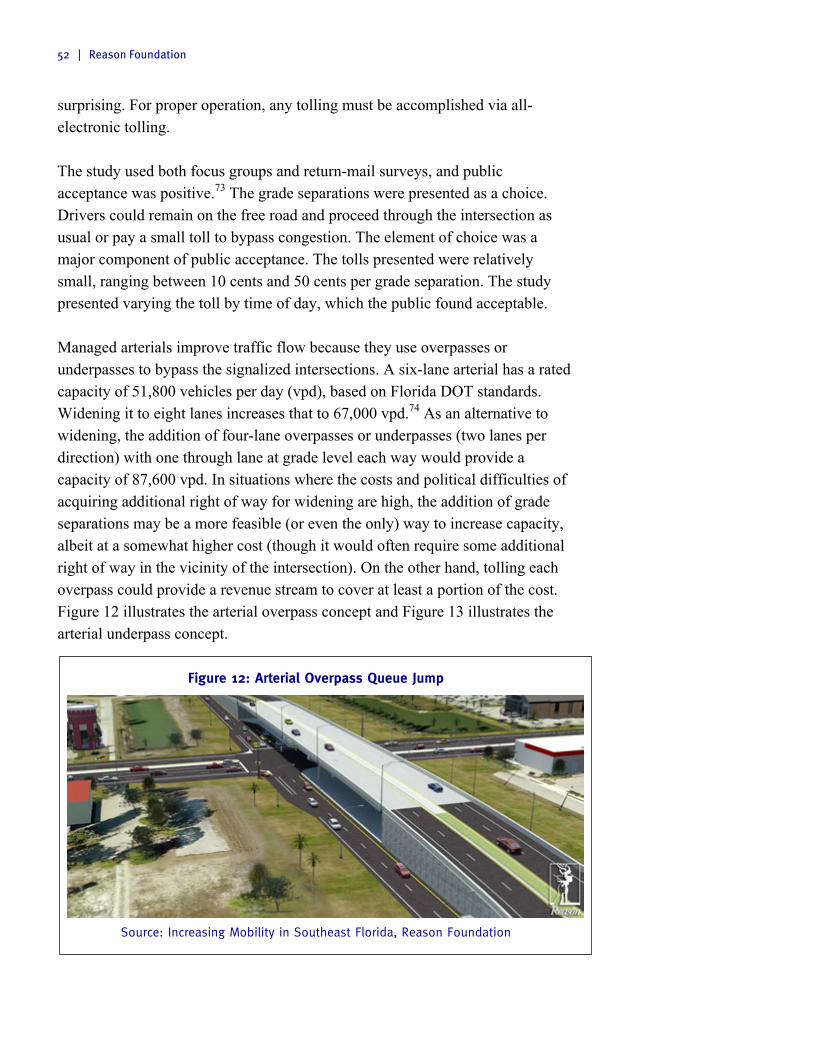
52 | Reason Foundation
surprising. For proper operation, any tolling must be accomplished via all-electronic tolling. The study used both focus groups and return-mail surveys, and public acceptance was positive.73 The grade separations were presented as a choice. Drivers could remain on the free road and proceed through the intersection as usual or pay a small toll to bypass congestion. The element of choice was a major component of public acceptance. The tolls presented were relatively small, ranging between 10 cents and 50 cents per grade separation. The study presented varying the toll by time of day, which the public found acceptable. Managed arterials improve traffic flow because they use overpasses or underpasses to bypass the signalized intersections. A six-lane arterial has a rated capacity of 51,800 vehicles per day (vpd), based on Florida DOT standards. Widening it to eight lanes increases that to 67,000 vpd.74 As an alternative to widening, the addition of four-lane overpasses or underpasses (two lanes per direction) with one through lane at grade level each way would provide a capacity of 87,600 vpd. In situations where the costs and political difficulties of acquiring additional right of way for widening are high, the addition of grade separations may be a more feasible (or even the only) way to increase capacity, albeit at a somewhat higher cost (though it would often require some additional right of way in the vicinity of the intersection). On the other hand, tolling each overpass could provide a revenue stream to cover at least a portion of the cost. Figure 12 illustrates the arterial overpass concept and Figure 13 illustrates the arterial underpass concept.
Figure 12: Arterial Overpass Queue Jump
Source: Increasing Mobility in Southeast Florida, Reason Foundation

Reducing Congestion in Denver | 53
Figure 13: Arterial Underpass Queue Jump
Source: Increasing Mobility in Southeast Florida, Reason Foundation
The managed arterial concept is an accepted method for solving traffic congestion. The National Academy of Sciences Transportation Research Board (TRB) presented an overview of managed arterials at its 2012 annual meeting, and TRB’s journal, Transportation Research Record, published a paper on the subject in issue number 2297.75
E. Improving the Transit Network
Transit ridership has been increasing in Denver. Trips per capita increased from 40 in 1985 to 47 in 2008.76 However, this represents a relatively small subset of the population. In 1980 5.8% of the metro area commuted to work via transit. By 2010 this number had decreased to 4.1%. What explains the conflict between these numbers? Parts of the metro area are very well served by transit. Those residents who take transit do so often. However, other mostly suburban areas are not well served by transit. The challenge is to increase transit ridership in these areas.
Transit in Post-World War II Metropolitan Regions Substantial research has been conducted into the best way to operate transit service. Geographical orientation of service is one key aspect. Several studies conducted over the past decade have shown that multi-destination transit networks (grid networks) are most efficient in attracting passengers and are cheaper to operate than downtown-based systems (radial networks).

54 | Reason Foundation
Multi-destination transit networks (grid networks) are most efficient
in attracting passengers and are cheaper to operate than downtown-
based systems (radial networks).
In 2008, Gregory Thompson, chair of the Transportation Research Board Light Rail Committee, and Jeffrey Brown, associate professor of transportation planning at Florida State University, studied 45 U.S. metro areas to determine whether radial or grid networks offer better service.77 The authors also separated metro areas into those that have bus service only and those that have both rail and bus service. They found that the grid or multi-destination areas that used both rail and bus transit performed better. The radial approach connected neighborhoods to the central business district (CBD), but made reaching jobs outside of the CBD difficult. The multi-destination approach, while not as good at connecting neighborhoods to the CBD, was much better overall because it offered reliable transit service to more parts of the metro areas. Further, from 1984 through 2004, the grid metro areas experienced much smaller productivity declines (single digit) than the radial metros (25%). (Productivity refers to the number of people using the transit system compared to the cost to operate that service.) There was also a smaller increase in per-capita costs for the grid service compared with the radial service. Thompson and Brown studied two bus-only systems in more detail: Broward County Transit (BCT) in Fort Lauderdale, Florida, and the T in Tarrant County, Texas (Fort Worth), which cover similarly sized areas with similar growth patterns. While the T has a radial pattern, BCT has a grid focus. BCT had 31.72 boardings per hour, which was almost double the T’s 16.45. Operating expenses for BCT were also substantially lower, while load factor—the percentage of seats and standing room on a transit vehicle occupied—was substantially higher.

Reducing Congestion in Denver | 55
Figure 14 shows the difference between Broward County’s grid service on the left and Tarrant County’s radial service on the right.
Figure 14: Transit and Employment Access Broward County, FL and Tarrant County, TX
Source: Jeffrey Brown and Gregory Thompson,
Hubs, Spokes, the Grid, and the Future of Transit
That study also highlights the differences between Denver and other U.S. metro areas. New York, Chicago and several other major Northeastern metro areas experienced their fastest period of growth before World War II. Pre-World War II metro areas developed around walking and rail. They have higher population densities and are typically more compact and more centralized. Denver, Houston, Phoenix, Salt Lake City and other southern and western metro areas experienced their fastest growth after World War II. These metro areas developed around the automobile. They have lower population densities and occupy a larger geographic area. Some post-World War II cities, such as Portland, have tried to duplicate the characteristics of pre-World War II cities using urban growth boundaries. Such boundaries limit the physical area of development, creating denser communities. The downside is they also drive up housing costs. Moreover, such boundaries have in fact had minimal success in increasing transit usage. Similarly, it is unlikely that Denver could successfully engineer transit-supporting densities through regulation. For all its regulations aimed at creating denser communities believed to get travelers out of their cars, Portland’s transit usage is not much

56 | Reason Foundation
higher than that of Denver or Salt Lake City or San Diego—comparable cities with less stringent land-use restrictions. Another challenge is the prevalence of traditional Euclidean zoning, separating residential and commercial uses.78 In Euclidean-zoned communities people tend to live further away from where they work than in mixed-use communities. This increased distance between home and work limits the effectiveness of rail. And while mixed-use zoning has become popular in in-town areas of Denver, the majority of the Denver region is still zoned into traditional residential, commercial and industrial areas and considerable opposition exists to changing traditional zoning. Furthermore, while some residents are content to pay higher housing prices to live in a denser area with more transit options, most residents still prefer a location in the suburbs. The upshot is that regardless of policy, Denver will never have the transit ridership of New York City because of the fundamental structure of cities built up after World War II. What does this mean for Denver’s transit system? For one thing, it suggests that we should be skeptical of expensive new rail projects and additional FAStracks expansion. Transit officials hoped that FAStracks would increase the percentage of people who ride transit substantially. However, the percentage of folks riding transit has increased only slightly.
Transit officials hoped that FAStracks would increase the percentage
of people who ride transit substantially. However, the percentage of
folks riding transit has increased only slightly.
More importantly, FAStracks costs have increased. When voters approved a 0.4% sales tax increase, the Denver Regional Transit District (RTD) expected to build 122 miles of light rail over the course of 12 years for $4.7 billion. However, construction is behind schedule.79 The cost has increased from $4.7 billion to $7.8 billion, which is typical for rail projects.80 New funds are difficult to procure. In 2012, the agency declined to put a sales tax increase on the ballot because polling indicated voters would reject it. This report accepts the need to finish FAStracks lines currently under construction. But it also outlines a new approach to transit, based on establishing a comprehensive network of express bus, bus rapid transit, limited-stop bus and local bus service across the Denver metropolitan area. In so doing, it replaces some planned rail lines with express bus and bus rapid transit. The great

Reducing Congestion in Denver | 57
advantage of a bus-based transit system of this sort is that for the cost of two or three new rail lines serving just a handful of commuter corridors, the region can create a comprehensive transit system for the entire metro area. What’s more, this comprehensive system could be implemented in just five years—decades before a rail network would be completed. Of course, the traditional problem with buses is that traffic congestion has an impact on bus travel times and thus severely dampens transit’s time-savings competitiveness with the automobile. Since buses travel in the same traffic lanes as cars, automobile drivers can travel the same route in less time than bus users, thus substantially diminishing time-related incentives to use transit as an alternative. Fortunately, express bus service and bus rapid transit can take advantage of toll-free access to the express lanes and managed arterials outlined earlier in this section. This allows for fast, reliable travel times and in this way completely changes commuters’ cost-benefit calculations—shifting the balance toward transit, without ever penalizing motorists. While some may question whether bus service will ever be as popular as rail service, current I-25 express lane numbers show promising results. In a recent report HPTE revealed that approximately 40 buses use the express lane every hour during the morning commute period.81 This is an average of one bus every 1.6 minutes. A total of almost 6,000 people commute by bus in the I-25 express lanes during the morning commute period.82 Meanwhile, a total of 15,687 people combined use the six light rail lines.83 Therefore on average the I-25 express lane carries twice as many commuters as each rail line (some rail lines operate together in certain locations). Yet the express lane is cheaper to operate, build and maintain than any one rail line.
On average the I-25 express lane carries twice as many commuters
as each rail line (some rail lines operate together in certain
locations). Yet the express lane is cheaper to operate, build and
maintain than any one rail line.
The Characteristics of Express Bus and Bus Rapid Transit High-quality limited-stop bus services typically operate as express bus on freeway and other high-speed arterials, and as bus rapid transit on arterials and local streets. There are differences between these two types of services.

58 | Reason Foundation
Express bus is a bus service that provides point-to-point service from one of many park-and-ride lots in the suburbs to various business districts throughout the metro area.84 Metro areas have several different bus routes serving a park-and-ride area or have intermediate stops where commuters can transfer from one bus to another. Express bus service is used mostly during rush hour when choice ridership is higher. Express bus mainly operates on freeways or expressways, making its service characteristics similar to commuter rail. Bus rapid transit (BRT) is an enhanced bus service that operates with characteristics of a dedicated guideway.85 As a result BRT operates at faster speeds, provides greater service reliability and increased customer convenience.86 BRT operates mainly on arterials, has frequent stops along the transit line (every 1⁄4 to 1⁄2 mile) and serves multiple origin and destination pairs. Its service characteristics are similar to heavy or light rail. To more effectively differentiate from local bus, BRT often has the following features:87
§ Running ways that give buses priority
§ Unique station design
§ Larger vehicles
§ Electronic smart card/off-board fare collection
§ Intelligent transportation systems such as priority signaling
§ More frequent service especially during rush hour
§ Specific branding Since BRT runs on arterial and local streets, it may have additional features to help it fit into the community. These include land use or area-specific zoning and elevated boarding platforms level with the station. Since the term BRT has come to encompass a considerable range of service types, a recent research report from the Federal Transit Administration sought to provide some clarity by separating BRT into two basic types:88
§ “BRT-heavy” refers to BRT systems that operate in dedicated rights of way
§ “BRT-lite” refers to BRT systems that lack dedicated rights of way. Such services have many of the components of BRT heavy but use fewer enhancements. These services may be as basic as limited-stop arterial express service with signal priority.

Reducing Congestion in Denver | 59
BRT-Heavy, BRT-Lite, Express Bus and Virtual Exclusive Busways Our basic premise—that express bus and BRT can produce more transit bang for the buck in Denver—is generally valid. However, the more popular express bus operating in a dedicated lane concept has two significant drawbacks. First, obtaining an exclusive right of way is expensive, in both land costs and pavement costs. Second, since very few corridors can support more than 10 such buses per hour (one every six minutes) and usually only during peak periods, for the vast majority of the time that expensive right of way is empty and unproductive. Even with one-minute headways (60 buses per hour), that exclusive bus lane could handle at least 1,600 vehicles per hour at uncongested LOS C conditions. Thus, 1,540 spaces are going to waste if that lane is used exclusively for bus service. This is borne out by experience. In the 1970s various state DOTs experimented by dedicating a freeway lane in each direction to express bus service. The result was a waste of a full highway lane. This waste led to the conversion of original transitways for express bus service, such as the Shirley Highway in Northern Virginia, to HOV (high occupancy vehicle) lanes.89 Initially, vanpools were allowed in, and when that measure failed to use all the capacity, three-person carpools. In most metro areas that took this path, the eventual result (as on I-95 in Miami) was HOV lanes filled with two-person carpools. Unlimited numbers of HOV-2s led to congestion, greatly reducing the “express” nature of the bus service. This is precisely where priced lanes (such as our proposed express lane and managed arterial network) can make a significant difference. Variable pricing can keep such lanes flowing at a high volume with no congestion (at LOS C). Therefore, a properly run priced lane can provide express buses with performance comparable to what they get from an exclusive busway. Because of this, some have termed a priced lane that provides guaranteed access for express bus service a “virtual exclusive busway” (VEB).90
A properly run priced lane can provide express buses with
performance comparable to what they get from an exclusive busway.
VEBs have been implemented in Denver. The RTD’s express bus service on I-25 is an example of a (VEB). The dynamically priced lanes provide free passage to buses, vanpools and emergency vehicles but charge a variable toll based on

60 | Reason Foundation
congestion to automobiles. Denver plans to add this type of service to US 36 once the express lane is extended to Boulder. Every Denver-area freeway that has express lanes can offer this high-speed, high-quality bus service. In some metro areas the DOT and transit operator enter into an agreement to build and operate the express lanes together. Denver’s transportation agencies should consider such a partnership. Texas DOT and Houston Metro’s transit agency have an agreement to operate service on Houston’s Katy Freeway (I-10).91 The $250 million project added four priced lanes to the median of the freeway, replacing a single reversible HOT lane as part of a larger-scale project that rebuilt and widened the freeway. It is a public-public partnership between Harris County Toll Road Authority (HCTRA), the local transit agency (Metro) and the Texas DOT, with the approval of FHWA and FTA. HCTRA financed the priced lanes and will operate and maintain them, using the toll revenue for debt service and operation and maintenance costs. Metro is guaranteed up to 25% of the priced lanes’ capacity, for any combination of buses, vanpools and carpools. In a memorandum of understanding (MOU), it agreed to increase the HOV occupancy level over time, as needed, to stay within its 25% usage. HCTRA, in turn, agreed in the MOU to use variable pricing to maintain LOS C conditions, thereby limiting the number of toll-paying vehicles using the priced lanes. To get a better idea of the cost-effectiveness of such networks, the Government Accountability Office compiled data from the FTA’s New Starts and Small Starts programs on recent BRT, light rail (LRT) and heavy rail (HRT) projects. The average cost per route-mile was $124 million for LRT and $154 million for HRT.92 If a metro area wanted to build a region-wide LRT or HRT system, encompassing 250 route-miles, the cost would be $31 billion for LRT or $38.5 billion for HRT. A comparable VEB network would require 500 lane-miles, with one lane per direction. If all 500 lane-miles had to be added as new construction (i.e., if there were no HOV lanes to convert, at modest cost), the cost would be $5 billion if the average cost were $10 million per lane-mile or $10 billion if the average cost were $20 million per lane-mile.
Thus, the capital cost of a VEB network would be between one-sixth
and one-fourth that of a rail system of comparable size.
Thus, the capital cost of a VEB network would be between one-sixth and one-fourth that of a rail system of comparable size (though that comparison does not

Reducing Congestion in Denver | 61
include the cost of additional buses to make full use of the new network). Furthermore, the LRT or HRT capital costs—$30 billion to $40 billion—would all have to be raised as federal, state and local tax money. Passenger fares would not cover any of that, and would cover only a portion of the operating and maintenance costs. By contrast, the VEB network’s capital costs would be partly covered by motorists paying the variable-priced tolls. Thus, transit capital funds would likely be needed only for the express bus vehicles and any off-line stations and park-and-ride lots developed to enhance express bus on priced lanes service.
Figure 15: Transit System Capital Costs of Heavy Rail System, Light Rail System and Bus Rapid Transit (in billions $)
On managed arterials, BRT heavy has the same problems as express bus service operating in dedicated lanes: acquiring land for a dedicated lane is expensive and few corridors support more than 10 buses per hour. Instead we recommend a BRT-lite service best exemplified by the Metro Rapid program implemented by the Los Angeles County Metropolitan Transportation Authority starting in 2000.93 It offers limited-stop bus rapid transit service in specially marked buses along major arterials. In addition to making stops about 0.7 miles apart (vs. 0.2 miles between stops on conventional bus routes), the service increasingly operates with traffic signal priority at intersections. The initial Metro Rapid line 720 increased transit ridership in that corridor by 40%. Others have seen even greater increases: 794 has increased ridership by 65% and 770 by 70%. That success has led to the rapid expansion of the service to 20 other major arterials
$0 $5 $10 $15 $20 $25 $30 $35 $40 $45
Transit System Capital Cost
Bus Rapid Transit Light Rail Heavy Rail

62 | Reason Foundation
in Los Angeles County, as of 2014, encompassing 380 arterial-miles and 500 buses.94 A recent Transportation Research Board paper compared Metro Rapid service on Ventura Blvd. in LA’s San Fernando Valley with parallel BRT-heavy service on the area’s then-new Orange Line exclusive busway. The travel times were about the same for both, but the capital cost per boarding was only $1,300 for the BRT-lite versus $16,800 per boarding for the BRT-heavy service, primarily because of the exclusive-guideway cost for the latter.95
BRT-lite appears to be a highly cost-effective way to expand transit
service on arterials.
BRT-lite appears to be a highly cost-effective way to expand transit service on arterials. And just as express bus is well-suited to operate on express toll lanes on freeways, BRT-lite could take advantage of managed arterials to operate faster than what is possible on ordinary arterials. This addition would expand the network of region-wide BRT to the corridors with managed arterials, in addition to the express lane network. BRT-lite service can be added on traditional arterial roads with grade separations. Services on traditional arterial roads will not offer the same speeds as those operating on managed arterials, but will still be considerably faster than local bus.
A 21st Century Approach to Transit in Denver Denver’s transit network can be improved in three simultaneous steps. First, BRT and express bus service should be extended to parts of the metro area that lack rail service. Second, existing local bus networks need to add new routes and increase the frequency of existing routes. Finally, the existing bus and rail schedules should be tweaked to make connections as easy as possible.

Reducing Congestion in Denver | 63
P a r t 5
Managed Lane and Freeway Capacity
The first part of solving metro Denver’s mobility problems involves adding limited general purpose capacity and an express toll lane network. The challenge is determining where to add additional freeway capacity and whether to price it. We relied on projections of traffic in individual freeway corridors, provided by DRCOG and adjusted based on current traffic projections. They showed projected traffic in each direction during the AM and PM peak periods through 2035. Based on that data we can estimate which corridors need additional lanes, how many lanes are needed, whether the lanes should be priced and whether they should be reversible or operate in one direction.
A. The Express Toll Lane Network
The first part of the plan includes a comprehensive express toll lane network on the existing freeway system that provides reliable uncongested travel for buses, vanpools, emergency responders and single-occupant commuters or carpools. This express lane network will add toll lanes to various portions of I-25, I-70, I-76, I-225, I-270, US 6, US 36 and C-470. These projects will add a total of 450 new ETL-miles of capacity to the system, while the widening and conversion of I-70 to a toll road from the Twin Tunnels to the Eisenhower Tunnel and the completion of the beltway via the Jefferson Parkway toll road project would create another 252 lane-miles and 96 lane-miles respectively. Table 13 depicts the system as it would exist when completed by 2040. Figure 16 shows the express toll lanes network. Table 13 shows the proposed expansion of the freeway network, in five phases. The first phase concentrates on adding express toll lanes to the most congested portions of the freeway system, where relief is needed most. Phase 2 includes the further development of the ETLs, some additional general purpose capacity, and the construction of the Jefferson Parkway and widening and tolling of the I-70 mountain corridor. Phase 3 includes further improvements to I-25, I-70 and I-

64 | Reason Foundation
76. The fourth phase adds additional ETLs on portions of C-470, US 6 and Pena Blvd. The final phase would add ETLs to I-25 and I-225. Some of the freeways sections detailed in this report stretch outside the Denver metropolitan area to Fort Collins, Monument and Silverthorne. However, since the majority of the affected segment is in metro Denver, these segments are included in this report. Table 13: Proposed Denver Toll Lane Network Expansions Phase 1: 2015–2020 Express Toll Lanes
In Long Range Plan
Cost
I-25 Add 2 reversible express toll lanes between the C-470/E-470 Interchange and Wolfensberger Rd Castle Rock and 1 express lane per direction between Wolfsenberger Rd and Plum Creek Parkway (26 lane-miles)
Yes $594M
I-25 Add 2 reversible express toll lanes between E. 84th Ave and SR 66 and 1 reversible express toll lane between SR 66 and CR 34. (51.4 lane-miles)(24.2 lane-miles in Weld County)
Part $880M
I-25 Add 1 express toll lane per direction between Speer Blvd and E 84th Ave. (14 lane-miles)
No $235.2M
I-70 Add 2 express toll lanes per direction between I-25 and Pena Blvd (38 lane-miles)
Yes $1,400M
Phase 2: 2020–2025 Express Toll Lanes I-270 Add 1 express toll lane per direction between I-25 and I-70 (12 lane-miles) Different
Solution $200M
Phase 2: 2020–2025 Toll Roads I-70 West Add 1 lane per direction between Eisenhower Tunnel and Bus. 70/Colorado Blvd
(Exit 241A) Westbound and US 40 (Exit 247) Eastbound (59 lane-miles) and toll Eisenhower and Twin Tunnels
Different Solution
$1,600M
NW Parkway Phase 2
Construct a new 4-lane toll road to complete the Denver beltway (96 lane-miles)
Part $980M
Phase 3: 2025–2030 Express Toll Lanes I-70 Add 2 express toll lanes per direction between the C-470 Interchange and I-76
and 1 express toll lane per direction between I-76 and I-25 (47 lane-miles)
No $1,580M
I-76 Add 1 express toll lane per direction between I-70 and I-25 (11 lane-miles) No $160M
Phase 4: 2030–2035 Express Toll Lanes C-470 Add 2 express toll lanes per direction between I-25 and I-70 (104.8 lane-miles) No $514M US-6 Add 1 express toll lane per direction between I-70 and I-25 (17.6 lane-miles) No $580M Pena Blvd Add 1 express toll lane per direction between I-70 and E-470 (12.6 lane-miles) Different
Solution $150M
Phase 5: 2035–2040 Express Toll Lanes I-25 Add 2 express toll lanes per direction between Speer Blvd and C470/E470 (68.4
lane-miles) No $1,540M
I-225 Add 1 express toll lane per direction between I-70 and I-25 (24.4 lane-miles) No $292.8M
Total Cost Express Toll Lanes $8,126M
Total Cost Toll Roads $2,580M
Total Cost Express Toll Network $10,706M
Note: All figures are sketch-level estimates, not investment-grade figures.

Reducing Congestion in Denver | 65
Figure 16: Map of Denver Express Lane Network Expansions
The express toll lanes network is a comprehensive system of new lanes. The phases are structured first to build lanes on the most congested parts of the network and then expand those lanes to the entire network. A system built in this order will provide the most benefits. For example, many drivers from Castle Rock travel north on I-25 in the morning and south in the afternoon to the Denver Tech Center. The worst of the congestion is between Castle Rock and E-470 so the section from Castle Rock to E-470 should be built first and the section from E-470 to the Tech Center should be built later. Some delays may remain on I-25 north of I-225. However, since the worst congestion is currently south of E-470, that is where the first express toll lanes on I-25 should be built. The express toll lanes on each highway will function together as a network. And the network is only as strong as its weakest link. Some parts of the network have better cost-benefit ratios than others. Some will transport more commuters than others, but the value lies in creating this total network offering uncongested travel throughout almost any part of metro Denver. As a result, it is critical that the entire network be built.
2 Managed Lanes in Each Direction
1 Managed Lanes in Each Direction
Highway Segment with Tolled Tunnels
Tolled Highway Segment

66 | Reason Foundation
B. New General Purpose Capacity
An express toll lane network is the most effective way to improve mobility in a growing metro area. However, some highways lack sufficient general purpose lanes, are so congested that additional general purpose lanes are needed, or are located in a rural corridor that cannot support express toll lanes. Certain parts of I-25, I-70 and I-76 need additional general purpose lane capacity. These sections are indicated in Table 14 below. Figure 17 shows the new general purpose sections. Table 14: Proposed Denver General Purpose Network Expansions Phase 2: 2020–2025
In LRP
Cost
I-70 Add 1 general purpose lane per direction between SR 74W (exit 252) and C-470 (exit 260) (16 lane-miles)
Yes $416M
I-76 Add 1 general purpose lane per direction between I-25 and 88th St. (9.4 lane-miles) No $120M Phase 3: 2025–2030 I-25 Add 1 general purpose lane per direction between N of SR 66 to SR 14 (51 lane-miles in
Weld County) Part $612M
I-25 Add 1 general purpose lane per direction between Exit 163 County Line Rd and 1.5 lane-miles south of Plum Creek Parkway (32.8 lane-miles)
No $400M
Total Cost General Purpose Lanes $1,548M
* Note: All figures are sketch-level estimates, not investment-grade figures.
Figure 17: Map of Denver General Purpose Lanes Network Expansions
1 Additional General Purpose Lane in Each Direction

Reducing Congestion in Denver | 67
C. Freeway Interchanges
Some of Denver’s freeway interchanges are functionally obsolete. Such interchanges feature outdated designs or carry far more traffic than the original design intended. Table 15 has a listing of interchanges that need to be modernized. Figure 18 displays the geographic location of these modernizations.
Table 15: New and Modified Freeway Interchanges Interchange In LRP Cost* Interchange In LRP Cost* I-25 at Douglas Lane Yes $35M I-25 at Baseline Rd. No $50M I-25 at Castlegate Dr. Yes $12M I-76 at 160th Ave. No $20M I-70 at US 40, Empire Junction No $55.5M I-70 at Colfax Ave. Yes $150M US 6 Federal St. to Bryant St., Interchange Improvements
Yes $31.2M I-25 at Colfax Ave. No $50M
US 36 at Sheridan Blvd. Yes $49.2M I-25 at Hampden Ave. No $150M E-470, I-70, Gun Club Rd. No $145.7M I-225 at Parker Rd. No $50M I-25 at Broadway No $25.0M E-470 at Hampden Ave. No $40M I-70 at Central Park Blvd. No $50.6M I-25 at Ridgegate Parkway No $50M I-70 at Harvest Mile Rd. Yes $31.2M C-470 at Wadsworth Blvd. No $100M I-70 at Picadilly Rd. Yes $21.6M Wadsworth Blvd at US 285 No $100M E-470 at 48th Ave. Yes $21.2M Wadsworth Blvd at I-70/I-76 No $50M E-470 at 88th Ave. Yes $13.9M Wadsworth Blvd at US 36 No $140M E-470 at 112th Ave. Yes $13.9M US 287 at Northwest Parkway No $100M E-470 at Potomac St. Yes $6.3M C-470 at University Blvd. No $100M E-470 at Quebec St. Yes $19.5M I-25 at Colorado Blvd. No $75M Jefferson Parkway at SH 72 Yes $20M I-70 at Colorado Blvd. No $25M Jefferson Parkway at Candelas Parkway Yes $20M I-270 at Vasquez Blvd. No $25M Jefferson Parkway at Indiana St. Yes $20M I-76 at Colorado Blvd. No $200M I-25 at SH 7 Yes $58M E-470 at Colorado Blvd. No $100M I-25 at Alameda Ave/Santa Fe Drive Yes $42.5M E-470 at Parker Rd. No $50M I-25 at Arapahoe Rd. Yes $83M I-70/Pena Blvd at Airport Blvd. Part $100M I-70 at 32nd Ave. No $22M Pena Blvd. at Tower Rd. and Buckley
Rd. Extension No $125M
I-70 at Kipling St. No $32.6M 6th Ave. at SR 58 No $200M I-70 at US 6 No $25M E-470 at 104th Ave. No $20M I-70 at E-470 No $145.7M C-470 at Santa Fe Drive Yes $75M US 6 at Simms St. Yes $35.4M I-76 at Bridge St. No $20.0M US 6 at Kipling St. Yes $29.2M SR 58 at Cabela Dr. Yes $15.4M US 6 at Wadsworth Blvd. Yes $95.5M US 36 at Wadsworth Parkway No $60M I-25 at 104th Ave. No $60M New Alignment at I-76/74th St. No $50M Estimated Total Cost $3,511M
* Note: All figures are sketch-level estimates, not investment-grade figures.

68 | Reason Foundation
Figure 18: Map of New and Modified Freeway Interchanges
Freeway Interchange Needing Reconstruction

Reducing Congestion in Denver | 69
P a r t 6
Arterial Highways and Managed Arterials
The next part of solving metro Denver’s transportation challenges includes modernizing the existing arterial highway network and upgrading some arterials to managed arterials where appropriate. While Denver has a well-developed arterial system, it is crucial to continue to improve and expand this system. This report focuses on major arterials. Minor arterials, collectors and local roads are also important, but they are beyond the scope of this report. To cost-effectively improve its existing primary arterials, we recommend that Denver develop a managed arterial network. Several metro areas across the country, including Miami and San Diego, are considering managed arterials. As discussed previously, managed arterials combine dynamic traffic management systems with pricing to offer drivers a premium travel option.
To cost-effectively improve its existing primary arterials, we
recommend that Denver develop a managed arterial network.
A. Managed Arterials
The biggest component of any managed arterial is overpasses or underpasses at major intersections. Building grade-separated intersections improves traffic flow. Unlike a traffic light, which limits flow to the peak direction at least 50% of the time at major intersections, grade separation allows continuous flow. Traveling though these intersections and paying a small toll to bypass congestion will be optional. Vehicles will not be required to pay the toll to get across the intersection, only to use the bypass route that allows for a continuous “green time” for prevailing through traffic. Dynamic traffic management systems and access management are other important features of managed arterials.

70 | Reason Foundation
All major arterial intersections in the Denver metro area were investigated to determine whether they would be suitable for grade-separated intersections. Tolled grade-separated interchanges require both sufficient space (right-of-way) to build a surface intersection and grade separation, and sufficient traffic volume. Tolled grade separation is considered only for highways which have a minimum of three lanes per directional travel (i.e., a six-lane width requirement) and large enough traffic volumes on side streets to necessitate a long red signal for the peak direction. Intersection site visits were used to check intersection right-of-way needs. Intersection traffic volume data were obtained from numerous sources, including DRCOG, CDOT and the city of Denver. This report recommends that Denver implement five east-west managed arterials and four north-south managed arterials. Managed arterial costs include the cost to build the overpasses/underpasses, right-of-way acquisition costs at some intersections, minor street widenings in some areas and new alignments in some areas. These components are discussed below. The street widenings and associated right-of-way expenses are estimated at $1.1 billion. New grade-separated interchanges are estimated at $4.24 billion, but approximately half of this cost will be covered by toll revenue. New alignments are expected to cost approximately $224 million, while intelligent transportation systems (ITS) improvements are expected to cost $500 million. All projects not covered by toll revenue will be funded through gas taxes and/or mileage-based user fees. All Denver-area managed arterials will offer access to all local business and residences. For safety reasons, left turns from the main highway and from businesses located along the highway will be limited to areas with traffic signals. Since these managed arterials have many traffic signals, major delays are not expected. In areas without a traffic light, special signals that allow u-turns only can be installed. Some arterials will be widened to four or six lanes and converted to managed arterials. While managed arterials are typically used in place of road widening, some parts of Denver are growing so rapidly that both the widening and the conversion must occur. While these arterial improvements are not cheap, arterials form the basis for Denver’s street and transit network. While freeways transport more vehicles, major arterials transport commuters to and from the freeways and form the backbone of local travel. If the arterial system is ineffective, improving the freeway network will have limited results.

Reducing Congestion in Denver | 71
Further, improving arterial networks with managed arterials will also improve the transit system by providing reliable bus rapid transit service on congestion-free streets. One of the biggest reasons that choice bus riders (those who can commute to work by another mode) drive their cars is that many bus services take just as long as commuting by automobile since buses sit in the same congestion. Managed arterials would decrease bus travel times, likely increasing ridership and providing a robust transit network.
Improving arterial networks with managed arterials will also improve
the transit system by providing reliable bus rapid transit service on
congestion-free streets.
B. Proposed Arterial Projects The following tables detail managed arterials components. Table 16 details the arterial sections that need to be widened. Tables 17 and 18 detail the new roadways and rail crossings needed to complete these arterials. Figure 19 displays the location of these arterials. Table 19 details the new grade separations. Figure 20 displays the location of the grade separations. All components of managed arterials are included in Appendix A.
Table 16: Arterial Widenings Road From To Scope In
LRP Cost
100th Ave. Simms St Independence St. Widen by 1 lane in each direction (2.4 lane-miles) No $7.2M Church Ranch Blvd. 101st Ave. 103rd Ave. Widen by 1 lane in each direction (2.8 lane-miles) No $8.4M 104th Ave. Westminister Blvd. Croke Dr. Widen by 1 lane in each direction (7.2 lane-miles) No $22.2M 104th Ave. Marion St. 1/4 mi W of SR 2 Add 1 lane in each direction (13.0 lane-miles) No $39M Arapahoe Rd. E of 55th St. W of 75th St. Widen by 1 lane in each direction (4.0 lane-miles) No $12M Baseline Rd. E of 75th St. 95th St. Widen by 1 lane in each direction (3.2 lane-miles) No $9.6M Baseline Rd. ¼ mi W of US 287 I-25 Widen by 1 lane in each direction (13.0 lane-miles) No $32.5M Baseline Rd. 166th Ave. I-76 Widen by 1 lane in each direction (25.4 lane-miles) No $63.5M US 40 ½ mi SW of US 6 Indiana St. Add 1 lane in each direction (2.6 lane-miles) No $11.7M US 40 Cole Blvd. Wide Acres Rd. Add 1 lane in each direction (2.2 lane-miles) No $9.9M US 40 Sheridan Blvd. Irving St. Add 1 lane in each direction (2.4 lane-miles) No $10.8M US 40 Park Ave. Peoria St. Add 1 lane in each direction (13.4 lane-miles) No $60.3M US 40 Sable Blvd. ¼ mi E of Airport
Blvd. Add 1 lane in each direction (1.7 lane-miles) No $15.3M
Havana St. ½ mi SW of Galena St. Dartmouth Ave. Add 1 lane in SW direction (1 lane-mile) No $3M Dartmouth Ave. SR 30 Parker Rd. Add 1 lane in each direction (1.2 lane-miles) No $3.6M Hampden Ave. Conservatory Parkway Gun Club Rd. Add 1 lane in each direction (2.2 lane-miles) No $4.4M Titan Rd. Rampart Range Rd. US 285 Add 1 lane in each direction (6 lane-miles) No $12M RidgeGate Parkway I-25 Tomahawk Rd. Add 1 lane in each direction (18.8 lane-miles) No $56.4M SR 93 C-470 Table Mesa Rd. Add 1 lane in each direction (40 lane-miles) No $240M SR 93 ¼ mi S of Baseline Rd. ¼ mi N of Canyon
Blvd. Add 1 lane in each direction (4.0 lane-miles) No $20M

72 | Reason Foundation
Table 16: Arterial Widenings Road From To Scope In
LRP Cost
Wadsworth Blvd. C-470 Parkhill Ave. Add 1 lane in each direction (7.4 lane-miles) No $33.3M Wadsworth Blvd. US 285 Ohio Ave. Add 1 lane in each direction (7.0 lane-miles) No $31.5M Wadsworth Blvd. US 6 I-70/I-76 Add 2 lanes in each direction (16.4 lane-miles) Part $36.9M Wadsworth Parkway W 92nd Ave. 108th Ave. Add 1 lane in each direction (4.4 lane-miles) Yes $20M US 287 US 36 ¼ mi N of Arapahoe
Rd. Add 1 lane in each direction (15.6 lane-miles) No $46.8M
University Blvd. County Line Rd. Quincy Ave. Add 1 lane in each direction (10.0 lane-miles) No $45M Quincy Ave. University Blvd. Colorado Blvd. Add 2 lanes in each direction (4 lane-miles) No $18M Colorado Blvd. Quincy Ave. Hampden Ave. Add 2 lanes in each direction (4 lane-miles) No $18M Colorado Blvd. SR 2N 68th Ave. Add 1 lane in each direction (1.0 lane-miles) No $3M 68th Ave. Brighton Blvd. Colorado Blvd. Add 1 lane in each direction (0.8 lane-miles) No $2.4M Colorado Blvd. ¼ mi S of 88th Ave 140th Ave. Add 1 lane in each direction (13.2 lane-miles) No $39.6M Colorado Blvd. 140th Ave. ¼ mi N of 144th Ave. Add 2 lanes in each direction (2.8 lane-miles) No $5.6M Colorado Blvd. ¼ mi N of 144th Ave. 168th Ave. Add 1 lane in each direction (6.4 lane-miles) No $12.8M SR 83 ¼ mi S of SR 86 Bayou Gulch Rd. Add 1 lane in each direction (6.6 lane-miles) No $13.2M Arapahoe Rd. Parker Rd. Buckley Rd. Add 1 lane in each direction (1.6 lane-miles) No $7.2M Buckley Rd. ¼ mi S of Orchard Rd. Mississippi Ave. Add 1 lane in each direction (12.2 lane-miles) No $54.9M Buckley Rd. E 88th Ave. Chambers Rd. Add 1 lane in each direction (3.8 lane-miles) No $11.4M Chambers Rd. 96th Ave. ¼ mi S of 104th Ave. Add 1 lane in each direction (2.0 lane-miles) No $6M Chambers Rd. ¼ mi S of 104th Ave. ¼ mi N of 104th Ave. Add 1 lane in each direction (1.0 lane-mile) No $3M Adams County Parkway N.
Bridge over I-76 Sable Blvd. Add 1 lane in each direction (0.8 lane-miles) No $2.4M
Sable Blvd. Adams County Parkway N.
¼ mi N of 144th St. Add 1 lane in each direction (5.0 lane-miles) No $10M
US 85 Sable Blvd Connector
2 mi N of 168th Ave. Add 1 lane in each direction (8.8 lane-miles) No $22.4M
Monaco Parkway Yale Ave. Jewell Ave. Add 1 lane in northbound direction only (1.0 lane-mile) No $3M US 85 ¼ mi S of Mineral Ave. Sumner St.
northbound/Church Ave. southbound
Add 1 lane in each direction (4.0 lane-miles) No $13.2M
Total Cost $1101.4M
*Note: All figures are sketch-level estimates, not investment-grade figures.
Table 17: New Roadway Sections Road From To In LRP Cost* Arapahoe-Baseline Rd. Connector (2.5 miles) Arapahoe Ave. 2 mi W of 75th St Baseline Rd. 1 mi E of 75th St. No $30M Titan Rd. Extension (6.0 miles) US 85 at Titan Rd. Ridgegate Parkway just W of I-25 No $72M 68th Ave Colorado Blvd. Connector (3.0 miles) 68th Ave. at Colorado Blvd. 86th Ave. at Colorado Blvd. No $72M Pena Blvd.-Buckley Rd. Connector (1.5 miles) Pena Blvd./ w of Tower Rd./
Buckley Extension Buckley Rd. at E 88th Ave. No $18M
Chambers Rd. Adams County Parkway Connector (0.5 mile)
E 120th Ave. at Chambers Ave. S Adams County Parkway S of Valente Dr.
No $6M
Sable Blvd-US 85 Connector (0.5 mile) Sable Blvd ¼ mi N of 144th Ave. US 85 ½ mi N of US 85 No $6M Total Cost $204 M
*Note: All figures are sketch-level estimates, not investment-grade figures.
Table 18: New Bridges Action Section In LRP Cost* Railroad grade separation Airport Blvd. just N of Smith Rd. No $20M Total Cost $20M
*Note: All figures are sketch-level estimates, not investment-grade figures.

Reducing Congestion in Denver | 73
Table 19: Arterial Grade-Separated Interchanges Interchange In LRP Cost* Interchange In LRP Cost* Church Ranch Blvd. at Wadsworth Parkwy
No $55M Wadsworth Blvd. at 88th Ave. No $30M
W 104th Ave. at Sheridan Blvd. No $30M Wadsworth Blvd. at Interlocken Loop No $30M W 104th Ave. at Federal Blvd. No $36M US 287 at South Boulder Rd. No $30M W 104th Ave. at Huron St. No $30M US 287 at Arapahoe Rd. No $30M E 104th Ave. at Washington St. No $30M University Blvd. at County Line Rd. No $30M E. 104th Ave. at Colorado Blvd. No $55M University Blvd. at Dry Creek Rd. No $30M E 104th Ave. at US 85 No $35M University Blvd. at Arapahoe Rd. No $30M 104th Ave. at Chambers Blvd. No $45M University Blvd. at Belleview Ave. No $30M Arapahoe Ave. at US 36 No $65M Univerity Blvd. at Quincy Ave. No $18M Arapahoe Ave. at 30th St. No $40M Quincy Ave. at Colorado Blvd. No $18M Arapahoe Ave. at Foothills Parkway No $40M Colorado Blvd. at Evans Ave. No $30M Baseline Rd. at US 287 No $55M Colorado Blvd. at Florida Ave. No $30M Basline Rd. at Colorado Blvd. No $45M Colorado Blvd. at Cherry Creek St. No $30M Baseline Rd. at US 85 No $45M Colorado Blvd. at Alameda Ave. No $30M Colfax Ave. at 6th Ave. No $35M Colorado Blvd. at 1st Ave. No $30M Colfax Ave. at Indiana St. No $30M Colorado Blvd. at 17th Ave. No $30M US 40 at Kipling St. No $30M Colorado Blvd. at Martin Luther King Jr. Blvd. No $30M US 40 at Wadsworth Blvd. No $55M Vasquez Blvd. at 56th Ave. No $30M US 40 at Sheridan Rd. No $30M Canaan Highway at 60th Ave. No $30M US 40 at Kalamath St. and N. Speer Blvd. No $50M Canaan Highway at 68th Ave. No $40M US 40 at York St. and Josephine St. No $45M Colorado Blvd. at 88th Ave. No $30M US 40 at Colorado Blvd. No $60M Colorado Blvd. at Thornton Parkway No $30M US 40 at Peoria St. No $30M Colorado Blvd. at 120th Ave. No $55M US 40 at Potomac St. No $30M Colorado Blvd. at 128th Ave. No $30M US 40 at Chambers Blvd. No $30M Colorado Blvd. at 136th Ave. No $30M US 40 at Airport Blvd. No $55M Colorado Blvd. at 144th Ave. No $30M Hampden Ave. at University Blvd. No $35M Parker Rd. at SR 86 No $20M Hampen Ave. at Colorado Blvd. No $55M Parker Rd. at Hess Rd. No $20M Hampden Ave. at Monaco Parkway No $30M Parker Rd. at Main St. No $30M Hampden Ave. at Yosemite St. No $30M Parker Rd. at Lincoln Ave. No $30M East Dartmouth Ave. at Parker Rd.** No $20M Parker Rd. at Pine Lane No $30M Parker Rd. at Peoria St. No $30M Parker Rd. at Cottonwood Dr. No $30M Hampden Ave. at Chambers Rd. No $30M Parker Rd. at Arapahoe Rd.** No $18M Hampden Ave. at Buckley Rd. No $55M Arapahoe Rd. at Buckley Rd.** No $18M Hampden Ave. at Tower Rd. No $30M Buckley Rd. at Orchard Rd. No $30M Titan Rd. at US 85 No $45M Buckley Rd. at Smokey Hill Rd. No $30M Titan Rd. Ext. at Monarch Blvd. No $95M Buckley Rd. at Quincy Rd. No $30M Ridgegate Parkway at Chambers Rd. No $25M Buckley Rd. at E lliff Ave. No $30M Ridgegate Parkway at Jordan Rd. No $30M Buckley Rd. at Mississippi Ave. No $30M Ridgegate Parkway at Twenty Mile Rd. No $30M Airport Blvd. at Alameda Parkway No $30M Ridgegate Parkway at Parker Rd. No $55M Airport Blvd. at 6th Ave. No $30M SR 93 at SR 58 No $75M Chambers Rd. at 120th Ave. No $55M Broadway St. at Table Mesa Rd. No $30M N. County Services Prkwy at Sable Blvd. No $12M Broadway St. at Baseline Rd. No $35M Canaan Highway at US 85-SR 2 Connector No $12M Broadway St. at Boulder Canyon Dr. No $40M Canaan Highway at 168th Ave. No $25M U.S. 85 at 160th Ave. No $45M 120th Ave. at Sheridan Blvd. No $30M Wadsworth Blvd. at Chatfield Ave. No $30M 120th Ave. at Washington St. No $30M Wadsworth Blvd. at Ken Caryl Ave. No $35M Federal Blvd. at 112th Ave. No $30M Wadsworth Blvd. at Coal Mine Ave. No $35M 80th Ave. at Sheridan Blvd. No $30M Wadsworth Ave. at Bowles Ave. No $30M Alameda Ave. at Sheridan Blvd. No $30M Wadsworth Ave. at Belleview Ave. No $30M Alameda Ave. at Federal Blvd. No $35M

74 | Reason Foundation
Table 19: Arterial Grade-Separated Interchanges Interchange In LRP Cost* Interchange In LRP Cost* Wadsworth Blvd. at Quincy Ave. No $30M Alameda Ave. at Monaco Parkway No $30M Wadsworth Blvd. at Yale Ave. No $30M Havana Parkway at Alameda Ave. No $30M Wadsworth Blvd. at Jewell Ave. No $30M Santa Fe Dr. at Mississippi Ave. No $40M Wadsworth Blvd. at Mississippi Ave. No $30M Monaco Parkway at Evans Ave. No $30M Wadsworth Blvd. at Alameda Ave. No $30M Havana St. at Mississippi Ave. No $30M Wadsworth Blvd. at 32nd Ave. No $30M Havana St. at Iliff Ave. No $30M Wadsworth Blvd. at 44th Ave. No $30M Havana St. at Parker Rd. No $30M Wadsworth Bypass at 52nd Ave. No $30M Broadway at Belleview Ave. No $30M Wadsworth Bypass at Ralston Rd. No $30M US 85 at Bowles Ave. No $30M Wadsworth Bypass at 72nd Ave. No $30M US 85 at Mineral Ave. No $30M Wadsworth Bypass at 80th Ave. No $30M Arapahoe Rd. at Havana St. No $20M Arapahoe Rd. at Revere Parkway No $23M Total $4,235 M
*Note: All figures are sketch-level estimates, not investment-grade figures.
** Non-priced grade separation
Figure 19: Map of Denver-Area Managed Arterials
Managed Arterial HighwayManaged Arterial Freeway Segment

Reducing Congestion in Denver | 75
Figure 20: Map of Denver-Area Primary Arterial Grade Separations
Finally, Figure 21 shows all the proposed freeway and arterial improvements in one map.
Figure 21: Map of Denver-Area Improved Freeway and Arterial Network
Managed Arterial InterchangeArterial Interchange
Managed Arterial Interchange
Arterial Interchange
2 Managed Lanes in Each Direction
1 Managed Lane in Each Direction
Highway Segment with Tolled Tunnels
Tolled Highway Segment
Managed Arterial Highway
Managed Arterial Freeway Segment
1 Additional General Purpose Lane in Each Direction

76 | Reason Foundation
P a r t 7
Transit
Quality transit service is an integral part of improving mobility. Denver already has a fairly robust transit network, with the Regional Transportation District (RTD) operating light rail and bus service in Denver, Boulder, Longmont and surrounding communities. Nevertheless, Denver’s transit system can be improved. Reducing headways and increasing the amount of suburb-to-suburb bus service would better serve all residents.
A. Light Rail and Commuter Rail
Light and commuter rail are components of the transit network in Arapahoe, Denver, Douglas and Lincoln counties.
Current Service Lines in operation include the C which connects Union Station and Littleton, the D which connects 30th Ave. and Littleton via downtown, the E which connects Union Station and Lincoln St. in Douglas County, the F which connects downtown and Lincoln in Douglas County, the H which connects downtown and the Tech Center, and the W which connects Union Station and Golden. The C operates every 20–30 minutes between 4:45AM and 6:30 PM weekdays and approximately every hour early mornings on Saturday and Sunday.96 The D operates every 10 minutes on weekdays between 6:00 AM and 8:30 AM and between 3:30 PM and 5:30 PM, and every 15 minutes at all other times. On Saturdays and Sundays the D operates every 15–30 minutes. The E operates weekdays every 15 minutes between 8:45 AM and 1:30 PM and between 6:15 PM and 8:45 PM, and every 30 minutes at all other times. On Saturdays and Sundays the E operates every 15 to 30 minutes. The F operates weekdays every 15 minutes between 4:20 AM and 8:45 AM and between 1:45 and 7:15 PM. The H operates every 30 minutes between 4:30 AM and 5:30 AM and between 9:00 PM and 1:15 AM, and every 15 minutes between 5:30 AM and 9:00 PM. On

Reducing Congestion in Denver | 77
weekends the H operates every 15–30 minutes. The W operates weekdays every 15 minutes between 4:00 AM and 8:00 PM and every 30 minutes after 8:00 PM. The W operates weekends every 15–30 minutes. At certain points the C and D lines, the E, F and H lines and the C, E and W lines travel together. In these instances trains operate every 5–15 minutes.
Expansion The RTD is currently building the East Line, the Gold Line and the I-225 Line.97 The East and the Gold will be completely new lines; the I-225 line will be an extension of the H line. While these lines have a questionable justification, construction has begun and it is unrealistic to stop building these lines. The RTD is planning to start construction on the North and Northwest lines and to add extensions on to the Southeast (E and F) and Southwest (C and D) lines. This paper strongly recommends that the RTD does not construct the Northwest line or plan any additional rail lines. In addition to the cost to build, there are significant costs to operate and maintain these lines. Further, farebox revenue supports less than 50% of these operating and maintenance costs. Instead, the RTD should expand its high-quality local, express and bus rapid transit service throughout the metro area. More details are available in sections B and C.
Operating Improvements Currently, Denver’s rail lines feature dependable service with relatively short headways. Most lines feature rush hour headways of six to eight minutes. While a slight decrease in headways would be useful at the ends of the lines, such a change would cause service bunching in the middle of the lines, providing little overall benefit. No service changes are recommended at the present time.
B. Local Bus/Limited Stop Bus
Local bus service is the foundation for Denver’s transit network. Limited stop service skips some of the less popular stops on the route to provide faster service during high travel periods—typically rush hour.

78 | Reason Foundation
Local bus service is the foundation for Denver’s transit network.
Current Service The Regional Transportation District operates 86 local bus routes in the Denver metro area seven days a week, including six local bus routes in Boulder.98 RTD also operates 13 limited stop bus routes.
Expansion This paper recommends that Denver add additional local and limited stop bus routes, but does not specify where to add the bus routes. Developing the network will require a comprehensive travel survey. However, as a general rule, Denver needs to expand its service for two types of areas. First, the RTD should add routes that serve non-downtown employment centers. For example, while the Denver Tech Center is a major employer, most bus routes end in downtown Denver or at Union Station. Adding routes to serve the Tech Center would limit bus transfers, likely increasing ridership. Second, there are very few suburb-to-suburb routes. Some commuters travel between Aurora and Centennial. Currently, these customers have to transfer in downtown Denver. A lack of direct service reduces transit customers. Currently, the RTD directly operates more than 50% of its bus service. While the agency made a wise investment to contract out some of its service, it should periodically examine contracting out other bus lines to see if it can provide quality service at a cost savings.
C. BRT, Express Bus and Regional Bus
Express bus and BRT are two premium transit services that quickly move people long and intermediate distances respectively. They are typically a more cost-effective alternative to rail.
Current Service The RTD operates 16 express routes that feature no stops on the part of the route on freeways or primary arterials, and multiple stops when the bus operates on

Reducing Congestion in Denver | 79
local streets.99 Such service operates as a combination local/express bus service and operates mainly during rush hour between the suburbs and downtown Denver. The RTD also operates 17 regional bus routes that feature no stops on the freeway/primary arterial part of their route and several stops when the bus operates on local streets.100 These buses differ from express routes in that they connect different cities throughout the region such as Denver, Boulder, Longmont and Nederland. Express buses connect different areas within Denver and its immediate suburbs.
Under Construction The RTD is currently building a bus rapid transit line between Denver and Boulder along US 36 that is scheduled to open in 2016. This is the first BRT line for the region.
Expansion This paper recommends adding 20 new express bus and/or BRT lines to the existing network. This addition would provide extensive BRT and express service across the metro area. Figure 22 displays a potential new express bus and BRT network. Figure 23 displays this proposed new network with Denver’s existing express bus and regional bus network. However, before new routes are added a full study should be conducted to determine the exact routings.

80 | Reason Foundation
Figure 22: Map of Potential New Express Bus and BRT Routes
Figure 23: Map of Potential New Express Bus and BRT Routes and Existing Express Bus and Regional Bus Routes
Potential New Express Bus Routes
Potential New BRT Routes
Potential New Express Bus Routes
Potential New BRT Routes
Existing Express Bus Routes
Existing Regional Bus Routes

Reducing Congestion in Denver | 81
D. Vanpools
A vanpool consists of a commercial van and a group of seven to 15 people who ride to and from work together. Most vanpools require a small monthly charge to pay for gasoline and insurance. Since seven to 15 people share the costs, however, commuting by vanpool is substantially less expensive and less time-consuming than commuting alone, because vanpools can use the express toll lanes for free. The driver and substitute driver for most vanpools either do not have to pay or receive a significantly discounted price.
Since seven to 15 people share the costs, however, commuting by
vanpool is substantially less expensive and less time-consuming than
commuting alone, because vanpools can use the express toll lanes
for free.
Current Service The DRCOG “waytogo” program coordinates vanpools in the Denver area.101 CDOT coordinates vanpools between Denver, Fort Collins and Colorado Springs. There are more than 100 vanpools operating in the greater Denver area.102
Expansion Vanpools are a cost-effective transportation service. The express toll lanes network and managed arterials will offer enhanced vanpooling opportunities on metro Denver’s Interstates and arterial highways. Vanpool riders cover nearly 100% of the vanpool’s operating and capital costs. Some employers will pay part of the costs for their employees to form and operate a vanpool. State and metro transportation agencies may also be able to provide discounted insurance for vanpool members who use a much smaller per capita amount of the region’s infrastructure than other commuters.
E. Demand-Response Transit
With demand-response transit (DRT) service, individual passengers can request a ride from one specific location to another location at a certain time. Unlike

82 | Reason Foundation
local bus service, which offers a fixed-route service, the passenger must notify the transit operator of the need for service and the destination before he or she travels. There are two types of DRT service. In suburban and rural areas with low populations, DRT service is offered in lieu of fixed-route transit service as a more cost-effective transit option. In denser areas, DRT service is for elderly and disabled residents who cannot use fixed-route transit services. The Americans with Disabilities Act requires transit providers who offer fixed-route service to offer DRT service as well. Buses, taxis, vans and cars are used as DRT vehicles. As demand-response service typically has higher per capita costs than fixed-route service, most operators contract with the private sector to provide quality demand-response service at a lower cost. To its credit, the RTD contracts out DRT service.
Current Service The RTD provides demand-response transit (“call-n-Ride”) in several lower density areas where fixed-route service would be inefficient.103 Brighton and Superior are two of the communities with such service. The RTD also provides DRT to seniors and people with disabilities. Other smaller entities also provide service. For example, Adams County and Boulder County contract with Via Transit to provide DRT service.104 A number of counties provide DRT to seniors and those with disabilities.
Expansion The Denver region has several very rural areas where fixed-route transit will remain unfeasible. There is also a growing population of elderly and disabled residents who are unable to use fixed-route transit due to special medical conditions. As a result, substantial growth in demand-response transit is expected.

Reducing Congestion in Denver | 83
P a r t 8
Funding and Financing
Funding and financing are among the most challenging aspects of any major transportation improvement. Fortunately, there is existing statewide revenue currently being spent on other uses that can be devoted to transportation. Part 2 of this study detailed the economic losses caused by congestion, conservatively estimated at $200 billion annually by the U.S. Department of Transportation. In that context, dedicating $221 million per year that would have been spent on other programs to transportation is a minor investment. Before considering any tax increases, Colorado needs to spend its existing transportation revenue more efficiently and on transportation purposes. The following sections detail current revenue streams and totals. After that, this section outlines which additional state revenue should be devoted to transportation. The end of this study discusses long-term funding solutions, including mileage-based user fees.
A. Current Revenues In FY 2013, Colorado DOT had revenues of $1.2 billion.105 Forty percent of this total, or $487 million, came from federal funds; 33%, or $400 million, came from the state highway trust fund supported by motor fuel taxes. Seventeen percent, or $198 million, came from the Funding Advancements for Surface Transportation and Economic Recovery Act of 2009 (FASTER) and 10% came from other federal, state and local funds. CDOT can also receive transportation funds from two other sources.106 Senate Bill 09-228 triggers funding once a 5% personal income tax growth rate is met. House Bill 95-1174 requires the transportation commission to submit to the Capital Development Committee (CDC) a list of state highway construction, repair and maintenance projects for potential funding. However, 09-228 relies on general funds (this limits the user-pay user-benefit system described below) and 95-1174 is limited by fiscal realities. More importantly, neither of these mechanisms has provided any funding for transportation since 2008.

84 | Reason Foundation
State Highway Trust Fund Most CDOT funding comes from the state highway trust fund. The highway trust fund is divided into two parts. The first stream is composed of the first seven cents of the excise tax on gasoline, license plate fees, traffic fines, driver’s license/tag fees and passenger-miles fees. The second stream is composed of the remaining excise tax on gasoline and other fees and surcharges. Both funding streams support the account that pays for road construction formally known as the Colorado Highway Users Tax Fund, but a percentage of the first stream also funds the Colorado State Patrol and Ports of Entry. Both streams support the three main components of the Colorado Highway Users Tax Fund labeled the State Highway Fund, Counties (fund) and Local Governments (fund) but the exact funding percentages differ. The State Highway Fund receives 65% of the first stream and 60% of the second stream;107 counties receive 26% of the first stream and 22% of the second stream; and local governments receive 9% of the first stream and 18% of the second stream.
B. Changes to Transportation Funding and Financing
As discussed at the beginning of this section, the best method of increasing transportation funding is to dedicate all transportation revenues (gas taxes, tolls, mileage-based user fees) to transportation and to spend those resources efficiently. Colorado needs to make the following changes:
Short-Term Specific Changes First, the state should dedicate all state gasoline taxes to transportation. In FY 2013–2014 $108.1 million of gas tax revenue came “off the top” to support the State Patrol and Ports of Entry. The State Patrol, which operates Colorado’s weigh stations, needs a certain amount of funding for safety purposes. However, $108.1 million per year is more money than is needed and comes in addition to the Colorado Department of Public Safety’s $325+ million budget.108 The agency could reprioritize funds or contract out its administration of benefits to save money. We recommend the state provide $48.1 million annually to the State Patrol to monitor and enforce safety, and dedicate the other $60 million annually to more pressing highway needs.

Reducing Congestion in Denver | 85
Second, local cities and counties should use some of their local and county funds to build and maintain regional roads. CDOT already provides significant funds (9% of the first stream and 18% of the second stream) to local governments. Particularly in the Denver area, the difference between a local road and a regional or state road can be murky, which calls for a teamwork-based solution. By developing partnerships to improve regional and state roads, CDOT and local communities can improve roads more effectively. Third, Colorado legislators should consider reworking the complicated state funding formula. Prioritizing projects located in congested and quickly growing areas could target additional funds to where they are most needed. A similar reworking of the state formula in North Carolina increased funding for congested areas between 5% and 10%.109
Funding and Financing Solutions While none of the preceding changes are a panacea on their own, together they can augment existing funding. Colorado needs $13.2 billion over 30 years ($439.9 million per year) to close the gap. A total of $60 million will come from funds currently redirected to the State Highway Patrol and Ports of Entry; local areas can use $149.2 million of the total $211 million they receive from CDOT on regional and state highways. CDOT’s streamlined administrative procedures can provide $12 million per year. Table 20 details how Colorado can redirect more transportation funds toward improving the transportation system. Table 21 details what categories this redirected revenue will support.
Table 20: Annual Funding Categories Funding Stream Diversion Total Percent of New Dedicated Funding State Patrol $60 M 27.1% Local Funding $149.2 M 67.4% Administrative Changes $12 M 5.4% Total $221.2M 100.0%
Source: Colorado Department of Transportation

86 | Reason Foundation
Table 21: Annual Non-Toll Revenue CDOT Program Current Expenditure Proposed Expenditure Maintenance $620 M $620 M Debt Service $187 M $187 M Funding of Local/Minor Roads* $211 M $61.8 M Emergency/Contingency $86 M $86 M Program Delivery $41 M $41 M Maximize $33 M $33 M Other Administration $21 M $9 M State Highway Patrol/Ports of Entry $108 M $48 M Capacity/Modernization $4 M $225.2M Total $1,311 M $1,311 M
* Assumes local-state partnership
Source: Colorado Department of Transportation
Building and maintaining Colorado’s roadway system is vital to the state’s economic success. Our plan provides an implementable transportation plan that does not require a tax increase. However, there is still a $203.7 million annual funding deficit. A transition to a mileage-based user fee combined with continued population growth will eliminate this deficit over the long-term. The following section details mileage-based user fees.
Our plan provides an implementable transportation plan that does
not require a tax increase.
Long Term Funding: Text Box: Mileage-Based User Fees
Over the long term Colorado should consider switching from a gas tax to a mileage-based user fee. There are several reasons to make this switch. Many Colorado residents are buying alternative fuel vehicles and conventional vehicles are becoming more fuel-efficient. The gasoline-electric hybrid Prius averages 46 miles per gallon, twice the 2014 new vehicle average of 23.110 As a result, the Prius pays " the gasoline tax of an average new vehicle. The electric Nissan Leaf does not use gasoline so the Leaf pays no fuel tax at all. Conventional vehicles are also using less gasoline. Over the last 20 years, vehicle fleet fuel efficiency has increased by 25%, resulting in less gas purchased and thereby less gasoline tax incurred.111 In this way, inflation has eroded the purchasing power of the gasoline tax. Colorado’s state gas tax purchasing power has declined more than 40% since it was last increased.112

Reducing Congestion in Denver | 87
Over the last 20 years, vehicle fleet fuel efficiency has
increased by 25%, resulting in less gas purchased and thereby
less gasoline tax incurred.
Yet increasing the gas tax is not the best solution. Owners of hybrids and electric vehicles, who tend to be wealthier than the average vehicle owner, will continue to pay less than owners of traditional vehicles, introducing both economic and equity issues. As well, politicians will be tempted to use gas taxes for non-roadway expenses. Further, gas taxes are not the best proxy for roadway usage. Tractor-trailers and other heavy vehicles wear out the road 10 times faster than cars, yet they do not pay 10 times the gasoline taxes. Finally, even if gas taxes were increased, they would have to be increased every 10 to 15 years, a political impossibility. With mileage-based user fees (MBUF), drivers pay a per-mile fee to use a certain section of road. The fee varies based on the type of road; Interstates and freeways have the highest rate per mile followed by arterials and then local streets. The fee varies by time of day. Driving during the height of rush hour is the most expensive, followed by driving during shoulder periods and then off-peak hours. The fee varies by type of vehicle. For example, passenger vehicles pay less than tractor-trailers. MBUFs are not an additional tax. MBUFs will replace the fuel tax, although the two may co-exist during a transition period. MBUFs will also replace tolls on all highways where tolls are charged. In all situations MBUFs are a replacement of the existing revenue source, not an additional revenue source. Some have questioned whether MBUFs will increase the burden on the poor and elderly residents. Studies have found MBUFs are actually more equitable than gas taxes.113
Studies have found MBUFs are actually more equitable than
gas taxes.

88 | Reason Foundation
There are many types of MBUFs in operation.114 They typically fall into one of three categories. The first is a plan that provides unlimited mileage for an annual fee. This option does not require an annual inspection or odometer reading. Vehicle owners pay a flat fee with their vehicle registration. The second is a more advanced system that uses wireless reporting to monitor miles driven on state roads. This system tracks mileage and uses variable pricing, which charges drivers a higher price during peak hours and a lower price during non-peak hours, but it does not track location. The third is a more advanced system that includes mileage data and vehicle location data. Since these plans have location data, they do not charge for out-of-state or off-road usage. These systems also enable safety warnings and road conditions to be communicated to drivers. In Oregon, where an extensive pilot program was tested and a permanent MBUF program is being implemented, users are allowed to opt-in to the program.115 This opt-in process has increased public acceptance, as the current MBUF option allows drivers to save by driving less and no participant pays more than he currently does in fuel taxes. Colorado’s transportation authorities initially began studying mileage-based user fees in 2008 and were expected to begin a pilot program in the near future. They ultimately decided against the pilot program after reviewing public feedback.116 Colorado stakeholders wanted the state to be a “near follower” in adopting MBUFs—that is to say that they wanted other states to test and implement their own programs prior to continuing efforts in Colorado. In 2013 the Oregon state legislature passed the necessary legal framework for a permanent MBUF system.117 Minnesota, Nevada and other states have successfully completed pilot programs.118 Now that pioneering states have served as a laboratory, Colorado state transportation authorities should feel comfortable pushing forward with MBUFs. We recommend Colorado authorities take another look at MBUFs in 2015.

Reducing Congestion in Denver | 89
P a r t 9
Costs, Benefits and Structural Issues for Denver’s Transportation Improvements
This report has detailed Denver’s current approach to mobility, explained the difference between non-recurrent and recurrent congestion, and created a detailed plan for Denver’s highway and transit network. This section will focus on the costs of such a plan.
A. Express Toll Lane and Toll Road Costs and Revenues
Since the express toll lane (ETL) network is the largest component of our plan, we discuss the costs and benefits in depth. While the $10.71 billion cost is significant, the benefits far outweigh the cost. The below table provides an overview of the network’s costs: Appendices B, C and D provide details on how we estimated traffic on the ETL, drawing on the experience of other jurisdictions where similarly priced lanes have been in operation for more than a decade. All links in the freeway system were examined for projected congestion over the next several decades, using link-specific projections from DRCOG to determine which roads need additional capacity in a specific time frame, and whether that capacity should be one or more lanes in each direction or one or more reversible lanes. That analysis led to the network spelled out in Part 6, which we proposed building in five phases, with the first phase opening in 2020 and the final phase opening in 2040. New priced capacity, which is most of the total, is detailed in this section. New unpriced capacity is detailed below (“C. General Purpose Lanes Costs and Benefits”).

90 | Reason Foundation
Appendix B also explains how we estimated costs for each of the links making up the network, including improvements to I-70 west between east of the Twin Tunnels and the Eisenhower Tunnel, and a new toll road to complete the beltway (which we have named the Jefferson Parkway and included as part of the toll lane network). We used three sources for project numbers. Some of the project numbers come from Wilbur Smith Associates’ study of potential toll lanes in 2004 under contract to CDOT’s Colorado Tolling Enterprise. Some cost numbers are from the DRCOG 2035 long-range plan.119 For the others, we used very recent cost estimates developed for a similar priced-lane network study in the Miami metro area, studied for the Florida DOT.120 Costs from all sources were inflation-adjusted to 2014 dollars, and modified based on revised traffic count and land acquisition cost data. The network’s cost in 2014 dollars is $10.7 billion.
The network’s cost in 2014 dollars is $10.7 billion.
How much of that cost could be financed based on the toll revenues that the express lanes network would generate? To provide an approximation, we developed a 40-year projection of toll revenue for the proposed network, which is also explained in some detail in the Appendix D. Assuming that toll levels would be proportional to the intensity of congestion (higher with more congestion, lower with less), we compared Denver’s 2014 congestion with that of the Atlanta, Los Angeles, Miami, San Diego and Washington, D.C. regions, drawing on their experience with priced lanes. The toll rates and congestion levels are shown below in Table 22. Since Denver is the smallest metro area and has the least congestion, we developed an average toll rate of $0.24 per mile. Since projections from DRCOG, CDOT and other sources show traffic growth in Denver continuing over the next four decades, the market-clearing toll rate for the ETL network will need to increase. We estimated this annual increase by adjusting the starting rate by an assumed 3.5% inflation rate. The 40-year spreadsheet then allowed us to project both the traffic volume using the ETL network and the toll rates charged each year. Table 22: Average Weekday Express Lane Network Toll Rates for Selected Corridors (per mile) Metro Area Highway Toll Rate per
Weekday Mile Toll Rate (peak direction)
Highway Travel Time Index
Atlanta I-85 13 cents 25 cents 1.24 Los Angeles I-10, I-110 54 cents 80 cents 1.37 Los Angeles SR 91 48 cents 94 cents 1.37 Miami I-95 14 cents 28 cents 1.25 San Diego I-15 10 cents 20 cents 1.18
Source: Georgia State Road and Tollway Authority, Orange County Transportation Authority, 95Express, San Diego Association of Governments, Los Angeles Metro Express Lanes.

Reducing Congestion in Denver | 91
An initial way to estimate such a project’s financial feasibility is to compare the net present value (NPV) of its cost with the net present value of its revenue (the amount of money available to build the highway). Future costs and revenues must be discounted to current dollar numbers in order to provide a valid comparison. For public infrastructure, a commonly used discount rate is 6%, which is the value we chose. The revenue spreadsheet uses standard 6% NPV factors to discount the value of each year’s revenue to the net present value in the base year of 2020—the year the first phase of the network would open, according to our model. The NPV of revenue from this calculation is $10.7 billion. For a valid comparison we compared the NPV of revenue to a cost figure in the same base year, in this case 2020. To obtain this figure, we used a two-step process. First, we adjusted the cost of each phase, given in 2014 dollars, to its value in year-constructed dollars, using a construction-cost inflation factor of 3.5% per year. That produced the construction-year figures for each of the five phases, as shown in Table 9-2. We then calculated the NPV of each of those figures as of 2020, the common year for comparing the NPV of costs and NPV of revenues. As the table reveals, the NPV of project cost, in 2020, is $11.0B.
The NPV of project cost, in 2020, is $11.0B.
Table 23: Major Project Costs (in thousands) Project Cost, 2014 $ Start
Year Future-Year Cost
NPV Factor
NPV of Cost
ETL Phase 1 $3,109M 2020 $3,822 M 1.0 $3,822M ETL Phase 2 $2,780M 2025 $4,059M .7473 $3,033M ETL Phase 3 $1,740M 2030 $3,017M .5584 $1,685M ETL Phase 4 $1,244M 2035 $2,562M .4173 $1,069M ETL Phase 5 $1,833M 2040 $4,483M .3118 $1,398M Totals* $10,706M $17,943M $11,007M
* Totals are rounded
Comparing the NPV of cost and the NPV of revenue shows that the two are approximately equal. And the values are equal using a relatively high inflation rate of 3.5%. If the historical 2.7% inflation rate is used, the NPV of cost is significantly lower than the NPV of revenue. A second piece of good news is that developing the express lanes network using value-priced tolls would leverage limited public funds into a greatly improved

92 | Reason Foundation
transportation network. As toll revenues cover more than 60% of the cost of our express lane network (which also functions as a virtual exclusive busway), adding tolled lanes stretches limited state/federal dollars further than general purpose lanes while reducing congestion and improving transit service. The 2035 RTP also notes the uncertainty of federal and state funding for even the fiscally constrained transportation plan. The partly self-financing nature of the express lane network that we are proposing reduces much of the financial uncertainty inherent in planning for a future that will rely largely on traditional governmental funding sources.
B. Time-Saving Benefits
The time savings are significant. We calculate the benefits from the freeways with express lanes only. But the toll roads, managed arterials, general purpose expansions and operational improvements also have extensive benefits. Using data from the traffic and revenue projection in Appendix D, together with recent projections of future congestion from DRCOG,121 we can estimate the direct value of this congestion reduction to motorists. First, we estimate the time-saving benefits for those using the express lanes. From the traffic and revenue spreadsheet in Appendix D, we find that in 2040 there will be 463 lane-miles in operation, averaging 1,280 vehicles/lane/hour for six peak hours per day. Daily vehicle-miles of travel in those lanes is thus 3,555,840. Assume the average one-way trip that uses the network travels 10 miles in those lanes, at an average of 60 mph in the express lanes (vs. an average of 34 mph if no express lanes are built (DRCOG predicts an average speed of 34 mph in the general purpose lanes). Simple math gives us a time saving of 0.15 hours per one-way trip, adding up to 53,338 hours saved/day. With 250 weekdays per year, that’s 13.3 million hours per year saved. Using DRCOG’s estimate of $26.50/vehicle hour as the average value of a driver’s time, that totals $352 million per year for express toll lanes users. Next, we estimate the savings in general purpose lanes. Since the express lanes capture 5% of total 2035 traffic, we are dealing with the remaining 95% that use the general purpose lanes on a given weekday. DRCOG estimates total vehicle-hours of delay in the status quo system (without adding the ETL network) at 999,800 per weekday. Taking 95% of that gives us 949,810 delay hours per weekday. Assuming that eliminating LOS F congestion reduced vehicle-hours of

Reducing Congestion in Denver | 93
delay by 10%, that gives us 94,981 hours eliminated per day, or 23,745,520 per year. At $26.50 per vehicle-hour, that gives us $629 million per year in time savings for GP lane users. Adding together the benefits to both categories of motorist gives us $981 million in annual time savings. Over the standard 20-year period used for benefit/cost analysis, that would be $19.6 billion. Comparing this with the $10.7 billion cost of the network, the benefit/cost ratio is nearly 2:1. This calculation includes only time and vehicle savings to motorists. And remember this calculation includes only the express toll lanes. Table 24 presents the total savings.
Adding together the benefits to both categories of motorist gives us
$981 million in annual time savings.
Table 24: Electronic Toll Network Benefits Managed Lane Time
Savings General Purpose Lane Time Savings
Total
Time savings one-way trip 0.15 hours Negligible 0.12 hours Time savings per day 53,338 hours 94,981 hours 148,319 hours Time savings per year $13.3 million hours $23.7 million hours $37 million hours Time savings in dollars $352 million $629 million $981 million
C. General Purpose Lanes Costs and Benefits
There are only 122 lane-miles of additional general purpose lanes. We estimate these lanes will cost approximately $1,548 million dollars. Since most of these lanes can be constructed in existing right-of-way in flat rural areas of the metro area, they have relatively low costs. These general purpose lanes are suggested only in corridors where express lanes would be unfeasible. There are also several interchange improvements to both general purpose and managed freeways. Interstate interchange improvement projects are estimated to cost $3.32 billion.

94 | Reason Foundation
D. Managed Arterial Improvements
Managed arterials are major surface streets with optional tolled overpasses or underpasses at signalized intersections. The cost to build overpasses and/or underpasses for the managed arterials network is estimated at $4.2 billion. Based on research of managed arterials in South Florida and Lee County, Florida, tolls are expected to cover half of the construction costs. Making roadway improvements associated with the managed arterials network is expected to cost $1.33 billion, bringing the total managed arterial network price tag to $5.57 billion. While this cost is not cheap, it must be put in perspective compared to other costs. The $6 billion is approximately half of the resources DRCOG plans to spend on arterial highways; it is also less than the cost of the FasTrak expansions. Additionally, unlike arterial highways and rail expansions, users would pay about $2.3 billion in tolls of the costs to construct the managed arterial lanes. Table 25 displays the total cost, cost covered by toll revenue, cost covered by funding changes and any funding gaps.
Table 25: Roadway/Transit Construction Costs Road/Transit Type Total Cost Total Cost
Covered by Tolls
Covered by Funding Changes
Funding Gap
Electronic Toll Lanes/Toll Roads Freeway Network
$10,706M $6,542M $4,164M $0M
General Purpose Freeway Additions
$1,548M $0M $357M $1,191M
Freeway Interchanges $3,511M $0M $0M $3,511M New Primary Arterials $224M $0M $0M $224M Primary Arterial Widenings $1,101M $0M $0M $1,101M Grade Separations $4,235M $2,120M $2,115M $0M Intelligent Transportation Technology
$500M $0M $0M $500M
Total $21,825M $8,662M $6,636M $6,527M
E. Summary of Costs
More than 60% of the construction costs of our $10.7 billion electronic toll lanes network are covered by toll revenue. Approximately half of the revenue needed to build the grade separations on our managed arterials network is also covered by toll revenue. As we discussed in Part 8, dedicating state transportation revenues currently used for other services to transportation will help reduce the remaining cost of the electronic toll lane/toll roads freeway network, the

Reducing Congestion in Denver | 95
remaining cost of the managed arterials network and most of the general purpose freeway additions. The funds to build new primary arterials, arterial widenings and intelligent transportation technology and the remainder of the general purpose freeway network can be covered by local funds or the eventual transition to a mileage-based user fee. While our plan did not focus on purely local roads or study areas outside of the Denver-Boulder-Fort Collins greater metro area, Colorado’s existing transportation budget of $1.2 billion per year ($39 billion over 30 years adjusted for inflation) combined with county and local funds is likely sufficient to pay for transportation needs in other areas of the state and local roads. Our express lanes and managed arterials provide a free virtual guideway for express bus and bus rapid transit service and the associated ITS improvements guarantee fast, reliable transit service. Farebox revenue and, if needed, local funds can pay for the cost to buy, operate and maintain the buses.
More than 60% of the construction costs of our $10.7 billion
electronic toll lanes network are covered by toll revenue.

96 | Reason Foundation
P a r t 1 0
Conclusion
This report provides a detailed framework for Denver to increase its mobility. With significant growth projected over the next 25 years, Denver’s productivity and quality of life are threatened by a lack of mobility. Denver is at a crossroads in terms of transportation policy. Implementing the current 2035 Metro Vision Regional Transportation Plan will lead to a future of dramatically worsening congestion, in which the average peak-period trip is projected to take 80% longer than at off-hours (compared with 40% longer, as of now). That approach would continue to spend substantial transportation resources on rail transit and non-motorized transportation. While both have benefits, they are not the key to reducing congestion. By contrast, we have developed a comprehensive transportation system consisting of road and transit improvements that reduce congestion and increase mobility more effectively and more cheaply than the DRCOG 2035 plan. By including the congestion reduction components of the 2035 Metro Vision Regional Transportation Plan and replacing the rail and non-motorized projects with additional projects to reduce congestion, our plan more effectively increases mobility.
We have developed a comprehensive transportation system
consisting of road and transit improvements that reduce congestion
and increase mobility more effectively and more cheaply than the
DRCOG 2035 plan.
Our plan for the state and regional highway totals $22 billion (Table 25). Assuming DRCOG chooses to spend an additional $15 billion on local roads and an additional $15 billion to provide transit services, the 30-year total would be $52 billion. This $52 billion plan spends only 39% of the $133 billion (Table 1) in the DRCOG 2012 long-range plan and covers a longer time period of 30 years (from 2015–2044) compared to 24 years (2012–2035) for the DRCOG

Reducing Congestion in Denver | 97
plan. More importantly, our plan has a realistic funding and financing source, filling a $6 billion hole with the transition to a mileage-based user fee, while the current DRCOG plan has a $40 billion hole that the entity has no realistic way of funding. Unlike the DRCOG’s 2035 plan that hopes to spend $133 billion dollars and still results in worse congestion, our plan significantly reduces congestion and saves money. Our plan includes the following components:
§ Making major investments in dynamically priced express lane capacity
§ Making minor investments in general purpose capacity
§ Developing a network of managed arterials
§ Improving the operation and management of the system through operational changes
§ Creating an express bus network running on the ETL network
§ Creating a bus rapid transit network running on managed arterials
Unlike the DRCOG’s 2035 plan that hopes to spend $133 billion
dollars and still results in worse congestion, our plan significantly
reduces congestion and saves money.
Our plan also offers motorists a choice of paying tolls on express lanes and managed arterials in exchange for faster and more reliable trips or using free lanes that operate at lower traffic speeds. Our plan offers a transit option that provides quick, reliable service using ETLs, overpasses and underpasses, express lanes and managed arterials for commuters who choose to use transit at a cost-effective price. Our plan also offers continued free lanes on freeways and arterials for motorists who do not choose to take advantage of the express lanes in their car or as a transit rider. And our plan offers each of these three choices cost-effectively. Congestion threatens to strangle Denver, destroying its viability as a place to live and work, as well as its position as a major economic center. But as former Transportation Secretary Norman Mineta said, “Congestion is not a scientific mystery, nor is it an uncontrollable force. Congestion results from poor policy choices and a failure to separate solutions that are effective from those that are not.”122 The policy choices recommended in this report would put Denver on the road to greatly increased mobility by 2040.

98 | Reason Foundation
A p p e n d i x A
Appendix A: Major Primary Arterial Highways Components
Appendix A: Major Primary Arterial Highways Components Corridor From To Scope Boulder-Brighton Highway Arapahoe Ave/Baseline Rd.
US 36 I-76 Build N/S and E/W managed grade separations at US 36 and Arapahoe Ave. Build managed grade separation at 30th St. Build managed grade separation at Foothills Parkway Add 2 lanes from E of 55th St. to W of 75th St. Add new 4-lane alignment from Arapahoe Ave. W of 75th St. to Baseline Rd. E of 75th St. Add 2 lanes from E of 75th St. to 95th St. Build N/S and E/W managed grade separations at US 287 Add 2 lanes to from ¼ mi W of US 287 to I-25 Rebuild I-25 interchange Build N/S and E/W managed grade separations at Colorado Blvd. Add 2 lanes to from 166th Ave to I-76 Rebuild US 85 interchange Rebuild I-76 interchange
Thornton Crossing 104th Ave./100th Ave./ Church Ranch Blvd.
Simms St.
E-470 Add 2 lanes between Simms St. and Independence St. Build grade-separated interchange at Church Ranch Rd. Add 2 lanes between 101st Ave. and 103th Ave. Rebuild Interchange at US 36 Add 2 lanes between Westminster Blvd. and Crooke Dr. (3.6 miles) Build managed grade separation at Sheridan Parkway Build managed grade separation at Federal Blvd. Build managed grade separation at Huron St. Rebuild I-25 interchange Build managed grade separation at Washington St. Add 2 lanes between Marion St. and ¼ mi W of SR 2 Build managed grade separation at Colorado Blvd. Build grade separation at US 85 Rebuild E-470 interchange
Historic Denver Highway/US 40
C-470 I-70 Rebuild interchange at US 6 Rebuild interchange at I-70 Add 2 lanes from 1/2 mi SW of US 6 to Indiana St. Build managed grade separation at Indiana St. Add 2 lanes from Cole Blvd. to Wide Acres Rd. Build managed grade separation at Kipling St. Build managed grade separation at Wadsworth Blvd. Build managed grade separation at Sheridan Blvd. Add 2 lanes from Sheridan Blvd. to Irving St. Rebuild I-25 interchange Build grade separation at Kalamath St. and N. Speer Blvd.

Reducing Congestion in Denver | 99
Appendix A: Major Primary Arterial Highways Components Corridor From To Scope
Build managed grade separation at York St. and Josephine St. Build managed grade separation at Colorado Blvd. Add 2 lanes from Park Ave. to Peoria St. Build managed grade separation at Peoria St. Build managed grade separation at Potomac St. Build managed grade separation at Chambers Blvd. Add 2 lanes from Sable Blvd. to ¼ mi E of Airport Blvd. Build managed grade separation at Airport Blvd.
Englewood Crossing US 285/SR 30/SR 85/Hamden Ave.
Build managed grade separation at University Blvd. Build N/S and E/W managed grade separations at Colorado Blvd. Rebuild I-25 interchange Build managed grade separation at Monaco Parkway Build managed grade separation at Yosemite St. Add 1 lane in SW direction between Dartmouth Rd. and ½ mi SW of Galena St. Add 2 lanes from SR 30 to SR 83 Build managed grade separation at Parker Rd. Build managed grade separation at Peoria St. Rebuild I-225 interchange Build managed grade separation at Chambers Rd. Build managed grade separation at Buckley Rd. Build managed grade separation at Tower Rd. Add 2 lanes between Conservatory Parkway and Gun Club Rd. Rebuild interchange at E-470
Southern Connector
Rampart Range Rd
Tomohawk Rd
Add 2 lanes to Titan Rd. between Rampart Range Rd. and US 85 Build managed grade separation at US 85 New 4-lane alignment between US 85 and Ridgegate Parkway Build full interchange at Monarch Blvd. Rebuild I-25 Interchange Add 2 lanes from I-25 to Tomahawk Rd. Build managed grade separation at Chambers Rd. Build managed grade separation at Jordan Rd. Build managed grade separation at Twenty Mile Rd. Build managed grade separation at Parker Rd.
Boulder-Golden Highway SR 93
C-470 SR 7 Canyon Blvd.
Add 2 lanes between C-470 and Table Mesa Rd. Rebuild interchange at SR 58 Build managed grade separation at Table Mesa Dr. Build managed grade separation at Baseline Rd. Add 2 lanes between ¼ mi S. of Baseline Rd. to ¼ mi N of Canyon Blvd. Build managed grade separation at Canyon Blvd.
Old Western Highway Wadsworth Blvd., Wadsworth Parkway, US 287
C-470 Jasper Rd.
Rebuild interchange at C-470 Add 2 lanes between C-470 and Parkhill Ave. Build managed grade separation at Chatfield Ave Build managed grade separation at Ken Caryl Ave. Build managed grade separation at Coal Mine Ave. Add 2 lanes between US 285 and Ohio Ave. Build managed grade separation at Bowles Ave. Build managed grade separation at Belleview Ave. Build managed grade separation at Quincy Ave. Rebuild interchange at US 285 Build managed grade separation at Yale Ave. Build managed grade separation at Jewell Ave.

100 | Reason Foundation
Appendix A: Major Primary Arterial Highways Components Corridor From To Scope
Build managed grade separation at Mississippi Ave. Build managed grade separation at Alameda Ave. Rebuild I-70/I-76 interchange Build N/S and E/W managed grade separations at US 40 Add 2 lanes from US 6 to I-70/I-76 Build managed grade separation at 32nd Ave. Build managed grade separation at 44th Ave. Build managed grade separation at 52nd Ave. Build managed grade separation at Ralston Rd. Build managed grade separation at 72nd Ave. Build managed grade separation at 80th Ave. Build managed grade separation at 88th Ave. Add 2 lanes between 92nd Ave. and 108th Ave. Build N/S and E/W managed grade separations at Church Ranch Blvd Build managed grade separation at Interlocken Loop Rebuild US 36 interchange Add 2 lanes between US 36 and ¼ mi N. of Arapahoe Rd. Rebuild Northwest Parkway interchange Build managed grade separation at W. South Boulder Rd. Build N/S and E/W managed grade separations at Baseline Rd. Build managed grade separation at Arapahoe Rd.
Capital Highway University Blvd.-Colorado Blvd.-Vasquez Blvd.
C-470 168th Ave.
Rebuild C-470 interchange Add 2 lanes between County Line Rd and Quincy Ave. Build managed grade separation at County Line Rd. Build managed grade separation at Dry Creek Rd. Build managed grade separation at Arapahoe Rd. Build managed grade separation at Belleview Ave. Build grade separation at Quincy Blvd. Build grade separation at Colorado Blvd. Add 4 lanes between University Blvd. and Colorado Blvd Add 4 lanes between Quincy Ave. and Hampden Ave. Build N/S and E/W managed grade separations at Hampden Ave. Build managed grade separation at Evans Ave. Rebuild I-25 interchange Build managed grade separation at Florida Ave. Build managed grade separation at Cherry Creek St. Build managed grade separation at Alameda Ave. Build managed grade separation at 1st Ave. Build N/S and E/W managed grade separations at US 40 Build managed grade separation at 17th Ave. Build managed grade separation at Martin Luther King Jr. Blvd. Rebuild I-70 interchange Build managed grade separation at 56th Ave. Rebuild I-270 interchange Build managed grade separation at 60th Ave. Add 2 lanes between SR 2N and 68th Ave. Build overpass at US 85 and Brighton Blvd. Add 2 lanes between Brighton Blvd. and Colorado Blvd. New 4-lane alignment parallel to railroad tracks and W of reservior from 68th Ave W of Colorado Blvd. to 86th St at Colorado Blvd. Rebuild interchange at I-76/74th St. Add 2 lanes from ¼ mi S. of 88th Ave to 140th Ave.

Reducing Congestion in Denver | 101
Appendix A: Major Primary Arterial Highways Components Corridor From To Scope
Build managed grade separation at 88th Ave. Build managed grade separation at Thornton Parkway Build N/S and E/W managed grade separations at 104th Ave. Build managed grade separation at 120th Ave. Build managed grade separation at 128th Ave. Build managed grade separation at 136th Ave. Add 4 lanes between 140th Ave. and ¼ mi N of 144th Ave. Build managed grade separation at 144th Ave. Add 2 lanes between ¼ mi N of 144th Ave. and E 168th Ave. Rebuild E-470 intersection Build N/S and E/W grade separations at 160th Ave.
Parker-Brighton Highway
SR 86 SR 52 Build grade separation at SR 86 Add 2 lanes between ¼ mi S. of SR 86 and Bayou Gulch Rd. (3.3 miles) Build managed grade separation at Hess Rd. Build managed grade separation at Main St. Build managed grade separation at Lincoln Ave. Build managed grade separation at Pine Lane Rebuild E-470 interchange Build managed grade separation at Cottonwood Dr. Build managed grade separation at Arapahoe Rd. Add 2 lanes between Parker Rd. and Buckley Rd. Build managed grade separation at Buckley Rd. Build managed grade separation at Orchard Rd. Add 2 lanes between 1/4 mi S of Orchard Rd. and Mississippi Ave. Build managed grade separation at Quincy Rd. Build managed grade separation at E Iliff Ave. Build managed grade separation at Mississippi Ave. Build managed grade separation at Alameda Parkway Build managed grade separation at 6th Ave. Build N/S and E/W managed grade separations at US 40 Rebuild Pena Blvd/I-70/40th Ave interchange Add 2 lanes from I-70/40th Ave. interchange to Tower Rd/Buckley Rd. Interchange Add new 4-lane alignment from Tower Rd/Buckley Rd. interchange to 88th Ave. Add 2 lanes between 88th Ave. and Chambers Rd. Add 2 lanes between E 96th St. and ¼ mi S of 104th Ave. Add managed grade separation at 104th Ave. Add 4 lanes between ¼ mi S of 104th Ave. and ¼ mi N of 104th Ave. Add grade separation at 120th Ave. Add new 4-lane alignment between 120th Ave. and S. Adams County Parkway ¼ mi S. of Valente Drive Add 2 lanes between new alignment and Sable Blvd. Add 2 lanes between Adams County Parkway and 1/4 mi N of 144th St. Add new 4-lane alignment between ¼ mi N of 144th Ave. and US 85 ½ mi S of Bromley Lane Add managed grade separation at Canaan Highway/US 85-SR 2 Connector Rebuild 160th Ave. interchange Add managed grade separation at 168th Ave. Add 2 lanes between new alignment and 2 mi N of 168th Ave.

102 | Reason Foundation
A p p e n d i x B
Appendix B: Analysis of Express Toll Lane Additions
In the body of this study, we made the case that additional freeway lane-miles are a key component in a serious effort to reduce congestion in the metro Denver area. This appendix explains how we determined where to put the freeway lane additions. Using current traffic volume counts and DRCOG’s Volume/Capacity maps of the Denver area projected to 2030, we were able to generate the Volume/Capacity graphs as illustrated below. Each graph provides data for both AM and PM peak directional volume and capacity for its corresponding segment. Any line extending above 1.0 on the chart depicts a road segment that is functioning above capacity in that direction during that time period. When this is the case, the building of new lane-miles is justified for that segment. Where (i.e., what year) the line crosses above 1.0 on the chart is also important and determines the phase into which the project falls. A line that begins above 1.0 implies a greater urgency to build new lane-miles. Some lines never reach 1.0, and in those cases adding new lanes is not justified. An example is shown in Figure B-1 (next page). From these volume/capacity graphs, we were able to gain a better understanding of which freeway segments require additional lanes. Then, using DRCOG volume maps of the Denver metro area for 2005 and 2030, we examined traffic volumes on segments of freeway that showed potential for lane additions. We created spreadsheets to analyze what the addition of 1, 2 or 3 express toll lanes (ETLs) would do to traffic volumes in the general purpose (GP) lanes. The building of an additional ETL (beyond one) was only justified when conditions on the GP lanes are still somewhat congested with the initial ETL functioning at full capacity. From these spreadsheets, we were able to estimate both where ETLs were needed and how many to add. An example spreadsheet, titled Table B-1, is included at the end of this appendix.

Reducing Congestion in Denver | 103
Figure B-1: Typical Volume/Capacity Graph (I-25 C470/E470 to CastleRock)
The methodology underlying the spreadsheet is as follows:
§ Column A represents the Year.
§ Columns B and C represent directional Average Daily Traffic (ADT) (number of vehicles) as taken from the DRCOG Denver volume maps for 2005 and 2030. The ADT figures for years between 2005 and 2030 were interpolated, and those beyond 2030 reflect projections of continued growth of traffic volume.
§ Columns D and E reflect AM and PM Peak hour traffic. More specifically, these figures reflect the number of vehicles that travel on each road segment per hour during peak hours. To calculate these figures, we must first look back at the Volume/Capacity graphs and determine which directional ADT coincides with which peak period (either AM or PM). Once this is determined, the AM Peak is calculated by taking 23% of the corresponding ADT figure and then dividing it by 2½. We use these calculations because according to the DRCOG model, about 46% of the average daily traffic occurs during peak hours, and Denver currently experiences about five hours of heavy peak traffic – from 6:30 to 9:00 AM in the morning and 3:30 to 6:00 PM in the afternoon. The same calculations were performed in order to determine the PM Peak by simply using the alternate ADT figure.
1.6
1.4
1.2
1.0
0.8
0.6
0.4
0.2
02000 2005 2010 2015 2020 2025 2030 2035
VIC
AM Northbound
PM Southbound
AM Southbound
PM Northbound

104 | Reason Foundation
§ The next three columns—F, G and H—represent projected traffic on the ETLs, depending on how many of them are added. Applying the dates from the proposed project staging chart enabled the analysis to project when the ETLs would go live and show how many new ETLs would be needed. In each case we assumed a 5-year “ramp-up” of ETL traffic, beginning with 480 vehicles per lane (in the peak direction) and increasing to the desired capacity of 1,600 vehicles per lane (in the peak direction). Thus, column F shows Traffic with one ETL, column G Traffic with two ETLs, and column H Traffic with three ETLs.
§ Columns I, J and K correspond to the number of vehicles that will travel in the GP lanes per AM peak hour. These lanes are the existing freeway lanes and will continue to function as non-tolled lanes. As the ETLs are constructed and put into operation, some traffic will move onto the ETLs from the GP lanes. Column I shows the AM GP Traffic/Lane if one ETL is constructed; column J AM GP Traffic/Lane with two ETLs, and column K, AM GP Traffic/Lane with construction of three ETLs. ETL are not needed if traffic in the GP lanes does not exceed 2,000 vehicles per lane per peak hour. However, almost every freeway in metro Denver currently exceeds or is forecast to exceed 2,000 vehicles per hour during peak periods.
§ Columns L, M and N are calculated the same way as columns I, J and K, but use the PM peak hour figures.
From these traffic projection charts we estimated the appropriate number of ETLs to be built on each freeway segment, as well as the project phasing. The resulting set of capacity expansions and proposed phasing are what appears in Table 13 in the body of the report. There are no traffic projection charts for the I-70 Corridor, and the Jefferson Parkway, as neither project was included in the DRCOG modeling exercise. The I-70 Mountain Corridor project adds one lane in each direction to I-70 from the Twin Tunnels area to the Eisenhower Tunnel area. The Jefferson Parkway, which completes the beltway around Denver, is a new 4-lane tolled road. Once constructed, all capacity will be tolled and vehicles will not have the option of bypassing tolls by using GP lanes.

Reducing Congestion in Denver | 105
Table B-1: Traffic Projections on I-25 between the C-470/E-470 Interchange and Castle Rock A B C D E F G H I J K L M N Year Northbound
ADT Southbound ADT
AM Peak (N)
PM Peak (S)
Traffic/ 1 ETL
Traffic/ 2 ETLs
Traffic/ 3 ETLs
AM GP traffic/lane 1 ETL
Am GP traffic/lane 2 ETLs
AM GP traffic/lane 3 ETLs
PM GP traffic/lane 1 ETL
PM GP traffic/lane 2 ETLS
PM GP traffic/lane 3 ETLs
2005 64,135 62,000 5,900 5,704 0 0 0 1,967 1,967 1,967 1,901 1,901 1,901 2006 65,407 63,202 6,017 5,815 0 0 0 2,006 2,006 2,006 1,938 1,938 1,938 2007 66,704 64,427 6,137 5,927 0 0 0 2,046 2,046 2,046 1,976 1,976 1,976 2008 68,027 65,676 6,259 6,042 0 0 0 2,086 2,086 2,086 2,014 2,014 2,014 2009 69,377 66,950 6,383 6,159 0 0 0 2,128 2,128 2,128 2,053 2,053 2,053 2010 70,753 68,248 6,509 6,279 0 0 0 2,170 2,170 2,170 2,093 2,093 2,093 2011 72,156 69,571 6,638 6,401 0 0 0 2,213 2,213 2,213 2,134 2,134 2,134 2012 73,587 70,920 6,770 6,525 0 0 0 2,257 2,257 2,257 2,175 2,175 2,175 2013 75,047 72,295 6,904 6,651 0 0 0 2,301 2,301 2,301 2,217 2,217 2,217 2014 76,535 73,696 7,041 6,780 0 0 0 2,347 2,347 2,347 2,260 2,260 2,260 2015 78,053 75,125 7,181 6,911 600 1,200 1,800 2,194 1,994 1,794 2,104 1,904 1,704 2016 79,601 76,581 7,323 7,045 700 1,400 2,100 2,208 1,974 1,741 2,115 1,882 1,648 2017 81,180 78,066 7,469 7,182 800 1,600 2,400 2,223 1,956 1,690 2,127 1,861 1,594 2018 82,790 79,580 7,617 7,321 900 1,800 2,700 2,239 1,939 1,639 2,140 1,840 1,540 2019 84,432 81,122 7,768 7,463 1,000 2,000 3,000 2,256 1,923 1,589 2,154 1,821 1,488 2020 86,107 82,695 7,922 7,608 1,100 2,200 3,300 2,274 1,907 1,541 2,169 1,803 1,436 2021 87,815 84,298 8,079 7,755 1,200 2,400 3,600 2,293 1,893 1,493 2,185 1,785 1,385 2022 89,556 85,933 8,239 7,906 1,300 2,600 3,900 2,313 1,880 1,446 2,202 1,769 1,335 2023 91,333 87,599 8,403 8,059 1,400 2,800 4,200 2,334 1,868 1,401 2,220 1,753 1,286 2024 93,144 89,297 8,569 8,215 1,500 3,000 4,500 2,356 1,856 1,356 2,238 1,738 1,238 2025 94,992 91,028 8,739 8,375 1,600 3,200 4,800 2,380 1,846 1,313 2,258 1,725 1,192 2026 96,876 92,793 8,913 8,537 1,600 3,200 4,800 2,438 1,904 1,371 2,312 1,779 1,246 2027 98,797 94,592 9,089 8,702 1,600 3,200 4,800 2,496 1,963 1,430 2,367 1,834 1,301 2028 100,757 96,426 9,270 8,871 1,600 3,200 4,800 2,557 2,023 1,490 2,424 1,890 1,357 2029 102,755 98,295 9,453 9,043 1,600 3,200 4,800 2,618 2,084 1,551 2,481 1,948 1,414 2030 104,793 100,201 9,641 9,218 1,600 3,200 4,800 2,680 2,147 1,614 2,539 2,006 1,473 2031 106,871 102,144 9,832 9,397 1,600 3,200 4,800 2,744 2,211 1,677 2,599 2,066 1,532 2032 108,991 104,124 10,027 9,579 1,600 3,200 4,800 2,809 2,276 1,742 2,660 2,126 1,593 2033 111,153 106,143 10,226 9,765 1,600 3,200 4,800 2,875 2,342 1,809 2,722 2,188 1,655 2034 113,357 108,200 10,429 9,954 1,600 3,200 4,800 2,943 2,410 1,876 2,785 2,251 1,718 2035 115,606 110,298 10,636 10,147 1,600 3,200 4,800 3,012 2,479 1,945 2,849 2,316 1,782 2036 117,899 112,437 10,847 10,344 1,600 3,200 4,800 3,082 2,549 2,016 2,915 2,381 1,848 2037 120,237 114,616 11,062 10,545 1,600 3,200 4,800 3,154 2,621 2,087 2,982 2,448 1,915 2038 122,622 116,838 11,281 10,749 1,600 3,200 4,800 3,227 2,694 2,160 3,050 2,516 1,983 2039 125,054 119,104 11,505 10,958 1,600 3,200 4,800 3,302 2,768 2,235 3,119 2,586 2,053 2040 127,534 121,413 11,733 11,170 1,600 3,200 4,800 3,378 2,844 2,311 3,190 2,657 2,123 2041 130,064 123,767 11,966 11,387 1,600 3,200 4,800 3,455 2,922 2,389 3,262 2,729 2,196 2042 132,644 126,166 12,203 11,607 1,600 3,200 4,800 3,534 3,001 2,468 3,336 2,802 2,269 2043 135,274 128,612 12,445 11,832 1,600 3,200 4,800 3,615 3,082 2,548 3,411 2,877 2,344 2044 137,957 131,106 12,692 12,062 1,600 3,200 4,800 3,697 3,164 2,631 3,487 2,954 2,421 2045 140,694 133,647 12,944 12,296 1,600 3,200 4,800 3,781 3,248 2,715 3,565 3,032 2,499

106 | Reason Foundation
A p p e n d i x C
Appendix C: Project Cost Estimates
Cost estimates in this study are based on three sources. The first is a Wilbur Smith Associates Report, CTE Preliminary Traffic and Revenue Study, December 2004, pages 5–20 and 5–21. These figures were converted to 2014 dollars and traffic volumes were adjusted based on changes in growth patterns over the past 10 years. That study included several of the ETL projects included in our proposed network. Several other segments were not included in the Wilbur Smith study.123 For those we used cost estimates from a 2009 Florida Department of Transportation study on a possible Express Lanes network for the greater Miami area.124 That study used Federal Highway Administration freeway lane addition cost numbers from the agency’s HERS system for at-grade lanes, and used cost estimates from the recent Tampa elevated express lanes project designer (Figg Bridge) for elevated lane costs. Those figures were converted to 2014 dollars. Finally, we used recent cost estimates in DRCOG 2035’s Plan for appropriate freeway and arterial roads.125 The figures are shown in 2014 dollars. Cost estimates from the above studies were adjusted using historic construction cost indices to reflect construction cost inflation over the intervening years. The average construction cost index over 17 years is 2.79%. To err on the conservative side we assume annual construction cost inflation of 3.5%.

Reducing Congestion in Denver | 107
Table C-1: Annual Denver-Specific Construction Cost Indices (1989–2009)
1990 1.3% 1991 1.3% 1992 3.2% 1993 4.7% 1994 -0.1% 1995 2.0% 1996 6.0% 1997 -0.1% 1998 3.3% 1999 0.6% 2000 6.0% 2001 -2.2% 2002 1.7% 2003 5.7% 2004 8.7% 2005 1.9% 2006 2.9% 2007 0.6% 2008 3.3% 2009 3.5%* Average 2.8%
Source: ENR.com, cost index-Denver
*estimate

108 | Reason Foundation
A p p e n d i x D
Appendix D: Project Revenue Estimates
The first step in estimating revenue for the proposed network of value-priced lanes (including the Jefferson Parkway) was to figure out the “market-clearing” price for such lanes in Denver operating at the desired LOS C during peak periods. We started with the assumption that this price level is proportional to the intensity of congestion. Variable-priced lane projects are operating in Atlanta, Los Angeles, Miami, San Diego and Washington D.C. (Denver’s I-25 lanes feature fixed-time of day pricing; since we recommend variable pricing we have not included them.) The project, average toll rate and travel time index are listed in table D-1 below.
Table D-1: Average Weekday Express Lane Network Toll Rates for Selected Corridors Metro Area Highway Toll Rate per Weekday Mile Toll Rate (peak
direction) Highway Travel Time Index
Atlanta I-85 13 cents 25 cents 1.24 Los Angeles I-10, I-110 54 cents 80 cents 1.37 Los Angeles SR 91 48 cents 94 cents 1.37 Miami I-95 14 cents 28 cents 1.25 San Diego I-15 10 cents 20 cents 1.18
Source: Georgia State Road and Tollway Authority, Orange County Transportation Authority, 95Express, SANDAG, Metro Express Lanes.
Denver is a smaller market than the above metro areas. However, its current traffic congestion is almost as severe as the larger metro areas and it is forecast to grow faster than the U.S. average. We therefore used 24.75 cents per mile as the peak period peak direction weekday (excluding holidays) toll price for the facility. Assuming that traffic volume continues to increase as Denver grows over the next 40 years, the market-clearing toll rate will have to increase in order to remain effective as a tool to manage traffic demand in the lanes. To approximate this, we model it as increasing at the rate of inflation (the Consumer Price Index

Reducing Congestion in Denver | 109
or CPI). We assume an average CPI of 3.5% over this time period. Because the first phase of the proposed ETL network would open to traffic in 2020, we must first adjust the starting toll rate from the 2014 value of 24.75 cents/mile to the 2020 toll rate. We calculated CPI by using 3.5% per year, yielding an inflation-adjusted 30.42 cents/mile as of 2020. Our revenue estimation procedure makes use of a 40-year spreadsheet, covering years from 2015 through 2054. To calculate the total, we first estimate the weekday peak-period toll revenue and convert that to annual peak-period revenue. Then, we estimate the relatively small fraction of total revenue generated from weekends and non-peak times on weekdays and add it to the larger sum from peak periods. Peak-period revenue consists of revenue generated from ETL travel in the peak direction plus revenue from trips taken in the non-peak direction (which is generally the case, since most of the proposed segments in the network have lanes in both directions). We make the general assumptions that the toll charged in the non-peak direction is 50% of what is charged in the peak direction. We also assume that traffic volume in the non-peak direction is 60% of volume in the peak direction. Simple algebra then tells us that the weighted average toll charged during peak periods is 81.25% of the peak-direction toll. That means our starting average peak-period toll in 2020 is 24.7 cents/mile, instead of the 30.42 cents/mile we calculated above for the peak direction toll. That number appears on the 2020 row in the spreadsheet in Table D-2. Based on our capacity expansion project proposals and staging table, we determined how many ETL lane-miles would begin operation in each phase. In its opening year, the ETL network begins with 165 lane-miles (the Phase 1 projects plus the 35 miles of existing I-25 HOT lanes and US 36 HOT lanes). Five years later, the Phase 2 projects come on line, boosting the network total to 177 lane-miles. Subsequent phases increase the total to 235 lane-miles, then 370 and finally 463 lane-miles, as shown in the third column of the spreadsheet. As each phase begins operating, we assume its lanes in the first year attract 480 vehicles/lane/hour in the peak direction and 160/lane/hour in the non-peak direction, for a first-year average of 640 vehicles per weekday peak hour per lane. Traffic continues to increase each year of the five-year ramp-up period, until that set of lanes reaches capacity (defined as 1,600/lane/hour in the peak direction and 960/lane/hour in the non-peak direction, for an average of 1,280). As each new phase begins operating, its lanes experience the same five-year ramp-up period, so the total network traffic during those five years is a weighted

110 | Reason Foundation
average of the traffic in the previously existing ETLs and the ramping-up traffic in the new ETLs of the added phase. The final adjustment to be made is the definition of the peak period. DRCOG reports that the current peak period is defined as five hours per day, split between AM and PM peaks. We use that number for the first 10 years of network operation. However, Colorado DOT’s 2008 annual report on Denver region congestion cites DRCOG projections indicating that by 2035 vehicle hours of delay in the region will be 361% greater than 2007 levels.126 Thus, it is highly likely that the number of weekday hours defined as peak period hours will increase. We use 5.5 peak hours for 2025 to 2034, 6.0 peak hours for 2035 to 2044, and 6.5 peak hours for 2045 to 2054. This number directly affects the calculation of the weekday peak-period revenue, as shown in the spreadsheet’s fifth column. Annual peak-period revenue is simply 250 times the weekday figure, using the accepted measure of 250 net weekdays per year; that number appears in the sixth column. The seventh column lists annual non-peak revenue, and is based on the experience of the 91 Express Lanes, whose annual non-peak revenue (non-peak periods on weekdays plus all weekend and holiday days) accounts for 29% of annual peak revenue. (Express toll lanes during non-peak hours are not operating at capacity and toll rates are reduced.) Adding annual peak and non-peak revenue gives us total annual gross revenue, in the next column. As is customary in toll revenue forecasts, we next deduct 10% of the gross revenue (to cover operating and maintenance costs), giving us (bondable) net annual revenue. The final task accomplished via the spreadsheet is to compute the net present value of this 40-year revenue stream, as of the base year 2020. This is completed using a fairly standard 6% discount rate. The NPV of net revenue for these toll lanes is $4.0 billion.

Reducing Congestion in Denver | 111
Table D-2: Revenue Projection for ETL Network
Year Lane-miles
Wkday peak vol/ETL
Average peak toll
Peak revenue/ wkday
Annual peak revenue
Annual non-peak revenue
Total gross revenue Net revenue NPV
factor NPV revenue
2020 165 640 0.247 $130,574 $32,643,600 $9,466,644 $42,110,244 $35,793,707 1.0000 $35,793,707 2021 165 800 0.256 $168,931 $42,232,658 $12,247,471 $54,480,128 $46,308,109 0.9434 $43,687,070 2022 165 960 0.265 $209,812 $52,452,961 $15,211,359 $67,664,319 $57,514,671 0.8900 $51,188,262 2023 165 1,120 0.274 $253,348 $63,336,950 $18,367,715 $81,704,665 $69,448,966 0.8396 $58,311,390 2024 165 1,280 0.284 $299,674 $74,918,564 $21,726,383 $96,644,947 $82,148,205 0.7921 $65,070,114 2025 177 1,005 0.294 $261,237 $65,309,327 $18,939,705 $84,249,031 $71,611,677 0.7473 $53,513,481 2026 177 1,074 0.304 $288,944 $72,236,014 $20,948,444 $93,184,459 $79,206,790 0.7050 $55,839,001 2027 177 1,143 0.315 $318,270 $79,567,566 $23,074,594 $102,642,161 $87,245,836 0.6651 $58,025,089 2028 177 1,212 0.326 $349,295 $87,323,838 $25,323,913 $112,647,751 $95,750,588 0.6274 $60,077,026 2029 177 1,280 0.337 $381,804 $95,451,007 $27,680,792 $123,131,799 $104,662,029 0.5919 $61,951,524 2030 235 1,203 0.349 $542,405 $135,601,284 $39,324,372 $174,925,656 $148,686,808 0.5584 $83,029,258 2031 235 1,222 0.361 $570,256 $142,563,953 $41,343,547 $183,907,500 $156,321,375 0.5268 $82,351,774 2032 235 1,241 0.374 $599,392 $149,847,898 $43,455,890 $193,303,789 $164,308,220 0.4970 $81,660,071 2033 235 1,260 0.387 $629,868 $157,467,078 $45,665,453 $203,132,531 $172,662,651 0.4689 $80,955,198 2034 235 1,280 0.400 $662,262 $165,565,385 $48,013,962 $213,579,347 $181,542,445 0.4423 $80,300,895 2035 370 1,139 0.414 $960,323 $240,080,844 $69,623,445 $309,704,289 $263,248,646 0.4173 $109,851,053 2036 370 1,174 0.429 $1,024,477 $256,119,256 $74,274,584 $330,393,841 $280,834,765 0.3937 $110,556,637 2037 370 1,209 0.444 $1,091,945 $272,986,258 $79,166,015 $352,152,273 $299,329,432 0.3714 $111,167,860 2038 370 1,244 0.459 $1,162,881 $290,720,204 $84,308,859 $375,029,064 $318,774,704 0.3504 $111,688,780 2039 370 1,280 0.475 $1,238,412 $309,602,996 $89,784,869 $399,387,865 $339,479,685 0.3305 $112,210,980 2040 463 1,139 0.492 $1,556,994 $389,248,624 $112,882,101 $502,130,725 $426,811,117 0.3118 $133,092,371 2041 463 1,174 0.509 $1,661,008 $415,252,073 $120,423,101 $535,675,174 $455,323,898 0.2942 $133,947,236 2042 463 1,209 0.527 $1,770,396 $442,598,933 $128,353,691 $570,952,624 $485,309,730 0.2775 $134,687,776 2043 463 1,244 0.546 $1,885,406 $471,351,390 $136,691,903 $608,043,293 $516,836,799 0.2618 $135,318,907 2044 463 1,280 0.565 $2,007,866 $501,966,496 $145,570,284 $647,536,780 $550,406,263 0.2470 $135,951,591 2045 463 1,280 0.584 $2,078,141 $519,535,324 $150,665,244 $670,200,567 $569,670,482 0.2330 $132,745,716 2046 463 1,280 0.605 $2,150,876 $537,719,060 $155,938,527 $693,657,587 $589,608,949 0.2198 $129,615,439 2047 463 1,280 0.626 $2,226,157 $556,539,227 $161,396,376 $717,935,603 $610,245,262 0.2074 $126,558,978 2048 463 1,280 0.648 $2,304,072 $576,018,100 $167,045,249 $743,063,349 $631,603,847 0.1957 $123,574,590 2049 463 1,280 0.671 $2,384,715 $596,178,733 $172,891,833 $769,070,566 $653,709,981 0.1846 $120,660,578 2050 463 1,280 0.694 $2,673,862 $668,465,405 $193,854,967 $862,320,372 $732,972,316 0.1741 $127,633,221 2051 463 1,280 0.718 $2,767,447 $691,861,694 $200,639,891 $892,501,585 $758,626,348 0.1643 $124,623,502 2052 463 1,280 0.744 $2,864,307 $716,076,853 $207,662,287 $923,739,141 $785,178,270 0.1550 $121,684,755 2053 463 1,280 0.770 $2,964,558 $741,139,543 $214,930,468 $956,070,011 $812,659,509 0.1462 $118,815,307 2054 463 1,280 0.797 $3,068,318 $767,079,427 $222,453,034 $989,532,461 $841,102,592 0.1379 $116,013,523 2055 463 1,280 0.824 $3,175,709 $793,927,207 $230,238,890 $1,024,166,097 $870,541,183 0.1301 $113,277,808 2056 463 1,280 0.853 $3,286,859 $821,714,659 $238,297,251 $1,060,011,911 $901,010,124 0.1228 $110,606,604 2057 463 1,280 0.883 $3,401,899 $850,474,673 $246,637,655 $1,097,112,328 $932,545,478 0.1158 $107,998,390 2058 463 1,280 0.914 $3,520,965 $880,241,286 $255,269,973 $1,135,511,259 $965,184,570 0.1093 $105,451,680 2059 463 1,280 0.946 $3,644,199 $911,049,731 $264,204,422 $1,175,254,153 $998,966,030 0.1031 $102,965,024 ETL Network Total NPV Revenue 2020–2059 $3,962,452,168
We included separate calculations for the I-70 mountain corridor and the Jefferson Parkway. These two facilities are toll roads where 100% of capacity is tolled. The Jefferson Parkway is the missing link in Denver’s beltway and the I-70 mountain corridor project widens I-70 from four lanes to six lanes between the Twin Tunnels area and the Eisenhower Tunnel area.

112 | Reason Foundation
Revenue Projections for I-70 West
For I-70 West, since much of the project cost includes the tunnel work, we believe it is appropriate to toll all lanes on the highway since all drivers will benefit from the tunnel expansion. We calculated the expected cost of the I-70 West project to be $1,540M. We assumed the tunnel would be paid off over 40 years. We took the current annual average daily traffic (AADT) and assumed a 1% annual average increase in traffic volumes. We assumed that the toll would increase at the construction inflation rate, which we estimated as 3.5%. Since we put this project in the second phase, we assumed a start date of 2025. To pay 100% of project costs we assumed a starting toll rate of $3.03. A $3.03 starting cost calculates to a $0.10 per mile toll, a remarkably low figure considering the mountainous terrain.

Reducing Congestion in Denver | 113
Table D-3: Revenue Projection For I-70 West
Year Toll Rate Traffic Count Revenue
Days of the Year Gross Revenue Net Revenue NPV Factor NPV Revenue
2020 2.550 65,000 $165,750 365.25 $60,540,188 $51,459,159 1.0000 $51,459,159 2021 2.639 65,650 $173,267 365.25 $63,285,685 $53,792,832 0.9434 $50,748,157 2022 2.731 66,307 $181,124 365.25 $66,155,691 $56,232,337 0.8900 $50,046,980 2023 2.827 66,970 $189,338 365.25 $69,155,851 $58,782,474 0.8396 $49,355,490 2024 2.926 67,639 $197,925 365.25 $72,292,069 $61,448,259 0.7921 $48,673,555 2025 3.028 68,316 $206,901 365.25 $75,570,515 $64,234,937 0.7473 $48,001,041 2026 3.134 68,999 $216,284 365.25 $78,997,637 $67,147,992 0.7050 $47,337,820 2027 3.244 69,689 $226,092 365.25 $82,580,180 $70,193,153 0.6651 $46,683,763 2028 3.357 70,386 $236,345 365.25 $86,325,191 $73,376,413 0.6274 $46,038,742 2029 3.475 71,090 $247,064 365.25 $90,240,039 $76,704,033 0.5919 $45,402,633 2030 3.597 71,800 $258,268 365.25 $94,332,425 $80,182,561 0.5584 $44,775,314 2031 3.722 72,518 $269,981 365.25 $98,610,400 $83,818,840 0.5268 $44,156,662 2032 3.853 73,244 $282,224 365.25 $103,082,382 $87,620,025 0.4970 $43,546,558 2033 3.988 73,976 $295,023 365.25 $107,757,168 $91,593,593 0.4689 $42,944,883 2034 4.127 74,716 $308,402 365.25 $112,643,955 $95,747,362 0.4423 $42,351,522 2035 4.272 75,463 $322,388 365.25 $117,752,359 $100,089,505 0.4173 $41,766,359 2036 4.421 76,218 $337,009 365.25 $123,092,428 $104,628,564 0.3937 $41,189,281 2037 4.576 76,980 $352,292 365.25 $128,674,670 $109,373,469 0.3714 $40,620,176 2038 4.736 77,750 $368,268 365.25 $134,510,066 $114,333,556 0.3504 $40,058,935 2039 4.902 78,527 $384,969 365.25 $140,610,098 $119,518,583 0.3305 $39,505,448 2040 5.073 79,312 $402,428 365.25 $146,986,766 $124,938,751 0.3118 $38,959,609 2041 5.251 80,105 $420,678 365.25 $153,652,615 $130,604,723 0.2942 $38,421,312 2042 5.435 80,907 $439,756 365.25 $160,620,761 $136,527,647 0.2775 $37,890,452 2043 5.625 81,716 $459,699 365.25 $167,904,913 $142,719,176 0.2618 $37,366,927 2044 5.822 82,533 $480,546 365.25 $175,519,401 $149,191,491 0.2470 $36,850,635 2045 6.026 83,358 $502,339 365.25 $183,479,206 $155,957,325 0.2330 $36,341,477 2046 6.237 84,192 $525,120 365.25 $191,799,988 $163,029,989 0.2198 $35,839,353 2047 6.455 85,034 $548,934 365.25 $200,498,117 $170,423,399 0.2074 $35,344,168 2048 6.681 85,884 $573,828 365.25 $209,590,707 $178,152,101 0.1957 $34,855,824 2049 6.915 86,743 $599,851 365.25 $219,095,645 $186,231,298 0.1846 $34,374,228 2050 7.157 87,610 $627,054 365.25 $229,031,633 $194,676,888 0.1741 $33,899,286 2051 7.407 88,486 $655,491 365.25 $239,418,217 $203,505,485 0.1643 $33,430,906 2052 7.667 89,371 $685,218 365.25 $250,275,833 $212,734,458 0.1550 $32,968,997 2053 7.935 90,265 $716,293 365.25 $261,625,842 $222,381,966 0.1462 $32,513,471 2054 8.213 91,168 $748,776 365.25 $273,490,574 $232,466,988 0.1379 $32,064,238 2055 8.500 92,079 $782,733 365.25 $285,893,372 $243,009,366 0.1301 $31,621,213 2056 8.798 93,000 $818,230 365.25 $298,858,636 $254,029,841 0.1228 $31,184,308 2057 9.106 93,930 $855,337 365.25 $312,411,875 $265,550,094 0.1158 $30,753,441 2058 9.424 94,869 $894,127 365.25 $326,579,754 $277,592,791 0.1093 $30,328,526 2059 9.754 95,818 $934,675 365.25 $341,390,146 $290,181,624 0.1031 $29,909,483 2060 10.096 96,776 $977,063 365.25 $356,872,189 $303,341,361 0.0972 $29,496,229 2061 10.449 97,744 $1,021,373 365.25 $373,056,343 $317,097,891 0.0917 $29,088,685 2062 10.815 98,721 $1,067,692 365.25 $389,974,448 $331,478,281 0.0865 $28,686,773 2063 11.193 99,709 $1,116,112 365.25 $407,659,789 $346,510,821 0.0816 $28,290,413 2064 11.585 100,706 $1,166,727 365.25 $426,147,161 $362,225,086 0.0770 $27,899,530 I–70 West Total NPV Revenue 2025–2064 $1,482,758,638

114 | Reason Foundation
Revenue Projection for the Jefferson Parkway
The Jefferson Parkway is a new tolled 24-mile freeway with 96 lane-miles that completes the beltway. We determined the expected cost of the Jefferson Parkway to be $980 million. We assumed the road would be paid off over 40 years. We estimated the average annual traffic at a 2025 opening of 21,546 (AADT) and assumed a 1.5% average annual increase. We assumed the toll would increase at the construction inflation rate, which we estimated as 3.5%. Since we placed the project in the second phase, we assumed a start date of 2025. To pay 100% of the project costs, we assumed the toll rate to travel the 24-mile length of the corridor at $5.56. This averages to $0.23 cost per mile, which is a very low toll rate for a completely new road.

Reducing Congestion in Denver | 115
Table D-4: Revenue Projection for Jefferson Parkway Year Toll Rate Traffic Count Revenue Days of the Year Gross Revenue Net Revenue NPV Factor NPV Revenue 2020 4.680 20,000 $93,600 365.25 $34,187,400 $29,059,290 1.0000 $29,059,290 2021 4.843 20,300 $98,329 365.25 $35,914,718 $30,527,511 0.9434 $28,799,654 2022 5.013 20,605 $103,297 365.25 $37,729,310 $32,069,913 0.8900 $28,542,337 2023 5.188 20,914 $108,516 365.25 $39,635,583 $33,690,245 0.8396 $28,287,319 2024 5.370 21,227 $113,999 365.25 $41,638,171 $35,392,445 0.7921 $28,034,580 2025 5.558 21,546 $119,759 365.25 $43,741,939 $37,180,648 0.7473 $27,784,099 2026 5.752 21,869 $125,810 365.25 $45,952,001 $39,059,201 0.7050 $27,535,856 2027 5.954 22,197 $132,166 365.25 $48,273,726 $41,032,667 0.6651 $27,289,831 2028 6.162 22,530 $138,844 365.25 $50,712,756 $43,105,842 0.6274 $27,046,004 2029 6.378 22,868 $145,859 365.25 $53,275,018 $45,283,765 0.5919 $26,804,356 2030 6.601 23,211 $153,229 365.25 $55,966,738 $47,571,727 0.5584 $26,564,867 2031 6.832 23,559 $160,970 365.25 $58,794,457 $49,975,289 0.5268 $26,327,517 2032 7.071 23,912 $169,103 365.25 $61,765,047 $52,500,290 0.4970 $26,092,288 2033 7.319 24,271 $177,647 365.25 $64,885,726 $55,152,867 0.4689 $25,859,161 2034 7.575 24,635 $186,623 365.25 $68,164,078 $57,939,466 0.4423 $25,628,117 2035 7.840 25,005 $196,052 365.25 $71,608,068 $60,866,857 0.4173 $25,399,137 2036 8.115 25,380 $205,958 365.25 $75,226,065 $63,942,155 0.3937 $25,172,203 2037 8.399 25,760 $216,364 365.25 $79,026,862 $67,172,833 0.3714 $24,947,297 2038 8.693 26,147 $227,296 365.25 $83,019,694 $70,566,740 0.3504 $24,724,399 2039 8.997 26,539 $238,780 365.25 $87,214,264 $74,132,125 0.3305 $24,503,494 2040 9.312 26,937 $250,844 365.25 $91,620,765 $77,877,650 0.3118 $24,284,562 2041 9.638 27,341 $263,518 365.25 $96,249,904 $81,812,419 0.2942 $24,067,587 2042 9.975 27,751 $276,832 365.25 $101,112,931 $85,945,991 0.2775 $23,852,550 2043 10.324 28,168 $290,819 365.25 $106,221,662 $90,288,412 0.2618 $23,639,434 2044 10.685 28,590 $305,513 365.25 $111,588,511 $94,850,234 0.2470 $23,428,222 2045 11.059 29,019 $320,949 365.25 $117,226,520 $99,642,542 0.2330 $23,218,898 2046 11.447 29,454 $337,165 365.25 $123,149,390 $104,676,982 0.2198 $23,011,443 2047 11.847 29,896 $354,200 365.25 $129,371,513 $109,965,786 0.2074 $22,805,843 2048 12.262 30,344 $372,096 365.25 $135,908,009 $115,521,808 0.1957 $22,602,079 2049 12.691 30,800 $390,896 365.25 $142,774,761 $121,358,547 0.1846 $22,400,136 2050 13.135 31,261 $410,646 365.25 $149,988,456 $127,490,188 0.1741 $22,199,997 2051 13.595 31,730 $431,394 365.25 $157,566,623 $133,931,629 0.1643 $22,001,647 2052 14.071 32,206. $453,190 365.25 $165,527,676 $140,698,525 0.1550 $21,805,068 2053 14.563 32,689 $476,088 365.25 $173,890,962 $147,807,318 0.1462 $21,610,246 2054 15.073 33,178 $500,142 365.25 $182,676,803 $155,275,283 0.1379 $21,417,165 2055 15.601 33,678 $525,412 365.25 $191,906,549 $163,120,566 0.1301 $21,225,809 2056 16.147 34,183 $551,958 365.25 $201,602,627 $171,362,233 0.1228 $21,036,162 2057 16.712 34,696 $579,846 365.25 $211,788,600 $180,020,310 0.1158 $20,848,210 2058 17.297 35,216 $609,142 365.25 $222,489,219 $189,115,836 0.1093 $20,661,937 2059 17.902 35,744 $639,919 365.25 $233,730,486 $198,670,914 0.1031 $20,477,328 2060 18.529 36,280 $672,251 365.25 $245,539,719 $208,708,761 0.0972 $20,294,370 2061 19.177 36,825 $706,217 365.25 $257,945,614 $219,253,772 0.0917 $20,113,045 2062 19.849 37,377 $741,898 365.25 $270,978,316 $230,331,568 0.0865 $19,933,340 2063 20.543 37,938 $779,383 365.25 $284,669,495 $241,969,071 0.0816 $19,755,242 2064 21.262 38,507 $818,761 365.25 $299,052,421 $254,194,558 0.0770 $19,578,734 Total Jefferson Parkway Revenue 2025–2064 $1,080,670,860

116 | Reason Foundation
About the Author
Baruch Feigenbaum is a Transportation Policy Analyst at Reason Foundation, researching and implementing transportation policy reforms. He has written about public-private partnerships, highway investment, the Transportation Investment Generating Economic Recovery (TIGER) program, high-speed rail and active transportation. He is a member of the Transportation Research Board Bus Transit Systems and Intelligent Transportation Systems Committees. He is vice-president of membership for the Transportation and Research Forum Washington Chapter, and a member of the American Planning Association, Institute of Transportation Engineers, and Young Professionals in Transportation. His work has been featured in the Atlanta Journal-Constitution and the Washington Post. Prior to joining Reason he handled transportation issues on Capitol Hill for Representative Lynn Westmoreland. He earned his Master’s degree in Transportation Planning from the Georgia Institute of Technology.

Reducing Congestion in Denver | 117
Endnotes 1 Texas A&M Transportation Institute, 2012 Annual Urban Mobility Report, (College Station,
TX, 2013), p. 7. 2 Ibid, p. 24. 3 Ibid. 4 “America’s Fastest Growing Cities 2014,” Forbes Magazine, July 2014
http://www.forbes.com/pictures/emeg45iikm/6-denver-colo/ 5 Monte Whaley, “RTD Poll: FasTracks Image Untarnished by Delay in Northern Project,”
Denver Post, July 26, 2013. 6 Denver Regional Council of Governments, Metro Vision Overview, Metro Vision 2035
Plan, 2014, https://www.drcog.org/index.cfm?page=MetroVision, October 20, 2013. 7 Texas A&M Transportation Institute, 2012 Annual Urban Mobility Report. 8 Hamilton County, OH, Idling: Frequently Asked Questions,
http://www.hcdoes.org/airquality/anti-idling/idlefaq.htm 9 Spencer Hunt, “Central Ohio Businesses Emit Fewer Greenhouse Gases,” The Columbus
Dispatch, November 4, 2013, http://www.dispatch.com/content/stories/local/2013/11/04/central-ohio-businesses-emit-fewer-greenhouse-gases.html
10 “Cost of Living: How Far Will My Salary Go In Another City,” CNN Money, http://money.cnn.com/calculator/pf/cost-of-living/, August 14, 2014.
11 Jeffrey Leib, “Denver-area Voters Won’t See FasTracks Sales-tax Vote in November,” Denver Post, April 27, 2011, http://www.denverpost.com/ci_17935951.
12 Eric Jaffe, “The End of Federal Transportation Funding as We Know It,” Atlantic City Lab, March 11, 2013, http://www.citylab.com/cityfixer/2013/03/its-end-federal-transportation-funding-we-know-it/4931/
13 Texas A&M Transportation Institute, 2012 Annual Urban Mobility Report, p. 3. 14 Ibid. 15 Ibid. 16 Ibid, p. 37. 17 Ibid, p. 40. 18 Texas A&M Transportation Institute, 2012 Annual Urban Mobility Report. 19 Ibid, p. 5.

118 | Reason Foundation
20 Jack Wells, “The Role of Transportation in the U.S. Economy,” presentation to the National
Surface Transportation Policy and Revenue Study Commission, June 26, 2006. 21 U.S. Department of Transportation, Federal Highway Administration, NHCRP Report 463,
Economic Implications of Congestion (Washington, D.C.: Federal Highway Administration, 2001).
22 Remy Prud’homme and Chang-Woon Lee, “Size, Sprawl, Speed and the Efficiency of Cities,” Urban Studies, vol. 36, No. 11 (October 1999), pp. 1849–1858.
23 Helena Oliviero, “Looking for love in all the close places,” Atlanta Journal-Constitution, October 15, 2002.
24 Sperling’s Best Places, Comparison Cost of Living Denver, August 14, 2014, http://www.bestplaces.net/compare-cities/sacramento_ca/denver_co/costofliving.
25 David Ellis et al., Shaping the Competitive Advantage of Texas Metropolitan Regions, (Austin, TX: Texas Business Leadership Council, 2006), August 4, 2014, http://www.txblc.org/reports/shaping-the-competitive-advantage-of-texas-metropolitan-regions/.
26 U.S. Department of Transportation Federal Highway Administration Office of Operations, Traffic Congestion and Reliability, 2005, www.ops.fhwa.dot.gov/congestion_report/executive_summary.htm.
27 The Texas Transportation Institute has defined both a Buffer Index and a Planning Time Index to measure these effects, http://mobility.tamu.edu/mmp.
28 U.S. Department of Transportation, Federal Highway Administration, Traffic Congestion and Reliability: Linking Solutions to Problems, (Washington DC, 2004)
29 U.S. Department of Transportation, National Cooperative Research Program, The 21st Century Operations-Oriented State DOT, (Washington D.C.: Transportation Research Board, April 2005), p. 18.
30 ITS Decision, Services and Technologies, Traffic Management –Dynamic Traffic Management Systems, August 26, 2014. http://fresno.ts.odu.edu/newitsd/ITS_Serv_Tech/traff_manag/dyn_trafficmangmt_summary.html
31 U.S. Department of Transportation Federal Highway Administration, Safety Application of Intelligent Transportation Systems in Europe and Japan, International Technology Scanning Program, http://international.fhwa.dot.gov/ipsafety/,2006.
32 Intelligent Transportation Society of America, Knowledge Center, http://www.itsa.org/knowledgecenter/knowledge-center-20, 2013, January 8, 2014.
33 U.S. Department of Transportation, Federal Highway Administration, Safety Application of Intelligent Transportation Systems in Europe and Japan, accessed from http://www.ops.fhwa.dot.gov/congestion_report/chapter2.htm, 2013, July 3, 2014.
34 California Department of Transportation, Operations Division, Frequently Asked Questions, http://www.dot.ca.gov/hq/paffairs/faq/faq66.htm, June 4, 2014.
35 Texas A&M Transportation Institute, 2012 Annual Urban Mobility Report, p. 51. 36 Texas A&M Transportation Institute, 2012 Urban Mobility Report, pp. 35–36. 37 Texas A&M Transportation Institute, 2012 Urban Mobility Report, pp. 23–24.

Reducing Congestion in Denver | 119
38 Minnesota Department of Transportation, FAQ—Freeway Incident Response Safety Team
(FIRST), (St. Paul, MN: Minnesota DOT, May 2008). 39 Ibid, citing ITE Journal, March 1992. 40 Doug MacDonald, “Highway Congestion: What Is to Be Done?” Presentation before the
Washington State Department of Transportation, Seattle, WA, November 2006. 41 Steve Hemminger, “Benefits of ITS,” presentation at International Bridge, Tunnel, and
Turnpike Association conference, Santa Monica, CA, March 2006. 42 U.S. Department of Transportation, National Cooperative Highway Research Program, Safe
and Quick Clearance of Traffic Incidents, Synthesis 318, (Washington, DC: 2003), http://trb.org/publications/nchrp/nchrp_syn_318.pdf.
43 U.S. Department of Transportation, Federal Highway Administration, Traffic Congestion and Reliability: Causes, How They Are Measured and Why They Matter, (Washington D.C., 2005, pp. 2-1–2-26).
44 Texas A&M Transportation Institute, 2012 Urban Mobility Report, pp. 35–36. 45 “National Traffic Signal Report Card,” paper presented at Atlanta Regional Traffic
Operations Task Force, presentation, Atlanta, GA, 2005. 46 Ibid. 47 U.S. Department of Transportation Federal Highway Administration, Intersection Safety
Issue Briefs: Access Management, Issue Brief 13, http://safety.fhwa.dot.gov/intersection/resources/fhwasa10005/docs/brief_13.pdf, February 14, 2014.
48 Ibid. 49 U.S. Department of Transportation Federal Highway Administration, Benefits of Access
Management, http://ops.fhwa.dot.gov/access_mgmt/docs/benefits_am_trifold.htm, updated 2013, February 14, 2014.
50 Iowa State University, Driveway Density and Driveway Consolidation, http://www.ctre.iastate.edu/research/access/toolkit/3.pdf, April 12, 2014.
51 U.S. Department of Transportation Federal Highway Administration, Signalized Intersections: An Informational Guide, Chapter 2-2 Human Factors: Motorists, http://safety.fhwa.dot.gov/intersection/signalized/13027/ch2.cfm, December 4, 2013.
52 Texas A&M Transportation Institute, 2009 Urban Mobility Report, Exhibit 12. 53 David Hartgen, Mobility Project—State by State Analysis of Future Congestion and
Capacity Needs, (Los Angeles, CA: Reason Foundation, August 2006), http://reason.org/news/show/mobility-project-state-by-stat-9
54 Cambridge Systematics, Inc., Unclogging America’s Arteries: Effective Relief for Highway Bottlenecks, 1999–2004, (Washington, D.C.: American Highway Users Alliance, 2004).
55 U.S. Department of Transportation Federal Highway Administration, Managed Lanes: A Primer, http://ops.fhwa.dot.gov/publications/managelanes_primer/,September 28, 2013.
56 European Conference of Ministers of Transport, Managing Urban Traffic Congestion, (Brussels: International Transport Forum, 2007), http://www.internationaltransportforum.org/Pub/pdf/07Congestion.pdf, pp. 167–173.

120 | Reason Foundation
57 U.S. Department of Transportation Federal Highway Administration, Office of Innovative
Program Delivery. 58 Jeffrey Leib, “Tolling Gets Another Look on Congested Metro Denver Road Corridors,”
Denver Post, Jan. 29, 2010. 59 Colorado Department of Transportation, Value Express Lanes Feasibility Study, Final
Report, (Denver: CDOT, 2001). 60 As of 2010, all toll facilities in metro Denver have eliminated cash tolling; see Peter
Samuel, “Colorado’s Third Toller Is All-Electronic,” Tollroadsnews.com, Jan. 1, 2010 (www.tollroadsnews.com/node/4523).
61 Baruch Feigenbaum, Bus Rapid Transit and Managed Lanes, Policy Study 432 (Los Angeles CA: Reason Foundation, January 2014), http://reason.org/files/bus_rapid_transit_and_managed_lanes.pdf, p. 24.
62 Corona Research, Tolled Express Lanes Public Opinion Survey,” 2006. 63 Reason-Rupe Public Opinion Survey, Poll Results Questions 27-32, Topline Results,
August, 2014, http://reason.com/assets/db/14084333327480.pdf. 64 Wendell Cox and Alan Pizarski, Blueprint 2030: Affordable Mobility and Access for All of
Atlanta and Georgia, (St. Louis, MO: Public Purpose, June 2004), http://www.publicpurpose.com/atl-blueprint2030.pdf
65 Ibid, pp. 10–18. 66 Kurtis Lee and Monte Whaley, “Hickenlooper Vetoes Bill Intended to Create Transparency
in Road Deals,” Denver Post, June 4, 2014, http://www.denverpost.com/news/ci_25898416/hickenlooper-vetoes-democratic-effort-creating-more-transparency-road
67 Ibid, p 39. 68 Bent Flyvbjerg, et al, Megaprojects and Risk: An Anatomy of Ambition, (Cambridge, U.K.:
Cambridge University Press, 2003). 69 Fitch Ratings, Global Infrastructure and Project Finance,
http://ibtta.org/sites/default/files/documents/IBTTA%20Publications/Fitch%20Ratings%20Global%20PPP%20Lessons%20Learned%202013.pdf, October 2013.
70 Federal Highway Administration, P3 Toolkit, http://www.fhwa.dot.gov/IPD/p3/toolkit/guidance_documents/index.htm, March 2014.
71 Chris Swenson and Robert Poole, Reducing Congestion in Lee County, Florida, Policy Study No. 374 (Los Angeles, CA: Reason Foundation, February 2009), p. 18.
72 CRSPE, Inc., et al., Lee County Queue Jump Study, Final Report (Lee County Department of Transportation, January 2003), pp. 4–8.
73 Swenson and Poole, Reducing Congestion in Lee County, Florida, p. 18. 74 Ibid., pp. 18–22. 75 U.S. National Research Council, Transportation Research Board, Transportation Research
Record 2297, (Washington, D.C.: U.S. National Research Council, 2011).

Reducing Congestion in Denver | 121
76 Randal O’Toole, Defining Success: The Case Against Rail Transit, Policy Analysis No. 663
(Washington, D.C.: Cato Institute, March 2010), http://object.cato.org/sites/cato.org/files/pubs/pdf/pa663.pdf, p 6.
77 Jeffrey Brown and Gregory Thompson, “Hub Spoke, the Grid, and the Future of Transit: The Importance of System Planning for Public Transit’s Success,” paper presented at the Future of Transportation Conference, Tallahassee, FL: September 15–17, 2012.
78 Robert Cervero and Michael Duncan, “Which Reduces Vehicle Travel More,” Journal of the American Planning Association, vol. 72, no. 4 (Autumn, 2006), pp. 475–490, http://www.uctc.net/papers/825.pdf
79 Jeffrey Leib, “FasTracks Costs Running Into The Red,” Denver Post, March 9, 2007. 80 Brent Flyberg, Mette Skamri Holm and Soren Buhl, Underestimating Costs in Public Works
Projects, Journal of the American Planning Association, vol. 68, no. 3 (Summer 2002), pp. 278-295.
81 Colorado High Performance Transportation Enterprise, I-25 HOV/Tolled Express Trends 2006–Present (Denver: Colorado High Performance Transportation Enterprise, 2012), pp. 3–6.
82 National Transit Database, 2012 Database, Service, http://www.ntdprogram.gov/ntdprogram/datbase/2012_database/NTDdatabase.htm, August 14, 2014.
83 Ibid. 84 Baruch Feigenbaum, Bus Rapid Transit and Managed Lanes, Policy Study 432 (Los
Angeles, CA: Reason Foundation, January 2014), http://reason.org/files/bus_rapid_transit_and_managed_lanes.pdf, p. 18.
85 What is Bus Rapid Transit? (Tampa FL: Center for Urban Transit Research—National Bus Rapid Transit Institute, April 2014), http://www.nbrti.org.
86 U.S. Department of Transportation, Federal Transit Administration, Bus Rapid Transit, (Washington, D.C.: U.S. DOT, 2014), http://www.fta.dot.gov/about/12351_4240.html
87 U.S. Department of Transportation, Federal Transit Administration, Characteristics of Bus Rapid Transit for Decision Makers 2009 Update, (Washington. D.C.: U.S. DOT, 2009), http://www.fta.dot.gov/documents/CBRT_2009_Update.pdf
88 CALSTART, 2008 Bus Rapid Transit Vehicle Demand & Systems Analysis,” Report No. FTA-CA-26-7074-2008.1, prepared for U.S. Department of Transportation, Federal Transit Administration, Washington, D.C., August 2008, pp. 5–8.
89 Robert W. Poole, Jr. and Ted Balaker, Virtual Exclusive Busways, Policy Study 337 (Los Angeles, CA: Reason Foundation, September 2005), http://reason.org/files/9428e00f34f5a65fd35f5b6589f1a0dd.pdf, pp. 10–14.
90 Ibid. 91 Ginger Goodin et al., KATY Freeway: An Evaluation of a Second Generation Managed
Lanes Project, (College Station, TX: Texas A&M Transportation Institute, September 2013), http://d2dtl5nnlpfr0r.cloudfront.net/tti.tamu.edu/documents/0-6688-1.pdf, pp. 141–147.
92 U.S. Government Accountability Office, Bus Rapid Transit: Projects Improve Transit Service and Can Contribute to Economic Development, (Washington, D.C.: U.S. GAO, July 2012), http://www.gao.gov/assets/600/592973.pdf

122 | Reason Foundation
93 Los Angeles Metro, Metro Rapid, http://www.metro.net/projects/rapid/, March 18, 2013. 94 Email from Rex Gephart of Los Angeles County Metropolitan Transportation Authority to
Robert Poole, Aug. 25, 2008. 95 William Vincent and Lisa Callaghan, “A Preliminary Evaluation of the Metro Orange Line
Bus Rapid Transit Project,” paper presented at the 2007 Transportation Research Board Annual Meeting, Washington D.C., January 2007.
96 Regional Transit District-Denver, Service—Light Rail Schedules, http://www.rtd-denver.com/lightrail.shtml, March 4, 2014.
97 Regional Transit District-Denver, What is FasTracks, http://www.rtd-fastracks.com/main_26, March 4, 2014.
98 Regional Transit District-Denver, Service—Schedules, http://www.rtd-denver.com/Schedules.shtml, March 4, 2014.
99 Ibid. 100 Ibid. 101 Denver Region Council of Governments, waytogo, Getting Around: Vanpool,
http://www.waytogo.org/getting-around/vanpool, June 12, 2014. 102 Colorado Department of Transportation, Commuter Choices Vanpool,
http://www.coloradodot.info/programs/commuterchoices/vanpool-program.html, June 12, 2014.
103 Denver Regional Council of Governments, Transit Element of the 2035 Metro Vision Regional Transportation Plan, Chapter 3 Inventory of Existing Services in the DRCOG Region, (Denver, CO: June 2009), p. 31, http://www.drcog.org/agendas/ACTION%20DRAFT%202035%20Transit%20Element.pdf
104 Via Transit, Paratransit, http://viacolorado.org/services/paratransit/, March 4, 2014. 105 Colorado Department of Transportation, Elected Officials Guide to The Colorado
Department of Transportation, 2013, p. 31. 106 Ibid, pp. 34–36. 107 Ibid. 108 State of Colorado, The Governor’s Office of State Planning and Budgeting, Public Safety:
FY 2013–2014 Budget Request Reconciliation. 109 David Hartgen, M. Gregory Fields, Baruch Feigenbaum, Robert Poole and Leonard Gilroy,
Transportation Priorities for North Carolina, pp. 19–25 (Raleigh, North Carolina: John Locke Foundation, March 2013), http://reason.org/files/nc_transportation_full.pdf
110 U.S. Department of Energy, Energy Efficiency and Renewable Energy, Compare Side by Side: Fuel Economy, https://www.fueleconomy.gov/feg/Find.do?action=sbs&id=33324
111 U.S. Department of Transportation Bureau of Transportation Statistics, Table 4-23: Average Fuel Efficiency of U.S. Light Duty Vehicles, (Washington, D.C.: USDOT, 2012), http://www.rita.dot.gov/bts/sites/rita.dot.gov.bts/files/publications/national_transportation_statistics/html/table_04_23.html

Reducing Congestion in Denver | 123
112 Building a Better Gas Tax: How to Fix One of State Government’s Least Sustainable
Revenue Sources, (Washington, D.C.: Institute on Taxation and Development Policy, 2011), http://www.itep.org/bettergastax/bettergastax.pdf
113 Brian Weatherford, Mileage-Based User Fees Winners and Losers: An Analysis of the Distributional Implications of Taxing Vehicle Miles Traveled, with Projections, 2010–2030, (Santa Monica, CA: RAND Corporation, 2012), http://www.rand.org/pubs/rgs_dissertations/SD295.html
114 Oregon Department of Transportation, Oregon Mileage Fee Concept and Road User Fee Pilot Program Preliminary Findings February 2013, http://www.oregon.gov/ODOT/HWY/RUFPP/docs/RUCPilotPrelimFind_Feb13.pdf
115 Oregon Department of Transportation, Oregon’s Mileage Fee Concept and Road User Fee Pilot Program Final Report.
116 Colorado Department of Transportation, Applied Research and Innovation Branch, Colorado Mileage-Based User Fee Study, December 2013, http://www.coloradodot.info/programs/research/pdfs/2013/mbuf.pdf/at_download/file
117 Oregon General Assembly, Senate Bill 810, 2013–2014 Session. 118 Nevada Department of Transportation, Nevada Vehicle Miles Travelled (VMT) Fee Study,
2014, https://www.nevadadot.com/uploadedFiles/NDOT/Documents/VMT%20FEE%20STUDY%20Bk.pdf
119 Wilbur Smith Associates, Colorado Tolling Enterprise Preliminary Traffic and Revenue Study, December 2004, pp. 5-1–5-19, Denver Regional Council of Governments, Metro Vision 2035 Appendix D, 2011, https://www.drcog.org/documents/2035%20MVRTP%20-%20Appendix%202%20-%204%20-%20AdoptFeb11.pdf, pp. 1-9.
120 Robert W. Poole, Jr., A Managed Lanes Vision for Southeast Florida, Policy Study 400, (Los Angeles, CA: Reason Foundation, March 2012), http://reason.org/files/mobility_southeast_florida.pdf.
121 DRCOG, 2008 Annual Report on Traffic Congestion in the Denver Region. 122 Norman Mineta, “Importance of Reducing Congestion” speech before National Retail
Federation, Washington, D.C., May 16, 2006. 123 Wilbur Smith Associates, Colorado Tolling Enterprise Preliminary Traffic and Revenue
Study. 124 Robert W. Poole, Jr., “A Managed Lanes Vision for Southeast Florida,” Miami: Florida
Department of Transportation District 6, Contract No. C-8P07, January 2009. 125 Denver Regional Council of Governments, Metro Vision 2035 Appendix D. 126 Colorado Department of Transportation, 2008 Annual Report on Traffic Congestion in the
Denver Region, (Denver, CO 2009), p. 4.

5737 Mesmer Ave.Los Angeles, CA 90230310-391-2245reason.org


