* Sergio Peña. El Colegio de la Frontera Norte. Av. Insurgentes 3708, Fraccionamiento Los Nogales, Ciudad Juárez, Chihuahua, 32350. Phone: (656) 616 74 90 and (656) 616 85 78. E-mail: [email protected]. Received on July 20th, 2010 and accepted on August 26th, 2011. This article analyzes the creation of municipal planning and research institutes, a phenomenon that is beginning to be institutionalized at the municipal level as spatial planning practice. There exist about 32 institutes in Mexico; the municipalities of Leon, Guanajuato and Juarez, Chihuahua, are the innovators that started to insti- tutionalize that trend and practice. The results show that municipalities that have adopted this institutional innovation are those that are in conurbation process, experiencing accelerated rates of growth, and a good proportion are northern munici- palities. The main conclusion is that there is a mismatch between the practice and goals of technical rationality and the complex and social diversity of urban munici- palities that require democratic and collaborative processes and practices. Keywords: spatial planning, collaborative planning, rational planning, planning institutes. Tendencias y prácticas recientes de la planeación espacial en México: Los institutos municipales de investigación y planeación Este artículo analiza la adopción de institutos municipales de investigación y planea- ción (imip), un fenómeno que se empieza a institucionalizar en México a nivel muni- cipal, como una práctica de planeación espacial. Actualmente existen alrededor de 32 institutos en México, siendo León, Guanajuato y Juárez, Chihuahua, los municipios innovadores que iniciaron la tendencia que ha comenzado a institucionalizarse. Los resultados muestran que los municipios que han adoptado esta innovación institucio- nal son aquellos que están en un proceso de conurbación, que experimentan tasas de crecimiento acelerado, y en una buena proporción son municipios norteños. La prin- Recent Trends and Practice in Spatial Planning in Mexico The Municipal Planning and Research Institutes Sergio Peña* VOLUMEN XXI . NÚMERO 2 . II SEMESTRE DE 2012 . PP. 407-449 Gestión y Política Pública 407
Transcript
* Sergio Peña. El Colegio de la Frontera Norte. Av. Insurgentes 3708, Fraccionamiento Los Nogales, Ciudad Juárez, Chihuahua, 32350. Phone: (656) 616 74 90 and (656) 616 85 78. E-mail: [email protected].
Received on July 20th, 2010 and accepted on August 26th, 2011.
This article analyzes the creation of municipal planning and research institutes, a phenomenon that is beginning to be institutionalized at the municipal level as spatial planning practice. There exist about 32 institutes in Mexico; the municipalities of Leon, Guanajuato and Juarez, Chihuahua, are the innovators that started to insti-tutionalize that trend and practice. The results show that municipalities that have adopted this institutional innovation are those that are in conurbation process, experiencing accelerated rates of growth, and a good proportion are northern munici-palities. The main conclusion is that there is a mismatch between the practice and goals of technical rationality and the complex and social diversity of urban munici-palities that require democratic and collaborative processes and practices.
Tendencias y prácticas recientes de la planeación espacial en México: Los institutos municipales de investigación y planeación
Este artículo analiza la adopción de institutos municipales de investigación y planea-ción (imip), un fenómeno que se empieza a institucionalizar en México a nivel muni-cipal, como una práctica de planeación espacial. Actualmente existen alrededor de 32 institutos en México, siendo León, Guanajuato y Juárez, Chihuahua, los municipios innovadores que iniciaron la tendencia que ha comenzado a institucionalizarse. Los resultados muestran que los municipios que han adoptado esta innovación institucio-nal son aquellos que están en un proceso de conurbación, que experimentan tasas de crecimiento acelerado, y en una buena proporción son municipios norteños. La prin-
Recent Trends and Practice in Spatial Planning in Mexico
The Municipal Planning and Research Institutes
Sergio Peña*
VOLUMEN XXI . NÚMERO 2 . II SEMESTRE DE 2012 . PP. 407-449 Gestión y Política Pública 407
SERGIO PEÑA
408 Gestión y Política Pública VOLUMEN XXI . NÚMERO 2 . II SEMESTRE DE 2012
cipal conclusión es que hay un desfase entre las metas de racionalidad técnica que pretenden poner en práctica y la complejidad y diversidad social de los municipios urbanos que requieren procesos y prácticas más democráticos y participativos.
The objective of this paper is to analyze recent trends and practice regarding spatial planning in Mexico. The idea for the paper emerged from a project undertaken by the author and other
colleagues to help establish the municipal planning and research insti-tute (hereafter imip by its Spanish acronym) in Nogales, Sonora. The emergence of imips across Mexico has been a phenomenon that started in 1994 with the creation of the first such institute in the municipality of Leon, Guanajuato, to the latest formed in 2007 by the municipa- lity of Nogales, Sonora.
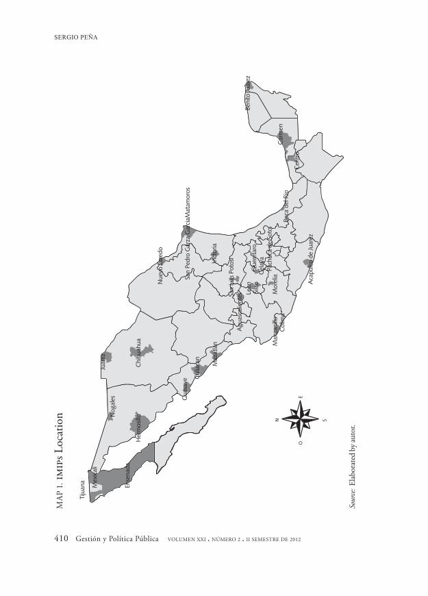
As of today, there exist about 32 municipal planning and research insti-tutes affiliated with the Mexican Association of Municipal Planning Institutes also known as amimp.1 A considerable number of institutes are located in northern Mexico (the states of Baja California, Sonora, Chihuahua, Nuevo Leon and Tamaulipas), central Mexico (the states of San Luis Potosi, Aguascalientes, Guanajuato, Michoacan and Hidalgo) and, to a lesser degree, in southern Mexico (the states of Gue rrero, Vera-cruz, Tabasco, Campeche and Quintana Roo). The states of Baja Cali-fornia, Guanajuato, Sinaloa, Nuevo Leon and Tamaulipas are the states that account for a larger number of such institutes (see map 1).
Planning practice in Mexico has been transformed substantially in part due to two interrelated crises: 1) the fiscal crisis of the State that led to the adoption of neoliberal policies as a new development strategy and governance philosophy in the 1980s; and 2) the legitimacy crisis of the political system based upon a one-party system and the rise of demo-cratic movements in Mexico. The two interrelated crises set in motion a
1 http://www.amimp.org.mx/enlaces.html [accessed on 02/11/2010]. Officially there are 39 members. Some of the members are regional or state planning agencies.
RECENT TRENDS AND PRACTICE IN SPATIAL PLANNING IN MEXICO
VOLUMEN XXI . NÚMERO 2 . II SEMESTRE DE 2012 Gestión y Política Pública 409
series of political and institutional changes that transformed substan-tially the relationship (i.e. responsibilities and mandates) among all levels of government. Several municipalities demanded a new form of governance different from the centralized patronage relationships of a one party system that existed for more than a half century in Mexico.2
This article is exploratory and addresses two key questions: What are the causes that explain the emergence of imips? What is the contribution of imips to local planning practices in Mexico?
To be able to answer the above questions the article is divided into four sections. The first section is intended to offer a historical recount of the context that triggered the emergence of new planning practice at the local level, particularly the rise of the democratic movement and the election of opposition party candidates, such as those from the National Action Par-ty or pan (by its Spanish acronym), to several municipal governments. The second section focuses on a brief history of contemporary spatial planning in Mexico identifying different stages in the planning practices; globalization and the adoption of neoliberal philosophy is of particular interest. In the following section an analysis of key indicators of demo-graphic, economic and governance effectiveness is undertaken. By com-paring and contrasting those municipalities that adopted an imip model with the rest of the nation; this section focuses on planning outcomes in order to make an indirect assessment of the impact imips have on local governments. The fourth section focuses specifically on understanding the institutional architecture of the imips; what is their mandate, mission and vision, professional qualifications and recruitment of the staff, orga-nization, products, etc., followed by a reflection to answer the questions posed previously regarding how imips have contributed to reshape plan-
2 The official party was formed in 1929 as the National Revolutionary Party (pnr) and then changed to the Mexican Revolution Party (prm), and in 1946 became the Institutionalized Revolution Party or pri. The pri was the arena were old revolutionary fighters or caudillos would solve their differences through political nego-tiation and avoid armed rebellions. Since its formation, pri controlled the political landscape through a patron-age system and any political opposition or independent movements were allowed just as a democratic facade.
SERGIO PEÑA
410 Gestión y Política Pública VOLUMEN XXI . NÚMERO 2 . II SEMESTRE DE 2012
N S
OE
Tiju
ana
Mex
ical
i
Ense
nada
Nog
ales
Her
mos
illo
Gua
save
Cul
iaca
n
Maz
atla
n Man
zani
llo
Col
ima
Aca
pulc
o de
Juar
ez
Juar
ez
Chi
huah
ua
Nue
vo L
ared
o
San
Pedr
o G
arza
Gar
ciaM
atam
oros
Vic
toria
San
Luis
Poto
siA
guas
calie
ntes Le
onQ
uere
taro
Cel
aya
Sila
o
Pach
uca
de S
oto
Mor
elia
Boca
del
Rio
Cen
tro
Car
men
Beni
to Ju
arez
MA
P 1. im
ips L
ocat
ion
Sour
ce: E
labor
ated
by a
utor
.
RECENT TRENDS AND PRACTICE IN SPATIAL PLANNING IN MEXICO
VOLUMEN XXI . NÚMERO 2 . II SEMESTRE DE 2012 Gestión y Política Pública 411
ning practice in Mexico. Finally, the paper contains some concluding re-marks about how to improve spatial planning and practice in Mexico.
THE ECONOMIC AND POLITICAL CONTEXT
As stated previously, two interrelated crises combined to create an inflec-tion point that produced deep structural changes in the way planning institutions and practices operated in Mexico: 1) the fiscal crisis that put the government on the brink of bankruptcy; and 2) a legitimacy crisis that triggered the movement for democracy and the beginning of the end of a one-party system. In the next paragraphs, I explain briefly these events so the reader will have in mind the context in which imips emerged in Mexico as a novel idea to make municipal governments more efficient, effective and professional in the way urban development is being planned.
The fiscal crisis originated as an imbalance between government in-come and expenditures during the 1970s. This fiscal imbalance had its origin in the fact that at the same time it had windfall income from oil exports, Mexico also spent recklessly on infrastructure, social spending, and large subsidies to urban dwellers to lower costs of living in the city. Government fiscal deficits were financed through borrowing in foreign markets. Windfall gains from oil by exporter countries, mainly in the Middle East, kept interest rates low and therefore made foreign borrow-ing attractive to national governments. The foreign debt of sovereign nations such as Mexico and Brazil, to mention a couple, skyrocketed to 96.8 and 116.2 billion dollars respectively (Todaro, 1997, 511). As long as oil prices were high and interest rates abroad were kept low, as hap-pened during the 1970s, Mexico could finance its fiscal deficits.
However, when oil prices went into a downward spiral and the U.S. Federal Reserve, headed by chairman Paul Volcker, decided to raise the discount rate to combat stagflation in the United States, this created the debacle of the Mexican public finance. Higher interest rates increased
SERGIO PEÑA
412 Gestión y Política Pública VOLUMEN XXI . NÚMERO 2 . II SEMESTRE DE 2012
the burden of the debt service. According to Todaro (1997, 551) the ratio of debt to gross national product (gnp) for Mexico at its peak reached 42.1 per cent. In 1982 Mexico shocked the world with the news that it could no longer serve its debt and, if there was not rescheduling or refinancing, Mexico would default. This announcement was just the beginning of the foreign debt crisis worldwide that required the inter-vention by institutions such as the International Monetary Fund (imf) and World Bank to address an international structural problem of the finance system.
The fiscal crisis forced Mexico to accept the imf terms of adopting structural adjustment programs (sap) to overcome its financial crisis and put public finance in order. sap called for a reduction of govern-ment expenditures (which meant cutting social expenditures and sub-sidies) and an increase in tax revenue. Other components of sap in Mexico were reducing government intervention in the economy and fostering the private sector by selling state enterprises, privatizing some government services, deregulating economic activities, and opening the economy to allow foreign direct investment and to engage and par-ticipate in the global economy. The imf policies work in tandem with the World Bank (1997) advice in how to reengineer government to make it more efficient and effective by adopting new managerial phi-losophies known as the new public administration (Denhart and Den-hart, 2003).
Shifting the attention to the political dimension, the following events are important to emphasize that accounted in part for the demise of the old and the emergence of new governance forms: first, the re-sponse to the 1985 Mexico City earthquake sent a powerful message that civil society can organize and act independently from any party or patronage institution; second, the contested nature of elections in states such as Baja California, Sonora, Chihuahua, Yucatan and Guanajuato, where the National Action Party became an important contender and where eventually the pri stopped being the ruling party; third, the lack of legitimacy of the 1988 presidential election that declared the pri’s
RECENT TRENDS AND PRACTICE IN SPATIAL PLANNING IN MEXICO
VOLUMEN XXI . NÚMERO 2 . II SEMESTRE DE 2012 Gestión y Política Pública 413
candidate, Carlos Salinas de Gortari (1988-1994), the winner over the leftist coalition3 candidate Cuauhtemoc Cardenas, who was widely viewed by Mexican society as the legitimate winner; fourth, the accord between the pri and pan to recognize Salinas de Gortari as the president in exchange for reforms that would make the election system more open and citizen controlled to prevent future electoral frauds. Electoral wins by the opposition parties, and eventually the loss of a majority in congress by the pri in 1997 not only restored a system of checks and balance among the three branches of government but also state and lo-cal governments lobbied for more control and powers being transferred to them. In the next paragraphs I offer an explanation of how the differ-ent events somehow were cumulative and transformed the political landscape in Mexico that frame planning practice.
Mexico City’s earthquake in 1985 is considered by many scholars as an important historical reference that marked a “before” and “after” re-garding the way government and society relate. This natural event made evident the incapacity of government to respond to an emergency situa-tion and the capacity of society to organize and act independently from government and party structures. Civil society for the first time was ca-pable of acting alone and independently from the traditional patronage system. Before the earthquake the pri acted as broker or mediator be-tween society and government developing a patronage system. After the earthquake civil society had more options to channel its demands and also political parties, such as the pan or prd, developed new mecha-nisms to relate to civil society and forms of governance.
The fiscal crisis of the state had a tremendous impact on the Mexican economy. The 1980s are known as the lost decade not only for Mexico but also for many other countries around the world. Not only Mexico’s gnp fail to grow; it actually contracted. According to the National Insti-tute of Geography and Statistics (inegi), in 1980 the per capita gnp was
3 The leftist coalition eventually formed the Democratic Revolution Party known as prd whose strong-hold is the Federal District or DF where Mexico City is located.
SERGIO PEÑA
414 Gestión y Política Pública VOLUMEN XXI . NÚMERO 2 . II SEMESTRE DE 2012
equivalent to 13 049 pesos and in 1996 it was 12 774 pesos.4 During this period, per capita income declined, unemployment rates increased, and the rates of poverty went from bad to worse.
The above context provides the stage for discontent with the one-party system. It took a severe economic crisis for the erosion of the po-litical grip of the pri. The pri could no longer legitimize its power. It is not surprising that people started looking for alternatives and were open to other political offers. In the 1980s it had become more difficult for the pri to maintain political control. Democratic waves emerged and the pan became a legitimate contender and government alternative. The very competitive gubernatorial elections in Sonora, Chihuahua, Yuca-tan, Guanajuato and Baja California were just the beginning of the end. In 1989 the pan scored its first big win when Ernesto Ruffo Appel was sworn into office as governor for the state of Baja California, becoming the first elected governor from a party other than the pri in modern post-revolution history. This big win was followed by others in states such as Guanajuato, Chihuahua, Yucatan, etc. Finally, the pri lost the crown jewel —the executive branch was won by Vicente Fox in 2000, a pan candidate.
The pan as a political party was created in 1939 by Manuel Gomez Morin as an opposition political party, ten years after the official party was born as the pnr. It can be said that the pan’s philosophy was the antithesis of the pri which embraced anti-democratic, corporatist and patronage structures. Since its beginning, the pan differentiated itself from the pri by offering a political ideology that emphasized citizen- based political institutions around principles such as individual free-dom, democratic values, economic liberalism, and conservative social causes.5 The pan had a strong appeal in some regions of Mexico such as
4 The data is deflated to 1993 as a base year. http://dgcnesyp.inegi.org.mx/cgi-win/ehm.exe/CI070010 [Accessed 2/17/2010].
5 The pan has strong ties to the religious rebellion movement in the 1920s known as la Cristiada or Christian rebellion. This movement had its stronghold in states such as Guanajuato and Jalisco, a region known as the Bajio.
RECENT TRENDS AND PRACTICE IN SPATIAL PLANNING IN MEXICO
VOLUMEN XXI . NÚMERO 2 . II SEMESTRE DE 2012 Gestión y Política Pública 415
the Bajio in central Mexico, considered to be the cradle of conserva-tism, as well as in northern states where capitalist entrepreneurial values are more embedded in a society known for its pragmatism (Morales, 2005).
Different authors (Bassols, 1995; Espinoza, 1998; Guillen, 1996; Morales, 2005; Padilla, 1995; Valencia, 1995) have analyzed the rela-tionship between political parties and government style and arrived to some basic conclusions. The pan moved away from traditional patron-age and tried a new way to include public participation in local govern-ment; the pan created two distinctive programs in its political platform —miercoles ciudadano (citizen’s Wednesday) and Sabaton (Big Satur-day)—, both are intended to make government more accessible and closer to the public; it also established communal organization to solve problems such as garbage collection, street cleaning, etc. (Morales, 2005). The pan searched for municipal autonomy, efficiency in govern-ment and transparency in the use of resources. In Leon, Guanajuato, it created the Organizational Development Office as a way to bring a more professional government and develop managerial and planning skills (Valencia, 1995). Padilla (1995, 133-134) emphasizes that the pan was successful in urban settings with a growing middle class (i.e. Ciudad Juarez) that was dissatisfied with the pri’s forms of government (patron-age and authoritarian); the success of the pan was based on promoting the idea that anti-democracy and corruption, embedded in the pri, were the causes of the problems facing urban dwellers. Bassols (1995) argues that one of the most important things to highlight from pan gov-ernments is their desire to open and find new spaces for the participa-tion of civil society outside of the corporatist and patronage schemes. In addition, the pan was willing to change government structures related to administrative norms and planning practices. The other main party, the prd, given its leftist leaning ideology emphasize more social and eq-uity issues (e.g. financial aid to senior citizens and single mothers, schol-arships to low income students, etc.) and to a lesser degree municipal reform (Morales, 2005). The prd has been pragmatic and it has been
SERGIO PEÑA
416 Gestión y Política Pública VOLUMEN XXI . NÚMERO 2 . II SEMESTRE DE 2012
open to undertaking public-private partnerships.6 At the same time, the prd replicates many of the patronage practices used by the pri. Mexico City has been the main laboratory for the prd.
In summary, this section has shown how the combination of two cri-ses —an economic and political one— set the stage for the emergence of new forms of government and planning practices. The control of state and municipal government by opposition parties such as the pan and prd and, eventually, the loss of the presidency opened up a window of opportunity for trying something different from the traditional corporat-ist and patronage system. The creation of municipal planning and re-search institutes or imips is the evidence of innovations in local governing and planning in Mexico. Before discussing the imips, it is important to analyze more specifically the spatial planning practice that prevailed in Mexico to have a point of reference to be able to contrast and compare.
A BRIEF HISTORY OF SPATIAL PLANNING AND PRACTICE IN MEXICO
This section is based mainly on Garza (1999, 2005) and Gazca (2009), which analyze in detail the evolution of spatial planning in Mexico. Both authors offer a typology that identified important inflection points in regards to the planning framework and practice in Mexico. Garza (1999, 2005) identifies four stages that characterized spatial planning practice in Mexico: 1) the setting up of the Mexican state; 2) the Mexican miracle; 3) planning in the context of the big crisis and the lost decade; and 4) planning during the neoliberal state. Gazca (2009, 52-53) argues that it is through a historical-spatial analysis of capitalism in Mexico and state intervention in organizing the territory, that we can understand spatial planning. Furthermore, Gazca (2009) identifies five stages: 1) the first step towards regional planning, 2) regional policies undertaken at the
6 Carlos Slim, considered to be the richest man in the world, has partnered with Mexico City govern-ment to rescue the historical district.
RECENT TRENDS AND PRACTICE IN SPATIAL PLANNING IN MEXICO
VOLUMEN XXI . NÚMERO 2 . II SEMESTRE DE 2012 Gestión y Política Pública 417
state level, 3) the institutionalization of regional policy, 4) decentral-ization and regional policy, and 5) the State crisis and the retreat from regional policy. In the next paragraphs, I will analyze the main character-istics of each stage framing the analysis by looking at the role knowledge, action and power played ( Friedmann, 1987; Forester, 1989).
According to Garza (2005, 39) and Gazca (2009) the first few de-cades of the 20th century (1900-1940) in Mexico are a period when the “judicial superstructure” of spatial policy in Mexico was laid down. The Mexican Constitution, approved in 1917, is the main “judicial su-perstructure” that frames contemporary spatial planning practice in Mexico. This “judicial superstructure” focused on the dual objective of developing a balance between the city and the rural areas (town and country planning). Gazca (2009) points out the importance of the first plans (Six Year Plan, the First General Planning Law) and the role that the State plays in the process of facilitating productive process and capi-tal accumulation.
What is important to rescue from the “judicial superstructure” is the issue related to property rights because it is the most important aspect to be able to understand spatial/territorial planning in Mexico. Eminent domain power is one of the most important tools to shape spatial policy. Article 27 of the Mexican Constitution is the one that directly deals with eminent domain issues. What is important to highlight from article 27 is the following: 1) the State assumes the role of trustee of the people and it has the authority to transfer property and regulate its uses; 2) the State has the authority to take land whenever the public interest requires it; 3) property rights are not absolute; that is, the landlord owns only usufruc-tuary rights not the physical asset itself. In addition, article 121 addresses local jurisdiction over land and buildings. Article 115 focuses on mu-nicipal authority and mandates regarding land use (Garza, 2005).
Some studies (Peña, 2002) have compared the Mexican institutional framework of planning vis à vis the U.S. This comparative work is im-portant to be able to understand planning practices by contrasting them with other models. One of the key differences between the two planning
SERGIO PEÑA
418 Gestión y Política Pública VOLUMEN XXI . NÚMERO 2 . II SEMESTRE DE 2012
systems is the ability of local governments to control and regulate urban development through the use of eminent domain power. In the U.S. based on the Tenth Amendment and Dillon’s rule, the local or munici-pal government has the authority over land use decisions in its territorial jurisdiction (Blaesser and Weinstein, 1989, 16-20). In contrast, in Mex-ico local government authority on land use is severely handicapped; emi-nent domain is executed either through a federal executive decree7 or by state governments. In summary, the legal framework assigns an over-whelming power to the federal government to shape spatial policy at different scales. The State, controlled by the official party —the pri— became the force that congregated diffuse power; thus a centralist model of planning was not only necessary but it was the only option at that historical moment of nation building after the Mexican revolution.
Applying Faludi’s (1973) framework of substantive and procedural planning I argue the following. The substantive planning issues (ends) were derived not by planners applying positivist knowledge but rather by political elites or caudillos 8 that also happened to become entrepreneurs; the distinction between the private and the public interest was fuzzy to say the least. Political elites skewed resources and investment in regions where they have their strongholds; northern states such as Sonora, Tam-aulipas and Sinaloa benefit the most (Wilkie, 1967). In summary, pow-er relations among elites concentrated around the official party (pri) were the cause of the contradictory results of knowledge and action.
The Mexican miracle is a period of unprecedented prosperity in Mex-ico that lasted about three decades (1940-1970). The miracle consisted of unprecedented rates of growth above 6 per cent per year parallel to
7 Article 27 was used to implement the agrarian reform after the 1910 revolution that destroyed the old hacienda or plantation system by distributing land to peasants and creating a new breed of farmers. Also, the most famous executive decree was when president Lazaro Cardenas in 1938 expropriated the assets of for-eign oil companies; creating the state enterprise Pemex that to this day is in charge of oil exploration, exploi-tation and distribution.
8 Caudillo is a term applied to former soldiers of the Mexican revolution that replaced the elite from the old regime. Francisco Villa, Alvaro Obregon, Plutarco Elias Calles and Lazaro Cardenas are among the most famous caudillos.
RECENT TRENDS AND PRACTICE IN SPATIAL PLANNING IN MEXICO
VOLUMEN XXI . NÚMERO 2 . II SEMESTRE DE 2012 Gestión y Política Pública 419
macroeconomic stability (Hansen, 1983). At the same time, the country experienced a shift not only in its economic base by becoming an indus-trial country, but also by moving towards the path of an urban society. The degree of urbanization went from 20 per cent in 1940 to 47.1 per cent in 1970; the number of cities increased from 55 to 174 (Garza, 2005, 30-33). Two issues central to the territorial spatial agenda were the production of public goods in the form of capital facilities that would support the economic growth miracle such as roads, ports, irrigation, bridges, electricity, etc., and regional spatial policy aimed to reduce re-gional disparities and the primacy of the urban system. The creation of institutions and agencies in charge of planning capital facilities such as the Federal Electricity Commission (cfe), the communications and roads agency (sct), and watershed and hydrology commissions, was an important contribution during this period. Gazca (2009) points out that this era is very rich in regional spatial policy which was mirror based on the experiment of rational planning in the Tennessee Valley Authority in the U.S. and replicated in Mexico with the watershed program (Pro-grama de Cuencas) in addition to other policies such as growth poles.
It is important to reflect on the knowledge bases of planning and the profile of the planning profession during the Mexican miracle. Mexican spatial policy is not immune to paradigms being applied in other parts of the world. Different works (Friedmann and Weaver, 1979; Friedmann, 1987) are very illustrative to analyze the regional and spatial planning paradigms. Rational planning provides the episte-mological bases for regional planning. Planning is driven by scientific positivist knowledge applied to public policy (Friedmann, 1987). Planning focuses on problems where means are known and ends are agreed (Blanco, 1994); technical engineering solutions are the means to achieve the goal of economic growth linked to spatial or territorial policies. The State, particularly after the Great Depression, undertakes a proactive role to help the market overcome either coordination prob-lems or market failures, particularly those related to the provision of public goods.
SERGIO PEÑA
420 Gestión y Política Pública VOLUMEN XXI . NÚMERO 2 . II SEMESTRE DE 2012
Garza (2005, 54) and Gazca (2009) arrived at the same conclusion that regional policies in Mexico were ineffective and, worse, produced opposite results —a higher degree of urban concentration and primacy of the main industrial cities and a territorial polarization. Furthermore, the dominant political elite basically only cared about promoting spe-cific sectors of the economy and merely made token efforts at imple-menting spatial territorial policies. The priority was to promote indus-try without caring much about spatial concentration or regional inequalities. Caudillos were replaced by a new breed of entrepreneurs linked to the official party; president Miguel Aleman (1946-1952) best represents this new breed of political-entrepreneurs or capitalist crony-ism (Hansen, 1983). Power brokers were in charge of setting the ends and planners simply were reduced to procedural tasks often linked to technical engineering.
According to Garza (1999, 58) three events frame the urban analyses that were produced during the volatile decade that goes from 1960 to 1970: 1) ideas promoted by the Latin American Economic Commis-sion (cepal) as part of the U.S. lead initiative known as The Alliance for Progress; 2) the questioning of physical and urban design solutions to social problems; 3) the emergence of spatial segregation and moderniza-tion theories and studies which framed most of the analysis. Research was framed by the mass migration of the rural population to large cities such as Mexico City and interests in survival strategies of urban dwell-ers. Another relevant aspect is that urban and regional planning was in-corporated into academia; research centers and academic programs were created. The National Autonomous University of Mexico (unam) and the National Polytechnic Institute (ipn), two of the most prestigious academic institutions in Mexico, started offering graduate degrees in planning and urbanism respectively (Garza, 2005, 65).
Spatial planning research and practice in Mexico was affected and shaped by the social tension and movements of the 1960s. For instance, in the United States the civil rights movement and the opposition to the Vietnam war strongly influenced planning to pay attention to social and
RECENT TRENDS AND PRACTICE IN SPATIAL PLANNING IN MEXICO
VOLUMEN XXI . NÚMERO 2 . II SEMESTRE DE 2012 Gestión y Política Pública 421
racial issues. Mexico was becoming an urban society and also a more edu-cated one; Mexican society started demanding a more open, democratic and tolerant society. Garza (1999, 78-79) emphasized that in the follow-ing decade new planning programs emerged. The Colegio de Mexico (Colmex) offered a master’s degree in urban development, The Metro-politan Autonomous University (uam) campus in Xochimilco offered an undergraduate degree in urban settlements, uam-Azcapotzalco offered urban sociology. The support for scholars to study urbanism or similar careers in Europe was also important. Critical theory or Marxist analysis (e.g. Lefebvre, Castells, Harvey, etc.) appeared as a new conceptual frame-work applied by Mexican scholars to study the urban space.
The planning focus was no longer instrumental (means-ends) but rather trying to understand substantive issues and big questions that society is dealing with (e.g. housing access and survival strategies, urban segregation, poverty, exclusion and political participation, etc.). The traditional power structure of one strong party was confronted and questioned by a sector of society that felt excluded (students, young urban middle class). Knowl-edge or epistemological bases of planning moved from the rational-techni-cal and instrumental towards a more sociological approach (substantive).
The next decade saw the emergence of planning professionalization and institutionalization of planning practice. The passage of the Gen-eral Law of Urban Settlements and the creation of The Human Settle-ments and Public Works Agency, known as sahop by its Spanish acro-nym, in 1976 are another inflection point for planning practice in Mexico. sahop was in charge of coordinating intra and inter-urban spa-tial policy. The sahop was transformed in 1982 into the Urban Devel-opment Agency or sedue. Garza (2005, 60) describes these changes as the “most important jurisdictional superstructure” that established the bases that still today frame the spatial planning practice in Mexico. The planning practice of sahop and later sedue has focused on four aspects: norms, strategies, government coordination and planning instruments. The goals set forward for spatial planning deal with the “problem” of urban primacy that Mexico City represents. Therefore, policies promot-
SERGIO PEÑA
422 Gestión y Política Pública VOLUMEN XXI . NÚMERO 2 . II SEMESTRE DE 2012
ing new growth poles and development of “backward regions” were pro-moted. Spatial planning attempted to foster a more balanced urban hi-erarchy not only of economic activities but also population across the national territory.
Gazca (2009) highlights the creation of 226 plans of the main urban agglomerations and planning commissions addressing specific issues such as marginality, arid zones, rural development, etc. However, ac-cording to Garza (2005, 61-62), the institutionalization process of ur-ban and regional planning was a failure due to the fact that there is not evidence of a greater degree of technical-scientific rigor: sahop lacked expertise in making plans that could be in accordance with existing re-alities. Plans were bureaucratic requirements rather than road map and sahop was bogged down in the negative inertia of the political system (i.e. corruption), and its own “architectonic bias”.
The above discussion shows clearly that there is a mismatch between knowledge and action or between theory and practice. On the one hand, the main planning agencies in Mexico, sahop and later sedue, focused on territorial and physical planning. On the other hand, academic insti-tutions and planning programs were emphasizing more urban sociologi-cal studies. Planning practice and knowledge generated were not syn-chronized. Furthermore, the pri continued playing the role of power broker among all actors, urban developers continued doing business as usual by socializing costs and privatizing gains, and popular urban move-ments, such as squatting, continued to be tolerated and, in many in-stances, promoted by leaders of the National Confederation of Popular Organizations (cnop), one of the political pillars9 of the pri (Duhau, 1998). Mexican cities are more a product of politics and power than tech-nical scientific knowledge in the form of rational planning (Ward, 1990).
9 The pri is organized into three broad sectors. The workers sector congregates the unionized workers and is organized around the Mexican Workers Confederation or ctm. The second sector is the peasants and rural masses affiliated with the National Confederation of Peasants known as cnc. The last sector is the Na-tional Confederation of Popular Organizations or cnop which deals with urban demands such as housing, public services, etc.
RECENT TRENDS AND PRACTICE IN SPATIAL PLANNING IN MEXICO
VOLUMEN XXI . NÚMERO 2 . II SEMESTRE DE 2012 Gestión y Política Pública 423
As explained previously, the economic crisis experienced by Mexico for most of the 1980s altered substantially the political structure and the planning regime. The pri’s role as power broker was eroded and a cen-trifugal process of power towards state and local actors got underway. The central government was willing to transfer more responsibilities to the local governments as a way to deal with fiscal deficits and restore or-der in the public finance. Two laws were passed that are important from a planning perspective: 1) the Planning Law in 1983 and 2) reforms to ar-ticle 115 in 1983 and 1999 that explicitly transfer to local governments more responsibilities such as public utilities (water, sewer, roads, etc.) as well as those to control and manage the urban development process. Other laws, such as the National Democratic Planning System in 1983, and reforms to articles 25 and 26 allow more vertical and horizontal coordination regarding planning (Gazca, 2009, 71) with the making of the State Planning Commissions (coplades) and Municipal Planning Committees (Copladem). A key problem was the lack of expertise to undertake planning (Garza, 2005, 77), particularly in rural or small ur-ban municipalities. In addition, transfer of responsibilities was not neces-sarily attached to a transfer of resources or rules to make local govern-ments more accountable (Guillen, 1996).
During the period of the lost decade, as the 1980s were known, and during the administration of president Carlos Salinas de Gortari (1988-1994) the Solidaridad program was perhaps the most important spatial program at the urban scale. The program was designed to provide basic infrastructure and other type of public works to alleviate urban poverty. Several studies have pointed out that the program was mainly political rather than a comprehensive strategy to strengthen urban planning; the program was used as a means to restore the pri’s power base through po-litical patronage (Diaz-Cayero and Magaloni, 2003; Bruhn, 1996; Kurtz, 2002). Planning knowledge was put to the service of power to restore the political machinery. However, a new financial crisis at the end of 1994, known as the Error de Diciembre (December’s Mistake), which sent the value of the peso in a downward spiral vis à vis the dollar was too much to
SERGIO PEÑA
424 Gestión y Política Pública VOLUMEN XXI . NÚMERO 2 . II SEMESTRE DE 2012
bear. The pri lost the majority in Congress in the 1997 midterm elections and in 2000 lost the executive branch to Vicente Fox —a pan candidate.
The pri administration of Ernesto Zedillo (1994-2000) and the two pan administrations under Vicente Fox (2000-2006) and Felipe Calde-ron (2006-present) did not change philosophy in regards to spatial plan-ning. These administrations were in charge of consolidating the neolib-eral State that was a work in progress since 1982. Different scholars in Mexico arrived at similar conclusions with regards to the future of spatial planning in Mexico. For Garza (2005) the neoliberal State meant the abdication of the federal government to lead urban policy and the trans-fer of planning responsibility to local government. However, some local government lacked the technical capacity and the resources. In addition, local governments by themselves cannot be a substitute for the federal government to plan the territory at a national scale (Garza, 2005, 101-104). According to Iracheta (1997), in the 1990s the challenge for local planning is to create competitive cities and address urban poverty after a lost decade. The central focus of planning is no longer to develop a for-mal model of the physical and environmental image of the city, but rath-er to define the way in which the local authorities and civil society will participate in the generation of initiatives and the governance of their own space. This implies that planning needs to take into account the political game and search for consensus. Planning focus becomes the socio-spatial configuration process (Iracheta,1997, 156-157). Localities are organizing without a central authority and national spatial policy. Perlo (2000) concludes that a new territorial policy needs to consider the diversity of the territory and realize that national spatial policy requires new instruments and rules that would allow development that could be steered towards common goals. The new spatial policy needs to be “com-prehensive, integral, coherent, decentralized, participative, democratic and strategic” (Perlo, 2000, 329).
A few issues from the above arguments can be rescued to set the stage to begin discussing the role imips will play in spatial planning within the context of the neoliberal State. First, the transfer of more planning re-
RECENT TRENDS AND PRACTICE IN SPATIAL PLANNING IN MEXICO
VOLUMEN XXI . NÚMERO 2 . II SEMESTRE DE 2012 Gestión y Política Pública 425
sponsibilities to the local level and the lack of local planning expertise forced some governments to innovate and try out new instruments to improve the planning processes and practice (Cabrero et al., 1997; Guillen, 1996). Second, due to globalization cities such as those along the U.S.-Mexico border, tourist resorts such as Cancun, and mega cities such as Mexico City, Monterrey and Guadalajara are often linked more to the global economy than national economic processes (Perlo, 2000; Sassen, 2006); therefore, there is a need to become more competitive and improve planning practice. Third, the traditional top-down and centralized spatial planning approach becomes obsolete in a democratic society; the traditional patronage system no longer seems feasible. Thus, there is a need to find new mechanisms and rules that will redefine the relationship between government and society.
I hypothesize that the causes behind the establishment of imips is to respond precisely to these three issues that local governments face that relate to: 1) the acquisition of knowledge and expertise through techni-cal-administrative innovations to deliver services in a more efficient and effective way (Cabrero and Arellano, 1993) thus professionalizing plan-ning; 2) the challenge of making urban centers more competitive to be able to “hinge” to the global economy (Sassen, 2006), and 3) the search for new planning paradigms that will replace the traditional patrona ge-cronyism regime. In summary, I argue that the surge of imips is an attempt to subdue politics and power in favor of technical reason to deliver basic government outputs (public services) more efficiently, im-prove government processes and practices (administrative innovation), and increase accountability (democratic).
MAIN CHARACTERISTICS OF THE MUNICIPALITIES ADOPTINGTHE IMIP MODEL
The goal is to offer a general overview of municipal planning institutes in regards to their mission, vision, professional background, planning
SERGIO PEÑA
426 Gestión y Política Pública VOLUMEN XXI . NÚMERO 2 . II SEMESTRE DE 2012
practice and procedure. However, before delving into those issues it is important to discuss some of the characteristics (demographic and eco-nomic) of the urban municipalities that have adopted the imip planning model and the main indicators, in terms of the quality of government, of the municipalities being studied. I do not pretend to establish any causality between the creation of the imip and government effectiveness in delivering services; this is beyond the scope of the present article. In-stead, what I attempt is to present a general profile of the municipalities and their ability to cope with the demand for public services by innovat-ing their planning practice —the creation of an imip being one of them.
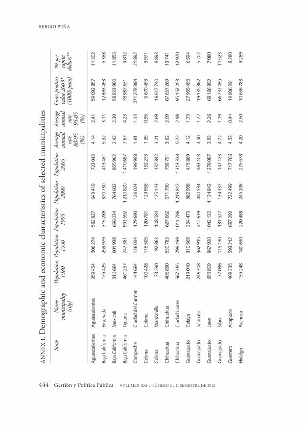
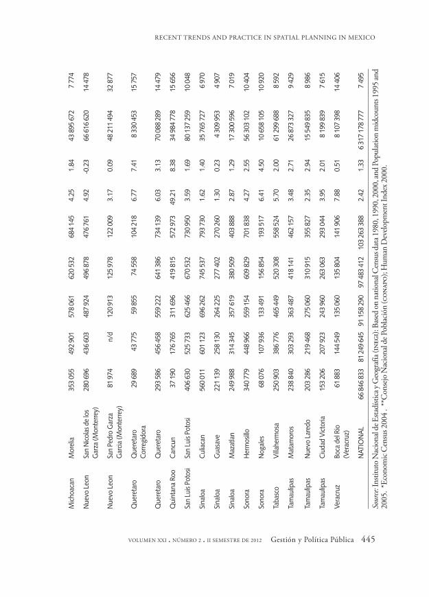
As mentioned earlier there exist 32 planning institutes in municipali-ties that are diverse in terms of their demographics. Based on the 2005 inter-census population count,10 the size of the 32 municipalities on av-erage was slightly above a half million (526 338); and the largest in the group are Tijuana (1 410 687), Ciudad Juarez (1 313 338) and Leon (1 278 087). The smallest ones are Corregidora (104 218) and San Pedro Garza Garcia (122 009). In general terms, those urban municipalities have a higher than average rate of population growth; the average annual rate of growth at the national level for the 1985-1995 decade was 2.42 per cent and for the next decade 1995-2005 the annual average rate of growth was 1.33 per cent. In contrast, the average annual rate of growth of the 32 municipalities was 5.57 and 2.30 per cent, respectively. It is important to emphasize that some of the 32 municipalities have impres-sive average annual rates of growth in 1985-1995 and a lower rate of growth for the next decade (1995-2005). One set of the 32 is munici-palities located at the U.S.-Mexico border such as Tijuana (7.67 and 4.23%), Ciudad Juarez (5.22 and 2.98%), Mexicali (2.42 and 2.30%), and Nogales (6.41 and 4.50%). Another set is resort and tourist munici-palities such as Benito Juarez where Cancun is located (49.21 and
10 The population census is conducted every 10 years in Mexico by inegi for years ending in zero such as 2010; however, between census there is a quick population counting in the years ending in five —2005. The key difference is that the population counting only focuses on demographic aspects whereas the census is more comprehensive and incorporates social, housing and economic variables.
RECENT TRENDS AND PRACTICE IN SPATIAL PLANNING IN MEXICO
VOLUMEN XXI . NÚMERO 2 . II SEMESTRE DE 2012 Gestión y Política Pública 427
8.38%) and Manzanillo (3.21 and 2.69%). Another set is municipalities that are suburbs of larger metropolitan areas such as Boca del Rio (7.88 and .51%), a suburb of Veracruz City; San Pedro Garza Garcia (3.17 and .019%) and San Nicolas de los Garza (4.92 and -.23%), suburbs of Monterrey; and Corregidora (6.77 and 7.41%), a suburb of Queretaro. The rest of the municipalities are midsize cities that are state capitals such as Hermosillo, Sonora; Victoria, Tamaulipas; Centro, Tabasco, where the capital of Villahermosa is located; and Culiacan, Sinaloa (see annex 1).11 Let us remember that the first imip was formed in 1994 in the municipality of Leon in the state of Guanajuato. Faster rates of growth experienced the previous decade is just one of several causes that forced some municipalities to innovate regarding how to manage urban growth and cope with the provision of urban services through better planning.
The 32 municipalities being considered account for 16.31 per cent of the total population of Mexico in 2005 and 23.35 per cent of the national gross production value in 2003.12 In 2000 the gdp per capita for Mexico was $7 495 dollars compared to $11 066 dollars for the 32 municipalities. The municipality of San Pedro Garza Garcia, a suburb of Monterrey, has the highest gdp per capita ($32 877), followed by the municipality of Carmen, Campeche ($21 892); however, the high gdp per capita of Carmen comes from oil production. Corregidora, Queretaro, and Benito Juarez, Cancun, followed in the range of $15 000. On the opposite side, the lowest gdp per capita in the group are Guasave ($4 907), Irapuato ($5 202) and Ensenada ($5 388).13
11 All calculations are based on the 1995 and 2005 population and counting and 2000 Census. Data comes from the National Institute of Geography and Statistics (inegi). http://www.inegi.org.mx/inegi/de-fault.aspx [Accessed 3/9/2010)
12 Data calculated based on Censos Economicos 2004. Data comes from the National Institute of Ge-ography and Statistics (inegi). http://www.inegi.org.mx/inegi/default.aspx [accessed 3/9/2010].
13 Data comes from the 2000 Human Development Index elaborated by the National Population Council (Conapo) http://www.conapo.gob.mx/publicaciones/indicesoc/IDH2000/dh_Indices.pdf [ac-cessed 3/9/2010].
SERGIO PEÑA
428 Gestión y Política Pública VOLUMEN XXI . NÚMERO 2 . II SEMESTRE DE 2012
Regarding the demographics and economic characteristics of the 32 municipalities under study we can say that, in general, those munici-palities experienced higher than average rates of population growth, particularly in the 1985 to 1995 decade. An important source of growth can be attributed to foreign direct investment (fdi), in the form of for-eign owned assembly plants also known as maquiladoras14 in the case of the municipalities on the U.S.-Mexico border. Also, it can be attributed to the urban growth of metropolis that are in a conurbation process such as the cases of Monterrey (San Pedro Garza Garcia and San Nicolas de los Garza), Queretaro (Corregidora) and Veracruz (Boca del Rio). Based on those facts, I argue that municipalities facing high rates of population growth and, at the same, a very dynamic economy engaged in the global network of production confronted the need to improve their planning practice to be able to deal with not only the increasing demand for urban services, but also to position themselves better in the global network of cities (Sassen, 2006).
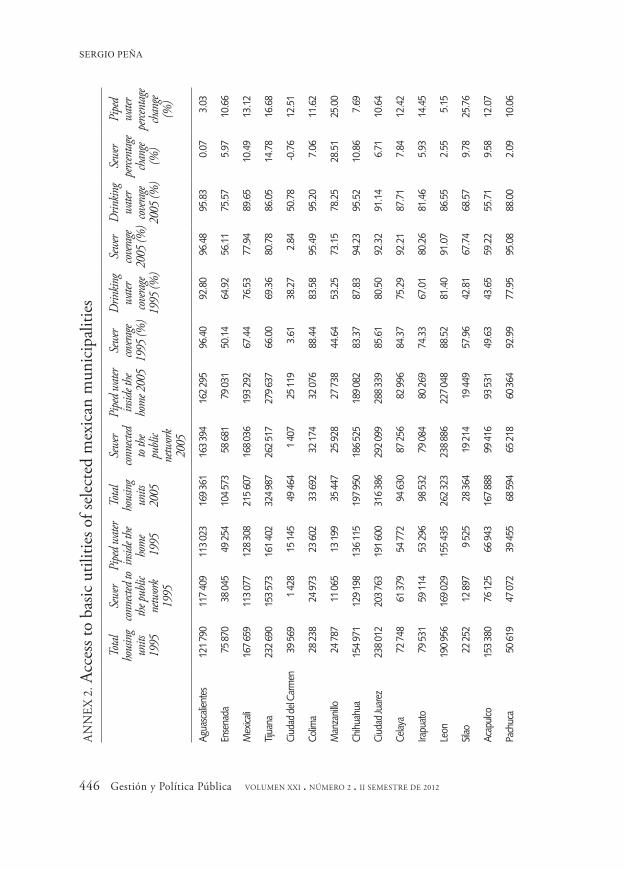
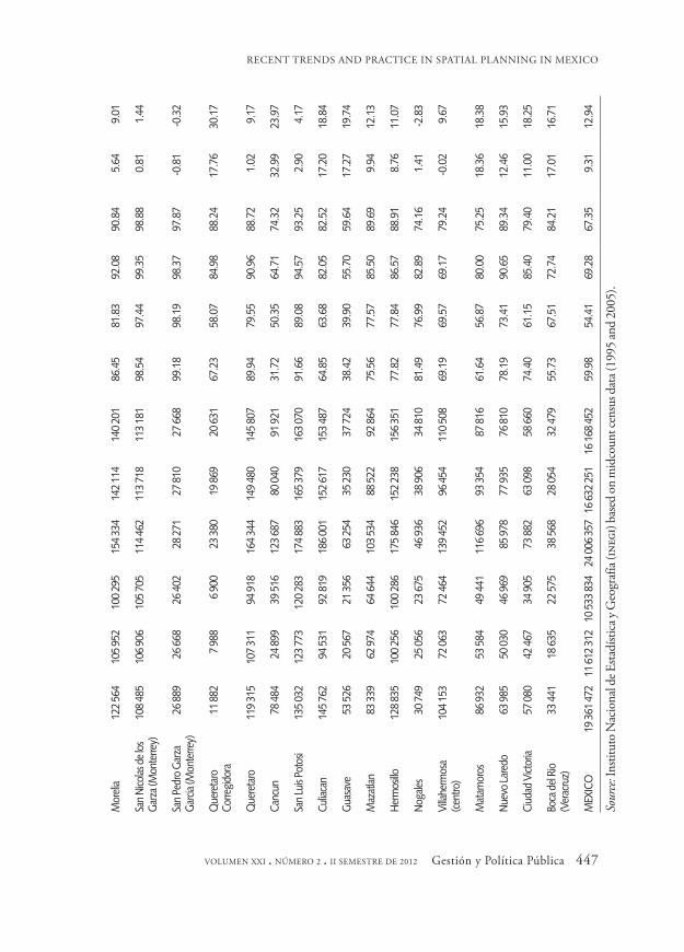
Furthermore, I present some facts regarding urban indicators and the governance capability of the municipalities. In developing countries, such as Mexico, one of the key indicators of government capability is access to basic services or public utilities, such as sewer and water, that are considered a local responsibility.15 In addition, access to water and sewer is important for the quality of life of urban dwellers as well as for the competitiveness of the city. For sewer I only take into consideration homes connected to the public network (excluding septic tank and open discharge to creeks, rivers or other water bodies). For access to wa-ter I only considered piped water inside the house (excluding water out-side but within the property and public wells). I believe both indicators
14 A maquiladora is a regime that allows inputs into Mexico free of duties and then the inputs are as-sembled in factories and returned to the origin country in the form of goods or outputs. With the opening of the Mexican economy in the 1980s and the signing of the North American Free Trade Agreement (nafta) in the mid 1990s most of the maquiladoras factories have located on the Mexican side of the border with the United States.
15 In Mexico, article 115 of the Constitution was reformed in 1983 to make explicit that local govern-ments have the responsibility of providing water and sewer services, among other services.
RECENT TRENDS AND PRACTICE IN SPATIAL PLANNING IN MEXICO
VOLUMEN XXI . NÚMERO 2 . II SEMESTRE DE 2012 Gestión y Política Pública 429
are more representative of local government capability. I compare two points in time (1995 and 2005) in order to explore whether municipali-ties that adopted the imip planning model have been able to keep up with the pace of growth and reduce existing gaps compared to the na-tional average. While I would like to compare before and after the imip was created the following restrictions do not allow; census data is avail-able only every five or ten years and some imips just got started and it would be difficult to assess any impact.
Regarding access to basic utilities such as sewer and water, I found the following (see annex 2).16 Overall, the 32 municipalities have a high-er rate of coverage or access to sewer and water compared to the national average. The coverage for piped water for the 32 municipalities under consideration increased from 70.44 to 83.14 per cent compared to 54.41 and 67.35 per cent respectively for the nation as a whole. The coverage for sewer went from 71.11 to 80.33 per cent in the study group compared to 59.98 and 69.28 per cent for the nation.
The most important indicator is the percentage change in coverage from 1995 to 2005; the percentage change tells us not only if the mu-nicipalities kept pace with urban growth but also if they did reduce the initial gap. Thus, a gap reduction is an indicator of the government ca-pability. The data for sewer show that municipalities that have a high rate of coverage in the benchmark year (1995) have marginal gains such as Aguascalientes, San Nicolas de los Garza and San Pedro Garza Garcia (both suburbs of Monterrey) and San Luis Potosi. On the opposite end, there are communities that have a very low rate of coverage in the refer-ence year and made substantial improvements above the rate of growth of households; for instance, the percentage change (1995-2005) for Benito Juarez municipality where the resort town of Cancun is located (32.99%), Manzanillo another resort town (28.51%), the border city of Matamoros (18.36%) and several others in the range of 10 per cent to
16 Data from the 1990 Census has been severely questioned regarding its validity. Also because recently data from the mid decade population counting was available so we decide to compare 1995 and 2005.
SERGIO PEÑA
430 Gestión y Política Pública VOLUMEN XXI . NÚMERO 2 . II SEMESTRE DE 2012
17 per cent. In general, the majority of the 32 communities improved the coverage of sewer services with the exception of Ciudad del Carmen, which continues having a very low rate of coverage.
The data for piped water also show some important improvements. The rate of coverage for the municipalities under study is higher com-pared to the nation from 1995 to 2005. The coverage for the 32 mu-nicipalities increased from 70.44 to 83.14 per cent compared to 54.41 and 67.35 per cent for the nation. The top performers or the munici-palities whose marginal gains or rates of change were impressive are Corregidora, a suburb of the city of Queretaro (30.17%), Silao (25.76%), Manzanillo (25%), Cancun (23.97%), and Guasave (19.74%). The rest of the municipalities tend to approach the national indicator of marginal gains (12.94 %). The municipality of Nogales lags behind the rest in this indicator.
An argument that can be made against comparing the group of 32 municipalities against the national average is that there are several ru-ral municipalities that will keep the national average low. Thus, it will be necessary to compare urban municipalities against urban munici-palities. The 2005 municipal marginality index, developed by the Con-sejo Nacional de Poblacion [National Population Council] also known as Conapo,17 was used to compare all municipalities whose population is above 100 000. The marginality index takes into consideration indi-cators such as education levels, housing conditions, which include ac-cess to services and physical characteristics of the home, and size of town. There are a total of 2 453 municipalities in Mexico and only 182 municipalities met the 100 000 population threshold. I applied a t-test to determine if the mean difference is statistically significant between the 32 municipalities under study and the rest of the urban municipali-ties. The results show (see annex 3) that the 32 municipalities are better
17 http://www.conapo.gob.mx/index.php?option=com_content&view=article&id=78&Itemid=194 [accessed 3/10/2010]. The index applied a factor analysis technique. The index ranges from a negative value (-2.37), which means a very low marginality, to a positive value (4.49), which indicates a high marginality level.
RECENT TRENDS AND PRACTICE IN SPATIAL PLANNING IN MEXICO
VOLUMEN XXI . NÚMERO 2 . II SEMESTRE DE 2012 Gestión y Política Pública 431
off; in other words, they have lower levels of marginality compared to the rest. In summary, the results indicate that the municipalities under study performed better in access to basic service indicators.
Municipal public finance is another indicator I used to analyze gov-ernment capability. Specifically, I look at revenues, revenue collected by municipalities through property tax, and expenditures in public works or infrastructure. The argument I put forward is that government capability will be linked to its ability to raise more revenue from its own sources, such as property tax, and depend less on federal and state transfers.
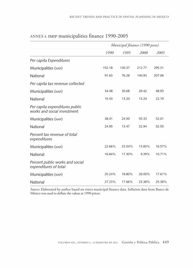
Annex 4 presents the results of the main indicators and I found the following: the 32 municipalities per capita expenditures almost double in real terms from 1990 to 2005 from roughly 152 to 295 pesos.18 The per capita expenditures for the 32 municipalities are higher by a ratio of about 1 to 1.5; in other words, per capita expenditures are about 50 per cent higher than the national benchmark.19 Regarding real per capita tax revenue collected by municipalities the trend is more erratic the range goes from 29 to 49 pesos. However, the tax collected continues being higher by the 32 municipalities than the national average by a ratio of about 2 to 1.
The trend for public works and social expenditures shows a conver-gence between the group of municipalities and the nation; the excep-tions are the municipalities of San Pedro Garza Garcia (Monterrey) and Nuevo Laredo, whose expenditures were 2 to 4 times higher, respectively, in 2005. In relative terms, there seems to be a slight edge in favor of the municipalities being studied; however, in 2005 the relative expenditures in public works and social programs were lower compared to the nation.
Finally, looking at the percentage of tax revenue to total expenditures allows us to see the structural weakness of municipal finance in Mexico.
18 In 1995 most of the financial indicators declined. The reason is that in December 1994 the Mexican peso exchange rate crashed and suffered a strong devaluation vis à vis the dollar going from 4 to 1 to slightly above 7 to 1. The values were deflated at 1990 pesos.
19 Revenue and expenditures are the same. Municipalities in Mexico by law are not allowed to borrow or issue bonds, thus the income and expenditures must be balanced.
SERGIO PEÑA
432 Gestión y Política Pública VOLUMEN XXI . NÚMERO 2 . II SEMESTRE DE 2012
Property tax and user fees are the main source of municipal revenue. Sales tax, income tax and corporate tax, among others, are collected by the federal government and shared with the states. The data show that, in general, Mexican municipalities depend heavily on federal and state transfers and roughly 85 to 90 per cent of municipal revenue is federal and state transfers. The 32 municipalities are relatively better off but the fact is that they also face those structural weaknesses of depending heav-ily on transfers.
In summary, based on demographics, economic and public finance information presented here, the 32 municipalities that have adopted an imip alternative represent a very important set of municipalities in the urban system of Mexico. I can say that they are a very important second tier in the urban hierarchy behind the main urban agglomerations such as Mexico City, Guadalajara and Monterrey. Those municipalities face higher rates of urban growth and, therefore, an unprecedented demand for urban services and amenities. Additionally, some of the municipali-ties are located in states such as Baja California, Chihuahua, Nuevo Leon and Sinaloa; were the first opposition governments to the pri emerged and that demanded not only more autonomy and democracy but also a new form of relationship between government and citizens (Ziccardi, 1995). Thus, I argue that the creation of imips represents a way to improve the procedures and practice of municipal planning that I will discuss in more detail in the next section.
THE IMIPS’ PLANNING PRACTICE AND PROCESSES
This section offers an analysis of the profile of the imips related to the way the different imips perceived their main function, practices and pro-cedures. This section deals specifically with the second question posed regarding the contribution of imips to the planning practice. A content analysis of the different websites of the imips was the methodology I fol-lowed to identify some key elements that will allow us to understand in
RECENT TRENDS AND PRACTICE IN SPATIAL PLANNING IN MEXICO
VOLUMEN XXI . NÚMERO 2 . II SEMESTRE DE 2012 Gestión y Política Pública 433
more depth what imips are and what they do. This section concludes with a reflection regarding to what extent imips have become a new para-digm in spatial planning in Mexico and the main obstacles they face.
In the mission and vision of the organizations, some keywords are common across the majority of the imips. First, there is an emphasis on placing a high value on technical knowledge; for instance, there are words such as “high technical quality”, “a technical consulting organiza-tion”, “scientific bases”, “technical scientific bases and criteria”, “techni-cal-operational structure”. Second, about half of the imips include the concept of strategic planning; for instance, some emphasize “strategic projects”, “strategic planning culture”, “strategic orientation”, etc. Third, there is also a concern with the continuity and long term nature of the planning processes; words or phrases such as “ensuring continu-ity”, “long term”, “permanent manner”, and “continuity of the process’’ are common. Fourth, the concept of sustainability is also another com-mon element. Last but not least important, is the pledge by imips to in-corporate public participation in the procedures; words such as “inclu-sive”, “citizen participation” and “different actors” are found.
The establishment of imips attempts to overcome some structural weaknesses of local governments; for instance, there is a lack of continu-ity of programs and projects due to the fact that no reelection of local mayors or municipal presidents is allowed, thus making planning short-term and reactive. Also, the absence of a civil service leads to massive changes or rotation of public officials with every new government pre-venting the professionalization of planning and accumulation of knowl-edge and expertise. Local governments have created a parallel structure to government planning bureaucracy such as Desarrollo Urbano (urban development) and imips’ bylaws establish that the director’s tenure should transcend government periods with the option of reappoint-ment; the staff enjoys similar rights to those of the civil service career officials.
Another way to analyze the imips in Mexico and how they are con-tributing to spatial planning is to look at the areas of planning that are
SERGIO PEÑA
434 Gestión y Política Pública VOLUMEN XXI . NÚMERO 2 . II SEMESTRE DE 2012
being emphasized. This will give some hint in regards to what imips do and how they view urban planning. Seven planning areas are empha-sized across the board and that I consider to be the most representative of the planning profession: transportation and mobility, urban design, capital facilities planning, geographic information systems (gis), infra-structure planning, regional and urban planning. Urban planning is the department that is most common across the imips, particularly those located in smaller cities that do not have staff to perform more special-ized tasks. gis was the other department that was common; an impor-tant activity of planning is precisely to generate the spatial and statistical information that the planning process requires. Urban design was the third most important area being emphasized. Regional planning was among the least emphasized area.
Another area I wanted to analyze concerns services that imips offer to the public. I focus on those services that are sold or offered to the public and that generate some revenue to the organization. The imips are con-sistent with the idea of producing technical knowledge to drive the planning process. Cartographic and statistical information are the most important services offered or being marketed to the public.
Regarding the product or outputs imips generate, I focus on what plans are produced. It is obvious that a planning agency must gener-ate plans among other things. I classified the products in four categories. The first and second categories are plans, that according to constitutional article 115, all municipalities in Mexico are required to produce such as the Plan de Desarrollo Urbano [Urban Development Plan] and Plan de Ordenamiento Ecologico y Territorial [Comprehensive Land Use Plan]. The next categories are small area plans, such as neighborhood and community planning, or sector plans, such as mobility or capital facilities plans. The entire universe of imips is in charge of producing the urban development plan; that is, municipal governments have trans-ferred to imips the responsibility for producing the plans required by law. The majority of imips are also in charge of producing the compre-hensive land use plan.
RECENT TRENDS AND PRACTICE IN SPATIAL PLANNING IN MEXICO
VOLUMEN XXI . NÚMERO 2 . II SEMESTRE DE 2012 Gestión y Política Pública 435
The last area I analyze was related to how imips relate to the public. imips as independent or decentralized governmental organizations are required to comply with the open records law just like any public entity. imips use their websites to comply with the law. The information that is posted deals with whom to contact in the organization, the organiza-tion’s operating procedures, organizational structure, directory, con-tracts and bidding opportunities and finance statements. The idea is to make the organization transparent and open to the public.
As discussed previously, planning practice in Mexico was character-ized by patronage machine politics. Elected non-pri municipal govern-ments in the 1980s and 1990s experimented with new forms of urban politics; municipalities such as Leon, Guanajuato, and Juarez, Chihua-hua, are among the trailblazers in the imip movement. In some ways, the imip movement in Mexico finds a parallel in the reform movement in the U.S. which attempted to reform local government based on a few principles: the public interest above all, the most qualified people should run the city, politics should be separate from administration; merit sys-tem and qualified professionals should be in charge of essentially techni-cal problems; and the application of scientific principles and manage-ment to local government (Ross and Levine, 2001, 159). In essence, the imips are an attempt to create a rational bureaucracy just as Max Weber prescribed more than a century ago.
The question that remains to be asked is. To what extent has the imip model been able to transform the planning practice in Mexico? Several scholars (Garza, 1999 and 2005; Guillen, 1996; Iracheta, 1997; Ramos, 2007) have criticized the planning practice at the local level because of the lack of technical expertise and planning professionals. I would argue though that spatial planning outcomes, good or bad, in urban munici-palities, such as the ones we have studied here, are not because of the lack of professional expertise because the imips are well equipped with technical knowledge; but rather due to the fact that imips’ institutional design (rational planning) is not the most adequate in the context that the new urban governance demands.
SERGIO PEÑA
436 Gestión y Política Pública VOLUMEN XXI . NÚMERO 2 . II SEMESTRE DE 2012
The imip model somehow attempts to adopt and implement rational planning practices; that is, the application of technical knowledge de-rived through scientific principles to the public domain (Friedmann, 1987). However, as many authors have acknowledged (Forester, 1989; Healy, 2006; Lindbloom, 1996) power relationships embedded in the political process are as important, or more important, as technical knowledge to implement actions and public policy.
The institutional design of imip is a paradox. On the one hand, imips as purely technical entities that are supposed to plan independent from politics gives them a reputation and validity as institutions. On the other hand, they are criticized for being ineffective because they have no control over the decision making process and implementation; therefore, there is no guarantee that the plans developed by the imip and policy recommen-dations are implemented. imips as parallel government entities only have an advisory role, therefore, their influence will depend of the support by the decision making bodies, such as the municipal president and the local legislative body known as the cabildo. Furthermore, whenever there is a change of governing political party there is no assurance of support by the incoming political group to the point that in the worst case scenario the imip could disappear because, in many instances imips, are not for-mally part of the government structure recognized in state or federal law.
The imip in Ciudad Juarez is a good case study to exemplify the above structural problems. The imip in Ciudad Juarez was officially formed in 1995 during the pan administration of Ramon Galindo Noriega (1995-1998). The pan administration, to differentiate itself from the pri, em-phasized different values in local government —citizen driven govern-ments as opposed to patronage politics; strategic planning as opposed to machine politics.The imip was conceived as a means to bring profes-sional management, efficiency and effectiveness to government. The pan governed the municipality for twelve years and had some influence in the municipal decisions; in 2004 the pri regained the control of the munici-pality and it has governed since. The support for imip dwindled with the pri administrations because it was perceived as a pan entity and the fund-
RECENT TRENDS AND PRACTICE IN SPATIAL PLANNING IN MEXICO
VOLUMEN XXI . NÚMERO 2 . II SEMESTRE DE 2012 Gestión y Política Pública 437
ing declined substantially; the imip subsidy from the municipality in 2004 was about 21 million pesos and in 2005 close to 12 million pesos, a decline of 43 per cent.20 In addition, the incoming municipal president Ernesto Murgia (2004-2007) did not embrace the municipal plans pro-moted by imip and he even redirected and went against the growth pat-terns imip was promoting. In parallel, the Chihuahua state government, headed by pri governor Patricio Martinez, was in constant disagreement with the local municipality during the years the pan was in charge; state government not only undermined the imip planning recommendations but also limited the eminent domain powers of the municipal govern-ment to control and manage urban growth; for instance, Francisco Villarreal, a pan mayor, during his administration (1992-1995), used eminent domain to expropriate 1 200 hectares of land of known as Lote Bravo to use them to promote low income housing, plans that imip sup-ported but that the state governor reversed (Fuentes and Cervera, 2004; Fuentes, 2009) almost a decade later.
CONCLUSIONS: IMIPS IN THE CONTEXT OF URBAN GOVERNANCE
One of the main changes in the planning paradigm in recent decades has been the acknowledgment that rational planning has its limits in regards to urban planning. New paradigms have emerged recently to compete with rational planning. Collaborative planning and strategic planning are among them; both agree that a necessary condition to improve planning practice is through an open and honest debate and dialogue among all the stakeholders in developing a new vision for space development.
According to the most prominent scholars of the collaborative para-digm (Healy, 2006; Innes and Booher, 2010), planning practice has undergone substantial changes; the following are the most important. Planning emphasis has moved from Euclidian planning and morpholo-
438 Gestión y Política Pública VOLUMEN XXI . NÚMERO 2 . II SEMESTRE DE 2012
gies to spatial relations and cooperation. Planning has moved from a hierarchical bureaucratic practice towards more decentralized planning.
In regards to the shift away from Euclidean planning, this means that the main task of planning is no longer a physical planning object such as a land use plan, which attempts to find the optimal location and distri-bution of all different uses based on rational planning principles. In-stead, the main planning task is to improve the planning process, based on open and honest dialogue. Planning outcomes no longer are a plan itself but rather other products such as social learning or a new “plan-ning doctrine”. In the words of Faludi (2000, 312) a “planning doc-trine” is simply a coherent action framework with regards to three as-pects: 1) spatial arrangements, 2) the development of the area and 3) the way the first two will be handled. The new planning paradigm places especial emphasis on the process about how to arrive at or create a “plan-ning doctrine” that will guide urban development.
In the transition from hierarchical structures towards more decenral-ized process the main changes are the following. Planning is no longer the exclusive domain of the state or government or professional planners applying science to public policy (Friedmann, 1987). Planning now is open to other actors, such as the private sector and civil society. In other words, urban governance becomes a central focus of planning; gover-nance is the process of governing a political territorial community (Healy, 2010), which recognizes that the state by itself is not capable of delivering the best outcome possible but requires the help, support and participation of private organizations and civil society.
From the above discussion, what can be said regarding the future of imips? It is clear that the idea that imips, as a means to implement rational planning, is a naïve one because in a context of a democratic society ra-tional planning has severe limitations and becomes impossible; the main proof is that plans developed by those agencies rarely are adopted and implemented therefore making imips ineffective. However, it does not mean that the technical knowledge that the imip produces is not neces-sary and important. Healy (2006, 2010) and Innes and Booher (2010)
RECENT TRENDS AND PRACTICE IN SPATIAL PLANNING IN MEXICO
VOLUMEN XXI . NÚMERO 2 . II SEMESTRE DE 2012 Gestión y Política Pública 439
agree that technical knowledge plays an important role in the planning process by providing information, scenarios, future visions, forecasts, etc. that can be useful to help the debate in the different planning arenas. The planner facilitates and contributes to the debate and helps to shape a col-lective discourse from which the “planning doctrine” will emerge.
In conclusion, the imip should not be seen as the answer and solution to all urban problems through the application of technical knowledge; this is impossible to accomplish. The imip should be visualized and de-sign as an agency that will help to shape the new “planning doctrine” through useful information that will help to develop a coherent frame-work of urban governance through honest and open debate. The imip is not the solution to urban development rather an important stakeholder that facilitates and informs the planning process.
REFERENCES
Azuela, Antonio and Emilio Duhau (1993), “En torno al cambio insti-tucional: Tres reformas jurídicas y su impacto en la gestión”, in Anto-nio Azuela and Emilio Duhau (eds.), Gestión urbana y cambio institu-cional, Mexico, Universidad Autónoma Metropolitana.
Bassols, Mario (1995), “Para entender a Saltillo: La gestión panista de Rosendo Villarreal”, in Alicia Ziccardi (ed.), La tarea de gobernar: Gobiernos locales y demandas ciudadanas, Mexico, Miguel Ángel Porrúa.
Blaesser, Brian and Alan Weinstein (1989), Land Use and the Constitu-tion: Principles for Planning Practice, Chicago, Planners Press apa.
Blanco, Hilda (1994), How to Think About Social Problems: American Pragmatism and the Idea of Planning, Westport, Greenwood Press.
Bruhn, Kathleen (1996), “Social Spending and Political Support: The Lessons of the National Solidarity Program in Mexico”, Comparatve Politics, 28 (2), pp. 151-178.
Cabrero, Enrique and David Arellano (1993), “Análisis de innovaciones
G PP
SERGIO PEÑA
440 Gestión y Política Pública VOLUMEN XXI . NÚMERO 2 . II SEMESTRE DE 2012
exitosas en organizaciones públicas: Una propuesta metodológica”, Gestion y Política Pública, II (1), pp. 59-86.
Cabrero, Enrique, Laura Flamand, Claudia Santizo and Alejandro Vega (1997), “Claroscuros del nuevo federalismo mexicano: Estrategias en la descentralización federal y capacidades en la gestión local”, Gestion y Política Pública, VI (2), pp. 329-387.
Conapo (Consejo Nacional de Población) (2000), Índice de marginali-dad urbana.
Diaz-Cayeros, Alberto and Beatriz Magaloni (2003), “The Politics of Public Spending”, Background Paper for the World Bank World Deve-lopment Report 2004, Washington, DC, World Bank.
Duhau, Emilio (1998), Hábitat popular y política urbana, Mexico, Universi-dad Autónoma Metropolitana, Azcapotzalco, and Miguel Ángel Porrúa.
Denhart, Janet and Robert Denhart (2003), The New Public Service: Serving, not Steering, New York, M.E. Sharpe.
Espinoza, Victor (1998), Alternancia política y gestión pública: El Partido Acción Nacional en el gobierno de Baja California, Mexico, El Colegio de la Frontera Norte.
Faludi, Andreas (1973), Planning Theory, Oxford, Pergamon Press.______ (2000), “The Performance of Spatial Planning”, Planning Prac-
tice and Research, 15 (4), pp. 299-318. Forester, John (1989), Planning in the Face of Power, Berkeley, Univer-
sity of California Press.Friedmann, John (1987), Planning in the Public Domain: From Knowl-
edge to Action. Princeton, Princeton University Press. _______ (1996), “Two Centuries of Planning Theory: An Overview”,
in, J. Mandelbaum Seymour, Luigi Mazza and Robert W. Burchell (eds.), Explorations in Planning Theory, New Brunswick, Rutgers The State University of New Jersey.
Friedmann, John and Clyde Weaver (1997), Territory and Function: The Evolution of Regional Planning, Berkeley, The University of Califor-nia Press.
Fuentes, Cesar (2009), “La planeación estratégica como instrumento de
RECENT TRENDS AND PRACTICE IN SPATIAL PLANNING IN MEXICO
VOLUMEN XXI . NÚMERO 2 . II SEMESTRE DE 2012 Gestión y Política Pública 441
un nuevo modelo de gestión del desarrollo urbano en Ciudad Juárez: Retos y oportunidades”, in José M. Ramos and Ismael Aguilar (eds.), La gestión del desarrollo local en México: Problemas y agenda, Mexico, Miguel Ángel Porrúa and El Colegio de la Frontera Norte.
Fuentes, Cesar and Luis Cervera (2004), “La gestión del suelo urbano en Ciudad Juárez, Chihuahua: La difícil transición de la gobernabi-lidad autoritaria a la gobernabilidad democrática”, in Luis A. Payan and Socorro Tabuenca (eds.), Gobernabilidad o ingobernabilidad en la región Paso del Norte, Ciudad Juárez, Mexico, eon, uacj and colef.
Gazca, José (2009), La región, la regionalización y el desarrollo regional en México, Mexico, unam, Instituto de Geografía.
Garza, Gustavo (1999), Cincuenta años de investigación urbana y regional en México, 1940-1991, Mexico, El Colegio de México.
_______ (2005), La urbanización de México en el siglo xx, Mexico, El Colegio de México.
Grant, Jill (1994), The Drama of Democracy: Contention and Dispute in Community Planning, Toronto, University of Toronto Press.
Guillén, Tonatiuh (1996), Gobiernos municipales en México: Entre la modernización y la tradición política, Mexico, Miguel Ángel Porrúa and El Colegio de la Frontera Norte.
Hansen, Roger (1983), La política del desarrollo mexicano, Mexico, Siglo XXI Editores.
Healy, Patsy (2006), Collaborative Planning: Shaping Places in Fragment-ed Societies, New York, Palgrave McMillan.
______ (2010), Making Better Places: The Planning Project in the Twen-ty-First Century. New York, Palgrave Macmillan.
Innes, Judith and David Booher (año), Planning with Complexity: An Introduction to Collaborative Rationality for Public Policy, New York, Routledge.
inegi (Instituto Nacional de Estadística y Geografía) (1990), Censo General de Población.
______ (1995), Conteo General de Población.______ (2000), Censo General de Población.
SERGIO PEÑA
442 Gestión y Política Pública VOLUMEN XXI . NÚMERO 2 . II SEMESTRE DE 2012
______ (2004), Censo Económico.______ (2005), Conteo General de Población. Iracheta, Alfonso X. (1997), Planeación y desarrollo una visión del futuro,
Mexico, Plaza y Valdés.Kurtz, Marcus (2002), “Understanding the Third World Welfare State
After Neoliberalism: The Politics of Social Provision in Chile and Mexico”, Comparative Politics, 34 (3), pp. 293-313.
Lindbloom, Charles (1996), “The Science of ‘Muddling Through’”, in Scott Campbell and Susan Fainstein (eds.), Readings in Planning Theory, Oxford, Blackwell Publishers.
Morales, Martagloria (2005), “Los gobiernos locales y los partidos políticos”, Gestión y Política Pública, XIV (2), pp. 311-340.
Padilla, Héctor (1995), “Ciudad Juárez: Administración pública y con-flicto político en la experiencia de un gobierno panista”, in Alicia Ziccardi (ed.), La tarea de gobernar: Gobiernos locales y demandas ciu-dadanas, Mexico, Miguel Ángel Porrúa.
Palma, Fernando (2007), La participación social en la planeación del de-sarrollo urbano: Caso Nezahualcóyotl Estado de México, Mexico, Miguel Ángel Porrúa.
Peña, Sergio (2002), “Land Use Planning on the USA-Mexico Border: A Comparison of the Legal Framework”, Journal of Borderland Stud-ies, 17 (1), pp. 1-19.
Perlo, Manuel (2000), “Nuevo territorio, viejas políticas urbano-regio-nales”, in Rolando Cordera and Alicia Zicardi (eds.), Las políticas so-ciales de México al final del milenio: Descentralización, diseño y gestión, Mexico, Miguel Ángel Porrúa.
Ramos, José M. (2007), Gobiernos locales en México: Hacia una agenda de gestión estratégica de desarrollo, Mexico, Miguel Ángel Porrúa and El Colegio de la Frontera Norte.
Ross, Bernard and Myron Levine (2001), Urban Politics: Power in Met-ropolitan America, Itasca, IL, F.E. Peacock Publishers Inc.
Sassen, Saskia (2006), Cities in a World Economy, Thousand Oaks, CA, Pine Forge Press.
RECENT TRENDS AND PRACTICE IN SPATIAL PLANNING IN MEXICO
VOLUMEN XXI . NÚMERO 2 . II SEMESTRE DE 2012 Gestión y Política Pública 443
Todaro, Michael (1997), Economic Development, New York, Addison-Wesley Publishing Company Inc.
Valencia, Guadalupe (1995), “La administración panista del municipio de León, Guanajuato (1989-1991)”, in Alicia Ziccardi (ed.), La tarea de gobernar: Gobiernos locales y demandas ciudadanas, Mexico, Miguel Ángel Porrúa.
Ward, Peter (1990), Mexico City: The Production an Reproduction of an Urban Environment, London, Belhaven Press.
Wilkie, James (1967), The Mexican Revolution: Federal Expenditures and Social Change Since 1910, Berkeley, University of California Press.
World Bank (1997), World Development Report 1997: The State in a Changing World, Washington, D.C.,The World Bank.
Ziccardi, Alicia (1995), “La tarea de gobernar: Las ciudades y la gobern-abilidad”, in Alicia Ziccardi (ed.), La tarea de gobernar: Gobiernos lo-cales y demandas ciudadanas, Mexico, Miguel Ángel Porrúa.
SERGIO PEÑA
444 Gestión y Política Pública VOLUMEN XXI . NÚMERO 2 . II SEMESTRE DE 2012
AN
NEX
1. D
emog
raph
ic a
nd e
cono
mic
cha
ract
erist
ics o
f sel
ecte
d m
unic
ipal
ities
St
ate
Nam
em
unici
palit
y(ci
ty)
Popu
lation
1980
Popu
lation
1990
Popu
lation
1995
Popu
lation
2000
Popu
lation
2005
Avera
ge
annu
al ra
te 80
-95
(%)
Avera
ge
annu
al ra
te 95
-05
(%)
Gross
prod
uct
valu
e 200
3*
(100
0s pe
sos)
pib p
er ca
pita
do
llars*
*
Agu
asca
lient
esA
guas
calie
ntes
359
454
506
274
582
827
643
419
723
043
4.14
2.41
59 0
92 8
5711
302
Baja
Cal
iforn
iaEn
sena
da17
5 42
5 25
9 97
9 31
5 28
9 3
70 7
30
413
481
5.32
3.11
12 6
93 4
935
388
Baja
Cal
iforn
iaM
exica
li51
0 66
4 60
1 93
8 69
6 03
4 7
64 6
02
855
962
2.42
2.30
58 8
33 9
0011
855
Baja
Cal
iforn
iaTi
juan
a46
1 25
7 74
7 38
1 99
1 59
2 1
210
820
1 41
0 68
7 7.
674.
2378
987
631
9 81
2
Cam
pech
eC
iuda
d de
l Car
men
144
684
136
034
179
690
126
024
19
9 98
8 1.
611.
1327
1 27
8 89
421
892
Col
ima
Col
ima
100
428
116
505
120
781
129
958
13
2 27
3 1.
350.
955
670
493
9 97
1
Col
ima
Man
zani
llo73
290
9
2 86
3 10
8 58
4 1
25 1
43
137
842
3.21
2.69
16 6
17 7
408
893
Chi
huah
uaC
hihu
ahua
406
830
530
783
627
662
671
790
75
8 79
1 3.
622.
0967
637
269
13 7
41
Chi
huah
uaC
iuda
d Ju
arez
567
365
798
499
1 01
1 78
6 1
218
817
1 31
3 33
8 5.
222.
9895
152
253
12 9
70
Gua
naju
ato
Cel
aya
219
010
310
569
354
473
382
958
41
5 86
9 4.
121.
7327
959
495
6 59
4
Gua
naju
ato
Irapu
ato
246
308
362
915
412
639
440
134
46
3 10
3 4.
501.
2219
135
862
5 20
2
Gua
naju
ato
Leon
655
809
867
920
1 04
2 13
2 1
134
842
1 27
8 08
7 3.
932.
2668
166
892
7 08
0
Gua
naju
ato
Sila
o 7
7 03
6 11
5 13
0 13
1 52
7 1
34 3
37
147
123
4.72
1.19
66 7
32 4
9511
523
Gue
rrero
Aca
pulco
409
335
593
212
687
292
722
499
71
7 76
6 4.
530.
4419
806
391
8 28
0
Hid
algo
Pach
uca
135
248
180
630
220
488
245
208
27
5 57
8 4.
202.
5010
636
783
9 28
9
RECENT TRENDS AND PRACTICE IN SPATIAL PLANNING IN MEXICO
VOLUMEN XXI . NÚMERO 2 . II SEMESTRE DE 2012 Gestión y Política Pública 445
Mich
oaca
nM
orel
ia35
3 05
5 49
2 90
1 57
8 06
1 6
20 5
32
684
145
4.25
1.84
43 8
95 6
727
774
Nue
vo L
eon
San
Nico
las d
e lo
s G
arza
(Mon
terre
y)28
0 69
6 43
6 60
3 48
7 92
4 4
96 8
78
476
761
4.92
-0.2
366
616
620
14 4
78
Nue
vo L
eon
San
Pedr
o G
arza
G
arcia
(Mon
terre
y) 8
1 97
4 n
/d
120
913
125
978
12
2 00
9 3.
170.
0948
211
494
32 8
77
Que
reta
roQ
uere
taro
C
orre
gido
ra 2
9 68
9 4
3 77
5 5
9 85
5 74
558
10
4 21
8 6.
777.
418
330
453
15 7
57
Que
reta
roQ
uere
taro
293
586
456
458
559
222
641
386
734
139
6.03
3.13
70 0
88 2
8914
479
Qui
ntan
a Ro
oC
ancu
n37
190
17
6 76
5 31
1 69
6 41
9 81
5 57
2 97
3 49
.21
8.38
34 9
84 7
7815
656
San
Luis
Poto
siSa
n Lu
is Po
tosi
406
630
525
733
625
466
670
532
730
950
3.59
1.69
80 1
37 2
5910
048
Sina
loa
Cul
iaca
n56
0 01
1 60
1 12
3 69
6 26
2 74
5 53
7 79
3 73
0 1.
621.
4035
765
727
6 97
0
Sina
loa
Gua
save
221
139
258
130
264
225
277
402
270
260
1.30
0.23
4 30
9 95
34
907
Sina
loa
Maz
atla
n24
9 98
8 31
4 34
5 35
7 61
9 38
0 50
9 40
3 88
8 2.
871.
2917
300
596
7 01
9
Sono
raH
erm
osillo
340
779
448
966
559
154
609
829
701
838
4.27
2.55
56 3
03 1
0210
404
Sono
raN
ogal
es68
076
10
7 93
6 13
3 49
1 15
6 85
4 19
3 51
7 6.
414.
5010
658
105
10 9
20
Taba
sco
Villa
herm
osa
250
903
386
776
465
449
520
308
558
524
5.70
2.00
61 2
99 6
888
592
Tam
aulip
asM
atam
oros
238
840
303
293
363
487
418
141
462
157
3.48
2.71
26 8
73 3
279
429
Tam
aulip
asN
uevo
Lar
edo
203
286
219
468
275
060
310
915
355
827
2.35
2.94
15 5
49 8
35
8 9
86
Tam
aulip
asC
iuda
d Vi
ctor
ia15
3 20
6 20
7 92
3 24
3 96
0 26
3 06
3 29
3 04
4 3.
952.
018
199
839
7
615
Vera
cruz
Boca
del
Rio
(V
erac
ruz)
61
883
144
549
135
060
135
804
141
906
7.88
0.51
8 10
7 39
8
14 4
06
NAT
ION
AL
66 8
46 8
3381
249
645
91 1
58 2
9097
483
412
103
263
388
2.42
1.33
6 31
7 17
8 77
7
7
495
Sour
ce: I
nstit
uto
Nac
iona
l de E
stadí
stica
y G
eogr
afía
(ineg
i): B
ased
on
natio
nal C
ensu
s dat
a 198
0, 1
990,
200
0, an
d Po
pulat
ion
mid
coun
ts 19
95 an
d 20
05. *
Econ
omic
Cen
sus 2
004
. **C
onse
jo N
acio
nal d
e Pob
lació
n (c
onap
o); H
uman
Dev
elopm
ent I
ndex
200
0.
SERGIO PEÑA
446 Gestión y Política Pública VOLUMEN XXI . NÚMERO 2 . II SEMESTRE DE 2012
AN
NEX
2. A
cces
s to
basic
util
ities
of s
elec
ted
mex
ican
mun
icip
aliti
esTo
tal
hous
ing
units
19
95
Sewe
r con
necte
d to
the p
ublic
ne
twork
19
95
Pipe
d wate
r in
side t
he
hom
e 19
95
Total
ho
usin
g un
its
2005
Sewe
r con
necte
d to
the
publi
c ne
twork
20
05
Pipe
d wate
r in
side t
he
hom
e 200
5
Sewe
r cov
erage
19
95 (%
)
Drin
king
water
cov
erage
19
95 (%
)
Sewe
r cov
erage
20
05 (%
)Drin
king
water
cov
erage
20
05 (%
)
Sewe
r pe
rcent
age
chan
ge(%
)
Pipe
d wa
ter
perce
ntag
e ch
ange
(%
)
Agua
scali
ente
s12
1 79
011
7 40
911
3 02
316
9 36
116
3 39
416
2 29
596
.40
92.8
0 96
.48
95.8
3 0.
07
3.03
Ense
nada
75 8
7038
045
49 2
5410
4 57
358
681
79 0
3150
.14
64.9
2 56
.11
75.5
7 5.
97
10.6
6
Mex
icali
167
659
113
077
128
308
215
607
168
036
193
292
67.4
4 76
.53
77.9
4 89
.65
10.4
9 13
.12
Tijua
na23
2 69
015
3 57
316
1 40
232
4 98
726
2 51
727
9 63
766
.00
69.3
6 80
.78
86.0
5 14
.78
16.6
8
Ciud
ad d
el Ca
rmen
39 5
691
428
15 1
4549
464
1 40
725
119
3.61
38
.27
2.84
50
.78
-0.7
6 12
.51
Colim
a28
238
24 9
7323
602
33 6
9232
174
32 0
7688
.44
83.5
8 95
.49
95.2
0 7.
06
11.6
2
Man
zani
llo24
787
11 0
6513
199
35 4
4725
928
27 7
3844
.64
53.2
5 73
.15
78.2
5 28
.51
25.0
0
Chih
uahu
a15
4 97
112
9 19
813
6 11
519
7 95
018
6 52
518
9 08
283
.37
87.8
3 94
.23
95.5
2 10
.86
7.69
Ciud
ad Ju
arez
238
012
203
763
191
600
316
386
292
099
288
339
85.6
1 80
.50
92.3
2 91
.14
6.71
10
.64
Celay
a72
748
61 3
7954
772
94 6
3087
256
82 9
9684
.37
75.2
9 92
.21
87.7
1 7.
84
12.4
2
Irapu
ato
79 5
3159
114
53 2
9698
532
79 0
8480
269
74.3
3 67
.01
80.2
6 81
.46
5.93
14
.45
Leon
190
956
169
029
155
435
262
323
238
886
227
048
88.5
2 81
.40
91.0
7 86
.55
2.55
5.
15
Silao
22 2
5212
897
9 52
528
364
19 2
1419
449
57.9
6 42
.81
67.7
4 68
.57
9.78
25
.76
Acap
ulco
153
380
76 1
2566
943
167
888
99 4
1693
531
49.6
3 43
.65
59.2
2 55
.71
9.58
12
.07
Pach
uca
50 6
1947
072
39 4
5568
594
65 2
1860
364
92.9
9 77
.95
95.0
8 88
.00
2.09
10
.06
RECENT TRENDS AND PRACTICE IN SPATIAL PLANNING IN MEXICO
VOLUMEN XXI . NÚMERO 2 . II SEMESTRE DE 2012 Gestión y Política Pública 447
Mor
elia
122
564
105
952
100
295
154
334
142
114
140
201
86.4
5 81
.83
92.0
8 90
.84
5.64
9.
01
San
Nico
las d
e los
G
arza
(Mon
terre
y)10
8 48
510
6 90
610
5 70
511
4 46
211
3 71
811
3 18
198
.54
97.4
4 99
.35
98.8
80.
811.
44
San
Pedr
o G
arza
G
arcia
(Mon
terre
y)26
889
26 6
6826
402
28 2
7127
810
27 6
6899
.18
98.1
998
.37
97.8
7-0
.81
-0.3
2
Que
reta
ro
Corre
gido
ra11
882
7 98
86
900
23 3
8019
869
20 6
3167
.23
58.0
7 84
.98
88.2
4 17
.76
30.1
7
Que
reta
ro11
9 31
510
7 31
194
918
164
344
149
480
145
807
89.9
4 79
.55
90.9
6 88
.72
1.02
9.
17
Canc
un78
484
24 8
9939
516
123
687
80 0
4091
921
31.7
2 50
.35
64.7
1 74
.32
32.9
9 23
.97
San
Luis
Poto
si13
5 03
212
3 77
312
0 28
317
4 88
316
5 37
916
3 07
091
.66
89.0
8 94
.57
93.2
5 2.
90
4.17
Culia
can
145
762
94 5
3192
819
186
001
152
617
153
487
64.8
5 63
.68
82.0
5 82
.52
17.2
0 18
.84
Gua
save
53 5
2620
567
21 3
5663
254
35 2
3037
724
38.4
2 39
.90
55.7
0 59
.64
17.2
7 19
.74
Maz
atlan
83 3
3962
974
64 6
4410
3 53
488
522
92 8
6475
.56
77.5
7 85
.50
89.6
9 9.
94
12.1
3
Her
mos
illo12
8 83
510
0 25
610
0 28
617
5 84
615
2 23
815
6 35
177
.82
77.8
4 86
.57
88.9
1 8.
76
11.0
7
Nog
ales
30 7
4925
056
23 6
7546
936
38 9
0634
810
81.4
9 76
.99
82.8
9 74
.16
1.41
-2
.83
Villa
herm
osa
(cen
tro)
104
153
72 0
6372
464
139
452
96 4
5411
0 50
869
.19
69.5
7 69
.17
79.2
4 -0
.02
9.67
Mat
amor
os86
932
53 5
8449
441
116
696
93 3
5487
816
61.6
4 56
.87
80.0
0 75
.25
18.3
6 18
.38
Nue
vo La
redo
63 9
8550
030
46 9
6985
978
77 9
3576
810
78.1
9 73
.41
90.6
5 89
.34
12.4
6 15
.93
Ciud
ad V
ictor
ia57
080
42 4
6734
905
73 8
8263
098
58 6
6074
.40
61.1
5 85
.40
79.4
0 11
.00
18.2
5
Boca
del
Rio
(Ver
acru
z)33
441
18 6
3522
575
38 5
6828
054
32 4
7955
.73
67.5
1 72
.74
84.2
1 17
.01
16.7
1
MEX
ICO
19
361
472
11 6
12 3
1210
533
834
24 0
06 3
5716
632
251
16 1
68 4
5259
.98
54.4
1 69
.28
67.3
5 9.
31
12.9
4
Sour
ce: I
nstit
uto
Nac
iona
l de E
stadí
stica
y G
eogr
afía
(ineg
i) ba
sed
on m
idco
unt c
ensu
s dat
a (19
95 an
d 20
05).
SERGIO PEÑA
448 Gestión y Política Pública VOLUMEN XXI . NÚMERO 2 . II SEMESTRE DE 2012
ANNEX 3. T- Test human development index: imip municipalities vs. other municipalities
Group statistics
Marginality Index N Mean Std. deviation Std. error mean
imip municipalities 32 -1.6301 .38535 .06812
No imip municipalities 150 -1.2742 .65878 .05379
Independent samples test
Marginality Index
Levene’ s test for equalityof variances T-test for equality of means