2864, chemin Sullivan Sullivan (Quebec) JOY 2ND Tel.: (819) 824-1030 Fax: (819) 824-1003 email: [email protected]angiaiJmaque explorations inc. 2. I o Kalahari Resources Inc. Recession Larder Prospect Report on the 1996 Exploration Proyam KJridand LakCj Ontano NTS32D04 Richard Roy November 1997 32D04NE0163 2.17933 MCGARRY 010
Kalahari Resources Inc.Recession Larder ProspectReport on the 1996 Exploration
ProyamKJridand LakCj Ontano
NTS32D04
Richard Roy November 1997
32D04NE0163 2.17933 MCGARRY 010
angiaiJmaqueexplorations inc.
SUMMARY
The Recession Larder Prospect is located in McGarry Township, east of Kirkland Lake, Ontario. It consists of 8 claims covering an area of 320 acres. The property was optioned by Kalahari Resources Inc. from 2973090 Canada Inc.
The property lies within part of the Abitibi Orogen, consisting of metamorphosed Early Precambrian volcanic, sedimentary and intrusive rocks in an east-plunging synclinorium between the Abitibi and Round Lake Batholiths. Two major east-west trending fault zones cut the northern and southern units of the synclinorium; the Destor-Porcupine Fault Zone and the Kirkland Lake-Larder Lake Fault Zone respectively. The gold deposits of the Kirkland Lake area are related to the latter structure. The rocks consist of komatiitic, tholeiitic and calc-alkaline volcanics of the Wabawewa, Catherine and Skead Groups respectively, with a basal unit of Pacaud tuffs. The younger, Upper Supergroup volcanic cycle is comprised of komatiitic lavas of the Larder Lake Group, tholeiitic rocks of the Kinojevis Group and calc-alkaline rocks of the Blake River Group. A northwest- southeast trending wedge of rhyolitic pyroclastic rocks is located east of Victoria Lake, and is thought to be a rhyolitic portion of the Blake River Group called the Gauthier Group.
Two main lithologies were delineated on the property: Timiskaming conglomerate to wacke, and trachytic flows with local fragmental breccias. Three small outcrops of diabase were also located, cutting both the conglomerates and the trachytes.
Several past and present gold-producers lies in the immediate vicinity of the Recession Larder property. They include the Kerr Mine (l .6 km southeast), Armistice Mine (l .5 km southeast), and Chesterville (1.6 km southeast). Numerous showing are also located close to and adjacent to the property including the Arjon Prospect (south border), Ivan Larder Prospect (west boundary), and the McGarry Gold/ Lee Geo Indicators property (north boundary) on which reserves of 110,000 tons grading 0.10 oz/t Au have been outlined.
The first known work done on the property itself was completed by Drummond in 1939. Three holes were drilled and two shallow shafts were sunk. Values of up to l .33 opt Au are reported from this work.
In 1981, Lampe Resources drilled two holes which aimed to the north. They were done in the NW part of the property on line 0+75E at 0+25N. The first hole was 61 meters long at a 45 0 dip while the other, positioned 3 meters north of the first one, was 148m long at
angldUmaqueexplorations inc.
a 450 dip. These holes both intersected the trachyte of the Timiskaming volcanic sequence but results obtained did not show any significant values.
The 1996 drilling program encountered strong shearing, alteration and quartz veining with local pyrite mineralization. The gold values obtained are low, but consistently in detectable quantities in hole -01. Although quite disappointing, the samples rarely contained significant amounts of sulphides.
The drill program also helped to better define the stratigraphy in the southeast portion of the property. Hole -05 encountered altered sedimentary rocks which are also sheared. No significant gold values were obtained from this hole but the lack of sulphides within the shear explains the low values.
The 1996 exploration program added significantly to our knowledge of the property, establishing the structural nature of the Ivan Larder Fault and locating other significant structures such as within the sediments in the eastern part of the property. Adding an IP survey to the existing database could provide specific targets along the favourable structures already defined and may point to new areas where no work has been done so far. In addition it is recommended to complete a 2,500 feet drilling program to test the IP anomalies obtained. A total of S85 600.00 is required to complete the program.
angiaUmaqueexplorations inc.
TABLE OF CONTENT
1.0 INTRODUCTION
2.0 PROPERTY, LOCATION AND ACCESS
3.0 REGIONAL GEOLOGY
4.0 LOCAL GEOLOGY
5.0 PREVIOUS WORK HISTORY
6.0 1996 EXPLORATION PROGRAM
7.0 DISCUSSION
8.0 CONCLUSION
9.0 RECOMMENDATIONS
10.0 BUDGET
4
4
4
8
10
12
18
20
20
21
REFERENCES
FIGURE 1: CLAIM MAP AND GENERAL LOCATION
FIGURE 2: REGIONAL GEOLOGY, KIRKLAND LAKE AREA, ONTARIO______7
TABLE l DIAMOND DRILLING STATISTICS_________________________13
APPENDIX 1: DIAMOND DRILL LOGS
MAP 1; RECESSION LARDER PROSPECT COMPILATION. 1:2500 BACK POCKET
SECTION l TO 7 GEOLOGICAL SECTIONS. 1:500____________BACK POCKET
32D04NE0163 2.17933 MCGARRY 01 OC
angldUmaqueexplorations inc.
1.0 INTRODUCTION
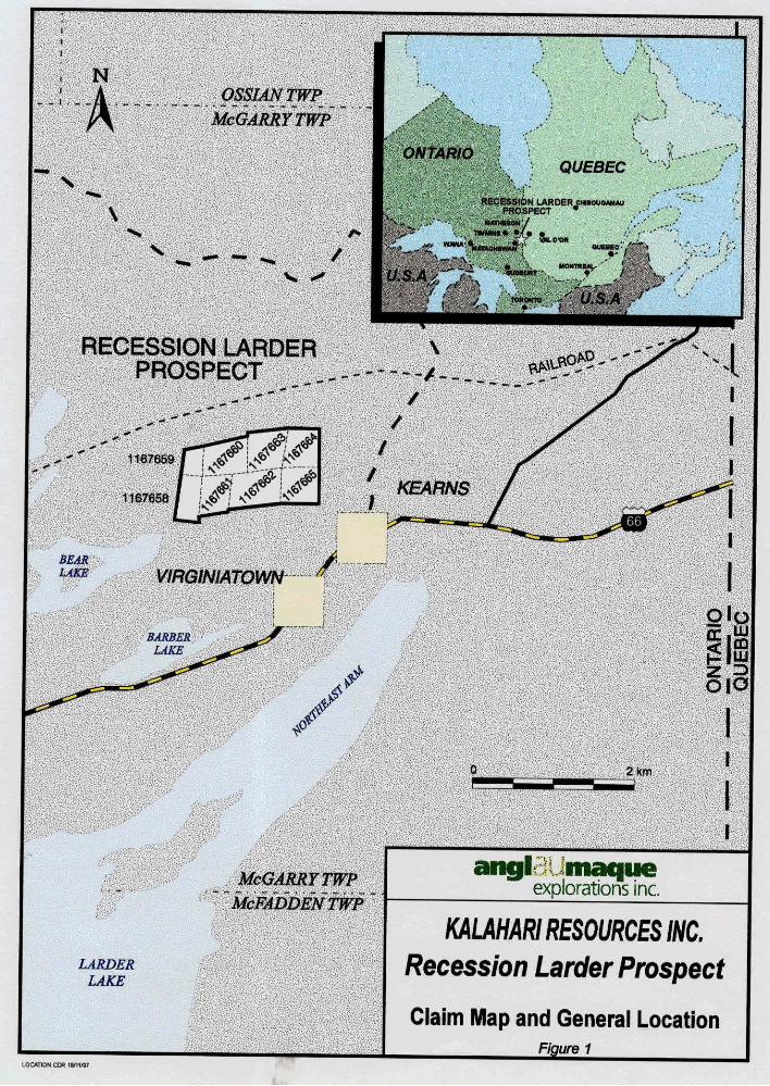
The Recession Larder Project is located in central McGarry Twp, near Kirkland Lake Ont. (NTS 32D/04). It includes eight claims covering 320 acres (Figure l). It is currently under option by Kalahari Resources Inc. of Vancouver.
An exploration program consisting of line cutting and diamond drilling was done between October 8l and 29th , 1996. All work was done through the supervision of Anglaumaque Explorations Inc. Diamond drilling was contracted to Forage Val d'Or Inc.
Following is a brief account of the regional and local geology and a list of the historical work done on the current property. The report also provides a detailed description of the holes drilled and a discussion of the results obtained. Based on this information, a series of recommendations are proposed.
2.0 PROPERTY, LOCATION AND ACCESS
The Recession Larder Property is located 40 km east of the town of Kirkland Lake, Ontario and consists of 8 claims (1167658 and 1167665). It lies in the central part of McGarry Township on NTS Map Sheet 32D/04. The claims are registered with the Office of the Mining Recorder at Kirkland Lake, Ontario under the name of 297 3090 Canada Inc. The property is currently under option by Kalahari Resources Inc.
Access to the property is via HWY 66 which reaches the towns of Kirkland Lake to the west and the Quebec border to the east. A dirt road from the Virginiatown provides direct access to the property.
3.0 REGIONAL GEOLOGY
The property lies within part of the Abitibi Orogen, consisting of metamorphosed Early Precambrian volcanic, sedimentary and intrusive rocks in an east-plunging synclinorium between the Abitibi and Round Lake batholiths. Two major east-west trending fault zones cut the northern and southern units of the synclinorium; the Destor-Porcupine Fault Zone and the Kirkland Lake-Larder Lake Fault Zone respectively. The gold deposits of the Kirkland Lake area are related to the latter structure.
NgSSIANTWP
McGARRYTWP
QUEBEC
RECESSION LARDER emeus****)PROSPECT *l, - ' - i t '
-!-,... .•j"^' '. . TIMMIMS* */* *:.".i-'^ VA . 3\ WLDW ,;"'^i'^^^ W*"*',lii*WQHftWAM f OUBMB-
RECESSION LARDER PROSPECT
McFADDENTWP
LARDER LAKE
angl maqueexplorations inc.
KALAHARI RESOURCES INC. Recession Larder Prospect
Claim Map and General Location___________Figure 1__________
LOCATION CW
angiaUmaqueexplorations inc.
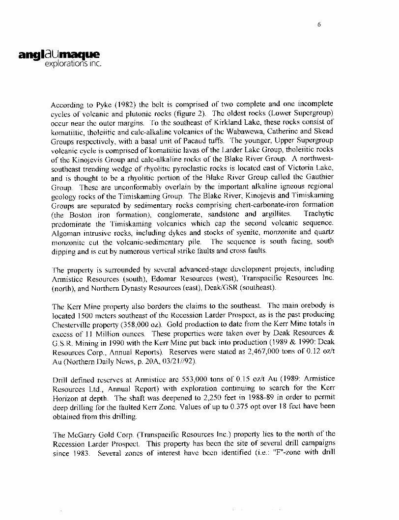
According to Pyke (1982) the belt is comprised of two complete and one incomplete cycles of volcanic and plutonic rocks (figure 2). The oldest rocks (Lower Supergroup) occur near the outer margins. To the southeast of Kirkland Lake, these rocks consist of komatiitic, tholeiitic and calc-alkaline volcanics of the Wabawewa, Catherine and Skead Groups respectively, with a basal unit of Pacaud tuffs. The younger, Upper Supergroup volcanic cycle is comprised of komatiitic lavas of the Larder Lake Group, tholeiitic rocks of the Kinojevis Group and calc-alkaline rocks of the Blake River Group. A northwest- southeast trending wedge of rhyolitic pyroclastic rocks is located east of Victoria Lake, and is thought to be a rhyolitic portion of the Blake River Group called the Gauthier Group. These are unconformably overlain by the important alkaline igneous regional geology rocks of the Timiskaming Group. The Blake River, Kinojevis and Timiskaming Groups are separated by sedimentary rocks comprising chert-carbonate-iron formation (the Boston iron formation), conglomerate, sandstone and argillites. Trachytic predominate the Timiskaming volcanics which cap the second volcanic sequence. Algoman intrusive rocks, including dykes and stocks of syenite, monzonite and quartz monzonite cut the volcanic-sedimentary pile. The sequence is south facing, south dipping and is cut by numerous vertical strike faults and cross faults.
The property is surrounded by several advanced-stage development projects, including Armistice Resources (south), Edomar Resources (west), Transpacific Resources Inc. (north), and Northern Dynasty Resources (east), Deak/GSR (southeast).
The Kerr Mine property also borders the claims to the southeast. The main orebody is located 1500 meters southeast of the Recession Larder Prospect, as is the past producing Chesterville property (358,000 oz). Gold production to date from the Kerr Mine totals in excess of 11 Million ounces. These properties were taken over by Deak Resources *fe G.S.R. Mining in 1990 with the Kerr Mine put back into production (1989 A 1990: Deak Resources Corp., Annual Reports). Reserves were stated as 2,467,000 tons of 0.12 oz/t Au (Northern Daily News, p. 20A, 03/21 1192).
Drill defined reserves at Armistice are 553,000 tons of 0.15 oz/t Au (1989: Armistice Resources Ltd., Annual Report) with exploration continuing to search for the Ken- Horizon at depth. The shaft was deepened to 2,250 feet in 1988-89 in order to permit deep drilling for the faulted Kerr Zone. Values of up to 0.375 opt over 18 feet have been obtained from this drilling.
The McGarry Gold Corp. (Transpacific Resources Inc.) property lies to the north of the Recession Larder Prospect. This property has been the site of several drill campaigns since 1983. Several zones of interest have been identified (i.e.: "F"-zone with drill
ALKALIC INTRUSIVE
GOWGANDA FORMATION
FELSIC INTRUSIVE
SYENITE, MONZONITE
GABBRO, DIORITE
PERIDOTITE, DUNITE
CONGLOMERATE
TRACHYTE
VOLCANIC ROCK
GEOLOGICAL . CONTACT
. CWOSS FAULT
m GOLD DEPOSIT
O 5km
\
explorations inc.
KALAHARI RESOURCES INC. Recession Larder Prospect
Regional Geology_______ Figure 2 ^^—^^—
angiaUmaqueexplorations inc.
indicated reserves of 110,000 tons of 0.10 oz/t Au). Recently, Transpacific has exercised its option to purchase 100*^ of the property following a 24 hole drill program which has intersected significant gold values in 17 holes. Values of up to 14 opt over l .4 feet and 29 feet at 0.05 opt are reported (Northern Daily News Friday October 17th 1997).
4.0 LOCAL GEOLOGY
Geological mapping by S.J. Carmichael was completed in 1992 at a scale of 1:2500 over grid lines cut at either 100 meter or 50m centers (figure 3). The author described the geology of the property as consisting of two main lithologies including Timiskaming conglomerate and wacke, and trachytic flows and fragmental breccias. Three small outcrops of diabase were also located, cutting both the conglomerates and the trachytes".
I) Timiskaming ConglomerateAll outcrops of conglomerate were located north of the Ivan Larder Fault. They are typical, unaltered and contain the occasional diagnostic jasper pebbles. Exposure is generally limited to small cliff faces and are void of any bedding or dip features. Cobble lithologies vary from syenide to volcanic with intrusive varieties dominating. The clasts are relatively undeformed and show little if any stretching or flattening. The maximum clast size is roughly six inches.
II) Timiskaming TrachyteTrachytic units underlie most of the property and occur south of the Ivan Larder Fault. They vary from dark green chloritic fragmental flows, often moderately magnetic to buff carbonated sericitic units where cut by shears of faults. Lesser interbedded siltstone units were located on line 3+OOE, 2+OOS. The bedding of these units strike east-northeast with a dark green chloritic groundmass with up to 25*^0 syenitic clasts. Where higher proportions of syenitic fragments are present, the trachyte appears as dark red to pink in colour. One such location is line 2+50E, 4+25S.
The dominant structure on the property is the Ivan Larder Fault which transects the entire claim group. It appears to mark a lithological contact between the Timiskaming conglomerate to the north and the Timiskaming trachyte to the south.
According to S.J. Carmichael the mineralization on the property is associated to a series of secondary faults which trend roughly east-northeast. Quartz veining and carbonate/sericite alteration are related to these secondary faults. Mineralization is confined to the trachytic units and consists of quartz veins and flat-lying small quartz
IVAN LARDER FAULT
BASELINE AzBO'
CONGLOMERATE
TRACHYTE
DIABASE
150m
X
Outcrop
Fault; Shear
Drill Hole
Trench; Pit
Quartz Vein
VLF-EM Anomaly
Maxl-Probe Anomaly
angl maqueexplorations inc.
KALAHARI RESOURCES INC. Recession Larder Prospect
LOCAL GEOLOGYFigure 3
10
angldUmaqueexplorations inc.
stockworks. On the property, a total of eight areas were manually stripped and sampled.
Most of the veins contain up to l 07o of pyrite with minor chalcopyrite. The best assays
returned from the sampling was 0.02 oz/t Au an other samples returned Q.29% Cu from a
vein mineralized with irregular pods of malachite and chalcopyrite.
5.0 PREVIOUS WORK HISTORY
The Kirkland Lake-Larder Lake area has been actively explored since the early part of the
century when the Kirkland Lake Break was discovered. Although exploration efforts
came in pulses throughout the century, important discoveries were made in most decades,
the most recent being Sudbury Contact's Victoria Creek Project in 1993.
The first known work done on the property itself was completed by Drummond in 1939.
Three holes were drilled and two shallow shafts were sunk. They obtained an interesting
result of 1.33 oz/t Au. Two of the three holes were located on claim #1167659 where
one of the shaft is found (on Line 2+1OE at 0+75N). The first hole was drilled towards
the south at a low angle. The second one was drilled at a dip of 700 to the north. Gold
values were reported over a 50 cm width in the first hole. The third hole, located about
100m south of the other holes, was drilled at a 45 0 angle to the north. Unfortunately,
none of the collars were found during a mapping campaign in 1992.
However, during this campaign, four old drill holes were located at the following
coordinates: 3+60E, 0+00; 3+90E, 0+00; 1+25E, 3+30S and 1+60E, 2+90S. The drill
core from these holes was found at the intersection of the baseline and 3+60S, near the
collar of the two first holes. Many of the core boxes were overturned, rendering the core
useless.
A fifth hole, drilled at a nearly vertical dip probably during that same period, is located at
the southern limit of the property on line 8+25E. These holes, which seem to be over
thirty years old, were never mentioned or described in any report.
In 1981, the property was held by M. Leahy and C. Forbes who did some ground
magnetic and electromagnetic surveys (VFL) and then was optioned to Lampe Resources.
Two drill holes, aimed to the north, were done in the NW part of the property on line
0+75E at 0+25N. The first hole was 61 meters long at a 45 0 dip while the other,
positioned 3 meters north of the first one, was 148m long at a 45 0 dip. These holes both
intersected the trachyte of the Timiskaming volcanic sequence but results obtained did
not show any significant values.
10
angiaUmaqueexplorations inc.
stockworks. On the property, a total of eight areas were manually stripped and sampled.
Most of the veins contain up to Wo of pyrite with minor chalcopyrite. The best assays
returned from the sampling was 0.02 oz/t Au an other samples returned Q.29% Cu from a
vein mineralized with irregular pods of malachite and chalcopyrite.
5.0 PREVIOUS WORK HISTORY
The Kirkland Lake-Larder Lake area has been actively explored since the early part of the
century when the Kirkland Lake Break was discovered. Although exploration efforts
came in pulses throughout the century, important discoveries were made in most decades,
the most recent being Sudbury Contact's Victoria Creek Project in 1993.
The first known work done on the property itself was completed by Drummond in 1939.
Three holes were drilled and two shallow shafts were sunk. They obtained an interesting
result of 1.33 oz/t Au. Two of the three holes were located on claim #1167659 where
one of the shaft is found (on Line 2+10E at 0+75N). The first hole was drilled towards
the south at a low angle. The second one was drilled at a dip of 700 to the north. Gold
values were reported over a 50 cm width in the first hole. The third hole, located about
100m south of the other holes, was drilled at a 45 0 angle to the north. Unfortunately,
none of the collars were found during a mapping campaign in 1992.
However, during this campaign, four old drill holes were located at the following
coordinates: 3+60E, 0+00; 3+90E, 0+00; 1+25E, 3+30S and 1+60E, 2+90S. The drill
core from these holes was found at the intersection of the baseline and 3+60S, near the
collar of the two first holes. Many of the core boxes were overturned, rendering the core
useless.
A fifth hole, drilled at a nearly vertical dip probably during that same period, is located at
the southern limit of the property on line 8+25E. These holes, which seem to be over
thirty years old, were never mentioned or described in any report.
In 1981, the property was held by M. Leahy and C. Forbes who did some ground
magnetic and electromagnetic surveys (VFL) and then was optioned to Lampe Resources.
Two drill holes, aimed to the north, were done in the NW part of the property on line
0+75E at 0+25N. The first hole was 61 meters long at a 45 0 dip while the other,
positioned 3 meters north of the first one, was 148m long at a 45 0 dip. These holes both
intersected the trachyte of the Timiskaming volcanic sequence but results obtained did
not show any significant values.
11
angldUmaqueexplorations inc.
In 1981, Geo Indicators owned the northern part of claim #1167659 which was part of
the McGarry Gold option located north of the present property. One hole, with a north
direction and a dip of 45 0, is located on the actual line 1+75E at 2+50N. This hole
intersected the Timiskaming conglomerate but no significant mineralization was noted.
In 1984-85, Leahy completed a three hole drill program with two of them located on the
Geo Indicators portion of the property aimed towards the south. These two holes were
abandoned because of extensive caving. It is possible that these holes intersected the Ivan
Larder Fault but the hole coordinates written in the logs would place them too far north
of this structure to intersect the fault. The third hole was drilled from 1+45E, 1 + 10N
towards the south and intersected only trachyte. Analyses did not return any significant
results.
G. Mullan staked the property in December 1990. In 1992, he hired S.J. Carmichael to
do an exploration program which consisted of a geological, ground magnetic and
electromagnetic survey. Both geophysical surveys were done at a 25m line spacing, thus
allowing to locate more precisely the geological contact between the volcanic rocks
(magnetic high) and the conglomerates (magnetic low) which correspond to the Ivan
Larder fault. The electromagnetic survey (VLF-II) confirmed and located four interesting
conductors. A Maxi-Probe multi-frequency survey by Geoem Inc. on a few lines (3)
allowed a better understanding on the nature of the conductors.
The Ivan Larder Fault is traceable from both the VLF-II and Maxi-Probe surveys
(anomaly "A") a strong conductor. The conductivity is reported to increase toward the
east. A second deformation zone is interpreted to cross the central part of the property.
This central zone follows a Maxi-Probe anomaly over a strike length of 700 meters
(anomaly "B") and joins most historical showings within the property. The Maxi-Probe
survey report characterizes anomaly "B" as a "possible tight shear zone type target
surrounded by very high resistivity material, possibly quartz or silicification". A
northeast trending late brittle fault is also interpreted to cross the entire property based on
geophysical surveys. This late fault does not seem to have caused significant displacement of the volcanic and sedimentary sequences.
Kalahari Resources Inc. established an exploration program which commenced in
October of 1996 and was supervised by Anglaumaque Explorations Inc.
12
mgiaUmaqueexplorations inc.
6.0 1996 EXPLORATION PROGRAM
Prior to diamond drilling, the 17 lineal kilometer of grid was re-cut. Between October 8th
and 29th, 1996 a total of nine holes were drilled on the property. The total footage for the
1996 drilling program is 2583 feet (table 1). Among these holes, DDH 96REC-01 and
96REC-02 were stopped prematurely. Hole -01 was stopped in overburden after the casing
broke at a depth of 40 feet due to large boulders. The rig was moved 40 meters north and
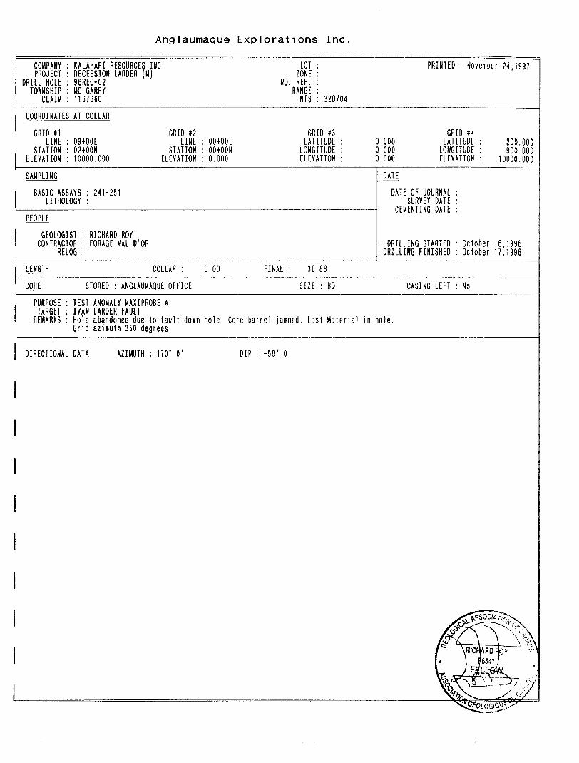
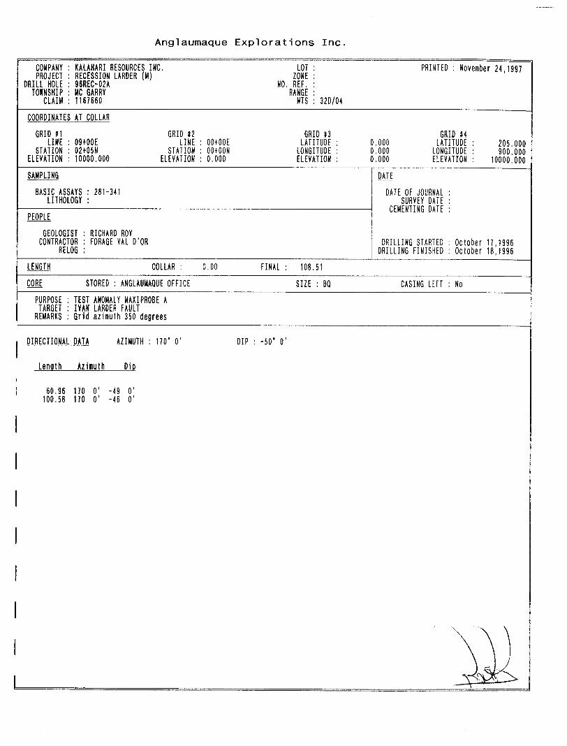
hole 96REC-01A was successfully drilled. Hole 96REC-02 was abandoned at a depth of 121
feet due to excessive caving and sanding within the hole. Hole 96REC-02A was
subsequently drilled 5 meters from the original hole.
The following sections lists the target tested by each hole a gives a brief description of
the results obtained.
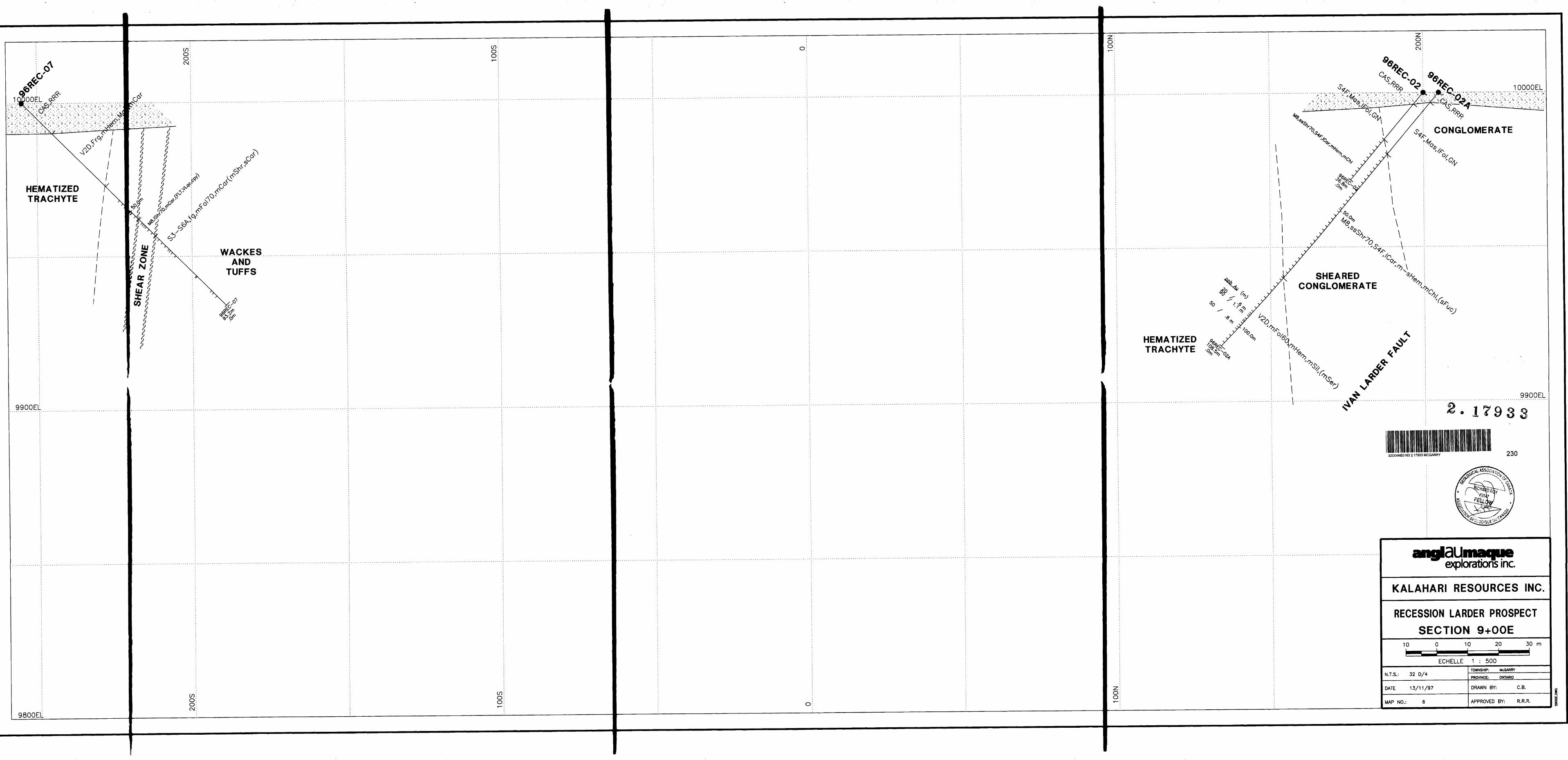
96REC-01A: The first hole was aimed to test the Ivan Larder Fault near the
northwest corner of the property where the fault waves, following a northeast (0700 AZ.)
direction which may represent a jog within the fault. These jogs create localized tension
openings favorable for quartz vein injections and gold mineralization.
0-56 Casing
56 - 196 Timiskaming ConglomerateRelatively massive but locally fractured. Alteration and
quartz veining is weak. Only traces of sulfides locally.
196-375 Sheared Timiskaming ConglomerateStrongly sheared and fractured conglomerates with intense
stretching of cobbles (5 to 1). Alteration consists of
gradually increasing carbonatisation, and hematization up
to a depth of 300 feet. Fuchsitic alteration is also progressively stronger. Quartz veining is mostly between
266 and 300 feet where it amounts to 2007o of the rock.
Pyrite is only found in trace amounts within the shear zone.
From 300 to 375, alteration is weak to moderate while up
to lO^o of quartz veining is observed. At 338 feet, a one foot section contains 50*/^ quartz veining with 2Vo fine grained pyrite stringers within the vein.
375 - 477 Sheared Timiskaming Trachyte375 - 401 : Strongly sheared trachyte with low hematiticalteration and moderate carbonate alteration. Up to 5 07oquartz veining with traces of pyrite is observed within theunit.401 - 477 : Moderately sheared trachyte with moderatehematization and up to 15 07o quartz veining in the form ofveinlets (^2 inches in width.). Traces of sulfides.
477 - 496 Massive Timiskaming TrachyteMassive and weakly chloritized trachyte. Traces of quartz veinlets locally.
496 End of Hole
The Ivan Larder Fault was therefore crossed between 196 and 477 feet. Deformation and alteration peaks at a depth of 300 feet. Although only minor sulfides were observed in this hole, the intensity of deformation and alteration confirms the potential of this important structure.
Assays obtained for this hole are quite disappointing. The best result is 110 PPB Au over 5 feet between 217 and 222 feet. Up to 507o quartz veining with traces of pyrite was observed within this interval. Nevertheless, the Ivan Larder Fault did contain detectable gold from 182 to 251 feet. Values within this interval range from 10 to 110 PPB Au.
96REC-02A: 500m east of the above target, the Ivan Larder Fault was tested where the coincident Maxi-Probe anomaly shows the strongest conductivity. This area is also 200m west of the northeast trending brittle fault.
O- 14 Casing
14-85.5 Timiskaming ConglomerateRelatively massive but locally fractured. Alteration and quartz veining is weak. Only traces of sulfides locally.
85.5-258 Sheared Timiskaming Conglomerate and TrachyteStrongly sheared and fractured conglomerates and trachyte at 700 to the core axis, with intense stretching of cobbles (5 to l). The contact with the trachyte is probably at 196 feet (strongly sheared therefore difficult to establish clearly).
15
angiaiimaqueexplorations inc.
Near the central portion of the shear, hematite and fucshite
alteration is very strong. Quartz is mostly is found as local veinlets. Pyrite is only found in trace amounts within the shear zone.
veining is observed. Up to 3Vo pyrite in the sericitized wall rock of the veins309 - 331.5 : 5 to 4007o quartz veining with traces to 3 07o
pyrite (approx. Wo this entire section).
356 End of Hole
Hole 96REC-02A shows an net improvement in alteration, quartz veining and pyrite
mineralization compared to hole -O l A. This observation confirms the interpreted increase
in conductivity towards the east from the Maxi-Probe survey.
Although hole -02A was visually more promising, assay results of the hole were all below
100 PPB Au. The highest value is 90 PPB Au over 3.5 feet (313 to 316.5 feet) from a
strongly sericitized trachyte containing 25^0 quartz veining and 3*^b fine pyrite. This interval
lies well below the fault itself.
Holes 96REC-03 and -04 are located 175 meters from each other and tested the Maxi-Probe
B anomaly. The holes were strategically located where old pits revealing quartz veining
were noted.
96REC-03:
O- 10 Casing
10-175 Hematized Timiskaming TrachyteModerately hematized fine grained, massive trachyte. Local quartz veining and associated sericite alteration as follows:
23-81 : 2007o quartz veins (some up to 3 feet wide), moderately sericitized, traces of pyrite
175-226 Hematized Timiskaming Fragmental TrachyteAs at 10 to 175 apart from the presence of up to 25^o strongly hematized fragments ^cm. Locally moderately
16
angiaiimaqueexplorations inc.
sericitized. From 175 to 187, injection of 5 to 2007o quartz veinlets with traces to 3^o fine grained pyrite.
226 - 306 Massive Green Timiskaming Fragmental TrachyteAs 1 75 to 226 but without the alteration. It is fresh looking. Only minor quartz veinlets with traces of pyrite.
306 End of Hole
The two sections containing quartz veining probably correspond to the two pits mapped
near the collar of the hole.
96REC-04:
Hole was collared 175 meters east of hole -03 on October 19th 1996. The target for this hole was a linear magnetic anomaly coincident with the Maxi-Probe anomaly. The hole
reached bedrock at a depth of l O feet and was stopped at a depth of 306 feet on October 20th 1996.
The rock encountered consists of a monotonous sequence of weakly to moderately hematized fragmental trachyte. It is locally magnetic in the center of the hole (which
explains the targeted anomaly). Only minor quartz veining and traces of pyrite was noted.
Although hole -03 encountered significant quartz veining along with up to Wo pyrite, the
only anomalous gold value obtained is 140 ppb Au over 5 feet (61 to 66 feet) from a
moderately sericitized trachyte containing I 07o disseminated pyrite in 10*54 quartz veining. Hole -04 encountered a monotonous sequence of hematized trachyte and assay results are all below 0.0 1 g/tAu.
96REC-05: Hole 96REC-05 tested anomaly C (Maxi-Probe) along with down dip
extension of an old pit which returned a assay result of 557 ppb Au (grab sample). The hole
was collared 100 meters southeast of hole -04.
0-20 Casing
20 - 89 Timiskaming WackeModerately carbonated and well foliated wackes showing good bedding locally. A fold axis was also noted at a depth of 79 feet. Assuming that the foliation strikes perpendicular to the hole, the fold observed is a tight fold plunging 30 to
17
angldUmaqueexplorations inc.
400 to the east. Only minor quartz veining and traces of disseminated pyrite was observed in the sediments.
89 - 296 Hematized Fragmental TrachyteMassive, weakly carbonated but strongly hematized trachyte. Only rare white quartz veins were seen. Traces of pyrite in the trachyte.From 263 to 267 feet a quartz vein containing SO'Ki brecciated trachyte fragments was noted. It contains Q.5% pyrite and traces of chalcopyrite.
296 End of Hole
No significant assays were obtained from this hole.
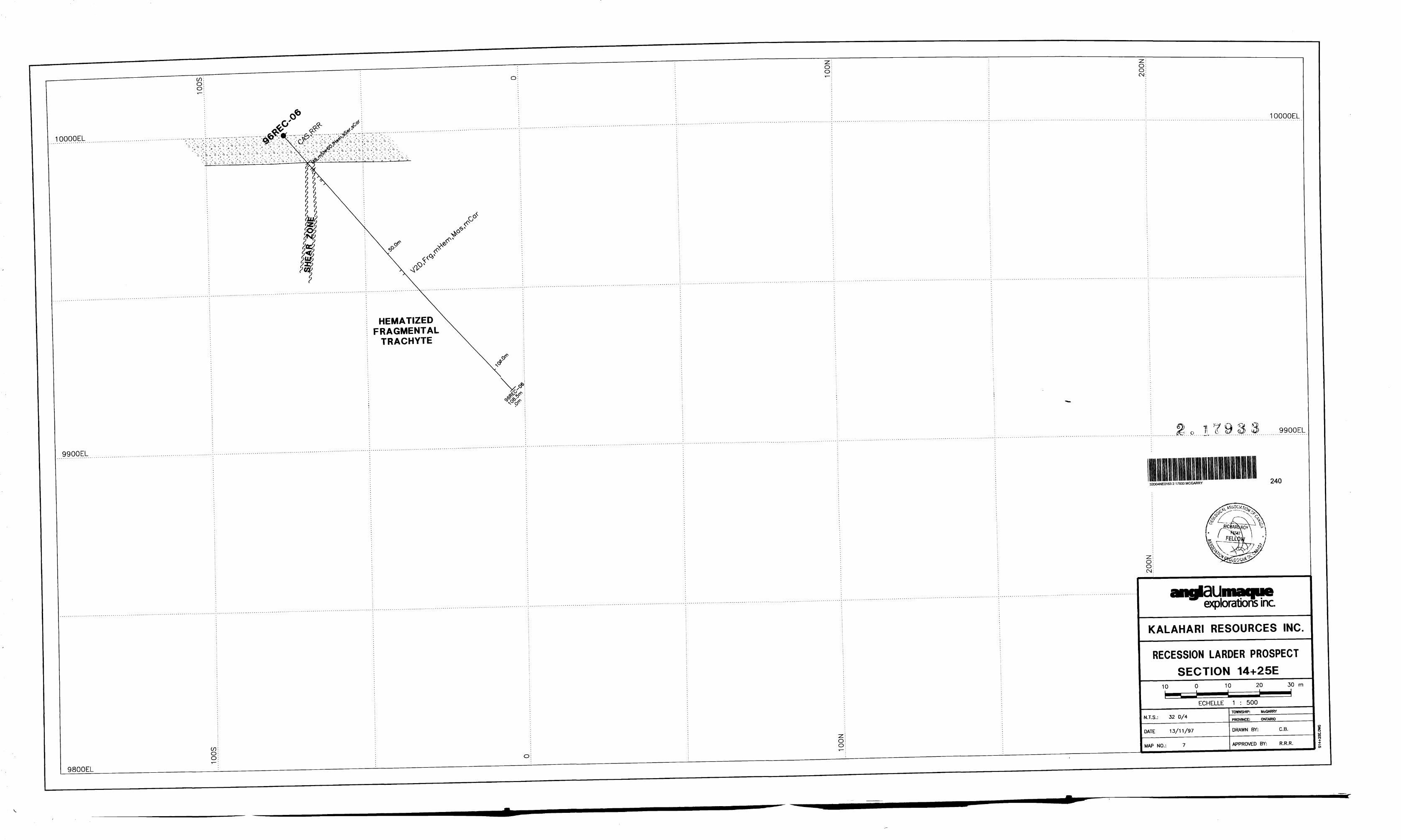
96REC-06: Hole 96REC-06 was designed to test a moderate VLF anomaly located
near the eastern limit of the property. Immediately east of the property limit, a band of
sedimentary rocks are shown on government geological maps.
0-38 Casing
38-306 Hematized Fragmental TrachyteMassive, weakly carbonated but strongly hematized trachyte. Only rare white quartz veins were seen. Traces of pyrite in the trachyte.
From 42 to 49: moderately sheared fragmental trachyte which is locally strongly sericitized and contains traces of pyrite associated with the sericite.
306 End of Hole
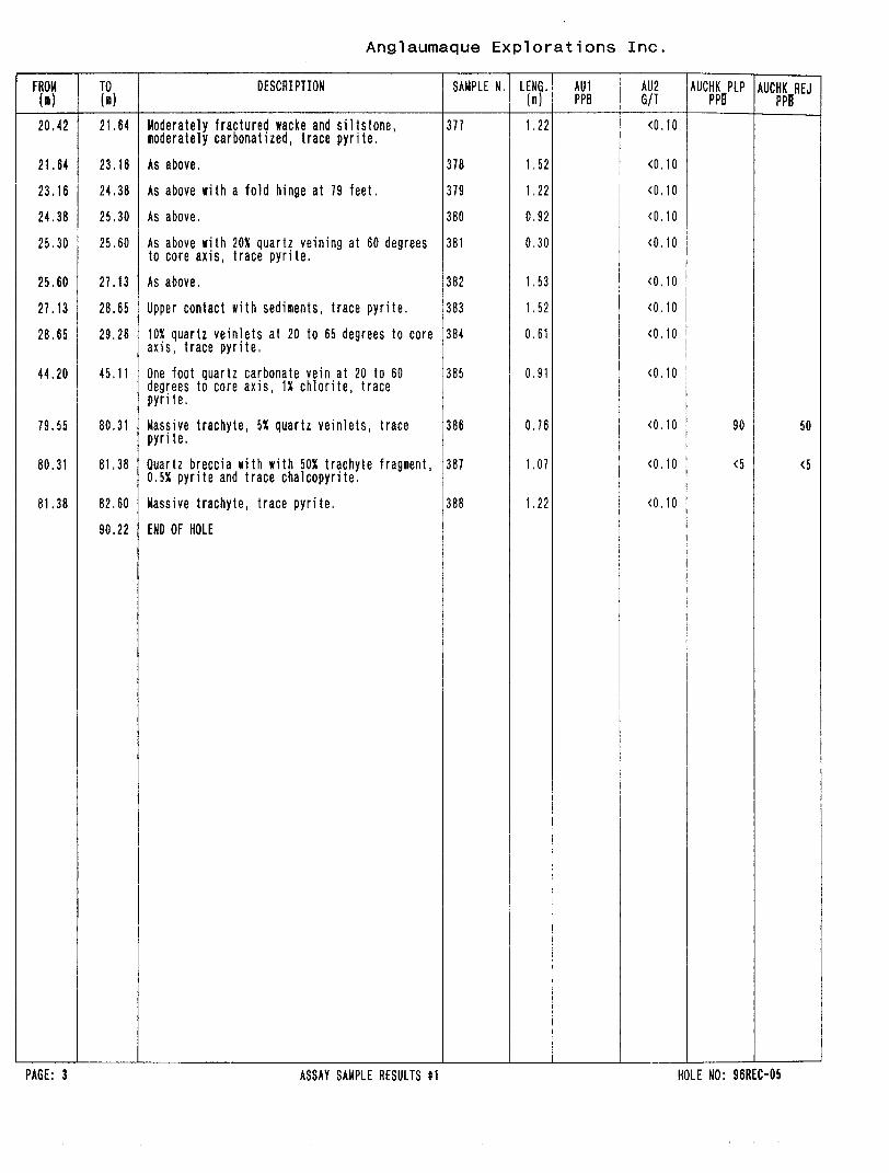
96REC-07; The presence of the carbonated wackes in hole -05 added significantly
to the potential of anomaly D located 80 meters south of anomaly C, as it would occur in the
center of the sedimentary package. In light of this new information, a proposed hole -07 to
test anomaly D on line 9^00E was established.
18
angldllmaqueexplorations inc.
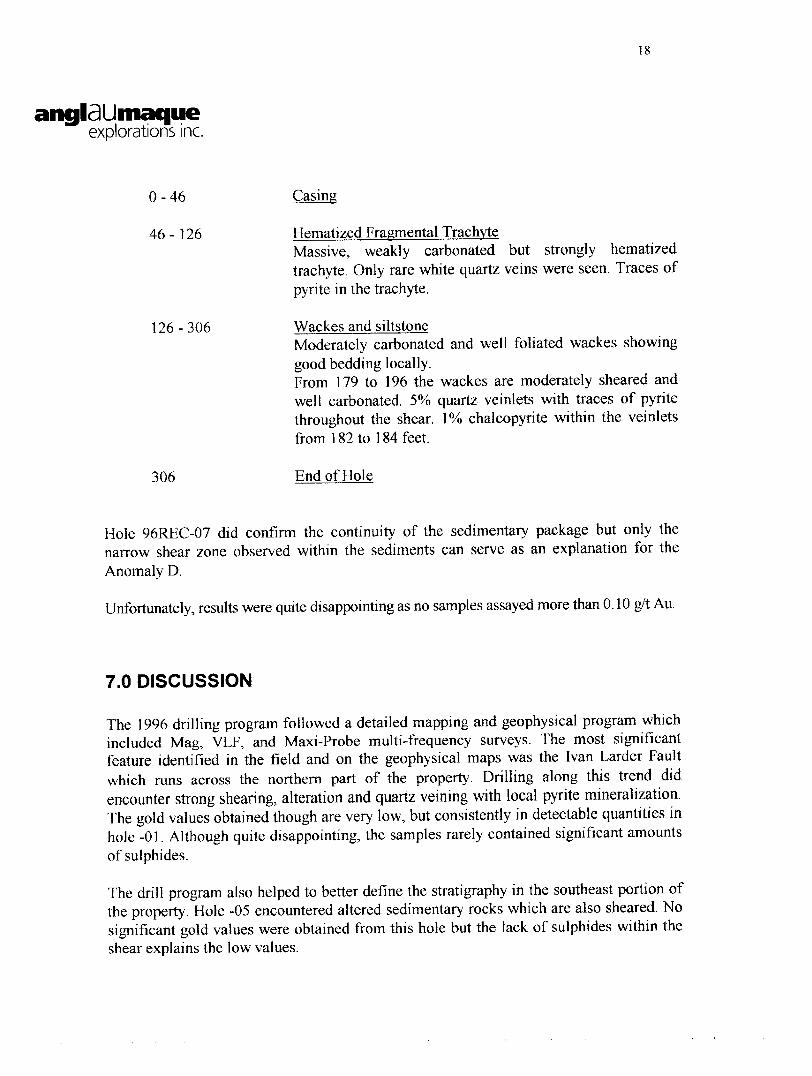
0-46 Casing
46-126 Hematized Fragmental TrachyteMassive, weakly carbonated but strongly hematized trachyte. Only rare white quartz veins were seen. Traces of pyrite in the trachyte.
126-306 Wackes and siltstoneModerately carbonated and well foliated wackes showing good bedding locally.From 179 to 196 the wackes are moderately sheared and well carbonated. 5 07o quartz veinlets with traces of pyrite throughout the shear. P/o chalcopyrite within the veinlets from 182 to 184 feet.
306 End of Hole
Hole 96REC-07 did confirm the continuity of the sedimentary package but only the
narrow shear zone observed within the sediments can serve as an explanation for the
Anomaly D.
Unfortunately, results were quite disappointing as no samples assayed more than 0.10 g/t Au.
7.0 DISCUSSION
The 1996 drilling program followed a detailed mapping and geophysical program which
included Mag, VLF, and Maxi-Probe multi-frequency surveys. The most significant
feature identified in the field and on the geophysical maps was the Ivan Larder Fault
which runs across the northern part of the property. Drilling along this trend did
encounter strong shearing, alteration and quartz veining with local pyrite mineralization.
The gold values obtained though are very low, but consistently in detectable quantities in
hole -01. Although quite disappointing, the samples rarely contained significant amounts
of sulphides.
The drill program also helped to better define the stratigraphy in the southeast portion of
the property. Hole -05 encountered altered sedimentary rocks which are also sheared. No
significant gold values were obtained from this hole but the lack of sulphides within the
shear explains the low values.
19
angldLimaqueexplorations inc.
The altered and sheared sedimentary unit still holds excellent potential of hosting
economic gold mineralization. In order to select better targets along this shear zone, an IP
survey should be done to locate coincident chargeable sections. In addition, other
potential targets may be defined elsewhere in this overburden covered area. For example,
the ENE trending Bear Creek follows a subtle depression which could hide an important
fault zone. Current available data does not justify diamond drilling below the creek but
an IP survey may provide targets along this trend.
The Recession Larder Prospect has similar geology, structure and alteration to other
surrounding properties where gold mineralization does occur in economic concentrations.
The 1996 exploration program added significantly to our knowledge of the property,
establishing the structural nature of the Ivan Larder Fault and locating other significant
structures such as within the sediments in the eastern part of the property. Adding an IP
survey to the existing database could provide specific targets along the favourable
structures already defined and may point to new areas where no work has been done so
far.
20
angldUmaqueexplorations inc.
8.0 CONCLUSION
1- The Recession Larder Property is underlain by trachytes and conglomerates.
A fine sedimentary sequence also occurs near the southwest portion of the
property.
2- The background gold content on the claim group is very low. Most samples
returned values of less than 5 ppb Au. The highest value obtained is 140 ppb
Au in hole -03. Hole -01 did return detectable gold values across a good portion of the Ivan Larder Fault.
3 - A new shear zone within fine grained sediments in the southwest portion of
the property was uncovered. Although little sulphide was noted, it does
represent a new potential structure for gold mineralization.
4- The low values are explained by the lack of significant sulphide
mineralization in most holes. The Maxi Probe anomalies tested are related
to topographical features, some caused by important shearing.
9.0 RECOMMENDATIONS
1 - The grid should be covered by a new geophysical survey. Mag-VLF and IP
should be done in order to better define the deformation zones and locate
significant sulphide mineralization within structures.
2 - A further 2 500 feet (760 meters) should be completed to test the most
promising geophysical targets. Some footage should also be reserved to testing
the area below Bear Creek. A NNE trending structure could follow the river.
21
angiaUmaqueexplorations inc.
10.0 BUDGET
l - Geophysics:Complete magnetic, VLF, and I.P. survey over the entire grid,
DRILLING STARTED : October 09 DRILLING FINISHED : October 16
CASING LEFT : No
24,1997
215.000 275.000 0000.000
,1996 .1996
DIRECTIONAL DATA AZIMUTH : 170' O' DIP : -50* O'
Length Azimuth Dip
30.48 170 O' -52 O'74.68 170 O'91.44 170 O 1121.92 170 O'151.18 167 O 1
-50 O 1-49 O 1-49 O 1-47 O 1
Anglaumaque Explorations Inc.
FROM TO W
DESCRIPTION
0,00
17.07
17.07
59.74
59.74 114.30
114.30 145.C
145,( 151.18
151.18
CAS.RRR
CASINGCasing removed.
S4F,Mas,lFol,nGN
POLYGENIC MATRIX SUPPORTED CONGLOMERATEMassive unaltered polygenic conglomerate with 20 to 50X fragments ()2 in). Weakly foliated and stretching of fragments (2 to 1). Fragments composed of 30X granitic, 40X volcanic and 30X sedimentary (wackes with minor cherts and jasper). Rare quartz veining and traces of sulfides.
56.08 - 59.74 ZFrc,nFrc,lCar,2VNq(py)
FRACTURED ZONEModerately fractured conglomerates. Fracturing at 45 to 90 degrees to the core axis. Foliation still weak at 45 degrees to the core axis. Low carbonate alteration throughout and low hematization locally. A pyrite rich fragment? found at 185.5 feet.
M8,ssShr65,S4F,lCar,lFuc,lHem(VNqc)
SHEARED CONGLOMERATEStrongly sheared and fractured conglomerate at 65 degrees to the core axis. A gradual bleaching gives it a light green color. Local carbonate, fucshite and hematite alteration throughout. Minor quartz carbonate veining with traces to 1X fine pyrite and traces of chalcopyrite locally. Pyrite is very fine grained. Lost core locally as described below.
62.18 - 63.25 LC
LOST CORE
LC
LC
LC
67.67 - 68.43
LOST CORE
70.56 - 71.32
LOST CORE
73.15 - 73.76
LOST CORE
M8,n-sShr,Y2D,sChl,sCar,lHen(VNqc)
MODERATELY TO STRONGLY SHEARED TRACHYTEStrongly chloritized and sheared trachyte. Shearing at 45 degrees to the core axis. Local faint hematitealteration observed. Quartz veining is low in the strongly sheared section but increases within themoderately sheared trachyte near the end of the section, irdecreases down hole.
V2D,Mas,fg,nChl,mCar l lHem
Traces of pyrite throughout. Shearing gradually
MASSIVE TRACHYTEMassive weakly foliated trachyte at 50 degrees to the core axis. It is fine grained, locally showingfragmental texture. Weakly hematized and moderately chloritized, Some sections are well carbonated.
END OF HOLE
PAGE: 2 GEOLOGICAL DESCRIPTION HOLE NO: 96REC-01A
Anglaumaque Explorations Inc.
FROM ("i)
55.47
56.08
56.69
58.22
59.74
61.26
63.25
65.38
66.14
68.43
69.49
71.32
71.93
73.76
74.98
75.59
76.50
77.11
78.03
78.94
80.16
81.53
84.12
85.65
87.17
88.09
88.85
90.53
92.35
93.88
95.40
TO ( )
56.08
56.69
58.22
59.74
61.26
62.18
65.38
66.14
67.67
69.49
70.56
71.93
73.15
74.98
75.59
76.50
77.11
78.03
78,94
60.16
81.53
84.12
85.65
87.17
88.09
88.85
90.53
92.35
93.88
95,40
96.32
DESCRIPTION
Massive conglomerate, trace pyrite.
One to tKO inch pyrite quartz fragment, probably vein fragment, strongly fractured pyrite.
Moderately fractured conglomerate, trace fine grained pyrite, weakly carbonatized.
DRILLING STARTED : October 16 DRILLING FINISHED : October 17
CASING LEFT : No
.1996 ,1996
hole, Core barrel jammed, Lost Material in hole.
DIRECTIONAL DATA AZIMUTH : 170* O 1 DIP : -50* O'
Anglaumaque Explorations Inc,
FROM (n)
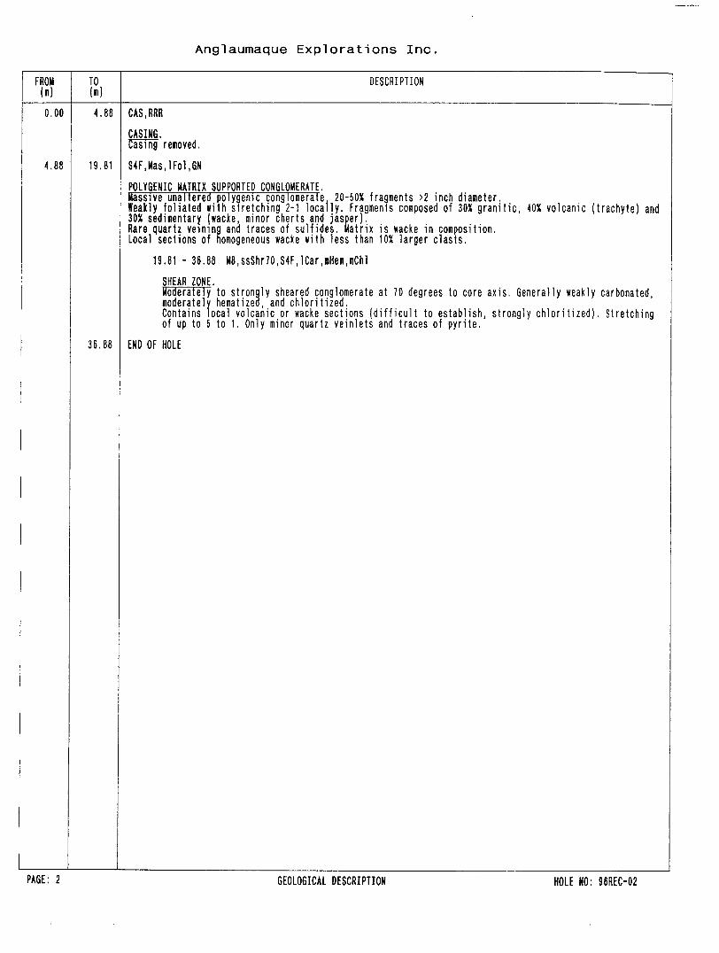
TO DESCRIPTION
4.86 CAS.RRR
CASING. Casing removed.
4.88 19.81 S4F,Mas,lFol,GN
POLYGENIC MATRIX SUPPORTED CONGLOMERATE.Massive unaltered polygenic conglomerate. 20-50X fragments )2 inch diameter.Weakly foliated Kith stretching 2-1 locally. Fragments composed of 30X granitic, 40X volcanic (trachyte) and30X sedimentary (wacke, minor cherts and jasper).Rare quartz veimng and traces of sulfides. Matrix is wacke in composition.Local sections of homogeneous wacke with less than 10X larger clasts.
19.81 - 36.88 M8,ssShr70,S4F,lCar,mHeii,mChl
SHEAR ZONE.Moderately to strongly sheared conglomerate at 70 degrees to core axis. Generally weakly carbonated,moderately hematized, and chloritized.Contains local volcanic or wacke sections (difficult to establish, strongly chloritized). Stretchingof up to 5 to 1. Only minor quartz veinlets and traces of pyrite,
36.88 END OF HOLE
PAGE: 2 GEOLOGICAL DESCRIPTION HOLE NO: 96REC-02
Anglaumaque Explorations Inc.
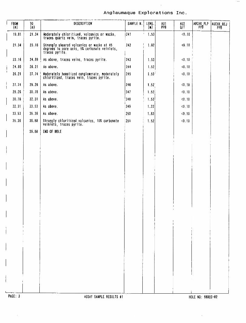
FROM W
19.81
21.34
23.16
24.69
26.21
27.74
29.26
30.78
32.31
33.53
35.36
TO (m)
21.34
23,16
24.69
26.21
27.74
29,26
30.78
32,31
33.53
35.36
36.88
36.68
DESCRIPTION
Moderately chloritized, volcanics or wacke,traces quartz vein, traces pyrite.Strongly sheared volcanics or wacke at 45 degrees to core axis, 5X carbonate veinlets,traces pyrite.
DRILLING STARTED : October 17 DRILLING FINISHED : October 18
CASING LEFT : No
24,1997
205.000 900.000
0000.000
.1996
.1996
DIRECTIONAL DATA AZIMUTH : 170' O 1 DIP : -50 s O'
Length Azimuth Dip
60.96 170 O' -49 O' 100.58 170 O' -46 O'
Anglaumaque Explorations Inc.
FROM TO (m)
DESCRIPTION
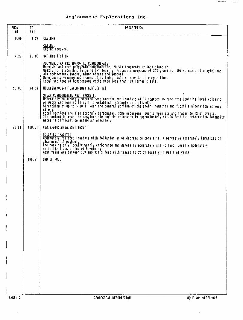
0.00 4.27 CAS.RRR
CASING. Casing removed.
1.27 26.06 S4F,Has,lFol,GN
POLYGENIC MATRIX SUPPORTED CONGLOMERATE.Massive unaltered polygenic conglomerate, 20-50X fragments >2 inch diameter.Keakly foliatedwith stretching 2-1 locally. Fragments composed of 30X granitic, 40X volcanic (trachyte) and305! sedimentary (wacke, minor cherts and jasper),Rare quartz veining and traces of sulfides. Matrix is wacke in composition.Local sections of homogeneous wacke with less than 10X larger clasts.
SHEAR CONGLOMERATE AND TRACHYTE.Moderately to strongly sheared conglomerate and trachyte at 70 degrees to core axis,Contains local volcanicor wacke sections (Difficult to establish, strongly chloritized).Stretching of up to 5 to 1. Near the central portion of the shear, hematite and fucshite alteration is verystrong.Local sections are also strongly carbonated. Some occasional quartz veinlets and traces to IX of pyrite.The contact between the conglomerate and the volcanics is approximately at 196 feet but deformation intensitymakes it difficult to establish precisely.
78.64 108.51 Y2D,nFol60,llHem,llSil,(mSer)
FOLIATED TRACHYTE.Moderately foliated trachyte with foliation at 60 degrees to core axis. A pervasive moderately hematizationalso exist throughout.The rock is only locally weakly carbonated and generally moderately sililcified. Locally moderatelysericitized associated with veining.Most veins are between 309 and 331.5 feet with traces to 3X py locally in walls of veins,
108,51 END OF HOLE
PAGE: 2 GEOLOGICAL DESCRIPTION HOLE NO: 96REC-02A
Anglaumaque Explorations Inc.
FROM (m)
26.06
27.74
2S.26
30.78
32.31
33.83
35.36
36,88
38.40
39.93
41.45
42.98
44.50
46.02
47.55
49,07
49.68
50.60
52.12
53.64
55.17
56.69
58.22
59,74
61,26
62.79
64.31
65.84
67.36
TO ( )
27.74
29.26
30.78
32,31
33,83
35.36
36.88
38.40
39.93
41.45
42,98
44,50
46.02
47.55
49.07
49.68
50.60
52.12
53.64
55.17
56.69
58.22
59.74
61.26
62.79
64.31
65.84
67.36
68.88
DESCRIPTION
Moderately sheared at 45 degrees to core axis, strongly chloritized volcanics traces pyrite.
As above.
Moderately sheared conglomerate at 45 degrees to core axis, traces pyrite.
As above, weakly hematized.
Strongly sheared conglomerate at 60 degrees to core axis, noderately hematized, strongly chloritized, traces quartz, traces pyrite.
DRILLING STARTED : October 18 DRILLING FINISHED : October 19
CASING LEFT : No
.1996
.1996
PURPOSE TEST ANOMALY MAXIPROBE B TARGET Central Showings REMARKS Grid azinuth 350 degrees.
DIRECTIONAL DATA AZIMUTH : 350' O 1 DIP : -45* O'
Length Azinuth Dip
30.48 350 O' -45 O 160.96 350 O' -45 O'91.44 350 O' -44 O 193.27 348 O' -40 O 1
Anglaumaque Explorations Inc.
FROM (l)
TO (n)
DESCRIPTION
0.00 3.05 CAS.RRR
CASING. Casing removed.
3,05 53.34 V2D, Mas, tiHei, rCar, (VNq.nSer)HEMATIZED TRACHYTE.Moderately hematized and carbonated trachyte. It is massive and reddish in color from hematite. Pervasivemoderately henatization exist throughout.Abundant quartz veining, mostly between 23 and 81 feet. Moderate sericite alteration associated with veiningalong with traces of pyrite in the walls of the veins. Local minor galena in the veins.
7.01 - 24.69 ZVNq,i)Ser,mHem,mCar
ZONE OF QUARTZ VEINS.Zone containing 20X Quartz veins, some up to 3 feet wide. Walls of veins are moderately sericitizedand contain traces of pyrite.Core angles of veins varies from 20 to 70 degrees to the core axis.
53.34 68.88 V2D,Frg,mHem,mCar,(VNq,mSer)
HEMATIZED FRAGMENTAL TRACHYTE.Moderately hematized and carbonated trachyte. It is massive and reddish in color from hematite. Contains 25Xstrongly nematized autoclasts ()2cm).Pervasive moderately hematization exist throughout. Stronger sericite associated with quartz veining.
53.34 - 57.00 ZVNq,mSer,iiHem,mCar,3py
ZONE OF QUARTZ VEINS.Zone containing 2OX quartz veins. Halls of veins are moderately sericitized and contain traces to 3Xof pyrite.Core angles of veins varies from 20 to 70 degrees to the core axis.
68.88 93.27 V2D,6N,Frg,Mas,5VLqc
GREEN FRAGMENTAL TRACHYTE.Massive unaltered fragmental trachyte. Shows some minor chloritization associated with 5X quartz carbonateveinlets throughout. No sulfides.
93.27 END OF HOLE
PAGE: 2 GEOLOGICAL DESCRIPTION HOLE NO: 96REC-03
Anglaumaque Explorations Inc
FROM (n)
6.40
7.01
7.92
8.53
9.45
10.06
10.97
12.50
17.07
18.59
20.12
21.64
23.16
24.69
49.07
50.60
52.12
53.34
54.25
55.78
56.54
57.00
58.22
59,74
TO (m)
7.01
7.92
8.53
9.45
10.06
10.97
12.50
14.02
18.59
20.12
21.64
23.16
24.69
26.21
50.60
52.12
53.34
54.25
55.78
56.54
57.00
58.22
59.74
61.26
93.27
DESCRIPTION
Massive henatized trachyte, traces pyrite.
10X qtz injections, 1X galena in vein, tracepyrite.
Massive hematized trachyte, traces pyrite.
Quartz carbonate vein at 60 degrees to coreaxis, bull white, traces galena.
2X quartz veinlets, traces pyrite.
Quartz carbonate vein at 60 degrees to coreaxis, 1X galena, bull white.
30X pink color quartz injections, tracespyrite.
IX disseminated pyrite in massive hematizedtrachyte.
35X quartz injections in massive hematizedtrachyte, traces pyrite.
IX disseminated pyrite in hematized andsericitized trachyte with 10X quartzinjections,
As above, 5X quartz injections.
As above, 5X quartz injections.
Hera t i zed trachyte, traces pyrite.
As above.
Hematized trachyte, traces pyrite.
As above, 2X quartz veinlets at 30 degrees tocore axis,
CORE STORED : ANGLAUMAQUE OFFICE SIZE : BQ CASING LEFT : No
PURPOSETARGET
REMARKS
TEST ANOMALY MAXIPROBE BCentral ShowingsGrid azimuth 350 degrees.
DIRECTIONAL DATA AZIMUTH : 350' O' DIP : -48' O'
Length Aziauth Dip
30.48 350 O' -48 O 160.96 350 O' -46 O'96.32 352 O' -44 O'
Anglaumaque Explorations Inc.
FROM (m)
TO (m)
DESCRIPTION
0.00 3.05 CAS.RRR
CASING.Casing removed.
3.05 96.32 V2D,Frg,inHeig,Mas,(YNq,iiCar)
HEHATIZED FRA6HENTAL TRACHYTE.Moderately henatized and carbonated trachyte. It is massive and reddish in color from hematite. Contains 20Xstrongly henatized autoclasts ()2cm).Pervasive moderately hematization exist throughout, Carbonate alteration weak throughout except from 26 to196 feet where it is moderate.Only minor quartz veinets throughout at 20 degrees to core axis, Compared to possible foliation (E-fl), theveins are vertical and NNE.Up to n disseminated pyrite in walls of some veins, traces of chalcopyrite locally.
96.32 END OF HOLE
PAGE: 2 GEOLOGICAL DESCRIPTION HOLE NO: 96REC-04
Anglaumaque Explorations Inc.
FROM ( l
S. 40
7.92
30.18
42.37
43.89
44.50
45.72
46,33
51.36
68.28
78.64
TO ( i)
7.92
9.45
31.39
43.89
44.50
45.72
46.33
47.55
52,12
69.49
78.94
96.32
DESCRIPTION
5X quartz veinlets at 40 degrees to core axis,1X pyrite.
Massive fragmental trachyte, traces pyrite.
2X quartz veins at 45 degrees to core axis, traces of galena.
5X quartz veins at 30 degrees to core axis,traces of pyrite,
As above, 10X veins.
As above, 2X veins.
As above with strongly hematized wall rock ofveins, IX pyrite.
Massive fragmental trachyte, traces pyrite.
10X quartz vein at 20 degrees to core axis, traces of chalcopyrite.
2 OX quartz vein at 45 degrees to core axis,barren.
A 6 inch quartz veining at 45 degrees to core axis, traces of chalcopyrite.
CORE STORED : ANGLAUMAQUE OFFICE SIZE : BQ CASING LEFT : No
PURPOSETARGETREMARKS
TEST ANOMALY MAXIPROBE CCentral ShowingsGrid azimuth 350 degrees.
DIRECTIONAL DATA AZIMUTH : 350' O' DIP : -50* O'
Length Azinuth Dip
30.48 350 O' -50 O'60.96 350 O 1 -48 O'90.22 349 O' -45 O'
1
Anglaumaque Explorations Inc
FROM (n)
TO DESCRIPTION
0.00 6.10 CAS.RRR
CASING.Casing removed,
6.10 27.13 S3-S6A,fg,mFol60,mCar(mBed,Fld)
HACKES AND SILTSTONE?.Fine grained, moderately foliated at 60 degrees to core axis and moderately carbonated wackes and siltstones.Local bedding confirms the sediments. A foid hinge at 79 feet is observed.It indicates an east plunging axis at 30 to 40 degrees if the foliation is perpendicular to core.No observed reliable graded bedding. Minor quartz veining and trace pyrite.
27.13 90.22 V2D,Frg,sHen,Mas,(nCar)
HEHATIZED FRAGMENTAL TRACHYTE.Strongly hematized trachyte. It is massive and reddish in color from hematite. Contains 40X stronglyhematized autoclasts ()2cm) generally syenjtic.Contains only a few minor quartz veining with no pyrite.
90.22 END OF HOLE
PAGE: 2 GEOLOGICAL DESCRIPTION HOLE HO: 96REC-05
Anglaumaque Explorations Inc.
FROM ( )
20.42
21.64
23.16
24.38
25.30
25.60
27.13
28.65
44.20
79.55
80.31
81.38
TO W
21.64
23.16
24.38
25.30
25.60
27.13
28.65
29.26
45.11
80.31
81,38
82.60
90.22
DESCRIPTION
Moderately fractured wacke and siltstone,moderately carbonatized, trace pyrite.
As above.As above with a fold hinge at 79 feet.As above.
As above with 2 OX quartz veining at 60 degreesto core axis, trace pyrite.As above.
Upper contact with sediments, trace pyrite.10X quartz veinlets at 20 to 65 degrees to coreaxis, trace pyrite,
One foot quartz carbonate vein at 20 to 60degrees to core axis, IX chlorite, tracepyrite.Massive trachyte, 5X quartz veinlets, tracepyrite.Quartz breccia with with 50X trachyte fragment, 0.5X pyrite and trace chalcopyrite.
HEMATIZED FRAGMENTAL TRACHYTE.Moderately to strongly hematized and weakly carbonated trachyte. It is massive and reddish in color fromhematite. Contains 30X strongly hematized autoclasts ()2cm) generally syenitic.Contains a zone of shearing near the collar and only a few minor quartz veining with trace pyrite.
11.58 - 14.33 lU.iShrGO.lHei.sSer.sCar
SHEARED TRACHYTEModerately sheared trachyte at 60 degrees to core axis. It is strongly carbonatized and sericitizedand weakly hematized. Contains a few sericitized gouged slips.No quartz veining and trace pyrite in sericite.
DRILLING STARTED : October 23,1996 DRILLING FINISHED : October 29,1996LENGTH COLLAR : FINAL : 93.27CORE STORED : ANGLAUMAQUE OFFICE SIZE : CASING LEFT : NoPURPOSE
TARGETREMARKS
TEST ANOMALY MAXIPROBE DWithin SedimentsGrid azimuth 350 degrees.
DIRECTIONAL DATA AZIMUTH : 350' O' DIP : -45' O'
Anglaumaque Explorations Inc.
FROM TO (n)
DESCRIPTION
0.00 14.02 CAS.RRR
CASING.Casing removed.
14.02 38,40 Y2D,Frg,mHen,Mas,iiCar
HEMATIZED FRAGMENTAL TRACHYTE.Moderately to strongly hematized and weakly to moderately carbonated trachyte. It is massive and reddish in color from hematite. Contains 305! strongly hematized autoclasts ()2cm) which show blurred contacts. Contains only a few minor quartz veining with no pyrite.
38.40 93,27 S3-S6A,fg,mFol70,RiCar(inShr,sCar)
JAQUES AND SILTSTONES.Fine grained, moderately foliated at 70 degrees to core axis and moderately carbonated wackes and minorsiltstones beds. One narrow 4 inch cherty looking bed at 165 feet.fleakly sheared from 179 to 196 and more altered in this area.Also carbonate alteration continues to a depth of 226. Minor quartz veining and trace pyrite and up to 15!chalcopyrite locally.
53.64 - 61.26 M8,lShr70,nCar,(FLT,VLqc,cpy)
SHEARED SEDIMENTS.Weakly sheared sediments at 70 degrees to core axis. Moderately carbonatized. Local fault gouge andminor quartz carbonate veinlets with trace to 15! chalcopyrite and trace pyrite.
5X quartz veinlets, minor fault gouge, tracepyrite.
Reakly sheared sediments, trace pyrite.
As above.
As above.
Moderately foliated, trace pyrite.
As above.
As above.
As above.
10X quartz vein, trace pyrite.
As above, IX disseminated pyrite,
Trace quartz, trace pyrite.
10X quartz carbonate vein at 60 degrees to coreaxis, 0.5X pyrite.
20X quartz carbonate vein at 60 degrees to coreaxis, trace pyrite.
5X quartz carbonate vein at 60 degrees to coreaxis, trace pyrite.
END OF HOLE
SAMPLE N.
427
428
429
430
431
432
433
434
435
436
437
438
439
440
441
442
443
444
445
446
447
448
449
450
LENG. (i)
1.52
1.22
1.52
0.92
0,61
1.52
1.52
1.53
0.61
0.61
0,61
1,22
1.52
1.52
1.53
1.52
1.53
1.52
0.61
0.91
1.53
0.30
0.92
1.52
A Ui PPB
AU2 G/T
(0.10
(0.10
(0.10
(0.10
(0.10
(0.10
(0.10
(0.10
(0.10
(0.10
(0.10
(0.10
(0.10
(0.10
(0.10
(0.10
(0.10
(0.10
(0.10
(0.10
(0.10
(0.10
(0.10
(0.10
AUCHK PLP PPB
(5
(5
(5
AUCHK REJ PPB
(5
(5
(5
PAGE; 3 ASSAY SAMPLE RESULTS #1 HOLE NO: 96REC-07
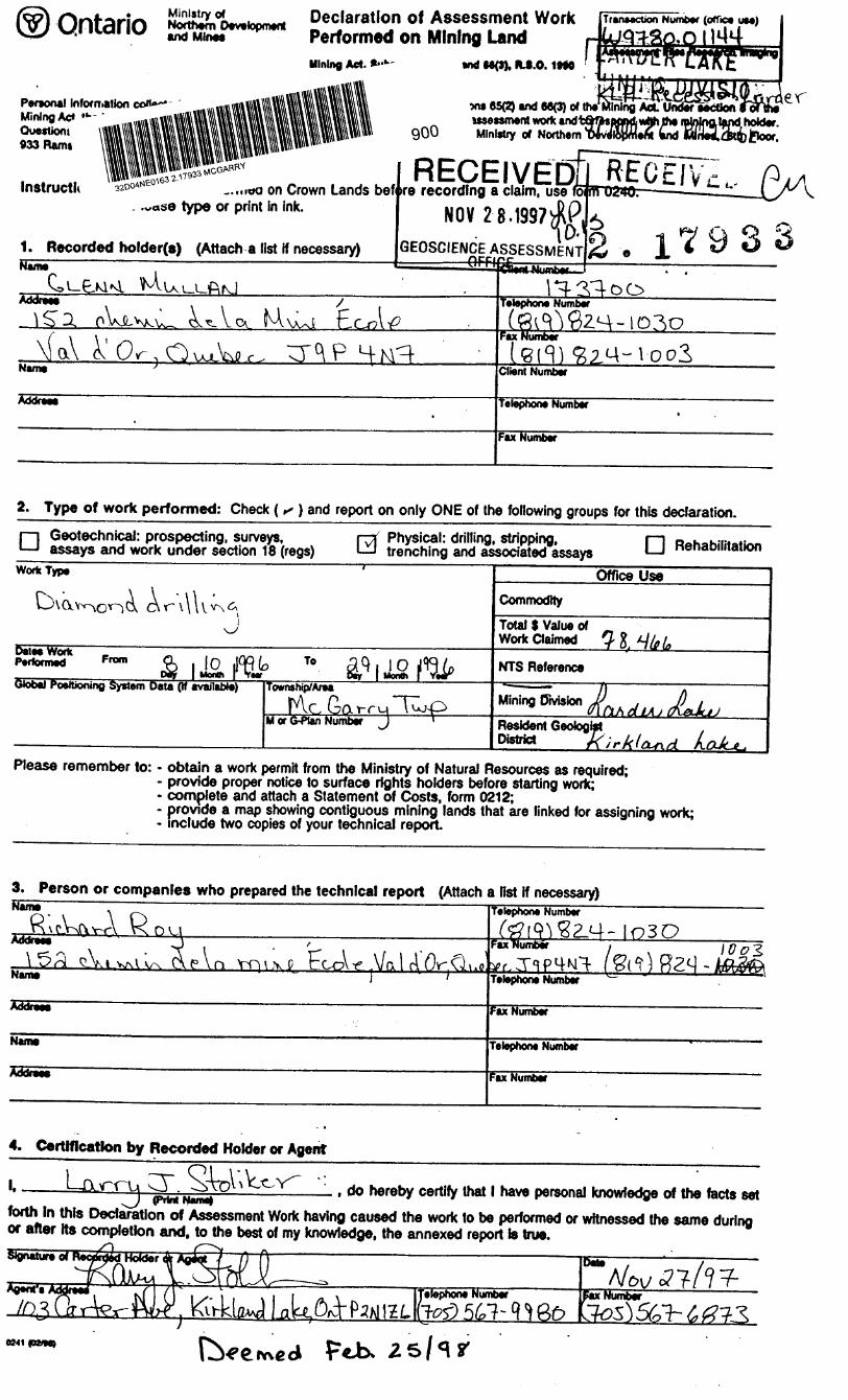
Ontario Ministry Declaration of Assessment WorkMine* Performed on Mining Land
Mining Act. *-1- and M0). ftJ.O. IMO
Personal Information coif*~* Mining Ac* Ouestioni 933 Ram.
Instructli 32004'
900
ww 65(2) and 66(3) o* the usessment work and Ministry of Northern
Transection Numb** (office us*)'
..., lda on Crown Lands bef. .vase type or print in ink.
1. Recorded holder(s) (Attach a list if necessary)
RECEIVED!*re recording a claim, use
NOV li
GEOSCIENCE ASSESSMENT 2. 17933Name
vvL'^^W^ o^t. V exTelephone Number
*X Or OujuWrFax
Name Clteni Number
Addreee Telephone Number
Fax Number
2. Type of work performed: Check ( *" ) and report on only ONE of the following groups for this declaration.
D Geotechnical: prospecting, surveys, assays and work under section 18 (regs)
Physical: drilling, stripping, trenching and associated assays Q Rehabilitation
Work Type
O\dY^o A A -\\ -v~)C\ C\iT\\UvA^
JDales Work ————
Performed Fnm Q , |0 1^(0 To 39 l 1 O jl'H/pGtoba) PosrUoning System Data (if available) Township/Area
Me Ga rru \uj~OM or G^lan Number J '
Office UseCommodity
Total S Value of n Work Claimed 3 ft. *J fa (o
NTS Reference
fciir^Ohrfsion /AA diA j J)AJKJJ
Resident Geologist
Please remember to: - obtain a work permH from the Ministry of Natural Resources as required;- provide proper notice to surface rights holders before starting work;- complete and attach a Statement of Costs, form 0212;- provide a map showing contiguous mining lands that are linked for assigning work;- include two copies of your technical report
3. Person or companies who prepared the technical report (Attach a list if necessary)NameR;Addreee
Name
cWw\ K 04j f
^\ r\ /5 \ C \ \/ 1 I/O r"\ ri tVvl w\V iu\ C\fVni YT^VXP CCOV-tf' VfX l ri UV" vJ.uoJ '
Addr*"*
Name
Addrea*
Telephone Number
(# ^^2-^- !o3O
^TRP^MI- l&^^-t&ifoTelephone Number ~~
fax Number
Telephone Number
Fax Number
4. Certification by Recorded Holder or Agent
———1., do hereby certify that l have personal knowledge of the facts setforth In this Declaration of Assessment Work having caused the work to be performed or witnessed the same during or after Its completion and. to the best of my knowledge, the annexed report is true.SfgnaturaToT 55.-
3M \ZLelephone Number SxHumbeir
25/1*
5. Work to be recorded and distributed. Work can only be assigned to claims thai are contiguous
the minino land where work was performed, at the time work was performed. A map showing the contiguous Onk
must accompany this form. ' ^ . .vo*^*.
Mining Claim Number. Or N work wae done on' other eligible mining land, show In this column the location number indicated on the claim map.
•g•g•g12
3
4
5
6
7
8
9
10
11
12
13
14
15
1.
TB7827
1234567
1234568
L- ll&ft&sqlUruollf^U,!H13UZ.
" [j V}(43
li (tlLL^li 63 U5
^Orru J- or
Number of Claim Unto. For other mining land, 1st hectares.
16 ha
12
2
^ \* -f" ' ;
- l '* i' i" j
i
Column Totals
Value of work performed on tNe claim or other mining land.
126,825
0
f 8, 892
'3jc| jiTT^fTW""
*.-*lTf^-"- -- - . — ~- -
-tbfeo^- — —.
.
®7QL(l(j
Value of workapplied to this claim.
N/A
J24.000
S 4,000Sfa'uorT'""
SlHo o^oo•"Smoc-3 M* n D S3400otM-OO
*- .1
^llfeDD
Value of work assigned to other mining dakna.
S24.000
" '';r-q 0
0
-^ ——— .:. :
a^^TODtr ~~^ — ........,.... .— — — ~ --...
—- ,. .
"!-
.^ —
NJ 1 i t^)kj vJ, (^ f*} f~~\
Bank. Value of work to be distributed at a Mure date.
S2.825
0
14,892
tt-klT^/"
-ttttb^ -- 4,422 S
6"? 1 9 S
t
Sc5D9
H l lo L, C,
^ x ^^ , do hereby certify that the above work credits are eligible under(Print Ful N*nw)
subsection 7 (ifof the Assessment Work Regulation 6/96 for assignment to contiguous claims or for application to
the claim where the work was done.
Signature of
6. Instructions for cutting back credits that are not approved.
Some of the credits claimed in this declaration may be cut back. Please check ( s ) in the boxes below to show how
you wish to prioritize the deletion of credits: -
Oa 1. Credits are to be cut back from the Bank first, followed by option 2 or 3 or 4 as Indicated.
D 2. Credits are to be cut back starting wRh the claims listed last, working backwards; or
G* 3. Credits are to be cut back equally over all claims Hsted in this declaration; or
D 4. Credits are to be cut back as prioritized on the attached appendix or as follows (describe):
Note: If you have not indicated how your credits are to be deleted, credits will be cut back from the Bank first,
followed by option number 2 if necessary.
For Office Use Only
RECEIVEDDeemed Approved Octe
D*te Approved
Dal* Notification Sent
Total V*hM of dvdK ApprovH
ApprovM lor (woordlnQ by Mining Recorder (Slgnatura)
Ontario Ministry ofNorthern Developmentand Mines
Statement of Costs for Assessment Credit
Transaction Nurabar
DIVTSIOPersonal information collected on this form Is obtained under the authority of subsection 6(1) of the Assessmam Work Ragylasection B of the Mining Act, the Information is a public record. This Information will be used to review the aaSBtstwUv&t andfcbfrakpondfcitrithe mining land holder. Questions about this collection should be directed to the Chief Mining Recorder, Ministry of Northern Development andMines, em Moor, 933 namsey Laxe noaa, auaoury, umario, rje oao. ——————— ———— — - LJ
RECEIVE.Work Type
ftwvvnc^i ry;U,^P \ ' VA\ (L,^r\ p \^ rv c^l VN r. t- 1 cArl
Q^\ ^ 0O
Units of WorkDepending on (he type of work, list the number of hours/days worked, metres of drilling, kilo metres of grid line, number of samples, etc.
3/^0, 5t(rV-\ . i \
LYVLTD [^ffAoM-snrr\ r\ ; A Ai^H(r tt^nusMUo
^ o
Associated Costs (e.g. supplies, mobilization and demobilization).
Q m t F VfvrV R^ Y-^Vr* \r~ ~~ \ \ O- ' \
l ^ A \ (j -i- W1 -Li ' f-V^vf\"i~"TL'^ r. 0 LV|"^ V^O prx~'r \ r^^Cn r\ (i YrorySO
Transportation Costs
\jp.WcVr Vc.vVfi l
Food and Lodging Costs
\^nU\ (\^A V^^^
Cost Per Unit of work
i
i
t
l^U f, 0 ^ j.
Total Value of Assessment Work
Total Cost
^L[4 -^qcj^/;
n3 J ksq 3^f H 35. rt
,^/ q/^ll
S ]R5o.c rl^^. c C
^ l.SSn.nT(G no .oT
14 o^^.^-C
^13 4 k 5.^
Calculations of Filing Discounts:
1. Work filed within two years of performance is claimed at 1000xb of the above Total Value of Assessment Work.2. If work is filed after two years and up to five years after performance, it can only be claimed at 500Xo of the Total Value of Assessment Work. If this situation applies to your claims, use the calculation below:
TOTAL VALUE OF ASSESSMENT WORK x 0.50 Total S value of worked claimed.
Note:- Work older than 5 years is not eligible for credit.- A recorded holder may be required to verify expenditures claimed in this statement of costs within 45 days of a request for verification and/or correction/clarification. If verification and/or correction/clarification is not made, the Minister may reject all or part of the assessment work submitted.
Certification verifying costs:
i. L-.OL vr u "CT. , do hereby] certify, that the amounts shown are as accurate as may(pieces print full name)
reasonably be determined and the costs were incurred while conducting assessment work on the lands indicated on
the accompanying Declaration of Work form as
to make this certificatl
0212 (02/96)
'RECEIVEDNOV 2 1 199/
GEOSCIENCE ASSESSMENT ______OFFICE
(recorded holder, agernT or slate company position with signing authority)l am authorized
Ministry ofNorthern Developmentand Mines
Ministere du Developpement du Nord et des Mines Ontario
Februarys, 1998
GLENN J. MULLAN 152 chemin de la Mine Ecole Val d'Or, Quebec J9P 4N7
ORIGINAL SIGNED BYBlair KiteSupervisor, Geoscience Assessment OfficeMining Lands Section
Correspondence ID: 11875
Copy for: Assessment Library
Work Report Assessment Results
Submission Number: 2.17933
Date Correspondence Sent: February 05, 1998 Assessor:Lucille Jerome —^^^—^-—^^—-.^—^-—
Transaction First ClaimNumber Number Township(s) l Area(s) Status Approval Date
W9780.01144 1167659 MCGARRY Deemed Approval January 28, 1998
Section:16 Drilling PDRILL
Assessment work credit has been redistributed, as outlined on the attached Distribution of Assessment Work Credit sheet, to better reflect the location of the
work.
Correspondence to: Recorded Holder(s) and/or Agent(s):
Resident Geologist Larry J. Stoliker
Kirkland Lake, ON KIRKLAND LAKE, ONTARIO, CANADA
Assessment Files Library GLENN J. MULLAN
Sudbury, ON Val d'Or, Quebec
Page: 1Correspondence ID: 11875
Distribution of Assessment Work Credit
The following credit distribution reflects the value of assessment work performed on the mining land(s).
o9900EL .... i..........................................................................^ ~ w * 9900EL
32D04NE0163 2.17933 MCGARRY 250
CO: O :o;
9800ELo.
O :o:
exploratiore inc
KALAHARI RESOURCES INC.
RECESSION LARDER PROSPECT SECTION 2+OOE
10 10 20 30 m
ECHELLE 1 : 500
N.T.S.: 32 D/4
DATE 13/11/97
MAP NO.:
TOWNSHIP: MCGARRY
PROVINCE: ONTARIO
DRAWN BY: C.B.
APPROVED BY: R.R.R.
(f) oO':
z;o
10000EL ! i . ............^............................................................................J.......................................^^
•:- -:-:- ^kv -:-;/; v ::- ^ ̂ :.-;";;" -:- -:-;- v.
CONGLOMERATE
\ SHEARED\ TRACHYTE
SHEARED CONGLOMERATE
9900EL
HEMATIZE TRACHYTE
COo :
9800EL
O:
O ;o;
lUiexplorations inc.
KALAHARI RESOURCES INC.
RECESSION LARDER PROSPECT SECTION 2+75E
10 10 20 30 m
ECHELLE 1 : 500
N.T.S.: 32 D/4
DATE 13/11/97
MAP NO.:
TOWNSHIP: MCGARRY
PROVINCE: ONTARIO
DRAWN BY: C.B.
APPROVED BY: R.R.R.
c/roo;
O: O-
O: Q: CM!
10000EL
10000EL
HEMATIZED TRACHYTE
. ^ Y*i1 7 s? o
9900EL i ......... ............................t..............................................................................^............................................................-...........^^