Spring 1988 Recognition of Breccia Pipes in Northern Arizona by Karen J. Wenrich and Hoyt B. Sutphin U.S. Geological Survey MS 905, Federal Center Denver, CO 8 0 2 2 5 The southwestern corner of the Colorado Plateau in northern Arizona is host to thousands of solution-collapse breccia pipes. A breccia is a coarse-grainedrock composed of large, angular, broken rock fragments that are cemented together in a finer grained matrix. A breccia pipe is a vertical pipelike column of broken rock (Figure 1). Because of the coarse-grained and initially porous nature of these breccia pipes, mineralizing fluids that passed through some pipes deposited a large suite of metallic minerals. Although thousands of pipes may exist, only a small fraction of these, probably less than 8 percent, were mineralized, and an even Wash Cliffs (western margin of the Colorado Plateau) to the Echo Cliffs, and from the Mogollon Rim (southern margin of the Colorado Plateau) to the Utah border (Figure 3). A few have been recognized just north of the border in Utah. Although pipes have not been identified within the area of the Mt. Floyd and San Francisco volcanic fields, they are undoubtedly buried beneath the lavas; however, economic recovery of any minerals is doubtful. Pipes may also extend eastward, buried beneath sedimentary rocks. This is considered unlikely, however, because the Redwall Limestone, which contains the roots of the breccia pipes, pinches out to the east between Holbrook and the Four Corners area (McKee and Gutschick, 1969). Description and Origin Breccia pipes in northwestern Arizona are Figure 1. The Bat Cave pipe forms a prominent 800- foot (250-meter) vertical column alono the cliff face. percentage of these; perhaps less strictly co~iapse in origin and resulted from This pipe is locatedjust south of the ~o'iorado &er on than 10 percent, contain economic the dissolution of the Redwall Limestone, the Hualapai Indian in the Lower Supai Group and upperpart of the Redwall Limestone. concentrations of minerals. An example of which formed caverns, followed by mineralized breccia is shown in ~ i ~ u r d 2. U.S. Geological Survey (USGS)geologists have studied breccia pipes in northwestern Arizona since 1977, with the start of the National Uranium Resource Evaluation (NURE) program. After NURE quadrangle maps were completed in 1978, breccia-pipe research continued in conjunction with the Bureau of Indian Affairs as part of its mineral- resource assessment of the Navajo and Hualapai Indian Reservations. This article summarizes the location, description, origin, and mineralization of breccia pipes in Arizona, explains how they can be recognized at the surface, and outlines their mineral production and potential. Location Despite the depressed 1980's mineral market, exploration activity for breccia pipes has been steady during the past 8 years because some pipes contain high-grade uranium ore. Breccia pipes are located in flat- lying strata in areas where essentiallythe only deformation is folding and broad regional warping. They are abundant from the Grand progressive stoping, or gravitative collapse, of the overlying strata. This collapse produced steep-walled, pipelike bodies (Figure 1) that were filled with angular to rounded fragments ranging from totally comminuted material to house-size blocks, bounded by a steeply dipping ring fracture. No pipes contain fragments from underlying formations; all material has been dropped downward into the pipe. This negates any theories of origin that invoke explosive activity from below. Dissolution of the Redwall Limestone began during the Late Mississippian [approximately330 million years (m.y.)ago], creating an extensive karst terrain characterized by closed depressions or sinkholes, caves, and underground drainage. Evidence for this can be seen throughout the Grand Canyon wherever Redwall caves, exposed in cross section along the canyon walls, are filled by channel deposits of the overlying Mississippian Surprise Canyon Formation. Dissolution of the Redwall and collapse of the overlying strata either continued throughout the late Paleozoic and early Mesozoic or ceased after the Figure 2. This breccia is composed of fragments of angular, bleached Hermit Shale or Coconino Sand- stone cemented by a finely pulverized matrix of quartz sand that includes minerals such as uraninite, pyrite, galena, sphalerite, and numerous other copper and nickel-cobalt-iron sulfides. These minerals are responsible for the dark-gray color of the mat&. Mississippian and was reactivated during the Late Triassic (approximately210 m.y. ago) or earlier. No pipes have been observed in strata younger than Triassic, although such
Transcript
Spring 1988
Recognition of Breccia Pipes in Northern Arizona
by Karen J. Wenrich and Hoyt B. Sutphin
U.S. Geological Survey MS 905, Federal Center
Denver, CO 80225
The southwestern corner of the Colorado Plateau in northern Arizona is host to thousands of solution-collapse breccia pipes. A breccia is a coarse-grained rock composed of large, angular, broken rock fragments that are cemented together in a finer grained matrix. A breccia pipe is a vertical pipelike column of broken rock (Figure 1). Because of the coarse-grained and initially porous nature of these breccia pipes, mineralizing fluids that passed through some pipes deposited a large suite of metallic minerals. Although thousands of pipes may exist, only a small fraction of these, probably less than 8 percent, were mineralized, and an even
Wash Cliffs (western margin of the Colorado Plateau) to the Echo Cliffs, and from the Mogollon Rim (southern margin of the Colorado Plateau) to the Utah border (Figure 3). A few have been recognized just north of the border in Utah. Although pipes have not been identified within the area of the Mt. Floyd and San Francisco volcanic fields, they are undoubtedly buried beneath the lavas; however, economic recovery of any minerals is doubtful. Pipes may also extend eastward, buried beneath sedimentary rocks. This is considered unlikely, however, because the Redwall Limestone, which contains the roots of the breccia pipes, pinches out to the east between Holbrook and the Four Corners area (McKee and Gutschick, 1969).
Description and Origin Breccia pipes in northwestern Arizona are
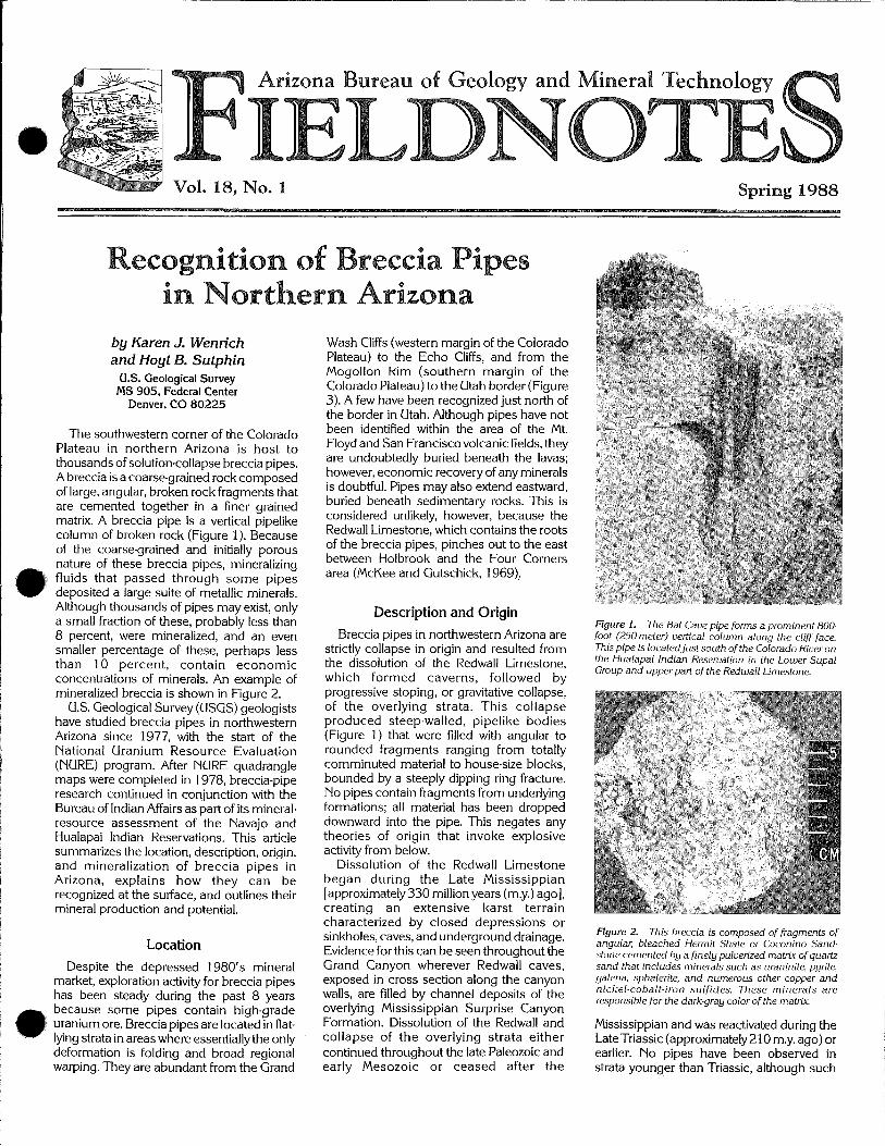
Figure 1. The Bat Cave pipe forms a prominent 800- foot (250-meter) vertical column alono the cliff face.
percentage of these; perhaps less strictly co~iapse in origin and resulted from This pipe is locatedjust south of the ~o'iorado &er on than 10 percent, contain economic the dissolution of the Redwall Limestone, the Hualapai Indian in the Lower Supai
Group and upperpart of the Redwall Limestone. concentrations of minerals. An example of which formed caverns, followed by mineralized breccia is shown in ~ i ~ u r d 2.
U.S. Geological Survey (USGS) geologists have studied breccia pipes in northwestern Arizona since 1977, with the start of the National Uranium Resource Evaluation (NURE) program. After NURE quadrangle maps were completed in 1978, breccia-pipe research continued in conjunction with the Bureau of Indian Affairs as part of its mineral- resource assessment of the Navajo and Hualapai Indian Reservations. This article summarizes the location, description, origin, and mineralization of breccia pipes in Arizona, explains how they can be recognized at the surface, and outlines their mineral production and potential.
Location Despite the depressed 1980's mineral
market, exploration activity for breccia pipes has been steady during the past 8 years because some pipes contain high-grade uranium ore. Breccia pipes are located in flat- lying strata in areas where essentially the only deformation is folding and broad regional warping. They are abundant from the Grand
progressive stoping, or gravitative collapse, of the overlying strata. This collapse produced steep-walled, pipelike bodies (Figure 1) that were filled with angular to rounded fragments ranging from totally comminuted material to house-size blocks, bounded by a steeply dipping ring fracture. No pipes contain fragments from underlying formations; all material has been dropped downward into the pipe. This negates any theories of origin that invoke explosive activity from below.
Dissolution of the Redwall Limestone began during the Late Mississippian [approximately 330 million years (m.y.) ago], creating an extensive karst terrain characterized by closed depressions or sinkholes, caves, and underground drainage. Evidence for this can be seen throughout the Grand Canyon wherever Redwall caves, exposed in cross section along the canyon walls, are filled by channel deposits of the overlying Mississippian Surprise Canyon Formation. Dissolution of the Redwall and collapse of the overlying strata either continued throughout the late Paleozoic and early Mesozoic or ceased after the
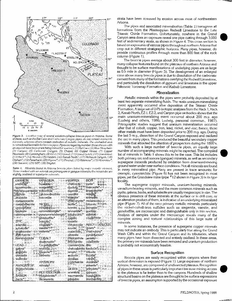
Figure 2. This breccia is composed of fragments of angular, bleached Hermit Shale or Coconino Sand- stone cemented by a finely pulverized matrix of quartz sand that includes minerals such as uraninite, pyrite, galena, sphalerite, and numerous other copper and nickel-cobalt- iron sulfides. These minerals are responsible for the dark-gray color of the mat&.
Mississippian and was reactivated during the Late Triassic (approximately 210 m.y. ago) or earlier. No pipes have been observed in strata younger than Triassic, although such
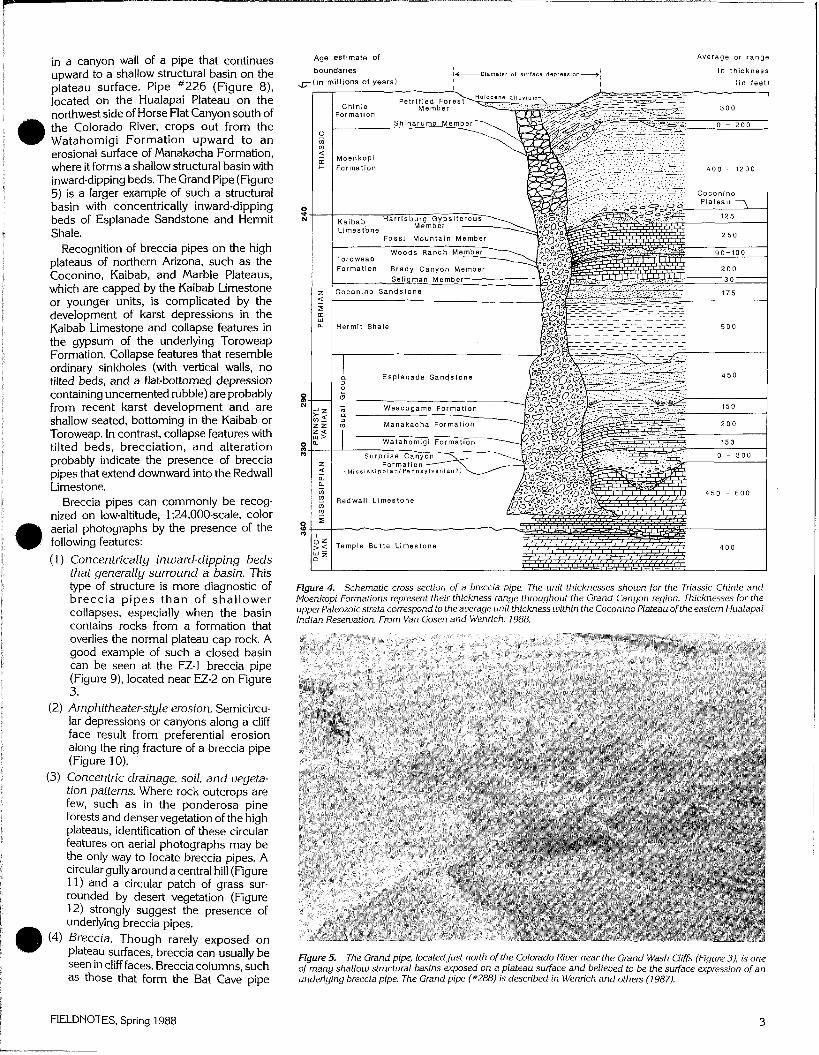
Figure 3. Location map of several solution-collapse breccia pipes in Arizona. Some ofthese, such as the Bat Cave and Carbonate Canyon pipes, do not contain economic minerals, whereas others contain orebodies of metallic minerals. The unshaded area is consideredfauorableforbrecciapipes. Pipes are keyed by number; thoseshown with an asterisk have been orare being mined for uranium. (1) Bat Cave; (2) Blue Mountain; (3) Canyon; (4) Carbonate Canyon; (5) Chapel; (6) Copper House; (7) Copper Mountain; (8) Cunningham; (9) EZ-2; (10) Grand; (1 1) Grand Gulch; (12) Grandoiew; (13) Hack*; (14) Hermit; (15) Hidden; (16) Kanab Noith*; (1 7) Mohawk Canyon; (18) Orphan*; (19) Parashant; (20) Pigeon*; (21) Pinenut; (22) Ridenour*; (23) Riueruiew*; (24) Sauanic; (25) SBF; (26) Snyder.
Table 1. Minerals found in Arizona breccia pipes listed by major metallic element Those marked with an asterisk are primary-ore organgue minerals; the remainder are slightly oxidized or supergene minerals.
strata have been removed by erosion across most of northwestern Arizona.
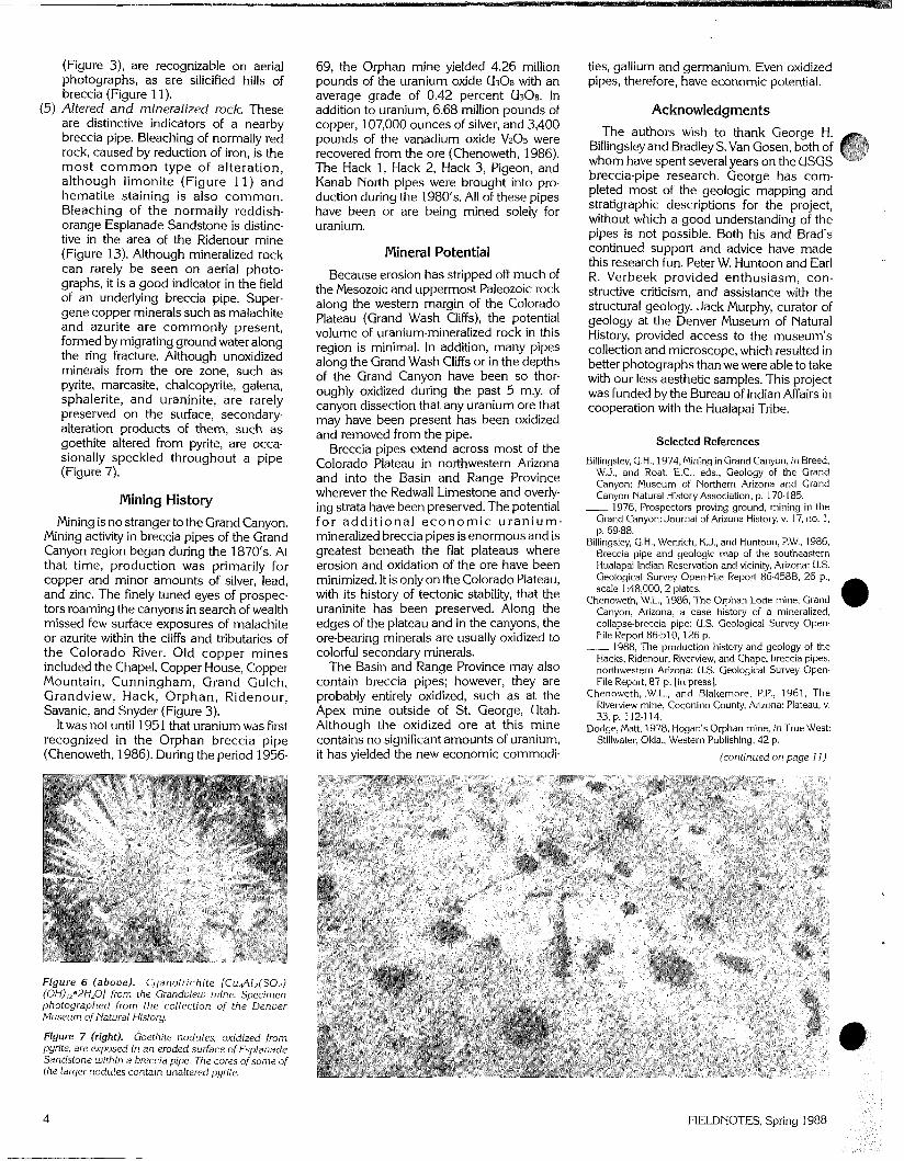
The pipes and associated mineralization (Table 1) transgress all formations from the Mississippian Redwall Limestone to the Late Triassic Chinle Formation. Unfortunately, nowhere in the Grand Canyon area does an exposure reveal one pipe cutting through 3,000 feet of sedimentary strata, as shown in Figure 4. This cross section is based on exposures of various pipes throughout northern Arizona that crop out in different stratigraphic horizons. Many pipes, however, do provide continuous profiles through more than 800 feet of the rock column (Figure 1 ).
The breccia pipes average about 300 feet in diameter; however, many collapse features found on the plateaus of northern Arizona and thought to be surface manifestations of underlying pipes are as large as 0.5 mile in diameter (Figure 5). The development of an enlarged cone above many breccia pipes is due to dissolution of the carbonate cement from many of the formations overlying the Redwall Limestone, and particularly the dissolution of gypsum and limestone in the upper Paleozoic Toroweap Formation and Kaibab Limestone.
Mineralization Metallic minerals within the pipes were probably deposited by at
least two separate mineralizing fluids. The main uranium-mineralizing event apparently occurred after deposition of the Triassic Chinle Formation. A large set of U-Pb isotopic analyses from the Hack 1, Hack 2, Kanab North, EZ-1, EZ-2, and Canyon pipe orebodies shows that the main uranium-mineralizing event occurred about 200 m.y. ago (Ludwig and others, 1986; Ludwig, personal commun., 1987). Petrographic studies suggest that uranium mineralization occurred after that of cobalt, copper, iron, lead, nickel, and zinc; hence, these other metals must have been deposited prior to 200 m.y. ago. During the last 5 my., dissection of the Grand Canyon exposed and oxidized the ore in many pipes. This produced the beautiful secondary copper minerals that attracted the attention of prospectors during the 1800's.
With such a large number of breccia pipes, an equally large number of accompanying minerals might be expected. The compiled list of minerals in Table 1 shows this to be the case. This list includes both primary ore and nonore (gangue) minerals, as well as secondary supergene minerals produced by oxidation from downward-moving ground water under near-surface conditions. Not all minerals are found in every mineralized pipe. Many are present in trace amounts; for example, cyanotrichite (Figure 6) has not been recognized in most pipes, yet the Grandview mine (pipe #12 shown in Figure 3) is its type locality.
The supergene copper minerals, uranium-bearing minerals, vanadium-bearing minerals, and the more common minerals such as pyrite, galena, barite, and sphalerite are usually megascopic in size. The obvious presence of these minerals at the surface or in drill core, or an alteration product of them, is indicative of an underlying mineralized pipe (Figure 7). All of the rarer primary metallic minerals, particularly the nickel-cobalt-iron sulfides such as siegenite, vaesite, and gersdorffite, are microscopic and distinguishable only in thin section. Analysis of samples under the microscope reveals many of the complex zoning and textural relationships of this large suite of minerals.
In some instances, the presence of supergene copper minerals may not indicate an orebody. This is particulariy true along the Grand Wash Cliffs and within the Grand Canyon and its tributaries, where many pipes have been dissected and entirely oxidized. In these areas, the primary ore minerals have been removed and uranium production is probably not economically feasible.
Surface Recognition Breccia pipes are easily recognized within canyons where their
vertical dimension is exposed (Figure 1). Large expanses of northern Arizona, however, are composed of undissected plateaus. Recognition of pipes in these areas is particularly important because mining access to the plateaus is far better than to the canyons. Hundreds of shallow structural basins on the plateaus are thought to be surface expressions of breccia pipes, an assumption supported by the occasional exposure
2 FIELDNOTES, Spring 1988
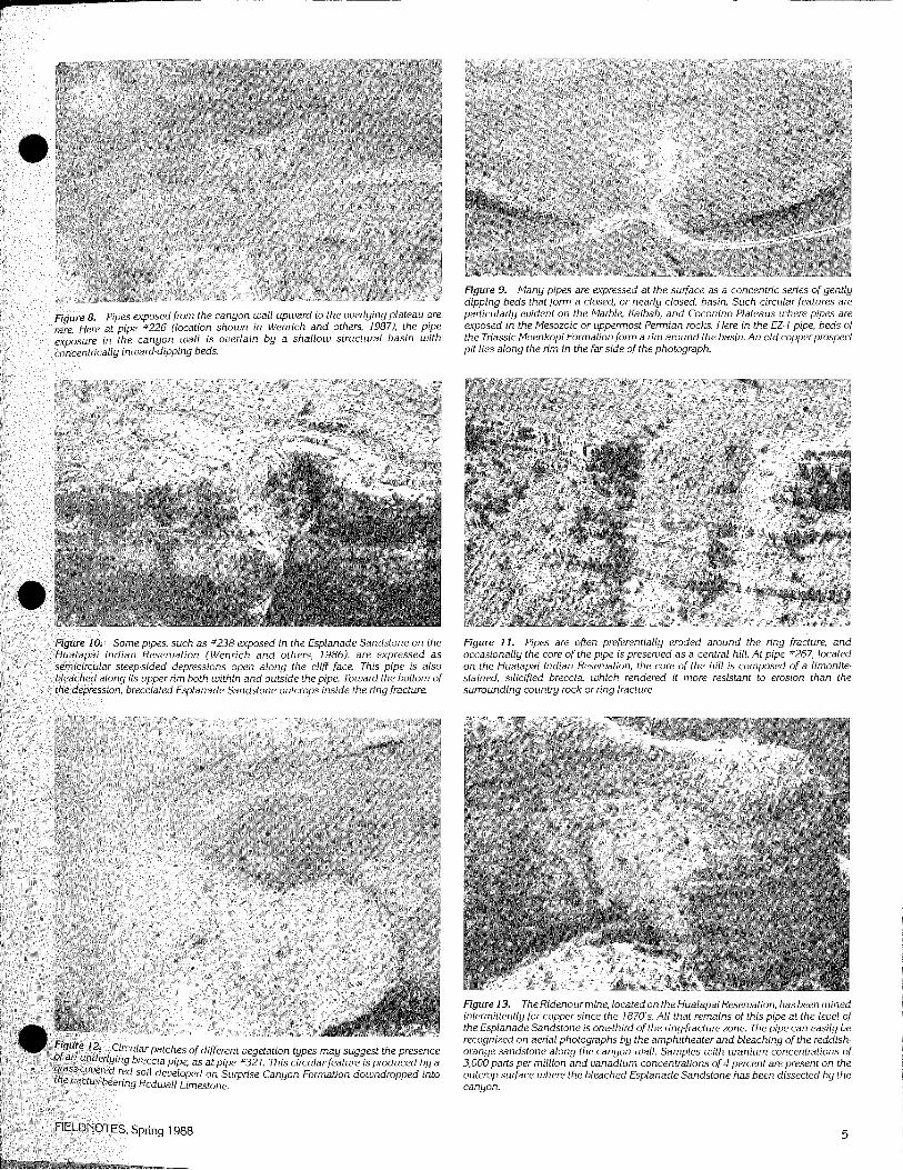
in a canyon wall of a pipe that continues upward to a shallow structural basin on the plateau surface. Pipe #226 (Figure 8), located on the Hualapai Plateau on the northwest side of Horse Flat Canyon south of a the Colorado River, crops out from the Watahomigi Formation upward to an erosional surface of Manakacha Formation, where it forms a shallow structural basin with inward-dipping beds. The Grand Pipe (Figure 5) is a larger example of such a structural basin with concentrically inward-dipping beds of Esplanade Sandstone and Hermit Shale.
Recognition of breccia pipes on the high plateaus of northern Arizona, such as the Coconino, Kaibab, and Marble Plateaus, which are capped by the Kaibab Limestone or younger units, is complicated by the development of karst depressions in the Kaibab Limestone and collapse features in the gypsum of the underlying Toroweap Formation. Collapse features that resemble ordinary sinkholes (with vertical walls, no tilted beds, and a flat-bottomed depression containing uncemented rubble) are probably from recent karst development and are shallow seated, bottoming in the Kaibab or Toroweap. In contrast, collapse features with tilted beds, brecciation, and alteration probably indicate the presence of breccia pipes that extend downward into the Redwall Limestone.
Breccia pipes can commonly be recog- nized on low-altitude, 1:24,000-scale, color aerial photographs by the presence of the following features:
(1) Concentrically inward-dipping beds that generally surround a basin. This type of structure is more diagnostic of breccia pipes than of shallower collapses, especially when the basin contains rocks from a formation that overlies the normal plateau cap rock. A good example of such a closed basin can be seen at the EZ-1 breccia pipe (Figure 9), located near EZ-2 on Figure 3.
(2) Arnphitheater-style erosion. Semicircu- lar depressions or canyons along a cliff face result from preferential erosion along the ring fracture of a breccia pipe (Figure 10).
(3) Concentric drainage, soil, and uegeta- tion patterns. Where rock outcrops are few, such as in the ponderosa pine forests and denser vegetation of the high plateaus, identification of these circular features on aerial photographs may be the only way to locate breccia pipes. A circular gully around a central hill (Figure 11) and a circular patch of grass sur- rounded by desert vegetation (Figure 12) strongly suggest the presence of underlying breccia pipes.
@ (4) Breccia. Though rarely exposed on plateau surfaces, breccia can usually be seen in cliff faces. Breccia columns, such as those that form the Bat Cave pipe
Age estimate of
boundaries I t - -D#arneter of surface depresrlon-l
in millions of years) I I
Average or range
i n thickness
( i n f e e t )
Figure 4. Schematic cross section of a breccia pipe. The unit thicknesses shown for the Triassic Chinle and Moenkopi Formations represent their thickness range throughout the Grand Canyon region. Thicknesses for the upperPaleozoic strata correspond to the average unit thickness within the Coconino Plateau of the eastern Hualapai Indian Reservation. From Van Gosen and Wenrich, 1988.
Figure 5. The Grand pipe, locatedjust north of the Colorado Riuer near the Grand Wash Cliffs (Figure 3), is one of many shallow structural basins exposed on a plateau suflace and belieued to be the surface expression of an underlying breccia pipe. The Grand pipe (#288) is described in Wenrich and others (1987).
I FIELDNOTES, Spring 1988
(Figure 3), are recognizable on aerial 69, the Orphan mine yielded 4.26 million ties, gallium and germanium. Even oxidized photographs, as are silicified hills of pounds of the uranium oxide Us08 with an pipes, therefore, have economic potential. breccia (Figure 1 1 ). average grade of 0.42 percent UsOs. In
(5) Altered and mineralized rock. These addition to uranium, 6.68 million pounds of Acknowledarnents are distinctive indicators of a nearby breccia pipe. Bleaching of normally red rock, caused by reduction of iron, is the most common type of alteration, although limonite (Figure 11) and hematite staining is also common. Bleaching of the normally reddish- orange Esplanade Sandstone is distinc- tive in the area of the Ridenour mine (Figure 13). Although mineralized rock can rarely be seen on aerial photo- graphs, it is a good indicator in the field of an underlying breccia pipe. Super- gene copper minerals such as malachite and azurite are commonly present, formed by migrating ground water along the ring fracture. Although unoxidized minerals from the ore zone, such as pyrite, marcasite, chalcopyrite, galena, sphalerite, and uraninite, are rarely preserved on the surface, secondary- alteration products of them, such as goethite altered from write, are occa- sionally speckled throGghout a pipe (Figure 7).
Mining History Mining is no stranger to the Grand Canyon.
Mining activity in breccia pipes of the Grand Canyon region began during the 1870's. At that time, production was primarily for copper and minor amounts of silver, lead, and zinc. The finely tuned eyes of prospec- tors roaming the canyons in search of wealth missed few surface exposures of malachite or azurite within the cliffs and tributaries of the Colorado River. Old copper mines included the Chapel, Copper House, Copper Mountain, Cunningham, Grand Gulch, Grandview, Hack, Orphan, Ridenour, Savanic, and Snyder (Figure 3).
It was not until 1951 that uranium was first recognized in the Orphan breccia pipe (Chenoweth, 1986). During the period 1956-
Figure 6 (above) . Cyanotrichite [CuJ12(S04) (OH),292H20] from the Grandview mine. Specimen photographed from the collection of the Denver Museum of Natural History.
Figure 7 (right). Goethite nodules, oxidized from pyrite, are exposed in a n eroded surface of Esplanade Sandstone within a breccia pipe. The cores of some of the larger nodules contain unaltered pyrite.
copper, 107,000 ounces of silver, and 3,400 pounds of the vanadium oxide V205 were recovered from the ore (Chenoweth, 1986). The Hack 1, Hack 2, Hack 3, Pigeon, and Kanab North pipes were brought into pro- duction during the 1980's. All of these pipes have been or are being mined solely for uranium.
Mineral Potential Because erosion has stripped off much of
the Mesozoic and uppermost Paleozoic rock along the western margin of the Colorado Plateau (Grand Wash Cliffs), the potential volume of uranium-mineralized rock in this region is minimal. In addition, many pipes along the Grand Wash Cliffs or in the depths of the Grand Canyon have been so thor- oughly oxidized during the past 5 m.y. of canyon dissection that any uranium ore that may have been present has been oxidized and removed from the pipe.
Breccia pipes extend across most of the Colorado Plateau in northwestern Arizona and into the Basin and Range Province wherever the Redwall Limestone and overly- ing strata have been preserved. The potential for add i t iona l e c o n o m i c u r a n i u m - mineralized breccia pipes is enormous and is greatest beneath the flat plateaus where erosion and oxidation of the ore have been minimized. It is only on the Colorado Plateau, with its history of tectonic stability, that the uraninite has been preserved. Along the edges of the plateau and in the canyons, the ore-bearing minerals are usually oxidized to colorful secondary minerals.
The Basin and Range Province may also contain breccia pipes; however, they are probably entirely oxidized, such as at the Apex mine outside of St. George, Utah. Although the oxidized ore at this mine contains no significant amounts of uranium, it has yielded the new economic commodi-
The authors wish to thank George H. Billingsley and Bradley S. Van Gosen, both of whom have spent several years on the USGS breccia-pipe research. George has com- pleted most of the geologic mapping and stratigraphic descriptions for the project, without which a good understanding of the pipes is not possible. Both his and Brad's continued support and advice have made this research fun. Peter W. Huntoon and Earl R. Verbeek provided enthusiasm, con- structive criticism, and assistance with the structural geology. Jack Murphy, curator of geology at the Denver Museum of Natural History, provided access to the museum's collection and microscope, which resulted in better photographs than we were able to take with our less aesthetic samples. This project was funded by the Bureau of Indian Affairs in cooperation with the Hualapai Tribe.
Selected References
Billingsley, G.H., 1974, Mining in Grand Canyon, in Breed. W.J., and Roat, E.C., eds., Geology of the Grand Canyon: Museum of Northern Arizona and Grand Canyon Natural History Association, p. 170-185. - 1976, Prospectors proving ground, mining in the
Grand Canyon: Journal of Arizona History, v. 17, no. 1, p. 69-88.
Billingsley, G.H., Wenrich, K J . , and Huntoon, P.W., 1986, Breccia pipe and geologic map of the southeastern Hualapai lndian Reservation and vicinity, Arizona: U.S. Geological Survey Open-File Report 86.4588, 26 p., scale 1 :48,000, 2 plates.
Chenoweth, W.L., 1986, The Orphan Lode mine, Grand Canyon, Arizona, a case history of a mineralized, collapse-breccia pipe: U.S. Geological Survey Open. File Report 86-51 0, 126 p.
1988, The production history and geology of the Hacks, Ridenour. Riverview, and Chapel breccia pipes, northwestern Arizona: U.S. Geological Survey Open- File Report, 87 p. [in press].
Chenoweth, .W.L., and Blakemore, P.P., 1961, The Riverview mine, Coconino County, Arizona: Plateau, v. 33, p. 112.1 14.
Dodge, Matt, 1978, Hogan's Orphan mine, in True West: Stillv~ater, Okla., Western Publishing, 42 p.
(continued on page 11)
8. Pipes exposed from the canyon wall upward to the overlying plateau are re at pipe #226 (location shown in Wenrich and others, 19871, the pipe e in the canyon wall is overlain by a shallow structural basin wi th
trically inward-dipping beds.
Figure 9. Many pipes are expressed at the surface as a concentric series of gently dipping beds that form a closed, or nearly closed, basin. Such circular features are particularly evident on the Marble, Kaibab, and Coconino Plateaus where pipes are exposed in the Mesozoic or uppermost Permian rocks. Here in the EZ- 1 pipe, beds of the Triassic Moenkopi Formation form a rim around the basin. An old copperprospect pit lies along the rim in the far side of the photograph.
pipes, such as #238 exposed in the Esplanade Sandstone on the Reservation (Wenrich and others, 1986), are expressed as -sided depressions open along the cliff face. This pipe is also upper rim both within and outside the pipe. Toward the bottom of cciated Esplanade Sandstone outcrops inside the ring fracture.
Figure 11. Pipes are often preferentially eroded around the ring fracture, and occasionally the core of the pipe is preserued as a central hill. At pipe s267, located on the Hualapai Indian Reseruation, the core of the hill is composed of a limonite- stained, silicified breccia, which rendered it more resistant to erosion than the surrounding county rock or ring fracture.
Figure 13. The Ridenourmine, located on the Hualapai Reseruation, has been mined intermittently for copper since the 1870's. All that remains of this pipe at the level of the Esplanade Sandstone is one-third of the ring-fracture zone. The pipe can easily be recognized on aerial photographs by the amphitheater and bleaching of the reddish- orange sandstone along the canyon wall. Samples with uranium concentrations of 3,000 parts per million and vanadium concentrations of 4 percent are present on the outcrop surface where the bleached Esplanade Sandstone has been dissected by the canyon.
FIELDNOTES, Spring 1988
Arizona Agencies: Activity Summaries
The following summaries were written by staff members of the respective State agencies. For further information on pro- grams or activities, contact the agencies directly at the following addresses: Arizona Radiation Regulatory Agency, 4814
S. 40th St., Phoenix, AZ 85040; tel: (602) 255-4845.
Arizona Earthquake Information Center, Northern Arizona University, Box 5620, Flagstaff, AZ 8601 1 ; tel: (602) 523-71 91.
Arizona Dept. of Mines a n d Mineral Resources, Mineral Blda.. State Fair- grounds, Phoenix, AZ 85507; tel: (602) 255-3791. - -
Arizona Dept. of Mines and Mineral Resour- ces, 41 6 W. Congress, Tucson, AZ 85701 ; tel: (602) 628-5399.
Arizona State Land Dept., 1616 W. Adams, Phoenix, AZ 85007; tel: (602) 255-4628.
U.S. Bureau of Land Management, Arizona State Office, P.O. Box 16563, Phoenix, AZ 8501 1; tel: (602) 241-5507.
Arizona Geological Survey, 845 N. Park Ave., Tucson, AZ 85719; tel: (602) 621-7906.
ARIZONA RADIATION REGULATORY AGENCY
Radon-in-Homes Survey
by John O'lYeill
The Arizona Radiation Regulatory Agency (ARRA), in conjunction with the U.S. Environ- mental Protection Agency (EPA), initiated a radon-in-homes survey during the week of October 28, 1987. Before the jointly spon- sored study began, the Arizona Legislature allocated $58,000 to study radon in the State. Of that funding, $8,000 was earmarked for the Arizona Geological Survey to study and define areas within the State that might have elevated radon levels.
The Arizona radon studv is under the
under closed-house conditions. The canister is then sealed and sent to the EPA testing laboratory in Montgomery, Alabama. The laboratory provides analysis results to the ARRA staff, who notify each homeowner. Early in 1988,200 homeowners who placed charcoal canisters in their homes will also be asked to expose alpha-track detectors for 12 months. Readings from the alpha-track detectors will be correlated with canister data from the same homes to determine varian- ces. By June 1988, all test canisters will have been placed.
When the testing is completed, the EPA will prepare an analysis of data that will include identification of radon "hot spots." The EPA will also provide descriptions of radon levels and regional distributions throughout the State. Based on this informa- tion, other homeowners may opt for testing. The charcoal-canister test should cost between $1 5 and $30.
The ARRA staff have increased public awareness of the health effects of radon through the media, printed materials, such as EPA radon booklets and the ARRA Radiation Review, and public-speaking presentations. During 1987 the ARRA received more than 2,000 radon~elated telephone calls from the public and media. Public acceptance of free radon testing fluctuated from a high of 51 percent to an average of 30 percent of those contacted each week. (Average telephone contacts during 1 week numbered 150.) Willingness to participate seemed related to the intensity of media coverage. At the conclusion of the ARRAIEPA study, the ARRA will continue to make charcoal canisters available through county public-health programs and will analyze exposed canisters. Efforts to educate the public about radon and radon-reduction techniques will also continue.
ARIZONA EARTHQUAKE INFOWIvlATlON CENTER
1987 Progress Report
by David S. Brurnbaugh
The Arizona Earthquake Information Center (AEIC) completed its second full year of operations in 1987. The AEIC collects data, conducts research, and distributes information on earthquakes in Arizona and adjacent areas of the Southwest.
Data are collected primarily through operation of the northern Arizona seismic network. By mid-1987, this network included five stations in northern and central Arizona: Flagstaff (FLAG), Grand Canyon (GCN), Jerome (JRA), Williams (WMZ), and Sunset Crater (SCN).
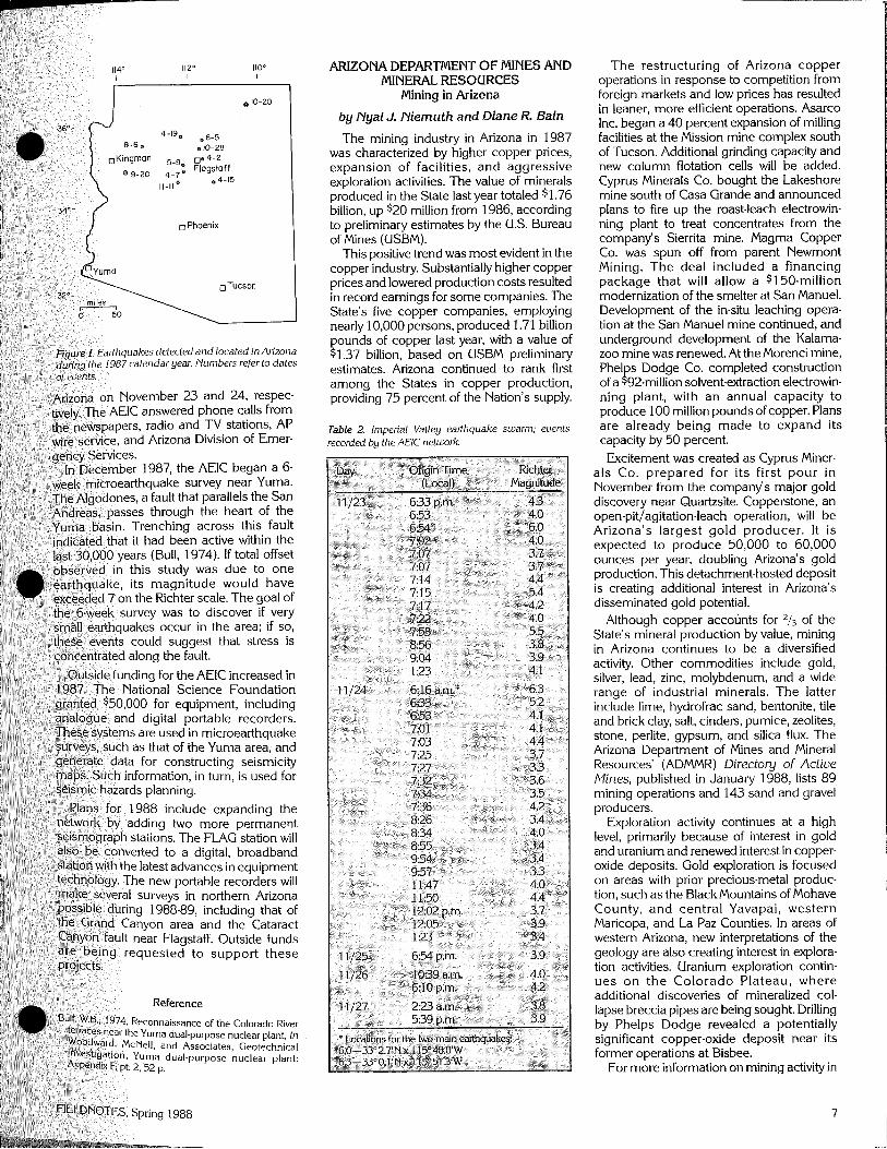
Activity in 1987 increased over that in 1986; 16 earthquakes were detected in Arizona during 1987 (Table 1). The largest of these, which occurred on September 20, had a local magnitude of 3.3. This was the first earthquake detected near Kingman in 51 years. It was also the first earthquake in Arizona of magnitude 3.0 or larger since April 15, 1985, ending a period of relative quiet that lasted 29 months. It was followed on October 20 by a magnitude 3.0 event in northeastern Arizona. Activity during the year was recorded throughout northern and central Arizona, including an event on November 1 1 in Chino Valley in the normally quiet Transition Zone (Figure 1).
Activity outside Arizona that the AEIC recorded in 1987 included the California earthquake sequence in the Imperial Valley in November. The AEIC recorded 39 events from this swarm from November 23 to November 27 (Table 2). The two main shocks, which registered 6.0 and 6.3 on the Richter scale, shook Colorado River towns in
- - -..-
direction of the ARRA's invir~nmental Mle I. Arizona earthquakes defected during ,987. Laboratory Manager. Other staff members conduct radon measurements, compile information, and answer public inquiries.
The EPA provided 3,000 charcoal canis- ters for throughout the State: 2,250 are being placed in homes and 750 are being put in geographic areas where ele- vated levels of radon have been detected. The EPA supplied the ARRA with a system- atic random sample of tele~hone numbers and associated names and'addresses. The sample, which is being used for random selection of survey participants, is directed toward population areas. It is based on a statistical design that will allow results to be extrapolated to the total population of Arizona.
During telephone interviews, each partici- pant is asked to complete a questionnaire regarding the homeowner and residence. A charcoal canister is sent to each participant to expose to the ambient air for 48 hours
6 FIELDNOTES, Spring 1988
ARIZONA DEPARTMEPIT OF MINES AND MINERAL RESOURCES
Mining in Arizona
by Nyal J. Niernuth and Diane R. Bain
The mining industry in Arizona in 1987 was characterized by higher copper prices, expansion of facilities, and aggressive exploration activities. The value of minerals produced in the State last year totaled $1.76 billion, up $20 million from 1986, according to preliminary estimates by the U.S. Bureau of Mines (USBM).
This positive trend was most evident in the copper industry. Substantially higher copper prices and lowered production costs resulted in record earnings for some companies. The State's five copper companies, employing nearly 10,000 persons, produced 1.71 billion pounds of copper last year, with a value of $1.37 billion, based on USBM preliminary estimates. Arizona continued to rank first among the States in copper production, providing 75 percent of the Nation's supply.
Table 2. Imperial Valley earthquake swarm; events recorded by the AElC netluork
The restructuring of Arizona copper operations in response to competition from foreign markets and low prices has resulted in leaner, more efficient operations. Asarco Inc. began a 40 percent expansion of milling facilities at the Mission mine complex south of Tucson. Additional grinding capacity and new column flotation cells will be added. Cyprus Minerals Co. bought the Lakeshore mine south of Casa Grande and announced plans to fire up the roast-leach electrowin- ning plant to treat concentrates from the company's Sierrita mine. Magma Copper Co. was spun off from parent Newmont Mining. The deal included a financing package that will allow a $150-million modernization of the smelter at San Manuel. Development of the in-situ leaching opera- tion at the San Manuel mine continued, and underground development of the Kalama- zoo mine was renewed. At the Morenci mine, Phel s Dodge Co. completed construction of a r9Z-million solventextraction electrowin- ning plant, with an annual capacity to produce 100 million pounds of copper. Plans are already being made to expand its capacity by 50 percent. Excitement was created as Cyprus Miner-
als Co. prepared for its first pour in ~ovembek from the company's major gold discoverv near Quartzsite. C o ~ ~ e r s t o n e , an a .
open-pit]agitation-leach operation, will' be - -
~ r i z o n a ' s largest gold producer. It is expected to produce 50,000 to 60,000 ounces per year, doubling Arizona's gold ~roduction. This detachment-hosted deposit is creating additional interest in Arizona's disseminated gold potential.
Although copper accounts for of the State's mineral production by value, mining in Arizona continues to be a diversified activity. Other commodities include gold, silver, lead, zinc, molybdenum, and a wide range of industrial minerals. The latter include lime, hydrofrac sand, bentonite, tile and brick clav, salt, cinders, pumice, zeolites, .. . stone, perlite, gypsum, and silica flux. The Arizona Department of Mines and Mineral Resources' (ADMMR) Directory of Active Mines, published in January 1988, lists 89, mining operations and 143 sand and gravel producers.
Exploration activity continues at a high level, primarily because of interest in gold and uranium and renewed interest in copper- oxide deposits. Gold exploration is focused on areas with prior precious-metal produc- tion. such as the BlackMountains of Mohave county, and central Yavapai, western Maricopa, and La Paz Counties. In areas of western Arizona, new interpretations of the geology are also creating interest in explora- tion activities. Uranium ex~loration contin- ues on t h e Colorado plateau, where additional discoveries of mineralized col- lapse breccia pipes are being sought. Drilling by Phelps Dodge revealed a potentially significant copper-oxide deposit near its former o~erations at Bisbee.
For more information on mining activity in
7
Arizona, contact the ADMMR office in Tucson or Phoenix. Recent publications include The Primary Copper Industry of Arizona in 1986, Directo ry of Active Mines (map available), Arizona Industrial Miner- als, and Mineral Development.
ARIZONA STATE LAND DEPARTMENT Nonrenewable-Resource Activities
by Robert A. Larkin
During the 1986-87 fiscal year, the leasing of State trust lands for nonrenewable- resource activities produced $4.2 million in royalties and rentals. Copper continued to be the largest royalty producer of all minerals, contributing 97 percent of the mineral income of $1.43 million.
The mineral-material leasing program continued to benefit from the economy as well as the department's pricing structure, contributing royalties of $2.2 million. This total is 41 percent higher than last year's figure.
Prospecting continued with approximately 475 permits in effect, covering more than 168,000 acres. The oil-and-gas leasing
rogram produced rental income of 0263,570. with leases covering 613,788 acres.
The Arizona State Land Department recently moved its offices to 161 6 W. Adams, Phoenix, AZ 85007. The Nonrenewable Resources and Minerals Section of the department oversees mineral-material sales. It also issues prospecting permits; mineral, oil and gas, and geothermal leases; and permits for geophysical exploration. Ancil- lary programs include research on proposed land sales and exchanges, environmental impact studies, review of mining and reclamation plans, and contracting for archaeological surveys and excavations.
U.S. BUREAU OF LAND MANAGEMENT ARIZONA STATE OFFICE Mineral Program Highlights
by John J. Haas, Alan S. Rabinof, and William H. Ward
The U.S. Bureau of Land Management (BLM) directs the mining law program, making Federal land available for prospect- ing, exploration, and the location of mining claims for gold, silver, copper, uranium, and other hard-rock minerals. BLM issues pat- ents to the owners of mining claims when valuable mineral deposits have been discov- ered. Until patenting, BUvl manages mining operations to prevent unnecessary degrada- tion of surface resources. Arizona had 147,575 mining claims on file in January 1988.
About 275 notices of intent to operate and 50 mining plans are received annually under BLM surface-management regulations. The number of operations in Arizona has steadily risen during the past 5 years. The most active exploration is for uranium in areas north of the Grand Canyon. Seven mines have been
proposed since 1980: three are being developed, one is in production, and three have been mined out and reclaimed. Ari- zona's first open-pit gold mine was approved in 1987. Production from the Copperstone mine, which is on public land, is expected to double the State's annua! gold production.
BLM is also responsible for leasing Federal lands for development of oil and gas resources and issues all Federal drilling permits. About 500 Federal oil and gas leases, encompassing 1.1 million acres in Arizona, are currently in effect. During the energy crisis of the early 19801s, however, 11 million acres were leased. The State of Arizona receives 50 percent of the receipts derived from these leases; its share of the revenues totaled approximately $25 million from 1920 to 1988. Drilling activity has recently focused on the Arizona Strip and Yuma areas. Although a few exploratory holes are drilled in the State each year, to date, there has been no oil or gas production from Federal lands in Arizona. The only oil and gas production in the State comes from about two dozen wells on the Navajo lndian Reservation in the extreme northeast corner of the State and is administered by the BLM office in Farmington, New Mexico.
Although lndian tribes lease their own mineral rights, the B M approves mining and exploration plans, inspects lease operations, and verifies production for royalty purposes. Coal is produced from the Black Mesa and Kayenta mines, which are on the Navajo and Hopi lndian Reservations in northeastern Arizona. Both mines are operated by Pea- body Coal Co. Coal produced from these mines (11 to 12 million tons annually) is purchased by the Navajo and Mohave Generating Stations to provide electric power for residents of California, Arizona, and Nevada. Copper is produced from three mines on the Tohono O'odham (formerly Papago) lndian Reservation. Copper ores are mined by open-pit methods at ASARCO's San Xavier North and South mines. At the Lakeshore mine, which was recently acquired by Cyprus Minerals Co., copper is extracted by in-situ leaching methods. Approximately 1.5 million tons of sand and gravel are produced annually from leases and permits on the Yavapai, Gila River, Salt River, Colorado River, San Xavier, Navajo, Ft. Yuma, and Cocopah Reservations.
Sand, gravel, building stone, and other common construction materials from BLM lands may be sold to interested parties at the appraised fair-market value. Sales included 20,700 cubic yards and 190,100 tons of materials during fiscal year 1987. These materials are also available for free use by government agencies and qualified non- profit organizations. Public lands provide significant amounts of free construction materials for public roads and highways. About 29,000 cubic yards and 444,500 tons of materials were provided to government and nonprofit agencies during fiscal year 1987.
MIZONA GEBLOGIW SCIRW Applied Geology
b y Larry D. Fellows
The Arizona Geological Survey (AGS) has statutory responsibility to investigate Ari- zona's geologic framework, including min- era1 resources and geologic limitations, and to provide information about them. AGS activities during 1987 that are related to application of geologic information are highlighted below.
Superconducting Super Collider (SSC). A select panel of the National Academy of Sciences and National Academy of Engi- neering recommended to the U.S. Depart- ment of Energy that Arizona's Maricopa site be included on the list of most qualified proposals. This unranked list currently includes only 7 sites. Favorable geologic setting was one of the major considerations that led to inclusion of theMaricopa site. AGS geologist Stephen Reynolds first suggested the Maricopa Mountains to the SSC team several years ago. He and AGS geologist Jon Spencer helped map the geology of the area in 1987. John Welty, the SSC project geolo- gist, is on loan from AGS.
New gold mine. Cypress Minerals Co. opened its Copperstone mine 18 miles south of Parker in La Paz County. The mine, which employs 105 persons, is expected to pro. duce an average of 50,000 to 60,000 ounces of gold per year over its projected 6-year life span. In 1986 Arizona ranked sixth in the nation in gold production with 42,556 ounces. With Copperstone in operation, Arizona's output will more than double.
AGS geologists have conducted geologic
e investigations and prepared detailed geo- logic maps in western Arizona since 1982. During 1987 they worked in the Buckskin, Granite Wash, Hieroglyphic, and Wicken- burg Mountains in La Paz, Mohave, Yavapai, and Maricopa Counties. This was the third year of AGS cooperation with the U.S. Geological Survey as part of its Cooperative Geologic Mapping (COGEOMAP) program with State geological surveys. On the basis of these investigations, together with knowl- edge of existing mineral deposits, it is apparent that much of western Arizona has mineral-resource potential. Discovery and development of the Copperstone mine, located within the same geologic setting, strengthens this conclusion.
The Copperstone mine is in a flat desert area with only a few small isolated outcrops. In other parts of Arizona and the West, undiscovered deposits may be totally hidden beneath the land surface, with no obvious clues to their existence. Detailed geologic mapping, geochemical and geophysical studies, and drilling in such areas will be necessary to determine their mineral potential.
Land subsidence and earth fissures. As ground water continues to be pumped faster than it is recharged, ground-water levels
(continued on page 1 1 )
8 FIELDNOTES, Spring 1988
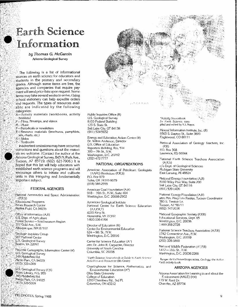
by Thomas G. McGarvin Arizona Geological Survey
following is a list of informational
resources avail-
aterials (workbooks, activity
, filmstrips, and videos
(Contact the author at the
is intriguing and fundamentally
FEDETPAL AGENCIES
-Southwestern Region
Public Inquiries Office (R) U.S. Geological Survey *Activity Sourcebook 8105 Federal Buildina for Earth Science, com- - 125 S. State St. Salt Lake City, UT 841 38 (901 ) 524-5652
Energy and Education Action Center (R) Dr. Wilton Anderson, Director U.S. Office of Education Reporters Building, Rm. 514 300- 7th St., S.W. Washington, D.C. 20202 (202) 472-7777
NATIONAL ORGANIZATIONS
American Association of Petroleum Geologists (AAPG) Bookstore (F,R,S)
P.O. Box 979 Tulsa, OK 74101-9079 (91 8) 584-2555
American Coal Foundation (A,R) 918- 16th St., N.W., Suite 404 Washington, D.C. 20006-2902
American Geological Institute National center- for Earth Science Education
(A,EP,R.T) 4220 King St. Alexandria, VA 22302 1-800-336-4764
Director of Education (R) Center for Environmental Education 624-9th St., N.W. Washington, D.C. 20016
Center for Science Education (A*) attn: Dr. John R. Carpenter, Director University of South Carolina Columbia, SC 29208
piled and ed~ted by V.J. Mayer.
Mineral Information Institute, Inc. (R) 6565 S. Dayton St., Suite 3800 Englewood, CO 801 1 1
National Association of Geology Teachers, Inc. (P,R)
P.O. Box 368 Lawrence, KS 66044
National Earth Science Teachers Association (AIRS)
c/o Dept. of Geological Sciences Michigan State University East Lansing, MI 48824
National Energy Foundation (A,R) 51 60 Wiley Post Way, Suite 200 Salt Lake City, UT 841 16 (801 ) 539-1406
National Energy Foundation (A,R) attn: Mrs. Mary Lou Rankin, Tucson Coordinator 380 S. Treston Ln. Tucson, AZ 5871 1 (602) 747-2036
National Geographic Society (F,P,R) Educational Services, Dept. 8 5 Washington, D.C. 20036 1-800-368-2728
National Science Teachers Association (A,P,R) 1742 Connecticut Ave., N.W. Washington, D.C. 20009
National Wildlife Federation (A*,P,R) 1412-16th St., N.W. Washington, D.C. 20036-2266
*Earth Science Sourcebook: a Guide to Earth Science *Ranger Rick's Naturescope series, theActiue Actiuities and Resources (8th Grade) Earth activity book.
Clearinghouse for Science, Mathematics, and Environmental Education (A*) ARIZONA AGENCIES 1
Ohio State University College of Education 1200 Chambers Rd., 3 r d ' ~ l . Columbus, OH 43212
Arizona Association for Learning in and about the Environment (AALE) (P,R)
179 W. Kent Dr. Chandler, AZ 85224
Arizona Dept. of Education (A) School Improvement Unit attn: Mr. Mike Lang 1535 W. Jefferson Phoenix, AZ 85007 (602) 255-3847
Arizona Dept. of Mines and Mineral Resources (R) Mineral Building - Fairgrounds Phoenix, AZ 85007 (602) 255-3791
Arizona Dept. of Water Resources (R) Education Division attn: Ms. Lin Stevens 99 E. Virginia Ave. Phoenix, AZ 85004 (602) 255-1 546
Arizona Geological Survey (P,R) 845 N. Park Ave. Tucson, AZ 85719 (602) 621-7906
Arizona Science Teachers Association (ASTA) (PR)
c/o JoAnne Wolf Science Resource Center Mesa Public Schools 143 S. Alma School Rd. Mesa, AZ 85202 (602) 890-7056
Central Arizona Film Cooperative (F) P.O. Box 60006 Phoenix, AZ 85082 (602) 965-7564
Museum of Northern Arizona Press (R) attn: Ms. Diana Lubick Rt. 4, Box 720 Flagstaff, AZ 86001 (602) 774-521 1
Salt River Project (A,F,R) Public Mairs Office P.O. Box 52025 Phoenix, AZ 85072-2025 (602) 236-8246
Science Learning Center (A,P) P.O. Box 5697 Flagstaff, AZ 8601 1 (602) 523-7160
University of Arizona (F) Film Library 1325 E. Speedway Tucson, AZ 85721 (602) 621-3857
ARIZONA PARKS AND MONUMENTS
Arizona-Sonora Desert Museum (R) 2021 N. Kinney Rd. Tucson, AZ 85743 (602) 883-1 380
Arizona State Parks (R) 1688 W. Adams Phoenix, AZ 85007 (602) 255-41 74
Grand Canyon Natural History Assn. (R) P.O. Box 399 Grand Canyon, AZ 86023 (602) 638-7773
Petrified Forest Museum Assn. (R,S) P.O. Box 277 Petrified Forest National Park, AZ 86028 (602) 524-6228
Southwest Parks and Monuments Assn. (R) The Bookshop 221 N. Court Tucson, AZ 85701 (602) 622-1 999
Nystrom/Eye Gate Media (R) attn: Ms. Ruth M. Swanson 1914 E. Ranch Rd. Tempe, AZ 85284 (602) 831-2023
PBS Video (F) 1320 Braddock PI. Alexandria, VA 22314-1 698 1-800-424-7963
Rand McNally and CO. (R) attn: Mr. Bruce E. Best 2902 W. Curry Chandler, AZ 85224 (602) 839-31 88
Science Graphics (S) p.0. Box 7516 Bend, OR 97708 (503) 389-5652
Scott Resources, Inc. (R) P.O. Box 2121-C Fort Collins, CO 80522 (303) 484-7445
National Science Resource Center (R) A&I,Rrn. 1170 Smithsonian Institution Washington, D.C. 20560
Society for Visual Education, Inc. (A,F) attn: Ms. Sharon Painter P.O. Box 35397 Phoenix, AZ 85069 (602) 234-1 762
Studio 2 (M) 6631 Muirwood Ct. Lisle, IL 60532 (312) 961-3381
Time-Life Films and Video (F) 100 Eisenhower Dr. Paramus, NJ 07652
Visual Geographics Associates (F) 363 East 3300 South, Suite 3 Salt Lake City, UT 841 1 5 (801) 484.9495
Walt Disney Educational Media Co. (R) 600 S. Buena Vista St. Burbank, CA 91521
Ward's Natural Science Establishment, Inc. (R) 11850 E. Florence Ave. Sante Fe Springs, CA 90670 1-800-872-7289
(continued from page 4) (continued from page 8)
Dunning, C.H., 1948,A report on Hack's Canyon uranium mine: Arizona Department of Mineral Resources, 10 p.
Flanigan, V.J., 1985, Geophysical exploration for breccia pipes on the Colorado Plateau of northern Arizona, i n USGS research on mineral resources-1985, program and abstracts: U.S. Geological Survey Circular 949, p. 11-12,
Gornitz, Vivien, and Kerr, P.F., 1970, Uranium mineraliza- tion and alteration, Orphan mine, Grand Canyon, Arizona: Economic Geology, v. 65, no. 7, p. 751-768.
Hill, J.M., 1915, The Grand Gulch mining region, Mohave County, Arizona: U.S. Geological Survey Bulletin 580. D, p. 39-58.
Hoffman, M.E., 1977, Origin and mineralization of breccia pipes, Grand Canyon district, Arizona: Laramie. University of Wyoming. M.S. Thesis, 51 p.
Huntoon, P.W., Billingsley, G.H.. Breed, W.J., Sears, J.W., Ford, T.D., Clark, M.D., Babcock, R.S., and Brown, E.H., 1986, Geologic map of the eastern Grand Canyon and vicinity, Arizona: Grand Canyon Natural History Association, scale 1:62,500.
Kofford, M.E., 1969, The Orphan mine, i n Baars, D.L., ed., History of the Grand Canyon region: Four Corners Geological Society Guidebook, 5th Field Conference, p. 190-194.
Krewedl, D.A., and Carisey, J.C., 1986, Contributions to the geology of uranium-mineralized breccia pipes in northern Arizona: Arizona Geological Society Digest, v. 16, p. 179-1 86.
Leicht, W.C., 1971, Minerals of the Grandview mine: Mineralogical Record, Sept./Oct. ed., p. 215.221.
Ludwig, K.R., Rasmussen,J.D.,andSimmons,K.R., 1986, Age of uranium ores in collapse.breccia pipes in the Grand Canyon area, northern Arizona labs.]: Geologi- cal Society of America Abstracts with Programs, v. 18, no. 5, p. 392.
McKee, E.D., and Gutschick, R.C., 1969, History of the Redwall Limestone of northern Arizona: Geological Society of America Memoir 114, 726 p.
Marks, R.L., 1961, Mining uranium on the rim of Grand Canyon: The Eiplosive Engineer, v. 39, no. 6, p. 165. 170.
Reimer, G.M., 1985, Helium soil gas survey of a collapse feature on the Hualapai lndian Reservation, Arizona: U.S. Geological Survey Open-File Report 85-394, 15 p.
Shoemaker, E.M., Squires, R.L., and Abrams, M.L., 1978, The Bright Angel and Mesa Butte fault systems of northern Arizona, i n Smith, R.B., and Eaton, G.D., eds., Cenozoic tectonics and regional geophysics of the western Cordillera: Geological Society of America Memoir 152, p. 341-368.
Sutphin, H.B., and Wenrich, KJ., 1983, Structural control of breccia pipes on the southern Marble Plateau, Arizona: U.S. Geological Survey Open-File Report 83- 908, 6 p., scale 1:50,000, 2 plates.
Van Gosen, B.S., and Wenrich, K.J., 1988, Ground magnetometer surveys over known and suspected breccia pipes on the Coconino Plateau, northwestern Arizona: U.S. Geological Survey Bulletin 1683-C, 89 p. [in press].
Verbeek, E.R., Grout, M.A., and Van Gosen, B.S., 1988, Structure of the Ridenour Cu-V-U deposit and vicinity, Coconino County, Arizona: U.S. Geological Survey OpemFile Report 88-6, 50 p.
Waesche, H.H., 1934, The Grand View copper project: Grand Canyon Nature Notes, v. 8, no. 12, p. 250.258.
Watkins, T.A., 1975, The geology of the Copper House, Copper Mountain, and Parashant breccia pipes, western Grand Canyon, Mohave County, Arizona: Golden, Colorado School of Mines, M.S. Thesis, 91 p.
Wenrich, K.J., 1985, Mineralization of breccia pipes in northern Arizona: Economic Geology, v. 80, no. 6, p. 1722-1 735.
1986, Geochemical exploration for mineralized breccia pipes in northern Arizona, U.S.A.: Applied Geochemistry, v. 1, no. 4, p. 469-485.
Wenrich, KJ., Billingsley, G.H., and Huntoon, P.W., 1986, Breccia pipe and geologic map of the northeastern Hualapai lndian Reservation and vicinity, Arizona: U.S. Geological Survey Open-File Report 86-458A, 29 p., scale 1:48,000, 2 plates. - 1987, Breccia pipe and geologic map of the
northwestern Hualapai lndian Reservation and vicinity, Arizona: U.S. Geological Survey Open-File Report 86- 458C, 32 p., scale 1:48,000,2 plates.
continue to decline. When too much decline occurs, the overlying sands and gravels consolidate, the land surface subsides, and earth fissures may develop. Water levels have declined and fissures have developed in Maricopa, Pinal, Pima, a n d Cochise Counties. The AGS, Arizona Department of Water Resources, Arizona Department of Transportation, U.S. Geological Survey, and U.S. Bureau of Reclamation collaborated to update information about water-level declines and earth fissures. The final prod- uct, a map published by AGS in 1987 (Map 23), shows areas and amounts of measured water-level declines, as well as earth-fissure zones.
Radon. Radon is a gas formed by the natural radioactive decay of uranium minerals in rocks and soil. In 1987 radon was detected at levels above the Environmental Protection Agency recommended action level (4 picocuries per liter) in several parts of the State, including southwestern Tucson and Prescott. AGS assisted the Pima County Health Department in assessing radon levels in homes in southwestern Tucson by map- ping the area underlain by rocks with above- normal uranium content. The Legislature appropriated $8,000 to AGS to investigate uranium levels in rocks and soil in selected communities. The results will be given to the Arizona Radiation Regulatory Agency for use in placing charcoal canisters to measure indoor radon levels.
In addition to the examples of applied- geology activities highlighted above, AGS provided information to agencies, compa- nies, and individuals during 1987. Because Arizona's population is increasing more rapidly than that of most States, knowledge of the distribution and characteristics of rock and earth materials is essential for proper management of land and resources. During 1987 AGS increased such understanding through its publications, library facilities, public talks, and participation in professional society activities.
11 FIELDNOTES, Spring 1988
New Publications from the Arizona Geological Survey The following publications may be
purchased over the counter or by mail from the Arizona Geological Survey, 845 N. Park Ave., Tucson, AZ 85719. For price information on these and other Survey publications, contact the Survey offices.
Erickson, Rolfe, 1988, Geology of the Willcox north quadrangle and fhe southernmost Greasewood Mountain quadrangle, Arizona: Miscellaneous Map MM-88-B, 6 p., scale 1:24,000.
This report describes the geology of the western e n d of t h e Dos Cabezas Mountains and adjacent areas. Rock units exposed in the area include Proterozoic igneous, metasedimentary, and metavol- canic rocks, middle Tertiary volcanic rocks, and a middle Tertiary pluton.
Chenoweth, W.L., 1988, Uranium procurement and geologic inuestiga- tions of the Manhattan Project in Arizona: Open-File Report 88-2, 2 3 p.
The Manhattan Project was the highly secret plan during World War II to develop the atomic bomb. The project included the acquisition of raw materials. An estimated 64,000 pounds of uranium oxide were recovered from vanadium ores mined in Monument Valley and the Carrizo Mountains of Arizona. Geologic
I investigations laid the groundwork for exploration activities.
Dernsey, K.A., 1988, Quaternary geo- logic map of the Salome 3 0 x 60- minute quadrangle, west-central Ari- zona: Open-File Report 88-4, scale 1 :I 00,000.
This map shows the distribution of Quaternary units in this part of the Basin and Range physiographic province. Land- forms and geomorphic relationships in this region are products of several inde- pendent variables and may serve as analogies for similar mountain-basin settings in other areas of the Southwest.
Pearthree, M.S., and Baker, V.R., 1987, Channel change along the Rillito Creeksystem of southeastern Arizona, 1941 through 1983; implications for flood-plain management: Special Paper 6, 58p. , scale 1:24,000.
Lateral bank erosion and channel instability along the ephemeral streams of the Rillito Creek system have posed g r e a t e r h a z a r d s t o t h e T u c s o n metropolitan area than has overbank flooding. This special paper investigates the historical behavior of this alluvial s t ream system. It document s and evaluates past channel variability, deter- mines potential sites of bank erosion and lateral channel migration, and suggests flood-plain management alternatives to Federal regulations currently applied to semiarid regions.
Engineers International, Inc., 1988, Summary report of geotechnical investigations, 9/86 through 2/88, Maricopa Superconducting Super Col- lider site, Maricopa County, Arizona: Open-File Report 87-6, 144 p., scale 1 :24,000 and 1 :62,500.
The proposed Maricopa site for the SSC passes mainly through three types of earth materials: 35 miles of indurated alluvium and fanglomerate, 10 miles of granitic rocks, and 8 miles of volcanic and sedimentary rocks. This report details the hard-rock investigations, including data obtained from existing sources, field investigations such as drilling, and labora- tory testing.
Wahl, D.E., Reynolds, S.J., Capps, R.C., Kortemeier, C.P., Grubensky, M.J., Scott, E.A., and Stimac, J.A., 1988, Geologic map of the southern Hieroglyphic Mountains, central Ari- zona: Open-FileReport 88- l ,6p . , scale 1 :24,000.
This report describes the geology of the Baldy Mountain and Hieroglyphic Mountains, southwest quadrangles. In this region, northwest-trending, high- angle normal faults cut Proterozoic schists and Tertiary volcanic rocks. The map area includes the construction site of the-New Waddell Dam and the Mystic mine.
I Arizona Guidebook Available I I vol. 18, No. 1 Spring 1988 I
Arizona Bureau of Geology The Bureau of Geology and Mineral Technology is a division of the University of Arizona
and Mineral Technology Geological Survey Branch 845 N. Park Ave. Tucson, Pi2 8 5 7 1 9 TEL: 6021621-7906
Geology of Central and Northern Arizona, the field-trip guidebook for the 1986 Rocky Mountain Section meeting of the Geological Society of America, is now available from the Arizona Geological Survey. The 176-page guidebook contains nine field guides that cover subjects as diverse as Early Proterozoic orogenic events and the paleontology of the Petrified Forest. Copies may be purchased for $15 each, plus $4.25 for shipping and handling, from the Arizona Geological Survey, 845 N. Park Ave., Tucson, AZ 8571 9.
. . . . . . . . . . . . . . . . . . . . . . . . . State of Arizona Governor Rose Mofford University of Arizona . . . . . . . . . . . . . . . . . . . . . . President Henry KoMer Bureau of Geology & Mineral Technology
. . . . . . . . . . . . . . . . . . . . . . Acting Director Edgar J. McCullough, Jr. State Geologist & Assistant Director,