20 July 2009 A REPORT TO THE USFWS & USGS EXECUTIVE OVERSIGHT COMMITTEE ______________________________________ RECOMMENDATION OF A NATIONAL GEOGRAPHIC FRAMEWORK ______________________________________
Transcript
20 July 2009
A REPORT TO THE USFWS & USGS
EXECUTIVE OVERSIGHT COMMITTEE
______________________________________
RECOMMENDATION OF A NATIONAL GEOGRAPHIC FRAMEWORK
______________________________________
National Geographic Framework Recommendation – 20 July 2009
2
Introduction In April 2009 the SHC Executive Oversight Committee (EOC) formed and tasked a team of Service and USGS scientists (the RPW team) to develop a geographic framework which would provide a spatial context for biological planning and conservation design in support of conservation delivery. The intent of this exercise is to provide guidance relative to building capacity and geographically focusing efforts to implement landscape-scale conservation (Strategic Habitat Conservation) throughout the country. In general, the framework would: (1) address terrestrial and aquatic species needs, as well as multiple ecosystems, (2) be accessible and transparent to employees and partners, (3) facilitate addressing complex conservation challenges, including accelerating climate change, and (4) provide a spatial framework to address activities in the context of higher-level conservation goals. The EOC defined the specific task to the RPW team as follows:
• Recommend a scaleable geographic framework that appropriately aggregates Bird Conservation Regions (BCRs) for landscape-scale biological planning and conservation design for both terrestrial and aquatic species.
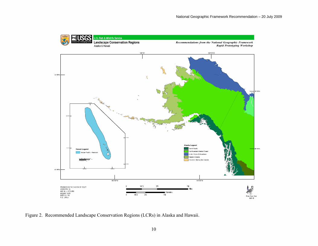
The EOC further defined the requested product as a map with an accompanying explanatory narrative. The RPW team assembled at the Service’s National Conservation Training Center in Shepherdstown WV on June 23-25, 2009, to conduct their work. This report delivers their recommendation. II. Recommendation Conterminous United States. The RPW team recommends that BCRs in the conterminous United States be aggregated into fifteen Landscape Conservation Regions (LCRs) as shown in Figure 1, incorporating seven breaks in BCR boundaries. Table 1 provides a description of LCR units using Omernick’s Level II ecoregions (Omernick 1987), Joint Ventures, BCRs, and freshwater ecoregions (Abell et al. 2000, 2008). Alaska. The Team decided to not aggregate the five BCRs that occur in Alaska due to their large size and the fact that they currently represent the biome level (Figure 2.). The Alaskan BCRs already encompass the desired objective of addressing terrestrial and aquatic conservation planning.
National Geographic Framework Recommendation – 20 July 2009
3
Hawaii. The team recommends that BCR 67 should be maintained as a stand-alone LCR (Figure 2). Marine BCRs. Marine BCRs, including the Carribbean, were not addressed because they were not part of the Team’s assignment. Their large size also precluded appropriate analysis at this workshop - we recommend reviewing and integrating marine BCRs with the National Geographic Framework in the future. US Pacific Islands other than Hawaii were not addressed by the team. Florida. The team noted that south Florida, BCR 31, could be reconsidered with respect to aggregation with a marine BCR (i.e. Caribbean) at some time in the future. Summary. − The PRW Team used a structured decision-making process to meet the objectives of the Workshop. While a quantitative system for scoring attributes of various mapping alternatives was not developed in the time allotted, the team utilized the rapid prototyping process to objectively develop and analyze the recommended map. This analysis also led to structured decision-making on the nine proposed breaks in BCR boundaries. As such, the Team is highly satisfied with the National Geographic Framework of LCRs recommended herein. Some concern existed among Team members that we were unable to produce the desired “instrument” for quantitatively evaluating alternatives, but most believed more time may have allowed us to develop such a tool. There were indications that a strictly numerical-based scoring system may have led the team to a very similar endpoint. Strong consensus exists that the team employed structured decision-making to produce the proposed Framework and this recommendation is forwarded to the EOC without reservation. For informational purposes, the recommended LCRs are provided with overlays of various ecological and geopolitical polygons. Figure 3. LCRs with BCR overlay. Figure 4. LCRs with breaks and deliberated non-breaks in BCR boundaries. Figure 5. LCRs with freshwater ecoregions overlay. Figure 6. LCRs with Omernik’s Level II overlay.
The team noted that Omernik ecoregions do not correspond to BCR boundaries in all cases, even though BCRs are generally constructed from aggregations of Omernik ecoregions.
Figure 7. LCRs with Joint Venture overlay.
National Geographic Framework Recommendation – 20 July 2009
4
The team notes that Joint Venture boundaries do not correspond to BCR boundaries in all cases.
. Figure 8. LCRs with FWS Regions overlay. Figure 9. LCRs with state boundaries overlay. Table 2 provides a key to the Joint Venture abbreviations used in Table 1. III. Team Process and Methods In order to address the objectives, the RPW Team established fundamental goals and measures to enable evaluation of alternative geographic frameworks and refinement of a recommended alternative. Taking all the guidance into account, we converged on three primary drivers for determining how to aggregate BCRs into Landscape Conservation Regions: (1) avoid fragmentation of BCRs as much as possible, (2) retain ecologic homogeneity as much as possible, and (3) be mindful of existing nationally significant partnerships. Ecologic homogeneity was interpreted as fidelity to established terrestrial and aquatic fundamental units. Omernik’s Level II ecoregions and Freshwater Ecoregions (FE) were adopted as the fundamental layers for terrestrial and aquatic homogeneity, respectively. Freshwater ecoregions are desirable because they are:
• identified and characterized for all of North America, and the rest of the planet as well.
• perfectly spatially nested from extremely fine scale to macro units (thus are scaleable to the entire geography of interest in the U.S.),
• ecologically defined, as opposed to merely topographic drainage units, and • the framework adopted by the National Fish Habitat Action Plan program.
Fidelity to BCR boundaries is desirable because these are the units developed by the North American Bird Conservation Initiative as a common ecological planning unit for birds. Omernik Level II ecological regions were adopted to further account for other aspects of terrestrial ecology. The Team used existing migratory bird Joint Venture boundaries as a tertiary consideration consistent with partnership weighting. Joint Ventures represent existing partnerships that have developed biological planning and conservation design capacity for bird conservation. With these objectives in mind, the team developed criteria and preliminary metrics for guiding decisions when aggregating BCRs to form the map of LCRs. Further, we adopted the overall constraint that the total number of LCRs for the conterminous United States should be more than ten but not exceed twenty. The team was aware from preliminary investigations that fidelity to BCR boundaries would, in many cases, significantly fragment aquatic units (i.e. FEs). We recognized that any attempt to derive
National Geographic Framework Recommendation – 20 July 2009
5
a single map that would satisfy bird, terrestrial, aquatic, and partnership objectives would result in numerous “give-and-take” decisions when locating the LCR unit boundaries. Faced with these tradeoffs, the team sought guidance from the EOC and began to devise decision rules for use during aggregation schemes. Guidance from the EOC suggested qualitatively adopting the following weights, or relative importance of criteria, when faced with tradeoffs associated with deciding which BCRs to aggregate:
Objective/Criteria Weight Fidelity to BCRs and terrestrial homogeneity 45% Fidelity to aquatic homogeneity 40% Fidelity to national partnerships 15%
The EOC was interested in being mindful of nationally significant partnerships such as the Columbia River Basin, the Chesapeake Bay, the Klamath Basin, Everglades, etc., but recognized that the RPW Team could not address these landscapes in a quantitative manner. The EOC and the team recognize that these landscapes can and will continue to be handled from a policy perspective, regardless of the geographic framework produced by this team. In other words, existing nationally significant partnerships and collaborative efforts (e.g. the Chesapeake Bay Program, Klamath Basin Watershed Restoration planning) will continue to operate regardless of where LCR boundaries occur. While the team remained mindful of National Fish Habitat Action Plan partnerships, the NFHAP boundaries were in many cases too coarse to provide specific guidance. However, the team believes that incorporation of Freshwater Ecoregions injects a significant element of fidelity to NFHAP interests. The team applied the criteria to preliminary candidate maps, which provided insight into the overall utility of the criteria. This process allowed us to refine the criteria and adopt a qualitative strategy of applying them to subsequent aggregation strategies. The aggregation objectives, criteria and guiding metrics are shown below:
Objective Criteria Guiding Metric Fidelity to BCRs Intact BCR boundaries Minimize # of breaks of
existing BCR boundaries Retain homogeneity of terrestrial ecosystems
Omernik’s Level II ecoregions Minimize the # of Omernik’s Level II ecoregions within individual LCRs
Retain homogeneity of aquatic systems
Freshwater Ecoregions (FEs), the framework adopted by NFHAP
Maximize the ratio: (number of FEs with >50% of their area within the LCR) / (number of different FEs within the LCR).
Attention to nationally significant partnerships
MB Joint Venture boundaries, state boundaries
Minimize # of splits to Joint Venture boundaries and # LCRs within a state
National Geographic Framework Recommendation – 20 July 2009
6
To develop the final map, the team “unioned” three data layers in GIS: BCRs, FEs, and Mid-Atlantic HUC regions. This allowed the team to overlay the line-work from the aquatic layers in order to inform our BCR aggregation scheme. We also consulted several additional GIS data layers: MB Joint Ventures, Omernik’s Level II ecoregions, and state lines. Referring to all these layers, we aggregated BCRs into suggested LCR units, being mindful of the aquatic, terrestrial, and partnership criteria and metrics described above. We attempted to maintain the integrity of FEs within LCRs and avoid aggregating ecologically divergent FEs within LCRs. We used the collective geographic and ecologic expertise of the team to finalize the boundaries of the suggested LCRs. The first draft of our map broke individual BCRs in nine locations in order to achieve the aquatic criteria. Each of these nine breaks in a BCR boundary was then further deliberated by the team, with careful assessment of the value of the break to aquatic and terrestrial interests and the cost of splitting the BCR to migratory bird interests. Existing partnerships (e.g. Joint Ventures) were also considered in the analysis of the potential breaks. After thorough deliberation, the team adopted seven of the proposed BCR breaks and rejected two of them. Our final map contained 15 LCRs in the conterminous U.S., 5 in Alaska, and 1 in Hawaii – a total of 21 LCRs nationwide (Figures 1 and 2). Proposed BCR breaks which were adopted.− Seven of the nine proposed BCR breaks were ultimately adopted as being sufficiently beneficial to aquatic and terrestrial interest to merit the fragmentation of a BCR (Figure 4.). 1. Flint River (FLA) watershed break: Aquatic value = high; BCR cost = low. This was considered to be the least controversial and simplest of the nine proposed breaks. This break was needed to divide the Gulf from the Atlantic freshwater ecoregion boundaries. The break generally aligns with the East Gulf Coastal Plain/Atlantic Coast JV administrative boundary, although it occurs on a watershed line instead of the existing JV boundary. The JV community has already decided that a break in BCR 29 is warranted; hence this will result in minimal impact on bird conservation. 2 & 3. Chesapeake-A and B breaks: Aquatic value = medium; BCR cost = low. These breaks were needed to keep the Lower Chesapeake Bay watershed intact due to the significant established partnership in this region. These breaks were made on drainage-based HUC boundaries. The Team readily adopted these breaks because they split only BCR 27 and 29, both of which are in the Atlantic Coast JV, which currently administratively conducts its activities within North Atlantic, Mid Atlantic, and South Atlantic subunits. 4. Ozarks break: Aquatic value=medium; BCR cost=high. This break facilitates inclusion of the eastern Central Hardwoods with the Appalachian Mountains. It aligns the Ozark Mountains with the Lower Mississippi River system from an aquatic and terrestrial standpoint. It keeps the Ohio River basin intact and combines two areas with similar FE units. The cost is that it splits the Central Hardwoods BCR and Central Hardwoods JV.
National Geographic Framework Recommendation – 20 July 2009
7
5. Great Basin-Columbia break: Aquatic value=high; BCR cost=medium. This break was deemed to be highly important for retaining aquatic integrity due to the significance of the Columbia River Basin from a fisheries standpoint and the fact that the northern BCR 9 includes FE units that are highly different than those in southern BCR 9. The Great Basin contains highly unique fish assemblages and aquatic environments. This break splits BCR 9, an ecological region with substantial shrub-steppe habitats throughout the BCR. However, BCR 10 also contains much shrub-steppe habitat. The team felt the aquatic benefits derived from this break outweighed the terrestrial-based costs. 6. Sierra Crest break: Aquatic value=high; BCR cost=low. This is a watershed-oriented break which splits BCR 15 along the crest of the Sierra Nevadas and greatly enhances ecological and planning integrity for aquatic resources. If not split, BCR 15 pools the San Francisco Bay Delta and Great Basin watersheds, each of which contains their own endemic fish assemblages – the split separates these drainages. This decision generally follows the boundary between Intermountain West JV and Central Valley JV and the Eastern Sierras represent Great Basin habitats. 7. Coastal Louisiana break: Aquatic value=high; BCR cost=high. This break keeps the Lower Mississippi River ecosystem intact by combining the Mississippi River Delta and associated portions of coastal Louisiana with the LCR encompassing the Mississippi River Delta and Gulf Coastal Plains. Without this break, the river delta would join with totally different drainages in Texas (BCRs 20, 21, and 36). This break joins the eastern section of BCR 37 (Vermillion Bay to the eastern boundary of BCR 37 ) with BCRs 25, 26, and 27 (the Lower Mississippi River/Gulf Coast Plain system. This scenario logically addresses aquatic resource issues but severs a long-running agreement relative to bird conservation planning and partnerships. The break combines coastal Louisiana with the Ozarks region from a terrestrial planning perspective. Adoption of this break was not unanimous, but the team reached consensus to make the split. Proposed BCR breaks which were NOT adopted.− Two of the nine proposed BCR breaks were not adopted. In these two cases, the team decided that the cost of the break to BCR planning efforts outweighed the benefits to aquatic interests (Figure 4.). Appalachia break: Aquatic value=medium; BCR cost=high. The Team considered breaking BCR 28 as a means of separating the Chesapeake Bay and Ohio River watersheds (e.g., to facilitate Ohio River mussel conservation, etc). However, this break would have severed the Appalachian Mountains. The team decided to not adopt the Appalachia break in order to keep the Appalachian Mountains BCR (#28), the Appalachian Mountain JV, and the Eastern Brook Trout Joint Venture intact.
National Geographic Framework Recommendation – 20 July 2009
8
Ohio break: Aquatic value=medium; BCR cost=high. This break would have split BCR 22 and the Upper Mississippi River-Great Lakes JV yet would not achieve significant consolidation of similar FE units. It would have combined the Eastern Corn Belt Plains with two Omernik Level II ecoregions (Interior Plateau and Allegheny Plateau). The cost of this break is that it fragmented the Ohio River basin. As such, the Team decided to not adopt the Ohio break and to keep BCR 22 intact. References Abell, R. A., D. M. Olson, E. Dinerstein, P. T. Hurley, J. T. Diggs, W. Eichbaum, S. Walters, W. Wettengel, T. Allnutt, C. J. Loucks, and P. Hedao. 2000. Freshwater ecoregions of North America: a conservation assessment. Island Press, Washington D. C. 319 pp. Abell, R. A. M. L. Thieme, C. Revenga, M. Bryer, M. Kottelat, N. Bogutskaya, B. Coad, N. Mandrak, S. Contreras Balderas, W. Bussing, M. L. J. Stiassny, P. Skelton, G. R. Allen, P. Unmack, A. Naseka, R. Ng, N. Sindorf, J. Robertson, E. Armijo, J. V. Higgins, T. J. Heibel, E. Wikramanayake, D. Olson, H. L. López, R. E. Reis, J. G. Lundberg, M. H. Sabaj Pérez, and P. Petry. 2008. Freshwater ecoregions of the world: a new map of biogeographic units for freshwater biodiversity conservation. BioScience 58(5):403-441. Omernik, J. M. 1987. Ecoregions of the conterminous United States. Annals of the Association of American Geographers 77: 18–125.
National Geographic Framework Recommendation – 20 July 2009
9
Figure 1. Recommended Landscape Conservation Regions (LCRs) in conterminous U.S.
National Geographic Framework Recommendation – 20 July 2009
10
Figure 2. Recommended Landscape Conservation Regions (LCRs) in Alaska and Hawaii.
National Geographic Framework Recommendation – 20 July 2009
11
Table 1. Units completely or partially contained within each Landscape Conservation Region (LCR).
Landscape Conservation Region
(LCR)
Bird Conservation Region (BCR)
(p=partial) Joint Ventures States # Freshwater
Ecoregions >50% Number of Level II
Omernick's
North Atlantic 14, 27p, 29p, 30 ACJV (1) NY, ME, VT, NH, MA, RI, CT, NJ, PA, DE,
MD, VA (12) 1 7
South Atlantic 27p, 29p, 31 ACJV, EGCPJV (2) VA, NC, SC, GA, AL, FL (6) 2 3
Appalachian 24p, 28 AMJV, CHJV, UMRGLRJV (3)
MA, CT, NY, NJ, MD, PA, OH, WV, VA, KY, TN, NC, GA, AL (14)
4 7
Gulf Coastal Plain / Ozarks
24p, 25, 26, 27p, 37p
ACJV, EGCPJV, LMVJV, GCJV, CHJV,
UMRGLRJV (6)
IL, MO, KY, TN, AR, OK, TX, LA, AL, MS,
GA, FL (12) 6 5
Eastern Tallgrass Prairie 22 UMRGLRJV, LMVJV,
PPJV, OPJV (4)
SD, MN, NE, IA, IL, IN, OH, MO, KS, OK, MI
(11) 1 5
Upper Midwest / Great Lakes 12, 13, 23 UMRGLRJV, PPJV,
ACJV, (3) MN, IA, WI, MI, IL, IN,
OH, NY, PA (9) 2 4
Northern Great Plains 11, 17 NGPJV, PPJV, IWJV, RWBJV (4)
MT, ND, MN, WY, SD, NE, IA (7) 2 6
Southern Great Plains 18, 19 PLJV, RWBJV, IWJV, NGPJV (4)