Recommended Transboundary Conservation Strategies for Kootenai River and Kootenay Lake Burbot Lota lota in Idaho and British Columbia Prepared by: The Kootenai River Burbot Conservation Committee 2002
Transcript
Recommended Transboundary Conservation Strategies for Kootenai River and Kootenay Lake Burbot
2.1 Overview........................................................................................................................2 2.2 The Kootenai River ........................................................................................................2 2.3 Description of Burbot......................................................................................................3
2.3.1 Distribution ..............................................................................................................3 2.3.2 General Burbot Life History......................................................................................3
2.4 Stock Status of Burbot....................................................................................................5 2.4.1 Stock Status in the Kootenai River, Idaho................................................................5 2.4.2 Kootenay River and Lake, British Columbia.............................................................6 2.4.3 Kootenai River, Montana .........................................................................................7 2.4.4 Kootenai Tribe and Burbot Fishing...........................................................................7
2.5 Potential Reasons for the Decline ..................................................................................8 2.5.1 Exploitation..............................................................................................................8 2.5.2 Environmental Degradation .....................................................................................9 2.5.3 Reduced Productivity...............................................................................................9 2.5.5 Temperature Changes.............................................................................................9 2.5.6 Hydropower and Flood Control ................................................................................9
2.6 Libby Dam Current Operation.......................................................................................11 2.6.1 Libby Dam .............................................................................................................11 2.6.2 Winter Operation of Libby Dam..............................................................................11 2.6.3 Libby Dam and Kootenai River White Sturgeon Recovery Flows...........................13 2.6.4 Hydropower Operation of Libby Dam and Monetary Value ....................................16
3.0 Problems Confronting Burbot...........................................................................................16 3.1 Habitat .........................................................................................................................16 3.2 Winter Flow Management ............................................................................................16 3.3 Power Peaking.............................................................................................................17 3.4 River Temperature .......................................................................................................17 3.5 Nutrient Losses ............................................................................................................18 3.6 Spring Lowering of Kootenay Lake...............................................................................18
5.1 Flow Manipulation ........................................................................................................19 5.2 Ecosystem Rehabilitation .............................................................................................19 5.3 Donor Stocks ...............................................................................................................19 5.4 Confined Brood Stocks.................................................................................................20 5.5 Viable Stock Densities..................................................................................................20 5.6 Burbot Culture..............................................................................................................20 5.7 Additional Turbines at Libby Dam.................................................................................20 5.8 Spring Management of Kootenay Lake ........................................................................21 5.9 Assessment Techniques ..............................................................................................21 5.10 Provide Protection From Illegal Harvest .....................................................................21
ii
Table of Contents, Continued Page
6.0 Monitoring, Compliance, and Review of Burbot Conservation..........................................21 6.1 Status and Recovery Measures ...................................................................................21
List of Tables Table 1 The tiered flow regime described in the 1997 Kootenai River White Sturgeon
Recovery Plan, conversion of cfs to m3/s divide by 35.4. ........................................14
List of Figures Figure 1. Kootenai River and locations of Libby Dam, Bonners Ferry, Lake
Koocanusa, Kootenay Lake, and other important locations, including river kilometer (rkm). ........................................................................................................4
Figure 2. The current storage reservation diagram for Libby Dam (USACE 1991).................12
Figure 3. Hydrographs for the Kootenai River below Libby Dam, reflecting river fluctuations characteristic of daily power peaking, conversion of cfs to m3/s divide by 35.4. ........................................................................................................13
Figure 4. The Libby Dam operation in 1997 illustrates the flood control, power, and fish operations...............................................................................................................15
1
EXECUTIVE SUMMARY
The burbot Lota lota is common in the upstream reaches of the Columbia River Basin in the northwestern USA and Canada. In Idaho burbot are endemic only to the Kootenai River, while they also occur in this same river system in British Columbia as well as Kootenay Lake. The Kootenai River and Kootenay Lake once provided popular sport, subsistence, and commercial fisheries for burbot. However, soon after the start of operation of Libby Dam and formation of Lake Koocanusa, in 1972, the respective burbot fisheries in the Kootenai River, Idaho and Kootenay Lake, British Columbia collapsed. Several changes have occurred on the Kootenai River, but the most serious impact is thought to be Libby Dam, constructed by the US Army Corps of Engineers for hydropower and flood control management. Shortly after the dam became operational, the fishery in Kootenay Lake rapidly diminished from an annual harvest of over 26,000 burbot in 1969 to none in 1987. Angling regulations for burbot fishing in both bodies of water became more restrictive, but the fisheries did not improve; eventually both fisheries were closed. The main reasons for the loss of both fisheries are believed to be high winter flows during the traditional spawning period for burbot, loss of nutrients to the impoundment created by Libby Dam, and warmer winter temperatures. Because burbot are important, fisheries and river managers joined as a Kootenai River Burbot Conservation Committee to formulate a Conservation Strategy to prevent further losses and identify actions needed to rehabilitate the burbot population. These Conservation Strategies propose measures that are thought necessary for the rehabilitation of burbot in the lower Kootenai River; they include ecosystem rehabilitation, modification of the present flood rule curves to reduce flow during the winter migration and spawning season for burbot, the use of behaviorally and genetically similar donor stocks, confined brood stocks, burbot culture, an additional turbine on Libby Dam, and spring management of Kootenay Lake elevation. Rehabilitation of the burbot population is believed more likely if all of the measures are implemented and the process is facilitated through managing agencies with public involvement.
2
1.0 Burbot Conservation Goal
The burbot Conservation Goal is to maintain and restore multiple life history strategies, and maintain genetic diversity necessary to sustain a viable burbot population in the Kootenai River. Complete restoration of the burbot population will be achieved when monitoring and evaluation of recovery indicates a sufficient surplus of fish is present to provide for a sport harvest.
2.0 Introduction
2.1 Overview
Burbot fisheries in the Kootenai River of Idaho and British Columbia (BC) and Kootenay Lake, BC, once provided important fishing, subsistence, and commercial opportunities but are now in a state of collapse (Paragamian et al. 2000). Because of their historic importance, fisheries and river managers joined as a Kootenai River Burbot Recovery Committee to formulate a Conservation Strategy to prevent further losses and identify actions needed to rehabilitate the burbot population. When a population assessment determines a species is at risk of extinction, a Conservation Strategy may be developed to provide measures to alleviate the threats and recover or rehabilitate the population. If managing agencies and water use managers agree in writing to follow the prescribed measures of a Conservation Strategy, then the Strategy can become a Conservation Agreement (note there are several definitions of Conservation Agreement). A Conservation Agreement may be one of the last steps in avoiding federal intervention with the Endangered Species Act. A Conservation Strategy was thought to be necessary for several reasons. The burbot population in the Kootenai River in Idaho and British Columbia may be at risk of demographic extinction and is genetically different than the burbot population above Kootenai Falls, Montana. This population is also geographically isolated by the Corra-Linn Dam downstream (formerly the natural Bonnington Falls) and Kootenai Falls located upstream. Managers believed that it would be important to have a Conservation Strategy prepared if the opportunity was present to implement a Conservation Agreement. In addition, there is the pending prospect of a listing action under the Endangered Species Act. If the population were listed in the Federal Register as an Endangered Species, a Recovery Team would be formed by the US Fish and Wildlife Service (USFWS) to develop a Recovery Plan. An existing Conservation Strategy for burbot could be used as the foundation for a Recovery Plan and save valuable time for implementation of rehabilitation/recovery efforts.
On February 2, 2000, burbot Lota lota in the Kootenai River in Idaho were petitioned by the Idaho Conservation League and American Wildlands for emergency listing as endangered under the Endangered Species Act. On September 28, 2001 the USFWS released in the Federal Register a positive 90 day finding for burbot in the lower Kootenai River (Idaho) stating that adequate information was presented in the petition to suggest that listing as threatened or endangered was warranted under the Endangered Species Act.
2.2 The Kootenai River
The Kootenai River is part of the upper Columbia River drainage, is one of the largest tributaries to the Columbia River, originates in Kootenay National Park, British Columbia, and
3
has a drainage of 49,987 km2 (19,301 sq mi) (Bonde and Bush 1975) (Figure 1). From Kootenay Provincial Park, the river flows south through BC and into Montana; at Jennings it is impounded by Libby Dam, forming Lake Koocanusa. From Libby Dam, the river turns west, then travels northwest into Idaho, then north into BC and Kootenay Lake. The river drains Kootenay Lake through the West Arm and joins with the Columbia River near Castlegar, BC. The geological history of the Kootenai River system can be traced back to the Wisconsin Glacier and glacial Lake Kootenay (Alden 1953). Colonization of the river with a variety of fish species is thought to have occurred during this period (Northcote 1973). Many changes have occurred since then including channelization, diking, eutrophication, nutrient reduction, and dam construction and operation.
2.3 Description of Burbot
2.3.1 Distribution
The burbot is holarctic in geographic distribution, extending almost continuously from the British Isles eastward across Europe and Asia to the Bering Strait (McPhail and Paragamian 2000). In North America burbot range eastward from the Seward Peninsula in Alaska (McPhail and Lindsey 1970) to New Brunswick on the Atlantic coast and are found through the northern tier of states in the US. In Idaho burbot are endemic only to the Kootenai River (Simpson and Wallace 1982).
2.3.2 General Burbot Life History
Burbot are the only freshwater member of the family Gadidae, the cod family; they reach a weight of about 4.5 kg (9.9 lb) in Idaho. Burbot are winter spawners, spawning at temperatures usually below 4°C (39.2°F). Burbot are highly synchronized in their spawning in both maturation and arrival to a spawning site (Arndt and Hutchinson 2000; Evenson 2000). Burbot spawn in large groups called “spawning balls,” and a female burbot may release over 1,000,000 eggs (Becker 1983). The eggs are semibuoyant and often drift downstream to a lake where larva may rear. Very young burbot are pelagic and feed on zooplankton. As they grow in length, they move to the shoreline and feed on insects and small fish. They then move into deeper water, feeding on fish and Mysid shrimp Mysis relicta. Male burbot mature at about age-3 and –4, while females mature at about age-4 and -5. Weak year classes of burbot have been known to produce very strong year classes, and they have the ability to recover when given suitable environmental conditions (Jakob Kjellman, Department of Limnology and Environmental Science, University of Helsinki, personal communication).
4
Figure 1. Kootenai River and locations of Libby Dam, Bonners Ferry, Lake Koocanusa, Kootenay Lake, and other important locations, including river kilometer (rkm).
0 2
Kilometer
N
S
EW
Libby Dam (rkm 352)
Kootenai Falls (rkm 310)
rkm 170
Bonners Ferry (rkm 246)
IDAHO WASHINGTOBRITISH COLUMBIA
MONTANA
Yaak River
Moyie River
Lake Koocanusa
Goat River
Kootenay Lake
5
2.4 Stock Status of Burbot
2.4.1 Stock Status in the Kootenai River, Idaho
Many burbot in the Kootenai River, Idaho, are transboundary while a few are sedentary residents. The highest numbers of burbot occur during the winter when many more fish migrate from the lower river and Kootenay Lake, in British Columbia, during the spawning season. The earliest records of burbot sampling in the Kootenai River, Idaho, were taken from the Idaho Department of Fish and Game (IDFG) Panhandle Region archives. They indicated IDFG sampling caught 199 burbot during the 1957-1958 winter. The length-frequency distribution demonstrated the presence of young fish (35.6-50.8 cm, 14-20 inches total length, likely age-3 to age-5) and of older fish in the population. Soon after completion of Libby Dam, a substantial reduction in the abundance of burbot was noted. Partridge (1983) captured a total of 108 burbot using three different gear types from 1979 through 1982. He sampled fewer fish than indicated in the archival records with the same gear and similar effort. In 1979 he caught only eight fish (or one burbot/16 net days) with effort similar to that used in 1957-1958 when 199 were caught (Partridge 1983). Although all age groups vulnerable to sampling gear appeared in Partridge’s catch, he believed the abundance was substantially less compared to the late 1950s. A follow-up study of burbot was initiated in 1993 to determine burbot abundance, distribution, size, reproductive success, and movement, and to identify limiting factors (Paragamian 1993). Only 17 burbot were caught in 1993 (CPUE of one burbot/33 net days) and eight in 1994 (CPUE of one burbot/111 net days), sampling methods were similar to Partridge (1983). However, numerous age groups of fish were represented in the net catch, indicating some burbot recruitment was occurring. Only one burbot was sampled between Bonners Ferry and the Montana border. Sampling for burbot during the winter of 1993 through 1994 at the mouths of Idaho tributaries was carried out in anticipation of intercepting a spawning run of fish from Kootenay Lake, BC or the lower river; but no burbot were caught. . There was no evidence of reproduction in Idaho.
The burbot fishery in Idaho was primarily a winter fishery, although some fishing occurred in spring. The combined sport and commercial fisheries in Idaho during the 1950s and 1960s were thought to have yielded over 2,041 kg (4,500 lb). Three commercial fishermen alone in 1958 harvested 2,041 kg (4,500 lb) of burbot (Paul Jeppson, Fisheries Biologist, IDFG Panhandle Region, archives). Anglers were interviewed and asked about their fishing experiences (Paragamian 1995), and IDFG archives were reviewed. Anecdotal information indicated an excellent winter fishery was present from the 1950s through the early 1970s. Anglers reported catching many burbot through the ice on set lines. Following construction of Libby Dam, warmer water released from Lake Koocanusa eliminated ice cover and the ice fishery on the Kootenai River (Partridge 1983).
Spearing of burbot on spawning runs in tributaries (Snow, Caribou, and Deep creeks) also accounted for many of the fish harvested. There was no daily or seasonal limit on the number of burbot that could be harvested. Some anglers reported filling gunnysacks with fish. It was believed that many of these burbot were of Kootenay Lake origin (Partridge 1983). Burbot regulations in Idaho were liberal until 1984 when a two-fish per day limit was adopted. This was followed in 1992 by a ban on all burbot harvest. The burbot harvest from 1979 through 1982 was estimated at less than 250 fish/year. Burbot were nonexistent in a creel survey that extended from spring 1993 through spring of 1994 (Paragamian 1993; Paragamian 1994).
6
Burbot were thought to spawn in numerous tributaries to the Kootenai River in January and February. It is not known if spawning occurred in the mainstem Kootenai River. Burbot spawners were known to concentrate in Boundary, Smith, Parker, Trout, Mission, Deep, and Snow creeks. It is not known if these were discrete stocks of fish or spawners randomly seeking tributaries from year to year. Regardless, annual winter sampling at the mouth of Smith and Boundary creeks since 1996 has resulted in the capture of only two burbot, both from Boundary Creek.
2.4.2 Kootenay River and Lake, British Columbia
At the present time the burbot population in Kootenay Lake and the Kootenay River in British Columbia are red listed as an imperiled population in British Columbia. The burbot fishery in Kootenay Lake was primarily a late spring-early summer fishery. Up until the mid 1960s the daily harvest limit was 15 burbot per day. The daily limit was lowered to 12 per day in 1967 (Sinclair and Crowley 1969). Burbot were concentrated in the Balfour area of the West Arm of Kootenay Lake and were vulnerable to angling. The concentration of burbot was likely due to the abundance of Mysid shrimp used as food or the use of available spawning habitat (Andrusak and Crowley 1978). Over 26,000 burbot were caught in 1969 and about 20,000 in 1971. The angling catch rate of burbot averaged about one fish per hour during the 1969-71 period. Harvest of burbot declined substantially in years following 1971. As a result, the daily limit was reduced to 10 burbot per day in 1975 (Andrusak 1976).
The need for more intensive management was apparent (Andrusak and Crowley 1976) and a potential production and harvest study was undertaken. The findings of the study indicated an optimum sustainable yield of about 12,000 burbot at 14,560 rod hours could be sustained by the fishery (Martin 1976). The limit of burbot was then reduced to five fish per day in 1976, although no improvement in the burbot population had been observed. The harvest of burbot continued to decline through the 1970s with angling catch success remaining at about 0.7 fish per hour. The burbot fishery eventually collapsed, and as of 1987 no fish have been recorded in the fishery at Balfour; the lake was closed to burbot fishing and harvest in 1997.
No burbot were caught during two weeks of sampling in the West Arm in July 1994 (Paragamian 1995) or during subsequent sampling in June and July in 1995 (Colin Spence, Fisheries Biologist, British Columbia Ministry of Environment Lands and Parks, personal communication). Divers scoured the “Ling beds” weekly throughout March 1999 and saw no burbot. This contrasts with work prior to the collapse of the population when divers were able to capture dozens of fish for study (Colin Spence, Fisheries Biologist, British Columbia Ministry of Environment Lands and Parks, personal communication).
There is evidence to suggest there may have been both tributary and lake spawning stocks of burbot in Kootenay Lake. Paragamian (1995) suggested some fish were adfluvial and spawned in tributaries of the Kootenai River (including the Goat River). Anecdotal information suggested there were also spawning runs in Summit, Corn, and Duck creeks. Martin (1976) found evidence of a March spawning stock of burbot in the West Arm of Kootenay Lake. The only recent documentation of spawning in Kootenay Lake is an observation of a small “ball” of burbot for the second year on the shoreline of the North Arm of Kootenay Lake (Colin Spence, Fisheries Biologist, British Columbia Ministry of Environment Lands and Parks, personal communication).
7
2.4.3 Kootenai River, Montana
Burbot provided a substantial sport fishery in the Montana portions of the Kootenai River above and below Kootenai Falls in the past, but these fisheries have declined after the construction of Libby Dam (Don Skarr, Montana Fish Wildlife and Parks, personal communication). However, the daily catch of burbot in the Kootenai River is five with no closed season with the exception of a closure year round immediately below Libby Dam. The presence of the dam, constructed in 1972, has altered the natural flow regime of the Kootenai River. This change in environment is one of the many factors affecting the strategy for burbot rehabilitation. Currently, adult and sub-adult burbot below Libby Dam are monitored on a biweekly basis (using SCUBA divers) during November through March of each year. This is done primarily to observe spawning activity, but also to monitor seasonal concentrations of fish. It is not known whether spawning is successful, since age-0 burbot have not been found in the river below the dam. Repeated D-ring sampling efforts in the mainstem Kootenai River and in Lake Creek and Fisher River have not produced any larval burbot. A juvenile burbot survey was conducted during fall of 1993 on portions of four tributaries to the Kootenai River: the Fisher River and Libby, Lake, and Callahan creeks. Eleven burbot 200-275 mm (7.9-10.8 in) were collected in the Fisher River. It is not known whether these fish emigrated from the Kootenai River or whether they were hatched and reared in the Fisher River.
Hoop nets are also deployed in the stilling basin below Libby Dam and in an area below Kootenai Falls during December and February to monitor spawning concentrations in these areas and to try to estimate spawning populations. Nearly 500 burbot have been caught by hoopnets in the past five years during winter. There is evidence of entrainment of burbot through Libby Dam (Skaar et al. 1996). However, fish captured and tagged below the dam have not been recaptured in Idaho. Other areas may be used by burbot in the river between the dam and the falls, since recaptures of burbot in the stilling basin from year to year are relatively rare. The catch of burbot below Kootenai Falls in Montana has been very low.
During the winter of 1998-1999, Montana Fish, Wildlife, and Parks deployed four experimental spawning boxes in an attempt to determine favored spawning substrate. This effort was undertaken after observing burbot spawning behavior in the stilling basin below Libby Dam during the winter of 1997-1998. No spawning was observed during the winter of 1998-1999, in or outside of the experimental boxes. It is hypothesized that water temperatures were not cool enough during 1998-1999 to induce the heavy spawning burbot concentrations that were observed during the previous winter, which had cooler temperatures. There may be other variables associated with the spawning activity.
2.4.4 Kootenai Tribe and Burbot Fishing
Fisheries resources in the Kootenai River were historically abundant and were used by the Kootenai Tribe for cultural and subsistence purposes. The Kootenai Tribe relied heavily upon this important resident fishery to provide their main dietary staple and were very adept at using weirs and traps. Schaeffer (1940) reported that the Kootenai fished for burbot in the fall/winter months using weirs constructed on tributaries of the Kootenai River. The following information was provided recently by Abe Abraham, a well-respected Kootenai Tribal Elder: “The ling moved into the tributaries to the Kootenai River from Kootenay Lake all the way to the mouth of the Moyie River. We fished for ling through the ice in February using lines and large hooks baited with squawfish and peamouth chub. Ling were extremely abundant and were a
8
main staple for the Tribe in the late winter/early spring months. The large fish were cut into strips and air-dried or dried over a fire. The ling were shared with all tribal members. They were the most important food source for the Tribe at that time of year.” In 1941, Turney-High reported: “The Kutenai considered their land a fortunate one… Scarcity, need, and famine were so unusual that they were considered of supernatural origin. Scarcity of food predicted death in the immediate family and also, perhaps with some practicality, the presence of an enemy.”
Over the past few decades, native fish stocks, including burbot, have declined
significantly in the drainage due to changes in the natural ecosystem. Some of these changes include alteration in river flows and lower productivity due to the operation of Libby Dam, diking and diversions resulting in loss of side-channel habitat, and poor water quality from past industrial, agricultural and mining influences. The Tribe recognizes the connection of all resources in the web of life, and that the preservation of the Tribe depends on protecting these resources in a holistic manner. Because the entire ecosystem has been altered for decades, much has already been lost. The Tribe looks to the future with the hope that the native fish such as the burbot may once again inhabit their river in abundance.
2.5 Potential Reasons for the Decline
2.5.1 Exploitation
Over-exploitation of the burbot in Kootenay Lake and the Kootenai River was a concern for fish managers when it became evident the fisheries were at risk of failing (Paragamian et al. 2000). Reduction in creel limits and fishery closures did not restore the fisheries. Paragamian et al. (2000) examined the length frequency distribution of burbot caught from the West Arm from 1968 through 1976 (Martin 1976) and calculated Proportional Stock Densities (PSD) for each year. For the Kootenai River, Idaho, proportional stock density (PSD; the percentage of 20 cm in total length and longer burbot that also exceeded 38 cm) for the hoop net catches from the winter of 1957-1958 (Paul Jeppson, IDFG Fisheries Biologist, Panhandle Region archives), the Partridge (1983) sample, and Paragamian (2000) were calculated. Relative stock density (RSD) was also calculated for preferred (P; 53 cm), and memorable (M; 67 cm) length burbot (Fisher et al. 1996). We found that PSD remained high from the late 1950’s into the late 1990s (1992-1996) in the Kootenai River, Idaho, but RSD-P increased from 18 to 47 to 62. RSD-M also increased from 1 to 20 by the late 1990’s. From anecdotal information we believe that angling exploitation was high for the Kootenai River fishery in the 1950’s through the 1970’s. The burbot PSD from 1957 to 1958 indicates a good representation of young fish (RSD –M; 1, and RSD-P;18) while later the PSD was characteristic of a population that was recruitment limited (RSD-M; 20, RSD-P;62). Had exploitation been a limiting factor the proportion of quality length or longer fish would have decreased. However, the contrary occurred the proportion of smaller burbot decreased, which resulted in higher RSD values. The Kootenay Lake fishery from 1968 to 1975 was comprised of large burbot (Martin 1976). RSD-P was high (90-100) and even after Libby Dam was constructed it remained at nearly 100, RSD-M was also high (53-84). If angling was a factor we would have expected a decrease in the two larger length categories of burbot, but instead from 1968 to 1975 RSD-M increased from 53 to 81. The increase in the proportion of larger fish suggests a recruitment limited fishery.
9
2.5.2 Environmental Degradation
The history of environmental degradation to the Kootenai River and its ecosystem is well documented (Northcote 1973; Cloern 1976; Daley et al. 1981; Partridge 1983; Anonymous 1996). Logging and mining in the drainage have always been concerns, particularly with the release of heavy metals and their subsequent toxicity (Partridge 1983). The natural conditions of the Kootenai River no longer exist. Logging and mining operations as early as the 1880s caused tributary discharge to flash and physically changed the streams and caused siltation (Northcote 1973). Additional disturbances came to the drainage in 1892 with attempts to dike the lower reach of the river and claim land for agricultural uses (Northcote 1973). Mining added to the deterioration of the water quality in the tributaries and river, and from 1953 through the 1970s, operation of a fertilizer plant on the St. Mary River greatly increased nutrient loading (Northcote 1973). Most of these physical changes, however, came about many years before the collapse of the burbot fisheries; thus, it is unlikely they could be responsible for such a dramatic decline. Libby Dam, the last major change to the river, was created under an International Columbia River Treaty between the USA and Canada for cooperative water management of the Columbia River Basin (Columbia River Treaty 1964). Construction of the dam began in 1966 by the US Army Corps of Engineers (USACE) and was completed in 1972.
2.5.3 Reduced Productivity
Eutrophication of the Kootenai River because of pollution from a fertilizer plant on a tributary to the Kootenai River in BC brought about an elevation in productivity, particularly in Kootenay Lake (Northcote 1973). Pollution abatement in the mid-1970s and the impoundment of water and consequential settling of sediment nutrients behind Libby Dam reduced the nutrient loading to the river (Daley et al. 1981; Snyder and Minshall 1996). Pollution abatement and impoundment of Lake Koocanusa also resulted in reduced productivity of Kootenay Lake (Daley et al. 1981: Ashley et al. 1996).
2.5.5 Temperature Changes
Impoundment of Lake Koocanusa and regulation of downstream flows began in March of 1972. Temperature during the winter also increased by 3°C (37°F) (Partridge 1983). Under the present operation, the river now remains ice-free during the winter. The possible consequences of post-dam changes in winter flows and temperature of the Kootenai River downstream of Libby Dam were reviewed by Paragamian et al. (2000). Burbot are winter spawners and often spawn under the ice in January through March (Becker 1983). Prior to the dam, the Kootenai River froze frequently during these months. Burbot spawn at about 1.5°C (34.7°F), or near freezing temperatures (Becker 1983; MacKay 1963). Since 1974, the winter river temperatures are now 3-4°C (37-39.2°F) as opposed to the pre-dam years of near 1°C (33.8°F) and less (Partridge 1983).
2.5.6 Hydropower and Flood Control
After completion of Libby Dam, mean monthly flows downstream during spring were reduced by 50% and winter flows tripled, changing burbot spawning migration conditions
10
dramatically. Prior to Libby Dam the natural discharge during January-February of about 170 m3/s (6,003 cfs) was followed by a gradual increase during late winter and spring, by June flow reached a peak spring freshet, from melting snow in the mountains, that could exceed 2,800 m3/s (98,880 cfs). At present, average discharge is higher during September to February than before the dam. Winter hydropower and with it power peaking may play a key role in inhibiting populations of fluvial and adfluvial burbot in the Kootenai River from moving to spawning areas and tributaries (Paragamian 2000). Current velocities in the lower Kootenai River are subject to change with daily winter operations at Libby Dam, and velocity increases are directly proportional to flow increases and elevation of Kootenay Lake. Burbot are weak swimmers and have a low endurance for extended periods of increased flow with a critical velocity of 24 cm/s (9.4 in/s) (Jones et al. 1974). Flows in the Kootenai River at Copeland, Idaho above 255 m3/s (9,005 cfs) produced average current velocities higher [>24 cm/s (9.4 in/s)] than the critical velocity for burbot (Paragamian 1995). Flow near the Idaho/BC border can often be as high as 510 m3/s (18,000 cfs) during normal winter operations of Libby Dam. Burbot can move extensive distances during the winter to spawn (McCrimmon 1959; Morrow 1980; Breeser et al. 1988; Evensen 1993). In some systems they move as far as 125 km to spawn (Breeser et al. 1988). The winter months are normally the most environmentally stable times of the year, which would allow fish with low endurance like burbot the opportunity to travel great distances to spawn. In the Kootenai River traditional spawning tributaries in Idaho are 50 to 120 km (31-75 mi) from Kootenay Lake. Tagging and telemetry studies in the river have shown that burbot in Idaho move freely between the lake and the river in Idaho, providing flow conditions are low. Paragamian (2000) provided telemetry data that indicated high flows during the winter inhibits spawning migrations of burbot in the Kootenai River. In addition, biopsies of female and male burbot post-spawn indicated some burbot do not spawn and are resorbing gonadal products (Paragamian 1994; Paragamian and Whitman 1996). These finding were substantiated during the winter of 2000-2001 when Kozfkay and Paragamian (in progress) found evidence of burbot spawning in Idaho, a 65% of normal winter snowpack when flows were only about 113-311 m3/s (4,000-11,000 cfs). These data and the timing of the collapse with the operation of Libby Dam implicates winter hydropower and flood control operations as important factors in the collapse of the burbot populations. McPhail (1995) stated, “although burbot populations often increase after impoundment, the downstream effects of impoundment can be detrimental.”
The natural Kootenai River was converted to a regulated system after Libby Dam was
constructed. The prime months of burbot fishing may have been affected in the West Arm of Kootenay Lake when high summer flows through the West Arm disappeared as a consequence of impounding water in Lake Koocanusa. The West Arm fishery was unique in that a shallow shelf at the mouth of the West Arm formed a trap for Mysis shrimp, a food source for burbot. (Martin and Northcote 1991).
The potential for nitrogen gas super saturation posses an unknown threat to burbot as
well as other fish species in the Kootenai River. Spill tests at Libby Dam have been proposed by the USACE for spring of 2002 (memo, Jeff Laufle, USACE). Included in the test is biological monitoring to ensure there are no extensive threats to fish and invertebrate life. However, in the past these tests have been opposed by the public because of their concern for the loss of fish life.
11
2.6 Libby Dam Current Operation
2.6.1 Libby Dam
Libby Dam on the Kootenai River in northwest Montana is authorized primarily for flood control and power production, and operated by the USACE. Reservoir releases are greatly influenced by endangered species concerns. Operating guidelines for endangered fish populations are specified in the 1995 Biological Opinion for Kootenai River White Sturgeon Acipenser transmontanus (Dwyer 1995), the 1995 Biological Opinion for Snake River Salmon (NMFS, 1995), the 1998 Biological Opinion for Columbia/Snake River Steelhead Oncorhynchus mykis (NMFS, 1998), and a Biological Opinion for the listed bull trout Salvelinus confluentus and annual guidelines from the USFWS. The year begins with the reservoir level near elevation 735 m (2,411 ft) [146 m from full (48 ft)] on January 1. Reservoir regulators attempt to draft Lake Koocanusa to its lowest annual elevation by March 15 in anticipation of spring runoff. From April until July, the USACE strives to merge the sometimes-conflicting objectives of flood control and flow augmentation for endangered Kootenai River white sturgeon. Flood control operations take precedence over sturgeon operations, and are focused on providing 200-year flood protection from river stages in excess of elevation 540 m (1,770 ft) at Bonners Ferry, Idaho (McGrane, 1996). The elevation for Lake Koocanusa (AKA Libby Reservoir) is guided by its flood control storage reservation diagram (Figure 2), and constrained by the International Joint Commission (IJC) 1938 Order on Kootenay Lake.
2.6.2 Winter Operation of Libby Dam
Libby Dam is operated during the winter months to maximize power revenues while the reservoir is being drafted to provide space for spring runoff. Daily and weekly power peaking operations are common. The current allowable maximum rate of change in the tailwater elevation below Libby Dam is 0.3 m/h (1 ft/h) and 1.2 m (4 ft) per 24 h from May 1 through September 30, and 0.3 m/h (1 ft/h) per 1/2 h and 1.8 m (6 ft) per 24 h from October 1 through April 30 (USACE, 1984). It was not uncommon for discharges to be ramped from 113 m3/s (4,000 cfs) to over 567 m3/s (20,000 cfs) in the early morning hours and back down to 113 m3/s (4,000 cfs) during the night-time to meet daily demands for electricity (Figure 3). This is generally done during the colder months, September through April. But recently management of Libby Dam has been changed, and flows are not dropped below 283 m3/s (10,000 cfs) during power peaking operations.
12
Figure 2. The current storage reservation diagram for Libby Dam (USACE 1991)
Figure 3. Hydrographs for the Kootenai River below Libby Dam, reflecting river fluctuations
characteristic of daily power peaking, conversion of cfs to m3/s divide by 35.4.
The USACE has attempted to limit the river elevation at Bonners Ferry to the flood stage of 538 m (1,764 ft) when sufficient space is available in the reservoir, while at the same time allowing the river to rise near flood stage for the benefit of white sturgeon. This has been a difficult balancing act. To add to the operational complexity, Libby Dam also provides system flood control benefits to the lower Columbia River.
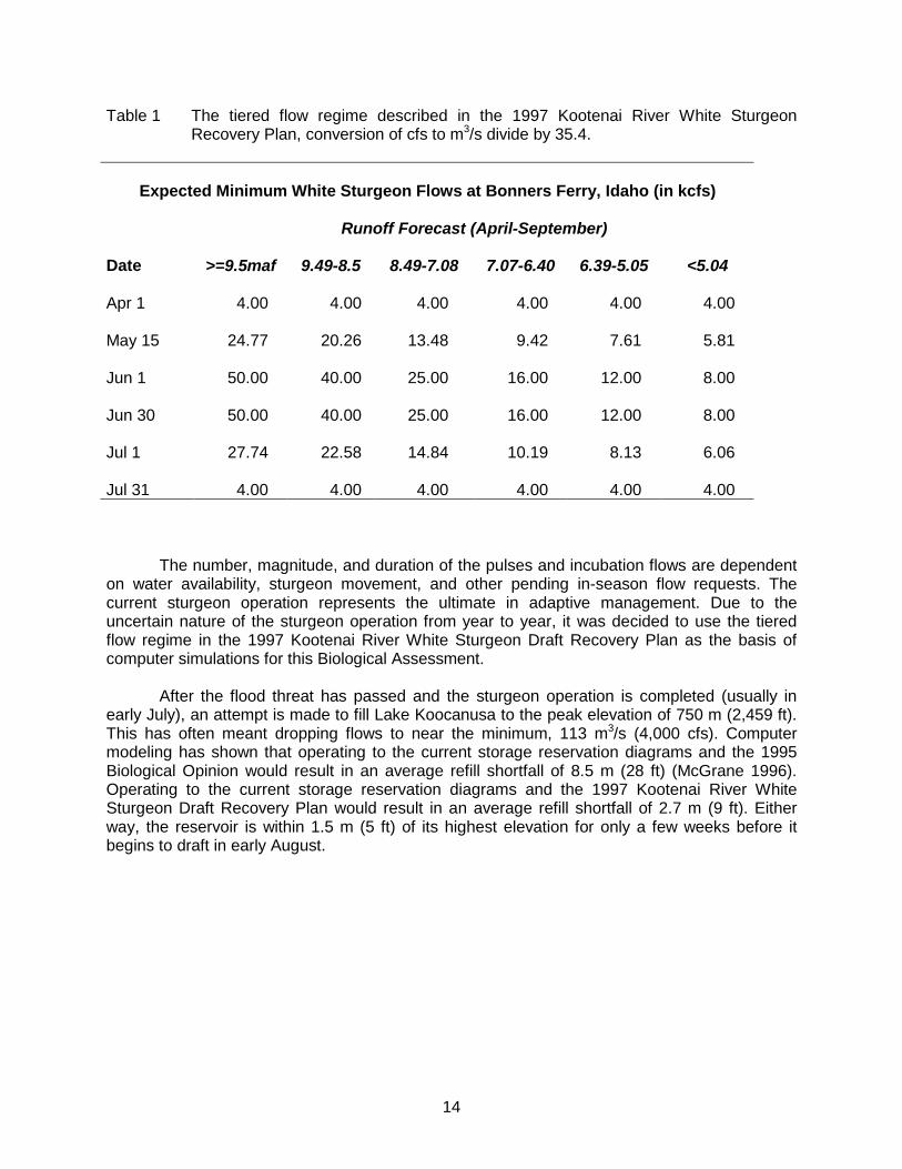
2.6.3 Libby Dam and Kootenai River White Sturgeon Recovery Flows
While the primary guidance for white sturgeon recovery is found in the 1995 Biological Opinion (aka BIOP), the US Fish and Wildlife Service has submitted additional guidelines for Libby Dam operation in 1996, 1997, 1998, and 1999 which are based on April final flow forecasts and storage of some water during winter. The current white sturgeon operation is between flow targets described in the 1995 BIOP, and the tiered flow regime described in the Kootenai River White Sturgeon Recovery Plan (USFWS, 1999) (Table 1). In general, the current sturgeon flow regime features at least one “pulse” of maximum powerhouse discharge of 708 m3/s (25,000 cfs) from Libby Dam for a minimum duration of three days coincident with the peak of the lowland runoff, and targeting water temperatures at Bonners Ferry above 10°C (50°F) (Figure 4). The pulse (or pulses) is followed by a period of incubation flow in the 312 to 708 m3/s (11,000 to 25,000 cfs) range, which is much higher at Bonners Ferry because of local inflow. A flow design for Kootenai River burbot will not conflict with recovery of sturgeon.
14
Table 1 The tiered flow regime described in the 1997 Kootenai River White Sturgeon Recovery Plan, conversion of cfs to m3/s divide by 35.4.
Expected Minimum White Sturgeon Flows at Bonners Ferry, Idaho (in kcfs)
The number, magnitude, and duration of the pulses and incubation flows are dependent on water availability, sturgeon movement, and other pending in-season flow requests. The current sturgeon operation represents the ultimate in adaptive management. Due to the uncertain nature of the sturgeon operation from year to year, it was decided to use the tiered flow regime in the 1997 Kootenai River White Sturgeon Draft Recovery Plan as the basis of computer simulations for this Biological Assessment.
After the flood threat has passed and the sturgeon operation is completed (usually in early July), an attempt is made to fill Lake Koocanusa to the peak elevation of 750 m (2,459 ft). This has often meant dropping flows to near the minimum, 113 m3/s (4,000 cfs). Computer modeling has shown that operating to the current storage reservation diagrams and the 1995 Biological Opinion would result in an average refill shortfall of 8.5 m (28 ft) (McGrane 1996). Operating to the current storage reservation diagrams and the 1997 Kootenai River White Sturgeon Draft Recovery Plan would result in an average refill shortfall of 2.7 m (9 ft). Either way, the reservoir is within 1.5 m (5 ft) of its highest elevation for only a few weeks before it begins to draft in early August.
Flood Control Draft Flood Control -Power ReleasesFlood Control -
Power Releases
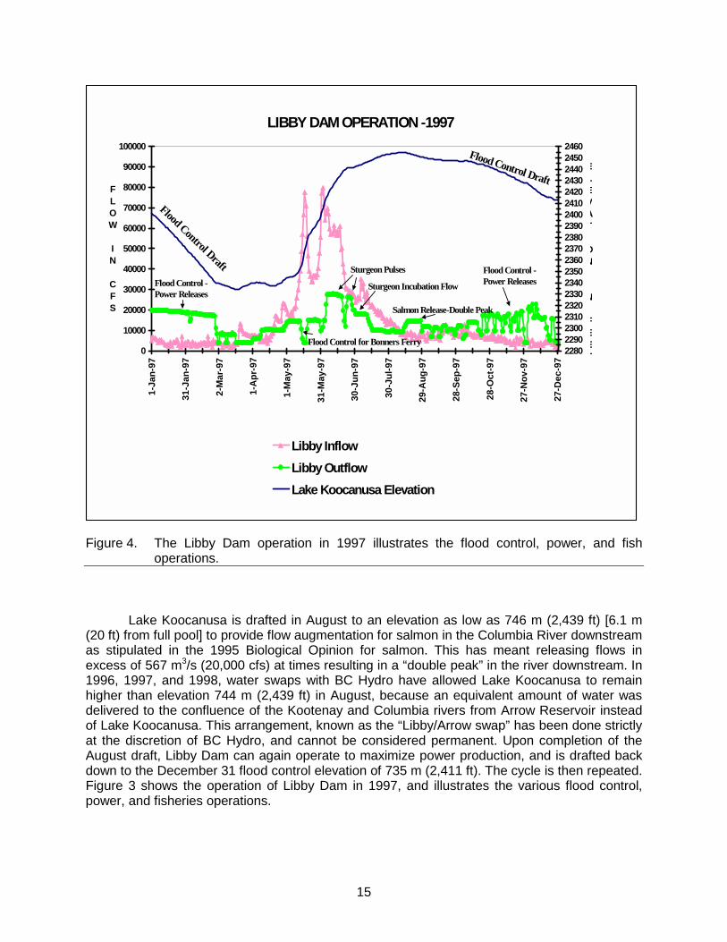
Sturgeon Pulses
Flood Control for Bonners Ferry
Sturgeon Incubation Flow
Salmon Release-Double Peak
Figure 4. The Libby Dam operation in 1997 illustrates the flood control, power, and fish
operations. Lake Koocanusa is drafted in August to an elevation as low as 746 m (2,439 ft) [6.1 m
(20 ft) from full pool] to provide flow augmentation for salmon in the Columbia River downstream as stipulated in the 1995 Biological Opinion for salmon. This has meant releasing flows in excess of 567 m3/s (20,000 cfs) at times resulting in a “double peak” in the river downstream. In 1996, 1997, and 1998, water swaps with BC Hydro have allowed Lake Koocanusa to remain higher than elevation 744 m (2,439 ft) in August, because an equivalent amount of water was delivered to the confluence of the Kootenay and Columbia rivers from Arrow Reservoir instead of Lake Koocanusa. This arrangement, known as the “Libby/Arrow swap” has been done strictly at the discretion of BC Hydro, and cannot be considered permanent. Upon completion of the August draft, Libby Dam can again operate to maximize power production, and is drafted back down to the December 31 flood control elevation of 735 m (2,411 ft). The cycle is then repeated. Figure 3 shows the operation of Libby Dam in 1997, and illustrates the various flood control, power, and fisheries operations.
16
2.6.4 Hydropower Operation of Libby Dam and Monetary Value
No submission by BPA.
3.0 Problems Confronting Burbot
3.1 Habitat
As previously mentioned, the Kootenai Basin has undergone many anthropogenic alterations (Daley et al. 1981; Northcoat 1973; Snyder and Minshall 1996; Anonymous 1996). However, many of these changes occurred before the collapse of the burbot fisheries (Paragamian et al. 2000). Paragamian et al (2000) summarized the case history of the burbot fisheries collapse; the most important factor responsible for the decline is thought to be winter flow management from Libby Dam a secondary factor may be the loss of primary and secondary productivity (Snyder and Minshall 1996).
3.2 Winter Flow Management
Operation of Libby Dam for hydropower and flood control changed the river’s natural hydrograph (low flows in summer and high flows in winter) and created warmer winter water temperatures (Partridge 1983; Paragamian et al. 2000). Winter flows are now more erratic and three to four times greater than pre-dam conditions. Burbot are winter spawners and are known to travel over 125 km (77.7 mi) to spawn (Bresser et al. 1988). Burbot in the Kootenai River are thought to have traveled up to 120 km (75 mi) from Kootenay Lake to spawn in tributaries in Idaho (Paragamian et al. 1995). Winter was the most environmentally stable period of the year prior to Libby Dam, when flows in the Kootenai River were at their lowest seasonal level (Figure 2). Burbot have low stamina (compared to 19 other species) and can become weak swimmers, and velocities in excess of 24 cm/s (9.4 in/s) affected sustained swimming endurance when subjected for more than 10 minutes (Jones et al. 1974); thus it is reasonable to believe increased flow could affect spawning migration.
The results of recent studies by IDFG researchers implicated winter flow management of
water from Libby Dam as a possible major cause for the decline in burbot. Burbot spawning migration in both activity and upstream passage was disrupted by elevated winter flows and water velocities from Libby Dam (Paragamian 2000). Elevated flows were due to hydropower production and evacuation of water from Lake Koocanusa for flood control. Increased flows caused and are directly related to increased river velocities.
Winter flows in the Kootenai River were once relatively stable. The specific effect of this
disruption to burbot spawning migration is unknown, but it may have diminished spawning fitness, changed the timing of spawning, reduced stamina, or even affected reproductive physiology. One or all of these possible outcomes could have been sufficient to collapse the fishery by reducing spawning success and recruitment to sustain the fishery.
Examination of the physical characteristics of the Kootenai River indicated migrations of
burbot might be further complicated when increased flows change some reaches of the river into velocity barriers or difficult passage locations (Paragamian 2000). Telemetry studies during 1994-1996 indicated few burbot moved above rkm 152 during high flows. Velocity
17
measurements during winter 1995-1996 indicated this reach had significantly higher velocities than other randomly selected sites. Other locations in the river may have similar or perhaps greater water velocities. Future flow management of the Kootenai River for burbot migrations may also need to take into consideration discharge and velocities at these specific sites.
3.3 Power Peaking
High fluctuating flows from Libby Dam appear to generate confusing migration cues and continuously disrupt burbot upstream spawning migrations (Paragamian 2000). Many burbot demonstrated repeated sequences of movement upstream, no movement, and/or fall back during the winters of 1994-1995 and 1997-1998 related to flow change. Daily differences in flow from Libby Dam during the winter range up to about 650 m3/s (23,000 cfs). As mentioned previously, burbot are winter spawners and under pre-dam conditions winter was the most environmentally stable time of the year.
Burbot are thought to be highly synchronous in their spawning (Becker 1975; Arndt and
Hutchinson 2000; Evenson 2000). In recent IDFG studies, burbot spawning synchrony may have been disrupted in several ways (Paragamian 2000). Paragamian (2000) found burbot travel time was slower during flows higher than 113 m3/s (4,000 cfs). Telemetry findings during winter 1994-1995 indicated three burbot that migrated to Idaho, from Kootenay Lake and the Kootenai River in BC, did not arrive until a month or more after the spawning season. At that point, water temperatures were above 7°C (44.6°F), and warmer than normal burbot prefer for spawning temperatures (Becker 1975). Inhibition of movement for spawning migration may also explain why some burbot failed to spawn that year, and why five of ten burbot monitored during the winter of 1997-1998 are believed to have failed to spawn (Paragamian 2000). Failure to spawn may have been due to excessive stress caused by changing flows of power peaking and flood control. Thus, in order for burbot, which are naturally slow moving, to reach spawning tributaries in Idaho it may take nearly a month to travel from Kootenay Lake. Any disruption is likely to affect arrival time to spawning areas.
3.4 River Temperature
Warmer winter temperatures in the Kootenai River may have masked the location of spawning tributaries of burbot. During the winters of 1994-1995 Paragamian (2000) found burbot appeared to be attracted to the colder water of the Goat River from the Kootenai River when temperatures were 0°C (33°F) and 4°C (40°F), respectively. Soon after this observation burbot ascended the Goat River to spawn. However, when the temperature of the two rivers was similar several days later, three additional burbot bypassed the Goat River on a suspected spawning journey into Idaho. The Goat River is the largest tributary to the Kootenai River between Bonners Ferry and Kootenay Lake, and also has the largest cold water input. Although other tributaries were substantially cooler than the Kootenai River, their low volume was diluted by the backwater effect of higher flow of warm water from the river. Despite the fact the Kootenai River was low during the winter of 2000-2001 temperatures in the river were still warmer than that of the Goat River by an average of about 2°C (4°F) (Kozfkay and Paragamian 2001).
18
3.5 Nutrient Losses
Lake Koocanusa, the impoundment created by Libby Dam, acts as a nutrient sink and has reduced productivity of the river (Snyder and Minshall 1996) and that of Kootenay Lake (Northcote 1973). Young burbot need food soon after hatching, and reduced productivity could also be an important factor to the loss of burbot. Unpublished data indicated the loss of primary productivity might have also played a role in the collapse of burbot (Paragamian 1994).
3.6 Spring Lowering of Kootenay Lake
Each spring, usually in March, Kootenay Lake is lowered about 2 m (6 ft) for flood control storage space; the lowering of 2 m (6 ft) is a pattern, not an absolute elevation. This activity does not violate the International Joint Commission (IJC) ruling on elevations of Kootenay Lake. This action in effect lowers the Kootenay River and causes a draft effect on tributary streams. Prior to the construction of the Cora Linn Dam and widening of the Grohman Narrows in the 1930s at the outlet of Kootenay Lake, the lake level would rise about 3 m (9.8 ft) in spring due to increased runoff from snowmelt and the outflow from the lake. Thus, the Kootenai River would have backed up into tributary stream mouths. The current draft effect increases velocities in the low gradient portions of the tributaries, which may wash out rearing larval burbot. This is a poorly understood aspect of the impact on burbot rearing but is an operation of the system that may also warrant further consideration. The only known larval burbot was caught in March 1999 in a ½ meter net tow below the confluence of the Goat and Kootenai rivers when Kootenay Lake was being drawn down.
4.0 Fisheries Management
Fishery managers regulate both the direct harvest and incidental take of fish through restrictive regulations and angler education. Currently, there is no legal burbot harvest opportunity for burbot in the Idaho section of the Kootenai River or in the Kootenay River and Kootenay Lake in British Columbia. Montana allows a limited harvest above and downstream of Libby Dam. However, burbot in Montana do not contribute to the population in Idaho and British Columbia.
5.0 Conservation Strategy
The burbot Conservation Goal is to maintain and restore multiple life history strategies, and maintain genetic diversity necessary to sustain a viable burbot population in the Kootenai River. For burbot population rehabilitation to occur, the physical and biological environment required by all life stages of the species must be restored and maintained, the best case scenario is a return to a normative river. Based on the best available information the most serious limiting factor to the burbot population in the Kootenai River is winter flow management and the associated high flows and velocities. Higher winter flows have also increased water temperatures several degrees and eliminated ice cover, this may also be a limiting factor to burbot. Of secondary importance appears to be the nutrient and productivity limitations in the river because Lake Koocanusa is a nutrient sink.
The objectives necessary to achieve rehabilitation of the burbot population must be
achievable and measurable. Rehabilitation of the burbot population is believed more likely if all
19
of the following measures are implemented and the process is facilitated through managing agencies with public involvement. Objectives must include:
5.1 Flow Manipulation
Based on the best available information the most important limiting factor is the relationship between winter flow and burbot migration. An important objective is to provide a hospitable migration corridor to burbot spawners from the lower river and Kootenay Lake to spawning tributaries in Idaho. Modification of present flood rule curves by the USACE and the return of flow in the Kootenai River, particularly during January and the first two weeks in February, to pre-dam levels of about 170 m3/s (6,000 cfs) may provide help in the recovery of burbot (Figure 4). Burbot would thus be conceded a travel corridor similar to natural conditions and allowed to migrate unimpeded to tributaries in Idaho. These changes are also expected to benefit burbot in Kootenay Lake, BC. Adoption of VARQ [a proposed USACE flow scheme for operation of the Columbia River Basin (USACE 1999)] and in combination with Kootenai Integrated Rule Curve (KIRC) to the operation of Libby Dam and the configuration of flows using this hydrologic measure would also be beneficial to burbot recovery. VARQ has a higher storage rate in winter than the present system of operation of Libby Dam. The higher storage rate is because VARQ releases less water in January and February and ensures more rapid and dependable refill for Lake Koocanusa.
5.2 Ecosystem Rehabilitation
To recover the burbot population, restoration of normative winter flows during the spawning migration, colder winter water temperatures, and the restoration of nutrients must be addressed. Normative winter flows were previously discussed in this text while colder winter temperatures are expected to occur with lower flows (slower moving water cools more rapidly). Juvenile rearing conditions must provide for adequate cover and food (fertilization of the Kootenai River or South Arm of Kootenay Lake). At present an additional limiting factor is thought to be the limited availability of nutrients for primary and secondary productivity. The Adaptive Ecosystem Assessment (AEA) methodology has proven in previous studies (Walters et al. 1997; Ashley et al. 1996) to be a useful tool in the prediction of ecosystem response to mitigation of environmental variables. AEA should be applied to the Kootenai River, and the response of burbot to the addition of nutrients to improve productivity should be measured. At the present time there is no information available on the response of burbot growth or productivity to nutrient additions. However, it is expected restoration of primary and secondary productivity to pre-Libby Dam levels will enhance recovery of burbot if flows change. This aspect of rehabilitation must also insure adequate spawning habitat conditions for burbot in tributaries. Tributaries at the valley floor are of low gradient. Flow conditions in the Kootenai River impact velocities and temperatures in tributaries on the valley floor. Within the rehabilitation of the ecosystem is the recognition that it is coordinated with recovery goals for other fish species; white sturgeon Acipenser transmontanus, bull trout Salvilinus confluentus, and rainbow trout Oncorhynchus mykiss.
5.3 Donor Stocks
Burbot stocks in the Kootenai River below Kootenai Falls have been depleted to the point where they may be near demographic extinction. If the stock has reached a point of an
20
unlikely recovery and the extinction risk is high; experimentation and/or addition of burbot of a similar genetic makeup and life history may be necessary to refound burbot in tributaries for recovery. The life history and population genetics of other burbot stocks in the drainage should be investigated, e.g. Duncan, trout and Moyie lakes. The most logical source at present is Duncan Lake. Burbot in Duncan Lake were found to have a similar genetic make up, based on mitochondrial DNA, to burbot in the Kootenai River (Kozfkay and Paragamian, in progress). It is not known if burbot were previously formed of discrete spawning stocks that could be termed metapopulations, or perhaps were part of a one “source sink” stock.
5.4 Confined Brood Stocks
Burbot reproduce in large schools, and spawners may have a strong affinity to other spawners. Burbot densities are so low that individual spawners may not be capable of locating others by chemosensory or other biophyisico means. Restoration of burbot could be enhanced by maintaining gravid burbot in an enclosure to act as attractants to other potential spawners. This is an experimental measure and should be managed as such.
5.5 Viable Stock Densities
Research needs must address the necessary answers to questions to rehabilitate burbot; for example, minimum spawning densities in tributaries, burbot behavior, and viable population numbers to achieve satisfactory recruitment of burbot cohorts. Very little is known regarding these subjects but they may play an essential role in understanding what is necessary to achieve the conservation goal.
5.6 Burbot Culture
Culture of burbot is an undeveloped area of endeavor. Any activities in this area would be entirely experimental and could not be a dependable means of recovery in the foreseeable future.
5.7 Additional Turbines at Libby Dam
At the present time BPA and the USACE consider additional turbines at Libby Dam as cost ineffective from a power production standpoint. In addition, although the USACE has authorization to seek funds for installation of up to three more turbines, it has no sponsorship for installation of more units. Another party would be needed to cost-share the power production, since normally the BPA is the marketer of Corps-generated power in the Columbia Basin. Furthermore, BPA does not wish to relinquish its right to develop additional units. However, additional turbines have a potential fisheries benefit including burbot recovery. Each additional turbine could boost discharge by 142 m3/s (5,000 cfs) while avoiding spill, which would generate high levels of dissolved gas and increase potential for gas bubble disease in aquatic organisms below the dam. This does not necessarily change the flood control rule curve to allow more winter storage. But if discharge potential is increased, spring flood control becomes more flexible, because higher inflows could be passed without danger of spilling when the reservoir is full, up to the downriver flood stage limit.
21
5.8 Spring Management of Kootenay Lake
This is a poorly understood aspect of Kootenay Lake that could have had an effect on burbot in the Kootenai River. The legal expertise in administering the control of elevations of Kootenay Lake is governed by the IJC Board of Control. The possible impact of lowering Kootenay Lake each spring should also be considered as a potential threat to larval burbot rearing in tributaries. Elimination of the spring draw-down of Kootenay Lake, drafting the lake at a much slower rate, setting the target elevation date for Kootenay Lake back by at least one month may prove beneficial to burbot.
5.9 Assessment Techniques
There is a need to continue working on adult and juvenile stock assessment methods in order to monitor recovery efforts and progress. Assessment techniques will vary depending on the needs of the objectives and tasks necessary for monitoring and evaluation.
5.10 Provide Protection From Illegal Harvest
There must be adequate protection from possible poaching during the implementation of the Conservation Strategy.
6.0 Monitoring, Compliance, and Review of Burbot Conservation
6.1 Status and Recovery Measures
6.1.1 Implementation Schedule
To be completed with adoption of a Conservation Agreement 6.1.2 Report Procedures
Monitoring and Evaluation efforts of Kootenai River burbot are funded by the Bonneville Power Administration (BPA); any reports or annual documents will correspond to those in the contract between IDFG and BPA.
6.1.3 Monitoring and Evaluation
A Hypothesis test using a scientific design, approved by the Kootenai River Burbot Recovery Committee, will be used to evaluate burbot movement, spawning, and recruitment. The study design should entail all aspects of recovery and testing as time and money permit. This section will be more fully completed with adoption of a Conservation Agreement
22
Participants in Developing the Kootenai River Burbot Conservation Strategy Jay Hammond Jeff Laufle British Columbia Ministry of Environment US Army Corps of Engineers Lands and Parks Sue Ireland Greg Hoffman Kootenai Tribe of Idaho Montana Fish Montana Fish Wildlife and Parks Wildlife and Parks Vaughn L. Paragamian Colin Spence Idaho Department of Fish and Game British Columbia Ministry of Environment
Lands and Parks Scott Bettin Bonneville Power Administration Scott Deeds US Fish and Wildlife Service
23
REFERENCES
Alden, W. C. 1953. Physiography and glacial geology of western Montana and adjacent areas. U.S. Geological Survey, Professional Paper 231, Helena, Montana.
Andrusak, H. 1976. Kootenay Lake sport fishery 1974-1976. British Columbia Ministry of
Environment, Fish and Wildlife Report, Nelson. Andrusak, H., and M. A. Crowley. 1978. Kootenay Lake sport fishery 1974-1976. British
Columbia Ministry of Environment, Fish and Wildlife Report, Nelson. Anonymous. 1996. History of diking on the Kootenay River floodplain in British Columbia.
Redwing Naturalists, Prepared for Habitat Enhancement Branch, Department of Fisheries and Oceans, Vancouver, BC.
Arndt, S. K. A., and J. Hutchinson. 2000. Characteristics of burbot spawning in a tributary to
Columbia Lake, British Columbia, over a four-year period. Pages 48-60 in V. L. Paragamian and D. W. Willis, editors. Burbot: biology, ecology, and management. American Fisheries Society, Fisheries Management Section, Publication Number 1, Bethesda, Maryland.
Ashley, K., L. C. Thompson, L. Haywood-Farmer, J. Yang, F. R. Pick, P. B. Hamilton, D. C.
Lasenby, K. E. Smokoroski, L. McEachern, D. Sebastian, and G. Scholten. 1996. Kootenay Lake fertilization experiment - year 3 (1994-95) report. Fisheries Project Report No. RD 49, British Columbia Ministry of Environment, Lands and Parks, Fisheries Branch, Vancouver, BC.
Becker, G. 1983. Fishes of Wisconsin. The University of Wisconsin Press. Madison, Wisconsin. Bonde, T. H., and R. M. Bush. 1975. Kootenai River water quality investigations, Libby Dam
pre-impoundment study 1967-1972. US Army Corps of Engineers, Washington, DC. Breeser, S. W., F. D. Stearns, M. W. Smith, R. L. West, and J. B. Reynolds. 1988. Observations
of movements and habitat preferences of burbot in an Alaskan glacial river system. Transactions of the American Fisheries Society 117:506-509.
Cloern, J. E. 1976. Recent limnological changes in southern Kootenay Lake, British Columbia.
Canadian Journal of Zoology 54:1571-1578. Daley, R. J., E. C. Carmack, C. B. Gray, C. H. Pharo, S. Jasper, and R. C. Wiegland. 1981. The
effects of upstream impoundments on Kootenay Lake, BC. Canada Inland Waters Directorate, Research Institute, Scientific Series, West Vancouver, BC.
Dwyer, T. 1996. Letter to General Ernest J. Harrell, Commander, North Pacific Division, US
Army Corps of Engineers, March 1, 1995. Biological Opinion on effects of operation of Federal Columbia River Power System on Kootenai River white sturgeon. Acting Regional Director of USFWS, Portland, Oregon.
24
Evenson, M. J. 1993. Seasonal movements of radio-implanted burbot in the Tanana River drainage. Alaska Department of Fish and Game, Division of Sport Fisheries, Fishery Data Series 93-47, Anchorage, Alaska.
Evenson, M. J. 2000. Reproductive traits of burbot in the Tanana River, Alaska. Pages 61-70 in
V. L. Paragamian and D. Willis, editors. Burbot: biology, management, and ecology. Fisheries Management Section, American Fisheries Society, Publication Number 1, Bethesda, Maryland.
Faber, D. J. 1970. Ecological observations of newly hatched lake whitefish in South Bay Lake
Huron. pages. 481-500 in C. C. Lindsey and C. S. Woods, editors. Biology of Coregonid fishes, University of Manitoba Press, Winnipeg.
Fisher, S. J., D. W. Willis, and K. L. Pope. 1996. An assessment of burbot Lota lota weight-
length data from North American populations. Canadian Journal of Zoology 74:570-575. Fratt, T. W. 1991. Trophic ecology of burbot and lake trout in Green Bay and Lake Michigan with
information for burbot fecundity, gonadosomatic index, sea lamprey marks, and acanthocephalens. Master’s Thesis University of Wisconsin, Stevens Point, Wisconsin.
Ghan, D., and W. G. Sprules. 1993. Diet, prey selection and growth of larval and juvenile burbot
Lota lota (L.). Journal of Fish Biology 42:47-64. Jones, D. R., J. W. Kiceniuk, and O. S. Bamford. 1974. Evaluation of the swimming
performance of several species of fish from the Mackenzie River. Journal of the Fisheries Research Board of Canada 31:1641-1647.
Jones, J. R., and R. Bachman. 1976. Prediction of phosphorus and chlorophyll levels in lakes.
Journal of Water Pollution Control Federation 48:2176-2182. Kozfkay, J., and V. L. Paragamian. In progress. Kootenai River fisheries inventory: stock status
of burbot. Idaho Department of Fish and Game. Bonneville Power Administration, Annual Progress Report, Project 88-65, Boise, Idaho.
Martin, A. D. 1976. Kootenay Lake burbot fishery. Miscellaneous student report provided to the
British Columbia Ministry of Environment, Nelson. Martin, A. D., and T. G. Northcote. 1991. Kootenay Lake: an inappropriate model for Mysis
relicta introduction in north temperate lakes. American Fisheries Society Symposium 9:23-29.
MacKay, M. A. 1963. Fishes of Ontario. The Bryant Press Limited, Toronto. McGrane, P. C. 1996. Local flood control objectives for Libby Dam project. Memorandum of
Record. US Army Corps of Engineers, Seattle District, Hydraulics and Hydrology files, July 30, 1996.
McCrimmon, H. R. 1959. Observations of burbot spawning in Lake Simcoe, Ontario. Journal of
Wildlife Management 23:447-449.
25
McPhail, J. D. 1995. A review of burbot Lota lota life history and habitat use in relation to compensation and improvement opportunities. British Columbia Ministry of Environment, Vancouver, BC.
McPhail, J. D., and C. C. Lindsey. 1970. Freshwater fishes of Alaska and northwest Canada.
Fisheries Research Board of Canada, Bulletin 173, Ottawa. Mills, M. 1994. Harvest, catch, and participation in Alaskan sport fisheries during 1993. Alaska
Department of Fish and Game, Fisheries Data Series No. 94-28, Anchorage, Alaska. Morrow, J. E. 1980. The freshwater fishes of Alaska. Alaska Northwest Publishing, Anchorage,
Alaska. Northcote, T. G. 1973. Some impacts of man on Kootenay Lake and its salmonids. Great Lakes
Fishery Commission, Technical Report Number 25, Ann Arbor, Michigan. NMFS. 1995. Endangered species Act – Section 7 Consultation. Biological Opinion: Reinitiation
of consultation on 1994-1998 operation of the Federal Columbia River Power System and juvenile transportation program in 1995 and future years. Consultation by National Marine Fisheries Service, Northwest Region. US Army Corps of Engineers, Bonneville Power Administration, Bureau of Reclamation, National Marine Fisheries Service.
Opinion on the operation of the Federal Columbia River Power System and juvenile transportation program: a supplemental to the Biological Opinion signed on March 2, 1995, for the same projects [Consultation number 10005]. Northwest Region Seattle, Washington, May 14,1998.
Paragamian, V. L. 1993. Kootenai River fisheries inventory: stock status of burbot and rainbow
trout and fisheries inventory. Idaho Department of Fish and Game and Bonneville Power Administration, Annual Progress Report, Project 88-65, Boise, Idaho.
Paragamian, V. L. 1994. Kootenai River fisheries inventory: stock status of burbot and rainbow
trout and fisheries inventory. Idaho Department of Fish and Game, Bonneville Power Administration, Project 88-65. Boise, Idaho.
Paragamian, V. L. 1995. Kootenai River fisheries inventory: stock status of burbot and rainbow
trout and fisheries inventory. Idaho Department of Fish and Game. Bonneville Power Administration, Annual Progress Report, Project 88-65, Boise, Idaho.
Paragamian, V. L. 2000. The effects of variable flows on burbot spawning migrations in the
Kootenai River, Idaho, USA, and British Columbia, Canada. Pages 111-123 in V. L. Paragamian and D. W. Willis, editors. Burbot: biology, ecology, and management. American Fisheries Society, Fisheries Management Section, Publication Number 1, Bethesda, Maryland.
Paragamian, V. L., and V. Whitman. 1996. Kootenai River fisheries inventory: stock status of
burbot. Idaho Department of Fish and Game. Bonneville Power Administration, Annual Progress Report, Project 88-65, Boise, Idaho.
26
Paragamian, V. L., M. Powell, and J. Falure. 1999. Mitochondrial DNA analysis of burbot Lota lota stocks in the Kootenai River Basin of British Columbia, Montana, and Idaho. Transactions of the American Fisheries Society 128:854-860.
Paragamian, V. L., V. Whitman, J. Hammond, and H. Andrusak. 2000. Collapse of burbot
fisheries in the Kootenai River, Idaho, USA, and Kootenay Lake, British Columbia, Canada. Pages 155-164 in V. L. Paragamian and D. W. Willis, editors. Burbot: biology, ecology, and management. American Fisheries Society, Fisheries Management Section, Publication Number 1, Bethesda, Maryland.
Partridge, F. 1983. Kootenai River fisheries investigations. Idaho Department of Fish and Game,
Federal Aid in Sport Fish Restoration, Project F-73-R-5, Completion Report, Boise, Idaho.
Ryder, R. A., and J. Pesendorfer. 1992. Food, growth, habitat, and community interactions of
young of-the-year burbot, Lota lota (L.) in a Precambrian Shield lake. Hydrobiologia 243/244:211-227.
Schaeffer, C. 1940. The subsistence quest of the Kutenai: a study of the interaction of culture
and environment. Kootenai Tribe. Unpublished Ph.D. dissertation. University of Pennsylvania.
Simpson, J., and R. Wallace. 1982. Fishes of Idaho. The University of Idaho Press, Moscow,
Idaho. Sinclair, D. C., and M. A. Crowley. 1969. Kootenay Lake sport fishery, 1962-1968. British
Columbia Ministry of Environment Fish and Wildlife, Nelson. Skarr, D., J. DeShazer, L. Garrow, T. Ostrowski, and B. Thornburg. 1996. Quantification of
Libby Reservoir levels needed to maintain or enhance reservoir fisheries. Montana Department of Fish, Wildlife, and Parks and Bonneville Power Administration, Project 83-467 Completion Report, Kalispell, Montana.
Smith, S. E. 1968. Species succession and fishery exploitation in the Great Lakes. Journal of
the Fisheries Research Board of Canada 25:667-693. Snyder, E. B., and G. W. Minshall. 1996. Ecosystem metabolism and nutrient dynamics in the
Kootenai River in relation to impoundment and flow enhancement for fisheries management. Stream Ecology Center, Idaho State University, Completion Report, Pocatello, Idaho.
Taube, T. and D. R. Bernard. 1995. Stock assessment and biological characteristics of burbot in
Lake Louise and Tolsona Lake, Alaska, 1994. Alaska Department of Fish and Game, Fishery Data Series No. 95-14, Anchorage, Alaska.
Turney-High, H. H. 1941. Memoirs of the American Anthropological Association: Ethnography of
the Kutenai. American Anthropological Association. Menasha. USACE. 1999. Status report – work to date on the development of the VARQ flood control
operation at Libby Dam and Hungry Horse Dam. US Army Corps of Engineers, Northwest Division, North Pacific Region. Portland, Oregon.
27
USFWS. 1999. Recovery plan for the Kootenai River population of the white sturgeon Acipenser
transmontanus. Region 1, US Fish and Wildlife Service, Portland, Oregon. Vachta, R. 1990. The food spectrum and growth of burbot Lota lota fry in experimental
conditions. Bulletin Vuhr, Vodnany 26:14-19. Vincent-Lang, D. 1993. Area management report for the recreational fishery in the upper
Copper/upper Susitna River management area. Alaska Department of Fish and Game, Division of Sport Fish, Anchorage, Alaska.
Wells, L., and A. L. McLain. 1973. Lake Michigan. Man’s effects on native fish stocks and other
biota. Great Lakes Fishery Commission Technical Report No. 20. Ann Arbor, Michigan.