REPORT RECONNAISSANCE OFFSHORE SAND SEARCH (ROSS) PRELIMINARY INVENTORY REPORT Prepared for Florida Department of Environmental Protection Bureau of Beaches and Coastal Systems 3900 Commonwealth Boulevard Tallahassee, Florida January 22, 2009 URS Corporation 1625 Summit Lake Drive, Ste. 200 Tallahassee, FL 32317
ROSS Preliminary Inventory Report Pursuant to Section 161.144, Florida Statutes, the Legislature has mandated that the Department of Environmental Protection (FDEP) “…shall develop and maintain an inventory of identified offshore sand sources as part of the regional elements of its comprehensive long-term beach management plan. Offshore sand sources in state or federal waters which are identified for potential, proposed, or permitted use shall be clearly mapped or otherwise noted and readily available for public review”. A Preliminary Inventory Report organized by Borrow Area type and subdivided by county is presented here. The Report lists in tabular format selected information from the ROSS Oracle database. This information includes county name, Project Name, Project Date, Project ID, Report Date, JCP#, Borrow Area Name, Borrow Area ID, Polygon Centroid lat/long coordinates, and descriptive information on the location of the borrow area. Sand sources will be categorized as potential, proposed or permitted in accordance with its current designation on ROSS. The system-generated preliminary inventory report will be converted to a .pdf file, posted on the ROSS web site and made readily available for public review through a link on the home page of ROSS. FDEP will also provide a link to the inventory report on the BBCS web site. The published inventory will be periodically updated by URS as authorized work under the existing contract Task Assignment #5 for ROSS maintenance and geotechnical services.
ROSS Preliminary Inventory Report Field Definitions County – The county off which the borrow area is located. This is not related to jurisdictional status. Project Name – The name of the project for which the borrow area was determined. Project Date – The date of the actual project. Project ID – A ROSS internally generated discrete identification number assigned to allow for easier searching. Report Date – The date the report was completed. JCP# - The FDEP Joint Coastal Permitting section’s permit number assigned to a specific borrow area. Borrow Area Name – The name assigned to a particular borrow area. This field may match information in the Borrow Area ID field. Borrow Area ID – An identifier for a particular borrow area. Polygon Centroid – A latitude/longitude coordinate located in the center of the borrow area polygon. Used for locational purposes. Borrow Area Location – A written description of the location of the centroid of the borrow area. This is based off bearing and distance from a Florida Range Monument located nearest to the borrow area.
Permitted
Bay
ROSS Preliminary Inventory Report: Permitted Borrow Area
179
2005 Panama City Beach Sand Search Investigation
10/12/2005
PROJECT INFORMATION
Project ID:
Project Name:
Project Date:
0128852001-JC
IIC
JCP #:
Borrow Area Name:
Borrow Area ID:
BayCounty:
Report Date: Mar, 2000
Polygon Centroid: 30.16169464
Borrow Area Polygon Location:
Located off of Bay County, near Bay County Pier and Park. The centroid of the borrow area is located at a bearing of 203˚ and a distance of 6356 feet from Range Monument R065
-85.81844647Latitude = Longitude =
Data Compiled By: URS Corporation 1625 Summit Lake Drive Tallahassee, FL 32317 Phone 850-574-3197
ROSS Preliminary Inventory Report: Permitted Borrow Area
179
2005 Panama City Beach Sand Search Investigation
10/12/2005
PROJECT INFORMATION
Project ID:
Project Name:
Project Date:
0128852001-JC
VIIB
JCP #:
Borrow Area Name:
Borrow Area ID:
BayCounty:
Report Date: Mar, 2000
Polygon Centroid: 30.24829841
Borrow Area Polygon Location:
Located off of the western side of Bay County, south of Sunnyside. The centroid of the borrow area is located at a bearing of 212˚ and a distance of 2172 feet from Range Monument R012
-85.96019676Latitude = Longitude =
Data Compiled By: URS Corporation 1625 Summit Lake Drive Tallahassee, FL 32317 Phone 850-574-3197
ROSS Preliminary Inventory Report: Permitted Borrow Area
179
2005 Panama City Beach Sand Search Investigation
10/12/2005
PROJECT INFORMATION
Project ID:
Project Name:
Project Date:
0128852001-JC
VIB
JCP #:
Borrow Area Name:
Borrow Area ID:
BayCounty:
Report Date: Mar, 2000
Polygon Centroid: 30.23724655
Borrow Area Polygon Location:
Located off of Bay County, near Laguna Beach. The centroid of the borrow area is located at a bearing of 187˚ and a distance of 2191 feet from Range Monument R020
-85.93510702Latitude = Longitude =
Data Compiled By: URS Corporation 1625 Summit Lake Drive Tallahassee, FL 32317 Phone 850-574-3197
ROSS Preliminary Inventory Report: Permitted Borrow Area
179
2005 Panama City Beach Sand Search Investigation
10/12/2005
PROJECT INFORMATION
Project ID:
Project Name:
Project Date:
0128852001-JC
V
JCP #:
Borrow Area Name:
Borrow Area ID:
BayCounty:
Report Date: Mar, 2000
Polygon Centroid: 30.21351696
Borrow Area Polygon Location:
Located off of Bay County, near Panama City Pier. The centroid of the borrow area is located at a bearing of 223˚ and a distance of 2384 feet from Range Monument R038
-85.88784681Latitude = Longitude =
Data Compiled By: URS Corporation 1625 Summit Lake Drive Tallahassee, FL 32317 Phone 850-574-3197
ROSS Preliminary Inventory Report: Permitted Borrow Area
179
2005 Panama City Beach Sand Search Investigation
10/12/2005
PROJECT INFORMATION
Project ID:
Project Name:
Project Date:
0128852001-JC
IIA
JCP #:
Borrow Area Name:
Borrow Area ID:
BayCounty:
Report Date: Mar, 2000
Polygon Centroid: 30.159978
Borrow Area Polygon Location:
Located off of Bay County, near Gulf Lagoon Beach. The centroid of the borrow area is located at a bearing of 214˚ and a distance of 4004 feet from Range Monument R071
-85.80206217Latitude = Longitude =
Data Compiled By: URS Corporation 1625 Summit Lake Drive Tallahassee, FL 32317 Phone 850-574-3197
ROSS Preliminary Inventory Report: Permitted Borrow Area
179
2005 Panama City Beach Sand Search Investigation
10/12/2005
PROJECT INFORMATION
Project ID:
Project Name:
Project Date:
0128852001-JC
I
JCP #:
Borrow Area Name:
Borrow Area ID:
BayCounty:
Report Date: Mar, 2000
Polygon Centroid: 30.11381035
Borrow Area Polygon Location:
Located off of Bay County, near Biltmore Beach and St. Andrews State Park. The centroid of the borrow area is located at a bearing of 227˚ and a distance of 7653 feet from Range Monument R094
-85.75657487Latitude = Longitude =
Data Compiled By: URS Corporation 1625 Summit Lake Drive Tallahassee, FL 32317 Phone 850-574-3197
ROSS Preliminary Inventory Report: Permitted Borrow Area
179
2005 Panama City Beach Sand Search Investigation
10/12/2005
PROJECT INFORMATION
Project ID:
Project Name:
Project Date:
0128852001-JC
VIIIB
JCP #:
Borrow Area Name:
Borrow Area ID:
BayCounty:
Report Date: Mar, 2000
Polygon Centroid: 30.25496453
Borrow Area Polygon Location:
Located off of the western side of Bay County, south of Hollywood Beach. The centroid of the borrow area is located at a bearing of 208˚ and a distance of 1793 feet from Range Monument R007
-85.97352623Latitude = Longitude =
Data Compiled By: URS Corporation 1625 Summit Lake Drive Tallahassee, FL 32317 Phone 850-574-3197
ROSS Preliminary Inventory Report: Permitted Borrow Area
179
2005 Panama City Beach Sand Search Investigation
10/12/2005
PROJECT INFORMATION
Project ID:
Project Name:
Project Date:
0128852001-JC
VIC
JCP #:
Borrow Area Name:
Borrow Area ID:
BayCounty:
Report Date: Mar, 2000
Polygon Centroid: 30.23343042
Borrow Area Polygon Location:
Located off of Bay County, near Laguna Beach. The centroid of the borrow area is located at a bearing of 201˚ and a distance of 3400 feet from Range Monument R021
-85.9351656Latitude = Longitude =
Data Compiled By: URS Corporation 1625 Summit Lake Drive Tallahassee, FL 32317 Phone 850-574-3197
ROSS Preliminary Inventory Report: Permitted Borrow Area
179
2005 Panama City Beach Sand Search Investigation
10/12/2005
PROJECT INFORMATION
Project ID:
Project Name:
Project Date:
0128852001-JC
VIIC
JCP #:
Borrow Area Name:
Borrow Area ID:
BayCounty:
Report Date: Mar, 2000
Polygon Centroid: 30.24735642
Borrow Area Polygon Location:
Located off of the western side of Bay County, south of Sunnyside. The centroid of the borrow area is located at a bearing of 198˚ and a distance of 1936 feet from Range Monument R013
-85.95568525Latitude = Longitude =
Data Compiled By: URS Corporation 1625 Summit Lake Drive Tallahassee, FL 32317 Phone 850-574-3197
ROSS Preliminary Inventory Report: Permitted Borrow Area
179
2005 Panama City Beach Sand Search Investigation
10/12/2005
PROJECT INFORMATION
Project ID:
Project Name:
Project Date:
0128852001-JC
VIIA
JCP #:
Borrow Area Name:
Borrow Area ID:
BayCounty:
Report Date: Mar, 2000
Polygon Centroid: 30.24479518
Borrow Area Polygon Location:
Located off of the western side of Bay County, near Laguna Beach. The centroid of the borrow area is located at a bearing of 194˚ and a distance of 1845 feet from Range Monument R015
-85.94965776Latitude = Longitude =
Data Compiled By: URS Corporation 1625 Summit Lake Drive Tallahassee, FL 32317 Phone 850-574-3197
ROSS Preliminary Inventory Report: Permitted Borrow Area
179
2005 Panama City Beach Sand Search Investigation
10/12/2005
PROJECT INFORMATION
Project ID:
Project Name:
Project Date:
0128852001-JC
IIB
JCP #:
Borrow Area Name:
Borrow Area ID:
BayCounty:
Report Date: Mar, 2000
Polygon Centroid: 30.16404809
Borrow Area Polygon Location:
Located off of Bay County, near Bay County Pier and Park. The centroid of the borrow area is located at a bearing of 205˚ and a distance of 4336 feet from Range Monument R067
-85.81089329Latitude = Longitude =
Data Compiled By: URS Corporation 1625 Summit Lake Drive Tallahassee, FL 32317 Phone 850-574-3197
ROSS Preliminary Inventory Report: Permitted Borrow Area
179
2005 Panama City Beach Sand Search Investigation
10/12/2005
PROJECT INFORMATION
Project ID:
Project Name:
Project Date:
0128852001-JC
VIIIA
JCP #:
Borrow Area Name:
Borrow Area ID:
BayCounty:
Report Date: Mar, 2000
Polygon Centroid: 30.25401039
Borrow Area Polygon Location:
Located off of the western side of Bay County, south of Hollywood Beach. The centroid of the borrow area is located at a bearing of 191˚ and a distance of 2402 feet from Range Monument R006
-85.9754491Latitude = Longitude =
Data Compiled By: URS Corporation 1625 Summit Lake Drive Tallahassee, FL 32317 Phone 850-574-3197
ROSS Preliminary Inventory Report: Permitted Borrow Area
179
2005 Panama City Beach Sand Search Investigation
10/12/2005
PROJECT INFORMATION
Project ID:
Project Name:
Project Date:
0128852001-JC
III
JCP #:
Borrow Area Name:
Borrow Area ID:
BayCounty:
Report Date: Mar, 2000
Polygon Centroid: 30.17762062
Borrow Area Polygon Location:
Located off of Bay County, near Bay County Pier and Park. The centroid of the borrow area is located at a bearing of 187˚ and a distance of 3447 feet from Range Monument R059
-85.82811631Latitude = Longitude =
Data Compiled By: URS Corporation 1625 Summit Lake Drive Tallahassee, FL 32317 Phone 850-574-3197
ROSS Preliminary Inventory Report: Permitted Borrow Area
179
2005 Panama City Beach Sand Search Investigation
10/12/2005
PROJECT INFORMATION
Project ID:
Project Name:
Project Date:
0128852001-JC
VIA
JCP #:
Borrow Area Name:
Borrow Area ID:
BayCounty:
Report Date: Mar, 2000
Polygon Centroid: 30.23079649
Borrow Area Polygon Location:
Located off of Bay County, near Laguna Beach. The centroid of the borrow area is located at a bearing of 193˚ and a distance of 2273 feet from Range Monument R025
-85.92184504Latitude = Longitude =
Data Compiled By: URS Corporation 1625 Summit Lake Drive Tallahassee, FL 32317 Phone 850-574-3197
Brevard
ROSS Preliminary Inventory Report: Permitted Borrow Area
217
1998 Breavard County Shore Protection Project - South Reach Borrow Area
1/1/1998
PROJECT INFORMATION
Project ID:
Project Name:
Project Date:
Canaveral Shoals Borrow Area I
JCP #:
Borrow Area Name:
Borrow Area ID:
BrevardCounty:
Report Date:
Polygon Centroid: 28.43235026
Borrow Area Polygon Location:
Located off of Brevard County, east, southeast of Cape Canaveral. The centroid of the borrow area is located at a bearing of 127˚ and a distance of 14022 feet from Range Monument V141
-80.49430183Latitude = Longitude =
Data Compiled By: URS Corporation 1625 Summit Lake Drive Tallahassee, FL 32317 Phone 850-574-3197
ROSS Preliminary Inventory Report: Permitted Borrow Area
217
1998 Breavard County Shore Protection Project - South Reach Borrow Area
1/1/1998
PROJECT INFORMATION
Project ID:
Project Name:
Project Date:
Canaveral Shoals Borrow Area II
JCP #:
Borrow Area Name:
Borrow Area ID:
BrevardCounty:
Report Date:
Polygon Centroid: 28.40594957
Borrow Area Polygon Location:
Located off of Brevard County, east, southeast of Cape Canaveral. The centroid of the borrow area is located at a bearing of 122˚ and a distance of 33018 feet from Range Monument V141
-80.44534315Latitude = Longitude =
Data Compiled By: URS Corporation 1625 Summit Lake Drive Tallahassee, FL 32317 Phone 850-574-3197
ROSS Preliminary Inventory Report: Permitted Borrow Area
217
1998 Breavard County Shore Protection Project - South Reach Borrow Area
1/1/1998
PROJECT INFORMATION
Project ID:
Project Name:
Project Date:
Space Coast Shoals Borrow Area II
JCP #:
Borrow Area Name:
Borrow Area ID:
BrevardCounty:
Report Date:
Polygon Centroid: 28.22683477
Borrow Area Polygon Location:
Located off of Brevard County, east of Patrick Air Force Base. The centroid of the borrow area is located at a bearing of 83˚ and a distance of 15351 feet from Range Monument R072
-80.55431328Latitude = Longitude =
Data Compiled By: URS Corporation 1625 Summit Lake Drive Tallahassee, FL 32317 Phone 850-574-3197
Broward
ROSS Preliminary Inventory Report: Permitted Borrow Area There are currently no Permitted Borrow Areas located off of this county. This page has been inserted as a place holder to be replaced with updated information should Permitted Borrow Areas be established offshore of this County.
Charlotte
ROSS Preliminary Inventory Report: Permitted Borrow Area There are currently no Permitted Borrow Areas located off of this county. This page has been inserted as a place holder to be replaced with updated information should Permitted Borrow Areas be established offshore of this County.
Citrus
ROSS Preliminary Inventory Report: Permitted Borrow Area There are currently no Permitted Borrow Areas located off of this county. This page has been inserted as a place holder to be replaced with updated information should Permitted Borrow Areas be established offshore of this County.
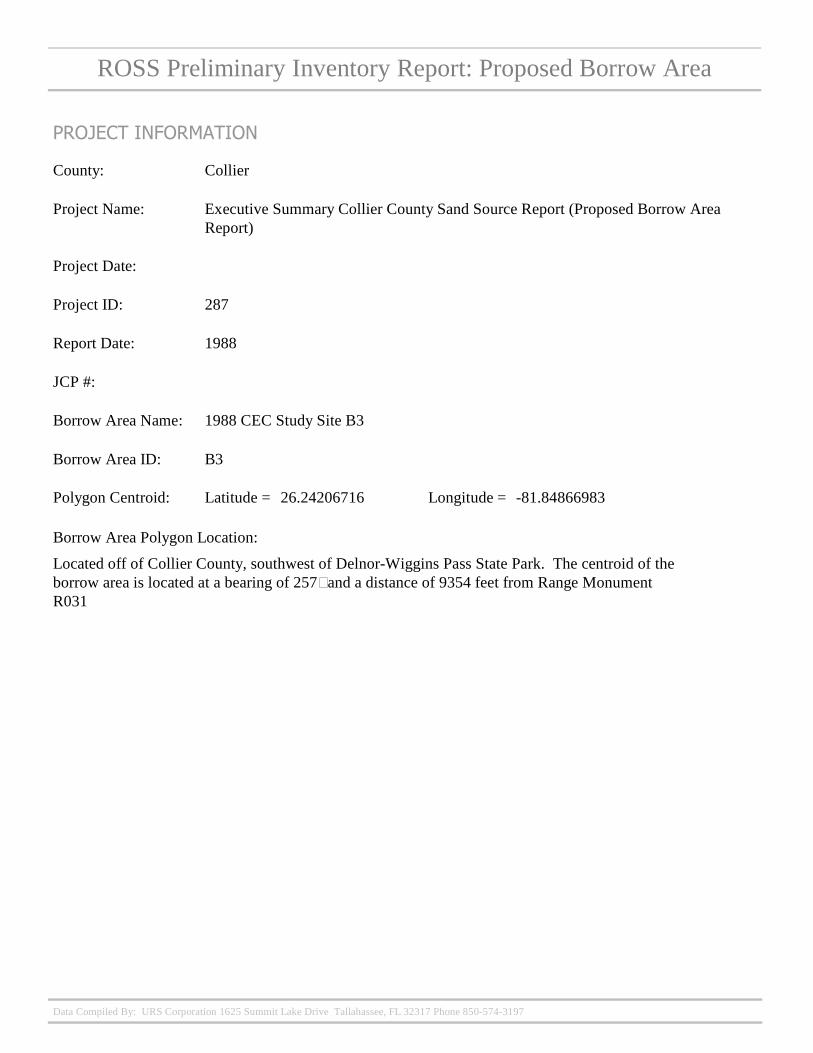
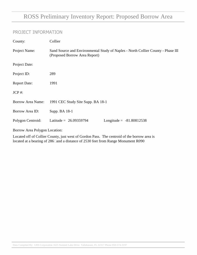
Collier
ROSS Preliminary Inventory Report: Permitted Borrow Area
306
Collier County Restoration Project Post-Construction Monitoring (Permitted Borrow Area Report)
PROJECT INFORMATION
Project ID:
Project Name:
Project Date:
CEC Dredged Borrow Area 6
BA 6
JCP #:
Borrow Area Name:
Borrow Area ID:
CollierCounty:
Report Date: 1996
Polygon Centroid: 26.20038798
Borrow Area Polygon Location:
Located off of Collier County, northwest of Naples Municipal Beach. The centroid of the borrow area is located at a bearing of 268? and a distance of 6335 feet from Range Monument R048
-81.83439216Latitude = Longitude =
Data Compiled By: URS Corporation 1625 Summit Lake Drive Tallahassee, FL 32317 Phone 850-574-3197
ROSS Preliminary Inventory Report: Permitted Borrow Area
306
Collier County Restoration Project Post-Construction Monitoring (Permitted Borrow Area Report)
PROJECT INFORMATION
Project ID:
Project Name:
Project Date:
CEC Dredged Borrow Area NB-IIC
NB-IIC
JCP #:
Borrow Area Name:
Borrow Area ID:
CollierCounty:
Report Date: 1996
Polygon Centroid: 26.13038349
Borrow Area Polygon Location:
Located off of Collier County, west, southwest of Naples Municipal Beach. The centroid of the borrow area is located at a bearing of 263? and a distance of 32466 feet from Range Monument R070
-81.90117249Latitude = Longitude =
Data Compiled By: URS Corporation 1625 Summit Lake Drive Tallahassee, FL 32317 Phone 850-574-3197
ROSS Preliminary Inventory Report: Permitted Borrow Area
306
Collier County Restoration Project Post-Construction Monitoring (Permitted Borrow Area Report)
PROJECT INFORMATION
Project ID:
Project Name:
Project Date:
CEC Dredged BA NB-III-B
NB-IIB
JCP #:
Borrow Area Name:
Borrow Area ID:
CollierCounty:
Report Date: 1996
Polygon Centroid: 26.14787205
Borrow Area Polygon Location:
Located off of Collier County, west, southwest of Naples Municipal Beach. The centroid of the borrow area is located at a bearing of 257? and a distance of 44303 feet from Range Monument R057
-81.94022102Latitude = Longitude =
Data Compiled By: URS Corporation 1625 Summit Lake Drive Tallahassee, FL 32317 Phone 850-574-3197
ROSS Preliminary Inventory Report: Permitted Borrow Area
306
Collier County Restoration Project Post-Construction Monitoring (Permitted Borrow Area Report)
PROJECT INFORMATION
Project ID:
Project Name:
Project Date:
CEC Dredged BA NB-IIA
NB-IIA
JCP #:
Borrow Area Name:
Borrow Area ID:
CollierCounty:
Report Date: 1996
Polygon Centroid: 26.13542324
Borrow Area Polygon Location:
Located off of Collier County, west, southwest of Naples Municipal Beach. The centroid of the borrow area is located at a bearing of 261? and a distance of 35889 feet from Range Monument R065
-81.91185192Latitude = Longitude =
Data Compiled By: URS Corporation 1625 Summit Lake Drive Tallahassee, FL 32317 Phone 850-574-3197
ROSS Preliminary Inventory Report: Permitted Borrow Area
29
Phase III Sand Search: Detailed Geotechnical and Geophysical Investigations Collier County, Florida
6/12/2003
PROJECT INFORMATION
Project ID:
Project Name:
Project Date:
Borrow Area T1
T1
JCP #:
Borrow Area Name:
Borrow Area ID:
CollierCounty:
Report Date: 2004
Polygon Centroid: 26.39523427
Borrow Area Polygon Location:
Located off of Collier County, west of Captiva Island. The centroid of the borrow area is located at a bearing of 245˚ and a distance of 74135 feet from Range Monument R108
-82.3805172Latitude = Longitude =
Data Compiled By: URS Corporation 1625 Summit Lake Drive Tallahassee, FL 32317 Phone 850-574-3197
ROSS Preliminary Inventory Report: Permitted Borrow Area
29
Phase III Sand Search: Detailed Geotechnical and Geophysical Investigations Collier County, Florida
6/12/2003
PROJECT INFORMATION
Project ID:
Project Name:
Project Date:
Borrow Area N5
N5
JCP #:
Borrow Area Name:
Borrow Area ID:
CollierCounty:
Report Date: 2004
Polygon Centroid: 26.15059658
Borrow Area Polygon Location:
Located off of Collier County, west, southwest of Naples Municipal Beach. The centroid of the borrow area is located at a bearing of 254˚ and a distance of 31093 feet from Range Monument R057
-81.90120782Latitude = Longitude =
Data Compiled By: URS Corporation 1625 Summit Lake Drive Tallahassee, FL 32317 Phone 850-574-3197
Dade
ROSS Preliminary Inventory Report: Permitted Borrow Area
137
Dade County Beach Erosion Control Project GDM
PROJECT INFORMATION
Project ID:
Project Name:
Project Date:
Borrow Area E
JCP #:
Borrow Area Name:
Borrow Area ID:
DadeCounty:
Report Date:
Polygon Centroid: 25.83909206
Borrow Area Polygon Location:
Located off of Dade County, east of 65th Street Park. The centroid of the borrow area is located at a bearing of 101˚ and a distance of 10130 feet from Range Monument R046
-80.09037415Latitude = Longitude =
Data Compiled By: URS Corporation 1625 Summit Lake Drive Tallahassee, FL 32317 Phone 850-574-3197
ROSS Preliminary Inventory Report: Permitted Borrow Area
137
Dade County Beach Erosion Control Project GDM
PROJECT INFORMATION
Project ID:
Project Name:
Project Date:
Borrow Area D
JCP #:
Borrow Area Name:
Borrow Area ID:
DadeCounty:
Report Date:
Polygon Centroid: 25.84415588
Borrow Area Polygon Location:
Located off of Dade County, east of 65th Street Park. The centroid of the borrow area is located at a bearing of 91˚ and a distance of 7610 feet from Range Monument R046
-80.09720896Latitude = Longitude =
Data Compiled By: URS Corporation 1625 Summit Lake Drive Tallahassee, FL 32317 Phone 850-574-3197
ROSS Preliminary Inventory Report: Permitted Borrow Area
137
Dade County Beach Erosion Control Project GDM
PROJECT INFORMATION
Project ID:
Project Name:
Project Date:
Borrow Area B
JCP #:
Borrow Area Name:
Borrow Area ID:
DadeCounty:
Report Date:
Polygon Centroid: 25.87002414
Borrow Area Polygon Location:
Located off of Dade County, east of North Shore Ocean Front Park. The centroid of the borrow area is located at a bearing of 84˚ and a distance of 7991 feet from Range Monument R038
-80.09683503Latitude = Longitude =
Data Compiled By: URS Corporation 1625 Summit Lake Drive Tallahassee, FL 32317 Phone 850-574-3197
ROSS Preliminary Inventory Report: Permitted Borrow Area
137
Dade County Beach Erosion Control Project GDM
PROJECT INFORMATION
Project ID:
Project Name:
Project Date:
Borrow Area C
JCP #:
Borrow Area Name:
Borrow Area ID:
DadeCounty:
Report Date:
Polygon Centroid: 25.8776875
Borrow Area Polygon Location:
Located off of Dade County, east, northeast of North Shore Ocean Front Park. The centroid of the borrow area is located at a bearing of 82˚ and a distance of 10433 feet from Range Monument R036
-80.0904635Latitude = Longitude =
Data Compiled By: URS Corporation 1625 Summit Lake Drive Tallahassee, FL 32317 Phone 850-574-3197
ROSS Preliminary Inventory Report: Permitted Borrow Area
137
Dade County Beach Erosion Control Project GDM
PROJECT INFORMATION
Project ID:
Project Name:
Project Date:
Borrow Area A
JCP #:
Borrow Area Name:
Borrow Area ID:
DadeCounty:
Report Date:
Polygon Centroid: 25.91538975
Borrow Area Polygon Location:
Located off of Dade County, east of Haulover Beach. The centroid of the borrow area is located at a bearing of 102˚ and a distance of 10901 feet from Range Monument R019
-80.0903675Latitude = Longitude =
Data Compiled By: URS Corporation 1625 Summit Lake Drive Tallahassee, FL 32317 Phone 850-574-3197
Dixie
ROSS Preliminary Inventory Report: Permitted Borrow Area There are currently no Permitted Borrow Areas located off of this county. This page has been inserted as a place holder to be replaced with updated information should Permitted Borrow Areas be established offshore of this County.
Duval
ROSS Preliminary Inventory Report: Permitted Borrow Area
268
USACE Duval County Shore Protection Project, 2003 Exploration Areas A and B1
8/11/2003
PROJECT INFORMATION
Project ID:
Project Name:
Project Date:
2003 Duval Co Borrow Areas
DU-10
JCP #:
Borrow Area Name:
Borrow Area ID:
DuvalCounty:
Report Date: 2003
Polygon Centroid: 30.35637513
Borrow Area Polygon Location:
Located off of Duval County, east of Manhatten Beach. The centroid of the borrow area is located at a bearing of 82˚ and a distance of 43996 feet from Range Monument R047
-81.2693263Latitude = Longitude =
Data Compiled By: URS Corporation 1625 Summit Lake Drive Tallahassee, FL 32317 Phone 850-574-3197
ROSS Preliminary Inventory Report: Permitted Borrow Area
268
USACE Duval County Shore Protection Project, 2003 Exploration Areas A and B1
8/11/2003
PROJECT INFORMATION
Project ID:
Project Name:
Project Date:
2003 Duval Co Borrow Areas
DU-10
JCP #:
Borrow Area Name:
Borrow Area ID:
DuvalCounty:
Report Date: 2003
Polygon Centroid: 30.35636216
Borrow Area Polygon Location:
Located off of Duval County, east of Manhatten Beach. The centroid of the borrow area is located at a bearing of 85˚ and a distance of 26438 feet from Range Monument R043
-81.32082004Latitude = Longitude =
Data Compiled By: URS Corporation 1625 Summit Lake Drive Tallahassee, FL 32317 Phone 850-574-3197
ROSS Preliminary Inventory Report: Permitted Borrow Area
267
Duval County Beaches Florida General Design Memorandum Phase I-Borrow Area (1974)
2/1/1975
PROJECT INFORMATION
Project ID:
Project Name:
Project Date:
1974 Duval Co Borrow Area
DU-3
JCP #:
Borrow Area Name:
Borrow Area ID:
DuvalCounty:
Report Date: Feb, 1975
Polygon Centroid: 30.35667498
Borrow Area Polygon Location:
Located off of Duval County, east of Manhatten Beach. The centroid of the borrow area is located at a bearing of 85˚ and a distance of 24321 feet from Range Monument R043
-81.32703885Latitude = Longitude =
Data Compiled By: URS Corporation 1625 Summit Lake Drive Tallahassee, FL 32317 Phone 850-574-3197
Escambia
ROSS Preliminary Inventory Report: Permitted Borrow Area There are currently no Permitted Borrow Areas located off of this county. This page has been inserted as a place holder to be replaced with updated information should Permitted Borrow Areas be established offshore of this County.
Flagler
ROSS Preliminary Inventory Report: Permitted Borrow Area There are currently no Permitted Borrow Areas located off of this county. This page has been inserted as a place holder to be replaced with updated information should Permitted Borrow Areas be established offshore of this County.
Franklin
ROSS Preliminary Inventory Report: Permitted Borrow Area There are currently no Permitted Borrow Areas located off of this county. This page has been inserted as a place holder to be replaced with updated information should Permitted Borrow Areas be established offshore of this County.
Gulf
ROSS Preliminary Inventory Report: Permitted Borrow Area There are currently no Permitted Borrow Areas located off of this county. This page has been inserted as a place holder to be replaced with updated information should Permitted Borrow Areas be established offshore of this County.
Hernando
ROSS Preliminary Inventory Report: Permitted Borrow Area There are currently no Permitted Borrow Areas located off of this county. This page has been inserted as a place holder to be replaced with updated information should Permitted Borrow Areas be established offshore of this County.
Indian River
ROSS Preliminary Inventory Report: Permitted Borrow Area
224
2007 Indian River Beach Restoration Project - Borrow Area
1/1/2007
PROJECT INFORMATION
Project ID:
Project Name:
Project Date:
SECTOR 7 BORROW AREA
JCP #:
Borrow Area Name:
Borrow Area ID:
Indian RiverCounty:
Report Date:
Polygon Centroid: 27.58644531
Borrow Area Polygon Location:
Located off of Indian River County, east of Floralton Beach. The centroid of the borrow area is located at a bearing of 78˚ and a distance of 10693 feet from Range Monument R111
-80.29705171Latitude = Longitude =
Data Compiled By: URS Corporation 1625 Summit Lake Drive Tallahassee, FL 32317 Phone 850-574-3197
ROSS Preliminary Inventory Report: Permitted Borrow Area
224
2007 Indian River Beach Restoration Project - Borrow Area
1/1/2007
PROJECT INFORMATION
Project ID:
Project Name:
Project Date:
SECTOR 1 & 2 BORROW AREA
JCP #:
Borrow Area Name:
Borrow Area ID:
Indian RiverCounty:
Report Date:
Polygon Centroid: 27.57341053
Borrow Area Polygon Location:
Located off of Indian River County, southeast of Floralton Beach. The centroid of the borrow area is located at a bearing of 80˚ and a distance of 9228 feet from Range Monument R115
-80.29885878Latitude = Longitude =
Data Compiled By: URS Corporation 1625 Summit Lake Drive Tallahassee, FL 32317 Phone 850-574-3197
Jefferson
ROSS Preliminary Inventory Report: Permitted Borrow Area There are currently no Permitted Borrow Areas located off of this county. This page has been inserted as a place holder to be replaced with updated information should Permitted Borrow Areas be established offshore of this County.
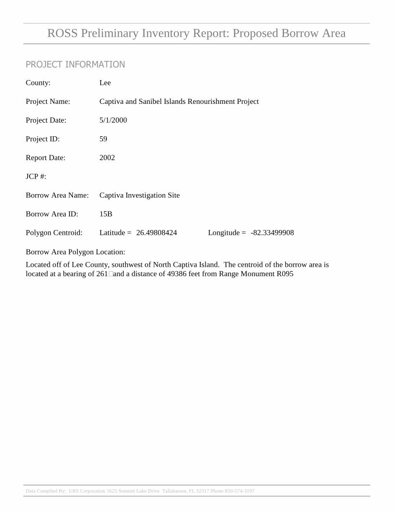
Lee
ROSS Preliminary Inventory Report: Permitted Borrow Area
301
Lee County, FL Shore Protection Project - General Reevaluation Report - Appendix B Geotechnical Ap. (Permitted Borrow Area Report)
PROJECT INFORMATION
Project ID:
Project Name:
Project Date:
Estero Borrow Area "Future Use"
JCP #:
Borrow Area Name:
Borrow Area ID:
LeeCounty:
Report Date: 1998
Polygon Centroid: 26.41529128
Borrow Area Polygon Location:
-82.21379626Latitude = Longitude =
Data Compiled By: URS Corporation 1625 Summit Lake Drive Tallahassee, FL 32317 Phone 850-574-3197
ROSS Preliminary Inventory Report: Permitted Borrow Area
301
Lee County, FL Shore Protection Project - General Reevaluation Report - Appendix B Geotechnical Ap. (Permitted Borrow Area Report)
PROJECT INFORMATION
Project ID:
Project Name:
Project Date:
Gasparilla Borrow Area #2
2
JCP #:
Borrow Area Name:
Borrow Area ID:
LeeCounty:
Report Date: 1998
Polygon Centroid: 26.71079928
Borrow Area Polygon Location:
Located off of northern Lee County, just west of Lighthouse Beach State Park. The centroid of the borrow area is located at a bearing of 246? and a distance of 7920 feet from Range Monument R025
-82.28519411Latitude = Longitude =
Data Compiled By: URS Corporation 1625 Summit Lake Drive Tallahassee, FL 32317 Phone 850-574-3197
ROSS Preliminary Inventory Report: Permitted Borrow Area
301
Lee County, FL Shore Protection Project - General Reevaluation Report - Appendix B Geotechnical Ap. (Permitted Borrow Area Report)
PROJECT INFORMATION
Project ID:
Project Name:
Project Date:
Gasparilla Borrow Area #1
1
JCP #:
Borrow Area Name:
Borrow Area ID:
LeeCounty:
Report Date: 1998
Polygon Centroid: 26.7374623
Borrow Area Polygon Location:
Located off of northern Lee County, just west of Gasparilla Island State Park. The centroid of the borrow area is located at a bearing of 276? and a distance of 3178 feet from Range Monument R019
-82.27253922Latitude = Longitude =
Data Compiled By: URS Corporation 1625 Summit Lake Drive Tallahassee, FL 32317 Phone 850-574-3197
ROSS Preliminary Inventory Report: Permitted Borrow Area
300
Captiva Island Beach Maintenence Nourishment Project - Phase I (Permitted Borrow Area Report)
PROJECT INFORMATION
Project ID:
Project Name:
Project Date:
Blind Pass Ebb Shoal BA
6
JCP #:
Borrow Area Name:
Borrow Area ID:
LeeCounty:
Report Date: 1990
Polygon Centroid: 26.47169536
Borrow Area Polygon Location:
-82.1803745Latitude = Longitude =
Data Compiled By: URS Corporation 1625 Summit Lake Drive Tallahassee, FL 32317 Phone 850-574-3197
ROSS Preliminary Inventory Report: Permitted Borrow Area
300
Captiva Island Beach Maintenence Nourishment Project - Phase I (Permitted Borrow Area Report)
PROJECT INFORMATION
Project ID:
Project Name:
Project Date:
Blind Pass Flood Shoal BA
JCP #:
Borrow Area Name:
Borrow Area ID:
LeeCounty:
Report Date: 1990
Polygon Centroid: 26.48543291
Borrow Area Polygon Location:
-82.18100068Latitude = Longitude =
Data Compiled By: URS Corporation 1625 Summit Lake Drive Tallahassee, FL 32317 Phone 850-574-3197
ROSS Preliminary Inventory Report: Permitted Borrow Area
59
Captiva and Sanibel Islands Renourishment Project
5/1/2000
PROJECT INFORMATION
Project ID:
Project Name:
Project Date:
Captiva/Sanibel III-A
III-A
JCP #:
Borrow Area Name:
Borrow Area ID:
LeeCounty:
Report Date: 2001
Polygon Centroid: 26.39469634
Borrow Area Polygon Location:
Located off of Lee County, southwest of Sanibel Island. The centroid of the borrow area is located at a bearing of 217˚ and a distance of 31384 feet from Range Monument R116
-82.22654247Latitude = Longitude =
Data Compiled By: URS Corporation 1625 Summit Lake Drive Tallahassee, FL 32317 Phone 850-574-3197
ROSS Preliminary Inventory Report: Permitted Borrow Area
36
Federal Beach Erosion Control Study for Lee County, Florida
6/29/1967
PROJECT INFORMATION
Project ID:
Project Name:
Project Date:
COE Study Area
JCP #:
Borrow Area Name:
Borrow Area ID:
LeeCounty:
Report Date: 1969
Polygon Centroid: 26.44717898
Borrow Area Polygon Location:
Located off of Lee County, just southwest of Fort Myers Beach (Estero Island). The centroid of the borrow area is located at a bearing of 205˚ and a distance of 1471 feet from Range Monument R183
-81.95168824Latitude = Longitude =
Data Compiled By: URS Corporation 1625 Summit Lake Drive Tallahassee, FL 32317 Phone 850-574-3197
ROSS Preliminary Inventory Report: Permitted Borrow Area
36
Federal Beach Erosion Control Study for Lee County, Florida
6/29/1967
PROJECT INFORMATION
Project ID:
Project Name:
Project Date:
1969 COE Study Area
JCP #:
Borrow Area Name:
Borrow Area ID:
LeeCounty:
Report Date: 1969
Polygon Centroid: 26.51567007
Borrow Area Polygon Location:
Located off of Lee County, west of Captiva Island. The centroid of the borrow area is located at a bearing of 266˚ and a distance of 2123 feet from Range Monument R97
-82.19794031Latitude = Longitude =
Data Compiled By: URS Corporation 1625 Summit Lake Drive Tallahassee, FL 32317 Phone 850-574-3197
ROSS Preliminary Inventory Report: Permitted Borrow Area
32
Lee County, Florida, Charlotte Harbor Maintenance Project
2/1/1990
PROJECT INFORMATION
Project ID:
Project Name:
Project Date:
Charlotte Harbor Study Area
JCP #:
Borrow Area Name:
Borrow Area ID:
LeeCounty:
Report Date: 1990
Polygon Centroid: 26.69636646
Borrow Area Polygon Location:
Located off of Lee County, west of Cayo Costa. The centroid of the borrow area is located at a bearing of 268˚ and a distance of 13737 feet from Range Monument R031
-82.29625652Latitude = Longitude =
Data Compiled By: URS Corporation 1625 Summit Lake Drive Tallahassee, FL 32317 Phone 850-574-3197
ROSS Preliminary Inventory Report: Permitted Borrow Area
54
Estero Island and Lovers Key Offshore Sand Source Investigation
4/1/2000
PROJECT INFORMATION
Project ID:
Project Name:
Project Date:
Estero BA 1
1
JCP #:
Borrow Area Name:
Borrow Area ID:
LeeCounty:
Report Date: 2001
Polygon Centroid: 26.44038598
Borrow Area Polygon Location:
Located off of Lee County, southwest of Fort Myers Beach (Estero Island). The centroid of the borrow area is located at a bearing of 227˚ and a distance of 8889 feet from Range Monument R178
-81.98091668Latitude = Longitude =
Data Compiled By: URS Corporation 1625 Summit Lake Drive Tallahassee, FL 32317 Phone 850-574-3197
ROSS Preliminary Inventory Report: Permitted Borrow Area
36
Federal Beach Erosion Control Study for Lee County, Florida
6/29/1967
PROJECT INFORMATION
Project ID:
Project Name:
Project Date:
COE Study Area
JCP #:
Borrow Area Name:
Borrow Area ID:
LeeCounty:
Report Date: 1969
Polygon Centroid: 26.72888661
Borrow Area Polygon Location:
Located off of Lee County, just west of Gasparilla Island State Park. The centroid of the borrow area is located at a bearing of 282˚ and a distance of 1220 feet from Range Monument R022
-82.26575399Latitude = Longitude =
Data Compiled By: URS Corporation 1625 Summit Lake Drive Tallahassee, FL 32317 Phone 850-574-3197
ROSS Preliminary Inventory Report: Permitted Borrow Area
54
Estero Island and Lovers Key Offshore Sand Source Investigation
4/1/2000
PROJECT INFORMATION
Project ID:
Project Name:
Project Date:
Estero BA 2
2
JCP #:
Borrow Area Name:
Borrow Area ID:
LeeCounty:
Report Date: 2001
Polygon Centroid: 26.40083218
Borrow Area Polygon Location:
Located off of Lee County, southwest Estero Island. The centroid of the borrow area is located at a bearing of 221˚ and a distance of 4500 feet from Range Monument R204
-81.90964592Latitude = Longitude =
Data Compiled By: URS Corporation 1625 Summit Lake Drive Tallahassee, FL 32317 Phone 850-574-3197
ROSS Preliminary Inventory Report: Permitted Borrow Area
59
Captiva and Sanibel Islands Renourishment Project
5/1/2000
PROJECT INFORMATION
Project ID:
Project Name:
Project Date:
BA V
V
JCP #:
Borrow Area Name:
Borrow Area ID:
LeeCounty:
Report Date: 2002
Polygon Centroid: 26.5089038
Borrow Area Polygon Location:
Located off of Lee County, west of Captiva Island (southwest of Redfish Pass). The centroid of the borrow area is located at a bearing of 237˚ and a distance of 51521 feet from Range Monument R072
-82.34806787Latitude = Longitude =
Data Compiled By: URS Corporation 1625 Summit Lake Drive Tallahassee, FL 32317 Phone 850-574-3197
ROSS Preliminary Inventory Report: Permitted Borrow Area
40
Captiva Island Beach Maintenance Nourishment Project Phase II - Sand Search
11/29/1990
PROJECT INFORMATION
Project ID:
Project Name:
Project Date:
Captiva BA IV-A
IV-A
JCP #:
Borrow Area Name:
Borrow Area ID:
LeeCounty:
Report Date: 1991
Polygon Centroid: 26.54889751
Borrow Area Polygon Location:
Located off of Lee County, west of Redfish Pass (Captiva Island). The centroid of the borrow area is located at a bearing of 259˚ and a distance of 4610 feet from Range Monument R084
-82.21388877Latitude = Longitude =
Data Compiled By: URS Corporation 1625 Summit Lake Drive Tallahassee, FL 32317 Phone 850-574-3197
ROSS Preliminary Inventory Report: Permitted Borrow Area
40
Captiva Island Beach Maintenance Nourishment Project Phase II - Sand Search
11/29/1990
PROJECT INFORMATION
Project ID:
Project Name:
Project Date:
Captiva BA IV-B
IV-B
JCP #:
Borrow Area Name:
Borrow Area ID:
LeeCounty:
Report Date: 1991
Polygon Centroid: 26.5584511
Borrow Area Polygon Location:
Located off of Lee County, west of Captiva Island. The centroid of the borrow area is located at a bearing of 245˚ and a distance of 3538 feet from Range Monument R080
-82.21298715Latitude = Longitude =
Data Compiled By: URS Corporation 1625 Summit Lake Drive Tallahassee, FL 32317 Phone 850-574-3197
ROSS Preliminary Inventory Report: Permitted Borrow Area
40
Captiva Island Beach Maintenance Nourishment Project Phase II - Sand Search
11/29/1990
PROJECT INFORMATION
Project ID:
Project Name:
Project Date:
BA I-A
I-A
JCP #:
Borrow Area Name:
Borrow Area ID:
LeeCounty:
Report Date: 1991
Polygon Centroid: 26.50205425
Borrow Area Polygon Location:
Located off of Lee County, just west of Captiva Island. The centroid of the borrow area is located at a bearing of 256˚ and a distance of 7941 feet from Range Monument R100
-82.21228658Latitude = Longitude =
Data Compiled By: URS Corporation 1625 Summit Lake Drive Tallahassee, FL 32317 Phone 850-574-3197
ROSS Preliminary Inventory Report: Permitted Borrow Area
40
Captiva Island Beach Maintenance Nourishment Project Phase II - Sand Search
11/29/1990
PROJECT INFORMATION
Project ID:
Project Name:
Project Date:
Captiva BA IV-C
IV-C
JCP #:
Borrow Area Name:
Borrow Area ID:
LeeCounty:
Report Date: 1992
Polygon Centroid: 26.55008801
Borrow Area Polygon Location:
Located off of Lee County, west of Redfish Pass (Captiva Island). The centroid of the borrow area is located at a bearing of 260˚ and a distance of 2790 feet from Range Monument R084
-82.20871463Latitude = Longitude =
Data Compiled By: URS Corporation 1625 Summit Lake Drive Tallahassee, FL 32317 Phone 850-574-3197
ROSS Preliminary Inventory Report: Permitted Borrow Area
40
Captiva Island Beach Maintenance Nourishment Project Phase II - Sand Search
11/29/1990
PROJECT INFORMATION
Project ID:
Project Name:
Project Date:
BA I-B
I-B
JCP #:
Borrow Area Name:
Borrow Area ID:
LeeCounty:
Report Date: 1991
Polygon Centroid: 26.51413213
Borrow Area Polygon Location:
Located off of Lee County, just west of Captiva Island. The centroid of the borrow area is located at a bearing of 256˚ and a distance of 9924 feet from Range Monument R095
-82.22100306Latitude = Longitude =
Data Compiled By: URS Corporation 1625 Summit Lake Drive Tallahassee, FL 32317 Phone 850-574-3197
ROSS Preliminary Inventory Report: Permitted Borrow Area
59
Captiva and Sanibel Islands Renourishment Project
5/1/2000
PROJECT INFORMATION
Project ID:
Project Name:
Project Date:
BA VI
VI
JCP #:
Borrow Area Name:
Borrow Area ID:
LeeCounty:
Report Date: 2001
Polygon Centroid: 26.45119148
Borrow Area Polygon Location:
Located off of Lee County, west of Captiva Island. The centroid of the borrow area is located at a bearing of 253˚ and a distance of 51457 feet from Range Monument R105
-82.33064443Latitude = Longitude =
Data Compiled By: URS Corporation 1625 Summit Lake Drive Tallahassee, FL 32317 Phone 850-574-3197
ROSS Preliminary Inventory Report: Permitted Borrow Area
59
Captiva and Sanibel Islands Renourishment Project
5/1/2000
PROJECT INFORMATION
Project ID:
Project Name:
Project Date:
BA VII
VII
JCP #:
Borrow Area Name:
Borrow Area ID:
LeeCounty:
Report Date: 2001
Polygon Centroid: 26.42348924
Borrow Area Polygon Location:
Located off of Lee County, west of Captiva Island. The centroid of the borrow area is located at a bearing of 244˚ and a distance of 48226 feet from Range Monument R108
-82.31038018Latitude = Longitude =
Data Compiled By: URS Corporation 1625 Summit Lake Drive Tallahassee, FL 32317 Phone 850-574-3197
ROSS Preliminary Inventory Report: Permitted Borrow Area
36
Federal Beach Erosion Control Study for Lee County, Florida
6/29/1967
PROJECT INFORMATION
Project ID:
Project Name:
Project Date:
69 USACE BA
JCP #:
Borrow Area Name:
Borrow Area ID:
LeeCounty:
Report Date: 1969
Polygon Centroid: 26.50327789
Borrow Area Polygon Location:
Located off of Lee County, west of Captiva Island. The centroid of the borrow area is located at a bearing of 252˚ and a distance of 2129 feet from Range Monument R101
-82.19508079Latitude = Longitude =
Data Compiled By: URS Corporation 1625 Summit Lake Drive Tallahassee, FL 32317 Phone 850-574-3197
ROSS Preliminary Inventory Report: Permitted Borrow Area
40
Captiva Island Beach Maintenance Nourishment Project Phase II - Sand Search
11/29/1990
PROJECT INFORMATION
Project ID:
Project Name:
Project Date:
Captiva BA III
III
JCP #:
Borrow Area Name:
Borrow Area ID:
LeeCounty:
Report Date: 1991
Polygon Centroid: 26.48305628
Borrow Area Polygon Location:
Located off of Lee County, west of Captiva Island. The centroid of the borrow area is located at a bearing of 256˚ and a distance of 26428 feet from Range Monument R102
-82.26323529Latitude = Longitude =
Data Compiled By: URS Corporation 1625 Summit Lake Drive Tallahassee, FL 32317 Phone 850-574-3197
ROSS Preliminary Inventory Report: Permitted Borrow Area
40
Captiva Island Beach Maintenance Nourishment Project Phase II - Sand Search
11/29/1990
PROJECT INFORMATION
Project ID:
Project Name:
Project Date:
Captiva BA II
II
JCP #:
Borrow Area Name:
Borrow Area ID:
LeeCounty:
Report Date: 1991
Polygon Centroid: 26.49848932
Borrow Area Polygon Location:
Located off of Lee County, west of Captiva Island. The centroid of the borrow area is located at a bearing of 260˚ and a distance of 18165 feet from Range Monument R100
-82.24197689Latitude = Longitude =
Data Compiled By: URS Corporation 1625 Summit Lake Drive Tallahassee, FL 32317 Phone 850-574-3197
ROSS Preliminary Inventory Report: Permitted Borrow Area
59
Captiva and Sanibel Islands Renourishment Project
5/1/2000
PROJECT INFORMATION
Project ID:
Project Name:
Project Date:
Captiva BA IV
IV
JCP #:
Borrow Area Name:
Borrow Area ID:
LeeCounty:
Report Date: 2001
Polygon Centroid: 26.62975545
Borrow Area Polygon Location:
Located off of Lee County, just west of Northern Captiva Island. The centroid of the borrow area is located at a bearing of 247˚ and a distance of 18055 feet from Range Monument R050
-82.29155088Latitude = Longitude =
Data Compiled By: URS Corporation 1625 Summit Lake Drive Tallahassee, FL 32317 Phone 850-574-3197
ROSS Preliminary Inventory Report: Permitted Borrow Area
59
Captiva and Sanibel Islands Renourishment Project
5/1/2000
PROJECT INFORMATION
Project ID:
Project Name:
Project Date:
Captiva/Sanibel III-B
III-B
JCP #:
Borrow Area Name:
Borrow Area ID:
LeeCounty:
Report Date: 2001
Polygon Centroid: 26.37519457
Borrow Area Polygon Location:
Located off of Lee County, southwest of Sanibel Island. The centroid of the borrow area is located at a bearing of 210˚ and a distance of 35937 feet from Range Monument R117
-82.22056773Latitude = Longitude =
Data Compiled By: URS Corporation 1625 Summit Lake Drive Tallahassee, FL 32317 Phone 850-574-3197
ROSS Preliminary Inventory Report: Permitted Borrow Area
40
Captiva Island Beach Maintenance Nourishment Project Phase II - Sand Search
11/29/1990
PROJECT INFORMATION
Project ID:
Project Name:
Project Date:
Captiva BA V
V
JCP #:
Borrow Area Name:
Borrow Area ID:
LeeCounty:
Report Date: 1991
Polygon Centroid: 26.55664963
Borrow Area Polygon Location:
Located off of Lee County, just east of Redfish Pass (Captiva Island). The centroid of the borrow area is located at a bearing of 64˚ and a distance of 3123 feet from Range Monument R083
-82.19096158Latitude = Longitude =
Data Compiled By: URS Corporation 1625 Summit Lake Drive Tallahassee, FL 32317 Phone 850-574-3197
Levy
ROSS Preliminary Inventory Report: Permitted Borrow Area There are currently no Permitted Borrow Areas located off of this county. This page has been inserted as a place holder to be replaced with updated information should Permitted Borrow Areas be established offshore of this County.
Manatee
ROSS Preliminary Inventory Report: Permitted Borrow Area
304
Manatee County, Florida Shore Protection Project General Design Memorandum (Permitted Borrow Area Report)
PROJECT INFORMATION
Project ID:
Project Name:
Project Date:
COE Alt. BA
COE Alt. BA
JCP #:
Borrow Area Name:
Borrow Area ID:
ManateeCounty:
Report Date: 1989
Polygon Centroid: 27.43891015
Borrow Area Polygon Location:
Located off of Manatee County, just west of Longboat Pass. The centroid of the borrow area is located at a bearing of 265? and a distance of 2933 feet from Range Monument R043
-82.6992368Latitude = Longitude =
Data Compiled By: URS Corporation 1625 Summit Lake Drive Tallahassee, FL 32317 Phone 850-574-3197
ROSS Preliminary Inventory Report: Permitted Borrow Area
303
General Design Memorandum Phase II Project Design - Manatee County, Florida Beach Erosion Control Project (Permitted Borrow Area Report)
PROJECT INFORMATION
Project ID:
Project Name:
Project Date:
Principal Borrow Site
COE BA
JCP #:
Borrow Area Name:
Borrow Area ID:
ManateeCounty:
Report Date: 1980
Polygon Centroid: 27.53299155
Borrow Area Polygon Location:
Located off of Manatee County, just west of Anna Maria Island. The centroid of the borrow area is located at a bearing of 263? and a distance of 2937 feet from Range Monument R004
-82.75165569Latitude = Longitude =
Data Compiled By: URS Corporation 1625 Summit Lake Drive Tallahassee, FL 32317 Phone 850-574-3197
ROSS Preliminary Inventory Report: Permitted Borrow Area
304
Manatee County, Florida Shore Protection Project General Design Memorandum (Permitted Borrow Area Report)
PROJECT INFORMATION
Project ID:
Project Name:
Project Date:
COE Alt. BA
COE Alt. BA
JCP #:
Borrow Area Name:
Borrow Area ID:
ManateeCounty:
Report Date: 1989
Polygon Centroid: 27.5203385
Borrow Area Polygon Location:
-82.75170643Latitude = Longitude =
Data Compiled By: URS Corporation 1625 Summit Lake Drive Tallahassee, FL 32317 Phone 850-574-3197
ROSS Preliminary Inventory Report: Permitted Borrow Area
299
Manatee County Shore Protection Project, Sub Appendix 1 Core Boring Logs and Laboratory Data (Including Appendix 1 Geotechnical Report) (Permitted Borrow Area Report)
PROJECT INFORMATION
Project ID:
Project Name:
Project Date:
Excluded Area "B"
Excluded Area "B"
JCP #:
Borrow Area Name:
Borrow Area ID:
ManateeCounty:
Report Date:
Polygon Centroid: 27.48862702
Borrow Area Polygon Location:
-82.71447865Latitude = Longitude =
Data Compiled By: URS Corporation 1625 Summit Lake Drive Tallahassee, FL 32317 Phone 850-574-3197
ROSS Preliminary Inventory Report: Permitted Borrow Area
299
Manatee County Shore Protection Project, Sub Appendix 1 Core Boring Logs and Laboratory Data (Including Appendix 1 Geotechnical Report) (Permitted Borrow Area Report)
PROJECT INFORMATION
Project ID:
Project Name:
Project Date:
Excluded Area "A"
Excluded Area "A"
JCP #:
Borrow Area Name:
Borrow Area ID:
ManateeCounty:
Report Date:
Polygon Centroid: 27.46859027
Borrow Area Polygon Location:
-82.70602299Latitude = Longitude =
Data Compiled By: URS Corporation 1625 Summit Lake Drive Tallahassee, FL 32317 Phone 850-574-3197
ROSS Preliminary Inventory Report: Permitted Borrow Area
304
Manatee County, Florida Shore Protection Project General Design Memorandum (Permitted Borrow Area Report)
PROJECT INFORMATION
Project ID:
Project Name:
Project Date:
COE Principal BA
COE BA
JCP #:
Borrow Area Name:
Borrow Area ID:
ManateeCounty:
Report Date: 1989
Polygon Centroid: 27.48219866
Borrow Area Polygon Location:
Located off of Manatee County, just west of Anna Maria Island (Bradenton Beach). The centroid of the borrow area is located at a bearing of 235? and a distance of 2409 feet from Range Monument R025
-82.71289459Latitude = Longitude =
Data Compiled By: URS Corporation 1625 Summit Lake Drive Tallahassee, FL 32317 Phone 850-574-3197
ROSS Preliminary Inventory Report: Permitted Borrow Area
70
Seven Year (84 Month) Post-Construction Monitoring Report for the Anna Maria Island Shore Protection Project
2/1/2000
PROJECT INFORMATION
Project ID:
Project Name:
Project Date:
Anna Maria Island N. BA
AMI North BA
JCP #:
Borrow Area Name:
Borrow Area ID:
ManateeCounty:
Report Date: 2000
Polygon Centroid: 27.51715899
Borrow Area Polygon Location:
Located off of Manatee County, just west of Anna Maria Island. The centroid of the borrow area is located at a bearing of 230˚ and a distance of 4247 feet from Range Monument R008
-82.74604427Latitude = Longitude =
Data Compiled By: URS Corporation 1625 Summit Lake Drive Tallahassee, FL 32317 Phone 850-574-3197
ROSS Preliminary Inventory Report: Permitted Borrow Area
70
Seven Year (84 Month) Post-Construction Monitoring Report for the Anna Maria Island Shore Protection Project
2/1/2000
PROJECT INFORMATION
Project ID:
Project Name:
Project Date:
Anna Maria Island S. BA
AMI South BA
JCP #:
Borrow Area Name:
Borrow Area ID:
ManateeCounty:
Report Date: 2000
Polygon Centroid: 27.44700471
Borrow Area Polygon Location:
Located off of Manatee County, just west of Anna Maria Island (Coquina Beach). The centroid of the borrow area is located at a bearing of 241˚ and a distance of 3764 feet from Range Monument R038
-82.70275657Latitude = Longitude =
Data Compiled By: URS Corporation 1625 Summit Lake Drive Tallahassee, FL 32317 Phone 850-574-3197
ROSS Preliminary Inventory Report: Permitted Borrow Area
55
Longboat Key White Sand Search Investigations
8/1/1999
PROJECT INFORMATION
Project ID:
Project Name:
Project Date:
Borrow Area IX
BA IX
JCP #:
Borrow Area Name:
Borrow Area ID:
ManateeCounty:
Report Date: 2004
Polygon Centroid: 27.53285807
Borrow Area Polygon Location:
Located off of Manatee County, west of the tip of Anna Marie Island. The centroid of the borrow area is located at a bearing of 262˚ and a distance of 9908 feet from Range Monument R003
-82.77236165Latitude = Longitude =
Data Compiled By: URS Corporation 1625 Summit Lake Drive Tallahassee, FL 32317 Phone 850-574-3197
ROSS Preliminary Inventory Report: Permitted Borrow Area
70
Seven Year (84 Month) Post-Construction Monitoring Report for the Anna Maria Island Shore Protection Project
2/1/2000
PROJECT INFORMATION
Project ID:
Project Name:
Project Date:
92/93 Anna Maria Borrow Area
COE BA
JCP #:
Borrow Area Name:
Borrow Area ID:
ManateeCounty:
Report Date: 2000
Polygon Centroid: 27.47195502
Borrow Area Polygon Location:
Located off of Manatee County, west of the northern tip of Anna Maria Island. The centroid of the borrow area is located at a bearing of 242˚ and a distance of 2084 feet from Range Monument R029
-82.70788412Latitude = Longitude =
Data Compiled By: URS Corporation 1625 Summit Lake Drive Tallahassee, FL 32317 Phone 850-574-3197
Martin
ROSS Preliminary Inventory Report: Permitted Borrow Area
170
Sand Search 1989 Jupiter Island Beach Renourishment Program
5/16/1989
PROJECT INFORMATION
Project ID:
Project Name:
Project Date:
SITE A
JCP #:
Borrow Area Name:
Borrow Area ID:
MartinCounty:
Report Date:
Polygon Centroid: 27.07493019
Borrow Area Polygon Location:
Located off of Martin County, east of Hobe Sound Beach. The centroid of the borrow area is located at a bearing of 62˚ and a distance of 12329 feet from Range Monument R90
-80.07920371Latitude = Longitude =
Data Compiled By: URS Corporation 1625 Summit Lake Drive Tallahassee, FL 32317 Phone 850-574-3197
ROSS Preliminary Inventory Report: Permitted Borrow Area
170
Sand Search 1989 Jupiter Island Beach Renourishment Program
5/16/1989
PROJECT INFORMATION
Project ID:
Project Name:
Project Date:
SITE B
JCP #:
Borrow Area Name:
Borrow Area ID:
MartinCounty:
Report Date:
Polygon Centroid: 27.01103985
Borrow Area Polygon Location:
Located off of Martin County, east of Jupiter Island. The centroid of the borrow area is located at a bearing of 80˚ and a distance of 12373 feet from Range Monument R113
-80.05488599Latitude = Longitude =
Data Compiled By: URS Corporation 1625 Summit Lake Drive Tallahassee, FL 32317 Phone 850-574-3197
Monroe
ROSS Preliminary Inventory Report: Permitted Borrow Area There are currently no Permitted Borrow Areas located off of this county. This page has been inserted as a place holder to be replaced with updated information should Permitted Borrow Areas be established offshore of this County.
Nassau
ROSS Preliminary Inventory Report: Permitted Borrow Area
270
Nassau County, Shore Protection Project
10/9/2006
PROJECT INFORMATION
Project ID:
Project Name:
Project Date:
N-11
JCP #:
Borrow Area Name:
Borrow Area ID:
NassauCounty:
Report Date: Oct 9, 2006
Polygon Centroid: 30.69883664
Borrow Area Polygon Location:
Located off of Nassau County, east of Fort Clinch Pier (Ft. Clinch State Park). The centroid of the borrow area is located at a bearing of 90˚ and a distance of 16023 feet from Range Monument R010
-81.38063792Latitude = Longitude =
Data Compiled By: URS Corporation 1625 Summit Lake Drive Tallahassee, FL 32317 Phone 850-574-3197
ROSS Preliminary Inventory Report: Permitted Borrow Area
269
Amelia Island Sand Transfer/Sand Search Study
11/1/1993
PROJECT INFORMATION
Project ID:
Project Name:
Project Date:
N-10
JCP #:
Borrow Area Name:
Borrow Area ID:
NassauCounty:
Report Date: Nov, 1993
Polygon Centroid: 30.51509843
Borrow Area Polygon Location:
Located off of Nassau County, east, southeast of Amelia Island State Park (near Nassau Sound). The centroid of the borrow area is located at a bearing of 104˚ and a distance of 9317 feet from Range Monument R077
-81.40936577Latitude = Longitude =
Data Compiled By: URS Corporation 1625 Summit Lake Drive Tallahassee, FL 32317 Phone 850-574-3197
Okaloosa
ROSS Preliminary Inventory Report: Permitted Borrow Area There are currently no Permitted Borrow Areas located off of this county. This page has been inserted as a place holder to be replaced with updated information should Permitted Borrow Areas be established offshore of this County.
Palm Beach
ROSS Preliminary Inventory Report: Permitted Borrow Area There are currently no Permitted Borrow Areas located off of this county. This page has been inserted as a place holder to be replaced with updated information should Permitted Borrow Areas be established offshore of this County.
Pasco
ROSS Preliminary Inventory Report: Permitted Borrow Area There are currently no Permitted Borrow Areas located off of this county. This page has been inserted as a place holder to be replaced with updated information should Permitted Borrow Areas be established offshore of this County.
Pinellas
ROSS Preliminary Inventory Report: Permitted Borrow Area
35
Pinellas County, Florida Beach Erosion Control Project - Indian Shores Beach Nourishment
8/1/1986
PROJECT INFORMATION
Project ID:
Project Name:
Project Date:
Egmont Shoal Borrow Area
JCP #:
Borrow Area Name:
Borrow Area ID:
PinellasCounty:
Report Date: 1990
Polygon Centroid: 27.62022342
Borrow Area Polygon Location:
Located off of Pinellas County, west of Mullet Key. The centroid of the borrow area is located at a bearing of 302˚ and a distance of 12619 feet from Range Monument R003
-82.79431143Latitude = Longitude =
Data Compiled By: URS Corporation 1625 Summit Lake Drive Tallahassee, FL 32317 Phone 850-574-3197
ROSS Preliminary Inventory Report: Permitted Borrow Area
35
Pinellas County, Florida Beach Erosion Control Project - Indian Shores Beach Nourishment
8/1/1986
PROJECT INFORMATION
Project ID:
Project Name:
Project Date:
Egmont Shoal Borrow Area
JCP #:
Borrow Area Name:
Borrow Area ID:
PinellasCounty:
Report Date: 1990
Polygon Centroid: 27.6248546
Borrow Area Polygon Location:
Located off of Pinellas County, west of Mullet Key. The centroid of the borrow area is located at a bearing of 305˚ and a distance of 14435 feet from Range Monument R003
-82.79757669Latitude = Longitude =
Data Compiled By: URS Corporation 1625 Summit Lake Drive Tallahassee, FL 32317 Phone 850-574-3197
Santa Rosa
ROSS Preliminary Inventory Report: Permitted Borrow Area There are currently no Permitted Borrow Areas located off of this county. This page has been inserted as a place holder to be replaced with updated information should Permitted Borrow Areas be established offshore of this County.
Sarasota
ROSS Preliminary Inventory Report: Permitted Borrow Area
302
Lido Key, Sarasota County, Florida Feasibility Phase Study Geotechnical Appendix (Permitted Borrow Area Report)
PROJECT INFORMATION
Project ID:
Project Name:
Project Date:
Lido Key Borrow Area 5
LKBA-5
JCP #:
Borrow Area Name:
Borrow Area ID:
SarasotaCounty:
Report Date: 2001
Polygon Centroid: 27.21118797
Borrow Area Polygon Location:
Located off of Sarasota County, southwest of Big Sarasota Pass. The centroid of the borrow area is located at a bearing of 237? and a distance of 39851 feet from Range Monument R047
-82.66478786Latitude = Longitude =
Data Compiled By: URS Corporation 1625 Summit Lake Drive Tallahassee, FL 32317 Phone 850-574-3197
ROSS Preliminary Inventory Report: Permitted Borrow Area
302
Lido Key, Sarasota County, Florida Feasibility Phase Study Geotechnical Appendix (Permitted Borrow Area Report)
PROJECT INFORMATION
Project ID:
Project Name:
Project Date:
Lido Key Borrow Area 7
LKBA-7
JCP #:
Borrow Area Name:
Borrow Area ID:
SarasotaCounty:
Report Date: 2001
Polygon Centroid: 27.19952339
Borrow Area Polygon Location:
Located off of Sarasota County, southwest of Big Sarasota Pass. The centroid of the borrow area is located at a bearing of 241?and a distance of 54050 feet from Range Monument R047
-82.70598366Latitude = Longitude =
Data Compiled By: URS Corporation 1625 Summit Lake Drive Tallahassee, FL 32317 Phone 850-574-3197
ROSS Preliminary Inventory Report: Permitted Borrow Area
302
Lido Key, Sarasota County, Florida Feasibility Phase Study Geotechnical Appendix (Permitted Borrow Area Report)
PROJECT INFORMATION
Project ID:
Project Name:
Project Date:
Lido Key Borrow Area 6
LKBA-6
JCP #:
Borrow Area Name:
Borrow Area ID:
SarasotaCounty:
Report Date: 2001
Polygon Centroid: 27.2125796
Borrow Area Polygon Location:
Located off of Sarasota County, southwest of Big Sarasota Pass. The centroid of the borrow area is located at a bearing of 244? and a distance of 49015 feet from Range Monument R047
-82.69620536Latitude = Longitude =
Data Compiled By: URS Corporation 1625 Summit Lake Drive Tallahassee, FL 32317 Phone 850-574-3197
ROSS Preliminary Inventory Report: Permitted Borrow Area
52
City of Venice Beach Nourishment Project, Environmental Study
10/1/1991
PROJECT INFORMATION
Project ID:
Project Name:
Project Date:
Venice Beach Borrow Area
Venice Beach Borrow Area
JCP #:
Borrow Area Name:
Borrow Area ID:
SarasotaCounty:
Report Date: 1992
Polygon Centroid: 27.26548634
Borrow Area Polygon Location:
Located off of Sarasota County, just southwest of Big Sarasota Pass. The centroid of the borrow area is located at a bearing of 212˚ and a distance of 2761 feet from Range Monument R049
-82.5669409Latitude = Longitude =
Data Compiled By: URS Corporation 1625 Summit Lake Drive Tallahassee, FL 32317 Phone 850-574-3197
ROSS Preliminary Inventory Report: Permitted Borrow Area
55
Longboat Key White Sand Search Investigations
8/1/1999
PROJECT INFORMATION
Project ID:
Project Name:
Project Date:
Longboat Key BA 6B
LBK-6B
JCP #:
Borrow Area Name:
Borrow Area ID:
SarasotaCounty:
Report Date: 1999
Polygon Centroid: 27.4070897
Borrow Area Polygon Location:
Located off of Sarasota County, west of Longboat Pass. The centroid of the borrow area is located at a bearing of 252˚ and a distance of 34806 feet from Range Monument R044
-82.78707347Latitude = Longitude =
Data Compiled By: URS Corporation 1625 Summit Lake Drive Tallahassee, FL 32317 Phone 850-574-3197
ROSS Preliminary Inventory Report: Permitted Borrow Area
55
Longboat Key White Sand Search Investigations
8/1/1999
PROJECT INFORMATION
Project ID:
Project Name:
Project Date:
Borrow Area VIII
BA VIII
JCP #:
Borrow Area Name:
Borrow Area ID:
SarasotaCounty:
Report Date: 2004
Polygon Centroid: 27.43866963
Borrow Area Polygon Location:
Located off of Sarasota County, west of Longboat Pass. The centroid of the borrow area is located at a bearing of 248˚ and a distance of 26422 feet from Range Monument R032
-82.77082541Latitude = Longitude =
Data Compiled By: URS Corporation 1625 Summit Lake Drive Tallahassee, FL 32317 Phone 850-574-3197
ROSS Preliminary Inventory Report: Permitted Borrow Area
48
Lido Key Beach Nourishment
10/16/1994
PROJECT INFORMATION
Project ID:
Project Name:
Project Date:
Lido Key Borrow Area 1
LKBA-1
JCP #:
Borrow Area Name:
Borrow Area ID:
SarasotaCounty:
Report Date: 1995
Polygon Centroid: 27.2908387
Borrow Area Polygon Location:
Located off of Sarasota County, southwest of Longboat Key. The centroid of the borrow area is located at a bearing of 228˚ and a distance of 30584 feet from Range Monument R018
-82.67818584Latitude = Longitude =
Data Compiled By: URS Corporation 1625 Summit Lake Drive Tallahassee, FL 32317 Phone 850-574-3197
ROSS Preliminary Inventory Report: Permitted Borrow Area
71
Lido Key Offshore Sand Source Investigation
7/1/1998
PROJECT INFORMATION
Project ID:
Project Name:
Project Date:
Lido Key Borrow Area 3
LKBA-3
JCP #:
Borrow Area Name:
Borrow Area ID:
SarasotaCounty:
Report Date: 2000
Polygon Centroid: 27.29573679
Borrow Area Polygon Location:
Located of Sarasota County, southwest of Longboat Key. The centroid of the borrow area is located at a bearing of 234˚ and a distance of 40705 feet from Range Monument R011
-82.72155711Latitude = Longitude =
Data Compiled By: URS Corporation 1625 Summit Lake Drive Tallahassee, FL 32317 Phone 850-574-3197
ROSS Preliminary Inventory Report: Permitted Borrow Area
55
Longboat Key White Sand Search Investigations
8/1/1999
PROJECT INFORMATION
Project ID:
Project Name:
Project Date:
Longboat Key Borrow Area 5A
LBK-5A
JCP #:
Borrow Area Name:
Borrow Area ID:
SarasotaCounty:
Report Date: 1999
Polygon Centroid: 27.38867288
Borrow Area Polygon Location:
Located off of Sarasota County, southwest of Longboat Pass. The centroid of the borrow area is located at a bearing of 245˚ and a distance of 41166 feet from Range Monument R044
-82.79975381Latitude = Longitude =
Data Compiled By: URS Corporation 1625 Summit Lake Drive Tallahassee, FL 32317 Phone 850-574-3197
ROSS Preliminary Inventory Report: Permitted Borrow Area
55
Longboat Key White Sand Search Investigations
8/1/1999
PROJECT INFORMATION
Project ID:
Project Name:
Project Date:
Longboat Key BA 7B
LBK-7B
JCP #:
Borrow Area Name:
Borrow Area ID:
SarasotaCounty:
Report Date: 1999
Polygon Centroid: 27.43177369
Borrow Area Polygon Location:
Located off of Sarasota County, west of Longboat Pass. The centroid of the borrow area is located at a bearing of 249˚ and a distance of 40876 feet from Range Monument R029
-82.8135869Latitude = Longitude =
Data Compiled By: URS Corporation 1625 Summit Lake Drive Tallahassee, FL 32317 Phone 850-574-3197
ROSS Preliminary Inventory Report: Permitted Borrow Area
55
Longboat Key White Sand Search Investigations
8/1/1999
PROJECT INFORMATION
Project ID:
Project Name:
Project Date:
Longboat Key Borrow Area 5B
LBK-5B
JCP #:
Borrow Area Name:
Borrow Area ID:
SarasotaCounty:
Report Date: 1999
Polygon Centroid: 27.38117688
Borrow Area Polygon Location:
Located off of Sarasota County, southwest of Longboat Pass. The centroid of the borrow area is located at a bearing of 239˚ and a distance of 38452 feet from Range Monument R044
-82.786912Latitude = Longitude =
Data Compiled By: URS Corporation 1625 Summit Lake Drive Tallahassee, FL 32317 Phone 850-574-3197
ROSS Preliminary Inventory Report: Permitted Borrow Area
52
City of Venice Beach Nourishment Project, Environmental Study
10/1/1991
PROJECT INFORMATION
Project ID:
Project Name:
Project Date:
Manasota Borrow Area 2
BA2
JCP #:
Borrow Area Name:
Borrow Area ID:
SarasotaCounty:
Report Date: 1992
Polygon Centroid: 26.97099316
Borrow Area Polygon Location:
Located off of southern Sarasota County, west of Manasota Beach. The centroid of the borrow area is located at a bearing of 241˚ and a distance of 17232 feet from Range Monument R163
-82.44879378Latitude = Longitude =
Data Compiled By: URS Corporation 1625 Summit Lake Drive Tallahassee, FL 32317 Phone 850-574-3197
ROSS Preliminary Inventory Report: Permitted Borrow Area
55
Longboat Key White Sand Search Investigations
8/1/1999
PROJECT INFORMATION
Project ID:
Project Name:
Project Date:
Longboat Key Mid 1
Mid 1
JCP #:
Borrow Area Name:
Borrow Area ID:
SarasotaCounty:
Report Date: 1999
Polygon Centroid: 27.37921699
Borrow Area Polygon Location:
Located off of Sarasota County, just northwest of Longboat Key. The centroid of the borrow area is located at a bearing of 248˚ and a distance of 2784 feet from Range Monument R004
-82.64540789Latitude = Longitude =
Data Compiled By: URS Corporation 1625 Summit Lake Drive Tallahassee, FL 32317 Phone 850-574-3197
ROSS Preliminary Inventory Report: Permitted Borrow Area
71
Lido Key Offshore Sand Source Investigation
7/1/1998
PROJECT INFORMATION
Project ID:
Project Name:
Project Date:
Lido Key Borrow Area 4
LKBA-4
JCP #:
Borrow Area Name:
Borrow Area ID:
SarasotaCounty:
Report Date: 2000
Polygon Centroid: 27.32050108
Borrow Area Polygon Location:
Located off of Sarasota County, just west, southwest of Longboat Key. The centroid of the borrow area is located at a bearing of 234˚ and a distance of 30354 feet from Range Monument R008
-82.70265946Latitude = Longitude =
Data Compiled By: URS Corporation 1625 Summit Lake Drive Tallahassee, FL 32317 Phone 850-574-3197
ROSS Preliminary Inventory Report: Permitted Borrow Area
55
Longboat Key White Sand Search Investigations
8/1/1999
PROJECT INFORMATION
Project ID:
Project Name:
Project Date:
Longboat Key BA 1
LBK-1
JCP #:
Borrow Area Name:
Borrow Area ID:
SarasotaCounty:
Report Date: 1999
Polygon Centroid: 27.31423714
Borrow Area Polygon Location:
Located off of Sarasota County, just southwest of Longboat Key. The centroid of the borrow area is located at a bearing of 224˚ and a distance of 22439 feet from Range Monument R013
-82.66775225Latitude = Longitude =
Data Compiled By: URS Corporation 1625 Summit Lake Drive Tallahassee, FL 32317 Phone 850-574-3197
ROSS Preliminary Inventory Report: Permitted Borrow Area
55
Longboat Key White Sand Search Investigations
8/1/1999
PROJECT INFORMATION
Project ID:
Project Name:
Project Date:
Longboat Key Mid 2
Mid 2
JCP #:
Borrow Area Name:
Borrow Area ID:
SarasotaCounty:
Report Date: 1999
Polygon Centroid: 27.35943556
Borrow Area Polygon Location:
Located off of Sarasota County, just west, southwest of Longboat Key. The centroid of the borrow area is located at a bearing of 239˚ and a distance of 4366 feet from Range Monument R011
-82.63690539Latitude = Longitude =
Data Compiled By: URS Corporation 1625 Summit Lake Drive Tallahassee, FL 32317 Phone 850-574-3197
ROSS Preliminary Inventory Report: Permitted Borrow Area
55
Longboat Key White Sand Search Investigations
8/1/1999
PROJECT INFORMATION
Project ID:
Project Name:
Project Date:
Longboat Key BA 6A
LBK-6A
JCP #:
Borrow Area Name:
Borrow Area ID:
SarasotaCounty:
Report Date: 1999
Polygon Centroid: 27.41932861
Borrow Area Polygon Location:
Located off of Sarasota County, west of Longboat Pass. The centroid of the borrow area is located at a bearing of 258˚ and a distance of 32850 feet from Range Monument R044
-82.78442093Latitude = Longitude =
Data Compiled By: URS Corporation 1625 Summit Lake Drive Tallahassee, FL 32317 Phone 850-574-3197
ROSS Preliminary Inventory Report: Permitted Borrow Area
55
Longboat Key White Sand Search Investigations
8/1/1999
PROJECT INFORMATION
Project ID:
Project Name:
Project Date:
Longboat Key BA 7A
LBK-7A
JCP #:
Borrow Area Name:
Borrow Area ID:
SarasotaCounty:
Report Date: 1999
Polygon Centroid: 27.41952095
Borrow Area Polygon Location:
Located off of Sarasota County, west of Longboat Pass. The centroid of the borrow area is located at a bearing of 251˚ and a distance of 44484 feet from Range Monument R034
-82.81985709Latitude = Longitude =
Data Compiled By: URS Corporation 1625 Summit Lake Drive Tallahassee, FL 32317 Phone 850-574-3197
ROSS Preliminary Inventory Report: Permitted Borrow Area
52
City of Venice Beach Nourishment Project, Environmental Study
10/1/1991
PROJECT INFORMATION
Project ID:
Project Name:
Project Date:
Manasota Borrow Area 1
BA1
JCP #:
Borrow Area Name:
Borrow Area ID:
SarasotaCounty:
Report Date: 1992
Polygon Centroid: 26.98085963
Borrow Area Polygon Location:
Located off of southern Sarasota County, west of Manasota Beach. The centroid of the borrow area is located at a bearing of 242˚ and a distance of 12080 feet from Range Monument R162
-82.43699929Latitude = Longitude =
Data Compiled By: URS Corporation 1625 Summit Lake Drive Tallahassee, FL 32317 Phone 850-574-3197
ROSS Preliminary Inventory Report: Permitted Borrow Area
71
Lido Key Offshore Sand Source Investigation
7/1/1998
PROJECT INFORMATION
Project ID:
Project Name:
Project Date:
Borrow Area 2
LKBA-2
JCP #:
Borrow Area Name:
Borrow Area ID:
SarasotaCounty:
Report Date: 2000
Polygon Centroid: 27.29103707
Borrow Area Polygon Location:
Located off of Sarasota County, southwest of Longboat Key. The centroid of the borrow area is located at a bearing of 226˚ and a distance of 34759 feet from Range Monument R013
-82.6953147Latitude = Longitude =
Data Compiled By: URS Corporation 1625 Summit Lake Drive Tallahassee, FL 32317 Phone 850-574-3197
St. Johns
ROSS Preliminary Inventory Report: Permitted Borrow Area There are currently no Permitted Borrow Areas located off of this county. This page has been inserted as a place holder to be replaced with updated information should Permitted Borrow Areas be established offshore of this County.
St. Lucie
ROSS Preliminary Inventory Report: Permitted Borrow Area
222
2003 Ft. Pierce Beach Nourishment Borrow Area
1/1/2003
PROJECT INFORMATION
Project ID:
Project Name:
Project Date:
2003/2004/2005 Borrow Area
JCP #:
Borrow Area Name:
Borrow Area ID:
St. LucieCounty:
Report Date:
Polygon Centroid: 27.43480261
Borrow Area Polygon Location:
Located off of St. Lucie County, northeast of Frederick Douglass Memorial Park and southeast of Surfside Park. The centroid of the borrow area is located at a bearing of 69˚ and a distance of 15456 feet from Range Monument R054
-80.22983769Latitude = Longitude =
Data Compiled By: URS Corporation 1625 Summit Lake Drive Tallahassee, FL 32317 Phone 850-574-3197
Taylor
ROSS Preliminary Inventory Report: Permitted Borrow Area There are currently no Permitted Borrow Areas located off of this county. This page has been inserted as a place holder to be replaced with updated information should Permitted Borrow Areas be established offshore of this County.
Volusia
ROSS Preliminary Inventory Report: Permitted Borrow Area
167
Volusia County Reconnaissance
12/1/2004
PROJECT INFORMATION
Project ID:
Project Name:
Project Date:
B21-1
JCP #:
Borrow Area Name:
Borrow Area ID:
VolusiaCounty:
Report Date:
Polygon Centroid: 29.20908237
Borrow Area Polygon Location:
Located off of Volusia County, southeast of Daytona Beach. The centroid of the borrow area is located at a bearing of 61˚ and a distance of 38479 feet from Range Monument R114
-80.87200983Latitude = Longitude =
Data Compiled By: URS Corporation 1625 Summit Lake Drive Tallahassee, FL 32317 Phone 850-574-3197
ROSS Preliminary Inventory Report: Permitted Borrow Area
167
Volusia County Reconnaissance
12/1/2004
PROJECT INFORMATION
Project ID:
Project Name:
Project Date:
B11-3
JCP #:
Borrow Area Name:
Borrow Area ID:
VolusiaCounty:
Report Date:
Polygon Centroid: 29.20754949
Borrow Area Polygon Location:
Located off of Volusia County, southeast of Daytona Beach. The centroid of the borrow area is located at a bearing of 62˚ and a distance of 31535 feet from Range Monument R110
-80.89409675Latitude = Longitude =
Data Compiled By: URS Corporation 1625 Summit Lake Drive Tallahassee, FL 32317 Phone 850-574-3197
Wakulla
ROSS Preliminary Inventory Report: Permitted Borrow Area There are currently no Permitted Borrow Areas located off of this county. This page has been inserted as a place holder to be replaced with updated information should Permitted Borrow Areas be established offshore of this County.
Walton
ROSS Preliminary Inventory Report: Permitted Borrow Area There are currently no Permitted Borrow Areas located off of this county. This page has been inserted as a place holder to be replaced with updated information should Permitted Borrow Areas be established offshore of this County.
Proposed
Bay
ROSS Preliminary Inventory Report: Proposed Borrow Area There are currently no Proposed Borrow Areas located off of this county. This page has been inserted as a place holder to be replaced with updated information should Proposed Borrow Areas be established offshore of this County.
Brevard
ROSS Preliminary Inventory Report: Proposed Borrow Area There are currently no Proposed Borrow Areas located off of this county. This page has been inserted as a place holder to be replaced with updated information should Proposed Borrow Areas be established offshore of this County.
Broward
ROSS Preliminary Inventory Report: Proposed Borrow Area There are currently no Proposed Borrow Areas located off of this county. This page has been inserted as a place holder to be replaced with updated information should Proposed Borrow Areas be established offshore of this County.
Charlotte
ROSS Preliminary Inventory Report: Proposed Borrow Area There are currently no Proposed Borrow Areas located off of this county. This page has been inserted as a place holder to be replaced with updated information should Proposed Borrow Areas be established offshore of this County.
Citrus
ROSS Preliminary Inventory Report: Proposed Borrow Area There are currently no Proposed Borrow Areas located off of this county. This page has been inserted as a place holder to be replaced with updated information should Proposed Borrow Areas be established offshore of this County.
Collier
ROSS Preliminary Inventory Report: Proposed Borrow Area
287
Executive Summary Collier County Sand Source Report (Proposed Borrow Area Report)
PROJECT INFORMATION
Project ID:
Project Name:
Project Date:
1988 CEC Study Site B7
B7
JCP #:
Borrow Area Name:
Borrow Area ID:
CollierCounty:
Report Date: 1988
Polygon Centroid: 26.07044694
Borrow Area Polygon Location:
Located off of Collier County, south of Gordon Pass. The centroid of the borrow area is located at a bearing of 245° and a distance of 2885 feet from Range Monument R097
-81.80068707Latitude = Longitude =
Data Compiled By: URS Corporation 1625 Summit Lake Drive Tallahassee, FL 32317 Phone 850-574-3197
ROSS Preliminary Inventory Report: Proposed Borrow Area
288
Geophysical Survey and Vibracore Sampling Offshore Collier County, FL (Proposed Borrow Area Report)
PROJECT INFORMATION
Project ID:
Project Name:
Project Date:
CEC Study Area 98-1
98-1
JCP #:
Borrow Area Name:
Borrow Area ID:
CollierCounty:
Report Date: 1998
Polygon Centroid: 26.1416907
Borrow Area Polygon Location:
Located off of Collier County, west, southwest of Naples Municipal Beach. The centroid of the borrow area is located at a bearing of 260° and a distance of 69493 feet from Range Monument R057
-82.01378221Latitude = Longitude =
Data Compiled By: URS Corporation 1625 Summit Lake Drive Tallahassee, FL 32317 Phone 850-574-3197
ROSS Preliminary Inventory Report: Proposed Borrow Area
288
Geophysical Survey and Vibracore Sampling Offshore Collier County, FL (Proposed Borrow Area Report)
PROJECT INFORMATION
Project ID:
Project Name:
Project Date:
CEC Study Area 98-7
98-7
JCP #:
Borrow Area Name:
Borrow Area ID:
CollierCounty:
Report Date: 1998
Polygon Centroid: 25.87584353
Borrow Area Polygon Location:
Located off of Collier County, west of Marco Island. The centroid of the borrow area is located at a bearing of 234° and a distance of 45297 feet from Range Monument R130
-81.85647219Latitude = Longitude =
Data Compiled By: URS Corporation 1625 Summit Lake Drive Tallahassee, FL 32317 Phone 850-574-3197
ROSS Preliminary Inventory Report: Proposed Borrow Area
288
Geophysical Survey and Vibracore Sampling Offshore Collier County, FL (Proposed Borrow Area Report)
PROJECT INFORMATION
Project ID:
Project Name:
Project Date:
CEC Study Area 98-8
98-8
JCP #:
Borrow Area Name:
Borrow Area ID:
CollierCounty:
Report Date: 1998
Polygon Centroid: 26.13590325
Borrow Area Polygon Location:
Located off of Collier County, southwest of Naples Municipal Beach. The centroid of the borrow area is located at a bearing of 260° and a distance of 81870 feet from Range Monument R057
-82.04937907Latitude = Longitude =
Data Compiled By: URS Corporation 1625 Summit Lake Drive Tallahassee, FL 32317 Phone 850-574-3197
ROSS Preliminary Inventory Report: Proposed Borrow Area
288
Geophysical Survey and Vibracore Sampling Offshore Collier County, FL (Proposed Borrow Area Report)
PROJECT INFORMATION
Project ID:
Project Name:
Project Date:
CEC Study Area 98-11
98-11
JCP #:
Borrow Area Name:
Borrow Area ID:
CollierCounty:
Report Date: 1998
Polygon Centroid: 26.25428982
Borrow Area Polygon Location:
Do not see R154 in Collier???
-82.0178037Latitude = Longitude =
Data Compiled By: URS Corporation 1625 Summit Lake Drive Tallahassee, FL 32317 Phone 850-574-3197
ROSS Preliminary Inventory Report: Proposed Borrow Area
287
Executive Summary Collier County Sand Source Report (Proposed Borrow Area Report)
PROJECT INFORMATION
Project ID:
Project Name:
Project Date:
1988 CEC Study Site B5
B5
JCP #:
Borrow Area Name:
Borrow Area ID:
CollierCounty:
Report Date: 1988
Polygon Centroid: 26.2147744
Borrow Area Polygon Location:
Located off of Collier County, south of Vanderbilt Beach Estates. The centroid of the borrow area is located at a bearing of 255° and a distance of 7808 feet from Range Monument R041
-81.83995521Latitude = Longitude =
Data Compiled By: URS Corporation 1625 Summit Lake Drive Tallahassee, FL 32317 Phone 850-574-3197
ROSS Preliminary Inventory Report: Proposed Borrow Area
292
Marco Pass Sand Source Investigation (Proposed Borrow Area Report)
PROJECT INFORMATION
Project ID:
Project Name:
Project Date:
Marco Pass Proposed BA
MP Prop. BA
JCP #:
Borrow Area Name:
Borrow Area ID:
CollierCounty:
Report Date: 2003
Polygon Centroid: 25.9773408
Borrow Area Polygon Location:
Located off of Collier County, west of Marco Pass. The centroid of the borrow area is located at a bearing of 337° and a distance of 7030 feet from Range Monument R128
-81.75784965Latitude = Longitude =
Data Compiled By: URS Corporation 1625 Summit Lake Drive Tallahassee, FL 32317 Phone 850-574-3197
ROSS Preliminary Inventory Report: Proposed Borrow Area
289
Sand Source and Environmental Study of Naples - North Collier County - Phase III (Proposed Borrow Area Report)
PROJECT INFORMATION
Project ID:
Project Name:
Project Date:
1991 CEC Study Site BA 3-2-2
BA 3-2-2
JCP #:
Borrow Area Name:
Borrow Area ID:
CollierCounty:
Report Date: 1991
Polygon Centroid: 26.23847736
Borrow Area Polygon Location:
Located off of Collier County, southwest of Delnor-Wiggins Pass State Park. The centroid of the borrow area is located at a bearing of 259° and a distance of 8266 feet from Range Monument R033
-81.84456895Latitude = Longitude =
Data Compiled By: URS Corporation 1625 Summit Lake Drive Tallahassee, FL 32317 Phone 850-574-3197
ROSS Preliminary Inventory Report: Proposed Borrow Area
289
Sand Source and Environmental Study of Naples - North Collier County - Phase III (Proposed Borrow Area Report)
PROJECT INFORMATION
Project ID:
Project Name:
Project Date:
1991 CEC Study Site BA 3-5
BA 3-5
JCP #:
Borrow Area Name:
Borrow Area ID:
CollierCounty:
Report Date: 1991
Polygon Centroid: 26.22160786
Borrow Area Polygon Location:
Located off of Collier County, northwest of Naples Municipal Beach. The centroid of the borrow area is located at a bearing of 265° and a distance of 8267 feet from Range Monument R040
-81.84213489Latitude = Longitude =
Data Compiled By: URS Corporation 1625 Summit Lake Drive Tallahassee, FL 32317 Phone 850-574-3197
ROSS Preliminary Inventory Report: Proposed Borrow Area
289
Sand Source and Environmental Study of Naples - North Collier County - Phase III (Proposed Borrow Area Report)
PROJECT INFORMATION
Project ID:
Project Name:
Project Date:
1991 CEC Study Site BA 6
BA 6
JCP #:
Borrow Area Name:
Borrow Area ID:
CollierCounty:
Report Date: 1991
Polygon Centroid: 26.19970398
Borrow Area Polygon Location:
Located off of Collier County, northwest of Naples Municipal Beach. The centroid of the borrow area is located at a bearing of 266° and a distance of 6088 feet from Range Monument R048
-81.83363267Latitude = Longitude =
Data Compiled By: URS Corporation 1625 Summit Lake Drive Tallahassee, FL 32317 Phone 850-574-3197
ROSS Preliminary Inventory Report: Proposed Borrow Area
289
Sand Source and Environmental Study of Naples - North Collier County - Phase III (Proposed Borrow Area Report)
PROJECT INFORMATION
Project ID:
Project Name:
Project Date:
1991 CEC Study Site BA 7
BA 7
JCP #:
Borrow Area Name:
Borrow Area ID:
CollierCounty:
Report Date: 1991
Polygon Centroid: 26.0685713
Borrow Area Polygon Location:
Located off of Collier County, south of Gordon Pass. The centroid of the borrow area is located at a bearing of 252° and a distance of 3302 feet from Range Monument R098
-81.80126917Latitude = Longitude =
Data Compiled By: URS Corporation 1625 Summit Lake Drive Tallahassee, FL 32317 Phone 850-574-3197
ROSS Preliminary Inventory Report: Proposed Borrow Area
289
Sand Source and Environmental Study of Naples - North Collier County - Phase III (Proposed Borrow Area Report)
PROJECT INFORMATION
Project ID:
Project Name:
Project Date:
1991 CEC Study Site Supp. BA 16-2
Supp. BA 16-2
JCP #:
Borrow Area Name:
Borrow Area ID:
CollierCounty:
Report Date: 1991
Polygon Centroid: 26.16605027
Borrow Area Polygon Location:
Located off of Collier County, west of Naples Municipal Beach. The centroid of the borrow area is located at a bearing of 259° and a distance of 17272 feet from Range Monument R057
-81.86356402Latitude = Longitude =
Data Compiled By: URS Corporation 1625 Summit Lake Drive Tallahassee, FL 32317 Phone 850-574-3197
ROSS Preliminary Inventory Report: Proposed Borrow Area
288
Geophysical Survey and Vibracore Sampling Offshore Collier County, FL (Proposed Borrow Area Report)
PROJECT INFORMATION
Project ID:
Project Name:
Project Date:
CEC Study Area 98-3
98-3
JCP #:
Borrow Area Name:
Borrow Area ID:
CollierCounty:
Report Date: 1998
Polygon Centroid: 26.03891669
Borrow Area Polygon Location:
Located off of Collier County, west of Gordon Pass. The centroid of the borrow area is located at a bearing of 258° and a distance of 88251 feet from Range Monument R090
-82.05270959Latitude = Longitude =
Data Compiled By: URS Corporation 1625 Summit Lake Drive Tallahassee, FL 32317 Phone 850-574-3197
ROSS Preliminary Inventory Report: Proposed Borrow Area
288
Geophysical Survey and Vibracore Sampling Offshore Collier County, FL (Proposed Borrow Area Report)
PROJECT INFORMATION
Project ID:
Project Name:
Project Date:
CEC Study Area 98-9
98-9
JCP #:
Borrow Area Name:
Borrow Area ID:
CollierCounty:
Report Date: 1998
Polygon Centroid: 26.09731246
Borrow Area Polygon Location:
Located off of Collier County, west of Naples Municipal Pier. The centroid of the borrow area is located at a bearing of 263° and a distance of 93250 feet from Range Monument R075
-82.07552008Latitude = Longitude =
Data Compiled By: URS Corporation 1625 Summit Lake Drive Tallahassee, FL 32317 Phone 850-574-3197
ROSS Preliminary Inventory Report: Proposed Borrow Area
289
Sand Source and Environmental Study of Naples - North Collier County - Phase III (Proposed Borrow Area Report)
PROJECT INFORMATION
Project ID:
Project Name:
Project Date:
1991 CEC Study Site Supp. BA 18-2
Supp. BA 18-2
JCP #:
Borrow Area Name:
Borrow Area ID:
CollierCounty:
Report Date: 1991
Polygon Centroid: 26.08659622
Borrow Area Polygon Location:
Located off of Collier County, southwest of Gordon Pass. The centroid of the borrow area is located at a bearing of 251° and a distance of 2596 feet from Range Monument R091
-81.80759398Latitude = Longitude =
Data Compiled By: URS Corporation 1625 Summit Lake Drive Tallahassee, FL 32317 Phone 850-574-3197
ROSS Preliminary Inventory Report: Proposed Borrow Area
289
Sand Source and Environmental Study of Naples - North Collier County - Phase III (Proposed Borrow Area Report)
PROJECT INFORMATION
Project ID:
Project Name:
Project Date:
1991 CEC Study Site BA 3-2-1
BA 3-2-1
JCP #:
Borrow Area Name:
Borrow Area ID:
CollierCounty:
Report Date: 1991
Polygon Centroid: 26.24255478
Borrow Area Polygon Location:
Located off of Collier County, southwest of Delnor-Wiggins Pass State Park. The centroid of the borrow area is located at a bearing of 257° and a distance of 8811 feet from Range Monument R031
-81.84715849Latitude = Longitude =
Data Compiled By: URS Corporation 1625 Summit Lake Drive Tallahassee, FL 32317 Phone 850-574-3197
ROSS Preliminary Inventory Report: Proposed Borrow Area
289
Sand Source and Environmental Study of Naples - North Collier County - Phase III (Proposed Borrow Area Report)
PROJECT INFORMATION
Project ID:
Project Name:
Project Date:
1991 CEC Study Site BA 2
Supp. BA 2
JCP #:
Borrow Area Name:
Borrow Area ID:
CollierCounty:
Report Date: 1991
Polygon Centroid: 26.25676094
Borrow Area Polygon Location:
Located off of Collier County, southwest of Delnor-Wiggins Pass State Park. The centroid of the borrow area is located at a bearing of 258° and a distance of 9078 feet from Range Monument R026
-81.8507956Latitude = Longitude =
Data Compiled By: URS Corporation 1625 Summit Lake Drive Tallahassee, FL 32317 Phone 850-574-3197
ROSS Preliminary Inventory Report: Proposed Borrow Area
289
Sand Source and Environmental Study of Naples - North Collier County - Phase III (Proposed Borrow Area Report)
PROJECT INFORMATION
Project ID:
Project Name:
Project Date:
1991 CEC Study Site BA1
Supp. BA 1
JCP #:
Borrow Area Name:
Borrow Area ID:
CollierCounty:
Report Date: 1991
Polygon Centroid: 26.26631813
Borrow Area Polygon Location:
Located off of Collier County, just southwest of Delnor-Wiggins Pass State Park. The centroid of the borrow area is located at a bearing of 249° and a distance of 6502 feet from Range Monument R022
-81.84538076Latitude = Longitude =
Data Compiled By: URS Corporation 1625 Summit Lake Drive Tallahassee, FL 32317 Phone 850-574-3197
ROSS Preliminary Inventory Report: Proposed Borrow Area
287
Executive Summary Collier County Sand Source Report (Proposed Borrow Area Report)
PROJECT INFORMATION
Project ID:
Project Name:
Project Date:
1988 CEC Study Site B6
B6
JCP #:
Borrow Area Name:
Borrow Area ID:
CollierCounty:
Report Date: 1988
Polygon Centroid: 26.20045622
Borrow Area Polygon Location:
Located off of Collier County, northwest of Naples Municipal Beach. The centroid of the borrow area is located at a bearing of 268° and a distance of 7253 feet from Range Monument R048
-81.83706994Latitude = Longitude =
Data Compiled By: URS Corporation 1625 Summit Lake Drive Tallahassee, FL 32317 Phone 850-574-3197
ROSS Preliminary Inventory Report: Proposed Borrow Area
287
Executive Summary Collier County Sand Source Report (Proposed Borrow Area Report)
PROJECT INFORMATION
Project ID:
Project Name:
Project Date:
1988 CEC Study Site B4
B4
JCP #:
Borrow Area Name:
Borrow Area ID:
CollierCounty:
Report Date: 1988
Polygon Centroid: 26.22342842
Borrow Area Polygon Location:
Located off of Collier County, northwest of Naples Municipal Beach. The centroid of the borrow area is located at a bearing of 264° and a distance of 10279 feet from Range Monument R039
-81.84822369Latitude = Longitude =
Data Compiled By: URS Corporation 1625 Summit Lake Drive Tallahassee, FL 32317 Phone 850-574-3197
ROSS Preliminary Inventory Report: Proposed Borrow Area
287
Executive Summary Collier County Sand Source Report (Proposed Borrow Area Report)
PROJECT INFORMATION
Project ID:
Project Name:
Project Date:
1988 CEC Study Site B3
B3
JCP #:
Borrow Area Name:
Borrow Area ID:
CollierCounty:
Report Date: 1988
Polygon Centroid: 26.24206716
Borrow Area Polygon Location:
Located off of Collier County, southwest of Delnor-Wiggins Pass State Park. The centroid of the borrow area is located at a bearing of 257° and a distance of 9354 feet from Range Monument R031
-81.84866983Latitude = Longitude =
Data Compiled By: URS Corporation 1625 Summit Lake Drive Tallahassee, FL 32317 Phone 850-574-3197
ROSS Preliminary Inventory Report: Proposed Borrow Area
287
Executive Summary Collier County Sand Source Report (Proposed Borrow Area Report)
PROJECT INFORMATION
Project ID:
Project Name:
Project Date:
1988 CEC Study Site B2
B2
JCP #:
Borrow Area Name:
Borrow Area ID:
CollierCounty:
Report Date: 1988
Polygon Centroid: 26.25548709
Borrow Area Polygon Location:
Located off of Collier County, southwest of Delnor-Wiggins Pass State Park. The centroid of the borrow area is located at a bearing of 256° and a distance of 9668 feet from Range Monument R026
-81.85227064Latitude = Longitude =
Data Compiled By: URS Corporation 1625 Summit Lake Drive Tallahassee, FL 32317 Phone 850-574-3197
ROSS Preliminary Inventory Report: Proposed Borrow Area
287
Executive Summary Collier County Sand Source Report (Proposed Borrow Area Report)
PROJECT INFORMATION
Project ID:
Project Name:
Project Date:
1988 CEC Study Site B1
B1
JCP #:
Borrow Area Name:
Borrow Area ID:
CollierCounty:
Report Date: 1988
Polygon Centroid: 26.26462722
Borrow Area Polygon Location:
Located off of Collier County, just southwest of Delnor-Wiggins Pass State Park. The centroid of the borrow area is located at a bearing of 247° and a distance of 7410 feet from Range Monument R022
-81.84755113Latitude = Longitude =
Data Compiled By: URS Corporation 1625 Summit Lake Drive Tallahassee, FL 32317 Phone 850-574-3197
ROSS Preliminary Inventory Report: Proposed Borrow Area
288
Geophysical Survey and Vibracore Sampling Offshore Collier County, FL (Proposed Borrow Area Report)
PROJECT INFORMATION
Project ID:
Project Name:
Project Date:
CEC Study Area 98-10
98-10
JCP #:
Borrow Area Name:
Borrow Area ID:
CollierCounty:
Report Date: 1998
Polygon Centroid: 25.88617289
Borrow Area Polygon Location:
Located off of Collier County, west of Marco Island. The centroid of the borrow area is located at a bearing of 253° and a distance of 29530 feet from Range Monument R148
-81.81078698Latitude = Longitude =
Data Compiled By: URS Corporation 1625 Summit Lake Drive Tallahassee, FL 32317 Phone 850-574-3197
ROSS Preliminary Inventory Report: Proposed Borrow Area
288
Geophysical Survey and Vibracore Sampling Offshore Collier County, FL (Proposed Borrow Area Report)
PROJECT INFORMATION
Project ID:
Project Name:
Project Date:
CEC Study Area 98-6
98-6
JCP #:
Borrow Area Name:
Borrow Area ID:
CollierCounty:
Report Date: 1998
Polygon Centroid: 25.93730615
Borrow Area Polygon Location:
Located off of Collier County, west of Marco Island. The centroid of the borrow area is located at a bearing of 261° and a distance of 34105 feet from Range Monument R130
-81.84787704Latitude = Longitude =
Data Compiled By: URS Corporation 1625 Summit Lake Drive Tallahassee, FL 32317 Phone 850-574-3197
ROSS Preliminary Inventory Report: Proposed Borrow Area
288
Geophysical Survey and Vibracore Sampling Offshore Collier County, FL (Proposed Borrow Area Report)
PROJECT INFORMATION
Project ID:
Project Name:
Project Date:
CEC Study Area 98-5
98-5
JCP #:
Borrow Area Name:
Borrow Area ID:
CollierCounty:
Report Date: 1998
Polygon Centroid: 25.99842143
Borrow Area Polygon Location:
Located off of Collier County, southwest of Gordon Pass. The centroid of the borrow area is located at a bearing of 243° and a distance of 40541 feet from Range Monument R106
-81.88857367Latitude = Longitude =
Data Compiled By: URS Corporation 1625 Summit Lake Drive Tallahassee, FL 32317 Phone 850-574-3197
ROSS Preliminary Inventory Report: Proposed Borrow Area
288
Geophysical Survey and Vibracore Sampling Offshore Collier County, FL (Proposed Borrow Area Report)
PROJECT INFORMATION
Project ID:
Project Name:
Project Date:
CEC Study Area 98-4
98-4
JCP #:
Borrow Area Name:
Borrow Area ID:
CollierCounty:
Report Date: 1998
Polygon Centroid: 26.02592135
Borrow Area Polygon Location:
Located off of Collier County, southwest of Gordon Pass. The centroid of the borrow area is located at a bearing of 243° and a distance of 45849 feet from Range Monument R092
-81.91827814Latitude = Longitude =
Data Compiled By: URS Corporation 1625 Summit Lake Drive Tallahassee, FL 32317 Phone 850-574-3197
ROSS Preliminary Inventory Report: Proposed Borrow Area
288
Geophysical Survey and Vibracore Sampling Offshore Collier County, FL (Proposed Borrow Area Report)
PROJECT INFORMATION
Project ID:
Project Name:
Project Date:
CEC Study Area 98-2
98-2
JCP #:
Borrow Area Name:
Borrow Area ID:
CollierCounty:
Report Date: 1998
Polygon Centroid: 26.04108364
Borrow Area Polygon Location:
Located off of Collier County, west of Gordon Pass. The centroid of the borrow area is located at a bearing of 257° and a distance of 77868 feet from Range Monument R090
-82.02221437Latitude = Longitude =
Data Compiled By: URS Corporation 1625 Summit Lake Drive Tallahassee, FL 32317 Phone 850-574-3197
ROSS Preliminary Inventory Report: Proposed Borrow Area
289
Sand Source and Environmental Study of Naples - North Collier County - Phase III (Proposed Borrow Area Report)
PROJECT INFORMATION
Project ID:
Project Name:
Project Date:
1991 CEC Study Site Supp. BA 18-1
Supp. BA 18-1
JCP #:
Borrow Area Name:
Borrow Area ID:
CollierCounty:
Report Date: 1991
Polygon Centroid: 26.09359794
Borrow Area Polygon Location:
Located off of Collier County, just west of Gordon Pass. The centroid of the borrow area is located at a bearing of 286° and a distance of 2530 feet from Range Monument R090
-81.80812538Latitude = Longitude =
Data Compiled By: URS Corporation 1625 Summit Lake Drive Tallahassee, FL 32317 Phone 850-574-3197
ROSS Preliminary Inventory Report: Proposed Borrow Area
20
Collier County Sand Search
7/31/2000
PROJECT INFORMATION
Project ID:
Project Name:
Project Date:
CEC Study Area 98-13
98-13
JCP #:
Borrow Area Name:
Borrow Area ID:
CollierCounty:
Report Date: 2000
Polygon Centroid: 25.78882657
Borrow Area Polygon Location:
Located off of Collier County, south of Marco Island. The centroid of the borrow area is located at a bearing of 178° and a distance of 41937 feet from Range Monument R148
-81.72380173Latitude = Longitude =
Data Compiled By: URS Corporation 1625 Summit Lake Drive Tallahassee, FL 32317 Phone 850-574-3197
ROSS Preliminary Inventory Report: Proposed Borrow Area
20
Collier County Sand Search
7/31/2000
PROJECT INFORMATION
Project ID:
Project Name:
Project Date:
CEC Study Area 98-19
98-19
JCP #:
Borrow Area Name:
Borrow Area ID:
CollierCounty:
Report Date: 2000
Polygon Centroid: 25.71382966
Borrow Area Polygon Location:
Located off of Collier County, south of Marco Island. The centroid of the borrow area is located at a bearing of 159° and a distance of 72640 feet from Range Monument R148
-81.65125957Latitude = Longitude =
Data Compiled By: URS Corporation 1625 Summit Lake Drive Tallahassee, FL 32317 Phone 850-574-3197
ROSS Preliminary Inventory Report: Proposed Borrow Area
20
Collier County Sand Search
7/31/2000
PROJECT INFORMATION
Project ID:
Project Name:
Project Date:
CEC Study Area 98-12
98-12
JCP #:
Borrow Area Name:
Borrow Area ID:
CollierCounty:
Report Date: 2000
Polygon Centroid: 25.81116689
Borrow Area Polygon Location:
Located off of Collier County, south of Marco Island. The centroid of the borrow area is located at a bearing of 155° and a distance of 37845 feet from Range Monument R148
-81.68141281Latitude = Longitude =
Data Compiled By: URS Corporation 1625 Summit Lake Drive Tallahassee, FL 32317 Phone 850-574-3197
ROSS Preliminary Inventory Report: Proposed Borrow Area
20
Collier County Sand Search
7/31/2000
PROJECT INFORMATION
Project ID:
Project Name:
Project Date:
CEC Study Area 98-18
98-18
JCP #:
Borrow Area Name:
Borrow Area ID:
CollierCounty:
Report Date: 2000
Polygon Centroid: 25.72797444
Borrow Area Polygon Location:
Located off of Collier County, near Cape Romano. The centroid of the borrow area is located at a bearing of 151° and a distance of 72024 feet from Range Monument R148
-81.62558461Latitude = Longitude =
Data Compiled By: URS Corporation 1625 Summit Lake Drive Tallahassee, FL 32317 Phone 850-574-3197
ROSS Preliminary Inventory Report: Proposed Borrow Area
20
Collier County Sand Search
7/31/2000
PROJECT INFORMATION
Project ID:
Project Name:
Project Date:
CEC Study Area 98-17
98-17
JCP #:
Borrow Area Name:
Borrow Area ID:
CollierCounty:
Report Date: 2000
Polygon Centroid: 25.74361992
Borrow Area Polygon Location:
Located off of Collier County, south of Marco Island. The centroid of the borrow area is located at a bearing of 152° and a distance of 64749 feet from Range Monument R148
-81.64121116Latitude = Longitude =
Data Compiled By: URS Corporation 1625 Summit Lake Drive Tallahassee, FL 32317 Phone 850-574-3197
ROSS Preliminary Inventory Report: Proposed Borrow Area
20
Collier County Sand Search
7/31/2000
PROJECT INFORMATION
Project ID:
Project Name:
Project Date:
CEC Study Area 98-15
98-15
JCP #:
Borrow Area Name:
Borrow Area ID:
CollierCounty:
Report Date: 2000
Polygon Centroid: 25.77690491
Borrow Area Polygon Location:
Located off of Collier County, south of Marco Island. The centroid of the borrow area is located at a bearing of 152° and a distance of 51920 feet from Range Monument R148
-81.65822204Latitude = Longitude =
Data Compiled By: URS Corporation 1625 Summit Lake Drive Tallahassee, FL 32317 Phone 850-574-3197
ROSS Preliminary Inventory Report: Proposed Borrow Area
20
Collier County Sand Search
7/31/2000
PROJECT INFORMATION
Project ID:
Project Name:
Project Date:
CEC Study Area 98-14
98-14
JCP #:
Borrow Area Name:
Borrow Area ID:
CollierCounty:
Report Date: 2000
Polygon Centroid: 25.79499008
Borrow Area Polygon Location:
Located off of Collier County, south of Marco Island. The centroid of the borrow area is located at a bearing of 146° and a distance of 48212 feet from Range Monument R148
-81.64906582Latitude = Longitude =
Data Compiled By: URS Corporation 1625 Summit Lake Drive Tallahassee, FL 32317 Phone 850-574-3197
Dade
ROSS Preliminary Inventory Report: Proposed Borrow Area There are currently no Proposed Borrow Areas located off of this county. This page has been inserted as a place holder to be replaced with updated information should Proposed Borrow Areas be established offshore of this County.
Dixie
ROSS Preliminary Inventory Report: Proposed Borrow Area There are currently no Proposed Borrow Areas located off of this county. This page has been inserted as a place holder to be replaced with updated information should Proposed Borrow Areas be established offshore of this County.
Duval
ROSS Preliminary Inventory Report: Proposed Borrow Area There are currently no Proposed Borrow Areas located off of this county. This page has been inserted as a place holder to be replaced with updated information should Proposed Borrow Areas be established offshore of this County.
Escambia
ROSS Preliminary Inventory Report: Proposed Borrow Area There are currently no Proposed Borrow Areas located off of this county. This page has been inserted as a place holder to be replaced with updated information should Proposed Borrow Areas be established offshore of this County.
Flagler
ROSS Preliminary Inventory Report: Proposed Borrow Area There are currently no Proposed Borrow Areas located off of this county. This page has been inserted as a place holder to be replaced with updated information should Proposed Borrow Areas be established offshore of this County.
Franklin
ROSS Preliminary Inventory Report: Proposed Borrow Area There are currently no Proposed Borrow Areas located off of this county. This page has been inserted as a place holder to be replaced with updated information should Proposed Borrow Areas be established offshore of this County.
Gulf
ROSS Preliminary Inventory Report: Proposed Borrow Area There are currently no Proposed Borrow Areas located off of this county. This page has been inserted as a place holder to be replaced with updated information should Proposed Borrow Areas be established offshore of this County.
Hernando
ROSS Preliminary Inventory Report: Proposed Borrow Area There are currently no Proposed Borrow Areas located off of this county. This page has been inserted as a place holder to be replaced with updated information should Proposed Borrow Areas be established offshore of this County.
Indian River
ROSS Preliminary Inventory Report: Proposed Borrow Area There are currently no Proposed Borrow Areas located off of this county. This page has been inserted as a place holder to be replaced with updated information should Proposed Borrow Areas be established offshore of this County.
Jefferson
ROSS Preliminary Inventory Report: Proposed Borrow Area There are currently no Proposed Borrow Areas located off of this county. This page has been inserted as a place holder to be replaced with updated information should Proposed Borrow Areas be established offshore of this County.
Lee
ROSS Preliminary Inventory Report: Proposed Borrow Area
59
Captiva and Sanibel Islands Renourishment Project
5/1/2000
PROJECT INFORMATION
Project ID:
Project Name:
Project Date:
Captiva Investigation Site
15B
JCP #:
Borrow Area Name:
Borrow Area ID:
LeeCounty:
Report Date: 2002
Polygon Centroid: 26.49808424
Borrow Area Polygon Location:
Located off of Lee County, southwest of North Captiva Island. The centroid of the borrow area is located at a bearing of 261° and a distance of 49386 feet from Range Monument R095
-82.33499908Latitude = Longitude =
Data Compiled By: URS Corporation 1625 Summit Lake Drive Tallahassee, FL 32317 Phone 850-574-3197
ROSS Preliminary Inventory Report: Proposed Borrow Area
59
Captiva and Sanibel Islands Renourishment Project
5/1/2000
PROJECT INFORMATION
Project ID:
Project Name:
Project Date:
Captiva Investigation Site
4
JCP #:
Borrow Area Name:
Borrow Area ID:
LeeCounty:
Report Date: 2002
Polygon Centroid: 26.67575537
Borrow Area Polygon Location:
Located off of Lee County, west of Cayo Costa. The centroid of the borrow area is located at a bearing of 258° and a distance of 10918 feet from Range Monument R037
-82.28848402Latitude = Longitude =
Data Compiled By: URS Corporation 1625 Summit Lake Drive Tallahassee, FL 32317 Phone 850-574-3197
ROSS Preliminary Inventory Report: Proposed Borrow Area
59
Captiva and Sanibel Islands Renourishment Project
5/1/2000
PROJECT INFORMATION
Project ID:
Project Name:
Project Date:
Captiva Investigation Site
3
JCP #:
Borrow Area Name:
Borrow Area ID:
LeeCounty:
Report Date: 2002
Polygon Centroid: 26.65078578
Borrow Area Polygon Location:
Located off of Lee County, west of Cayo Costa. The centroid of the borrow area is located at a bearing of 251° and a distance of 9421 feet from Range Monument R046
-82.27324371Latitude = Longitude =
Data Compiled By: URS Corporation 1625 Summit Lake Drive Tallahassee, FL 32317 Phone 850-574-3197
ROSS Preliminary Inventory Report: Proposed Borrow Area
59
Captiva and Sanibel Islands Renourishment Project
5/1/2000
PROJECT INFORMATION
Project ID:
Project Name:
Project Date:
Captiva Investigation Site
6
JCP #:
Borrow Area Name:
Borrow Area ID:
LeeCounty:
Report Date: 2002
Polygon Centroid: 26.58435324
Borrow Area Polygon Location:
Located off of Lee County, west of North Captiva Island. The centroid of the borrow area is located at a bearing of 256° and a distance of 12671 feet from Range Monument R071
-82.25912665Latitude = Longitude =
Data Compiled By: URS Corporation 1625 Summit Lake Drive Tallahassee, FL 32317 Phone 850-574-3197
ROSS Preliminary Inventory Report: Proposed Borrow Area
54
Estero Island and Lovers Key Offshore Sand Source Investigation
4/1/2000
PROJECT INFORMATION
Project ID:
Project Name:
Project Date:
Estero Sand Deposit Site
EI-11
JCP #:
Borrow Area Name:
Borrow Area ID:
LeeCounty:
Report Date: 2003
Polygon Centroid: 26.41442
Borrow Area Polygon Location:
Located off of Lee County, south of Sanibel Island. The centroid of the borrow area is located at a bearing of 225° and a distance of 28492 feet from Range Monument R114
-82.235605Latitude = Longitude =
Data Compiled By: URS Corporation 1625 Summit Lake Drive Tallahassee, FL 32317 Phone 850-574-3197
ROSS Preliminary Inventory Report: Proposed Borrow Area
54
Estero Island and Lovers Key Offshore Sand Source Investigation
4/1/2000
PROJECT INFORMATION
Project ID:
Project Name:
Project Date:
Estero Sand Deposit Site
EI-7
JCP #:
Borrow Area Name:
Borrow Area ID:
LeeCounty:
Report Date: 2003
Polygon Centroid: 26.414605
Borrow Area Polygon Location:
Located off of Lee County, south of Sanibel Island. The centroid of the borrow area is located at a bearing of 207° and a distance of 18167 feet from Range Monument R120
-82.184235Latitude = Longitude =
Data Compiled By: URS Corporation 1625 Summit Lake Drive Tallahassee, FL 32317 Phone 850-574-3197
ROSS Preliminary Inventory Report: Proposed Borrow Area
54
Estero Island and Lovers Key Offshore Sand Source Investigation
4/1/2000
PROJECT INFORMATION
Project ID:
Project Name:
Project Date:
Estero Sand Deposit Site
EI-6
JCP #:
Borrow Area Name:
Borrow Area ID:
LeeCounty:
Report Date: 2003
Polygon Centroid: 26.36937872
Borrow Area Polygon Location:
Located off of Lee County, south of Gulfside City Park / Algiers Beach (Sanibel Island). The centroid of the borrow area is located at a bearing of 208° and a distance of 25956 feet from Range Monument R134
-82.16062213Latitude = Longitude =
Data Compiled By: URS Corporation 1625 Summit Lake Drive Tallahassee, FL 32317 Phone 850-574-3197
ROSS Preliminary Inventory Report: Proposed Borrow Area
59
Captiva and Sanibel Islands Renourishment Project
5/1/2000
PROJECT INFORMATION
Project ID:
Project Name:
Project Date:
Captiva Investigation Site
19
JCP #:
Borrow Area Name:
Borrow Area ID:
LeeCounty:
Report Date: 2002
Polygon Centroid: 26.42441374
Borrow Area Polygon Location:
Located off of Lee County, southwest of Captiva Island. The centroid of the borrow area is located at a bearing of 250° and a distance of 60951 feet from Range Monument R108
-82.35098895Latitude = Longitude =
Data Compiled By: URS Corporation 1625 Summit Lake Drive Tallahassee, FL 32317 Phone 850-574-3197
ROSS Preliminary Inventory Report: Proposed Borrow Area
59
Captiva and Sanibel Islands Renourishment Project
5/1/2000
PROJECT INFORMATION
Project ID:
Project Name:
Project Date:
Captiva Investigation Site
21
JCP #:
Borrow Area Name:
Borrow Area ID:
LeeCounty:
Report Date: 2002
Polygon Centroid: 26.40959552
Borrow Area Polygon Location:
Located off of Lee County, southwest of Captiva Island. The centroid of the borrow area is located at a bearing of 246° and a distance of 62594 feet from Range Monument R108
-82.35010903Latitude = Longitude =
Data Compiled By: URS Corporation 1625 Summit Lake Drive Tallahassee, FL 32317 Phone 850-574-3197
ROSS Preliminary Inventory Report: Proposed Borrow Area
59
Captiva and Sanibel Islands Renourishment Project
5/1/2000
PROJECT INFORMATION
Project ID:
Project Name:
Project Date:
Captiva Investigation Site
14
JCP #:
Borrow Area Name:
Borrow Area ID:
LeeCounty:
Report Date: 2002
Polygon Centroid: 26.48809662
Borrow Area Polygon Location:
Located off of Lee County, west, southwest of Captiva Island. The centroid of the borrow area is located at a bearing of 258° and a distance of 40329 feet from Range Monument R098
-82.30590023Latitude = Longitude =
Data Compiled By: URS Corporation 1625 Summit Lake Drive Tallahassee, FL 32317 Phone 850-574-3197
ROSS Preliminary Inventory Report: Proposed Borrow Area
54
Estero Island and Lovers Key Offshore Sand Source Investigation
4/1/2000
PROJECT INFORMATION
Project ID:
Project Name:
Project Date:
Estero Sand Deposit Site
EI-2
JCP #:
Borrow Area Name:
Borrow Area ID:
LeeCounty:
Report Date: 2003
Polygon Centroid: 26.39684508
Borrow Area Polygon Location:
Located off of Lee County, southwest of Estero Island and northwest of Lovers Key State Park. The centroid of the borrow area is located at a bearing of 221° and a distance of 3460 feet from Range Monument R207
-81.90078416Latitude = Longitude =
Data Compiled By: URS Corporation 1625 Summit Lake Drive Tallahassee, FL 32317 Phone 850-574-3197
ROSS Preliminary Inventory Report: Proposed Borrow Area
59
Captiva and Sanibel Islands Renourishment Project
5/1/2000
PROJECT INFORMATION
Project ID:
Project Name:
Project Date:
Captiva Investigation Site
15A
JCP #:
Borrow Area Name:
Borrow Area ID:
LeeCounty:
Report Date: 2002
Polygon Centroid: 26.51080333
Borrow Area Polygon Location:
Located off of Lee County, west of North Captiva Island. The centroid of the borrow area is located at a bearing of 238° and a distance of 51090 feet from Range Monument R072
-82.34778307Latitude = Longitude =
Data Compiled By: URS Corporation 1625 Summit Lake Drive Tallahassee, FL 32317 Phone 850-574-3197
ROSS Preliminary Inventory Report: Proposed Borrow Area
59
Captiva and Sanibel Islands Renourishment Project
5/1/2000
PROJECT INFORMATION
Project ID:
Project Name:
Project Date:
Captiva Investigation Site
20
JCP #:
Borrow Area Name:
Borrow Area ID:
LeeCounty:
Report Date: 2002
Polygon Centroid: 26.38240451
Borrow Area Polygon Location:
Located off of Lee County, southwest of Sanibel Island. The centroid of the borrow area is located at a bearing of 238° and a distance of 60406 feet from Range Monument R113
-82.32789152Latitude = Longitude =
Data Compiled By: URS Corporation 1625 Summit Lake Drive Tallahassee, FL 32317 Phone 850-574-3197
ROSS Preliminary Inventory Report: Proposed Borrow Area
59
Captiva and Sanibel Islands Renourishment Project
5/1/2000
PROJECT INFORMATION
Project ID:
Project Name:
Project Date:
Captiva Investigation Site
25
JCP #:
Borrow Area Name:
Borrow Area ID:
LeeCounty:
Report Date: 2002
Polygon Centroid: 26.34440095
Borrow Area Polygon Location:
Located off of Lee County, southwest of Sanibel Island. The centroid of the borrow area is located at a bearing of 240° and a distance of 89542 feet from Range Monument R113
-82.40405747Latitude = Longitude =
Data Compiled By: URS Corporation 1625 Summit Lake Drive Tallahassee, FL 32317 Phone 850-574-3197
ROSS Preliminary Inventory Report: Proposed Borrow Area
54
Estero Island and Lovers Key Offshore Sand Source Investigation
4/1/2000
PROJECT INFORMATION
Project ID:
Project Name:
Project Date:
Estero Sand Deposit Site
EI-3
JCP #:
Borrow Area Name:
Borrow Area ID:
LeeCounty:
Report Date: 2003
Polygon Centroid: 26.31005425
Borrow Area Polygon Location:
Located off of Lee County, south of Sanibel Island and Estero Island. The centroid of the borrow area is located at a bearing of 152° and a distance of 46289 feet from Range Monument R159
-81.99187653Latitude = Longitude =
Data Compiled By: URS Corporation 1625 Summit Lake Drive Tallahassee, FL 32317 Phone 850-574-3197
ROSS Preliminary Inventory Report: Proposed Borrow Area
59
Captiva and Sanibel Islands Renourishment Project
5/1/2000
PROJECT INFORMATION
Project ID:
Project Name:
Project Date:
Captiva Investigation Site
23
JCP #:
Borrow Area Name:
Borrow Area ID:
LeeCounty:
Report Date: 2002
Polygon Centroid: 26.38790178
Borrow Area Polygon Location:
Located off of Lee County, southwest of Captiva Island. The centroid of the borrow area is located at a bearing of 243° and a distance of 72499 feet from Range Monument R108
-82.3716452Latitude = Longitude =
Data Compiled By: URS Corporation 1625 Summit Lake Drive Tallahassee, FL 32317 Phone 850-574-3197
ROSS Preliminary Inventory Report: Proposed Borrow Area
59
Captiva and Sanibel Islands Renourishment Project
5/1/2000
PROJECT INFORMATION
Project ID:
Project Name:
Project Date:
Captiva Investigation Site
24
JCP #:
Borrow Area Name:
Borrow Area ID:
LeeCounty:
Report Date: 2002
Polygon Centroid: 26.37213443
Borrow Area Polygon Location:
Located off of Lee County, southwest of Captiva Island. The centroid of the borrow area is located at a bearing of 241° and a distance of 79939 feet from Range Monument R108
-82.38778677Latitude = Longitude =
Data Compiled By: URS Corporation 1625 Summit Lake Drive Tallahassee, FL 32317 Phone 850-574-3197
ROSS Preliminary Inventory Report: Proposed Borrow Area
54
Estero Island and Lovers Key Offshore Sand Source Investigation
4/1/2000
PROJECT INFORMATION
Project ID:
Project Name:
Project Date:
Estero Sand Deposit Site
EI-1
JCP #:
Borrow Area Name:
Borrow Area ID:
LeeCounty:
Report Date: 2003
Polygon Centroid: 26.43351178
Borrow Area Polygon Location:
Located off of Lee County, southeast of Sanibel Beach (Sanibel Island). The centroid of the borrow area is located at a bearing of 125° and a distance of 10762 feet from Range Monument R173
-81.98978948Latitude = Longitude =
Data Compiled By: URS Corporation 1625 Summit Lake Drive Tallahassee, FL 32317 Phone 850-574-3197
ROSS Preliminary Inventory Report: Proposed Borrow Area
59
Captiva and Sanibel Islands Renourishment Project
5/1/2000
PROJECT INFORMATION
Project ID:
Project Name:
Project Date:
Captiva Investigation Site
22
JCP #:
Borrow Area Name:
Borrow Area ID:
LeeCounty:
Report Date: 2002
Polygon Centroid: 26.40041493
Borrow Area Polygon Location:
Located off of Lee County, southwest of Captiva Island. The centroid of the borrow area is located at a bearing of 244° and a distance of 66896 feet from Range Monument R108
-82.35965045Latitude = Longitude =
Data Compiled By: URS Corporation 1625 Summit Lake Drive Tallahassee, FL 32317 Phone 850-574-3197
ROSS Preliminary Inventory Report: Proposed Borrow Area
59
Captiva and Sanibel Islands Renourishment Project
5/1/2000
PROJECT INFORMATION
Project ID:
Project Name:
Project Date:
Captiva Investigation Site
2
JCP #:
Borrow Area Name:
Borrow Area ID:
LeeCounty:
Report Date: 2002
Polygon Centroid: 26.63600267
Borrow Area Polygon Location:
Located off of Lee County, southwest of Cayo Costa. The centroid of the borrow area is located at a bearing of 230° and a distance of 4789 feet from Range Monument R052
-82.25041893Latitude = Longitude =
Data Compiled By: URS Corporation 1625 Summit Lake Drive Tallahassee, FL 32317 Phone 850-574-3197
ROSS Preliminary Inventory Report: Proposed Borrow Area
54
Estero Island and Lovers Key Offshore Sand Source Investigation
4/1/2000
PROJECT INFORMATION
Project ID:
Project Name:
Project Date:
Estero Sand Deposit Site
EI-8
JCP #:
Borrow Area Name:
Borrow Area ID:
LeeCounty:
Report Date: 2003
Polygon Centroid: 26.37054398
Borrow Area Polygon Location:
Located off of Lee County, southwest of Sanibel Island. The centroid of the borrow area is located at a bearing of 207° and a distance of 35112 feet from Range Monument R120
-82.20651342Latitude = Longitude =
Data Compiled By: URS Corporation 1625 Summit Lake Drive Tallahassee, FL 32317 Phone 850-574-3197
ROSS Preliminary Inventory Report: Proposed Borrow Area
59
Captiva and Sanibel Islands Renourishment Project
5/1/2000
PROJECT INFORMATION
Project ID:
Project Name:
Project Date:
Captiva Investigation Site
18
JCP #:
Borrow Area Name:
Borrow Area ID:
LeeCounty:
Report Date: 2002
Polygon Centroid: 26.39407215
Borrow Area Polygon Location:
Located off of Lee County, southwest of Sanibel Island. The centroid of the borrow area is located at a bearing of 239° and a distance of 54033 feet from Range Monument R113
-82.3132478Latitude = Longitude =
Data Compiled By: URS Corporation 1625 Summit Lake Drive Tallahassee, FL 32317 Phone 850-574-3197
ROSS Preliminary Inventory Report: Proposed Borrow Area
54
Estero Island and Lovers Key Offshore Sand Source Investigation
4/1/2000
PROJECT INFORMATION
Project ID:
Project Name:
Project Date:
Estero Sand Deposit Site
EI-10
JCP #:
Borrow Area Name:
Borrow Area ID:
LeeCounty:
Report Date: 2003
Polygon Centroid: 26.38197263
Borrow Area Polygon Location:
Located off of Lee County, southwest of Sanibel Island. The centroid of the borrow area is located at a bearing of 215° and a distance of 35907 feet from Range Monument R116
-82.23143253Latitude = Longitude =
Data Compiled By: URS Corporation 1625 Summit Lake Drive Tallahassee, FL 32317 Phone 850-574-3197
ROSS Preliminary Inventory Report: Proposed Borrow Area
59
Captiva and Sanibel Islands Renourishment Project
5/1/2000
PROJECT INFORMATION
Project ID:
Project Name:
Project Date:
Captiva Investigation Site
9
JCP #:
Borrow Area Name:
Borrow Area ID:
LeeCounty:
Report Date: 2002
Polygon Centroid: 26.54484518
Borrow Area Polygon Location:
Located off of Lee County, west, southwest of North Captiva Island. The centroid of the borrow area is located at a bearing of 242° and a distance of 32843 feet from Range Monument R072
-82.30609025Latitude = Longitude =
Data Compiled By: URS Corporation 1625 Summit Lake Drive Tallahassee, FL 32317 Phone 850-574-3197
ROSS Preliminary Inventory Report: Proposed Borrow Area
59
Captiva and Sanibel Islands Renourishment Project
5/1/2000
PROJECT INFORMATION
Project ID:
Project Name:
Project Date:
Captiva Investigation Site
11
JCP #:
Borrow Area Name:
Borrow Area ID:
LeeCounty:
Report Date: 2002
Polygon Centroid: 26.49902675
Borrow Area Polygon Location:
Located off of Lee County, west, southwest of Captiva Island. The centroid of the borrow area is located at a bearing of 257° and a distance of 25927 feet from Range Monument R097
-82.26536271Latitude = Longitude =
Data Compiled By: URS Corporation 1625 Summit Lake Drive Tallahassee, FL 32317 Phone 850-574-3197
ROSS Preliminary Inventory Report: Proposed Borrow Area
54
Estero Island and Lovers Key Offshore Sand Source Investigation
4/1/2000
PROJECT INFORMATION
Project ID:
Project Name:
Project Date:
Estero Sand Deposit Site
EI-12
JCP #:
Borrow Area Name:
Borrow Area ID:
LeeCounty:
Report Date: 2003
Polygon Centroid: 26.37708352
Borrow Area Polygon Location:
Located off of Lee County, southwest of Sanibel Island. The centroid of the borrow area is located at a bearing of 225° and a distance of 44205 feet from Range Monument R116
-82.26305654Latitude = Longitude =
Data Compiled By: URS Corporation 1625 Summit Lake Drive Tallahassee, FL 32317 Phone 850-574-3197
ROSS Preliminary Inventory Report: Proposed Borrow Area
59
Captiva and Sanibel Islands Renourishment Project
5/1/2000
PROJECT INFORMATION
Project ID:
Project Name:
Project Date:
Captiva Investigation Site
7
JCP #:
Borrow Area Name:
Borrow Area ID:
LeeCounty:
Report Date: 2002
Polygon Centroid: 26.538295
Borrow Area Polygon Location:
Located off of Lee County, southwest of North Captiva Island. The centroid of the borrow area is located at a bearing of 254° and a distance of 16154 feet from Range Monument R084
-82.245885Latitude = Longitude =
Data Compiled By: URS Corporation 1625 Summit Lake Drive Tallahassee, FL 32317 Phone 850-574-3197
ROSS Preliminary Inventory Report: Proposed Borrow Area
59
Captiva and Sanibel Islands Renourishment Project
5/1/2000
PROJECT INFORMATION
Project ID:
Project Name:
Project Date:
Captiva Investigation Site
16
JCP #:
Borrow Area Name:
Borrow Area ID:
LeeCounty:
Report Date: 2002
Polygon Centroid: 26.47729028
Borrow Area Polygon Location:
Located off of Lee County, west, southwest of Captiva Island. The centroid of the borrow area is located at a bearing of 258° and a distance of 50062 feet from Range Monument R100
-82.33251621Latitude = Longitude =
Data Compiled By: URS Corporation 1625 Summit Lake Drive Tallahassee, FL 32317 Phone 850-574-3197
ROSS Preliminary Inventory Report: Proposed Borrow Area
54
Estero Island and Lovers Key Offshore Sand Source Investigation
4/1/2000
PROJECT INFORMATION
Project ID:
Project Name:
Project Date:
Estero Sand Deposit Site
EI-5
JCP #:
Borrow Area Name:
Borrow Area ID:
LeeCounty:
Report Date: 2003
Polygon Centroid: 26.34662983
Borrow Area Polygon Location:
Located off of Lee County, south of Sanibel Island. The centroid of the borrow area is located at a bearing of 198° and a distance of 28138 feet from Range Monument R145
-82.12055233Latitude = Longitude =
Data Compiled By: URS Corporation 1625 Summit Lake Drive Tallahassee, FL 32317 Phone 850-574-3197
ROSS Preliminary Inventory Report: Proposed Borrow Area
59
Captiva and Sanibel Islands Renourishment Project
5/1/2000
PROJECT INFORMATION
Project ID:
Project Name:
Project Date:
Captiva Investigation Site
17
JCP #:
Borrow Area Name:
Borrow Area ID:
LeeCounty:
Report Date: 2002
Polygon Centroid: 26.43994053
Borrow Area Polygon Location:
Located off of Lee County, southwest of Captiva Island. The centroid of the borrow area is located at a bearing of 252° and a distance of 49557 feet from Range Monument R108
-82.32123622Latitude = Longitude =
Data Compiled By: URS Corporation 1625 Summit Lake Drive Tallahassee, FL 32317 Phone 850-574-3197
ROSS Preliminary Inventory Report: Proposed Borrow Area
59
Captiva and Sanibel Islands Renourishment Project
5/1/2000
PROJECT INFORMATION
Project ID:
Project Name:
Project Date:
Captiva Investigation Site
1A
JCP #:
Borrow Area Name:
Borrow Area ID:
LeeCounty:
Report Date: 2002
Polygon Centroid: 26.57336566
Borrow Area Polygon Location:
Located off of Lee County, west of North Captiva Island. The centroid of the borrow area is located at a bearing of 226° and a distance of 5605 feet from Range Monument R074
-82.22857756Latitude = Longitude =
Data Compiled By: URS Corporation 1625 Summit Lake Drive Tallahassee, FL 32317 Phone 850-574-3197
ROSS Preliminary Inventory Report: Proposed Borrow Area
59
Captiva and Sanibel Islands Renourishment Project
5/1/2000
PROJECT INFORMATION
Project ID:
Project Name:
Project Date:
Captiva Investigation Site
1B
JCP #:
Borrow Area Name:
Borrow Area ID:
LeeCounty:
Report Date: 2002
Polygon Centroid: 26.58565274
Borrow Area Polygon Location:
Located off of Lee County, west of North Captiva Island. The centroid of the borrow area is located at a bearing of 239° and a distance of 2765 feet from Range Monument R072
-82.22851848Latitude = Longitude =
Data Compiled By: URS Corporation 1625 Summit Lake Drive Tallahassee, FL 32317 Phone 850-574-3197
ROSS Preliminary Inventory Report: Proposed Borrow Area
59
Captiva and Sanibel Islands Renourishment Project
5/1/2000
PROJECT INFORMATION
Project ID:
Project Name:
Project Date:
Captiva Investigation Site
5
JCP #:
Borrow Area Name:
Borrow Area ID:
LeeCounty:
Report Date: 2002
Polygon Centroid: 26.62423812
Borrow Area Polygon Location:
Located off of Lee County, southwest of Cayo Costa. The centroid of the borrow area is located at a bearing of 242° and a distance of 16800 feet from Range Monument R051
-82.28498379Latitude = Longitude =
Data Compiled By: URS Corporation 1625 Summit Lake Drive Tallahassee, FL 32317 Phone 850-574-3197
ROSS Preliminary Inventory Report: Proposed Borrow Area
59
Captiva and Sanibel Islands Renourishment Project
5/1/2000
PROJECT INFORMATION
Project ID:
Project Name:
Project Date:
Captiva Investigation Site
10
JCP #:
Borrow Area Name:
Borrow Area ID:
LeeCounty:
Report Date: 2002
Polygon Centroid: 26.5189132
Borrow Area Polygon Location:
Located off of Lee County, southwest of North Captiva Island. The centroid of the borrow area is located at a bearing of 250° and a distance of 32717 feet from Range Monument R084
-82.29029214Latitude = Longitude =
Data Compiled By: URS Corporation 1625 Summit Lake Drive Tallahassee, FL 32317 Phone 850-574-3197
ROSS Preliminary Inventory Report: Proposed Borrow Area
59
Captiva and Sanibel Islands Renourishment Project
5/1/2000
PROJECT INFORMATION
Project ID:
Project Name:
Project Date:
Captiva Investigation Site
12
JCP #:
Borrow Area Name:
Borrow Area ID:
LeeCounty:
Report Date: 2002
Polygon Centroid: 26.51632802
Borrow Area Polygon Location:
Located off of Lee County, west of North Captiva Island. The centroid of the borrow area is located at a bearing of 232° and a distance of 40816 feet from Range Monument R072
-82.31512807Latitude = Longitude =
Data Compiled By: URS Corporation 1625 Summit Lake Drive Tallahassee, FL 32317 Phone 850-574-3197
ROSS Preliminary Inventory Report: Proposed Borrow Area
59
Captiva and Sanibel Islands Renourishment Project
5/1/2000
PROJECT INFORMATION
Project ID:
Project Name:
Project Date:
Captiva Investigation Site
8
JCP #:
Borrow Area Name:
Borrow Area ID:
LeeCounty:
Report Date: 2002
Polygon Centroid: 26.54898785
Borrow Area Polygon Location:
Located off of Lee County, west of North Captiva Island. The centroid of the borrow area is located at a bearing of 240° and a distance of 27670 feet from Range Monument R072
-82.29114233Latitude = Longitude =
Data Compiled By: URS Corporation 1625 Summit Lake Drive Tallahassee, FL 32317 Phone 850-574-3197
ROSS Preliminary Inventory Report: Proposed Borrow Area
54
Estero Island and Lovers Key Offshore Sand Source Investigation
4/1/2000
PROJECT INFORMATION
Project ID:
Project Name:
Project Date:
Estero Sand Deposit Site
EI-4
JCP #:
Borrow Area Name:
Borrow Area ID:
LeeCounty:
Report Date: 2003
Polygon Centroid: 26.30641156
Borrow Area Polygon Location:
Located off of Lee County, south of Sanibel Island. The centroid of the borrow area is located at a bearing of 165° and a distance of 41985 feet from Range Monument R154
-82.0355478Latitude = Longitude =
Data Compiled By: URS Corporation 1625 Summit Lake Drive Tallahassee, FL 32317 Phone 850-574-3197
ROSS Preliminary Inventory Report: Proposed Borrow Area
59
Captiva and Sanibel Islands Renourishment Project
5/1/2000
PROJECT INFORMATION
Project ID:
Project Name:
Project Date:
Captiva Investigation Site
13
JCP #:
Borrow Area Name:
Borrow Area ID:
LeeCounty:
Report Date: 2002
Polygon Centroid: 26.4529791
Borrow Area Polygon Location:
Located off of Lee County, southwest of Captiva Island. The centroid of the borrow area is located at a bearing of 250° and a distance of 32758 feet from Range Monument R108
-82.27396436Latitude = Longitude =
Data Compiled By: URS Corporation 1625 Summit Lake Drive Tallahassee, FL 32317 Phone 850-574-3197
ROSS Preliminary Inventory Report: Proposed Borrow Area
54
Estero Island and Lovers Key Offshore Sand Source Investigation
4/1/2000
PROJECT INFORMATION
Project ID:
Project Name:
Project Date:
Estero Sand Deposit Site
EI-9
JCP #:
Borrow Area Name:
Borrow Area ID:
LeeCounty:
Report Date: 2003
Polygon Centroid: 26.39813481
Borrow Area Polygon Location:
Located off of Lee County, southwest of Sanibel Island. The centroid of the borrow area is located at a bearing of 214° and a distance of 29027 feet from Range Monument R116
-82.21955783Latitude = Longitude =
Data Compiled By: URS Corporation 1625 Summit Lake Drive Tallahassee, FL 32317 Phone 850-574-3197
Levy
ROSS Preliminary Inventory Report: Proposed Borrow Area There are currently no Proposed Borrow Areas located off of this county. This page has been inserted as a place holder to be replaced with updated information should Proposed Borrow Areas be established offshore of this County.
Manatee
ROSS Preliminary Inventory Report: Proposed Borrow Area There are currently no Proposed Borrow Areas located off of this county. This page has been inserted as a place holder to be replaced with updated information should Proposed Borrow Areas be established offshore of this County.
Monroe
ROSS Preliminary Inventory Report: Proposed Borrow Area There are currently no Proposed Borrow Areas located off of this county. This page has been inserted as a place holder to be replaced with updated information should Proposed Borrow Areas be established offshore of this County.
Nassau
ROSS Preliminary Inventory Report: Proposed Borrow Area There are currently no Proposed Borrow Areas located off of this county. This page has been inserted as a place holder to be replaced with updated information should Proposed Borrow Areas be established offshore of this County.
Okaloosa
ROSS Preliminary Inventory Report: Proposed Borrow Area There are currently no Proposed Borrow Areas located off of this county. This page has been inserted as a place holder to be replaced with updated information should Proposed Borrow Areas be established offshore of this County.
Palm Beach
ROSS Preliminary Inventory Report: Proposed Borrow Area There are currently no Proposed Borrow Areas located off of this county. This page has been inserted as a place holder to be replaced with updated information should Proposed Borrow Areas be established offshore of this County.
Pasco
ROSS Preliminary Inventory Report: Proposed Borrow Area There are currently no Proposed Borrow Areas located off of this county. This page has been inserted as a place holder to be replaced with updated information should Proposed Borrow Areas be established offshore of this County.
Pinellas
ROSS Preliminary Inventory Report: Proposed Borrow Area There are currently no Proposed Borrow Areas located off of this county. This page has been inserted as a place holder to be replaced with updated information should Proposed Borrow Areas be established offshore of this County.
Santa Rosa
ROSS Preliminary Inventory Report: Proposed Borrow Area
Located off of Santa Rosa County, south of Navarre Beach. The centroid of the borrow area is located at a bearing of 171° and a distance of 7854 feet from Range Monument R204
-86.87907332Latitude = Longitude =
Data Compiled By: URS Corporation 1625 Summit Lake Drive Tallahassee, FL 32317 Phone 850-574-3197
ROSS Preliminary Inventory Report: Proposed Borrow Area
Located off of Santa Rosa County, south of Navarre Beach. The centroid of the borrow area is located at a bearing of 179° and a distance of 7475 feet from Range Monument V503
-86.84359911Latitude = Longitude =
Data Compiled By: URS Corporation 1625 Summit Lake Drive Tallahassee, FL 32317 Phone 850-574-3197
Sarasota
ROSS Preliminary Inventory Report: Proposed Borrow Area
295
Geotechnical and Sand Source Investigation, Longboat Key (Proposed Borrow Area Report)
PROJECT INFORMATION
Project ID:
Project Name:
Project Date:
Mid-Island Borrow Site
JCP #:
Borrow Area Name:
Borrow Area ID:
SarasotaCounty:
Report Date: 1989
Polygon Centroid: 27.36260277
Borrow Area Polygon Location:
Located off of Sarasota County, just west of Longboat Key. The centroid of the borrow area is located at a bearing of 247° and a distance of 3007 feet from Range Monument R011
-82.63409035Latitude = Longitude =
Data Compiled By: URS Corporation 1625 Summit Lake Drive Tallahassee, FL 32317 Phone 850-574-3197
ROSS Preliminary Inventory Report: Proposed Borrow Area
293
Sarasota County, Florida Shore Protection Project: General Design Memorandum (Proposed Borrow Area Report)
PROJECT INFORMATION
Project ID:
Project Name:
Project Date:
Siesta Key Borrow Area
SK BA
JCP #:
Borrow Area Name:
Borrow Area ID:
SarasotaCounty:
Report Date: 1990
Polygon Centroid: 27.27852048
Borrow Area Polygon Location:
Located off of Sarasota County, just west of Sarasota Point. The centroid of the borrow area is located at a bearing of 256° and a distance of 1676 feet from Range Monument R045
-82.5746228Latitude = Longitude =
Data Compiled By: URS Corporation 1625 Summit Lake Drive Tallahassee, FL 32317 Phone 850-574-3197
ROSS Preliminary Inventory Report: Proposed Borrow Area
294
Final Descriptive Report for the Lido Key Feasibility Investigation - Vibracores and Analysis (Proposed Borrow Area Report)
PROJECT INFORMATION
Project ID:
Project Name:
Project Date:
Proposed Borrow Area
Prop. BA
JCP #:
Borrow Area Name:
Borrow Area ID:
SarasotaCounty:
Report Date: 2001
Polygon Centroid: 27.211595
Borrow Area Polygon Location:
Located off of Sarasota County, west, southwest of Sarasota Point. The centroid of the borrow area is located at a bearing of 244° and a distance of 49159 feet from Range Monument R047
-82.69619Latitude = Longitude =
Data Compiled By: URS Corporation 1625 Summit Lake Drive Tallahassee, FL 32317 Phone 850-574-3197
ROSS Preliminary Inventory Report: Proposed Borrow Area
294
Final Descriptive Report for the Lido Key Feasibility Investigation - Vibracores and Analysis (Proposed Borrow Area Report)
PROJECT INFORMATION
Project ID:
Project Name:
Project Date:
Proposed Borrow Area
Prop. BA
JCP #:
Borrow Area Name:
Borrow Area ID:
SarasotaCounty:
Report Date: 2001
Polygon Centroid: 27.19871463
Borrow Area Polygon Location:
Located off of Sarasota County, west, southwest of Sarasota Point. The centroid of the borrow area is located at a bearing of 241° and a distance of 54448 feet from Range Monument R047
-82.70686286Latitude = Longitude =
Data Compiled By: URS Corporation 1625 Summit Lake Drive Tallahassee, FL 32317 Phone 850-574-3197
ROSS Preliminary Inventory Report: Proposed Borrow Area
295
Geotechnical and Sand Source Investigation, Longboat Key (Proposed Borrow Area Report)
PROJECT INFORMATION
Project ID:
Project Name:
Project Date:
Longboat Pass Borrow Site
JCP #:
Borrow Area Name:
Borrow Area ID:
SarasotaCounty:
Report Date: 1989
Polygon Centroid: 27.43486715
Borrow Area Polygon Location:
Sarasota Co.?????
-82.70083129Latitude = Longitude =
Data Compiled By: URS Corporation 1625 Summit Lake Drive Tallahassee, FL 32317 Phone 850-574-3197
ROSS Preliminary Inventory Report: Proposed Borrow Area
295
Geotechnical and Sand Source Investigation, Longboat Key (Proposed Borrow Area Report)
PROJECT INFORMATION
Project ID:
Project Name:
Project Date:
New Pass Borrow Site
JCP #:
Borrow Area Name:
Borrow Area ID:
SarasotaCounty:
Report Date: 1989
Polygon Centroid: 27.32444246
Borrow Area Polygon Location:
Located off of Sarasota County, just west of New Pass. The centroid of the borrow area is located at a bearing of 232° and a distance of 3618 feet from Range Monument R028
-82.60044469Latitude = Longitude =
Data Compiled By: URS Corporation 1625 Summit Lake Drive Tallahassee, FL 32317 Phone 850-574-3197
ROSS Preliminary Inventory Report: Proposed Borrow Area
296
Sarasota County, Shore Protection Project: General Design Memorandum (Proposed Borrow Area Report)
PROJECT INFORMATION
Project ID:
Project Name:
Project Date:
Manasota Key Borrow Area
JCP #:
Borrow Area Name:
Borrow Area ID:
SarasotaCounty:
Report Date: 1991
Polygon Centroid: 26.97603829
Borrow Area Polygon Location:
Located off of Sarasota County, just west of Manasota Key. The centroid of the borrow area is located at a bearing of 242° and a distance of 13879 feet from Range Monument R163
-82.44041347Latitude = Longitude =
Data Compiled By: URS Corporation 1625 Summit Lake Drive Tallahassee, FL 32317 Phone 850-574-3197
ROSS Preliminary Inventory Report: Proposed Borrow Area
294
Final Descriptive Report for the Lido Key Feasibility Investigation - Vibracores and Analysis (Proposed Borrow Area Report)
PROJECT INFORMATION
Project ID:
Project Name:
Project Date:
Proposed Borrow Area
Prop. BA
JCP #:
Borrow Area Name:
Borrow Area ID:
SarasotaCounty:
Report Date: 2001
Polygon Centroid: 27.21068198
Borrow Area Polygon Location:
Located off of Sarasota County, west, southwest of Sarasota Point. The centroid of the borrow area is located at a bearing of 237° and a distance of 40138 feet from Range Monument R047
-82.6654549Latitude = Longitude =
Data Compiled By: URS Corporation 1625 Summit Lake Drive Tallahassee, FL 32317 Phone 850-574-3197
St. Johns
ROSS Preliminary Inventory Report: Proposed Borrow Area There are currently no Proposed Borrow Areas located off of this county. This page has been inserted as a place holder to be replaced with updated information should Proposed Borrow Areas be established offshore of this County.
St. Lucie
ROSS Preliminary Inventory Report: Proposed Borrow Area There are currently no Proposed Borrow Areas located off of this county. This page has been inserted as a place holder to be replaced with updated information should Proposed Borrow Areas be established offshore of this County.
Taylor
ROSS Preliminary Inventory Report: Proposed Borrow Area There are currently no Proposed Borrow Areas located off of this county. This page has been inserted as a place holder to be replaced with updated information should Proposed Borrow Areas be established offshore of this County.
Volusia
ROSS Preliminary Inventory Report: Proposed Borrow Area
167
Volusia County Reconnaissance
12/1/2004
PROJECT INFORMATION
Project ID:
Project Name:
Project Date:
B13-3
JCP #:
Borrow Area Name:
Borrow Area ID:
VolusiaCounty:
Report Date:
Polygon Centroid: 29.06916177
Borrow Area Polygon Location:
Located off of Volusia County, east of New Smyrna Beach. The centroid of the borrow area is located at a bearing of 57° and a distance of 37491 feet from Range Monument R176
-80.78649999Latitude = Longitude =
Data Compiled By: URS Corporation 1625 Summit Lake Drive Tallahassee, FL 32317 Phone 850-574-3197
Wakulla
ROSS Preliminary Inventory Report: Proposed Borrow Area There are currently no Proposed Borrow Areas located off of this county. This page has been inserted as a place holder to be replaced with updated information should Proposed Borrow Areas be established offshore of this County.
Walton
ROSS Preliminary Inventory Report: Proposed Borrow Area There are currently no Proposed Borrow Areas located off of this county. This page has been inserted as a place holder to be replaced with updated information should Proposed Borrow Areas be established offshore of this County.
Potential
Bay
ROSS Preliminary Inventory Report: Potential Borrow Area
18
Reconnaissance Level Regional Sand Search of Florida Panhandle
1/1/2001
PROJECT INFORMATION
Project ID:
Project Name:
Project Date:
W-9
W-9
JCP #:
Borrow Area Name:
Borrow Area ID:
BayCounty:
Report Date:
Polygon Centroid: 29.94867987
Borrow Area Polygon Location:
Located off of Bay County, southwest of Crooked Island (Tyndall Airforce Base). The centroid of the borrow area is located at a bearing of 227° and a distance of 43253 feet from Range Monument V016
-85.66986718Latitude = Longitude =
Data Compiled By: URS Corporation 1625 Summit Lake Drive Tallahassee, FL 32317 Phone 850-574-3197
ROSS Preliminary Inventory Report: Potential Borrow Area
283
Panama City Beach Vibracore Investigation Phase II (2007)
PROJECT INFORMATION
Project ID:
Project Name:
Project Date:
JCP #:
Borrow Area Name:
Borrow Area ID:
BayCounty:
Report Date:
Polygon Centroid: 30.18999436
Borrow Area Polygon Location:
Located off of Bay County, south of the Dan Russel Pier. The centroid of the borrow area is located at a bearing of 212° and a distance of 8683 feet from Range Monument R043
-85.88315005Latitude = Longitude =
Data Compiled By: URS Corporation 1625 Summit Lake Drive Tallahassee, FL 32317 Phone 850-574-3197
ROSS Preliminary Inventory Report: Potential Borrow Area
283
Panama City Beach Vibracore Investigation Phase II (2007)
PROJECT INFORMATION
Project ID:
Project Name:
Project Date:
JCP #:
Borrow Area Name:
Borrow Area ID:
BayCounty:
Report Date:
Polygon Centroid: 30.084799
Borrow Area Polygon Location:
Located off of Bay County, south of St. Andrews State Park. The centroid of the borrow area is located at a bearing of 200° and a distance of 4065 feet from Range Monument R112
-85.69703324Latitude = Longitude =
Data Compiled By: URS Corporation 1625 Summit Lake Drive Tallahassee, FL 32317 Phone 850-574-3197
ROSS Preliminary Inventory Report: Potential Borrow Area
179
2005 Panama City Beach Sand Search Investigation
10/12/2005
PROJECT INFORMATION
Project ID:
Project Name:
Project Date:
JCP #:
Borrow Area Name:
Borrow Area ID:
BayCounty:
Report Date:
Polygon Centroid: 30.11135729
Borrow Area Polygon Location:
Located off of Bay County, southwest of St. Andrews State Park. The centroid of the borrow area is located at a bearing of 239° and a distance of 4670 feet from Range Monument R098
-85.74037637Latitude = Longitude =
Data Compiled By: URS Corporation 1625 Summit Lake Drive Tallahassee, FL 32317 Phone 850-574-3197
ROSS Preliminary Inventory Report: Potential Borrow Area
18
Reconnaissance Level Regional Sand Search of Florida Panhandle
1/1/2001
PROJECT INFORMATION
Project ID:
Project Name:
Project Date:
W-7
W-7
JCP #:
Borrow Area Name:
Borrow Area ID:
BayCounty:
Report Date:
Polygon Centroid: 30.02644258
Borrow Area Polygon Location:
Located off of Bay County, south of the Dan Russel Pier. The centroid of the borrow area is located at a bearing of 206° and a distance of 73502 feet from Range Monument R038
-85.97764914Latitude = Longitude =
Data Compiled By: URS Corporation 1625 Summit Lake Drive Tallahassee, FL 32317 Phone 850-574-3197
ROSS Preliminary Inventory Report: Potential Borrow Area
18
Reconnaissance Level Regional Sand Search of Florida Panhandle
1/1/2001
PROJECT INFORMATION
Project ID:
Project Name:
Project Date:
W-8
W-8
JCP #:
Borrow Area Name:
Borrow Area ID:
BayCounty:
Report Date:
Polygon Centroid: 30.08303104
Borrow Area Polygon Location:
Located off of Bay County, southwest of St. Andrews State Park. The centroid of the borrow area is located at a bearing of 224° and a distance of 21860 feet from Range Monument R094
-85.78434982Latitude = Longitude =
Data Compiled By: URS Corporation 1625 Summit Lake Drive Tallahassee, FL 32317 Phone 850-574-3197
Brevard
ROSS Preliminary Inventory Report: Potential Borrow Area
257
Phase II Central Sand Search (shapefiles)
PROJECT INFORMATION
Project ID:
Project Name:
Project Date:
BE-1
BE-1
JCP #:
Borrow Area Name:
Borrow Area ID:
BrevardCounty:
Report Date:
Polygon Centroid: 28.62413427
Borrow Area Polygon Location:
Located off of Brevard County, east, east of False Cape. The centroid of the borrow area is located at a bearing of 49° and a distance of 8108 feet from Range Monument V081
-80.57710291Latitude = Longitude =
Data Compiled By: URS Corporation 1625 Summit Lake Drive Tallahassee, FL 32317 Phone 850-574-3197
ROSS Preliminary Inventory Report: Potential Borrow Area
257
Phase II Central Sand Search (shapefiles)
PROJECT INFORMATION
Project ID:
Project Name:
Project Date:
BE-2
BE-2
JCP #:
Borrow Area Name:
Borrow Area ID:
BrevardCounty:
Report Date:
Polygon Centroid: 28.47980815
Borrow Area Polygon Location:
Located off of Brevard County, east, northeast of Cape Canaveral. The centroid of the borrow area is located at a bearing of 65° and a distance of 10537 feet from Range Monument V137
-80.50399422Latitude = Longitude =
Data Compiled By: URS Corporation 1625 Summit Lake Drive Tallahassee, FL 32317 Phone 850-574-3197
ROSS Preliminary Inventory Report: Potential Borrow Area
257
Phase II Central Sand Search (shapefiles)
PROJECT INFORMATION
Project ID:
Project Name:
Project Date:
BE-3
BE-3
JCP #:
Borrow Area Name:
Borrow Area ID:
BrevardCounty:
Report Date:
Polygon Centroid: 28.319225
Borrow Area Polygon Location:
Located off of Brevard County, east of Cocoa Beach. The centroid of the borrow area is located at a bearing of 95° and a distance of 17215 feet from Range Monument R033
-80.55798Latitude = Longitude =
Data Compiled By: URS Corporation 1625 Summit Lake Drive Tallahassee, FL 32317 Phone 850-574-3197
ROSS Preliminary Inventory Report: Potential Borrow Area
257
Phase II Central Sand Search (shapefiles)
PROJECT INFORMATION
Project ID:
Project Name:
Project Date:
BE-6
BE-6
JCP #:
Borrow Area Name:
Borrow Area ID:
BrevardCounty:
Report Date:
Polygon Centroid: 28.088025
Borrow Area Polygon Location:
Located off of Brevard County, east of Paradise Beach Park. The centroid of the borrow area is located at a bearing of 66° and a distance of 13068 feet from Range Monument R131
-80.52439Latitude = Longitude =
Data Compiled By: URS Corporation 1625 Summit Lake Drive Tallahassee, FL 32317 Phone 850-574-3197
ROSS Preliminary Inventory Report: Potential Borrow Area
257
Phase II Central Sand Search (shapefiles)
PROJECT INFORMATION
Project ID:
Project Name:
Project Date:
BE-5
BE-5
JCP #:
Borrow Area Name:
Borrow Area ID:
BrevardCounty:
Report Date:
Polygon Centroid: 28.133755
Borrow Area Polygon Location:
Located off of Brevard County, east of Indian Harbour Beach. The centroid of the borrow area is located at a bearing of 75° and a distance of 15476 feet from Range Monument R111
-80.53287Latitude = Longitude =
Data Compiled By: URS Corporation 1625 Summit Lake Drive Tallahassee, FL 32317 Phone 850-574-3197
ROSS Preliminary Inventory Report: Potential Borrow Area
257
Phase II Central Sand Search (shapefiles)
PROJECT INFORMATION
Project ID:
Project Name:
Project Date:
BE-4
BE-4
JCP #:
Borrow Area Name:
Borrow Area ID:
BrevardCounty:
Report Date:
Polygon Centroid: 28.21821307
Borrow Area Polygon Location:
Located off of Brevard County, southeast of Patrick Air Force Base. The centroid of the borrow area is located at a bearing of 87° and a distance of 12637 feet from Range Monument R074
-80.56114104Latitude = Longitude =
Data Compiled By: URS Corporation 1625 Summit Lake Drive Tallahassee, FL 32317 Phone 850-574-3197
ROSS Preliminary Inventory Report: Potential Borrow Area
257
Phase II Central Sand Search (shapefiles)
PROJECT INFORMATION
Project ID:
Project Name:
Project Date:
BE-7
BE-7
JCP #:
Borrow Area Name:
Borrow Area ID:
BrevardCounty:
Report Date:
Polygon Centroid: 28.00565716
Borrow Area Polygon Location:
Located off of Brevard County, east of the Indian River Aquatic Preserve. The centroid of the borrow area is located at a bearing of 58° and a distance of 9730 feet from Range Monument R165
-80.4958401Latitude = Longitude =
Data Compiled By: URS Corporation 1625 Summit Lake Drive Tallahassee, FL 32317 Phone 850-574-3197
Broward
ROSS Preliminary Inventory Report: Potential Borrow Area
227
Phase I South East Sand Search (shapefiles)
1/1/2007
PROJECT INFORMATION
Project ID:
Project Name:
Project Date:
BO-4
BO-4
JCP #:
Borrow Area Name:
Borrow Area ID:
BrowardCounty:
Report Date:
Polygon Centroid: 26.04459733
Borrow Area Polygon Location:
Located off of Broward County, east of the City of Dania Pier. The centroid of the borrow area is located at a bearing of 102° and a distance of 5674 feet from Range Monument R102
-80.09677824Latitude = Longitude =
Data Compiled By: URS Corporation 1625 Summit Lake Drive Tallahassee, FL 32317 Phone 850-574-3197
ROSS Preliminary Inventory Report: Potential Borrow Area
227
Phase I South East Sand Search (shapefiles)
1/1/2007
PROJECT INFORMATION
Project ID:
Project Name:
Project Date:
BO-2
BO-2
JCP #:
Borrow Area Name:
Borrow Area ID:
BrowardCounty:
Report Date:
Polygon Centroid: 26.16187659
Borrow Area Polygon Location:
Located off of Broward County, northeast of Hugh Taylor Birch State Park. The centroid of the borrow area is located at a bearing of 99° and a distance of 4725 feet from Range Monument R060
-80.08503274Latitude = Longitude =
Data Compiled By: URS Corporation 1625 Summit Lake Drive Tallahassee, FL 32317 Phone 850-574-3197
ROSS Preliminary Inventory Report: Potential Borrow Area
227
Phase I South East Sand Search (shapefiles)
1/1/2007
PROJECT INFORMATION
Project ID:
Project Name:
Project Date:
BO-3
BO-3
JCP #:
Borrow Area Name:
Borrow Area ID:
BrowardCounty:
Report Date:
Polygon Centroid: 26.1103299
Borrow Area Polygon Location:
Located off of Broward County, east of the Ft. Lauderdale Beach. The centroid of the borrow area is located at a bearing of 100° and a distance of 7078 feet from Range Monument R078
-80.0844799Latitude = Longitude =
Data Compiled By: URS Corporation 1625 Summit Lake Drive Tallahassee, FL 32317 Phone 850-574-3197
ROSS Preliminary Inventory Report: Potential Borrow Area
227
Phase I South East Sand Search (shapefiles)
1/1/2007
PROJECT INFORMATION
Project ID:
Project Name:
Project Date:
BO-1
BO-1
JCP #:
Borrow Area Name:
Borrow Area ID:
BrowardCounty:
Report Date:
Polygon Centroid: 26.27349473
Borrow Area Polygon Location:
Located off of Broward County, east of Hillsboro Beach. The centroid of the borrow area is located at a bearing of 95° and a distance of 4518 feet from Range Monument R018
-80.06638909Latitude = Longitude =
Data Compiled By: URS Corporation 1625 Summit Lake Drive Tallahassee, FL 32317 Phone 850-574-3197
Charlotte
ROSS Preliminary Inventory Report: Potential Borrow Area
56
Phase II Reconnaissance Sand Search (Jet Probes) and Geotechnical Investigation (2002)
11/30/2002
PROJECT INFORMATION
Project ID:
Project Name:
Project Date:
Area 3
Area 3
JCP #:
Borrow Area Name:
Borrow Area ID:
CharlotteCounty:
Report Date:
Polygon Centroid: 26.8774078
Borrow Area Polygon Location:
Located off of Charlotte County, west of Engelwood Beach. The centroid of the borrow area is located at a bearing of 238° and a distance of 22515 feet from Range Monument R015
-82.4094266Latitude = Longitude =
Data Compiled By: URS Corporation 1625 Summit Lake Drive Tallahassee, FL 32317 Phone 850-574-3197
Citrus
ROSS Preliminary Inventory Report: Potential Borrow Area There are currently no Potential Borrow Areas located off of this county. This page has been inserted as a place holder to be replaced with updated information should Potential Borrow Areas be established offshore of this County.
Collier
ROSS Preliminary Inventory Report: Potential Borrow Area
56
Phase II Reconnaissance Sand Search (Jet Probes) and Geotechnical Investigation (2002)
11/30/2002
PROJECT INFORMATION
Project ID:
Project Name:
Project Date:
Area 5
Area 5
JCP #:
Borrow Area Name:
Borrow Area ID:
CollierCounty:
Report Date:
Polygon Centroid: 25.91621869
Borrow Area Polygon Location:
Located off of Collier County, west of Marco Island. The centroid of the borrow area is located at a bearing of 226° and a distance of 18336 feet from Range Monument R130
-81.78798115Latitude = Longitude =
Data Compiled By: URS Corporation 1625 Summit Lake Drive Tallahassee, FL 32317 Phone 850-574-3197
Dade
ROSS Preliminary Inventory Report: Potential Borrow Area
227
Phase I South East Sand Search (shapefiles)
1/1/2007
PROJECT INFORMATION
Project ID:
Project Name:
Project Date:
DA-3
DA-3
JCP #:
Borrow Area Name:
Borrow Area ID:
DadeCounty:
Report Date:
Polygon Centroid: 25.79517417
Borrow Area Polygon Location:
Located off of Dade County, east of Miami Beach. The centroid of the borrow area is located at a bearing of 111° and a distance of 11415 feet from Range Monument R059
-80.09205592Latitude = Longitude =
Data Compiled By: URS Corporation 1625 Summit Lake Drive Tallahassee, FL 32317 Phone 850-574-3197
ROSS Preliminary Inventory Report: Potential Borrow Area
227
Phase I South East Sand Search (shapefiles)
1/1/2007
PROJECT INFORMATION
Project ID:
Project Name:
Project Date:
DA-2
DA-2
JCP #:
Borrow Area Name:
Borrow Area ID:
DadeCounty:
Report Date:
Polygon Centroid: 25.77391453
Borrow Area Polygon Location:
Located off of Dade County, east of Miami Beach. The centroid of the borrow area is located at a bearing of 93° and a distance of 6117 feet from Range Monument R071
-80.11351901Latitude = Longitude =
Data Compiled By: URS Corporation 1625 Summit Lake Drive Tallahassee, FL 32317 Phone 850-574-3197
ROSS Preliminary Inventory Report: Potential Borrow Area
227
Phase I South East Sand Search (shapefiles)
1/1/2007
PROJECT INFORMATION
Project ID:
Project Name:
Project Date:
DA-4
DA-4
JCP #:
Borrow Area Name:
Borrow Area ID:
DadeCounty:
Report Date:
Polygon Centroid: 25.89806082
Borrow Area Polygon Location:
Located off of Dade County, east, southeast of Haulover Beach. The centroid of the borrow area is located at a bearing of 92° and a distance of 11040 feet from Range Monument R027
-80.09032911Latitude = Longitude =
Data Compiled By: URS Corporation 1625 Summit Lake Drive Tallahassee, FL 32317 Phone 850-574-3197
ROSS Preliminary Inventory Report: Potential Borrow Area
227
Phase I South East Sand Search (shapefiles)
1/1/2007
PROJECT INFORMATION
Project ID:
Project Name:
Project Date:
DA-1
DA-1
JCP #:
Borrow Area Name:
Borrow Area ID:
DadeCounty:
Report Date:
Polygon Centroid: 25.93084553
Borrow Area Polygon Location:
Located off of Dade County, east of Sunny Isles. The centroid of the borrow area is located at a bearing of 91° and a distance of 8015 feet from Range Monument R016
-80.09743981Latitude = Longitude =
Data Compiled By: URS Corporation 1625 Summit Lake Drive Tallahassee, FL 32317 Phone 850-574-3197
Dixie
ROSS Preliminary Inventory Report: Potential Borrow Area There are currently no Potential Borrow Areas located off of this county. This page has been inserted as a place holder to be replaced with updated information should Potential Borrow Areas be established offshore of this County.
Duval
ROSS Preliminary Inventory Report: Potential Borrow Area
258
Phase III Northeast Sand Search (shapefiles)
PROJECT INFORMATION
Project ID:
Project Name:
Project Date:
DU-PRIMARY-1
DU-PRIMARY-1
JCP #:
Borrow Area Name:
Borrow Area ID:
DuvalCounty:
Report Date:
Polygon Centroid: 30.46680094
Borrow Area Polygon Location:
Located off of Duval County, east of Little Talbot Island State Park. The centroid of the borrow area is located at a bearing of 94° and a distance of 16921 feet from Range Monument R007
-81.36170601Latitude = Longitude =
Data Compiled By: URS Corporation 1625 Summit Lake Drive Tallahassee, FL 32317 Phone 850-574-3197
ROSS Preliminary Inventory Report: Potential Borrow Area
258
Phase III Northeast Sand Search (shapefiles)
PROJECT INFORMATION
Project ID:
Project Name:
Project Date:
DU-SECONDARY-1
DU-SECONDARY-1
JCP #:
Borrow Area Name:
Borrow Area ID:
DuvalCounty:
Report Date:
Polygon Centroid: 30.35013293
Borrow Area Polygon Location:
Located off of Duval County, east of Atlantic Beach. The centroid of the borrow area is located at a bearing of 83° and a distance of 38278 feet from Range Monument R048
-81.28531064Latitude = Longitude =
Data Compiled By: URS Corporation 1625 Summit Lake Drive Tallahassee, FL 32317 Phone 850-574-3197
ROSS Preliminary Inventory Report: Potential Borrow Area
258
Phase III Northeast Sand Search (shapefiles)
PROJECT INFORMATION
Project ID:
Project Name:
Project Date:
NA-SECONDARY-3
NA-SECONDARY-3
JCP #:
Borrow Area Name:
Borrow Area ID:
DuvalCounty:
Report Date:
Polygon Centroid: 30.54573703
Borrow Area Polygon Location:
Located off of Duval County, east, northeast of Little Talbot Island State Park. The centroid of the borrow area is located at a bearing of 61° and a distance of 48083 feet from Range Monument R004
-81.28855518Latitude = Longitude =
Data Compiled By: URS Corporation 1625 Summit Lake Drive Tallahassee, FL 32317 Phone 850-574-3197
Escambia
ROSS Preliminary Inventory Report: Potential Borrow Area
18
Reconnaissance Level Regional Sand Search of Florida Panhandle
1/1/2001
PROJECT INFORMATION
Project ID:
Project Name:
Project Date:
W-2
W-2
JCP #:
Borrow Area Name:
Borrow Area ID:
EscambiaCounty:
Report Date:
Polygon Centroid: 30.1705081
Borrow Area Polygon Location:
Located off of Escambia County, south of Gulf Islands National Seashore. The centroid of the borrow area is located at a bearing of 187° and a distance of 51310 feet from Range Monument R077
-87.29480627Latitude = Longitude =
Data Compiled By: URS Corporation 1625 Summit Lake Drive Tallahassee, FL 32317 Phone 850-574-3197
ROSS Preliminary Inventory Report: Potential Borrow Area
111
Geotechnical Sand Search for Beach Restoration (2005)
5/1/2005
PROJECT INFORMATION
Project ID:
Project Name:
Project Date:
JCP #:
Borrow Area Name:
Borrow Area ID:
EscambiaCounty:
Report Date:
Polygon Centroid: 30.26517917
Borrow Area Polygon Location:
Located off of Escambia County, south of Perdido Key State Park. The centroid of the borrow area is located at a bearing of 163° and a distance of 7758 feet from Range Monument R010
-87.48255416Latitude = Longitude =
Data Compiled By: URS Corporation 1625 Summit Lake Drive Tallahassee, FL 32317 Phone 850-574-3197
ROSS Preliminary Inventory Report: Potential Borrow Area
18
Reconnaissance Level Regional Sand Search of Florida Panhandle
1/1/2001
PROJECT INFORMATION
Project ID:
Project Name:
Project Date:
A-1
A-1
JCP #:
Borrow Area Name:
Borrow Area ID:
EscambiaCounty:
Report Date:
Polygon Centroid: 30.21545327
Borrow Area Polygon Location:
Located off of Escambia County, south of Perdido Key State Park. The centroid of the borrow area is located at a bearing of 168° and a distance of 23788 feet from Range Monument R004
-87.49401992Latitude = Longitude =
Data Compiled By: URS Corporation 1625 Summit Lake Drive Tallahassee, FL 32317 Phone 850-574-3197
ROSS Preliminary Inventory Report: Potential Borrow Area
18
Reconnaissance Level Regional Sand Search of Florida Panhandle
1/1/2001
PROJECT INFORMATION
Project ID:
Project Name:
Project Date:
W-3
W-3
JCP #:
Borrow Area Name:
Borrow Area ID:
EscambiaCounty:
Report Date:
Polygon Centroid: 30.14968101
Borrow Area Polygon Location:
Located off of Escambia County, south of Pensacola Beach Pier. The centroid of the borrow area is located at a bearing of 166° and a distance of 67361 feet from Range Monument R137
-87.04456343Latitude = Longitude =
Data Compiled By: URS Corporation 1625 Summit Lake Drive Tallahassee, FL 32317 Phone 850-574-3197
ROSS Preliminary Inventory Report: Potential Borrow Area
18
Reconnaissance Level Regional Sand Search of Florida Panhandle
1/1/2001
PROJECT INFORMATION
Project ID:
Project Name:
Project Date:
W-1
W-1
JCP #:
Borrow Area Name:
Borrow Area ID:
EscambiaCounty:
Report Date:
Polygon Centroid: 30.08441531
Borrow Area Polygon Location:
Located off of Escambia County, south of Perdido Key State Park. The centroid of the borrow area is located at a bearing of 170° and a distance of 71734 feet from Range Monument R015
-87.43547627Latitude = Longitude =
Data Compiled By: URS Corporation 1625 Summit Lake Drive Tallahassee, FL 32317 Phone 850-574-3197
Flagler
ROSS Preliminary Inventory Report: Potential Borrow Area
258
Phase III Northeast Sand Search (shapefiles)
PROJECT INFORMATION
Project ID:
Project Name:
Project Date:
FL-SECONDARY-1
FL-SECONDARY-1
JCP #:
Borrow Area Name:
Borrow Area ID:
FlaglerCounty:
Report Date:
Polygon Centroid: 29.57080999
Borrow Area Polygon Location:
Located off of Flagler County, northeast of Beverly Beach. The centroid of the borrow area is located at a bearing of 59° and a distance of 24083 feet from Range Monument R056
-81.09412318Latitude = Longitude =
Data Compiled By: URS Corporation 1625 Summit Lake Drive Tallahassee, FL 32317 Phone 850-574-3197
ROSS Preliminary Inventory Report: Potential Borrow Area
258
Phase III Northeast Sand Search (shapefiles)
PROJECT INFORMATION
Project ID:
Project Name:
Project Date:
FL-SECONDARY-3
FL-SECONDARY-3
JCP #:
Borrow Area Name:
Borrow Area ID:
FlaglerCounty:
Report Date:
Polygon Centroid: 29.53733669
Borrow Area Polygon Location:
Located off of southern Flagler County, east of Flagler Beach. The centroid of the borrow area is located at a bearing of 64° and a distance of 83489 feet from Range Monument R099
-80.88540781Latitude = Longitude =
Data Compiled By: URS Corporation 1625 Summit Lake Drive Tallahassee, FL 32317 Phone 850-574-3197
ROSS Preliminary Inventory Report: Potential Borrow Area
258
Phase III Northeast Sand Search (shapefiles)
PROJECT INFORMATION
Project ID:
Project Name:
Project Date:
FL-PRIMARY-1
FL-PRIMARY-1
JCP #:
Borrow Area Name:
Borrow Area ID:
FlaglerCounty:
Report Date:
Polygon Centroid: 29.54691254
Borrow Area Polygon Location:
Located off of Flagler County, east of Beverly Beach. The centroid of the borrow area is located at a bearing of 65° and a distance of 17469 feet from Range Monument R060
-81.10349974Latitude = Longitude =
Data Compiled By: URS Corporation 1625 Summit Lake Drive Tallahassee, FL 32317 Phone 850-574-3197
ROSS Preliminary Inventory Report: Potential Borrow Area
258
Phase III Northeast Sand Search (shapefiles)
PROJECT INFORMATION
Project ID:
Project Name:
Project Date:
FL-SECONDARY-2
FL-SECONDARY-2
JCP #:
Borrow Area Name:
Borrow Area ID:
FlaglerCounty:
Report Date:
Polygon Centroid: 29.51403352
Borrow Area Polygon Location:
Located off of southern Flagler County, east of Flagler Beach. The centroid of the borrow area is located at a bearing of 63° and a distance of 42675 feet from Range Monument R088
-81.00532819Latitude = Longitude =
Data Compiled By: URS Corporation 1625 Summit Lake Drive Tallahassee, FL 32317 Phone 850-574-3197
ROSS Preliminary Inventory Report: Potential Borrow Area
258
Phase III Northeast Sand Search (shapefiles)
PROJECT INFORMATION
Project ID:
Project Name:
Project Date:
SJ-SECONDARY-6
SJ-SECONDARY-6
JCP #:
Borrow Area Name:
Borrow Area ID:
FlaglerCounty:
Report Date:
Polygon Centroid: 29.67877755
Borrow Area Polygon Location:
Located off of Flagler County, east of Washington Oaks / "The Rocks". The centroid of the borrow area is located at a bearing of 70° and a distance of 61412 feet from Range Monument R022
-81.02287062Latitude = Longitude =
Data Compiled By: URS Corporation 1625 Summit Lake Drive Tallahassee, FL 32317 Phone 850-574-3197
Franklin
ROSS Preliminary Inventory Report: Potential Borrow Area
18
Reconnaissance Level Regional Sand Search of Florida Panhandle
1/1/2001
PROJECT INFORMATION
Project ID:
Project Name:
Project Date:
East 2
East 2
JCP #:
Borrow Area Name:
Borrow Area ID:
FranklinCounty:
Report Date:
Polygon Centroid: 29.47057138
Borrow Area Polygon Location:
Located off of Franklin County, south of Little St. George Island. The centroid of the borrow area is located at a bearing of 163° and a distance of 44052 feet from Range Monument R030
-84.98667666Latitude = Longitude =
Data Compiled By: URS Corporation 1625 Summit Lake Drive Tallahassee, FL 32317 Phone 850-574-3197
ROSS Preliminary Inventory Report: Potential Borrow Area
18
Reconnaissance Level Regional Sand Search of Florida Panhandle
1/1/2001
PROJECT INFORMATION
Project ID:
Project Name:
Project Date:
E-2
E-2
JCP #:
Borrow Area Name:
Borrow Area ID:
FranklinCounty:
Report Date:
Polygon Centroid: 29.41983343
Borrow Area Polygon Location:
Located off of Franklin County, south of Little St. George Island. The centroid of the borrow area is located at a bearing of 177° and a distance of 57502 feet from Range Monument R021
-85.04126961Latitude = Longitude =
Data Compiled By: URS Corporation 1625 Summit Lake Drive Tallahassee, FL 32317 Phone 850-574-3197
ROSS Preliminary Inventory Report: Potential Borrow Area
18
Reconnaissance Level Regional Sand Search of Florida Panhandle
1/1/2001
PROJECT INFORMATION
Project ID:
Project Name:
Project Date:
East 3
East 3
JCP #:
Borrow Area Name:
Borrow Area ID:
FranklinCounty:
Report Date:
Polygon Centroid: 29.59317311
Borrow Area Polygon Location:
Located off of Franklin County, south of Government Cut (between Little St. George and St. George Island). The centroid of the borrow area is located at a bearing of 152° and a distance of 9225 feet from Range Monument R054
-84.93852953Latitude = Longitude =
Data Compiled By: URS Corporation 1625 Summit Lake Drive Tallahassee, FL 32317 Phone 850-574-3197
ROSS Preliminary Inventory Report: Potential Borrow Area
18
Reconnaissance Level Regional Sand Search of Florida Panhandle
1/1/2001
PROJECT INFORMATION
Project ID:
Project Name:
Project Date:
East 1
East 1
JCP #:
Borrow Area Name:
Borrow Area ID:
FranklinCounty:
Report Date:
Polygon Centroid: 29.56493089
Borrow Area Polygon Location:
Located off of Franklin County, south of Little St. George Island. The centroid of the borrow area is located at a bearing of 165° and a distance of 12875 feet from Range Monument R039
-84.98593495Latitude = Longitude =
Data Compiled By: URS Corporation 1625 Summit Lake Drive Tallahassee, FL 32317 Phone 850-574-3197
ROSS Preliminary Inventory Report: Potential Borrow Area
18
Reconnaissance Level Regional Sand Search of Florida Panhandle
1/1/2001
PROJECT INFORMATION
Project ID:
Project Name:
Project Date:
E-3
E-3
JCP #:
Borrow Area Name:
Borrow Area ID:
FranklinCounty:
Report Date:
Polygon Centroid: 29.69083736
Borrow Area Polygon Location:
Located off of Franklin County, south of St. George Island State Park (St. George Island). The centroid of the borrow area is located at a bearing of 167° and a distance of 1496 feet from Range Monument R113
-84.77239148Latitude = Longitude =
Data Compiled By: URS Corporation 1625 Summit Lake Drive Tallahassee, FL 32317 Phone 850-574-3197
Gulf
ROSS Preliminary Inventory Report: Potential Borrow Area
18
Reconnaissance Level Regional Sand Search of Florida Panhandle
1/1/2001
PROJECT INFORMATION
Project ID:
Project Name:
Project Date:
E-1
E-1
JCP #:
Borrow Area Name:
Borrow Area ID:
GulfCounty:
Report Date:
Polygon Centroid: 29.49539253
Borrow Area Polygon Location:
Located off of Gulf County, southwest of Cape San Blas. The centroid of the borrow area is located at a bearing of 218° and a distance of 70254 feet from Range Monument R116
-85.47274729Latitude = Longitude =
Data Compiled By: URS Corporation 1625 Summit Lake Drive Tallahassee, FL 32317 Phone 850-574-3197
ROSS Preliminary Inventory Report: Potential Borrow Area
18
Reconnaissance Level Regional Sand Search of Florida Panhandle
1/1/2001
PROJECT INFORMATION
Project ID:
Project Name:
Project Date:
E-1 adj
E-1 adj
JCP #:
Borrow Area Name:
Borrow Area ID:
GulfCounty:
Report Date:
Polygon Centroid: 29.60384371
Borrow Area Polygon Location:
Located off of Gulf County, south of Cape San Blas. The centroid of the borrow area is located at a bearing of 188° and a distance of 18298 feet from Range Monument R116
-85.35384553Latitude = Longitude =
Data Compiled By: URS Corporation 1625 Summit Lake Drive Tallahassee, FL 32317 Phone 850-574-3197
Hernando
ROSS Preliminary Inventory Report: Potential Borrow Area There are currently no Potential Borrow Areas located off of this county. This page has been inserted as a place holder to be replaced with updated information should Potential Borrow Areas be established offshore of this County.
Indian River
ROSS Preliminary Inventory Report: Potential Borrow Area
257
Phase II Central Sand Search (shapefiles)
PROJECT INFORMATION
Project ID:
Project Name:
Project Date:
IR-1
IR-1
JCP #:
Borrow Area Name:
Borrow Area ID:
Indian RiverCounty:
Report Date:
Polygon Centroid: 27.6477883
Borrow Area Polygon Location:
Located off of southern Indian River County, east of northern Orchid Island. The centroid of the borrow area is located at a bearing of 67° and a distance of 5054 feet from Range Monument R086
-80.33878998Latitude = Longitude =
Data Compiled By: URS Corporation 1625 Summit Lake Drive Tallahassee, FL 32317 Phone 850-574-3197
ROSS Preliminary Inventory Report: Potential Borrow Area
257
Phase II Central Sand Search (shapefiles)
PROJECT INFORMATION
Project ID:
Project Name:
Project Date:
BE-8
BE-8
JCP #:
Borrow Area Name:
Borrow Area ID:
Indian RiverCounty:
Report Date:
Polygon Centroid: 27.87713
Borrow Area Polygon Location:
Located off of northern Indian River County, east of Sebastian Inlet State Park. The centroid of the borrow area is located at a bearing of 62° and a distance of 17038 feet from Range Monument R003
-80.400785Latitude = Longitude =
Data Compiled By: URS Corporation 1625 Summit Lake Drive Tallahassee, FL 32317 Phone 850-574-3197
ROSS Preliminary Inventory Report: Potential Borrow Area
257
Phase II Central Sand Search (shapefiles)
PROJECT INFORMATION
Project ID:
Project Name:
Project Date:
IR-2
IR-2
JCP #:
Borrow Area Name:
Borrow Area ID:
Indian RiverCounty:
Report Date:
Polygon Centroid: 27.61990242
Borrow Area Polygon Location:
Located off of southern Indian River County, east of Floralton Beach State Recreation Area (Orchid Island). The centroid of the borrow area is located at a bearing of 55° and a distance of 10062 feet from Range Monument R102
-80.31106105Latitude = Longitude =
Data Compiled By: URS Corporation 1625 Summit Lake Drive Tallahassee, FL 32317 Phone 850-574-3197
Jefferson
ROSS Preliminary Inventory Report: Potential Borrow Area There are currently no Potential Borrow Areas located off of this county. This page has been inserted as a place holder to be replaced with updated information should Potential Borrow Areas be established offshore of this County.
Lee
ROSS Preliminary Inventory Report: Potential Borrow Area
56
Phase II Reconnaissance Sand Search (Jet Probes) and Geotechnical Investigation (2002)
11/30/2002
PROJECT INFORMATION
Project ID:
Project Name:
Project Date:
Area 4
Area 4
JCP #:
Borrow Area Name:
Borrow Area ID:
LeeCounty:
Report Date:
Polygon Centroid: 26.46148443
Borrow Area Polygon Location:
Located off of Lee County, west of Captiva Island and Sanibel Island. The centroid of the borrow area is located at a bearing of 252° and a distance of 26117 feet from Range Monument R108
-82.25642195Latitude = Longitude =
Data Compiled By: URS Corporation 1625 Summit Lake Drive Tallahassee, FL 32317 Phone 850-574-3197
Levy
ROSS Preliminary Inventory Report: Potential Borrow Area There are currently no Potential Borrow Areas located off of this county. This page has been inserted as a place holder to be replaced with updated information should Potential Borrow Areas be established offshore of this County.
Manatee
ROSS Preliminary Inventory Report: Potential Borrow Area
282
Longboat Key Resource Investigation
PROJECT INFORMATION
Project ID:
Project Name:
Project Date:
PROPOSED_VC_080207
PROPOSED_VC_080207
JCP #:
Borrow Area Name:
Borrow Area ID:
ManateeCounty:
Report Date:
Polygon Centroid: 27.43850179
Borrow Area Polygon Location:
Located off of Manatee County, west of Longboat Pass. The centroid of the borrow area is located at a bearing of 270° and a distance of 2410 feet from Range Monument R044
-82.69766536Latitude = Longitude =
Data Compiled By: URS Corporation 1625 Summit Lake Drive Tallahassee, FL 32317 Phone 850-574-3197
ROSS Preliminary Inventory Report: Potential Borrow Area
56
Phase II Reconnaissance Sand Search (Jet Probes) and Geotechnical Investigation (2002)
11/30/2002
PROJECT INFORMATION
Project ID:
Project Name:
Project Date:
Area 2
Area 2
JCP #:
Borrow Area Name:
Borrow Area ID:
ManateeCounty:
Report Date:
Polygon Centroid: 27.41784712
Borrow Area Polygon Location:
Located off of Manatee County, west of Longboat Pass. The centroid of the borrow area is located at a bearing of 257° and a distance of 30356 feet from Range Monument R044
-82.77664865Latitude = Longitude =
Data Compiled By: URS Corporation 1625 Summit Lake Drive Tallahassee, FL 32317 Phone 850-574-3197
Martin
ROSS Preliminary Inventory Report: Potential Borrow Area
257
Phase II Central Sand Search (shapefiles)
PROJECT INFORMATION
Project ID:
Project Name:
Project Date:
MI-5
MI-5
JCP #:
Borrow Area Name:
Borrow Area ID:
MartinCounty:
Report Date:
Polygon Centroid: 27.014525
Borrow Area Polygon Location:
Located off of Martin County, east of Jupiter Island. The centroid of the borrow area is located at a bearing of 77° and a distance of 15194 feet from Range Monument R113
-80.047205Latitude = Longitude =
Data Compiled By: URS Corporation 1625 Summit Lake Drive Tallahassee, FL 32317 Phone 850-574-3197
ROSS Preliminary Inventory Report: Potential Borrow Area
257
Phase II Central Sand Search (shapefiles)
PROJECT INFORMATION
Project ID:
Project Name:
Project Date:
MI-1
MI-1
JCP #:
Borrow Area Name:
Borrow Area ID:
MartinCounty:
Report Date:
Polygon Centroid: 27.24699
Borrow Area Polygon Location:
Located off of Martin County, east of Jensen Beach Park. The centroid of the borrow area is located at a bearing of 59° and a distance of 10381 feet from Range Monument R015
-80.157795Latitude = Longitude =
Data Compiled By: URS Corporation 1625 Summit Lake Drive Tallahassee, FL 32317 Phone 850-574-3197
ROSS Preliminary Inventory Report: Potential Borrow Area
257
Phase II Central Sand Search (shapefiles)
PROJECT INFORMATION
Project ID:
Project Name:
Project Date:
MI-2
MI-2
JCP #:
Borrow Area Name:
Borrow Area ID:
MartinCounty:
Report Date:
Polygon Centroid: 27.21365
Borrow Area Polygon Location:
Located off of Martin County, east of Stuart Beach / Martin Park. The centroid of the borrow area is located at a bearing of 60° and a distance of 5995 feet from Range Monument R027
-80.153515Latitude = Longitude =
Data Compiled By: URS Corporation 1625 Summit Lake Drive Tallahassee, FL 32317 Phone 850-574-3197
ROSS Preliminary Inventory Report: Potential Borrow Area
257
Phase II Central Sand Search (shapefiles)
PROJECT INFORMATION
Project ID:
Project Name:
Project Date:
MI-3
MI-3
JCP #:
Borrow Area Name:
Borrow Area ID:
MartinCounty:
Report Date:
Polygon Centroid: 27.12223735
Borrow Area Polygon Location:
Located off of Martin County, east of Hobe Sound National Wildlife Refuge. The centroid of the borrow area is located at a bearing of 62° and a distance of 13811 feet from Range Monument R070
-80.09936681Latitude = Longitude =
Data Compiled By: URS Corporation 1625 Summit Lake Drive Tallahassee, FL 32317 Phone 850-574-3197
ROSS Preliminary Inventory Report: Potential Borrow Area
257
Phase II Central Sand Search (shapefiles)
PROJECT INFORMATION
Project ID:
Project Name:
Project Date:
MI-4
MI-4
JCP #:
Borrow Area Name:
Borrow Area ID:
MartinCounty:
Report Date:
Polygon Centroid: 27.07378083
Borrow Area Polygon Location:
Located off of Martin County, east, southeast of Hobe Sound Beach. The centroid of the borrow area is located at a bearing of 65° and a distance of 12482 feet from Range Monument R090
-80.07813311Latitude = Longitude =
Data Compiled By: URS Corporation 1625 Summit Lake Drive Tallahassee, FL 32317 Phone 850-574-3197
Monroe
ROSS Preliminary Inventory Report: Potential Borrow Area There are currently no Potential Borrow Areas located off of this county. This page has been inserted as a place holder to be replaced with updated information should Potential Borrow Areas be established offshore of this County.
Nassau
ROSS Preliminary Inventory Report: Potential Borrow Area
258
Phase III Northeast Sand Search (shapefiles)
PROJECT INFORMATION
Project ID:
Project Name:
Project Date:
NA-SECONDARY-1
NA-SECONDARY-1
JCP #:
Borrow Area Name:
Borrow Area ID:
NassauCounty:
Report Date:
Polygon Centroid: 30.6763956
Borrow Area Polygon Location:
Located off of Nassau County, east of Fernandina Beach. The centroid of the borrow area is located at a bearing of 93° and a distance of 38684 feet from Range Monument R016
-81.31646263Latitude = Longitude =
Data Compiled By: URS Corporation 1625 Summit Lake Drive Tallahassee, FL 32317 Phone 850-574-3197
ROSS Preliminary Inventory Report: Potential Borrow Area
258
Phase III Northeast Sand Search (shapefiles)
PROJECT INFORMATION
Project ID:
Project Name:
Project Date:
NA-SECONDARY-2
NA-SECONDARY-2
JCP #:
Borrow Area Name:
Borrow Area ID:
NassauCounty:
Report Date:
Polygon Centroid: 30.60055944
Borrow Area Polygon Location:
Located off of Nassau County, east of American Beach. The centroid of the borrow area is located at a bearing of 99° and a distance of 37999 feet from Range Monument R040
-81.33095886Latitude = Longitude =
Data Compiled By: URS Corporation 1625 Summit Lake Drive Tallahassee, FL 32317 Phone 850-574-3197
ROSS Preliminary Inventory Report: Potential Borrow Area
258
Phase III Northeast Sand Search (shapefiles)
PROJECT INFORMATION
Project ID:
Project Name:
Project Date:
NA-PRIMARY-2
NA-PRIMARY-2
JCP #:
Borrow Area Name:
Borrow Area ID:
NassauCounty:
Report Date:
Polygon Centroid: 30.56156136
Borrow Area Polygon Location:
Located off of Nassau County, east of American Beach. The centroid of the borrow area is located at a bearing of 85° and a distance of 14036 feet from Range Monument R063
-81.40256688Latitude = Longitude =
Data Compiled By: URS Corporation 1625 Summit Lake Drive Tallahassee, FL 32317 Phone 850-574-3197
ROSS Preliminary Inventory Report: Potential Borrow Area
258
Phase III Northeast Sand Search (shapefiles)
PROJECT INFORMATION
Project ID:
Project Name:
Project Date:
NA-PRIMARY-1
NA-PRIMARY-1
JCP #:
Borrow Area Name:
Borrow Area ID:
NassauCounty:
Report Date:
Polygon Centroid: 30.67564811
Borrow Area Polygon Location:
Located off of Nassau County, east of Fernandina Beach. The centroid of the borrow area is located at a bearing of 102° and a distance of 9916 feet from Range Monument R016
-81.40079086Latitude = Longitude =
Data Compiled By: URS Corporation 1625 Summit Lake Drive Tallahassee, FL 32317 Phone 850-574-3197
Okaloosa
ROSS Preliminary Inventory Report: Potential Borrow Area
18
Reconnaissance Level Regional Sand Search of Florida Panhandle
1/1/2001
PROJECT INFORMATION
Project ID:
Project Name:
Project Date:
W-4
W-4
JCP #:
Borrow Area Name:
Borrow Area ID:
OkaloosaCounty:
Report Date:
Polygon Centroid: 30.33425503
Borrow Area Polygon Location:
Located off of Okaloosa County, southwest of Okaloosa Island Pier. The centroid of the borrow area is located at a bearing of 181° and a distance of 21467 feet from Range Monument R001
-86.63423706Latitude = Longitude =
Data Compiled By: URS Corporation 1625 Summit Lake Drive Tallahassee, FL 32317 Phone 850-574-3197
ROSS Preliminary Inventory Report: Potential Borrow Area
18
Reconnaissance Level Regional Sand Search of Florida Panhandle
1/1/2001
PROJECT INFORMATION
Project ID:
Project Name:
Project Date:
W-5
W-5
JCP #:
Borrow Area Name:
Borrow Area ID:
OkaloosaCounty:
Report Date:
Polygon Centroid: 30.2849388
Borrow Area Polygon Location:
Located off of Okaloosa County, south of Destin. The centroid of the borrow area is located at a bearing of 182° and a distance of 33469 feet from Range Monument R040
-86.43365939Latitude = Longitude =
Data Compiled By: URS Corporation 1625 Summit Lake Drive Tallahassee, FL 32317 Phone 850-574-3197
ROSS Preliminary Inventory Report: Potential Borrow Area
280
Eglin Okaloosa Destin
PROJECT INFORMATION
Project ID:
Project Name:
Project Date:
JCP #:
Borrow Area Name:
Borrow Area ID:
OkaloosaCounty:
Report Date:
Polygon Centroid: 30.26979566
Borrow Area Polygon Location:
Located off of Okaloosa County, south of Destin. The centroid of the borrow area is located at a bearing of 180° and a distance of 38928 feet from Range Monument R020
-86.49680554Latitude = Longitude =
Data Compiled By: URS Corporation 1625 Summit Lake Drive Tallahassee, FL 32317 Phone 850-574-3197
ROSS Preliminary Inventory Report: Potential Borrow Area
280
Eglin Okaloosa Destin
PROJECT INFORMATION
Project ID:
Project Name:
Project Date:
JCP #:
Borrow Area Name:
Borrow Area ID:
OkaloosaCounty:
Report Date:
Polygon Centroid: 30.37274009
Borrow Area Polygon Location:
Located off of Okaloosa County, south of Eglin Airforce Base. The centroid of the borrow area is located at a bearing of 187° and a distance of 6428 feet from Range Monument V606
-86.5664683Latitude = Longitude =
Data Compiled By: URS Corporation 1625 Summit Lake Drive Tallahassee, FL 32317 Phone 850-574-3197
Palm Beach
ROSS Preliminary Inventory Report: Potential Borrow Area
227
Phase I South East Sand Search (shapefiles)
1/1/2007
PROJECT INFORMATION
Project ID:
Project Name:
Project Date:
PB-2
PB-2
JCP #:
Borrow Area Name:
Borrow Area ID:
Palm BeachCounty:
Report Date:
Polygon Centroid: 26.70007284
Borrow Area Polygon Location:
Located off of Palm Beach County, east of Palm Beach. The centroid of the borrow area is located at a bearing of 85° and a distance of 2061 feet from Range Monument R099
-80.02732593Latitude = Longitude =
Data Compiled By: URS Corporation 1625 Summit Lake Drive Tallahassee, FL 32317 Phone 850-574-3197
ROSS Preliminary Inventory Report: Potential Borrow Area
227
Phase I South East Sand Search (shapefiles)
1/1/2007
PROJECT INFORMATION
Project ID:
Project Name:
Project Date:
PB-1
PB-1
JCP #:
Borrow Area Name:
Borrow Area ID:
Palm BeachCounty:
Report Date:
Polygon Centroid: 26.81058988
Borrow Area Polygon Location:
Located off of Palm Beach County, east of John D. MacArthur Beach State Park. The centroid of the borrow area is located at a bearing of 87° and a distance of 3516 feet from Range Monument R062
-80.02423375Latitude = Longitude =
Data Compiled By: URS Corporation 1625 Summit Lake Drive Tallahassee, FL 32317 Phone 850-574-3197
ROSS Preliminary Inventory Report: Potential Borrow Area
227
Phase I South East Sand Search (shapefiles)
1/1/2007
PROJECT INFORMATION
Project ID:
Project Name:
Project Date:
PB-3
PB-3
JCP #:
Borrow Area Name:
Borrow Area ID:
Palm BeachCounty:
Report Date:
Polygon Centroid: 26.58378135
Borrow Area Polygon Location:
Located off of Palm Beach County, east of Lantana Park (South Palm Beach). The centroid of the borrow area is located at a bearing of 83° and a distance of 1704 feet from Range Monument R138
-80.03285892Latitude = Longitude =
Data Compiled By: URS Corporation 1625 Summit Lake Drive Tallahassee, FL 32317 Phone 850-574-3197
ROSS Preliminary Inventory Report: Potential Borrow Area
227
Phase I South East Sand Search (shapefiles)
1/1/2007
PROJECT INFORMATION
Project ID:
Project Name:
Project Date:
PB-4
PB-4
JCP #:
Borrow Area Name:
Borrow Area ID:
Palm BeachCounty:
Report Date:
Polygon Centroid: 26.49226716
Borrow Area Polygon Location:
Located off of Palm Beach County, northeast of Delray Public Beach. The centroid of the borrow area is located at a bearing of 89° and a distance of 1942 feet from Range Monument R170
-80.04744246Latitude = Longitude =
Data Compiled By: URS Corporation 1625 Summit Lake Drive Tallahassee, FL 32317 Phone 850-574-3197
ROSS Preliminary Inventory Report: Potential Borrow Area
227
Phase I South East Sand Search (shapefiles)
1/1/2007
PROJECT INFORMATION
Project ID:
Project Name:
Project Date:
PB-5
PB-5
JCP #:
Borrow Area Name:
Borrow Area ID:
Palm BeachCounty:
Report Date:
Polygon Centroid: 26.39355019
Borrow Area Polygon Location:
Located off of Palm Beach County, east of Red Reef Park. The centroid of the borrow area is located at a bearing of 105° and a distance of 2322 feet from Range Monument R203
-80.05919655Latitude = Longitude =
Data Compiled By: URS Corporation 1625 Summit Lake Drive Tallahassee, FL 32317 Phone 850-574-3197
Pasco
ROSS Preliminary Inventory Report: Potential Borrow Area There are currently no Potential Borrow Areas located off of this county. This page has been inserted as a place holder to be replaced with updated information should Potential Borrow Areas be established offshore of this County.
Pinellas
ROSS Preliminary Inventory Report: Potential Borrow Area
56
Phase II Reconnaissance Sand Search (Jet Probes) and Geotechnical Investigation (2002)
11/30/2002
PROJECT INFORMATION
Project ID:
Project Name:
Project Date:
Area 1
Area 1
JCP #:
Borrow Area Name:
Borrow Area ID:
PinellasCounty:
Report Date:
Polygon Centroid: 27.87607648
Borrow Area Polygon Location:
Located off of Pinellas County, west of Indian Shores. The centroid of the borrow area is located at a bearing of 265° and a distance of 22849 feet from Range Monument R082
-82.91744061Latitude = Longitude =
Data Compiled By: URS Corporation 1625 Summit Lake Drive Tallahassee, FL 32317 Phone 850-574-3197
Santa Rosa
ROSS Preliminary Inventory Report: Potential Borrow Area There are currently no Potential Borrow Areas located off of this county. This page has been inserted as a place holder to be replaced with updated information should Potential Borrow Areas be established offshore of this County.
Sarasota
ROSS Preliminary Inventory Report: Potential Borrow Area
281
Lido Key Cultural Resource Investigation
PROJECT INFORMATION
Project ID:
Project Name:
Project Date:
JCP #:
Borrow Area Name:
Borrow Area ID:
SarasotaCounty:
Report Date:
Polygon Centroid: 27.32055933
Borrow Area Polygon Location:
Located off of Sarasota County, west of Lido Key near New Pass. The centroid of the borrow area is located at a bearing of 242° and a distance of 1927 feet from Range Monument R032
-82.59283006Latitude = Longitude =
Data Compiled By: URS Corporation 1625 Summit Lake Drive Tallahassee, FL 32317 Phone 850-574-3197
St. Johns
ROSS Preliminary Inventory Report: Potential Borrow Area
258
Phase III Northeast Sand Search (shapefiles)
PROJECT INFORMATION
Project ID:
Project Name:
Project Date:
SJ-PRIMARY-3
SJ-PRIMARY-3
JCP #:
Borrow Area Name:
Borrow Area ID:
St. JohnsCounty:
Report Date:
Polygon Centroid: 29.87682927
Borrow Area Polygon Location:
Located off of St. Johns County, east of Anastasia State Park. The centroid of the borrow area is located at a bearing of 72° and a distance of 16162 feet from Range Monument R140
-81.22255392Latitude = Longitude =
Data Compiled By: URS Corporation 1625 Summit Lake Drive Tallahassee, FL 32317 Phone 850-574-3197
ROSS Preliminary Inventory Report: Potential Borrow Area
258
Phase III Northeast Sand Search (shapefiles)
PROJECT INFORMATION
Project ID:
Project Name:
Project Date:
SJ-PRIMARY-2
SJ-PRIMARY-2
JCP #:
Borrow Area Name:
Borrow Area ID:
St. JohnsCounty:
Report Date:
Polygon Centroid: 29.87956637
Borrow Area Polygon Location:
Located off of St. Johns County, east of Anastasia State Park. The centroid of the borrow area is located at a bearing of 67° and a distance of 8360 feet from Range Monument R137
-81.24740796Latitude = Longitude =
Data Compiled By: URS Corporation 1625 Summit Lake Drive Tallahassee, FL 32317 Phone 850-574-3197
ROSS Preliminary Inventory Report: Potential Borrow Area
258
Phase III Northeast Sand Search (shapefiles)
PROJECT INFORMATION
Project ID:
Project Name:
Project Date:
SJ-SECONDARY-5
SJ-SECONDARY-5
JCP #:
Borrow Area Name:
Borrow Area ID:
St. JohnsCounty:
Report Date:
Polygon Centroid: 29.77255847
Borrow Area Polygon Location:
Located off of southern St. Johns County, east of Summer Haven. The centroid of the borrow area is located at a bearing of 72° and a distance of 81320 feet from Range Monument R199
-80.99836482Latitude = Longitude =
Data Compiled By: URS Corporation 1625 Summit Lake Drive Tallahassee, FL 32317 Phone 850-574-3197
ROSS Preliminary Inventory Report: Potential Borrow Area
258
Phase III Northeast Sand Search (shapefiles)
PROJECT INFORMATION
Project ID:
Project Name:
Project Date:
SJ-SECONDARY-3
SJ-SECONDARY-3
JCP #:
Borrow Area Name:
Borrow Area ID:
St. JohnsCounty:
Report Date:
Polygon Centroid: 29.88934454
Borrow Area Polygon Location:
Located off of St. Johns County, east of Anastasia State Park. The centroid of the borrow area is located at a bearing of 70° and a distance of 33132 feet from Range Monument R142
-81.17440877Latitude = Longitude =
Data Compiled By: URS Corporation 1625 Summit Lake Drive Tallahassee, FL 32317 Phone 850-574-3197
ROSS Preliminary Inventory Report: Potential Borrow Area
258
Phase III Northeast Sand Search (shapefiles)
PROJECT INFORMATION
Project ID:
Project Name:
Project Date:
SJ-PRIMARY-1
SJ-PRIMARY-1
JCP #:
Borrow Area Name:
Borrow Area ID:
St. JohnsCounty:
Report Date:
Polygon Centroid: 30.1359295
Borrow Area Polygon Location:
Located off of St. Johns County, east of Mickler Landing. The centroid of the borrow area is located at a bearing of 76° and a distance of 15574 feet from Range Monument R047
-81.30301745Latitude = Longitude =
Data Compiled By: URS Corporation 1625 Summit Lake Drive Tallahassee, FL 32317 Phone 850-574-3197
ROSS Preliminary Inventory Report: Potential Borrow Area
258
Phase III Northeast Sand Search (shapefiles)
PROJECT INFORMATION
Project ID:
Project Name:
Project Date:
SJ-SECONDARY-2
SJ-SECONDARY-2
JCP #:
Borrow Area Name:
Borrow Area ID:
St. JohnsCounty:
Report Date:
Polygon Centroid: 30.08841159
Borrow Area Polygon Location:
Located off of St. Johns County, northeast of South Ponte Vedra Beach. The centroid of the borrow area is located at a bearing of 78° and a distance of 50430 feet from Range Monument R071
-81.18750502Latitude = Longitude =
Data Compiled By: URS Corporation 1625 Summit Lake Drive Tallahassee, FL 32317 Phone 850-574-3197
ROSS Preliminary Inventory Report: Potential Borrow Area
258
Phase III Northeast Sand Search (shapefiles)
PROJECT INFORMATION
Project ID:
Project Name:
Project Date:
SJ-SECONDARY-1
SJ-SECONDARY-1
JCP #:
Borrow Area Name:
Borrow Area ID:
St. JohnsCounty:
Report Date:
Polygon Centroid: 30.0900709
Borrow Area Polygon Location:
Located off of St. Johns County, northeast of South Ponte Vedra Beach. The centroid of the borrow area is located at a bearing of 79° and a distance of 18829 feet from Range Monument R063
-81.28220322Latitude = Longitude =
Data Compiled By: URS Corporation 1625 Summit Lake Drive Tallahassee, FL 32317 Phone 850-574-3197
ROSS Preliminary Inventory Report: Potential Borrow Area
258
Phase III Northeast Sand Search (shapefiles)
PROJECT INFORMATION
Project ID:
Project Name:
Project Date:
DU-PRIMARY-2
DU-PRIMARY-2
JCP #:
Borrow Area Name:
Borrow Area ID:
St. JohnsCounty:
Report Date:
Polygon Centroid: 30.24490106
Borrow Area Polygon Location:
Located off of northern St. Johns County, east of Ponte Vedra Beach. The centroid of the borrow area is located at a bearing of 75° and a distance of 17711 feet from Range Monument R009
-81.32537616Latitude = Longitude =
Data Compiled By: URS Corporation 1625 Summit Lake Drive Tallahassee, FL 32317 Phone 850-574-3197
ROSS Preliminary Inventory Report: Potential Borrow Area
258
Phase III Northeast Sand Search (shapefiles)
PROJECT INFORMATION
Project ID:
Project Name:
Project Date:
SJ-SECONDARY-4
SJ-SECONDARY-4
JCP #:
Borrow Area Name:
Borrow Area ID:
St. JohnsCounty:
Report Date:
Polygon Centroid: 29.76789123
Borrow Area Polygon Location:
Located off of southern St. Johns County, east of Summer Haven. The centroid of the borrow area is located at a bearing of 61° and a distance of 37632 feet from Range Monument R195
-81.1335318Latitude = Longitude =
Data Compiled By: URS Corporation 1625 Summit Lake Drive Tallahassee, FL 32317 Phone 850-574-3197
St. Lucie
ROSS Preliminary Inventory Report: Potential Borrow Area
257
Phase II Central Sand Search (shapefiles)
PROJECT INFORMATION
Project ID:
Project Name:
Project Date:
SL-2
SL-2
JCP #:
Borrow Area Name:
Borrow Area ID:
St. LucieCounty:
Report Date:
Polygon Centroid: 27.42702
Borrow Area Polygon Location:
Located off of St. Lucie County, east of Frederick Douglass Memorial Park (Hutchinson Island). The centroid of the borrow area is located at a bearing of 67° and a distance of 14131 feet from Range Monument R057
-80.230925Latitude = Longitude =
Data Compiled By: URS Corporation 1625 Summit Lake Drive Tallahassee, FL 32317 Phone 850-574-3197
ROSS Preliminary Inventory Report: Potential Borrow Area
257
Phase II Central Sand Search (shapefiles)
PROJECT INFORMATION
Project ID:
Project Name:
Project Date:
SL-3
SL-3
JCP #:
Borrow Area Name:
Borrow Area ID:
St. LucieCounty:
Report Date:
Polygon Centroid: 27.33162011
Borrow Area Polygon Location:
Located off of St. Lucie County, east of Herman Bay (Hutchinson Island). The centroid of the borrow area is located at a bearing of 66° and a distance of 7056 feet from Range Monument R092
-80.20856746Latitude = Longitude =
Data Compiled By: URS Corporation 1625 Summit Lake Drive Tallahassee, FL 32317 Phone 850-574-3197
ROSS Preliminary Inventory Report: Potential Borrow Area
284
South St Lucie Sand Search Investigation
PROJECT INFORMATION
Project ID:
Project Name:
Project Date:
de minimus exemption
de minimus exemption
JCP #:
Borrow Area Name:
Borrow Area ID:
St. LucieCounty:
Report Date:
Polygon Centroid: 27.36110479
Borrow Area Polygon Location:
Located off of St. Lucie County, east of Herman Bay (Hutchinson Island). The centroid of the borrow area is located at a bearing of 63° and a distance of 11286 feet from Range Monument R083
-80.20725237Latitude = Longitude =
Data Compiled By: URS Corporation 1625 Summit Lake Drive Tallahassee, FL 32317 Phone 850-574-3197
ROSS Preliminary Inventory Report: Potential Borrow Area
257
Phase II Central Sand Search (shapefiles)
PROJECT INFORMATION
Project ID:
Project Name:
Project Date:
SL-1
SL-1
JCP #:
Borrow Area Name:
Borrow Area ID:
St. LucieCounty:
Report Date:
Polygon Centroid: 27.49522018
Borrow Area Polygon Location:
Located off of northern St. Lucie County, east of Pepper Beach State Recreation Area (North Hutchinson Island). The centroid of the borrow area is located at a bearing of 70° and a distance of 8829 feet from Range Monument R028
-80.27272681Latitude = Longitude =
Data Compiled By: URS Corporation 1625 Summit Lake Drive Tallahassee, FL 32317 Phone 850-574-3197
Taylor
ROSS Preliminary Inventory Report: Potential Borrow Area There are currently no Potential Borrow Areas located off of this county. This page has been inserted as a place holder to be replaced with updated information should Potential Borrow Areas be established offshore of this County.
Volusia
ROSS Preliminary Inventory Report: Potential Borrow Area
258
Phase III Northeast Sand Search (shapefiles)
PROJECT INFORMATION
Project ID:
Project Name:
Project Date:
VO-SECONDARY-3
VO-SECONDARY-3
JCP #:
Borrow Area Name:
Borrow Area ID:
VolusiaCounty:
Report Date:
Polygon Centroid: 29.10935608
Borrow Area Polygon Location:
Located off of Volusia County, east of Ponce de Leon Inlet. The centroid of the borrow area is located at a bearing of 69° and a distance of 43501 feet from Range Monument R153
-80.79005557Latitude = Longitude =
Data Compiled By: URS Corporation 1625 Summit Lake Drive Tallahassee, FL 32317 Phone 850-574-3197
ROSS Preliminary Inventory Report: Potential Borrow Area
258
Phase III Northeast Sand Search (shapefiles)
PROJECT INFORMATION
Project ID:
Project Name:
Project Date:
VO-PRIMARY-2
VO-PRIMARY-2
JCP #:
Borrow Area Name:
Borrow Area ID:
VolusiaCounty:
Report Date:
Polygon Centroid: 28.94658986
Borrow Area Polygon Location:
Located off of Volusia County, east of Apollo Beach. The centroid of the borrow area is located at a bearing of 58° and a distance of 15264 feet from Range Monument R215
-80.78239296Latitude = Longitude =
Data Compiled By: URS Corporation 1625 Summit Lake Drive Tallahassee, FL 32317 Phone 850-574-3197
ROSS Preliminary Inventory Report: Potential Borrow Area
258
Phase III Northeast Sand Search (shapefiles)
PROJECT INFORMATION
Project ID:
Project Name:
Project Date:
VO-SECONDARY-6
VO-SECONDARY-6
JCP #:
Borrow Area Name:
Borrow Area ID:
VolusiaCounty:
Report Date:
Polygon Centroid: 28.95792437
Borrow Area Polygon Location:
Located off of Volusia County, east of Apollo State Park. The centroid of the borrow area is located at a bearing of 57° and a distance of 73416 feet from Range Monument V016
-80.58660601Latitude = Longitude =
Data Compiled By: URS Corporation 1625 Summit Lake Drive Tallahassee, FL 32317 Phone 850-574-3197
ROSS Preliminary Inventory Report: Potential Borrow Area
258
Phase III Northeast Sand Search (shapefiles)
PROJECT INFORMATION
Project ID:
Project Name:
Project Date:
VO-SECONDARY-2
VO-SECONDARY-2
JCP #:
Borrow Area Name:
Borrow Area ID:
VolusiaCounty:
Report Date:
Polygon Centroid: 29.29515005
Borrow Area Polygon Location:
Located off of Volusia County, east of Ormond Beach. The centroid of the borrow area is located at a bearing of 63° and a distance of 44068 feet from Range Monument R080
-80.89743614Latitude = Longitude =
Data Compiled By: URS Corporation 1625 Summit Lake Drive Tallahassee, FL 32317 Phone 850-574-3197
ROSS Preliminary Inventory Report: Potential Borrow Area
258
Phase III Northeast Sand Search (shapefiles)
PROJECT INFORMATION
Project ID:
Project Name:
Project Date:
VO-SECONDARY-1
VO-SECONDARY-1
JCP #:
Borrow Area Name:
Borrow Area ID:
VolusiaCounty:
Report Date:
Polygon Centroid: 29.22653291
Borrow Area Polygon Location:
Located off of Volusia County, east of Daytona Beach. The centroid of the borrow area is located at a bearing of 62° and a distance of 24472 feet from Range Monument R098
-80.92728608Latitude = Longitude =
Data Compiled By: URS Corporation 1625 Summit Lake Drive Tallahassee, FL 32317 Phone 850-574-3197
ROSS Preliminary Inventory Report: Potential Borrow Area
258
Phase III Northeast Sand Search (shapefiles)
PROJECT INFORMATION
Project ID:
Project Name:
Project Date:
VO-SECONDARY-5
VO-SECONDARY-5
JCP #:
Borrow Area Name:
Borrow Area ID:
VolusiaCounty:
Report Date:
Polygon Centroid: 28.93285197
Borrow Area Polygon Location:
Located off of Volusia County, east, northeast of Apollo State Park. The centroid of the borrow area is located at a bearing of 57° and a distance of 41747 feet from Range Monument V006
-80.68043791Latitude = Longitude =
Data Compiled By: URS Corporation 1625 Summit Lake Drive Tallahassee, FL 32317 Phone 850-574-3197
ROSS Preliminary Inventory Report: Potential Borrow Area
258
Phase III Northeast Sand Search (shapefiles)
PROJECT INFORMATION
Project ID:
Project Name:
Project Date:
VO-SECONDARY-4
VO-SECONDARY-4
JCP #:
Borrow Area Name:
Borrow Area ID:
VolusiaCounty:
Report Date:
Polygon Centroid: 28.95579406
Borrow Area Polygon Location:
Located off of Volusia County, east of Apollo Beach. The centroid of the borrow area is located at a bearing of 57° and a distance of 20642 feet from Range Monument R215
-80.76968261Latitude = Longitude =
Data Compiled By: URS Corporation 1625 Summit Lake Drive Tallahassee, FL 32317 Phone 850-574-3197
ROSS Preliminary Inventory Report: Potential Borrow Area
258
Phase III Northeast Sand Search (shapefiles)
PROJECT INFORMATION
Project ID:
Project Name:
Project Date:
VO-PRIMARY-3
VO-PRIMARY-3
JCP #:
Borrow Area Name:
Borrow Area ID:
VolusiaCounty:
Report Date:
Polygon Centroid: 28.81238678
Borrow Area Polygon Location:
Located off of Volusia County, east of Mosquito Lagoon. The centroid of the borrow area is located at a bearing of 53° and a distance of 6261 feet from Range Monument V033
-80.72533143Latitude = Longitude =
Data Compiled By: URS Corporation 1625 Summit Lake Drive Tallahassee, FL 32317 Phone 850-574-3197
ROSS Preliminary Inventory Report: Potential Borrow Area
258
Phase III Northeast Sand Search (shapefiles)
PROJECT INFORMATION
Project ID:
Project Name:
Project Date:
VO-PRIMARY-1
VO-PRIMARY-1
JCP #:
Borrow Area Name:
Borrow Area ID:
VolusiaCounty:
Report Date:
Polygon Centroid: 29.21044856
Borrow Area Polygon Location:
Located off of Volusia County, east of Daytona Beach. The centroid of the borrow area is located at a bearing of 64° and a distance of 17209.7 feet from Range Monument R100
-80.94283647Latitude = Longitude =
Data Compiled By: URS Corporation 1625 Summit Lake Drive Tallahassee, FL 32317 Phone 850-574-3197
Wakulla
ROSS Preliminary Inventory Report: Potential Borrow Area There are currently no Potential Borrow Areas located off of this county. This page has been inserted as a place holder to be replaced with updated information should Potential Borrow Areas be established offshore of this County.
Walton
ROSS Preliminary Inventory Report: Potential Borrow Area
18
Reconnaissance Level Regional Sand Search of Florida Panhandle
1/1/2001
PROJECT INFORMATION
Project ID:
Project Name:
Project Date:
W-6
W-6
JCP #:
Borrow Area Name:
Borrow Area ID:
WaltonCounty:
Report Date:
Polygon Centroid: 30.15174044
Borrow Area Polygon Location:
Located off of Walton County, south of Miramar Beach. The centroid of the borrow area is located at a bearing of 189° and a distance of 74915 feet from Range Monument R024
-86.35247834Latitude = Longitude =
Data Compiled By: URS Corporation 1625 Summit Lake Drive Tallahassee, FL 32317 Phone 850-574-3197