27
Reconnaissance Study of Mississippian Siliciclastic Sandstones in Eastern Nevada GEOLOGY U.S. GEOLOGICAL SURVEY BULLETIN 1988-1
Reconnaissance Study of Mississippian Siliciclastic Sandstones in Eastern Nevada
GEOLOGY
U.S. GEOLOGICAL SURVEY BULLETIN 1988-1
AVAILABILITY OF BOOKS AND MAPS OF THE U.S. GEOLOGICAL SURVEY
Instructions on ordering publications of the U.S. Geological Survey, along with prices of the last offerings, are given in the current-year issues of the monthly catalog "New Publications of the U.S. Geological Survey." Prices of available U.S. Geological Survey publications re leased prior to the current year are listed in the most recent annual "Price and Availability List." Publications that may be listed in various U.S. Geological Survey catalogs (see back inside cover) but not listed in the most recent annual "Price and Availability List" may no longer be available.
Reports released through the NTIS may be obtained by writing to the National Technical Information Service, U.S. Department of Commerce, Springfield, VA 22161; please include NTIS report number with inquiry.
Order U.S. Geological Survey publications by mail or over the counter from the offices listed below.
BY MAIL
Books
Professional Papers, Bulletins, Water-Supply Papers, Tech niques of Water-Resources Investigations, Circulars, publications of general interest (such as leaflets, pamphlets, booklets), single copies of Earthquakes & Volcanoes, Preliminary Determination of Epicen ters, and some miscellaneous reports, including some of the forego ing series that have gone out of print at the Superintendent of Documents, are obtainable by mail from
U.S. Geological Survey, Map Distribution . Box 25286, MS 306, Federal Center
Denver, CO 80225
Subscriptions to periodicals (Earthquakes & Volcanoes and Preliminary Determination of Epicenters) can be obtained ONLY from the
Superintendent of DocumentsGovernment Printing Office
Washington, DC 20402
(Check or money order must be payable to Superintendent of Documents.)
MapsFor maps, address mail orders to
U. S. Geological Survey, Map DistributionBox 25286, Bldg. 810, Federal Center
Denver, CO 80225
Residents of Alaska may order maps from
VS. Geological Survey, Earth Science Information Center101 Twelfth Ave., Box 12
Fairbanks, AK 99701
OVER THE COUNTER
Books and Maps
Books and maps of the U.S. Geological Survey are available over the counter at the following U.S. Geological Survey offices, all of which are authorized agents of the Superintendent of Documents.
ANCHORAGE, Alaska-Rm. 101, 4230 University Dr.
LAKEWOOD, Colorado-Federal Center, Bldg. 810
MENLO PARK, California-Bldg. 3, Rm. 3128, 345 Middlefield Rd.
RESTON, Virginia-USGS National Center, Rm. 1C402, 12201 Sunrise Valley Dr.
SALT LAKE CITY, Utah-Federal Bldg., Rm. 8105, 125 South State St.
SPOKANE, Washington-U.S. Post Office Bldg., Rm. 135, West 904 Riverside Ave.
WASHINGTON, D.C.-Main Interior Bldg., Rm. 2650, 18th and C Sts., NW.
Maps OnlyMaps may be purchased over the counter at the following
U.S. Geological Survey offices:
FAIRBANKS, Alaska-New Federal Bldg, 101 Twelfth Ave.
ROLLA, Missouri-1400 Independence Rd.
STENNIS SPACE CENTER, Mississippi-Bldg. 3101
Reconnaissance Study of Mississippian Siliciclastic Sandstones in Eastern Nevada
By Hugh McLean
EVOLUTION OF SEDIMENTARY BASINS EASTERN GREAT BASIN Harry E. Cook and Christopher J. Potter, Project Coordinators
U.S. GEOLOGICAL SURVEY BULLETIN 1988-1
A multidisciplinary approach to research studies of sedimentary rocks and their constituents and the evolution of sedimentary basins, both ancient and modern
UNITED STATES GOVERNMENT PRINTING OFFICE, WASHINGTON : 1995
U.S. DEPARTMENT OF THE INTERIOR
BRUCE BABBITT, Secretary
U.S. GEOLOGICAL SURVEY
Gordon P. Eaton, Director
For sale by U.S. Geological Survey, Information ServicesBox 25286, Federal Center
Denver, CO 80225
Any use of trade, product, or firm names in this publication is for descriptive purposes only and does not imply endorsement by the U.S. Government
Library of Congress Cataloging-in-Publication Data
McLean, Hugh, 1939-Reconnaissance study of Mississippian siliciclastic sandstones in eastern Nevada /
by Hugh McLean.p. cm. (Evolution of sedimentary basins Eastern Great Basin ; ch. I)
(U.S. Geological Survey bulletin ; 1988-1)Includes bibliographical references.Supt.ofDocs.no.: 119.3:198811. Sandstone Nevada. 2. Geology, Stratigraphic Mississippian. I. Title.
II. Series. III. Series: U.S. Geological Survey bulletin; 1988-1. QE75.B9 no. 1988-1 [QE471.15.S25]557.3 s dc20 95-3056 [552'.5] CIP
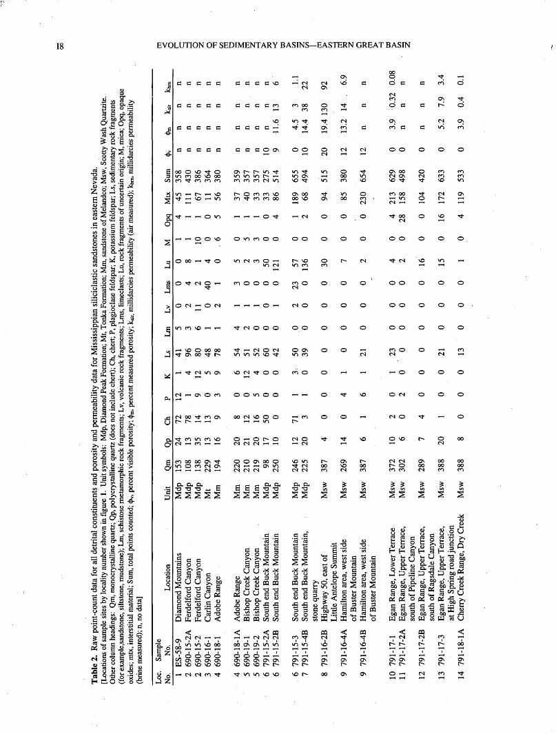
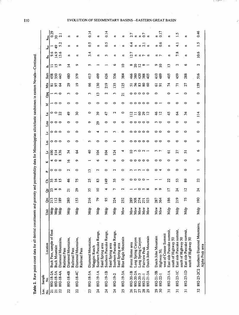
CONTENTS
Abstract........................................................................................................................... IIIntroduction.................................................................................................................... 1Previous Work................................................................................................................ 3Methods of Study............................................................................................................ 4Composition of Sandstones............................................................................................ 4
Framework Grains.................................................................................................. 4Accessory Grains.................................................................................................... 5
Reservoir Characteristics................................................................................................ 5Porosity and Permeability....................................................................................... 5Textural Characteristics of Visible Porosity........................................................... 12Paragenesis of Cements.......................................................................................... 16
Summary......................................................................................................................... 16References Cited.............................................................................................................. 18
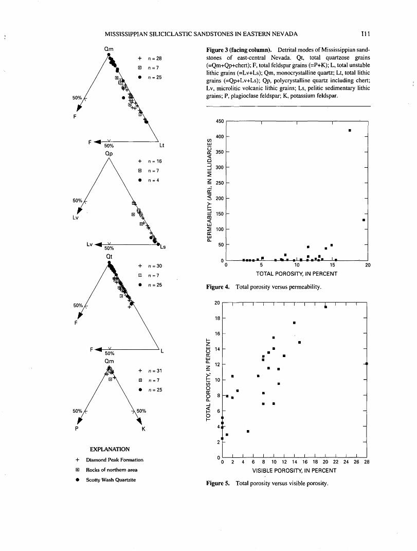
FIGURES
1. Map of study area showing sample localities.......................................................................................................... 122. Time-rock correlation chart for Mississippian strata in eastern Nevada................................................................. 33. Ternary diagrams showing detrital modes of Mississippian sandstones of east-central Nevada............................ 114. Graph showing total porosity versus permeability.................................................................................................. 115. Graph showing total porosity versus visible porosity ............................................................................................. 11
6-14. Photographs showing:6. Shrinkage of pelitic rock fragment, Diamond Peak Formation..................................................................... 127. Porosity associated with dissolution of rock fragment, Diamond Peak Formation....................................... 138. Porosity associated with dissolution of rock fragment, quartzose sandstone of the Scotty Wash Quartzite. 139. Secondary porosity, Diamond Peak Formation.............................................................................................. 14
10. Secondary porosity and cementation, Diamond Peak Formation.................................................................. 1411 Secondary pore formed by dissolution of calcareous cement, Diamond Peak Formation ............................ 1512. Secondary porosity, Diamond Peak Formation.............................................................................................. 1513 Euhedral quartz overgrowth and secondary pore space, closeup view of figure 12...................................... 1614. Dissolution pores and euhedral surfaces of quartz overgrowths, Diamond Peak Formation
and Scotty Wash Quartzite............................................................................................................................. 17
TABLES
1. Detrital modes for major framework constituents of Mississippian siliciclastic sandstones, eastern Nevada........ 162. Raw point-count data for all detrital constituents and porosity and permeability data for
Mississippian siliciclastic sandstones, eastern Nevada........................................................................................... 8
III

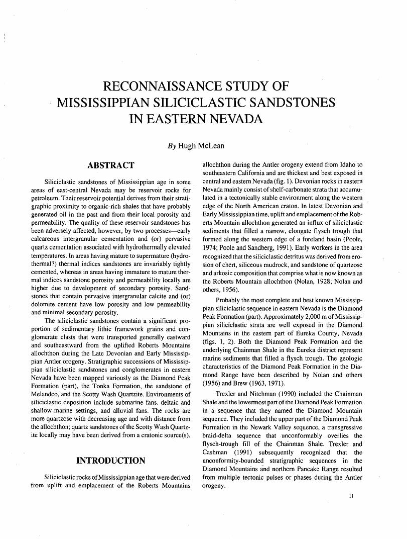
RECONNAISSANCE STUDY OF MISSISSIPPIAN SILICICLASTIC SANDSTONES
IN EASTERN NEVADA
By Hugh McLean
ABSTRACT
Siliciclastic sandstones of Mississippian age in some areas of east-central Nevada may be reservoir rocks for petroleum. Their reservoir potential derives from their strati- graphic proximity to organic-rich shales that have probably generated oil in the past and from their local porosity and permeability. The quality of these reservoir sandstones has been adversely affected, however, by two processes early calcareous intergranular cementation and (or) pervasive quartz cementation associated with hydrothermally elevated temperatures. In areas having mature to supermature (hydro- thermal?) thermal indices sandstones are invariably tightly cemented, whereas in areas having immature to mature ther mal indices sandstone porosity and permeability locally are higher due to development of secondary porosity. Sand stones that contain pervasive intergranular calcite and (or) dolomite cement have low porosity and low permeability and minimal secondary porosity.
The siliciclastic sandstones contain a significant pro portion of sedimentary lithic framework grains and con glomerate clasts that were transported generally eastward and southeastward from the uplifted Roberts Mountains allochthon during the Late Devonian and Early Mississip pian Antler orogeny. Stratigraphic successions of Mississip pian siliciclastic sandstones and conglomerates in eastern Nevada have been mapped variously as the Diamond Peak Formation (part), the Tonka Formation, the sandstone of Melandco, and the Scotty Wash Quartzite. Environments of siliciclastic deposition include submarine fans, deltaic and shallow-marine settings, and alluvial fans. The rocks are more quartzose with decreasing age and with distance from the allochthon; quartz sandstones of the Scotty Wash Quartz ite locally may have been derived from a cratonic source(s).
INTRODUCTION
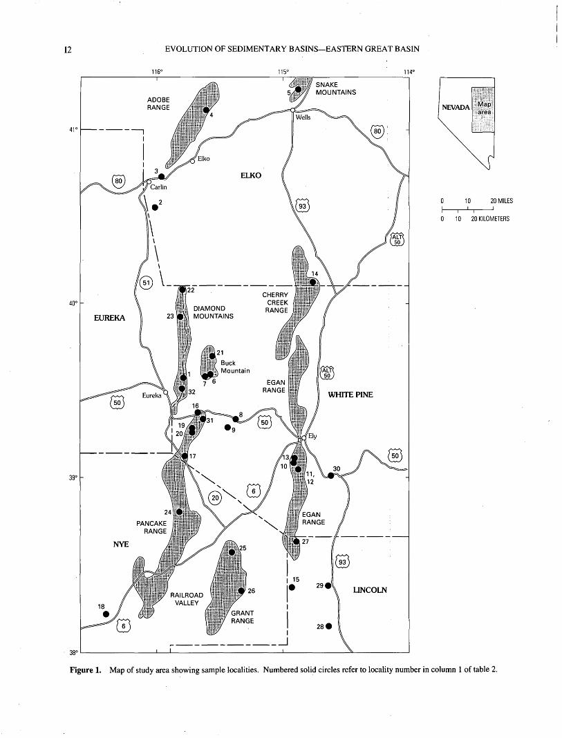
Siliciclastic rocks of Mississippian age that were derived from uplift and emplacement of the Roberts Mountains
allochthon during the Antler orogeny extend from Idaho to southeastern California and are thickest and best exposed in central and eastern Nevada (fig. 1). Devonian rocks in eastern Nevada mainly consist of shelf-carbonate strata that accumu lated in a tectonically stable environment along the western edge of the North American craton. In latest Devonian and Early Mississippian time, uplift and emplacement of the Rob erts Mountain allochthon generated an influx of siliciclastic sediments that filled a narrow, elongate flysch trough that formed along the western edge of a foreland basin (Poole, 1974; Poole and Sandberg, 1991). Early workers in the area recognized that the siliciclastic detritus was derived from ero sion of chert, siliceous mudrock, and sandstone of quartzose and arkosic composition that comprise what is now known as the Roberts Mountain allochthon (Nolan, 1928; Nolan and others, 1956).
Probably the most complete and best known Mississip pian siliciclastic sequence in eastern Nevada is the Diamond Peak Formation (part). Approximately 2,000 m of Mississip pian siliciclastic strata are well exposed in the Diamond Mountains in the eastern part of Eureka County, Nevada (figs. 1, 2). Both the Diamond Peak Formation and the underlying Chainman Shale in the Eureka district represent marine sediments that filled a flysch trough. The geologic characteristics of the Diamond Peak Formation in the Dia mond Range have been described by Nolan and others (1956) and Brew (1963,1971).
Trexler and Nitchman (1990) included the Chainman Shale and the lowermost part of the Diamond Peak Formation in a sequence that they named the Diamond Mountain sequence. They included the upper part of the Diamond Peak Formation in the Newark Valley sequence, a transgressive braid-delta sequence that unconformably overlies the flysch-trough fill of the Chainman Shale. Trexler and Cashman (1991) subsequently recognized that the unconformity-bounded Stratigraphic sequences in the Diamond Mountains and northern Pancake Range resulted from multiple tectonic pulses or phases during the Antler orogeny.
12 EVOLUTION OF SEDIMENTARY BASINS EASTERN GREAT BASIN
116'
40° -111 DIAMOND
23 l|i MOUNTAINS
0 10 20 MILES
0 10 20 KILOMETERS
Figure 1. Map of study area showing sample localities. Numbered solid circles refer to locality number in column 1 of table 2.
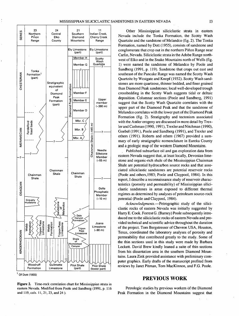
MISSISSIPPIAN SILICICLASTIC SANDSTONES IN EASTERN NEVADA 13
23Northern
Pinon Range
TonkaFormation 1
(part)
Chainman Shale
Woodruff Formation
24Central
ElkoCounty
Stratigraphic equivalent
of Diamond
PeakFormation
(part)
Chainman Shale
DellePhosphatic
Member(-10 m)
21SouthernDiamond
Mountains
Ely Limestone (part)
Member H
Member G
Member F
Member E
Member D
Chainman Shale
Pilot Shale (part)
11Indian Creek, Cherry Creek
Range
Ely Limestone (part)
ScottyWash
Quartzite
Upper member (-380 m)
Needle Siltstone Member (-55 m)
Pilot Shale (lower part)
Of Dott(1955)
Figure 2. Time-rock correlation chart for Mississippian strata in eastern Nevada. Modified from Poole and Sandberg (1991, p. 116 and 119, cols. 11, 21, 23, and 24).
Other Mississippian siliciclastic strata in eastern Nevada include the Tonka Formation, the Scotty Wash Quartzite and the sandstone of Melandco (fig. 2). The Tonka Formation, named by Dott (1955), consists of sandstone and conglomerate that crop out in the northern Pinon Range near Carlin, Nevada. Siliciclastic strata in the Adobe Range north west of Elko and in the Snake Mountains north of Wells (fig. 1) were named the sandstone of Melandco by Poole and Sandberg (1991, p. 119). Sandstone that crops out east and southeast of the Pancake Range was named the Scotty Wash Quartzite by Westgate and Knopf (1932). Scotty Wash sand stones are more quartzose, thinner bedded, and finer grained than Diamond Peak sandstones; local well-developed trough crossbedding in the Scotty Wash suggests tidal or deltaic deposition. Columnar sections (Poole and Sandberg, 1991) suggest that the Scotty Wash Quartzite correlates with the upper part of the Diamond Peak and that the sandstone of Melandco correlates with the lower part of the Diamond Peak Formation (fig. 2). Stratigraphy and tectonism associated with the Antler orogeny are discussed in more detail by Trex- ler and Cashman (1990,1991), Trexler and Nitchman (1990), Goebel (1991), Poole and Sandberg (1991), and Trexler and others (1991). Roberts and others (1967) provided a sum mary of early Stratigraphic nomenclature in Eureka County and a geologic map of the western Diamond Mountains.
Published subsurface oil and gas exploration data from eastern Nevada suggest that, at least locally, Devonian lime stone and organic-rich shale of the Mississippian Chainman Shale are potential hydrocarbon source rocks and that asso ciated siliciclastic sandstones are potential reservoir rocks (Poole and others, 1983; Poole and Claypool, 1984). In this report, I describe a reconnaissance study of reservoir charac teristics (porosity and permeability) of Mississippian silici clastic sandstones in areas exposed to different thermal regimes as determined by analyses of petroleum source-rock potential (Poole and Claypool, 1984).
Acknowledgments. Petrographic study of the silici clastic rocks of eastern Nevada was initially suggested by Harry E. Cook. Forrest G. (Barney) Poole subsequently intro duced me to the siliciclastic rocks of eastern Nevada and pro vided technical and scientific advice throughout the duration of the project. Tom Bergstresser of Chevron USA, Houston, Texas, coordinated the laboratory analyses of porosity and permeability that contributed greatly to the study. Some of the thin sections used in this study were made by Barbara Lockett. David Brew kindly loaned a suite of thin sections from his dissertation area in the southern Diamond Moun tains. Laura Zink provided assistance with preliminary com puter graphics. Early drafts of the manuscript profited from reviews by Janet Pitman, Tom MacKinnon, and F.G. Poole.
PREVIOUS WORK
Petrologic studies by previous workers of the Diamond Peak Formation in the Diamond Mountains suggest that
14 EVOLUTION OF SEDIMENTARY BASINS EASTERN GREAT BASIN
most of the detritus in the siliciclastic sequence was derived from rocks that now comprise the Roberts Mountains alloch- thon or Antler highland (Nolan, 1928; Brew, 1963, 1971; Harbaugh, 1980; Harbaugh and Dickinson, 1981). Sedimen tary rock fragments of quartzose sandstone, siltstone, sili ceous mudstone, pure and impure chert, and potassium feldspar-bearing arkosic sandstone are present within the Antler foreland (Dickinson and others, 1983).
Studies of provenance and composition of the Chain- man Shale and Diamond Peak Formation in the central Dia mond Range were reported by Brew (1963, 1971). Detrital modes, facies interpretations, and tectonic implications of the Diamond Peak Formation from an area immediately north of Brew's map area were reported by Harbaugh (1980) and recast by Harbaugh and Dickinson (1981) and Dickinson and others (1983). Trexler and Cashman (1991) reported paleocurrent data and selected detrital modes for the Newark Valley sequence in the Diamond, Pancake, and White Pine mountain ranges. Facies within the Newark Valley sequence in the Diamond Mountains were interpreted by Perry and Trexler (1993) as representing alluvial, deltaic, and shal low-marine environments, and detrital constituents within the Newark Valley sequence were interpreted as reflecting recycling of underlying strata. Together, the variation in facies and composition were interpreted by Perry and Trex ler as indications of a tectonically active depositional setting.
METHODS OF STUDY
For the purposes of this study, 60 siliciclastic sandstone samples were collected from 31 sites in Elko, Eureka, White Pine, Nye, and Lincoln Counties of east-central Nevada (fig. 1). Thin sections were examined petrographically to deter mine composition of framework grains, type and volume of intergranular cements, and amount of visible pore space. Standard thin sections were stained with sodium cobaltini- trate for potassium feldspar and point counted using petro- graphic techniques outlined by Dickinson (1970). Most of the thin sections were impregnated with blue-dyed epoxy, which facilitated measurement of visible porosity. The Gazzi-Dickinson method described by Ingersoll and others (1984) was employed in counting polycrystalline rock frag ments. Detrital modes shown in figure 3 and listed in table 1 are based on counts of 300^4-00 framework grains per thin section; raw point counts and porosity and permeability data are given in table 2. Counts of visible pore space (filled by blue-dyed epoxy) and intergranular cement increased the total number of counted points in some sections to as many as 655 (table 2).
Calcite and dolomite cements were identified in hand specimen by applying a drop of dilute (2N) HC1 to fresh sur faces. Samples that effervesced freely were considered to be cemented by calcite, whereas samples that effervesced only
on a scratched surface were considered to be cemented with dolomite.
A suite of 27 sandstone samples was analyzed by the Western Exploration Technical Center of Chevron USA, Houston, Texas, for percentage of total porosity and perme ability. Porosities were measured by the mercury intrusion technique, and permeabilities were measured by unstressed (air) and stressed (brine) techniques. Results of these analy ses are given in table 2.
COMPOSITION OF SANDSTONES
FRAMEWORK GRAINS
Detrital modes for samples of the Diamond Peak For mation and Scotty Wash Quartzite and for samples from locations north of the Diamond Mountains are shown in four ternary diagrams in figure 3. The rocks in the "northern area" of figure 3 include the Tonka Formation of Dott (1955), the sandstone of Melandco in the Adobe Range and Snake Mountains, and the Diamond Peak Formation at Ferdelford Canyon in the northern Pinon Range (locality 2, fig. 1).
Quartz. The QtFL and QmFLt diagrams of figure 3 illustrate the quartzose, subquartzose, and sublithic compo sitions of Mississippian siliciclastic sandstones of east-cen tral Nevada. Most of the well-rounded monocrystalline quartz grains (Qm) were probably recycled from eroded quartzose sandstone protoliths in the source area. Polycrys talline quartz (Qp, table 2) excludes chert and consists mainly of very fine grained quartzite. Well-rounded grains were probably recycled from sandstone in the source area.
Chert. Grains of recrystallized chert (Ch) are com mon framework constituents in most of the Mississippian sandstones except for the Scotty Wash Quart/ite. Well-rounded grains of chert were probably recycled from sandstone protoliths, whereas angular and subangular grains were probably derived from chert-bearing sequences in the source area such as the Ordovician Vinini Formation. The great variation in degree of both clarity and recrystallization of chert grains suggests the possibility of multiple sources.
Potassium feldspar. Potassium feldspar is present in modest amounts (4-12 percent) in samples from the Adobe Range and Snake Mountains in the northern part of the area (Tonka Formation and sandstone of Melandco) and from the Diamond Peak Formation in the northern Pancake Range. One sample from the Diamond Peak Formation contained as much as 19 percent potassium feldspar (table 2, locality 19). Potassium feldspar is also present as detrital grains in sand stone and siltstone rock fragments. Individual potassium feldspar framework grains were probably recycled from an arkosic sandstone protolith. Dickinson and others (1983) suggested that potassium feldspar in the Diamond Peak For mation was recycled from arkose in the Cambrian Harmony Formation. Local variations in potassium feldspar content
MISSISSIPPIAN SILICICLASTIC SANDSTONES IN EASTERN NEVADA 15
may support the concept of Perry and Trexler (1993) that sediments comprising the Diamond Peak Formation in the Newark Valley sequence were reworked by local tectonic pulses. Alternatively, sediment availability and input from source rocks in the allochthon such as the Harmony Forma tion may have varied locally. Such variation through time could have affected potassium feldspar concentrations in resultant sediment accumulations.
Potassium feldspar in tightly compacted rocks that have little visible porosity shows no evidence of alteration. In rocks that have significant secondary porosity, grains of potassium feldspar are corroded and pitted.
Plagioclase. Except for three samples from the Dia mond Peak Formation (localities 1, 20, and 23, table 2), raw counts of plagioclase feldspar do not exceed six grains per thin section. Most plagioclase is subangular to subrounded, finely twinned albite. Plagioclase provenance remains prob lematic; possible sources include volcanic, recycled sedi mentary, and plutonic rocks. Patchy mottling observed on some twinned grains might be a relict texture.
Sedimentary rock fragments. Chert and siliciclastic sedimentary rock fragments dominate the population of lithic framework grains in samples from the Diamond Peak Forma tion, Tonka Formation, and sandstone of Melandco. The suite of lithologies includes potassium feldspar-bearing quartzo- feldspathic sandstone and siltstone, argillaceous mudstone of varying brownish color and degree of opacity, and tuf- faceous(?) mudstone that ranges from light-colored impure chert to colorless, nearly isotropic cryptocrystalline forms.
Metamorphic rock fragments. Schistose rock frag ments are present only in trace amounts in the Diamond Peak Formation and its northern correlatives and are absent in the Scotty Wash Quartzite. Pale-green chloritic grains were included as metamorphic rock fragments and make up the relatively large part of metamorphic grains counted in Dia mond Peak sandstones at locality 19 (table 2).
Volcanic rock fragments. Grains containing clearly discernible volcanic textures are very rare; however; those that were observed consisted of microlitic laths of albite set in a groundmass of light-brown, translucent glass.
Limeclasts. Calcareous framework grains were noted in only a few geographically widely separated samples. This local occurrence suggests that intertongues of limestone may have provided an intraformational source for the limeclasts. Limestone interbeds in the Diamond Peak Formation were observed in the vicinity of locality 6 (table 2). Alternatively, limeclasts at locality 3 (Carlin Canyon) may have been derived from recycling of Paleozoic limestones that uncon- formably underlie the Tonka Formation (Dott, 1955).
Rock fragments of uncertain origin. Cryptocrystalline grains that have no discernible texture or fabric were counted as rock fragments of uncertain origin. Although the general abundance of sedimentary rock fragments suggests that most of the grains in the uncertain-origin category are also proba bly sedimentary, a volcanic origin for some is possible.
ACCESSORY GRAINS
Mica. Mica was observed in only a few samples from the Diamond Peak Formation and was notably absent in sand stones of the Scotty Wash Quartzite (table 2). In the few rocks that contained mica, the predominant variety was muscovite, although sparse grains of light-brown biotite were also noted.
Opaque grains. Grains of opaque material are present sporadically in both the Diamond Peak Formation and Scotty Wash Quartzite. In sandstones adjacent to mineralized zones where elevated temperatures are presumably related to circu lation of hydrothermal fluids (such as the Ward mining dis trict, localities 10-12, table 2), the opaque grains are mainly pyrite. At Trough Spring Canyon (locality 15, table 2), how ever, dissolution of nonmetallic opaque grains that are pale orange in reflected light forms secondary pores.
RESERVOIR CHARACTERISTICS
POROSITY AND PERMEABILITY
Laboratory measurements of total porosity and perme ability in air and brine are given together with visible poros ity in table 2. Budget limitations prevented rocks from the Adobe and northern Pinon ranges and the Snake Mountains from being included in the suite of samples in which these parameters were measured. Total porosity within the sample suite ranged from 2.5 to 19.4 percent (fig. 4). Unstressed (air) permeability ranged from 0.32 to 420 mD (fig. 4), whereas stressed (brine) permeability ranged from 0.10 to 370 mD. Visible porosity determined by point-counting ranged from 0 to 28 percent and correlates favorably with laboratory measurements (figure 5); in eight samples visible porosity is within 2 percent of total porosity.
Where petroleum source rocks are mature to supermature, such as the Ward mining district in the northern Egan Range and Dry Creek in the Cherry Creek Range (Poole and others, 1983) (localities 10-13, 14, fig. 1), quartz-cemented quartzose sandstone is uniformly well cemented; that is, porosity and permeability are minimal. In contrast, noncalcareous sandstones associated with immature to mature petroleum source rocks yielded highly variable values of porosity and permeability. For example, several samples from a small area in Trough Spring Canyon in the southern Egan Range (locality 15, fig. 1) ranged from 11.6 to 17.4 percent porosity and from 43 to 420 mD permeability. Similarly, at the south end of Buck Mountain (locality 6, fig. 1), closely spaced samples ranged from 4.5 to 14.1 percent porosity and from 3 to 38 mD permeability. Near Nevada Governors Spring in the northern Pancake Range (locality 17, fig. 1), porosity ranged from 8.4 to 13.1 percent and air permeability from 2.4 to 18 mD. The variations in porosity and permeability in noncalcareous and slightly calcareous sandstones are probably due to variables
o\
Tab
le 1
. D
etri
tal
mod
es f
or m
ajor
fram
ewor
k co
nstit
uent
s of
Mis
siss
ippi
an s
ilici
clas
tic s
ands
tone
s, e
aste
rn N
evad
a.[L
ocat
ions
of s
ampl
e si
tes
show
n by
loca
lity
num
ber
on fi
gure
1.
Nor
mal
ized
det
rita
l mod
es f
or Q
tFL
, Qm
FLt,
QpL
vLs,
and
Qm
PK: Q
t, to
tal q
uart
zose
gra
ins
(=Q
m+Q
p+ch
ert)
;F,
tota
l fel
dspa
r gra
ins
(=P+
K);
L, t
otal
uns
tabl
e lit
hic
grai
ns (
=Lv+
Ls)
; Qm
, mon
ocry
stal
line
quar
tz; L
t, to
tal l
ithic
gra
ins
(=Q
p+L
v+L
s); Q
p, p
olyc
ryst
allin
e qu
artz
incl
udin
g ch
ert;
Lv,
mic
rolit
ic v
olca
nic
lithi
c gr
ains
; Ls,
pol
itic
sedi
men
tary
lith
ic g
rain
s; P
, pla
gioc
lase
fel
dspa
r; K
, pot
assi
um f
elds
par.
The
lette
r (n
) in
dica
tes
no d
ata.
Uni
t sym
bols
:M
dp, D
iam
ond
Peak
For
mat
ion;
Mt,
Ton
ka F
orm
atio
n ; M
m, s
ands
tone
of M
elan
dco;
Msw
, Sco
tty W
ash
Qua
rtzi
te]
Loc
ality
No. 1 2 2 3 4 4 5 5 6 6 6 7 8 9 9 10 11 12 13 14 14 15 15 15 15 16 16 17 17 17
Sam
ple
num
ber
ES-
58-9
690-
15-
2 A69
0-15
-269
0-16
-169
0-18
-1
690-
18-
1 A69
0-19
-169
0-19
-279
1-15
-2A
791-
15-2
B
791-
15-3
791-
15-4
B79
1-16
-2B
791-
16-4
A79
1-16
-4B
791-
17-1
791-
17-2
A79
1-17
-2B
791-
17-3
791-
18-1
A
791-
18-1
B79
1-18
-2A
791-
18-3
A79
1-18
-3B
791-
18-4
791-
19-1
A79
1-19
-1B
791-
19-2
A79
1-19
-2B
791-
19-3
Uni
tM
dpM
dpM
dpM
tM
m
Mm
Mm
Mm
Mdp
Mdp
Mdp
Mdp
Msw
Msw
Msw
Msw
Msw
Msw
Msw
Msw
Msw
Msw
Msw
Msw
Msw
Mdp
Mdp
Mdp
Mdp
Mdp
Qt 81 63 61 81 71 78 79 80 60 61 74 58 93 96 93 93 91 95 92 97 89 94 92 97 100 69 77 59 69 59
F 4 2 7 2 4 2 4 3 0 0 1 0 0 2 2 1 1 0 0 0 0 0 0 1 0 0 0 0 0 0
L 15 35 32 17 25 .20 17 17 40 39 25 42 7 2 5 6 8 5 8 3 11 6 8 2 0 31 23 41 31 41
Qm 50 34 45 73 63 69 68 69 36 59 55 53 92 91 91 90 89 91 87 95 87 92 89 96 100 47 67 37 39 26
F 4 2 7 2 4 2 4 3 0 0 1 0 0 2 2 1 1 0 0 0 0 0 0 1 0 0 0 0 0 0
Lt 46 64 48 25 23 29 18 28 64 41 44 47 8 7 7 9 10 9 13 5 13 8 11 3 0 53 33 63 61 74
Qp 37 48 35 35 24 34 39 40 22 n n n n n n n n n n n n n n n n 19 n 14 19 10
Lv0 1 8 0 5 0 0 0 0 n n n n n n n n n n n n n n n n 0 n 0 0 0
Ls 63 51 57 65 71 66 61 60 78 n n n n n n n n n n n n n n n n 81 n 86 81 90
Qm 92 86 96 98 94 97 95 96 100
100 97 100
100 98 98 98 100
100 99 100
100
100
100 99 100
100
100 99 100
100
P 7 6 1 0 1 0 0 2 0 0 1 0 0 2 2 2 0 0 1 0 0 0 0 1 0 0 0 1 0 0
K
1 8 3 2 5 3 5 2 0 0 2 0 0 0 0 0 0 0 0 0 0 0 0 0 0 0 0 0 0 0
m O r o Z o oo m
o m
H jo 03 00 Z r m 00 I Z o jo
m H 03
oo Z
MISSISSIPPIAN SILICICLASTIC SANDSTONES IN EASTERN NEVADA 17
o o en m -* rf es "i cs ^H es o <* m vo o r- -3- o o ooooo ooooo o
o ' cs o vo CS O O vo CS O ^H O ^H o ' O O O <-H O O O O
o ON in in oo »n es r- oo ON oo o vOTj-^t ^f ^ vo ON o ON o ON o o o ON o o o oO ON ON ON OO ON ON ON ON ON ON O ON ON ON ON ON ON ON O ON O ON O O O ON O O O O
C e c C C e c en c ^ ~* en -<t CN ON en ON m en c ococc e c oo *-< c c r^oooooNONvovoinoooNON o oo in
C C C C C C C CS C O OOOOO O en CN CS C O C O C C CCOOG C
e c c c c c c in e ON ON r~ vo oo ^ r^ oo en in c ococc e c cs ON c c cs ^H -H en en -<t cs^
CS CS ~* en CSr- co co co in
O »-l -^ CN VO
oo t in tS VO SO
vo oo en »n Tj- en
cs >n vo en ^H ON >n oo cs voCS r-> ^H
en ~H vo rt r- Tfr
O ^ o O O
en r~ 't O en en TfenenvoON O in ^ oo ^j- en eN vo r- ON en in in ->T in vo ** vocscsinoo r-» ON oo oo ON oooNinincs in
en t*^ O vo O in cs vo vo t^ vo CN ON CNcNenrt encSencSen CN-^-^-^H
oo en O en en ^^ ON in oo OCS !-< --1
cs Tt en en cs en
O ^ O (S -^ en CS^H^o > O -« O O O^nOOO
envooNOOOO t^'-<voenen cN^f (N ^ ^H vo O oo >n vo vo ON
D- CX d, D< CX O -O T3 T3 T3
< « uO fN CS tSoo ir> >o >n- «N <s cs
ex ex ex ex ex ex ex ex ex ex ex ex ex ex
< < < pQ U CN en T- T- ^t < < OQ < »n I-H ^H CN en
ON ON ON ONPU P-, tin fc CNi I ^H ^H ^H ON
ON ON ON ON oo
OOOOOOOOOO OOONONONON
CNCNCNCNCN CNCNCNCNCNONONONONON ONONONONONOOOOOOOOOO OOOOOOOOOO
C^OOONONON ONOOO^ > i ^H cs cs cs enTj-Ttrfin^^H^^H^, t-icSCSCSCS CSCSCNCNCN CNCScSCNCS
o m ^H o vo r** ON oo ON ON
1/3 t/2 c/3 t/2
CQ < <<-< cS en ^H ff)O O O -^ »iCN CN CS CS CSCS CS CS CN CSON ON ON ON ONoo oo oo oo oo
vo r^ t*- oo ONCS CS CS CS CS
VO Tt OO VO OO ON vo F»
^ ^ ex ex exc/5 t/3 "O "O T3
PQ < U Qen » * *-H » * » H^^ CS en en enCS CS CS CS CNCS CS CS CS CNON ON ON ON ONOO OO OO 00 OO
ON O r-i r I . Ccs en en en en
Tab
le 2
. R
aw p
oint
-cou
nt d
ata
for
all d
etri
tal
cons
titu
ents
and
por
osit
y an
d pe
rmea
bilit
y da
ta f
or M
issi
ssip
pian
sili
cicl
astic
san
dsto
nes
in e
aste
rn N
evad
a.
[Loc
atio
ns o
f sam
ple
site
s by
loca
lity
num
ber s
how
n in
fig
ure
1. U
nit s
ymbo
ls:
Mdp
, Dia
mon
d Pe
ak F
orm
atio
n; M
t, To
nka
Form
atio
n; M
m, s
ands
tone
of M
elan
dco;
Msw
, Sco
tty W
ash
Qua
rtzite
. O
ther
col
umn
head
ings
: Q
m, m
onoc
ryst
allin
e qu
artz
; Qp,
pol
ycry
stal
line
quar
tz (d
oes
not i
nclu
de c
hert)
; Ch,
che
rt; P
, pla
gioc
lase
fel
dspa
r; K
, pot
assi
um fe
ldsp
ar; L
s, se
dim
enta
ry ro
ck fr
agm
ents
(f
or e
xam
ple.
sand
ston
e, s
iltst
one,
mud
ston
e); L
m, s
chis
tose
met
amor
phic
rock
frag
men
ts; L
v, v
olca
nic
rock
frag
men
ts; L
ms,
lim
ecla
sts;
Lu,
roc
k fr
agm
ents
of u
ncer
tain
orig
in; M
, mic
a; O
pq, o
paqu
e ox
ides
; mtx
, int
erst
itial
mat
eria
l; Su
m, t
otal
poi
nts
coun
ted;
fy,,
perc
ent v
isib
le p
oros
ity; <
j>m, p
erce
nt m
easu
red
poro
sity
; kai
r, m
illid
arci
es p
erm
eabi
lity
(air
mea
sure
d); k
bm, m
ilh'd
arci
es p
erm
eabi
lity
(brin
e m
easu
red)
; n, n
o da
ta]
Loc.
Sa
mpl
e N
o.
No.
1 E
S-58
-92
690-
15-2
A2
690-
15-2
3 69
0-16
-14
690-
18-1
4 69
0-18
-1A
5 69
0-19
-15
690-
19-2
6 79
1-15
-2A
6 79
1-15
-2B
6 79
1-15
-37
791-
15-4
B
8 79
1-16
-2B
9 79
1-16
-4A
9 79
1-16
-4B
10
791-
17-1
11
791-
17-2
A
12
791-
17-2
B
13
791-
17-3
14
791-
18-1
A
Loca
tion
Dia
mon
d M
ount
ains
Ferd
elfo
rd C
anyo
nFe
rdel
ford
Can
yon
Car
lin C
anyo
nA
dobe
Ran
ge
Ado
be R
ange
Bis
hop
Cre
ek C
anyo
nB
isho
p C
reek
Can
yon
Sout
h en
d B
uck
Mou
ntai
nSo
uth
end
Buc
k M
ount
ain
Sout
h en
d B
uck
Mou
ntai
nSo
uth
end
Buc
k M
ount
ain,
ston
e qu
arry
Hig
hway
50,
eas
t of
Litt
le A
ntel
ope
Sum
mit
Ham
ilton
are
a, w
est s
ide
of B
uste
r Mou
ntai
nH
amilt
on a
rea,
wes
t sid
eof
Bus
ter M
ount
ain
Egan
Ran
ge, L
ower
Ter
race
Egan
Ran
ge, U
pper
Ter
race
,so
uth
of P
ipel
ine
Can
yon
Egan
Ran
ge, U
pper
Ter
race
,so
uth
of R
agsd
ale
Can
yon
Egan
Ran
ge, U
pper
Ter
race
,at
Hig
h Sp
ring
road
junc
tion
Che
rry
Cre
ek R
ange
, Dry
Cre
ek
Uni
tM
dpM
dpM
dpM
tM
m
Mm
Mm
Mm
Mdp
Mdp
Mdp
Mdp
Msw
Msw
Msw
Msw
Msw
Msw
Msw
Msw
Qm
153
108
138
229
194
220
210
219 98 250
246
225
387
269
387
372
302
289
388
388
QP 24 13 35 13 16 20 21 20 17 10 12 20 4 14 6 10 6 7 20 8
Ch 72 78 14 13 9 8 12 16 50 0 71 3 0 0 1 2 0 4 1 0
P 12 1 9 0 3 0 0 5 0 0 1 1 0 4 6 0 2 0 0 0
K 1 4 12 5 9 6 12 4 0 0 3: 0 0 1 1 1 0 0 0 0
Ls 41 96 80 48 78 54 51 52 60 42 50 39 0 0 21 23 0 0 21 13
Lm5 3 6 1 1 4 2 0 0 0 0 0 0 0 0 0 0 0 0 0
Lv 0 2 11 0 2 1 1 1 0 1 2 0 0 0 0 0 0 0 0 0
Lms 0 4 2 401 3 0 0 0 0 23 0 0 0 0
- 0 0 0 0 0
Lu 0 8 1 4 0 5 2 3 50 121 57 136 30 7 2 4 2 16 15 1
M1 1 10 0
, 6 0 5 3 0 0 0 0 0 0 0 0 0 0 0 0
Opq 4 1 1 0 5 1 1 1 0 4 1 2 0 0 0 4 28 0 16 4
Mtx 45 111 67 11 56 37 40 33 33 86 189 68 94 85 230
213
158
104
172
119
Sum
358
430
386
364
380
359
357
357
275
514
655
494
515
380
654
629
498
420
633
533
<K n n n n n n n n 10 9 0 10 20 12 12 0 0 0 0 0
<t>m n n n n n n n n n 11
.6 4.5
14.4
19.4
13.2 n 3.9
n n 5.2
3.9
kair n n n n n n n n n 13 3 38 130 14 n 0.
32n n 7.
9
0.4
kbrn n n n n n n n n n 6 1.
122 92 6.
9
n 0.08
n n 3.4
0.1
m 0 r O z 0 00 M D § M Z jo w 00 Z 00 k 00 d m
JO Z o w H 03 00 Z

14
791-
18-I
B
Che
rry
Cre
ek R
ange
, Dry
Cre
ek15
79
1-18
-2A
So
uthe
rn E
gan
Ran
ge,
Tro
ugh
Sprin
g C
anyo
n15
79
1-18
-3 A
So
uthe
rn E
gan
Ran
ge,
Tro
ugh
Sprin
g C
anyo
n15
79
1-18
-3B
So
uthe
rn E
gan
Ran
ge,
Trou
gh S
prin
g C
anyo
n15
79
1-18
-4
Sout
hern
Ega
n R
ange
, Tr
ough
Spr
ing
Can
yon
16
791-
19-1
A
Hig
hway
50,
wes
t sid
e Pa
ncak
e Su
mm
it16
79
1-19
-1B
H
ighw
ay 5
0,w
est s
ide
Panc
ake
Sum
mit
17
791-
19-2
A
Panc
ake
Ran
ge,
Nev
ada
Gov
erno
rs S
prin
g17
79
1-19
-2B
Pa
ncak
e R
ange
,N
evad
a G
over
nors
Spr
ing
17
791-
19-3
Pa
ncak
e R
ange
,N
evad
a G
over
nors
Spr
ing
17
791-
19-4
Pa
ncak
e R
ange
,N
evad
a G
over
nors
Spr
ing
18
91FP
-180
H
ot C
reek
Ran
ge,
Milk
Spr
ing
area
19
91FP
-252
A
Nor
ther
n Pa
ncak
e R
ange
,fla
gsto
ne q
uarr
y ne
arB
lack
Sha
de W
ell
19
91FP
-252
B
Nor
ther
n Pa
ncak
e R
ange
,fla
gsto
ne q
uarr
y ne
arB
lack
Sha
de W
ell
19
91FP
-252
C
Nor
ther
n Pa
ncak
e R
ange
,fla
gsto
ne q
uarr
y ne
arB
lack
Sha
de W
ell
19
91FP
-259
N
orth
ern
Panc
ake
Ran
ge,
Bla
ck S
hade
Wel
l20
91
FP-2
54A
N
orth
ern
Panc
ake
Ran
ge,
1 km
sou
thea
st o
f loc
ality
19
20
91FP
-254
B
Nor
ther
n Pa
ncak
e R
ange
,1
km s
outh
east
of l
ocal
ity 1
920
91
FP-2
54C
N
orth
ern
Panc
ake
Ran
ge,
1 km
sou
thea
st o
f loc
ality
19
21
892-
18-1
A
Buc
k Pa
ss, s
ampl
e of
floa
t
Msw
Msw
Msw
Msw
Msw
289
427
464
327
307
5 11 12 1 0
1 0 0 0 1
0 0 0 4 0
0 0 0 0 0
0 15 42 0 0
0 0 0 0 0
0 0 0 0 0
0 0 0 0 0
32 0 2 7 0
Mdp
25
3 35
78
0
0 15
2 0
0 0
16
Mdp
19
5 24
4
0 0
17
46
Mdp
14
6 23
65
2
0 14
6 0
0 0
17
Mdp
14
6 21
95
0
0 89
0
0 0
28
Mdp
10
5 15
11
7 0
0 13
5 0
0 0
32
Mdp
11
9 24
84
0
0 34
0
0 0
97
Mdp
25
0 26
7
2 0
34
5 0
0 48
Mdp
25
5 14
12
5
8 38
7
1 13
50
Mdp
15
5 15
8
2 19
38
7 24
69
Mdp
21
2 28
29
1
10
45
4 1
8 69
Mdp
14
7 24
81
9
4 50
1
1 4
39
Mdp
23
7 26
26
5
3 76
4
2 3
61
Mdp
26
5 29
16
0
5 48
8
0 8
56
Mdp
18
4 20
16
0
2 87
1
0 1
30
0 5
106
438
0 n
n n
0 1
77
531
9 11
.6
43
26
0 0
38
558
14
17.4
420
370
0 15
50
40
4 16
n
n n
0 1
77
386
20
n n
n
0 24
67
62
5 1
8 2.
1 0.
7
0 4
127
417
1 n
n n
0 16
55
47
0 8
13.1
2.
4 0.
8
0 2
62
443
7 10
.6
3.7
1.4
0 6
73
483
8 8.
4 18
8.
8
0 73
49
48
0 .
2 n
n n
9 0
36
417
3 8.
7 2.
7 0.
9
0 5
92
500
10
15.5
2.
7 1
2 1
65
473
19
n n
n
0 1
254
600
0 n
n n
1 6
152
566
0 2.5
1.3
0.39
0 1
153
514
0 n
n n
1 3
88
535
5 n
n n
1 0
26
462
28
12.2
1.
4 0.45
0 0
77
418
11
11.5
1.9
0.6
Z GO r Q n H n Z o </3 H O Z Z
en Z Z 3
Tab
le 2
. R
aw p
oint
-cou
nt d
ata
for a
ll de
trita
l con
stitu
ents
and
por
osity
and
per
mea
bilit
y da
ta fo
r Mis
siss
ippi
an s
ilici
clas
tic s
ands
tone
s in
eas
tern
Nev
ada
Con
tinue
d.
Loc
. Sa
mpl
e N
o.
No.
21
892-
18-
2 A21
89
2-18
-3A
22
892-
18-4
A
22
892-
18-4
B
22
892-
18-4
C
23
892-
18-
5 A
24
892-
19-1
A
24
892-
19-
IB
24
892-
19-2
25
892-
19-3
A
26
892-
20- I
B27
89
2-20
-2A
27
892-
20-3
28
892-
21-1
29
892-
21-3
A
29
892-
21 -3
B30
89
2-22
-1
31
892-
23-1
A
31
892-
23- 1
C
31
892-
23- I
D
32
892-
23-2
C2
Loc
atio
n
Buc
k Pa
ss, s
ampl
e of
floa
tB
uck
Mou
ntai
nD
iam
ond
Mou
ntai
ns,
Rai
lroad
Pas
sD
iam
ond
Mou
ntai
ns,
Rai
lroa
d Pa
ssD
iam
ond
Mou
ntai
ns,
Rai
lroad
Pas
s
Dia
mon
d M
ount
ains
,M
aggi
ni R
anch
Sout
hern
Pan
cake
Ran
ge,
Sand
Spr
ing
area
Sout
hern
Pan
cake
Ran
ge,
Sand
Spr
ing
area
Sout
hern
Pan
cake
Ran
ge,
Sand
Spr
ing
area
Blu
e Ea
gle
Mou
ntai
n
Fore
st H
ome
area
Long
Spr
ing
Can
yon
Long
Spr
ing
Can
yon
Fairv
iew
Pea
kD
utch
Joh
n M
ount
ain
Dut
ch J
ohn
Mou
ntai
nH
ighw
ay 5
0,w
est o
f Con
ner
Sum
mit
East
sid
e Pa
ncak
e su
mm
it,so
uth
of H
ighw
ay 5
0Ea
st s
ide
Panc
ake
sum
mit,
sout
h of
Hig
hway
50
East
sid
e Pa
ncak
e su
mm
it,so
uth
of H
ighw
ay 5
0
Sout
hern
Dia
mon
d M
ount
ains
,A
lpha
Pea
k ar
ea
Uni
tM
dpM
dpM
dp
Mdp
Mdp
Mdp
Mdp
Mdp
Mdp
Msw
Msw
Msw
Msw
Msw
Msw
Msw
Msw
Mdp
Mdp
Mdp
Mdp
Qm
213
112
189
280
153
216 79 95 224
232
289
308
274
271
323
287
364
186
219 75 190
QP 23 8 9 21 29 35 10 4 7 2 1 1 0 5 8 9 9 17 24 12 24
Ch 35 16 15 46 75 25 83 149 35 0 0 0 0 0 1 1 1 22 53 89 22
P 0 0 0 2 0 13 2 0 2 0 3 1 3 1 0 0 4 0 0 0 1
K 4 0 8 16 9 1 6 4 0 0 0 0 0 0 0 0 0 0 0 0 0
Ls 100
114
136 34 64 40 104
104
124 4 10 3 0 2 1 3 7 61 27 51 6
Lm0 0 0 0 0 5 0 0 1 0 0 0 0 0 0 0 0 0 0 0 0
Lv
0 0 0 0 0 0 4 2 3 0 0 0 0 0 0 0 0 0 0 0 0
Lms 0 0 0 0 0 9 29 0 0 0 0 0 0 0 0 3 0 0 0 0 0
Lu0 0 22 49 30 0 39 47 2 0
112 11 60 29 12 46 12 45 64 34 114
M1 0 0 0 0 0 0 0 0 0 0 0 0 0 0 0 1 0 0 0 0
Opq 1 3 0 3 0 3 13 2 3 21 0 0 0 0 0 0 0 1 0 0
Mtx 81 97 64 29 19 66 130
219
135
125 51 56 83 80 60 61 91 74 71 27 159
Sum
458
350
443
480
379
413
499
626
536
384
466
380
420
388
405
410
489
405
459
288
516
*V 11 15 9 14 9 5 1 1 6 10 8 20 12 8 1 9 10 13 2 6 2
<J>m 9.
614
.913
.6 n n 3.4
n 3 n n 12.7 n n 7 n n 7 n 7.8
n 10.6
kair 1
49 5.2
n n 0.5
n 0.5
n n 6.4
n n 2.1
n n 0.6
n 4.1
n 1.5
kbrn 0.
2930 2.
1
n n 0.14
n 0.14
n n 2.7
n n 0.7
n n 0.17
n 1.5
n 0.46
m 0 r H O z 0 Tl
00 m a m H 73 *t CO 00 2 00 m oo z O 73 m H DO 00
MISSISSIPPIAN SILICICLASTIC SANDSTONES IN EASTERN NEVADA 111
Qm
n = 28
n = 7
n = 25
50%
50%
50%
EXPLANATION
+ Diamond Peak Formation
S Rocks of northern area
Scotty Wash Quartzite
Figure 3 (facing column). Detrital modes of Mississippian sand stones of east-central Nevada. Qt, total quartzose grains (=Qm+Qp+chert); F, total feldspar grains (=P+K); L, total unstable lithic grains (=Lv+Ls); Qm, monocrystalline quartz; Lt, total lithic grains (=Qp+Lv+Ls); Qp, polycrystalline quartz including chert; Lv, microlitic volcanic lithic grains; Ls, pelitic sedimentary lithic grains; P, plagioclase feldspar; K, potassium feldspar.
450
400
CE 350
^ 300
2
? 250
£< 200
<LU
^crLU 0.
100
50
0 5 10 15
TOTAL POROSITY, IN PERCENT
Figure 4. Total porosity versus permeability.
20
1-LU CJcc.LUQ.
Z
£fCOocrOQ_
<*
OH
zu
18
16
14
12
10
8
6i i
4i
l2
n
1 1 1 1 1 1 1 1 1 1 1 1 1
m
-
*
_ j
f
-1
_ " '
_ " _
m m
_ _
1 1r ~
l 1 1 1 1 1 1 l 1 l l l l0 2 4 6 8 10 12 14 16 18 20 22 24 26 28
VISIBLE POROSITY, IN PERCENT
Figure 5. Total porosity versus visible porosity.
112 EVOLUTION OF SEDIMENTARY BASINS EASTERN GREAT BASIN
associated with the development of secondary porosity such as ground-water temperature, pH, and, flow gradients, as well as to the abundance of intergranular cements (calcite and (or) dolomite) and the degree of weathering.
TEXTURAL CHARACTERISTICS OF VISIBLE POROSITY
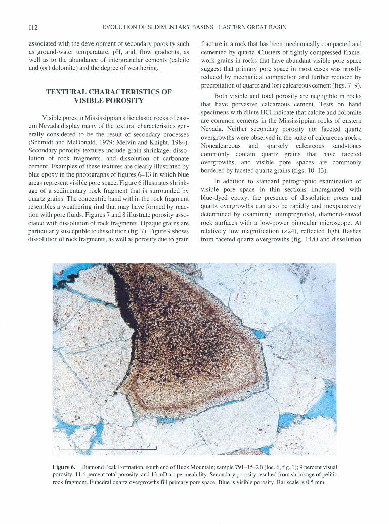
Visible pores in Mississippian siliciclastic rocks of east ern Nevada display many of the textural characteristics gen erally considered to be the result of secondary processes (Schmidt and McDonald, 1979; Melvin and Knight, 1984). Secondary porosity textures include grain shrinkage, disso lution of rock fragments, and dissolution of carbonate cement. Examples of these textures are clearly illustrated by blue epoxy in the photographs of figures 6-13 in which blue areas represent visible pore space. Figure 6 illustrates shrink age of a sedimentary rock fragment that is surrounded by quartz grains. The concentric band within the rock fragment resembles a weathering rind that may have formed by reac tion with pore fluids. Figures 7 and 8 illustrate porosity asso ciated with dissolution of rock fragments. Opaque grains are particularly susceptible to dissolution (fig. 7). Figure 9 shows dissolution of rock fragments, as well as porosity due to grain
fracture in a rock that has been mechanically compacted and cemented by quartz. Clusters of tightly compressed frame work grains in rocks that have abundant visible pore space suggest that primary pore space in most cases was mostly reduced by mechanical compaction and further reduced by precipitation of quartz and (or) calcareous cement (figs. 7-9).
Both visible and total porosity are negligible in rocks that have pervasive calcareous cement. Tests on hand specimens with dilute HC1 indicate that calcite and dolomite are common cements in the Mississippian rocks of eastern Nevada. Neither secondary porosity nor faceted quartz overgrowths were observed in the suite of calcareous rocks. Noncalcareous and sparsely calcareous sandstones commonly contain quartz grains that have faceted overgrowths, and visible pore spaces are commonly bordered by faceted quartz grains (figs. 10-13).
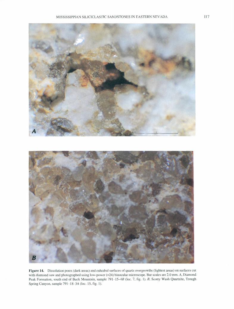
In addition to standard petrographic examination of visible pore space in thin sections impregnated with blue-dyed epoxy, the presence of dissolution pores and quartz overgrowths can also be rapidly and inexpensively determined by examining unimpregnated, diamond-sawed rock surfaces with a low-power binocular microscope. At relatively low magnification (x24), reflected light flashes from faceted quartz overgrowths (fig. 14A) and dissolution
Figure 6. Diamond Peak Formation, south end of Buck Mountain; sample 791-15-2B (loc. 6, fig. 1); 9 percent visual porosity, 11.6 percent total porosity, and 13 mD air permeability. Secondary porosity resulted from shrinkage of pelitic rock fragment. Euhedral quartz overgrowths fill primary pore space. Blue is visible porosity. Bar scale is 0.5 mm.
MISSISSIPPIAN SILICICLASTIC SANDSTONES IN EASTERN NEVADA 113
fc (
t'M^9.-.-- '\.', >; lf( r** - J*^-.1??
*»,: ->«.*-/
i i-.
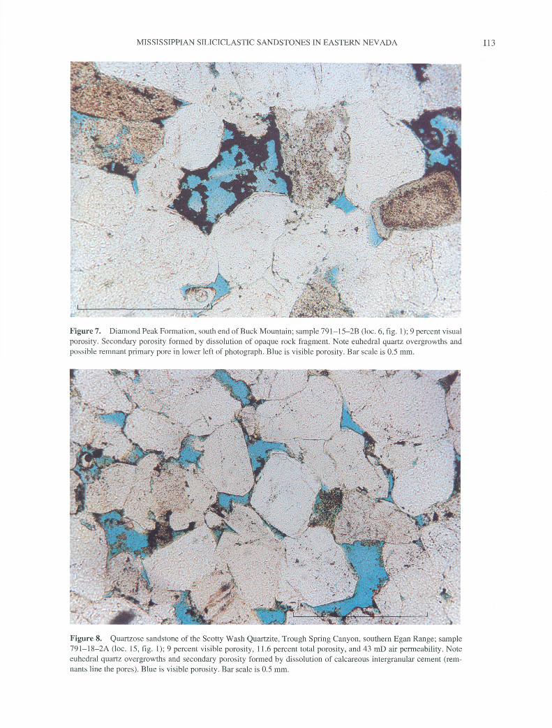
Figure?. Diamond Peak Formation, south end of Buck Mountain; sample 791-15-2B (loc. 6, fig. 1); 9 percent visual porosity. Secondary porosity formed by dissolution of opaque rock fragment. Note euhedral quartz overgrowths and possible remnant primary pore in lower left of photograph. Blue is visible porosity. Bar scale is 0.5 mm.
Figure 8. Quartzose sandstone of the Scotty Wash Quartzite, Trough Spring Canyon, southern Egan Range; sample 791-18-2A (loc. 15, fig. 1); 9 percent visible porosity, 11.6 percent total porosity, and 43 mD air permeability. Note euhedral quartz overgrowths and secondary porosity formed by dissolution of calcareous intergranular cement (rem nants line the pores). Blue is visible porosity. Bar scale is 0.5 mm.
114 EVOLUTION OF SEDIMENTARY BASINS EASTERN GREAT BASIN
-r
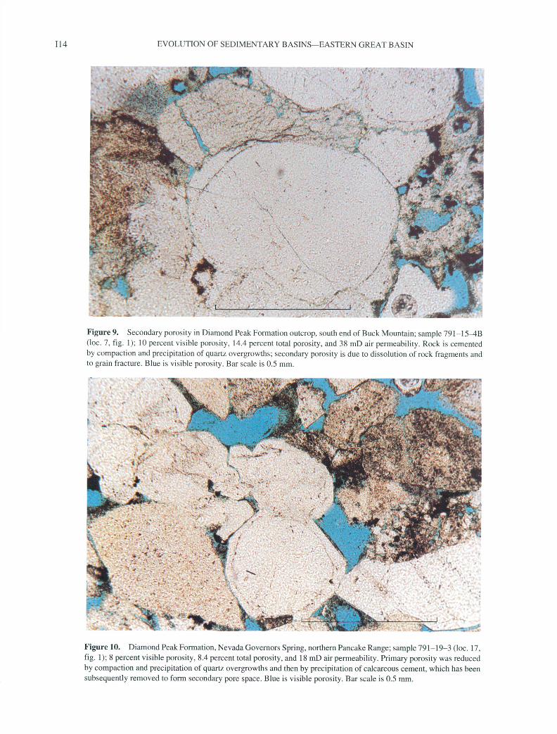
Figure 9. Secondary porosity in Diamond Peak Formation outcrop, south end of Buck Mountain; sample 791-15^B (loc. 7, fig. 1); 10 percent visible porosity, 14.4 percent total porosity, and 38 mD air permeability. Rock is cemented by compaction and precipitation of quartz overgrowths; secondary porosity is due to dissolution of rock fragments and to grain fracture. Blue is visible porosity. Bar scale is 0.5 mm.
Figure 10. Diamond Peak Formation, Nevada Governors Spring, northern Pancake Range; sample 791-19-3 (loc. 17, fig. 1); 8 percent visible porosity, 8.4 percent total porosity, and 18 mD air permeability. Primary porosity was reduced by compaction and precipitation of quartz overgrowths and then by precipitation of calcareous cement, which has been subsequently removed to form secondary pore space. Blue is visible porosity. Bar scale is 0.5 mm.
MISSISSIPPIAN SILICICLASTIC SANDSTONES IN EASTERN NEVADA 115
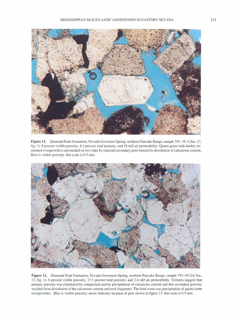
Figure 11. Diamond Peak Formation, Nevada Governors Spring, northern Pancake Range; sample 791-19-3 (loc. 17, fig. 1); 8 percent visible porosity, 8.4 percent total porosity, and 18 mD air permeability. Quartz grain with doubly ter minated overgrowth is surrounded on two sides by outsized secondary pore formed by dissolution of calcareous cement. Blue is visible porosity. Bar scale is 0.5 mm.
Figure 12. Diamond Peak Formation, Nevada Governors Spring, northern Pancake Range; sample 791-19-2A (loc. 17, fig. 1); 8 percent visible porosity, 13.1 percent total porosity; and 2.4 mb air permeability. Textures suggest that primary porosity was eliminated by compaction and by precipitation of calcareous cement and that secondary porosity resulted from dissolution of the calcareous cement and rock fragments. The final event was precipitation of quartz (note overgrowths). Blue is visible porosity; arrow indicates location of pore shown in figure 13. Bar scale is 0.5 mm.
116 EVOLUTION OF SEDIMENTARY BASINS EASTERN GREAT BASIN
*& 'ssjisyiEr -' -
V
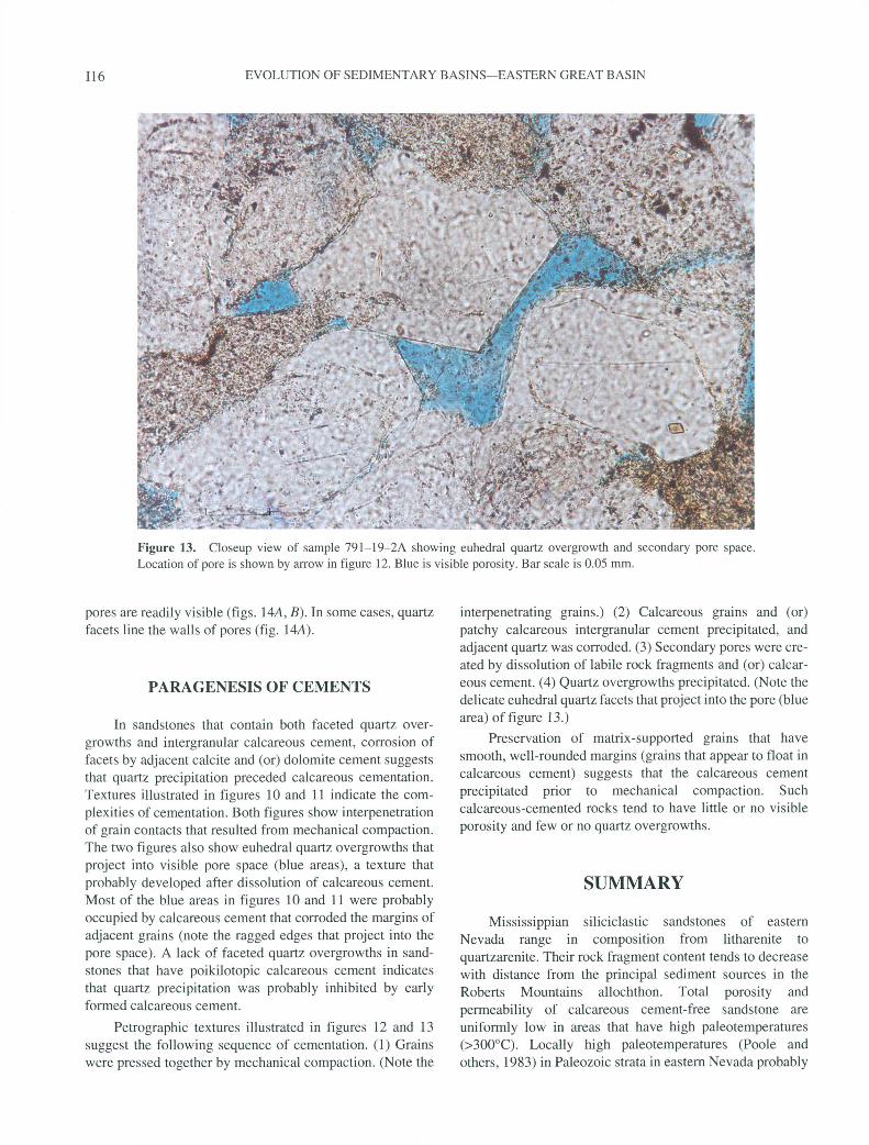
* -*r*;*, ;5Figure 13. Closeup view of sample 791-19-2A showing euhedral quartz overgrowth and secondary pore space. Location of pore is shown by arrow in figure 12. Blue is visible porosity. Bar scale is 0.05 mm.
pores are readily visible (figs. 144, B). In some cases, quartz facets line the walls of pores (fig. 144).
PARAGENESIS OF CEMENTS
In sandstones that contain both faceted quartz over growths and intergranular calcareous cement, corrosion of facets by adjacent calcite and (or) dolomite cement suggests that quartz precipitation preceded calcareous cementation. Textures illustrated in figures 10 and 11 indicate the com plexities of cementation. Both figures show interpenetration of grain contacts that resulted from mechanical compaction. The two figures also show euhedral quartz overgrowths that project into visible pore space (blue areas), a texture that probably developed after dissolution of calcareous cement. Most of the blue areas in figures 10 and 11 were probably occupied by calcareous cement that corroded the margins of adjacent grains (note the ragged edges that project into the pore space). A lack of faceted quartz overgrowths in sand stones that have poikilotopic calcareous cement indicates that quartz precipitation was probably inhibited by early formed calcareous cement.
Petrographic textures illustrated in figures 12 and 13 suggest the following sequence of cementation. (1) Grains were pressed together by mechanical compaction. (Note the
interpenetrating grains.) (2) Calcareous grains and (or) patchy calcareous intergranular cement precipitated, and adjacent quartz was corroded. (3) Secondary pores were cre ated by dissolution of labile rock fragments and (or) calcar eous cement. (4) Quartz overgrowths precipitated. (Note the delicate euhedral quartz facets that project into the pore (blue area) of figure 13.)
Preservation of matrix-supported grains that have smooth, well-rounded margins (grains that appear to float in calcareous cement) suggests that the calcareous cement precipitated prior to mechanical compaction. Such calcareous-cemented rocks tend to have little or no visible porosity and few or no quartz overgrowths.
SUMMARY
Mississippian siliciclastic sandstones of eastern Nevada range in composition from litharenite to quartzarenite. Their rock fragment content tends to decrease with distance from the principal sediment sources in the Roberts Mountains allochthon. Total porosity and permeability of calcareous cement-free sandstone are uniformly low in areas that have high paleotemperatures (>300°C). Locally high paleotemperatures (Poole and others, 1983) in Paleozoic strata in eastern Nevada probably
MISSISSIPPIAN SILICICLASTIC SANDSTONES IN EASTERN NEVADA 117
Figure 14. Dissolution pores (dark areas) and euhedral surfaces of quartz overgrowths (lightest areas) on surfaces cut with diamond saw and photographed using low-power (x24) binocular microscope. Bar scales are 2.0 mm. A, Diamond Peak Formation, south end of Buck Mountain, sample 791-15^5 (loc. 7, fig. 1). B, Scotty Wash Quartzite, Trough Spring Canyon, sample 791-18-3A (loc. 15, fig. 1).
118 EVOLUTION OF SEDIMENTARY BASINS EASTERN GREAT BASIN
are due to thermal episodes associated with Mesozoic plutonism and Cenozoic volcanism. Indeed, still active hydrothermal heating is postulated for generating petroleum in Paleozoic source rocks in the most productive fields of eastern Nevada, the Grant Canyon and Bacon Flat oil fields in Railroad Valley (Hulen and others, 1994). Preservation of hydrocarbon-productive porosity and permeability in Mississippian sandstones in eastern Nevada probably depends on the delicate balance between a thermal regime that generates and facilitates migration of liquid hydrocarbons and excessive heat and adverse fluid dynamics that destroy source rocks and render potential reservoir rocks hard and tight.
REFERENCES CITED
Brew, D.A., 1963, Synorogenic sedimentation of Mississippian age, Eureka quadrangle, Nevada: Stanford, California, Stan ford University, Ph.D. thesis, 260 p.
1971, Mississippian stratigraphy of the Diamond Peak area, Eureka County, Nevada, with a section on the Biostratigraphy and age of the Carboniferous formations by M. Gordon, Jr.: U.S. Geological Survey Professional Paper 661, 84 p.
Dickinson, W.R., 1970, Interpreting detrital modes of graywacke and arkose: Journal of Sedimentary Petrology, v. 40, p. 695-707.
Dickinson, W.R., Harbaugh, D.W., Sailer, A.M., Heller, P.L., and Snyder, W.S., 1983, Detrital modes of upper Paleozoic sand stones from Antler orogen in Nevada Implications for nature of Antler orogeny: American Journal of Science, v. 283, p. 481-509.
Dott, R.H., Jr., 1955, Pennsylvanian stratigraphy of Elko and north ern Diamond Ranges, northeastern Nevada: American Associ ation of Petroleum Geologists Bulletin, v. 39, no. 11, p. 2211-2305.
Goebel, K.A., 1991, Paleogeographic setting of Late Devonian to Early Mississippian transition from passive to collisional mar gin, Antler foreland, eastern Nevada and western Utah, in Coo per, J.D., and Stevens, C.H., eds., Paleozoic paleogeography of the Western United States-II: Pacific Section, Society of Eco nomic Paleontologists and Mineralogists, v. 67, p. 401 418.
Harbaugh, D.W., 1980, Depositional facies and provenance of the Mississippian Chainman shale and Diamond Peak Formation, central Diamond Mountains, Nevada: Stanford, California, Stanford University, M.S. thesis, 81 p.
Harbaugh, D.W., and Dickinson, W.R., 1981, Depositional facies of Mississippian elastics, Antler foreland basin, central Dia mond Mountains, Nevada: Journal of Sedimentary Petrology, v. 51, p. 1223-1234.
Hulen, J.B., Goff, Fraser, Ross, J.R., Bortz, L.C., and Bereskin, S.R., 1994, Geology and geothermal origin of Grant Canyon and Bacon Rat oil fields, Railroad Valley, Nevada: American Association of Petroleum Geologists Bulletin, v. 78, p. 596-623.
Ingersoll, R.V., Bullard, T.F., Ford, R.L., Pickle, J.D., and Sares, S.W., 1984, The effect of grain size on detrital modes A test of the Gazzi-Dickinson point-counting method: Journal of Sed imentary Petrology, v. 54, p. 103-116.
Melvin, John, and Knight, A.S., 1984, Lithofacies, diagenesis and porosity of the Ivishak Formation, Prudhoe Bay area, Alaska, in McDonald, D.A., and Surdam, R.C., eds., Clastic diagene sis: American Association of Petroleum Geologists Memoir 37, p. 347-365.
Nolan, T.B., 1928, A Late Paleozoic positive area in Nevada: American Journal of Science, ser. 5, v. 16, no. 92, p. 153-161.
Nolan, T.B., Merriam, C.W., and Williams, J.S., 1956, The strati- graphic section in the vicinity of Eureka, Nevada: U.S. Geolog ical Survey Professional Paper 276, 77 p.
Perry, A.J., and Trexler, J.H., Jr., 1993, Tectonic implications of sedimentation within the (Upper Mississippian) lower Newark Valley sequence, Diamond Mountains, Nevada: Cordilleran and Rocky Mountain Sections, Geological Society of America, Abstracts with Programs, v. 25, no. 5, p. 133.
Poole, F.G., 1974, Flysch deposits of the Antler Foreland basin, western United States, in Dickinson, W.R., ed., Tectonics and sedimentation: Society of Economic Paleontologists and Min eralogists Special Publication 22, p. 58-82.
Poole, F.G., and Claypool, G.E., 1984, Petroleum source-rock potential and crude-oil correlation in the Great Basin, in Wood ward, Jane, Meissner, F.F., and Clayton, J.L., eds., Hydrocar bon source rocks of the Greater Rocky Mountain region: Denver, Rocky Mountain Association of Geologists, p. 179-229.
Poole, F.G., Claypool, G.E., and Fouch, T.D., 1983, Major epi sodes of petroleum generation in part of the northern Great Basin: Geothermal Resources Council Special Report 13, p. 207-213.
Poole, F.G., and Sandberg, C.A., 1991, Mississippian paleogeogra phy and conodont biostratigraphy of the western United States, in Cooper, J.D., and Stevens, C.H., eds., Paleozoic paleogeog raphy of the Western United States-II: Pacific Section, Society of Economic Paleontologists and Mineralogists, v. 67, p. 107-136.
Roberts, R.J., Montgomery, K.M., and Lehner, R.E., 1967, Geolo gy and mineral resources of Eureka County, Nevada: Nevada Bureau of Mines and Geology Bulletin 64, 152 p.
Schmidt, Volkmar, and McDonald, D.A., 1979, Texture and recog nition of secondary porosity in sandstones, in Scholle, P.A., and Schluger, P.R., eds., Aspects of diagenesis: Society of Eco nomic Paleontologists and Mineralogists Special Publication 26, p. 209-225.
Speed, R.C., and Sleep, N.H., 1982, Antler orogeny and foreland basin A model: Geological Society of America Bulletin, v. 93, p. 815-828.
Trexler, J.H., Jr., and Cashman, P.H., 1990, The Diamond Mountain phase of the Antler orogeny Late Mississippian compressional deformation in east-central Nevada: Geological Society of America Abstracts with Programs, v. 22, p. 274.
1991, Mississippian stratigraphy and tectonics of east-cen tral Nevada Post-Antler orogenesis, in Cooper, J.D., and Stevens, C.H., eds., Paleozoic paleogeography of the Western United States-II: Pacific Section, Society of Economic Paleon tologists and Mineralogists, v. 67, p. 331-342.
Trexler, J.H., Jr., and Nitchman, S.P., 1990, Sequence stratigraphy of the Antler foreland basin, east-central Nevada: Geology, v. 18, p. 422^125.
MISSISSIPPIAN SILICICLASTIC SANDSTONES IN EASTERN NEVADA 119
Trexler, J.H., Jr., Snyder, W.S., Cashman, P.H., Gallegos, D.M., States-II: Pacific Section, Society of Economic Paleontolo-and Spinosa, Claude, 1991, Mississippian through Permian gists and Mineralogists, v. 67, p. 317-329.orogenesis in eastern Nevada Post-Antler, pre-Sonoma tec- Westgate, L.G., and Knopf, Adolph, 1932, Geology and ore depos-tonics of the western Cordillera, in Cooper, J.D., and Stevens, its of the Pioche district, Nevada: U.S. Geological Survey Pro-C.H., eds., Paleozoic paleogeography of the Western United fessional Paper 171, 79 p.
Published in the Central Region, Denver, Colorado Manuscript approved for publication December 1, 1994 Edited by Judith Stoeser Graphics design by Denny Welp Cartography by Springfield & Springfield Photocomposition by Denny Welp Cover art by Art Isom
U.S. GOVERNMENT PRINTING OFFICE: 1995-673-046/86087

SELECTED SERIES OF U.S. GEOLOGICAL SURVEY PUBLICATIONS
Periodicals
Earthquakes & Volcanoes (issued bimonthly). Preliminary Determination of Epicenters (issued monthly).
Technical Books and Reports
Professional Papers are mainly comprehensive scientific reports of wide and lasting interest and importance to professional scientists and engineers. Included are reports on the results of resource studies and of topographic, hydrologic, and geologic investigations. They also include collections of related papers addressing different aspects of a single sci entific topic.
Bulletins contain significant data and interpretations that are of lasting scientific interest but are generally more limited in scope or geo graphic coverage than Professional Papers. They include the results of re source studies and of geologic and topographic investigations; as well as collections of short papers related to a specific topic.
Water-Supply Papers are comprehensive reports that present sig nificant interpretive results of hydrologic investigations of wide interest to professional geologists, hydrologists, and engineers. The series covers investigations in all phases of hydrology, including hydrology, availabil ity of water, quality of water, and use of water.
Circulars present administrative information or important scientif ic information of wide popular interest in a format designed for distribu tion at no cost to the public. Information is usually of short-term interest
Water-Resources Investigations Reports are papers of an inter pretive nature made available to the public outside the formal USGS pub lications series. Copies are reproduced on request unlike formal USGS publications, and they are also available for public inspection at deposi tories indicated in USGS catalogs.
Open-File Reports include unpublished manuscript reports, maps, and other material that are made available for public consultation at de positories. They are a nonpermanent form of publication that may be cit ed in other publications as sources of information.
Maps
Geologic Quadrangle Maps are multicolor geologic maps on to pographic bases in 7 1/2- or 15-minute quadrangle formats (scales main ly 1:24,000 or 1:62,500) showing bedrock, surficial, or engineering geology. Maps generally include brief texts; some maps include structure and columnar sections only.
Geophysical Investigations Maps are on topographic or planimet- ric bases at various scales, they show results of surveys using geophysical techniques, such as gravity, magnetic, seismic, or radioactivity, which re flect subsurface structures that are of economic or geologic significance. Many maps include correlations with the geology.
Miscellaneous Investigations Series Maps are on planimetric or topographic bases of regular and irregular areas at various scales; they present a wide variety of format and subject matter. The series also in cludes 7 1/2-minute quadrangle photogeologic maps on planimetric bases which show geology as interpreted from aerial photographs. The series also includes maps of Mars and the Moon.
Coal Investigations Maps are geologic maps on topographic or planimetric bases at various scales showing bedrock or surficial geology, stratigraphy, and structural relations in certain coal-resource areas.
Oil and Gas Investigations Charts show stratigraphic informa tion for certain oil and gas fields and other areas having petroleum poten tial.
Miscellaneous Field Studies Maps are multicolor or black-and- white maps on topographic or planimetric bases on quadrangle or irreg ular areas at various scales. Pre-1971 maps show bedrock geology in re lation to specific mining or mineral-deposit problems; post-1971 maps are primarily black-and-white maps on various subjects such as environ mental studies or wilderness mineral investigations.
Hydrologic Investigations Atlases are multicolored or black-and- white maps on topographic or planimetric bases presenting a wide range of geohydrologic data of both regular and irregular areas; the principal scale is 1:24,000, and regional studies are at 1:250,000 scale or smaller.
Catalogs
Permanent catalogs, as well as some others, giving comprehensive listings of U.S. Geological Survey publications are available under the conditions indicated below from USGS Map Distribution, Box 25286, Building 810, Denver Federal Center, Denver, CO 80225. (See latest Price and Availability List.)
"Publications of the Geological Survey, 1879-1961'* may be pur chased by mail and over the counter in paperback book form and as a set microfiche.
"Publications of the Geological Survey, 1962-1970"may be pur chased by mail and over the counter in paperback book form and as a set of microfiche.
"Publications of the U.S. Geological Survey, 1971-1981" may be purchased by mail and over the counter in paperback book form (two vol umes, publications listing and index) and as a set of microfiche.
Supplements for 1982, 1983, 1984, 1985, 1986, and for subse quent years since the last permanent catalog may be purchased by mail and over the counter in paperback book form.
State catalogs, "List of U.S. Geological Survey Geologic and Wa ter-Supply Reports and Maps For (State)," may be purchased by mail and over the counter in paperback booklet form only.
"Price and Availability List of US. Geological Survey Publica tions," issued annually, is available free of charge in paperback booklet form only.
Selected copies of a monthly catalog "New Publications of the U.S. Geological Survey" is available free of charge by mail or may be ob tained over the counter in paperback booklet form only. Those wishing a free subscription to the monthly catalog "New Publications of the U.S. Geological Survey" should write to the U.S. Geological Survey, 582 Na tional Center, Reston, VA 22092.
Note.-Prices of Government publications listed in older catalogs, announcements, and publications may be incorrect. Therefore, the prices charged may differ from the prices in catalogs, announcements, and pub lications.

McL
ean RE
CO
NN
AIS
SA
NC
E STU
DY
, MISSISSIPPIA
N SIL
ICIC
AST
IC SA
ND
STO
NE
S, NE
VA
DA
U.S
. Geological Survey B
ulletin 1988-1


