RECORD OF DECISION NYSEG - Granville MGP State Superfund Project Granville, Washington County Site No. 558021 March 2014 Prepared by Division of Environmental Remediation New York State Department of Environmental Conservation
Transcript
RECORD OF DECISION
NYSEG - Granville MGP State Superfund Project
Granville, Washington County Site No. 558021
March 2014
Prepared by Division of Environmental Remediation
New York State Department of Environmental Conservation
RECORD OF DECISION March 2014 NYSEG - Granville MGP, Site No. 558021 Page 1
DECLARATION STATEMENT - RECORD OF DECISION
NYSEG - Granville MGP State Superfund Project
Granville, Washington County Site No. 558021
March 2014
Statement of Purpose and Basis This document presents the remedy for the NYSEG - Granville MGP site, a Class 2 inactive hazardous waste disposal site. The remedial program was chosen in accordance with the New York State Environmental Conservation Law and Title 6 of the Official Compilation of Codes, Rules and Regulations of the State of New York (6 NYCRR) Part 375, and is not inconsistent with the National Oil and Hazardous Substances Pollution Contingency Plan of March 8, 1990 (40CFR300), as amended. This decision is based on the Administrative Record of the New York State Department of Environmental Conservation (the Department) for the NYSEG - Granville MGP site and the public's input to the proposed remedy presented by the Department. A listing of the documents included as a part of the Administrative Record is included in Appendix B of the ROD. Description of Selected Remedy The elements of the selected remedy are as follows: 1. Remedial Design: A remedial design program will be implemented to provide the details necessary for the construction, operation, optimization, maintenance, and monitoring of the remedial program. Green remediation principles and techniques will be implemented to the extent feasible in the design, implementation, and site management of the remedy as per DER-31. The major green remediation components are as follows; •Considering the environmental impacts of treatment technologies and remedy stewardship over the long term; •Reducing direct and indirect greenhouse gases and other emissions; •Increasing energy efficiency and minimizing use of non-renewable energy; •Conserving and efficiently managing resources and materials; •Reducing waste, increasing recycling and increasing reuse of materials which would otherwise be considered a waste; •Maximizing habitat value and creating habitat when possible; •Fostering green and healthy communities and working landscapes which balance ecological, economic and social goals; and
RECORD OF DECISION March 2014 NYSEG - Granville MGP, Site No. 558021 Page 2
•Integrating the remedy with the end use where possible and encouraging green and sustainable re-development. 2. On-Site Excavation and Backfill: A. Former MGP Operations Area: Excavation and off-site disposal of all MGP-related structures and grossly contaminated soil, as defined in 6 NYCRR Part 375-1.2(u), from the former MGP operations area. The footprint of the operations area excavation will be approximately 100 feet by 175 feet and approximately 14 feet deep. On-site and off-site soil may be stockpiled and used to backfill the excavation and establish the designed grades of this area, subject to the following limitations. Soils which meet the SCOs for restricted residential use or background levels may be used to backfill from the bottom of the excavation up to a level two feet below the finished grade, as established during the remedial design. Above this level, the upper two feet of soil will meet background levels or the lower of the protection of ecological resources or restricted residential SCOs, of which the top six inches will consist of topsoil sufficient to maintain a vegetation layer. B. Metawee River Buffer Zone: From a 25 foot wide buffer along the east bank of the Mettawee River, excavation and off-site disposal of all grossly contaminated soil, as defined in 6 NYCRR Part 375-1.2(u), and all MGP-impacted soil in the upper two feet exceeding the SCOs for restricted residental use and protection of ecological resources. The Mettawee River buffer excavation will be a minimum of 25 feet wide and approximately 700 feet long. Soils which meet the SCOs for restricted residential use or background levels may be used to backfill from the bottom of the excavation up to a level two feet below the finished grade, as established during the remedial design. Above this level, the upper two feet of soil will meet background levels or the lower of the protection of ecological resources or restricted residential SCOs. All backfill soils will be suitable to maintain vegetation and the upper one foot will consist of high quality topsoil. 3. Off-Site Excavation and Backfill: Excavation and off-site disposal of all MGP-impacted soil from beneath the channel of the Mettawee River and the Little League ball fields to the west of the Mettawee River. The length of the river section to be excavated is approximately 700 feet. The Mettawee River will be temporarily relocated to accomplish the excavation in the river channel, and then returned to its current position. The area of excavation at the ballfields will be approximately 200 x 50 feet and approximately 14 feet deep. Backfill of the ballfields area will meet the SCOs for unrestricted use, as described in 6 NYCRR Part 375-6.7(d). Backfill beneath the streambed will also meet SCOs for unrestricted use. The stream bed itself will be restored with appropriately graded gravel, cobbles and boulders, and placed in a manner to maximize the habitat value of the finished river bed.
RECORD OF DECISION March 2014 NYSEG - Granville MGP, Site No. 558021 Page 3
4. In-situ Solidification: Outside the operations area on the site, coal tar which has migrated laterally through a thin gravel layer approximately 10 feet below the ground surface will be treated by in-situ solidification (ISS). ISS will be implemented in an approximate 2.5 acre area extending approximately 700 feet northward from the operations area between the Mettawee River buffer zone and the recreational trail. The exact ISS boundaries will be determined during the Remedial Design. ISS is a process that binds soil particles in place, creating a low permeability mass. The contaminated soil will be mixed in place together with solidifying agents (typically portland cement) or other binding agents using an excavator or augers. The soil and binding agents are mixed to produce a solidified mass resulting in a low permeability monolith. The resulting solid matrix reduces or eliminates mobility of contamination and reduces or eliminates the matrix as a source of groundwater contamination. The solidified mass will then be covered with a cover system as described in element 6 to prevent direct exposure and to protect the solidified material from weathering due to freeze/thaw cycles. 5. Coal Tar Recovery: Coal tar will be extracted from bedrock in the area adjacent to the holder and throughout the area of subsurface soil contamination to be addressed by ISS. The coal tar recovery will be accomplished using both existing monitoring wells and additional larger diameter wells installed specifically for this purpose. Recovery wells will be installed early in the remediation process, allowing collection of mobile tar to proceed while the excavation and stabilization elements are being designed. Approximately 30 new extraction wells are planned. Tar will be recovered from the wells by methods designed to maximize the removal of mobile tar while minimizing the collection of groundwater. The specific method of tar removal (skimming versus pumping) will be determined during the remedial design. Coal tar recovery in the bedrock will continue until the recoverable tar has been removed and tar ceases to accumulate in the wells. It is anticipated that these wells will continue to collect tar for several years. Coal tar recovery in the ISS area will continue until the ISS implementation begins. Recovery of tar in this area is intended to remove and destroy as much contamination as practicable prior to immobilizing the remainder. 6. Site Cover: A site cover will be required to allow for the restricted residential use of the site, and to protect the ISS component of the remedy. In the ISS area, the function of this cover will be to provide sufficient thermal protection of the stabilized mass from seasonal freeze/thaw cycles, and to protect the ISS mass from deep root penetration while still allowing re-establishment of an appropriate floodplain vegetative cover. To provide this protection, a four-foot soil cover will be established between the solidified waste and the finished ground surface. The finished ground surface will not exceed the current flood plain elevation.
RECORD OF DECISION March 2014 NYSEG - Granville MGP, Site No. 558021 Page 4
In the former MGP operations areas not subject to ISS, the soil cover will be a minimum of two feet of soil placed over a demarcation layer. This soil cover will meet the requirements for cover material as set forth in 6 NYCRR Part 375-6.7(d) for the lower of restricted residential use or the protection of ecological resources, with the upper two feet of the soil of sufficient quality to maintain a vegetative layer. Outside the ISS and former operations areas, and in all of the off-site areas, it is anticipated that all MGP-contaminated soils will be removed and backfilled; consequently there will be no need for a cover system. 7. River, Riverbank and Floodplain Forest Restoration: The Mettawee River channel will be restored by re-establishing appropriate cross-sectional dimensions while using natural stream bank restoration techniques. Restoration will include bank stabilization using native plant species selected for terrestrial and aquatic habitats of the Mettawee River bank and floodplain forest. Natural stream bank and floodplain forest restoration techniques will be specified in the restoration plan in the remedial design. A minimum 25 foot buffer will be maintained between the limits of ISS and the top of the restored stream bank. All remedial and restoration work will comply with the substantive requirements of ECL Article 15 and 6 NYCRR Part 608. Sediment backfill in the river will meet applicable sediment quality and gradation criteria. 8. Monitored Natural Attenuation of Groundwater: Groundwater contamination will be addressed with monitored natural attenuation (MNA). Groundwater will be monitored for site related contamination and also for MNA indicators which will provide an understanding of the biological activity breaking down the contamination. It is anticipated that contamination will decrease by an order of magnitude in a reasonable period of time (5 to 10 years). Reports of the progress of this attenuation will be provided at 5 and 10 years, and active remediation will be proposed if it appears that natural processes alone will not address the contamination. The contingency remedial action will depend on the information collected, but it is currently anticipated that oxygen injection would be the expected contingency remedial action. 9. Environmental Easement: Imposition of an institutional control in the form of an environmental easement for the controlled property that: • requires the remedial party or site owner to complete and submit to the Department a periodic certification of institutional and engineering controls in accordance with Part 375-1.8 (h)(3); • allows the use and development of the controlled property for restricted residential, commercial and industrial uses, although land use is subject to local zoning laws; • restricts the use of groundwater as a source of potable or process water, without necessary water quality treatment as determined by the NYSDOH or County DOH; and • requires compliance with the Department approved Site Management Plan.
RECORD OF DECISION March 2014 NYSEG - Granville MGP, Site No. 558021 Page 5
10. Site Management Plan: A Site Management Plan is required, which includes the following: a. an Institutional and Engineering Control Plan that identifies all use restrictions and engineering controls for the site and details the steps and media-specific requirements necessary to ensure the following institutional and/or engineering controls remain in place and effective: • Institutional Controls: The Environmental Easement discussed in element 9 above. • Engineering Controls: The solidified soils discussed in Paragraph 4, the coal tar recovery system discussed in Paragraph 5, and the site cover discussed in Paragraph 6 above. This plan includes, but may not be limited to: • an Excavation Plan which details the provisions for management of future excavations in areas of remaining contamination; • a provision for evaluation of the potential for soil vapor intrusion for any buildings developed on the site, including provision for implementing actions recommended to address exposures related to soil vapor intrusion; • provisions for the management and inspection of the identified engineering controls; • maintaining site access controls and Department notification; and • the steps necessary for the periodic reviews and certification of the institutional and/or engineering controls. • a Monitoring Plan to assess the performance and effectiveness of the remedy. Details of the monitoring program will be developed during the remedial design. The plan will include, but may not be limited to: • monitoring of groundwater to assess the performance and effectiveness of the remedy; • restoration monitoring of the Mettawee River, associated floodplain and revegetated upland areas. Restored areas will be inspected for erosion, settlement, and establishment of plantings and seeding. Repairs will be made as necessary and as directed by the Department. • a schedule of ongoing tar collection, groundwater monitoring and frequency of submittals to the Department; • monitoring for vapor intrusion for any buildings developed on the site, as may be required by the Institutional and Engineering Control Plan discussed above.
RECORD OF DECISION March 2014 NYSEG - Granville MGP, Site No. 558021 Page 6
New York State Department of Health Acceptance The New York State Department of Health (NYSDOH) concurs that the remedy for this site is protective of human health. Declaration The selected remedy is protective of human health and the environment, complies with State and Federal requirements that are legally applicable or relevant and appropriate to the remedial action to the extent practicable, and is cost effective. This remedy utilizes permanent solutions and alternative treatment or resource recovery technologies, to the maximum extent practicable, and satisfies the preference for remedies that reduce toxicity, mobility, or volume as a principal element. ____________________________________ ____________________________________ Date Robert W. Schick, P.E., Director Division of Environmental Remediation
March 28, 2014
RECORD OF DECISION March 2014 NYSEG - Granville MGP, Site No. 558021 Page 7
RECORD OF DECISION
NYSEG - Granville MGP Granville, Washington County
Site No. 558021 March 2014
SECTION 1: SUMMARY AND PURPOSE The New York State Department of Environmental Conservation (the Department), in consultation with the New York State Department of Health (NYSDOH), has selected a remedy for the above referenced site. The disposal of hazardous wastes at the site has resulted in threats to public health and the environment that would be addressed by the remedy. The disposal or release of hazardous wastes at this site, as more fully described in this document, has contaminated various environmental media. The remedy is intended to attain the remedial action objectives identified for this site for the protection of public health and the environment. This Record of Decision (ROD) identifies the selected remedy, summarizes the other alternatives considered, and discusses the reasons for selecting the remedy. The New York State Inactive Hazardous Waste Disposal Site Remedial Program (also known as the State Superfund Program) is an enforcement program, the mission of which is to identify and characterize suspected inactive hazardous waste disposal sites and to investigate and remediate those sites found to pose a significant threat to public health and environment. The Department has issued this document in accordance with the requirements of New York State Environmental Conservation Law and 6 NYCRR Part 375. This document is a summary of the information that can be found in the site-related reports and documents. SECTION 2: CITIZEN PARTICIPATION The Department seeks input from the community on all remedies. A public comment period was held, during which the public was encouraged to submit comment on the proposed remedy. All comments on the remedy received during the comment period were considered by the Department in selecting a remedy for the site. Site-related reports and documents were made available for review by the public at the following document repository: Pember Library 33 W. Main St Granville, NY 12832 Phone: 518 645-2525 A public meeting was also conducted. At the meeting, the findings of the remedial investigation (RI) and the feasibility study (FS) were presented along with a summary of the proposed remedy.
RECORD OF DECISION March 2014 NYSEG - Granville MGP, Site No. 558021 Page 8
After the presentation, a question-and-answer period was held, during which verbal or written comments were accepted on the proposed remedy. Comments on the remedy received during the comment period are summarized and addressed in the responsiveness summary section of the ROD. Receive Site Citizen Participation Information By Email Please note that the Department's Division of Environmental Remediation (DER) is "going paperless" relative to citizen participation information. The ultimate goal is to distribute citizen participation information about contaminated sites electronically by way of county email listservs. Information will be distributed for all sites that are being investigated and cleaned up in a particular county under the State Superfund Program, Environmental Restoration Program, Brownfield Cleanup Program, Voluntary Cleanup Program, and Resource Conservation and Recovery Act Program. We encourage the public to sign up for one or more county listservs at http://www.dec.ny.gov/chemical/61092.html SECTION 3: SITE DESCRIPTION AND HISTORY Location: The former Granville Manufactured Gas Plant (MGP) site is located approximately 0.25 miles north of the central business district of the Village of Granville and the intersection of North St. and West Main St. (NYS Rte 149). The site is bounded by wooded land to the north and south, and by the Mettawee River to the west. A recreational walking/bicycle trail constructed on a former railroad bed bounds the site on the east. To the east of the recreational trail are residential structures fronting on North St. Site Features: The site is approximately 10 acres in size and is composed of three adjoining parcels owned by the New York State Electric and Gas Corporation (NYSEG). The southern portion of the site is wooded, while the northern half transitions from a wooded area into an open field containing the NYSEG Granville Operations Center, which is unoccupied. An earthen berm separates the wooded portion of the site from the open, northern portion. Access to the site is uncontrolled. Current Zoning/Use(s): The site is zoned for residential use. However, the NYSEG Operations Center has been operating on the site for many years and constitutes a non-conforming commercial use. The nearest residential structures are located approximately 300 feet to the east. Past Use of the Site: A manufactured gas plant (MGP) was constructed on the site in 1898 and operated until 1946. During this period gas was manufactured using a carbureted water gas process. The initial operator was the Granville Electric and Gas Company. Ownership passed to the Eastern New York Electric and Gas Company, Inc. in 1925, and then to the New York State Electric and Gas Corporation in 1928. Following closure of the gas manufacturing facility in 1946, a propane distribution company (Fuel Gas Company) operated at the site until 1958. Site contamination is
RECORD OF DECISION March 2014 NYSEG - Granville MGP, Site No. 558021 Page 9
related to the gas manufacturing operations conducted by NYSEG and its predecessors. Site Geology and Hydrogeology: The site is underlain by the following unconsolidated deposits, in order of increasing depth: glacial outwash sand, glaciolacustrine clay and silt, and glacial till. Bedrock, consisting of steeply dipping slate of the Mt. Merino and Indian River formations, outcrops at the ground surface at the eastern edge of the site. Across the rest of the site, bedrock underlies the till at depths ranging from 20 to 60 feet. The principal hydrogeologic feature is the Mettawee River which flows adjacent to the site in a northwestward direction. Groundwater is present between 6 and 12 feet below the ground surface and flows northwestward, roughly parallel to the flow of the river. A hydraulic connection exists between groundwater and the river although groundwater discharge to the river is minimal. A site location map is attached as Figure 1. SECTION 4: LAND USE AND PHYSICAL SETTING The Department may consider the current, intended, and reasonably anticipated future land use of the site and its surroundings when evaluating a remedy for soil remediation. For this site, alternatives (or an alternative) that restrict(s) the use of the site to restricted-residential use (which allows for commercial use and industrial use) as described in Part 375-1.8(g) were/was evaluated in addition to an alternative which would allow for unrestricted use of the site. A comparison of the results of the RI to the appropriate standards, criteria and guidance values (SCGs) for the identified land use and the unrestricted use SCGs for the site contaminants is included in the Tables for the media being evaluated in Exhibit A. SECTION 5: ENFORCEMENT STATUS Potentially Responsible Parties (PRPs) are those who may be legally liable for contamination at a site. This may include past or present owners and operators, waste generators, and haulers. The PRPs for the site, documented to date, include: New York State Electric and Gas Corporation (NYSEG) The Department and NYSEG entered into a Consent Order, Index No. D0-0002-9309 on March 25, 1994 to investigate and, where necessary, remediate former manufactured gas plant sites. The Order obligates NYSEG to implement a full remedial program. SECTION 6: SITE CONTAMINATION 6.1: Summary of the Remedial Investigation A Remedial Investigation (RI) has been conducted. The purpose of the RI was to define the nature and extent of any contamination resulting from previous activities at the site. The field
RECORD OF DECISION March 2014 NYSEG - Granville MGP, Site No. 558021 Page 10
activities and findings of the investigation are described in the RI Report. The following general activities are conducted during an RI: • Research of historical information, • Geophysical survey to determine the lateral extent of wastes, • Test pits, soil borings, and monitoring well installations, • Sampling of waste, surface and subsurface soils, groundwater, and soil vapor, • Sampling of surface water and sediment, • Ecological and Human Health Exposure Assessments. The analytical data collected on this site includes data for: - groundwater - soil - sediment - soil vapor 6.1.1: Standards, Criteria, and Guidance (SCGs) The remedy must conform to promulgated standards and criteria that are directly applicable or that are relevant and appropriate. The selection of a remedy must also take into consideration guidance, as appropriate. Standards, Criteria and Guidance are hereafter called SCGs. To determine whether the contaminants identified in various media are present at levels of concern, the data from the RI were compared to media-specific SCGs. The Department has developed SCGs for groundwater, surface water, sediments, and soil. The NYSDOH has developed SCGs for drinking water and soil vapor intrusion. The tables found in Exhibit A list the applicable SCGs in the footnotes. For a full listing of all SCGs see: http://www.dec.ny.gov/regulations/61794.html 6.1.2: RI Results The data have identified contaminants of concern. A "contaminant of concern" is a hazardous waste that is sufficiently present in frequency and concentration in the environment to require evaluation for remedial action. Not all contaminants identified on the property are contaminants of concern. The nature and extent of contamination and environmental media requiring action are summarized in Exhibit A. Additionally, the RI Report contains a full discussion of the data. The contaminant(s) of concern identified at this site is/are: COAL TAR
RECORD OF DECISION March 2014 NYSEG - Granville MGP, Site No. 558021 Page 11
benzene, toluene, ethylbenzene and xylenes (BTEX)
Polycyclic Aromatic Hydrocarbons (PAHs), Total
As illustrated in Exhibit A, the contaminant(s) of concern exceed the applicable SCGs for: - groundwater - soil 6.2: Interim Remedial Measures An interim remedial measure (IRM) is conducted at a site when a source of contamination or exposure pathway can be effectively addressed before issuance of the Record of Decision. There were no IRMs performed at this site during the RI. 6.3: Summary of Environmental Assessment This section summarizes the assessment of existing and potential future environmental impacts presented by the site. Environmental impacts may include existing and potential future exposure pathways to fish and wildlife receptors, wetlands, groundwater resources, and surface water. The Fish and Wildlife Resources Impact Analysis (FWRIA) for OU 01, which is included in the RI report, presents a detailed discussion of the existing and potential impacts from the site to fish and wildlife receptors. The gas manufacturing process created a dark, oily liquid waste known as coal tar which accumulated in the gas holder foundation. Coal tar is slightly denser than water and is referred to as a dense non-aqueous phase liquid (DNAPL). Over the years, coal tar has leaked from the former gas holder foundation, resulting in the contamination of soil and groundwater and a limited area of bedrock. The tar has spread off-site, through a highly permeable gravel layer approximately ten feet beneath the ground surface. Within the gravel layer, the coal tar has spread to the north, under approximately 4 acres of the NYSEG property, and to the west, under the Mettawee River and an adjoining portion of the Granville Little League property. Immediately north of the gas holder, coal tar has migrated downward into bedrock. Groundwater on and off-site is contaminated with coal tar related compounds in areas immediately adjacent to coal tar contaminated soil. Contaminated groundwater has not spread far beyond the limits of the tar contamination. MGP tar contamination in soil and bedrock is readily identifiable visually. Laboratory analyses of soil were used primarily to confirm the boundaries of the tar contamination and establish the limits of clean soil surrounding it. In samples where grossly contaminated soil was encountered, it was not necessary to submit samples to a laboratory to identify contamination. Based on investigations conducted to date, the primary contaminants of concern at this site include volatile organic compounds (benzene, toluene, xylenes); semivolatile compounds (benzo(a)anthracene, benzo(a)pyrene, chrysene, naphthalene, phenanthrene, acenaphthene); and
RECORD OF DECISION March 2014 NYSEG - Granville MGP, Site No. 558021 Page 12
several related polycyclic aromatic hydrocarbon (PAHs) at lower concentrations. Several samples contained levels of volatile organic compounds (VOCs) and semivolatile organic compounds (SVOCs) that exceed the soil cleanup objectives (SCOs) for unrestricted use. The VOCs found in MGP byproducts and are also found in petroleum products such as gasoline. PAHs are found in MGP byproducts as well as many petroleum products, such as asphalt. Soil vapor samples were collected from the soil next to the recreational path adjacent to the site. The results indicated that actions are not needed to address off-site exposures related to soil vapor intrusion. On-site samples were not collected. There are no buildings on the site so no indoor air samples were collected. Special Resources Impacted: The remedial investigation has documented MGP related contamination a short distance beneath a portion of the Mettawee River, as well as beneath the associated floodplain forest. Although this contamination has not been found in the streambed itself, the potential exists for this contamination to become exposed in the streambed in the future. Thus, the importance of this stream as aquatic habitat is an important consideration in decision making. This portion of the Mettawee River is classified as a C(T) stream. The best usage of Class C waters is fishing. These waters shall be suitable for fish, shellfish, and wildlife propagation and survival. The water quality shall be suitable for primary and secondary contact recreation, although other factors may limit the use for these purposes. The symbol (T) means that the classified waters are trout waters. Any water quality standard, guidance value, or thermal criterion that specifically refers to trout or trout waters applies. In addition to being an important local fishery and wildlife habitat, riverine and forest habitats also provide a corridor of movement for numerous species of wildlife. 6.4: Summary of Human Exposure Pathways This human exposure assessment identifies ways in which people may be exposed to site-related contaminants. Chemicals can enter the body through three major pathways (breathing, touching or swallowing). This is referred to as exposure. Persons who access the site or use the adjacent paved path, ball fields or river for recreational purposes are unlikely to come in contact with contaminants in subsurface soil or groundwater unless they dig below the surface. Contaminated groundwater is not used for drinking or other purposes. Volatile organic compounds in the groundwater may move into the soil vapor (air spaces within the soil), which in turn may move into overlying buildings and affect the indoor air quality. This process, which is similar to the movement of radon gas from the subsurface into the indoor air of buildings, is referred to as soil vapor intrusion. Because there are no occupied buildings on the site, inhalation of site contaminants in indoor air due to soil vapor intrusion does not represent a concern for the site in its current condition. However, the potential exists for the inhalation of site contaminants due to soil vapor intrusion for any future on-site development. In addition, sampling indicates soil vapor intrusion is not a concern for off-site buildings. 6.5: Summary of the Remediation Objectives
RECORD OF DECISION March 2014 NYSEG - Granville MGP, Site No. 558021 Page 13
The objectives for the remedial program have been established through the remedy selection process stated in 6 NYCRR Part 375. The goal for the remedial program is to restore the site to pre-disposal conditions to the extent feasible. At a minimum, the remedy shall eliminate or mitigate all significant threats to public health and the environment presented by the contamination identified at the site through the proper application of scientific and engineering principles. The remedial action objectives for this site are: Groundwater RAOs for Public Health Protection • Prevent ingestion of groundwater with contaminant levels exceeding drinking water standards. • Prevent contact with, or inhalation of volatiles, from contaminated groundwater. RAOs for Environmental Protection • Restore ground water aquifer to pre-disposal/pre-release conditions, to the extent practicable. • Remove the source of ground or surface water contamination. Soil RAOs for Public Health Protection • Prevent ingestion/direct contact with contaminated soil. • Prevent inhalation of or exposure from contaminants volatilizing from contaminants in soil. RAOs for Environmental Protection • Prevent migration of contaminants that would result in groundwater or surface water contamination. • Prevent impacts to biota from ingestion/direct contact with soil causing toxicity or impacts from bioaccumulation through the terrestrial food chain. Sediment RAOs for Environmental Protection • Prevent releases of contaminant(s) from sediments that would result in surface water levels in excess of (ambient water quality criteria). Soil Vapor RAOs for Public Health Protection • Mitigate impacts to public health resulting from existing, or the potential for, soil vapor intrusion into buildings at a site. SECTION 7: SUMMARY OF THE SELECTED REMEDY To be selected the remedy must be protective of human health and the environment, be cost-effective, comply with other statutory requirements, and utilize permanent solutions, alternative technologies or resource recovery technologies to the maximum extent practicable. The remedy must also attain the remedial action objectives identified for the site, which are presented in
RECORD OF DECISION March 2014 NYSEG - Granville MGP, Site No. 558021 Page 14
Section 6.5. Potential remedial alternatives for the Site were identified, screened and evaluated in the feasibility study (FS) report. A summary of the remedial alternatives that were considered for this site is presented in Exhibit B. Cost information is presented in the form of present worth, which represents the amount of money invested in the current year that would be sufficient to cover all present and future costs associated with the alternative. This enables the costs of remedial alternatives to be compared on a common basis. As a convention, a time frame of 30 years is used to evaluate present worth costs for alternatives with an indefinite duration. This does not imply that operation, maintenance, or monitoring would cease after 30 years if remediation goals are not achieved. A summary of the Remedial Alternatives Costs is included as Exhibit C. The basis for the Department's remedy is set forth at Exhibit D. The selected remedy is referred to as the Partial Excavation, DNAPL Extraction and In Situ Solidification remedy. The estimated present worth cost to implement the remedy is $15,137,159. The cost to construct the remedy is estimated to be $14,757,559 and the estimated average annual cost is $30,600. The elements of the selected remedy are as follows: 1. Remedial Design: A remedial design program will be implemented to provide the details necessary for the construction, operation, optimization, maintenance, and monitoring of the remedial program. Green remediation principles and techniques will be implemented to the extent feasible in the design, implementation, and site management of the remedy as per DER-31. The major green remediation components are as follows; •Considering the environmental impacts of treatment technologies and remedy stewardship over the long term; •Reducing direct and indirect greenhouse gases and other emissions; •Increasing energy efficiency and minimizing use of non-renewable energy; •Conserving and efficiently managing resources and materials; •Reducing waste, increasing recycling and increasing reuse of materials which would otherwise be considered a waste; •Maximizing habitat value and creating habitat when possible; •Fostering green and healthy communities and working landscapes which balance ecological, economic and social goals; and •Integrating the remedy with the end use where possible and encouraging green and sustainable re-development. 2. On-Site Excavation and Backfill: A. Former MGP Operations Area:
RECORD OF DECISION March 2014 NYSEG - Granville MGP, Site No. 558021 Page 15
Excavation and off-site disposal of all MGP-related structures and grossly contaminated soil, as defined in 6 NYCRR Part 375-1.2(u), from the former MGP operations area. The footprint of the operations area excavation will be approximately 100 feet by 175 feet and approximately 14 feet deep. On-site and off-site soil may be stockpiled and used to backfill the excavation and establish the designed grades of this area, subject to the following limitations. Soils which meet the SCOs for restricted residential use or background levels may be used to backfill from the bottom of the excavation up to a level two feet below the finished grade, as established during the remedial design. Above this level, the upper two feet of soil will meet background levels or the lower of the protection of ecological resources or restricted residential SCOs, of which the top six inches will consist of topsoil sufficient to maintain a vegetation layer. B. Metawee River Buffer Zone: From a 25 foot wide buffer along the east bank of the Mettawee River, excavation and off-site disposal of all grossly contaminated soil, as defined in 6 NYCRR Part 375-1.2(u), and all MGP-impacted soil in the upper two feet exceeding the SCOs for restricted residental use and protection of ecological resources. The Mettawee River buffer excavation will be a minimum of 25 feet wide and approximately 700 feet long. Soils which meet the SCOs for restricted residential use or background levels may be used to backfill from the bottom of the excavation up to a level two feet below the finished grade, as established during the remedial design. Above this level, the upper two feet of soil will meet background levels or the lower of the protection of ecological resources or restricted residential SCOs. All backfill soils will be suitable to maintain vegetation and the upper one foot will consist of high quality topsoil. 3. Off-Site Excavation and Backfill: Excavation and off-site disposal of all MGP-impacted soil from beneath the channel of the Mettawee River and the Little League ball fields to the west of the Mettawee River. The length of the river section to be excavated is approximately 700 feet. The Mettawee River will be temporarily relocated to accomplish the excavation in the river channel, and then returned to its current position. The area of excavation at the ballfields will be approximately 200 x 50 feet and approximately 14 feet deep. Backfill of the ballfields area will meet the SCOs for unrestricted use, as described in 6 NYCRR Part 375-6.7(d). Backfill beneath the streambed will also meet SCOs for unrestricted use. The stream bed itself will be restored with appropriately graded gravel, cobbles and boulders, and placed in a manner to maximize the habitat value of the finished river bed. 4. In-situ Solidification: Outside the operations area on the site, coal tar which has migrated laterally through a thin gravel layer approximately 10 feet below the ground surface will be treated by in-situ solidification (ISS). ISS will be implemented in an approximate 2.5 acre area extending approximately 700 feet northward from the operations area between the Mettawee River buffer zone and the recreational trail. The exact ISS boundaries will be determined during the Remedial Design.
RECORD OF DECISION March 2014 NYSEG - Granville MGP, Site No. 558021 Page 16
ISS is a process that binds soil particles in place, creating a low permeability mass. The contaminated soil will be mixed in place together with solidifying agents (typically portland cement) or other binding agents using an excavator or augers. The soil and binding agents are mixed to produce a solidified mass resulting in a low permeability monolith. The resulting solid matrix reduces or eliminates mobility of contamination and reduces or eliminates the matrix as a source of groundwater contamination. The solidified mass will then be covered with a cover system as described in element 6 to prevent direct exposure and to protect the solidified material from weathering due to freeze/thaw cycles. 5. Coal Tar Recovery: Coal tar will be extracted from bedrock in the area adjacent to the holder and throughout the area of subsurface soil contamination to be addressed by ISS. The coal tar recovery will be accomplished using both existing monitoring wells and additional larger diameter wells installed specifically for this purpose. Recovery wells will be installed early in the remediation process, allowing collection of mobile tar to proceed while the excavation and stabilization elements are being designed. Approximately 30 new extraction wells are planned. Tar will be recovered from the wells by methods designed to maximize the removal of mobile tar while minimizing the collection of groundwater. The specific method of tar removal (skimming versus pumping) will be determined during the remedial design. Coal tar recovery in the bedrock will continue until the recoverable tar has been removed and tar ceases to accumulate in the wells. It is anticipated that these wells will continue to collect tar for several years. Coal tar recovery in the ISS area will continue until the ISS implementation begins. Recovery of tar in this area is intended to remove and destroy as much contamination as practicable prior to immobilizing the remainder. 6. Site Cover: A site cover will be required to allow for the restricted residential use of the site, and to protect the ISS component of the remedy. In the ISS area, the function of this cover will be to provide sufficient thermal protection of the stabilized mass from seasonal freeze/thaw cycles, and to protect the ISS mass from deep root penetration while still allowing re-establishment of an appropriate floodplain vegetative cover. To provide this protection, a four-foot soil cover will be established between the solidified waste and the finished ground surface. The finished ground surface will not exceed the current flood plain elevation. In the former MGP operations areas not subject to ISS, the soil cover will be a minimum of two feet of soil placed over a demarcation layer. This soil cover will meet the requirements for cover material as set forth in 6 NYCRR Part 375-6.7(d) for the lower of restricted residential use or the protection of ecological resources, with the upper two feet of the soil of sufficient quality to maintain a vegetative layer.
RECORD OF DECISION March 2014 NYSEG - Granville MGP, Site No. 558021 Page 17
Outside the ISS and former operations areas, and in all of the off-site areas, it is anticipated that all MGP-contaminated soils will be removed and backfilled; consequently there will be no need for a cover system. 7. River, Riverbank and Floodplain Forest Restoration: The Mettawee River channel will be restored by re-establishing appropriate cross-sectional dimensions while using natural stream bank restoration techniques. Restoration will include bank stabilization using native plant species selected for terrestrial and aquatic habitats of the Mettawee River bank and floodplain forest. Natural stream bank and floodplain forest restoration techniques will be specified in the restoration plan in the remedial design. A minimum 25 foot buffer will be maintained between the limits of ISS and the top of the restored stream bank. All remedial and restoration work will comply with the substantive requirements of ECL Article 15 and 6 NYCRR Part 608. Sediment backfill in the river will meet applicable sediment quality and gradation criteria. 8. Monitored Natural Attenuation of Groundwater: Groundwater contamination will be addressed with monitored natural attenuation (MNA). Groundwater will be monitored for site related contamination and also for MNA indicators which will provide an understanding of the biological activity breaking down the contamination. It is anticipated that contamination will decrease by an order of magnitude in a reasonable period of time (5 to 10 years). Reports of the progress of this attenuation will be provided at 5 and 10 years, and active remediation will be proposed if it appears that natural processes alone will not address the contamination. The contingency remedial action will depend on the information collected, but it is currently anticipated that oxygen injection would be the expected contingency remedial action. 9. Environmental Easement: Imposition of an institutional control in the form of an environmental easement for the controlled property that: • requires the remedial party or site owner to complete and submit to the Department a periodic certification of institutional and engineering controls in accordance with Part 375-1.8 (h)(3); • allows the use and development of the controlled property for restricted residential, commercial and industrial uses, although land use is subject to local zoning laws; • restricts the use of groundwater as a source of potable or process water, without necessary water quality treatment as determined by the NYSDOH or County DOH; and • requires compliance with the Department approved Site Management Plan. 10. Site Management Plan: A Site Management Plan is required, which includes the following: a. an Institutional and Engineering Control Plan that identifies all use restrictions and engineering controls for the site and details the steps and media-specific requirements necessary to ensure the following institutional and/or engineering controls remain in place and effective:
RECORD OF DECISION March 2014 NYSEG - Granville MGP, Site No. 558021 Page 18
• Institutional Controls: The Environmental Easement discussed in element 9 above. • Engineering Controls: The solidified soils discussed in Paragraph 4, the coal tar recovery system discussed in Paragraph 5, and the site cover discussed in Paragraph 6 above. This plan includes, but may not be limited to: • an Excavation Plan which details the provisions for management of future excavations in areas of remaining contamination; • a provision for evaluation of the potential for soil vapor intrusion for any buildings developed on the site, including provision for implementing actions recommended to address exposures related to soil vapor intrusion; • provisions for the management and inspection of the identified engineering controls; • maintaining site access controls and Department notification; and • the steps necessary for the periodic reviews and certification of the institutional and/or engineering controls. • a Monitoring Plan to assess the performance and effectiveness of the remedy. Details of the monitoring program will be developed during the remedial design. The plan will include, but may not be limited to: • monitoring of groundwater to assess the performance and effectiveness of the remedy; • restoration monitoring of the Mettawee River, associated floodplain and revegetated upland areas. Restored areas will be inspected for erosion, settlement, and establishment of plantings and seeding. Repairs will be made as necessary and as directed by the Department. • a schedule of ongoing tar collection, groundwater monitoring and frequency of submittals to the Department; • monitoring for vapor intrusion for any buildings developed on the site, as may be required by the Institutional and Engineering Control Plan discussed above .
RECORD OF DECISION EXHIBITS A THROUGH D March 2014NYSEG - Granville MGP, Site No. 558021 PAGE 1
Exhibit A Nature and Extent of Contamination This section describes the findings of the Remedial Investigation for all environmental media that were evaluated. As described in Section 6.1, samples were collected from various environmental media to characterize the nature and extent of contamination. For each medium for which contamination was identified, a table summarizes the findings of the investigation. The tables present the range of contamination found at the site in the media and compares the data with the applicable SCGs for the site. The contaminants are arranged into three categories; volatile organic compounds (VOCs), semi-volatile organic compounds (SVOCs) and inorganics (metals and cyanide). For comparison purposes, the SCGs are provided for each medium that allows for unrestricted use.
Waste/Source Areas As described in the RI report, waste/source materials were identified at the site and are impacting soil, bedrock and groundwater. Wastes are defined in 6 NYCRR Part 375-1.2 (aw) and include solid, industrial and/or hazardous wastes. Source Areas are defined in 6 NYCRR Part 375 (au). Source areas are areas of concern at a site were substantial quantities of contaminants are found which can migrate and release significant levels of contaminants to another environmental medium. Wastes and Source areas were identified at the site include, coal tar. Coal tar wastes were identified in the foundation of the former MGP gas holder. This subsurface structure appears to be the principal source of contamination on the site. As noted on Figures 2 and 3, DNAPL coal tar containing BTEX and PAH compounds has migrated away from the gas holder in the subsurface under an area approximately four acres in size. The area of separate phase tar contamination extends northward, westward under a section of the Mettawee River and the adjacent recreational fields, and downward into an area of shallow bedrock adjacent to the holder. The waste/source areas identified will be addressed in the remedy selection process.
Groundwater In overburden and bedrock groundwater, VOCs, SVOCs, and metals were detected above applicable standards. In the most contaminated areas, wells which contained visible tar were not sampled because BTEX and PAH compounds can be assumed to be present in groundwater at levels far above the applicable groundwater standards. Groundwater sampling was conducted in wells surrounding the tar-contaminated zone to establish how far contaminated groundwater has moved beyond the tar-contaminated zone. A total of 33 wells were sampled. Contaminant levels were found to decrease rapidly with increasing distance from visible coal tar contamination.
RECORD OF DECISION EXHIBITS A THROUGH D March 2014NYSEG - Granville MGP, Site No. 558021 PAGE 2
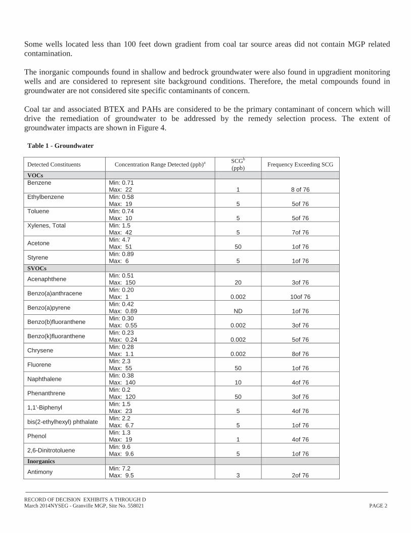
Some wells located less than 100 feet down gradient from coal tar source areas did not contain MGP related contamination. The inorganic compounds found in shallow and bedrock groundwater were also found in upgradient monitoring wells and are considered to represent site background conditions. Therefore, the metal compounds found in groundwater are not considered site specific contaminants of concern. Coal tar and associated BTEX and PAHs are considered to be the primary contaminant of concern which will drive the remediation of groundwater to be addressed by the remedy selection process. The extent of groundwater impacts are shown in Figure 4.
RECORD OF DECISION EXHIBITS A THROUGH D March 2014NYSEG - Granville MGP, Site No. 558021 PAGE 3
Detected Constituents Concentration Range Detected (ppb)a SCGb (ppb) Frequency Exceeding SCG
Arsenic Min: 5.8 Max: 40.6 25 7of 76
Barium Min: 14.2 Max: 3320 1000 1of 76
Cadmium Min: 0.03 Max: 5.9 5 2of 76
Chromium Min: 1.0 Max: 6880 50 6of 76
Lead Min: 3.1 Max: 55.7 25 4of 76
Magnesium Min: 48 Max: 60600 35000 2of 76
Nickel Min: 1.3 Max: 398 100 4of 76
a - ppb: parts per billion, which is equivalent to micrograms per liter, ug/L, in water. b- SCG: Standard Criteria or Guidance - Ambient Water Quality Standards and Guidance Values (TOGs 1.1.1), 6 NYCRR Part 703, Surface water and Groundwater Quality Standards, and Part 5 of the New York State Sanitary Code (10 NYCRR Part 5).
Soil
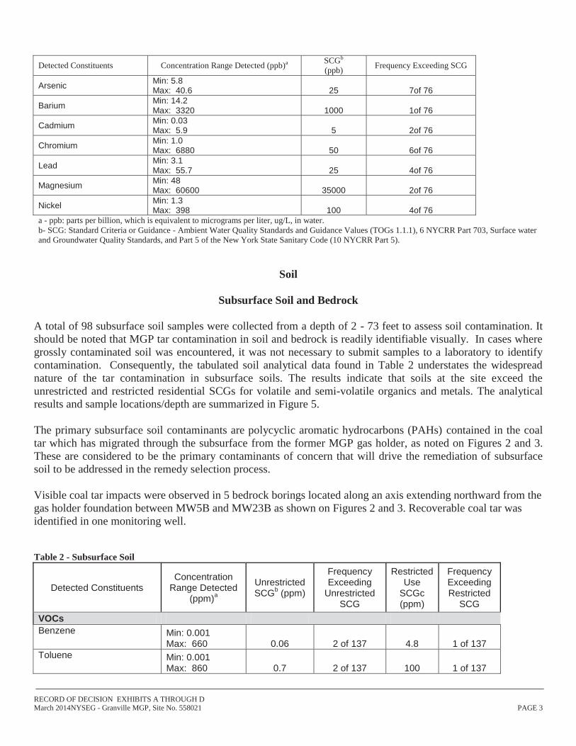
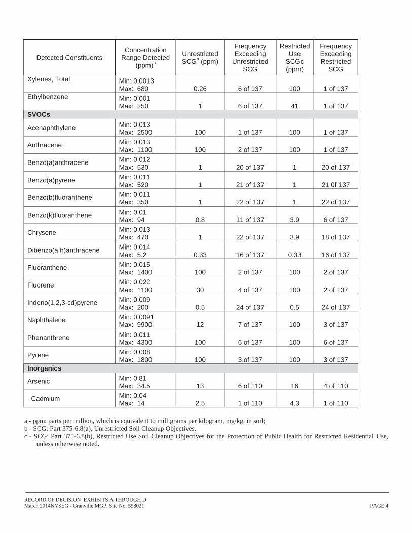
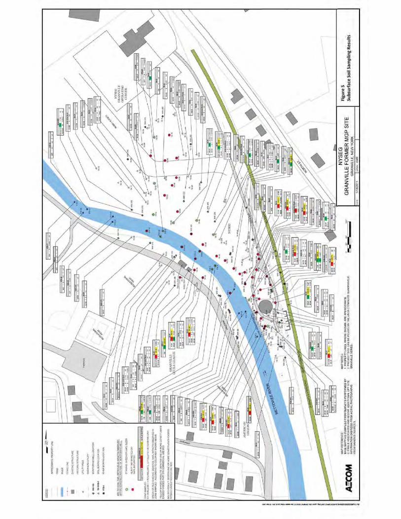
Subsurface Soil and Bedrock A total of 98 subsurface soil samples were collected from a depth of 2 - 73 feet to assess soil contamination. It should be noted that MGP tar contamination in soil and bedrock is readily identifiable visually. In cases where grossly contaminated soil was encountered, it was not necessary to submit samples to a laboratory to identify contamination. Consequently, the tabulated soil analytical data found in Table 2 understates the widespread nature of the tar contamination in subsurface soils. The results indicate that soils at the site exceed the unrestricted and restricted residential SCGs for volatile and semi-volatile organics and metals. The analytical results and sample locations/depth are summarized in Figure 5. The primary subsurface soil contaminants are polycyclic aromatic hydrocarbons (PAHs) contained in the coal tar which has migrated through the subsurface from the former MGP gas holder, as noted on Figures 2 and 3. These are considered to be the primary contaminants of concern that will drive the remediation of subsurface soil to be addressed in the remedy selection process. Visible coal tar impacts were observed in 5 bedrock borings located along an axis extending northward from the gas holder foundation between MW5B and MW23B as shown on Figures 2 and 3. Recoverable coal tar was identified in one monitoring well. Table 2 - Subsurface Soil
Detected Constituents Concentration
Range Detected (ppm)a
Unrestricted SCGb (ppm)
Frequency Exceeding
Unrestricted SCG
Restricted Use
SCGc (ppm)
Frequency Exceeding Restricted
SCG VOCs Benzene Min: 0.001
Max: 660 0.06 2 of 137 4.8 1 of 137 Toluene Min: 0.001
Max: 860 0.7 2 of 137 100 1 of 137
RECORD OF DECISION EXHIBITS A THROUGH D March 2014NYSEG - Granville MGP, Site No. 558021 PAGE 4
Detected Constituents Concentration
Range Detected (ppm)a
Unrestricted SCGb (ppm)
Frequency Exceeding
Unrestricted SCG
Restricted Use
SCGc (ppm)
Frequency Exceeding Restricted
SCG Xylenes, Total Min: 0.0013
Max: 680 0.26 6 of 137 100 1 of 137 Ethylbenzene Min: 0.001
Max: 250 1 6 of 137 41 1 of 137 SVOCs
Acenaphthylene Min: 0.013 Max: 2500 100 1 of 137 100 1 of 137
Anthracene Min: 0.013 Max: 1100 100 2 of 137 100 1 of 137
Benzo(a)anthracene Min: 0.012 Max: 530 1 20 of 137 1 20 of 137
Benzo(b)fluoranthene Min: 0.011 Max: 350 1 22 of 137 1 22 of 137
Benzo(k)fluoranthene Min: 0.01 Max: 94 0.8 11 of 137 3.9 6 of 137
Chrysene Min: 0.013 Max: 470 1 22 of 137 3.9 18 of 137
Dibenzo(a,h)anthracene Min: 0.014 Max: 5.2 0.33 16 of 137 0.33 16 of 137
Fluoranthene Min: 0.015 Max: 1400 100 2 of 137 100 2 of 137
Fluorene Min: 0.022 Max: 1100 30 4 of 137 100 2 of 137
Indeno(1,2,3-cd)pyrene Min: 0.009 Max: 200 0.5 24 of 137 0.5 24 of 137
Naphthalene Min: 0.0091 Max: 9900 12 7 of 137 100 3 of 137
Phenanthrene Min: 0.011 Max: 4300 100 6 of 137 100 6 of 137
Pyrene Min: 0.008 Max: 1800 100 3 of 137 100 3 of 137
Inorganics
Arsenic Min: 0.81 Max: 34.5 13 6 of 110 16 4 of 110
Cadmium Min: 0.04 Max: 14 2.5 1 of 110 4.3 1 of 110
a - ppm: parts per million, which is equivalent to milligrams per kilogram, mg/kg, in soil; b - SCG: Part 375-6.8(a), Unrestricted Soil Cleanup Objectives. c - SCG: Part 375-6.8(b), Restricted Use Soil Cleanup Objectives for the Protection of Public Health for Restricted Residential Use,
unless otherwise noted.
RECORD OF DECISION EXHIBITS A THROUGH D March 2014NYSEG - Granville MGP, Site No. 558021 PAGE 5
Surface Soil Twelve surface soil samples were collected from a depth of 0-2 inches to assess potential for direct human exposure. Three samples were collected near the recreational path adjacent to the site, one sample was collected from an on-site test pit, three samples were collected off-site near the Mettawee River pavilion, and 5 background samples were collected along the recreational path at a significant distance from the site. No VOCs were detected in any of the surface soil samples. Of the on-site sample and the samples collected near the recreational path, three exceeded the restricted residential SCO for benzo(a)pyrene, and one exceeded the restricted residential SCO for benzo(b)fluoranthene. One on-site sample exceeded commercial SCO for arsenic and one sample exceeded the restricted residential SCO for cyanide. The off-site samples from the Mettawee River pavilion met unrestricted use SCOs for PAHs and SVOCs. Of the off-site samples collected on the recreational path, three samples exceeded the unrestricted SCO for benzo(a)pyrene. The similarity in recreational path sample results collected adjacent to the site and from remote background locations indicates that the observed concentrations can be attributed to historic fill and the prior operation of the recreational path as a railway. The locations and analytical results from the surface soil sampling are shown in Figure 6. Table 3 - Surface Soil
Samples From Recreational Path Adjacent To Site and On-Site Test Pit
Detected Constituents Concentration
Range Detected (ppm)a
Unrestricted SCGb
(ppm)
Frequency Exceeding
Unrestricted SCG
Restricted Use
SCGc (ppm)
Frequency Exceeding Restricted
SCG SVOCs
Benzo(a)pyrene Min0.13 Max: 2.6 1 3 of 4 1 3 of4
Benzo(b)fluoranthene Min: 0.15 Max: 6.1 1 3 of 4 1 1 of 4
Inorganics
Arsenic Min:6.8 Max: 18.5 13 1 of 4 16 1 of4
Cadmium Min:< 0.05 Max: <0.258 2.5 0 0f 4 4.3
Total Cyanide Min< 1.0 Max: 62.9 27 1 of 4 27 1 of4
Lead Min: 38.6 Max:247 63 2 of 4 400 0 of 4
a - ppm: parts per million, which is equivalent to milligrams per kilogram, mg/kg, in soil; b - SCG: Part 375-6.8(a), Unrestricted Soil Cleanup Objectives. c - SCG: Part 375-6.8(b), Restricted Use Soil Cleanup Objectives for the Protection of Public Health for Restricted Residential Use, unless otherwise noted.
RECORD OF DECISION EXHIBITS A THROUGH D March 2014NYSEG - Granville MGP, Site No. 558021 PAGE 6
Samples From Recreational Path Distant From Site (Background)
Detected Constituents Concentration
Range Detected (ppm)a
Unrestricted SCGb
(ppm)
Frequency Exceeding
Unrestricted SCG
Restricted Use
SCGc (ppm)
Frequency Exceeding Restricted
SCG SVOCs
Benzo(a)pyrene Min: 0.14 Max: 3.9 1 3 of 5 1 3 of 5
Benzo(b)fluoranthene Min: 0.14 Max: 3.9 1 3 of 5 1 3 of 5
Inorganics
Arsenic Min: 5.1 Max: 14.1 13 1 of 5 16 0 of 5
Lead Min: 12.3 Max: 341 63 2 of 5 400 0 of 5
Cadmium Min: .082 Max: 4.39 2.5 1 of 5 4.3 0 of 5
Total Cyanide Min< 0.8 Max: 1.1 27 0 of 5 27 0 of 5
Samples From Mettawee River Pavilion Off-Site
Detected Constituents Concentration
Range Detected (ppm)a
Unrestricted SCGb
(ppm)
Frequency Exceeding
Unrestricted SCG
Restricted Use
SCGc (ppm)
Frequency Exceeding Restricted
SCG SVOCs
Benzo(a)pyrene Min: 0.016 Max0.074 1 0 of 3 1 0 of 3
Benzo(b)fluoranthene Min: 0.017 Max: 0.064 1 0 of 3 1 0 of 3
Inorganics
Arsenic Min: 3.4 Max: 18.5 13 0 of 3 16 0 of 3
Cadmium Min:0.106 Max: 0.255 2.5 0 of 3 4.3 0 of 3
Total Cyanide Min: < 0.9 Max: < 1.0 27 0 of 3 27 0 of 3
Lead Min: 10.1 Max: 14.4 63 0 of 3 400 0 of 3
a - ppm: parts per million, which is equivalent to milligrams per kilogram, mg/kg, in soil; b - SCG: Part 375-6.8(a), Unrestricted Soil Cleanup Objectives. c - SCG: Part 375-6.8(b), Restricted Use Soil Cleanup Objectives for the Protection of Public Health for Restricted Residential Use, unless otherwise noted.
RECORD OF DECISION EXHIBITS A THROUGH D March 2014NYSEG - Granville MGP, Site No. 558021 PAGE 7
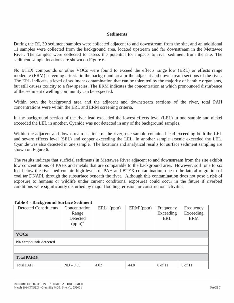
Sediments
During the RI, 39 sediment samples were collected adjacent to and downstream from the site, and an additional 11 samples were collected from the background area, located upstream and far downstream in the Mettawee River. The samples were collected to assess the potential for impacts to river sediment from the site. The sediment sample locations are shown on Figure 6. No BTEX compounds or other VOCs were found to exceed the effects range low (ERL) or effects range moderate (ERM) screening criteria in the background area or the adjacent and downstream sections of the river. The ERL indicates a level of sediment contamination that can be tolerated by the majority of benthic organisms, but still causes toxicity to a few species. The ERM indicates the concentration at which pronounced disturbance of the sediment dwelling community can be expected. Within both the background area and the adjacent and downstream sections of the river, total PAH concentrations were within the ERL and ERM screening criteria. In the background section of the river lead exceeded the lowest effects level (LEL) in one sample and nickel exceeded the LEL in another. Cyanide was not detected in any of the background samples. Within the adjacent and downstream sections of the river, one sample contained lead exceeding both the LEL and severe effects level (SEL) and copper exceeding the LEL. In another sample arsenic exceeded the LEL. Cyanide was also detected in one sample. The locations and analytical results for surface sediment sampling are shown on Figure 6. The results indicate that surficial sediments in Mettawee River adjacent to and downstream from the site exhibit low concentrations of PAHs and metals that are comparable to the background area. However, soil one to six feet below the river bed contain high levels of PAH and BTEX contamination, due to the lateral migration of coal tar DNAPL through the subsurface beneath the river. Although this contamination does not pose a risk of exposure to humans or wildlife under current conditions, exposures could occur in the future if riverbed conditions were significantly disturbed by major flooding, erosion, or construction activities. Table 4 - Background Surface Sediment
Detected Constituents Concentration Range
Detected (ppm)a
ERLb (ppm) ERMc(ppm) Frequency Exceeding
ERL
Frequency Exceeding
ERM
VOCs No compounds detected
Total PAH16
Total PAH ND – 0.59 4.02 44.8 0 of 11 0 of 11
RECORD OF DECISION EXHIBITS A THROUGH D March 2014NYSEG - Granville MGP, Site No. 558021 PAGE 8
Detected Constituents Concentration Range
Detected (ppm)a
ERLb (ppm) ERMc(ppm) Frequency Exceeding
ERL
Frequency Exceeding
ERM
Inorganics Concentration Range Detected(ppm)
LELd SELe Frequency Exceeding LEL
Frequency Exceeding SEL
Lead 5.8 – 32.8 31.0 110.0 1 of 11 0 of 11
Nickel 7.5 – 18.1 16.0 50.0 1 of 11 0 of 11
Total Cyanide ND g N/Af N/A a - ppm: parts per million, which is equivalent to milligrams per kilogram, mg/kg, in sediment; b – ERL – Effects Range Low: The Department’s “Technical Guidance for Screening Contaminated Sediments.” c – ERM – Effects Range Median: The Department’s “Technical Guidance for Screening Contaminated Sediments.” d - LEL – Lowest Effects Level: The Department’s “Technical Guidance for Screening Contaminated Sediments.” e - SEL – Severe Effects Level. The Department’s “Technical Guidance for Screening Contaminated Sediments.” f – N/A – No Screening Criterion Available g – ND – Not Detected Sediment is considered contaminated if either of these criteria is exceeded. If the SEL criteria are exceeded, the sediment is severely impacted. If only the LEL is impacted, the impact is considered moderate. Table 5 - Near site and downstream Surface Sediment
Detected Constituents Concentration Range
Detected (ppm)a
ERLb (ppm) ERMc(ppm) Frequency Exceeding
ERL
Frequency Exceeding
ERM
VOCs
No compounds detected above standards
Total PAH ND – 1.66 4.02 44.8 0 of 26 0 of 26
Inorganics Concentration Range Detected(ppm)a
LELd SELe Frequency Exceeding LEL
Frequency Exceeding SEL
Arsenic ND – 6.7 6.0 33.0 1 of 26 0 of 26
Copper 4.3 – 19.5 16.0 110.0 1 of 26 0 of 26
Lead 4.9 - 198 31.0 110.0 1 of 26 1 of 26
Total Cyanide ND - 1 N/Af N/A a - ppm: parts per million, which is equivalent to milligrams per kilogram, mg/kg, in sediment; b – ERL – Effects Range Low: The Department’s “Technical Guidance for Screening Contaminated Sediments.” c – ERM – Effects Range Median: The Department’s “Technical Guidance for Screening Contaminated Sediments.”
RECORD OF DECISION EXHIBITS A THROUGH D March 2014NYSEG - Granville MGP, Site No. 558021 PAGE 9
d - LEL – Lowest Effects Level: The Department’s “Technical Guidance for Screening Contaminated Sediments.” e - SEL – Severe Effects Level. The Department’s “Technical Guidance for Screening Contaminated Sediments.” f – N/A – No Screening Criterion Available g – ND – Not Detected A sediment is considered contaminated if either of these criteria is exceeded. If the SEL criteria are exceeded, the sediment is severely impacted. If only the LEL is impacted, the impact is considered moderate.
Soil Vapor At this site no buildings were present in impacted areas, so only soil vapor and ambient air were evaluated. Soil vapor samples were collected from the soil along the eastern site boundary adjacent to the recreational path The results indicate that actions are not needed to address off-site exposures related to soil vapor intrusion. The presence of NAPL and contaminated groundwater indicate that on-site soil vapor in the operations area is potentially contaminated and evaluation of soil vapor intrusion is warranted if new buildings were to be developed on the site.
RECORD OF DECISION EXHIBITS A THROUGH D March 2014NYSEG - Granville MGP, Site No. 558021 PAGE 10
Exhibit B Description of Remedial Alternatives
The following alternatives were considered based on the remedial action objectives (see Section 6.5) to address the contaminated media identified at the site as described in Exhibit A.
Alternative 1: No Action The No Action Alternative is evaluated as a procedural requirement and as a basis for comparison. This alternative leaves the site in its present condition and does not provide any additional protection to public health and the environment.
Alternative 2: Restoration to Pre-Disposal or Unrestricted Conditions
Full Excavation The Full Excavation alternative requires removal and off-site disposal of NAPL-impacted soil and all soil that exceeds the SCOs for unrestricted use from all areas of the site, including the former operations area, upland areas on both sides of the river, and beneath the river itself. Monitored natural attenuation of groundwater would reduce dissolved contaminant concentrations over a period of several years following completion of the excavation. Capital Cost .........................................................................................................................................$19,205,643
Alternative 3: Partial Excavation and NAPL Extraction This alternative includes the excavation and removal of NAPL impacted soil in the operations area and beneath the river, excavation and removal of all former MGP structures and foundations, installation and operation of a NAPL extraction and removal system in upland areas on both sides of the river and institutional controls in the form of an environmental easement to prevent groundwater use and limit future use of the site to commercial. Natural attenuation of groundwater would reduce dissolved contaminant concentrations over a period of several years following completion of the excavation and solidification. Present Worth: ..................................................................................................................................... $12,334,723 Capital Cost: .........................................................................................................................................$11,211,726 Annual Costs: ..............................................................................................................................................$90,411
Alternative 4: Partial Excavation and Containment This alternative includes excavation of NAPL impacted soil in the former operations area and beneath the river, removal of the former gas holder and adjacent structures, installation of sheet piling around the upland areas on
RECORD OF DECISION EXHIBITS A THROUGH D March 2014NYSEG - Granville MGP, Site No. 558021 PAGE 11
both sides of the river, and extraction of NAPL in the bedrock. An institutional control in the form of an environmental easement would be placed on the site to prevent groundwater use and limit future site use to commercial. A Site Management Plan would be implemented on both on-site and off-site properties to maintain the containment areas. Natural attenuation of groundwater would reduce dissolved contaminant concentrations over a period of several years following completion of the excavation and solidification. Present Worth: .........................................................................................................................................$9,690,991 Capital Cost: ............................................................................................................................................$9,311,381 Annual Costs: ................................................................................................................................................$30,589
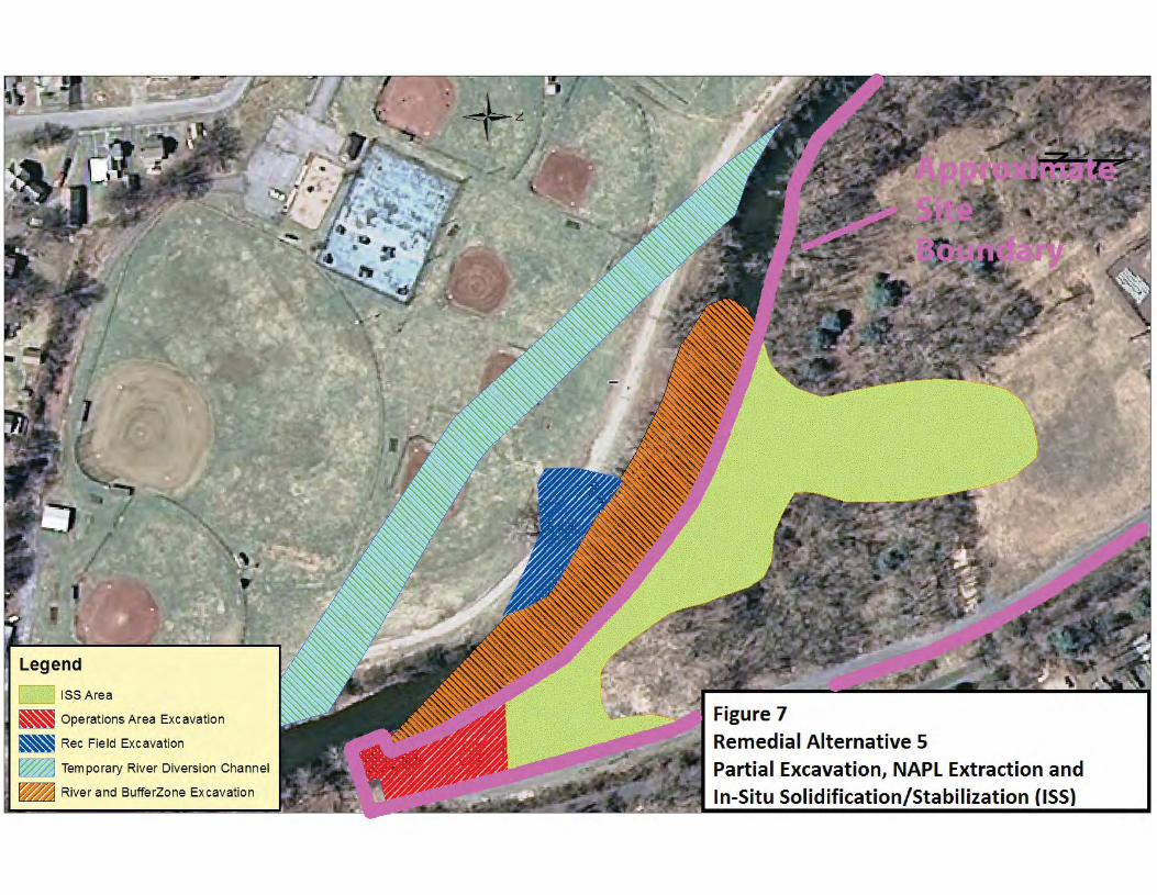
Alternative 5: Partial Excavation, NAPL Extraction and In-Situ Solidification/Stabilization (ISS) This alternative includes excavation of NAPL impacted soil in the former operations area, beneath the river including a twenty five foot buffer zone along the eastern edge of the river excavation and in a small portion of the Little League property, removal of the former gas holder and adjacent structures, extraction of liquid tar from bedrock and overburden soils. Tar-contaminated soils located outside the excavation area will be treated using in-situ solidification. A site management plan will provide for evaluation of the potential for soil vapor intrusion for any buildings developed on the site. In-situ solidification is a process that uses a solidifying or stabilizing agent to bind the soil particles in place, creating a low permeability mass. The contaminated soil would be mixed in place with solidifying or stabilizing agents (typically portland cement). The soil and binding agent are mixed by augers or a backhoe to produce a solidified mass, resulting in a low permeability monolith. The solidified mass would then be covered with a 4-foot soil cover to prevent freeze/thaw cycles from damaging the solidified material, which would also prevent direct exposure to the solidified mass. The resulting solid matrix reduces or eliminates mobility of contamination and reduces or eliminates the matrix as a source of groundwater contamination Natural attenuation of groundwater would reduce dissolved contaminant concentrations over a period of several years following completion of the excavation and solidification. Present Worth: .......................................................................................................................................$15,137,159 Capital Cost: ..........................................................................................................................................$14,757,559 Annual Costs: ................................................................................................................................................$30,589
RECORD OF DECISION EXHIBITS A THROUGH D March 2014NYSEG - Granville MGP, Site No. 558021 PAGE 12
Exhibit C Remedial Alternative Costs
Remedial Alternative Capital Cost ($)
Annual Costs ($)
Total Present Worth ($)
1 No Action
0
0
0
2 Restoration to Pre-Disposal or Unrestricted Conditions
$19,205,000
0
$19,205,000
3 Partial Excavation and NAPL Extraction
$11,211,000
$90,411
$12,334,000
4 Partial Excavation and containment
$9,311,000
$30,589
$9,690,000
5 Partial Excavation, NAPL Extraction and In-Situ Solidification/Stabilization(ISS)
$14,757,559
$30,589
$15,137,159
RECORD OF DECISION EXHIBITS A THROUGH D March 2014NYSEG - Granville MGP, Site No. 558021 PAGE 13
Exhibit D SUMMARY OF SELECTED REMEDY The Department is selecting Alternative 5: Partial Excavation, NAPL Extraction and In-Situ Solidification (ISS) as the remedy for this site. The elements of this remedy are described in Section 7. The selected remedy is depicted in Figure 7. Basis for Selection The selected remedy is based on the results of the RI and the evaluation of alternatives. The criteria to which potential remedial alternatives are compared are defined in 6 NYCRR Part 375. A detailed discussion of the evaluation criteria and comparative analysis is included in the FS report. The first two evaluation criteria are termed "threshold criteria" and must be satisfied in order for an alternative to be considered for selection. 1. Protection of Human Health and the Environment. This criterion is an overall evaluation of each alternative's ability to protect public health and the environment. Alternative 1 (No Action) does not provide any protection to public health and the environment and will not be evaluated further. The proposed remedy, Alternative 5, would satisfy this criterion by removing or stabilizing/solidifying all the contaminated soil on the site and removing recoverable coal tar DNAPL from the bedrock. Alternative 5 addresses the source of the groundwater contamination as well as the contaminated soil beneath the Mettawee River bed, which represent the most significant threats to public health and the environment. Alternative 2, by removing all soil contaminated above the unrestricted soil cleanup objectives and recovery of coal tar DNAPL in the bedrock, meets the threshold criteria. Alternatives 3 and 4 also comply with this criterion but to a lesser degree or with lower certainty. Alternatives 3, 4 and 5 rely on a restriction of groundwater use at the site to protect human health. Alternatives 2, 3, 4 and 5 rely on natural attenuation of contamination over time in conjunction with source removal and/or treatment to protect the groundwater resource. 2. Compliance with New York State Standards, Criteria, and Guidance (SCGs). Compliance with SCGs addresses whether a remedy will meet environmental laws, regulations, and other standards and criteria. In addition, this criterion includes the consideration of guidance which the Department has determined to be applicable on a case-specific basis. Alternative 5 would comply with SCGs to the extent practicable. It would address contamination source areas and would comply with restricted residential use soil cleanup objectives. It would also create the conditions necessary to achieve groundwater quality standards in the overburden and bedrock groundwater. Alternative 2 offers a similar level of compliance. Alternatives 3 and 4 would also comply with this criterion but to a lesser degree or with lower certainty. Because Alternatives 2, 3, 4, and 5 satisfy the threshold criteria, the remaining criteria are particularly important in selecting a final remedy for the site. It is expected that Alternatives 2 and 5 will achieve groundwater SCGs
RECORD OF DECISION EXHIBITS A THROUGH D March 2014NYSEG - Granville MGP, Site No. 558021 PAGE 14
in the overburden in less than 5 years, while overburden groundwater contamination above SCGs will remain under Alternatives 3 and 4 for many years. All of the alternatives recognize that groundwater quality in the bedrock will require a much longer time frame to achieve SCGs. The next six "primary balancing criteria" are used to compare the positive and negative aspects of each of the remedial strategies. 3. Long-term Effectiveness and Permanence. This criterion evaluates the long-term effectiveness of the remedial alternatives after implementation. If wastes or treated residuals remain on-site after the selected remedy has been implemented, the following items are evaluated: 1) the magnitude of the remaining risks, 2) the adequacy of the engineering and/or institutional controls intended to limit the risk, and 3) the reliability of these controls. Long-term effectiveness is best accomplished by those alternatives involving excavation and removal of the contaminated overburden soils. Alternative 2 calls for complete excavation of soil contamination while Alternatives 3, 4 and 5 call for excavation of the operations area and beneath the river, with different strategies employed to manage any contamination that is allowed to remain. At least some coal tar will remain along fractures in the bedrock under all of the alternatives, because there is currently no technology which will totally remove it. Consequently, all alternatives will require institutional controls to restrict the use of groundwater from the bedrock aquifer, and a long term bedrock monitoring program. The greatest degree of long term effectiveness would be achieved by Alternative 2 since all contaminated material with the exception of coal tar in bedrock fractures would be removed from the site. Alternative 3 would remove more source material than Alternatives 4 and 5 but would leave any remaining contamination uncontained. Alternative 4 provides full containment but leaves the most contaminated material in place, Alternative 5 will provide greater long term effectiveness than Alternatives 3 and 4 by removing more source material than alternative 4 and immobilizing remaining contamination through ISS treatment. 4. Reduction of Toxicity, Mobility or Volume. Preference is given to alternatives that permanently and significantly reduce the toxicity, mobility or volume of the wastes at the site. Alternative 2 calls for removal of all soil which contains visible NAPL or contamination above unrestricted use criteria. The excavated material would either be shipped to a permitted thermal desorption facility for treatment or to a permitted landfill, which will provide the greatest reduction in toxicity, mobility and volume, since all contamination would be addressed. Alternative 3 calls for excavation of soil and NAPL from a portion of the operations area and the river, but does not require total removal. The excavated soils would be managed at an off-site thermal treatment facility or by disposal in a landfill, which effectively reduces their mobility, toxicity and volume. In the rest of the site, NAPL which can be extracted would be removed and treated at an off-site facility. Although extraction of NAPL will reduce its mobility and volume, substantial amounts of contamination will not readily move toward the extraction wells and will remain adhered to soil particles. In areas where NAPL contamination remains, potential migration of contamination in groundwater will not necessarily be reduced. Monitored natural attenuation would, in time, reduce the toxicity and mobility of contamination in the groundwater, but achievement of groundwater quality standards is unlikely.
RECORD OF DECISION EXHIBITS A THROUGH D March 2014NYSEG - Granville MGP, Site No. 558021 PAGE 15
Alternative 4 calls for removal of soil and NAPL from a portion of the operations area and the river, comparable to Alternative 3. As would be the case with Alternative 3, waste generated would be managed at an off-site thermal treatment facility or by disposal in a landfill. This technology would effectively reduce the toxicity and volume of contamination in soil, groundwater, and NAPL. In the rest of the site, NAPL impacted soil would be contained using a subsurface barrier wall. This technology would not reduce the volume or toxicity of NAPL, but would reduce its mobility. Monitored natural attenuation would also reduce the toxicity and mobility of contamination in the groundwater, but achievement of groundwater quality standards is unlikely. Alternative 5 calls for removal of contaminated subsurface soil and structures from a portion of the operations area, the upland area on the recreational field property, and beneath the river. Waste generated will be managed at an off-site thermal treatment facility or in a landfill, which will reduce the toxicity, mobility and volume of contamination. In the rest of the site, following a limited period of NAPL recovery, soil containing NAPL would be solidified, which would reduce the mobility and toxicity of the contaminated soil. ISS is also effective in reducing the mobility of contamination in groundwater by greatly lowering the hydraulic conductivity of soil containing NAPL. This prevents clean groundwater from coming into contact with impacted soil and NAPL. It should be noted however, that ISS actually increases the overall volume of the treated soil to some degree, due to the injection of cement grout into the soil. Monitored natural attenuation would, in time, reduce the toxicity and mobility of contamination in the groundwater in areas outside the solidified material. 5. Short-term Impacts and Effectiveness. The potential short-term adverse impacts of the remedial action upon the community, the workers, and the environment during the construction and/or implementation are evaluated. The length of time needed to achieve the remedial objectives is also estimated and compared against the other alternatives. Since Alternatives 2, 3, 4, and 5 include excavation of source material and the river, the short term impacts for all alternatives are similar. Alternatives 3, 4 and 5 would result in lower levels of truck traffic, since the volume of soil removed and transported off site would be less than the amount required by Alternative 2. Noise impacts will be generated by sheet pile driving for the river diversion under all alternatives, but Alternative 4 would require far more sheeting to be driven, so noise impacts would be greater. Truck traffic to transport DNAPL collected from bedrock recovery wells will occur under all the Alternatives, but the number of truck trips required to move the recovered tar are likely to be insignificant compared to the number of dump truck trips required to transport the far larger volumes of contaminated soil. Alternative 5 will result in some inbound truck traffic as a result of the transportation of stabilizing agents for ISS, but again, the number of truck trips is relatively small compared the number required for the full excavation alternatives. Minimizing truck traffic is consistent with the green remediation principles outlined in DER-31. 6. Implementability. The technical and administrative feasibility of implementing each alternative are evaluated. Technical feasibility includes the difficulties associated with the construction of the remedy and the ability to monitor its effectiveness. For administrative feasibility, the availability of the necessary personnel and materials is evaluated along with potential difficulties in obtaining specific operating approvals, access for construction, institutional controls, and so forth. Alternative 2 through 5 all include excavation, diversion of the river and NAPL recovery. All of these activities can be accomplished using standard construction techniques. Alternative 5 also includes in-situ solidification. This is a somewhat newer technology that is performed by a more limited number of contractors, but it has been successfully implemented at several MGP sites in New York State and elsewhere. Based on the shallow depth
RECORD OF DECISION EXHIBITS A THROUGH D March 2014NYSEG - Granville MGP, Site No. 558021 PAGE 16
of the ISS target area (10 – 15’ bgs) and the lack of large obstructions, Alternative 5 is as readily implementable as the other alternatives. 7. Cost-Effectiveness. Capital costs and annual operation, maintenance, and monitoring costs are estimated for each alternative and compared on a present worth basis. Although cost-effectiveness is the last balancing criterion evaluated, where two or more alternatives have met the requirements of the other criteria, it can be used as the basis for the final decision. The costs of the alternatives vary significantly. Alternative 2 has a high cost, but the site would be restored to pre-release conditions. Alternative 3 has a moderate to high cost but only partially removes the NAPL. Alternative 4 has a moderate to high cost but leaves the most contamination in place untreated. Alternative 5 is less costly than Alternative 2 and more costly than Alternatives 3 and 4. It fully addresses the RAOs with the exception of NAPL removal, which it addresses partially. 8. Land Use. When cleanup to pre-disposal conditions is determined to be infeasible, the Department may consider the current, intended, and reasonable anticipated future land use of the site and its surroundings in the selection of the soil remedy. All of the alternatives will require a restriction on the use of groundwater from the bedrock aquifer. Alternative 2 would require no further restrictions on land use. Since the anticipated use of the on-site area includes commercial use, Alternatives 3 and 4 would be less desirable because some contaminated soil and NAPL would remain untreated. Exposure to the remaining material would be controlled under the terms of a Site Management Plan. Alternatives 2 and 5 would remove or treat more of the contaminated soil permanently. The final criterion, Community Acceptance, is considered a "modifying criterion" and is taken into account after evaluating those above. It is evaluated after public comments on the Proposed Remedial Action Plan have been received. 9. Community Acceptance. Concerns of the community regarding the investigation, the evaluation of alternatives, and the PRAP were evaluated. A responsiveness summary has been prepared that describes public comments received and the manner in which the Department addressed the concerns raised. Alternative 5 has been selected because, as described above, it satisfies the threshold criteria and provides the best balance of the balancing criterion.
Background Sediment ' ·· ~•,w•~ analytical range (ppm):
Total PAH: ND-0.59 Lead: 5.8-32.8
Total Cyanide: ND
• Soil Vapor
• Surface Soi l
• Background Surface Soil
~ On site and downstream Surface Sedimen
.._ Background Surface Sediment
Recreational Path
On-site and Downstream ~ -.J Surface Sediment analytical range (ppm):
Total PAH: ND-1 .66 Lead: 4.9-198
Total Cyanide: ND-1 .0
Background Surface Soil analytical Range (ppm):
BTEX: ND Total PAH: 5.12-45.65
Total Cyanide: ND
On-site Surface Soil analytical range : (ppm):
BTEX: ND Total PAH: 0.16-25.65
Total Cyanide: ND
Figure 6
Surface Soil, Sediment and
Soil Vapor Sample Locations
ISS Area I I
~ Operations Area Excavation
~Rec Field Excavation
~Temporary River Diversion Channel ~
River and BufferZone Excavation
Figure 7 Remedial Alternative 5 Partial Excavation, NAPL Extraction and In-Situ Solidification/Stabilization (ISS)
APPENDIX A
Responsiveness Summary
RECORD OF DECISION RESPONSIVENESS SUMMARY March 2014 Granville MGP Site No558021 PAGE A-1
RESPONSIVENESS SUMMARY
Granville MGP State Superfund Project
Town of Granville, Washington County, New York Site No. 558021
The Proposed Remedial Action Plan (PRAP) for the Granville MGP site was prepared by the New York State Department of Environmental Conservation (the Department) in consultation with the New York State Department of Health (NYSDOH) and was issued to the document repositories on February 25, 2014. The PRAP outlined the remedial measure proposed for the contaminated soil at the Granville MGP site. The release of the PRAP was announced by sending a notice to the public contact list, informing the public of the opportunity to comment on the proposed remedy. A public meeting was held on March 13, 2014, which included a presentation of the remedial investigation/feasibility study (RI/FS) for the Granville MGP site as well as a discussion of the proposed remedy. The meeting provided an opportunity for citizens to discuss their concerns, ask questions and comment on the proposed remedy. These comments have become part of the Administrative Record for this site. The public comment period for the PRAP ended on March 26, 2014. This responsiveness summary responds to all questions and comments raised during the public comment period. The following are the comments received at the public meeting, with the Department's responses: COMMENT 1: What is done about turbidity in the Mettawee River during the project? RESPONSE 1: The Department recognizes that controlling releases of turbid water in a trout stream such as the Mettawee is of primary importance. One of the principal reasons for the temporary river diversion is to allow the removal of contaminated materials beneath the river bed without releasing contaminants or creating sheens and turbidity during the removal process. A Water Quality Certification will be required for the proposed project, and the construction specifications will include turbidity standards and a plan to monitor and minimize turbidity. Although some turbidity may be temporarily generated during certain construction activities, steps will be taken to minimize turbidity releases. COMMENT 2: What is the timeframe for this project? RESPONSE 2: It will take at least a year for the engineering design to be developed, after which a contractor for the project will be procured. While this design work is going on, the tar recovery wells
RECORD OF DECISION RESPONSIVENESS SUMMARY March 2014 Granville MGP Site No558021 PAGE A-2
will be installed. The excavation and soil stabilization work is expected to begin in the spring of 2017. COMMENT 3: When will the river detour be undertaken? RESPONSE 3: The detailed schedule will be determined during the remedial design process. In general, however, it is likely that the river diversion will need to be an early component of the main construction project, since much of the rest of the excavation work can only be accomplished while the river is diverted. COMMENT 4: Will fish be able to move through the reroute? RESPONSE 4: Yes, one of the principal design requirements is that the bypass allows fish to move upstream and downstream past the work area. The bypass will be designed such that the current velocity does not exceed the swim speed of the species expected to use the bypass. COMMENT 5: How much coal tar is present? RESPONSE 5: The Department has not estimated the amount of tar in terms of tar present. Spatially, the subsurface soils contaminated with coal tar underlie an area exceeding 4 acres, with an average thickness between 2 and 3 feet. COMMENT 6: We have had 100 year floods in this area, what impact will that have on the cleanup operations? RESPONSE 6: In general, short-term surficial events like floods have minimal effects on the long-term processes involved in subsurface migration. All of the contamination is located below the ground surface, and the river did not reach contaminated materials during recent floods. If heavy rains and flooding are forecast during the remediation work, the work area will be secured, and all machinery will be moved back from the river. COMMENT 7: Is the project sized appropriately? RESPONSE 7: The Department believes that sufficient data is available to define the general boundaries of the remediation area. The precise limits will be determined by additional sampling conducted during the design process. COMMENT 8: What will the done when the river is put back? RESPONSE 8: The Department and NYSEG will coordinate with Trout Unlimited, and the U.S. Fish & Wildlife Service to develop a restoration plan for the remediated portion of the river. Enhancements will be considered to make that section of the river more productive for trout and better at handling future floods.
RECORD OF DECISION RESPONSIVENESS SUMMARY March 2014 Granville MGP Site, Site No. 558021 PAGE A-3
COMMENT 9: For what size stretch of river will the enhancement be done? RESPONSE 9: This project will only restore the river in the 700 foot section where contaminated materials are being removed, plus short upstream and downstream transition sections that may be affected by the construction. COMMENT 10: Is all of the coal tar produced by the MGP still there? RESPONSE 10: While the Department believes that significant amounts of coal tar weres discharged to the subsurface, there is no means of quantifying what remains to what was produced. During the time when the plant was in operation coal tar from the production process had very little value and no records indicate thatan effort was made to recover coal tar, although some small quantities may have been sold or given away. COMMENT 11: Where will the contaminated materials go? RESPONSE 11: The heavily contaminated soils will be sent to a thermal desorption facility, which heats the soil to vaporize the tar, and then combusts the vapor to destroy the chemicals contained in the tar. Although the specific facility won’t be chosen until the remedial design is complete, there is a thermal desorption facility located nearby - the ESMI facility in Fort Edward. Less contaminated materials may be disposed at a landfill that is permitted to accept such materials. COMMENT 12: Will they have the capacity to take all of the material? RESPONSE 12: That will be determined when the project is bid. The disposal facility(ies) will be required to have the capacity to take all of the materials. NYSEG submitted a letter dated March 24, 2014 that included the following comments: COMMENT 13: Section 7: Summary of the Proposed Remedy: According to the draft PRAP, the estimated present worth cost to implement the remedy is $14,350,000. As shown in the revised cost estimate recently sent to NYSDEC by NYSEG, the correct value is $15,137,159. The text also indicates the cost to construct the remedy is estimated to be $13,970,000. The capital cost included in NYSEG’s estimate is $14,351,872. RESPONSE 13: The ROD has been modified accordingly.
RECORD OF DECISION RESPONSIVENESS SUMMARY March 2014 Granville MGP Site, Site No. 558021 PAGE A-4
COMMENT 14: Section 7: Summary of the Proposed Remedy, Coal Tar Recovery: Based on the results of the pilot NAPL recovery conducted at the site during the remedial investigation, NYSEG does not expect that significant quantities of NAPL will be recovered through installation of recovery wells before ISS application. Accordingly, we request a mechanism clearly stated in the PRAP that allows for discontinuation the NAPL recovery program if or when significant amounts of NAPL are not recovered. RESPONSE 14: At similar MGP sites where large amounts of tar were present in highly permeable soils, considerable success has been realized in recovering tar with passive collection wells. Although we cannot guarantee such success at this site, the physical layout of this site appears to be favorable for tar recovery. The highly permeable nature of the coarse gravel NAPL reservoir and the large quantities of highly mobile, low viscosity tar present suggests that NAPL will readily migrate to the recovery wells. The Department recognizes that individual wells may not produce tar in significant quantities. The use of wells which consistently do not produce tar can be discontinued. In the unlikely case that the NAPL recovery system fails to produce significant volume of NAPL across the entire site, the Department agrees that cessation of the recovery program may be appropriate. COMMENT 15: Figures: Figure 2 Limits of Coal Tar DNAPL: The area identified as the limits of coal tar DNAPL on the figure includes areas identified as both “staining, sheen, or NAPL blebs” and “abundant coal tar/NAPL impacted.” It is not accurate to identify this as “The Limits of Coal Tar DNAPL.” RESPONSE 15: The Department considers the limits of coal tar DNAPL to include all areas exhibiting visible coal tar impacts. The precise boundaries of the limits of coal tar DNAPL will be determined during the remedial design process. COMMENT 16: Exhibit A: Nature and Extent of Contamination: Waste/Source Areas: The second paragraph indicates the area of contamination is six acres. The correct value is four acres. RESPONSE 16: Exhibit A has been modified accordingly. COMMENT 17: Exhibit B: Description of Remedial Alternatives; Alternative 5: Partial Excavation, NAPL Extraction and In-Situ Solidification/Stabilization (ISS): The first sentence says “This alternative includes excavation of NAPL impacted soil in the former operations area and beneath the river…” Excavation on a portion of the Little League property is also included.
RECORD OF DECISION RESPONSIVENESS SUMMARY March 2014 Granville MGP Site, Site No. 558021 PAGE A-5
RESPONSE 17: Exhibit B has been modified accordingly. COMMENT 18: Exhibit C: Remedial Alternative Costs: The capital cost for Alternative 5 - Partial Excavation, NAPL Extraction and In-Situ Solidification/Stabilization (ISS) is shown in the table as $13,972,262. As shown in the revised cost estimate recently sent to NYSDEC by NYSEG, the correct value is $14,757,559. The value for total present worth cost shown in the table is $14,351,872. The correct value is $15,137,159. RESPONSE 18: Exhibit C has been modified accordingly. The US Fish and Wildlife Service and Trout Unlimited submitted a letter dated on March 13, 2014. COMMENT 19: We recommend several detailed design suggestions for a modified stream channel when the river is restored. RESPONSE 19: The stream channel modifications proposed in the comment will be provided to NYSEG to be addressed in the remedial design. The Department notes that proposed modifications would create a meander on a portion of the Granville Little League property. Since a third party land owner is involved consideration of this proposal will have to be coordinated with the property owner to determine if it they would agree to its’ implementation.
APPENDIX B
Administrative Record
RECORD OF DECISION ADMINISTRATIVE RECORD March 2014 Granville MGP Site, Site No. 558021 Page B-1
Administrative Record
Granville MGP State Superfund Project
Town of Granville, Washington County, New York Site No. 558021
1. Proposed Remedial Action Plan for the Granville MGP site, dated February 2014, prepared by the Department.
2. Order on Consent, Index No. A3-0536-1205, between the Department and New York
State Electric and Gas Corporation, executed on March 30, 1994.
3. Fact Sheet, dated August 8, 2008, prepared by the Department.
4. Fact Sheet, dated February 24, 2014, prepared by the Department.
5. Remedial Investigation Report – Granville MGP site, dated July 18, 2011, prepared by AECOM.
6. Feasibility Study – Granville MGP site, dated December 16, 2011, prepared by AECOM.
7. Feasibility Study Addendum – Granville MGP site, Alternative 5C, dated July 5, 2013,
prepared by AECOM.
8. Feasibility Study Addendum – Granville MGP site, Alternative 5D, dated February 5, 2014, prepared by AECOM.
9. NYSEG comments on Proposed Remedial Action Plan, dated March 24, 2014.
10. U.S. Fish and Wildlife Service and Trout Unlimited recommendations regarding stream channel restoration, dated March 13, 2014.