107
RECORD OF DECISION RIVERFRONT SITE OPERABLE UNIT 1: FRONT STREET SITE September 2003 Prepared by U.S. Environmental Protection Agency Region 7 Kansas City, Kansas

RECORD OF DECISION
RIVERFRONT SITE OPERABLE UNIT 1: FRONT STREET SITE
September 2003
Prepared by U.S. Environmental Protection Agency
Region 7 Kansas City, Kansas

RECORD OF DECISION RIVERFRONT SITE
OPERABLE UNIT 1: FRONT STREET SITE
Part I - DECLARATION
1.1 Site Name and Location . . . . . . . . . . . . . . . . . . . . . . . . . . . . . . . . . . . . . . . . . . . . . 1 1.2 Statement of Basis and Purpose . . . . . . . . . . . . . . . . . . . . . . . . . . . . . . . . . . . . . . . 1 1.3 Assessment of Site . . . . . . . . . . . . . . . . . . . . . . . . . . . . . . . . . . . . . . . . . . . . . . . . . 1 1.4 Description of Selected Remedy . . . . . . . . . . . . . . . . . . . . . . . . . . . . . . . . . . . . . . 1 1.5 Statutory Determinations . . . . . . . . . . . . . . . . . . . . . . . . . . . . . . . . . . . . . . . . . . . . 2 1.6 Record of Decision Data Certification Checklist . . . . . . . . . . . . . . . . . . . . . . . . . . 2 1.7 Authorizing Signature . . . . . . . . . . . . . . . . . . . . . . . . . . . . . . . . . . . . . . . . . . . . . . 3
Part II - DECISION SUMMARY
1.0 Site Name, Location, and Description . . . . . . . . . . . . . . . . . . . . . . . . . . . . . . . . . . . . . . . . 4
2.0 Site History and Enforcement Activities . . . . . . . . . . . . . . . . . . . . . . . . . . . . . . . . . . . . . . 4 2.1 Site History . . . . . . . . . . . . . . . . . . . . . . . . . . . . . . . . . . . . . . . . . . . . . . . . . . . . . . 4 2.2 Previous Investigations and Enforcement Activities . . . . . . . . . . . . . . . . . . . . . . . 5
3.0 Community Participation . . . . . . . . . . . . . . . . . . . . . . . . . . . . . . . . . . . . . . . . . . . . . . . . . . 5
4.0 Scope and Role of Operable Unit or Response Action . . . . . . . . . . . . . . . . . . . . . . . . . . . 6
5.0 Site Characteristics 5.1 Conceptual Site Model . . . . . . . . . . . . . . . . . . . . . . . . . . . . . . . . . . . . . . . . . . . . . . 7 5.2 Overview of Operable Unit 1 Front Street Site . . . . . . . . . . . . . . . . . . . . . . . . . . . 7 5.3 Surface and Subsurface Features . . . . . . . . . . . . . . . . . . . . . . . . . . . . . . . . . . . . . . 7 5.4 Sampling Strategy . . . . . . . . . . . . . . . . . . . . . . . . . . . . . . . . . . . . . . . . . . . . . . . . . 8 5.5 Known and Suspected Sources of Contamination . . . . . . . . . . . . . . . . . . . . . . . . . 8 5.6 Types of Contamination and Affected Media . . . . . . . . . . . . . . . . . . . . . . . . . . . . 9 5.7 Location of Contamination and Known Potential Routes of Migration . . . . . . . . 9
5.7.1 Soil Contamination . . . . . . . . . . . . . . . . . . . . . . . . . . . . . . . . . . . . . . . . . . 9 5.7.2 Groundwater Contamination . . . . . . . . . . . . . . . . . . . . . . . . . . . . . . . . . . 10
6.0 Current and Potential Future Site and Resource Uses . . . . . . . . . . . . . . . . . . . . . . . . . . . 10
7.0 Summary of Site Risks . . . . . . . . . . . . . . . . . . . . . . . . . . . . . . . . . . . . . . . . . . . . . . . . . . . 11 7.1 Summary of Human Health Risk Assessment . . . . . . . . . . . . . . . . . . . . . . . . . . . 12
i

7.1.1 Identification of Contaminants of Concern . . . . . . . . . . . . . . . . . . . . . . . 12 7.1.2 Exposure Assessment . . . . . . . . . . . . . . . . . . . . . . . . . . . . . . . . . . . . . . . . 12 7.1.3 Toxicity Assessment . . . . . . . . . . . . . . . . . . . . . . . . . . . . . . . . . . . . . . . . 17 7.1.4 Risk Characterization Assessment . . . . . . . . . . . . . . . . . . . . . . . . . . . . . . 23 7.1.5 Uncertainty Analysis . . . . . . . . . . . . . . . . . . . . . . . . . . . . . . . . . . . . . . . . 35
7.2 Summary of Ecological Risk Assessment . . . . . . . . . . . . . . . . . . . . . . . . . . . . . . 36 7.3 Risk Assessment Conclusion . . . . . . . . . . . . . . . . . . . . . . . . . . . . . . . . . . . . . . . . 36
8.0 Remedial Action Objectives . . . . . . . . . . . . . . . . . . . . . . . . . . . . . . . . . . . . . . . . . . . . . . 37 8.1 Remedial Action Objectives . . . . . . . . . . . . . . . . . . . . . . . . . . . . . . . . . . . . . . . . 37 8.2 Alternate Concentration Limits . . . . . . . . . . . . . . . . . . . . . . . . . . . . . . . . . . . . . . 37
9.0 Description of Alternatives . . . . . . . . . . . . . . . . . . . . . . . . . . . . . . . . . . . . . . . . . . . . . . . 40 9.1 Description of Groundwater/Soil Alternatives . . . . . . . . . . . . . . . . . . . . . . . . . . 40
9.1.1 Alternative 1 - No Action/No Action . . . . . . . . . . . . . . . . . . . . . . . . . . . . 40 9.1.2 Alternative 2 - Limited Action/Limited Action . . . . . . . . . . . . . . . . . . . . 41 9.1.3 Alternative 3 - Monitoring/Limited Action . . . . . . . . . . . . . . . . . . . . . . . 43 9.1.4 Alternative 4 - Monitoring/Limited Excavation & Offsite Disposal . . . . 44 9.1.5 Alternative 5 - Hydraulic Containment, Above Ground Treatment &
Monitored Natural Attenuation/Capping & Sheet Piling . . . . . . . . . . . . . 45 9.1.6 Alternative 6 - Groundwater Extraction & Above Ground
Treatment/Excavation & Offsite Disposal . . . . . . . . . . . . . . . . . . . . . . . . 46 9.1.7 Alternative 7 - In-situ Bioremediation/Excavation & Onsite Treatment . 47 9.1.8 Alternative 8 - In-situ Physical Treatment/In-situ Treatment . . . . . . . . . 48 9.1.9 Alternative 3A - Monitored Attainment of ACLs/Institutional Controls 50 9.1.10 Alternative 3A Plus - Monitoring of ACLs Plus Limited
Treatment/Institutional Controls Plus Limited Treatment . . . . . . . . . . . . 50 9.2 Common Elements and Distinguishing Features of Each Alternative . . . . . . . . . 52
9.2.1 Common Elements . . . . . . . . . . . . . . . . . . . . . . . . . . . . . . . . . . . . . . . . . . 52 9.2.2 Distinguishing Features . . . . . . . . . . . . . . . . . . . . . . . . . . . . . . . . . . . . . . 52
10.0 Comparative Analysis of Alternatives . . . . . . . . . . . . . . . . . . . . . . . . . . . . . . . . . . . . . . . 55 10.1 Overall Protection of Human Health and the Environment . . . . . . . . . . . . . . . . . 55 10.2 Compliance with Applicable or Relevant and Appropriate Requirements . . . . . 56 10.3 Long-term Effectiveness . . . . . . . . . . . . . . . . . . . . . . . . . . . . . . . . . . . . . . . . . . . 56 10.4 Reduction of Toxicity, Mobility, and Volume Through Treatment . . . . . . . . . . . 57 10.5 Short-term Effectiveness . . . . . . . . . . . . . . . . . . . . . . . . . . . . . . . . . . . . . . . . . . . 57 10.6 Implementability . . . . . . . . . . . . . . . . . . . . . . . . . . . . . . . . . . . . . . . . . . . . . . . . . 58 10.7 Cost . . . . . . . . . . . . . . . . . . . . . . . . . . . . . . . . . . . . . . . . . . . . . . . . . . . . . . . . . . . 60 10.8 State Acceptance . . . . . . . . . . . . . . . . . . . . . . . . . . . . . . . . . . . . . . . . . . . . . . . . . 60 10.9 Community Acceptance . . . . . . . . . . . . . . . . . . . . . . . . . . . . . . . . . . . . . . . . . . . . 60
11.0 Principal Threat Wastes . . . . . . . . . . . . . . . . . . . . . . . . . . . . . . . . . . . . . . . . . . . . . . . . . . 61
ii
12.0 Selected Remedy . . . . . . . . . . . . . . . . . . . . . . . . . . . . . . . . . . . . . . . . . . . . . . . . . . . . . . . 61 12.1 Summary of the Rationale for the Selected Remedy . . . . . . . . . . . . . . . . . . . . . . 61 12.2 Description of Selected Remedy . . . . . . . . . . . . . . . . . . . . . . . . . . . . . . . . . . . . . 62 12.3 Summary of the Estimated Remedy Costs . . . . . . . . . . . . . . . . . . . . . . . . . . . . . . 66 12.4 Expected Outcome of the Selected Remedy . . . . . . . . . . . . . . . . . . . . . . . . . . . . 70
13.0 Statutory Determinations . . . . . . . . . . . . . . . . . . . . . . . . . . . . . . . . . . . . . . . . . . . . . . . . . 73 13.1 Protection of the Human Health and Environment . . . . . . . . . . . . . . . . . . . . . . . 73 13.2 Compliance with Applicable or Relevant and Appropriate Requirements . . . . . 73 13.3 Cost Effectiveness . . . . . . . . . . . . . . . . . . . . . . . . . . . . . . . . . . . . . . . . . . . . . . . . 76 13.4 Utilization of Permanent Solutions and Alternative Treatment
Technologies to the Maximum Extent Practicable . . . . . . . . . . . . . . . . . . . . . . . 78 13.5 Preference for Treatment As A Principal Element . . . . . . . . . . . . . . . . . . . . . . . 79 13.6 Five-Year Review Requirements . . . . . . . . . . . . . . . . . . . . . . . . . . . . . . . . . . . . . 79
14.0 Documentation of Significant Changes . . . . . . . . . . . . . . . . . . . . . . . . . . . . . . . . . . . . . . 80
PART III RESPONSIVENESS SUMMARY . . . . . . . . . . . . . . . . . . . . . . . . . . . . . . . . . . . 80
1.01 Stakeholder Issues and EPA Responses . . . . . . . . . . . . . . . . . . . . . . . . . . . . . . . . . . . . . . 80
2.0 Technical and Legal Issues . . . . . . . . . . . . . . . . . . . . . . . . . . . . . . . . . . . . . . . . . . . . . . . 80 2.1 Technical Issues . . . . . . . . . . . . . . . . . . . . . . . . . . . . . . . . . . . . . . . . . . . . . . . . . . 80 2.2 Legal Issues . . . . . . . . . . . . . . . . . . . . . . . . . . . . . . . . . . . . . . . . . . . . . . . . . . . . . 80
LIST OF TABLES Table 7-1 Summary of Contaminants of Concern and Medium-Specific Exposure
Point Concentrations (Surface Soil) . . . . . . . . . . . . . . . . . . . . . . . . . . . . . 14 Table 7-2 Summary of Contaminants of Concern and Medium-Specific Exposure
Point Concentrations (Subsurface Soil) . . . . . . . . . . . . . . . . . . . . . . . . . . 15 Table 7-3 Summary of Contaminants of Concern and Medium-Specific Exposure
Point Concentrations (Groundwater) . . . . . . . . . . . . . . . . . . . . . . . . . . . . 16 Table 7-4 Cancer Toxicity Data Study . . . . . . . . . . . . . . . . . . . . . . . . . . . . . . . . . . . 19 Table 7-5 Non-Cancer Toxicity Data Study . . . . . . . . . . . . . . . . . . . . . . . . . . . . . . . 21 Table 7-6a Risk Characterization Summary - Carcinogens (Resident) . . . . . . . . . . . 24 Table 7-6b Risk Characterization Summary - Carcinogens (Resident) . . . . . . . . . . . 25 Table 7-7a Risk Characterization Summary - Carcinogens (Worker) . . . . . . . . . . . . 26 Table 7-7b Risk Characterization Summary - Carcinogens (Worker) . . . . . . . . . . . . 27 Table 7-7c Risk Characterization Summary - Carcinogens (Worker) . . . . . . . . . . . . 28 Table 7-8a Risk Characterization Summary - Carcinogens (Trespasser) . . . . . . . . . 29 Table 7-8b Risk Characterization Summary - Carcinogens (Recreational User) . . . . 30 Table 7-9 Risk Characterization Summary - Non-Carcinogens (Resident) . . . . . . . 31
iii
Table 7-10 Risk Characterization Summary - Non-Carcinogens (Resident) . . . . . . . 32 Table 7-11 Summary of Carcinogenic and Non-Carcinogenic Risks . . . . . . . . . . . . 33 Table 9-1 Summary of General Comparison Information for Each Alternative . . . 54 Table 10-1 Comparative Analysis of Alternatives . . . . . . . . . . . . . . . . . . . . . . . . . 60a Table 12-1 Alternative 3A Plus - Institutional Controls, Monitoring of ACLs, and
Limited Treatment/Limited Treatment and Institutional Controls . . . . . 67 Table 12-2 Groundwater Cleanup Levels for Chemicals of Concern . . . . . . . . . . . . 71 Table 12-3 Soil Cleanup Levels for Chemicals of Concern . . . . . . . . . . . . . . . . . . . . 72 Table 13-1 Description of ARARs for Selected Remedy . . . . . . . . . . . . . . . . . . . . . . 74
LIST OF FIGURES Figure 1-2 Riverfront Operable Units 1 to 5 Location Map . . . . . . . . . . . . . . . . . . . 4a Figure 1-3 OU1 Front Street Layout . . . . . . . . . . . . . . . . . . . . . . . . . . . . . . . . . . . . . 4b Figure 1-4 PCE Contaminated Soil Removal Areas . . . . . . . . . . . . . . . . . . . . . . . . . 5a Figure 1-5 Tree-core Sample Result . . . . . . . . . . . . . . . . . . . . . . . . . . . . . . . . . . . . . 8a Figure 2-2 Ecological Habitats . . . . . . . . . . . . . . . . . . . . . . . . . . . . . . . . . . . . . . . . 36b Figure 2-3 Potential Source of Contamination . . . . . . . . . . . . . . . . . . . . . . . . . . . . 36c Figure 3-1 Ecological Exposure Mode . . . . . . . . . . . . . . . . . . . . . . . . . . . . . . . . . . 36a Figure 3-2 Sample Location . . . . . . . . . . . . . . . . . . . . . . . . . . . . . . . . . . . . . . . . . . 36d Figure 3-15 ART In-Well Stripper Treatment Schematic . . . . . . . . . . . . . . . . . . . . . 48a Figure 4-21 Location and Maximum PCE Concentrations . . . . . . . . . . . . . . . . . . . . . 9a Figure 5-1 Conceptual Site Model . . . . . . . . . . . . . . . . . . . . . . . . . . . . . . . . . . . . . . 7a Figure 5-2A Generalized Geohydrologic Section . . . . . . . . . . . . . . . . . . . . . . . . . . . . 7c Figure 8 Plan View of PCE Plume . . . . . . . . . . . . . . . . . . . . . . . . . . . . . . . . . . . . 7b
LIST OF PHOTOGRAPHS Photograph 01 . . . . . . . . . . . . . . . . . . . . . . . . . . . . . . . . . . . . . . . . . . . . . . . . . . . . . . . . 36e Photograph 9 and 10 . . . . . . . . . . . . . . . . . . . . . . . . . . . . . . . . . . . . . . . . . . . . . . . . . . . 36f Photograph 4 . . . . . . . . . . . . . . . . . . . . . . . . . . . . . . . . . . . . . . . . . . . . . . . . . . . . . . . . . 36g
APPENDIX A ACL Calculations . . . . . . . . . . . . . . . . . . . . . . . . . . . . . . . . . . . . . . . . . . 80a
iv
PART I THE DECLARATION
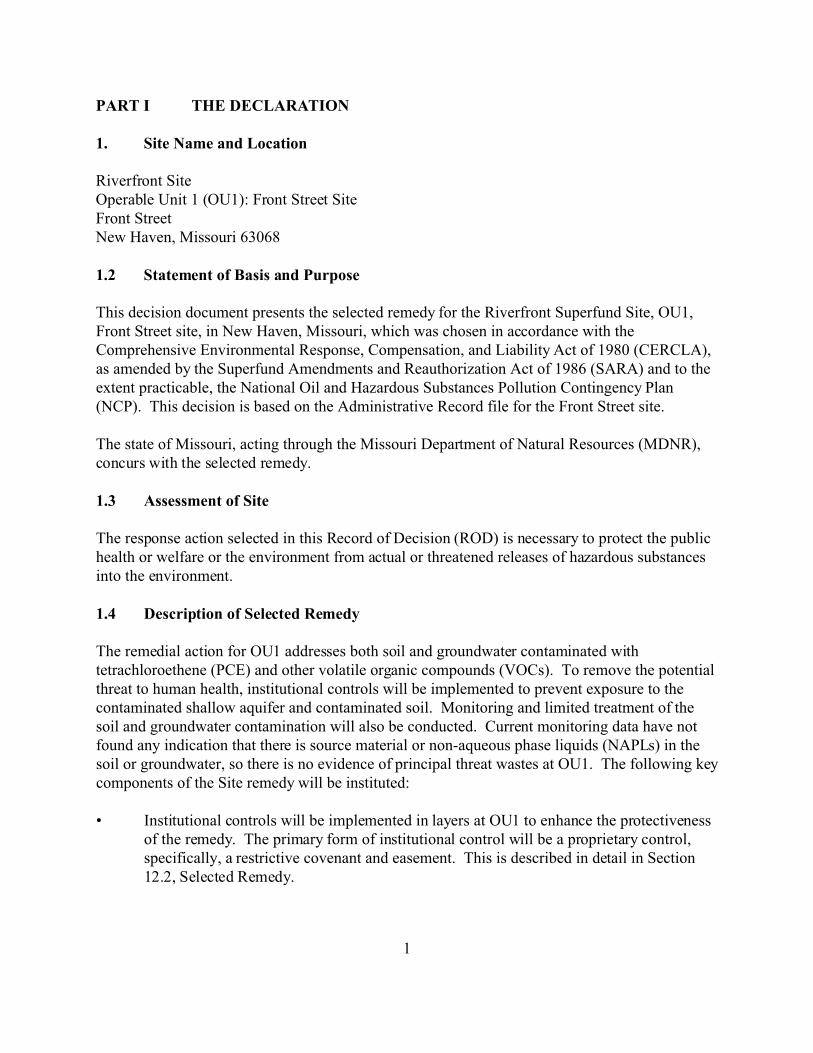
1. Site Name and Location
Riverfront Site Operable Unit 1 (OU1): Front Street Site Front Street New Haven, Missouri 63068
1.2 Statement of Basis and Purpose
This decision document presents the selected remedy for the Riverfront Superfund Site, OU1, Front Street site, in New Haven, Missouri, which was chosen in accordance with the Comprehensive Environmental Response, Compensation, and Liability Act of 1980 (CERCLA), as amended by the Superfund Amendments and Reauthorization Act of 1986 (SARA) and to the extent practicable, the National Oil and Hazardous Substances Pollution Contingency Plan (NCP). This decision is based on the Administrative Record file for the Front Street site.
The state of Missouri, acting through the Missouri Department of Natural Resources (MDNR), concurs with the selected remedy.
1.3 Assessment of Site
The response action selected in this Record of Decision (ROD) is necessary to protect the public health or welfare or the environment from actual or threatened releases of hazardous substances into the environment.
1.4 Description of Selected Remedy
The remedial action for OU1 addresses both soil and groundwater contaminated with tetrachloroethene (PCE) and other volatile organic compounds (VOCs). To remove the potential threat to human health, institutional controls will be implemented to prevent exposure to the contaminated shallow aquifer and contaminated soil. Monitoring and limited treatment of the soil and groundwater contamination will also be conducted. Current monitoring data have not found any indication that there is source material or non-aqueous phase liquids (NAPLs) in the soil or groundwater, so there is no evidence of principal threat wastes at OU1. The following key components of the Site remedy will be instituted:
• Institutional controls will be implemented in layers at OU1 to enhance the protectiveness of the remedy. The primary form of institutional control will be a proprietary control, specifically, a restrictive covenant and easement. This is described in detail in Section 12.2, Selected Remedy.
1
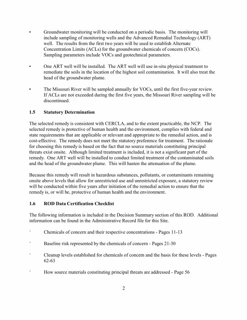
• Groundwater monitoring will be conducted on a periodic basis. The monitoring will include sampling of monitoring wells and the Advanced Remedial Technology (ART) well. The results from the first two years will be used to establish Alternate Concentration Limits (ACLs) for the groundwater chemicals of concern (COCs). Sampling parameters include VOCs and geotechnical parameters.
• One ART well will be installed. The ART well will use in-situ physical treatment to remediate the soils in the location of the highest soil contamination. It will also treat the head of the groundwater plume.
• The Missouri River will be sampled annually for VOCs, until the first five-year review. If ACLs are not exceeded during the first five years, the Missouri River sampling will be discontinued.
1.5 Statutory Determination
The selected remedy is consistent with CERCLA, and to the extent practicable, the NCP. The selected remedy is protective of human health and the environment, complies with federal and state requirements that are applicable or relevant and appropriate to the remedial action, and is cost-effective. The remedy does not meet the statutory preference for treatment. The rationale for choosing this remedy is based on the fact that no source materials constituting principal threats exist onsite. Although limited treatment is included, it is not a significant part of the remedy. One ART well will be installed to conduct limited treatment of the contaminated soils and the head of the groundwater plume. This will hasten the attenuation of the plume.
Because this remedy will result in hazardous substances, pollutants, or contaminants remaining onsite above levels that allow for unrestricted use and unrestricted exposure, a statutory review will be conducted within five years after initiation of the remedial action to ensure that the remedy is, or will be, protective of human health and the environment.
1.6 ROD Data Certification Checklist
The following information is included in the Decision Summary section of this ROD. Additional information can be found in the Administrative Record file for this Site.
/ Chemicals of concern and their respective concentrations - Pages 11-13
/ Baseline risk represented by the chemicals of concern - Pages 21-30
/ Cleanup levels established for chemicals of concern and the basis for these levels - Pages 62-63
/ How source materials constituting principal threats are addressed - Page 56
2

/ Current and reasonably anticipated future land use assumptions and current and potential future beneficial uses of groundwater used in the baseline risk assessment and ROD Page 7
/ Potential land and groundwater use that will be available at the Site as a result of the Selected Remedy - Page 66
/ Estimated capital, annual operation and maintenance, and total present worth costs, discount rate, and the number of years over which the remedy cost estimates are projected - Pages 50, 63-65
/ Key factor(s) that led to selecting the remedy - Pages 57-58
1.7 Authorizing Signature
/s/ Andrea Jirka, for 9/30/03 Cecilia Tapia Date Acting Division Director Superfund Division
3
PART II THE DECISION SUMMARY
1.0 Site Name, Location, and Description
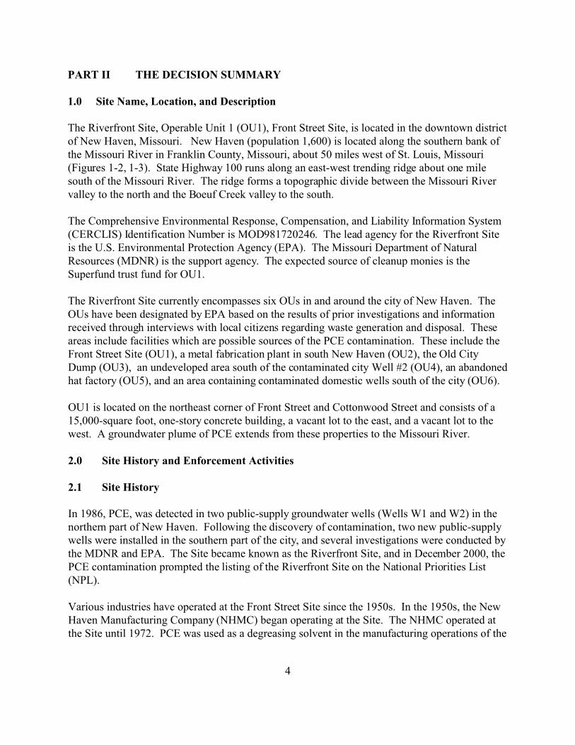
The Riverfront Site, Operable Unit 1 (OU1), Front Street Site, is located in the downtown district of New Haven, Missouri. New Haven (population 1,600) is located along the southern bank of the Missouri River in Franklin County, Missouri, about 50 miles west of St. Louis, Missouri (Figures 1-2, 1-3). State Highway 100 runs along an east-west trending ridge about one mile south of the Missouri River. The ridge forms a topographic divide between the Missouri River valley to the north and the Boeuf Creek valley to the south.
The Comprehensive Environmental Response, Compensation, and Liability Information System (CERCLIS) Identification Number is MOD981720246. The lead agency for the Riverfront Site is the U.S. Environmental Protection Agency (EPA). The Missouri Department of Natural Resources (MDNR) is the support agency. The expected source of cleanup monies is the Superfund trust fund for OU1.
The Riverfront Site currently encompasses six OUs in and around the city of New Haven. The OUs have been designated by EPA based on the results of prior investigations and information received through interviews with local citizens regarding waste generation and disposal. These areas include facilities which are possible sources of the PCE contamination. These include the Front Street Site (OU1), a metal fabrication plant in south New Haven (OU2), the Old City Dump (OU3), an undeveloped area south of the contaminated city Well #2 (OU4), an abandoned hat factory (OU5), and an area containing contaminated domestic wells south of the city (OU6).
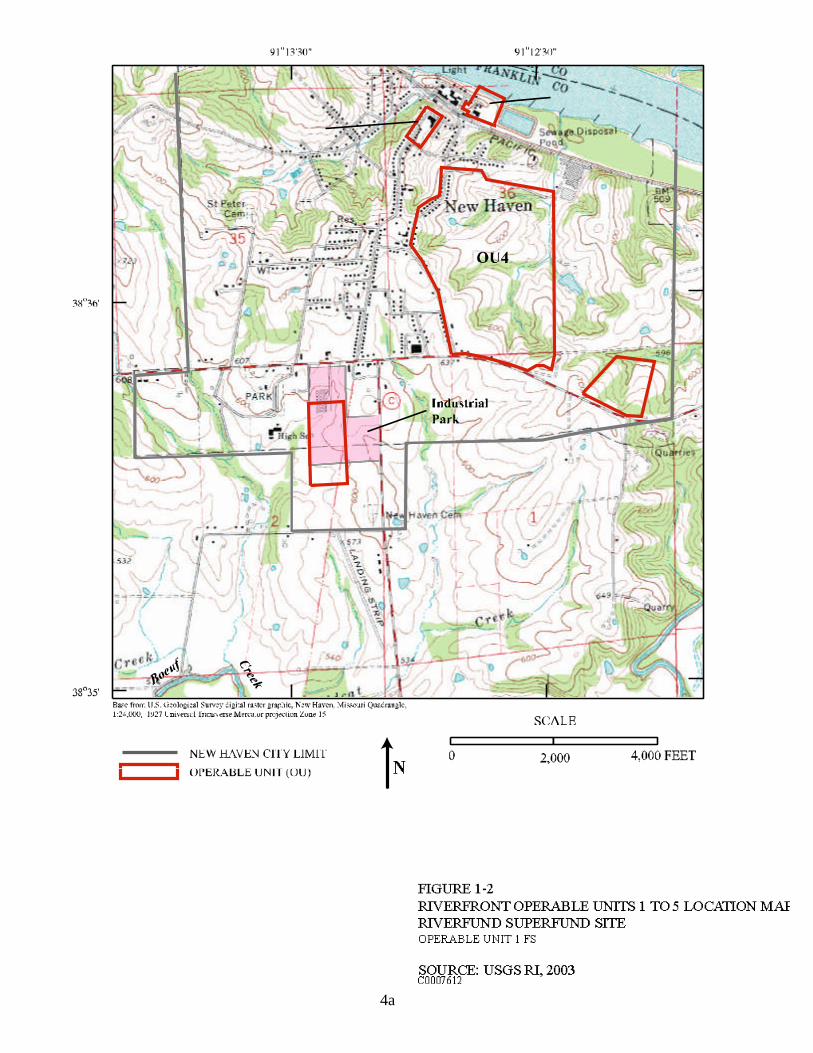
OU1 is located on the northeast corner of Front Street and Cottonwood Street and consists of a 15,000-square foot, one-story concrete building, a vacant lot to the east, and a vacant lot to the west. A groundwater plume of PCE extends from these properties to the Missouri River.
2.0 Site History and Enforcement Activities
2.1 Site History
In 1986, PCE, was detected in two public-supply groundwater wells (Wells W1 and W2) in the northern part of New Haven. Following the discovery of contamination, two new public-supply wells were installed in the southern part of the city, and several investigations were conducted by the MDNR and EPA. The Site became known as the Riverfront Site, and in December 2000, the PCE contamination prompted the listing of the Riverfront Site on the National Priorities List (NPL).
Various industries have operated at the Front Street Site since the 1950s. In the 1950s, the New Haven Manufacturing Company (NHMC) began operating at the Site. The NHMC operated at the Site until 1972. PCE was used as a degreasing solvent in the manufacturing operations of the
4
4a
FRONT STREET COTT
ONW
OOD
STRE
ET
Missouri River
boat ramp
STREET CITY UTILITIES
about 200 feet
RAILROAD TRACK
SCALE
0 200 400 FEET N
BW-01 BW-01A
BW-00 BW-00A
TW-D
TW-G
TW-E
TW-C
TW-A
TW-F
TW-B SEWAGE LAGOON
New Haven
PROPERTY BOUNDARY
FRONT
BUILDING
City well W2
Base from U.S. Geological Survey digital data, 1:100,000, 1927 Universal Transverse Mercator projection Zone 15
MAXIMUM PCE CONCENTRATION DETECTED, IN STREET OR CONCRETE PAD MICROGRAMS PER LITER. THE SQUARES INDICATE STREAM OR WATER MONITORING WELLS IN BEDROCK AQUIFER � NOT DETECTED � 0.01-4.99 � 5.0-49.99 � 50-499 FIGURE 1-3 � 500-670 OPERABLE UNIT 1, FRONT STREET, LAYOUT
RIVERFRONT SUPERFUND SITE OPERABLE UNIT 1 FS
SOURCE: USGS RI, 2003 C0007613 4b
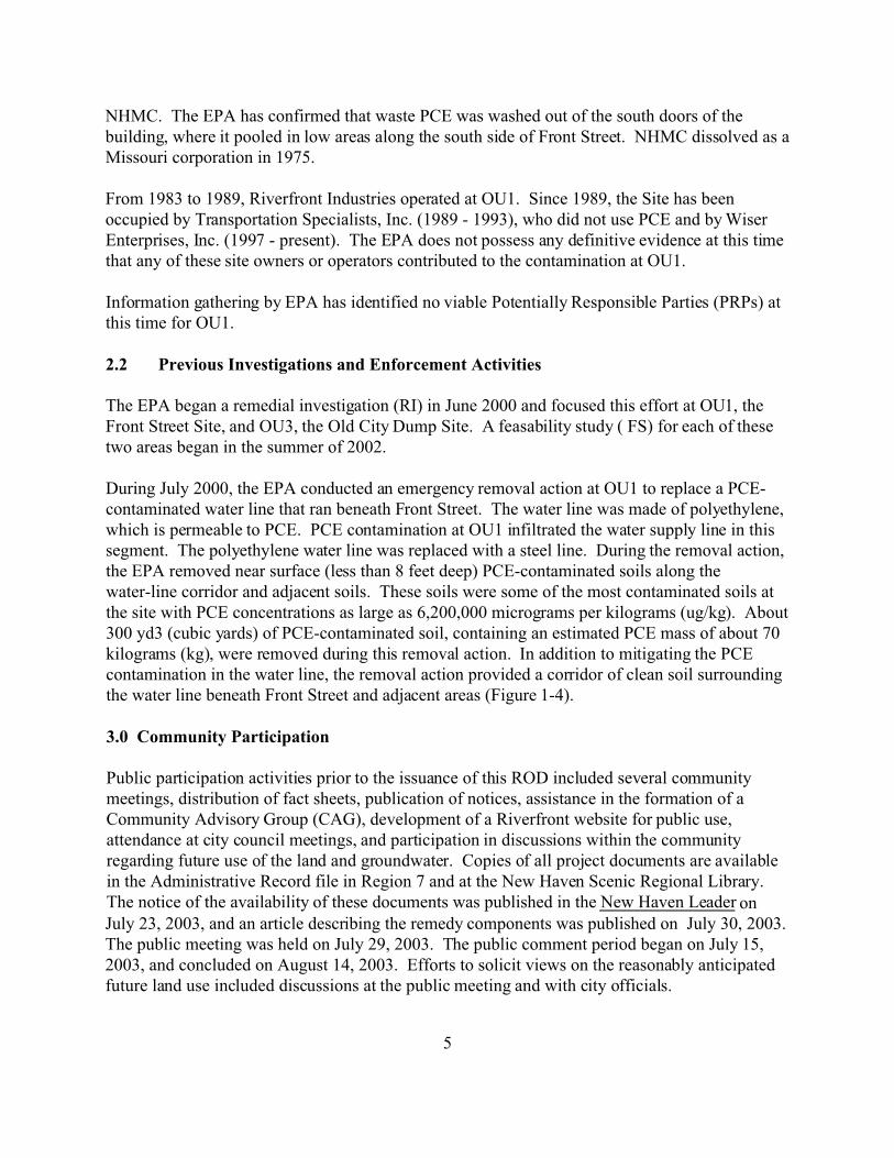
NHMC. The EPA has confirmed that waste PCE was washed out of the south doors of the building, where it pooled in low areas along the south side of Front Street. NHMC dissolved as a Missouri corporation in 1975.
From 1983 to 1989, Riverfront Industries operated at OU1. Since 1989, the Site has been occupied by Transportation Specialists, Inc. (1989 - 1993), who did not use PCE and by Wiser Enterprises, Inc. (1997 - present). The EPA does not possess any definitive evidence at this time that any of these site owners or operators contributed to the contamination at OU1.
Information gathering by EPA has identified no viable Potentially Responsible Parties (PRPs) at this time for OU1.
2.2 Previous Investigations and Enforcement Activities
The EPA began a remedial investigation (RI) in June 2000 and focused this effort at OU1, the Front Street Site, and OU3, the Old City Dump Site. A feasability study ( FS) for each of these two areas began in the summer of 2002.
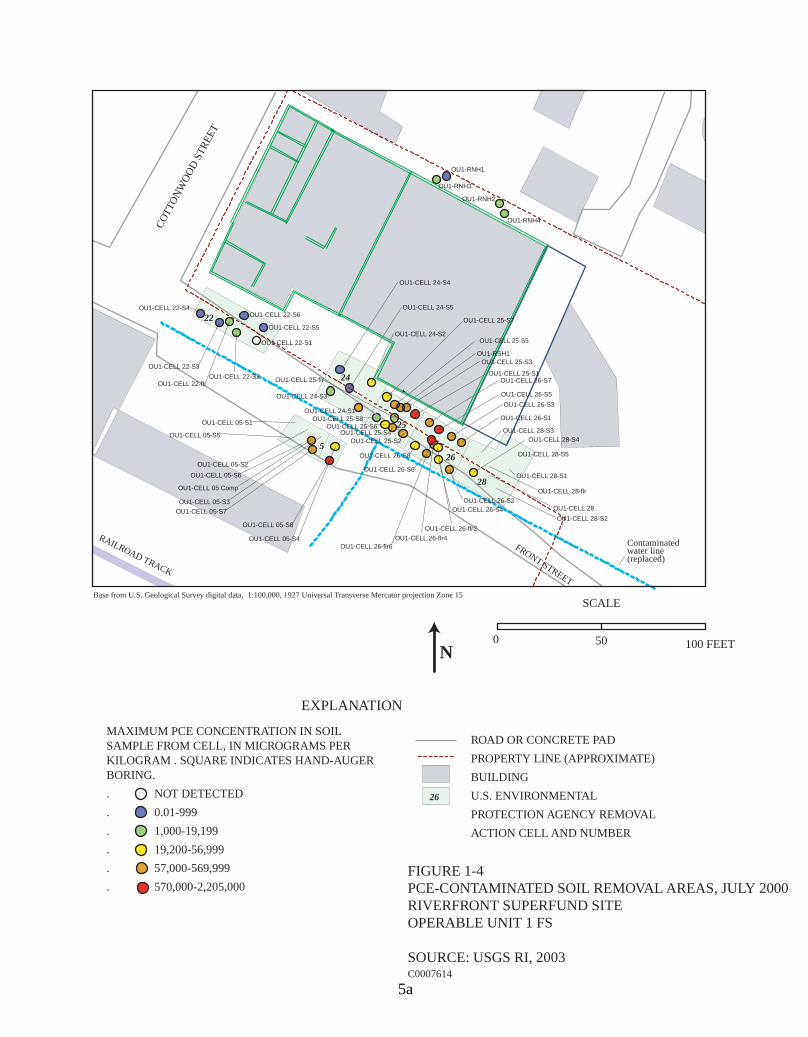
During July 2000, the EPA conducted an emergency removal action at OU1 to replace a PCE-contaminated water line that ran beneath Front Street. The water line was made of polyethylene, which is permeable to PCE. PCE contamination at OU1 infiltrated the water supply line in this segment. The polyethylene water line was replaced with a steel line. During the removal action, the EPA removed near surface (less than 8 feet deep) PCE-contaminated soils along the water-line corridor and adjacent soils. These soils were some of the most contaminated soils at the site with PCE concentrations as large as 6,200,000 micrograms per kilograms (ug/kg). About 300 yd3 (cubic yards) of PCE-contaminated soil, containing an estimated PCE mass of about 70 kilograms (kg), were removed during this removal action. In addition to mitigating the PCE contamination in the water line, the removal action provided a corridor of clean soil surrounding the water line beneath Front Street and adjacent areas (Figure 1-4).
3.0 Community Participation
Public participation activities prior to the issuance of this ROD included several community meetings, distribution of fact sheets, publication of notices, assistance in the formation of a Community Advisory Group (CAG), development of a Riverfront website for public use, attendance at city council meetings, and participation in discussions within the community regarding future use of the land and groundwater. Copies of all project documents are available in the Administrative Record file in Region 7 and at the New Haven Scenic Regional Library. The notice of the availability of these documents was published in the New Haven Leader on July 23, 2003, and an article describing the remedy components was published on July 30, 2003. The public meeting was held on July 29, 2003. The public comment period began on July 15, 2003, and concluded on August 14, 2003. Efforts to solicit views on the reasonably anticipated future land use included discussions at the public meeting and with city officials.
5
25
26
28
24
22
5
lr
lr
l l
l
lr
Contaminated
(replaced)
SCALE
COTT
ONW
OOD
STRE
ET
RAILROAD TRACK
FRONT STREET
OU1-CELL 22-S2 OU1-CELL 22-f
OU1-CELL 24-S2
OU1-CELL 28-S1
OU1-CELL 28-S5
OU1-CELL 24-S3
OU1-CELL 24-S1
OU1-CELL 28-S3
OU1-CELL 26-S1
OU1-CELL 26-S3
OU1-CELL 26-S5
OU1-CELL 26-S7 OU1-CELL 25-S1
OU1-CELL 25-S3 OU1-RSH1
OU1-CELL 25-S7
OU1-CELL 05-S1
OU1-CELL 05-S5
OU1-CELL 05-S2
OU1-CELL 05-S6
OU1-CELL 05 Comp
OU1-CELL 05-S3 OU1-CELL 05-S7
OU1-CELL 05-S8
OU1-CELL 05-S4
OU1-CELL 28-f
OU1-CELL 28
OU1-CELL 28-S2
OU1-CELL 28-S4
OU1-CELL 26-S2 OU1-CELL 26-S4
OU1-CELL 26-f r2 OU1-CELL 26-f r4
OU1-CELL 26-f r6
OU1-CELL 26-S6
OU1-CELL 26-S8
OU1-CELL 25-S2 OU1-CELL 25-S4
OU1-CELL 25-S6 OU1-CELL 25-S8
OU1-CELL 24-S5
OU1-CELL 25-f
OU1-CELL 24-S4
OU1-RNH4
OU1-RNH2
OU1-RNH1
OU1-RNH3
OU1-CELL 22-S3
OU1-CELL 22-S4 OU1-CELL 22-S6
OU1-CELL 22-S5
OU1-CELL 22-S1 OU1-CELL 25-S5
water line
Base from U.S. Geological Survey digital data, 1:100,000, 1927 Universal Transverse Mercator projection Zone 15
0� 50 100 FEETN
EXPLANATION
MAXIMUM PCE CONCENTRATION IN SOIL SAMPLE FROM CELL, IN MICROGRAMS PER ROAD OR CONCRETE PAD
KILOGRAM . SQUARE INDICATES HAND-AUGER PROPERTY LINE (APPROXIMATE) BORING. BUILDING . NOT DETECTED 26 U.S. ENVIRONMENTAL . 0.01-999 PROTECTION AGENCY REMOVAL . 1,000-19,199 ACTION CELL AND NUMBER . 19,200-56,999 . 57,000-569,999 FIGURE 1-4 . 570,000-2,205,000� PCE-CONTAMINATED SOIL REMOVAL AREAS, JULY 2000
RIVERFRONT SUPERFUND SITE OPERABLE UNIT 1 FS
SOURCE: USGS RI, 2003 C0007614
5a
4.0 Scope and Role of Operable Unit or Response Action
This action will be the final response action for OU1. Other actions will be implemented at the other OUs at the Riverfront Site. This action will be conducted under remedial authorities. OU1 is part of an overall cleanup of the Riverfront Site that includes six separate OUs in combination with short-term response measures performed under CERCLA removal authority. OU1 is a discrete area of contamination that does not affect, and is not affected by, other OUs at the Riverfront Site. OU1 and OU3 are the first OUs at the Site that have progressed to the remedy selection phase. Other OUs will be addressed in subsequent phases.
OU1 addresses soils and groundwater impacted by releases of materials that occurred at or near the former manufacturing facility on Front Street. These releases have resulted in a localized area of soil contamination and a relatively narrow plume of contaminated groundwater that flows from the former facility and discharges into the Missouri River. This material is not contributing to the PCE contamination which affected the city’s closed public water supply wells. The OU1 plume is not adversely affecting any other current drinking water sources or surface water quality in the Missouri River. Contamination in soil is limited to soils in the immediate vicinity of the Front Street facility at depths of two feet or greater. There is no current exposure to contaminated soils associated with OU1, unless the soil surface is disturbed.
Since completion of the sampling that characterized the extent of groundwater contamination associated with OU1, additional sampling has been performed in the residences located above or adjacent to the groundwater plume to determine if indoor air quality is being adversely affected by organic vapors emanating from the plume. This sampling has identified the presence of elevated organic vapors in one of these residences that may be related to vapor intrusion from contaminated groundwater beneath the home. Additional sampling is ongoing to determine if indoor air quality is, in fact, being impacted by the contaminated groundwater plume and if health-based levels are exceeded.
If EPA determines that interior vapor concentrations in the residence above the contaminated plume are related to the Front Street releases and that these vapor concentrations pose an unacceptable risk to affected residents, appropriate response measures will be considered and implemented by EPA. Such measures could include installation of a ventilation system to remove contaminated vapors from living areas within the residences or other effective action. This work, if required, will be performed using CERCLA removal authority which allows the EPA to perform immediate actions to protect human health and the environment. This document proposes remedial or long-term measures to address the PCE contamination in soils and groundwater. Hence, the indoor air quality is outside of the scope of this ROD and will be addressed through the more immediate removal process.
5.0 Site Characteristics
6

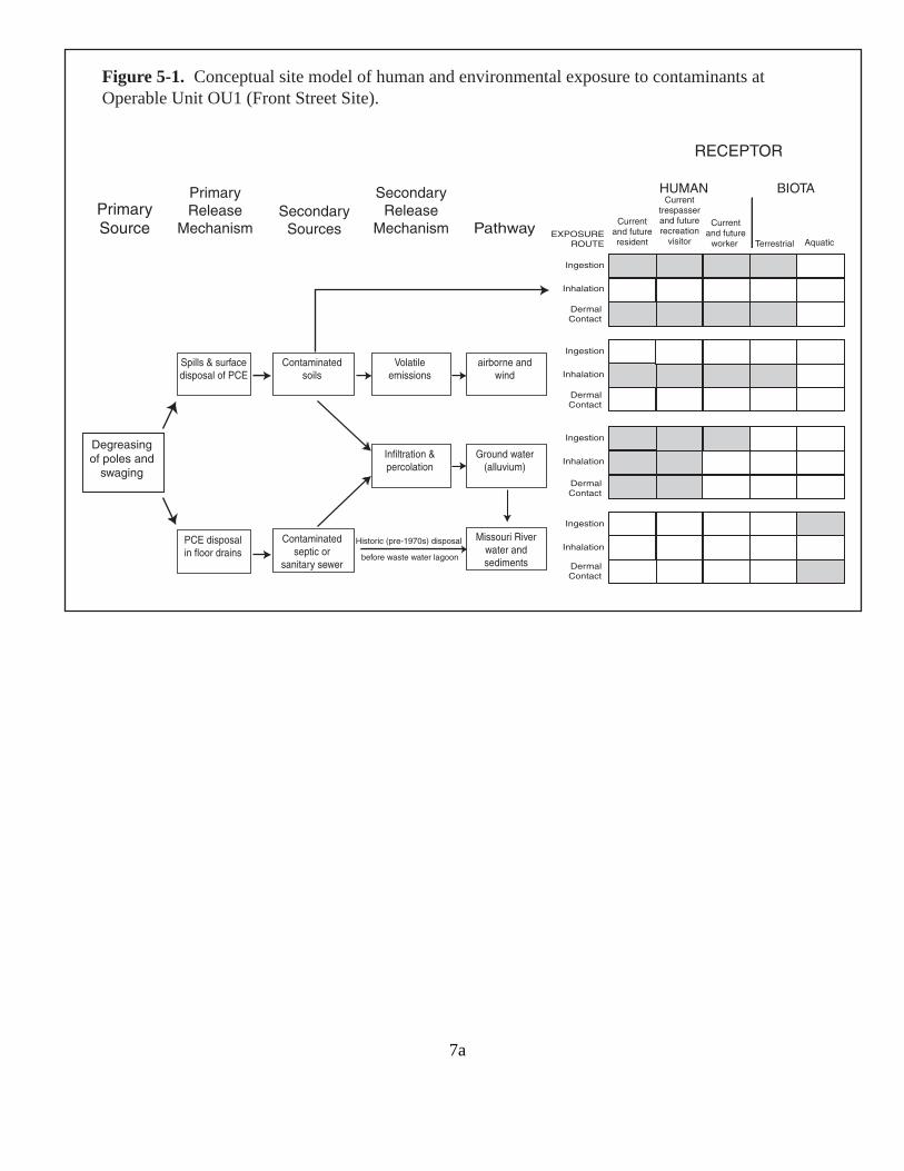
5.1 Conceptual Site Model
As shown in the conceptual site model (CSM) [Figure 5-1], the following pathways for current and future receptors were considered. Reasonable exposure scenarios were developed, based on how the Site is currently used and assumptions about its future use.
/ Ingestion, dermal contact, and inhalation of groundwater contaminants for domestic usage (washing, bathing, laundry, etc.) for potential offsite residents and as a potable drinking water supply for potential offsite residents and onsite occupational workers (i.e., untreated water supply).
/ Ingestion and dermal contact with surface soil (0 to 2 feet in depth) for current onsite trespassers and workers, and future residents, workers, and recreational users.
/ Inhalation of airborne contaminants in outdoor air for current onsite trespassers and workers, and future residents, workers, and recreational users.
/ Ingestion and dermal contact with Missouri River water for current and future recreational users.
In addition, the EPA is investigating if contaminants from the groundwater or soils are migrating into a nearby residence at levels that could pose a risk. Currently (September 2003), the indoor air data are inconclusive.
5.2 Overview of OU1
The Front Street Site (OU1) is located in downtown New Haven and consists of a 15,000-square foot, one-story, concrete building (the Front Street Building), and vacant lots to the east and west of this building. It is located on the south side of the Missouri River alluvial plain, just north of a bluff. The Site is protected by a flood control levee to the north.
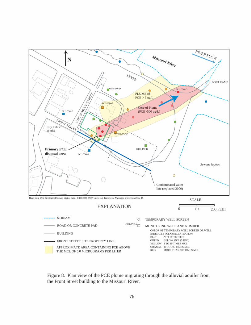
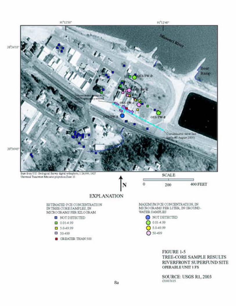
The highest PCE concentrations were detected in the soils beneath Front Street along the south side of the Front Street Building. A plume of groundwater contaminated with PCE and its degradation products begins below the Front Street Site and extends northeast to the Missouri River. The plume passes under two residential properties as it migrates to the river (Figure 8).
5.3 Surface and Subsurface Features
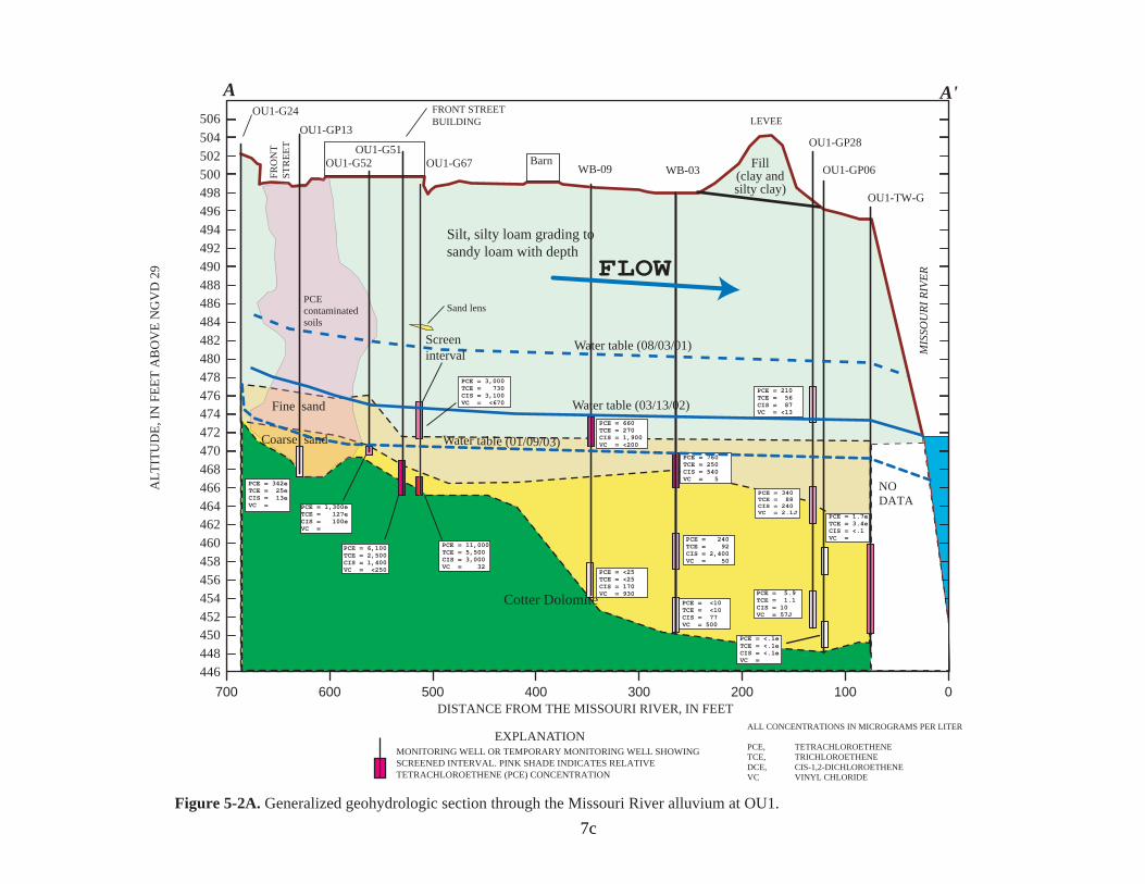
Bedrock below the Site varies from approximately 29 feet below ground surface (bgs) to the southeast (nearest the bluff) to approximately 38 feet bgs to the north (Figure 5-2A). Bedrock continues to drop off steeply to the north below the groundwater plume. At the Missouri River, bedrock is 56 feet bgs. A layer of medium to fine silty sand covers the bedrock surface to approximately 20 feet bgs. The upper 20 feet of the soil is mostly silt.
The depth to groundwater depends on the stage of the Missouri River. Normally, the depth varies from 10 to 12 feet bgs after the spring floods to around 20 to 22 feet bgs in late
7
i i l
i l
i
i l
i
ill di l
i l i l i
i ils
l ile i i
ai wi
(all i )
Mi i Ri
i
il i l i
i i
i
( ).
Hi i i l
l
i i
visi ial ic Source Sources
so nd
ssour
Conceptual site model of human and environmental exposure to contaminants at
Ingestion
Inhalation
Contact
Ingestion
Inhalation
Contact
Current and future
Current trespasser and future
tor
Current and future
Aquat
Ingestion
EXPOSURE
Inhalation
Contact
Ingestion
Inhalation
Contact
HUMAN
Pr mary Pr mary Re ease
Mechan sm Secondary
Secondary Re ease
Mechan sm Pathway
Degreas ng of po es and
swag ng
Sp s & surface sposa of PCE
PCE d sposa n f oor dra ns
Contam nated Vo at em ss ons
rborne and
Ground water uv um
ver water and sed ments
Inf trat on & perco at on
Contam nated sept c or
san tary sewer
Figure 5-1. Operable Unit OU1 Front Street Site
stor c (pre-1970s) d sposa
before waste water agoon
Dermal
Dermal
res dent recreat on
worker Terrestr ROUTE
Dermal
Dermal
RECEPTOR
BIOTA
7a
/L
( /L)
SCALE
N
LEVEE
Missouri River
Sewage lagoon
RIVER FLOW
( )
FRONT STREET
COTT
ONW
OOD
STRE
ET PLUME of
PCE > 5 ug
Core of Plume PCE>500 ug
OU1-TW-C
OU1-TW-B
OU1-TW-A
OU1-TW-F
OU1-TW-E
OU1-TW-D OU1-TW-G
Base from U.S. Geological Survey digital data, 1:100,000, 1927 Universal Transverse Mercator projection Zone 15
EXPLANATION
Primary PCE disposal area
BOAT RAMP
Contaminated water line replaced 2000
City Public Works
STREAM
ROAD OR CONCRETE PAD OU1-TW-A
BUILDING
FRONT STREET SITE PROPERTY LINE
APPROXIMATE AREA CONTAINING PCE ABOVE THE MCL OF 5.0 MICROGRAMS PER LITER
0 100 200 FEET
TEMPORARY WELL SCREEN
MONITORING WELL AND NUMBER COLOR OF TEMPORARY WELL SCREEN OR WELL INDICATES PCE CONCENTRATION BLUE� NOT DETECTED GREEN� BELOW MCL (5 UG/l) YELLOW � 1 TO 10 TIMES MCL ORANGE� 10 TO 100 TIMES MCL RED� MORE THAN 100 TIMES MCL
Figure 8. Plan view of the PCE plume migrating through the alluvial aquifer from the Front Street building to the Missouri River.
7b
--
--
--
--
A A'
ALT
ITU
DE,
IN F
EET
AB
OV
E N
GV
D 2
9
506 504 502 500 498 496 494 492 490 488 486 484 482 480 478 476 474 472 470 468 466 464 462 460 458 456 454 452 450 448 446
PCE contaminated soils
PCE = 11,000TCE = 5,500CIS = 3,000VC = 32
PCE = 3,000TCE = 730 CIS = 3,100VC = <670
PCE = 6,100TCE = 2,500CIS = 1,400VC = <250
PCE = 1,300eTCE = 127e CIS = 100e VC =
PCE = 342e TCE = 25e CIS = 13e VC =
PCE = 210 TCE = 56 CIS = 87 VC = <13
PCE = 340 TCE = 88 CIS = 240 VC = 2.1J
PCE = 5.9 TCE = 1.1 CIS = 10 VC = 57J
PCE = 1.7e TCE = 3.4e CIS = <.1 VC =
PCE = 670 TCE = 280 CIS = 2,400VC = 630
PCE = <.1e TCE = <.1e CIS = <.1e VC =
NO DATA
WB-09 WB-03
PCE = <25 TCE = <25 CIS = 170 VC = 930
PCE = 660 TCE = 270 CIS = 1,900VC = <200
PCE = <10 TCE = <10 CIS = 77 VC = 500
PCE = 240 TCE = 92 CIS = 2,400VC = 50
PCE = 760 TCE = 250 CIS = 540 VC = 5
FLOW Silt, silty loam grading to sandy loam with depth
Fill (clay andsilty clay)
Cotter Dolomite
Wat ble (01/09/03)
OU1-G51 OU1-G52
OU1-G24
OU1-G67 OU1-GP06
OU1-GP28
OU1-TW-G
OU1-GP13
Barn
FRONT STREET BUILDING LEVEE
FRO
NT
STR
EET
MIS
SOU
RI R
IVER
Screen interval
Sand lens
Fine sand
Coarse sand
Water table (03/13/02)
Water table (08/03/01)
er ta
700 600 500 400 300 200 100 DISTANCE FROM THE MISSOURI RIVER, IN FEET
ALL CONCENTRATIONS IN MICROGRAMS PER LITER EXPLANATION
MONITORING WELL OR TEMPORARY MONITORING WELL SHOWING PCE, � TETRACHLOROETHENE TCE, � TRICHLOROETHENE
SCREENED INTERVAL. PINK SHADE INDICATES RELATIVE DCE,� CIS-1,2-DICHLOROETHENETETRACHLOROETHENE (PCE) CONCENTRATION VC� VINYL CHLORIDE
Figure 5-2A. Generalized geohydrologic section through the Missouri River alluvium at OU1.
0
7c
summer/early autumn. However, in times of prolonged flooding, the depth to groundwater can be zero feet, while during the drought year of 2002, the depth to groundwater fell to 26 feet bgs. Generally, groundwater in the sand and silt flows northeast into the Missouri River at between 35 and 58 feet per year. During flood stage, the groundwater flow into the river may stop or even reverse.
5.4 Sampling Strategy
The Front Street Site has been extensively investigated. Samples have been collected from trees, soils, and groundwater at the Site and in the vicinity to define the extent of contamination. Contaminated soils and groundwater are present at the Site.
Tree-core samples were collected because the levels of PCE in the cores were found to correlate with the levels of PCE in the soil and groundwater below the tree. The tree-core PCE results indicated that the highest PCE concentrations were along the south side of the Front Street Building (Figure 1-5).
Three phases of soil sampling were conducted at the Front Street Site. PCE was detected at 128 of the 144 soil sampling locations. The concentrations of PCE vary substantially with depth and the boring’s location across the Site. The maximum PCE concentration detected at the Site was 6,200,000 ug/kg found in a sample collected four feet deep beneath Front Street.
Four phases of groundwater sampling have been conducted at the Site. In Phases I and II, six monitoring wells were installed in the alluvium and four monitoring wells were installed in the bedrock. During Phases III and IV, direct push temporary wells were installed (21 in Phase III and 6 in Phase IV). PCE and its degradation products (trichloroethene [TCE], cis-1,2-dichloroethene [cis-DCE], and vinyl chloride [VC]) were detected in many of these samples. The maximum PCE concentration detected in the groundwater at the Site was 11,000 micrograms per liter (ug/L).
Water and sediment samples were also collected from the Missouri River. PCE and its degradation products were not detected in any of the water or sediment samples from the river.
5.5 Known and Suspected Sources of Contamination
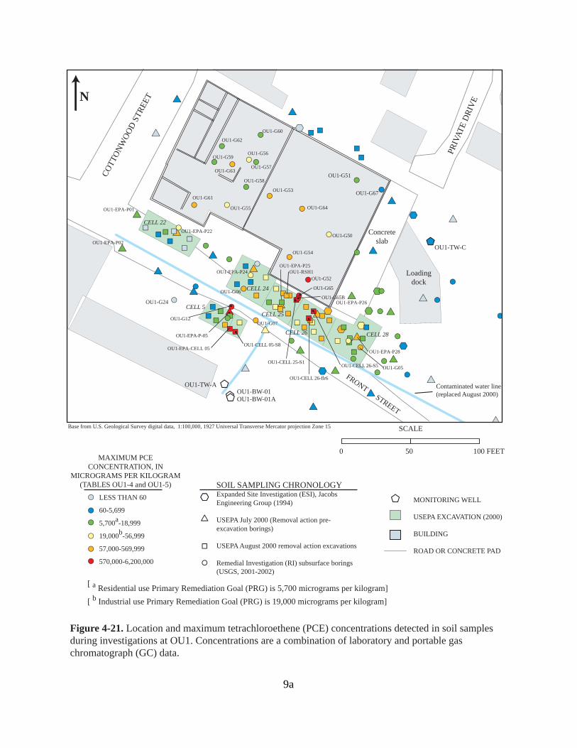
The RI investigation confirmed PCE contamination in the soil and groundwater at OU1. Based on the sampling results, EPA has estimated that approximately 34,000 cubic yards of soils below the Front Street Site are contaminated with some level of PCE. Concentrations vary substantially with depth and are highest at shallow depths near locations where PCE was dumped. The detection of large concentrations of PCE along Front Street confirms statements made by former New Haven Manufacturing Company employees that PCE was dumped and washed out of doors on the south side of the building. The stained soil is consistent with the statements made by former employees.
8
8a
A second probable source area, or extension of the area described above, is adjacent to the Front Street Building in the vicinity of borings G-65 and G-65B (Figure 4-21). These two borings were drilled through clean soil replaced after the excavation of Cell 25. Concentrations of PCE generally decreased with increasing depth. The highest PCE concentration detected in this area (estimated at 1,871,900 ug/kg) was in a sample collected from a depth of 6.0 feet in boring G65B. This sample was collected immediately below the bottom of the clean backfill.
In addition, a plume of PCE-contaminated groundwater extends from the Site to the Missouri River and contains about 5.8 million gallons of water. Concentrations of PCE were detected in 22 of the 28 groundwater sampling locations in the alluvial aquifer in the vicinity of OU1. Thirteen of the 14 locations having PCE concentrations above the maximum contaminant level (MCL) of 5 ug/L were in the vicinity of the Front Street Building or downgradient from the building near the boat ramp. Figure 8 is a plan view of the PCE plume migrating from the alluvial aquifer from the Front Street Building to the Missouri River. Plumes of degradation products are located within the PCE plume.
5.6 Types of Contamination and Affected Media
Based on the data collected during and after the RI/FS, 12 COCs were identified that drive the need for remedial action. The VOCs PCE, TCE, and VC were detected in the groundwater and soil at OU1 at levels that contributed significantly to the Site’s risks. The VOCs cis-1,2-dichloroethene (c-DCE), benzene, 1,1-dichloroethene, and total 1,2-dichloroethene were found in the groundwater at levels that contributed significantly to the Site’s risks. The polynuclear aromatic hydrocarbons (PAHs) benzo(a)pyrene, benzo(a)anthracene, benzo(b)fluoranthene, and indeno(1,2,3-cd)pyrene and the metal arsenic were detected in the soils at levels that contributed significantly to the Site’s risks. These COCs were identified from the data collected during the RI between 1999 and 2002 and further supplemental sampling in 2003. Sampling data were available from 28 groundwater locations (7 monitoring wells and 21 temporary well screens), one domestic well, 140 soil sampling locations (88 borings and 52 samples from excavations and test pits), 10 surface water samples (including samples of the Missouri River), and more than 70 samples from nearby trees. These data have not found any indication that there is source material or NAPLs in the soil or groundwater.
5.7 Location of Contamination and Potential Routes of Migration
5.7.1 Soil Contamination
The vertical profile of PCE in soils at OU1 indicates that, in general, PCE concentrations in the upper two to three feet of soil are lower than those at deeper depths. This relation is true even in the suspected source areas in the vicinity of boreholes G12 and G65. The most likely mechanism for PCE introduction into the soils at OU1 was by disposal directly on the land surface. Volatilization from the shallow subsurface probably is an important loss mechanism within the upper few feet of soil at the site, but is not important at depth.
9
Contaminated water line (replaced August 2000)
CELL 5
CELL 22
CELL 24
CELL 25
CELL 26 CELL 28
Loading dock
Concrete slab
OU1-G24
OU1-G51
OU1-G67
' '
'
'
'
'
'
'
'
$
$ $
$
$
$
$
$
$ $
$
$
$
$ $
$
$
$
$
$
$
$
$
$
$
$
$
$
$
#
OU1-EPA-P-05
OU1-EPA-P22
OU1-EPA-P01
OU1-EPA-P02
OU1-EPA-P24 OU1-EPA-P25
OU1-EPA-P26
OU1-EPA-P28
FRONT STREET
% %
% %
% %
% %
% %
%%%
%
%
%
%
% %
%
%
%
%
%
%
%
%
%
%
%
%
%
%
%
% %
% %
% %
%
%
%
%
%
% %
%%%
%%
%
#
OU1-CELL 05-S8
#
OU1-CELL 25-S1
#
OU1-CELL 26-flr6
#
OU1-CELL 26-S5
OU1-RSH1
OU1-EPA-CELL 05
#
#
#
#
#
#
#
#
#
#
#
#
#
# #
#
#
#
#
#
#
#
#
#
#
#
#
#
#
#
#
#
#
#
#
#
#
#
#
#
#
#
#
OU1-G52
OU1-G50
#
OU1-G12
#
OU1-G65
# OU1-G65B
OU1-G54
OU1-G07
OU1-G06
OU1-G05
OU1-G64
OU1-G53
OU1-G55
OU1-G58
OU1-G56
OU1-G57
OU1-G60
OU1-G59
OU1-G62
OU1-G63
OU1-G61
&
&
& &
OU1-TW-A
OU1-TW-C
OU1-BW-01 OU1-BW-01A
SCALEBase from U.S. Geological Survey digital data, 1:100,000, 1927 Universal Transverse Mercator projection Zone 15
N CO
TTON
WOO
D ST
REET
PRIV
ATE
DRI
VE
0 50 100 FEET MAXIMUM PCE
CONCENTRATION, IN MICROGRAMS PER KILOGRAM
(TABLES OU1-4 and OU1-5) SOIL SAMPLING CHRONOLOGY
#
#
#
#
LESS THAN 60
60-5,699
5,700a-18,999
19,000b-56,999
$
'' Expanded Site Investigation (ESI), Jacobs Engineering Group (1994)
USEPA July 2000 (Removal action pre-excavation borings)
& MONITORING WELL
USEPA EXCAVATION (2000)
BUILDING
# 57,000-569,999 % USEPA August 2000 removal action excavations ROAD OR CONCRETE PAD
# 570,000-6,200,000 # Remedial Investigation (RI) subsurface borings (USGS, 2001-2002)
[ a Residential use Primary Remediation Goal (PRG) is 5,700 micrograms per kilogram] [ b Industrial use Primary Remediation Goal (PRG) is 19,000 micrograms per kilogram]
Figure 4-21. Location and maximum tetrachloroethene (PCE) concentrations detected in soil samples during investigations at OU1. Concentrations are a combination of laboratory and portable gas chromatograph (GC) data.
9a
The detection of large PCE concentrations (greater than 57,000 ug/kg) beneath the building floor, especially beneath the older parts of the building, was unexpected due to the absence of floor drains, substantial cracks, or joints in the floor. However, PCE possibly was dumped on the ground in these areas in the late 1950s and 1960s before building additions were placed over them.
5.7.2 Groundwater Contamination
Figure 5-2A is a generalized geohydrologic section depicting the PCE plume through the Missouri River alluvium at OU1 and the distribution of the PCE and its degradation products. A vertical profile of PCE concentrations in samples indicates that the largest estimated PCE concentrations were detected in two discrete zones - a zone between about 35 and 100 feet deep and a zone between about 275 and 340 feet deep.
Initially, there was a concern that OU1 might be the source of the PCE contamination that closed city Wells 1 and 2. However, while large concentrations (up to 11,000 ug/L) of PCE were detected at OU1, the RI determined that the contaminant plume from OU1 was moving to the northeast, away from the city wells and was too shallow to have affected them (Figure 8). The bedrock monitoring wells at OU1 are near the end of the groundwater flow paths (the Missouri River is the regional groundwater drain) in the Cotter and Jefferson City Dolomite and Roubidoux Formation. Also, the results of discrete sampling at various depths in public-supply well W2 and in bedrock monitoring wells installed near public-supply well W2 indicate that the source of the PCE detected in public-supply well W2 probably was south of well W2 and not OU1.
6.0 Current and Potential Future Land and Water Uses
Current onsite land use of the Front Street Site is commercial/industrial. It is surrounded by residential property to the north, a sanitary sewer lagoon to the east, and a vacant lot/commercial property to the west. The reasonably anticipated future land use is as a greenspace or park and additional parking spaces. Negotiations are nearing completion with the prospective buyer for OU1, which will allow for this reuse. With the anticipated increased use of the boat ramp and numerous Lewis and Clark Bicentennial festivities expected in 2004, it is expected that the revitalization of the downtown area will be greatly enhanced by this property transfer and remedial action.
Although the Missouri River alluvial aquifer is widely used throughout Missouri for public-supply, domestic, industrial, irrigation use, in New Haven the aquifer is generally low-yielding and of marginal quality. Because of the low yields and marginal quality, the alluvial aquifer in New Haven has not been used as a drinking water source since the early 1900s. During normal stages of the Missouri River, the depth to groundwater in the alluvial aquifer in the vicinity of OU1 varies from 10 to 25 feet below the land surface. The thickness of the alluvium at OU1 is about 30 feet and increases to about 50 feet thick near the Missouri River. Except for an area
10

bordering the Missouri River, the thickness of saturated alluvium near OU1 is usually less than about 10 feet thick. The estimated specific capacity of the alluvial aquifer at OU1 is about 3 to 5 gallons per minute per foot of draw down indicating that there is insufficient yield and thickness of saturated alluvium at OU1 for public or industrial supply uses. Yields from the alluvial aquifer at OU1 are probably adequate for small domestic or irrigation uses. However, the presence of high concentrations of naturally occurring chemical constituents in water from the alluvial aquifer in New Haven makes it undesirable for domestic or irrigation use because of taste, odor, and fouling problems. Groundwater in the alluvial aquifer near the Front Street Site contains average concentrations of total dissolved solids (about 600 mg/L), dissolved iron (5,800 ug/L), and dissolved manganese (about 1,000 ug/L) that exceed the EPA secondary drinking water standards of 500 mg/L, 300 ug/L, and 50 ug/L, respectively. In addition, the concentrations of manganese exceed the State of Missouri Drinking Water Standard of 50 ug/L (10 CSR 20-7.031). The large concentrations of dissolved iron and manganese would impart a bitter metallic taste to the water and cause excessive staining to fixtures and cloths. In addition, the large concentrations of dissolved iron also would cause excessive iron fouling of well screens and pumps. Groundwater in the alluvial aquifer also contains a strong "rotten egg" odor resulting from natural geochemical processes that reduce sulfate to sulfide.
7.0 SUMMARY OF SITE RISKS
The Missouri Department of Health and Senior Services (MDHSS) completed a Baseline Risk Assessment Operable Unit 1 (OU1) - Front Street (HHRA) in 2003. The HHRA estimates the human health risks that the Front Street Site could pose if no actions were taken. It is one of the factors EPA considers in deciding whether to take actions at a site. The risk assessment also identifies the contaminants and exposure pathways that need to be addressed by the remedial action.
For OU1, the Front Street Site, EPA’s decision to take action is based primarily on the presence of contamination in groundwater at levels that exceed drinking water standards and contamination in the soils that exceed acceptable risk levels. Current trespassers and workers and future residents, workers, and recreational users could be affected by the contaminated soils. Residences near the Site may be currently affected, and could be affected in the future, by contaminants migrating from the Site.
Additional field work was conducted at the Site after the RI/FS and the HHRA were completed. These data were used to further refine the conclusions in the HHRA and serve as the basis for determining appropriate action. One of the key findings of the additional field work was that indoor air contaminant levels may be affected by contaminants from the Site.
The RI, the FS, the HHRA, and the OU1 Proposed Plan may be found in the Administrative Record file. Currently (September 2003), there is no human exposure to the contaminants at the Site, except possibly for the in-door air pathway. This section of the ROD summarizes the Site risks at Front Street.
11
7.1 Summary of Human Health Risk Assessment
This summary of health risk identifies the COCs, the exposure assessment, the toxicity assessment, and the risk characterization.
7.1.1 Identification of Chemicals of Concern
Based on the data collected during and after the RI/FS, 12 COCs were identified that drive the need for remedial action. The VOCs PCE, TCE, and VC were detected in the groundwater and soil at OU1 at levels that contributed significantly to the Site’s risks. The VOCs c-DCE, benzene, 1,1-dichloroethene, and total 1,2-dichloroethene were found in the groundwater at levels that contributed significantly to the Site’s risks. The PAHs benzo(a)pyrene, benzo(a)anthracene, benzo(b)fluoranthene, and indeno(1,2,3-cd)pyrene and the metal arsenic were detected in the soils at levels that contributed significantly to the Site’s risks. These COCs were identified from the data collected during the RI between 1999 and 2002 and further supplemental sampling in 2003. Sampling data were available from 28 groundwater locations (7 monitoring wells and 21 temporary well screens), one domestic well, 140 soil sampling locations (88 borings and 52 samples from excavations and test pits), 10 surface water samples (including samples of the Missouri River), and more than 70 samples from nearby trees.
Initially, there was a concern that OU1 might be the source of the PCE contamination that closed city wells 1 and 2. However, while large concentrations (up to 11,000 ug/L) of PCE were detected at OU1, the RI determined that the contaminant plume from OU1 was moving to the northeast, away from the city wells and was too shallow to have affected them.
Tables 7-1, 7-2, and 7-3 present the concentrations of COCs that pose potential threats to human health in the shallow soil, subsurface soil, and groundwater, respectively. The tables also identify the exposure point concentrations (EPCs) for groundwater, the concentration ranges, the detection frequency, and how the EPC was derived. Arsenic and PCE are the most frequently detected COCs in the surface soil. PCE was the most frequently detected COC in the subsurface soil. PCE and cis-DCE are the most frequently detected COCs in groundwater.
7.1.2 Exposure Assessment
Exposure refers to the potential contact of an individual (the receptor) with a contaminant. The exposure assessment evaluates the magnitude, frequency, duration, and route of potential exposure. This section describes which populations may be exposed, the exposure pathways, and how much exposure to the contaminants is present. A complete discussion of all the scenarios and exposure pathways is presented in the Baseline Risk Assessment, OU1 - Front Street (the HHRA).
12
As shown in the CSM (Figure 5-1), the following pathways for current and future receptors were considered. Reasonable exposure scenarios were developed, based on how the Site is currently used and assumptions about its future use.
/ ingestion, dermal contact, and inhalation of groundwater contaminants for domestic usage (washing, bathing, laundry, etc.) for potential offsite residents and as a potable drinking water supply for potential offsite residents and onsite occupational workers (i.e., untreated water supply).
/ Ingestion and dermal contact with surface soil (0 to 2 feet in depth) for current onsite trespassers and workers, and future residents, workers, and recreational users.
/ Inhalation of airborne contaminants in outdoor air for current onsite trespassers and workers, and future residents, workers, and recreational users.
/ Ingestion and dermal contact with Missouri River water for current and future recreational users.
In addition, the EPA is investigating if contaminants from the groundwater or soils are migrating into a nearby residence at levels that could pose a risk. Currently (September 2003), the indoor air data are inconclusive.
It is a highly conservative assumption that residents and workers could be exposed to contaminated groundwater from OU1. As of September 2003, all current residences and work places at or near OU1 are on city water. OU1 is currently included in the well advisory for the Riverfront Superfund Site. The quality of the water in the contaminated aquifer is very poor, making it unlikely that the water would be used as a potable water source even if a new well were installed.
13
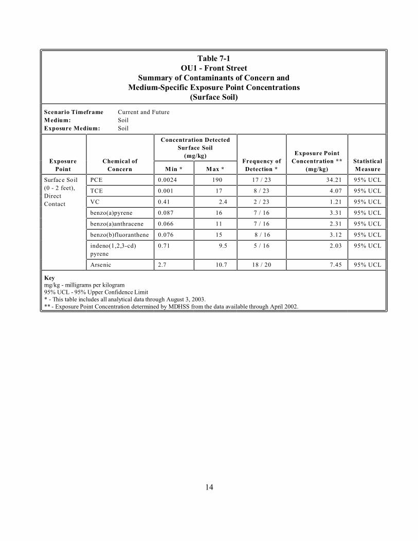
Table 7-1 OU1 - Front Street
Current and Future
Soil
Soil
Exposure
Concentration Detected
Frequency of
Point Concern
(0 - 2 feet),
Direct
Contact
PCE 0.0024 190 17 / 23 34.21 95% UCL
TCE 0.001 17 8 / 23 4.07 95% UCL
VC 0.41 2.4 2 / 23 1.21 95% UCL
benzo(a)pyrene 0.087 16 7 / 16 3.31 95% UCL
benzo(a)anthracene 0.066 11 7 / 16 2.31 95% UCL
benzo(b)fluoranthene 0.076 15 8 / 16 3.12 95% UCL
pyrene
0.71 9.5 5 / 16 2.03 95% UCL
2.7 10.7 18 / 20 7.45 95% UCL
Key
Summary of Contaminants of Concern and Medium-Specific Exposure Point Concentrations
(Surface Soil)
Scenario Timeframe
Medium:
Exposure Medium:
Chemical of
Surface Soil
(mg/kg) Exposure Point
Concentration ** Statistical
Min * Max * Detection * (mg/kg) Measure
Surface Soil
indeno(1,2,3-cd)
Arsenic
mg/kg - milligrams per kilogram 95% UCL - 95% Upper Confidence Limit * - This table includes all analytical data through August 3, 2003. ** - Exposure Point Concentration determined by MDHSS from the data available through April 2002.
14

Table 7-2 OU1 - Front Street
Current and Future
Soil
Soil
Exposure
Concentration Detected
Frequency of
Point Concern
than 2 feet),
Direct
Contact
PCE 0.00091 6,200 48 / 61 160.03 95% UCL
TCE 0.002 1.3 25 / 61 1 MAX
4.1 8.9 18 / 38 6.34 95% UCL
Key
MAX - Maximum Concentration Detected
Summary of Contaminants of Concern and Medium-Specific Exposure Point Concentrations
(Subsurface Soil)
Scenario Timeframe
Medium:
Exposure Medium:
Chemical of
Surface Soil
(mg/kg) Exposure Point
Concentration Statistical
Min * Max * Detection * ** (mg/kg) Measure
Subsurface
Soil (deeper
Arsenic
mg/kg - milligrams per kilogram 95% UCL - 95% Upper Confidence Limit
* - This table includes all analytical data through August 3, 2003. ** - Exposure Point Concentration determined by MDHSS from the data available in April 2002.
15
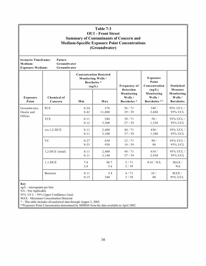
Table 7-3 OU1 - Front Street
(Groundwater)
Scenario Timeframe: Future
Concentration Detected Exposure
Point
Frequency of
Exposure
Point Concern Boreholes
PCE 0.24 370 56 / 71 140 /
Onsite and 0.42 11,000 29 / 39 2,660 95% UCL
Offsite TCE 0.11 280 39 / 71 50 / 95% UCL /
0.12 5,500 27 / 39 1,330 95% UCL
0.11 2,400 44 / 71 430 / 95% UCL /
0.11 3,100 37 / 39 1,380 95% UCL
VC 0.27 630 22 / 71 90 / 95% UCL /
0.55 930 19 / 39 90 95% UCL
0.11 2,400 44 / 71 610 / 95% UCL /
0.11 3,148 37 / 39 2,930 95% UCL
7.4 88.7 3 / 71 MAX /
2.8 5.6 2 / 39 NA
Benzene 0.11 3.4 4 / 71 16 / /
0.15 340 3 / 39 80 95% UCL
Key
MAX - Maximum Concentration Detected
Summary of Contaminants of Concern and Medium-Specific Exposure Point Concentrations
Medium: Groundw ater
Exposure M edium: Groundw ater
Monitoring Wells /
Boreholes *
(ug/L) Concentration Statistical
Detection (ug/L) Measure
Monitoring Monitoring Monitoring
Chemical of Wells / Wells / Wells /
M in Max Boreholes * Boreholes **
Groundwater, 95% UCL /
cis-1,2-DCE
1,2-DCE (total)
1,1-DCE 0.41 / NA
MAX
ug/L - micrograms per liter NA - Not Applicable
95% UCL - 95% Upper Confidence Limit
* - This table includes all analytical data through August 3, 2003. **Exposure Point Concentration determined by MDHSS from the data available in April 2002.
16
It is a highly conservative assumption that future residents and workers could be exposed to contaminants in the surface soil. One of the risk drivers for surface soil, PAHs, was found only in one boring, indicating that the distribution of these contaminants is not widespread. Nearly all of the arsenic (another surface soil risk driver) levels detected are at naturally occurring background levels. Most of the PCE contamination in the shallow soil is below the Front Street Building or Front Street itself. So the PCE contamination is essentially capped and exposure is limited.
While the CSM considered exposure to humans and the environment from contaminants in the Missouri River, this pathway was not assessed in the HHRA. The river was sampled during the RI, and all the results were non-detect for all man-made contaminants and at background levels for natural contaminants.
7.1.3 Toxicity Assessment
Tables 7-4 and 7-5 show the cancer toxicity and the non-cancer toxicity, respectively, for the COCs that are the major risk contributors at OU1, Front Street. Based on data from EPA’s Integrated Risk Information System (IRIS) and other published data, the COCs have the following carcinogen classifications:
/ Three of the COCs are human carcinogens (EPA weight of evidence A). / One of the COCs is a probable human carcinogen (EPA weight of evidence B1). / Five of the COCs are probable human carcinogens (EPA weight of evidence B2). / One of the COCs is a possible human carcinogen (EPA weight of evidence C). / Two of the COCs are either not classifiable as a human carcinogen (one) or have not been
assessed (one).
The carcinogenic oral/dermal and inhalation slope factors for the COCs are presented in Table 74.
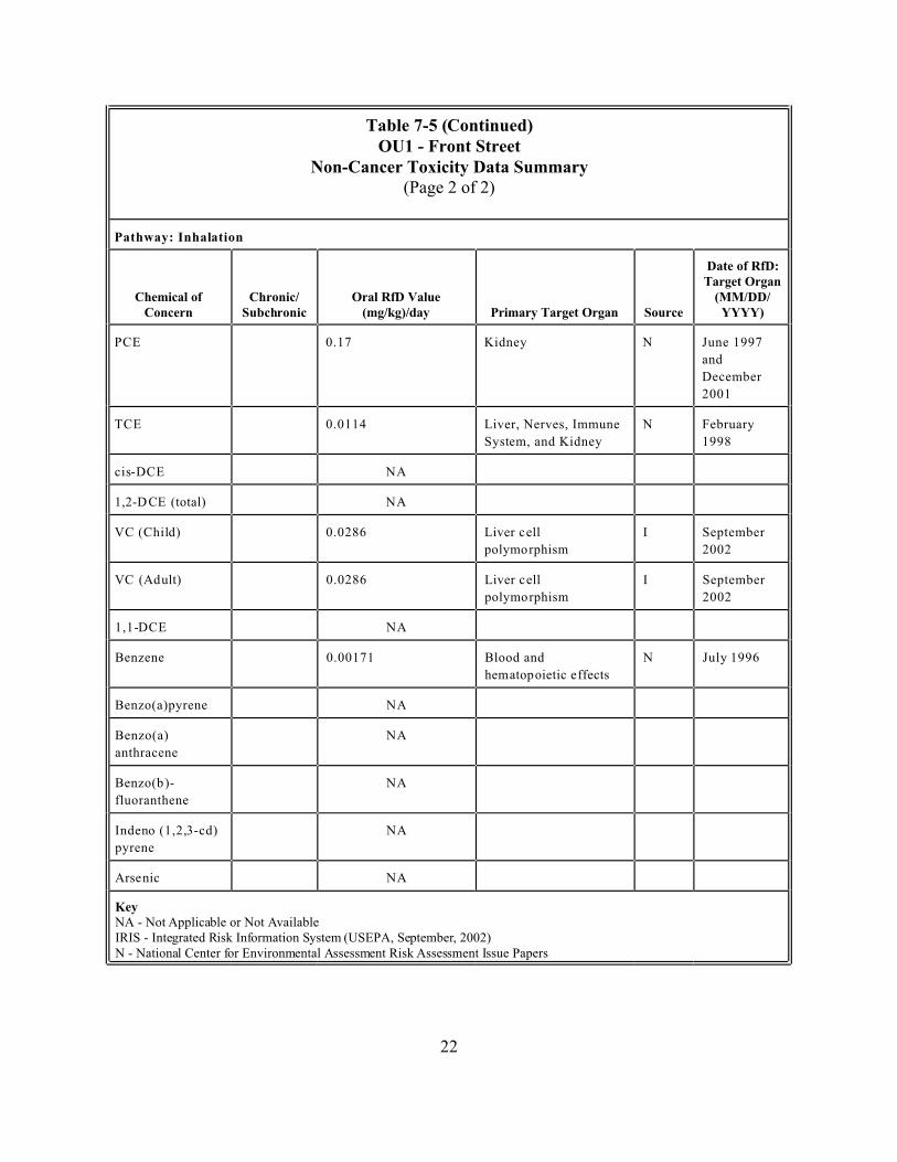
In addition, nine (of the twelve) COCs have toxicity data which describe their potential for adverse non-carcinogenic health effects. The chronic toxicity data available for these COCs have been used to develop oral, dermal, and inhalation reference doses (RfDs). The RfD is a level that an individual may be exposed to that is not expected to cause any harmful effect. The oral, dermal, and inhalation RfDs are presented in Table 7-5. For complete information on the toxicity of the COCs, see the OU1 HHRA.
The following sources are used in the HHRA to determine toxicity values:
/ EPA’s IRIS database for toxicity value (i.e., carcinogenic slope factors and noncarcinogenic reference doses (EPA, September 2002).
17
/ National Center for Environmental Assessment (NCEA) - Superfund Technical Support Center Risk Assessment Issue Papers for: - Tetrachloroethene (June 1997 and December 2001) - Trichloroethene (February 1998) - Benzo(a)pyrene (November 1994) - Benzene (July 1996)
/ Health Effects Assessment Summary Tables (HEAST), EPA 540/R-97–036
18
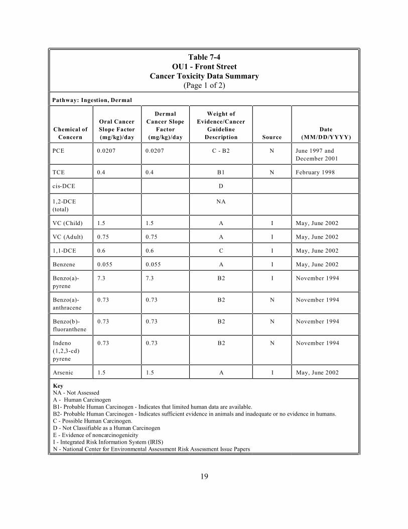
Table 7-4 OU1 - Front Street
Cancer Toxicity Data Summary (Page 1 of 2)
Concern
Oral Cancer
Dermal
Factor
Weight of
Evidence/Cancer
Source
Date
PCE 0.0207 0.0207 N
December 2001
TCE 0.4 0.4 B1 N
D
(total)
NA
1.5 1.5 A I
0.75 0.75 A I
0.6 0.6 C I
Benzene 0.055 0.055 A I
Benzo(a)-
pyrene
7.3 7.3 B2 I November 1994
Benzo(a)-
anthracene
0.73 0.73 B2 N November 1994
fluoranthene
0.73 0.73 B2 N November 1994
Indeno
pyrene
0.73 0.73 B2 N November 1994
1.5 1.5 A I
Key NA - Not Assessed
B1- Probable Human Carcinogen - Indicates that limited human data are available. B2- Probable Human Carcinogen - Indicates sufficient evidence in animals and inadequate or no evidence in humans.
Pathway: Ingestion, Dermal
Chemical of Slope Factor
(mg/kg)/day
Cancer Slope
(mg/kg)/day
Guideline
Description (MM/DD/YYYY)
C - B2 June 1997 and
February 1998
cis-DCE
1,2-DCE
VC (Child) May, June 2002
VC (Ad ult) May, June 2002
1,1-DCE May, June 2002
May, June 2002
Benzo(b )
(1,2,3-cd)
Arse nic May, June 2002
A - Human Carcinogen
C - Possible Human Carcinogen. D - Not Classifiable as a Human Carcinogen E - Evidence of noncarcinogenicity I - Integrated Risk Information System (IRIS) N - National Center for Environmental Assessment Risk Assessment Issue Papers
19

OU1 - Front Street Cancer Toxicity Data Summary
(Page 2 of 2)
Concern Factor Units
Weight of
Evidence/Cancer
Source
Date
PCE 0.0107 N
December 2001
TCE 0.00595 B1 N
D
(total)
NA
0.0308 A I
0.0154 A I
0.175 C I
Benzene 0.0273 A I
Benzo(a)-
pyrene
3.08 B2 N November 1994
Benzo(a)-
anthracene
0.308 B2 N November 1994
fluoranthene
0.308 B2 N November 1994
Indeno
pyrene
0.308 B2 N November 1994
15.1 A I
Key NA - Not Assessed
B1- Probable Human Carcinogen - Indicates that limited human data are available. B2- Probable Human Carcinogen - Indicates sufficient evidence in animals and inadequate or no evidence in humans.
Table 7-4 (Continued)
Pathway: Inhalation
Chemical of
Inhalation
Cancer Slope Guideline
Description (MM/DD/YYYY)
(mg/kg)/day C - B2 June 1997 and
(mg/kg)/day February 1998
cis-DCE
1,2-DCE
VC (Child) (mg/kg)/day May, June 2002
VC (Ad ult) (mg/kg)/day May, June 2002
1,1-DCE (mg/kg)/day May, June 2002
(mg/kg)/day May, June 2002
(mg/kg)/day
(mg/kg)/day
Benzo(b)- (mg/kg)/day
(1,2,3-cd)
(mg/kg)/day
Arsenic (mg/kg)/day May, June 2002
A - Human Carcinogen
C - Possible Human Carcinogen. D - Not Classifiable as a Human Carcinogen E - Evidence of noncarcinogenicity I - Integrated Risk Information System (IRIS) N - National Center for Environmental Assessment Risk Assessment Issue Papers
20
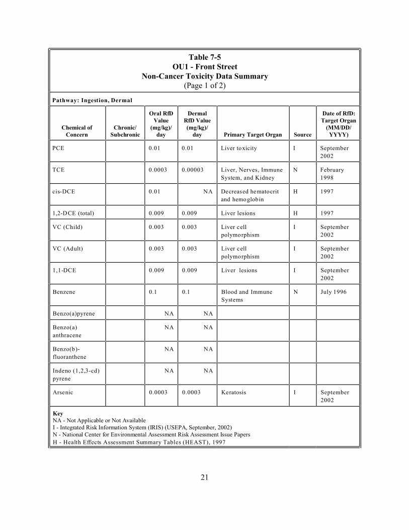
Table 7-5 OU1 - Front Street
Non-Cancer Toxicity Data Summary (Page 1 of 2)
Dermal Date of RfD: Value RfD Value Target Organ
Chemical of Chronic/ (MM/DD/ Concern day day Primary Target Organ Source YYYY)
PCE 0.01 0.01 I September
2002
TCE 0.0003 0.00003 Liver, Nerves, Immune N February
1998
0.01 NA H 1997
0.009 0.009 H 1997
0.003 0.003 I September
2002
0.003 0.003 I September
2002
0.009 0.009 I September
2002
Benzene 0.1 0.1 N
Benzo(a)pyrene NA NA
Benzo(a) NA NA
anthracene
NA NA
fluoranthene
NA NA
pyrene
0.0003 0.0003 I September
2002
Key
Pathway: Ingestion, Dermal
Oral RfD
(mg/kg)/ (mg/kg)/ Subchronic
Liver toxicity
System, and Kidney
cis-DCE Decreased hematocrit
and hemoglobin
1,2-D CE (total) Liver lesions
VC (Child) Liver cell
polymorphism
VC (Adult) Liver cell
polymorphism
1,1-DCE Liver lesions
Blood and Immune
Systems
July 1996
Benzo(b)-
Indeno (1,2,3-cd)
Arsenic Keratosis
NA - Not Applicable or Not Available I - Integrated Risk Information System (IRIS) (USEPA, September, 2002) N - National Center for Environmental Assessment Risk Assessment Issue Papers
H - Health Effects Assessment Summary Tables (HEAST), 1997
21
OU1 - Front Street Non-Cancer Toxicity Data Summary
(Page 2 of 2)
Date of RfD: Target Organ
Chemical of Chronic/ Oral RfD Value (MM/DD/ Concern (mg/kg)/day Primary Target Organ Source YYYY)
PCE 0.17 Kidney N June 1997
and
December
2001
TCE 0.0114 Liver, Nerves, Immune N February
1998
NA
NA
0.0286 I September
2002
0.0286 I September
2002
NA
Benzene 0.00171 Blood and N
Benzo(a)pyrene NA
Benzo(a) NA
anthracene
NA
fluoranthene
NA
pyrene
NA
Key
Table 7-5 (Continued)
Pathway: Inhalation
Subchronic
System, and Kidney
cis-DCE
1,2-D CE (total)
VC (Child) Liver cell
polymorphism
VC (Adult) Liver cell
polymorphism
1,1-DCE
hematopoietic effects
July 1996
Benzo(b)-
Indeno (1,2,3-cd)
Arsenic
NA - Not Applicable or Not Available IRIS - Integrated Risk Information System (USEPA, September, 2002) N - National Center for Environmental Assessment Risk Assessment Issue Papers
22
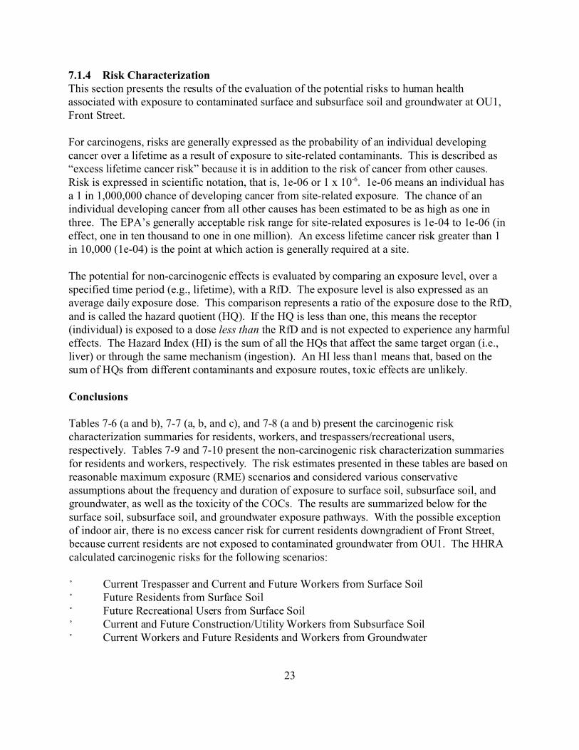
7.1.4 Risk Characterization This section presents the results of the evaluation of the potential risks to human health associated with exposure to contaminated surface and subsurface soil and groundwater at OU1, Front Street.
For carcinogens, risks are generally expressed as the probability of an individual developing cancer over a lifetime as a result of exposure to site-related contaminants. This is described as “excess lifetime cancer risk” because it is in addition to the risk of cancer from other causes. Risk is expressed in scientific notation, that is, 1e-06 or 1 x 10⁻⁶. 1e-06 means an individual has a 1 in 1,000,000 chance of developing cancer from site-related exposure. The chance of an individual developing cancer from all other causes has been estimated to be as high as one in three. The EPA’s generally acceptable risk range for site-related exposures is 1e-04 to 1e-06 (in effect, one in ten thousand to one in one million). An excess lifetime cancer risk greater than 1 in 10,000 (1e-04) is the point at which action is generally required at a site.
The potential for non-carcinogenic effects is evaluated by comparing an exposure level, over a specified time period (e.g., lifetime), with a RfD. The exposure level is also expressed as an average daily exposure dose. This comparison represents a ratio of the exposure dose to the RfD, and is called the hazard quotient (HQ). If the HQ is less than one, this means the receptor (individual) is exposed to a dose less than the RfD and is not expected to experience any harmful effects. The Hazard Index (HI) is the sum of all the HQs that affect the same target organ (i.e., liver) or through the same mechanism (ingestion). An HI less than1 means that, based on the sum of HQs from different contaminants and exposure routes, toxic effects are unlikely.
Conclusions
Tables 7-6 (a and b), 7-7 (a, b, and c), and 7-8 (a and b) present the carcinogenic risk characterization summaries for residents, workers, and trespassers/recreational users, respectively. Tables 7-9 and 7-10 present the non-carcinogenic risk characterization summaries for residents and workers, respectively. The risk estimates presented in these tables are based on reasonable maximum exposure (RME) scenarios and considered various conservative assumptions about the frequency and duration of exposure to surface soil, subsurface soil, and groundwater, as well as the toxicity of the COCs. The results are summarized below for the surface soil, subsurface soil, and groundwater exposure pathways. With the possible exception of indoor air, there is no excess cancer risk for current residents downgradient of Front Street, because current residents are not exposed to contaminated groundwater from OU1. The HHRA calculated carcinogenic risks for the following scenarios:
/ Current Trespasser and Current and Future Workers from Surface Soil / Future Residents from Surface Soil / Future Recreational Users from Surface Soil / Current and Future Construction/Utility Workers from Subsurface Soil / Current Workers and Future Residents and Workers from Groundwater
23
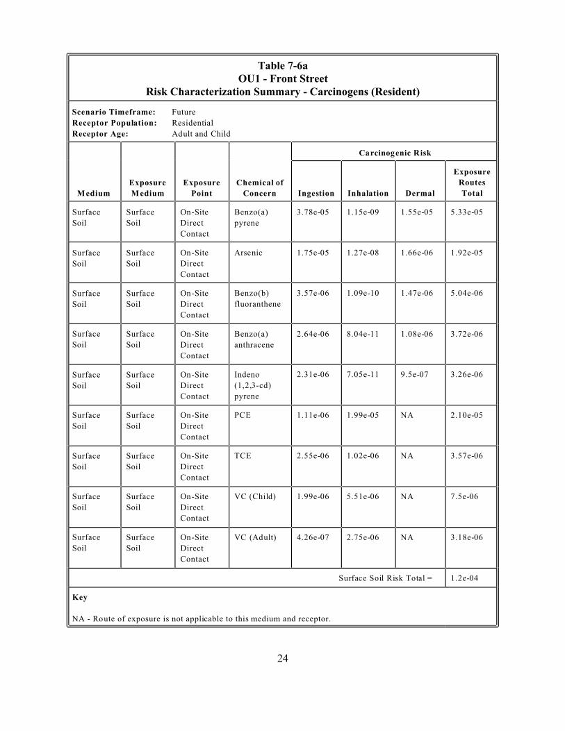
Table 7-6a OU1 - Front Street
Scenario Timeframe: Future
Receptor Age:
Exposure
Exposure Exposure Routes
Point Concern Dermal Total
Surface
Soil
Surface
Soil Direct
Contact
Benzo(a)
pyrene
Surface Surface
Soil Soil Direct
Contact
Surface Surface Benzo(b)
Soil Soil Direct fluoranthene
Contact
Surface Surface Benzo(a)
Soil Soil Direct anthracene
Contact
Surface
Soil
Surface
Soil Direct
Contact
Indeno
pyrene
Surface Surface PCE NA
Soil Soil Direct
Contact
Surface Surface TCE NA
Soil Soil Direct
Contact
Surface Surface NA
Soil Soil Direct
Contact
Surface Surface NA
Soil Soil Direct
Contact
Key
Risk Characterization Summary - Carcinogens (Resident)
Receptor Population: Residential
Adult and Child
Carcinogenic Risk
Chemical of
Medium Medium Ingestion Inhalation
On-Site 3.78e-05 1.15e-09 1.55e-05 5.33e-05
On-Site Arsenic 1.75e-05 1.27e-08 1.66e-06 1.92e-05
On-Site 3.57e-06 1.09e-10 1.47e-06 5.04e-06
On-Site 2.64e-06 8.04e-11 1.08e-06 3.72e-06
On-Site
(1,2,3-cd)
2.31e-06 7.05e-11 9.5e-07 3.26e-06
On-Site 1.11e-06 1.99e-05 2.10e-05
On-Site 2.55e-06 1.02e-06 3.57e-06
On-Site VC (Child) 1.99e-06 5.51e-06 7.5e-06
On-Site VC (Adult) 4.26e-07 2.75e-06 3.18e-06
Surface Soil Risk Total = 1.2e-04
NA - Route of exposure is not applicable to this medium and receptor.
24
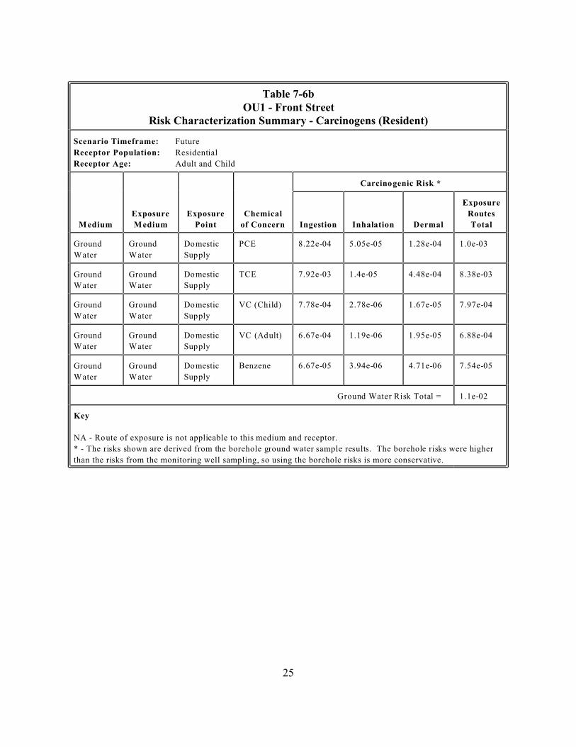
Table 7-6b OU1 - Front Street
Scenario Timeframe: Future
Receptor Age:
Exposure Exposure
Point
Chemical
of Concern Dermal
Exposure
Routes
Total
Ground Ground PCE
Ground Ground TCE
Ground Ground
Ground Ground
Ground Ground Benzene
Key
Risk Characterization Summary - Carcinogens (Resident)
Receptor Population: Residential
Adult and Child
Medium Medium
Carcinogenic Risk *
Ingestion Inhalation
Water Water
Domestic
Supply
8.22e-04 5.05e-05 1.28e-04 1.0e-03
Water Water
Domestic
Supply
7.92e-03 1.4e-05 4.48e-04 8.38e-03
Water Water
Domestic
Supply
VC (Child) 7.78e-04 2.78e-06 1.67e-05 7.97e-04
Water Water
Domestic
Supply
VC (Adult) 6.67e-04 1.19e-06 1.95e-05 6.88e-04
Water Water
Domestic
Supply
6.67e-05 3.94e-06 4.71e-06 7.54e-05
Ground Water Risk Total = 1.1e-02
NA - Route of exposure is not applicable to this medium and receptor.
* - The risks shown are derived from the borehole ground water sample results. The borehole risks were higher
than the risks from the monitoring well sampling, so using the borehole risks is more conservative.
25
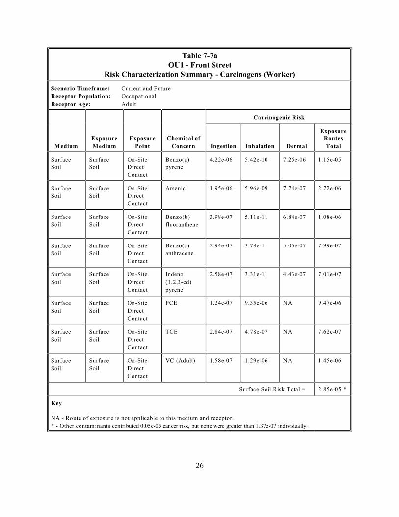
Table 7-7a OU1 - Front Street
Scenario Timeframe: Current and Future
Occupational
Receptor Age:
Exposure
Exposure Exposure Routes
Point Concern Dermal Total
Surface
Soil
Surface
Soil Direct
Contact
Benzo(a)
pyrene
Surface Surface
Soil Soil Direct
Contact
Surface Surface Benzo(b)
Soil Soil Direct fluoranthene
Contact
Surface Surface Benzo(a)
Soil Soil Direct anthracene
Contact
Surface
Soil
Surface
Soil Direct
Contact
Indeno
pyrene
Surface Surface PCE NA
Soil Soil Direct
Contact
Surface Surface TCE NA
Soil Soil Direct
Contact
Surface Surface NA
Soil Soil Direct
Contact
Key
Risk Characterization Summary - Carcinogens (Worker)
Receptor Population:
Adult
Carcinogenic Risk
Chemical of
Medium Medium Ingestion Inhalation
On-Site 4.22e-06 5.42e-10 7.25e-06 1.15e-05
On-Site Arsenic 1.95e-06 5.96e-09 7.74e-07 2.72e-06
On-Site 3.98e-07 5.11e-11 6.84e-07 1.08e-06
On-Site 2.94e-07 3.78e-11 5.05e-07 7.99e-07
On-Site
(1,2,3-cd)
2.58e-07 3.31e-11 4.43e-07 7.01e-07
On-Site 1.24e-07 9.35e-06 9.47e-06
On-Site 2.84e-07 4.78e-07 7.62e-07
On-Site VC (Adult) 1.58e-07 1.29e-06 1.45e-06
Surface Soil Risk Total = 2.85e-05 *
NA - Route of exposure is not applicable to this medium and receptor.
* - Other contaminants contributed 0.05e-05 cancer risk, but none were greater than 1.37e-07 individually.
26
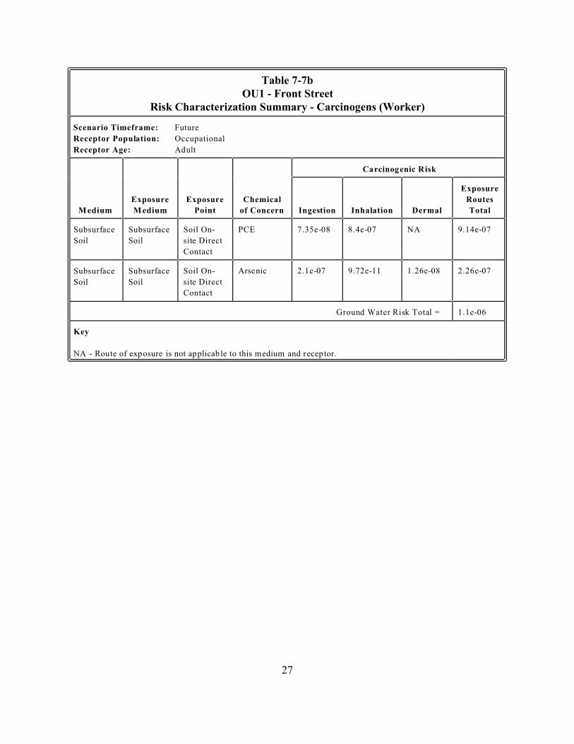
Table 7-7b OU1 - Front Street
Scenario Timeframe: Future
Occupational
Receptor Age:
Exposure
Exposure Exposure Chemical Routes
Point of Concern Dermal Total
Soil On- PCE NA
Soil Soil
Contact
Soil On-
Soil Soil
Contact
Key
Risk Characterization Summary - Carcinogens (Worker)
Receptor Population:
Adult
Carcinogenic Risk
Medium Medium Ingestion Inhalation
Subsurface Subsurface 7.35e-08 8.4e-07 9.14e-07
site Direct
Subsurface Subsurface Arsenic 2.1e-07 9.72e-11 1.26e-08 2.26e-07
site Direct
Ground Water Risk Total = 1.1e-06
NA - Route of exposure is not applicable to this medium and receptor.
27

Table 7-7c OU1 - Front Street
Scenario Timeframe: Future
Occupational
Receptor Age:
Exposure Exposure
Point
Chemical
of Concern Dermal
Exposure
Routes
Total
Ground Ground PCE NA NA
Ground Ground TCE NA NA
Ground Ground NA NA
Ground Ground Benzene NA NA
Key
Risk Characterization Summary - Carcinogens (Worker)
Receptor Population:
Adult
Medium Medium
Carcinogenic Risk *
Ingestion Inhalation
Water Water
Domestic
Supply
1.93e-04 1.93e-04
Water Water
Domestic
Supply
1.86e-03 1.86e-03
Water Water
Domestic
Supply
VC (Adult) 2.48e-04 2.48e-04
Water Water
Domestic
Supply
1.57e-05 1.57e-05
Ground Water Risk Total = 2.3e-03
NA - Route of exposure is not applicable to this medium and receptor.
* - The risks shown are derived from the borehole ground water sample results. The borehole risks were higher
than the risks from the monitoring well sampling, so using the borehole risks is more conservative.
28
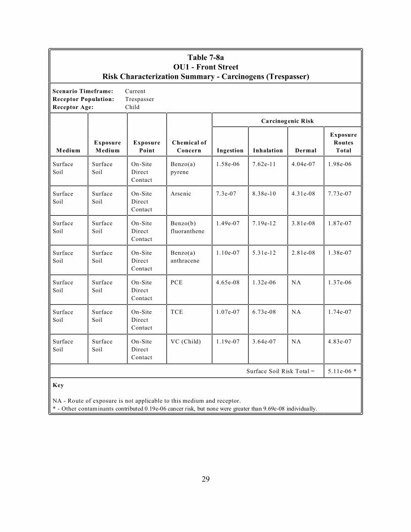
Table 7-8a OU1 - Front Street
Scenario Timeframe: Current
Trespasser
Receptor Age: Child
Exposure
Exposure Exposure Routes
Point Concern Dermal Total
Surface
Soil
Surface
Soil Direct
Contact
Benzo(a)
pyrene
Surface Surface
Soil Soil Direct
Contact
Surface Surface Benzo(b)
Soil Soil Direct fluoranthene
Contact
Surface Surface Benzo(a)
Soil Soil Direct anthracene
Contact
Surface Surface PCE NA
Soil Soil Direct
Contact
Surface Surface TCE NA
Soil Soil Direct
Contact
Surface Surface NA
Soil Soil Direct
Contact
Key
Risk Characterization Summary - Carcinogens (Trespasser)
Receptor Population:
Carcinogenic Risk
Chemical of
Medium Medium Ingestion Inhalation
On-Site 1.58e-06 7.62e-11 4.04e-07 1.98e-06
On-Site Arsenic 7.3e-07 8.38e-10 4.31e-08 7.73e-07
On-Site 1.49e-07 7.19e-12 3.81e-08 1.87e-07
On-Site 1.10e-07 5.31e-12 2.81e-08 1.38e-07
On-Site 4.65e-08 1.32e-06 1.37e-06
On-Site 1.07e-07 6.73e-08 1.74e-07
On-Site VC (Child) 1.19e-07 3.64e-07 4.83e-07
Surface Soil Risk Total = 5.11e-06 *
NA - Route of exposure is not applicable to this medium and receptor.
* - Other contaminants contributed 0.19e-06 cancer risk, but none were greater than 9.69e-08 individually.
29

Table 7-8b OU1 - Front Street
Scenario Timeframe: Future
Receptor Age:
Exposure
Exposure Exposure Routes
Point Concern Dermal Total
Surface
Soil
Surface
Soil Direct
Contact
Benzo(a)
pyrene
Surface Surface 3e-06
Soil Soil Direct
Contact
Surface Surface Benzo(b)
Soil Soil Direct fluoranthene
Contact
Surface Surface Benzo(a)
Soil Soil Direct anthracene
Contact
Surface
Soil
Surface
Soil Direct
Contact
Indeno
pyrene
Surface Surface PCE NA
Soil Soil Direct
Contact
Surface Surface TCE NA
Soil Soil Direct
Contact
Surface Surface NA
Soil Soil Direct
Contact
Surface Surface NA
Soil Soil Direct
Contact
Key
Risk Characterization Summary - Carcinogens (Recreational User)
Receptor Population: Recreational
Adult and Child
Carcinogenic Risk
Chemical of
Medium Medium Ingestion Inhalation
On-Site 6.49e-06 1.98e-10 2.66e-06 9.15e-06
On-Site Arsenic 2.17e-09 2.84e-07 3.28e-06
On-Site 6.12e-07 1.86e-11 2.51e-07 8.63e-07
On-Site 4.52e-07 1.38e-11 1.86e-07 6.38e-07
On-Site
(1,2,3-cd)
3.97e-07 1.21e-11 1.63e-07 5.6e-07
On-Site 1.9e-07 3.41e-06 3.6e-06
On-Site 4.36e-07 1.75e-07 6.11e-07
On-Site VC (Child) 3.4e-07 9.44e-07 1.28e-06
On-Site VC (Adult) 7.3e-08 4.72e-07 5.45e-07
Surface Soil Risk Total = 2.05e-05 *
NA - Route of exposure is not applicable to this medium and receptor.
* - Other contaminants contributed 0.05e-05 cancer risk, but none were greater than 1.09e-07 individually.
30
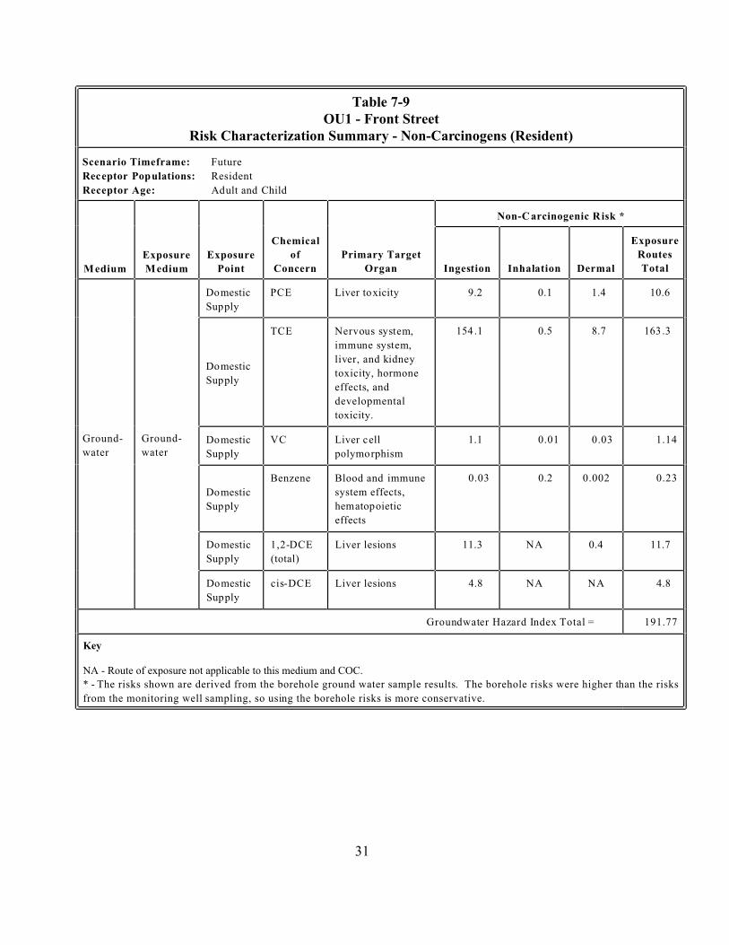
Table 7-9 OU1 - Front Street
Scenario Timeframe: Future
Resident
Receptor Age:
Exposure Exposure
Point
Chemical
of
Concern
Primary Target
Organ Dermal
Exposure
Routes
Total
Ground
water
Ground
water
PCE 9.2 0.1 1.4 10.6
TCE
developmental
toxicity.
0.5 8.7
VC 1.1 0.01 0.03 1.14
Benzene
system effects,
effects
0.03 0.2 0.002 0.23
(total)
11.3 NA 0.4 11.7
4.8 NA NA 4.8
191.77
Key
NA - Route of exposure not applicable to this medium and COC.
Risk Characterization Summary - Non-Carcinogens (Resident)
Receptor Populations:
Adult and Child
Medium Medium
Non-C arcinogenic Risk *
Ingestion Inhalation
Domestic
Supply
Liver toxicity
Domestic
Supply
Nervous system,
immune system,
liver, and kidney
toxicity, hormone
effects, and
154 .1 163 .3
Domestic
Supply
Liver cell
polymorphism
Domestic
Supply
Blood and immune
hematopoietic
Domestic
Supply
1,2-DCE Liver lesions
Domestic
Supply
cis-DCE Liver lesions
Groundwater Hazard Index Total =
* - The risks shown are derived from the borehole ground water sample results. The borehole risks were higher than the risks
from the monitoring well sampling, so using the borehole risks is more conservative.
31

Table 7-10 OU1 - Front Street
Scenario Timeframe: Future
Receptor Age:
Exposure Exposure
Point
Chemical
of Concern
Primary
Target Organ Dermal
Exposure
Routes
Total
Ground
water
Ground
water
PCE 2.6 NA NA 2.6
TCE
toxicity,
hormone
and nervous
43.4 NA NA 43.4
VC 0.3 NA NA 0.3
Benzene Blood and
effects
0.01 NA NA 0.01
(total)
3.2 NA NA 3.2
1.4 NA NA 1.4
50.91
Key
NA - Route of exposure not applicable to this medium and COC.
Risk Characterization Summary - Non-Carcinogens (Resident)
Receptor Population: Worker
Adult
Medium Medium
Non-C arcinogenic Risk *
Ingestion Inhalation
Domestic
Supply
Liver toxicity
Domestic
Supply
Liver, kidney,
effects, immune
system toxicity.
Domestic
Supply
Liver cell
polymorphism
Domestic
Supply immune system
Domestic
Supply
1,2-DCE Liver lesions
Domestic
Supply
cis-DCE Liver lesions
Groundwater Hazard Index Total =
* - The risks shown are derived from the borehole ground water sample results. The borehole risks were higher than the risks
from the monitoring well sampling, so using the borehole risks is more conservative.
32
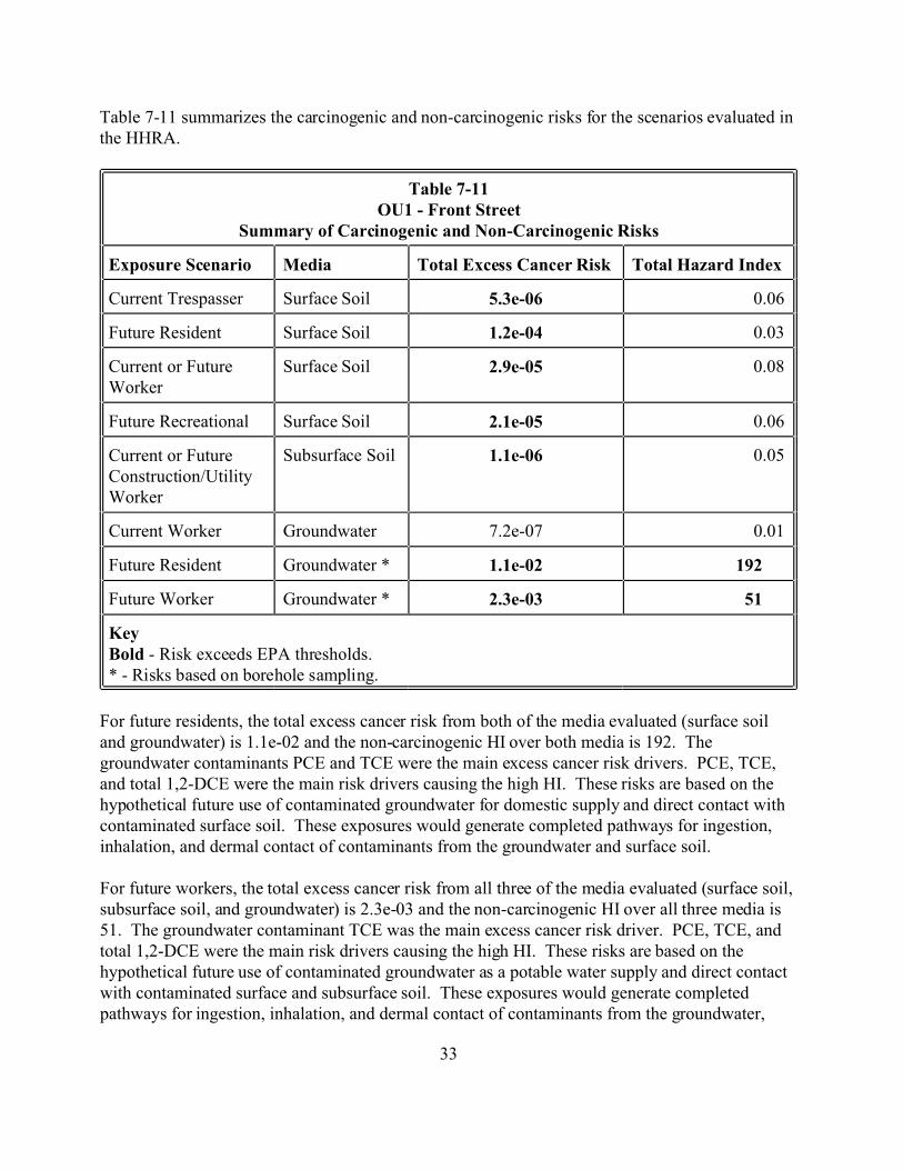
Table 7-11 summarizes the carcinogenic and non-carcinogenic risks for the scenarios evaluated in the HHRA.
Table 7-11 OU1 - Front Street
Media Total Hazard Index
Current Trespasser 5.3e-06 0.06
Future Resident 1.2e-04 0.03
Current or Future Worker
2.9e-05 0.08
Future Recreational 2.1e-05 0.06
Current or Future
Worker
1.1e-06 0.05
Current Worker Groundwater 7.2e-07 0.01
Future Resident Groundwater * 1.1e-02 192
Future Worker Groundwater * 2.3e-03 51
Key Bold
Summary of Carcinogenic and Non-Carcinogenic Risks
Exposure Scenario Total Excess Cancer Risk
Surface Soil
Surface Soil
Surface Soil
Surface Soil
Construction/Utility Subsurface Soil
- Risk exceeds EPA thresholds. * - Risks based on borehole sampling.
For future residents, the total excess cancer risk from both of the media evaluated (surface soil and groundwater) is 1.1e-02 and the non-carcinogenic HI over both media is 192. The groundwater contaminants PCE and TCE were the main excess cancer risk drivers. PCE, TCE, and total 1,2-DCE were the main risk drivers causing the high HI. These risks are based on the hypothetical future use of contaminated groundwater for domestic supply and direct contact with contaminated surface soil. These exposures would generate completed pathways for ingestion, inhalation, and dermal contact of contaminants from the groundwater and surface soil.
For future workers, the total excess cancer risk from all three of the media evaluated (surface soil, subsurface soil, and groundwater) is 2.3e-03 and the non-carcinogenic HI over all three media is 51. The groundwater contaminant TCE was the main excess cancer risk driver. PCE, TCE, and total 1,2-DCE were the main risk drivers causing the high HI. These risks are based on the hypothetical future use of contaminated groundwater as a potable water supply and direct contact with contaminated surface and subsurface soil. These exposures would generate completed pathways for ingestion, inhalation, and dermal contact of contaminants from the groundwater,
33
surface soil, and subsurface soil.
The future resident and future worker cancer risk levels are higher than EPA’s threshold excess cancer level of 1e-04 (one excess cancer in ten thousand people). This threshold is the point at which action is generally required at a site.
Two other exposure scenarios had excess cancer risks greater than 1e-06. The current trespasser had a risk of 5.3e-06 and the future recreational user had a risk of 2.1e-05. These risks fall between EPA’s thresholds for when action is generally required (1e-04) and when further action is generally not warranted (1e-06). Because the threat to future residents and workers from the various media at the site will require action to address these media, the trespasser case and the recreational user case will not be discussed further.
Levels of all the groundwater COCs exceeded the federal and Missouri MCLs, which are the chemical-specific standards that regulate the allowable levels of these COCs in groundwater.
Groundwater. The future resident and future worker groundwater scenarios and exposure pathways have the highest excess cancer risks. The carcinogenic risk drivers are TCE (8.38e-03) and PCE (1e-03) for future residents and TCE (1.86e-03) for future workers. The concentrations in the borehole sample results were used, since they are more conservative (have higher risk) than the monitoring well sample results. It should be noted that the monitoring well results would still exceed EPA’s action required threshold (total excess cancer risk from the monitoring wells was 1.7e-03 for future residents and 3.1e-04 for future workers). Other COCs contributing to the risk are VC (7.97e-04 and 6.88e-04 for child and adult, respectively) and benzene (7.54e-05) for future residents and PCE (1.93e-04) and VC (2.48e-04) for future workers. Most of the risk is from the ingestion pathway (1e-02 out of 1.1e-02 total risk) for future residents. All of the risk came from the ingestion pathway for future workers.
Only the future resident and future worker groundwater scenarios and exposure pathways had HIs that exceeded 1. The non-carcinogenic risk driver is TCE for future residents (HI of 163.3) and for future workers (HI of 43.4). However, the HIs for PCE, VC, cis-DCE, and total 1,2-DCE all exceeded 1 for the future resident and all of these except VC exceeded 1 for the future worker. The concentrations in the borehole sample results were used, since they are more conservative (have higher risk) than the monitoring well sample results. It should be noted that the monitoring well results would still exceed EPA’s action required threshold (HI of 12 for the future resident and 3 for the future worker). Most of the risk is from the ingestion pathway (total HI of 180.5 out of 192) for the future resident. All of the risk came from the ingestion pathway for future workers.
Surface Soil. The future resident surface soil scenario and exposure pathway has an excess cancer risk (1.2e-04) greater than the EPA threshold for when action is generally required (1e-04). The carcinogenic risk drivers are benzo(a) pyrene (5.33e-05), arsenic (1.92e-05), and PCE (2.1e-05). Other COCs contributing to the risk are:
34
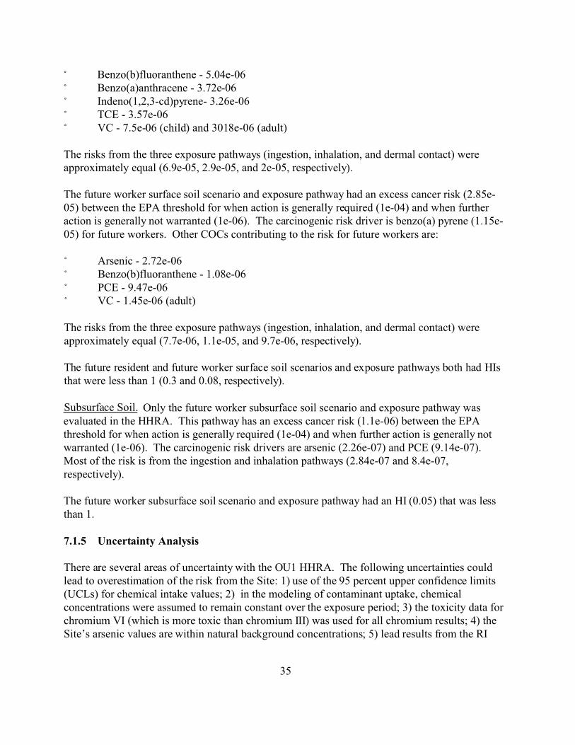
/ Benzo(b)fluoranthene - 5.04e-06 / Benzo(a)anthracene - 3.72e-06 / Indeno(1,2,3-cd)pyrene- 3.26e-06 / TCE - 3.57e-06 / VC - 7.5e-06 (child) and 3018e-06 (adult)
The risks from the three exposure pathways (ingestion, inhalation, and dermal contact) were approximately equal (6.9e-05, 2.9e-05, and 2e-05, respectively).
The future worker surface soil scenario and exposure pathway had an excess cancer risk (2.85e-05) between the EPA threshold for when action is generally required (1e-04) and when further action is generally not warranted (1e-06). The carcinogenic risk driver is benzo(a) pyrene (1.15e-05) for future workers. Other COCs contributing to the risk for future workers are:
/ Arsenic - 2.72e-06 / Benzo(b)fluoranthene - 1.08e-06 / PCE - 9.47e-06 / VC - 1.45e-06 (adult)
The risks from the three exposure pathways (ingestion, inhalation, and dermal contact) were approximately equal (7.7e-06, 1.1e-05, and 9.7e-06, respectively).
The future resident and future worker surface soil scenarios and exposure pathways both had HIs that were less than 1 (0.3 and 0.08, respectively).
Subsurface Soil. Only the future worker subsurface soil scenario and exposure pathway was evaluated in the HHRA. This pathway has an excess cancer risk (1.1e-06) between the EPA threshold for when action is generally required (1e-04) and when further action is generally not warranted (1e-06). The carcinogenic risk drivers are arsenic (2.26e-07) and PCE (9.14e-07). Most of the risk is from the ingestion and inhalation pathways (2.84e-07 and 8.4e-07, respectively).
The future worker subsurface soil scenario and exposure pathway had an HI (0.05) that was less than 1.
7.1.5 Uncertainty Analysis
There are several areas of uncertainty with the OU1 HHRA. The following uncertainties could lead to overestimation of the risk from the Site: 1) use of the 95 percent upper confidence limits (UCLs) for chemical intake values; 2) in the modeling of contaminant uptake, chemical concentrations were assumed to remain constant over the exposure period; 3) the toxicity data for chromium VI (which is more toxic than chromium III) was used for all chromium results; 4) the Site’s arsenic values are within natural background concentrations; 5) lead results from the RI
35

sampling may be high due to at least one and possibly two outlier results with very high lead levels; and 6) benzo(a)pyrene results from the RI sampling may be high, because only two samples had detectable levels of benzo(a)pyrene. These two results may be outliers.
The following uncertainties could lead to over- or underestimation of the risk from the Site: 1) the concentrations of the chemicals in the sample results may have been over- or underestimated; 2) toxicity information was not available for some of the elements compounds detected, so the toxicity data from similar elements or compounds were used; 3) dose-response information from animal studies was used to predict effects in humans; and 4) the groundwater data were segregated into well and borehole data sets and each set was used to calculate risk. (Note - the higher risk borehole data have been used throughout this section, so use of the monitoring well data instead would actually result in a decrease of the risk from the site.)
The following uncertainties could lead to an underestimation of the risk from the Site: 1) it is possible that not all of the contaminants in the sample were recovered by the laboratory extraction; and 2) in-door air sampling data was not available for evaluation of this exposure pathway in the HHRA.
7.2 Summary of Ecological Risk Assessment
A screening-level ERA was conducted to assess the potential for the existence of ecological receptors and pathways between those receptors and the COCs associated with the Riverfront Site as a whole. There was not a separate ERA done for OU1 specifically. The ERA was conducted using the methodology described in the Ecological Risk Assessment Guidance for Superfund: Process for Designing and Conducting Ecological Risk Assessments (EPA 1997). The screening-level ERA was designed to assess the need for a follow-up Baseline ERA. The results of the screening-level ERA are discussed in detail in the Ecological Risk Assessment, Revision 0, prepared for EPA by Black & Veatch Special Projects Corp. (BVSPC). Figure 3-1 shows the ecological exposure model for the Riverfront Site.
The ERA indicated that the potential for significant ecological impacts from OU1 are small. State and federal threatened and endangered species exist within Franklin County; however, none of these species are known to exist in the area or at OU1. The lack of suitable habitat in the vicinity of OU1 indicates that there is minimal potential for these species to be present. Surface water (Missouri River) analytical results did not detect contaminants, so the maximum possible concentrations were below the Ecological Screening Values (ESVs). The ESVs determine the ecological risks. Consequently, the potential for ecological receptors to be exposed to contaminants in the surface water would be considered minimal, and there is no need for any additional Baseline ERA (Figures 2-2, 2-3, and 3-2 and Photographs 01, 09, 10, and 04).
7.3 Risk Assessment Conclusion
The groundwater risk driver COCs are TCE and PCE . Other COCs contributing to the overall
36
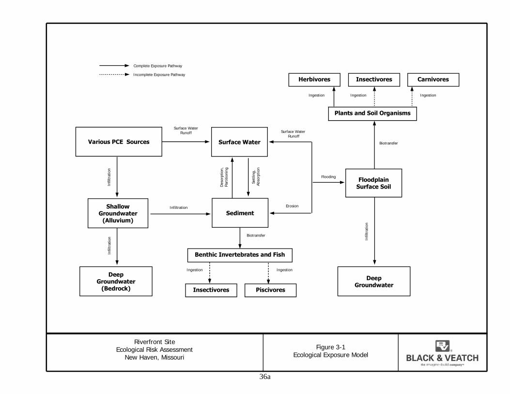
i
lComp ete Exposure Pathway
lIncomp ete Exposure Pathway Herbivores Insectivores Carnivores
iIngest on iIngest on Ingest on
Plants and Soil Organisms
Surface Water Runoff
i
Surface Water Various PCE Sources
Surface Water Runoff
Infil
trat
on
Floodplain Surface Soil
iEros on
Biotransfer
i i
Shallow Groundwater
(Alluvium)
Infil
trat
on
Infil
trat
on
Deep Groundwater
(Bedrock)
i i i
Sediment
Sett
ling,
Ab
sorp
t on
Des
orpt
on,
Pa
rtiti
on n
g
Biotransfer
Flooding
iInfiltrat on
Benthic Invertebrates and Fish
iIngest on iIngest on
Insectivores Piscivores
Deep Groundwater
ite l Ri
i l l l
Riverfront S Ecologica sk Assessment
New Haven, Missour
Figure 3-1 Eco ogica Exposure Mode
36a
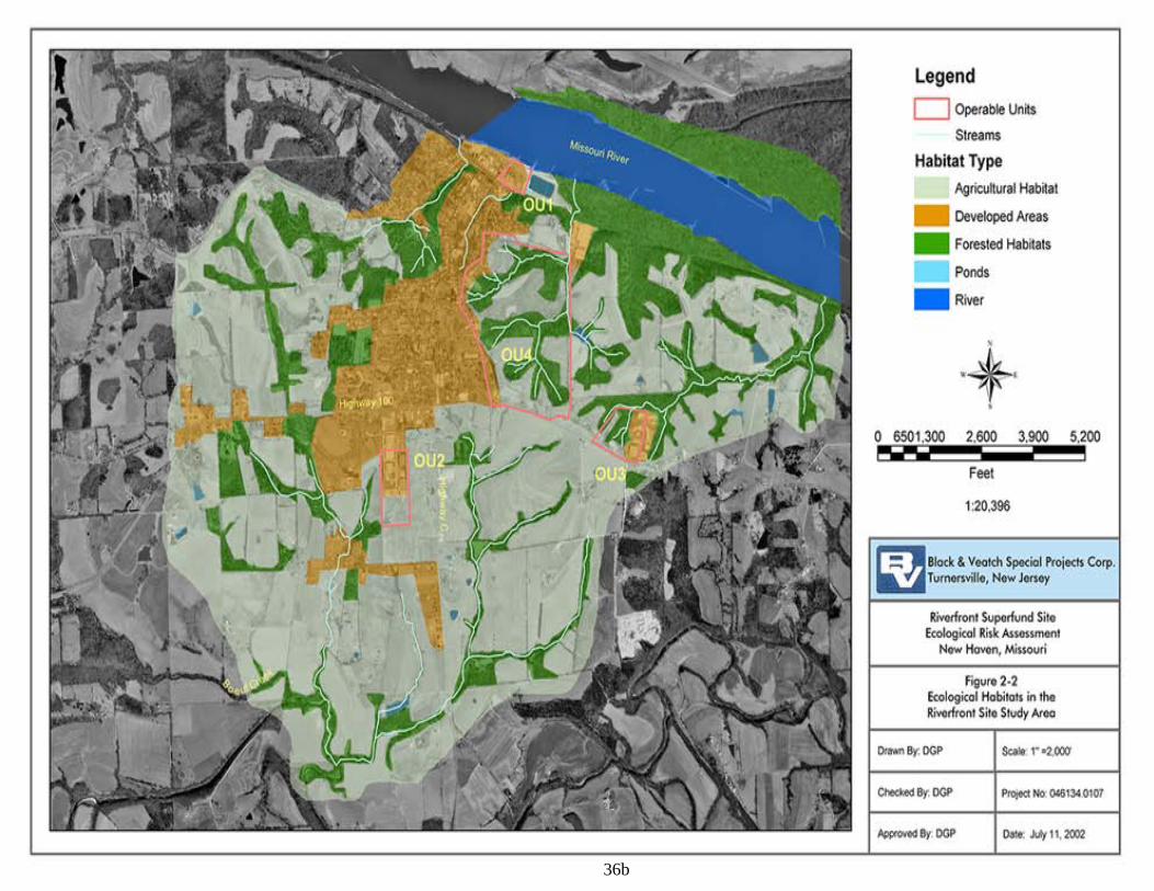
36b

36c
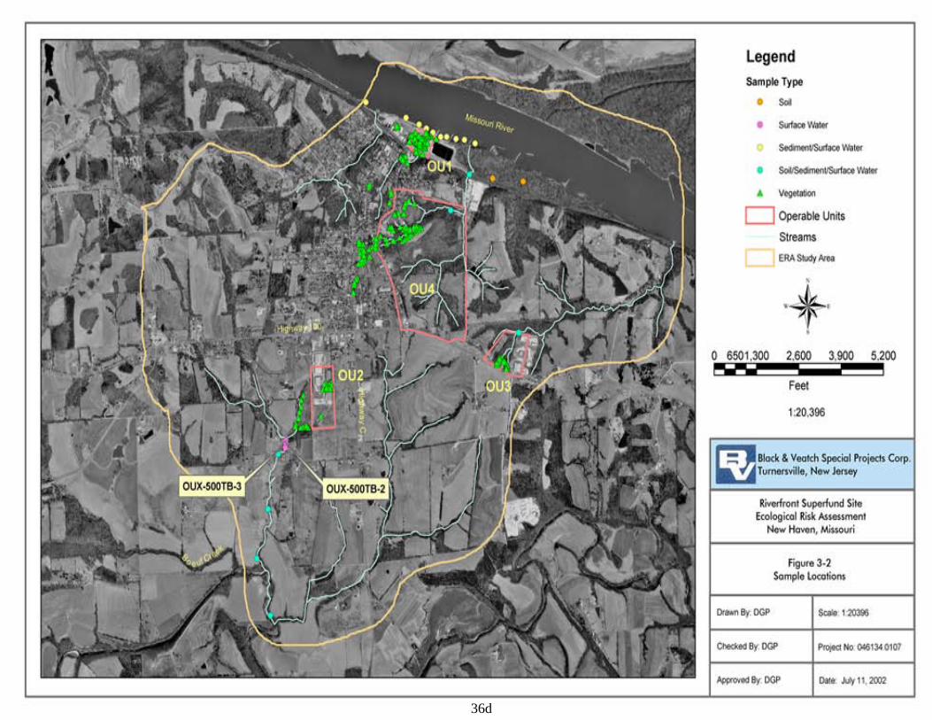
36d
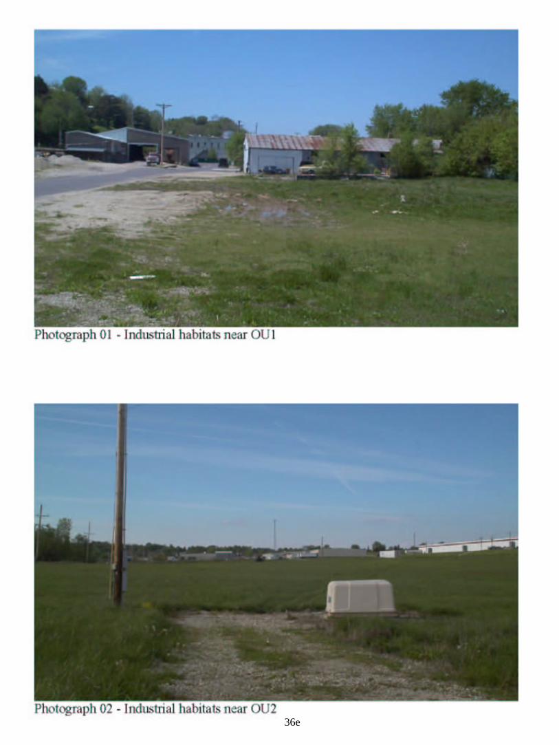
36e
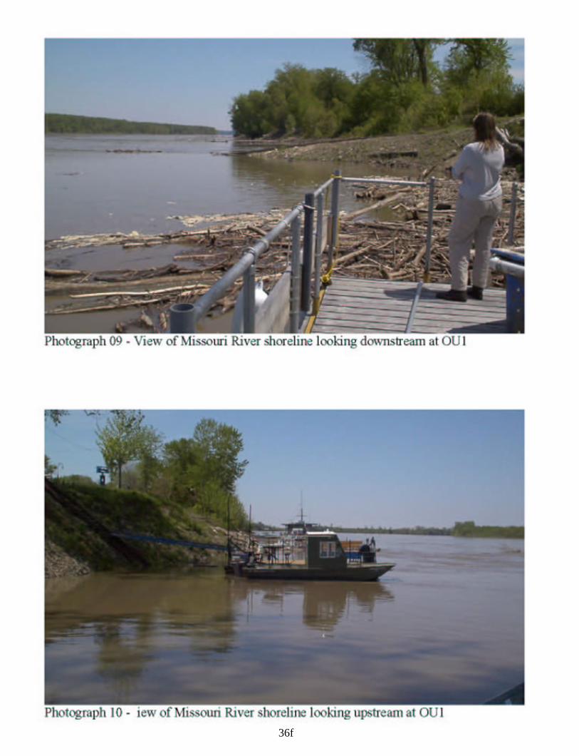
36f
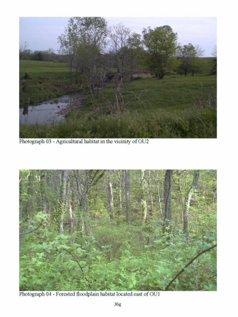
36g
risk from the groundwater are VC and benzene. The groundwater exposures had the highest excess cancer risks (1.1e-02 for future resident and 2.3e-03 for future worker) and noncarcinogenic risks (HI of 192 for future resident and 51 for future worker) of the exposure scenarios evaluated. However, for these future populations to be exposed to the contaminants would require that untreated domestic or potable supply wells be installed in the contaminated plume. Currently, there is no risk from the contaminated groundwater because all residences and businesses are on city water.
The surface soil risk driver COCs are benzo(a)pyrene, arsenic, and PCE. Other COCs contributing to the overall risk from the groundwater are benzo(b)fluoranthene, benzo(a)anthracene, indeno(1,2,3-cd)pyrene, TCE, and VC. The surface soil exposures had excess cancer risks of 1.2e-04 for future residents and 2.85e-05 for future workers. The noncarcinogenic risks were less than 1 for both populations. However, for these future populations to be exposed to the contaminants would require that residences be built on the Site and that the existing building floor slab be removed and not replaced with some type of capping material. Currently, there is no risk from the contaminated surface soil because the surface soils are either covered with the building slab or by thick grass sod.
The subsurface soil risk driver COCs are arsenic and PCE. The subsurface soil exposure had an excess cancer risk of 1.1e-06 for future workers. The non-carcinogenic risks were less than 1. However, for future workers to be exposed to the contaminants would require that they work unprotected during construction or utility work at the Site. Currently, there is no risk from the contaminated subsurface soil.
The response action selected in this ROD is necessary to protect the public health or welfare or the environment from actual or threatened releases of hazardous substances into the environment from OU1, the Front Street Site.
8.0 Remedial Action Objectives (RAOs)
8.1 Remedial Action Objectives The Remedial Action Objectives (RAOs) for OU1 are to: 1) prevent use of groundwater with contaminant levels exceeding MCLs as a drinking water source; 2) prevent further degradation of the groundwater below the Site and in the plume; and 3) prevent exposure to soil with contaminant concentrations which result in an excess cancer risk greater than 1 x 10⁻⁶ or a HQ greater than 1.
8.2 Alternate Concentration Limits (ACLs) The EPA generally seeks to return usable groundwater to beneficial use whenever practicable. When contaminated groundwater is currently or potentially used as a drinking water source, EPA typically selects a remedy that will restore the groundwater to achieve MCLs and non-zero Maximum Contaminant Level Goals (MCLGs) established under the Safe Drinking Water Act. Under limited circumstances specified in CERCLA Section 121(d)(2)(B)(ii), (the Superfund
37
statute), ACLs may be used instead of drinking water standards (typically, MCLs or MCLGs). The use of ACLs allows flexibility in establishing groundwater cleanup levels under limited circumstances. The following discussion presents the specific RAOs and ACLs used in the preferred alternative.
After the completion of the FS, the EPA and MDNR continued to explore existing and innovative mechanisms for addressing contamination at OU1. One of the mechanisms incorporates the use of ACLs and this mechanism was incorporated into an additional alternative that became the preferred alternative for OU1. The use of ACLs requires that three statutory criteria be met; these criteria are:
1) The contaminated groundwater has “known or projected points of entry to a surface water body”.
2) There must be no “statistically significant increases” of contaminants in the surface water body at those points of entry, or at points downstream.
3) It must be possible to reliably prevent human exposure to the contaminated groundwater through the use of institutional controls.
The EPA has determined that conditions at OU1 meet the criteria to support the use of ACLs. The following information documents this finding.
Criteria 1: Extensive sampling performed during the RI and during subsequent field investigations has defined the contaminant plume boundary with a high degree of confidence. The contaminated groundwater plume originating at the Front Street Site flows to the northeast approximately 600 feet where it enters the Missouri River. At the widest cross-section, just before entering the Missouri River, the plume attains a maximum width of about 300 feet. The “core” of this plume, which contains PCE concentrations above 500 ug/L, is less than 100 feet wide. Substantial microbial degradation of PCE occurs within the plume, and PCE concentrations decrease down the plume axis and concentrations of degradation products such as cis-DCE, VC, and ethene increase. The RI determined that in the more than 30 years since the last known use of PCE at the facility, the contaminant plume has reached steady-state conditions, and concentrations within the plume will remain at their present levels or decrease as the result of degradation processes within the aquifer.
Criteria 2. During the RI, surface water and bed-sediment samples were collected from the Missouri River upstream, within, and downstream of the “known or projected” point of entry of the contaminant plume into the river. The water samples were collected during a low stage of the river and from the bottom of the river to maximize the potential for detecting the contaminant plume discharge. None of the water or bed-sediment samples contained detectable concentrations of PCE or its degradation products.
A conservative analysis was done to determine the maximum impact that the plume (the contaminated shallow aquifer) could have on the Missouri River water quality. The analysis
38
conservatively assumed that the highest contaminant concentration detected in the core of the plume (11,000 ug/L PCE) discharges directly into the Missouri River. This concentration is several orders of magnitude larger than the maximum concentration detected in the discharge area along the Missouri River. The analysis further assumed that this plume discharges continuously for a distance of 400 feet along the Missouri River, and that the contaminated water entering the river does not mix with the overlying water. In fact, turbulent conditions at the base of the river would actually result in instantaneous mixing with thousands of cubic feet of surrounding river water, even during low flow conditions. Using these extremely conservative assumptions, the analysis concluded that the maximum PCE concentration that could occur at the downstream limit of the discharge zone in the Missouri River would be 1.2 ug/L - well below the drinking water MCL value and the Missouri Water Quality Standard for protection of aquatic life, which is 5 ug/L. The non-detections of PCE and its degradation products in the river samples collected during the RI confirm the conservative nature of the analysis and support the “no statistically significant increase” in contaminant concentrations criteria required for the use of ACLs. Assumptions and data used in the conservative analysis are provided in Appendix A at the end of this document.
Criteria 3. To reliably prevent future exposure to contaminated groundwater associated with OU1, measures preventing exposure are in place and will be supplemented with additional institutional controls. The flood protection levee surrounding downtown New Haven is owned by the city, but was constructed by the U.S. Army Corps of Engineers (USACE) using federal funds. The city is responsible for maintenance of the levee and ensuring that stringent guidelines for construction and other activities near the levee are followed. To maintain annual certification from the USACE of the levee’s integrity, the city must ensure that these guidelines are followed; these include controlling subsurface excavations, borings, and the installation of wells within 500 feet of the back of the levee. Before any such activities occur, the city and USACE must review a written plan of the activity. The USACE provides technical comments, and the city is responsible for approving or disapproving the plan and ensuring that USACE guidelines are followed. The city public works department is responsible for oversight of subsurface activities near the levee. Given the location of the Front Street Site in a highly visible area of downtown New Haven, new municipal offices and facilities, any subsurface activities conducted at OU1 would presumably be readily observable and hence controllable. The city has a large financial interest in monitoring subsurface activities near the levee because if the USACE guidelines are not followed, the levee risks losing USACE certification which would severely affect flood insurance rates in the area.
In addition to the USACE restrictions, water-well drilling activities in the OU1 area are under a water well drilling advisory issued by the MDNR in 2002. This advisory covers the installation of water-supply wells and ground-source heat systems in the entire northern part of the city. Because of the low yields and marginal quality of the water in the alluvial aquifer near OU1, it is unlikely that future water wells would be installed in the OU1 area. Additional institutional controls which will prevent exposure at the Site are detailed in Sections 9.1.2 and 12.2 below.
39
9.0 Description of Remedial Alternatives
From the screening of technologies, EPA evaluated and assembled a range of alternatives. The alternatives are listed below. The alternative title shows the primary option for groundwater listed first, followed by a slash (/), and then the primary option for the contaminated soil.
• Alternative 1 - No Action / No Action • Alternative 2 - Institutional Controls / Institutional Controls • Alternative 3 - Monitoring / Institutional Controls • Alternative 4 - Monitoring / Limited Excavation • Alternative 5 - Hydraulic Containment and Monitored Natural Attenuation / Capping and
Sheet Piling • Alternative 6 - Groundwater Extraction / Excavation and Offsite Disposal • Alternative 7 - In Situ Bioremediation / Excavation and Onsite Treatment • Alternative 8 - In Situ Physical Treatment / In Situ Treatment
In addition to the alternatives evaluated in the FS, the OU1 Proposed Plan introduced a new alternative, 3A, that would establish ACLs for the contaminated groundwater. After comments were received from the MDNR on Alternative 3A, the EPA added limited in situ treatment of the contaminated soils at OU1 and the head of the contaminated plume that is below OU1 to Alternative 3A. This Alternative 3A with the added treatment component is referred to as Alternative 3A Plus. These two alternatives are also discussed in this section.
• Alternative 3A - Monitored Attainment of ACLs / Institutional Controls • Alternative 3A Plus - Monitored Attainment of ACLs Plus Limited Treatment /
Institutional Controls Plus Limited Treatment
9.1 Description of Alternatives/Remedy Components
9.1.1 Alternative 1 - No Action / No Action
The NCP requires that the EPA consider a no further action alternative. The No Action Alternative serves as a baseline against which the other remedial alternatives can be compared. Under the No Action Alternative, no further action would be taken to monitor, control, or remediate the groundwater and soil contamination. There would be no capital or operation and maintenance (O&M) costs associated with this alternative. However, five-year reviews of OU1 would be required under CERCLA, so there would be very low periodic costs (which occur every five years). Because this alternative would not be protective of human health and the environment and would not comply with applicable or relevant and appropriate requirements (ARARs), this alternative is not further evaluated.
40
9.1.2 Alternative 2 - Institutional Controls / Institutional Controls
Treatment/Containment Components No treatment or containment components are included.
Institutional Controls Institutional controls will be implemented at OU1 in layers to enhance the protectiveness of the remedy. The primary form of institutional control will be a proprietary control, specifically a restrictive covenant and easement. This form of proprietary control was selected as it is effective as an informational device and creates a readily enforceable legal property interest.
The EPA will seek the imposition of a restrictive covenant and easement on the Site by the landowner. The MDNR will be named as the grantee of this restrictive covenant and easement and will have the authority to enforce the restrictive covenant and easement. The EPA will be named as a third-party, or intended, beneficiary in this instrument so that EPA will also have the ability to enforce the terms of the restrictive covenant and easement. This restrictive covenant and easement will be patterned on the model restrictive covenant and easement found in the MDNR CALM Appendix E, Attachment E1.
The objectives of imposing a restrictive covenant and easement on OU1 are to eliminate or minimize exposures to contamination remaining at OU1 and limiting the possibility of the spread of contamination. These objectives will be achieved by use of the restrictive covenant and easement as it will: (1) provide notice; (2) limit use; and (3) provide federal and state access. Specifically, the restrictive covenant and easement will achieve this by:
• providing notice to prospective purchasers and occupants that there are contaminants in soils and the groundwater.
• ensuring that future owners are aware of any engineered controls put into place as part of this remedial action.
• prohibiting residential, commercial and industrial uses, except those uses which would be consistent with the remedial action.
• limiting the disturbance of contaminated soils. • prohibiting the placement of groundwater wells. • prohibiting other ground penetrating activities which may result in the creation of a
hydraulic conduit between water bearing zones. • providing access to EPA and the state of Missouri for verifying land use. • prescribing actions that must be taken to install and/or maintain engineered controls (if
applicable). • providing access to EPA and the state of Missouri for sampling and the maintenance of
engineered controls.
In addition to the above proprietary control, the EPA is currently in negotiations with a prospective purchaser for the Site concerning appropriate future uses that could be made of the
41
Site once the purchaser acquires title. Pursuant to a Prospective Purchaser Agreement, EPA and the state will provide certain protections from liability to the purchaser in exchange for an agreement to restrict Site use and provide Site access in a manner generally consistent with those controls which would be achieved by the restrictive covenant and easement discussed above. The additional controls which would be imposed on the Site by the Prospective Purchaser Agreement would provide a desirable layering of controls and help ensure that any future Site use maintains an appropriate level of protectiveness of human health and the environment.
In addition to the above controls, an additional governmental control exists which is expected to effectively preclude the placement of groundwater wells and subsurface activity at the Site. As discussed above, the flood protection levee surrounding downtown New Haven is owned by the city, but was constructed by the USACE using federal funds. The city is responsible for maintenance of the levee and ensuring that stringent guidelines for the construction and other activities near the levee are followed. To maintain annual certification from the USACE of the levee’s integrity, the city must ensure that certain guidelines are followed; these include controlling subsurface excavations, borings, and the installation of wells within 500 feet of the back of the levee. This 500-foot area includes all of the Front Street Site. Before any excavations, borings, or installation of wells may take place, the city and USACE must review a written plan of the activity. The USACE provides technical comments, and the city is responsible for approving or disapproving the plan and ensuring that USACE guidelines are followed. Given the location of the Front Street Site in a highly visible area of downtown New Haven, new municipal offices and facilities, any subsurface activities conducted at OU1 would presumably be readily observable and hence controllable. The city has a large financial interest in monitoring subsurface activities near the levee, because if the USACE guidelines are not followed, the area risks loss of USACE certification, which would severely affect flood insurance rates in the area.
An additional governmental control may take the form of the Riverfront Superfund Site being listed by the MDNR on the State’s Registry of Confirmed, Abandoned, or Uncontrolled Hazardous Waste Disposal Sites in Missouri (“Registry”). The Registry is maintained by the MDNR pursuant to the Missouri Hazardous Waste Management Law, Section 260.440 RSMo. Sites listed on the Registry appear on a publicly available list. A notice filed with the Recorder of Deeds in the county where the site is located details hazardous waste contamination at the site, and notice regarding the contamination must be provided by the seller to potential buyers. In addition, the use of property listed on the Registry may not change substantially without the written approval of the MDNR.
An important notification function is also served by the water well drilling advisory issued by the MDNR which affects the Site. This advisory notifies well drillers of the groundwater contamination in the area.
The EPA may also provide public education through the preparation and distribution of an annual newsletter on the site and conduct informational meetings every five years. The public education
42

campaign would be intended to inform citizens of the potential health hazards associated with exposure to contaminated groundwater and would remind city officials of the restrictions on OU1.
Monitoring Components No groundwater monitoring would occur in this alternative.
Operation and Maintenance (O&M) Components The O&M activities may consist of ongoing public education activities, including: 1) annual preparation of a newsletter on OU1; 2) publication of the newsletter in the local newspaper; 3) direct mailing of the newsletter to local officials and concerned citizens; and 4) holding public information meetings on OU1 in New Haven every five years. Five-year reviews of OU1 would be required under CERCLA, so there would be a five-year review report prepared periodically. Finally, the surface of the parking lot would have to be maintained to ensure that no contaminated surface soil was exposed.
Expected Outcomes Implementation of Alternative 2 would prevent exposure to the contaminated groundwater. However, without monitoring it would be difficult to determine if the contaminants were migrating farther from the Site or contaminating the Missouri River at detectable levels. The groundwater would remain contaminated above federal and Missouri standards for an indeterminate time, but probably for over 100 years.
Future land use at the Front Street Site would be restricted to prevent exposure to the contaminated soils. This land use would be required in perpetuity through institutional controls. The soils would remain contaminated for an indeterminate time, but probably for over 100 years.
9.1.3 Alternative 3 - Monitoring / Institutional Controls
Treatment/Containment Components No treatment or containment components are included.
Institutional Controls The institutional controls would be the same as in Alternative 2.
Monitoring Activities Additional monitoring wells would be installed around OU1. These new and the existing monitoring wells would be sampled for VOCs and field geotechnical parameters. The sampling would occur on a quarterly basis for two years, twice a year for three years, and annually thereafter.
43
Operation and Maintenance (O&M) Activities The O&M activities for the monitoring activities would include well maintenance (periodic cleaning/redevelopment). O&M activities for the institutional controls would be the same as those listed in Alternative 2. Five-year reviews of OU1 would be required under CERCLA, so there would be a five-year review report prepared periodically. Finally, the Front Street Site would have to be maintained to ensure that no contaminated surface soil was exposed.
Expected Outcomes Implementation of Alternative 3 would prevent exposure to the contaminated groundwater. In addition, monitoring of the groundwater would allow EPA to determine if the contaminants were migrating farther from the Site. The groundwater would remain contaminated above federal and Missouri standards for an indeterminate time, but probably for over 100 years.
Future land use would be restricted to prevent exposure to the contaminated soils. This land use would be required in perpetuity through institutional controls. The soils would remain contaminated for an indeterminate time, but probably for over 100 years.
9.1.4 Alternative 4 - Monitoring / Limited Soil Excavation
Treatment/Containment Components No treatment components are included.
The upper six (6) feet of the contaminated soils would be contained. The upper soil would be excavated and disposed of offsite. Depending on sampling data, the soils would either be disposed of in a RCRA-permitted facility or a solid waste facility. In both cases, the contaminants in the excavated soils would be contained. The excavation would be backfilled with clean soil.
Institutional Controls The institutional controls remain the same as in Alternative 2.
Monitoring Activities Additional monitoring wells would be installed around OU1. The new and existing monitoring wells would be sampled for VOCs and field geotechnical parameters. The sampling would occur on a quarterly basis for two years, twice a year for three years, and annually thereafter.
Operation and Maintenance (O&M) Activities The O&M activities for the monitoring activities would include well maintenance (periodic cleaning/redevelopment). The O&M activities for the institutional controls would be the same as those listed in Alterative 2. Five-year reviews of OU1 would be required under CERCLA, so there would be a five-year review report prepared periodically. Finally, the surface of the Front Street Site would have to be maintained to ensure that no contaminated surface soil was exposed.
44
Expected Outcomes Implementation of Alternative 4 would prevent exposure to the contaminated groundwater. In addition, monitoring of the groundwater would allow EPA to determine if the contaminants were migrating farther from the Site. The groundwater would remain contaminated above federal and Missouri standards for an indeterminate time, but probably for over 100 years.
The excavation and offsite disposal of the shallow (0 to 2-foot depth) soils would prevent exposure to the contaminants in the shallow soils. In addition, because the upper six feet of soil would be excavated, most construction/utility work at the site would be conducted in the clean fill subsurface (depth less than six feet) soil. The soils below six feet would remain contaminated for an indeterminate time, but probably for over 100 years. Future land use would be restricted to prevent exposure to the contaminated soils. This land use would be required in perpetuity through institutional controls, although certain maintenance requirements may be relaxed since the surface soil would not be contaminated.
9.1.5 Alternative 5 - Hydraulic Containment and Monitored Natural Attenuation / Capping and Sheet Piling
Treatment/Containment Components This is primarily a containment alternative. The groundwater plume would be contained by a line of extraction wells inside the flood control levee. These wells would only pump sufficient water to stop the northward migration of the plume. The extracted water would be treated above ground with granular activated carbon (GAC).
The contaminated soils would be contained by driving sheet piling to bedrock around the contaminated volume. The soils would be capped with asphalt and an extraction well(s) installed inside the “box” of sheet piling. The extraction well would keep the groundwater level inside the sheet piling lower than outside. This would ensure that uncontaminated groundwater would flow into the sheet piling box, rather than contaminated groundwater flowing out. The extraction well would be connected to the groundwater containment wells’ above ground GAC treatment system.
Some contaminated groundwater would be extracted and treated, but the majority of the plume would be contained. The RI found strong evidence that natural attenuation is occurring within the contaminant plume. Once the source of the groundwater contamination (the contaminated soils beneath OU1) is isolated from the aquifer, the amount of new contamination entering the aquifer should be much less and natural attenuation processes should be able to restore the aquifer.
Institutional Controls The institutional controls remain the same as in Alternative 2, except that the site would be capped with asphalt.
45
Monitoring Activities Additional monitoring wells would be installed around OU1. The new and existing monitoring wells and the extraction wells would be sampled for VOCs, inorganic monitored natural attentuation (MNA) parameters, and field geotechnical parameters. The sampling would occur on a quarterly basis for two years, twice a year for three years, and annually thereafter.
Operation and Maintenance (O&M) Activities O&M activities would include monitoring and extraction well maintenance (periodic cleaning/redevelopment), maintenance of the extraction system piping and leak detection system, and replacement of spent GAC. The O&M activities for the institutional controls would be the same as those listed in Alterative 2. Five-year reviews of OU1 would be required under CERCLA, so there would be a five-year review report prepared periodically. Finally, the asphalt surface of the Site would have to be maintained to ensure that no contaminated surface soil was exposed.
Expected Outcomes Implementation of the institutional controls in Alternative 5 would prevent human exposure to the contaminated groundwater. Containment of the groundwater plume would prevent the contaminants from migrating farther. In particular, the groundwater containment would prevent the plume from entering the Missouri River. The groundwater would remain contaminated above federal and Missouri standards for an indeterminate time, but probably for less time than under Alternatives 1, 2, 3, or 4.
The containment of the contaminated soils would minimize the amount of contaminant migration from the contaminated soils to the aquifer below the site. Natural attenuation processes should restore the aquifer more quickly than would be the case in Alternatives 1, 2, 3, and 4. However, just how quickly the aquifer would be restored is not known, due to many complicating factors.
Future land use would be restricted to prevent human exposure to the contaminated soils. This land use would be required in perpetuity through institutional controls. The soils would remain contaminated for an indeterminate time, but probably for over 100 years.
9.1.6 Alternative 6 - Groundwater Extraction / Excavation and Offsite Disposal
Treatment/Containment Components The contaminated groundwater plume would be treated. Extraction wells would remove the groundwater as quickly as possible. The extracted water would be treated above ground by physical treatment (the FS assumed air stripping for costing purposes).
The contaminated soils would be contained. They would be enclosed by sheet piling and then excavated to a depth of approximately 22 feet. The excavated soil would be disposed of offsite in a RCRA landfill or solid waste landfill, as appropriate. The excavation would be filled with clean
46
soil. The sheet piling would be necessary to protect the local flood control levee during the excavation.
Institutional Controls The institutional controls remain the same as in Alternative 2 .
Monitoring Activities Additional monitoring wells would be installed around OU1. The new and existing monitoring wells and the extraction wells would be sampled for VOCs and field geotechnical parameters. The sampling would occur on a quarterly basis for two years, twice a year for three years, and annually thereafter.
Operation and Maintenance (O&M) Activities The O&M activities would include monitoring and extraction well maintenance (periodic cleaning/redevelopment), maintenance of the extraction system piping and leak detection system, and O&M of the air stripper. The O&M activities for the institutional controls would be the same as those listed in Alterative 2. Five-year reviews of OU1 would be required under CERCLA until the aquifer is remediated, so there would be some five-year review reports prepared periodically.
Expected Outcomes Implementation of the institutional controls in Alternative 6 would prevent human exposure to the contaminated groundwater until the aquifer is restored. The extraction and treatment of the contaminated groundwater should restore the aquifer to unrestricted use.
The excavation and offsite disposal of the contaminated soils would prevent human exposure to the contaminants in the excavated soils. In addition, the excavation of most of the contaminated soils (to a depth of approximately 22 feet) would minimize the amount of contaminant migration from the contaminated soils to the aquifer below the site.
The clean soil backfilled into the excavation should allow unlimited land use at the site. Only if a future excavation had to go to a depth below 22 feet (extremely unlikely, given the need to protect the flood control levee nearby), would soil contamination be encountered. Land use would be restricted in perpetuity through institutional controls, although the requirement to maintain the Site surface could be relaxed since the surface soil would not be contaminated.
9.1.7 Alternative 7 - In Situ Bioremediation / Excavation and On-Site Treatment
Treatment/Containment Components The contaminated groundwater plume would be treated by injecting nutrients into the plume using direct push technology. The nutrients would promote the biodegradation of the contaminants in the plume.
47
The contaminated soils would be treated. They would be enclosed by sheet piling and then excavated to a depth of approximately 22 feet. The excavated soil would be treated onsite using physical treatment (the FS assumed soil washing for costing purposes). The cleaned soil would be used as backfill. The sheet piling would be necessary to protect the local flood control levee during the excavation. The same nutrients used to remediate the groundwater plume would also be used to remediate the contaminated soils that could not be excavated (those soils that are below the water table).
Institutional Controls The institutional controls remain the same as in Alternative 2.
Monitoring Activities Additional monitoring wells would be installed around OU1. The new and existing monitoring wells and direct push sampling points would be sampled for VOCs and field geotechnical parameters. The sampling would occur twice a year for ten years.
Operation and Maintenance (O&M) Activities The O&M activities would include annual injections of nutrients into the aquifer and monitoring well maintenance (periodic cleaning/redevelopment). The O&M activities for the institutional controls would be the same as those listed in Alterative 2. Five-year reviews of OU1 would be required under CERCLA until the aquifer is remediated, so there would be some five-year review reports prepared periodically.
Expected Outcomes Implementation of the institutional controls in Alternative 7 would prevent human exposure to the contaminated groundwater until the aquifer is restored. The in situ treatment of the contaminated groundwater should restore the aquifer to unrestricted use.
The excavation and onsite treatment of the contaminated soils would prevent human exposure to the contaminants in the excavated soils. In addition, the in situ treatment of the soils left below the excavation (below a depth of approximately 22 feet) would minimize the amount of contaminant migration from the contaminated soils to the aquifer below the site.
The treated, clean soil backfilled into the excavation should allow unlimited land use at the site. Land use would be restricted in perpetuity through institutional controls, although the requirement to maintain the Site surface could be relaxed since the surface soil would not be contaminated.
9.1.8 Alternative 8 - In-Situ Physical Treatment / In-Situ Treatment
Treatment/Containment Components The contaminated groundwater plume would be treated. ART wells, an innovative technology (a combination of an in-situ aeration well and a soil vapor extraction [SVE] well) would remove the contaminants from the groundwater. (Figure 3-15)
48

Grade
Air Sparging
Mounded groundwater from sparging and vacuum
NegativeNegativeGradientGradient
Negative GradientNegative Gradient
Vault VaporVapor ExtractionExtraction
Air Stripping Recirc. Recirculation
Pu
mp
Pu
mp
Contaminated air from soil and stripped groundwater
(Not to scale)(Not to scale)
DissolvedDissolved OxygenOxygen
DissolvedDissolved OxygenOxygen
NegativeNegativeGradientGradient
FIGURE 3-15 ART IN-WELL STRIPPER TREATMENT SCHEMATIC RIVERFRONT SUPERFUND SITE
SOURCE: ADvTECH ENVIRONMENTAL, INC. OPERABLE UNIT 1 FS 48a
Figure 3-15. ART In-Well Stripper Treatment Schematic
The contaminated soils would be treated. ART wells, supplemented by some SVE wells, would remove the contaminants from the soils.
Institutional Controls The institutional controls remain the same as in Alternative 2 .
Monitoring Activities Additional monitoring wells would be installed around OU1. The new and existing monitoring wells and the ART treatment wells would be sampled for VOCs and field geotechnical parameters. The sampling would occur on a quarterly basis for two years, twice a year for three years, and annually thereafter.
The vapor from the ART wells would also be sampled for VOCs.
The Missouri River would be sampled annually for VOCs until the first five-year review. If the ACLs are not exceeded during the first five years, the Missouri River sampling would be discontinued.
Operation and Maintenance (O&M) Activities The O&M activities would include monitoring and ART treatment well maintenance (periodic cleaning/ redevelopment) and maintenance of the ART blower and compressor. The O&M activities for the institutional controls would be the same as those listed in Alterative 2. Five-year reviews of OU1 would be required under CERCLA until the aquifer is remediated, so there would be some five-year review reports prepared periodically. Finally, the Site surface would have to be maintained until the soil is remediated, to ensure that no contaminated surface soil was exposed.
Expected Outcomes Implementation of the institutional controls in Alternative 8 would prevent human exposure to the contaminated groundwater until the aquifer is restored. The in-situ treatment of the contaminated groundwater should restore the aquifer to unrestricted use.
The in-situ treatment of the contaminated soils would prevent human exposure to the contaminants in the soils until the soils are remediated. In addition, the ART wells would treat the contaminants migrating from the contaminated soils below the water table below the site.
Land use would be restricted in perpetuity through institutional controls, although the requirement to maintain the Site surface could be relaxed after the soils have been remediated.
9.1.9 Alternative 3A - Monitored Attainment of ACLs / Institutional Controls
After the EPA determined that ACLs could be applied at OU1, an additional Alternative, 3A, was presented in the Proposed Plan. This alternative is discussed below.
49
Treatment/Containment Components No treatment or containment components are included.
Institutional Controls The institutional controls would be the same as in Alternative 2. The Missouri River would be sampled annually for VOCs until the first five-year review. An evaluation of the need for further sampling will be made at that time.
Monitoring Activities The Missouri River would be sampled annually for VOCs until the first five-year review. An evaluation of the need for further sampling will be made at that time. Additional monitoring wells would be installed around OU1. The new and the existing monitoring wells would be sampled for VOCs and field geotechnical parameters. The sampling would occur on a quarterly basis for two years, twice a year for three years, and annually thereafter.
Operation and Maintenance (O&M) Activities The O&M activities would include monitoring maintenance (periodic cleaning/redevelopment). The O&M activities for the institutional controls would be the same as those listed in Alternative 2. Five-year reviews of OU1 would be required under CERCLA, so there would be a five-year review report prepared periodically. Finally, the Site surface would have to be maintained to ensure that no contaminated surface soil was exposed.
Expected Outcomes Implementation of Alternative 3A would prevent exposure to the contaminated groundwater. In addition, monitoring of the groundwater would allow EPA to determine if the plume’s contaminant levels are less than the ACLs established for OU1. The monitoring would also determine if contaminants were migrating further from the Site.
Institutional controls limiting Site use would prevent exposure to the contaminated soils. Land use would be restricted in perpetuity.
9.1.10 Alternative 3A Plus - Monitoring of ACLs Plus Limited Treatment / Institutional Controls Plus Limited Treatment
In response to a MDNR comment on Alternative 3A, the EPA added limited treatment of the soil and groundwater at OU1 to Alternative 3A. This modified Alternative 3A, referred to as Alternative 3A Plus, is discussed below.
Treatment/Containment Components One ART well would be installed in the contaminated source term soils and groundwater at OU1. This well would remediate the source soils and the groundwater at the head of the plume.
No containment components are included.
50

Institutional Controls The institutional controls would be the same as in Alternative 2.
Monitoring Activities Additional monitoring wells would be installed around OU1. The new and the existing monitoring wells and one ART well would be sampled for VOCs and field geotechnical parameters. The sampling would occur on a quarterly basis for two years, twice a year for three years, and annually thereafter. The Missouri River would be sampled annually for VOCs until the first five-year review. If the ACLs are not exceeded during the first five years, the Missouri River sampling would be discontinued. The vapor from the ART well would also be sampled for VOCs.
Operation and Maintenance (O&M) Activities The O&M activities would include monitoring and ART treatment well maintenance (periodic cleaning/redevelopment) and maintenance of the ART blower and compressor. The O&M activities for the institutional controls would be the same as those listed in Alternative 2. Five-year reviews of OU1 would be required under CERCLA, so there would be a five-year review report prepared periodically. Finally, the Site surface would have to be maintained to ensure that no contaminated soils are exposed.
Expected Outcomes Implementation of Alternative 3A Plus would prevent exposure to the contaminated groundwater. In addition, monitoring of the groundwater would allow EPA to determine if the plume’s contaminant levels are less than the ACLs established for OU1. The monitoring would also determine if contaminants were migrating farther from the Site. The ART well would remediate the contaminated groundwater from the head of the groundwater plume. The downgradient portion of the groundwater plume would remain contaminated above federal and Missouri standards for an indeterminate time, but probably for less time than under Alternatives 1, 2, 3, 3A, or 4.
The ART well would also remediate the contaminated source soils below the Front Street Building. Land use would be restricted to prevent exposure to the remaining contaminated soils. This land use would be required in perpetuity through institutional controls.
9.2 Common Elements and Distinguishing Features of Each Alternative
9.2.1 Common Elements
Common elements among the alternatives include:
51
• Alternatives 2 through 8, 3A, and 3A Plus include the same institutional controls. • Alternatives 2 through 8 use the Missouri CALM levels for soil cleanup standards. • Alternatives 3 through 8, 3A, and 3A Plus would conduct groundwater monitoring. • Alternatives 3, 3A, and 3A Plus have similar implementation times, since they only
require the installation of a few additional wells. • Alternatives 4, 6, and 7 would excavate some (Alternative 4) or all of the contaminated
soil above cleanup levels (Alternatives 6 and 7). • Alternatives 3A Plus, 6, and 8 would use air stripping (in-situ or ex-situ) to treat the
groundwater. • Alternatives 2, 3, 3A, and 5 would take the longest to reach cleanup levels (perhaps more
than 100 years). • Alternatives 3A Plus and 4 would take less time to reach cleanup levels than Alternatives
2, 3, 3A, or 5. However, the time to reach cleanup levels for Alternatives 3A Plus and 4 would still be greater than 30 years.
• Alternatives 2, 3, 3A, and 4 are limited action alternatives that would rely primarily on institutional controls to be protective. Alternative 4 would excavate and dispose of some of the contaminated soil offsite, so it would be more protective for soil risk than Alternatives 2, 3, and 3A.
• Alternatives 6, 7, and 8 are primarily treatment alternatives, would allow unrestricted use of the soil and groundwater after completion, would be the most reliable in the long term, and would take the least time to reach cleanup levels.
9.2.2 Distinguishing Features
Distinguishing features among the alternatives include:
• Alternatives 3A and 3A Plus would use ACLs for groundwater cleanup standards, while all the other alternatives use MCLs for the groundwater cleanup standards.
• Because Alternatives 3A and 3A Plus would use ACLs for groundwater cleanup standards, the Missouri CALM soil cleanup levels (which are designed to protect groundwater) would not be ARAR.
• Alternative 2 would not conduct groundwater monitoring. • Alternative 2 would have the shortest implementation time, since it would not require any
additional site work. • Alternatives 3A and 3A Plus would sample the Missouri River. • Alternative 5 is the only alternative to rely primarily on containment. • Alternative 5 would require the disposal of spent water treatment GAC. • Alternative 7 is the only alternative to rely primarily on bioremediation to treat the
groundwater (and some soils). • Alternative 7 is the only alternative to use onsite ex-situ treatment to remediate the
contaminated soil. • Alternative 7 would require repeated, large-scale mobilizations to treat the groundwater
plume.
52

• Alternatives 3A Plus and 8 would use ART wells, an innovative technology. • Alternatives 4 and 6 require the offsite disposal of contaminated soil. Alternative 6 would
require the disposal of nearly four times as much soil as Alternative 4.
Table 9-1 summarizes the costs, estimated time for design and construction, time to meet the RAO, and the remedy reliability data for the alternatives.
53
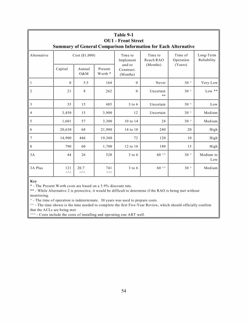
Table 9-1 OU1 - Front Street
Alternative
Implement
and/or
Time of Long-Term
Capital Annual
O&M
Present
1 0 5.5 164 0 Never 30 ^ Very Low
2 21 8 262 0
**
30 ^
3 35 15 485 3 to 6 30 ^ Low
4 3,450 15 3,900 12 30 ^
5 1,601 57 3,300 10 to 14 24 30 ^
6 20,630 68 21,980 14 to 18 240 20 High
7 14,900 446 19,360 72 120 10 High
8 790 60 1,700 12 to 18 180 15 High
3A 44 26 520 3 to 6 60 ^^ 30 ^
Low
3A Plus 121
^^^
20.7
^^^
741
^^^
3 to 6 60 ^^ 30 ^
Key
monitoring.
Summary of General Comparison Information for Each Alternative
Cost ($1,000) Time to
Construct.
(Months)
Time to
Reach RAO
(Months)
Operation
(Years)
Reliability
Worth *
Uncertain Low **
Uncertain
Uncertain Medium
Medium
Medium to
Medium
* - The Present W orth co sts are based on a 3 .9% discount rate.
** - While Alternative 2 is protective, it would be difficult to determine if the RAO is being met without
^ - The time of operation is indeterminate. 30 years was used to prepare costs.
^^ - The time shown is the time needed to complete the first Five-Year Review, which should officially confirm
that the ACLs are being met.
^^^ - Costs include the costs of installing and operating one ART well.
54

10.0 Comparative Analysis of Alternatives
This section of the ROD compares the alternatives against the nine criteria, noting how each compares to the other alternatives. A detailed evaluation of the original eight alternatives against the nine criteria can be found in the FS. Alternative 3A - Monitored Attainment of ACLs / Institutional Controls was evaluated against the nine criteria in the Proposed Plan, and EPA selected Alternative 3A as the preferred alternative. In response to state comments, an additional treatment component (limited soil and groundwater treatment) was added to Alternative 3A and this alternative is referred to as Alternative 3A Plus - Monitored Attainment of ACLs Plus Limited Treatment /Institutional Controls Plus Limited Treatment. Alternative 3A Plus is identical to Alternative 3A except that Alternative 3A Plus also includes the limited treatment of source soils and the head of the groundwater plume. Alternative 3A Plus is evaluated in this section along with Alternative 3A. Table 10-1 (at the end of this section) summarizes the comparative analysis of the alternatives.
As required, EPA evaluated the alternatives using the nine criteria listed in section 300.430 of the NCP. Two of the nine criteria, overall protection of human health and the environment and compliance with ARARs, are threshold criteria. If an alternative does not meet these two criteria, it cannot be considered as the Site remedy.
Five of the criteria are balancing criteria: long-term effectiveness and permanence; reduction of toxicity, mobility, or volume of contaminants through treatment; short-term effectiveness; implementability; and cost. The EPA can make tradeoffs between the alternatives with respect to the balancing criteria.
Two of the criteria are modifying criteria, state/support agency acceptance and community acceptance.
10.1 Overall Protection of Human Health and the Environment
This criterion determines whether an alternative eliminates, reduces, or controls threats to public health and the environment through institutional controls, engineering controls, or treatment. This is a threshold criterion.
All of the alternatives, except the no further action alternative, would adequately protect human health and the environment from contaminants in the groundwater and soil. Because Alternative 1 (the no further action alternative) is not protective of human health and the environment and therefore does not satisfy a threshold criterion under the NCP, it was eliminated from further consideration.
55
10.2 Compliance with ARARs
This criterion evaluates whether the alternative meets the federal and state environmental statutes, regulations, and other requirements that regulate the Site and the actions in the alternative. These regulations are known as applicable or relevant and appropriate requirements (ARARs). ARARs are generally placed into one of three categories: chemical-specific, location-specific, and action-specific. Chemical-specific ARARs regulate the levels of chemicals at a site. They are generally a level that must be met for a site to be considered remediated and are specific to a media (such as groundwater). Location-specific ARARs regulate contaminant levels or activities in specific locations, such as flood plains. Action-specific ARARs regulate remedial activities, not a specific contaminant. If necessary, this evaluation may also provide an explanation of why a waiver of a regulation is justified. This is a threshold criterion.
All the alternatives except Alternatives 2, 3, and 4 would comply with all ARARs. Alternatives 2, 3, and 4 would not comply with all the chemical-specific ARARs and would require the invocation of a waiver if selected. Therefore, Alternatives 2, 3, and 4 were eliminated from consideration under the remaining seven criteria. Alternative 3A and 3A Plus would attain ACLs, which EPA has determined are an appropriate attainment criterion at OU1, in place of MCLs and the Missouri CALM soil and groundwater cleanup levels.
10.3 Long-Term Effectiveness and Permanence
This criterion considers the ability of an alternative to maintain protection of human health and the environment over time, including the adequacy and reliability of the alternatives’ controls. This is a balancing criterion.
Alternative 7 should have the highest long-term effectiveness and permanence. All the contaminated soil would be remediated within one year and the groundwater would be remediated within ten years. The treatment technologies used are permanent, so residual long-term risk should be low.
Alternatives 6 and 8 would also have high long-term effectiveness and permanence. Both would take longer to achieve final remediation of groundwater (and of the soil, for Alternative 8) than Alternative 7. The treatment technologies used are permanent, so residual long-term risk should be low.
By containing the groundwater plume and the contaminated soil, Alternative 5 would also reduce the long-term risk from OU1. However, since most of the contaminants would not be treated and would still be onsite or in the groundwater plume, the containment would have to be maintained indefinitely. Thus, Alternative 5 has moderate long-term effectiveness and permanence.
56
Alternative 3A Plus has low long-term effectiveness and permanence. While it would provide limited treatment of the source term soils and a portion of the groundwater plume, it relies primarily on institutional controls and monitoring to reduce the risks to human health and the environment. The treatment technology used would be permanent, so the residual long-term risk from the soil and groundwater that are treated should be low. However, most of the contaminated groundwater and soil would not be treated.
Alternative 3A has the lowest long-term effectiveness and permanence. It would not treat any of the soils or the groundwater plume. Instead, it relies on institutional controls and monitoring to reduce the risks to human health and the environment.
10.4 Reduction of Toxicity, Mobility, or Volume of Contaminants Through Treatment
This criterion evaluates an alternative’s use of treatment to reduce the harmful effects of contaminants, their ability to move in the environment, and the amount of contamination present. This is a balancing criterion.
All of the treatment technologies are irreversible.
Alternative 7 would reduce the toxicity and volume of the groundwater contaminants. Alternative 6 would reduce the mobility and volume of groundwater contaminants. Alternative 8 would reduce the volume of groundwater contaminants. Alternative 5 would reduce the toxicity and volume of the contaminants in the extracted groundwater. It would also reduce the mobility of the groundwater contaminant plume, but by containment, not treatment. Alternative 3A Plus would reduce the volume of contaminants in the portion of the plume treated.
Alternative 7 would reduce the mobility and volume of the soil contaminants. Alternatives 8 and 3A Plus would reduce the volume of soil contaminants.
Alternatives 6 and 5 would reduce the mobility of the soil contaminants, but by containment (offsite for Alternative 6 and onsite for Alternative 5), not through treatment.
Because Alternative 3A does not include any treatment, it would not reduce the toxicity, mobility, or volume of the soil contaminants or the groundwater plume.
10.5 Short-Term Effectiveness
This criterion considers the length of time needed to implement an alternative. It also evaluates the risks the alternative poses to workers, residents, and the environment during implementation. In general, alternatives with the fewest construction or intrusive activities pose the lowest risk to site workers and the community. This is a balancing criterion.
57
Alternative 3A has the highest short-term effectiveness. It would only require a few months to implement. Since it only requires the installation of some monitoring wells, the risks to the community and the environment would be low. The risks to residents and the community could be controlled by limiting access to the area around the well installation. Risks to a small number of workers needed for implementation would also be low and could be controlled with personal protective equipment and good work practices.
Alternative 3A Plus has the second highest short-term effectiveness. It would also only require a few months to implement. Since it only requires the installation of one ART treatment well (and a very small amount of trenching) and some monitoring wells, the risks to the community and the environment would be low. The risks to residents and the community could be controlled by limiting access to the area around the well installation. Risks to a small number of workers needed for implementation would also be low and could be controlled with personal protective equipment and good work practices.
Alternative 8 has moderate short-term effectiveness because it would require the installation of significantly more wells that Alternative 3A or 3A Plus. It would also require some trenching in the contaminated soil. Alternative 8 would also take longer to implement than Alternative 3A and 3A Plus (12 to 18 months, compared to 3 to 6 months for 3A and 3A Plus). Alternative 8 would pose less short-term risk than Alternatives 5, 6, and 7 because it does not require large-scale soil excavation or sheet pile installation.
Alternatives 5, 6, and 7 have low short-term effectiveness. All of these alternatives require the installation of sheet piling around the contaminated soil. Alternatives 6 and 7 also require the excavation of 34,000 cubic yards of contaminated soil. While Alternative 5 would take approximately 10 months to construct, Alternative 6 would take 14 to 18 months and Alternative 7 would take 6 years (72 months).
10.6 Implementability
This criterion considers the technical and administrative feasibility of implementing the alternative. It evaluates such concerns as the relative availability of the goods and services needed to construct or operate the remedy. This is a balancing criterion.
Alternative 3A has the highest implementability. It would require the implementation of the common elements (institutional controls and monitoring) like the other alternatives. It would also require monitoring of the Missouri River. The sampling personnel, equipment, and procedures for sampling the Missouri River are well developed and readily available.
Alternative 3A Plus has the second highest implementability. It would require the implementation of the common elements (institutional controls and monitoring) like the other alternatives. It would also require the installation of one ART well and sampling of the Missouri River. While the ART technology is innovative and has only one vendor, it is not anticipated that there would
58

be any difficulties in installing one well. The sampling personnel, equipment, and procedures for sampling the Missouri River are well developed and readily available.
Alternative 8 would be moderately difficult to implement. In addition to the common elements, it would require the installation of a large number (more than 10) of ART treatment wells and several SVE wells. Because the ART technology is innovative and has only one vendor, there may be some scheduling difficulties due to the magnitude of the remedy. It would also require that trenches for the treatment system piping be dug around the site and offsite, requiring more coordination with the city, land owners, the ART vendor, and the well driller.
Alternatives 5, 6, and 7 would be difficult or very difficult to implement. The groundwater treatment systems in Alternatives 5 and 6 would require access agreements and coordination between the city, the USACE (which monitors activities around the flood control levee to prevent damage to the levee), the EPA, MDNR, local land owners, and the remedial contractor. The groundwater treatment system in Alternative 5 would have to operate for at least 30 years (more likely, indefinitely), while the system in Alternative 6 would have to operate for 20 years.
The groundwater treatment in Alternative 7 would only require six years, but would require the installation of over 1,000 treatment chemical injection points, very extensive sampling support, and several separate mobilizations. The large number of treatment and sampling points, the difficulties in coordinating the groundwater remediation, and the concerns about the remediation of the soils make Alternative 7 the most difficult alternative to implement.
The soil excavation in Alternatives 6 and 7 and the installation of the sheet piling in Alternatives 5, 6, and 7 would require the closing of Front and Cottonwood Streets. Alternatives 6 and 7 would require extensive coordination among the city, the USACE, the excavation contractor, the soil disposal or soil treatment contractor, EPA and MDNR. The sampling required for these two alternatives is also extensive and much of it would have to be done on short turnaround, which would increase coordination concerns.
The common elements, institutional controls and monitoring, should be relatively easy to implement for all of the alternatives. It is expected that all of OU1 will be acquired by the Industrial Development Authority of New Haven, Missouri. Given the location of the site, in a highly visible area of downtown New Haven, near municipal offices and facilities, any subsurface activities conducted at OU1 would presumably be readily observable, and hence, controllable. Public education could be easily achieved through notices in the newspaper, direct mailings, and public meetings. Five-year reviews are required for each alternative and the services, materials, and personnel needed to complete the reviews are readily available. Installation of monitoring wells is a common practice and technical assistance is readily available for health and safety concerns. Sampling personnel, equipment, and procedures for sampling wells or collecting direct push samples are well developed and available for the alternatives.
59
10.7 Cost
This criterion evaluates the estimated capital and O&M costs as well as present worth costs. Present worth costs are the total cost of an alternative over time in terms of today’s dollars (i.e., present worth costs correct for expected inflation). The cost estimates are order-of-magnitude estimates, which are expected to be accurate within a range of +50 to -30 percent. This is a balancing criterion.
Alternative 3A and 3A Plus had the lowest estimated costs, $520,000 and $741,000, respectively. All costs listed in this subsection are present worth costs. The other alternatives had costs more than three (Alternative 3A) or two times (Alternative 3A Plus) as high. For example, Alternative 8 costs $1.7 million present worth. The full-scale treatment alternatives, 6 and 7, cost $22 million and $19.3 million, respectively. The containment alternative, 5, costs $3.3 million.
10.8 State/Support Agency Acceptance
This criterion considers whether the state agrees with the EPA’s analyses and recommendations of the RI/FS and the Proposed Plan. This is a modifying criterion.
The MDNR supports the EPA’s selection of Alternative 3A Plus. The state supports Alternative 3A Plus because it includes treatment of the source soils and a portion of the groundwater plume. The MDNR also supports Alternatives 3A, 5, 6, 7, and 8.
10.9 Community Acceptance
This criterion considers whether the local community agrees with the EPA’s analyses and preferred alternative. Comments received on the Proposed Plan are important indicators of community acceptance. This is a balancing criterion.
During the Proposed Plan public comment period, no written comments were received that opposed EPA’s choice of Alternative 3A. The city did comment favorably on the selection of Alterative 3A. None of the questions raised during the public meeting opposed EPA’s choice of Alternative 3A. All questions raised at the public meeting were addressed at the meeting by EPA staff.
While Alternative 3A Plus was not presented in the Proposed Plan, Alternative 3A Plus is essentially Alternative 3A with enhanced protectiveness provided by the inclusion of a treatment component. Accordingly, no adverse comments would have been expected to have been made as a result of EPA’s selection of Alternative 3A Plus as EPA’s preferred alternative in the Proposed Plan.
60
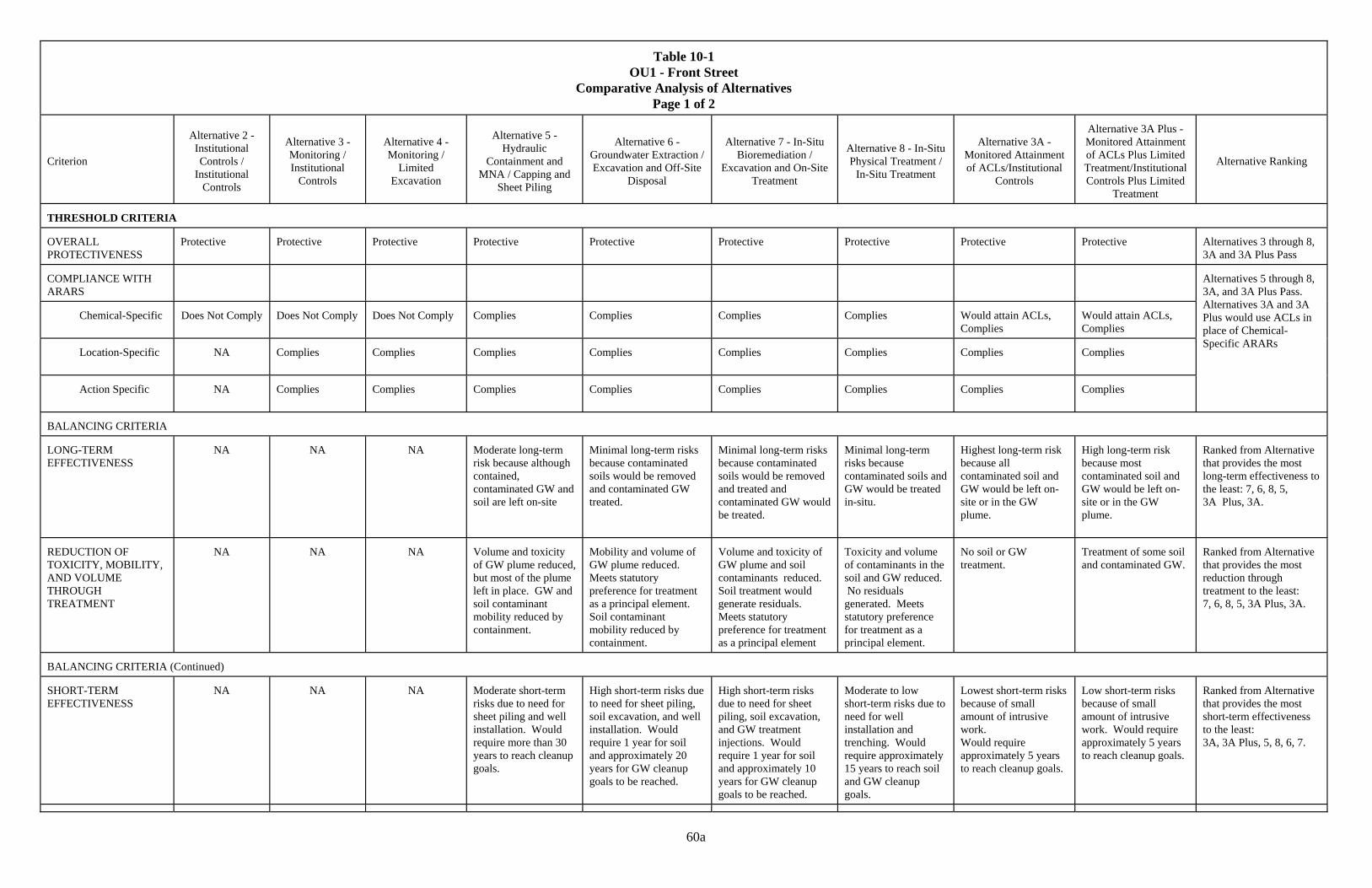
Table 10-1
OU1 - Front Street Comparative Analysis of Alternatives
Page 1 of 2
Criterion
Alternative 2 -
Institutional Controls /
Institutional Controls
Alternative 3 - Monitoring / Institutional
Controls
Alternative 4 - Monitoring /
Limited Excavation
Alternative 5 -
Hydraulic Containment and
MNA / Capping and Sheet Piling
Alternative 6 -
Groundwater Extraction / Excavation and Off-Site
Disposal
Alternative 7 - In-Situ
Bioremediation / Excavation and On-Site
Treatment
Alternative 8 - In-Situ Physical Treatment /
In-Situ Treatment
Alternative 3A -
Monitored Attainment of ACLs/Institutional
Controls
Alternative 3A Plus - Monitored Attainment of ACLs Plus Limited Treatment/Institutional Controls Plus Limited
Treatment
Alternative Ranking
THRESHOLD CRITERIA OVERALL PROTECTIVENESS
Protective
Protective
Protective
Protective
Protective
Protective
Protective
Protective
Protective
Alternatives 3 through 8, 3A and 3A Plus Pass
COMPLIANCE WITH ARARS
Chemical-Specific
Does Not Comply
Does Not Comply
Does Not Comply
Complies
Complies
Complies
Complies
Would attain ACLs, Complies
Would attain ACLs, Complies
Location-Specific
NA
Complies
Complies
Complies
Complies
Complies
Complies
Complies
Complies
Action Specific
NA
Complies
Complies
Complies
Complies
Complies
Complies
Complies
Complies
Alternatives 5 through 8, 3A, and 3A Plus Pass. Alternatives 3A and 3A Plus would use ACLs in place of Chemical-Specific ARARs
BALANCING CRITERIA LONG-TERM EFFECTIVENESS
NA
NA
NA
Moderate long-term risk because although contained, contaminated GW and soil are left on-site
Minimal long-term risks because contaminated soils would be removed and contaminated GW treated.
Minimal long-term risks because contaminated soils would be removed and treated and contaminated GW would be treated.
Minimal long-term risks because contaminated soils and GW would be treated in-situ.
Highest long-term risk because all contaminated soil and GW would be left on-site or in the GW plume.
High long-term risk because most contaminated soil and GW would be left on-site or in the GW plume.
Ranked from Alternative that provides the most long-term effectiveness to the least: 7, 6, 8, 5, 3A Plus, 3A.
REDUCTION OF TOXICITY, MOBILITY, AND VOLUME THROUGH TREATMENT
NA
NA
NA
Volume and toxicity of GW plume reduced, but most of the plume left in place. GW and soil contaminant mobility reduced by containment.
Mobility and volume of GW plume reduced. Meets statutory preference for treatment as a principal element. Soil contaminant mobility reduced by containment.
Volume and toxicity of GW plume and soil contaminants reduced. Soil treatment would generate residuals. Meets statutory preference for treatment as a principal element
Toxicity and volume of contaminants in the soil and GW reduced. No residuals generated. Meets statutory preference for treatment as a principal element.
No soil or GW treatment.
Treatment of some soil and contaminated GW.
Ranked from Alternative that provides the most reduction through treatment to the least: 7, 6, 8, 5, 3A Plus, 3A.
BALANCING CRITERIA (Continued) SHORT-TERM EFFECTIVENESS
NA
NA
NA
Moderate short-term risks due to need for sheet piling and well installation. Would require more than 30 years to reach cleanup goals.
High short-term risks due to need for sheet piling, soil excavation, and well installation. Would require 1 year for soil and approximately 20 years for GW cleanup goals to be reached.
High short-term risks due to need for sheet piling, soil excavation, and GW treatment injections. Would require 1 year for soil and approximately 10 years for GW cleanup goals to be reached.
Moderate to low short-term risks due to need for well installation and trenching. Would require approximately 15 years to reach soil and GW cleanup goals.
Lowest short-term risks because of small amount of intrusive work. Would require approximately 5 years to reach cleanup goals.
Low short-term risks because of small amount of intrusive work. Would require approximately 5 years to reach cleanup goals.
Ranked from Alternative that provides the most short-term effectiveness to the least: 3A, 3A Plus, 5, 8, 6, 7.
60a
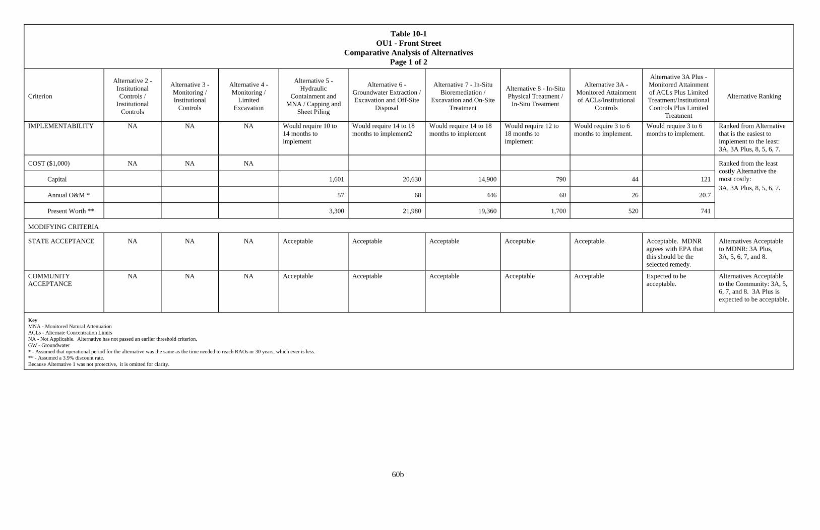
Table 10-1
OU1 - Front Street Comparative Analysis of Alternatives
Page 1 of 2
Criterion
Alternative 2 -
Institutional Controls /
Institutional Controls
Alternative 3 - Monitoring / Institutional
Controls
Alternative 4 - Monitoring /
Limited Excavation
Alternative 5 -
Hydraulic Containment and
MNA / Capping and Sheet Piling
Alternative 6 -
Groundwater Extraction / Excavation and Off-Site
Disposal
Alternative 7 - In-Situ
Bioremediation / Excavation and On-Site
Treatment
Alternative 8 - In-Situ Physical Treatment /
In-Situ Treatment
Alternative 3A -
Monitored Attainment of ACLs/Institutional
Controls
Alternative 3A Plus - Monitored Attainment of ACLs Plus Limited Treatment/Institutional Controls Plus Limited
Treatment
Alternative Ranking
IMPLEMENTABILITY NA NA NA Would require 10 to 14 months to implement
Would require 14 to 18 months to implement2
Would require 14 to 18 months to implement
Would require 12 to 18 months to implement
Would require 3 to 6 months to implement.
Would require 3 to 6 months to implement.
Ranked from Alternative that is the easiest to implement to the least: 3A, 3A Plus, 8, 5, 6, 7.
COST ($1,000)
NA
NA
NA
Capital
1,601
20,630
14,900
790
44
121
Annual O&M *
57
68
446
60
26
20.7
Present Worth **
3,300
21,980
19,360
1,700
520
741
Ranked from the least costly Alternative the most costly: 3A, 3A Plus, 8, 5, 6, 7.
MODIFYING CRITERIA STATE ACCEPTANCE
NA
NA
NA
Acceptable
Acceptable
Acceptable
Acceptable
Acceptable.
Acceptable. MDNR agrees with EPA that this should be the selected remedy.
Alternatives Acceptable to MDNR: 3A Plus, 3A, 5, 6, 7, and 8.
COMMUNITY ACCEPTANCE
NA
NA
NA
Acceptable
Acceptable
Acceptable
Acceptable
Acceptable
Expected to be acceptable.
Alternatives Acceptable to the Community: 3A, 5, 6, 7, and 8. 3A Plus is expected to be acceptable.
Key MNA - Monitored Natural Attenuation ACLs - Alternate Concentration Limits NA - Not Applicable. Alternative has not passed an earlier threshold criterion. GW - Groundwater * - Assumed that operational period for the alternative was the same as the time needed to reach RAOs or 30 years, which ever is less. ** - Assumed a 3.9% discount rate. Because Alternative 1 was not protective, it is omitted for clarity.
60b
11.0 Principal Threat Wastes
The NCP establishes an expectation that EPA will use treatment on principal threat wastes wherever practicable. Principal threat wastes are source materials that are considered highly toxic or highly mobile, that cannot be reliably contained, or present a significant risk to human health or the environment. Generally, contaminated groundwater is not considered to be a source material and is therefore not generally considered to be a principal threat waste.
There are no principal threat wastes at OU1. During the RI, sampling data were collected from 28 groundwater locations (7 monitoring wells and 21 temporary well screens), one domestic well, 140 soil sampling locations (88 borings and 52 samples from excavations and test pits), and 10 surface water samples (including samples of the Missouri River). No principal threat wastes were detected in any of these samples. Institutional controls will prevent exposure to the contaminants in the groundwater and the soil. While there are no principal threat wastes at OU1, the selected remedy does include limited treatment of the most contaminated soils and the head of the groundwater plume. Monitoring will be conducted to determine if the ACLs have been exceeded and if the groundwater contamination might reach new receptors.
12.0 Selected Remedy
Alternative 3A Plus, the selected remedial alternative for OU1, will address contaminated groundwater and soil. Alternative 3A Plus uses several institutional controls to prevent exposure to the contaminated groundwater and soil. It provides for limited in-situ treatment of the most contaminated soils at OU1. It also provides for the treatment of the head of the groundwater contaminant plume in-situ. Monitoring will be conducted to: 1) ensure that contaminant levels do not exceed ACLs; 2) ensure that the contaminants do not migrate from the Site and reach receptors, including the Missouri River; and 3) determine the effectiveness of the in-situ treatment.
Alternative 3A Plus meets both of the threshold criteria, protection of human health and the environment and compliance with ARARs (although it would comply with site-specific ACLs rather than the chemical-specific ARARs for the Site). It also provides the best balance among the balancing criteria and was the choice of the MDNR and the selection of Alternative 3A Plus appears consonant with the wishes of the local community as expressed at the public availability session for the Proposed Plan and as expressed in the city’s written comments on the Proposed Plan.
12.1 Summary of the Rationale for the Selected Remedy
The main factors influencing EPA in its selection of Alternative 3A Plus as the Site remedy are:
61
1) Institutional controls will eliminate or minimize the chance of a receptor being exposed to the contaminated soil at OU1 or the contaminated groundwater below and downgradient of OU1.
2) Current monitoring data have not found any indication that there is source material or nonaqueous phase liquids (NAPLs) in the soil or groundwater, so there is no evidence of principal threat wastes at OU1.
3) Monitoring of OU1 is warranted because of the Site’s history, and because of the levels of PCE and other COCs detected in the soil at the Site and in the groundwater below and downgradient of the Site.
4) Limited treatment of the most contaminated soils (source soils) at the Site and of the head of the groundwater plume will decrease the amount of contamination migrating from the soils into the aquifer and migrating downgradient in the groundwater plume.
5) The EPA has determined that OU1 meets the conditions for establishing ACLs: Condition 1) The contaminated groundwater has “known or projected” points of entry
to a surface water body. Contaminants in the groundwater at OU1 have a known or projected point-of-entry into the nearby surface water body, which is the Missouri River.
Condition 2) There must not be a “statistically significant increase” in the levels of contaminants in the surface water body at the points of entry, or at points downstream. Calculations (see Appendix A in this ROD) indicate that there should not be a detectable amount of contamination, much less a “statistically significant increase” in the levels of contaminants, in the Missouri River. The Missouri River will be sampled during the first five years of the Remedy to confirm that these calculations are correct.
Condition 3) It must be possible to reliably prevent human exposure to the contaminated groundwater through institutional controls. The proposed institutional controls in this Remedy are layered to enhance their protectiveness. EPA believes that these controls will prevent human exposure to the contaminated groundwater and soil.
6) The EPA has determined that active restoration of the shallow aquifer is not practicable, based on an evaluation of the balancing alternative evaluation criteria. In particular, see the cost effectiveness determination in the Statutory Determination Section (§13.3).
12.2 Description of the Selected Remedy
Institutional controls will be implemented at OU1 in layers to enhance the protectiveness of the remedy. The primary form of institutional control will be a proprietary control, specifically a restrictive covenant and easement. This form of proprietary control was selected as it is effective as an informational device and creates a readily enforceable legal property interest.
The EPA will seek the imposition of a restrictive covenant and easement on the Site by the landowner. The MDNR will be named as the grantee of this restrictive covenant and easement
62

and will have the authority to enforce the restrictive covenant and easement. The EPA will be named as a third-party, or intended, beneficiary in this instrument so that EPA will also have the ability to enforce the terms of the restrictive covenant and easement. This restrictive covenant and easement will be patterned on the model restrictive covenant and easement found in the MDNR CALM Appendix E, Attachment E1.
The objectives of imposing a restrictive covenant and easement on OU1 are to eliminate or minimize exposures to contamination remaining at OU1 and limiting the possibility of the spread of contamination. These objectives will be achieved by use of the restrictive covenant and easement as it will: (1) provide notice; (2) limit use; and (3) provide federal and state access. Specifically, the restrictive covenant and easement will achieve this by:
• providing notice to prospective purchasers and occupants that there are contaminants in soils and the groundwater.
• ensuring that future owners are aware of any engineered controls put into place as part of this remedial action.
• prohibiting residential, commercial and industrial uses, except those uses which would be consistent with the remedial action.
• limiting the disturbance of contaminated soils. • prohibiting the placement of groundwater wells. • prohibiting other ground penetrating activities which may result in the creation of a
hydraulic conduit between water bearing zones. • providing access to EPA and the state of Missouri for verifying land use. • prescribing actions that must be taken to install and/or maintain engineered controls (if
applicable). • providing access to EPA and the state of Missouri for sampling and the maintenance of
engineered controls.
In addition to the above proprietary control, the EPA is currently in negotiations with a prospective purchaser for the Site concerning appropriate future uses that could be made of the Site once the purchaser acquires title. Pursuant to a Prospective Purchaser Agreement, EPA and the state will provide certain protections from liability to the purchaser in exchange for an agreement to restrict Site use and provide Site access in a manner generally consistent with those controls which would be achieved by the restrictive covenant and easement discussed above. The additional controls which would be imposed on the Site by the Prospective Purchaser Agreement would provide a desirable layering of controls and help ensure that any future Site use maintains an appropriate level of protectiveness of human health and the environment.
In addition to the above controls, an additional governmental control exists which is expected to effectively preclude the placement of groundwater wells and subsurface activity at the Site. The flood protection levee surrounding downtown New Haven is owned by the city, but was constructed by the USACE using federal funds. The city is responsible for maintenance of the levee and ensuring that stringent guidelines for the construction and other activities near the levee
63
are followed. To maintain annual certification from the USACE of the levee’s integrity, the city must ensure that ceratin guidelines are followed; these include controlling subsurface excavations, borings, and the installation of wells within 500 feet of the back of the levee. This 500-foot area includes all of the Site. Before any excavations, borings, or installation of wells may take place, the city and USACE must review a written plan of the activity. The USACE provides technical comments, and the city is responsible for approving or disapproving the plan and ensuring that USACE guidelines are followed. Given the location of the Front Street Site in a highly visible area of downtown New Haven, new municipal offices and facilities, any subsurface activities conducted at OU1 would presumably be readily observable and hence controllable. The city has a large financial interest in monitoring subsurface activities near the levee, because if the USACE guidelines are not followed, the area risks loss of USACE certification which would severely affect flood insurance rates in the area.
An additional governmental control may take the form of the Riverfront Superfund Site being listed by the MDNR on the State’s Registry of Confirmed, Abandoned, or Uncontrolled Hazardous Waste Disposal Sites in Missouri (“Registry”). The Registry is maintained by the MDNR pursuant to the Missouri Hazardous Waste Management Law, Section 260.440 RSMo. Sites listed on the Registry appear on a publicly available list. A notice filed with the Recorder of Deeds in the county where the site is located details hazardous waste contamination at the site, and notice regarding the contamination must be provided by the seller to potential buyers. In addition, the use of property listed on the Registry may not change substantially without the written approval of the MDNR.
An important notification function is also served by the water well drilling advisory issued by the MDNR which affects the Site. This advisory notifies well drillers of the groundwater contamination in the area.
The EPA may also provide public education through the preparation and distribution of an annual newsletter on the site and conduct informational meetings, which will be held every five years. The public education campaign would be intended to inform citizens of the potential health hazards associated with exposure to contaminated groundwater and would remind city officials of the restrictions on OU1.
One ART treatment well and three new monitoring wells will be installed as part of the selected remedy. The ART well is a combination in-situ air-stripper well to treat the groundwater and a SVE well to treat the soil. The location of the ART well will be determined during the remedial design, but is expected to be in or very near the area of highest soil contamination (the southeast corner of the Front Street Building). A treatability study of the ART well will be conducted during its first quarter of operation. The treatability study will determine the effectiveness of the groundwater treatment, confirm that treatment of the ART system’s off-gas is not required, and determine any site-specific O&M requirements for the system.
64
Three monitoring wells will be installed. The locations of the monitoring wells will be determined during the remedial design, but it is likely that one of the wells will be installed downgradient of the ART well at the edge of the ART well’s treatment zone. A well downgradient of the ART well would be necessary to evaluate the effectiveness of the ART groundwater treatment. At least one and maybe both of the other wells will be installed at the downgradient edge of the plume. This well(s), and existing monitoring well G, would be used to determine if OU1 was in compliance with the ACLs. All the wells will have to comply with the guidelines established by the USACE for protection of the flood control levee. These requirements can be found at: http://www.nwk.usace.army.mil/local_protection/levees.html.
The selected remedy uses monitoring:
1) to generate the ACLs and then confirm that the ACLs are not being exceeded. 2) to ensure that the groundwater plume does not migrate to new receptors. 3) to determine the effectiveness of the ART well’s groundwater treatment. 4) to confirm that the off-gas from the ART well does not require treatment. 5) to confirm that the groundwater plume is not affecting the Missouri River.
The monitoring wells and the ART well will be sampled quarterly for the first two years; twice a year during years 3, 4, and 5; and annually thereafter. The off-gas from the ART well will be sampled quarterly for the first year and annually thereafter. The Missouri River will be sampled annually for the first five years.
The groundwater samples would be analyzed for VOCs (at least benzene, PCE, TCE, cis-DCE, and VC) and field parameters (dissolved oxygen [DO], iron II, pH, oxidation-reduction potential [ORP], and temperature). The ART off-gas samples will be analyzed for VOCs only, as will the Missouri River samples.
The first two years’ sampling results from the downgradient wells (existing well G and at least one new well) will be used, along with the sample results from the RI, to determine the ACLs (monitoring item 1). The ACLs will be set at one order of magnitude (times 10) above the highest concentration detected by the end of the second year to continue to protect the Missouri River. After the ACLs have been determined, monitoring results will be compared to the ACLs to evaluate if the Missouri River could be affected by the groundwater contaminant plume.
The sampling results from all the monitoring wells will be compared to the RI data to evaluate monitoring item 2 (is the groundwater plume migrating to new receptors).
The ART well’s sample results and the results from the monitoring well downgradient of the ART well will be compared to determine the effectiveness of the ART system’s groundwater treatment (monitoring item 3). The off-gas sample will be used to calculate an estimate of the mass of the VOCs being removed from the soil and groundwater and being emitted by the ART treatment
65
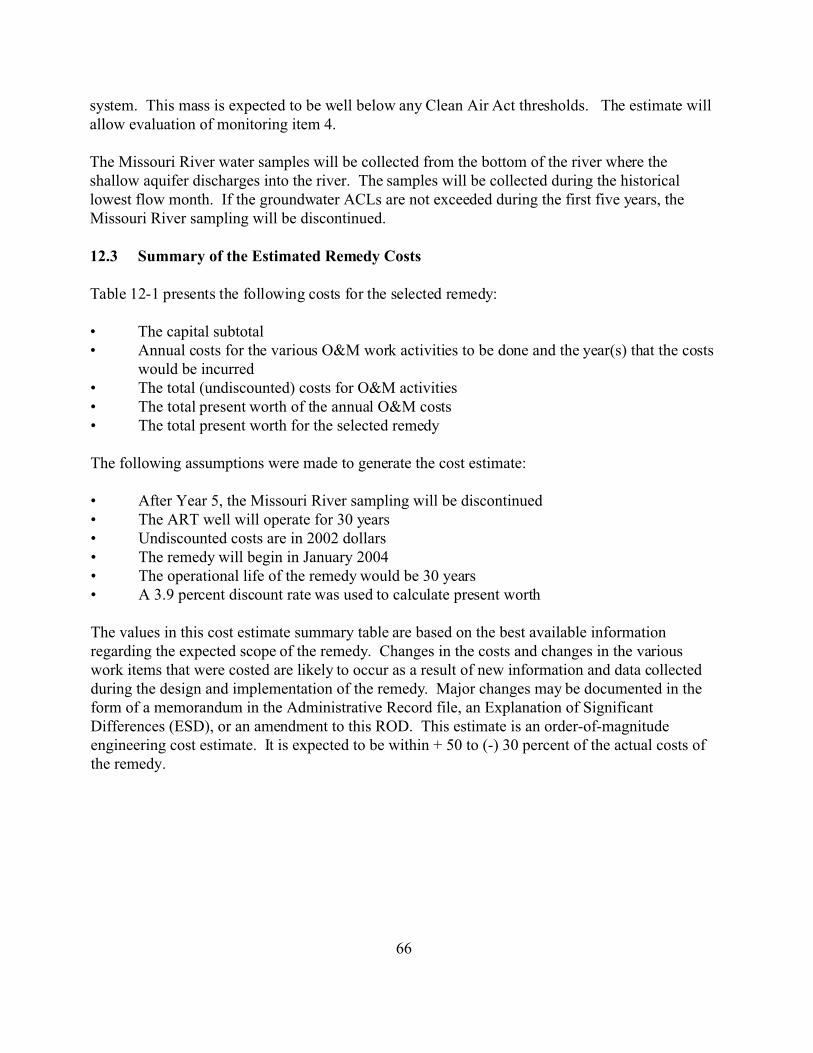
system. This mass is expected to be well below any Clean Air Act thresholds. The estimate will allow evaluation of monitoring item 4.
The Missouri River water samples will be collected from the bottom of the river where the shallow aquifer discharges into the river. The samples will be collected during the historical lowest flow month. If the groundwater ACLs are not exceeded during the first five years, the Missouri River sampling will be discontinued.
12.3 Summary of the Estimated Remedy Costs
Table 12-1 presents the following costs for the selected remedy:
• The capital subtotal • Annual costs for the various O&M work activities to be done and the year(s) that the costs
would be incurred • The total (undiscounted) costs for O&M activities • The total present worth of the annual O&M costs • The total present worth for the selected remedy
The following assumptions were made to generate the cost estimate:
• After Year 5, the Missouri River sampling will be discontinued • The ART well will operate for 30 years • Undiscounted costs are in 2002 dollars • The remedy will begin in January 2004 • The operational life of the remedy would be 30 years • A 3.9 percent discount rate was used to calculate present worth
The values in this cost estimate summary table are based on the best available information regarding the expected scope of the remedy. Changes in the costs and changes in the various work items that were costed are likely to occur as a result of new information and data collected during the design and implementation of the remedy. Major changes may be documented in the form of a memorandum in the Administrative Record file, an Explanation of Significant Differences (ESD), or an amendment to this ROD. This estimate is an order-of-magnitude engineering cost estimate. It is expected to be within + 50 to (-) 30 percent of the actual costs of the remedy.
66

67
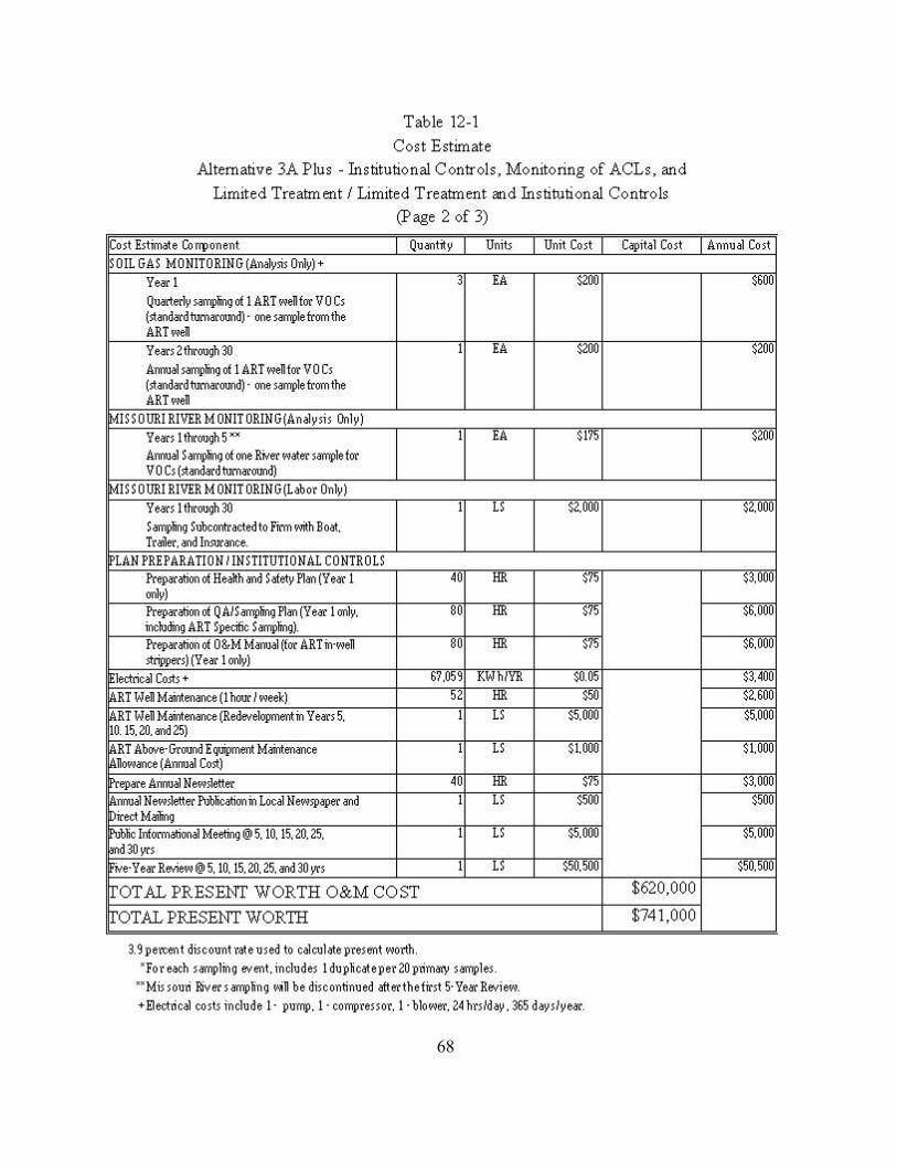
68
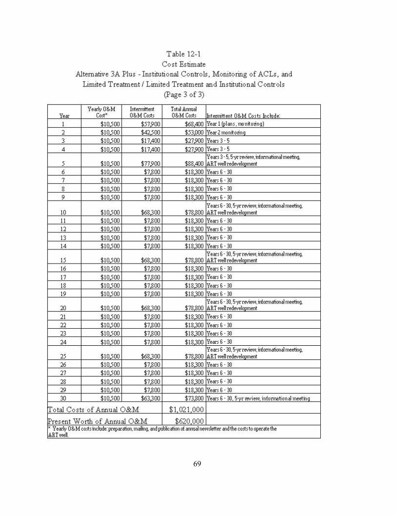
69

12.4 Expected Outcome of the Selected Remedy
As discussed above, institutional controls will be used to prevent exposure to the contaminated surface and subsurface soils and prevent development that would be inconsistent with the selected remedy. Because of the institutional controls that will be imposed, as well as the interest expressed by the City and community in committing the site for surficial uses only (e.g., greenspace or parking), it is very unlikely that OU1 would be developed for residential, hospital, day care, school use, or even commercial use.
The selected remedy is expected to prevent/minimize exposure to contaminated groundwater and soil from OU1. Currently, there is no human exposure to the contaminated groundwater from OU1, because the Front Street Building and all nearby residences and businesses are on city water. The groundwater will be monitored to ensure that the ACLs are not exceeded and that the contaminant plume is not migrating to areas where new receptors could be affected. Thus, the current uses of the groundwater below and downgradient of OU1 (essentially none) will be maintained. The time to reach cleanup levels for the COCs onsite and downgradient is unknown, but is anticipated to be greater than 30 years. If cleanup levels are not met within 30 years, but there are no other effects from the groundwater, the current remedy could continue to be implemented beyond 30 years.
The residual risk is minimal. The purpose of this response action is to control the potential risks from ingestion, inhalation, and dermal contact with contaminated groundwater and soil. The HHRA indicates that there are carcinogenic and non-carcinogenic risks to future residents (Cancer Risk = 1.1e-02 and HI = 192) and future workers (Cancer Risk = 2.3e-03 and HI = 51) who ingest, inhale, or have dermal contact with the contaminated groundwater and soil. Once the city purchases OU1, residential, day care, or commercial development cannot occur at the Site, so access to the groundwater and soil will be prevented. In addition, all nearby residences and businesses are on city water, so future exposure to the contaminated groundwater is very unlikely. Tables 12-2 and 12-3 summarize the cleanup levels for the COCs and the risks when cleanup levels are achieved for groundwater and soil, respectively.
The anticipated socio-economic and community impacts include the use of the Site as a greenspace or parking area. The redevelopment of the Site for such uses would fill a community need since there is very little undeveloped property in the area, and there is a boat ramp nearby whose use is limited due to insufficient parking. Also, construction of the the remedy should be complete in time to not interfere with the city’s activities during the Lewis and Clark Bicentennial. These activities will also require additional downtown parking.
Environmental exposure is limited to the contaminants in the groundwater. Since the groundwater is usually at least 10 feet bgs and discharges into the Missouri River, environmental exposure is minimal. The Missouri River will also be monitored to ensure that there is not a “statistically significant increase” in the levels of contaminants in the river. There are no
70
endangered species in the area, and the only PCE detected in a surface water sample was at another OU. The risk identified in the ERA was very minimal. The ERA concluded that sufficient data are available to fully evaluate the effects on ecological receptors in the area and as these were minimal, no further ecological investigation is warranted
Table 12-2 OU1 - Front Street
Groundwater Cleanup Levels for Chemicals of Concern
Groundwater
Site Area:
Available Use:
Cleanup Level Basis for Cleanup Level Risk At Cleanup Level
Concern Cancer
Risk *
PCE To Be 0 0
TCE To Be 0 0
To Be 0 0
To Be 0 0
Benzene To Be 0 0
Notes
* -
Media:
Contaminated Groundwater Plume
Individual Residential or O ccupational Supply
Controls to Ensure Restricted Use: Institutional Controls
Chemical of
(ug/L) Non-C arcinogenic Risk *
Compliance with ACL
Determined ^
Compliance with ACL
Determined ^
VC (Child) Compliance with ACL
Determined ^
VC (Adult) Compliance with ACL
Determined ^
Compliance with ACL
Determined ^
ug/L - micrograms per liter
ACL - Alternate Concentration Limits
Remedy should prevent exposure to these COCs, therefore risk would be 0.
^ - Alternate Concentration Limits will be established for these COCs after the first two years of monitoring results
are available.
71
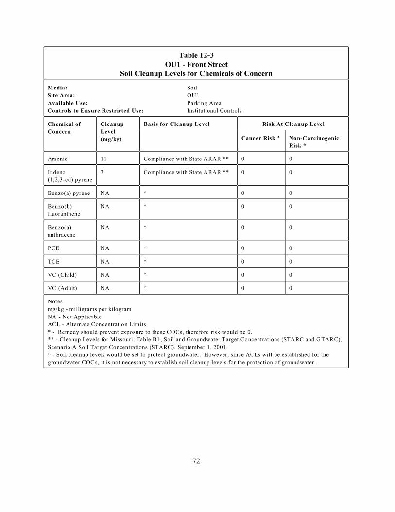
Table 12-3 OU1 - Front Street
Soil Cleanup Levels for Chemicals of Concern
Soil
Site Area: OU1
Available Use: Parking Area
Cleanup Basis for Cleanup Level Risk At Cleanup Level
Concern Level
Risk *
11 0 0
3 0 0
(1,2,3-cd) pyrene
Benzo(a) pyrene NA ^ 0 0
Benzo(b) NA ^ 0 0
fluoranthene
Benzo(a) NA ^ 0 0
anthracene
0 0 PCE NA ^
0 0 TCE NA ^
NA ^ 0 0
NA ^ 0 0
Notes
* -
Media:
Controls to Ensure Restricted Use: Institutional Controls
Chemical of
(mg/kg) Cancer Risk * Non-Carcinogenic
Arsenic Compliance with State ARAR **
Indeno Compliance with State ARAR **
VC (Child)
VC (Adult)
mg/kg - milligrams per kilogram
NA - Not Applicable
ACL - Alternate Concentration Limits
Remedy should prevent exposure to these COCs, therefore risk would be 0.
** - Cleanup Levels for Missouri, Table B1 , Soil and Groundwater Target Concentrations (STARC and G TARC),
Scenario A Soil Target Concentrations (STARC), September 1, 2001.
^ - Soil cleanup levels would be set to protect groundwater. However, since ACLs will be established for the
groundwater COCs, it is not necessary to establish soil cleanup levels for the protection of groundwater.
72

13. Statutory Determinations
13.1 Protection of Human Health and the Environment
The selected remedy will prevent future exposure to contaminated groundwater and soil by implementing institutional controls. Currently, there is no exposure to the contaminated groundwater or soil. The selected remedy includes monitoring and treatment of groundwater and soils of the groundwater around and downgradient of the Site to ensure that ACLs are not exceeded and that new receptors are not exposed to contaminant levels that could cause risk. The selected remedy requires minimal additional Site work, so there should not be any unacceptable short-term risks or any cross-media impacts. There is a very slight ecological risk to the Missouri River from the contaminated groundwater plume, but the selected remedy includes monitoring to ensure that contaminant levels that could cause risk will be detected in time to take remedial action.
13.2 Compliance with Applicable or Relevant and Appropriate Requirements
The selected remedy must meet the federal and state environmental statutes, regulations, and other requirements that regulate the Site and the actions in the alternative. These regulations are known as ARARs. ARARs are generally placed into one of three categories: chemical-specific, location-specific, and action-specific. Chemical-specific ARARs regulate the levels of chemicals at the Site. They are generally a level that must be met for the Site to be considered remediated and are specific to a media (such as groundwater). Location-specific ARARs regulate contaminant levels or activities in specific locations, such as flood plains. Action-specific ARARs regulate remedial activities, not a specific contaminant. In addition, if there is no ARAR for a chemical or action, the EPA may evaluate non-promulgated advisories issued by federal or state governments as “to-be-considered” (TBC) materials. If used, a standard based on a TBC is a legally enforceable performance standard.
The ARARs and TBCs for the selected remedy are listed in Table 13-1. In addition, the sampling activities will need to comply with the Occupational Safety and Health Act (OSHA) requirements.
This remedial action will comply with all ARARs and does not require that any waivers be invoked.
73
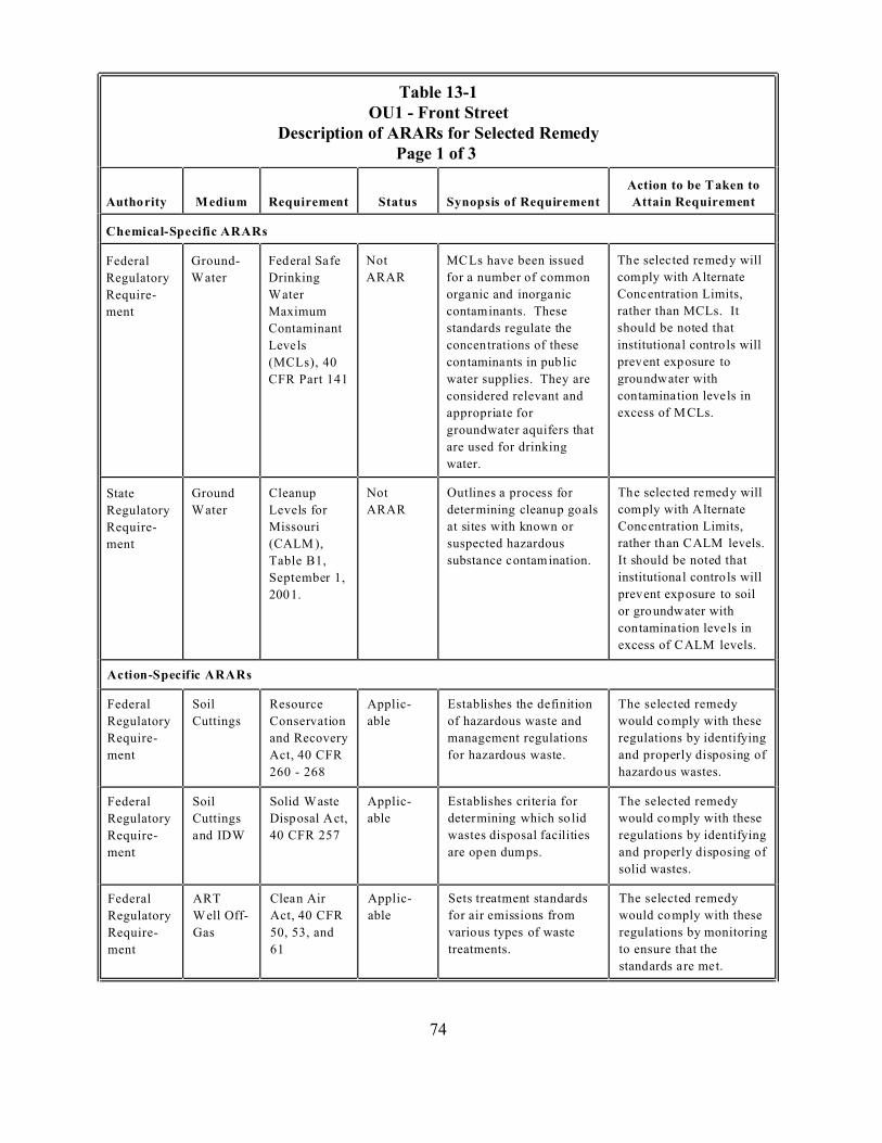
Table 13-1 OU1 - Front Street
Page 1 of 3
Status
Federal
Regulatory
Require
ment
Ground-
Drinking
Maximum
Not
ARAR
These
Contaminant
(MCLs), 40
CFR Part 141
considered relevant and
are used for drinking
water.
State
Regulatory
Require
ment
Ground Cleanup
Missouri
Table B1,
Not
ARAR
suspected hazardous
Federal Soil Resource Applic-
Regulatory Cuttings able of hazardous waste and
Require- and Recovery management regulations
ment
260 - 268
Federal Soil Applic-
Regulatory Cuttings able
Require- 40 CFR 257
ment
solid wastes.
Federal ART Applic-
Regulatory able
Require- Gas 50, 53, and
ment 61 treatments.
Description of ARARs for Selected Remedy
Authority Medium Requirement Synopsis of Requirement
Action to be Taken to
Attain Requirement
Chemical-Specific ARARs
Water
Federal Safe
Water
MCLs have been issued
for a number of common
organic and inorganic
contaminants.
The selected remedy will
comply with Alternate
Concentration Limits,
rather than MCLs. It
Levels
standards regulate the
concentrations of these
should be noted that
institutional contro ls will
contaminants in pub lic
water supplies. They are
prevent exposure to
groundwater with
contamination levels in
appropriate for excess of M CLs.
groundwater aquifers that
Water Levels for
(CALM ),
Outlines a process for
determining cleanup goals
at sites with known or
substance contamination.
The selected remedy will
comply with Alternate
Concentration Limits,
rather than CALM levels.
It should be noted that
September 1,
2001.
institutional contro ls will
prevent exposure to soil
or groundwater with
contamination levels in
excess of CALM levels.
Action-Specific ARARs
Establishes the definition The selected remedy
Conservation would comply with these
regulations by identifying
Act, 40 CFR for hazardous waste. and properly disposing of
hazardous wastes.
Solid Waste Establishes criteria for The selected remedy
Disposal Act, determining which so lid would comply with these
and IDW wastes disposal facilities regulations by identifying
are open dumps. and properly disposing of
Clean Air Sets treatment standards The selected remedy
Well Off- Act, 40 CFR for air emissions from would comply with these
various types of waste regulations by monitoring
to ensure that the
standards are met.
74

Table 13-1 OU1 - Front Street
Status
Federal ART Applic-
Regulatory able
Require- Gas 50, 53, and
ment 61 treatments.
Federal Applic-
Regulatory during able
Require- 42 USC Sect
ment
Opera-
State Soil Missouri Applic- Requires that hazardous
Regulatory
Require
ment
Cuttings Sanitary
Regulations,
able
10 CSR 80
3.010 (2) and wastes.
(3).
waste landfills.
State Missouri Applic- Requires that monitoring
Regulatory
Require
ment
able
driller familiar with these
Code, 10
CSR 23
4.010.
State ART Applic- Requires that ambient
Regulatory able
Require- Gas
ment
CSR 10
Federal Flood Executive Applic-
Regulatory
Require
ment
Plain
Manage
ment
Order on able
adverse impacts and
impacts.
Description of ARARs for Selected Remedy Page 2 of 3
Authority Medium Requirement Synopsis of Requirement
Action to be Taken to
Attain Requirement
Clean Air Sets treatment standards The selected remedy
Well Off- Act, 40 CFR for air emissions from would comply with these
various types of waste regulations by monitoring
to ensure that the
standards are met.
Noise Noise Federal activities must not The selected remedy
Control Act, result in noise that will would comply with these
Installa jeopardize the wealth or regulations by scheduling
tion or 4901 et seq. welfare of the public operations to minimize
noise concerns.
tion
The selected remedy
Landfill
waste be tested to
determine its handling and
disposal. Regulated
would comply with these
regulations by identifying
and properly disposing of
quantities of hazardous hazardous and solid
waste are excluded from
disposal in permitted solid
Well The selected remedy
Installa
tion
Monitoring
Well
Construction
wells be installed or
abandoned in accordance
with the M onitoring W ell
would comply with these
regulations by using a
Construction Code. regulations to install the
monitoring wells.
Missouri Air The selected remedy
Well Off- Pollution concentrations of VOCs would comply with these
Control be less than their regulations by monitoring
Program, 10 respective Acceptable to ensure that the
Ambient Levels at the site standards are met.
6.010 - 6.300 boundary.
Location-Specific ARARs
Requires Federal agencies The selected remedy
Flood Plain
Management,
40 CFR Part
to evaluate the potential
effects of actions that will
take place in a flood plain.
The intent is to avoid, as
would comply with these
regulations by identifying
actions that could cause
6, Appendix much as possible adverse minimizing them to the
A and 6.302 extent possible.
75
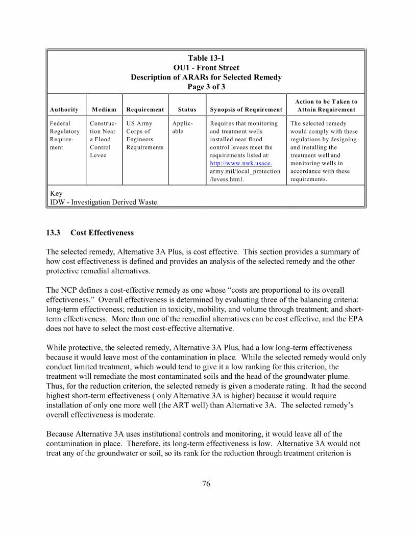
Table 13-1 OU1 - Front Street
Status
Federal Construc- US Army Applic- Requires that monitoring
Regulatory tion Near Corps of able
Require- a Flood Engineers
ment
Levee
Key
Description of ARARs for Selected Remedy Page 3 of 3
Autho rity M edium Requirement Synopsis of Requirement
Action to be T aken to
Attain Requirement
The selected remedy
and treatme nt wells would co mply with these
installed near flood regulations by designing
Control Req uirem ents control levees meet the and installing the
requ ireme nts listed at: treatment well and
http://www.nwk.usace. mon itoring w ells in
army.mil/local_protection
/levess.htm l.
accord ance with these
requirem ents.
IDW - Investigation Derived Waste.
13.3 Cost Effectiveness
The selected remedy, Alternative 3A Plus, is cost effective. This section provides a summary of how cost effectiveness is defined and provides an analysis of the selected remedy and the other protective remedial alternatives.
The NCP defines a cost-effective remedy as one whose “costs are proportional to its overall effectiveness.” Overall effectiveness is determined by evaluating three of the balancing criteria: long-term effectiveness; reduction in toxicity, mobility, and volume through treatment; and short-term effectiveness. More than one of the remedial alternatives can be cost effective, and the EPA does not have to select the most cost-effective alternative.
While protective, the selected remedy, Alternative 3A Plus, had a low long-term effectiveness because it would leave most of the contamination in place. While the selected remedy would only conduct limited treatment, which would tend to give it a low ranking for this criterion, the treatment will remediate the most contaminated soils and the head of the groundwater plume. Thus, for the reduction criterion, the selected remedy is given a moderate rating. It had the second highest short-term effectiveness ( only Alternative 3A is higher) because it would require installation of only one more well (the ART well) than Alternative 3A. The selected remedy’s overall effectiveness is moderate.
Because Alternative 3A uses institutional controls and monitoring, it would leave all of the contamination in place. Therefore, its long-term effectiveness is low. Alternative 3A would not treat any of the groundwater or soil, so its rank for the reduction through treatment criterion is
76
very low. It had the highest short-term effectiveness because it would require the least amount of intrusive work to install and operate. Alternative 3A’s overall effectiveness is low.
Because Alternative 5 is a containment alternative and would leave most of the contamination in place, its long-term effectiveness is low. Alternative 5 would treat some groundwater and should increase the relative rate of biodegradation within the plume, so its rank for the reduction through treatment criterion is also moderate. It would require a large amount of intrusive work at the site (sheet piling and extraction well installation and trenching), so its short-term effectiveness is low. Alternative 5 has low overall effectiveness.
Alternative 6 would restore the groundwater to unrestricted use and would remove the contaminated soils and replace them with clean backfill, allowing unrestricted use of the Site. Its long-term effectiveness is high. It would treat all of the groundwater, so its rank for the reduction through treatment criterion is also high. It would require the installation of sheet piling, the excavation of a large volume of soil, and the installation of a large number of extraction wells, so its short-term effectiveness is very low. Its overall effectiveness is high.
Alternative 7 would restore the groundwater to unrestricted use and would treat the contaminated soils and use the treated soils as clean backfill, allowing unrestricted use of the Site. Its long-term effectiveness is high. It would treat all of the groundwater and all the soil, so its rank for the reduction through treatment criterion is very high. It would require the installation of sheet piling and the excavation and onsite management of a large volume of soil. It would also require the installation of over 1,000 chemical injection points to treat the groundwater and several large-scale mobilizations. Therefore, its short-term effectiveness is very low. Its overall effectiveness is high.
Alternative 8 would restore the groundwater to unrestricted use and would treat the contaminated soils in-situ, allowing unrestricted use of the Site. Its long-term effectiveness is high. While it would treat all of the groundwater and all the soil, it would take longer than Alternative 7, so its rank for the reduction through treatment criterion is high. Alternative 8 would require significantly less intrusive work than Alternatives 5, 6, and 7, but significantly more than the selected remedy, so its short-term effectiveness is moderate. Its overall effectiveness is high.
The selected remedy, Alternative 3A Plus, had low costs ($741,000 present worth) and moderate overall effectiveness. It is a cost-effective remedy. Alternative 3A had the lowest costs ($520,000 present worth) and low effectiveness. It is not a cost effective remedy. Alternative 5 had higher costs ($3,300,000 present worth) and low overall effectiveness. It is not a cost-effective remedy. Alternative 6 had very high costs ($21,980,000 present worth) and high overall effectiveness. It is not a cost-effective remedy. Alternative 7 had very high costs ($19,360,000 present worth) and high overall effectiveness. It is not a cost-effective remedy. Alternative 8 had low costs ($1,700,000 present worth) and high overall effectiveness. It is a cost-effective remedy.
77
13.4 Utilization of Permanent Solutions and Alternative Treatment Technologies to the Maximum Extent Possible
The selected remedy does not use treatment as a major element. The rationale for not making treatment a major element is:
1) Current monitoring data and the HHRA have not found any current exposure to the Site contaminants.
2) Current monitoring data have not found any indication that there is source material or NAPLs in the groundwater, so there is no evidence of principal threat wastes at OU1.
3) The institutional controls will eliminate or minimize the chance of a receptor being exposed to the contaminated groundwater or soil in the future.
4) Monitoring of the groundwater from OU1 will provide a warning if contaminants levels downgradient of the Site increase significantly. Monitoring of the Missouri River will provide a warning if contaminants begin to migrate into the environment.
While treatment is not a major element of the selected remedy, limited treatment will be conducted. One ART treatment well will be installed. The ART well will remediate the highly contaminated soils at the Site and will also treat the groundwater at the head of the plume.
The relative rank of the selected remedy is discussed below for the balancing and modifying evaluation criteria. The selected remedy is only compared to those alternatives that passed the threshold criteria.
Long-term Effectiveness and Permanence: The long-term effectiveness of the selected remedy was the second lowest of all the alternatives. The selected remedy would leave most of the contaminated soil and groundwater in place. It relies mainly on institutional controls to reduce risk. Alternative 3A had the lowest long-term effectiveness because it would leave all the contaminated soil and groundwater in place. The other alternatives had higher long-term effectiveness because all would conduct more treatment (much more, for Alternatives 6, 7, and 8) or engineered containment (Alternative 5) and would rely less on institutional controls to reduce risk.
Reduction of Toxicity, Mobility, or Volume Through Treatment: All of the alternatives except Alternative 3A use treatment. Of the treatment alternatives, the selected remedy will conduct the least amount of treatment. All of the other alternatives would conduct more groundwater treatment than the selected remedy. Alternatives 7 and 8 would also conduct more soil treatment than the selected remedy. Alternatives 5 and 6 would contain the soils.
Short-Term Effectiveness: The short-term effectiveness of the selected remedy was the second highest of all the alternatives. The selected remedy would require a small amount of additional intrusive work (the installation of one ART well) compared to Alternative 3A, which had the least amount of intrusive work at the Site. The only increase in short-term risk from the selected
78
who collect the
The
Costs:
State Acceptance:
alternative.
13.5
However, EPA has included limited treatment of the
13.6
14.
The Proposed
79
remedy is to the workers who install the ART well and the monitoring wells and groundwater samples. These risks should be minor.
Implementability: The selected remedy would be the second easiest remedy to implement and would be much easier to implement than any of the containment or treatment alternatives. selected remedy would use institutional controls, but the city of New Haven and the MDNR have agreed with the controls and are assisting in their implementation.
The selected remedy is cost effective. The additional O&M costs for the selected remedy (compared to Alternative 3A) are warranted. The additional costs will be used to operate an ART well in the most contaminated soils at the Site, thus increasing the long-term effectiveness of the remedy. The ART well will be monitored to provide EPA and MDNR with current data.
The MDNR supports the remedy (Alternative 3A Plus) selected by the EPA.
Community Acceptance: While Alternative 3A Plus was not presented in the Proposed Plan, Alternative 3A Plus is, in essence, Alternative 3A with enhanced protectiveness provided by the inclusion of a treatment component. Alternative 3A was favorably commented on orally by the community at the public availability session held on the Proposed Plan and in writing by the city. Accordingly, it is expected that the community will accept and be supportive of the selected
Preference for Treatment as a Principal Element
There are no principal threat wastes at OU1. Therefore, the EPA’s statutory preference for treatment of principal threats does not apply. most contaminated soil and of the head of the groundwater plume in the selected remedy, as requested by the MDNR in their comments on the Proposed Plan.
Five-Year Review Requirements
After the selected remedy is implemented, the RAOs and ACLs will be met, but hazardous substances will remain in the groundwater and soil at OU1 above levels that allow unlimited use and unrestricted exposure. Therefore, a statutory review will be required every five years to ensure that the selected remedy is still protective of human health and the environment.
Documentation of Significant Changes from Preferred Alternative of Proposed Plan
The Proposed Plan for OU1 was released for public comment on July 24, 2003. Plan identified Alternative 3A - Monitored Attainment of ACLs / Institutional Controls and Monitoring as the preferred alternative. The EPA reviewed all written and oral comments
submitted during the public comment period. In their written comments, the MDNR stated that Alternative 3A was generally acceptable, but requested that the source at OU1 be treated. After reviewing the comment, EPA determined that limited treatment, in the form of one ART treatment well, should be added to the preferred alternative. This alternative, referred to as Alternative 3A Plus, is the selected remedy.
PART III Responsiveness Summary
1.1 Stakeholder Issues and EPA Responses
During the public comment period for the Proposed Plan, one written comment was received from the city of New Haven. This comment addressed the future use of the Site, access for EPA and its consultants, and expressed the city’s willingness to pass legislation to ensure that future use of OU1 is limited to green space, a park, and/or a parking lot. No specific comments regarding the remedy were included in this letter.
In addition to the city’s comments, informal comments were received by EPA from MDNR concerning the limited source control at OU1 and the institutional controls to be used at OU1. Following consideration of this comment by EPA, EPA adding a limited source control component to selected remedy Alternative 3A. This enhanced alternative is referred to as Alternative 3A Plus (“Plus” refers to the added elements of limited soil and groundwater treatment). Alternative 3A Plus was chosen by EPA as the selected remedy as it is more protective than Alternative 3A and satisfies the nine criteria set forth in the NCP. The MDNR concurs in the selection of this alternative.
2.0 Technical and Legal Issues
2.1 Technical Issues
There are no outstanding technical issues on OU1.
2.2 Legal Issues
There are no outstanding legal issues on OU1. The EPA will continue to coordinate with the MDNR and the prospective purchaser of the OU1 regarding the implementation of appropriate proprietary and governmental controls for OU1.
80

Fig. 1 Schematic plan view of the plume migrating from OU1 to the Missouri River (Not to Scale).
OU1
A2
A1
Plume
MO River flow
TW-C
TW-E
TW-D
TW-G
Boat Ramp
1. The OU 1 (Front Street) RI showed that a plume containing PCE, TCE, cis-DCE, and VC (vinyl chloride) is migratingfrom the Front Street building through the alluvium to the Missouri River.
2. From Freeze and Cherry (1979) or Todd (1980), the flux of ground-water movement can be calculated byv = - (K) x (dh/dl), where v is the specific discharge, K is the hydraulic conductivity, and dh/dl is the gradient. v has the units of square feet per second (sq ft/sec).
3. From the RI, the hydraulic conductivity of the alluvium at OU1 is about 22 ft/day or approximately2.5 x 10-4 ft per second and the gradient is about 0.002. Therefore, v is approximately 5 x 10⁻⁷ ft/sec.
4. Assume that the entire width of the plume at OU1 along the river bank (area A1 in Figure 1) is contributing PCE at the maximum detected concentration detected during the RI. The maximum concentration of 11,000 ug/L was found in geoprobe hole beneath the Front Street building. Therefore, each square foot along the cross section (A1) contributes: 5 x 10⁻⁷ sq ft/sec x 1 ft2 x 28.32 liter/cu ft x 11,000 ug/L = 0.16 ug PCE/sec. Assuming that the area of contaminant plume's discharge into the River is the same as the width of the plume in the alluvium (from Figure 1, length A1 = length A2), then the vertical thickness of the plume along line A1 is not needed. This is because in this simplified 1-D model, adjacent lines of "cubes" do not interact.
5. From the RI and the OU1 FS, the length of A1 (and A2) is approximately equal to 400 feet.
9/18/2003 1 of 4 OU1-ACL-backgroundv2 80a
ACL Calculations
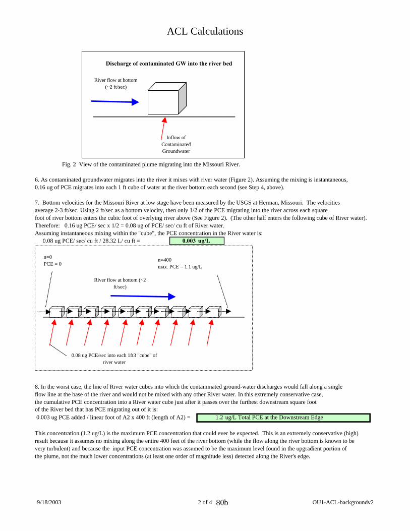
ACL Calculations
Inflow of Contaminated Groundwater
River flow at bottom (~2 ft/sec)
Discharge of contaminated GW into the river bed
Fig. 2 View of the contaminated plume migrating into the Missouri River.
6. As contaminated groundwater migrates into the river it mixes with river water (Figure 2). Assuming the mixing is instantaneous,0.16 ug of PCE migrates into each 1 ft cube of water at the river bottom each second (see Step 4, above).
7. Bottom velocities for the Missouri River at low stage have been measured by the USGS at Herman, Missouri. The velocities average 2-3 ft/sec. Using 2 ft/sec as a bottom velocity, then only 1/2 of the PCE migrating into the river across each square foot of river bottom enters the cubic foot of overlying river above (See Figure 2). (The other half enters the following cube of River water). Therefore: 0.16 ug PCE/ sec x 1/2 = 0.08 ug of PCE/ sec/ cu ft of River water. Assuming instantaneous mixing within the "cube", the PCE concentration in the River water is:
0.08 ug PCE/ sec/ cu ft / 28.32 L/ cu ft = 0.003 ug/L
River flow at bottom (~2 ft/sec)
0.08 ug PCE/sec into each 1ft3 "cube" of river water
n=400 max. PCE = 1.1 ug/L
n=0 PCE = 0
8. In the worst case, the line of River water cubes into which the contaminated ground-water discharges would fall along a singleflow line at the base of the river and would not be mixed with any other River water. In this extremely conservative case, the cumulative PCE concentration into a River water cube just after it passes over the furthest downstream square foot of the River bed that has PCE migrating out of it is: 0.003 ug PCE added / linear foot of A2 x 400 ft (length of A2) = 1.2 ug/L Total PCE at the Downstream Edge
This concentration (1.2 ug/L) is the maximum PCE concentration that could ever be expected. This is an extremely conservative (high) result because it assumes no mixing along the entire 400 feet of the river bottom (while the flow along the river bottom is known to be very turbulent) and because the input PCE concentration was assumed to be the maximum level found in the upgradient portion of the plume, not the much lower concentrations (at least one order of magnitude less) detected along the River's edge.
9/18/2003 2 of 4 OU1-ACL-backgroundv2 80b
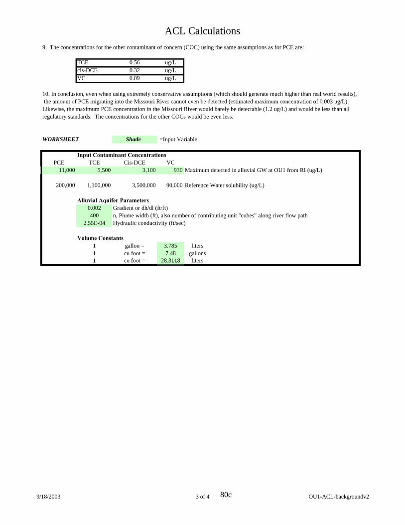
ACL Calculations 9. The concentrations for the other contaminant of concern (COC) using the same assumptions as for PCE are:
TCE 0.56 ug/L cis-DCE 0.32 ug/L VC 0.09 ug/L
10. In conclusion, even when using extremely conservative assumptions (which should generate much higher than real world results), the amount of PCE migrating into the Missouri River cannot even be detected (estimated maximum concentration of 0.003 ug/L). Likewise, the maximum PCE concentration in the Missouri River would barely be detectable (1.2 ug/L) and would be less than all regulatory standards. The concentrations for the other COCs would be even less.
WORKSHEET Shade =Input Variable
Input Contaminant Concentrations PCE TCE Cis-DCE VC
11,000 5,500 3,100
200,000 1,100,000 3,500,000
Alluvial Aquifer Parameters 0.002 Gradient or dh/dl (ft/ft) 400 n, Plume width (ft), also number of contributing unit "cubes" along river flow path
2.55E-04 Hydraulic conductivity (ft/sec)
Volume Constants 1 gallon = 3.785 liters 1 cu foot = 7.48 gallons 1 cu foot = 28.3118 liters
930 Maximum detected in alluvial GW at OU1 from RI (ug/L)
90,000 Reference Water solubility (ug/L)
9/18/2003 3 of 4 OU1-ACL-backgroundv2 80c
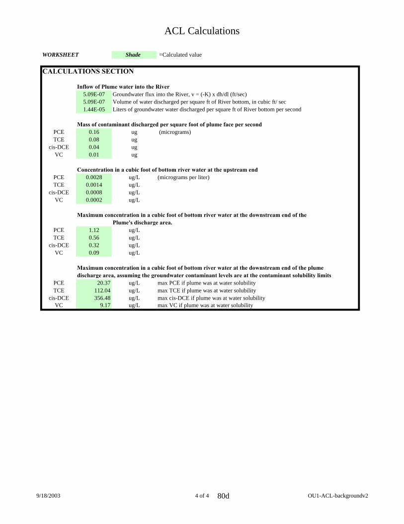
ACL Calculations
WORKSHEET Shade =Calculated value
CALCULATIONS SECTION
Inflow of Plume water into the River 5.09E-07 Groundwater flux into the River, v = (-K) x dh/dl (ft/sec)5.09E-07 Volume of water discharged per square ft of River bottom, in cubic ft/ sec1.44E-05 Liters of groundwater water discharged per square ft of River bottom per second
Mass of contaminant discharged per square foot of plume face per second PCE 0.16 ug (micrograms) TCE 0.08 ug
cis-DCE 0.04 ug VC 0.01 ug
Concentration in a cubic foot of bottom river water at the upstream end PCE 0.0028 ug/L (micrograms per liter) TCE 0.0014 ug/L
cis-DCE 0.0008 ug/L VC 0.0002 ug/L
Maximum concentration in a cubic foot of bottom river water at the downstream end of the Plume's discharge area.
PCE 1.12 ug/L TCE 0.56 ug/L
cis-DCE 0.32 ug/L VC 0.09 ug/L
Maximum concentration in a cubic foot of bottom river water at the downstream end of the plume discharge area, assuming the groundwater contaminant levels are at the contaminant solubility limits
PCE 20.37 ug/L max PCE if plume was at water solubility TCE 112.04 ug/L max TCE if plume was at water solubility
cis-DCE 356.48 ug/L max cis-DCE if plume was at water solubility VC 9.17 ug/L max VC if plume was at water solubility
9/18/2003 4 of 4 OU1-ACL-backgroundv2 80d


