c DECLARATION FOR THE RECORD OF DECISION EPA Region 5 Records Ctr. SITE NAME AND LOCATION Grand Traverse Overall Supply Site, Greilickville, Michigan. STATEMENT OF BASIS 206654 This decision document presents the selected remedial action for the Grand Traverse Overall Supply Site, in Greilickville, Michigan, which was chosen in accordance with the Comprehensive Environmental Response, Compensation, and Liability act of 1980 (CERCLA), as amended by the Superfund Amendments and Reauthorization Act of 1986 (SARA) and is consistent with the National Oil and Hazardous Substances Pollution Contingency Plan (NCP) to the extent practicable. This decision is based upon the contents of the Administrative Record for the site. The State of Michigan does not concur with this Record of Decision. DESCRIPTION OF THE SELECTED REMEDY U.S. EPA (EPA) has selected "No Action." DECLARATION EPA has determined that conditions at the site due to contamination by organic compounds pose no current or potential threat to human health or the environment. While the GTOS site does appear to exhibit trace amounts of inorganic contamination which result in slightly elevated calculations of potential future risk, EPA has also determined that the presence of these compounds does not appear to pose an unacceptable risk to human health or the environment. Accordingly, no further remedial action will be undertaken. EPA will, however, continue to monitor the inorganic contaminants in the groundwater for a period of twelve months. As this is a decision for "No Action", the statutory requirements of CERCLA Section 121 for remedial actions are not applicable and no five year review wilkbe undertaken. r^ ^ } DATE Valdas/^. Adamkus Regional Administrator
Transcript
c
DECLARATION FOR THE RECORD OF DECISION
EPA Region 5 Records Ctr.
SITE NAME AND LOCATION
Grand Traverse Overall Supply Site, Greilickville, Michigan.
STATEMENT OF BASIS
206654
This decision document presents the selected remedial action for the Grand Traverse OverallSupply Site, in Greilickville, Michigan, which was chosen in accordance with theComprehensive Environmental Response, Compensation, and Liability act of 1980 (CERCLA),as amended by the Superfund Amendments and Reauthorization Act of 1986 (SARA) and isconsistent with the National Oil and Hazardous Substances Pollution Contingency Plan (NCP)to the extent practicable. This decision is based upon the contents of the Administrative Recordfor the site.
The State of Michigan does not concur with this Record of Decision.
DESCRIPTION OF THE SELECTED REMEDY
U.S. EPA (EPA) has selected "No Action."
DECLARATION
EPA has determined that conditions at the site due to contamination by organic compounds poseno current or potential threat to human health or the environment. While the GTOS site doesappear to exhibit trace amounts of inorganic contamination which result in slightly elevatedcalculations of potential future risk, EPA has also determined that the presence of thesecompounds does not appear to pose an unacceptable risk to human health or the environment.Accordingly, no further remedial action will be undertaken. EPA will, however, continue tomonitor the inorganic contaminants in the groundwater for a period of twelve months.
As this is a decision for "No Action", the statutory requirements of CERCLA Section 121 forremedial actions are not applicable and no five year review wilkbe undertaken.
r^}
DATE Valdas/^. AdamkusRegional Administrator
ATTACHMENT I
TABLE OF CONTENTS
I. Site Description 1
II. Site History and Enforcement Activities 1
III. Highlights of Community Participation 4
IV. Scope & Role of Response Action 4
V. Site Characteristics 4
VI. Risk Assessment 17
VII. Explanation of Significant Changes 26
VIE. Statutory Authority Finding 26
Responsiveness Summary A-1
FIGURES and TABLES
Figures
1. Area Map 2
2. Site Map 3
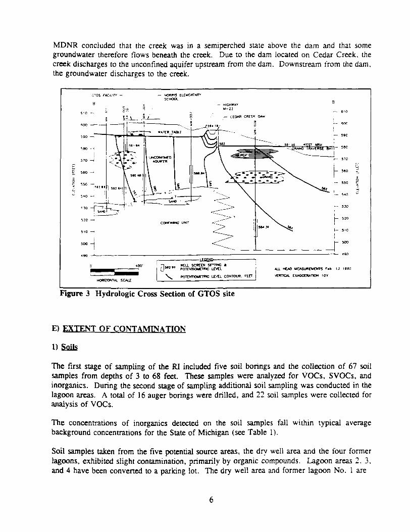
3. Hydrologic Cross Section of GTOS site 6
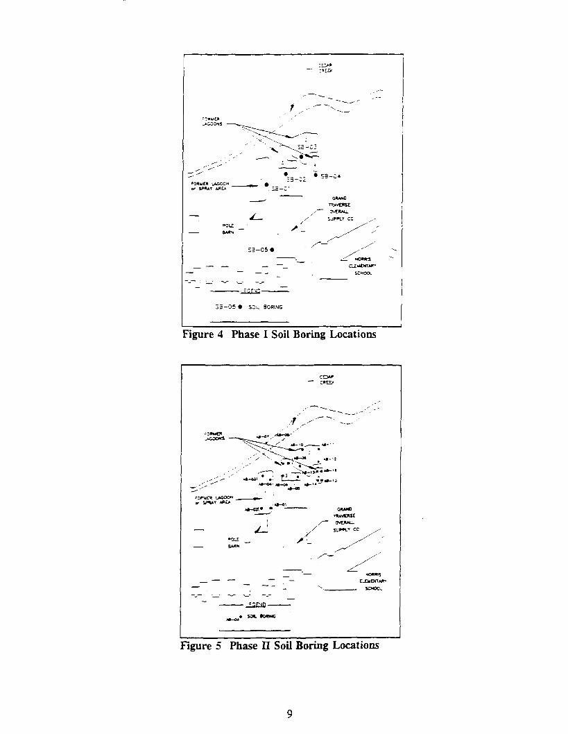
4. Phase I Soil Boring Locations 9
5. Phase II Soil Boring Locations 9
6. Stream Surface Water and Sediment Sample Locations 10
7. Monitoring Wells Locations 12
8. Residential Wells Locations 13
Tables
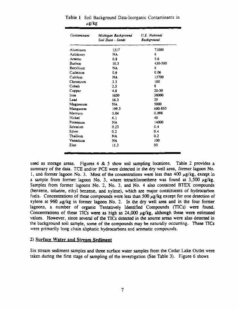
1. Soil Background Data-Inorganic Contaminants in /ig/kg 7
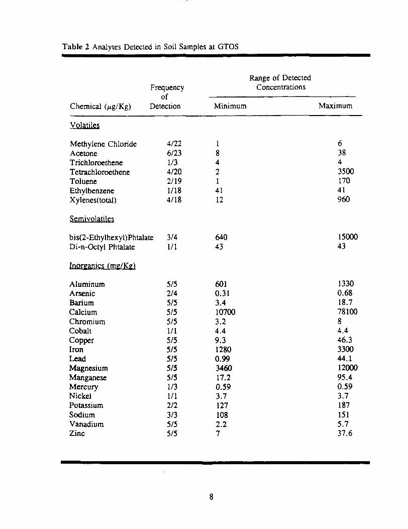
2. Analytes Detected in Soil Samples at GTOS 8
3. Organic Analytes Detected in Sediment Samples at GTOS 10
4. Analytes Detected in Groundwater Samples at GTOS 14
5. Conceptual Exposure Model of Potential Human Exposure Pathways 20
6. Summary of Noncarcinogenic Health Risks Associated with Site Worker and SiteTrespasser Exposure Scenario 22
7. Total Future Noncarcinogenic Health Risks Associated with Residential Exposure forAdults and Children 23
8. Summary of Carcinogenic Health Risks Associated with Site Worker and Site TrespasserExposure Scenario 25
GRAND TRAVERSE OVERALL SUPPLY
GREILICKVILLE, MICHIGAN
SUMMARY OF REMEDIAL ALTERNATIVE SELECTION
FEBRUARY 1992
DECISION SUMMARY
I. SITE DESCRDTTION
Grand Traverse Overall Supply Company (GTOS) site is located in Greilickville, Michigan,approximately 1-1/2 miles north of the city limits of Traverse City, Michigan (Figure 1). The3.9 acre site is in the SE 1/4 of section 28, T28N, R11W, Elmwood Township, LeelanauCounty, located just west of Highway M-22, on the north side of Cherry Bend Road and southof Cedar Creek (Figure 2).
The area surrounding the GTOS facility is primarily residential. The Norris Elementary Schoolis directly east of GTOS, and east of the school are residential homes. The Elmwood VolunteerFire Department is south of GTOS, followed by more residential homes. Residential homesborder GTOS to the west; to the north is Cedar Creek.
H. SITE HISTORY AND ENFORCEMENT ACTIVITIES
Grand Traverse Overall Supply Company performs commercial laundering for industrialclothing. The laundry facility began operations in 1953. A dry cleaning facility was added in1968. Until December 1977, the laundry wastes and process wastes from dry cleaningoperations were discharged to seepage lagoons and a dry-well on the site. Cooling water usedin dry cleaning operations was discharged to the Cedar Creek from 1968 to 1978. TheCompany began discharging its laundry and process wastes to the sanitary sewer system inDecember 1977, and the cooling water was also diverted to the sanitary sewer system beginningin 1978. Dry cleaning operations at GTOS were discontinued in 1987. The company isoperating on the site at the present, and is discharging the wastes into the sanitary sewer system.
In April 1978, traces of perchloroethene (PCE), trichloroethene (TCE), and 1,2 dichloroethene(1,2 DCE) were detected in the water supply of Norris Elementary School, located immediatelyeast of the GTOS site. The Michigan Department of Public Health condemned the school wellwater for consumption and conducted sampling of additional wells in the area. The samplingprogram confirmed the contamination of 10 drinking water wells. The GTOS site wasconsidered the likely source of the contaminants.
Remedial action was taken by GTOS under Michigan Department of Natural Resources (MDNR)supervision from 1978 to 1980. This included replacing contaminated drinking water wells withnew wells that extended into a deeper uncontaminated semi-confined aquifer, and excavating theon-site dry well and adjacent contaminated soils, with off-site disposal of excavated materials.In addition, three of the four lagoons were gravel filled, covered with asphalt, and converted toa parking lot. The fourth lagoon was backfilled and ultimately returned to a grassy area.
The MDNR performed a biological evaluation of the Cedar Creek in October-November of 1978to determine if wastewaters from the GTOS site, discharged into the lagoons and to the CedarCreek, had damaged the indigenous aquatic plant and communities in the creek. The studyconcluded that the aquatic animal community in the Cedar Creek, downstream from GTOS wasseriously degraded compared to the upstream community.
\-l TRAVERSE crrr
MICHIGAN NOT TO SCALE
Figure 1 Area Map
•--1
// -i'
GRANDTTWVtRSEOVERALL
SJPPLY CC
CEDARCREEK
DAM'• ', 'vU!
NORRISELEMENTARY .•
SCHOOL , • ,- HARBOR__^ ' WEST-\ / / MARINA
-^ ' 1 / , OFFICE
/ ^- p — WEST BAYHAM COVENANT
CHURCH
-njHARBOR WEST
MAMMA VILLAGE
~U
- -
1HARBOR WEST
UARINA
Figure 2 Site Map
The MDNR also conducted a hydrogeologic investigation of the site and surrounding area andissued a report of the investigation, in February 1981. The report concluded that the GTOS sitehad been the source of the TCE, PCE, and 1,2 DCE contamination of the shallow useableunconfined aquifer in the area.
The site was placed on the National Priorities List (NPL) in September 1983 because ofgroundwater contamination of the useable unconfined aquifer with PCE and TCE.
HI. HIGHLIGHTS OF COMMUNITY PARTICIPATION
On November 29, 1989 EPA hosted a Remedial Investigation Kick-off Meeting at the ElmwoodTownship Hall, Michigan. Approximately 30 citizens attended this meeting.
The Proposed Plan was released to the public for comment on October 15, 1991. The publiccomment period concluded November 14, 1991. The Proposed Plan provided the public withthe opportunity to request a Public Meeting to discuss the Remedial Investigation (RI) findingsand the proposed alternative.
The public participation requirements of CERCLA sections 113 (k) (2) (B) (i-v) and 117 havebeen met in the remedy selection process. This decision document presents the selected remedialaction for the GTOS site, in Michigan, chosen in accordance with CERCLA, as amended bySARA and, to the extent practicable, the NPL. The decision for this site is based on theadministrative record.
IV. SCOPE & ROLE OF RESPONSE ACTION
EPA recommends that no further remedial action be taken at the GTOS site for the followingreasons. Organic compounds, found in low levels in the soils, pose no current or potentialthreat to human health or the environment. Levels of organic and inorganic compounds presentin groundwater do not appear to pose an unacceptable risk to human health or the environment.
No five year review will be undertaken, but EPA will continue the monitor the groundwater fora period of twelve months.
V. SITE CHARACTERISTICS
The RI was conducted in two stages. Stage I began November 1989 and was completed inFebruary 1990, stage II was completed in November 1990. The RI also included a RiskAssessment to evaluate the level of risk to human health and the environment. This sectionsummarizes the analysis presented in the RI report:
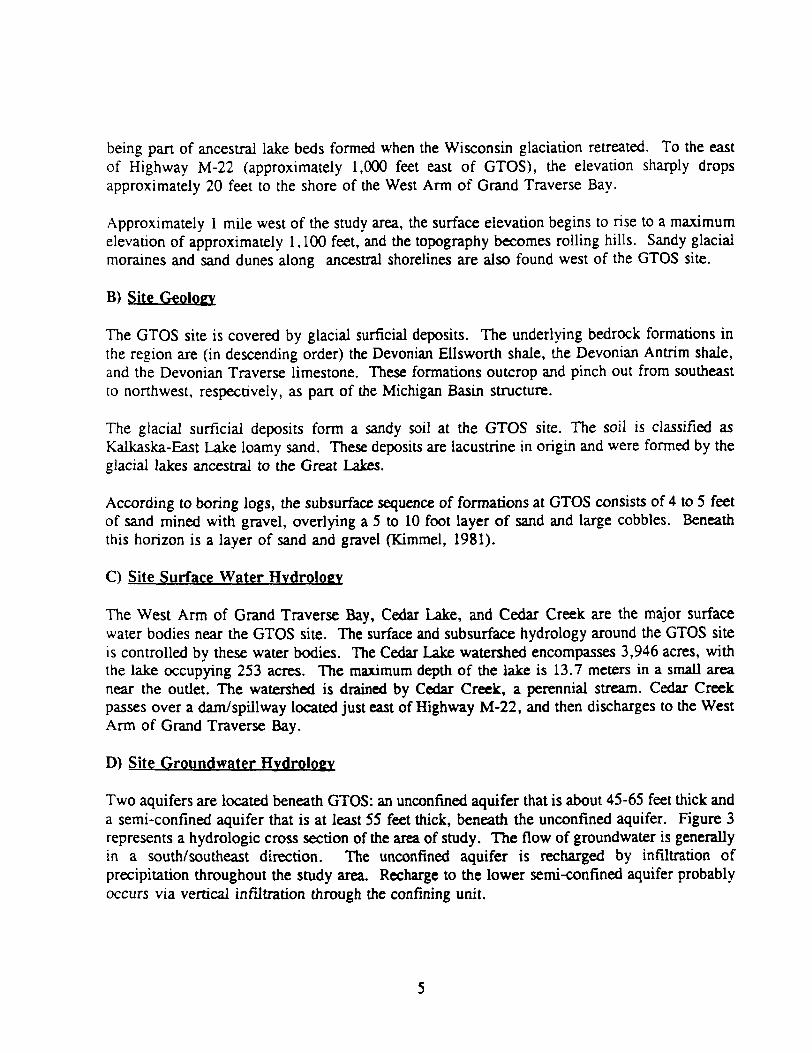
A) Site Topography
The GTOS site is located near the base of the Leelanau Peninsula. The peninsula andsurrounding area are dominated by landforms left by the Wisconsin glaciation (Martin 1957).The GTOS site is relatively flat, with an average ground surface elevation of 600 feet abovemean sea level (MSL; U.S.G.S., 1983). The relatively flat topography at the site is due to its
being part of ancestral lake beds formed when the Wisconsin glaciation retreated. To the eastof Highway M-22 (approximately 1,000 feet east of GTOS), the elevation sharply dropsapproximately 20 feet to the shore of the West Arm of Grand Traverse Bay.
Approximately 1 mile west of the study area, the surface elevation begins to rise to a maximumelevation of approximately 1,100 feet, and the topography becomes rolling hills. Sandy glacialmoraines and sand dunes along ancestral shorelines are also found west of the GTOS site.
B) Site Geology
The GTOS site is covered by glacial surficial deposits. The underlying bedrock formations inthe region are (in descending order) the Devonian Ellsworth shale, the Devonian Antrim shale,and the Devonian Traverse limestone. These formations outcrop and pinch out from southeastto northwest, respectively, as part of the Michigan Basin structure.
The glacial surficial deposits form a sandy soil at the GTOS site. The soil is classified asKalkaska-East Lake loamy sand. These deposits are lacustrine in origin and were formed by theglacial lakes ancestral to the Great Lakes.
According to boring logs, the subsurface sequence of formations at GTOS consists of 4 to 5 feetof sand mined with gravel, overlying a 5 to 10 foot layer of sand and large cobbles. Beneaththis horizon is a layer of sand and gravel (Kimmel, 1981).
C) Site Surface Water Hydrology
The West Arm of Grand Traverse Bay, Cedar Lake, and Cedar Creek are the major surfacewater bodies near the GTOS site. The surface and subsurface hydrology around the GTOS siteis controlled by these water bodies. The Cedar Lake watershed encompasses 3,946 acres, withthe lake occupying 253 acres. The maximum depth of the lake is 13.7 meters in a small areanear the outlet. The watershed is drained by Cedar Creek, a perennial stream. Cedar Creekpasses over a dam/spillway located just east of Highway M-22, and then discharges to the WestArm of Grand Traverse Bay.
D) Site Groundwater Hydrology
Two aquifers are located beneath GTOS: an unconfined aquifer that is about 45-65 feet thick anda semi-confined aquifer that is at least 55 feet thick, beneath the unconfined aquifer. Figure 3represents a hydrologic cross section of the area of study. The flow of groundwater is generallyin a south/southeast direction. The unconfined aquifer is recharged by infiltration ofprecipitation throughout the study area. Recharge to the lower semi-confined aquifer probablyoccurs via vertical infiltration through the confining unit.
MDNR concluded that the creek was in a semiperched state above the dam and that somegroundwater therefore flows beneath the creek. Due to the dam located on Cedar Creek, thecreek discharges to the unconfined aquifer upstream from the dam. Downstream from the dam.the groundwater discharges to the creek.
HORIZONTAL SCALE
-]„,-. WELL SCREEN 5CTT1MC *|M?v en*nt\irtr*j£-mr L£VtL
POTTMTXJUtTWC LEVU CONTOUR. FEET
AU. HEAD UEASUMEVCXTS f«t> u moVCWTCM. EXAGGtRATON 101
Figure 3 Hydrologic Cross Section of GTOS site
E) EXTENT OF CONTAMINATION
1)
The first stage of sampling of the RI included five soil borings and the collection of 67 soilsamples from depths of 3 to 68 feet. These samples were analyzed for VOCs, SVOCs, andinorganics. During the second stage of sampling additional soil sampling was conducted in thelagoon areas. A total of 16 auger borings were drilled, and 22 soil samples were collected foranalysis of VOCs.
The concentrations of inorganics detected on the soil samples fall within typical averagebackground concentrations for the State of Michigan (see Table 1).
Soil samples taken from the five potential source areas, the dry well area and the four formerlagoons, exhibited slight contamination, primarily by organic compounds. Lagoon areas 2. 3,and 4 have been convened to a parking lot. The dry well area and former lagoon No. 1 are
Table 1 Soil Background Data-Inorganic Contaminants in
used as storage areas. Figures 4 & 5 show soil sampling locations. Table 2 provides asummary of the data. TCE and/or PCE were detected in the dry well area, former lagoon No.1, and former lagoon No. 3. Most of the concentrations were less than 400 fig/kg, except ina sample from former lagoon No. 3, where tetrachloroethene was found at 3,500 ng/lfg.Samples from former lagoons No. 2, No. 3, and No. 4 also contained BTEX compounds(benzene, toluene, ethyl benzene, and xylene), which are major constituents of hydrocarbonfuels. Concentrations of these compounds were less than 500 /ig/kg except for one detection ofxylene at 960 /ig/kg in former lagoon No. 2. In the dry well area and in the four formerlagoons, a number of organic Tentatively Identified Compounds (TICs) were found.Concentrations of these TICs were as high as 24,000 ^g/kg, although these were estimatedvalues. However, since several of the TICs detected in the source areas were also detected inthe background soil sample, some of the compounds may be naturally occurring. These TICswere primarily long chain aliphatic hydrocarbons and aromatic compounds.
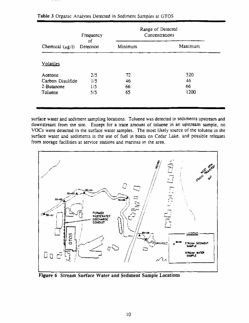
2) Surface Water and Stream Sediment
Six stream sediment samples and three surface water samples from the Cedar Lake Outlet weretaken during the first stage of sampling of the investigation (See Table 3). Figure 6 shows
Table 3 Organic Analytes Detected in Sediment Samples at GTOS
Chemical (^g/1)
Frequencyof
Detection
Range of DetectedConcentrations
Minimum Maximum
Volatiles
AcetoneCarbon Disulfide2-ButanoneToluene
2/51/51/55/5
72466665
52046661200
surface water and sediment sampling locations. Toluene was detected in sediments upstream anddownstream from the site. Except for a trace amount of toluene in an upstream sample, noVOCs were detected in the surface water samples. The most likely source of the toluene in thesurface water and sediments is the use of fuel in boats on Cedar Lake, and possible releasesfrom storage facilities at service stations and marinas in the area.
D o
Figure 6 Stream Surface Water and Sediment Sample Locations
10
3) Groundwater
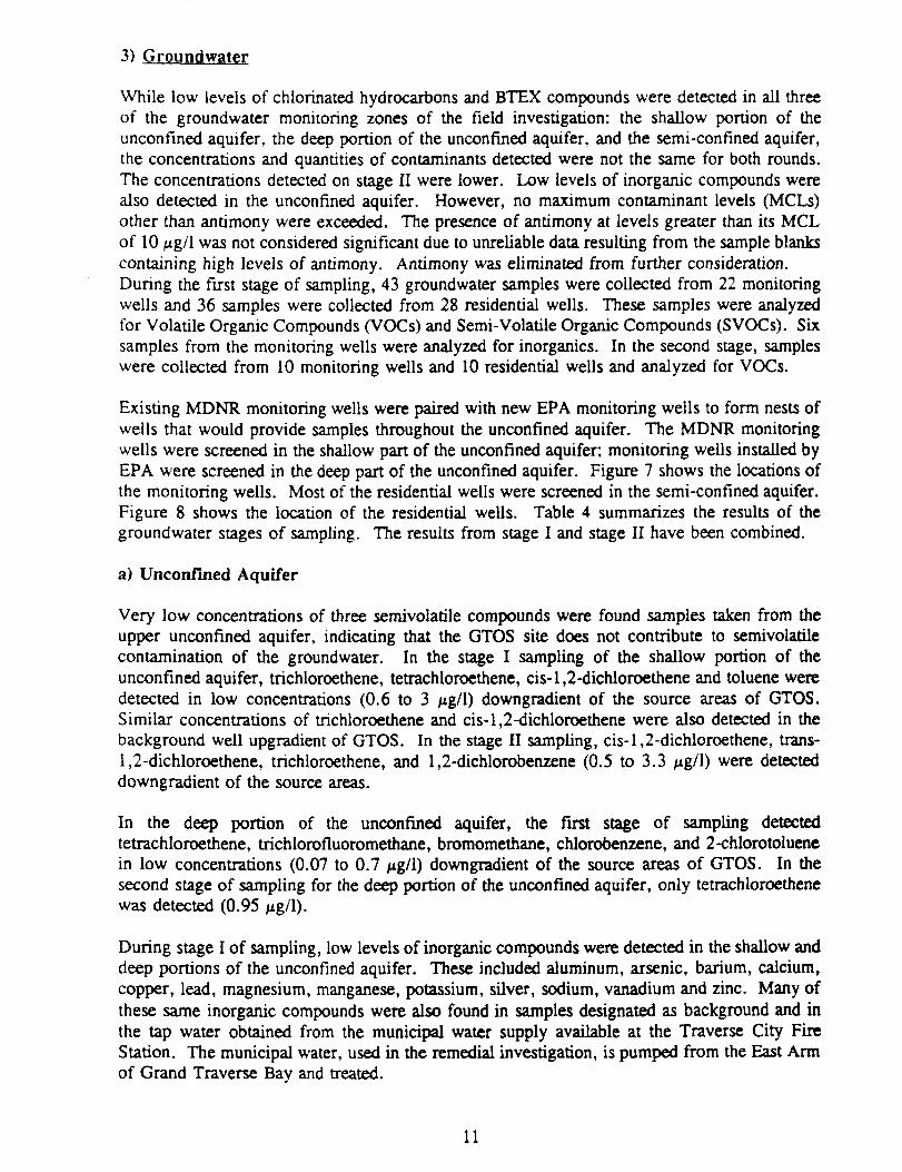
While low levels of chlorinated hydrocarbons and BTEX compounds were detected in all threeof the groundwater monitoring zones of the field investigation: the shallow portion of theunconfined aquifer, the deep portion of the unconfined aquifer, and the semi-confined aquifer,the concentrations and quantities of contaminants detected were not the same for both rounds.The concentrations detected on stage II were lower. Low levels of inorganic compounds werealso detected in the unconfined aquifer. However, no maximum contaminant levels (MCLs)other than antimony were exceeded. The presence of antimony at levels greater than its MCLof 10 ng/1 was not considered significant due to unreliable data resulting from the sample blankscontaining high levels of antimony. Antimony was eliminated from further consideration.During the first stage of sampling, 43 groundwater samples were collected from 22 monitoringwells and 36 samples were collected from 28 residential wells. These samples were analyzedfor Volatile Organic Compounds (VOCs) and Semi- Volatile Organic Compounds (SVOCs). Sixsamples from the monitoring wells were analyzed for inorganics. In the second stage, sampleswere collected from 10 monitoring wells and 10 residential wells and analyzed for VOCs.
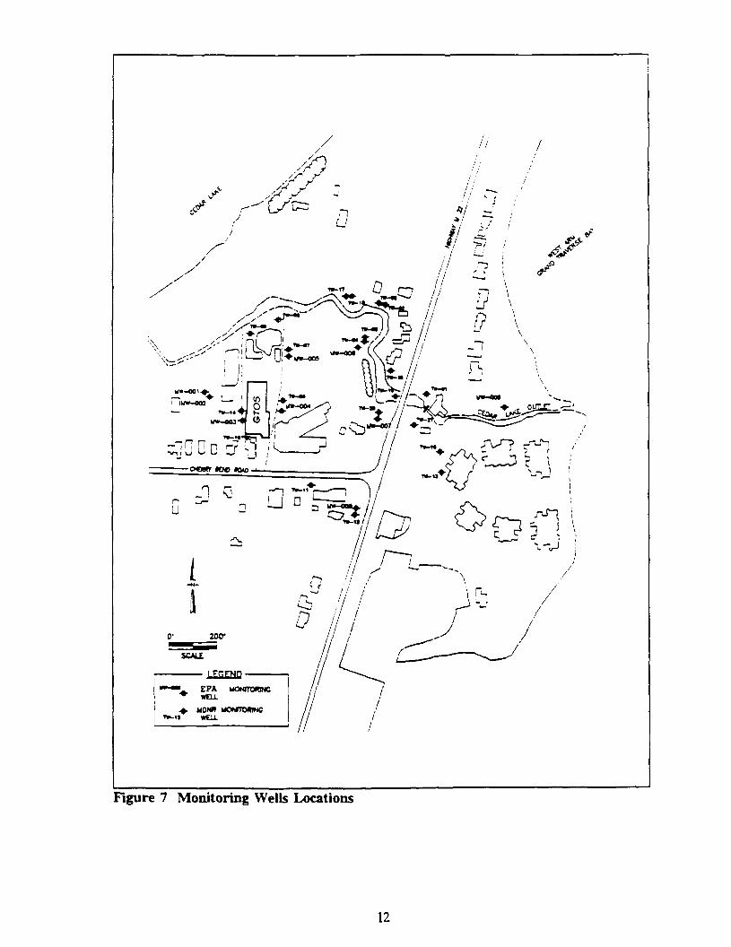
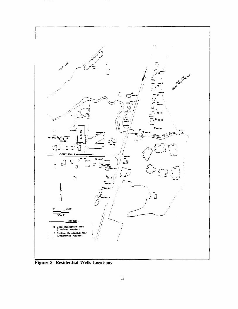
Existing MDNR monitoring wells were paired with new EPA monitoring wells to form nests ofwells that would provide samples throughout the unconfined aquifer. The MDNR monitoringwells were screened in the shallow part of the unconfined aquifer; monitoring wells installed byEPA were screened in the deep part of the unconfined aquifer. Figure 7 shows the locations ofthe monitoring wells. Most of the residential wells were screened in the semi-confined aquifer.Figure 8 shows the location of the residential wells. Table 4 summarizes the results of thegroundwater stages of sampling. The results from stage I and stage II have been combined.
a) Unconfined Aquifer
Very low concentrations of three semivolatile compounds were found samples taken from theupper unconfined aquifer, indicating that the GTOS site does not contribute to semivolatilecontamination of the groundwater. In the stage I sampling of the shallow portion of theunconfined aquifer, trichloroethene, tetrachloroethene, cis-l,2-dichloroethene and toluene weredetected in low concentrations (0.6 to 3 j*g/l) downgradient of the source areas of GTOS.Similar concentrations of trichloroethene and cis-l,2-dichloroethene were also detected in thebackground well upgradient of GTOS. In the stage II sampling, cis-l,2-dichloroethene, trans-1,2-dichloroethene, trichloroethene, and 1,2-dichlorobenzene (0.5 to 3.3 /ig/1) were detecteddowngradient of the source areas.
In the deep portion of the unconfined aquifer, the first stage of sampling detectedtetrachloroethene, trichlorofluoromethane, bromomethane, chlorobenzene, and 2-chlorotoluenein low concentrations (0.07 to 0.7 /xg/1) downgradient of the source areas of GTOS. In thesecond stage of sampling for the deep portion of the unconfined aquifer, only tetrachloroethenewas detected (0.95
During stage I of sampling, low levels of inorganic compounds were detected in the shallow anddeep portions of the unconfined aquifer. These included aluminum, arsenic, barium, calcium,copper, lead, magnesium, manganese, potassium, silver, sodium, vanadium and zinc. Many ofthese same inorganic compounds were also found in samples designated as background and inthe tap water obtained from the municipal water supply available at the Traverse City FireStation. The municipal water, used in the remedial investigation, is pumped from the East Armof Grand Traverse Bay and treated.
11
tf» 003^
-i n nSHI J O
r jrx /t5/V7 r"-«~3\
Figure 7 Monitoring Wells Locations
12
• OMB Rmacntiol W«1I(Confm«4
O Shallow R«id»nt>ol W*ll , . ,(UnconfinM *ourf«r) j //
Figure 8 Residential Wells Locations
13
Table 4 Analytes Detected in Groundwater Samples at GTOS
In the semi-confined aquifer, 33 individual compounds were detected downgradient of the GTOSsite in low concentrations (0.09 to 0.58 iig/l). The downgradient sample detected halogenatedcompounds, commonly used as solvents, and substituted aromatic compounds, commonly usedin fuels. The upgradient sample detected substituted aromatic compounds only. No VOCs weredetected in the stage II of sampling of the semi-confined aquifer.
VI. RISK ASSESSMENT
The analytical data collected during the RI indicated the presence of contaminants in variousmedia. Pursuant to the NCP, a baseline risk assessment was performed based on presentconditions at the site. The baseline risk assessment determines actual or potential risks or toxiceffects the chemical contaminants at the site pose under current and future land use assumptions.The risk assessment assumes no corrective action will take place and that no site use restrictionsor institutional controls such as fencing, groundwater use restrictions or construction restrictionswill be imposed. The baseline risk assessment included the following specific assumptions:
• Contaminated aquifers may be used as a drinking water source;
• The site may be used for residential development;
• Access restrictions such as fencing will not preclude potential trespassers fromgetting into the site; and
• No groundwater use restrictions will be enforced.
A) Contaminant Identification
The media of concern for human exposure were identified as groundwater, soil, sediment, andsurface water. A list of contaminants found at the site was developed to determine thecontaminants of concern for GTOS. Those contaminants that were reported very infrequentlyand at low concentrations were eliminated from further consideration as contaminants ofconcern. All carcinogenic contaminants were included as contaminants of concern. Thecompounds selected as contaminants of concern for the baseline risk assessment include:
Methylene ChlorideCarbon TetrachlorideBromomethaneBromodichloromethaneDibromochloromethaneBromoformCarbon Disulfide1,2-Dichloroethane1,2-Dichloroethene (cis and trans)1,1-Dichloroethene1,1,1-TrichloroethaneSilver
Analytical data gathered from the residential wells and monitoring wells sampled indicated noexceedances in groundwater of Federal MCLs for organic constituents. Among the inorganics,only antimony exceeded the MCL; however, since the sample blank was contaminated, thepresence of antimony is questionable and antimony was not selected as a contaminant of concern.
B) Exposure Assessment
Potential exposure to contaminants from the GTOS site was evaluated for the following potentialpathways or routes of exposure:
a) For site workers and site trespassers:
• Ingestion of soil
• Dermal absorption of contaminants in soils
• Incidental ingestion of sediments and surface water.
b) For residents:
• Ingestion of soil
• Ingestion of groundwater
• Dermal absorption of contaminants in soils
• Dermal absorption of contaminants in groundwater
• Inhalation of vapors from use of groundwater
• Incidental ingestion of sediments and surface water.
Q Calculation of Current and Future Risks
Current risks for receptor groups were based on concentrations of contaminants actually foundduring monitoring in and around the site. For example, current risks for trespassers and siteworkers use concentrations of contaminants found in the soil at the site during the RI. Currentrisks to residents use concentrations found in the groundwater taken from residential wells.
Potential future risks for site workers and trespassers are based on the assumption that the knowncurrent environmental concentrations remain the same. Potential future risks for residents arebased on the conservative assumptions that future concentrations of contaminants in residentialwells will be equal to the highest concentration of contaminants found in groundwater directlyunder the site, and that a residence could be built directly on the site, potentially exposing adultsand children to contaminants in the soil through direct contact.
18
D) Assumptions
Various assumptions were used for the performance of the baseline risk assessment. By meansof the exposure assessment, actual and potential exposure pathways were identified tocharacterize potentially exposed populations, and to determine the extent of exposure.Behavioral and physiological factors influencing exposure frequency and levels are presented ina series of exposure scenarios as a basis for quantifying contaminant intake levels by receptorpopulations for each identified pathway. The results of the exposure analysis are then appliedin the risk characterization. The scope of this risk assessment included an evaluation of bothcurrent and future human health and environmental risks. All the assumptions used in the riskassessment are explained in detail in the following sub-sections.
1. Exposure Pathways
The assessment of pathways by which human receptors may be exposed to contaminants fromthe GTOS site includes an examination of possible contaminant source areas and existingmigration pathways and exposure routes, as well as those that may be reasonably expected inthe future. The determination of exposure pathways is made by a careful evaluation of thecurrent extent of contamination in and around the site in relation to local land and water uses,and the results of a fate and transport assessment that evaluates contaminant migration pathways.
The site investigations performed at GTOS have confirmed the presence of low levels ofcontaminants of potential concern in soils and groundwater. The probable source of at leastsome of this contamination, the former lagoons and the dry well located on site, have beenexcavated and filled. The area has been covered in asphalt and gravel and is currently used asa parking lot.
Contaminants detected at the GTOS site may migrate off site or may persist on site. Somecontaminants of concern, such as the VOCs, are expected to be relatively mobile and may betransported from the soil to the groundwater. Once in the groundwater, these mobilecontaminants may be transported downgradient. Other chemicals, such as the inorganics andsemivolatiles, are expected to be less mobile and may remain in the source area for much longerperiods of time.
Based on the evaluation of site characteristics it was determined that groundwater is thecontaminated medium of most concern on site and the most important mode of contaminanttransport at GTOS. Fate processes, other than dispersion, volatilization, and adsorption, arepresumed to be insignificant in groundwater.
During rainy seasons, water can infiltrate contaminated soils and carry dissolved organic andinorganic compounds with it. Part of the contaminants in the leachate is adsorbed by the soilunderneath the contaminated soil zone. The other part of the contaminants, which is desorbedfrom the soil particles, continues to move downward and reaches the groundwater. However,since the former lagoon areas at the site have been filled, and the area has been covered withasphalt and gravel, percolation of rainwater through the asphalt is not expected.
19
Contaminants in the surface soil are not expected to migrate directly from the GTOS site viasurface water as the site is relatively flat and the former lagoon areas are predominantly coveredwith either asphalt or gravel.
Under current site conditions, volatilization is not expected to be significant because the asphaltand gravel cover minimizes volatilization of the subsurface contaminants, and because the sandysoils at the site are more likely to lose contaminants through the leaching process.
Groundwater is expected to discharge to surface water with a significant loss of contaminants.The distance from the site to the bay is less than 1/2 mile. As contaminated groundwatermigrates downgradient toward this discharge point, a significant loss of VOCs is expectedthrough volatilization, retardation and degradation.
Contaminants in the groundwater can volatilize to the soil pore spaces and finally reach thesurface of the soil and the surrounding air by diffusion. Volatilization from a water table aquiferis affected by depth to the water table and moisture content of the unsaturated soil column.Since the former lagoon areas have been covered with gravel and asphalt, volatilization fromgroundwater to the air is not expected to be significant.
Contaminants in groundwater which is pumped to the surface for use may volatilize directly tothe air. Contaminated groundwater used as a domestic or non domestic water supply couldresult in a significant loss of contaminants through volatilization to the atmosphere. Throughagitation, heating, or other mechanical handling, VOCs would be expected to volatilize rapidly,releasing contaminants to the atmosphere.
A conceptual exposure model for the GTOS site, which integrates and summarizes theinformation concerning source areas, contaminant migration pathways, and exposure routes intoa combination of exposure pathways is presented in Table 5. This model identifies the keypotential release mechanisms, transport media, exposure points, exposure media, exposureroutes, and receptors for each contaminated source. All potential exposure pathways andreceptors are included in this model, including some that were not quantified in the RI.
a) Risks from Soil
Site access is partially restricted by a 6 foot fence which separates the site from the adjacentschoolyard. This is not, however, expected to prevent children from entering the site.Therefore, both site workers and child trespassers were examined receptor groups under thecurrent land use scenario.
Individuals entering the site for various reasons, including work activities or trespassing, maybe exposed to contaminants by direct contact, especially during excavation activities.Contaminants in the soils may be absorbed through the skin on contact or accidentally ingestedby unintentional hand to mouth activities.
Contaminants may be adsorbed through the skin as a result of direct contact with soil. Thedegree of exposure is largely dependent on the concentration of the contaminant in the soil, theexposed skin area, the absorption rate, and the frequency of contact with soil. Exposure isexpected to occur more frequently for workers, since the workers are present at the site more
20
15-r»
De
rma
l Abso
rptio
n
C8VI
•xn
El3VI
(/;
=^aTnn
5£»rt
Z3
Z
3rt
O=5
rT
Incid
enta
l Ingcslioo/
^ .
rsno
5'
£.
C
i
•a
|C
2 vn
cLn3VI
00r>C.5'S3l
Zo3O
Z
f!
O
n
5"
n3
E.
1
n
n
5'a
~+5'23
f
fl
2^^ft)
—so3
O
rt
1 tS V
i-o'(JO =
B)
|.
?
SI
1w»
Abso
rptio
n fro
m O
r
§a.jjn
^5'ea.U
<i
Z3fl
O
3a.
*n
a
n
1w»
i.5fc
X)nQ.'r»
^
0ni
1•a.
II
"" 2"""•*
V5 i
^ 2
Z33f»
Z
3
O3
O
Incid
enta
l Soil/D
ust
3OD
I.o'3
?'
0
n.T
ng.5'
onQI3.
iV
nC.5'
oa
m
1r<
2
non•a2
— |tf3"~0
50i
ft)ft
B>3
1.
mX
n
Exposure
Media
/
S?n
—
'1 =
3 S.sr §•o srg
s "
regularly than children are. Adults are expected to receive dermal exposures primarily whileconducting grounds maintenance, excavating, or trespassing at the site. Children may beexposed to site contaminants while playing on the site grounds.
b) Risks from Groundwater
Low levels of groundwater contamination have been detected in both downgradient residentialwells and downgradient monitoring wells. The highest concentrations of contaminants found inthe residential wells were the ones used to calculate risk under a current use scenario.
The use of groundwater for showering or other general washing and bathing activities may resultin inhalation exposures to contaminants released as vapors. This is expected to be potentiallysignificant especially for the VOCs present in the aquifer. In addition, these same activitiesresult in either whole or partial body contact with contaminated water, potentially resulting inabsorption of contaminants through the skin.
The detailed quantification of exposures included analysis of water ingestion, inhalation, and skinabsorption. The current extent of exposure to residents by these pathways is low.
2. Receptors and Quantification of Cherniral Intakes
The key receptor groups include the site worker, the child trespasser, and current and potentialfuture residents. Young children (0-6 years old) were chosen for evaluation based on their smallbody size and increased sensitivity to contaminant exposure. Adults were also chosen forevaluation, since certain exposures that would not be expected to result in adverse effects overthe short term may result in potential problems after long term (chronic) exposure.
Estimated daily intakes of the selected contaminants of potential concern are calculated for eachof the exposed individuals identified for each exposure pathway. Daily intakes are calculatedseparately for carcinogenic and non-carcinogenic effects in accordance with methodologypresented by EPA. Daily intakes for residential receptors are calculated separately for both achild and an adult.
The degree of exposure via each pathway is determined by behavioral, chemical, andphysiological factors. Behavioral factors include the amount of time spent in contact with thecontaminants in soil and water. Chemical factors affecting the degree of exposure relate to thetendency for a compound to be absorbed through the skin and the tendency for a chemical tobioaccumulate, as well as the physical state of a chemical in the environment (e.g., solubilizedin water). Physiological parameters such as the condition of the skin (i.e., degree of hydrationand skin breaks) and the ability of the body to metabolize and eliminate the contaminants alsodetermine the amount and type of exposure that may occur.
D) Risk Characterization
The non-carcinogenic and carcinogenic health risks associated with each of the pathways andpotential receptors listed above have been evaluated. Basic toxicity information used to calculaterisk was derived from the Integrated Risk Information System (IRIS) and the Health EffectsAssessment Summary Tables (HEAST).
21
1. Non-carcinogenic Health Risks
Reference doses (RfDs) are daily exposure levels for humans, including sensitive individuals,which have been developed by EPA for estimating the potential for adverse health effects fromexposure to chemicals exhibiting non-carcinogenic effects. RfDs are expressed in units ofmg/kg-day and are calculated for daily exposure over a lifetime. Estimates of actual intakes ofchemicals from environmental media (e.g., the amount of a chemical ingested from contaminateddrinking water) can be compared to the RfD. RfDs are derived from human epidemiologicalstudies or animal studies to which uncertainty factors have been applied (e.g., to account for theuse of animal data to predict effects on humans). These uncertainty factors help ensure that theRfDs will not underestimate the potential for adverse non-carcinogenic effects to occur.Potential concern for non-carcinogenic effects of a single contaminant in a single medium isexpressed as the hazard quotient (HQ) (or the ratio of the estimated intake derived from thecontaminant concentration in a given medium compared to the contaminant's RfD). By addingthe HQs for all contaminants within a medium or across all media to which a given populationmay reasonably be exposed, the Hazard Index (HI) can be generated. The HI provides a usefulreference point for gauging the potential significance of multiple contaminant exposures withina single medium or across media. Any HI value greater than 1.0 suggests that a non-carcinogenpotentially presents an unacceptable health risk.
a) Noncarcinogenic Risks for Site Worker and Site Trespasser
The non-carcinogenic risks due to inorganic and organic contaminants associated with siteworker and child trespasser exposures are summarized in Table 6. Current and future risks forsite worker and child trespasser exposures were calculated by assuming that future concentrationsof contaminants will be about the same as current levels. The total His for the site worker rangefrom 0.018 to 0.0026. The total His for the child trespasser range from 0.044 to 0.007. (TotalHis are calculated by adding the RME inorganic to the RME organic, or by adding the RAEinorganic to the RAE organic). Since all pathway specific and total non-carcinogenic His areless than one, no significant non-carcinogenic health threat is expected.
Table 6 Summary of Noncarcinogenic Health RisksAssociated with Site Worker and Site TrespasserExposure Scenario
Inorganic OrganicRME* RAE" RME RAE
Site Worker 0.00820.0018 0.00960.0008
SiteTrespasser 0.024 0.0054 0.02 0.0016(Child)
* RME - Reasonable Maximum Exposure** RAE - Representative Average Exposure
22
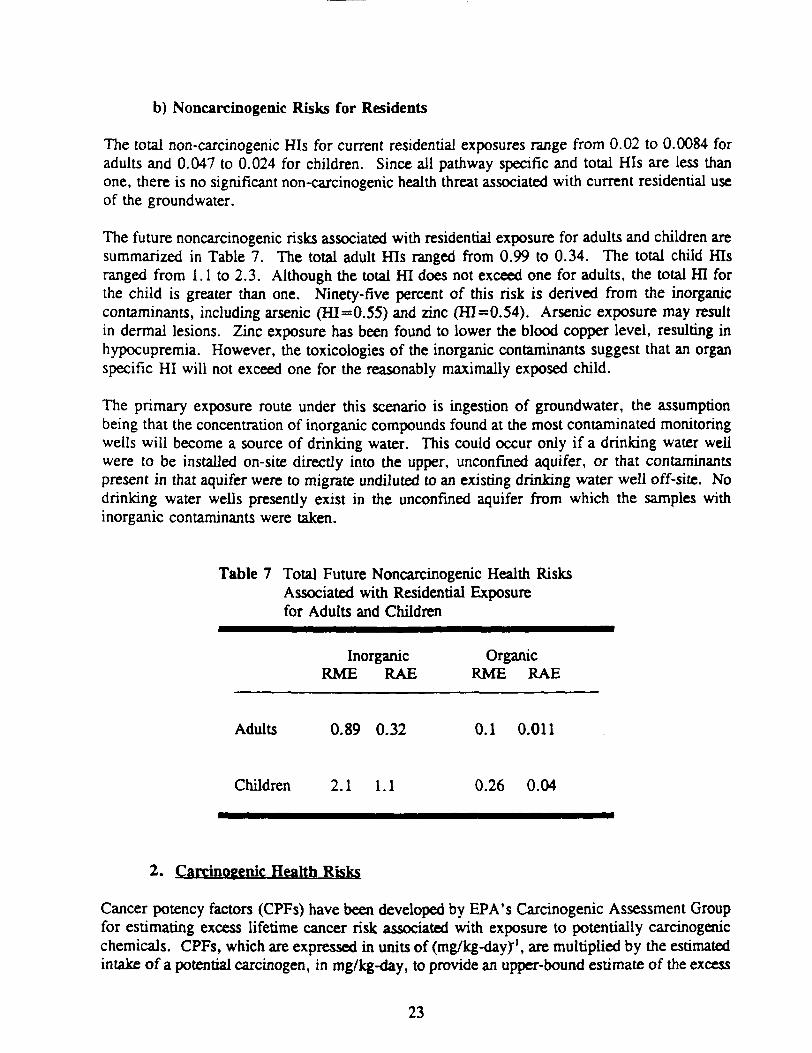
b) Noncarcinogenic Risks for Residents
The total non-carcinogenic His for current residential exposures range from 0.02 to 0.0084 foradults and 0.047 to 0.024 for children. Since all pathway specific and total His are less thanone, there is no significant non-carcinogenic health threat associated with current residential useof the groundwater.
The future noncarcinogenic risks associated with residential exposure for adults and children aresummarized in Table 7. The total adult His ranged from 0.99 to 0.34. The total child Hisranged from 1.1 to 2.3. Although the total HI does not exceed one for adults, the total HI forthe child is greater than one. Ninety-five percent of this risk is derived from the inorganiccontaminants, including arsenic (ffl=0.55) and zinc (HI=0.54). Arsenic exposure may resultin dermal lesions. Zinc exposure has been found to lower the blood copper level, resulting inhypocupremia. However, the toxicologies of the inorganic contaminants suggest that an organspecific HI will not exceed one for the reasonably maximally exposed child.
The primary exposure route under this scenario is ingestion of groundwater, the assumptionbeing that the concentration of inorganic compounds found at the most contaminated monitoringwells will become a source of drinking water. This could occur only if a drinking water wellwere to be installed on-site directly into the upper, unconfined aquifer, or that contaminantspresent in that aquifer were to migrate undiluted to an existing drinking water well off-site. Nodrinking water wells presently exist in the unconfined aquifer from which the samples withinorganic contaminants were taken.
Table 7 Total Future Noncarcinogenic Health RisksAssociated with Residential Exposurefor Adults and Children
Inorganic OrganicRME RAE RME RAE
Adults 0.89 0.32 0.1 0.011
Children 2.1 1.1 0.26 0.04
2. Carcinogenic Health Risks
Cancer potency factors (CPFs) have been developed by EPA's Carcinogenic Assessment Groupfor estimating excess lifetime cancer risk associated with exposure to potentially carcinogenicchemicals. CPFs, which are expressed in units of (mg/kg-dayX1, are multiplied by the estimatedintake of a potential carcinogen, in mg/kg-day, to provide an upper-bound estimate of the excess
23
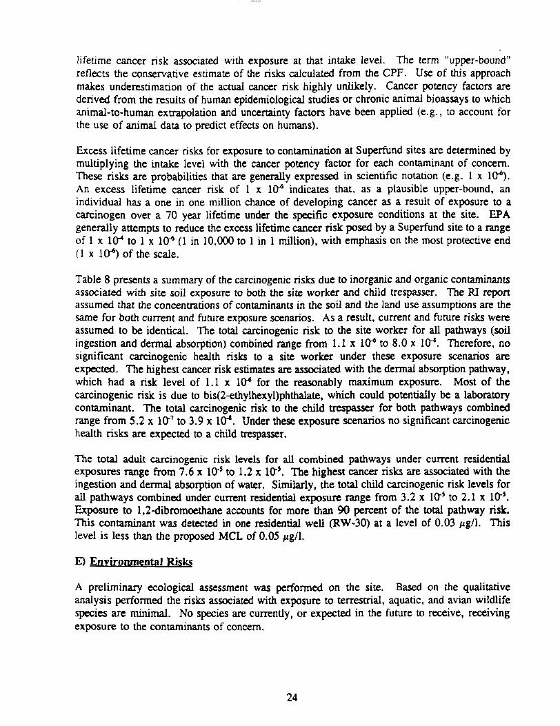
lifetime cancer risk associated with exposure at that intake level. The term "upper-bound"reflects the conservative estimate of the risks calculated from the CPF. Use of this approachmakes underestimation of the actual cancer risk highly unlikely. Cancer potency factors arederived from the results of human epidemiological studies or chronic animal bioassays to whichanimal-to-human extrapolation and uncertainty factors have been applied (e.g., to account forthe use of animal data to predict effects on humans).
Excess lifetime cancer risks for exposure to contamination at Superfund sites are determined bymultiplying the intake level with the cancer potency factor for each contaminant of concern.These risks are probabilities that are generally expressed in scientific notation (e.g. 1 x 10*).An excess lifetime cancer risk of 1 x 10* indicates that, as a plausible upper-bound, anindividual has a one in one million chance of developing cancer as a result of exposure to acarcinogen over a 70 year lifetime under the specific exposure conditions at the site. EPAgenerally attempts to reduce the excess lifetime cancer risk posed by a Superfund site to a rangeof 1 x 1CT* to 1 x 10"6 (1 in 10,000 to 1 in 1 million), with emphasis on the most protective end(1 x 10-*) of the scale.
Table 8 presents a summary of the carcinogenic risks due to inorganic and organic contaminantsassociated with site soil exposure to both the site worker and child trespasser. The RI reportassumed that the concentrations of contaminants in the soil and the land use assumptions are thesame for both current and future exposure scenarios. As a result, current and future risks wereassumed to be identical. The total carcinogenic risk to the site worker for all pathways (soilingestion and dermal absorption) combined range from 1.1 x 10* to 8.0 x 10~*. Therefore, nosignificant carcinogenic health risks to a site worker under these exposure scenarios areexpected. The highest cancer risk estimates are associated with the dermal absorption pathway,which had a risk level of 1.1 x 10* for the reasonably maximum exposure. Most of thecarcinogenic risk is due to bis(2-ethylhexyl)phthalate, which could potentially be a laboratorycontaminant. The total carcinogenic risk to the child trespasser for both pathways combinedrange from 5.2 x 10"7 to 3.9 x 10⁴. Under these exposure scenarios no significant carcinogenichealth risks are expected to a child trespasser.
The total adult carcinogenic risk levels for all combined pathways under current residentialexposures range from 7.6 x 10~5 to 1.2 x 10~s. The highest cancer risks are associated with theingestion and dermal absorption of water. Similarly, the total child carcinogenic risk levels forall pathways combined under current residential exposure range from 3.2 x 10~5 to 2.1 x Ifr5.Exposure to 1,2-dibromoethane accounts for more than 90 percent of the total pathway risk.This contaminant was detected in one residential well (RW-30) at a level of 0.03 /zg/1. Thislevel is less than the proposed MCL of 0.05 /zg/1.
E) Environmental Risks
A preliminary ecological assessment was performed on the site. Based on the qualitativeanalysis performed the risks associated with exposure to terrestrial, aquatic, and avian wildlifespecies are minimal. No species are currently, or expected in the future to receive, receivingexposure to the contaminants of concern.
24
Table 8 Summary of Carcinogenic Health RisksAssociated with Site Worker and Site TrespasserExposure Scenario
Inorganic OrganicRME RAE RME RAE
Site Worker NA NA l.lxlO6 8.0x10'*
SiteTrespasser NA NA 5.2xlO'7 3.9xlO'8
(Child)
NA - Not Applicable
F) Risk Summary
Based on the results of the Baseline Risk Assessment performed at the GTOS Site, EPA hasdetermined that conditions at the site due to organic compounds pose no significant current orfuture risk to human health or the environment. The GTOS site does appear to exhibit traceamounts of inorganic contamination which results in slightly elevated calculations of potentialfuture risk. The potential future risks discussed in the risk assessment are associated withingestion of drinking water contaminated with inorganic compounds, particularly arsenic andzinc. Under this exposure scenario, the child future use, the HI would exceed one. The Hisranged from a RAE of 1.1 to a RME of 2.1.
It is important to note that the analysis performed is very conservative and that no contaminantlevels detected in any of the monitoring wells or residential wells exceeded MCLs. The RiskAssessment assumes that the inorganic compound concentrations found in the groundwater willeventually reach residential wells without dilution. This assumption is considered unlikely, asthe inorganic contamination was found primarily in the unconfined upper aquifer and all drinkingwater wells are currently in the semi-confined aquifer. Theoretically, the detected levels ofinorganics could be the result of background contamination.
EPA makes risk management decisions based on a number of different factors, taking intoconsideration specific site-related information as well as standardized methodologies forcalculating exposure and overall risk probability. In this case, EPA has determined that the levelof inorganic contamination present at the GTOS site does not appear to pose an unacceptablehealth risk to the public.
While EPA has determined that conditions at the site do not warrant further remedial action,EPA will continue to monitor the groundwater for a period of twelve months.
25
VII. EXPLANATION OF SIGNIFICANT CHANGES
There are no significant changes from the recommended alternative described in the proposedplan.
Vm. STATUTORY AUTHORITY FINDING
EPA has determined that conditions at the site due to contamination by organic compounds poseno current or potential threat to human health or the environment. While the GTOS site doesappear to exhibit trace amounts of inorganic contamination which result in slightly elevatedcalculations of potential future risk, EPA has also determined that the presence of thesecompounds does not appear to pose an unacceptable risk to human health or the environment.Accordingly, no further remedial action will be undertaken. EPA will, however, continue tomonitor the inorganic contaminants in the groundwater for a period of twelve months.
As this is a decision for "No Action", the statutory requirements of CERCLA Section 121 forremedial actions are not applicable and no five year review will be undertaken.
26
RESPONSIVENESS SUMMARY
This Responsiveness Summary has been prepared to meet the requirements of Sections 113(k)(2)(B)(iv) and 117 (b) of the Comprehensive Environmental Response. Compensation, andLiability Act of 1980. as amended by the Superfund Amendments and Reauthorization Act of1986 (CERCLA), which requires the United States Environmental Protection Agency (EPA) torespond "...to each of the significant comments, criticisms, and new data submitted in writtenor oral presentations" on a proposed plan for remedial action. This Responsiveness Summaryaddresses concerns expressed by the public and the State of Michigan in the written and oralcomments received by EPA regarding the proposed action for the Grand Traverse OverallSupply (GTOS) site.
A. OVERVIEW
I. BACKGROUND/PROPOSED PLAN
The GTOS site is a 3.9 acre operating laundry facility located in Greilickville,Michigan, approximately 1-1/2 miles north of the city limits of Traverse City,Michigan. The laundry facility is located in a primarily residential area. TheRemedial Investigation (RT) was performed to determine the nature and extent ofcontamination at the Site.
II. PUBLIC COMMENT PERIOD
A public comment period was held from October 15, 1991 to November 14,1991, to allow interested parties to comment on the proposed plan, in accordancewith Section 117 of CERCLA. The proposed plan provided the public theopportunity to request a public meeting. A public meeting would be held if thethere was significant public interest. During the public comment period only oneresident requested a public meeting. EPA contacted this resident and answeredhis concerns regarding the site. During the comment period EPA received oneletter with written comments from a resident concerning the proposed plan anda letter with written comments from the State of Michigan requesting a publicmeeting.
B. COMMUNITY INVOLVEMENT
The level of public interest regarding the site has fluctuated over time. In 1989,when EPA hosted the Remedial Investigation kick-off meeting at the ElmwoodTownship Hall in Michigan, a group of 40 to 50 people attended the meeting.Most of those that attended were concerned about the site. GTOS managementmade a presentation that received a hostile reaction from the residents present.When the proposed plan was released for public comment, EPA provided thecommunity with the opportunity to review the plan and request a public meeting
A-l
to discuss the results of the investigation and any concerns on EPA's proposedaction. Two requests were received, one from a resident and one from the Stateof Michigan. EPA determined there was insufficient community interest for apublic meeting consequently; no public meeting was held for the site. Theconcerns presented by the State of Michigan and the residents have beenaddressed in the following section.
C. SUMMARY OF SIGNIFICANT COMMENTS
The public comments regarding the GTOS site are organized into the followingcategories:
• Summary of comments from the local community regarding theproposed plan;
• Summary of comments from MDNR concerning the RemedialInvestigation (RI) and the proposed plan.
I. SUMMARY OF COMMUNITY COMMENTS
One comment letter concerning the proposed plan was received from thecommunity and is addressed below:
Comment 1
What is meant by the final paragraph on page 1 of the fact sheet that reads. "Laundry waste wasdischarged into a seepage lagoon beginning in 1955..."
Response J
GTOS constructed four seepage lagoons in the back of the facility to receive the dischargedlaundry and dry cleaning waste. The first lagoon was constructed and became operational in1955. Three more lagoons were constructed between 1961 - 1968 and received waste until1977. These lagoons were filled with gravel and covered with asphalt in 1979. Refer to theROD for details (see page 1).
Comment 2
What is meant by line 5, paragraph 1, of the cover letter that reads, "Contaminants found arenot related to GTOS."
A-2
Response 2
During the Remedial Investigation. EPA found low levels of inorganic chemical compounds inthe upper unconfined aquifer. These contaminants probably cannot be attributed to GTOS. Seeresponse 4.
Comment 3
What is meant by the last sentence on paragraph 3 of the cover letter that reads. "PCE. TCE,and 1,2 DCE by-products of the dry cleaning business."
Response 3
TCE is a compound that is the main component in the solvents used for dry cleaning operations.PCE is an impurity commonly found in these solvents because TCE is derived from PCE, and1,2 DCE is a degradation product from TCE.
Comment 4
The commenter stated that EPA is inferring that the contamination came from a residence bystating it was "not related to GTOS".
Response 4
EPA did not mean to infer that the contamination found at GTOS came from residences in thearea. EPA has stated that, while the organic contamination found can be attributed to GTOS,the inorganic (metals) contamination probably cannot be attributed to GTOS. The source of thelow level inorganic contamination is not known.
II. SUMMARY OF MDNR COMMENTS
MDNR submitted written comments on the RI and the proposed plan. Thecomments are addressed below:
Comment 1
MDNR states that, "A more thorough investigation of the soils needs to be performed todetermine the full extent of the soil contamination. Depdi of soil sampling was too limited,especially in the phase II sampling work. Also, sampling locations should have been expandedto areas further away from the former waste lagoons to account for possible overflows andspillages."
A-3
Response 1
EPA disagrees and believes that the soil investigation for GTOS was more than thorough.During the stage I of the investigation, reviewed and approved by MDNR, 67 soil samples werecollected at depths varying from 3 to 68 feet deep. The stage II of soil sampling was designedby EPA and MDNR specifically to satisfy MDNR concerns with potential subsurface soilcontamination. This design participation is documented in the MDNR quarterly progress reportdated November 14, 1990. Since MDNR participated in the design of the sampling plan, EPAis unable to understand their current concerns. During the stage II, 22 additional soil samples,collected at 3.5 to 5 foot deep in the four former lagoon areas were obtained to furthercharacterize the source areas. All sampling at the site was performed in accordance with theapproved work plans.
Comment 2
MDNR states that, "Due to the lack of adequate soil sampling, it is not possible to make a wellinformed decision on whether source control measures should be implemented at the site. TheMDNR believes it is probable that contamination sources still exist because no excavation ofcontaminated lagoon soils was ever performed. Simply backfilling the lagoons with gravel andturning the area into a parking lot may not be an acceptable source control under MDNRstandards."
Response j
As stated in response 1, EPA believes that the soil sampling at GTOS was more than adequateand that the information collected is sufficient to make a well informed decision. The levels ofcontamination found during the extensive sampling of the lagoon areas were very low. Theconservative risk calculations performed indicated that no significant health or environmentalrisks are posed by the lagoon areas.
EPA reminds MDNR that the removal actions referred to in comment 2 were performed by thepotentially responsible party (PRP) under MDNR's supervision in 1979. Apparently MDNRfound the excavation of the dry well and consequent backfilling of the lagoons to be an"acceptable source control under MDNR standards" at that time. Please refer to Response 6 formore discussion of MDNR standards.
Comment 3
MDNR states that the data used to determine soil background was collected from a location tooclose to the facility, in an area that could have been affected by past activities at the facility.The MDNR states that it not accept this data as representative of background, nor accept thereferences made to United States regional data generally describing ranges of inorganicconcentrations in soils. MDNR believes that comparisons for background purposes should bemade on site specific area sampling.
A-4
Response 3
EPA believes that the data used for background is appropriate. The background comparisonswere based on site specific area samples, Michigan soils data, and United States soils regionaldata. The presence of volatile and semi-volatile tentatively identified compounds can beattributed to anthropogenic sources. The facility operates in a commercial/residential area andas such, is subject to anthropogenic sources, such as cars, trucks, and other equipment. Thesesources influence the environment and can not be eliminated from consideration. Environmentconditions such as these may be accepted as "natural" background.
Comment 4
MDNR states that a large percentage of the analytical data appears to be of questionable valuebecause it is coded with unfavorable quality assurance notations and a significant number ofparameters were frequently detected in field, trip, and method blanks used in the investigation.
Response 4
All data gathered and analyzed during a remedial investigation under the Superfund programmust comply with a Quality Assurance Project Plan (QAPP) which establishes a high standardof data quality. The data used to evaluate action at the GTOS site was subjected to QAPPrequirements which also demand that data be validated by EPA's Central Regional Laboratory.Data that did not meet established standards were not used in the evaluation.
Comment 5
MDNR states that, although the RI states that groundwater flows into the Cedar Lake Outletbelow the dam, no surface water samples were collected below the dam. In addition, nobiological assessments were conducted on the outlet downstream of the facility.
Response 5
Since such low concentrations of contaminants were found in the groundwater, there is no reasonto believe that any higher concentrations of contaminants would be present in the surface waterbelow the dam. The quantitative ecological assessment performed during the RI indicated thatthe levels of contaminants in the outlet are too low to cause stress to the biota in the stream.
Comment 6
MDNR states that, although the proposed plan states no contaminant concentrations weredetected above federal standards, levels of tetrachloroethene were detected above Michigan'sEnvironmental Response Act (1982 P.A. 307, as amended) health based criteria in bothgroundwater and soils and asks why this information was not included in the proposed plan. The
A-5
MDNR also asks how, under CERCLA, EPA can not consider a contaminant detected abovehealth based risk levels established by the State.
Response 6
A risk assessment at a Federal lead Superfund site is performed in accordance with Federal riskassessment guidelines. The risk assessment performed at the GTOS site determined thatcontamination at the site does not appear to pose an unacceptable risk to human health or theenvironment now or in the future. No contaminant levels above Federal MCLs were detected.When there are no unacceptable risks at a site and no further action is taken. State ARARs, suchas Michigan Act 307, are not triggered.
A no action determination by EPA does not, however, preclude other agencies or programs fromtaking actions they have determined are necessary at a site. EPA encourages the State toperform any additional studies at the site they may think are necessary or take the actions thatare appropriate under the Michigan Act 307 program.
Comment 7
MDNR states that data from previous investigations in 1979, 1981 and 1987 is not included inthe risk assessment. The unreported data would fill data gaps in the trend of groundwaterconcentration changes over time. No justification was given for not considering these reports.At a minimum, this data should have been evaluated qualitatively in the risk assessment.
Response 7
As stated in Response 4, data gathered and analyzed during a remedial investigation under theSuperfund program must comply with a QAPP which establishes a high standard of data qualityand be validated by the CLP. Since the collection of data from these investigations did notfollow these procedures, it could not be used in the risk calculations.
Comment 8
The Endangerment Assessment Handbook (EPA, 1985) and the Superfund Public HealthEvaluation Manual should not have been used as guidance documents according to the RiskAssessment Guidance for Superfund: Volume I - Human Health Evaluation Manual (EPA,1989).
Response 8
The methods used for conducting the risk assessment are those presented in the Risk AssessmentGuidance for Superfund Volumes I & II. The other two documents mentioned were only usedas supplemental information sources.
A-6
Comment 9
Adequate background locations for groundwater sampling were not established because theupgradient groundwater samples show contamination with site related chlorinated solvents.
Response 9
EPA disagrees and, based on the hydrogeologic data from the site, believes that the backgroundlocations for groundwater sampling are adequate. The fact that wells placed upgradient to thesite contained low levels of contaminants does not mean that the wells were improperly placed.The purpose of the wells was to assess the existing condition of the groundwater in an area notimpacted by the site.
Comment 10
The MDNR disagrees with the elimination of the soil-to-groundwater pathway as a potentialexposure pathway for current and future land use scenarios. The gravel covering the formerlagoons is insufficient to prevent migration of contaminants from soil to groundwater.
Response 10
The soil to groundwater pathway was eliminated from the calculations in the risk assessmentbecause its contribution is minimal compared to the other pathways. As stated in the RI thelagoon areas are not only covered with gravel, but asphalt as well. The percolation in this casewill be minimal.
A-7
=age NO.31/15/91
F1CHE/FRAME PAGES DATE TITLE
ADMINISTRATIVE RECORD INDEXGRAND TRAVERSE OVERALL SUPPLY
CREILICKVILLE, MICHIGAN
AUTHOR R E C I P I E N T
FINAL
DOCUMENT TYPE OOOB>
36/03/12 -etter re: USEPA hasdocument eo the re lets*or threatened releaseof harzaroous suostances
Constantelos, B.C.,U.S. EPA
Correspondence
89/06/16 Letter re: DrillingMethodSelection at GrandTraverseOverall Suoply Company(GTOS)Doe. Control NO. 5001-21-OOH-AAPL
Bennett, R., Weston,
Inc.
Lavis.B.,U.S. EPA Correspondence
39/11/27 Letter re: Amenanents to Brod, R., Ue«tonGTOS Saopling andAnalysisPlan (Attach.) Doc.Control No.4500-01-ABCS
Lavis.B., U.S. EPA Correspondence
22 90/01/08 Letter re:to 6TOS Saopting andAnalysis Plan GrandTraverse OverallSupply (Document ControlNo.4500-01-ABGL)
Brod.C., Ue»ton Lavia, B., U.S. EPA Correspondence
10 79/02/00 Water Quality Division MOMDM Biological Evaluationof the Cedar Lake Outlet
Traverse City, HI
U.S. EPA Other
13 87/06/17 Sit* Health I SafetyPlan form
Dresser i Mckee.lnc. U.S. EPA Other
89/01/04 Fax re: unreviewedGround Water t Soildata, and a copy ofthe "Chain of Custody"
Young, R., Ueaton,Inc.
U.S. EPA Other
-age NO.
01/16/9iADMINISTRATIVE RECORD INDEXGRAND TRAVERSE OVERALL SUPPLY
GREILICKVILLE, MICHIGAN
FICHE/FRAHE PAGES DATE TITLE AUTHOR RECIPIENT DOCUMENT TYPE OOCWJM:
"4/11/18 Report of »n Industrial MDNRUaatewater SurveyConducted st GrandTraverseOverall Supply Company