159
EPA/ROD/R04-99/050 1999 EPA Superfund Record of Decision: ABERDEEN PESTICIDE DUMPS EPA ID: NCD980843346 OU 05 ABERDEEN, NC 06/04/1999
EPA/ROD/R04-99/0501999
EPA Superfund
Record of Decision:
ABERDEEN PESTICIDE DUMPSEPA ID: NCD980843346OU 05ABERDEEN, NC06/04/1999
RECORD OF DECISION
ABERDEEN PESTICIDE DUMPS SITE
OPERABLE UNIT 5McIver Dump and Route 211 Areas
June 1999
UNITED STATES ENVIRONMENTAL PROTECTION AGENCYREGION 4
ATLANTA, GEORGIA
RECORD OF DECISION
ABERDEEN PESTICIDE DUMPS SITE
OPERABLE UNIT 5McIver Dump and Route 211 Areas
June1999
UNITED STATES ENVIRONMENTAL PROTECTION AGENCYREGION 4
ATLANTA, GEORGIA
TABLE OF CONTENTS
Description Page
DECLARATION FOR THE RECORD OF DECISION . . . . . . . . . . . . . . . . . . . . . . . . . . . . . . i
DECISION SUMMARY . . . . . . . . . . . . . . . . . . . . . . . . . . . . . . . . . . . . . . . . . . . . . . . . . . . . . . 1
1.0 SITE NAME, LOCATION, AND DESCRIPTION . . . . . . . . . . . . . . . . . . . . . . . . . . . . 11.1 McIver Dump Area . . . . . . . . . . . . . . . . . . . . . . . . . . . . . . . . . . . . . . . . . . . . . . 11.2 Route 211 Area . . . . . . . . . . . . . . . . . . . . . . . . . . . . . . . . . . . . . . . . . . . . . . . . . 3
2.0 SITE HISTORY AND ENFORCEMENT ACTIVITIES . . . . . . . . . . . . . . . . . . . . . . . . 3
3.0 COMMUNITY PARTICIPATION HIGHLIGHTS . . . . . . . . . . . . . . . . . . . . . . . . . . . . 4
4.0 SCOPE AND ROLE OF RESPONSE ACTION . . . . . . . . . . . . . . . . . . . . . . . . . . . . . . 4
5.0 SUMMARY OF SITE CHARACTERISTICS . . . . . . . . . . . . . . . . . . . . . . . . . . . . . . . . 55.1 Topography and Surface Drainage . . . . . . . . . . . . . . . . . . . . . . . . . . . . . . . . . . . 5
5.1.1 McIver Dump Area . . . . . . . . . . . . . . . . . . . . . . . . . . . . . . . . . . . . . . . . . 55.1.2 Route 211 Area . . . . . . . . . . . . . . . . . . . . . . . . . . . . . . . . . . . . . . . . . . . 5
5.2 Geology . . . . . . . . . . . . . . . . . . . . . . . . . . . . . . . . . . . . . . . . . . . . . . . . . . . . . . . 85.2.1 McIver Dump Area . . . . . . . . . . . . . . . . . . . . . . . . . . . . . . . . . . . . . . . . . 85.2.2 Route 211 Area . . . . . . . . . . . . . . . . . . . . . . . . . . . . . . . . . . . . . . . . . . . 8
5.3 Hydrogeology . . . . . . . . . . . . . . . . . . . . . . . . . . . . . . . . . . . . . . . . . . . . . . . . . . 95.3.1 McIver Dump Area . . . . . . . . . . . . . . . . . . . . . . . . . . . . . . . . . . . . . . . . . 95.3.2 Route 211 Area . . . . . . . . . . . . . . . . . . . . . . . . . . . . . . . . . . . . . . . . . . 11
5.4 Nature and Extent of Contamination Overview . . . . . . . . . . . . . . . . . . . . . . . . . 155.4.1 McIver Dump Area . . . . . . . . . . . . . . . . . . . . . . . . . . . . . . . . . . . . . . . . 15
5.4.1.1 Groundwater . . . . . . . . . . . . . . . . . . . . . . . . . . . . . . . . . . . . 155.4.1.2 Surface Water and Sediments . . . . . . . . . . . . . . . . . . . . . . . 16
5.4.2 Route 211 Area . . . . . . . . . . . . . . . . . . . . . . . . . . . . . . . . . . . . . . . . . . 165.4.2.1 Groundwater . . . . . . . . . . . . . . . . . . . . . . . . . . . . . . . . . . . . 165.4.2.2 Surface water and Sediments . . . . . . . . . . . . . . . . . . . . . . . . 19
6.0 SUMMARY OF SITE RISKS . . . . . . . . . . . . . . . . . . . . . . . . . . . . . . . . . . . . . . . . . . 216.1 Data Evaluation . . . . . . . . . . . . . . . . . . . . . . . . . . . . . . . . . . . . . . . . . . . . . . . . 216.2 Chemicals of Concern . . . . . . . . . . . . . . . . . . . . . . . . . . . . . . . . . . . . . . . . . . . . 216.3 Exposure Assessment . . . . . . . . . . . . . . . . . . . . . . . . . . . . . . . . . . . . . . . . . . . . 276.4 Toxicity Assessment . . . . . . . . . . . . . . . . . . . . . . . . . . . . . . . . . . . . . . . . . . . . . 306.5 Risk Characterization . . . . . . . . . . . . . . . . . . . . . . . . . . . . . . . . . . . . . . . . . . . . 31
6.5.1 McIver Dump Area . . . . . . . . . . . . . . . . . . . . . . . . . . . . . . . . . . . . . . . . 346.5.2 Route 211 Area . . . . . . . . . . . . . . . . . . . . . . . . . . . . . . . . . . . . . . . . . . 34
TABLE OF CONTENTSDescription Page
7.0 REMEDIATION OBJECTIVES . . . . . . . . . . . . . . . . . . . . . . . . . . . . . . . . . . . . . . . . . 407.1 McIver Dump Area . . . . . . . . . . . . . . . . . . . . . . . . . . . . . . . . . . . . . . . . . . . . . 407.2 Route 211 Area . . . . . . . . . . . . . . . . . . . . . . . . . . . . . . . . . . . . . . . . . . . . . . . . 407.3 Clean up Goals for McIver Dump and Route 211 Areas . . . . . . . . . . . . . . . . . . 41
8.0 DESCRIPTION OF REMEDIAL ALTERNATIVES . . . . . . . . . . . . . . . . . . . . . . . . . . 418.1 McIver Dump Area . . . . . . . . . . . . . . . . . . . . . . . . . . . . . . . . . . . . . . . . . . . . . 41
8.1.1 Alternative 1 . . . . . . . . . . . . . . . . . . . . . . . . . . . . . . . . . . . . . . . . . . . . . 418.1.2 Alternative 2 . . . . . . . . . . . . . . . . . . . . . . . . . . . . . . . . . . . . . . . . . . . . . 43
8.1.2.1 Description of Alternative 2 Components . . . . . . . . . . . . . . . 438.1.2.2 Other Features of Alternative 2 . . . . . . . . . . . . . . . . . . . . . . 448.1.2.3 Expected Outcomes of Alternative 2 . . . . . . . . . . . . . . . . . . 44
8.1.3 Alternative 3 . . . . . . . . . . . . . . . . . . . . . . . . . . . . . . . . . . . . . . . . . . . . . 448.1.3.1 Description of Alternative 3 Components . . . . . . . . . . . . . . . 468.1.3.2 Other Features of Alternative 3 . . . . . . . . . . . . . . . . . . . . . . 468.1.3.3 Expected Outcomes of Alternative 3 . . . . . . . . . . . . . . . . . . 47
8.1.4 Alternative 4 . . . . . . . . . . . . . . . . . . . . . . . . . . . . . . . . . . . . . . . . . . . . . 478.1.4.1 Description of Alternative 4 Components . . . . . . . . . . . . . . . 478.1.4.2 Other Features of Alternative 4 . . . . . . . . . . . . . . . . . . . . . . 528.1.4.3 Expected Outcomes of Alternative 4 . . . . . . . . . . . . . . . . . . 52
8.2 Route 211 Area . . . . . . . . . . . . . . . . . . . . . . . . . . . . . . . . . . . . . . . . . . . . . . . . 528.2.1 Alternative 1 . . . . . . . . . . . . . . . . . . . . . . . . . . . . . . . . . . . . . . . . . . . . . 528.2.2 Alternative 2 . . . . . . . . . . . . . . . . . . . . . . . . . . . . . . . . . . . . . . . . . . . . . 57
8.2.2.1 Description of Alternative 2 Components . . . . . . . . . . . . . . . 578.2.2.2 Other Features of Alternative 2 . . . . . . . . . . . . . . . . . . . . . . 598.2.2.3 Expected Outcomes of Alternative 2 . . . . . . . . . . . . . . . . . . 59
8.2.3 Alternative 3 . . . . . . . . . . . . . . . . . . . . . . . . . . . . . . . . . . . . . . . . . . . . . 598.2.3.1 Description of Alternative 3 Components . . . . . . . . . . . . . . . 598.2.3.2 Other Features of Alternative 3 . . . . . . . . . . . . . . . . . . . . . . 618.2.3.3 Expected Outcomes of Alternative 3 . . . . . . . . . . . . . . . . . . 62
8.2.4 Alternative 4 . . . . . . . . . . . . . . . . . . . . . . . . . . . . . . . . . . . . . . . . . . . . . 628.2.4.1 Description of Alternative 4 Components . . . . . . . . . . . . . . . 628.2.4.2 Other Features of Alternative 4 . . . . . . . . . . . . . . . . . . . . . . 658.2.4.3 Expected Outcomes of Alternative 4 . . . . . . . . . . . . . . . . . . 65
9.0 SUMMARY OF COMPARATIVE ANALYSIS OF ALTERNATIVES . . . . . . . . . . . 699.1 Threshold Criteria . . . . . . . . . . . . . . . . . . . . . . . . . . . . . . . . . . . . . . . . . . . . . . . 69
9.1.1 Overall Protection of Human Health and the Environment . . . . . . . . . . . 699.1.2 Compliance with Applicable or Relevant and Appropriate Requirements
(ARARs) . . . . . . . . . . . . . . . . . . . . . . . . . . . . . . . . . . . . . . . . . . . . . . . 709.2 Primary Balancing Criteria . . . . . . . . . . . . . . . . . . . . . . . . . . . . . . . . . . . . . . . . 70
9.2.1 Long-Term Effectiveness and Permanence . . . . . . . . . . . . . . . . . . . . . . 70
TABLE OF CONTENTSDescription Page
9.2.2 Reduction of Contaminant Toxicity, Mobility, and Volume . . . . . . . . . . 719.2.3 Short-Term Effectiveness . . . . . . . . . . . . . . . . . . . . . . . . . . . . . . . . . . . 719.2.4 Implementability . . . . . . . . . . . . . . . . . . . . . . . . . . . . . . . . . . . . . . . . . . 729.2.5 Cost . . . . . . . . . . . . . . . . . . . . . . . . . . . . . . . . . . . . . . . . . . . . . . . . . . . 73
9.3 Modifying Criteria . . . . . . . . . . . . . . . . . . . . . . . . . . . . . . . . . . . . . . . . . . . . . . 749.3.1 State Acceptance . . . . . . . . . . . . . . . . . . . . . . . . . . . . . . . . . . . . . . . . . 749.3.2 Community Acceptance . . . . . . . . . . . . . . . . . . . . . . . . . . . . . . . . . . . . 74
10.0 THE SELECTED REMEDY . . . . . . . . . . . . . . . . . . . . . . . . . . . . . . . . . . . . . . . . . . . . 7410.1 Description of the Selected Remedy . . . . . . . . . . . . . . . . . . . . . . . . . . . . . . . . . 74
10.1.1 McIver Dump Area . . . . . . . . . . . . . . . . . . . . . . . . . . . . . . . . . . . . . . . . 7410.1.1.1 Description of the Selected Remedy . . . . . . . . . . . . . . . . . . . 7510.1.1.2 Other Features of the Selected Remedy . . . . . . . . . . . . . . . . 7610.1.1.3 Expected Outcomes of the Selected Remedy . . . . . . . . . . . . 76
10.1.2 Route 211 Area . . . . . . . . . . . . . . . . . . . . . . . . . . . . . . . . . . . . . . . . . . 7610.1.2.1 Description of the Selected Remedy . . . . . . . . . . . . . . . . . . . 7710.1.2.2 Other Features of the Selected Remedy . . . . . . . . . . . . . . . . 7910.1.2.3 Expected Outcomes of the Selected Remedy . . . . . . . . . . . . 79
11.0 STATUTORY DETERMINATIONS . . . . . . . . . . . . . . . . . . . . . . . . . . . . . . . . . . . . . 7911.1 Overall Protection of Human Health and the Environment . . . . . . . . . . . . . . . . 8011.2 Compliance with Applicable or Relevant and Appropriate Requirements . . . . . . 8011.3 Cost Effectiveness . . . . . . . . . . . . . . . . . . . . . . . . . . . . . . . . . . . . . . . . . . . . . . 8111.4 Utilization of Permanent Solutions and Alternative Treatment Technologies or
Resource Recovery Technologies to the Maximum Extent Practicable . . . . . . . 8111.5 Preference for Treatment as a Principal Element . . . . . . . . . . . . . . . . . . . . . . . . 8211.6 Five-Year Review Requirement . . . . . . . . . . . . . . . . . . . . . . . . . . . . . . . . . . . . 82
APPENDIX A - RESPONSIVENESS SUMMARY
APPENDIX B - STATE CONCURRENCE
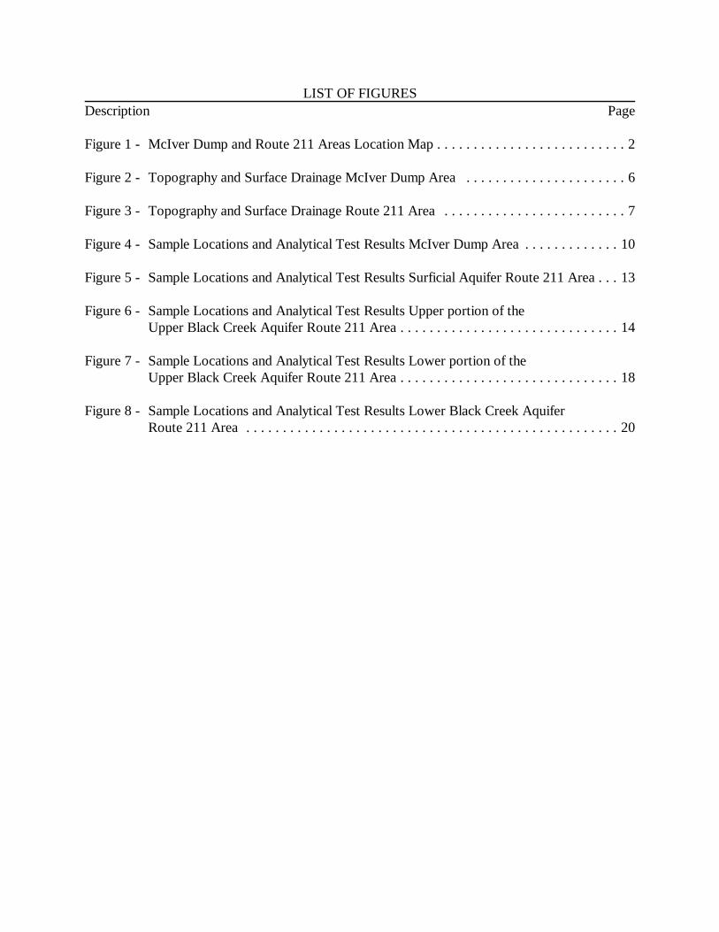
LIST OF FIGURESDescription Page
Figure 1 - McIver Dump and Route 211 Areas Location Map . . . . . . . . . . . . . . . . . . . . . . . . . . 2
Figure 2 - Topography and Surface Drainage McIver Dump Area . . . . . . . . . . . . . . . . . . . . . . 6
Figure 3 - Topography and Surface Drainage Route 211 Area . . . . . . . . . . . . . . . . . . . . . . . . . 7
Figure 4 - Sample Locations and Analytical Test Results McIver Dump Area . . . . . . . . . . . . . 10
Figure 5 - Sample Locations and Analytical Test Results Surficial Aquifer Route 211 Area . . . 13
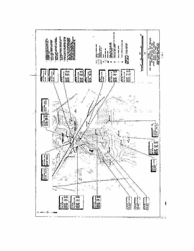
Figure 6 - Sample Locations and Analytical Test Results Upper portion of the Upper Black Creek Aquifer Route 211 Area . . . . . . . . . . . . . . . . . . . . . . . . . . . . . . 14
Figure 7 - Sample Locations and Analytical Test Results Lower portion of the Upper Black Creek Aquifer Route 211 Area . . . . . . . . . . . . . . . . . . . . . . . . . . . . . . 18
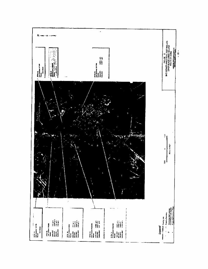
Figure 8 - Sample Locations and Analytical Test Results Lower Black Creek Aquifer Route 211 Area . . . . . . . . . . . . . . . . . . . . . . . . . . . . . . . . . . . . . . . . . . . . . . . . . . . 20
LIST OF TABLESDescription Page
Table 1 - Chemicals of Concern McIver Dump Area . . . . . . . . . . . . . . . . . . . . . . . . . . . . . . . . 22
Table 2 - Chemicals of Concern Route 211 Area . . . . . . . . . . . . . . . . . . . . . . . . . . . . . . . . . . . 23
Table 3 - RME Concentrations for Chemicals of Concern McIver Dump Area . . . . . . . . . . . . . 24
Table 4 - RME Concentrations for Chemicals of Concern Surficial Aquifer Route 211 Area . . . . . . . . . . . . . . . . . . . . . . . . . . . . . . . . . . . . . . . . . . . . . . . . . . . . 25
Table 5 - RME Concentrations for Chemicals of Concern Upper and Lower Black Creek Aquifers Route 211 Area . . . . . . . . . . . . . . . . . . . . . . . . . . . . . . 26
Table 6 - Site Conceptual Model McIver Dump Area . . . . . . . . . . . . . . . . . . . . . . . . . . . . . . . 28
Table 7 - Site Conceptual Model Route 211 Area . . . . . . . . . . . . . . . . . . . . . . . . . . . . . . . . . . 29
Table 8 - Cancer Slope Factors Chemicals of Concern . . . . . . . . . . . . . . . . . . . . . . . . . . . . . . . 32
Table 9 - Reference Doses Chemicals of Concern . . . . . . . . . . . . . . . . . . . . . . . . . . . . . . . . . . 33
Table 10 - Summary of Cancer and Non-cancer Risks Current Use Scenario McIver Dump Area . . . . . . . . . . . . . . . . . . . . . . . . . . . . . . . . . . . . . . . . . . . . . . . . 35
Table 11 - Summary of Cancer and Non-cancer Risks Future Use Scenario McIver Dump Area . . . . . . . . . . . . . . . . . . . . . . . . . . . . . . . . . . . . . . . . . . . . . . . . 36
Table 12 - Summary of Cancer and Non-cancer Risks Future Use Scenario Surficial Aquifer Route 211 Area . . . . . . . . . . . . . . . . . . . . . . . . . . . . . . . . . . . . . . 38
Table 13 - Summary of Cancer and Non-cancer Risks Future Use Scenario Upper and Lower Black Creek Aquifers Route 211 Area . . . . . . . . . . . . . . . . . . . . 39
Table 14 - Clean up Goals for McIver Dump and Route 211 Areas . . . . . . . . . . . . . . . . . . . . . 41
i
DECLARATION FOR THE RECORD OF DECISION
Site Name and LocationAberdeen Pesticide Dumps SiteOperable Unit Five (OU5)EPA ID # -NCD980843346Groundwater at Route 211 and McIver Dump AreasMoore County, Aberdeen, North Carolina
Statement of Basis and PurposeThis decision document presents the selected remedy for OU5 (groundwater) at the McIverDump and Route 211 Areas of the Aberdeen Pesticide Dumps Site (the Site) in Aberdeen, NorthCarolina, which was chosen in accordance with the Comprehensive Environmental Response,Compensation, and Liability Act of 1980 (CERCLA), as amended by the Superfund Amendmentsand Reauthorization Act of 1986 (SARA), and to the extent practicable, the National Oil andHazardous Substances Pollution Contingency Plan (NCP). This decision is based on theAdministrative Record for OU5.
The State of North Carolina concurs with the selected remedy.
Assessment of the SiteThe response action selected in this Record of Decision (ROD) is necessary to protect the publichealth or welfare or the environment from actual or threatened releases of hazardous substancesinto the environment.
Description of the Selected RemedyThe major components of the selected remedy for OU5 are:
McIver Dump Area
• Monitoring of natural attenuation in groundwater, surface water and sediments;
• Phytoremediation to enhance natural attenuation processes;
• Area reconnaissance; and
• Alternative water supply/well head treatment if future potential receptors are identified.
Route 211 Area
• Groundwater extraction from “source area groundwater” in the Surficial aquifer;
• Treatment of groundwater via carbon adsorption;
ii
• Discharge of treated groundwater via re-injection infiltration galleries;
• Monitoring of the extraction, treatment and discharge systems;
• Monitoring of natural attenuation in all aquifers;
• Area reconnaissance;
• Alternative water supply/well head treatment if future potential receptors are identified.
Statutory DeterminationsThe selected remedy is protective of human health and the environment, complies with Federaland State requirements that are applicable or relevant and appropriate to this remedial action, iscost-effective, and utilizes permanent solutions and alternative treatment technologies to theextent practicable. This remedy also satisfies to the extent practicable the statutory preference fortreatment as a principal element of the remedy. Because this remedy will result in hazardoussubstances remaining on-site above health-based levels for a relatively long period of time, areview will be conducted within five years after initiation of the remedial action and every fiveyears thereafter until remediation goals are achieved, to ensure that the remedy continues toprovide adequate protection to human health and the environment.
Data Certification ChecklistThe following information is included in the Decision Summary section of this ROD. Additionalinformation can be found in the administrative record for this site.
Chemicals of concern (COCs) and their respective range of concentrationsBaseline risks represented by the COCsCleanup levels established for COCs and the basis for the levelsCurrent and future groundwater use assumptions used in the baseline risk assessment and RODGroundwater use that will be available at the site as a result of the selected remedyEstimated capital, operation and maintenance (O&M), and total present worth costs; and thenumber of years over which the remedy cost estimates are projectedDecisive factors that led to selecting the remedy
RODAberdeen OU5
Page 1
RECORD OF DECISIONDECISION SUMMARY
INTRODUCTION
The Aberdeen Pesticides Dumps Site (the Site) encompasses approximately 10.57 square miles ofmostly rural property spread over five non-contiguous areas. The five non-contiguous areascomprising the Site are identified as the Farm Chemicals Area, the Twin Sites Area, the FairwaySix Area, the McIver Dump Area and the Route 211 Area.
The subject of this Record of Decision (ROD) is Operable Unit 5 (OU5); which is EPA’sdesignation to address groundwater, surface water, and sediment media at the McIver Dump andRoute 211 Areas.
1.0 SITE NAME, LOCATION, AND DESCRIPTION
Aberdeen Pesticide Dumps SiteEPA ID Number - NCD980843346
Operable Unit Five (OU5)Groundwater at McIver and Route 211 AreasAberdeen, Moore County, North Carolina
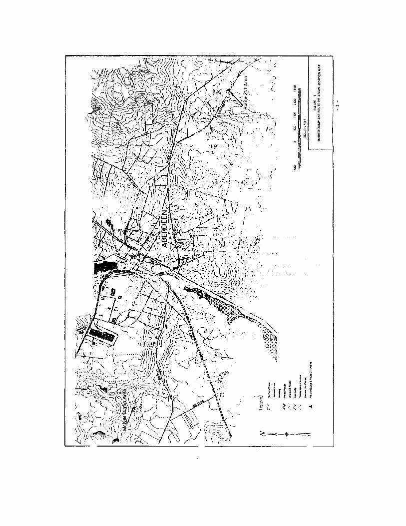
1.1 McIver Dump Area
The McIver Dump Area (Figure 1) is located approximately 0.5 miles north of the junction ofSR1112 (Roseland Road) and SR1106, west of the town of Aberdeen in Moore County. TheMcIver Dump Area formerly consisted of two subareas, area B and area C, and a soil stockpile.Materials, some of which contained pesticides, were discovered at both areas B and C. At area B,pesticides were removed in 1985 by EPA and disposed at the GSX facility located in Pinewood,South Carolina. In 1989 at area C, approximately 3,200 cubic yards of materials and soils wereremoved by an EPA Emergency Response Team and stockpiled on an impermeable liner locatednear area C. In late 1997, the potentially responsible parties (PRPs) excavated soils containingpesticide residuals from both areas B and C (approximately 12,828 tons). The excavated soils andthe soils stockpile were transported to a thermal desorption unit for treatment. Treated soils werereturned to the McIver Dump Area and used for clean fill. As a result of these remedial activitiesunder separate RODs, known sources of pesticides have been removed from the McIver DumpArea and, therefore, no future impacts to groundwater and/or surface water are anticipated.Additionally, significant erosion control measures have been constructed at the McIver DumpArea to control drainage to Patterson Branch, a stream to the north of the former source areas.
RODAberdeen OU5
Page 3
Topsoil has been place over the area, which has been seeded and fertilized to promote growth ofstabilizing vegetation.
1.2 Route 211 Area
The Route 211 Area (Figure 1) is located approximately 1,000 feet southwest of highway Route211 East and adjacent to the Aberdeen & Rockfish Railroad. It is approximately one mile east ofthe Town of Aberdeen. The Route 211 Area formerly contained an old sand mining basinapproximately 80 feet across and 8 to 20 feet deep. Materials, some of which containedpesticides, were discovered in a waste pile on the southwest slope of the pit. In 1986,approximately 100 cubic yards of pesticides and associated soil were removed by EPA anddisposed at the GSX facility in Pinewood, South Carolina. In 1989, approximately 200 cubicyards of similar material was discovered by EPA and subsequently removed, placed in thestockpile at the McIver Dump Area, and later treated by thermal desorption. In late 1997, thePRPs excavated and transported additional soils containing pesticides to a thermal desorption unitfor treatment (approximately 3,464 tons). Treated soils were then returned to the Route 211 Areafor use as clean fill and the entire pit at the area was filled. Following regrading of the Route 211Area, pinestraw was applied to prevent erosion and stabilize the soil. Surface runoff in theimmediate vicinity of the Route 211 Area flows away from the former source area. All the soilremediation work described above was performed under a separate ROD.
2.0 SITE HISTORY AND ENFORCEMENT ACTIVITIES
2.1 Site History and Enforcement Activities
The main PRPs identified for the McIver Dump and the Route 211 Areas are Novartis CropProtection, Inc. (formerly Ciba-Geigy Corporation), and Olin Corporation. During their operationof a pesticide formulation plant on Route 211 (the Geigy Chemical Plant) east of the Town ofAberdeen, corporate predecessors to the PRPs used the McIver Dump and Route 211 Areas fordisposal of wastes from that plant. These wastes contained pesticide and pesticide constituents.On March 31, 1989, pursuant to Section 105 of CERCLA, 42 U.S.C. § 9605, EPA placed theSite on the National Priorities List, set forth at 40 C.F.R. Part 300. The McIver Dump and Route211 Areas are two of the five non-contiguous areas comprising the Site.
In response to a release or substantial threat of release of hazardous substances at or from theSite, EPA commenced on June 30, 1987, a Remedial Investigation and Feasibility Study (RI/FS)for the Site, including the McIver Dump and Route 211 Areas. EPA completed its initial RemedialInvestigation (RI) at the Site on April 12, 1991. During that investigation, EPA determined thatthe surface water, groundwater, and sediments at the Site required further investigation. EPAdesignated the groundwater at all five Areas as Operable Unit Three (OU3). EPA conductedfurther investigation of OU3 and completed a Feasibility Study concerning OU3 on May 3, 1993.During that study, EPA determined that further investigation of the
RODAberdeen OU5
Page 4
groundwater at the McIver Dump and Route 211 Areas was necessary. EPA designated thegroundwater at those two Areas as OU5.
Effective March 21, 1994, the PRPs entered into an Administrative Order on Consent (AOC) withEPA concerning performance of the RI/FS for OU5. On September 16, 1997, EPA issued aninterim action ROD for the Route 211 Area to start pumping and treating groundwater containingthe highest concentrations of pesticides.
3.0 COMMUNITY PARTICIPATION HIGHLIGHTS
Pursuant to CERCLA § 113 (k)(2)(B)(i-v) and § 117, the RI/FS Report and the Proposed Planfor OU5 were made available to the public in January 1999. These documents can be found in theAdministrative Record file and the information repository maintained at the EPA Docket Room inRegion 4 and at the Aberdeen Town Hall in Aberdeen, North Carolina. In addition, the ProposedPlan fact sheet was mailed to individuals on the Site’s mailing list on January 14, 1999.
The notice of the availability of these documents and notification of the Proposed Plan PublicMeeting was announced in The Fayeteville Observer Times and The Pilot on January 18, 1999. Apublic comment period was held from January 18, 1999 through February 17, 1999. In addition, apublic meeting was held on February 4, 1999, at the Aberdeen Fire Station. At this meeting,representatives from EPA answered questions about the site and the remedial alternatives for theaction under consideration. EPA’s responses to the comments received during the commentperiod, including those raised during the public meeting, are included in the ResponsivenessSummary, which is part of this ROD. The Responsiveness Summary also incorporates a transcriptof the Proposed Plan public meeting.
4.0 SCOPE AND ROLE OF RESPONSE ACTION
As at many superfund sites, the problems at the Aberdeen Pesticide Dumps Site are complex. As aresult, the cleanup efforts at this Site were organized into several Operable Units (OUs),
OU1 & 4 Soil at all areas (Twin sites, Fairway six, Farm Chemical, McIver Dumpand Route 211). ROD signed on 9/30/91.
OU2 Renamed as OU4
OU3 Groundwater at Twin sites, Fairway Six and Farm Chemical areas. RODsigned on 10/7/93
OU5 Groundwater, surface water and sediment at McIver and Route 211 Areas.An interim ROD for the Route 211 Area was signed on September 16, 1997. This interim action addresses the highest concentrations of
RODAberdeen OU5
Page 5
pesticides in groundwater (source area groundwater) using a pump andtreat system.
OU 5, the subject of this ROD and the final response action for OU5 addresses groundwater,sediments and surface water at the McIver Dump and Route 211 Areas. The interim action for theRoute 211 Area is part of the selected remedy for OU5 described in this ROD.
5.0 SUMMARY OF SITE CHARACTERISTICS
The Aberdeen Pesticides Dumps site encompasses approximately 10.57 square miles of mostlyrural property spread over five non-contiguous areas. The subject of this ROD is OU 5, EPA’sdesignation for groundwater, sediment and surface water media at the McIver Dump and Route211 Areas. Therefore, site characteristics for only those two areas will be discussed in this section.
5.1 Topography and Surface Drainage
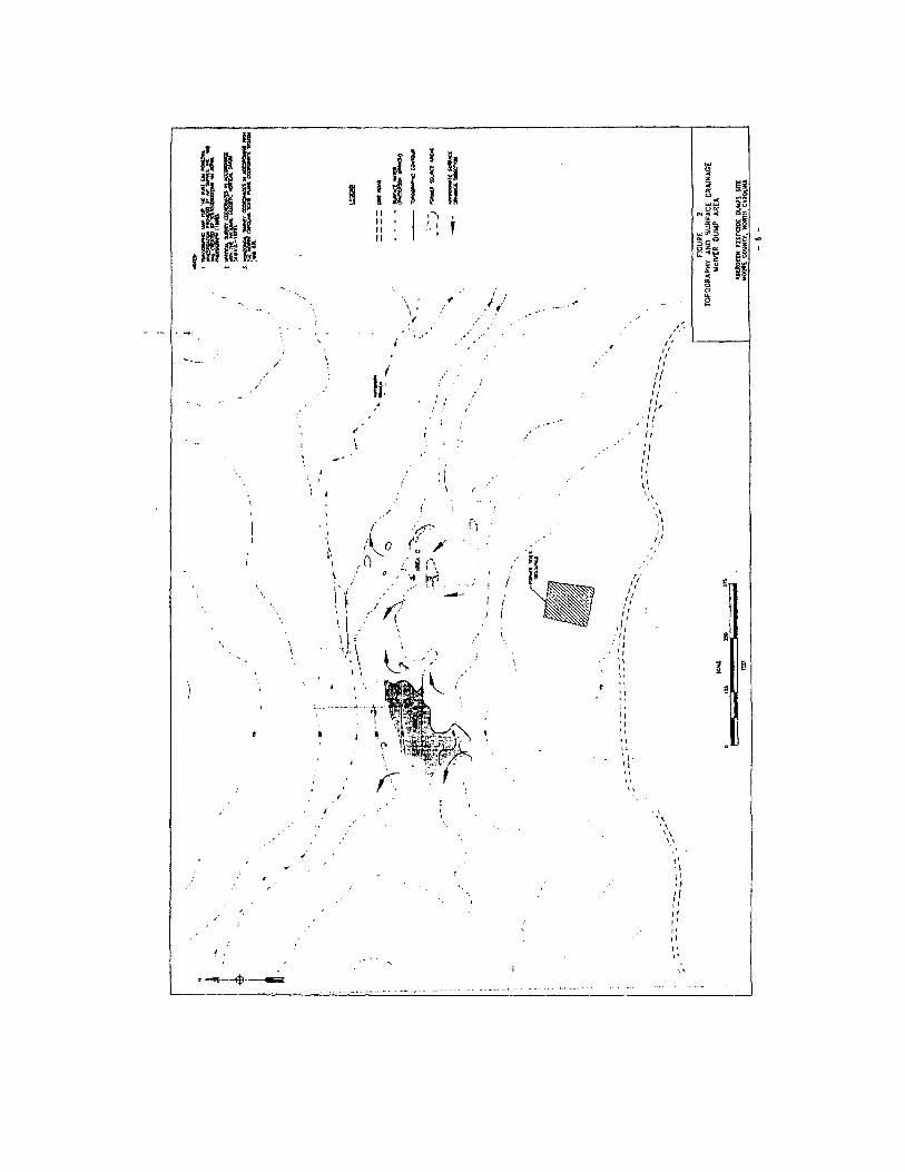
5.1.1 McIver Dump Area
The McIver Dump Area is located in a rural area of Moore County, the vicinity of which ispartially wooded and partially cleared for agricultural purposes. Topography and surface drainageat the McIver Dump Area is illustrated on Figure 2. The topography at the McIver Dump Areahas been modified since the soils from areas B and C have been excavated and treated. Significanterosion control measures have been constructed at the McIver Area to direct drainage at theMcIver Dump Area away from Patterson Branch. The McIver Dump Area has been seeded andfertilized to promote growth of stabilizing vegetation.
5.1.2 Route 211 Area
The topography of the Route 211 Area is generally flat with depressions and hills created fromhistoric sand mining operations. Topography and surface drainage at the Route 211 Area isillustrated on Figure 3. Prior to soils removal, the Route 211 Area comprised a small sand miningdepression. Since the source soils have been removed, the depression has been filled in with cleanfill. Following regrading of the Route 211 Area, pinestraw mulch was applied to prevent erosionand stabilize the soil. Surface runoff in the immediate vicinity of the Route 211 Area flows awayfrom the former source area. The nearest surface water body is a localized area containingintermittent ponded water to the southeast of the Route 211 Area. This surface water body is theresult of drainage originating topographically upslope of the Route 211 Area. The next surfacewater feature is an intermittent creek approximately 500 feet southeast of the route 211 Area.This creek, known as Bull Branch, flows south-southwest intermittently for approximately 0.8miles until it becomes a perennial stream. Along this intermittent stream are two man-made
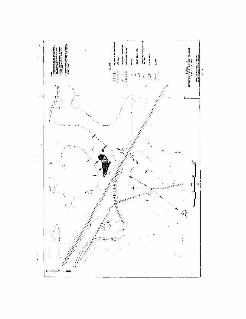
RODAberdeen OU5
Page 8
ponds approximately 800 feet and one-half mile from the Route 211 Area. This stream continuesto flow southward for approximately 3.3 miles, where it enters Quewhiffle Creek.
5.2 Geology
5.2.1 McIver Dump Area
The geologic formations encountered beneath the McIver Dump Area during the RI include theMiddendorf and Cape Fear Formations. These formations overlie the basement rocks of theCarolina Slate Belt. The upper portion of the Middendorf Formation is only partially presentbeneath the McIver Dump Area due to erosion. Along the upland portion of the McIver DumpArea, beneath the former soil stockpile and underlying former area B, the upper portion of theMiddendorf Formation is present. Formation materials are comprised of pink to purple to red towhite well graded sand to poorly graded sand. Beneath the upland area, a silty clay wasencountered beneath the upper Middendorf sand. The low permeability unit was gray, moist todry, and very dense. Perched water was encountered above this low permeability unit.
Beneath a portion of former area B and all of former area C, the geology is comprised of thelower Middendorf Formation. Formation materials are comprised of pink to purple to red to whitewell graded sand to poorly graded sand. An intermediate bed of silty clay ranging in thicknessfrom 1.5 to 3.5 feet was encountered within this sand.
At the base of the Middendorf Formation is the Cape Fear Formation. The Cape Fear Formationwas encountered beneath the entire McIver Dump Area and is comprised of gray silty clay.
5.2.2 Route 211 Area
The geologic formations encountered beneath the Route 211 Area during the RI include thePinehurst Formation, the Middendorf Formation and the Cape Fear Formation. The PinehurstFormation ranges in thickness from 5.5 to 50 feet and is comprised of brown, tan, red and grayfine to coarse sand with varying amounts of interstitial silt and clay.
At the base of the Pinehurst Formation is a silty, clayey sand, or sandy clay unit which includeshumic materials such as wood, grass, peat, and other plant debris at some locations. Wherepresent, this unit varies in thickness from approximately 2.5 to 9 feet.
The top of the Middendorf Formation is typically marked by a light gray to white, dense, brittlesilty clay, commonly overlain by a layer of pink to purple sand or fine gravel. Where present, thislow permeability unit ranges in thickness from approximately 1 to 22 feet.
Beneath the silty clay, the upper portion of the Middendorf is comprised of pink to purple to redto white well graded sand to poorly graded sand with varying amounts of interstitial silt and clay.
RODAberdeen OU5
Page 9
This water bearing upper sand ranges in thickness from approximately 9 to 47 feet. This sand isunderlain by a second gray to white to yellowish brown, dense, brittle silty clay. This clay, termedthe “middle clay”, was encountered at thicknesses ranging from approximately 1 to 17 feet.
Underlying the middle clay is the lower portion of the upper Middendorf Formation. This waterbearing sand is comprised of white to yellow to very pale brown well graded sand to poorlygraded sand to clayey sand with varying amounts of interstitial silt and clay. This unit ranges inthickness from approximately 14.5 to 45 feet.
Separating the upper and lower Middendorf Formation is a low permeability clay. This light grayclay ranged in thickness from less than 1 foot to 36 feet.
Underlying this low permeability unit is the Lower Middendorf sand. This sand was encounteredat all deep drilling locations and ranges in thickness from 21 to 70 feet. This unit was comprisedof poorly graded sand to well graded sand to clayey sand with varying amounts of silt and clay.The base of this unit was typically marked by a bed of purple well graded gravel with sand.
At the base of the Middendorf Formation, the light gray silty clay of the Cape Fear Formation wasencountered. This low permeability clay was encountered at all deep drilling locations.
5.3 Hydrogeology
5.3.1 McIver Dump Area
The aquifer penetrated during this investigation was the Black Creek Aquifer, which is comprisedof permeable sections of the Middendorf Formation. Groundwater in the Upper and Lower BlackCreek Aquifers can occur under perched or water table conditions, with an unsaturated portion ofthe aquifer above the water surface. Within the Lower Black Creek Aquifer, beneath former areasB and C, is a thin but continuous clay layer that acts as a local confining unit. This clay layerseparates the Lower Black Creek Aquifer into an upper and lower portion. The upper portion ofthe Lower Black Creek Aquifer is unconfined. The lower portion of the Lower Black CreekAquifer is under confined conditions adjacent to Patterson Branch.
Lower Black Creek Aquifer (upper and lower portions)
Figure 4 shows the monitoring well locations at the McIver Dump Area. The averagegroundwater gradient in the upper portion of the Lower Black Creek Aquifer is 0.02 ft/ft.Hydraulic conductivity values range from 2.73 x 10⁻² cm/sec to 3.44 x 10⁻³ cm/sec. Groundwaterin the upper portion of the Lower Black Creek Aquifer is moving at an average velocity of 325feet per year.

RODAberdeen OU5
Page 11
The average groundwater gradient in the lower portion of the Lower Black Creek Aquifer is0.008 ft/ft. Hydraulic conductivity values range from 3.82 x 10⁻⁴ cm/sec to 2.03 x 10⁻³ cm/sec.Groundwater in the lower portion of the Lower Black Creek Aquifer is moving at an averagevelocity of 343 feet per year.
In the upper portion of the Lower Black Creek Aquifer, the principal direction for groundwaterflow is toward the north-northeast, perpendicular to Patterson Branch. However, the lowerportion of the Lower Black Creek Aquifer exhibits a more regional north-easterly groundwaterflow direction.
There is a difference in the potentiometric surface levels between the upper and lower portions ofthe Lower Black Creek Aquifer. In the upper portion, unsaturated conditions exist; but in thelower portion, all locations within the investigation were fully confined. South of former area B,near monitoring well 04-MW-01 and the former soil stockpile, the potentiometric surface in theupper portion is higher than the potentiometric surface in the lower portion. Beneath the formerareas B and C and adjacent to Patterson Branch, this condition is reversed, and the potentiometricsurface in the lower portion of the Lower Black Creek Aquifer is above the potentiometricsurface in the upper portion. The vertical head difference reaches a maximum along PattersonBranch where the vertical gradient is approximately 2.6 feet in the upward direction. In addition,monitoring well MC-MW-04D is under artesian conditions, with the potentiometric surfaceapproximately 2 feet above ground surface. This head reversal indicates that a strong upwardvertical gradient is occurring and that groundwater discharge to Patterson Branch is occurring.
Results of the FLONETTM model conducted during the RI indicate that Patterson Branch acts as adischarge boundary for groundwater flow in the upper portion of the Lower Black Creek Aquifer.In addition, an upward hydraulic gradient exists between the lower and upper portions of theLower Black Creek Aquifer between the former source areas and Patterson Branch except for avery limited upgradient portion of the former area B where there is a slight downward verticalgradient.
After reviewing the all lithologic and hydraulic data collected from the McIver Dump Area, valuesfor transmissivity and storativity for the lower portion the Lower Black Creek Aquifer were foundto range from 191 to 706 ft2/day and 7.29 x 10⁻⁵ to 1.16 x 10⁻⁴ , respectively.
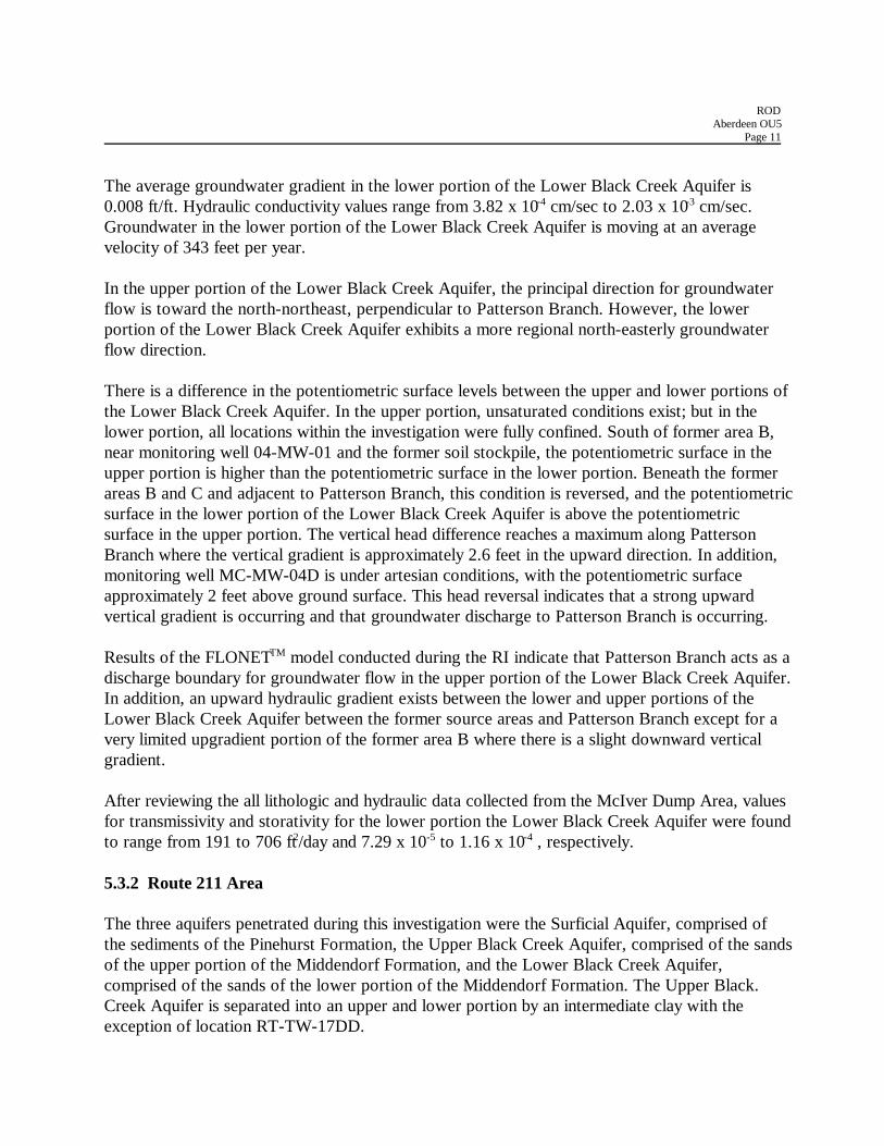
5.3.2 Route 211 Area
The three aquifers penetrated during this investigation were the Surficial Aquifer, comprised ofthe sediments of the Pinehurst Formation, the Upper Black Creek Aquifer, comprised of the sandsof the upper portion of the Middendorf Formation, and the Lower Black Creek Aquifer,comprised of the sands of the lower portion of the Middendorf Formation. The Upper Black.Creek Aquifer is separated into an upper and lower portion by an intermediate clay with theexception of location RT-TW-17DD.
RODAberdeen OU5
Page 12
Groundwater in the Surficial Aquifer is perched with an unsaturated section above thegroundwater surface. Groundwater in the upper portion of the Upper Black Creek Aquifer canoccur under water table conditions, with an unsaturated section above the groundwater surface.However, the upper portion of the Upper Black Creek Aquifer is locally confined downgradientof the former source area by the overlying low permeability unit. The lower portion of the UpperBlack Creek Aquifer is under confined conditions with the exception of location RT-TW-17DDwhere the middle clay is not present. The Lower Black Creek Aquifer is under confinedconditions.
Surficial Aquifer
In the Surficial Aquifer, the principal direction for groundwater flow is toward the southwest. Theaverage hydraulic gradient in the Surficial Aquifer is 0.01 ft/ft. Hydraulic conductivity values inthe Surficial Aquifer range from 1.11 x 10⁻² cm/sec to 6.2 x 10⁻⁴ cm/sec. Groundwater in theSurficial Aquifer is moving at an average velocity of approximately 632 feet per year. Monitoringwells screened in the Surficial Aquifer are shown on Figure 5.
Upper Portion Upper Black Creek Aquifer
The principal direction of groundwater flow in the upper portion of the Upper Black CreekAquifer is toward the east-southeast, a variance of greater than 90 degrees from the flow directionin the Surficial Aquifer. The average hydraulic gradient in the upper portion of the Upper BlackCreek Aquifer is 0.01 ft/ft. Hydraulic conductivity values in the upper portion of the Upper BlackCreek Aquifer range from 6.09 x 10⁻⁴ cm/sec to 2.54 x 10⁻³ cm/sec. Groundwater in the upperportion of the Upper Black Creek Aquifer is moving at an average velocity of 235 feet per year. Adownward vertical gradient exists between the perched Surficial Aquifer and the upper portion ofthe Upper Black Creek Aquifer. The difference in the groundwater surface between the twoAquifers ranges from approximately 26 feet to 32 feet. Monitoring wells screened in the upperportion of the Upper Black Creek Aquifer are shown on Figure 6. The absence of the SurficialAquifer and the thinning Upper Black Creek confining unit along the western perimeter of thestudy area indicates potential hydraulic interconnection between the Surficial Aquifer and theupper portion of the Upper Black Creek Aquifer.
Lower Portion of the Upper Black Creek
The groundwater flow direction in the lower portion of the Upper Black Creek Aquifer is towardthe south-southeast. The average hydraulic gradient is 0.0056 ft/ft across the study area. Thevertical gradient between the upper and lower portions of the Upper Black Creek Aquifer isdownward, with a head difference of approximately 3 feet. Hydraulic conductivity values in thelower portion of the Upper Black Creek Aquifer range from 8.64 x 10⁻⁴ cm/sec to 1.3 x 10⁻³
cm/sec. Groundwater in the lower portion of the Upper Black Creek Aquifer is moving at anaverage velocity of 32 feet per year.

RODAberdeen OU5
Page 15
Lower Black Creek Aquifer
The groundwater flow direction in the Lower Black Creek Aquifer is primarily toward the south.The average hydraulic gradient is 0.0045 ft/ft. The vertical gradient between the lower portion ofthe Upper Black Creek Aquifer and the Lower Black Creek Aquifer is downward, with a headdifference of up to approximately 4.5 feet. Hydraulic conductivity values range from 1.24 x 10⁻³
cm/sec to 4.04 x 10⁻³ cm/sec. Groundwater in the Lower Black Creek Aquifer is moving at anaverage velocity of 346 feet per year.
5.4 Nature and Extent of Contamination Overview
5.4.1 McIver Dump Area
5.4.1.1 Groundwater
The RI at the McIver Dump Area was conducted in multiple phases from November 1994 toOctober 1995. The following summarizes the findings of the investigation conducted duringPhases I, II, III, IV, IVb, and IVc.
Groundwater samples from the McIver Dump Area were analyzed for Target Compound List(TCL) pesticides and Ferbam. The pesticides detected most frequently at the McIver Dump Areawere the Benzenehexachloride (BHC) isomers, 4,4-dichlorodiphenyidichloroethane (4,4'-DDD),and dieldrin. The following sections provide a description of pesticides detected in groundwatersamples collected from the upper and lower portions of the Lower Black Creek Aquifer.
Upper Portion of the Lower Black Creek Aquifer
The pesticides most frequently detected in the upper portion of the Lower Black Creek Aquiferwere the four BHC isomers (alpha, beta, delta, and gamma), 4,4'-DDD, and dieldrin.Concentrations of each compound generally decreased with depth at locations where sampleswere collected from different depths within the aquifer. Several additional pesticides weredetected in groundwater, however, at random locations and at concentrations lower than those ofthe most frequently detected pesticides. As a result of groundwater discharge to PattersonBranch, the northern downgradient extent of pesticides in groundwater originating from theformer source areas (areas B and C) is Patterson Branch.
The concentrations of the four BHC isomers in the monitoring wells (Figure 4) indicate thatpesticides detected in groundwater originated from the former source areas (areas B and C), andhave migrated hydraulically downgradient to the discharge point at Patterson Branch. The closeproximity of the former source areas to Patterson Branch and the strong upward vertical gradient
RODAberdeen OU5
Page 16
adjacent to Patterson Branch has resulted in localized groundwater impact that is limited in aerialextent and in depth.
Lower Portion of the Lower Black Creek Aquifer
The pesticides most frequently detected in the lower portion of the Lower Black Creek Aquiferwere the four BHC isomers. Concentrations of these compounds were lower than those detectedin the upper portion of the Lower Black Creek Aquifer. A few additional compounds were alsorandomly detected in groundwater at low concentrations.
Pesticides detected in groundwater in the lower portion of the Lower Black Creek Aquifer arelocalized and exhibit no significant trends. Pesticide compounds were primarily detected beneathand downgradient of former source area B and within a small area hydraulically downgradient offormer source area C. The low concentrations of pesticides in groundwater that are limited inareal extent indicates that limited impact has occurred to the lower portion of the Lower BlackCreek Aquifer.
5.4.1.2 Surface Water and Sediments
Surface water and sediments were sampled and analyzed from Patterson Branch during the RI.Results show that concentrations of pesticides in surface water are below the North CarolinaSurface Water Standards. The four BHC isomers, 4,4'-DDD, 4,4'-DDT and 4,4'-DDE weredetected in the sediments in Patterson Branch.
5.4.2 Route 211 Area
5.4.2.1 Groundwater
The RI at the Route 211 Area was conducted in multiple phases from November 1994 to October1996. The following summarizes the findings of investigation conducted during Phases I, IIa, IIb,III, IVa, IVb, IVc, V, and VI. In addition, a Downgradient Receptors Study was conducted,which consisted of sampling and analysis of 21 private wells.
All groundwater samples for the Route 211 Area were analyzed for TCL pesticides. Some of thesamples collected from monitoring wells were also analyzed for Ferban, Sevin, Guthion andParathion.
Surficial Aquifer
The most frequently detected pesticides in the Surficial Aquifer were alpha-BHC, beta-BHC, anddelta-BHC. These compounds exhibit a decreasing trend downgradient of the former source area.The highest concentrations of pesticides were detected directly downgradient of the former
RODAberdeen OU5
Page 17
source area. Pesticide concentrations in monitoring wells located south of the Aberdeen andRockfish Railroad (ARR) were an order of magnitude less than those detected near the source.Concentrations of these compounds decrease hydraulically downgradient.
Other pesticides detected with moderate frequency were gamma-BHC, 4,4'-DDD, 4,4'-DDE, andDieldrin. These compounds exhibit no notable trend and were randomly detected at variousconcentrations. Several other pesticides compounds were detected in groundwater, albeit atrandom locations and relatively lower concentrations than the BHC isomers. These compoundsinclude 4,4'-DDT, endosulfan I, endosulfan II, endosulfan sulfate, endrin, endrin aldehyde,heptachlor, and toxaphene.
The extent of pesticides has been sufficiently defined in the Surficial Aquifer. This definition isbased on the known location and extent of the former source area, analytical test results ofdowngradient groundwater samples, and the absence of Surficial Aquifer groundwater along thewestern perimeter of the study area. Figure 5 illustrates the concentrations of the four BHCisomers in the monitoring wells of the Surficial Aquifer.
Upper Portion of the Upper Black Creek Aquifer
The most frequently detected pesticides in the upper portion of the Upper Black Creek Aquiferwere the four BHC isomers. These compounds were consistently detected at decreasingconcentrations hydraulically downgradient of the pesticide migration pathway. Other pesticidesdetected in groundwater include 4,4'-DDT, 4,4'-DDE, 4,4'-DDD, dieldrin, endosulfan I,endosulfan II, endosulfan sulfate, endrin, endrin aldehyde, and toxaphene. These compoundsexhibited no notable trends and were detected at lower concentrations than the BHC isomers.
The extent of pesticides has been sufficiently defined in the upper portion of the Upper BlackCreek Aquifer. Figure 6 illustrates the concentrations of the four BHC isomers in the monitoringwells of the upper portion of the Upper Black Creek Aquifer.
Lower Portion of the Upper Black Creek Aquifer
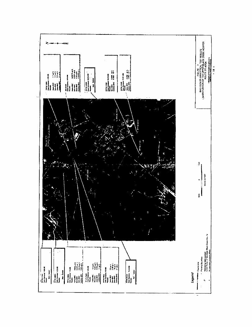
Of the groundwater samples collected during the Phase V RI, no pesticides were detected in theupgradient well RT-TW-17DD. The four BHC isomers were detected at various concentrations inmonitoring wells RT-TW-12DD, RT-TW-19DD, RT-TW-18DD, in the USGS well USGS-05-02,and in HydropunchTM sample RT-HP-03DD (Figure 7).
During the Downgradient Receptor Study, seven of the thirteen private water wells sampledwhich are potentially withdrawing water from the lower portion of the Upper Black CreekAquifer did not contain pesticides at or above method detection limits. However, the four BHCisomers were detected in six wells in the low part per billion range. None of the six wells withdetectable concentrations of pesticides are being used as a source of drinking water.
RODAberdeen OU5
Page 19
Of the groundwater samples collected during the Phase VI RI, no pesticides were detected in thesidegradient wells RT-TW-20DD and RT-TW-23DD. Monitoring well RT-TW-21DD and RT-TW-22DD contained detectable concentrations of alpha-BHC and gamma-BHC, however, in thelow part per trillion range.
Based upon the results of the Phase V RI, the Downgradient Receptor Study, and the Phase VIRI, the extent of pesticides has been sufficiently defined in the lower portion of the Upper BlackCreek Aquifer. Detectable concentrations of pesticides are consistent with the groundwater flowdirection. Concentrations of the BHC isomers increase downgradient of upgradient monitoringwell RT-TW-17DD. Concentrations then decrease further downgradient from monitoring wellRT-TW-19DD. Figure 7 illustrates the concentrations of the four BHC isomers in the monitoringwells of the lower portions of the Upper Black Creek Aquifer.
Lower Black Creek Aquifer
Of the groundwater samples collected during the Phase V RI, no TCL pesticides were detected inupgradient well RT-TW-17L or in sidegradient well USGS-05-01. The four BHC isomers weredetected in monitoring wells RT-TW- 18L and RT-TW- 19L. No other TCL pesticides weredetected in wells sampled during Phase V.
During the Downgradient Receptor Study, ten of the eleven water wells sampled which arepotentially withdrawing water from the Lower Black Creek Aquifer did not contain pesticides ator above method detection limits. The four BHC isomers were detected in only one wellpotentially withdrawing water from the Lower Black Creek Aquifer (concentrations of alpha-BHC at 0.023F1g/1, beta-BHC at 0,018 Fg/1, delta-BHC at 0.02 Fg/1, and gamma-BHC at0.047 Fg/1).
One or more of the BHC-isomers were detected in each of the monitoring wells installed duringthe Phase VI RI in the part per trillion range. Endosulfan I and DDD were also detected inmonitoring well RT-TW-22L at concentrations in the part per trillion range.
Sidegradient wells RT-TW-20L and RT-TW-22L and downgradient well RT-TW-21L sufficientlydefine the extent of pesticides in the Lower Black Creek Aquifer. Figure 8 presents theconcentrations of the four BHC isomers in the monitoring wells of the Lower Black Creekaquifer.
5.4.2.2 Surface water and Sediments
The surface water sampling effort was conducted by EPA during the initial remedial investigationfor the Site. The closest surface water body to the area is the head waters of Bull branch, andintermittent tributary to Quewhiffle Creek, which originates about 0.1 mile south of the area.Surface water and sediments were sampled and no pesticides, PCB, or VOCs were detected.
RODAberdeen OU5
Page 21
6.0 SUMMARY OF SITE RISKS
The baseline risk assessment (BRA) estimates what risks OU5 poses if no actions were taken. Itprovides the basis for taking action and identifies the contaminants and exposure pathways thatneed to be addressed by the remedial action. This section of the ROD summarizes the results ofthe BRA for OU5.
6.1 Data Evaluation
Data used to prepared the BRA was obtained from the RI report. The RI included the collectionof surface water, sediment and groundwater samples from locations comprising the McIver Dumpand Route 211 Areas. All available data collected between November 1994 and November 1996was used in the analysis. For the purpose of the BRA, the remedial investigation data wassegregated into two groups: the McIver Dump Area and Route 211 Area. The data was alsoseparated by aquifers and low permeability units (designated as upper and lower portions of theaquifer) within each of these two areas to reflect potential exposure conditions. At the McIverDump Area, the upper and lower portions of the Lower Black Creek Aquifer were evaluated. Atthe Route 211 Area, the Surficial Aquifer, upper portion of the Upper Black Creek Aquifer, lowerportion of the Upper Black Creek Aquifer and Lower Black Creek Aquifer were considered.These designations were made to more accurately represent the potential risks associated withthese two distinct geographical areas.
6.2 Chemicals of Concern
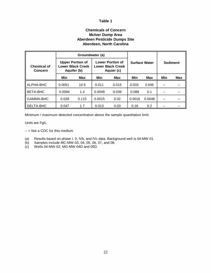
The Chemical of Concern (COCs) for groundwater at the McIver Dump and Route 211 Areas arepresented on Table 1 and 2 respectively. The table also includes the range of detectedconcentrations each COC.
Reasonable maximum exposure (RME) point concentrations for groundwater, and surface waterwere calculated. For groundwater, the arithmetic average of all wells with detected concentrationsfor each COC was used to evaluate each aquifer based on the specified groupings.
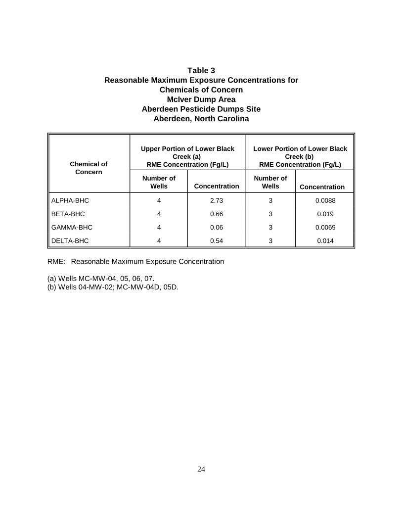
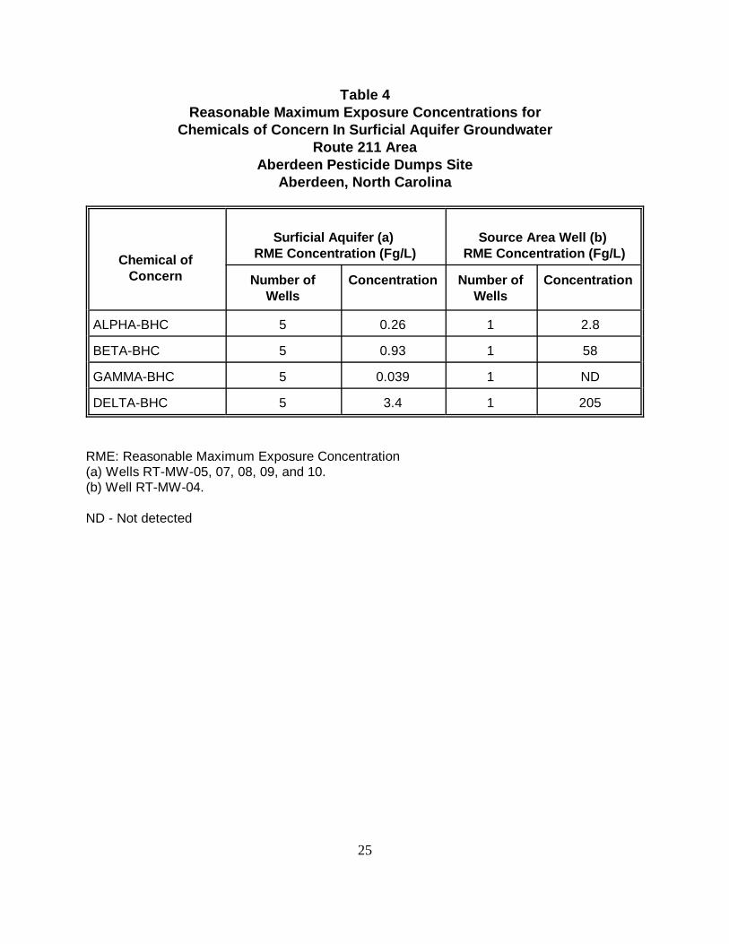
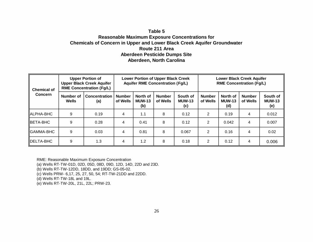
The RME concentrations for groundwater at the McIver Dump Area are presented in Table 3 forthe upper portion of the Lower Black Creek Aquifer and the lower portion of the Lower BlackCreek Aquifer. The RME for groundwater at the Route 211 Area are presented in Table 4 for theSurficial Aquifer and the source area well (RT-MW04). Table 5 presents the RME concentrationsfor the upper portion of the Upper Black Creek, the lower portion of the Upper Black Creek, andthe Lower Black Creek Aquifers at Route 211 Area.
22
Table 1
Chemicals of ConcernMcIver Dump Area
Aberdeen Pesticide Dumps SiteAberdeen, North Carolina
Chemical of Concern
Groundwater (a)
Surface Water SedimentUpper Portion ofLower Black Creek
Aquifer (b)
Lower Portion ofLower Black Creek
Aquier (c)
Min Max Min Max Min Max Min Max
ALPHA-BHC 0.0051 10.5 0.011 0.015 0.033 0.045 -- --
BETA-BHC 0.0094 1.4 0.0049 0.039 0.088 0.1 -- --
GAMMA-BHC 0.028 0.115 0.0015 0.02 0.0016 0.0048 -- --
DELTA-BHC 0.047 1.7 0.013 0.03 0.16 0.2 -- –
Minimum / maximum detected concentration above the sample quantitation limit.
Units are Fg/L.
-- = Not a COC for this medium
(a) Results based on phase I, II, lVb, and lVc data. Background well is 04-MW-01.(b) Samples include MC-MW-03, 04, 05, 06, 07, and 08.(c) Wells 04-MW-02; MG-MW-04D and 05D.
23
Table 2Chemicals of Concern
Route 211 AreaAberdeen Pesticide Dumps Site
Aberdeen, North Carolina
Chemical ofConcern
Surficial Aquifer (a)Upper Portion of
Upper Black CreekAquifer (b)
Lower Portion of UpperBlack Creek Aquifer (c)
Lower Black CreekAquifer (d)
Min Max Min Max Min Max Min Max
ALPHA-BHC 0.00075 2.8 0.0049 1.25 0.0079 2.5 0.0014 0.21
BETA-BHC 0.0069 58 0.003 1.1 0.009 1.2 0.002 0.045
GAMMA-BHC 0.047 0.089 0.0028 0.22 0.0016 2.1 0.024 0.16
DELTA-BHC 0.028 205 0.0013 4.75 0.019 3 0.0017 0.14
Minimum / maximum detected concentration above the sample quantitation limit.
ND - Not detected
Units are Fg/L.
(a) Results based on phases I, II, III, and IV data. Samples include 05-MW-01, 02, 03; RT-MW-04, 05, 07, 08, 09, 10.Background well is RT-MW-06. Wells 05-MW-01 and 05-MW-02 are upgradient of the source area.
(b) Samples include RT-TW-01D, 02D, 05D, 08D, 09D, 12D, 13D, 14D, 16D, 22D, and 23D.(c) Samples include RT-TW-8DD, 12DD, 17DD, 18DD, 19DD, 20DD, 21DD, 22DD, and 23DD; GS-05-2;
PRW-13,16,17,25, 26, 27, 34, 45, 46, 48, 50, 54 and 58.(d) Samples include RT-TW-13L, 17L, 18L, 19L, 20L, 21L, 22L; GS-05-1; PRW-23,37-1, 37-2,12-1,12-2,42,44,57, 81,
84, 86; and MVW-12.
24
Table 3Reasonable Maximum Exposure Concentrations for
Chemicals of ConcernMcIver Dump Area
Aberdeen Pesticide Dumps SiteAberdeen, North Carolina
Chemical ofConcern
Upper Portion of Lower BlackCreek (a)
RME Concentration (Fg/L)
Lower Portion of Lower BlackCreek (b)
RME Concentration (Fg/L)
Number ofWells Concentration
Number ofWells Concentration
ALPHA-BHC 4 2.73 3 0.0088
BETA-BHC 4 0.66 3 0.019
GAMMA-BHC 4 0.06 3 0.0069
DELTA-BHC 4 0.54 3 0.014
RME: Reasonable Maximum Exposure Concentration
(a) Wells MC-MW-04, 05, 06, 07. (b) Wells 04-MW-02; MC-MW-04D, 05D.
25
Table 4Reasonable Maximum Exposure Concentrations for
Chemicals of Concern In Surficial Aquifer GroundwaterRoute 211 Area
Aberdeen Pesticide Dumps SiteAberdeen, North Carolina
Chemical ofConcern
Surficial Aquifer (a) RME Concentration (Fg/L)
Source Area Well (b) RME Concentration (Fg/L)
Number ofWells
Concentration Number ofWells
Concentration
ALPHA-BHC 5 0.26 1 2.8
BETA-BHC 5 0.93 1 58
GAMMA-BHC 5 0.039 1 ND
DELTA-BHC 5 3.4 1 205
RME: Reasonable Maximum Exposure Concentration (a) Wells RT-MW-05, 07, 08, 09, and 10. (b) Well RT-MW-04.
ND - Not detected
26
Table 5Reasonable Maximum Exposure Concentrations for
Chemicals of Concern in Upper and Lower Black Creek Aquifer GroundwaterRoute 211 Area
Aberdeen Pesticide Dumps SiteAberdeen, North Carolina
Chemical ofConcern
Upper Portion of Upper Black Creek AquiferRME Concentration (Fg/L)
Lower Portion of Upper Black CreekAquifer RME Concentration (Fg/L)
Lower Black Creek AquiferRME Concentration (Fg/L)
Number ofWells
Concentration(a)
Numberof Wells
North ofMUW-13
(b)
Numberof Wells
South ofMUW-13
(c)
Numberof Wells
North ofMUW-13
(d)
Numberof Wells
South ofMUW-13
(e)
ALPHA-BHC 9 0.19 4 1.1 8 0.12 2 0.19 4 0.012
BETA-BHC 9 0.28 4 0.41 8 0.12 2 0.042 4 0.007
GAMMA-BHC 9 0.03 4 0.81 8 0.067 2 0.16 4 0.02
DELTA-BHC 9 1.3 4 1.2 8 0.18 2 0.12 4 0.006
RME: Reasonable Maximum Exposure Concentration (a) Wells RT-TW-01D, 02D, 05D, 08D, 09D, 12D, 14D, 22D and 23D. (b) Wells RT-TW-12DD, 18DD, and 19DD; GS-05-02. (c) Wells PRW- 6,17, 25, 27, 50, 54; RT-TW-21DD and 22DD. (d) Wells RT-TW-18L and 19L.
(e) Wells RT-TW-20L, 21L, 22L; PRW-23.
RODAberdeen OU5
Page 27
6.3 Exposure Assessment
A conceptual site model incorporates information on the potential chemical sources, affectedmedia, release mechanisms, potential exposure pathways, and known human and/or ecologicalreceptors to identify complete exposure pathways. A pathway is considered complete if: (1) thereis a source or chemical release from a source; (2) there is an exposure point where human orecological contact can occur; and (3) there is a route of exposure (oral, dermal, or inhalation)through which the chemical may be taken into the body.
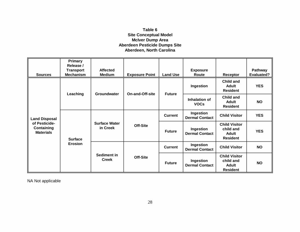
The contamination at the McIver Dump Area is allegedly due to the disposal of materialscontaining pesticides and pesticide residues more than 30 years ago. Contaminants released fromthis material and retained by the soil serve as a reservoir for continued release. Groundwater maybe impacted through the leaching action of infiltrating rain water. Surface water and sediment instreams within the drainage basin may be impacted by erosion or solubilization of soil-boundcontaminants or by an aquifer connection to the stream. The conceptual site model for the McIverDump Area is presented in Table 6.
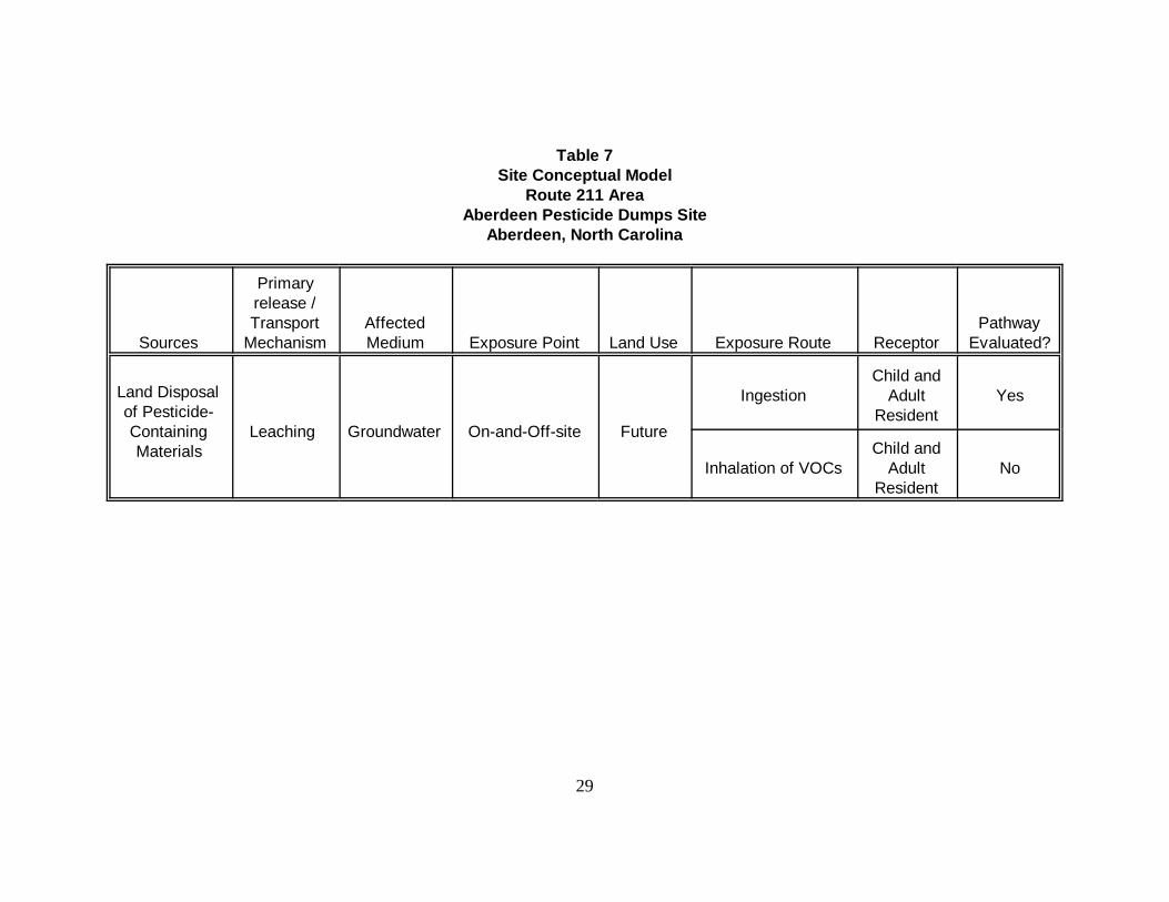
The contamination at the Route 211 Area is allegedly due to the disposal of materials, some ofwhich contained pesticides. Surface water impacts at the Route 211 Area are not expectedbecause the nearest surface water body (a small man-made pond approximately 800 feetsouthwest) is separated from the area of concern by a small topographic rise. Groundwater maybe impacted by the same release mechanisms as the McIver Dump Area. The conceptual sitemodel for the Route 211 Area is shown in Table 7.
Based on these models, the media available for human contact are:
(1). Groundwater. Potential receptors are future site residents.(2). Surface water and sediment in Patterson Branch. Patterson Branch is accessible to
juvenile visitors and future residents at the McIver Dump Area. It is assumed thatthese receptors may wade in the stream and be exposed to contaminants in bothsurface water and sediment; and
Potentially significant exposure routes are:
(1). Groundwater: Ingestion of groundwater and inhalation of Volatile OrganicChemicals (VOCs) (if present) released from groundwater while showering.Because no VOCs were selected as COPCs, the inhalation of VOCs whileshowering is considered to be an incomplete pathway and therefore, was notevaluated. Dermal contact with water during household water use was notconsidered a significant exposure pathway; and
28
Table 6Site Conceptual Model
McIver Dump AreaAberdeen Pesticide Dumps Site
Aberdeen, North Carolina
Sources
PrimaryRelease /Transport
MechanismAffectedMedium Exposure Point Land Use
ExposureRoute Receptor
PathwayEvaluated?
Land Disposalof Pesticide-ContainingMaterials
Leaching Groundwater On-and-Off-site Future
IngestionChild and
AdultResident
YES
Inhalation ofVOCs
Child andAdult
ResidentNO
SurfaceErosion
Surface Waterin Creek Off-Site
Current IngestionDermal Contact Child Visitor YES
Future IngestionDermal Contact
Child Visitorchild and
AdultResident
YES
Sediment inCreek Off-Site
Current IngestionDermal Contact Child Visitor NO
Future IngestionDermal Contact
Child Visitorchild and
AdultResident
NO
NA Not applicable
29
Table 7Site Conceptual Model
Route 211 AreaAberdeen Pesticide Dumps Site
Aberdeen, North Carolina
Sources
Primaryrelease /Transport
MechanismAffectedMedium Exposure Point Land Use Exposure Route Receptor
PathwayEvaluated?
Land Disposalof Pesticide-ContainingMaterials
Leaching Groundwater On-and-Off-site Future
IngestionChild and
AdultResident
Yes
Inhalation of VOCsChild and
AdultResident
No
RODAberdeen OU5
Page 30
(2). Surface water: Inadvertent ingestion and dermal contact with surface water in Patterson Branch. Contactwith sediment, because it is nearly always covered by water, was not evaluated.
6.4 Toxicity Assessment
Toxicity assessment is a two-step process whereby the potential hazards associated with route-specific exposureto a given chemical are (1) identified by reviewing relevant human and animal siudies; and (2) quantified throughanalysis of dose-response relationships.
Toxicity values are used in the baseline evaluation to determine both carcinogenic and non-carcinogenic risksassociated with each chemical of concern and route of exposure. Toxicity values that are used in this assessmentinclude:
• reference dose values (RfDs) for non-carcinogenic effects • cancer slope factors (CSFs) for carcinogenic effects
RfDs have been developed to indicate the potential for adverse health effects from exposure to chemicalsexhibiting non-carcinogenic (systemic) effects. RfDs are ideally based on studies where either animal or humanpopulations were exposed to a given compound by a given route of exposure for the major portion of the lifespan (referred to as a chronic study). The RfD is derived by determining dose-specific effect levels from all theavailable quantitative studies, and applying uncertainty factors to the most appropriate effect level to determinean RfD for humans. The RfD represents a threshold for toxicity. RfDs are derived such that human lifetimeexposure to a given chemical via a given route at a dose at or below the RfD should not result in adverse healtheffects, even for the most sensitive members of the population.
CSFs are route-specific values derived only for compounds that have been shown to cause an increased incidenceof tumors in either human or animal studies. The CSF is an upper bound estimate of the probability of a responseper unit intake of a chemical over a lifetime and is determined by low-dose extrapolation from human or animalstudies. When an animal study is used, the final CSF has been adjusted to account for extrapolation of animaldata to humans. If the studies used to derive the CSF were conducted for less than the life span of the testorganism, the final CSF has been adjusted to reflect risk associated with lifetime exposure.
The RfDs and CSFs used in this assessment were primarily obtained from USEPA's IRIS database. If no valuesfor a given compound and route of exposure were listed in IRIS, then USEPA's HEAST was consulted.USEPA's Office of Pesticide Programs (OPP) recently derived an RfD for gamma-BHC based on a newlyavailable chronic rat study and this value was used in this risk assessment. The gamma-BHC RfD on IRIS wasnot used because it is based on kidney effects that occur through a biological mechanism that is not relevant tohumans (a-2F-
RODAberdeen OU5
Page 31
globulin accumulation. Tables 8 and 9 summarize the toxicity values for carcinogenic and non-carcinogenic COCs, respectively.
6.5 Risk Characterization
The final step of the baseline risk assessment is the risk characterization. Human intakes for eachexposure pathway are integrated with reference toxicity values to characterize risk. Carcinogenicand non-carcinogenic effects are estimated separately.
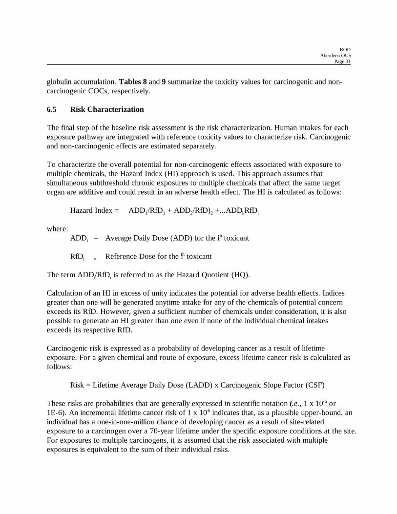
To characterize the overall potential for non-carcinogenic effects associated with exposure tomultiple chemicals, the Hazard Index (HI) approach is used. This approach assumes thatsimultaneous subthreshold chronic exposures to multiple chemicals that affect the same targetorgan are additive and could result in an adverse health effect. The HI is calculated as follows:
Hazard Index = ADD1/RfD1 + ADD2/RfD)2 +...ADDi/RfDi
where:ADDi = Average Daily Dose (ADD) for the ith toxicant
RfDi = Reference Dose for the ith toxicant
The term ADDi/RfDi is referred to as the Hazard Quotient (HQ).
Calculation of an HI in excess of unity indicates the potential for adverse health effects. Indicesgreater than one will be generated anytime intake for any of the chemicals of potential concernexceeds its RfD. However, given a sufficient number of chemicals under consideration, it is alsopossible to generate an HI greater than one even if none of the individual chemical intakesexceeds its respective RfD.
Carcinogenic risk is expressed as a probability of developing cancer as a result of lifetimeexposure. For a given chemical and route of exposure, excess lifetime cancer risk is calculated asfollows:
Risk = Lifetime Average Daily Dose (LADD) x Carcinogenic Slope Factor (CSF)
These risks are probabilities that are generally expressed in scientific notation (i.e., 1 x 10⁻⁶ or1E-6). An incremental lifetime cancer risk of 1 x 10⁻⁶ indicates that, as a plausible upper-bound, anindividual has a one-in-one-million chance of developing cancer as a result of site-relatedexposure to a carcinogen over a 70-year lifetime under the specific exposure conditions at the site.For exposures to multiple carcinogens, it is assumed that the risk associated with multipleexposures is equivalent to the sum of their individual risks.
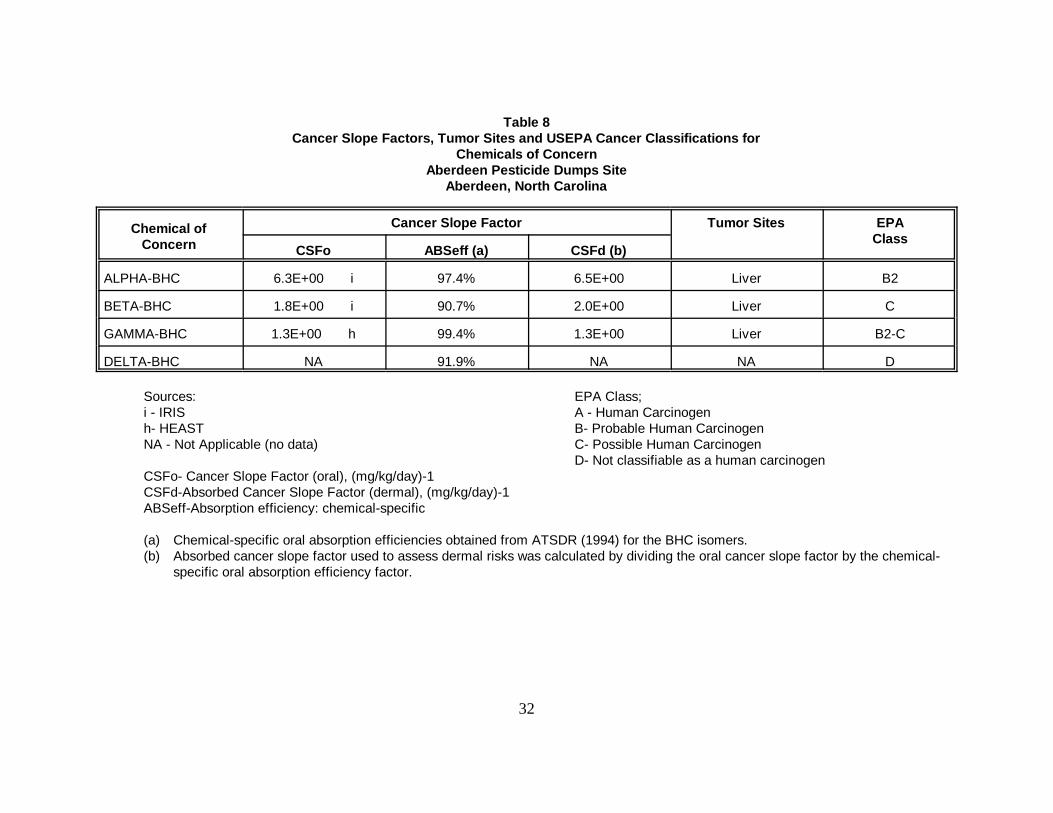
32
Table 8Cancer Slope Factors, Tumor Sites and USEPA Cancer Classifications for
Chemicals of ConcernAberdeen Pesticide Dumps Site
Aberdeen, North Carolina
Chemical ofConcern
Cancer Slope Factor Tumor Sites EPAClass
CSFo ABSeff (a) CSFd (b)
ALPHA-BHC 6.3E+00 i 97.4% 6.5E+00 Liver B2
BETA-BHC 1.8E+00 i 90.7% 2.0E+00 Liver C
GAMMA-BHC 1.3E+00 h 99.4% 1.3E+00 Liver B2-C
DELTA-BHC NA 91.9% NA NA D
Sources: EPA Class;i - IRIS A - Human Carcinogenh- HEAST B- Probable Human CarcinogenNA - Not Applicable (no data) C- Possible Human Carcinogen
D- Not classifiable as a human carcinogenCSFo- Cancer Slope Factor (oral), (mg/kg/day)-1CSFd-Absorbed Cancer Slope Factor (dermal), (mg/kg/day)-1ABSeff-Absorption efficiency: chemical-specific
(a) Chemical-specific oral absorption efficiencies obtained from ATSDR (1994) for the BHC isomers.(b) Absorbed cancer slope factor used to assess dermal risks was calculated by dividing the oral cancer slope factor by the chemical-
specific oral absorption efficiency factor.
33
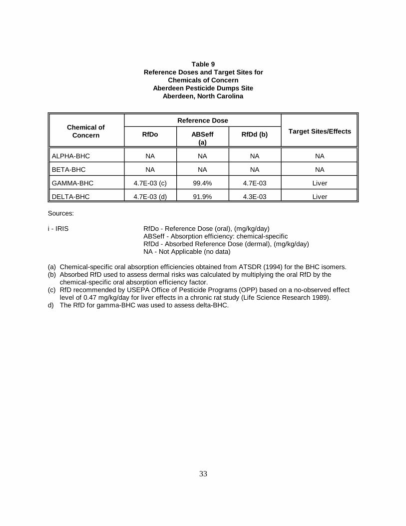
Table 9Reference Doses and Target Sites for
Chemicals of ConcernAberdeen Pesticide Dumps Site
Aberdeen, North Carolina
Chemical ofConcern
Reference Dose
Target Sites/EffectsRfDo ABSeff(a)
RfDd (b)
ALPHA-BHC NA NA NA NA
BETA-BHC NA NA NA NA
GAMMA-BHC 4.7E-03 (c) 99.4% 4.7E-03 Liver
DELTA-BHC 4.7E-03 (d) 91.9% 4.3E-03 Liver
Sources:
i - IRIS RfDo - Reference Dose (oral), (mg/kg/day)ABSeff - Absorption efficiency: chemical-specificRfDd - Absorbed Reference Dose (dermal), (mg/kg/day)NA - Not Applicable (no data)
(a) Chemical-specific oral absorption efficiencies obtained from ATSDR (1994) for the BHC isomers.(b) Absorbed RfD used to assess dermal risks was calculated by multiplying the oral RfD by the
chemical-specific oral absorption efficiency factor.(c) RfD recommended by USEPA Office of Pesticide Programs (OPP) based on a no-observed effect
level of 0.47 mg/kg/day for liver effects in a chronic rat study (Life Science Research 1989).d) The RfD for gamma-BHC was used to assess delta-BHC.
RODAberdeen OU5
Page 34
6.5.1 McIver Dump Area
Current Use
Currently complete exposure routes pertinent to OU 5 at the McIver Dump Area include:
• inadvertent ingestion of surface water • dermal contact with surface water
Potential receptors are site visitors. Estimated total risks associated with these exposure routesare summarized in Table 10. The estimate is based on exposure to the BHC isomers.
The sum of risks associated with currently complete exposure routes is 1 x 10⁻⁸ for the site visitor. Non-cancer effects are not expected for the site visitor based on a total HI of substantially less than one (0.00001) for combined exposure through incidental ingestion and dermal contact withsurface water.
Future Use
Future risks pertinent to OU 5 (groundwater and surface water) at the McIver Dump Areaconsider the development of groundwater resources within the contaminant plume for residents.Potential receptors in the future use scenario also include the previously discussed site visitors.Estimated total risks associated with these exposure routes are summarized in Table 11.
The excess lifetime cancer risks associated with future exposure routes range from 5 x 10⁻⁹ for asite visitor that could incidentally ingest stream water from Pattersons Branch to 3 x 10⁻⁴ for alifetime resident that could ingest groundwater for 30 years from the upper portion of the LowerBlack Creek Aquifer. The predicted excess lifetime cancer risk estimate for adult, and lifetimeresidents are due primarily to the ingestion of groundwater from the upper portion of the LowerBlack Creek Aquifer for 24 and 30 years, respectively. For the child resident, the predicted excesscancer risks are between the 1x10⁻⁴ to 1x10⁻⁶ risk range and below the same range for the sitevisitor. BHC isomers are the most significant contaminants in terms of cancer risk in this futureuse scenario.
As shown on Table 11, non-cancer effects are not expected for child, adult, and lifetime residentsor site visitors.
6.5.2 Route 211 Area
Current Use

35
Table 10Summary of Cancer and Noncancer Risks by Exposure Route
Current Use ScenarioMcIver Dump Area
Aberdeen Pesticide Dumps SiteAberdeen, North Carolina
MediumExposure Route Site Visitor
Cancer HI
Stream InadvertentIngestion
5E-9 0.000003
Water Dermal Contact 8E-9 0.000005
TOTAL CURRENT RISK 1E-8 0.00001
HI Hazard Index (noncancer risk)NA Not Applicable
36
Table 11Summary of Cancer and Noncancer Risks by Exposure Route
Future Use ScenarioMcIver Dump Area
Aberdeen Pesticide Dumps SiteAberdeen, North Carolina
Medium ExposureRoute
Child Resident Adult Resident Lifetime Resident(6-yr + 24-yr)
Site Visitor
Cancer HI Cancer HI Cancer HI Cancer HI
Stream Water InadvertentIngestion
9E-9 0.00001 8E-9 0.000002 2E-8 0.000003 5E-9 0.000003
Stream Water Dermal Contact 1E-8 0.00001 1E-8 0.000003 2E-8 0.00001 8E-9 0.00001
Groundwater
Upper Portionof LowerBlack Creek (b)
Ingestion 1E-4 0.02 2E-4 0.01 3E-4 0.01 NE NE
Lower Portionof LowerBlack Creek (a)
Ingestion 5E-7 0.0003 9E-7 0.0001 1E-6 0.0002 NE NE
(a) Wells 04-MW-02; MC-MW-04D and 05D.(b) Wells MC-MW-04,05, 06, and 07.
NE= Not evaluatedNC= Not calculatedHI= Hazard Index (noncancer risk)
RODAberdeen OU5
Page 37
There are no currently complete exposure routes pertinent to OU 5 (groundwater) at the Route211 Area.
Future Use
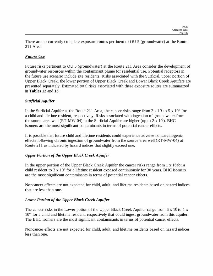
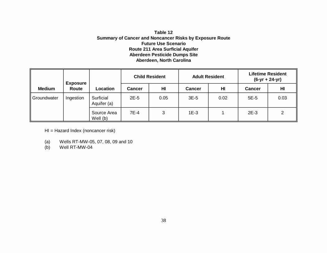
Future risks pertinent to OU 5 (groundwater) at the Route 211 Area consider the development ofgroundwater resources within the contaminant plume for residential use. Potential receptors inthe future use scenario include site residents. Risks associated with the Surficial, upper portion ofUpper Black Creek, the lower portion of Upper Black Creek and Lower Black Creek Aquifers arepresented separately. Estimated total risks associated with these exposure routes are summarizedin Tables 12 and 13.
Surficial Aquifer
In the Surficial Aquifer at the Route 211 Area, the cancer risks range from 2 x 10⁻⁵ to 5 x 10⁻⁵ fora child and lifetime resident, respectively. Risks associated with ingestion of groundwater fromthe source area well (RT-MW-04) in the Surficial Aquifer are higher (up to 2 x 10⁻³). BHCisomers are the most significant contaminants in terms of potential cancer effects.
It is possible that future child and lifetime residents could experience adverse noncarcinogeniceffects following chronic ingestion of groundwater from the source area well (RT-MW-04) atRoute 211 as indicated by hazard indices that slightly exceed one.
Upper Portion of the Upper Black Creek Aquifer
In the upper portion of the Upper Black Creek Aquifer the cancer risks range from 1 x 10⁻⁵ for achild resident to 3 x 10⁻⁵ for a lifetime resident exposed continuously for 30 years. BHC isomersare the most significant contaminants in terms of potential cancer effects.
Noncancer effects are not expected for child, adult, and lifetime residents based on hazard indicesthat are less than one.
Lower Portion of the Upper Black Creek Aquifer
The cancer risks in the Lower potion of the Upper Black Creek Aquifer range from 6 x 10⁻⁶ to 1 x10⁻⁴ for a child and lifetime resident, respectively that could ingest groundwater from this aquifer.The BHC isomers are the most significant contaminants in terms of potential cancer effects.
Noncancer effects are not expected for child, adult, and lifetime residents based on hazard indicesless than one.
38
Table 12Summary of Cancer and Noncancer Risks by Exposure Route
Future Use ScenarioRoute 211 Area Surficial AquiferAberdeen Pesticide Dumps Site
Aberdeen, North Carolina
MediumExposure
Route Location
Child Resident Adult Resident Lifetime Resident(6-yr + 24-yr)
Cancer HI Cancer HI Cancer HI
Groundwater Ingestion SurficialAquifer (a)
2E-5 0.05 3E-5 0.02 5E-5 0.03
Source AreaWell (b)
7E-4 3 1E-3 1 2E-3 2
HI = Hazard Index (noncancer risk)
(a) Wells RT-MW-05, 07, 08, 09 and 10(b) Well RT-MW-04
39
Table 13Summary of Cancer and Noncancer Risks by Exposure Route
Future Use ScenarioRoute 211 Area Upper and Lower Black Creek Aquifers
Aberdeen Pesticide Dumps SiteAberdeen, North Carolina
Medium ExposureRoute
Child Resident Adult Resident Lifetime Resident(6-yr + 24-yr)
Cancer HI Cancer HI Cancer HI
Groundwater
Upper portion of UpperBlack Creek (a)
Ingestion 1E-5 0.02 2E-5 0.01 3E-5 0.01
Lower portion of Upper Black Creek
North of MUW-13 (b) Ingestion 5E-5 0.03 8E-5 0.01 1E-4 0.02
South of MUW-13 (c) Ingestion 6E-6 0.003 1E-5 0.001 2E-5 0.002
Lower Black Creek
North of MUW-13 (d) Ingestion 8E-6 0.004 1E-5 0.002 2E-5 0.002
South of MUW-13 (e) Ingestion 6E-7 0.0004 1E-6 0.0004 2E-6 0.0002
HI Hazard Index (noncancer risk)(a) Wells RT-TW-01D, 02D, 05D, 08D, 09D, 12D, 14D, 22D and 23D.(b) Wells RT-TW-12DD, 18DD, 19DD; and GS-05-02.(c) Wells PRW-16, 17, 25, 27, 50, and 54; RT-TW-21DD and 22DD.(d) Wells RT-TW-18L and 19L.(e) Wells RT-TW-20L, 21L, and 22L; and PRW-23.

RODAberdeen OU5
Page 40
Lower Black Creek Aquifer
In this aquifer, cancer risks range from 6 x 10 -7 to 2 x 10⁻⁵ for a child and lifetime resident,respectively. BHC isomers are the most significant chemicals in terms of potential cancereffects.
Noncancer effects are not expected for child, adult, and lifetime residents based on hazardindices less than one.
7.0 REMEDIATION OBJECTIVES
Based on the evaluation of the BRA, the Applicable or Relevant and AppropriateRequirements (ARARs), the identified COCs, and the potential exposure route and receptors,remedial action objectives were developed for the McIver Dump and the Route 211 Areas.
7.1 McIver Dump Area
• Protect human health by preventing the ingestion of groundwater with COCsconcentrations exceeding established Federal and State ARARs, having potentialcarcinogens in excess of a total lifetime cancer risk of 1 x 10 -6, or having a HI greaterthan 1 for non-carcinogens.
• Protect human health and the environment by restoring groundwater at the McIverDump Area to concentrations below to the clean up goals described below.
• Protect the environment by preventing future potential impact to Patterson Branch.
7.2 Route 211 Area
• Protect human health by preventing the ingestion of groundwater with COCsconcentrations exceeding established Federal and State ARARs, having potentialcarcinogens in excess of a total lifetime cancer risk of 1 x 10 -6, or having a HI greaterthan 1 for non-carcinogens.
• Protect human health and the environment by restoring groundwater at the Route 211Area to concentrations below the clean up goals described below for the chemicals ofconcern.
• Protect the environment by preventing future potential impact to downgradient surfacewaters.
RODAberdeen OU5
Page 41
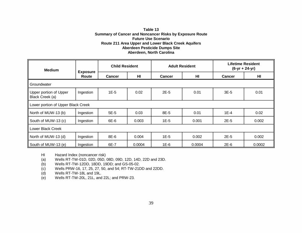
7.3 Clean up Goals for McIver Dump and Route 211 Areas
Table 14 shows the applicable groundwater clean up goals in parts per billion (ppb) for thechemicals of concern for both McIver Dump and Route 211 Areas.
Table 14
Chemicals of Concern (COCs) Groundwater Clean-up Goal Basis
Alpha - BHC 0.02 Risk - Based
Beta - BHC 0.10 Risk - Based
Delta - BHC 70.0 Risk - Based
Gamma - BHC 0.20 MCLs/NCGQS
MCLs - Maximum Contaminant LevelsNCGQS- North Carolina Groundwater Quality Standards
8.0 DESCRIPTION OF REMEDIAL ALTERNATIVES
The following section provides a summary of the alternatives developed in the Feasibility Study(FS) report for the clean-up of groundwater at McIver and Route 211 Areas.
8.1 McIver Dump Area
8.1.1 Alternative 1: No Action
The No Action alternative is required to be evaluated at every site to establish a baseline forcomparison. No further groundwater activities would be conducted at the McIver Dump Areaunder this alternative. Because this alternative does not entail contaminant removal, a reviewof the remedy would be conducted every five years in accordance with CERCLA. Costsincluded on this alternative are associated with the five year review which would includesampling and analysis for the COCs and preparation of the five year review report.
Estimated total present worth costs for the No Action alternative is $160,000. This costincludes a remedy review every 5 years for a 10 year period. There are no operation andmaintenance costs associated with this alternative. A detailed cost estimate for Alternative 1 isprovided in Table 15. Costs are rounded to two significant figures.
-42-
Table 15
Alternative 1McIver Dump Area
REMEDY REVIEW
Every 5 Years, $100,000
Calculation of Present Worth Factors (PWF) at 7% interest and 4% inflation:
Year PWF 5 0.862610 0.7441
Total: 1.6067
REMEDY REVIEW, PRESENT WORTH COST (10 years, i=7%, e=4%): $160,000
RODAberdeen OU5
Page 43
8.1.2 Alternative 2: Continued Groundwater/Surface Water/Sediments Monitoring,Phytoremediation, Area Reconnaissance, and Alternative Water Supply/Well Head Treatmentif Future Potential Receptors are identified
8.1.2.1 Description of Alternative 2 Components
Monitor Natural Attenuation
Monitoring would be used to verify that natural aquifer processes are reducing contaminantconcentrations to acceptable levels by intrinsic remediation; to determining the concentration,distribution, and migration of the COCs in groundwater/surface water and sediments, and toverify that the clean up goals are achieved during remedial action. Additionally, monitoring wouldbe used as a mechanism by which future receptors within the migration pathway of COCs areidentified and addressed, if necessary. Monitoring would also be used to maintain exposurecontrol within the defined remedial action objectives. After source removal and construction oferosion control measures already finished under a separate ROD, pesticide concentrations willnaturally decrease.
Monitoring would involve periodic (short and long-term) sampling and analysis of groundwater/surface water/sediments.
Phytoremediation
Phytoremediation is an innovative in-situ technology for the remediation of pesticide ingroundwater. Phytoremediation would be used to enhance the natural attenuation processes bythe use of vegetation to treat in-place contaminated groundwater. The McIver Dump Area isfavorable for the use of phytoremediation as a remedial technology because of the shallow watertable which would allow tree roots to get in contact with contaminated groundwater, proximity ofthe source area to the groundwater discharge area, and absence of current groundwater use.Additionally, phytoremediation offers some hydraulic control through transpiration, therebylimiting the migration of pesticides.
Area Reconnaissance
Area reconnaissance would be used to determine whether properties at the area are for sale,purchased, or being leased. This would be accomplished by reconnoitering the McIver DumpArea and reviewing property records. Town development plans would be reviewed to determineany future development strategies for the McIver Dump Area. Additionally, residential wellsurveys have been conducted at the McIver Dump Area. Through area reconnaissance, theresidential well surveys would be verified and updated. Area reconnaissance is an effective meansof controlling exposure as defined in the remedial action objectives. The area reconnaissanceprogram would be in place until clean up goals are achieved.
RODAberdeen OU5
Page 44
Alternative Water Supply/ Well Head Treatment
Currently, there are no receptors of impacted groundwater. However, if potential receptors areidentified in the future, an alternative water supply or well head treatment will be used to preventexposure. This option would be available for any potential receptor until clean up goals areachieved.
Remedy Review
A remedy review would be performed every 5 years until clean up goals are achieved to determinethe effectiveness of the remedy to protect human health and/or the environment. As a result of thisreview, if needed, additional site remediation or modifications to the remedy would be performed.
8.1.2.2 Other Features of Alternative 2
• Groundwater clean up goals for the COCs would be achieved by natural attenuation (sincesource soils were removed in 1997) and/or via phytoremediation.
• The time frame to achieve clean up goals under Alternative 2 is estimated to be 10 years.
• The estimated total present worth cost for Alternative 2 is $450,000. This cost includesperiodic monitoring of groundwater and Patterson Branch, the enhancement of the McIverDump Area through the planting of trees or other plant life (phytoremediation), and aremedy review every 5 years for a 10 year period to determine the effectiveness of thealternative to protect human health and/or the environment. A detailed cost estimate forAlternative 2 is provided in Table 16. Costs are rounded to two significant figures.
8.1.2.3 Expected Outcomes of Alternative 2
• After clean up goals are achieved (estimated time frame of 10 years), groundwater shouldbe available to drink without having to treat to remove pesticides.
8.1.3 Alternative 3: Groundwater Recovery of the Highest Concentrations ofPesticide Residuals using Extraction Wells and/or Interceptor Trenches, Treatment by CarbonAdsorption, Discharge of Treated Groundwater via Surface Water or Reinjection (InfiltrationGalleries/Injection Wells), Continued Groundwater/Surface Water Monitoring, AreaReconnaissance, and Alternative Water Supply/Well Head Treatment should Future PotentialReceptors be identified
-45-
Table 16
Alternative 2McIver Dump Area
Item Unit Cost Units Quantity Total Cost
DIRECT CAPITAL COSTS
Phytoremediation vegetation planting $32 tree 1,250 $40,000Administrative Fees $10,000 LS 1 $10,000
$50,000
INDIRECT CAPITAL COSTS
Health and Safety @ 5% of Direct Capital Costs (DCC) $2,500Bonds & Insurance @ 5% of DCC $2,500Contingency @ 20% of DCC $10,000
$15,000
TOTAL CAPITAL COST: $65,000ANNUAL OPERATING AND MAINTENANCE COSTS
MONITORINGSampling - First 5 Years:
Quarterly Sampling (Labor + Supplies) 2 days, 1 night + equipment $4,700 3 MO 4 $18,800Quarterly Sampling (Pesticide Analyses) 4 groundwater samples $620 3 MO 4 $2,480Quarterly QA/QC samples 2 water samples $310 3 MO 4 $1,240Annual Sampling (Pesticide Analyses) 2 surf. water, 2 sed., 3 QA/QC $1,115 YR 1 $1,115Validation and Report Preparation $3,600 3 MO 4 $14,400
$38,035Present Worth (n=5 yrs, i=7%, e=4%, PWF=4.58): $174,200
Sampling -Years 5-10:Annual Sampling (Labor + Supplies) 2 days, 1 night + equip. $4,700 YR 1 $4,700Annual Sampling (Analyses) 4 gw, 2 sw, 2 sed. samples $1,260 YR 1 $1,260Annual QA/QC Samples 4 water, 1 sediment sample $785 YR 1 $785Validation and Report Preparation $3,600 LS 1 $3,600
$10,345Present Worth (n=5-10, i=7%, e=4%, PWF=3.95): $40,863
REMEDY REVIEW $100,000 Every 5 Years
Present Worth Cost (see B.1-1, PWF=1.60): $160,000
TOTAL O&M COSTS: $380,000
TOTAL PRESENT WORTH COST $445,000
RODAberdeen OU5
Page 46
8.1.3.1 Description of Alternative 3 Components
Groundwater Extraction and Treatment Components
• Groundwater containing the highest concentrations of pesticides, “hot spots” (> 0.1 ppb),would be extracted using extraction wells interceptor trenches.
• Extracted groundwater would be treated using carbon adsorption.
• Treated groundwater would be discharged via surface water or a re-injection method.
Monitoring Natural Attenuation - same as Alternative 2.
Area Reconnaissance - Same as Alternative 2
Alternative Water Supply/ Well Head Treatment - Same as Alternative 2.
Remedy Review - Same as Alternative 2
8.1.3.2 Other Features of Alternative 3
• Groundwater clean up goals would be achieved by removing the highest concentrations ofpesticides using extraction wells and/or interception trenches, and by natural attenuationon the rest of the plume (since source soils were removed in 1997).
• Due to the groundwater flow velocity, the hydraulic gradient near the surface water body,and the limited discharge distance to the creek, increasing the gradient through extractionwould not significantly decrease the time frame to achieve clean up goals. The time frameto achieve clean up goals under Alternative 3 is estimated to be 10 years.
• For cost estimate purposes, interceptor trenches were assumed as the groundwaterrecovery method. Total present worth costs were estimated for Alternative 3 with twodifferent discharge options: discharge to surface water and infiltration galleries. Theestimated total cost is $1,500,000 discharging to surface water and $1,200,000discharging to an infiltration gallery. The groundwater recovery method and dischargeoption would be determined during remedial design. Costs include the construction ofinterceptor trenches to collect the highest concentrations of pesticides, a carbonadsorption treatment system, and the respective discharge option. Operation andmaintenance costs include power consumption, a site operator, carbon replacement,sampling, and a remedy review every 5 years for a 10 year period. Detailed cost estimates
RODAberdeen OU5
Page 47
for Alternative 3 are provided in Tables 17a and 17b. Costs are rounded to twosignificant figures.
8.1.3.3 Expected Outcomes of Alternative 3
• After clean up goals are achieved (estimated time frame of 10 years), groundwater shouldbe available to drink without having to treat to remove pesticides.
8.1.4 Alternative 4: Groundwater Recovery of Pesticide Residuals Exceeding Cleanup Goals using Extraction Wells and/or Interceptor Trenches, Treatment by CarbonAdsorption, Discharge of Treated Groundwater via Surface Water or Reinjection (InfiltrationGalleries/Injection Wells), Continued Groundwater/Surface Water Monitoring, AreaReconnaissance, and Alternative Water Supply/Well Head Treatment should Future PotentialReceptors be identified
8.1.4.1 Description of Alternative 4 Components
Groundwater Extraction and Treatment Components
• Groundwater containing pesticides above clean up goals would be extracted usingextraction wells or interceptor trenches.
• Extracted groundwater would be treated using carbon adsorption.
• Treated groundwater would be discharged via surface water or a re-injection method.
• Monitoring of the Extraction, treatment and discharge systems until clean up goals areachieved.
Monitoring Program
A monitoring would be implemented as a mechanism by which future receptors within themigration pathway of COCs are identified and addressed, if necessary. Monitoring would also beused to maintain exposure control within the defined remedial action objectives.
Monitoring would involve periodic (short and long-term) sampling and analysis of groundwater/surface water/sediments.
Area Reconnaissance - Same as Alternative 2
Alternative Water Supply/ Well Head Treatment - Same as Alternative 2.
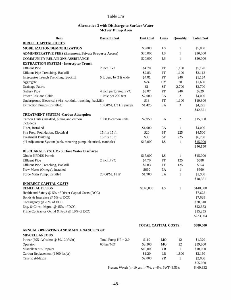
-48-
Table 17a
Alternative 3 with Discharge to Surface WaterMcIver Dump Area
Item Basis of Cost Unit Cost Units Quantity Total CostDIRECT CAPITAL COSTSMOBILIZATION/DEMOBILIZATION $5,000 LS 1 $5,000ADMINISTRATIVE FEES (Easement, Private Property Access) $20,000 LS 1 $20,000COMMUNITY RELATIONS ASSISTANCE $20,000 LS 1 $20,000EXTRACTION SYSTEM - Interceptor TrenchEffluent Pipe 2 inch PVC $4.70 FT 1,100 $5,170Effluent Pipe Trenching, Backfill $2.83 FT 1,100 $3,113Interceptor Trench Trenching, Backfill 5 ft deep by 2 ft wide $4.81 FT 240 $1,154Aggregate $24 CY 70 $1,680Drainage Fabric $1 SF 2,700 $2,700Gallery Pipe 4 inch perforated PVC $3.87 FT 240 $929Power Pole and Cable 1 Pole per 200 feet $2,000 EA 2 $4,000Underground Electrical (wire, conduit, trenching, backfill) $18 FT 1,100 $19,800Extraction Pumps (installed) 10 GPM, 1/3 HP pumps $1,425 EA 3 $4,275
$42,821TREATMENT SYSTEM -Carbon AdsorptionCarbon Units (installed, piping and carbonincluded)
1000 lb carbon units $7,950 EA 2 $15,900
Filter, installed $4,000 EA 1 $4,000Site Prep, Foundation, Electrical 15 ft x 15 ft $20 SF 225 $4,500Treatment Building 15 ft x 15 ft $30 SF 225 $6,750pH Adjustment System (tank, metering pump, electrical, manhole) $15,000 LS 1 $15,000
$46,150DISCHARGE SYSTEM- Surface Water DischargeObtain NPDES Permit $15,000 LS 1 $15,000Effluent Pipe 2 inch PVC $4.70 FT 125 $588Effluent Pipe Trenching, Backfill $2.83 FT 125 $354Flow Meter (Omega), installed $660 EA 1 $660Force Main Pump, installed 20 GPM, 1 HP $1,980 EA 1 $1,980
$18,581INDIRECT CAPITAL COSTSREMEDIAL DESIGN $140,000 LS 1 $140,000Health and Safety @ 5% of Direct Capital Costs (DCC) $7,628Bonds & Insurance @ 5% of DCC $7,628Contingency @ 20% of DCC $30,510Eng. & Const. Mgmt. @ 15% of DCC $22,883Prime Contractor Ovrhd & Proft @ 10% of DCC $15,255
$223,904
TOTAL CAPITAL COSTS: $380,000ANNUAL OPERATING AND MAINTENANCE COSTMISCELLANEOUSPower (895 kWhr/mo @ $0.10/kWhr) Total Pump HP = 2.0 $110 MO 12 $1,320Operator 60 hrs/MO $3,300 MO 12 $39,600Miscellaneous Repairs $10,000 YR 1 $10,000Carbon Replacement (1800 lbs/yr) $1.20 LB 1,800 $2,160Caustic Addition $2,000 YR 1 $2,000
$55,080Present Worth (n=10 yrs, i=7%, e=4%, PWF=8.53): $469,832
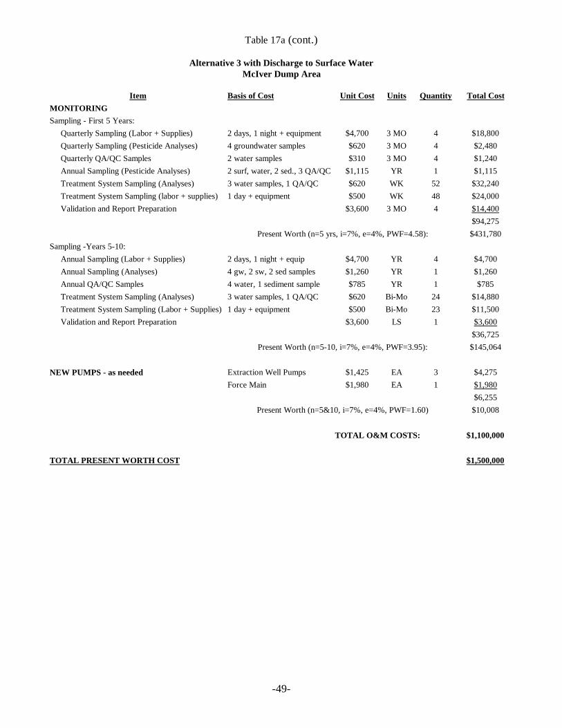
-49-
Table 17a (cont.)
Alternative 3 with Discharge to Surface WaterMcIver Dump Area
Item Basis of Cost Unit Cost Units Quantity Total CostMONITORINGSampling - First 5 Years:
Quarterly Sampling (Labor + Supplies) 2 days, 1 night + equipment $4,700 3 MO 4 $18,800Quarterly Sampling (Pesticide Analyses) 4 groundwater samples $620 3 MO 4 $2,480Quarterly QA/QC Samples 2 water samples $310 3 MO 4 $1,240Annual Sampling (Pesticide Analyses) 2 surf, water, 2 sed., 3 QA/QC $1,115 YR 1 $1,115Treatment System Sampling (Analyses) 3 water samples, 1 QA/QC $620 WK 52 $32,240Treatment System Sampling (labor + supplies) 1 day + equipment $500 WK 48 $24,000Validation and Report Preparation $3,600 3 MO 4 $14,400
$94,275Present Worth (n=5 yrs, i=7%, e=4%, PWF=4.58): $431,780
Sampling -Years 5-10:Annual Sampling (Labor + Supplies) 2 days, 1 night + equip $4,700 YR 4 $4,700Annual Sampling (Analyses) 4 gw, 2 sw, 2 sed samples $1,260 YR 1 $1,260Annual QA/QC Samples 4 water, 1 sediment sample $785 YR 1 $785Treatment System Sampling (Analyses) 3 water samples, 1 QA/QC $620 Bi-Mo 24 $14,880Treatment System Sampling (Labor + Supplies) 1 day + equipment $500 Bi-Mo 23 $11,500Validation and Report Preparation $3,600 LS 1 $3,600
$36,725Present Worth (n=5-10, i=7%, e=4%, PWF=3.95): $145,064
NEW PUMPS - as needed Extraction Well Pumps $1,425 EA 3 $4,275Force Main $1,980 EA 1 $1,980
$6,255Present Worth (n=5&10, i=7%, e=4%, PWF=1.60) $10,008
TOTAL O&M COSTS: $1,100,000
TOTAL PRESENT WORTH COST $1,500,000
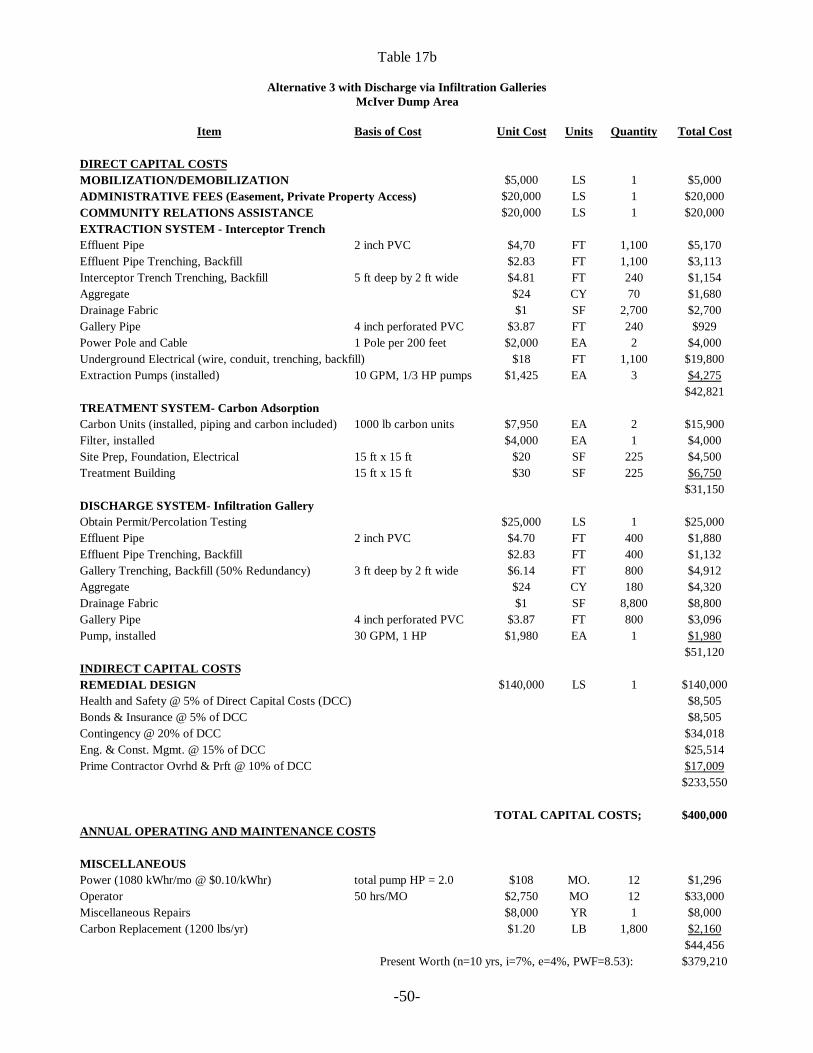
-50-
Table 17b
Alternative 3 with Discharge via Infiltration GalleriesMcIver Dump Area
Item Basis of Cost Unit Cost Units Quantity Total Cost
DIRECT CAPITAL COSTSMOBILIZATION/DEMOBILIZATION $5,000 LS 1 $5,000ADMINISTRATIVE FEES (Easement, Private Property Access) $20,000 LS 1 $20,000COMMUNITY RELATIONS ASSISTANCE $20,000 LS 1 $20,000EXTRACTION SYSTEM - Interceptor TrenchEffluent Pipe 2 inch PVC $4,70 FT 1,100 $5,170Effluent Pipe Trenching, Backfill $2.83 FT 1,100 $3,113Interceptor Trench Trenching, Backfill 5 ft deep by 2 ft wide $4.81 FT 240 $1,154Aggregate $24 CY 70 $1,680Drainage Fabric $1 SF 2,700 $2,700Gallery Pipe 4 inch perforated PVC $3.87 FT 240 $929Power Pole and Cable 1 Pole per 200 feet $2,000 EA 2 $4,000Underground Electrical (wire, conduit, trenching, backfill) $18 FT 1,100 $19,800Extraction Pumps (installed) 10 GPM, 1/3 HP pumps $1,425 EA 3 $4,275
$42,821TREATMENT SYSTEM- Carbon AdsorptionCarbon Units (installed, piping and carbon included) 1000 lb carbon units $7,950 EA 2 $15,900Filter, installed $4,000 EA 1 $4,000Site Prep, Foundation, Electrical 15 ft x 15 ft $20 SF 225 $4,500Treatment Building 15 ft x 15 ft $30 SF 225 $6,750
$31,150DISCHARGE SYSTEM- Infiltration GalleryObtain Permit/Percolation Testing $25,000 LS 1 $25,000Effluent Pipe 2 inch PVC $4.70 FT 400 $1,880Effluent Pipe Trenching, Backfill $2.83 FT 400 $1,132Gallery Trenching, Backfill (50% Redundancy) 3 ft deep by 2 ft wide $6.14 FT 800 $4,912Aggregate $24 CY 180 $4,320Drainage Fabric $1 SF 8,800 $8,800Gallery Pipe 4 inch perforated PVC $3.87 FT 800 $3,096Pump, installed 30 GPM, 1 HP $1,980 EA 1 $1,980
$51,120INDIRECT CAPITAL COSTSREMEDIAL DESIGN $140,000 LS 1 $140,000Health and Safety @ 5% of Direct Capital Costs (DCC) $8,505Bonds & Insurance @ 5% of DCC $8,505Contingency @ 20% of DCC $34,018Eng. & Const. Mgmt. @ 15% of DCC $25,514Prime Contractor Ovrhd & Prft @ 10% of DCC $17,009
$233,550
TOTAL CAPITAL COSTS; $400,000ANNUAL OPERATING AND MAINTENANCE COSTS
MISCELLANEOUSPower (1080 kWhr/mo @ $0.10/kWhr) total pump HP = 2.0 $108 MO. 12 $1,296Operator 50 hrs/MO $2,750 MO 12 $33,000Miscellaneous Repairs $8,000 YR 1 $8,000Carbon Replacement (1200 lbs/yr) $1.20 LB 1,800 $2,160
$44,456Present Worth (n=10 yrs, i=7%, e=4%, PWF=8.53): $379,210
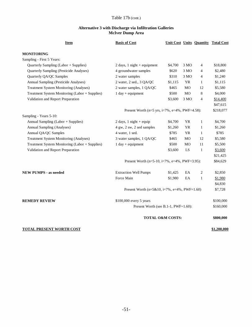
-51-
Table 17b (cont.)
Alternative 3 with Discharge via Infiltration GalleriesMcIver Dump Area
Item Basis of Cost Unit Cost Units Quantity Total Cost
MONITORINGSampling - First 5 Years:
Quarterly Sampling (Labor + Supplies) 2 days, 1 night + equipment $4,700 3 MO 4 $18,800Quarterly Sampling (Pesticide Analyses) 4 groundwater samples $620 3 MO 4 $2,480Quarterly QA/QC Samples 2 water samples $310 3 MO 4 $1,240Annual Sampling (Pesticide Analyses) 2 water, 2 sed., 3 QA/QC $1,115 YR 1 $1,115Treatment System Monitoring (Analyses) 2 water samples, 1 QA/QC $465 MO 12 $5,580Treatment System Monitoring (Labor + Supplies) 1 day + equipment $500 MO 8 $4,000Validation and Report Preparation $3,600 3 MO 4 $14,400
$47,615Present Worth (n=5 yrs, i=7%, e=4%, PWF=4.58): $218,077
Sampling - Years 5-10:Annual Sampling (Labor + Supplies) 2 days, 1 night + equip $4,700 YR 1 $4,700Annual Sampling (Analyses) 4 gw, 2 sw, 2 sed samples $1,260 YR 1 $1,260Annual QA/QC Samples 4 water, 1 sed. $785 YR 1 $785Treatment System Monitoring (Analyses) 3 water samples, 1 QA/QC $465 MO 12 $5,580Treatment System Monitoring (Labor + Supplies) 1 day + equipment $500 MO 11 $5,500Validation and Report Preparation $3,600 LS 1 $3,600
$21,425Present Worth (n=5-10, i=7%, e=4%, PWF=3.95): $84,629
NEW PUMPS - as needed Extraction Well Pumps $1,425 EA 2 $2,850Force Main $1,980 EA 1 $1,980
$4,830Present Worth (n=5&10, i=7%, e=4%, PWF=1.60) $7,728
REMEDY REVIEW $100,000 every 5 years $100,000Present Worth (see B.1-1, PWF=1.60): $160,000
TOTAL O&M COSTS: $800,000
TOTAL PRESENT WORTH COST $1,200,000
RODAberdeen OU5
Page 52
Remedy Review - Same as Alternative 2
8.1.4.2 Other Features of Alternative 4
• Groundwater clean up goals would be achieved by removing pesticides above clean upgoals using extraction wells and/or interception trenches.
• Due to the groundwater flow velocity, the hydraulic gradient near the surface water body,and the limited discharge distance to the creek, increasing the gradient through extractionwould not significantly decrease the time frame to achieve clean up goals. The time frameto achieve clean up goals under Alternative 4 is estimated to be 10 years.
• For cost estimate purposes, interceptor trenches were assumed as the groundwaterrecovery method. Total present worth costs for Alternative 4 were estimated using twodischarge options: discharge to surface water and infiltration galleries. The estimated totalcost is $2,000,000 with the surface water discharge option and $1,600,000 with aninfiltration gallery. Actual discharge options (and recovery options) would be determinedduring remedial design. Costs include the same parameters as with Alterative 3. However,because groundwater extraction rates are higher, extraction, treatment, and dischargesystems are more costly. Detailed cost estimates for Alternative 4 are provided in Tables18a and 18b. Costs are rounded to two significant figures.
8.1.4.3 Expected Outcomes of Alternative 4
• After clean up goals are achieved (estimated time frame of 10 years), groundwater shouldbe available to drink without having to treat to remove pesticides.
8.2 Route 211 Area
8.2.1 Alternative 1: No Action
The No Action alternative is required to be evaluated at every site to establish a baseline forcomparison. No further groundwater activities will be conducted at the Route 211 Area under thisalternative. Because this alternative does not entail contaminant removal, a review of the remedywould be conducted every five years in accordance with the Superfund law. Costs included onthis alternative are associated with the five year review which would include sampling and analysisfor the contaminants of concern (COCs) and preparation of the five year review report.
The estimated total present worth cost for Alternative 1 is $370,000. This cost includes a reviewof the remedy every 5 years for a 30 year period. There are no operation and maintenance costs
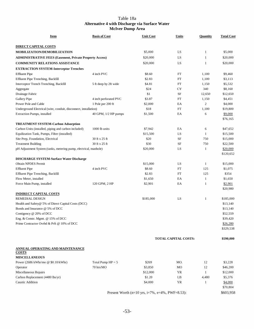
-53-
Table 18aAlternative 4 with Discharge via Surface Water
McIver Dump Area
Item Basis of Cost Unit Cost Units Quantity Total Cost
DIRECT CAPITAL COSTS
MOBILIZATION/DEMOBILIZATION $5,000 LS 1 $5,000
ADMINISTRATIVE FEES (Easement, Private Property Access) $20,000 LS 1 $20,000
COMMUNITY RELATIONS ASSISTANCE $20,000 LS 1 $20,000
EXTRACTION SYSTEM-Interceptor TrenchesEffluent Pipe 4 inch PVC $8.60 FT 1,100 $9,460Effluent Pipe Trenching, Backfill $2.83 FT 1,100 $3,113Interceptor Trench Trenching, Backfill 5 ft deep by 2ft wide $4.81 FT 1,150 $5,532Aggregate $24 CY 340 $8,160Drainage Fabric $1 SF 12,650 $12,650Gallery Pipe 4 inch perforated PVC $3.87 FT 1,150 $4,451Power Pole and Cable 1 Pole per 200 ft $2,000 EA 2 $4,000Underground Electrical (wire, conduit, disconnect, installation) $18 FT 1,100 $19,800Extraction Pumps, installed 40 GPM, 1/2 HP pumps $1,500 EA 6 $9,000
$76,165TREATMENT SYSTEM-Carbon AdsorptionCarbon Units (installed, piping and carbon included) 1000 lb units $7,942 EA 6 $47,652Equilization Tank, Pumps, Filter (installed) $15,500 LS 1 $15,500Site Prep, Foundation, Electrical 30 ft x 25 ft $20 SF 750 $15,000Treatment Building 30 ft x 25 ft $30 SF 750 $22,500pH Adjustment System (tanks, metering pump, electrical, manhole) $20,000 LS 1 $20,000
$120,652DISCHARGE SYSTEM-Surface Water DischargeObtain NPDES Permit $15,000 LS 1 $15,000Effluent Pipe 4 inch PVC $8.60 FT 125 $1,075Effluent Pipe Trenching, Backfill $2.83 FT 125 $354Flow Meter, installed $1,650 EA 1 $1,650Force Main Pump, installed 120 GPM, 2 HP $2,901 EA 1 $2,901
$20,980INDIRECT CAPITAL COSTSREMEDIAL DESIGN $185,000 LS 1 $185,000Health and Safety@ 5% of Direct Capital Costs (DCC) $13,140Bonds and Insurance @ 5% of DCC $13,140Contigency @ 20% of DCC $52,559Eng. & Constr. Mgmt. @ 15% of DCC $39,420Prime Contractor Ovrhd & Prft @ 10% of DCC $26,280
$329,538
TOTAL CAPITAL COSTS: $590,000
ANNUAL OPERATING AND MAINTENANCECOSTSMISCELLANEOUSPower (2686 kWhr/mo @ $0.10/kWhr) Total Pump HP = 5 $269 MO. 12 $3,228Operator 70 hrs/MO $3,850 MO 12 $46,200Miscellaneous Repairs $12,000 YR 1 $12,000Carbon Replacement (4480 lbs/yr) $1.20 LB 4,480 $5,376Caustic Addition $4,000 YR 1 $4,000
$70,804
Present Worth (n=10 yrs, i=7%, e=4%, PWF=8.53): $603,958
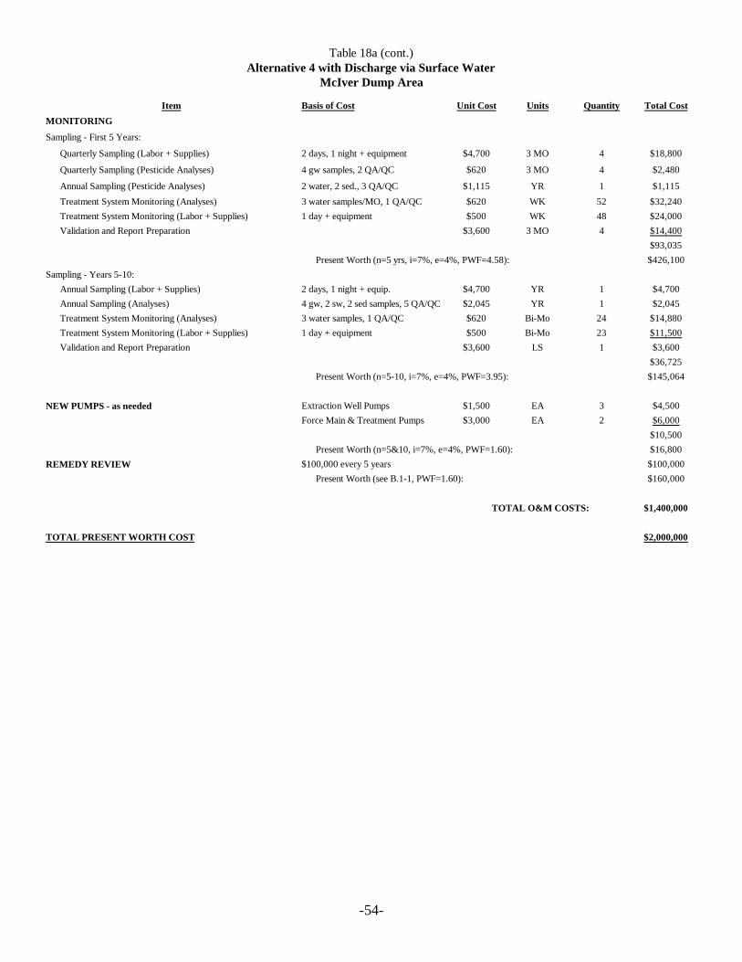
-54-
Table 18a (cont.)Alternative 4 with Discharge via Surface Water
McIver Dump Area
Item Basis of Cost Unit Cost Units Quantity Total CostMONITORING
Sampling - First 5 Years:
Quarterly Sampling (Labor + Supplies) 2 days, 1 night + equipment $4,700 3 MO 4 $18,800
Quarterly Sampling (Pesticide Analyses) 4 gw samples, 2 QA/QC $620 3 MO 4 $2,480
Annual Sampling (Pesticide Analyses) 2 water, 2 sed., 3 QA/QC $1,115 YR 1 $1,115
Treatment System Monitoring (Analyses) 3 water samples/MO, 1 QA/QC $620 WK 52 $32,240Treatment System Monitoring (Labor + Supplies) 1 day + equipment $500 WK 48 $24,000Validation and Report Preparation $3,600 3 MO 4 $14,400
$93,035Present Worth (n=5 yrs, i=7%, e=4%, PWF=4.58): $426,100
Sampling - Years 5-10:Annual Sampling (Labor + Supplies) 2 days, 1 night + equip. $4,700 YR 1 $4,700Annual Sampling (Analyses) 4 gw, 2 sw, 2 sed samples, 5 QA/QC $2,045 YR 1 $2,045Treatment System Monitoring (Analyses) 3 water samples, 1 QA/QC $620 Bi-Mo 24 $14,880Treatment System Monitoring (Labor + Supplies) 1 day + equipment $500 Bi-Mo 23 $11,500Validation and Report Preparation $3,600 LS 1 $3,600
$36,725Present Worth (n=5-10, i=7%, e=4%, PWF=3.95): $145,064
NEW PUMPS - as needed Extraction Well Pumps $1,500 EA 3 $4,500Force Main & Treatment Pumps $3,000 EA 2 $6,000
$10,500Present Worth (n=5&10, i=7%, e=4%, PWF=1.60): $16,800
REMEDY REVIEW $100,000 every 5 years $100,000Present Worth (see B.1-1, PWF=1.60): $160,000
TOTAL O&M COSTS: $1,400,000
TOTAL PRESENT WORTH COST $2,000,000
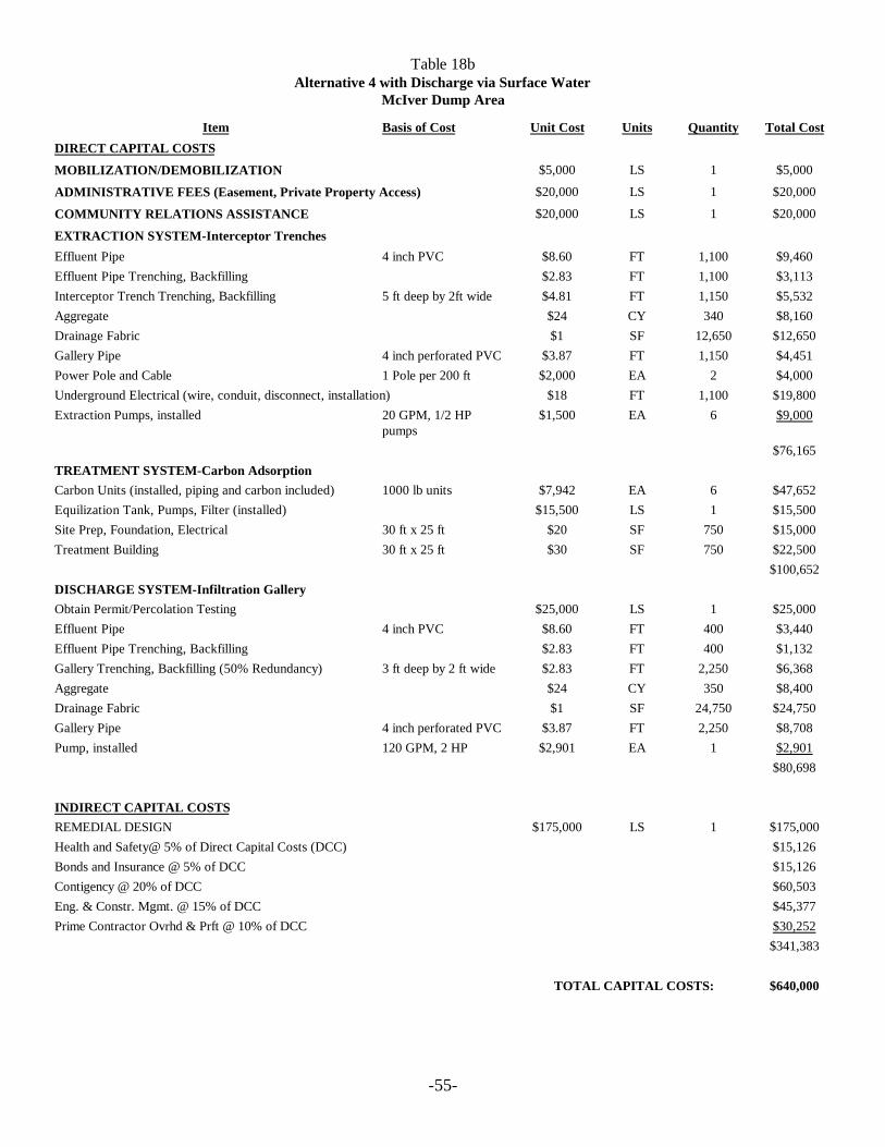
-55-
Table 18bAlternative 4 with Discharge via Surface Water
McIver Dump Area
Item Basis of Cost Unit Cost Units Quantity Total CostDIRECT CAPITAL COSTS
MOBILIZATION/DEMOBILIZATION $5,000 LS 1 $5,000
ADMINISTRATIVE FEES (Easement, Private Property Access) $20,000 LS 1 $20,000
COMMUNITY RELATIONS ASSISTANCE $20,000 LS 1 $20,000
EXTRACTION SYSTEM-Interceptor TrenchesEffluent Pipe 4 inch PVC $8.60 FT 1,100 $9,460Effluent Pipe Trenching, Backfilling $2.83 FT 1,100 $3,113Interceptor Trench Trenching, Backfilling 5 ft deep by 2ft wide $4.81 FT 1,150 $5,532Aggregate $24 CY 340 $8,160Drainage Fabric $1 SF 12,650 $12,650Gallery Pipe 4 inch perforated PVC $3.87 FT 1,150 $4,451Power Pole and Cable 1 Pole per 200 ft $2,000 EA 2 $4,000Underground Electrical (wire, conduit, disconnect, installation) $18 FT 1,100 $19,800Extraction Pumps, installed 20 GPM, 1/2 HP
pumps$1,500 EA 6 $9,000
$76,165TREATMENT SYSTEM-Carbon AdsorptionCarbon Units (installed, piping and carbon included) 1000 lb units $7,942 EA 6 $47,652Equilization Tank, Pumps, Filter (installed) $15,500 LS 1 $15,500Site Prep, Foundation, Electrical 30 ft x 25 ft $20 SF 750 $15,000Treatment Building 30 ft x 25 ft $30 SF 750 $22,500
$100,652DISCHARGE SYSTEM-Infiltration GalleryObtain Permit/Percolation Testing $25,000 LS 1 $25,000Effluent Pipe 4 inch PVC $8.60 FT 400 $3,440Effluent Pipe Trenching, Backfilling $2.83 FT 400 $1,132Gallery Trenching, Backfilling (50% Redundancy) 3 ft deep by 2 ft wide $2.83 FT 2,250 $6,368Aggregate $24 CY 350 $8,400Drainage Fabric $1 SF 24,750 $24,750Gallery Pipe 4 inch perforated PVC $3.87 FT 2,250 $8,708Pump, installed 120 GPM, 2 HP $2,901 EA 1 $2,901
$80,698
INDIRECT CAPITAL COSTSREMEDIAL DESIGN $175,000 LS 1 $175,000Health and Safety@ 5% of Direct Capital Costs (DCC) $15,126Bonds and Insurance @ 5% of DCC $15,126Contigency @ 20% of DCC $60,503Eng. & Constr. Mgmt. @ 15% of DCC $45,377Prime Contractor Ovrhd & Prft @ 10% of DCC $30,252
$341,383
TOTAL CAPITAL COSTS: $640,000

-56-
Table 18b (cont.)Alternative 4 with Discharge via Surface Water
McIver Dump Area
Item Basis of Cost Unit Cost Units Quantity Total Cost
ANNUAL OPERATING AND MAINTENANCE COSTS
MISCELLANEOUSPower (2686 kWhr/mo @ $0.10/kWhr) Total Pump HP = 5 $269 MO. 12 $3,228
Operator 60 hours/MO $3,300 MO 12 $39,600
Miscellaneous Repairs $10,000 YR 1 $10,000Carbon Replacement (4480 lbs/yr) $1.20 LB 4,480 $5,376
$58,204Present Worth (n=10 yrs, i=7%, e=4%, PWF=8.53): $496,480
MONITORINGSampling - First 5 Years:
Quarterly Sampling (Labor + Supplies) 2 days, 1 night + equip. $4,700 3 MO 4 $18,800Quarterly Sampling (Analyses) 4 gw samples, 2 QA/QC $930 3 MO 4 $3,720Annual Sampling (Pesticide Analyses) 2 water, 2 sediment, 3 QA/QC $1,115 YR 1 $1,115Treatment System Monitoring (Analyses) 2 water samples, 1 QA/QC $465 MO 12 $5,580Treatment System Monitoring (Labor + Supplies) 1 day + equipment $500 MO 8 $4,000Validation and Report Preparation $3,600 3 MO 4 $14,400
$47,615Present Worth (n=5 yrs, i=7%, e=4%, PWF=4.58): $218,077
Sampling - Years 5-10:Annual Sampling (Labor + Supplies) 2 days, 1 night + equip. $4,700 YR 1 $4,700Annual Sampling (Analyses) 4 gw, 2 sw, 2 sed, 5 QA/QC $2,045 YR 1 $2,045Treatment System Monitoring (Analyses) 2 water samples, 1 QA/QC $465 MO 12 $5,580Treatment System Monitoring (Labor + Supplies) 1 day + equipment $500 MO 11 $5,500Validation and Report Preparation $3,600 LS 1 $3,600
$21,425Present Worth (n=510, i=7%, e=4%, PWF=3.95) $84,629
NEW PUMPS - as needed Extraction Well Pumps $1,500 EA 3 $4,500Discharge & Treatment Pumps $3,000 EA 2 $6,000
$10,500Present Worth (n=5&10, i=7%, e=4%, PWF=1.60) $16,800
REMEDY REVIEW $100,000 every 5 years $100,000Present Worth (see B.1-1, PWF=1.60): $160,000
TOTAL O&M COSTS: $1,000,000
TOTAL PRESENT WORTH COST $1,600,000
RODAberdeen OU5
Page 57
associated with this alternative. A detailed cost estimate for Alternative 1 is provided in Table 19.Costs are rounded to two significant figures.
8.2.2 Alternative 2: Continued Groundwater Monitoring, Area Reconnaissance, andWell Head Treatment or Alternative Water Supply, if Future Potential Receptors are identified
8.2.2.1 Description of Alternative 2 Components
Monitor Natural Attenuation
Groundwater monitoring would be used to verify that natural aquifer processes are reducingcontaminant concentrations to acceptable levels by intrinsic remediation in the Surficial aquifer,upper portion of the Upper Black Creek Aquifer, lower portion of the Upper Black CreekAquifer, and Lower Black Creek Aquifer; to determining the concentration, distribution, andmigration of the COCs in groundwater, and to verify that the clean up goals are achieved duringremedial action. Additionally, monitoring would be used as a mechanism by which futurereceptors within the migration pathway of COCs are identified and addressed, if necessary.Monitoring would be used to maintain exposure control within the defined remedial actionobjectives.
The monitoring program would consist of sampling and analysis of monitoring wells in all aquifersin the pathway of impacted groundwater migration. The existing monitoring well network andpotential new monitoring wells placed at strategic locations would serve as “trigger” mechanismwells. Statistical increases of pesticide concentrations above acceptable exposure levelsdetermined through trend analysis would “trigger” an evaluation of potential receptors in themigration pathway of the groundwater. Should an exposure pathway exist, a well head treatmentsystem would be installed or an alternative water supply would be provided to the receptors. Amonitoring program under Alternative 2 would be established for groundwater in all aquifers withexisting monitoring wells and proposed monitoring wells. The monitoring program would includemonitoring of municipal well #13. Other details of the monitoring program would be developedduring remedial design.
Area Reconnaissance
Area reconnaissance would be used to determine whether properties at the area are for sale,purchased, or being leased. This would be accomplished by reconnoitering the Route 211 Areaand reviewing property records. Town development plans would be reviewed to determine anyfuture development strategies for the route 211 Area. Additionally, residential well surveys havebeen conducted at the Route 211 Area. Through area reconnaissance, the residential well surveyswould be verified and updated. Area reconnaissance is an effective means of controlling exposureas defined in the remedial action objectives. The area reconnaissance program would be in placeuntil clean up goals are achieved.
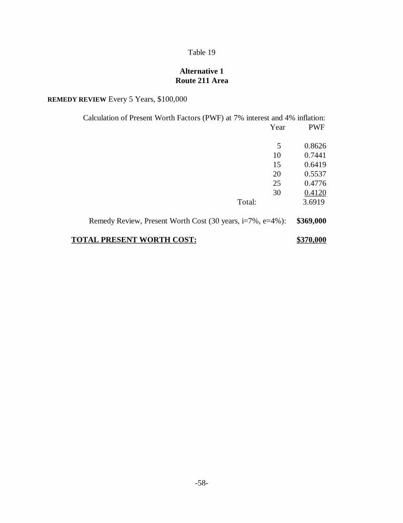
-58-
Table 19
Alternative 1Route 211 Area
REMEDY REVIEW Every 5 Years, $100,000
Calculation of Present Worth Factors (PWF) at 7% interest and 4% inflation:Year PWF
5 0.862610 0.744115 0.641920 0.553725 0.477630 0.4120
Total: 3.6919
Remedy Review, Present Worth Cost (30 years, i=7%, e=4%): $369,000
TOTAL PRESENT WORTH COST: $370,000
RODAberdeen OU5
Page 59
Alternative Water Supply/ Well Head Treatment
Currently, there are no receptors of impacted groundwater. However, if potential receptors areidentified in the future, an alternative water supply or well head treatment would be used toprevent exposure. This option would be available for any potential receptor until clean up goalsare achieved.
Remedy Review
A remedy review would be performed every 5 years until clean up goals are achieved to determinethe effectiveness of the remedy to protect human health and/or the environment. As a result of thisreview, if needed, additional site remediation or modifications to the remedy would be performed.
8.2.2.2 Other Features of Alternative 2
• Groundwater clean up goals for the COCs would be achieved by natural attenuation.
• The time frame to achieve the clean up under Alternative 2 was not estimated. However,without mitigating the migration of source area groundwater, the time frame to achievethe clean up goals could be expected to be greater than alternatives 3 and 4.
• The estimated total present worth cost for Alternative 2 is $1,400,000. Costs includeinstallation of additional monitoring wells, area reconnaissance, periodic sampling, andremedy review. A detailed cost estimate for Alternative 2 is provided in Table 20. Costsare rounded to two significant figures.
8.2.2.3 Expected Outcomes of Alternative 2
• After clean up goals are achieved, groundwater should be available to drink withouthaving to treat to remove pesticides.
8.2.3 Alternative 3: Groundwater Recovery from the Source Area GroundwaterUsing Extraction Wells, Treatment by Carbon Adsorption, and Discharge of TreatedGroundwater via Reinjection (Infiltration Galleries/Injection Wells), Continued GroundwaterMonitoring of the Surficial, Upper Black Creek and Lower Black Creek aquifers, AreaReconnaissance, and Contingency Controls with Well Head Treatment or Alternative WaterSupply if Future Potential Receptors are identified
8.2.3.1 Description of Alternative 3 Components
-60-
Table 20
Alternative 2Route 211 Area
Item Basis of Cost Unit Cost Units Quantity Total Cost
DIRECT CAPITAL COST
ADMINISTRATIVE FEES $30,000 LS 1 $30,000
COMMUNITY RELATIONS ASSISTANCE $20,000 LS 1 $20,000
MUNICIPAL WATER SUPPLY CONNECTIONS $175,000 LS 1 $175,000
MONITORING WELLS INSTALLATION
Mobilization/Demobilization $2,000 EA 1 $2,000
Decontamination Pad $350 EA 4 $1,400
Equipment Decontamination $120 HR 8 $960
Drilling and Materials 4 wells $80 LF 469 $37,520
Split Spoon Samples Every 5 ft $20 EA 94 $1,880
Well Development 15 hrs per well $120 HR 60 $7,200
Installation Oversight Geologist $1,000 Day 6 $6,000
$56,960
INDIRECT CAPITAL COSTS
Health and Safety @ 5% of Direct Capital Costs (DCC) $14,098
Bonds & Insurance @ 5% of DCC $14,098
Contingency @ 20% of DCC $56,392
Eng. & Const. Mgmt. @ 15% of DCC $42,294
Prime Contractor Ovrhd & Prft @ 10% of DCC $28,196
$155,078
TOTAL CAPITAL COSTS: $440,000
ANNUAL OPERATING AND MAINTENANCE COSTS
SITE RECONNAISSANCE 8 hrs (during sampling event) $400 YR 1 $400
Present Worth (n=30, i=7%, e=4%, PWF=19.60) $7,840
MONITORING
Sampling - First 5 Years:
Quarterly Sampling (Labor + Supplies) 5 days, 4 nts + equip. $10,000 3 MO 4 $40,000
Quarterly Sampling (Pesticide Analyses) 23 gw samples, 6 QA/QC $4,495 3 MO 4 $17,980
Validation and Report Preparation $4,300 3 MO 4 $17,200
$75,180
Present Worth (n=5 yrs, i=7%, e=4%, PWF=4.58) $344,324
Sampling - Years 5-30:
Annual Sampling (Labor + Supplies) 5 days, 4 nts + equip. $10,000 YR 1 $10,000
Annual Sampling (Analyses) 23 gw samples, 6 QA/QC $4,495 YR 1 $4,495
Validation and Report Preparation $4,300 LS 1 $4,300
$18,795
Present Worth (n=5-30, i=7%, e=4%, PWF=15.02) $282,301
REMEDY REVIEW $100,000 every 5 years $100,000
Present Worth (See B.2-1, PWF=3.69): $369,000
TOTAL O&M COST: $1,000,000
TOTAL PRESENT WORTH COST $1,400,000
RODAberdeen OU5
Page 61
Groundwater Extraction and Treatment
• Groundwater underlying the former disposal area referred to as “Source Areagroundwater” in the Surficial Aquifer, which poses the most significant risk at the Route211 Area, would be extracted using extraction wells.
• Extracted groundwater would be treated using carbon adsorption.
• Treated groundwater would be discharged via re-injection (infiltration galleries/injectionwells).
• Monitoring of the extraction, treatment and discharge systems until clean up goals areachieved.
Monitor Natural Attenuation - Same as Alternative 2
Area Reconnaissance - Same as Alternative 2
Alternative Water Supply/Well Head Treatment - Same as Alternative 2.
Remedy Review - Same as Alternative 2
8.2.3.2 Other Features of Alternative 3
• Groundwater clean up goals would be achieved by removing the Source Areagroundwater from the Surficial Aquifer using extraction wells; and by intrinsic remediationin the rest of the plume and aquifers.
• Through the removal of pesticide residuals and extraction of Source Area groundwaterfrom the Surficial Aquifer, pesticide concentrations would continue to reduce in allaquifers.
• The estimated time frame to achieve the clean up goal in the various aquifers ranges from0 to less than 30 years for gamma BHC (Lindane); from less than 5 to 90 years for alphaBHC; from less than 5 to 90 years for beta BHC ; and from 0 to less than 5 years for deltaBHC.
• Costs for this alternative assumed the use of an infiltration gallery as the dischargemethod. The estimated total present worth cost for Alternative 3 is $2,600,000. Costsassociated with this alternative include continued monitoring and periodic Areareconnaissance. Additional costs above that of Alternative 2 include well-head
RODAberdeen OU5
Page 62
components for the existing pumping well, a carbon adsorption treatment system and areinjection system. Operating and maintenance costs associated with this alternativeinclude power, a site operator, carbon replacement, and sampling of the treatment system.A detailed cost estimate for Alternative 3 is provided in Table 21. Costs are rounded totwo significant figures.
8.2.3.3 Expected Outcomes of Alternative 3
• After clean up goals are achieved, groundwater should be available to drink withouthaving to treat to remove pesticides.
8.2.4 Alternative 4: Groundwater Recovery from the Source Area Groundwater, theupper and lower portions of the Upper Black Creek Aquifer, and the Lower Black CreekAquifer using Extraction Wells, Treatment by Carbon Adsorption, Discharge of TreatedGroundwater via reinjection (Infiltration Galleries/Injection Wells) from the Source AreaGroundwater and via surface water from the lower aquifers, Continued GroundwaterMonitoring, Area Reconnaissance, and Exposure Controls with Well Head Treatment orAlternative Water Supply if any Future Potential Receptors are identified.
8.2.4.1 Description of Alternative 4 Components
Groundwater Extraction and Treatment
• Groundwater containing pesticides above clean up goals would be extracted from allaquifers using extraction wells.
• Extracted groundwater would be treated using carbon adsorption.
• Treated groundwater, extracted from the source area groundwater (Surficial Aquifer)would be discharged via re-injection (infiltration galleries/injection wells).
• Treated groundwater, extracted from all the other aquifers would be discharge via surfacewater in Quewhiffle Creek.
• Monitoring of the extraction, treatment and discharge systems until clean up goals areachieved.
Monitoring Program
The monitoring program would consist of sampling and analysis of monitoring wells in all aquifersin the pathway of impacted groundwater migration. The existing monitoring well network and
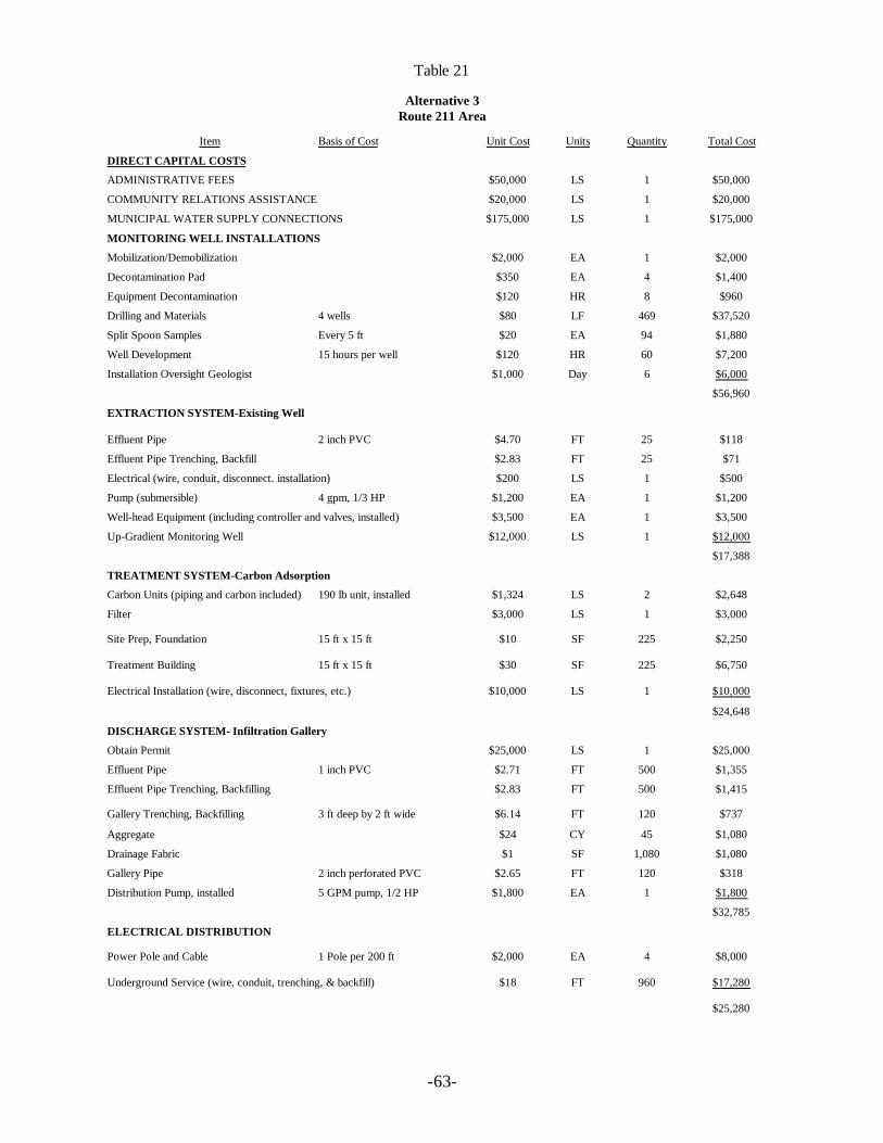
-63-
Table 21
Alternative 3Route 211 Area
Item Basis of Cost Unit Cost Units Quantity Total Cost
DIRECT CAPITAL COSTS
ADMINISTRATIVE FEES $50,000 LS 1 $50,000
COMMUNITY RELATIONS ASSISTANCE $20,000 LS 1 $20,000
MUNICIPAL WATER SUPPLY CONNECTIONS $175,000 LS 1 $175,000
MONITORING WELL INSTALLATIONS
Mobilization/Demobilization $2,000 EA 1 $2,000
Decontamination Pad $350 EA 4 $1,400
Equipment Decontamination $120 HR 8 $960
Drilling and Materials 4 wells $80 LF 469 $37,520
Split Spoon Samples Every 5 ft $20 EA 94 $1,880
Well Development 15 hours per well $120 HR 60 $7,200
Installation Oversight Geologist $1,000 Day 6 $6,000
$56,960
EXTRACTION SYSTEM-Existing Well
Effluent Pipe 2 inch PVC $4.70 FT 25 $118
Effluent Pipe Trenching, Backfill $2.83 FT 25 $71
Electrical (wire, conduit, disconnect. installation) $200 LS 1 $500
Pump (submersible) 4 gpm, 1/3 HP $1,200 EA 1 $1,200
Well-head Equipment (including controller and valves, installed) $3,500 EA 1 $3,500
Up-Gradient Monitoring Well $12,000 LS 1 $12,000
$17,388
TREATMENT SYSTEM-Carbon Adsorption
Carbon Units (piping and carbon included) 190 lb unit, installed $1,324 LS 2 $2,648
Filter $3,000 LS 1 $3,000
Site Prep, Foundation 15 ft x 15 ft $10 SF 225 $2,250
Treatment Building 15 ft x 15 ft $30 SF 225 $6,750
Electrical Installation (wire, disconnect, fixtures, etc.) $10,000 LS 1 $10,000
$24,648
DISCHARGE SYSTEM- Infiltration Gallery
Obtain Permit $25,000 LS 1 $25,000
Effluent Pipe 1 inch PVC $2.71 FT 500 $1,355
Effluent Pipe Trenching, Backfilling $2.83 FT 500 $1,415
Gallery Trenching, Backfilling 3 ft deep by 2 ft wide $6.14 FT 120 $737
Aggregate $24 CY 45 $1,080
Drainage Fabric $1 SF 1,080 $1,080
Gallery Pipe 2 inch perforated PVC $2.65 FT 120 $318
Distribution Pump, installed 5 GPM pump, 1/2 HP $1,800 EA 1 $1,800
$32,785
ELECTRICAL DISTRIBUTION
Power Pole and Cable 1 Pole per 200 ft $2,000 EA 4 $8,000
Underground Service (wire, conduit, trenching, & backfill) $18 FT 960 $17,280
$25,280

-64-
Table 21 (cont.)
Alternative 3Route 211 Area
INDIRECT CAPITAL COSTS
REMEDIAL DESIGN $75,000 LS 1 $75,000
Health and Safety @ 5% of Direct Capital Costs (DCC) $20,103
Bonds & Insurance @ 5% of DCC $20,103
Contingency @ 20% of DCC $80,412
Eng. & Const. Mgmt. @ 15% of DCC $60,309
Prime Contractor Ovrhd & Prft @ 10% of DCC $40,206
$296,134
TOTAL CAPITAL COSTS: $700,000
ANNUAL OPERATING AND MAINTENANCE COSTS
MISCELLANEOUS
Power (536 kWhr/mo @ $0. l0/kWhr) Total Pump HP = 1 $53.60 MO 12 $643
Operator 50 hrs/MO $2,750 MO 12 $33,000
Carbon Replacement (74 lb/yr) $1.20 YR 100 $120
Site Reconaissance (8 hours, completed during sampling event) $400 YR 1 $400
Miscellaneous Repairs $8,000 YR 1 $8,000
$42,163
Present Worth (n=30, i=7%, e=4%, PWF=19.60): $826,399
MONITORING
Sampling - First 5 Years:
Quarterly Sampling (Labor + Supplies) 5 days, 4 nts + equip. $10,000 3MO 4 $40,000
Quarterly Sampling (Pesticide Analyses) 23 gw samples, 6 QA/QC $4,495 3MO 4 $17,980
Treatment System Monitoring 6 gw samples, 2 QA/QC $1,240 3MO 4 $4,960
Validation and Report Preparation $4,300 3MO 4 $17,200
$80,140
Present Worth (n-5 yrs, i=7%, e=4%, PWF=4.58) $367,041
Sampling - Years 5-30
Annual Sampling (Labor + Supplies) 5 days, 4 nts + equip. $10,000 YR 1 $10,000
Annual Sampling (Analyses) 23 gw samples, 6 QA/QC $4,495 YR 1 $4,495
Treatment System Monitoring 6 gw samples, 2 QA/QC $1,240 YR 1 $1,240
Validation and Report Preparation $4,300 LS 1 $4,300
$20,035
Present Worth (n=5 30, i=7%, e=4%, PWF=15.02) $300,926
NEW PUMPS - as needed Extraction and DistributionPumps
$1,800 EA 2 $3,600
Present Worth (n=10&20, i=7%, e=4%, PWF=1.29) $4,644
INFILTRATION GALLERY REINSTALLATION AT 15 YEARS $3,215 LS 1 $3,215
Present Worth (n=15, i=7%, e=4%, PWF=0.64) $2,058
REMEDY REVIEW $100,000 every 5 years $100,000
Present Worth (n=30, i=7%, n=4%, PWF=3.69) $369,000
TOTAL O&M COSTS: $1,900,000
TOTAL PRESENT WORTH COST $2,600,00
RODAberdeen OU5
Page 65
potential new monitoring wells placed at strategic locations would serve as “trigger” mechanismwells. Statistical increases of pesticide concentrations above acceptable exposure levelsdetermined through trend analysis would “trigger” an evaluation of potential receptors in themigration pathway of the groundwater. Should an exposure pathway exist, a well head treatmentsystem would be installed or an alternative water supply would be provided to the receptors. Amonitoring program under Alternative 2 would be established for groundwater in all aquifers withexisting monitoring wells and proposed monitoring wells. Details of the monitoring programwould be developed during remedial design.
Area Reconnaissance - Same as Alternative 2
Alternative Water Supply Well/ Head Treatment - Same as Alternative 2.
Remedy Review - Same as Alternative 2
8.2.4.2 Other Features of Alternative 4
• Groundwater clean up goals would be achieved by removing pesticides above clean upgoals using extraction wells.
• A large treatment building to accommodate 4-10,000 lbs. carbon vessels would be needed.The treatment building would need to be centrally located and thousands of feet ofpipeline would be necessary for the extraction and treatment system.
• An approximately 3.6 mile discharge pipeline to Quewhiffle Creek would be required andnumerous easements and property access agreements would be needed for the disturbanceof approximately 250 acres of private property.
• The estimated time to achieve the clean up goal in the various aquifers ranges from 0 toless than 20 years for gamma BHC (Lindane); from less than 5 to 55 years for alpha BHC;from less than 5 to 55 years for beta BHC; and from 0 to less than 5 years for delta BHC.
• The estimated total present worth cost for Alternative 4 is $15,200,000. Capital costsinclude 22 extraction wells that would be installed as part of the groundwater extractionsystem. The extraction flow rate generated by these wells would require large treatmentand discharge systems. A detailed cost estimate for Alternative 4 is provided in Table 22.
8.2.4.3 Expected Outcomes of Alternative 4
• After clean up goals are achieved, groundwater should be available to drink withouthaving to treat to remove pesticides.
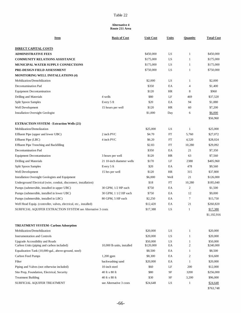
-66-
Table 22
Alternative 4Route 211 Area
Item Basis of Cost Unit Cost Units Quantity Total Cost
DIRECT CAPITAL COSTS
ADMINISTRATIVE FEES $450,000 LS 1 $450,000
COMMUNITY RELATIONS ASSISTANCE $175,000 LS 1 $175,000
MUNICIPAL WATER SUPPLY CONNECTIONS $175,000 LS 1 $175,000
PRE-DESIGN FIELD ASSESSMENT $750,000 LS 1 $750,000
MONITORING WELL INSTALLATIONS (4)
Mobilization/Demobilization $2,000 LS 1 $2,000
Decontamination Pad $350 EA 4 $1,400
Equipment Decontamination $120 HR 8 $960
Drilling and Materials 4 wells $80 LF 469 $37,520
Split Spoon Samples Every 5 ft $20 EA 94 $1,880
Well Development 15 hours per well $120 HR 60 $7,200
Installation Oversight Geologist $1,000 Day 6 $6,000
$56,960
EXTRACTION SYSTEM - Extraction Wells (21)
Mobilization/Demolization $25,000 LS 1 $25,000
Effluent Pipe (upper and lower UBC) 2 inch PVC $4.70 FT 5,760 $27,072
Effluent Pipe (LBC) 4 inch PVC $6.20 FT 4,520 $28,024
Effluent Pipe Trenching and Backfilling $2.83 FT 10,280 $29,092
Decontamination Pad $350 EA 21 $7,350
Equipment Decontamination 3 hours per well $120 HR 63 $7,560
Drilling and Materials 21 10-inch diameter wells $170 LF 2388 $405,960
Split Spoon Samples Every 5 ft $20 EA 478 $9,560
Well Development 15 hrs per well $120 HR 315 $37,800
Installation Oversight Geologists and Equipment $6,000 Well 21 $126,000
Underground Electrical (wire, conduit, disconnect, installation) $18 FT 10,280 $185,040
Pumps (submersible, installed in upper UBC) 30 GPM, 1/2 HP each $750 EA 2 $1,500
Pumps (submersible, installed in lower UBC) 30 GPM, 1 1/2 HP each $750 EA 12 $9,000
Pumps (submersible, installed in LBC) 80 GPM, 5 HP each $2,250 EA 7 $15,750
Well Head Equip. (controller, valves, electrical, etc., installed) $12,420 EA 21 $260,820
SURFICIAL AQUIFER EXTRACTION SYSTEM see Alternative 3 costs $17,388 LS 1 $17,388
$1,192,916
TREATMENT SYSTEM- Carbon Adsorption
Mobilization/Demobilization $20,000 LS 1 $20,000
Instrumentation and Controls $20,000 LS 1 $20,000
Upgrade Accessibility and Roads $50,000 LS 1 $50,000Carbon Units (piping and carbon included) 10,000 lb units, installed $120,000 EA 2 $240,000
Equalization Tank (10,000-gal., above-ground, steel) $8,500 EA 1 $8,500
Carbon Feed Pumps 1,200 gpm $8,300 EA 2 $16,600
Filter backwashing sand $20,000 EA 1 $20,000
Piping and Valves (not otherwise included) 10-inch steel $60 LF 200 $12,000
Site Prep, Foundation, Electrical, Security 40 ft x 80 ft $80 SF 3200 $256,000
Treatment Building 40 ft x 80 ft $30 SF 3,200 $96,000
SURFICIAL AQUIFER TREATMENT see Alternative 3 costs $24,648 LS 1 $24,648
$763,748
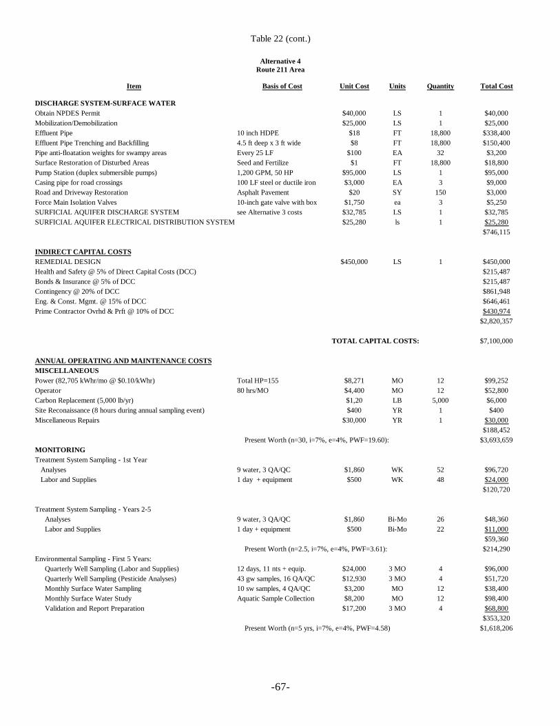
-67-
Table 22 (cont.)
Alternative 4Route 211 Area
Item Basis of Cost Unit Cost Units Quantity Total Cost
DISCHARGE SYSTEM-SURFACE WATERObtain NPDES Permit $40,000 LS 1 $40,000Mobilization/Demobilization $25,000 LS 1 $25,000Effluent Pipe 10 inch HDPE $18 FT 18,800 $338,400Effluent Pipe Trenching and Backfilling 4.5 ft deep x 3 ft wide $8 FT 18,800 $150,400Pipe anti-floatation weights for swampy areas Every 25 LF $100 EA 32 $3,200Surface Restoration of Disturbed Areas Seed and Fertilize $1 FT 18,800 $18,800Pump Station (duplex submersible pumps) 1,200 GPM, 50 HP $95,000 LS 1 $95,000Casing pipe for road crossings 100 LF steel or ductile iron $3,000 EA 3 $9,000Road and Driveway Restoration Asphalt Pavement $20 SY 150 $3,000Force Main Isolation Valves 10-inch gate valve with box $1,750 ea 3 $5,250SURFICIAL AQUIFER DISCHARGE SYSTEM see Alternative 3 costs $32,785 LS 1 $32,785SURFICIAL AQUIFER ELECTRICAL DISTRIBUTION SYSTEM $25,280 ls 1 $25,280
$746,115
INDIRECT CAPITAL COSTSREMEDIAL DESIGN $450,000 LS 1 $450,000Health and Safety @ 5% of Direct Capital Costs (DCC) $215,487Bonds & Insurance @ 5% of DCC $215,487Contingency @ 20% of DCC $861,948Eng. & Const. Mgmt. @ 15% of DCC $646,461Prime Contractor Ovrhd & Prft @ 10% of DCC $430,974
$2,820,357
TOTAL CAPITAL COSTS: $7,100,000
ANNUAL OPERATING AND MAINTENANCE COSTSMISCELLANEOUSPower (82,705 kWhr/mo @ $0.10/kWhr) Total HP=155 $8,271 MO 12 $99,252Operator 80 hrs/MO $4,400 MO 12 $52,800Carbon Replacement (5,000 lb/yr) $1,20 LB 5,000 $6,000Site Reconaissance (8 hours during annual sampling event) $400 YR 1 $400Miscellaneous Repairs $30,000 YR 1 $30,000
$188,452 Present Worth (n=30, i=7%, e=4%, PWF=19.60): $3,693,659
MONITORINGTreatment System Sampling - 1st Year Analyses 9 water, 3 QA/QC $1,860 WK 52 $96,720 Labor and Supplies 1 day + equipment $500 WK 48 $24,000
$120,720
Treatment System Sampling - Years 2-5Analyses 9 water, 3 QA/QC $1,860 Bi-Mo 26 $48,360Labor and Supplies 1 day + equipment $500 Bi-Mo 22 $11,000
$59,360 Present Worth (n=2.5, i=7%, e=4%, PWF=3.61): $214,290
Environmental Sampling - First 5 Years:Quarterly Well Sampling (Labor and Supplies) 12 days, 11 nts + equip. $24,000 3 MO 4 $96,000Quarterly Well Sampling (Pesticide Analyses) 43 gw samples, 16 QA/QC $12,930 3 MO 4 $51,720Monthly Surface Water Sampling 10 sw samples, 4 QA/QC $3,200 MO 12 $38,400Monthly Surface Water Study Aquatic Sample Collection $8,200 MO 12 $98,400Validation and Report Preparation $17,200 3 MO 4 $68,800
$353,320 Present Worth (n=5 yrs, i=7%, e=4%, PWF=4.58) $1,618,206
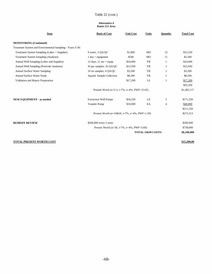
-68-
Table 22 (cont.)
Alternative 4Route 211 Area
Item Basis of Cost Unit Cost Units Quantity Total Cost
MONITORING (Continued)
Treatment System and Environmental Sampling - Years 5-30:
Treatment System Sampling (Labor + Supplies) 9 water, 3 QA/QC $1,860 MO 12 $22,320
Treatment System Sampling (Analyses) 1 day + equipment $500 MO 11 $5,500
Annual Well Sampling (Labor and Supplies) 12 days, 11 nts + equip. $24,000 YR 1 $24,000
Annual Well Sampling (Pesticide Analyses) 43 gw samples, 16 QA/QC $12,930 YR 1 $12,930
Annual Surface Water Sampling 10 sw samples, 4 QA/QC $3,200 YR 1 $3,200
Annual Surface Water Study Aquatic Sample Collection $8,200 YR 1 $8,200
Validation and Report Preparation $17,200 LS 1 $17,200
$93,350
Present Worth (n=5-3, i=7%, e=4%, PWF=15.02) $1,402,117
NEW EQUIPMENT - as needed Extraction Well Pumps $34,250 LS 5 $171,250
Transfer Pump $10,000 EA 4 $40,000
$211,250
Present Worth (n=10&20, i=7%, e=4%, PWF=1.29) $272,513
REMEDY REVIEW $200,000 every 5 years $200,000
Present Worth (n=30, i=7%, e=4%, PWF=3.69): $738,000
TOTAL O&M COSTS: $8,100,000
TOTAL PRESENT WORTH COST $15,200,00
RODAberdeen OU5
Page 69
9.0 SUMMARY OF COMPARATIVE ANALYSIS OF ALTERNATIVES
A detailed comparative analysis using the nine evaluation criteria set forth in the NCP wasperformed on the remedial alternatives for both the McIver Dump and Route 211 Areas. Theadvantages and disadvantages were compared to identify the alternative with the best balanceamong these nine criteria.
9.1 Threshold Criteria
9.1.1 Overall Protection of Human Health and the Environment
McIver Dump Area
Alternatives 2, 3, and 4 should be relatively equivalent in regards to the overall protection ofhuman health and the environment. Alternative 1 would not be a protective alternative. Currently,there are no complete exposure pathways and therefore, no significant risks to human health.Alternatives 2, 3, and 4 would involve some controls such as monitoring and area reconnaissanceto minimize the potential for future exposure.
Alternative 2 includes the enhancement of phytoremediation at the McIver Dump Area throughthe placement of trees or other plant life in the migration pathway of the pesticides. Alternative 3includes the recovery of groundwater containing the highest concentrations of pesticides.Alternative 4 would attempt to recover groundwater containing pesticides exceeding theirrespective cleanup goals.
Computer modeling indicates that pesticide concentrations would not increase above currentconditions. Based on the Ecological Risk Assessment, minimal impact is associated withecological receptors in Patterson Branch. Additionally, since source soils were removed in 1997,residual pesticide concentrations will naturally decrease. Alternatives 2, 3, and 4 would eachfurther limit the potential discharge of residual pesticides into Patterson Branch. Additionally,each of these alternatives includes establishment of a monitoring program at Patterson Branch toensure no significant impact to ecological receptors is maintained in the future.
Because Alternative 1 is not protective of human health and environment, it will be eliminated forconsideration under the remaining eight criteria.
Route 211 Area
All of the alternatives, except the No Action alternative, provide adequate protection of humanhealth. Alternatives 2, 3, and 4 would each utilize control mechanisms including continuedmonitoring and area reconnaissance. Additionally, these alternatives provide exposure controls if
RODAberdeen OU5
Page 70
any future potential receptors are identified in the migration pathway of impacted groundwater.The exposure controls could include installation of well head treatment systems or providing analternative water supply.
Because Alternative 1 is not protective of human health and environment, it will be eliminated forconsideration under the remaining eight criteria.
9.1.2 Compliance with Applicable or Relevant and Appropriate Requirements(ARARs)
McIver Dump Area
Alternatives 2, 3, and 4 would equally comply with ARARs. Groundwater containing pesticidesexceeding clean up goals would be addressed under those three alternatives, via natural atenuationand phytoremediation in Alternative 2, and groundwater extraction wells and natural attenuationin Alternatives 3 and 4.
Route 211 Area
Alternative 2 may not achieve the cleanup goals in a reasonable time frame when compared withthe Alternatives 3 and 4. Both Alternatives 3 and 4 would achieve the cleanup goals. Therefore,Alternative 3 and 4 would comply with ARARs. The primary difference between Alternatives 3and 4 would be that Alternative 3 would rely on natural processes for the remediation ofpesticides outside of the former source area, while Alternative 4 would use extraction wells in allaquifers.
9.2 Primary Balancing Criteria
9.2.1 Long-Term Effectiveness and Permanence
McIver Dump Area
Alternative 2,3 and 4 would reduce pesticide concentrations until clean up levels are achievedExposure during active remediation under Alternatives 2, 3, and 4 would be controlled throughcontinued monitoring and area reconnaissance. Therefore, Alternatives 2, 3, and 4 are equivalentin regards to addressing long-term effectiveness and permanence.
Route 211 Area
For Alternatives 2, 3, and 4, potential future receptors would be identified through acomprehensive monitoring program. The receptors would either be connected to public watersystems or individual carbon filtration systems would be installed at the point of use.
RODAberdeen OU5
Page 71
9.2.2 Reduction of Contaminant Toxicity, Mobility, and Volume
McIver Dump Area
Alternative 2 would reduce contaminant mobility and volume using phytoremediation.Alternatives 3 and 4 would reduce the volume and mobility of pesticides using extraction wells.Alternatives 2, 3, and 4 each would address the plume at the McIver Dump Area and each wouldreduce the mobility and volume of pesticides through treatment.
Route 211 Area
Alternative 4 offers the greatest reduction in mobility and volume of impacted groundwaterthrough extraction and treatment of all impacted groundwater. Alternative 3 would result in thereduction in mobility and volume of pesticides in the Source Area groundwater through extractionand treatment of approximately 60% of the pesticide mass in the Surficial Aquifer.
9.2.3 Short-Term Effectiveness
McIver Dump Area
For construction activities, Alternative 2 poses the least threat to workers, the public, and theenvironment followed by Alternatives 3 and 4. Alternative 2 would also require the least amountof time for implementation of construction activities followed, in ascending order, by Alternatives3, and 4.
The expected time frame to achieve cleanup goals under Alternatives 2, 3, and 4 is the same (10years).
Route 211 Area
Alternative 2 would require no construction-related activities which could endanger publiccommunities or remedial workers. Well installations have been successfully conducted during RIactivities. Therefore, implementation of Alternatives 3 and 4 would pose no significant concernsin regards to protection of public communities or remedial workers.
In terms of the achievement of cleanup goals, Alternative 4 would require the shortest time framefollowed by Alternative 3 and then by Alternatives 2. However, certain aquifers and certain BHCisomers would require equivalent time frames to achieve the clean up goals under Alternatives 3and 4. For gamma-BHC (Lindane), Alternatives 3 and 4 would each require from 0 to less than 30years and from 0 to less than 20 years, respectively, to achieve the cleanup goals in the variousaquifers, For beta-BHC, the time frames to achieve the cleanup goals in the various aquifers forAlternatives 3 and 4 would be from less than 5 to 90 years and from less than 5 to 55 years,
RODAberdeen OU5
Page 72
respectively. The time frames to achieve cleanup goals in the various aquifers for delta-BHCwould be from 0 to less than 5 years for both Alternatives 3 and 4. The range of time frames toachieve the cleanup goal in the various aquifers for alpha-BHC for Alternatives 3 and 4 would befrom less than 5 to 90 years and from less than 5 to 55 years, respectively.
Based on the results of the groundwater computer modeling, (included in the FS report), whenthe alpha-BHC concentration under Alternative 4 (upper portion of the Upper Black CreekAquifer) reachs the cleanup goal (0.02 ppb)(i.e., 55 years), the alpha-BHC concentration underAlternative 3 (Lower Black Creek Aquifer) will be reduced to 0.04 µg/l. This represents a 90%reduction in the alpha-BHC concentration under Alternative 3 needed to meet the 0.02 µg/lcleanup goal.
The remaining 35 year difference between these Alternatives (i.e., 90 years versus 55 years) is theamount of time that it will take for the concentrations in the Lower Black Creek Aquifer to gofrom 0.04 ppb to 0.02 ppb (a 2 x 10⁻⁶ risk to a 1 x 10⁻⁶ risk reduction). This is an extremely lowrisk range. Therefore, based upon the above discussion, the ability to achieve the cleanup goalunder Alternative 3 is generally equivalent to Alternative 4.
9.2.4 Implementability
McIver Dump Area
Alternative 2 requires the enhancement of the McIver Dump Area with trees and other plant life.No significant difficulties would be anticipated for planting trees or other plant life under thisalternative. Alternatives 3 and 4 each include engineered remediation systems which should beimplementable, although not uncomplicated. Additionally, excavation of interceptor trenchesunder Alternatives 3 and 4 may compromise the existing erosion control measures at the Area.
Route 211 Area
Alternatives 1 and 2 could be easily implemented. Alternatives 3 and 4 require construction of anextraction, treatment, and discharge system(s), all of which would be located on private property.However, Alternative 3 would consist of an extraction well, a treatment building accommodatingtwo carbon treatment canisters, and an infiltration gallery with approval already obtained from thisproperty owner. Multiple implementability concerns are associated with Alternative 4. Thefollowing lists certain aspects of Alternative 4 in regards to the implementability issues.
• Twenty-two extraction wells having a combined flow rate of 935 gallons per minute (gpm)is estimated for the alternative.
• A large treatment building to accommodate 4-10,000 lbs. carbon vessels would be needed.
RODAberdeen OU5
Page 73
• The treatment building would need to be centrally located. Thousands of feet of pipelinewould be necessary for the extraction and treatment system.
• A 3.6 mile discharge pipeline to Quewhiffle Creek would be required.
• Potential for spreading groundwater contaminants, other than pesticides, by the largecapture zone created by 22 extraction wells; and need for additional groundwaterinvestigation to be able to design an efficient treatment system .
• A minimum of nine months would be required to obtain a NPDES permit for surfacewater discharge, and greater than 2 years would be required for modeling the extractionsystem, obtaining access agreements (to approximately 250 acres of property), design ofthe system, and development of a monitoring program.
The monitoring program and control measures of Alternatives 2, 3, and 4 would adequatelyaddress the migration of pesticides and prevent future exposure.
9.2.5 Cost
McIver Dump Area
The total estimated present worth costs for each alternative are listed below:
• Alternative 1: $160,000• Alternative 2: $450,000• Alternative 3: $1,500,000 (Surface Water) - $1,200,000 (Infiltration Galleries)• Alternative 4: $2,000,000 (Surface Water) - $1,600,000 (Infiltration Galleries)
The costs for Alternatives 3 and 4 are greater than 2 times the cost for Alternative 2.
Route 211 Area
The total estimated present worth costs for each alternative are listed below:
• Alternative 1: $370,000• Alternative 2: $1,400,000• Alternative 3: $2,600,000• Alternative 4: $15,000,000
Alternative 4 would be significantly greater in cost than any of the other alternatives.
RODAberdeen OU5
Page 74
9.3 Modifying Criteria
9.3.1 State Acceptance
EPA and the North Carolina Department of Environment and Natural Resources (NCDENR)have cooperated throughout the RI/FS process for OU5. NCDENR has participated in thedevelopment of the RI/FS through comment on each of the various reports developed by EPA,and the Draft ROD and through frequent contact between the EPA and NCDENR site projectmanagers. EPA and NCDENR are in agreement on the selected alternatives for both McIverDump and Route 211 Areas. Please refer to the Responsiveness Summary which contains a letterof concurrence from NCDENR.
The NCDENR has participated during the development of all the remedial processes for this OU5and concurs with this remedy.
9.3.2 Community Acceptance
EPA solicited input from the community on the Proposed Plan for this action. Although publiccomments indicated no opposition to the preferred alternatives, some local residents expressedsome minor concerns during the Proposed Plan public meeting. Please see the ResponsivenessSummary which contains a transcript of the public meeting.
10.0 THE SELECTED REMEDY
Based upon consideration of the CERCLA requirements, the NCP, the analysis of the alternativesusing the nine criteria, and public and State comments, EPA has selected the remedy for OU5.This remedy may change somewhat as a result of the remedial design and the constructionprocesses. Changes to the remedy described in this ROD will be documented using a technicalmemorandum in the Administrative Record, an Explanation of Significant Differences (ESD) orROD amendment, as appropriate depending on the type of change.
10.1 Description of the Selected Remedy
10.1.1 McIver Dump Area
The selected remedy for the McIver Dump Area is:
Alternative 2: Continued Groundwater/Surface Water/Sediments Monitoring,Phytoremediation Area Reconnaissance, and Alternative Water Supply/Well Head Treatmentif Future Potential Receptors are identified
RODAberdeen OU5
Page 75
10.1.1.1 Description of the Selected Remedy
Monitor Natural Attenuation
Monitoring would be used to verify that natural aquifer processes are reducing contaminantconcentrations to acceptable levels by intrinsic remediation; to determining the concentration,distribution, and migration of the COCs in groundwater/surface water and sediments, and toverify that the clean up goals are achieved during remedial action. Additionally, monitoring wouldbe used as a mechanism by which future receptors within the migration pathway of COCs areidentified and addressed, if necessary. Monitoring would also be used to maintain exposurecontrol within the defined remedial action objectives. After source removal and construction oferosion control measures already finished under a separate ROD, pesticide concentrations willnaturally decrease.
Monitor would involve periodic (short and long-term) sampling and analysis ofgroundwater/surface water/sediments.
Phytoremediation
Phytoremediation is an innovative in-situ technology for the remediation of pesticide ingroundwater. Phytoremediation would be used to enhance the natural attenuation processes bythe use of vegetation to treat in-place contaminated groundwater. The McIver Dump Area isfavorable for the use of phytoremediation as a remedial technology because of the shallow watertable which allows tree roots to get in contact with contaminated groundwater), proximity of thesource area to the groundwater discharge area, and absence of current groundwater use.Additionally, phytoremediation offers some hydraulic control through transpiration, therebylimiting the migration of pesticides.
Area Reconnaissance
Area reconnaissance would be used to determine whether properties at the area are for sale,purchased, or being leased. This would be accomplished by reconnoitering the McIver DumpArea and reviewing property records. Town development plans would be reviewed to determineany future development strategies for the McIver Dump Area. Additionally, residential wellsurveys have been conducted at the McIver Dump Area. Through area reconnaissance, theresidential well surveys would be verified and updated. Area reconnaissance is an effective meansof controlling exposure as defined in the remedial action objectives. The area reconnaissanceprogram would be in place until clean up goals are achieved.
Alternative Water Supply/Well head treatment
RODAberdeen OU5
Page 76
Currently, there are no receptors of impacted groundwater. However, if potential receptors areidentified in the future, an alternative water supply or well head treatment will be used to preventexposure. This option would be available for any potential receptor until clean up goals areachieved.
Remedy Review
A remedy review would be performed every 5 years until clean up goals are achieved to determinethe effectiveness of the remedy to protect human health and/or the environment. As a result of thisreview, if needed, additional site remediation or modifications to the remedy would be performed.
10.1.1.2 Other Features of the Selected Remedy
• Pesticides exceeding the clean up goals would be achieved in groundwater by naturalattenuation (since source soils were removed in 1997) and/or removed from groundwatervia phytoremediation.
• The time frame to achieve clean up goals under Alternative 2 is estimated to be 10 years.
• Estimated total present worth costs for Alternative 2 is $450,000. This cost includes aperiodic monitoring of groundwater and Patterson Branch, the enhancement of the McIverDump Area through the planting of trees or other plant life (phytoremediation), and aremedy review every 5 years for a 10 year period to determine the effectiveness of thealternative to protect human health and/or the environment. A detailed cost estimate forAlternative 2 is provided in Table 16. Costs are rounded to two significant figures.
10.1.1.3 Expected Outcomes of the Selected Remedy
• After clean up goals are achieved (estimated time frame of 10 years), groundwater shouldbe available to drink without having to treat to remove pesticides.
10.1.2 Route 211 Area
The selected remedy for the Route 211 Area is:
Alternative 3: Groundwater Recovery from the Source Area Groundwater Using ExtractionWells, Treatment by Carbon Adsorption, and Discharge of Treated Groundwater viaReinjection (Infiltration Galleries/Injection Wells), Continued Groundwater Monitoring of theSurficial, Upper Black Creek and Lower Black Creek aquifers, Area Reconnaissance, andContingency Controls with Well Head Treatment or Alternative Water Supply if FuturePotential Receptors are identified.
RODAberdeen OU5
Page 77
10.1.2.1 Description of the Selected Remedy
Groundwater Extraction and Treatment Components
• Groundwater underlying the former disposal area referred to as “Source Areagroundwater” in the Surficial Aquifer, which poses the most significant risk at the Route211 Area, would be extracted using extraction wells.
• Extracted groundwater would be treated using carbon adsorption.
• Treated groundwater would be discharged via re-injection (infiltration galleries/injectionwells).
• Monitoring of the extraction, treatment and discharge systems until clean up goals areachieved.
Extraction System
The highest groundwater pesticide concentrations will be extracted from the Source areagroundwater from the Surficial Aquifer using one extraction well.
Treatment System
Activated carbon adsorption is considered to be the Best Available Treatment technologies forremoving pesticides from water. All of the pesticides present in the groundwater to be extractedcan be treated using activated carbon absorption. Routine analytical sampling of the influent andeffluent from the canister(s) shall be conducted to determine when the carbon canisters should bereplaced.
Discharge
Treated water will be discharged via an infiltration gallery system. Discharge requirements will bedocumented in an infiltration gallery permit. Based on the groundwater modeling, all treatedwater can be distributed through the galleries and allowed to infiltrate down through the soils tothe Surficial Aquifer. The infiltration system shall be located upgradient of the extraction systemto form a “closed-loop” system, as required by the State of North Carolina.
Monitor Natural Attenuation
Groundwater monitoring would be used to verify that natural aquifer processes are reducingcontaminant concentrations to acceptable levels by intrinsic remediation in the Surficial Aquifer,
RODAberdeen OU5
Page 78
upper portion of the Upper Black Creek Aquifer, lower portion of the Upper Black Creek Aquiferand Lower Black Creek Aquifer; to determining the concentration, distribution, and migration ofthe COCs in groundwater, and to verify that the clean up goals are achieved during remedialaction. Additionally, monitoring would be used as a mechanism by which future receptors withinthe migration pathway of COCs are identified and addressed, if necessary. Monitoring would beused to maintain exposure control within the defined remedial action objectives.
The monitoring program would consist of sampling and analysis of monitoring wells in all aquifersin the pathway of impacted groundwater migration. The existing monitoring well network andpotential new monitoring wells placed at strategic locations would serve as “trigger” mechanismwells. Statistical increases of pesticide concentrations above acceptable exposure levelsdetermined through trend analysis would “trigger” an evaluation of potential receptors in themigration pathway of the groundwater. Should an exposure pathway exist, a well head treatmentsystem would be installed or an alternative water supply would be provided to the receptors. Amonitoring program for the selected remedy would be established for groundwater in all aquiferswith existing monitoring wells and proposed monitoring wells. The monitoring program wouldinclude monitoring of municipal well #13. Other details of the monitoring program would bedeveloped during remedial design
Area Reconnaissance
Area reconnaissance would be used to determine whether properties at the area are for sale,purchased, or being leased. This would be accomplished by reconnoitering the Route 211 Areaand reviewing property records. Town development plans would be reviewed to determine anyfuture development strategies for the Route 211 Area. Additionally, residential well surveys havebeen conducted at the Route 211 Area. Through area reconnaissance, the residential well surveyswould be verified and updated. Area reconnaissance is an effective means of controlling exposureas defined in the remedial action objectives. The area reconnaissance program would be in placeuntil clean up goals are achieved.
Alternative Water Supply/ Well Head Treatment
Currently, there are no receptors of impacted groundwater. However, if potential receptors areidentified in the future, an alternative water supply or well head treatment would be used toprevent exposure. This option would be available for any potential receptor until clean up goalsare achieved.
Remedy Review
A remedy review would be performed every 5 years until clean up goals are achieved to determinethe effectiveness of the remedy to protect human health and/or the environment. As a result of
RODAberdeen OU5
Page 79
this review, if needed, additional site remediation or modifications to the remedy would beperformed.
10.1.2.2 Other Features of the Selected Remedy
• Groundwater clean up goals would be achieved by removing the Source Areagroundwater from the Surficial Aquifer using extraction wells; and by natural attenuationin the rest of the plume and aquifers.
• Through the removal of pesticide residuals and extraction of Source Area groundwaterfrom the Surficial Aquifer, pesticide concentrations would continue to reduce in allaquifers.
• The estimated time frame to achieve the clean up goal in the various aquifers ranges from0 to less than 30 years for gamma BHC (Lindane); from less than 5 to 90 years for alphaBHC; from less than 5 to 90 years for beta BHC; and from 0 to less than 5 years for deltaBHC.
• Costs for this alternative assumed the use of an infiltration gallery as the dischargemethod. The estimated total present worth cost for Alternative 3 is $2,600,000. Costsassociated with this alternative include continued monitoring and periodic Areareconnaissance. Additional costs above that of Alternative 2 include well-headcomponents for the existing pumping well, a carbon adsorption treatment system and areinjection system. Operating and maintenance costs associated with this alternativeinclude power, a site operator, carbon replacement, and sampling of the treatment system.A detailed cost estimate for Alternative 3 is provided in Table 21. Costs are rounded totwo significant figures.
10.1.2.3 Expected Outcomes of the Selected Remedy
• After clean up goals are achieved, groundwater should be available to drink withouthaving to treat to remove pesticides.
11.0 STATUTORY DETERMINATIONS
Under CERCLA Section 121, EPA must select remedies that are protective to human health andthe environment, comply with applicable or relevant and appropriate requirements (unless astatutory waiver is justified), are cost-effective, and utilize permanent solutions and alternativetreatment technologies or resource recovery technologies to the maximum extent practicable. Inaddition, CERCLA includes a preference for remedies that employ treatment that permanently andsignificantly reduce the volume, toxicity, or mobility of hazardous waste as their principalelement. The following sections discuss how this remedy meets these statutory requirements.
RODAberdeen OU5
Page 80
11.1 Overall Protection of Human Health and the Environment
McIver Dump Area
EPA’s selected remedy for the McIver Dump Area protects human health and the environmentthrough monitoring natural attenuation, the use of phytoremediation, area reconnaissance, andcontingency controls with well head treatment or alternative water supply if future potentialreceptors are identified.
The selected remedy will eliminate any cancer risks, non-cancer risks and potential futureexposure to human receptors. The exposure levels to the chemicals of concern will be reduced tolevels below the 1 x 10⁻⁶ for carcinogens; the HI of 1 for non-carcinogens; and below anyapplicable MCL or NCGQS
Route 211 Area
EPA’s selected remedy for the Route 211 Area protects human health and the environmentthrough the extraction and treatment of the “Source area groundwater”, monitoring naturalattenuation, area reconnaissance, and contingency controls with well head treatment or alternativewater supply if future potential receptors are identified.
Under current conditions, there are no complete exposure pathways associated with the Route211 Area groundwater. Calculated risks associated with the hypothetical future resident arealready within 1 x 10⁻⁴ to 1 x 10⁻⁶ for all aquifers, with the exception of the “Source areagroundwater”.
The selected remedy will eliminate any cancer risks, non-cancer risks and potential futureexposure to human receptors. The exposure levels to the chemicals of concern will be reduced tolevels below the 1 x 10⁻⁶ for carcinogens; the HI of 1 for non-carcinogens; and below anyapplicable MCL or NCGQS.
11.2 Compliance with Applicable or Relevant and Appropriate Requirements
The selected remedy shall be in full compliance with all applicable or relevant and appropriaterequirements (ARARs). The following ARARs will be attained by the selected remedy for OU5.
40 CFR Parts 261, 262, 263, 264, and 268 promulgated under the authority of the ResourceConservation and Recovery Act (RCRA). These regulations are applicable to the management ofhazardous waste, including treatment, storage and disposal.
Clean Water Act (CWA) Water Quality Criteria (CWA Part 303; 40 CFR Part 131) establisheswater quality criteria based on the protection of human health and the environment.
RODAberdeen OU5
Page 81
Safe Drinking Water Act (SDWA) National Primary Drinking Water Standards (40 CFR Part141) establishes health-based enforceable standards (maximum contaminants levels (MCLs)).
North Carolina Administrative Code (NCAC) Title 15A, Chapter 2, Subchapter 2L, Regulationsgoverning classifications and water quality standards applicable to groundwater, Promulgatedunder the authority of the NC Water and Air Resources Act. These regulations are applicable tothe protection of groundwater in the State of North Carolina.
NCAC Title 15A, 2B, Regulations governing the water quality standards applicable to surfacewaters. Promulgated under the authority of the NC Water and Air Resources Act. Theseregulations are applicable to the protection of surface waters in the State of North Carolina.
NCAC Title 15A, Chapter 13A, Regulations for the Management of Hazardous Wastepromulgated under the authority of NC Waste Management Act. These regulations are applicableto the management of hazardous waste in the State of North Carolina.
NCAC Title 15A, Chapter 13B, Regulations for disposal of Solid Waste promulgated under theauthority of the NC Hazardous Waste Commission Act. These regulations are applicable to themanagement of solid waste in the State of North Carolina.
11.3 Cost Effectiveness
EPA’s selected remedy is cost-effective and represents a reasonable value for the money to bespent. In making this determination, the following definition was used: “A remedy shall becost-effective if its costs are proportional to its overall effectiveness.” (40 CFR300.430(f)(1)(ii)(D). This was accomplished by evaluating the “overall effectiveness” of thosealternatives that satisfied the threshold criteria (i.e., were both protective of human health and theenvironment and ARAR compliant). Overall effectiveness was evaluated by assessing three of thefive balancing criteria in combination (long-term effectiveness and permanence; reduction intoxicity, mobility, and volume through treatment; and short-term effectiveness). Overalleffectiveness was then compared to costs to determine cost effectiveness. The relationship of theoverall effectiveness of this remedial alternative was determined to be proportional to its costs andhence represent a reasonable value for the money to be spent,
The estimated present worth cost for the Selected Remedy for the Route 211 Area is $2,600,000.The estimated present worth cost for the Selected Remedy for McIver Dump Area is $450,000.
11.4 Utilization of Permanent Solutions and Alternative Treatment Technologies orResource Recovery Technologies to the Maximum Extent Practicable
EPA and NCDENR have determined that the selected remedy represents the maximum extent towhich permanent solutions and treatment technologies can be utilized in a cost-effective manner.
RODAberdeen OU5
Page 82
Of those alternatives that are protective of human health and the environment and comply withARARs, EPA and NCDENR have determined that the selected remedy provides the best balanceof trade-offs in terms of long-term effectiveness and permanence, reduction of toxicity, mobility,or volume achieved through treatment, short-term effectiveness, implementability and cost, whilealso considering the statutory preference for treatment as a principal element and consideringState and community acceptance.
11.5 Preference for Treatment as a Principal Element
The selected remedy addresses principal treats posed by the OU5 through the use of treatmenttechnologies by treating contaminated groundwater using a carbon adsorption system in the Route211 Area, and phytoremdiation in the McIver Dump Area, as well as, natural attenuation in bothAreas. By utilizing treatment as a significant portion of the remedy, the statutory preference forremedies that employ treatment as a principal element is satisfied.
11.6 Five-Year Review Requirement
Because this remedy will result in hazardous substances remaining on-site above levels that allowfor unlimited use and unrestricted exposure for a long period of time, a review will be conductedwithin five years after initiation of remedial action, and every five years thereafter untilremediation goals are achieved, to ensure that the remedy continues to provide adequateprotection to human health and the environment.
APPENDIX ARESPONSIVENESS SUMMARY
Responsiveness SummaryOU5 ROD
Page 1
1.0 RESPONSIVENESS SUMMARY OVERVIEW
The U.S. Environmental Protection Agency (EPA) held a public comment period from January18, 1999, through February 17, 1999, for interested parties to comment on the Proposed Plan forthe remedial action for Operable Unit 5 (OU5) of the Aberdeen Pesticide Dumps Site inAberdeen, North Carolina. OU5 addresses groundwater, surface water and sediment at theMcIver Dump and Route 211 Areas. The Proposed Plan, included as Attachment A of thisdocument, provides a summary of the Site’s background information leading up to the publiccomment period.
EPA held a public meeting at 7:00 p.m. on February 4, 1999, at the Aberdeen Fire Station inAberdeen, North Carolina to describe EPA’s proposed alternatives for OU5. All commentsreceived by EPA during the public comment period were considered in the selection of theremedial action for OU5.
The Responsiveness Summary provides a summary of citizens’ comments and concerns identifiedand received during the public comment period, together with EPA’s responses to each commentand/or concern.
This Responsiveness Summary is organized into the following sections and attachments:
1.0 RESPONSIVENESS SUMMARY OVERVIEW: This section outlines the purpose of thepublic comment period and the Responsiveness Summary. It also references thebackground information leading up to the public comment period.
2.0 BACKGROUND ON COMMUNITY INVOLVEMENT AND CONCERNS: Thissection provides a brief history of the interests and concerns of the community related toOU5.
3.0 SUMMARY OF MAJOR QUESTIONS AND CONCERNS RECEIVED DURING THEPUBLIC COMMENT PERIOD AND EPA’S RESPONSES TO THESE COMMENTS:This section surnmarizes the comments received by EPA during the comment period,including any verbal comments made during the public meeting on February 4, 1999.EPA’s written responses to these comments are also provided.
ATTACHMENT A: Attachment A contains the Proposed Plan for OU5 which was mailed to theinformation repository and to individuals on the Site mailing list on January 14, 1999, anddistributed to the public during the public meeting held on February 4, 1999.
ATTACHMENT B: Attachment B includes the sign-in sheet from the public meeting held onFebruary 4, 1999, at the Aberdeen Fire Station, Aberdeen, North Carolina.
Responsiveness SummaryOU5 ROD
Page 2
ATTACHMENT C: Attachment C includes the address and phone number of the informationrepository designated for the Aberdeen Pesticide Dumps Site.
ATTACHMENT D: Attachment D includes a copy of the official transcript of the Public Meetingon the Proposed Plan for OU5.
2.0 BACKGROUND ON COMMUNITY INVOLVEMENT CONCERNS
2.1 Background on Community Involvement
The remedial action Proposed Plan fact sheet was prepared and mailed to citizens on the Site’smailing list on January 14, 1999, announcing a public comment period from January 17 - February18, 1999, and a public meeting on February 4th. A transcript of this meeting was prepared by acourt reporter and a copy was placed in the information repository located in the Aberdeen TownHall. A display ad appeared in both the Fayetteville Observer Times and The Pilot newspapers onJanuary 18, 1999 announcing the public comment period, the public meeting, and the location ofthe information repository. Also, EPA representatives met with the City Manager to inform himof the public meeting enabling him to be responsive to his constituents in the event he was unableto attend the meeting.
EPA representatives also met with representatives of the MooreFORCE TAG group and theirconsultant to go over the proposed remedial action and to respond to their concerns.
There has always been an interest by the public in the Aberdeen Pesticide Dumps Site areas andmeetings have been fairly well attended.
3.0 SUMMARY OF MAJOR QUESTIONS AND CONCERNS
3.1 Verbal Comments
The following is a summary of the verbal comments, concerns and questions raised by theattendees during the public meeting on July 10, 1997, together with EPA’s responses.
COMMENT 1: Is phytoremediation the leading remedial technology at the McIverDump Area?
RESPONSE: No, the leading remedial technology for the McIver Dump area will be NaturalAttenuation. Phytoremediation is an innovative in-situ technology and will be used to enhance thenatural attenuation processes by the use of vegetation to treat in-place contaminated groundwater.The McIver Dump Area is favorable for the use of phytoremediation as a remedial technologybecause of the shallow water table (i.e, allows tree roots to get in contact with contaminatedgroundwater), proximity of the source area to the groundwater discharge area, and absence of
Responsiveness SummaryOU5 ROD
Page 3
current groundwater use. Additionally, phytoremediation offers some hydraulic control throughtranspiration thereby limiting the migration of pesticides.
COMMENT 2: Would EPA limit the installation of private wells at the McIver Dumpand Route 211 Areas?
RESPONSE: No, EPA will not limit the installation of wells in the Areas unless the location of aproposed well will interfere with the operation or efficiency of the pump and treat system alreadyin place at the Route 211 Area.
EPA will make sure people interested in installing wells at the McIver Dump and Route 211Areas are informed that groundwater from these two areas should not be used for drinking waterpurposes without appropriate treatment to remove pesticide residuals prior to drinking. EPA willencourage people to hook up new constructions to city water where available.
COMMENT 3: Would EPA limit the installation of private wells in the Areas to beused for irrigation purposes?
RESPONSE: No, EPA will not limit the installation of irrigation wells in the Areas unless thelocation of a proposed wells will interfere with the operation or efficiency of the pump and treatsystem already in place at the Route 211 Area.
COMMENT 4: Would there be any limitations on developing the McIver Dump orthe Route 211 Areas due to groundwater contamination or thegroundwater remedial activities?
RESPONSE: There will be no limitations in developing any of the two areas due to groundwatercontamination or the groundwater remedial activities. See response to comment # 2 for anylimitations on the installation of wells.
3.2 Written Comments
The following are written comments submitted by Warner Environmental Management, Inc.,(TAG consultant) on behalf of MooreFORCE, Inc. EPA’s responses to each comment areincluded.
McIver Dump Area
COMMENT 1: ARARs - stick to the stricter NC groundwater standard of 1 x 10⁻⁶.
Responsiveness SummaryOU5 ROD
Page 4
RESPONSE: The clean up goals for the contaminants of concern not having a promulgated MCLor NCGQS are based on calculated risk levels of 1 x 10⁻⁶ for carcinogens, or hazard index (HI) of1 for non-carcinogens.
COMMENT 2 Natural Attenuation is the primary strategy for groundwater remediation,as phytoremediation is not a proven remediation technique. Ratherphytoremediaiton is the secondary technique being used to possiblyenhance the rate of natural attenuation. This needs to be clearly stated inthe ROD.
RESPONSE: The primary strategy for remediation at the McIver Dump Area is naturalattenuation. Phytoremediation is an innovative in-situ technology and will be used to enhance thenatural attenuation processes by the use of vegetation to treat in-place contaminated groundwater.Section 10 of the ROD clearly describes the selected remedy.
COMMENT 3: Continued groundwater and surface water monitoring is critical to protectthe community from additional environmental risks.
RESPONSE: EPA recognizes the monitoring program as an important part of the remedy. Themonitoring program will be used to verify that natural aquifer processes arereducing contaminant concentrations to acceptable levels by natural attenuation; todetermine the concentration, distribution, and migration of the contaminants ofconcern (COC) in groundwater/surface water and sediments; and to verify that theclean up goals are achieved during remedial action. Additionally, monitoring wouldbe used as a mechanism by which future receptors within the migration pathway ofCOCs are identified and addressed, if necessary. The monitoring program willinclude periodic (short and long-term) sampling and analysis of groundwater/surface water/sediments.
Route 211 Area
COMMENT 1 Beyond the primary remediation remedy of “groundwater recovery fromthe source area using extraction, treatment by carbon absorption anddischarge of treated groundwater via reinjection”, it should be clearly notedthat the secondary technique is “natural attenuation”.
RESPONSE: Groundwater containing the highest concentrations of pesticides will be extractedusing extractions wells, treated using carbon adsorption and discharged via infiltration galleries.This extraction system will extract groundwater from the surficial aquifer only, and will beoperating until the clean up goals are achieved.. Natural attenuation will be the remediationtechnique for all the other aquifers. The selected remedy is described in detail in Section 10 of theROD.
Responsiveness SummaryOU5 ROD
Page 5
COMMENT 2: ARARs - stick to the stricter NC groundwater standards of 1 x 10⁻⁶.
RESPONSE: The clean up goals for the contaminants of concern not having a promulgated MCLor NCGQS are based on calculated risk levels of 1 x 10⁻⁶ for carcinogens, or hazard index (HI) of1 for non-carcinogens.
COMMENT 3: The most critical aspect of the selected remedy is protecting the publicfrom exposure to contaminated groundwater. Therefore, the “areareconnaissance” portion of the selected remedy must be implementedvigilantly to prevent the installation of new drinking water wells. It hasbeen stated that ground level observations would be conducted by thoseindividuals who would be performing the sampling. However, because ofthe growing interest in land development in the area, and the extended timeperiods between sampling events, new drinking water wells could beinstalled unobserved. Or wells might be installed in areas where there areno monitoring wells. Given this situation, we strongly recommend that the“area reconnaissance” include additional methods to prevent new wellinstallations, such as periodic aerial observation or photography and theregular review of new building permits.
RESPONSE: EPA recognizes the importance of the “area reconnaissance” portion of the remedyand will make sure that an effective strategy to prevent drinking of contaminated groundwater isdeveloped during the remedial design. At this point, details of the area reconnaissance strategy arenot final. EPA will consider the given recommendations, such as aerial observation and newbuilding permits review, as options when developing the complete area reconnaissance strategyduring the remedial design.
COMMENT 4: Another important portion of the selected remedy, the “contingencycontrols with well head treatment or alternative water supply if futurepotential receptors are identified”, must be designed to immediatelyrespond when groundwater data indicate a potential exceedence of NCgroundwater standards.
RESPONSE: EPA recognizes the importance of the “contingency controls with well headtreatment or alternative water supply if future potential receptors are identified” portion of theremedy and will make sure that an effective strategy that prevent drinking of contaminatedgroundwater is developed during the remedial design.
COMMENT 5: Because of the complexities of the aquifer formations under this site, andthe widespread diffusion of contaminants down gradient from the sourcearea, the groundwater monitoring scheme for the surficial, Upper Black
RODAberdeen OU5
Page 6
Responsiveness SummaryOU5 ROD
Page 6
Creek and Lower Black Creek aquifers must be designed to adequatelyprotect the community in the long run i.e, until all groundwater meets NCgroundwater standards.
RESPONSE: The selected remedy will be designed in a manner that protects human health andthe environment until the clean up goals are achieved. Additionally, a remedy review would beperformed every 5 years until clean up goals are achieved to confirm the effectiveness of theremedy to protect human health and/or the environment. As a result of this review, if needed,additional site remediation or modifications to the remedy would be performed.
ATTACHMENT APROPOSED PLAN FACT SHEET
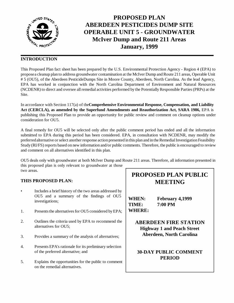
PROPOSED PLANABERDEEN PESTICIDES DUMP SITE
OPERABLE UNIT 5 - GROUNDWATERMcIver Dump and Route 211 Areas
January, 1999
INTRODUCTION
This Proposed Plan fact sheet has been prepared by the U.S. Environmental Protection Agency - Region 4 (EPA) topropose a cleanup plan to address groundwater contamination at the McIver Dump and Route 211 areas, Operable Unit# 5 (OU5), of the Aberdeen Pesticide Dumps Site in Moore County, Aberdeen, North Carolina. As the lead Agency,EPA has worked in conjunction with the North Carolina Department of Environment and Natural Resources(NCDENR) to direct and oversee all remedial activities performed by the Potentially Responsible Parties (PRPs) at theSite.
In accordance with Section 117(a) of the Comprehensive Environmental Response, Compensation, and LiabilityAct (CERCLA), as amended by the Superfund Amendments and Reauthorization Act, SARA 1986, EPA ispublishing this Proposed Plan to provide an opportunity for public review and comment on cleanup options underconsideration for OU5.
A final remedy for OU5 will be selected only after the public comment period has ended and all the informationsubmitted to EPA during this period has been considered. EPA, in consultation with NCDENR, may modify thepreferred alternative or select another response action presented in this plan and in the Remedial Investigation FeasibilityStudy (RI/FS) reports based on new information and/or public comments. Therefore, the public is encouraged to reviewand comment on all alternatives identified in this plan.
OU5 deals only with groundwater at both McIver Dump and Route 211 areas. Therefore, all information presented inthis proposed plan is only relevant to groundwater at thosetwo areas.
THIS PROPOSED PLAN:
• Includes a brief history of the two areas addressed byOU5 and a summary of the findings of OU5investigations;
1. Presents the alternatives for OU5 considered by EPA;
2. Outlines the criteria used by EPA to recommend thealternatives for OU5;
3. Provides a summary of the analysis of alternatives;
4. Presents EPA's rationale for its preliminary selectionof the preferred alternative; and
5. Explains the opportunities for the public to commenton the remedial alternatives.
PROPOSED PLAN PUBLICMEETING
WHEN: February 4,1999TIME: 7:00 PMWHERE:
ABERDEEN FIRE STATIONHighway 1 and Peach StreetAberdeen, North Carolina
30-DAY PUBLIC COMMENTPERIOD
2
This document summarizes information that isexplained in more detail in the Remedial Investigationand Feasibility Study Reports (RI/FS) for OU5 andother documents contained in the InformationRepository/Administrative Record for this Site.
SCOPE AND ROLE OF PROPOSEDREMEDIAL ACTION
The Aberdeen Pesticide Dumps Site was divided intodifferent Operable Units (OUs) in order to addresscontamination in the different media and areas. Theremedial alternatives described in this document dealwith OU5 only (groundwater contamination at theMcIver Dump and Route 211 areas). Other mediaand/or areas are being addressed under other OUs.
An interim Record of Decision (ROD) for the Route211 area was signed on September 16, 1997. Thisinterim action addressed, through a pump and treatsystem, the highest concentrations of pesticides ingroundwater at the Route 211 area. This interim actionis part of EPA's preferred alternative for the Route 211area described on this proposed plan.
MCIVER DUMP AREA SITE BACKGROUND
Site HistoryThe McIver Dump Area (Figure 1) is locatedapproximately 0.5 miles north of the junction ofSR1112 (Roseland Road) and SR1106, west ofAberdeen. The McIver Dump Area formerly consistedof two subareas, area B and area C, and a soilstockpile. Materials, some of which containedpesticides, were discovered at both areas B and C. Atarea B, pesticides were removed in 1985 by EPA anddisposed at the GSX facility located in Pinewood,South Carolina. In 1989 at area C, approximately3,200 cubic yards of materials and soils were removedby an EPA Emergency Response Team and stockpiledon an impermeable liner located near area C. In late1997, soils containing pesticide residuals wereexcavated from both areas B and C (approximately12,829 tons). The excavated soils and the soilsstockpile were transported to a thermal desorption unitfor treatment. Treated soils were returned to the McIverDump Area and used for clean fill. As a result of these
remedial activities (all conducted as part of a separateOU), known sources of pesticides have been removedfrom the Area and, therefore, no future impacts togroundwater and/or surface water are anticipated.Additionally, significant erosion control measures havebeen constructed at the Area to control drainage toPatterson Branch, a stream to the north of the formersource areas. Topsoil has been place over the Area,which has been seeded and fertilized to promote growthof stabilizing vegetation.
Remedial Investigation SummaryThe groundwater Remedial Investigation (RI) at theMcIver Dump Area was conducted in multiple phasesfrom November 1994 to October 1995. The followingsummarizes the investigative activities conducted:
• 8 Monitoring Wells Installed;• 27 Direct Push Samples Collected; and• 5 Surface Water/5 Sediment Samples Collected
from Patterson Branch.
Water bearing areas below the land surface are knownas aquifers. The only aquifer penetrated during thisinvestigation at the McIver area was the Lower BlackCreek Aquifer. Within the Lower Black Creek Aquiferis a thin but continuous clay layer that acts as a localconfining unit. This clay layer separates the LowerBlack Creek Aquifer into an upper and lower portion.The only impacted portion of the aquifer at the McIverDump Area is the upper portion of the Lower BlackCreek Aquifer. The principal direction for groundwaterflow is toward the north-northeast perpendicular toPatterson Branch.
Nature and Extent of ContaminationBased on the investigation, no one is being exposed tocontaminated groundwater in the McIver area.
The pesticides considered chemicals of concern (COCs)at the McIver Dump area are alpha- and beta-benzenehexachloride (BHC). Concentrations of eachcompound generally decreased with depth at locationswhere samples were collected from different depthswithin the aquifer. The concentrations of the two BHCisomers in the monitoring wells (Figure 2) indicate thatpesticides detected in groundwater
3
4
originated from the former source areas (areas B andC), and have migrated downgradient to PattersonBranch.
Surface water and sediments were sampled andanalyzed from Patterson Branch during the RI. Resultsshow that concentrations of pesticides in surface waterare below the North Carolina Surface Water Standards.Figure 2 shows the locations of the surface water andsediment samples collected.
The only pesticide detected at the McIver area havinga promulgated Federal or State groundwater qualitystandard for the protection of groundwater is gamma-BHC also known as Lindane. Lindane does not exceedthe promulgated Federal and State standard of 0.2 partsper billion (ppb) in any of the groundwater samplescollected from the monitoring wells in the area.
ROUTE 211 AREA SITE BACKGROUND
Site HistoryThe Route 211 Area (Figure 1) is locatedapproximately 1,000 feet southwest of highway Route211 East and adjacent to the Aberdeen & RockfishRailroad. It is approximately one mile east of the Townof Aberdeen. The Area formerly contained an old sandmining basin approximately 80 feet across and 8 to 20feet deep. Materials, some of which containedpesticides, were discovered in a waste pile on thesouthwest slope of the pit. In 1986, approximately 100cubic yards of pesticides and associated soil wereremoved by EPA and disposed at the GSX facility inPinewood, South Carolina. In 1989, approximately 200cubic yards of similar material was discovered by EPAand subsequently removed, placed in the stockpile atthe McIver Dump Area, and later treated by thermaldesorption. In late 1997, additional soils containingresidual pesticides were excavated and transported to athermal desorption unit for treatment (approximately3,464 tons). Treated soils were then returned to theArea for use as clean fill and the entire pit at the Areawas filled. Following regrading of the Area, pinestrawwas applied to prevent erosion and stabilize the soil.Surface runoff in the immediate vicinity of the Areaflows away from the former source area. All the soilremediation work described above was performed under
a different operable unit.
Remedial Investigation SummaryThe groundwater RI at the Route 211 Area wasconducted in multiple phases from November 1994 toOctober 1996. The following summarizes theinvestigative activities:
• 37 Monitoring Wells Installed;• 35 Direct Push Samples Collected; and• 2 HydroPunch Samples Collected.
In addition, a Downgradient Receptor Study wasconducted, which consisted of the sampling andanalysis of 21 private wells.
The three aquifers characterized during thisinvestigation were the Surficial Aquifer, the UpperBlack Creek Aquifer, and the Lower Black CreekAquifer. The investigation indicates that the UpperBlack Creek Aquifer is separated into an upper andlower portion by an intermediate clay layer with theexception of one sample location upgradient of thesource area. Figure 3 depicts the aquifers associatedwith the Route 211 Area.
The principal directions for groundwater flow in thedifferent aquifers are:• toward the southwest in the Surficial Aquifer;• toward the east-southeast in the upper portion of
the Upper Black Creek Aquifer;• toward the south-southeast in the lower portion of
the Upper Black Creek Aquifer, and• toward the south in the Lower Black Creek
Aquifer.
Nature and Extent of ContaminationBased on the investigation, no one is drinkingcontaminated groundwater from any aquifer in theRoute 211 study area.
Source Area Groundwater/Surficial AquiferThe groundwater underlying the former source area isreferred to as "Source Area Groundwater", which is asmall portion of the Surficial Aquifer. The Source AreaGroundwater is currently being rernediated as part ofthe Interim Remedial Action for

5
6
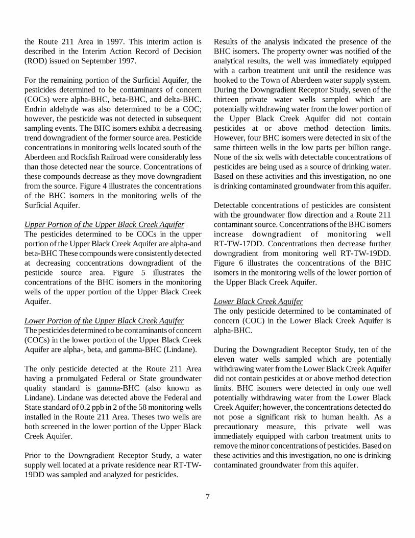
7
the Route 211 Area in 1997. This interim action isdescribed in the Interim Action Record of Decision(ROD) issued on September 1997.
For the remaining portion of the Surficial Aquifer, thepesticides determined to be contaminants of concern(COCs) were alpha-BHC, beta-BHC, and delta-BHC.Endrin aldehyde was also determined to be a COC;however, the pesticide was not detected in subsequentsampling events. The BHC isomers exhibit a decreasingtrend downgradient of the former source area. Pesticideconcentrations in monitoring wells located south of theAberdeen and Rockfish Railroad were considerably lessthan those detected near the source. Concentrations ofthese compounds decrease as they move downgradientfrom the source. Figure 4 illustrates the concentrationsof the BHC isomers in the monitoring wells of theSurficial Aquifer.
Upper Portion of the Upper Black Creek AquiferThe pesticides determined to be COCs in the upperportion of the Upper Black Creek Aquifer are alpha-andbeta-BHC These compounds were consistently detectedat decreasing concentrations downgradient of thepesticide source area. Figure 5 illustrates theconcentrations of the BHC isomers in the monitoringwells of the upper portion of the Upper Black CreekAquifer.
Lower Portion of the Upper Black Creek AquiferThe pesticides determined to be contaminants of concern(COCs) in the lower portion of the Upper Black CreekAquifer are alpha-, beta, and gamma-BHC (Lindane).
The only pesticide detected at the Route 211 Areahaving a promulgated Federal or State groundwaterquality standard is gamma-BHC (also known asLindane). Lindane was detected above the Federal andState standard of 0.2 ppb in 2 of the 58 monitoring wellsinstalled in the Route 211 Area. Theses two wells areboth screened in the lower portion of the Upper BlackCreek Aquifer.
Prior to the Downgradient Receptor Study, a watersupply well located at a private residence near RT-TW-19DD was sampled and analyzed for pesticides.
Results of the analysis indicated the presence of theBHC isomers. The property owner was notified of theanalytical results, the well was immediately equippedwith a carbon treatment unit until the residence washooked to the Town of Aberdeen water supply system.During the Downgradient Receptor Study, seven of thethirteen private water wells sampled which arepotentially withdrawing water from the lower portion ofthe Upper Black Creek Aquifer did not containpesticides at or above method detection limits.However, four BHC isomers were detected in six of thesame thirteen wells in the low parts per billion range.None of the six wells with detectable concentrations ofpesticides are being used as a source of drinking water.Based on these activities and this investigation, no oneis drinking contaminated groundwater from this aquifer.
Detectable concentrations of pesticides are consistentwith the groundwater flow direction and a Route 211contaminant source. Concentrations of the BHC isomersincrease downgradient of monitoring wellRT-TW-17DD. Concentrations then decrease furtherdowngradient from monitoring well RT-TW-19DD.Figure 6 illustrates the concentrations of the BHCisomers in the monitoring wells of the lower portion ofthe Upper Black Creek Aquifer.
Lower Black Creek AquiferThe only pesticide determined to be contaminated ofconcern (COC) in the Lower Black Creek Aquifer isalpha-BHC.
During the Downgradient Receptor Study, ten of theeleven water wells sampled which are potentiallywithdrawing water from the Lower Black Creek Aquiferdid not contain pesticides at or above method detectionlimits. BHC isomers were detected in only one wellpotentially withdrawing water from the Lower BlackCreek Aquifer; however, the concentrations detected donot pose a significant risk to human health. As aprecautionary measure, this private well wasimmediately equipped with carbon treatment units toremove the minor concentrations of pesticides. Based onthese activities and this investigation, no one is drinkingcontaminated groundwater from this aquifer.
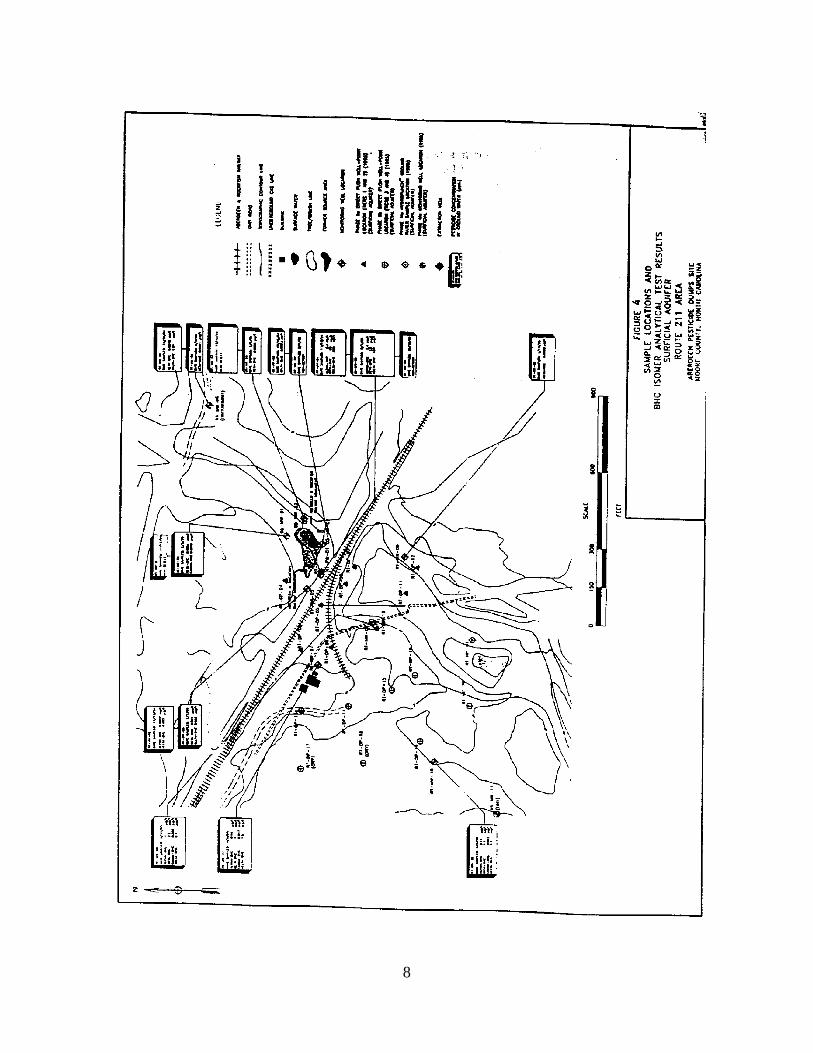
8
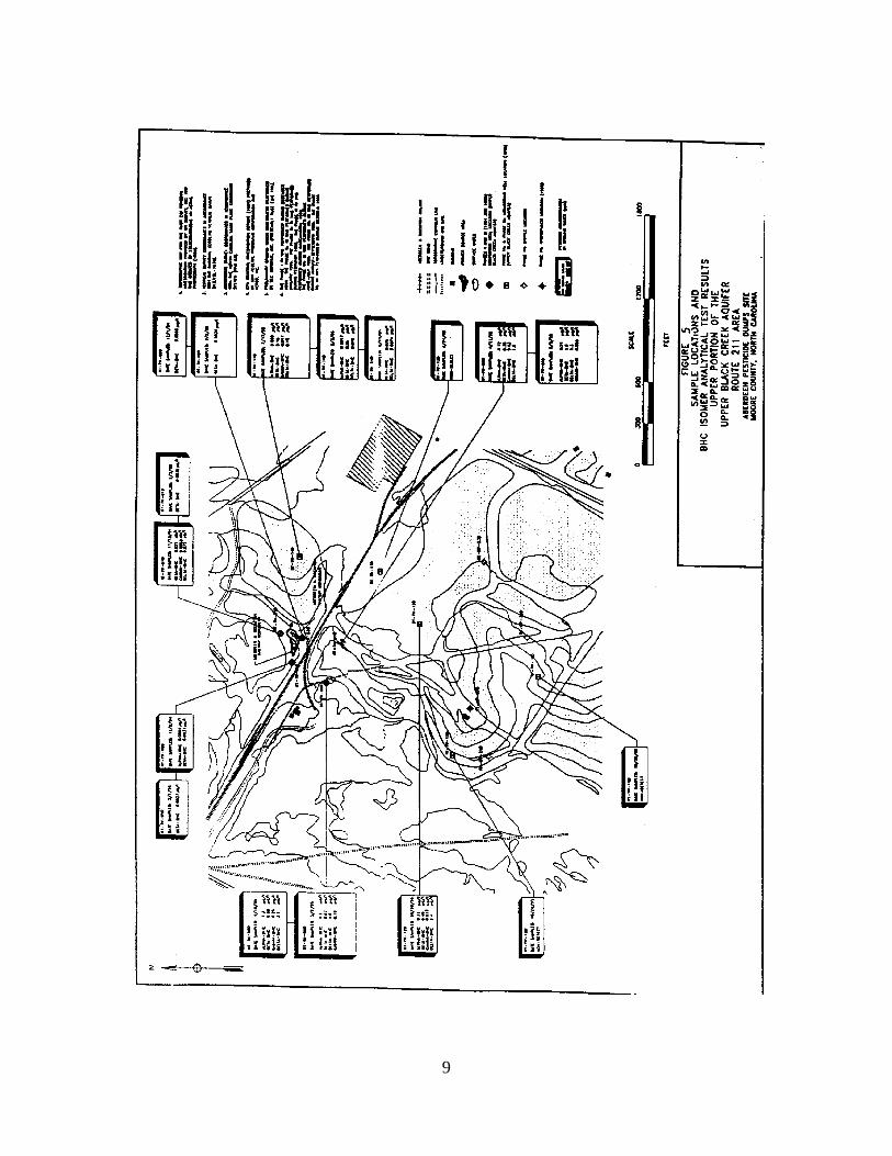
9
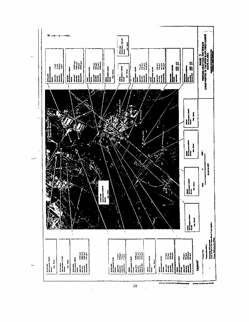
11
Figure 7 presents the concentrations of the BHCisomers in the monitoring wells of the Lower BlackCreek Aquifer.
SUMMARY OF SITE RISKS
As part of the Remedial Investigation/Feasibility Study(RI/FS) process, EPA analyzed and estimated anyexisting(current) and potential(future) human healthand/or environmental problems that could result if theOU5 contamination is not addressed. This analysis iscalled a Baseline Risk Assessment (BRA). Inconducting this assessment, EPA focused on thehuman health effects that could result from directexposure to contaminated groundwater in the Route211 and McIver Areas.
Based on the investigation, no one is drinkingcontaminated groundwater from the McIver or theRoute 211 Area. Therefore, there is no current risk tohuman health and the environment in any of the twoareas due to the ingestion of groundwater.
Future/potential risk might exist due to the ingestionof contaminated groundwater from the Lower BlackCreek Aquifer at the McIver Area. At the Route 211Area, future/potential risk might exist mainly due toingestion of contaminated groundwater from thesource area well. Future/potential risk might also existdue to the ingestion of groundwater from the otheraquifers within the plume.
For more detailed information about risk calculationsfor OU5, please refer to the BRA report available forreview at the repository.
REMEDIAL ACTION OBJECTIVES (RAOs)
Remedial action objectives or clean up goals weredeveloped based on the results of the Baseline RiskAssessment (BRA) and the examination of potentialApplicable or Relevant and Appropriate Requirements(ARARs). ARARs for groundwater include MaximumContaminants Levels (MCLs) and North CarolinaGroundwater Quality Standards (NCGQS).
The following are the applicable groundwater clean up
goals in parts per billion (ppb) for the chemicals ofconcern in both McIver and Route 211 Areas.
Chemicals of GroundwaterConcern (COCs) Clean-up Goal BasisAlpha -BHC 0.02 ppb Risk-basedBeta - BHC 0.10 ppb Risk-basedDelta - BHC 70.00 ppb Risk-basedGamma-BHC (Lindane) 0.20 ppb MCLs/NCGQS
SUMMARY OF ALTERNATIVES
The following section provides a summary of thealternatives developed in the Feasibility Study (FS)report for the clean-up of groundwater at McIver andRoute 211 Areas.
MCIVER AREA
Alternative 1: No Action
The No Action alternative is required to be evaluatedat every site to establish a baseline for comparison. Nofurther groundwater activities will be conducted at theMcIver Dump Area under this alternative. Becausethis alternative does not entail contaminant removal, areview of the remedy would be conducted every fiveyears in accordance with the Superfund law. Costsincluded on this alternative are associated with the fiveyear review which would include sampling andanalysis for the contaminants of concern (COCs) andpreparation of the five year review report.
The estimated cost of this alternative is $160,000.
Alternative 2: Phytoremediation, ContinuedGoundwater/Surface Water/SedimentsMonitoring, Area Reconnaissance, andContingency Well Head Treatment if FuturePotential Receptors are identified
Alternative 2 proposes phytoremediation, aninnovative technology for the remediation of pesticidein groundwater. Phytoremediation is the use ofvegetation to treat in-place contaminatedgroundwater. The McIver Dump Area is favorable forthe use of phytoremediation as a remedial technologybecause of the shallow water table (i.e,
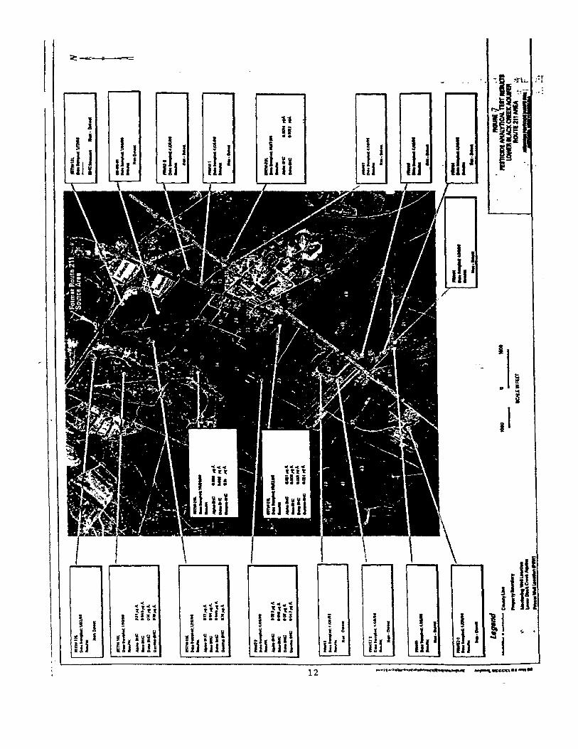
13
allows tree roots to get in contact with contaminatedgroundwater), proximity of the source area to thegroundwater discharge area, and absence of currentgroundwater use. Additionally, phytoremediation offerssome hydraulic control through transpiration therebylimiting the migration of pesticides. Following sourceremoval and construction of erosion control measuresalready finished under another operable unit, pesticideconcentrations will naturally decrease. Under Alternative2, the reduction in pesticide concentrations will bemonitored in both groundwater and Patterson Branch.Exposure control under Alternative 2 would bemaintained through monitoring and area reconnaissance,and well head treatment should future potentialreceptors be identified.
Monitoring will involve periodic (short and long-term)sampling and analysis of groundwater/surfacewater/sediments to determine if contaminants havedegraded or migrated. Monitoring will also be used as averification mechanism to confirm predicted contaminanttransport pathways, concentrations and time frames, andto evaluate potential contingencies should unanticipatedcontaminant trends or migration pathways occur.
Area reconnaissance will consist of periodicreconnoitering of specific areas to determine whetherproperties overlying impacted groundwater are for saleor have been purchased. Potential future development ofproperty areas will be determined in order to controlfuture exposures.
Alternative Water Supply/Well head treatment-Currently, there are no receptors of impactedgroundwater. However, if potential receptors areidentified in the future, an alternate water supply or wellhead treatment will be used to prevent exposure. Thisalternative will also include a review after the first fiveyears to determine the effectiveness of the alternative toprotect human health and/or the environment. As aresult of this review, EPA will determine if additionalsite remediation or modifications to the alternative arerequired. The estimated time to achieve the clean upgoal and cost of this Alternative 2 is 10 years and$450,000 respectively.
Alternative 3: Groundwater Recovery of theHighest Concentrations of PesticideResiduals using Extraction Wells and/orInterceptor Trenches, Treatment by CarbonAdsorption, Discharge of TreatedGroundwater via Surface Water orReinjection (Infiltration Galleries/InjectionWells), Continued Groundwater/SurfaceWater Monitoring, Area Reconnaissance,and Well Head Treatment should FuturePotential Receptors be identified
Under Alternative 3, groundwater containing the highestconcentrations of residual pesticides will be extractedusing extraction wells or interceptor trenches. Extractedgroundwater will be treated using carbon adsorption,and treated groundwater will be discharged via surfacewater or a re-injection method. As in Alternative 2,exposure controls would be maintained throughmonitoring, area reconnaissance and well head treatmentshould future potential receptors be identified.
This alternative will also include a review after the firstfive years to determine the effectiveness of thealternative to protect human health and/or theenvironment. As a result of this review, EPA willdetermine if additional site remediation or modificationsto the alternative are required. The estimated time toachieve the clean up goal and cost of Alternative 3 is 10years and $1,500,000 respectively.
Alternative 4: Groundwater Recovery of PesticideResiduals Exceeding RAOs using ExtractionWells and/or Interceptor Trenches,Treatment by Carbon Adsorption, Dischargeof Treated Groundwater via Surface Watero r R e i n j e c t i o n ( I n f i l t r a t i o nGalleries/Injection Wells), ContinuedGroundwater/Surface Water Monitoring,Area Reconnaissance, and Well HeadTreatment should Future Potential Receptorsbe identified
Under Alternative 4, contaminated groundwaterexceeding the remedial action objectives (RAOs) will beextracted using extraction wells or interceptor trenches.Extracted groundwater will be treated using
14
carbon adsorption, and treated groundwater will bedischarged via surface water or a re-injection method.During operation of the system, exposure controlswould be maintained through monitoring, areareconnaissance and well head treatment should futurepotential receptors be identified as defined in Alternative2.
This alternative will also include a review after the firstfive years to determine the effectiveness of thealternative to protect human health and/or theenvironment. As a result of this review, EPA willdetermine if additional site remediation or modificationsto the alternative are required. The estimated time toachieve the clean up goal and cost of Alternative 4 is 10years and $2,000,000 respectively.
ROUTE 211 AREA
Alternative 1: No Action
The No Action alternative is required to be evaluated atevery site to establish a baseline for comparison. Nofurther groundwater activities will be conducted at theRoute 211 Area under this alternative. Because thisalternative does not entail contaminant removal, areview of the remedy would be conducted every fiveyears in accordance with the Superfund law. Costsincluded on this alternative are associated with the fiveyear review which would include sampling and analysisfor the contaminants of concern (COCs) and preparationof the five year review report.
The estimated cost of Alternative 1 is $370,000.
Alternative 2: Cont inued GroundwaterMonitoring, Area Reconnaissance, and Well,Head Treatment or Alternative WaterSupply, if Future Potential Receptors areidentified
A continued groundwater monitoring program would beput in place to monitor pesticide concentrations andmigration pathways. If potential future receptors areidentified, they would be protected through themonitoring program, area reconnaissance, and, ifnecessary, through the use of well head treatment or
alternative water supply.
Monitoring will involve periodic (short and long-term)sampling and analysis of groundwater to determine ifcontaminants have degraded or migrated. Monitoringwill also be used as a verification mechanism to confirmpredicted contaminant transport pathways,concentrations and time frames, and to evaluatepotential contingencies should unanticipatedcontaminant trends or migration pathways occur. Themonitoring program includes monitoring of municipalwell #13.
Area reconnaissance will consist of periodicreconnoitering of specific areas to determine whetherproperties overlying impacted groundwater are for saleor have been purchased. Potential future development ofproperty areas will be determined in order to controlfuture exposures. Residential well surveys will continueto be conducted throughout the duration of the remedialaction to ensure foreseeable receptors are identified andprotected.
Alternative Water Supply/Well head treatment -Currently, there are no receptors of impactedgroundwater. However, if potential receptors areidentified in the future, an alternate water supply or wellhead treatment will be used to prevent exposure.
The time frame to achieve the clean up under Alternative2 was not estimated. However, without mitigating themigration of contaminated groundwater from the sourcearea, the time frame to achieve the clean up goals couldbe expected to be greater than alternatives 3 and 4.
This alternative will also include a review every fiveyears to determine the effectiveness of the alternative toprotect human health and/or the environment. As aresult of the reviews, EPA will determine if additionalsite remediation or modifications to the alternative arerequired. The estimated cost of Alternative 2 is$1,400,000.

15
Alternative 3: Groundwater Recovery from theSource Area Groundwater Using ExtractionWells, Treatment by Carbon Adsorption, andDischarge of Treated Groundwater viaReinjection (Infiltration Galleries/InjectionWells), Continued Groundwater Monitoringof the Surficial, Upper Black Creek andLower Black Creek aquifers, AreaReconnaissance, and Contingency Controlswith Well Head Treatment or AlternativeWater Supply if Future Potential Receptorsare identified.
Under this alternative, the groundwater underlying theformer disposal area referred to as “Source Areagroundwater”, which poses the most significant risk atthe Area, would be extracted and treated. Treatedgroundwater will be discharged via infiltration galleriesor a reinjection method. Through the removal ofpesticide residuals and extraction of Source Areagroundwater, pesticide concentrations would continueto reduce in all aquifers. Alternative 3 includes acontinued monitoring program to verify reduction inpesticide concentrations in the Surficial, Upper BlackCreek, and Lower Black Creek aquifers, includingmonitor migration pathways. If potential futurereceptors are identified, they would be protectedthrough the monitoring program, area reconnaissance,and, if necessary, through the use of well head treatmentor alternative water supply. The monitoring, areareconnaissance and contingency controls programs(same as in Alternative 2) will be in-place until the cleanup goals are achieved. The estimated time frame toachieve the clean up goal in the various aquifers rangesfrom 0 to less than 30 years for gamma BHC (Lindane);from less than 5 to 90 years for alpha BHC; from lessthan 5 to 90 years for beta BHC ; and from 0 to lessthan 5 years for delta BHC.
This alternative will also include a review every fiveyears to determine the effectiveness of the alternative toprotect human health and/or the environment. As aresult of the reviews, EPA will determine if additionalsite remediation or modifications to the alternative arerequired. The estimated cost of Alternative 3 is$2,600,000.
Alternative 4: Groundwater Recovery from theSource Area, the upper and lower portion ofthe Upper Black Creek Aquifer, and theLower Black Creek Aquifer using Extraction,Treatment by Carbon Adsorption, Dischargeof Treated Groundwater via reinjection(Infiltration Galleries/Injection Wells) fromthe Former Source Area and via surfacewater from the lower aquifers, ContinuedG r o u n d w a t e r M o n i t o r i n g , A r e aReconnaissance, and Exposure Controls withWell Head Treatment or Alternative WaterSupply if any Future Potential Receptors areidentified.
Under this alternative, groundwater from aquifers wouldbe extracted and treated. Alternative 4 includes acontinued monitoring program to verify the reduction inpesticide concentrations, monitor migration pathways,and evaluate the effectiveness of the extraction system.If potential future receptors are identified, they would beprotected through the monitoring program, areareconnaissance, and, if necessary, through the use ofwell head treatment or alternative water supply. Themonitoring, area reconnaissance and contingencycontrols programs (same as in Alternative 2 and 3) willbe in-place until the clean up goals are achieved. Theestimated time to achieve the clean up goal in thevarious aquifers ranges from 0 to less than 20 years forgamma BHC (Lindane); from less than 5 to 55 years foralpha BHC; from less than 5 to 55 years for beta BHC;and from 0 to less than 5 years for delta BHC.
This alternative will also include a review every fiveyears to determine the effectiveness of the alternative toprotect human health and/or the environment. As aresult of the reviews, EPA will determine if additionalsite remediation or modifications to the alternative arerequired. The estimated cost of Alternative 4 is$15,000,000.
EVALUATION OF ALTERNATIVES
The selection of the preferred alternatives for OU5 is theresult of a comprehensive screening and evaluationprocess. The Feasibility Study (FS) report identified andanalyzed appropriate alternatives to
16
address groundwater contamination at McIver Dumpand Route 211 Areas. As stated previously, the FSreport, as well as other documents used relevant to thesite, are available for public review in the informationrepository.
EPA uses the following nine criteria to compare allproposed alternatives:
1. Overall protection of human health and theenvironment: EPA assesses the degree to whicheach alternative eliminates, reduces, or controlsthreats to public health and the environmentthrough treatment, engineering methods, orinstitutional controls.
2. Compliance with Applicable or Relevant andAppropriate Requirements (ARARs): Thealternatives are evaluated for compliance with allapplicable state and federal environmental andpublic health laws and requirements that apply orare relevant and appropriate to the Site conditions.
3. Short-term effectiveness: The length of timeneeded to implement each alternative is considered,and EPA assesses the risks that may be posed toworkers and nearby residents during constructionand implementation.
4. Long-term effectiveness: The alternatives areevaluated based on their ability to maintain reliableprotection of public health and the environmentover time once the cleanup levels have been met.
5. Reduction of contaminant toxicity, mobility, andvolume: EPA evaluates each alternative based onhow it reduces (1) the harmful nature of thecontaminants, (2) their ability to move through theenvironment, and (3) the volume or amount ofcontamination at the Site.
6. Implementability: EPA considers the technicalfeasibility (e.g., how difficult the alternative is toconstruct and operate) and administrative ease(e.g., the amount of coordination with othergovernment agencies that is needed) of a remedy,
including the availability of necessary materials andservices.
7. Cost: The benefits of implementing a particularremedial alternative are weighed against the cost ofimplementation. Costs include the capital (up-front)cost of implementing an alternative over the longterm and the net present worth of both capital andoperation and maintenance costs.
8. State Acceptance: EPA requests state commentson the Remedial Investigation Report, RiskAssessment, Feasibility Study Report, andProposed Plan, and must take into considerationwhether the State concurs with, opposes, or has nocomment on the preferred alternative.
9. Community Acceptance: To ensure that the public has an adequate opportunity to provideinput, EPA holds a public comment period andpublic meeting and considers and responds to alloral and written comments received from thecommunity prior to the final selection of a remedialaction.
ANALYSIS OF ALTERNATIVES(SUMMARY)
MCIVER AREA
Overall Protection of Human Health and theEnvironment - Alternatives 2, 3, and 4 should berelatively equivalent in regards to the overall protectionof human health and the environment. Alternative 1would not be a protective alternative. Currently, thereare no complete exposure pathways and therefore, nosignificant risks to human health. Alternatives 2, 3, and4 would involve some controls such as monitoring andarea reconnaissance to minimize the potential for futureexposure.
Alternative 2 includes the enhancement of on-goingphytoremediation at the Area through the emplacementof trees or other plant life in the migration pathway ofthe pesticides. Alternative 3 includes the recovery ofgroundwater containing the highest concentrations ofpesticides. Alternative 4 which would attempt to recovergroundwater
17
containing pesticides exceeding their respective cleanupgoals.
Computer modeling indicates that pesticideconcentrations would not increase above currentconditions. Based on the Ecological Risk Assessment,minimal impact is associated with ecological receptorsin Patterson Branch. Additionally, since source soilswere removed in 1997, residual pesticide concentrationswill naturally decrease. Alternatives 2,3 and 4 wouldeach further limit the potential discharge of residualpesticides into Patterson Branch. Additionally, each ofthese alternatives includes establishment of a monitoringprogram at Patterson Branch to ensure no significantimpact to ecological receptors is maintained in thefuture.
Because Alternative 1 is not protective of human healthand environment, it will be eliminated for considerationunder the remaining eight criteria.
Compliance with ARARs - Alternatives 2, 3, and 4would equally comply with ARARs. Pesticidesexceeding clean up goals would be addressed underthose three alternatives, via phytoremediation inAlternative 2, and extraction wells in Alternatives 3 and4.
Long-Term Effectiveness and Permanence -Alternative 2,3 and 4 would reduce pesticideconcentrations until clean up levels are achievedExposure during active remediation under Alternatives2, 3, and 4 would be controlled through continuedmonitoring and area reconnaissance. Therefore,Alternatives 2, 3, and 4 are equivalent in regards toaddressing long-term effectiveness and permanence.
Reduction of Contaminant Toxicity, Mobility, andVolume - Alternative 2 would reduce contaminantmobility and volume using phytoremediation.Alternatives 3 and 4 would reduce the volume andmobility of pesticides using extraction wells.Alternatives 2, 3, and 4 each would address the plume atthe McIver Dump Area and each would reduce themobility and volume of pesticides through treatment.
Short-Term Effectiveness - For construction activities,Alternative 2 poses the least threat to workers, thepublic, and the environment followed by Alternatives 3and 4. Alternative 2 would also require the least amountof time for implementation of construction activitiesfollowed, in ascending order, by Alternatives 3, and 4.
The expected time frame to achieve cleanup goals underAlternatives 2, 3, and 4 is the same (10 years).
Implementability - Alternative 2 requires theenhacement of the McIver Dump Area with trees andother plant life. No significant difficulties would beanticipated for planting trees or other plant life underthis alternative. Alternatives 3 and 4 each includeengineered remediation systems which should beimplementable, although not uncomplicated.Additionally, excavation of interceptor trenches underAlternatives 3 and 4 may compromise the existingerosion control measures at the Area.
Cost - The total estimated present worth costs for eachalternative are listed below:
• Alternative 1: $160,000• Alternative 2: $450,000• Alternative 3: $1,5000,000 (Surface Water) -
$1,200,000 (Infiltration Galleries)• Alternative 4: $2,000,000 (Surface Water) -
$1,600,000 (Infiltration Galleries)
The costs for Alternatives 3 and 4 are greater than 2times the cost for Alternative 2.
ROUTE 211 AREA
Overall Protection of Human Health and theEnvironment - All of the alternatives, except the NoAction alternative, provide adequate protection ofhuman health. Alternatives 2, 3, and 4 would each utilizecontrol mechanisms including continued monitoring andarea reconnaissance. Additionally, these alternativesprovide exposure controls if any future potentialreceptors are identified in the migration pathway ofimpacted groundwater. The exposure controls couldinclude installation of well head treatment systems orproviding an alternative
18
water supply.
Because Alternative 1 is not protective of human healthand environment, it will be eliminated for considerationunder the remaining eight criteria.
Compliance with ARARs - Alternative 2 may notachieve the cleanup goals in a reasonable time framewhen compared with Alternatives 3 and 4. BothAlternatives 3 and 4 would achieve the cleanup goals.Therefore, Alternative 3 and 4 would comply withARARs. The primary difference between Alternatives 3and 4 would be that Alternative 3 would rely on naturalprocesses for the remediation of pesticides outside of theformer source area, while Alternative 4 would useextraction wells in all aquifers.
Long-Term Effectiveness and Permanence - ForAlternatives 2, 3, and 4, potential future receptors wouldbe identified through a comprehensive monitoringprogram. The receptors would either be connected topublic water systems or individual carbon filtrationsystems would be installed at the point of use.
Reduction of Toxicity, Mobility, or Volume ThroughTreatment - Alternative 4 offers the greatest reductionin mobility and volume of impacted groundwaterthrough extraction and treatment of all impactedgroundwater. Alternative 3 would result in the reductionin mobility and volume of pesticides in the Source Areagroundwater through extraction and treatment ofapproximately 60% of the pesticide mass in the Surficialaquifer.
Short-Term Effectiveness - Alternatives 2 wouldrequire no construction-related activities which couldendanger public communities or remedial workers. Wellinstallations have been successfully conducted during RIactivities. Therefore, implementation of Alternatives 3and 4 would pose no significant concerns in regards toprotection of public communities or remedial workers.
In terms of the achievement of cleanup goals,Alternative 4 would require the shortest time framefollowed by Alternative 3 and then by Alternatives 2.However, certain aquifers and certain BHC isomers
would require equivalent time frames to achieve theclean up goals under Alternatives 3 and 4. For gamma-BHC (Lindane), Alternatives 3 and 4 would each requirefrom 0 to less than 30 years and from 0 to less than 20years, respectively, to achieve the cleanup goals in thevarious aquifers. For beta-BHC, the time frames toachieve the cleanup goals in the various aquifers forAlternatives 3 and 4 would be from less than 5 to 90years and from less than 5 to 55 years, respectively. Thetime frames to achieve cleanup goals in the variousaquifers for delta-BHC would be from 0 to less than 5years for both Alternatives 3 and 4. The range of timeframes to achieve the cleanup goal in the variousaquifers for alpha-BHC for Alternatives 3 and 4 wouldbe from less than 5 to 90 years and from less than 5 to55 years, respectively.
Based on the results of the groundwater computermodeling, (included in the FS report), when the alpha-BHC concentration under Alternative 4 (upper portionof the Upper Black Creek Aquifer) reachs the cleanupgoal (0.02 ppb)(i.e., 55 years), the alpha-BHCconcentration under Alternative 3 (Lower Black CreekAquifer) will be reduced to 0.04 µg/l. This represents a90% reduction in the alpha-BHC concentration underAlternative 3 needed to meet the 0.02 µg/l cleanup goal.
The remaining 35 year difference between theseAlternatives (i.e., 90 years versus 55 years) is theamount of time that it will take for the concentrations inthe Lower Black Creek Aquifer to go from 0.04 ppb to0.02 ppb (a 2 x 10⁻⁶ risk to a 1 x 10⁻⁶ risk reduction).This is an extremely low risk range. Therefore, basedupon the above discussion, the ability to achieve thecleanup goal under Alternative 3 is generally equivalentto Alternative 4.
Implementability- Alternatives 1 and 2 could be easilyimplemented. Alternatives 3 and 4 require constructionof an extraction, treatment, and discharge system(s), allof which would be located on private property.However, Alternative 3 would consist of an extractionwell, a treatment building accommodating two carbontreatment canisters, and an infiltration gallery withapproval already obtained from this property owner.Multiple implementability
19
concerns are associated with Alternative 4. Thefollowing lists certain aspects of Alternative 4 in regardsto the implementability issues.
• Twenty-two extraction wells having a combinedflow rate of 935 gallons per minute (gpm) isestimated for the alternative.
• A large treatment building to accommodate 410,000 lbs. carbon vessels would be needed.
• The treatment building would need to be centrallylocated. Thousands of feet of pipeline would benecessary for the extraction and treatment system.
• A 3.6 mile discharge pipeline to Quewhiffle Creekwould be required.
• Potential for spreading unknown groundwatercontaminants, other than pesticides, in the largecapture zone created by 22 extraction wells.
• Numerous easements and property accessagreements would be required to obtain access toapproximately 250 acres.
• A minimum of nine months would be required toobtain a NPDES permit for surface waterdischarge, and greater than 2 years would berequired for modeling the extraction system,obtaining access agreements, design of the system,and development of a monitoring program.
The monitoring program and control measures ofAlternatives 2, 3, and 4 would adequately address themigration of pesticides and prevent future exposure.
Cost - The total estimated present worth costs for eachalternative are listed below:
• Alternative 1: $370,000• Alternative 2: $1,400,000• Alternative 3: $2,600,000• Alternative 4: $15,000,000
Alternative 4 would be significantly greater in cost thanany of the other alternatives.
State Acceptance - The North Carolina Department ofEnvironment and Natural Resources (NCDENR) hasparticipated during all the remedial process for this Siteand concurs with EPA's proposed remedial action forboth the McIver and Route 211 Areas.
Community Acceptance - Community acceptance willbe evaluated after the public comment period and will bedescribed in the Record of Decision for Operable Unit 5.
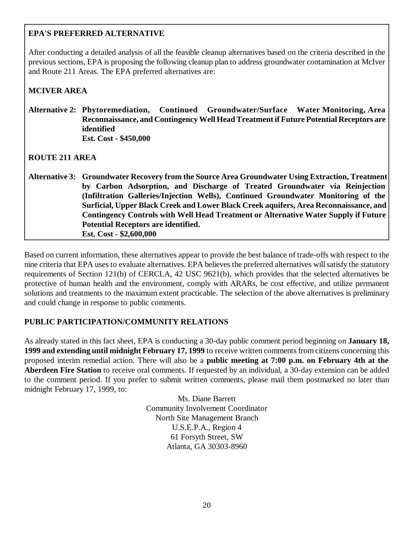
20
EPA'S PREFERRED ALTERNATIVE
After conducting a detailed analysis of all the feasible cleanup alternatives based on the criteria described in theprevious sections, EPA is proposing the following cleanup plan to address groundwater contamination at McIverand Route 211 Areas. The EPA preferred alternatives are:
MCIVER AREA
Alternative 2: Phytoremediation, Continued Groundwater/Surface Water Monitoring, AreaReconnaissance, and Contingency Well Head Treatment if Future Potential Receptors areidentifiedEst. Cost - $450,000
ROUTE 211 AREA
Alternative 3: Groundwater Recovery from the Source Area Groundwater Using Extraction, Treatmentby Carbon Adsorption, and Discharge of Treated Groundwater via Reinjection(Infiltration Galleries/Injection Wells), Continued Groundwater Monitoring of theSurficial, Upper Black Creek and Lower Black Creek aquifers, Area Reconnaissance, andContingency Controls with Well Head Treatment or Alternative Water Supply if FuturePotential Receptors are identified.Est. Cost - $2,600,000
Based on current information, these alternatives appear to provide the best balance of trade-offs with respect to thenine criteria that EPA uses to evaluate alternatives. EPA believes the preferred alternatives will satisfy the statutoryrequirements of Section 121(b) of CERCLA, 42 USC 9621(b), which provides that the selected alternatives beprotective of human health and the environment, comply with ARARs, be cost effective, and utilize permanentsolutions and treatments to the maximum extent practicable. The selection of the above alternatives is preliminaryand could change in response to public comments.
PUBLIC PARTICIPATION/COMMUNITY RELATIONS
As already stated in this fact sheet, EPA is conducting a 30-day public comment period beginning on January 18,1999 and extending until midnight February 17, 1999 to receive written comments from citizens concerning thisproposed interim remedial action. There will also be a public meeting at 7:00 p.m. on February 4th at theAberdeen Fire Station to receive oral comments. If requested by an individual, a 30-day extension can be addedto the comment period. If you prefer to submit written comments, please mail them postmarked no later thanmidnight February 17, 1999, to:
Ms. Diane BarrettCommunity Involvement Coordinator
North Site Management BranchU.S.E.P.A., Region 461 Forsyth Street, SW
Atlanta, GA 30303-8960
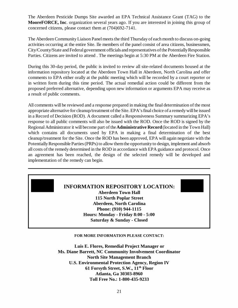
21
The Aberdeen Pesticide Dumps Site awarded an EPA Technical Assistance Grant (TAG) to theMooreFORCE, Inc. organization several years ago. If you are interested in joining this group ofconcerned citizens, please contact them at (704)692-7141.
The Aberdeen Community Liaison Panel meets the third Thursday of each month to discuss on-goingactivities occurring at the entire Site. Ile members of the panel consist of area citizens, businessmen,City/County/State and Federal government officials and representatives of the Potentially ResponsibleParties. Citizens are invited to attend . The meetings begin at 5:30 PM at the Aberdeen Fire Station.
During this 30-day period, the public is invited to review all site-related documents housed at theinformation repository located at the Aberdeen Town Hall in Aberdeen, North Carolina and offercomments to EPA either orally at the public meeting which will be recorded by a court reporter orin written form during this time period. The actual remedial action could be different from theproposed preferred alternative, depending upon new information or arguments EPA may receive asa result of public comments.
All comments will be reviewed and a response prepared in making the final determination of the mostappropriate alternative for cleanup/treatment of the Site. EPA’s final choice of a remedy will be issuedin a Record of Decision (ROD). A document called a Responsiveness Summary summarizing EPA’sresponse to all public comments will also be issued with the ROD. Once the ROD is signed by theRegional Administrator it will become part of the Administrative Record (located in the Town Hall)which contains all documents used by EPA in making a final determination of the bestcleanup/treatment for the Site. Once the ROD has been approved, EPA will again negotiate with thePotentially Responsible Parties (PRPs) to allow them the opportunity to design, implement and absorball costs of the remedy determined in the ROD in accordance with EPA guidance and protocol. Oncean agreement has been reached, the design of the selected remedy will be developed andimplementation of the remedy can begin.
INFORMATION REPOSITORY LOCATION:Aberdeen Town Hall
115 North Poplar StreetAberdeen, North Carolina
Phone: (910) 944-1115Hours: Monday - Friday 8:00 - 5:00
Saturday & Sunday - Closed
FOR MORE INFORMATION PLEASE CONTACT:
Luis E. Flores, Remedial Project Manager orMs. Diane Barrett, NC Community Involvement Coordinator
North Site Management BranchU.S. Environmental Protection Agency, Region IV
61 Forsyth Street, S.W., 11th FloorAtlanta, Ga 30303-8960
Toll Free No.: 1-800-435-9233
22
Mailing List
If you know of someone that would be interested in receiving a copy of this fact sheet andwould like to have their name placed on the Aberdeen Pesticide Dumps Site mailing list, askthem to complete this form and return to Diane Barrett at the EPA address previously given.If you have an address change or wish to have your name removed from this mailing list,please complete this form and return to Diane Barrett.
Thank you for your cooperation.
Name
Address
City, State, Zip Code
Addition Change Deletion
U.S. Environmental Protection Agency North Site Management Branch61 Forsyth Street, SW Diane Barrett, Community Rotations Coord.Atlanta, Georgia 30303-8960 Luis E. Flores, Remedial Project Manager
Official BusinessPenalty for Private Use $300
ATTACHMENT BPUBLIC MEETING SIGN-IN SHEET
ATTACHMENT CINFORMATION REPOSITORY
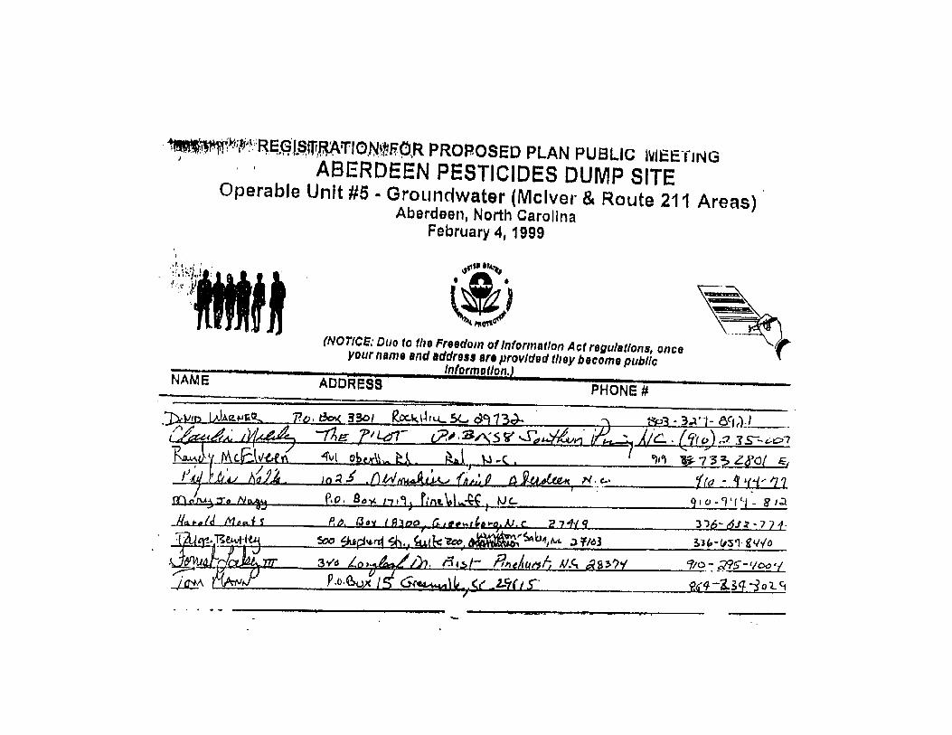
INFORMATION REPOSITORY LOCATION
ABERDEEN TOWN HALL115 North Poplar Street
Aberdeen, North Carolina
Telephone - (910) 944-1115
Hours: Monday - Friday 8:00 - 5:00Saturdays and Sundays- Closed
ATTACHMENT DPUBLIC MEETING OFFICIAL TRANSCRIPT
WORDSERVICES, INC.Post Office Box 751
Siler City, North Carolina 27344(800) 266-3248
PUBLIC MEETING
ON
PROPOSED PLAN
ABERDEEN PESTICIDES DUMP SITE
OPERABLE UNIT #5 - GROUNDWATER
MCIVER DUMP AND ROUTE 211 AREAS
FEBRUARY 4, 1999
ABERDEEN FIRE STATIONHIGHWAY 1 AND PEACH STREETABERDEEN, NORTH CAROLINA
TAKEN BY:WANDA B. LINDLEY, CVR-CM/NCCRNOTARY PUBLIC
WORDSERVICES, INC.Post Office Box 751
Siler City, North Carolina 27344(800) 266-3248
2
DIANE BARRETT: WE WELCOME EACH AND EVERY ONE1
OF YOU HERE TONIGHT. AND I JUST WANT TO RECOGNIZE ANY CITY2
OR STATE OF COUNTY OR CONGRESSIONAL OFFICIALS FIRST. RANDY,3
WILL YOU STAND?4
RANDY MCELVEEN: RANDY MCELVEEN FOR THE NORTH5
CAROLINA SUPERFUND, DEPARTMENT OF ENVIRONMENTAL AND NATURAL6
RESOURCES.7
DIANE BARRETT: THANK YOU. AND WE THANK EACH8
AND EVERY ONE OF YOU FOR TAKING TIME OUT OF YOUR BUSY9
SCHEDULES TO COME TO THIS MEETING TONIGHT. WE HAVE A LONG,10
LONG, LONG, LONG PRESENATION. I BELIEVE EVERYBODY THAT’S11
HERE HAS BEEN HERE BEFORE.12
SO LUIS FLORES IS THE PROJECT MANAGER FOR OP13
UNIT 5 WHICH DEALS WITH GROUNDWATER FOR ROUTE 211 AT THE14
MCIVER SITE.15
AND THE BILL OSTEEN -- DO YOU WANT TO STAND16
BILL, PLEASE? HE IS E.P.A.’S GROUNDWATER EXPERT. ANY17
QUESTIONS ABOUT GROUNDWATER YOU WANT ASK, YOU MIGHT ASK HIM.18
AND CHUCK MIKALIAN BACK THERE IN THE BACK, HE19
IS E.P.A.’S ATTORNEY FOR THE SITE. HE CAME ALONG JUST IN20
CASE WE HAD ANY LEGAL QUESTIONS. WELCOME HIM, TOO.21
THE PURPOSE OF TONIGHT’S MEETING IS FOR E.P.A.22
TO PRESENT THE PROPOSED PLAN OF ACTION FOR THE GROUNDWATER23
AT MCIVER AND ROUTE 211 AREAS. THESE TWO AREAS ARE CALLED24
OP UNIT 5. SINCE THERE ARE FIVE AREAS IN THE ABERDEEN25
WORDSERVICES, INC.Post Office Box 751
Siler City, North Carolina 27344(800) 266-3248
3
PESTICIDE DUMP SITE, WE HAVE BROKEN THEM DOWN INTO FIVE1
OPERABLE UNITS.2
OP UNITS 1, 2, AND 4 HANDLE SOIL. ALL THE3
SOIL HAS BEEN TREATED. THIS WAS THE SOURCE OF THE 4
CONTAMINATION, SO IT’S ALL BEEN TREATED AND IT’S CLEANED UP.5
AND THEN OP UNIT 3 DEALS WITH GROUNDWATER AT6
THE FAIRWAY TWIN AND -- WELL, OR A COUPLE OF SITES. AND 7
THEN OP UNIT 5, WHICH LUIS IS THE PROJECT MANAGER OVER,8
DEALS WITH MCIVER AND 211.9
THIS MEETING IS BEING RECORDED BY A COURT10
REPORTER WHICH IS REQUIRED BY LAW. SO WHENEVER YOU GET11
READY TO GIVE COMMENTS OR ASK QUESTIONS WHEN WE PUT IT UP12
FOR PUBLIC COMMENTS, PLEASE STATE YOUR NAME SO SHE CAN GET13
THAT FOR THE RECORD.14
AND THEN, OF COURSE, AS IN OTHER MEETINGS, A15
RECORDING WILL BE MADE -- A TRANSCRIPT WILL BE MADE OF THIS16
MEETING AND PLACED IN THE REPOSITORY FOR EVERYBODY TO17
REVIEW.18
I WAS GOING TO ASK A QUESTION, JUST AS A19
PERSONAL MATTER, BUT I’LL SKIP THAT ONE.20
AND YOU ARE ALL FAMILIAR, OF COURSE, WITH THE21
SUPERFUND PROCESS. I’LL JUST BRIEFLY GO OVER THIS. WE ARE22
NOW IN STEP 5, PUBLIC COMMENT. AS SOON AS THE PUBLIC23
COMMENT PERIOD IS OVER, WE WILL HAVE A RECORD OF DECISION.24
ALSO, I WANT TO INTERJECT HERE THAT IF ANYBODY25
WORDSERVICES, INC.Post Office Box 751
Siler City, North Carolina 27344(800) 266-3248
4
IN THE PUBLIC REQUESTS AN EXTENSION TO THE COMMENT PERIOD,1
WE WILL GRANT THAT. ONCE THE COMMENT PERIOD IS OVER AND THE2
RECORD OF DECISION HAS BEEN PREPARED, THEN WE WILL NOTIFY3
EVERYONE OF WHAT WAS SELECTED. AND THEN WE’LL GO INTO4
NEGOTIATIONS AGAIN WITH THE POTENTIAL RESPONSIBLE PARTIES TO5
DETERMINE HOW THE POTENTIALLY RESPONSIBLE PARTIES WILL BE6
PREPARED. AND THEN WE’LL GET TO WORK. SO HOPEFULLY THIS7
WILL BE ALL DONE MAYBE THE FIRST OF YEAR -- BY THE FIRST OF8
NEXT YEAR.9
LET’S SEE. MOOREFORCE IS THE COMMUNITY GROUP10
HERE THAT RECEIVED A TECHNICAL ASSISTANCE GRANT FROM E.P.A.,11
IF ANYBODY IS INTERESTED IN BEING A PART OF THAT GROUP AS12
REPRESENTED TONIGHT BY DAVID WARNER. HE IS THE TAG13
CONSULTANT FOR MOOREFORCE.14
ALSO, THE LEAGUE OF WOMEN VOTER’S IS VERY15
ACTIVE AND INTERESTED IN THE SITE. PHYLLIS KALK IS16
REPRESENTING THEM TONIGHT.17
AND THEN WE’VE GOT THE ABERDEEN COMMUNITY18
LIAISON PANEL WHICH MEETS MONTHLY -- ONCE A MONTH -- AND HAS19
BEEN MEETING, I BELIEVE, SINCE SEPTEMBER OF ‘95?20
UNIDENTIFIED SPEAKER: YES.21
DIANE BARRETT: OKAY. SO THERE’S BEEN A LOT22
OF INTEREST IN THE SITE AND A LOT OF PARTICIPATION, WHICH WE23
REALLY APPRECIATE.24
AND SO AT THIS TIME I WILL JUST TURN THIS OVER25
WORDSERVICES, INC.Post Office Box 751
Siler City, North Carolina 27344(800) 266-3248
5
TO LUIS.1
LUIS FLORES: THANKS, DIANE.2
WELL, AS DIANE MENTIONED, TONIGHT WE WILL BE3
JUST TALKING ABOUT E.P.A.’S PROPOSED PLAN TO ADDRESS4
GROUNDWATER CONTAMINATION AT THE MCIVER AND ROUTE 211 AREAS.5
LET ME FIRST SHOW YOU WHERE THE TWO AREAS ARE6
LOCATED. THE MCIVER AREA IS LOCATED -- IS LOCATED WEST OF7
THE TOWN OF ABERDEEN AT THE INTERSECTION OF ROSELAND ROAD8
WHICH IS THIS ROAD HERE (INDICATING) AND STATE ROUTE 11069
HERE (INDICATING) ABOUT HALF A MILE NORTH OF THAT.10
ON THE OTHER SIDE -- SIDE OF TOWN, THERE’S THE11
ROUTE 211 AREA. IT IS LOCATED EAST OF THE TOWN OF ABERDEEN,12
AND IT’S ABOUT A THOUSAND FEET SOUTH OF THE INTERSECTION OF13
THE ROUTE 211 AREA AND CAROLINA ROAD.14
THE TWO AREAS ARE NOT RELATED ONE TO THE OTHER15
ONE. THEY ARE LIKE SEPARATE. I’M GOING TO BE ADDRESSING16
BOTH AREAS SEPARATE. FIRST, I’M GOING TO GO OVER THE17
PRESENTATION FOR THE MCIVER AREA. AFTER THAT, WE WILL TAKE18
QUESTIONS ON MCIVER. AND WHEN WE’RE DONE WITH THOSE19
QUESTIONS, WE WILL GO TO THE PRESENTATION OF THE ROUTE 21120
AREA, AND THEN WE WILL TAKE QUESTIONS ON THE ROUTE 211 AREA.21
SO LET ME FIRST START WITH THE MCIVER AREA.22
AS I SAID, THE MCIVER AREA IS LOCATED IN THE -- AT THE23
INTERSECTION OF ROSELAND ROAD WHICH IS RIGHT HERE24
(INDICATING) AND STATE ROAD 1106 THAT CROSSES OVER HERE25
WORDSERVICES, INC.Post Office Box 751
Siler City, North Carolina 27344(800) 266-3248
6
(INDICATING). AND SO YOU CAN SEE, THE MCIVER AREA IS A1
SMALL AREA. HERE (INDICATING) WE HAVE THE FORMER SOURCE2
AREA WHERE THE CONTAMINATED SOIL WAS. ALL THAT HAS ALREADY3
BEEN REMOVED.4
YOU CAN SEE THIS ARROW OVER HERE (INDICATING).5
THIS SHOWS THE GROUNDWATER FLOW DIRECTION IS GOING NORTHEAST6
AND IS DISCHARGED IN PATTERSON BRANCH WHICH IS THIS DOTTED7
LINE HERE (INDICATING). BASICALLY, ALL GROUNDWATER IS8
DISCHARGED IN PATTERSON BRANCH, SO -- BECAUSE PATTERSON9
BRANCH IS SERVING AS A BOUNDARY FOR THE GROUNDWATER IN THIS10
AREA.11
AS YOU CAN SEE, THERE IS NO RESIDENCES IN THE12
AREA WHICH IS HERE (INDICATING). THE CLOSEST TWO HOMES ARE13
LOCATED NORTHWEST OF THE FORMER SOURCE AREA AND UPGRADIENT14
OF THE SOURCE -- FORMER SOURCE AREA. SO THEIR GROUNDWATER15
IS NOT IMPACTED.16
IF WE ZOOM INTO THE MCIVER AREA, WE CAN SEE17
THAT IT’S RELATIVELY A SMALL AREA. IT’S ABOUT SIX POINT18
FIVE ACRES. IT’S SEVEN HUNDRED FIFTY FEET LONG AND ABOUT19
THREE HUNDRED AND SEVENTY-FIVE FEET WIDE. HERE (INDICATING)20
IS WHERE THE FORMER SOURCE AREAS WERE. AND, AS I SAID, ALL21
THOSE -- THAT CONTAMINATED SOIL HAS BEEN REMOVED. THE22
GROUNDWATER FLOW DIRECTION AGAIN IS THIS WAY (INDICATING)23
TOWARDS PATTERSON BRANCH.24
WE SAMPLED PATTERSON BRANCH DURING THE25
WORDSERVICES, INC.Post Office Box 751
Siler City, North Carolina 27344(800) 266-3248
7
REMEDIAL INVESTIGATION, AND WE SAMPLED FOR SURFACE WATER AND1
SEDIMENTS. NONE OF THE SURFACE WATER SAMPLES THAT WERE2
COLLECTED EXCEEDED NORTH CAROLINA SURFACE WATER STANDARDS.3
SO, BASICALLY, THE IMPACT TO PATTERSON BRANCH IS MINIMAL.4
WE ALSO SAMPLED GROUNDWATER AROUND ON THIS5
AREA (INDICATING) USING MONITORING WELLS, AND WE FOUND OUT6
THAT NONE OF THE CONCENTRATIONS FROM MONITORING WELLS7
EXCEEDED ANY DRINKING WATER STANDARDS.8
LET ME SHOW YOU WHERE THE -- SOME OF THOSE -- 9
OR WHERE THE SAMPLING POINTS WERE. AS YOU CAN SEE, FOR A10
RELATIVELY SMALL AREA THERE ARE A LOT OF SAMPLING POINTS.11
THIRTY SAMPLES WERE COLLECTED FROM ABOUT THIRTY-TWO SAMPLING12
POINTS. SO AS YOU CAN SEE, FOR A SMALL AREA, THE AREA IS13
PRETTY WELL-DEFINED.14
SO, IN GENERAL, LOW LEVEL PESTICIDES WERE15
DETECTED IN THESE SAMPLES. AND, AS I SAID, NONE OF THEM16
EXCEEDED DRINKING WATER STANDARDS. SO BECAUSE THE DRINKING17
WATER STANDARDS WERE NOT EXCEEDED IN THIS SITE OR IN THIS18
AREA, IN THOSE CASES WE USED -- BECAUSE THE DRINKING WATER19
STANDARDS WERE NOT EXCEEDED, BASICALLY THE CLEAN-UP HERE ON20
THIS SITE IS GOING TO BE DRIVEN BY THOSE CONTAMINANTS THAT21
DO NOT HAVE A DRINKING WATER STANDARD.22
SO FOR CONTAMINANTS THAT HAVE A DRINKING WATER23
STANDARD, WE USED THAT DRINKING WATER STANDARD AS THE CLEAN-24
UP NUMBER. BUT FOR THOSE CONTAMINANTS THAT WE DO NOT HAVE A25
WORDSERVICES, INC.Post Office Box 751
Siler City, North Carolina 27344(800) 266-3248
8
DRINKING WATER STANDARD, WE CALCULATE MATHEMATICALLY A1
CLEAN-UP NUMBER, AND ALL THAT -- THOSE CALCULATIONS ARE2
BASED ON RISK ASSESSMENT.3
SO, BASICALLY, TAKING INTO CONSIDERATION THE4
FINDINGS OF THE INVESTIGATION WHICH IN SUMMARY ARE -- IN5
SUMMARY ARE THAT NOBODY IS USING THE GROUNDWATER IN THIS6
AREA, THAT -- THEIR LOW CONCENTRATION OF PESTICIDES, THAT7
NONE OF THE SAMPLES EXCEEDED DRINKING WATER STANDARDS, AND8
THAT PATTERSON BRANCH IS NOT IMPACTED.9
E.P.A. IS PROPOSING THE FOLLOWING PLAN TO10
ADDRESS THE GROUNDWATER. BASICALLY, WHAT WE’RE PROPOSING IS11
TO USE THE PHYTOREMEDIATION TO ENHANCE THE INTRINSIC12
REMEDIATION WHICH IS BASICALLY THE NATURAL PROCESS OF13
REMEDIATION THAT THE GROUNDWATER HAS. SO WE’RE -- WE’RE14
PROPOSING PLANTING TREES ALONG PATTERSON BRANCH TO HELP THE15
DEGRADATION OF THOSE CONTAMINANTS IN THE GROUNDWATER -- THE16
LOW LEVELS OF CONTAMINANTS.17
WE WILL ALSO PUT IN PLACE A MONITORING PROGRAM18
FOR GROUNDWATER TO MAKE SURE THAT THE CONCENTRATIONS ARE19
DECREASING. AND, ALSO, WE WILL SAMPLE SURFACE WATER AND20
SEDIMENT -- AND SEDIMENTS TO -- TO MAKE SURE THAT NOTHING21
HAS CHANGED AND THAT PATTERSON BRANCH HAS NOT BEEN IMPACTED.22
WE WILL ALSO DO AREA RECONNAISSANCE WHICH WILL23
CONSIST BASICALLY OF MAKING SURE THAT NOBODY WILL GO TO THE24
SITE AND START USING THE GROUNDWATER. IN THIS AREA, THERE’S25
9
WORDSERVICES, INC.Post Office Box 751
Siler City, North Carolina 27344(800) 266-3248
THE POTENTIAL FOR SOMEBODY TO GO OVER THERE AND PUT A WELL.1
IT’S VERY, VERY SLIM. BUT WE’RE STILL GOING TO HAVE THAT2
JUST AS A SECURE MEASURE. IF SOMEBODY GO OVER THERE AN PUT3
A WELL OR WANT A WELL THERE, WE WILL MAKE SURE THAT THEY4
WILL NOT USE THE GROUNDWATER USING EXPOSURE CONTROLS.5
SO, IN SUMMARY, WE WILL USE PHYTOREMEDIATION6
TO TAKE CARE OF THOSE LEVEL OF -- LOW LEVEL OF PESTICIDES7
AND TO HELP THE NATURAL ATTENUATION PROCESSES THAT ARE8
ALREADY OCCURRING ON THE SITE. WE WILL DO MONITORING TO9
MAKE SURE THAT WE KNOW WHERE THE CONCENTRATIONS ARE IN THE10
GROUNDWATER AND MONITORING THE SURFACE WATER AND SEDIMENTS11
TO MAKE SURE THAT WE KNOW -- WE’RE ASSURED THAT PATTERSON12
BRANCH IS NOT BEING IMPACTED.13
THE AREA RECONNAISSANCE ALSO TO MAKE SURE THAT14
NOBODY WILL GO OVER THERE AND USE THE GROUNDWATER UNTIL15
WE’RE DONE. AND IF SOMEBODY IS EXPOSED, WE WILL MAKE SURE16
THAT WE WILL CONTROL THAT EITHER BY PROVIDING A ALTERNATIVE17
WATER SUPPLY OR HEAD WELL TREATMENT.18
SO THAT’S BASICALLY THE PROPOSED PLAN FOR THE19
MCIVER AREA. I GUESS IF -- NOW IF THERE IS ANY QUESTIONS20
REGARDING THE MCIVER AREA AND THE PROPOSED ALTERNATIVE?21
DAVID SINCLAIR: I HAVE ONE.22
LUIS FLORES: YES?23
DAVID SINCLAIR: I’M DAVID SINCLAIR WITH THE24
FAYETTEVILLE OBSERVER-TIMES . I’M NOT QUITE CLEAR ON -- YOU25
10
WORDSERVICES, INC.Post Office Box 751
Siler City, North Carolina 27344(800) 266-3248
WERE TALKING ABOUT IF SOMEONE WERE TO MOVE INTO THAT AREA1
AND TRY TO DRILL A WELL, THAT YOU SAY YOU WOULD PREVENT THEM2
FROM DOING THAT OR STOP THEN FROM DOING THAT. I WAS A3
LITTLE FUZZY ON EXACTLY WHAT YOU WERE TALKING ABOUT IF4
SOMEBODY DOES MOVE IN THERE. WHAT WOULD HAPPEN?5
LUIS FLORES: WELL, THE AREA OF RECONNAISSANCE6
MAY JUST -- WE’RE JUST GOING TO MAKE SURE THAT NOBODY IS7
GOING TO USE THAT GROUNDWATER. I MEAN, THEY CAN MOVE THERE8
AND BUILD A HOUSE OR WHATEVER. THEY JUST SHOULD NOT DRINK9
THE GROUNDWATER STRAIGHT THE WAY IT COMES FROM THE GROUND.10
IF THEY INSIST ON PUTTING A PRIVATE WELL, WE WILL MAKE SURE11
THAT THEY WILL NOT DRINK THE WELL JUST STRAIGHT THE WAY IT12
COMES FROM THE GROUND.13
DAVID SINCLAIR: WOULD YOU PUT SOME KIND OF A14
TREATMENT DEVICE ON IT OR ---15
LUIS FLORES: YEAH, PROBABLY A WELL TREATMENT16
SYSTEM; MAYBE CARBON.17
DAVID WARNER: TONIGHT I’M SPEAKING ON BEHALF18
OF MOOREFORCE. HARRY HUBERT COULDN’T MAKE IT TO THE MEETING19
TONIGHT AND HE EXPRESSES HIS REGRETS. BUT I’M GOING TO20
ATTEMPT TO SPEAK FOR HARRY AND MOOREFORCE ON BEHALF OF THE21
COMMUNITY IN RESPONSE TO THE E.P.A. SELECTED ALTERNATIVE TWO22
FOR THE MCIVER SITE.23
FIRST OF ALL, I GUESS WE WANT TO JUST24
REINFORCE THAT WE DON’T TAKE EXCEPTION AT ALL TO THE25
11
WORDSERVICES, INC.Post Office Box 751
Siler City, North Carolina 27344(800) 266-3248
ALTERATIVE. WE THINK IT’S A REASONABLE ALTERNATIVE AT THIS1
POINT IN TIME. WE LIKE THAT THE REGULATORY STANDARD, I.E.2
THE CLEAN-UP STANDARD, IS GOING TO BE TO THE NORTH CAROLINA3
-- ONE TO THE -- TIMES TEN OR MINUS SIX IN TERMS OF RISK.4
AND -- AND WE SUPPORT THAT, AND -- AND WELL VIGILANTLY5
WATCH AND LOOK FOR RESULTS TO THAT STANDARD.6
AND THAT CONTINUED MONITORING, OF COURSE, OF7
THAT SITE IS CRITICAL; BECAUSE THINGS CAN HAPPEN IN THE8
FUTURE THAT WE DON’T SEE TODAY ON OTHER SITES. AND SO WE’RE9
VERY SUPPORTIVE OF A VERY STRUCTURED AND WELL-DESIGNED10
MONITORING PROGRAM AS WELL.11
IN THE SHEET THAT WAS CIRCULATED THAT -- I12
GUESS IT’S FROM COMMUNITY RELATIONS THAT HAD THE13
ALTERNATIVES OUTLINED -- SHOWING THAT ALTERNATIVE TWO WAS14
SELECTED FOR THE MCIVER AREA AND THE E.P.A. SELECTED15
ALTERATIVE, IT SAYS ALTERNATIVE TWO -- AND THE FIRST WORD,16
IT SAYS PHYTOREMEDIATION, CONTINUED GROUNDWATER/SURFACE17
WATER MONITORING, AREA RECONNAISSANCE, AND THE CONTINGENCY18
WELL HEAD TREATMENT IF WELLS ARE DRILLED.19
WE JUST TAKE EXCEPTION TO THAT AS20
PHYTOREMEDIATION IS NOT IN REALITY WHAT -- WHAT THE LEADING21
REMEDIATION TECHNIQUE IS HERE. BUT RATHER IT’S KIND OF --22
IT’S NOT A DO NOTHING ALTERNATIVE, BUT NATURAL ATTENUATION23
IS BEING COUNTED ON AS BEING THE PRIMARY MEANS OF24
REMEDIATION OF THE CONTAMINANTS ON THE SITE.25

12
WORDSERVICES, INC.Post Office Box 751
Siler City, North Carolina 27344(800) 266-3248
GRANTED, THAT THE CONTAMINANTS FOUND TODAY ARE1
BELOW REGULATORY LEVELS. BUT WE -- WE TOOK EXCEPTION TO THE2
WORD PHYTOREMEDIATION BEING THE LEADING. WE THINK THAT3
NATURAL ATTENUATION IS THE INTENDED TRIGGER OF THE4
CONTAMINANTS WITH PHYTOREMEDIATION BEING A POSSIBLE ENHANCER5
OF THAT PROCESS THROUGH WHATEVER MICRO -- MICROBIAL ACTIVITY6
THAT WILL HAPPEN IN THE TREES AND THAT TYPE OF THING.7
SO WED LIKE TO RECOMMEND THAT8
PHYTOREMEDIATION ISN’T A LEAD REMEDIAL STRATEGY. IT’S A9
SECONDARY POSSIBILITY OF ENHANCING THE PRIMARY STRATEGY10
WHICH IS NATURAL ATTENUATION OF THE CONTAMINANTS IN THE11
GROUNDWATER. SO WE JUST -- WE WANTED TO GO ON THE RECORD12
AND FORMALLY STATE THAT.13
AND THEN WE WANTED TO SEE THAT REFLECTED ALSO14
IN THE -- EVENTUALLY IN THE RECORD OF DECISION. REALLY IT’S15
NATURAL ATTENUATION; PHYTOS COME IN SECONDARY. AND WE JUST16
WANTED TO MAKE THAT CLEAR.17
AND THAT’S ABOUT ALL WE HAVE TO SAY FOR18
MCIVER.19
LUIS FLORES: YEAH, WHAT DAVID SAID,20
PHYTOREMEDIATION BASICALLY WILL BE USED TO ENHANCE THAT21
NATURAL ATTENUATION PROCESSES THAT ARE ALREADY OCCURRING AND22
WILL CONTINUE TO OCCUR NOW THAT THE SOURCE -- THE SOURCES23
HAVE BEEN REMOVED.24
ANY OTHER QUESTIONS BEFORE WE GO TO ROUTE 211?25
WORDSERVICES, INC.Post Office Box 751
Siler City, North Carolina 27344(800) 266-3248
13
(NO RESPONSE.)1
WELL, THE ROUTE 211 AREA IS A LARGER AREA IN2
COMPARED WITH MCIVER. HERE’S ROUTE 211 ROAD (INDICATING) OR3
HIGHWAY 211. THIS IS CAROLINA ROAD (INDICATING). AND THE4
ROUTE 211 AREA IS RIGHT HERE (INDICATING). HERE5
(INDICATING) IS WHERE THE FORMER SOURCE AREA WAS. ALL THAT6
SOIL -- CONTAMINATED SOIL HAS BEEN EXCAVATED AND REMOVED AND7
TREATED. SO IT’S NOT THERE ANYMORE.8
IN THE MCIVER -- I’M SORRY. IN THE ROUTE 2119
AREA WE COLLECTED SAMPLES FROM SEVENTY-NINE SAMPLING POINTS.10
WE USED MONITORING WELLS. WE USED TEMPORARY SAMPLING POINTS11
AND PRIVATE WELLS. THE RESULTS FROM THE -- FROM THAT SAMPLE12
TELLS US THAT THE HIGHEST CONCENTRATION OF PESTICIDES ARE13
LOCATED CLOSE TO THE FORMER SOURCE AREA, BASICALLY NORTH OF14
THE RAILROAD TRACKS. IT ALSO SHOWS THAT AS WE MOVE FURTHER15
DOWNGRADIENT OR FURTHER AWAY FROM THE FORMER SOURCE AREA,16
THE CONCENTRATIONS START DECREASING CONSIDERABLY.17
OF THE SEVENTY-NINE SAMPLING POINTS, DRINKING18
WATER STANDARDS WERE EXCEEDED ONLY IN TWO OF THEM; THESE TWO19
HERE (INDICATING). IN ALL THE OTHER SAMPLING POINTS, NONE20
OF THEN EXCEEDED DRINKING WATER STANDARDS.21
ALSO, WITH THE EXCEPTION OF THE SOURCE AREA22
WHERE THE HIGH CONCENTRATION OF PESTICIDES ARE AND THE TWO23
SAMPLE POINTS WHERE THE DRINKING WATER STANDARDS WERE24
EXCEEDED, ALL THE OTHER SAMPLES, ALL THE OTHER RESULTS FROM25
14
WORDSERVICES, INC.Post Office Box 751
Siler City, North Carolina 27344(800) 266-3248
THE ANALYSIS SHOW THAT THE CONCENTRATIONS ARE WITHIN E.P.A.1
ACCEPTABLE RISK RANGE OR E.P.A. ACCEPTABLE RANGE OF2
CONCENTRATIONS FOR CLEAN-UP.3
BUT BECAUSE THE STATE OF NORTH CAROLINA DOES4
NOT RECOGNIZE THE RANGE OF CONCENTRATIONS FOR CLEAN-UP, WE5
HAVE TO USE WHAT THE STATE OF NORTH CAROLINA RECOGNIZES6
WHICH IS THE MOST CONSERVATIVE NUMBER FOR CLEAN-UP OF THAT7
RANGE. SO, BASICALLY, WE WILL BE CLEANING TO THE MOST8
CONSERVATIVE NUMBER OF THAT RANGE, EVEN THOUGH THAT IN ALL9
THIS AREA, CONCENTRATIONS ARE WITHIN E.P.A. ACCEPTABLE RISK10
RANGE.11
SO LET’S GO BACK TO THIS AREA HERE THAT I SAID12
CLOSE TO THE FORMER SOURCE AREA WHERE THE HIGHEST13
CONCENTRATION OF PESTICIDES ARE. THAT IS THE AREA OR THE14
PART OF THE SITE THAT WE LAST YEAR INSTALLED THAT PUMP AND15
TREAT SYSTEM AS PART OF THE INTERIM -- INTERIM ACTION. WHAT16
THAT INTERIM ACTION IS DOING OR HAS BEEN DOING FOR THE LAST17
YEAR -- HERE’S THE RAILROAD TRACKS AGAIN (INDICATING). HERE18
(INDICATING) IS WHERE THE HIGH CONCENTRATION OF PESTICIDES19
ARE OR WHERE THE FORMER SOURCE WERE -- WHERE THE20
CONTAMINATED SOURCE WERE.21
WHAT THE INTERIM ACTION IS DOING IS BASICALLY22
CAPTURING ALL THOSE HIGH CONCENTRATIONS OF PESTICIDES THAT23
ARE ABOVE E.P.A. ACCEPTABLE RANGE. SO, AS I SAID, ALL THE24
CONCENTRATIONS DOWN HERE (INDICATING) ARE EITHER BELOW OR25
15
WORDSERVICES, INC.Post Office Box 751
Siler City, North Carolina 27344(800) 266-3248
WITHIN E.P.A. ACCEPTABLE RISK RANGE. CONCENTRATIONS UP HERE1
(INDICATING) ARE ABOVE E.P.A. ACCEPTABLE RISK RANGE. SO WE2
ARE TAKING CARE OF THOSE CONCENTRATIONS WITH THOSE -- WITH3
THAT GROUNDWATER CONCENTRATION ABOVE E.P.A. ACCEPTABLE RISK4
RANGE.5
USING THE -- THIS TREATMENT SYSTEM BASICALLY6
CONSISTS OF ONE EXTRACTION WELL. AND THAT EXTRACTION WELL7
HAS A CAPTURE ZONE THAT TAKES CARE OF THE AREA WHERE THE8
HIGHEST CONCENTRATIONS ARE IN THE GROUNDWATER. WE’RE TAKING9
THAT TO THE TREATMENT BUILDING WHICH IS HERE (INDICATING).10
WE’RE TREATING THAT WATER WITH CARBON. AND AFTER THE WATER11
IS TREATED, WE ARE DISCHARGING THAT WATER BACK INTO THE12
GROUND UPGRADIENT OF THE EXTRACTION WELL.13
SO THIS IS CLEAN WATER THAT IS GOING BACK IN14
THE AQUIFER AND IS BASICALLY HELPING MOVE THE -- THE15
GROUNDWATER WITH HIGH CONCENTRATIONS CLOSER TO THE16
EXTRACTION WELL SO THAT WE CAN EXTRACT IT FASTER.17
SO, IN SUMMARY, WE HAVE -- WE HAVE REALLY HIGH18
-- WE HAVE HIGH CONCENTRATIONS OF PESTICIDES IN THIS AREA19
(INDICATING) THAT ARE BEING ADDRESSED BY THE PUMP AND TREAT20
SYSTEM ALREADY INSTALLED. WE HAVE LOW CONCENTRATIONS OF21
PESTICIDES IN THAT AREA (INDICATING). THEY ARE WITHIN22
E.P.A. ACCEPTABLE RISK RANGE BUT ABOVE THE MOST CONSERVATIVE23
CLEAN-UP NUMBER THAT THE STATE TELLS -- TELLS US TO USE.24
AND WE HAVE TWO POINTS OVER HERE (INDICATING) WHERE DRINKING25
16
WORDSERVICES, INC.Post Office Box 751
Siler City, North Carolina 27344(800) 266-3248
WATER STANDARDS WERE EXCEEDED.1
SO WHAT WE’RE PROPOSING TO DO IN THE ROUTE 2112
AREA IS BASICALLY MAINTAIN THAT EXTRACTION SYSTEM THAT WAS3
PUT IN AS PART OF OUR INTERIM ACTION. WE’LL MAKE IT PART OF4
THIS FINAL ACTION. SO THAT WAY WE WILL BE TREATING THOSE5
HIGH CONCENTRATIONS OF PESTICIDES. WE WILL USE CARBON, AND6
WE WILL DISCHARGE BACK IN THE GROUND. AS I SAID, IT’S A7
SYSTEM THAT IS ALREADY IN PLACE.8
WE WILL DO MONITORING IN ALL THOSE AREAS9
DOWNGRADIENT WHERE THE CONCENTRATIONS ARE WITHIN E.P.A.10
ACCEPTABLE RISK RANGE, AND ALSO IN THOSE TWO MONITORING11
WELLS WHERE THE DRINKING WATER STANDARDS WERE EXCEEDED. WE12
WILL ALSO DO AREA RECONNAISSANCE IN THIS AREA, ALSO.13
AND IN THIS AREA -- THIS ROUTE 211 AREA, THIS14
PART BECOMES EVEN MORE IMPORTANT THAN IN THE MCIVER AREA.15
WE WILL MAKE SURE THAT NOBODY WILL USE THE GROUNDWATER IN16
THAT AREA. AND IF SOMEBODY INSISTS, THEN WE’LL MAKE SURE17
THAT WE WILL TREAT THAT WATER BEFORE THEY DRINK IT. OR18
ANOTHER OPTION IN THIS AREA IS TO HOOK UP ANY NEW19
CONSTRUCTION TO CITY WATER, BECAUSE THERE’S LINES -- CITY20
WATER LINES FOR THAT IN THIS AREA.21
SO, AGAIN, WE -- HIGH CONCENTRATIONS WILL BE22
TAKEN BY THE EXTRACTION SYSTEM AND TREATED. LOW23
CONCENTRATIONS WILL BE MONITORED TO MAKE SURE THAT WE KNOW24
WHERE ALL THE CONCENTRATIONS ARE AND REDUCED. SO,25
17
WORDSERVICES, INC.Post Office Box 751
Siler City, North Carolina 27344(800) 266-3248
BASICALLY, ON THIS PART OF THE AREA, WE WILL BE -- WE WILL1
LET NATURE TO TAKE CARE OF THE REMEDIATION AND WE WILL BE2
MONITORING TO MAKE SURE WE KNOW WHERE EVERYTHING IS.3
THE AREA RECONNAISSANCE: TO MAKE SURE NOBODY4
PUTS ANY WELLS IN THIS AREA AND DRINK THE WATER. AND IF WE5
FIND SOMEBODY THAT -- THAT DO, WE WILL PROVIDE ALTERNATE --6
ALTERNATIVE WATER SUPPLY.7
SO THAT’S BASICALLY THE PROPOSED ALTERNATIVE8
FOR THE ROUTE 211 AREA. ARE THERE ANY QUESTIONS REGARDING9
THIS AREA? YES?10
PHYLLIS KALK: DID YOU HAVE TO -- ARE THERE11
ANY PEOPLE LIVING CLOSE ENOUGH AROUND THERE THAT YOU HAVE TO12
-- THAT THEY HAVE TO PUT ON ABERDEEN WATER, YOU KNOW,13
INSTEAD OF THEIR PRIVATE WELLS? OR IS THERE ANYBODY WHO14
LIVED CLOSE ENOUGH TO THAT AREA TO HAVE TO DO THAT?15
LUIS FLORES: THERE -- THERE’S PEOPLE LIVING16
DOWN -- DOWN HERE (INDICATING) WHERE THE LOW CONCENTRATION17
OF PESTICIDES WERE DETECTED.18
PHYLLIS KALK: UH-HUH (YES).19
LUIS FLORES: THEIR PRIVATE WELLS WERE20
SAMPLED. SOME OF THEM WERE BELOW THE CLEAN-UP NUMBERS THAT21
WE’RE GOING TO USE. OTHERS WERE SLIGHTLY ABOVE BUT STILL22
WITHIN E.P.A. ACCEPTABLE RISK RANGE. BUT THE COMPANIES WENT23
AHEAD AND CONNECT ALL OF THEM BUT ONE TO CITY WATER. THAT24
-- THAT HOUSEHOLD THAT IS NOT CONNECTED TO CITY WATER,25
18
WORDSERVICES, INC.Post Office Box 751
Siler City, North Carolina 27344(800) 266-3248
TREATMENT -- HEAD TREATMENT SYSTEM WAS INSTALLED IN HIS1
WELL. THEY DID NOT WANT TO TAKE CITY WATER.2
DAVID SINCLAIR: DO YOU KNOW HOW MANY PEOPLE3
WERE HOOKED UP?4
LUIS FLORES: I THINK IT WAS LIKE SIX.5
DAVID WARNER: WE HAD SOME MEETINGS, IT WAS A6
YEAR AGO SEPTEMBER. SO WE TALKED ABOUT THE INTERIM ACTION7
AND PUTTING THE EXTRACTION WELL IN AND GOING AHEAD AND DOING8
THE CARBON ABSORPTION AND INFILTRATION GALLERY. AND I GUESS9
THAT WAS INSTALLED IN JANUARY OR SO OF ‘98. WE HADN’T HEARD10
ANYTHING. I JUST WONDERED WHAT THE DELAY WAS, BECAUSE UNTIL11
NOW WE’RE STARTING TO TALK ABOUT A PROPOSED REMEDIAL ACTION.12
WHAT WAS THE DELAY?13
LUIS FLORES: WELL, WE BASICALLY HAD THE14
REMEDIAL INVESTIGATION FINISHED WHEN WE GOT TOGETHER WITH15
THE COMPANIES AND DECIDED TO DO THE INTERIM ACTION. THE16
FEASIBILITY STUDY THAT WE HAD WAS NOT FINISHED YET. WE WERE17
STILL GOING BACK AND FORWARD WITH THE COMPANIES DOING18
GROUNDWATER MODELING AND DEVELOPING DIFFERENT ALTERNATIVES.19
AND THAT, BASICALLY, WAS WHAT TOOK MOST OF THE TIME.20
BUT RECOGNIZING AT THAT TIME THAT WE WERE --21
THAT IT WAS GOING TO TAKE US LONGER TO FINALIZE THAT22
FEASIBILITY STUDY REPORT, THAT WAS PROBABLY ONE OF THE23
BIGGEST REASONS TO GO AHEAD AND DO THE INTERIM ACTION;24
BECAUSE WE KNEW THAT THE REMEDIAL INVESTIGATION WAS25
WORDSERVICES, INC.Post Office Box 751
Siler City, North Carolina 27344(800) 266-3248
19
FINISHED, WE KNEW WHERE THE CONCENTRATIONS WERE, AND WE KNEW1
THAT THE HIGHEST CONCENTRATIONS WERE IN THIS AREA AND THAT2
WE COULD DO SOMETHING REAL PAST AND TAKE CARE OF THAT.3
RANDY MCELVEEN: E.P.A. -- RANDY MCELVEEN,4
NORTH CAROLINA SUPERFUND. E.P.A. ALSO DID SOME INTERNAL5
STUDY OF THAT TO MAKE SURE THIS WAS A SITE THAT WAS6
APPROPRIATE FOR THE REMEDIATION THAT WAS BEING PROPOSED. IS7
THAT NOT CORRECT?8
LUIS FLORES: I’M NOT SURE WHAT YOU --9
RANDY MCELVEEN: WAS IT MODELING MAINLY?10
LUIS FLORES: YEAH, MODELING -- EXTENSIVE11
GROUNDWATER MODELING WAS CONDUCTED, TOO.12
RANDY MCELVEEN: I WAS THINKING THAT THERE WAS13
ALSO SOME DISCUSSION WITHIN THE MANAGEMENT ABOUT THE -- TO14
ASSURE THAT THIS -- THAT THEY DIDN’T NEED SOME OTHER MORE15
AGGRESSIVE GROUNDWATER CLEAN-UP PROGRAM.16
LUIS FLORES: RIGHT. THERE WAS A LOT OF17
DISCUSSION --18
RANDY MCELVEEN: (INTERPOSING) WITHIN E.P.A.19
AND WITH THE STATE?20
LUIS FLORES: WITH THE E.P.A. ABOUT21
GROUNDWATER MODELING. WE WANTED TO MAKE SURE THAT BASICALLY22
THIS WAS THE BEST THING THAT WE CAN DO TO ADDRESS THIS --23
THESE AREAS. DAVID?24
DAVID WARNER: I’VE GOT MY STATEMENT NOW.25
WORDSERVICES, INC.Post Office Box 751
Siler City, North Carolina 27344(800) 266-3248
20
I’VE ASKED MY QUESTION, SO I’LL MAKE MY STATEMENT NOW, IF1
THAT’S ALL RIGHT.2
AGAIN, THIS IS ON BEHALF OF MOOREFORCE3
REGARDING THE ROUTE 211 SITE.4
COURT REPORTER: SIR, WOULD YOU LIKE TO STATE5
YOUR NAME SO IT WILL BE ON THE RECORD?6
DAVID WARNER: OH, I’M SORRY. DAVID WARNER --7
COURT REPORTER: THANK YOU.8
DAVID WARNER: -- CONSULTANT WITH MOOREFORCE9
UNDER THE TAG GRANT.10
(TO COURT REPORTER) AND I’VE GOT THIS ALL IN11
WRITING, BY THE WAY. I’LL SUBMIT IT TO YOU.12
THIS IS REALLY KIND OF A TWO-PART PROJECT,13
AND THE SOURCE AREA IS ONE AREA AND -- AND THE INTERIM14
ACTION WAS ALLOWED TO GO AHEAD -- TO GO AHEAD AND HIT THE15
HIGH CONCENTRATIONS OF GROUNDWATER CONTAMINANTS.16
BELOW THE RAILROAD ON THAT DEPICTION WHERE17
THOSE OTHER WELLS ARE, WHERE IT SAYS “LOW CONCENTRATION OF18
PESTICIDES,” REMEMBER THERE WERE TWO -- TWO SPOTS IN THERE19
WHERE THERE WERE SIGNIFICANT CONCENTRATIONS OF PESTICIDES.20
AND FOR THOSE OF YOU WHO GOT THE INFORMATION21
SHEET ABOUT THE AQUIFER, IT’S A LAYERED AQUIFER AND IT’S22
FAIRLY COMPLEX WITH FOUR DIFFERENT WATER UNITS SEPARATED BY23
CONFINED CLAY LAYERS.24
IT’S A COMPLEX HYDROGEOLOGY ON THE SITE. AND25
WORDSERVICES, INC.Post Office Box 751
Siler City, North Carolina 27344(800) 266-3248
21
WHAT WE’VE LEARNED IS THAT THE CONTAMINANTS ARE DIFFUSE DOWN1
THROUGH A PLUME DOWNGRADIENT FROM THE SOURCE AREA, AND THAT2
THE STRATEGY IN THE SOURCE AREA WAS TO PUMP AND TREAT. THE3
STRATEGY BELOW THE GROUND LEVEL IS NATURAL ATTENUATION -- 4
I.E. WE’RE GOING TO LET IT GO AND WE’RE GOING TO MONITOR IT.5
AND WE JUST WANT TO -- WE THINK THAT SHOULD BE6
ACKNOWLEDGED AS WELL THAT NATURAL ATTENUATION AGAIN IS A7
PART OF THE STRATEGY. LET IT GO NATURALLY AS PART OF THE8
DEAL, WITH THE CONTINGENCIES IN PLACE FOR WELL HEAD9
TREATMENT OR HOOKING UP TO CITY WATER, OR WHATEVER ELSE IS10
NEEDED.11
SO, AGAIN, NATURAL ATTENUATION OUGHT TO BE12
MENTIONED AS PART OF YOUR STRATEGY FOR THE WHOLE OTHER PART13
OF THE 211 SITE. AGAIN, WE WANT TO STICK TO THE NORTH14
CAROLINA GROUNDWATER STANDARDS OF ONE TIMES TEN MINUS SIX OF15
RISK.16
ONE OF THE CRITICAL AREAS, BECAUSE WE HAVE17
SUCH COMPLEX HYDROGEOLOGY BELOW THE RAILROAD THERE, AND WE18
HAVE SUCH A WIDELY DIVERSE DISPERSED PLUME OF CONTAMINANTS19
OVER A FAIRLY BROAD AREA, AREA RECONNAISSANCE AS YOU20
SUGGESTED IS VERY CRITICAL.21
AND IN OUR EARLIER DISCUSSIONS, WE WERE TOLD22
THAT ONE OF THE REGULAR WAYS THIS HAPPENS IS THAT THE FOLKS23
THAT ARE GOING OUT AND DOING THE SAMPLING OF THE WELLS WILL24
DO VISUAL OBSERVATIONS OF ANY LAND DISTURBANCES OR25
WORDSERVICES, INC.Post Office Box 751
Siler City, North Carolina 27344(800) 266-3248
22
DEVELOPMENT THAT ARE GOING ON.1
WE -- WE THINK THAT THAT’S GOOD, BUT IT NEEDS2
TO BE A LOT MORE; THAT BECAUSE IT’S SUCH A BROAD AREA, WE3
THINK THAT THE AREA RECONNAISSANCE IN THIS CASE NEEDS TO BE4
IMPLEMENTED VIGILANTLY TO PREVENT THE INSTALLATION OF NEW5
DRINKING WATER WELLS.6
THERE’S A GROWING INTEREST IN LAND DEVELOPMENT7
ALONG THAT AREA. AND I HAD A CHANCE TO GO WALK THE SITES8
AND DRIVE AROUND THIS AFTERNOON A BIT AND GET A FEEL FOR9
THAT. AND IN THAT INTERIM PERIOD, THE -- THE TIME BETWEEN10
THE SAMPLING EVENTS -- THERE’S SOME EXTENDED PERIODS OF TIME11
BETWEEN SAMPLING EVENTS, THINGS HAPPEN. AND HAVING THE12
FOLKS DOING THE GROUNDWATER SAMPLES LOOKING AROUND IS NOT13
GOING TO BE ENOUGH TO EFFECTIVELY RECONNAISSANCE THIS AREA14
FOR NEW DEVELOPMENT.15
WE’RE SUGGESTING THAT YOU BEEF THAT UP. AND16
YOU MENTIONED AERIAL RECONNAISSANCE WHICH YOU BROUGHT UP THE17
OTHER DAY. WE THINK THAT’S A GOOD WAY TO DO IT, EITHER18
THROUGH AERIAL PHOTOGRAPHY OR OTHER TYPES OF AERIAL19
RECONNAISSANCE, BECAUSE IT’S SUCH A BROAD AREA.20
AND ANOTHER GOOD WAY TO TAKE A LOOK AT THIS IS21
HAVING SOMEONE PERIODICALLY REVIEW THE BUILDING PERMITS FOR22
NEW DEVELOPMENT IN THAT WHOLE DOWNGRADIENT AREA. AND THERE23
MAY BE SOME OTHER MEANS, IF SOME OTHER THOUGHT IS PUT TO24
THAT.25
WORDSERVICES, INC.Post Office Box 751
Siler City, North Carolina 27344(800) 266-3248
23
BUT THE AREA RECONNAISSANCE CAN’T BE A CASUAL1
THING FOR THIS -- FOR THIS SITE, AGAIN, BECAUSE OF THE2
WIDESPREAD DISPERSION OF THE CONTAMINANTS.3
AND THEN ON THE OTHER END, THE CONTINGENCY4
CONTROLS FOR WELL HEAD TREATMENT OR ALTERNATIVE WATER5
SUPPLY. WE WOULD LIKE TO SEE, YOU KNOW, THAT -- THAT WHOLE6
CONTINGENCY MECHANISM DESIGNED TO IMMEDIATELY RESPOND WHEN7
WE START SEEING ELEVATED LEVELS OF CONTAMINANTS OR DETECTS8
WHERE WE HAVE NOT DETECTS BEFORE; AGAIN, BEING THE9
CONSERVATIVE RESPONSE AS IT HAS BEEN PRETTY MUCH THE CASE IN10
THE PAST.11
AND, AGAIN, WE HAVE A LITTLE BIT OF CONCERN12
ABOUT WHERE THE CONTAMINANTS ARE, BECAUSE IT’S SUCH A BROAD13
AREA AND THE AQUIFERS ARE STACKED ON EACH OTHER. AND WE’VE14
ONLY GOT A LIMITED NUMBER. ALTHOUGH WE HAVE LOTS OF DATA15
POINTS, WE STILL ONLY HAVE A LIMITED NUMBER OF DATA POINTS16
GIVEN THE THREE DIMENSIONS OF THE GROUNDWATER IN THIS AREA.17
AND, AGAIN, CAREFUL IMPLEMENTATION OF THE18
GROUNDWATER MONITORING SCHEME FOR THE LONG RUN IS CRITICAL;19
MAKING SURE THAT ALL WELLS REGISTERED BETTER THAN CLEAN-UP20
LEVELS AT THE END OF THIS WHOLE THING. SO WE WANT TO21
REINFORCE THAT. THAT’S REAL IMPORTANT IN SUCH A BROAD AREA22
OF DISBURSEMENT.23
I APPRECIATE IT. I’LL LEAVE A COPY OF WHAT I24
SAID FOR THE REPORTER.25
WORDSERVICES, INC.Post Office Box 751
Siler City, North Carolina 27344(800) 266-3248
24
LUIS FLORES: YEAH, WE DEFINITELY RECOGNIZE1
THE IMPORTANCE OF -- OF THE AREA RECONNAISSANCE AND THE2
MONITORING IN THE AREA DOWNGRADIENT. WE ARE -- WE KNOW WE3
HAVE TO PUT A LOT OF EFFORT IN COMING UP WITH -- WITH A GOOD4
SYSTEM TO PERFORM THOSE TWO THINGS. AND ALL THAT WILL BE5
DECIDED IN THE FUTURE AND WILL BE INCLUDED IN THE REMEDIAL6
DESIGN FOR THE -- FOR THE SITE. BUT WE ARE -- I’M SORRY?7
CLAUDIA MADLEY: CAN YOU BE MORE EXACT ABOUT8
HOW BROAD AN AREA THIS IS, BOTH ABOVE THE RAILROAD TRACKS9
AND BELOW THE RAILROAD TRACKS, IN TERMS OF ACREAGE OR SQUARE10
MILES?11
LUIS FLORES: I BELIEVE THAT FROM THE SOURCE12
AREA TO -- TO THE FURTHER -- TO THE -- TO THE AREA WHERE WE13
HAD NO DETECTS FOR THE DOWNGRADIENT, I THINK IT’S ABOUT A14
MILE. IT’S ABOUT A MILE, YEAH, LIKE FROM NORTH TO SOUTH15
THIS WAY (INDICATING).16
RANDY MCELVEEN: RANDY MCELVEEN FOR THE NORTH17
CAROLINA SUPERFUND. I THINK I CAN DID A LITTLE QUICK18
CALCULATION ON THAT. IT’S SOMEWHERE AROUND TWO HUNDRED AND19
FIFTY ACRES.20
LUIS FLORES: THANK YOU, RANDY.21
PHYLLIS KALK: THE WHOLE AREA?22
RANDY MCELVEEN: IT’S THE WHOLE AREA.23
BILL OSTEEN: I DISAGREE. I GOT TWO FORTY-24
NINE.25
WORDSERVICES, INC.Post Office Box 751
Siler City, North Carolina 27344(800) 266-3248
25
RANDY MCELVEEN: TWO FORTY-NINE, OKAY.1
LUIS FLORES: I HAVE LESS THAN ONE ACRE AT MY2
HOUSE. THAT’S ALL.3
FORREST LOCKEY: FORREST LOCKEY. I’M THE4
LANDOWNER ON 211. I’M JUST WONDERING WHAT LIMITATIONS THERE5
WILL BE ON DEVELOPING THE AREA. I HAVE ABOUT SIXTY ACRES OF6
LAND AROUND 211, THE SITE SITS ON. AND I’M JUST WONDERING7
WHAT LIMITATIONS THAT WOULD MEAN FOR ME AS A LAND DEVELOPER8
WHEN I AM BUILDING A SMALL INDUSTRIAL PARK THERE; TO BE ABLE9
TO DRILL WELLS, FORCE THE IRRIGATION IN THAT AREA?10
LUIS FLORES: ARE YOU TALKING ABOUT LIKE RIGHT11
ON TOP OF HERE OR IS IT FURTHER UPGRADIENT OR --12
FORREST LOCKEY: IT WILL BE AROUND THERE. I’M13
SURE IT WILL PROBABLY BE SEVERAL YEARS DOWN THE ROAD BEFORE14
ANYTHING IS DEVELOPED CLOSE TO THAT. BUT JUST WONDERING,15
ONCE I DO START BUILDING BUILDINGS CLOSE BY, WILL THERE BE A16
PROBLEM FOR, SAY, DRILLING A WELL FOR THE USE OF IRRIGATION?17
BECAUSE MOST OF THE BUILDINGS I WILL HAVE ON CITY WATER, BUT18
I WILL POSSIBLY WANT TO DRILL WELLS FOR IRRIGATION PURPOSES.19
I’M WONDERING IF THERE WOULD BE ANY LIMITATIONS TO THAT?20
LUIS FLORES: I REALLY DO NOT HAVE AN ANSWER21
FOR YOU RIGHT NOW REGARDING THAT. I CAN ONLY MAKE AN22
ASSUMPTION. I THINK IT WILL DEPEND A LOT ON WHERE -- WHERE23
ARE YOU TALKING ABOUT PUTTING A WELL? YOU SAID IT’S GOING24
TO BE USED FOR DRINKING WATER PURPOSES?25
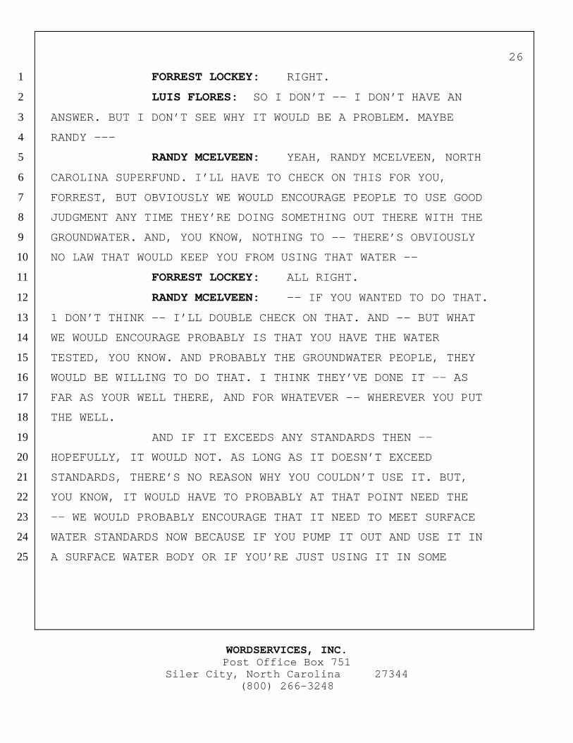
WORDSERVICES, INC.Post Office Box 751
Siler City, North Carolina 27344(800) 266-3248
26
FORREST LOCKEY: RIGHT.1
LUIS FLORES: SO I DON’T -- I DON’T HAVE AN2
ANSWER. BUT I DON’T SEE WHY IT WOULD BE A PROBLEM. MAYBE3
RANDY ---4
RANDY MCELVEEN: YEAH, RANDY MCELVEEN, NORTH5
CAROLINA SUPERFUND. I’LL HAVE TO CHECK ON THIS FOR YOU,6
FORREST, BUT OBVIOUSLY WE WOULD ENCOURAGE PEOPLE TO USE GOOD7
JUDGMENT ANY TIME THEY’RE DOING SOMETHING OUT THERE WITH THE8
GROUNDWATER. AND, YOU KNOW, NOTHING TO -- THERE’S OBVIOUSLY9
NO LAW THAT WOULD KEEP YOU FROM USING THAT WATER -- 10
FORREST LOCKEY: ALL RIGHT.11
RANDY MCELVEEN: -- IF YOU WANTED TO DO THAT.12
1 DON’T THINK -- I’LL DOUBLE CHECK ON THAT. AND -- BUT WHAT13
WE WOULD ENCOURAGE PROBABLY IS THAT YOU HAVE THE WATER14
TESTED, YOU KNOW. AND PROBABLY THE GROUNDWATER PEOPLE, THEY15
WOULD BE WILLING TO DO THAT. I THINK THEY’VE DONE IT -- AS16
FAR AS YOUR WELL THERE, AND FOR WHATEVER -- WHEREVER YOU PUT17
THE WELL.18
AND IF IT EXCEEDS ANY STANDARDS THEN --19
HOPEFULLY, IT WOULD NOT. AS LONG AS IT DOESN’T EXCEED20
STANDARDS, THERE’S NO REASON WHY YOU COULDN’T USE IT. BUT,21
YOU KNOW, IT WOULD HAVE TO PROBABLY AT THAT POINT NEED THE22
-- WE WOULD PROBABLY ENCOURAGE THAT IT NEED TO MEET SURFACE23
WATER STANDARDS NOW BECAUSE IF YOU PUMP IT OUT AND USE IT IN24
A SURFACE WATER BODY OR IF YOU’RE JUST USING IT IN SOME25
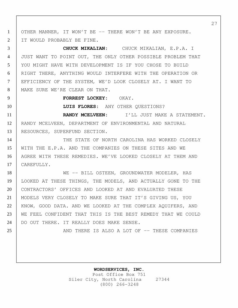
WORDSERVICES, INC.Post Office Box 751
Siler City, North Carolina 27344(800) 266-3248
27
OTHER MANNER, IT WON’T BE -- THERE WON’T BE ANY EXPOSURE.1
IT WOULD PROBABLY BE FINE.2
CHUCK MIKALIAN: CHUCK MIKALIAN, E.P.A. I3
JUST WANT TO POINT OUT, THE ONLY OTHER POSSIBLE PROBLEM THAT4
YOU MIGHT HAVE WITH DEVELOPMENT IS IF YOU CHOSE TO BUILD5
RIGHT THERE, ANYTHING WOULD INTERFERE WITH THE OPERATION OR6
EFFICIENCY OF THE SYSTEM, WE’D LOOK CLOSELY AT. I WANT TO7
MAKE SURE WE’RE CLEAR ON THAT.8
FORREST LOCKEY: OKAY.9
LUIS FLORES: ANY OTHER QUESTIONS?10
RANDY MCELVEEN: I’LL JUST MAKE A STATEMENT.11
RANDY MCELVEEN, DEPARTMENT OF ENVIRONMENTAL AND NATURAL12
RESOURCES, SUPERFUND SECTION.13
THE STATE OF NORTH CAROLINA HAS WORKED CLOSELY14
WITH THE E.P.A. AND THE COMPANIES ON THESE SITES AND WE15
AGREE WITH THESE REMEDIES. WE’VE LOOKED CLOSELY AT THEM AND16
CAREFULLY.17
WE -- BILL OSTEEN, GROUNDWATER MODELER, HAS18
LOOKED AT THESE THINGS, THE MODELS, AND ACTUALLY GONE TO THE19
CONTRACTORS’ OFFICES AND LOOKED AT AND EVALUATED THESE20
MODELS VERY CLOSELY TO MAKE SURE THAT IT’S GIVING US, YOU21
KNOW, GOOD DATA. AND WE LOOKED AT THE COMPLEX AQUIFERS, AND22
WE FEEL CONFIDENT THAT THIS IS THE BEST REMEDY THAT WE COULD23
DO OUT THERE. IT REALLY DOES MAKE SENSE.24
AND THERE IS ALSO A LOT OF -- THESE COMPANIES25
WORDSERVICES, INC.Post Office Box 751
Siler City, North Carolina 27344(800) 266-3248
28
HAVE DONE A LOT OF PUBLIC CONTACT THAT HAVE BEEN VERY GOOD1
FOR THIS PROGRAM. PEOPLE ARE VERY WELL AWARE OF THE2
SITUATION OUT THERE AND THERE IS NO ONE, AS LUIS HAS SAID,3
THAT’S DRINKING THE WATER AT THIS TIME, AND WE’RE GOING TO4
DO OUR BEST TO MAKE SURE NOBODY DOES DRINK IT.5
AND THERE -- EVERYONE OUT THERE THAT HAS A6
WELL, EVERY RESIDENT OUT THERE HAS BEEN CONTACTED AND THEIR7
WELLS HAVE BEEN TESTED AND THEY’VE BEEN -- BEEN GIVEN A8
LETTER THAT TELLS THEM EXACTLY ANY CONCENTRATIONS IF THERE9
ARE CONTAMINANTS FROM THE SITE THAT ARE IN THEIR WELL.10
SO THAT’S THE STATE’S POSITION. AND I’LL BE11
GLAD TO ASK SOME -- ANSWER ANY QUESTIONS THAT YOU HAVE FOR12
US.13
(NO RESPONSE.)14
LUIS FLORES: WELL, IF THERE IS NO MORE15
QUESTIONS, THANKS A LOT FOR COMING. WE’LL KEEP YOU POSTED.16
17
18
19
20
21
22
23
24
02/17/99:SRG 25
WORDSERVICES, INC.Post Office Box 751
Silver City, North Caroline 27344(800) 266-3248
29
C E R T I F I C A T E
STATE OF NORTH CAROLINA
COUNTY OF CHATHAM
I, WANDA B. LINDLEY, CVR-CM, A NOTARY PUBLIC FOR THE STATE OFNORTH CAROLINA, DO HEREBY CERTIFY THAT THE FOREGOING PUBLICMEETING WAS TAKEN AND REDUCED TO TYPEWRITING UNDER MY DIRECTSUPERVISION; THAT THE FOREGOING 28 PAGES CONSTITUTE A TRUE ANDACCURATE RECORD OF THE PROCEEDINGS TO THE BEST OF MY KNOWLEDGE ANDBELIEF.
IN WITNESS WHEREOF, I HAVE HEREUNTO SET MY HAND AND OFFICIALSEAL ON THIS, THE 9TH DAY OF MARCH, 1999.
APPENDIX BSTATE CONCURRENCE