42
EPA/ROD/R2006040001412 2006 EPA Superfund Record of Decision: PARRIS ISLAND MARINE CORPS RECRUIT DEPOT EPA ID: SC6170022762 OU 02 PARRIS ISLAND, SC 09/12/2006
EPA/ROD/R20060400014122006
EPA Superfund
Record of Decision:
PARRIS ISLAND MARINE CORPS RECRUIT DEPOT EPA ID: SC6170022762 OU 02PARRIS ISLAND, SC09/12/2006
Comprehensive Long-term Environmental Action Navy
CONTRACT NUMBER N62467-94-D-0888
Rev. 2 06/06
Record of Decision for
SiteISWMU 2 - Borrow Pit Landfill and SiteISWMU 15 - Dirt Roads
Marine Corps Recruit Depot Parris Island, South Carolina
U.S. EPA Identification Number SC6170022762
Contract Task Order 0020
June 2006
Southern Division Navai Facilities Engineering Command
2 155 Eagle Drive Nards Charleston, South Car-oltrla 29406
----. TETRA TECH NUS, h e
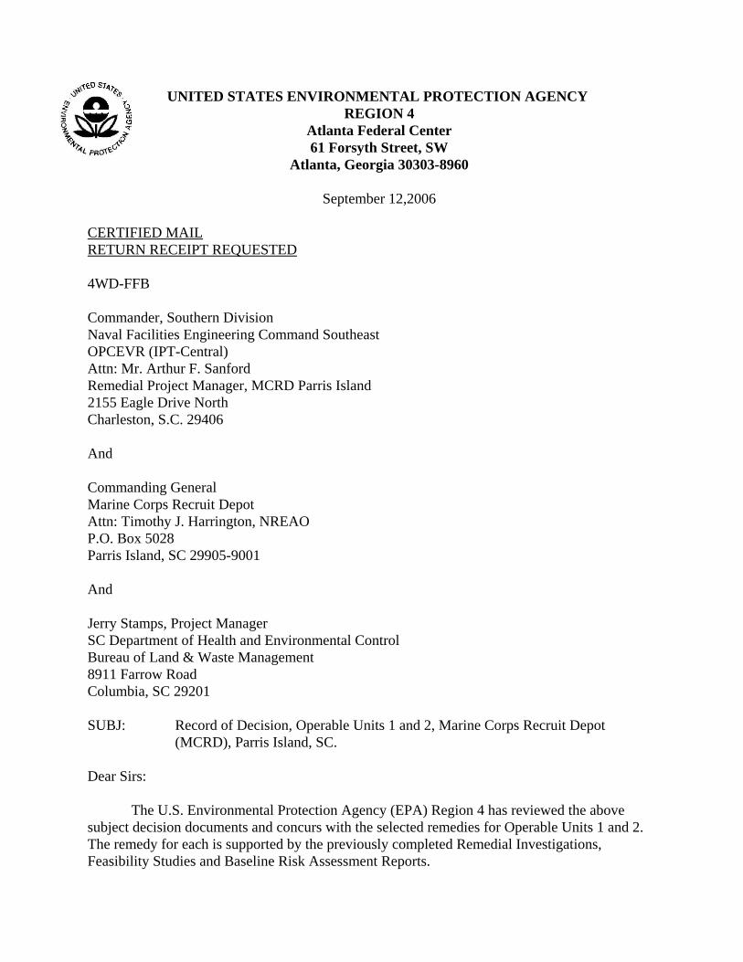
UNITED STATES ENVIRONMENTAL PROTECTION AGENCY REGION 4
Atlanta Federal Center 61 Forsyth Street, SW
Atlanta, Georgia 30303-8960
September 12,2006
CERTIFIED MAILRETURN RECEIPT REQUESTED
4WD-FFB
Commander, Southern Division Naval Facilities Engineering Command Southeast OPCEVR (IPT-Central) Attn: Mr. Arthur F. Sanford Remedial Project Manager, MCRD Parris Island 2155 Eagle Drive North Charleston, S.C. 29406
And
Commanding General Marine Corps Recruit Depot Attn: Timothy J. Harrington, NREAO P.O. Box 5028 Parris Island, SC 29905-9001
And
Jerry Stamps, Project Manager SC Department of Health and Environmental Control Bureau of Land & Waste Management 8911 Farrow Road Columbia, SC 29201
SUBJ: Record of Decision, Operable Units 1 and 2, Marine Corps Recruit Depot(MCRD), Parris Island, SC.
Dear Sirs:
The U.S. Environmental Protection Agency (EPA) Region 4 has reviewed the abovesubject decision documents and concurs with the selected remedies for Operable Units 1 and 2.The remedy for each is supported by the previously completed Remedial Investigations,Feasibility Studies and Baseline Risk Assessment Reports.
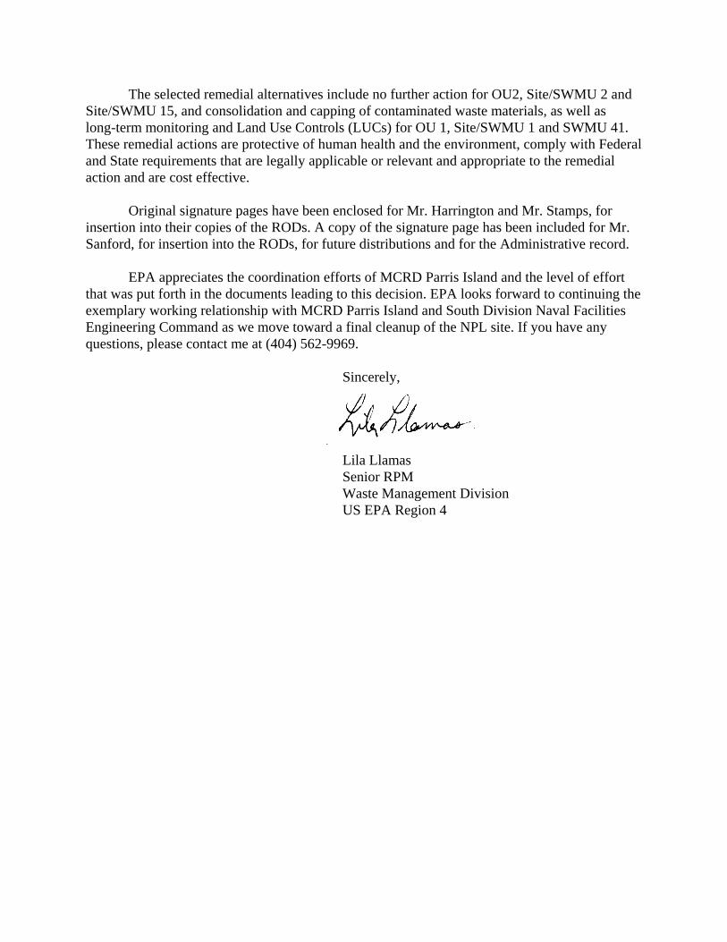
The selected remedial alternatives include no further action for OU2, Site/SWMU 2 andSite/SWMU 15, and consolidation and capping of contaminated waste materials, as well aslong-term monitoring and Land Use Controls (LUCs) for OU 1, Site/SWMU 1 and SWMU 41.These remedial actions are protective of human health and the environment, comply with Federaland State requirements that are legally applicable or relevant and appropriate to the remedialaction and are cost effective.
Original signature pages have been enclosed for Mr. Harrington and Mr. Stamps, forinsertion into their copies of the RODs. A copy of the signature page has been included for Mr.Sanford, for insertion into the RODs, for future distributions and for the Administrative record.
EPA appreciates the coordination efforts of MCRD Parris Island and the level of effortthat was put forth in the documents leading to this decision. EPA looks forward to continuing theexemplary working relationship with MCRD Parris Island and South Division Naval FacilitiesEngineering Command as we move toward a final cleanup of the NPL site. If you have anyquestions, please contact me at (404) 562-9969.
Sincerely,
Lila Llamas Senior RPM Waste Management Division US EPA Region 4
REVISION 2JUNE 2006
RECORD OF DECISION SITE/SWMU 2 - BORROW PIT LANDFILL and
SITE/SWMU 15 - DIRT ROADS FOR
MARINE CORPS RECRUIT DEPOT PARRIS ISLAND, SOUTH CAROLINA
U.S. EPA IDENTIFICATION NUMBER SC617OO22762
COMPREHENSIVE LONG-TERM ENVIRONMENTAL ACTION NAVY (CLEAN) CONTRACT
Submitted to: Southern Division
Naval Facilities Engineering Command 2155 Eagle Drive
North Charleston, South Carolina 29406
Submitted by: Tetra Tech NUS, Inc. 661 Andemen Drive
Foster Plaza 7 Pittsburgh, Pennsylvania 15220
CONTRACT NUMBER N62467-94-D-0888 CONTRACT TASK ORDER 0020
JUNE 2006
REVISION 2JUNE 2006
TABLE OF CONTENTS
SECTION PAGE NO.
ACRONYM LIST iv
1.0 DECLARATION FOR THE RECORD OF DECISION 1-1 1.1 SITE NAME AND LOCATION 1-1 1.2 STATEMENT OF BASIS AND PURPOSE 1-1 1.3 DESCRIPTION OF THE SELECTED REMEDY/STATUTORY
DETERMINATIONS 1-2 1.4 SIGNATURE AND SUPPORT AGENCY ACCEPTANCE OF THE
REMEDY 1-2
2.0 DECISION SUMMARY 2-1 2.1 SITE NAME. LOCATION. AND DESCRIPTION 2-1 2.2 SITE HISTORY AND ENFORCEMENT ACTIVITIES 2-1 2.3 HIGHLIGHTS OF COMMUNITY PARTICIPATION 2-3 2.4 SCOPE AND ROLE OF THE RESPONSE ACTION AT SITES 2
AND 15 2-3 2.5 SUMMARY OF SITE CHARACTERISTICS 2-3
2.5.1 Geology 2-4 2.5.2 Hydrogeology 2-4 2.5.3 Human Health Conceptual Site Model/Current and Potential
Future Land and Resource Uses 2-5 2.5.4 Ecology 2-6
2.6 NATURE AND EXTENT OF CONTAMINATION 2-9 2.7 SUMMARY OF SITE RISKS 2-10
2.7.1 Human Health Risk Assessment 2-11 2.7.2 Ecological Risk Assessment 2-12 2.7.3 Risk Assessment Summary 2-15
2.8 EXPLANATION OF SIGNIFICANT CHANGES 2-15
3.0 RESPONSIVENESS SUMMARY 3-1 3.1 STAKEHOLDER ISSUES AND LEAD AGENCY RESPONSES 3-1
REFERENCES R-1
APPENDIX
A RESPONSIVENESS SUMMARY
ii

REVISION 2JUNE 2006
TABLES
NUMBER
2-1 Summary Statistics - Surface Soil, Site 2 - Borrow Pit Landfill and Site 15 - Dirt Roads 2-2 Summary Statistics - Groundwater, Site 2 - Borrow Pit Landfill 2-3 Summary Statistics - Surface Water, Site 2 - Borrow Pit Landfill 2-4 Summary Statistics - Sediment, Site 2 - Borrow Pi Landfill 2-5 Summary Statistics - Sediment, Site 15 - Dirt Roads 2-6 Chemicals Retained as Human Health COPCs, Site 2 - Borrow Pit Landfill 2-7 Summary of Cancer Risks and Hazard Indices, Site 2 - Borrow Pit Landfill 2-8 Chemicals Retained as ERA Step 2 Ecological COPCs, Site 2 - Borrow Pit Landfill 2-9 Chemicals Retained as ERA Step 2 Ecological COPCs, Site 15 - Dirt Roads
FIGURES
NUMBER
2-1 Depot Location Map 2-2 Site Layout, Site 2 - Borrow Pit Landfill and Site 15 - Dirt Roads 2-3 Site Layout, Site 15 - Dirt Roads at Elliotts Beach
iii
REVISION 2JUNE 2006
ACRONYM LIST
B&R Environmental Brown & Root Environmentalbgs below ground surfaceCERCLA Comprehensive Environmental Response, Compensation, and Liability Actcm/sec centimeters per secondCOPC chemical of potential concernER, N Environmental Restoration, NavyERA ecological risk assessment ESV Ecological Screening ValueHHRA human health risk assessmentHI Hazard IndexHQ Hazard Quotient IAS Initial Assessment Study ILCR incremental lifetime cancer riskLOAEL lowest observed adverse effect level MCL Maximum Contaminant Level MCRD Marine Corps Recruit Depotmg/kg milligrams per kilogram Navy United States NavyNCP National Contingency Plan NEESA Naval Energy and Environmental Support ActivityNOAA National Oceanographic and Atmospheric AdministrationNOAEL no observed adverse effect level PAH polynuclear aromatic hydrocarbon PCBs polychlorinated biphenylsRBC risk-based concentrationRCRA Resource Conservation and Recovery Act RDA Recommended Daily AllowanceRFA RCRA Facilities Assessment RfD Reference DoseRFI RCRA Facilities InvestigationRI Remedial Investigation ROD Record of DecisionSARA Superfund Amendments and Reauthorization Act SCDHEC South Carolina Department of Health and Environmental Control SCDNR South Carolina Department of Natural ResourcesSVOCs semivolatile organic compoundsSWMU solid waste management unit TtNUS Tetra Tech, NUS, Inc. µg/kg micrograms per kilogramµG/L micrograms per literU.S. EPA United States Environmental Protection Agency VOCs volatile organic compoundsVS verification step
iv
REVISION 2JUNE 2006
1.0 DECLARATION FOR THE RECORD OF DECISION
1.1 SITE NAME AND LOCATION
Site/Solid Waste Management Unit (SWMU) 2, the Borrow Pit Landfill, is a reported landfilllocated in the central portion of Horse Island in the northern section of the Marine Corps RecruitDepot (MCRD) Parris Island. Site/SWMU 2 (Site 2) occupies approximately 1.9 acres; itssouthwestern border is approximately 100 feet from a marsh area. From approximately 1966 to1968, the site was reportedly used as a disposal site for domestic trash, construction debris, solidpaint wastes, cleaning rags, solvent sludge, perchloroethylene still bottoms, metal shavings,polychlorinated-biphenyl (PCB)-contaminated oil, mercury amalgam, and beryllium waste from theMCRD. Currently, the site is covered by mature pine trees.
In addition to Site 2, Site/SWMU 15 (Site 15) is included in this Record of Decision (ROD). Site15 consists of approximately 0.5 mile of dirt roads surrounding Site 2 and approximately 1.5 milesof dirt roads accessing Elliot's Beach. From about 1918 to 1966, the dirt roads of Park Island weresprayed with a mixture of waste lubricating oil, cutting oil, petroleum-based solvents, hydraulicfluids, and water-based coolants. The majority of the roads were paved in the 1940s, but the roadsleading to the Borrow Pit Landfill and Elliot's Beach remained unpaved and continued to be sprayeduntil 1966. At present, the majority of the roads leading to Elliot's Beach have been paved;approximately 0.25 mile remains unpaved.
The Superfund site identification number for MCRD Parris Island is 0403488. The United StatesEnvironmental Protection Agency (U.S. EPA) identification number is SC6170022762.
For ease of reading and clarity, Site/SWMU 2 and Site/SWMU 15 will be referred to as Site 2 andSite 15, respectively, for the remainder of this ROD.
1.2 STATEMENT OF BASIS AND PURPOSE
This ROD document proposes no action/no further action at Sites 2 and 15 at the MCRD ParrisIsland, South Carolina.1 This decision is made based on the results from previous investigations atthese sites, including an Initial Assessment Study (IAS) in 1986, a Verification Step (VS) in 1988,an Interim Resource Conservation and Recovery Act (RCRA) Facility Assessment (RFA) and acombined Remedial Investigation (RI)/RCRA Facilities Investigation (RFI) in 1998 and 1999.During these investigations, it was determined that no remediation is necessary at Sites 2 and 15 inorder to protect human health and the environment.
_______________________1 "No action" is equivalent to the RCRA term of "no further action" and has been added at the request ofthe South Carolina Department of Health and Environmental Control.
1-1
REVISION 2JUNE 2006
This ROD documents the selected remedy for Site 2 at the MCRD Parris Island, South Carolina. Theselected remedy was chosen in accordance with the Comprehensive Environmental Response,Compensation, and Liability Act (CERCLA) as amended by the Superfund Amendments andReauthorization Act (SARA), the Resource and Conservation Recovery Act (RCRA), as amended,and, to the extent practicable, the National Oil and Hazardous Substance Pollution Contingency Plan(NCP). The Navy and EPA select the remedy, with concurrence by SCDHEC. The decision wasbased on information contained within the site's Administrative Record, which is on file at theBeaufort County Public Library's Headquarters Location, 311 Scott Street, Beaufort, South Carolina,29902. The State of South Carolina concurs with this no action decision. The community did notprovide any comments during the public comment period.
1.3 DESCRIPTION OF THE SELECTED REMEDY/STATUTORY DETERMINATIONS
The Navy and EPA, with concurrence by the State of South Carolina, have determined that noremedial action is required to ensure protection of human health and the environment at Sites 2 and15. The measured level of risk to human health or environmental receptors allows for unrestricteduse and/or unlimited exposure. During the time between the publishing of the Proposed Plan andthe finalization of this ROD for SWMU 2, the Navy, U.S. EPA and the State of South Carolinacompleted negotiation of a FFA, which outlines the remediation process for sites at MCRD ParrisIsland. The FFA effective date is March 31, 2006. Some additional delay in ROD finalization wasincurred in resolving how land use controls and other post-remedial action activities are to be treatedat federal facilities on the National Priorities List.
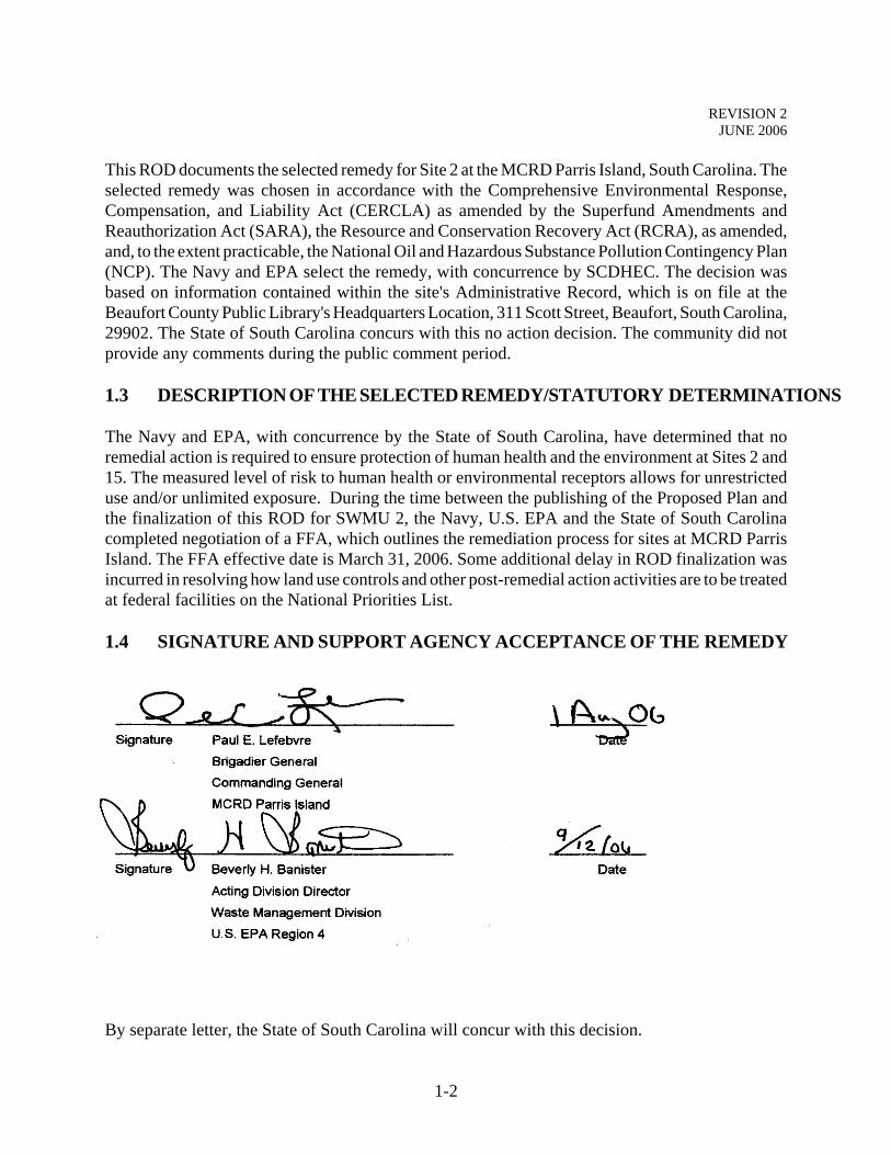
1.4 SIGNATURE AND SUPPORT AGENCY ACCEPTANCE OF THE REMEDY
By separate letter, the State of South Carolina will concur with this decision.
1-2
REVISION 2JUNE 2006
2.0 DECISION SUMMARY
2.1 SITE NAME, LOCATION, AND DESCRIPTION
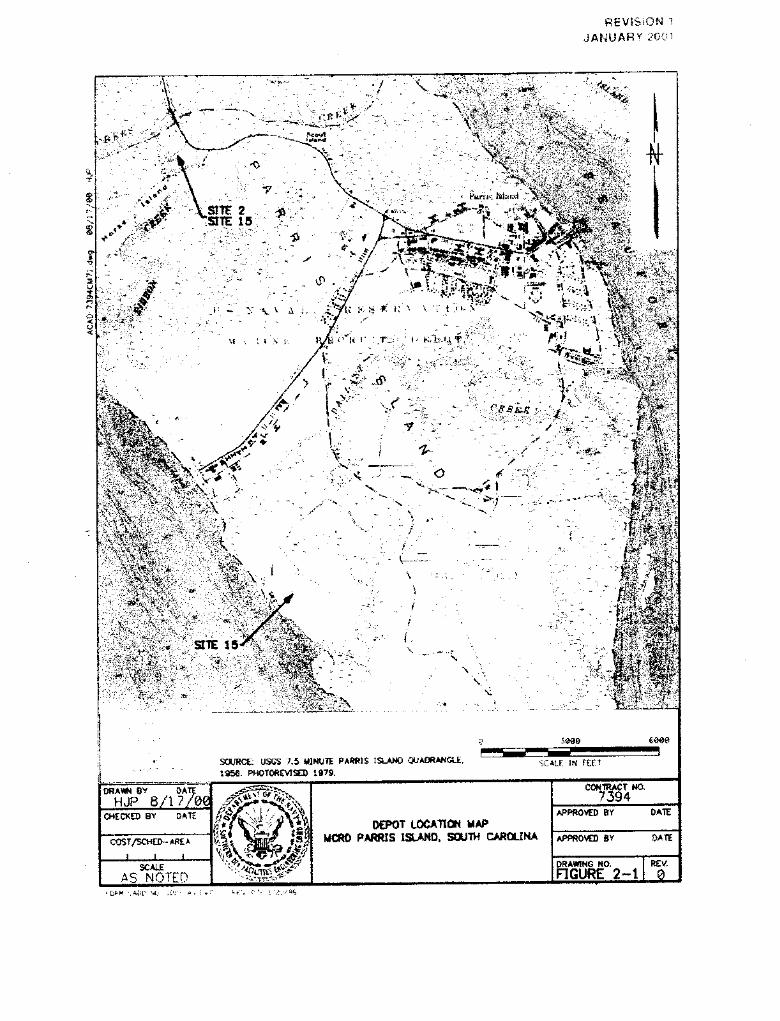
MCRD Parris Island is located along the southern coast of South Carolina, approximately 1 milesouth of the City of Port Royal and 3 miles south of the City of Beaufort within Beaufort County.MCRD Parris Island covers approximately 8,047 acres that consist of dry land, salt marshes,saltwater creeks, and ponds, as shown in Figure 2-1. MCRD Parris Island is the reception and recruittraining facility for the Marine Corps for enlisted men for all states east of the Mississippi River andfor enlisted women nationwide. The Superfund site identification number for MCRD Parris Islandis 0403488. The U.S. EPA identification number is SC6170022762.
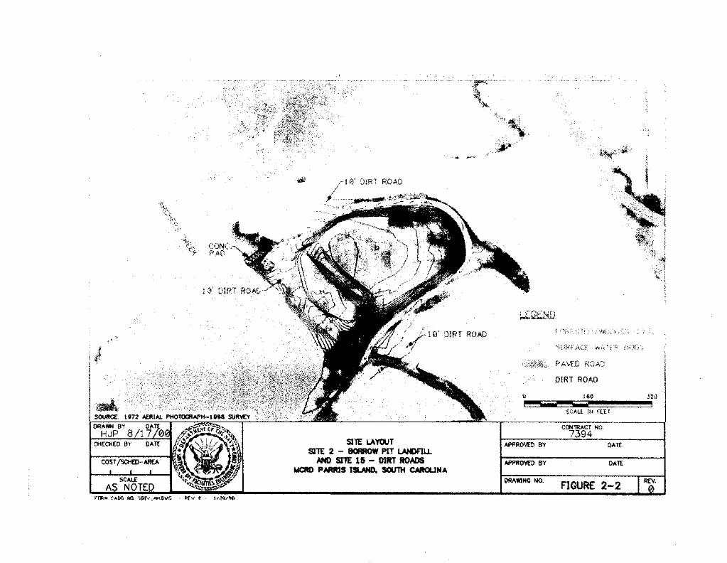
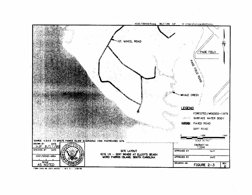
Site 2, Borrow Pit Landfill, is a landfill that was in operation from 1966 to 1968. It is located in thecentral portion of Horse Island, in the northern section of MCRD Parris Island, as shown on Figure2-1. As shown in Figure 2-2, the southwestern border of the landfill is located approximately 100feet from a marsh area. The former landfill occupies approximately 1.9 acres and is currentlycovered with mature pine trees. Site 15 is approximately 0.5 mile of dirt roads surrounding theBorrow Pit Landfill (Figure 2-2) and 1.5 miles of dirt roads accessing Elliot's Beach in thesouthwestern portion of MCRD Parris Island (Figure 2-3).
The United States Navy (Navy) is the lead agency for this ROD, and the U.S. EPA Region 4 andSouth Carolina Department of Health and Environmental Control (SCHDEC) serve as supportagencies. The Navy and EPA select the remedy, with concurrence by SCDHEC. Representatives ofthe National Oceanic and Atmospheric Administration (NOAA), the South Carolina Department ofNatural Resources (SCDNR), and the U.S. Fish and Wildlife Service also serve as natural resourcetrustees
2.2 SITE HISTORY AND ENFORCEMENT ACTIVITIES
Site 2 - Borrow Pit Landfill
In the 1960s, Site 2 consisted of a pit that was dug to provide fill dirt for the base. When wastedisposal at Site 2 was initiated, the unlined pit consisted of a hole approximately 10 feet deep. The1986 IAS indicated that, from 1966 to 1968, the landfill served as the disposal site for domestictrash, construction debris, solid paint wastes, cleaning rags (contaminated with oil, mineral spirits,and kerosene), spent absorbent, solvent sludge (aliphatic petroleum and chlorinated solventcompounds), perchloroethylene still bottoms, metal shavings, PCB-contaminated oil, mercuryamalgam, and beryllium wastes from the MCRD. An estimated 33,000 tons of solid waste refuse and16 tons of solid paint wastes (e.g., empty paint cans, cleaning rags, used brushes and rollers, andspray booth scrapings) were reportedly disposed in this landfill during the period of operation. Mostof the wastes were located in the central and eastern portions of Site 2 [Naval Energy andEnvironmental Support Activities (NEESA), 19861. Reportedly, paint shop personnel also brought
2-1
REVISION 2JUNE 2006
liquid paint wastes including thinners (mineral spirits, kerosene, and diesel fuel) and a stripper(methylene chloride) to this landfill and burned them. During the 3-year period, approximately 2,800gallons of liquid paint wastes may have been burned annually in this landfill (NEESA, 1986). Thelandfill was the facility's primary landfill after the termination of operations at the Site/SWMU 1 -Incinerator Landfill and the temporary suspension of operations at the Site/SWMU 3 - CausewayLandfill. When Site 2 operations were terminated, the pit was believed to be approximately halffilled with wastes and approximately 6 feet deep. Since 1968, no documented significant disposalor intrusive activities have taken place at Site 2. No regulatory actions have been undertaken at Site2.
Site 15 - Dirt Roads
In the past, the MCRD routinely sprayed the Depots dirt and gravel roads with oils to reduce dust.From about 1918 until 1966, waste lubricating oil, cutting oil, petroleum-based solvents (kerosene,gasoline, mineral spirits), hydraulic fluids, and water-based coolants were transported by roads andgrounds personnel from various Depot shops and sprayed for dust suppression. From 191 8 to 1940,an estimated 11,000 gallons were sprayed on all Depot roads; the majority was applied during the1930s. Most of the Depot roads were paved in the 1940s. However, from the early 1940s to 1966,approximately 16,200 gallons of waste oils and hydraulic fluids continued to be applied to the dirtroads accessing Elliot's Beach and the Borrow Pit Landfill. Most of the dirt road accessing Elliot'sBeach was recently-paved and only 0.25 mile of dirt road remains. No regulatory actions have beenundertaken at Site 15.
Environmental investigations of Sites 2 and 15 began in 1986. The following reports describe theresults of investigations at these sites to date and are available in the MCRD Parris Islandinformation repository:
• IAS of MCRD Parris Island, South Carolina (NEESA, 1986).
• RI Verification Step (McClelland Consultants, Inc., 1990).
• Interim RFA of United States Marine Corps, Recruit Depot Parris Island, South Carolina(Kearney, A.T., Inc., 1990).
• Relative Risk Evaluation [Brown and Root Environmental (B&R Environmental), 19961.
• RI/RFI Work Plan for Sites/SWMUs 1, 2, 3, and 15 and SWMU 41 (B&R Environmental,1998a) and Work Plan Addendum [Tetra Tech NUS, Inc. (TtNUS), 19991.
• RI/RFI Report for Sites/SWMUs 2 and 15 - Borrow Pit Landfill and Dirt Roads (TtNUS,2000a).
2-2
REVISION 2JUNE 2006
2.3 HIGHLIGHTS OF COMMUNITY PARTICIPATION
On August 10, 2000, the Proposed Plan for No Action at Sites 2 and 15 was made available to thepublic in the Information Repository at the Beaufort County Public Library's Headquarters Locationat 311 Scott Street, Beaufort, South Carolina 29902. This Proposed Plan recommended that nofurther investigation or remediation be performed at Sites 2 and 15.
The public notice of the Proposed Plan was published in the Beaufort Gazette on August 11, 17, and24, 2000. Additionally, a public information session was held on August 24, 2000 to present theresults of the RI/RFI, explain the preferred remedy, and solicit comments from the community. Atthis information session, representatives from Southern Division Naval Facilities EngineeringCommand, MCRD Parris Island, US. EPA Region 4, and SCDHEC were available to discuss aspectsof Sites 2 and 15 and the response actions under consideration. No comments were made during thepublic information session, and none were received during the public comment period. TheCommunity Relations Responsiveness Summary is included in Appendix A of this ROD.
2.4 SCOPE AND ROLE OF THE RESPONSE ACTION AT SITES 2 AND 15
Sites 2 and 15 are two of approximately 45 sites being evaluated for potential contamination at theMCRD Park Island. In 1996, the MCRD Parris Island partnering team was developed to facilitatethe development, review, and approval of work plans, reports (RIs and Feasibility Studies), anddecision documents (Proposed Plans and RODS). The original members of the team consisted of theSouthern Division of the Navy, Marine Corps - MCRD Parris Island, U.S. EPA, and SCDHEC. In1997, representatives of NOAA, SCDNR, and U. S. Fish and Wildlife Service joined the team asnatural resource trustees.
This ROD is designed to convey the final remedial remedy chosen by the MCRD partnering teamfor Sites 2 and 15. During the RI/RFI, risk to construction/maintenance workers, adolescent andadult recreational users, and child and adult future on-site residents were evaluated. It wasdetermined that, at both sites, contaminant concentrations in all media were within the U.S. EPA'sacceptable risk range. Additionally, the associated hazard indices (HIs) did not exceed unity,indicating that non-carcinogenic toxic effects would not be anticipated. There was no contaminationto warrant a remedial action to prevent unacceptable risk to ecological receptors, including fishes,aquatic birds, terrestrial birds, and terrestrial mammals. For this reason, the partnering team hasdecided that the best course was to take no action/no further action at Sites 2 and 15.
2.5 SUMMARY OF SITE CHARACTERISTICS
This section summarizes the regional and site-specific geology, hydrogeology, and ecology in thevicinity of MCRD Parris Island. A more detailed presentation of this information is available in theRI/RFI Report for Sites 2 and 15 (TtNUS, 2000a).
2-3
REVISION 2JUNE 2006
2.5.1 Geology
Four geological units are present in the Beaufort-Jasper County area. These units from the oldest(Eocene age) to the youngest (Pleistocene age) are the Santee Limestone, Cooper Marl, HawthornFormation, and Pleistocene sands and clays. Soils at MCRD Parris Island have been mapped by theU.S. Soil Conservation Service as both individual soils and groupings of soils (units) (Stuck, 1980).The Depot has been mapped as having 15 individual soil types, but only eight types are presentbeneath MCRD Parris Island. Three soil units have been mapped for the Depot (the Wando-Seabrook-Seewee, Coosaw-Williman-Ridgeland, and Bohicket-Capers-Handsboro Soil Units).
The Borrow Pit soils located at Site 2 and the adjacent Site 15 dirt road represent areas where soilshave been disturbed by man for use as fill material. These soils may include surface soil, subsoil,and, in some instances, substratum.
Soils collected from the Borrow Pit Landfill during the 1998 and 1999 field events consisted of fineto medium sands with a varying silt content, as confirmed by the lithologic descriptions during thesampling events. Rust-colored soils indicating possible fill material were encountered at several Site2 sample locations at a depth of 1 foot to 6.5 feet below ground surface (bgs). Subsequent test pittingsampling did not find evidence of remaining waste. Sediment samples collected from the tidal inletarea consist of silts overlying sand and shells, coarse sand and shells, and silty sands. The Site 15dirt road soils consisted of fine sand with varying silt and shell content. Sediment samples collectedat Site 15 consisted of fine sands with a varying silt and clay content and sandy silts and clays.
Subsurface materials at Site 2 were classified from the drilling of one soil test boring during the fieldinvestigation, the soil logs for the existing wells, test pits, and the hand-auger borings collectedwithin Site 2. Generally, the shallow subsurface geology inland of the tidal inlet consists of siltysand to a depth of approximately 25 feet bgs and sand with varying clay content to a depth ofapproximately 30 feet bgs. The subsurface geology along Archers Creek consists of predominantlyfine to medium sand with a varying clay content to the termination of the boring at 48 feet bgs. Aclayey, fine to coarse sand was encountered from 36 to 40 feet bgs that seems to correspond withthe confining unit encountered at a site located approximately 3,000 feet east of Site 2.
2.5.2 Hydrogeology
Two primary aquifers are present within the Beaufort-Jasper County area: the surficial Pleistoceneaquifer and the Floridan Aquifer. These aquifers are generally separated by the Hawthorn Formationand Cooper Marl, which act as confining units to the underlying Floridan Aquifer.
In the MCRD Parris Island area, the shallow unconfined aquifer generally consists of permeable,fine to medium Pleistocene age sands. Surface relief is relatively low. The area is drained by freshand brackish water streams inland and by tidal streams along the coast The water table in the MCRDParris Island area usually ranges from 0 to 10 feet bgs and is most commonly found at a depth of 3feet bgs. Water-table fluctuations are a function of tidal influence, recharge, evaporation, andtranspiration and have been observed to be as great as 6.5 feet at some locations (Glowacz, et al.,
2-4
REVISION 2JUNE 2006
1980). The direction of groundwater flow in the upper portion of the shallow surficial aquifer isgenerally toward the nearest surface water body, such as a pond, river, tidal creek, or the ocean.
In the Beaufort-Jasper County area, the Floridan Aquifer system occurs near the land surface, andoverlying confining beds vary from essentially 0 to more than 150 feet in thickness. Groundwaterin the Floridan Aquifer occurs in solutionally enlarged openings or cavities in the limestone. Ingeneral, groundwater occurs in a series of broadly defined water-bearing (permeable) zones thatserve as aquifers and are separated by less permeable rocks. Two hydrogeologic zones within theFloridan Aquifer lie beneath the MCRD Parris Island area: a 200-foot-thick upper hydrogeologicunit that contains an upper permeable zone and an 800-foot-thick lower hydrogeologic unit that hasa somewhat lower permeability compared to the upper unit.
Based on water-level measurements, the shallow water table at Site 2 occurs at depths ranging from3.5 to 14.5 feet bgs. The saturated thickness of the surficial aquifer ranges from 21.5 to 32.5 feet.Within the borrow pit, groundwater was encountered in the hand-auger borings and test pits atdepths from 2.5 to 8 feet bgs. Within the vicinity of the topographically upgradient monitoring wells,groundwater was encountered at depths from 12.1 to 14.5 feet bgs.
Recharge of the shallow aquifer beneath the site is likely to occur primarily through infiltration ofprecipitation inland of the tidal inlet. Groundwater flow is generally toward the west-northwest,although groundwater near the marsh appears to flow toward the adjacent tidal inlet. Based on thegroundwater elevation data collected during this field event, the vertical gradient within the surficialaquifer is downward. Site 2 is located within the 100-year flood plain.
Slug tests were performed at Site 2. The geometric average hydraulic conductivity for the shallowsurficial aquifer wells was calculated to be 1.13 feet per day [3.99 x 10⁻⁴ centimeter per second(cm/sec)]. The deep surficial well conductivity was determined to be 3.08 feet per day (1.08 x 10⁻³
cm/sec). The values for the shallow and deep wells are within the typical range of hydraulicconductivity for clayey, silty sands, silts, and sandy silts
2.5.3 Human Health Conceptual Site Model/Current and Potential Future Land andResource Uses
As described previously, Site 2 is a former unlined landfill located on Horse Island in the northernsection of MCRD Parris Island. The landfill is now a depression mainly covered in mature pinetrees. Site 15 is used as a traffic route. Neither site is used for residential purposes nor is itanticipated to be used for such in the future.
Sites 2 and 15 groundwater is not used as a potable water supply nor is it expected to be used as suchin the future, based on the high total dissolved solids content of the groundwater. Currently nooff-site residents are located hydraulically downgradient in the immediate vicinity of the sites thatmight use groundwater as a potable water supply. The surface water adjacent to Sites 2 and 15 is notcurrently used as a potable water supply, but it is used for recreation (boat launch and fishing).
2-5
REVISION 2JUNE 2006
The potential sources of contamination are the former wastes disposed within the landfill at Site 2and the waste oils that were sprayed on the road to suppress dust at Site 15. Contaminants may bereleased by mechanisms such as leaching of contaminants from soil/former waste material viainfiltrating water and subsequent migration to the water table, wind erosion of surface soil (fugitivedust), and volatilization of chemicals from soil (volatile emissions). Contaminants may also havebeen released from Site 15 via erosion of surface soil during rain storms. At Site 2, off-site migrationof surface water is limited, due to the lower elevation of the landfill compared to the surroundings.
As a general rule, once released from the source, contaminants may be transported in media suchas soil, groundwater, surface water, sediment, or air. Potential receptors may be exposed eitherdirectly or indirectly to contaminants in these media by a variety of exposure mechanisms.Inhalation of air, direct contact with soil, groundwater, surface water, and sediment, and ingestionof fish were exposure routes evaluated in the RI/RFI.
Potential receptors were identified by analyzing the interaction of current and potential future landuse practices and the identified sources of contamination. The receptors evaluated in the RI/RFIconsisted of construction workers, maintenance workers, on-site recreational users, and hypotheticalfuture on-site residents.
2.5.4 Ecology
Site 2
Site 2 is roughly rectangular in shape and covers an area of approximately 2 acres (Figure 2-2). Thesite perimeter is bounded to the north, east, and south by a dirt road leading to a boat ramp. Theremainder of the site perimeter consists of a 3-to 5-feet high berm along the southwestern boundaryof the site. A narrow strip of marsh habitat adjacent to an inlet of Archer's Creek is locatedsouthwest of the berm.
Habitat at Site 2 consists of a pine forest. The dominant overstory species are slash pine (Pinuselliotti) and loblolly pine (Pinus taeda). Other trees include sassafras (Sassafras albidum), blackcherry (Prunus serotina), and red bay (Persea borbonia). The midstory and much of the understoryconsist almost exclusively of wax myrtle (Myrica cerifera). Scattered shrubs and vines includepoison ivy (Rhus radicans), muscadine grape (Vitis rotundifolia), and greenbrier (Smilaxrotundifolia).
The narrow strip of marsh to the west and southwest of the site is dominated by needlerush (Juncusroemenanus). Cordgrass (Spartina alterniflora), sea oxeye (Bonichia frutescens), and glasswort(Salicornia virginica) are present in portions of the marsh.
The site is small in areal extent, yet 3 variety of wildlife species occur there. White-tailed deer(Odocoileus virginianus), raccoons (Procyon lotor), and gray squirrels (Sciurus carolinensis) areknown to forage on the site. Other mammals expected to occur at Site 2 include the opossum(Didelphis virginiana), short-tailed shrew (Blarina carolinensis), cotton rat (Sigmodon hispidus),
2-6
REVISION 2JUNE 2006
and cotton mouse (Peromyscus gossypinus). Mammalian carnivores expected to occur, at leastoccasionally, on the site include the red fox (Vulpes vulpes) and striped skunk (Mephitus mephitus).A variety of birds, reptiles, and amphibians utilize the site.
Mink (Mustela vison), river otters (Lutra canadensis), marsh rabbits (Sylvilagus palustris), and ricerats (Oryzomys palustris) probably forage along the edge of the marsh southwest of the site. Thetidal inlet provides habitat for a variety of fauna, particularly fish and crustaceans. Several speciesof animals probably prey upon these fish, mollusks, and crustaceans. These include mammals suchas the raccoon, mink, and river otter and wading birds such as the tricolored heron (Egretta tricolor),great blue heron (Ardea herodias), green heron (Butorides striatus), and snowy egret (Egretta thula).An active osprey (Pandion haliaetus) nest is located on a nesting platform at the edge of the inletimmediately southwest of the site.
Fish such as red drum (Sciaenops ocellatus), spotted seatrout (Cynoscion nebulosus), southernflounder (Paralichthys lethostigma), whiting (Menticirrhus americanus), and striped mullet (Mugilcephalus) are known to occur in Archer's Creek and presumably occur in the tidal inlet near the site.Smaller fish such as mud minnows (Umbra pygmaea) and mummichogs (Fundulus heteroclitus),as well as benthic and nektonic invertebrates such as oysters, shrimp, and crabs, also are expectedto occur in the inlet.
Endangered and threatened species that could potentially occur at or near the site consist of the baldeagle (Haliaeetus leucocephalus), wood stork (Mycteria americana), and American alligator(Alligator mississippiensis). An active bald eagle nest is located approximately 1 mile southeast ofthe site, and bald eagles (state and federally listed as threatened) could potentially forage on fish inArcher's Creek. Wood storks (state and federally listed as endangered) forage in various locationsthroughout the Depot, and they could potentially forage in the tidal inlet near the site. An alligatorwas observed near the site during sampling activities. Although common in some parts of its range,the alligator is federally listed as threatened due to Its similarity in appearance to the endangeredAmerican crocodile (Crocodylus acutus).
Although other endangered and threatened species occur in Beaufort County, the site provides poorhabitats for these species. For example, the manatee (Trichechus manatus), shortnose sturgeon(Acipenser brevirostrum), and various sea turtles have been seen, at least occasionally, in the BroadRiver, Beaufort River, and Port Royal Sound. Similarly, the Atlantic bottlenosed dolphin (Tursiopstruncatus) is a year-round resident of these areas. Although not threatened or endangered, dolphinsare afforded protection under the Federal Marine Mammal Act. However, these species usually arenot associated with shallow marshes and small tidal inlets like those near Site 2. With the exceptionof the bald eagle, wood stork, and alligator, the likelihood of endangered and threatened species inthe vicinity of the site is remote.
Site 15
Site 15 consists of approximately 0.5 mile of dirt road accessing the Site 2 Borrow Pit Landfill andapproximately 1.5 miles of road near Elliot's Beach (Figures 2-2 and 2-3). Most of the Elliot's Beach
2-7
REVISION 2JUNE 2006
road has been paved, and the only unpaved portion is within the picnic area at Elliot's Beach.
Habitat in the vicinity of the Borrow Pit road consists of pine forest on the downslope side of theroad and temperate evergreen forest on the upslope side. The area on the upslope side of the road
is dominated by laurel oak (Quercus lauriblia), and the downslope pine forest was discussedpreviously in the Site 2 ecological section. Other trees include black cherry, red bay, and loblollypine. Common understory shrubs and vines include saw palmetto (Serenoa repens), yaupon holly(Ilex vomitoria), muscadine grape, and greenbriar.
A variety of habitats exist in the vicinity of the Elliot's Beach road. Approximately 20 acres ofmowed grass with scattered live oaks (Quercus virginiana) occur in the picnic area. Mowed grassextends seaward to the edge of a 5foot bluff along the shoreline, where concrete slabs have beenrecently placed as riprap. The shoreline at the picnic area is rock and gravel, with no emergentvegetation. A boat ramp is located approximately 3,000 feet southeast of the picnic area, at themouth of Whale Creek An extensive saltwater marsh, dominated by cordgrass, is located upstreamalong Whale Creek.
Wooded areas near Elliot's Beach consist of temperate evergreen forest. This transitions into pineforest when proceeding inland. The temperate evergreen forest includes tree species such as live oak,laurel oak, cabbage palmetto (Sabal palmetto), red bay, and sweet bay (Magnolia virginiana).Common understory species include wax myrtle, yaupon holly, muscadine grape, and greenbrier.The pine forest includes these species but is dominated by slash pine and loblolly pine. Theunderstory of the pine forest near Elliot's Beach is thickly vegetated with sweet gum (Liquidambarstyraciflua), saw palmetto, oaks (Quercus spp), and numerous vines.
Terrestrial and aquatic animal species known and expected to occur in the vicinity of Site 15 arethose described previously in the Site 2 ecological discussion.
The most likely endangered and threatened species that could potentially occur at or near Site 15consist of the bald eagle, woodstork, and American alligator. Wood storks could potentially foragein the extensive marsh upstream of the boat ramp near Elliot's Beach. Bald eagles and alligatorscould potentially forage in the marsh or in the Broad River.
Other endangered and threatened species known to occur in Beaufort County that could potentiallyoccur near Site 15 consist of aquatic species such as the manatee (Trichechus manatus), shortnosesturgeon (Acipenser brevirostrum), and various sea turtles. These species are occasionally seen inthe Broad River, Beaufort River, and Port Royal Sound. There are no sandy beach habitats favoredas nesting sites by sea turtles near Site 15. Thus, the likelihood of sea turtles near the site (exceptfor occasional transients) is remote. The possibility that manatees and shortnose sturgeon mayoccasionally occur in the Broad River near Elliot's Beach cannot be ruled out.
2-8
REVISION 2JUNE 2006
2.6 NATURE AND EXTENT OF CONTAMINATION
This section summarizes the nature and extent of contamination observed at Sites 2 and 15 duringthe 1998 and 1999 RI/RFI. A more detailed presentation of this information is available in theRI/RFI Report for Sites 2 and 15 (TtNUS, 2000a).
The nature, extent, and concentration of hazardous substance contamination at Sites 2 and 15 wereevaluated during the RI/RFI conducted from May to September 1998 and in October 1999.Concentrations of analytes detected by laboratory analyses are reported in micrograms per kilogram(µg/kg) or milligrams per kilogram (mg/kg) for soil samples and micrograms per liter (µg/L) forwater samples. For instance, a concentration of 8,600 mg/kg for iron means that 8,600 milligramsof iron are present in each kilogram of soil. A kilogram is a metric unit measure of weight equal toabout 2.2 pounds. One thousand micrograms equal 1 milligram, 1,000 milligrams equal 1 gram, and1,000 grams equal 1 kilogram. A liter is a unit measure of volume roughly equal to a quart.
Samples were collected from Sites 2 and 15 in the spring and summer of 1998. Additionalsubsurface soil samples were collected in October 1999 as part of test pitting operations. During the1998 field investigation sampling at Site 2, eight surface soil samples, four filtered and non-filteredgroundwater samples, four filtered and non-filtered surface water samples, and five sedimentsamples were collected and analyzed. The field investigation at Site 15 during the same timeincluded seven surface soil samples and three sediment samples. In 1999, three subsurface soilsamples were collected at Site 2. Summary statistics for 1998 surface soil, groundwater, surfacewater, and sediment analytical results and 1998 and 1999 subsurface soil results are presented inTables 2-1 though 2-5.
Wastes were reportedly disposed of at Site 2. In addition, a review of aerial photographs indicatesthat the site was disturbed at the reported time of disposal. However, hand borings and test pits wereconducted as part of RI/RFI activities to determine whether waste materials are present at the site.The only evidence of waste at Site 2 was the presence of visually stained soils near the water table.The stained soils may be of natural origin. Furthermore, surface and subsurface soil and sedimentat Site 2 were found not to contain chemicals in excess of those found in background media and themost stringent of residential human health risk-based criteria or ecological screening values.
Surface soils and sediments at Site 15 were found to contain two isolated detections of chemicalsin excess of the background media and the most stringent residential human health risk-basedconcentrations (RBCs) or ecological screening values. Bis(2ethylhexyl) phthalate was detected inone sediment sample at a concentration of 1.5 times the U.S. EPA Region 4 Ecological ScreeningValue (ESV). Similarly, PCBs were detected in one sediment sample (from a previous sample event)at a concentration of 1.2 times the U.S. EPA Region 4 ecological screening level. Several inorganiccompounds were detected at concentrations greater than background levels, but were detected lessthan RBCs and ESVs.
Several metals, one volatile organic compound (VOC), and one semi-volatile organic compound(SVOC) were detected in Site 2 groundwater at concentrations in excess of the most stringent
2-9
REVISION 2JUNE 2006
residential human health RBCs or ecological screening values. These results are summarized asfollows.
• Chloroform and arsenic were the only chemicals detected in site groundwater atconcentrations that could result in potential risk to human health. Chloroform was detectedin one of five wells and arsenic in three of five wells. This evaluation assumes that site groundwater would be used as a potable water supply. However, the maximum concentrationof arsenic and chloroform detected were actually less than the U.S. EPA maximumcontaminant levels (MCLs), indicating that risks from these chemicals are within acceptableU.S. EPA ranges.
• Aluminum, iron, copper, zinc, and bis(2-ethylhexyl) phthalate were the only chemicalsdetected in the site groundwater at concentrations exceeding established ecological criteria.This evaluation assumes that the groundwater seeps into the adjacent surface water, mixingdoes not occur in the surface water, and that the most sensitive receptor is continuouslyexposed to the seep. However, with the exception of bis (2-ethylhexyl) phthalate, none ofthese chemicals were detected in the adjacent surface water at concentrations greater thanecological screening levels. Since bis(2-ethylhexyl) phthalate is a common laboratoryartifact and it was detected in background surface water samples at higher concentrationsthan detected at this site, it may not be a site contaminant.
Two metals and one SVOC were detected in Site 2 surface water at concentrations in excess of themost stringent residential human health RBCs or ecological screening values. These results aresummarized as follows.
• Bis(2-ethylhexyl) phthalate (two of four samples) and arsenic (one of four samples) weredetected in the surface water at concentrations that represent a potential threat to humanhealth assuming potable use of the saline water and regular consumption of fish living at thesite. Actual threats would be less since salt water is not used for drinking water.
• Silver was detected in two of four surface water samples and was the only chemical detectedat concentrations in excess of the most stringent surface water ecological screening values.However, the maximum detected concentration of silver was less than the associated ambientwater quality criteria. Therefore, ecological effects attributable to exposure to silver wouldnot be anticipated.
2.7 SUMMARY OF SITE RISKS
The Sites 2 and 15 RI/RFI analytical data were evaluated to determine baseline risks to humanhealth and the environment. The baseline risk assessment estimates what risks the sites would poseif no action were taken. It provides the basis for taking action and identifies the chemicals and theexposure pathways that need to be addressed by the remedial action. Sections 2.7.1 and 2.7.2summarize the results of the baseline risk assessment for this site.
2-10
REVISION 2JUNE 2006
2.7.1 Human Health Risk Assessment
A baseline human health risk assessment (HHRA) was performed to characterize and quantifypotential health risks at both sites, in the absence of remedial action. The HHRA for Sites 2 and 15was conducted using guidance from the U.S. EPA (U.S. EPA, 1989 and 1992), including regionalsupplemental guidance (U.S. EPA Region 4, 1995a). Methodologies presented in the MasterWorkplan for MCRD, Parris Island, South Carolina (B&R Environmental, 1998b) were also usedto develop the baseline risk assessment for these sites. During this evaluation, a list of chemicals ofpotential concern (COPCs) was developed for each environmental medium (e.g., surface soil,sediment, etc.) sampled at the sites. Table 2-6 presents the chemicals selected as human healthCOPCs. COPCs are chemicals that need further evaluation to determine if, in fact, the concentrationsfound at the site pose a potential risk to human health and the environment.
The human health risk assessment considered exposure of construction workers to site media. Theestimated incremental lifetime cancer risk (ILCR) to construction workers across all media at theBorrow Pit Landfill was 1.8E-06. This value exceeded one in one million (1.0E-06), which is thelower bound of U.S. EPA's acceptable risk range, but was less than one in 10,000 (1.0E-04), whichis the upper bound of this range. The noncarcinogenic risk estimates [Hazard Indices (HIs)] for theconstruction worker (0.09 to 0.45) were less than 1.0, which is the U.S. EPA's risk threshold,indicating that toxic effects would not be expected.
The maintenance worker was evaluated for exposure to surface soil and sediment only. Groundwaterand surface water were not evaluated as exposure medium because groundwater is not used as apotable water supply and maintenance workers do not come in contact with surface water. Becauseno COPCs were identified for surface soil and sediment at Sites 2 and 15 under a residential usescenario, carcinogenic and noncarcinogenic risks for the maintenance worker are expected to bewithin acceptable levels.
An analysis of exposure to surface waters by adolescent and adult recreational users resulted inILCRs of 4.4E-06 and 2.6E-06, respectively. Both values are within the US. EPA's acceptable riskrange. The noncarcinogenic HIS for both receptors (0.11 and 0.18) were less than the acceptable riskthreshold of 1.0.
The HHRA determined that ingestion of shellfish from the marsh located approximately 100 feetfrom Site 2 by adults would represent an estimated ILCR of 1.4E-06, which is also within U.S.EPA's acceptable risk range. The noncarcinogenic HI value was calculated to be 0.07, indicating thattoxic effects would not be expected.
The estimated ILCR for a hypothetical future lifelong (child and adult) resident exposed to surfacewater was 1.4E-05, which is within U.S. EPA's acceptable risk range. The noncarcinogenic HI fora future hypothetical child resident was 0.18, and the HI for a future hypothetical adult resident was0.11, both being less than the acceptable risk threshold of 1.0.
The estimated ILCR for a hypothetical future lifelong (child and adult) resident exposed togroundwater was 3.4E-05, which is within U.S. EPA's acceptable risk range. The noncarcinogenic
2-11
REVISION 2JUNE 2006
HIs for future hypothetical residents were 2.8 for a child and 1.2 for an adult, both of which exceedthe acceptable threshold of 1.0. Although the HI for the individual target organs for an adult wereall less than the acceptable level of 1.0, iron was the main contributor to the HI for a child and forthe adult. The reference dose (RfD) for iron is based on the Recommended Dietary Allowance(RDA) for adult nutrition. Children require more iron in their diets than adults do; consequently, useof an RfD based on the adult RDA for iron to evaluate exposures to children results in anoverestimation of the risks for children. The HI is less than 1.0 when calculated using a RfD basedon child nutritional requirements; therefore, all cancer risks and HIs are within acceptable levels.
A summary of human health ILCRs and HIs for Site 2 human receptors is presented in Table 2-7.No COPCs were detected in the soil or sediment of Site 15; therefore, quantitative risks were notcalculated for Site 15 human receptors.
The baseline HHRA reflects certain uncertainties regarding the true risks associated with Site 2.Conservative assumptions were used throughout the entire risk assessment; consequently, the finalestimated risks may well be overestimated. The major uncertainty involved the estimation ofexposure point concentrations and the retention of bis(2ethylhexyl) phthalate as a COPC. Basedupon the level of sampling conducted, the distribution of the chemical could not be fully determinedand the maximum detected concentration was used as the exposure point concentration. As a result,the estimations of risk, where the maximum concentrations were used as the exposure pointconcentration, are most likely to be overstated because it is unlikely that potential receptors wouldbe exposed to the maximum concentration over the entire exposure period.
Bis(2ethylhexyl) phthalate was retained as a COPC in surface water at Site 2, although the availabledata suggests that the presence of bis(2-ethylhexyl) phthalate in surface water may not be site relatedbut be due to contamination from sampling.2 Consequently, the retention of bis(2ethylhexyl)phthalate as a COPC may have also resulted in an overestimation of site risks.
2.7.2 Ecological Risk Assessment
An ecological risk assessment (ERA) was performed to characterize the potential risks fromsite-related contaminants to ecological receptors. The ERA was performed using the generalapproach recommended in U.S. EPA guidance for performing ERAS (U.S. EPA, 1997, U.S. EPA,1998), which served as the basis for the ERA methodology. Furthermore, the ERA was conductedin accordance with Navy policy [Department of the Navy (DON), 19991 and other availableguidance documents (U.S. EPA, 1995b; Wentsel et at., 1996) and publications (Ingersoll et at., 1997;Suter, 1993; Calabrese and Baldwin, 1993). The ERA investigated potential impacts to fish, benthicinvertebrates, soil invertebrates, terrestrial and aquatic plants, terrestrial wildlife, and semi-aquaticwildlife.
_________________________2 According to the U.S. EPA Contract Laboratory Program National Functional Guidelines for Organic DataReview (U.S. EPA, 1999), phthalates are listed as common laboratory contaminants. Phthalates were alsoobserved in several blank samples.
2-12
REVISION 2JUNE 2006
Initially, ecological COPCs were determined by comparing the maximum concentrations of detectedchemicals in surface water, groundwater, sediment, and surface soil to U.S. EPA Region 4ecological screening levels. When the hazard quotient (HQ) (ratio of the maximum concentrationto its respective screening level) exceeded 1.0, adverse impacts were considered possible and thechemical was retained as an ecological COPC. An HQ of greater than 1.0 is an indication thatecological receptors are potentially at risk. Additional evaluation or data may be necessary toconfirm with greater certainty whether ecological receptors are actually at risk, especially since mostguidelines are conservatively derived.
The initial ecological risk screening determined that the maximum concentrations of VOCs andseveral metals across all media at Site 2 exceed U.S. EPA Region 4 screening values and wereidentified as COPCs, indicating a potential ecological risk. In addition, SVOCs were retained asCOPCs in surface and groundwaters and one pesticide was retained as a COPC in surface water atSite 2. At Site 15, one PCB was retained as a COPC in surface soil and one SVOC and severalmetals were considered COPCs in sediment.
Modeling of contaminant exposure via the food chain was performed to investigate potential risksto representative receptors. All COPCs identified in surface water, sediment, and surface soil wereused in the food-chain modeling. Contaminant intake from the ingestion of food and water andincidental ingestion of soil or sediment were estimated and the resulting intake values were dividedby published no-observed-adverse-effects levels (NOAELs) and lowest-observed-adverse-effectslevels (LOAELs) to obtain food-chain HQs. The food-chain modeling evaluated 11 representativereceptors. The following table summarizes the maximum HQs calculated during the initial COPCscreening process and food-chain modeling.
2-13
REVISION 2JUNE 2006
Receptor Exposure Route Hazard Quotients - Site 2 Hazard Quotients - Site 15
Terrestrial and aquaticplants, soil invertebrates.benthic receptors (COPCinitial screening)
Direct contact withsediment. prey, surfacewater, and soil; ingestionof sediment, prey, surfacewater, soil, and food;uptake by plants
U.S. EPA Region 4Screening Values(1) HQsfor Soil (maximum = 85.8).sediment (0.34). surfacewater (4.04) andgroundwater (11.61)
U. S. EPA Region 4Screening Values(1). HQsfor Soil (maximum = 1.2)and sediment (1.54)
Terrestrial Food-ChainReceptors - MaximumConcentrations - Shrew - Robin - Hawk - Mouse - Fox - Woodcock
Direct contact withsediment, surface waterand soil: ingestion ofsediment, prey, surfacewater, soil. and food
Food Chain Modeling,Maximum HQs(1) based on: NOAELs LOAELs 2.77(1) 0.277(1) 2.41 0.241 1.12 0.112 12.8 0.128 7.32 0.732 4.57 0.457
Food Chain Modeling,Maximum HQs(1) based on: NOAELs LOAELs 1.00 0.1 0.256 0.26 0.168 0.017 0.0135 0.0014 0.425 0.043 0.545 0.055
Aquatic Food-ChainReceptors - MaximumConcentrations - Raccoon - Heron - Mummichog - Red Drum - Osprey
Direct contact withsediment and surfacewater; ingestion ofsediment, prey andsurface water
Food Chain Modeling,Maximum HQs(1) based on: NOAELs LOAELs 23.1(1) 2.31(1) 9.7 0.97 NA NA NA NA 11.3 1.13
Food Chain Modeling,Maximum HQs(1) based on: NOAELs LOAELs 63.1(1) 6.31(1) 26.4(1) 2.64(1) NA NA NA NA 30.9(1) 3.09(1)
1 Maximum HQ result does not include aluminum. NA - NOAELs or LOAELs not available.
Based on maximum concentrations, several maximum food chain NOAEL HQs exceeded 1.0. Theexceedances were limited to inorganic compounds. One organic compound, Aroclor-1254, resultedin an HQ equal to 1.0 for the shrew. This estimate is based on the premise that the shrew would bein contact with the maximum concentration of this compound every day of its life. The food-chainmodeling results found that, under more realistic conditions that consider mean chemicalconcentrations, no organic chemicals had NOEL HQs equal to or greater than 1.0.
The remaining food chain NOAEL HQs that exceeded 1.0 were due to aluminum, iron, andvanadium. However, the food chain HQs were calculated by assuming that concentrations ofinorganics in food items of terrestrial and aquatic receptors were equal to surface soil and sedimentconcentrations. This is a conservative assumption since accumulation and transfer through the foodchain generally does not occur for aluminum, iron, and vanadium. In view of this conservativeassumption, the HQs greater than 1.0 for aluminum, iron, and vanadium do not appear to beexcessive. In addition, all concentrations of aluminum, iron and vanadium at Sites 2 and 15 were atconcentrations less than background concentrations as shown below:
2-14
REVISION 2JUNE 2006
Analyte
Soil (mg/kg) Sediment (mg/kg)
Background Site 2 Max. Conc.
Background Site 2 Max. Conc.
Site 15 Max. Conc.
Aluminum 7,270 4,290 24,200 5,560 15,500
Iron 3,920 1,930 21,500 5,390 14,700
Vanadium 9.5 4.1 50 12.8 37.4
The results of COPC screening and food chain modeling indicate that COPCs do not pose significantpotential risks to terrestrial and aquatic receptors.
2.7.3 Risk Assessment Summary
The HHRA determined that all ILCRs resulting from exposure to Site 2 and 15 media are below orwithin the US. EPA's acceptable risk range of 1.0E-06 and 1.0E-04. Additionally, all HIs are lessthan the acceptable risk threshold of 1.0. Furthermore, the results of COPC screening and food chainmodeling indicate that COPCs do not pose significant potential risks to terrestrial and aquaticreceptors.
Based on the absence of excess risk to human health and the environment from contaminants in themedia investigated, a no action/no further action remedy has been selected as the appropriateresponse action for Sites 2 and 15.
The measured level of risk to human health or environmental receptors allows for unrestricted useand/or unlimited exposure.
2.8 EXPLANATION OF SIGNIFICANT CHANGES
As the lead agency, the Navy prepared and issued the Proposed Plan for Site 2 and 15 on August 10,2000 (TtNUS, 2000b). This Proposed Plan described the rationale for a no action final response atSites 2 and 15. No significant changes were made to the Proposed Plan. The Navy and EPA, withconcurrence by the State of South Carolina, have determined that no remedial action is required toensure protection of human health and the environment at Sites 2 and 15. This response action maybe re-evaluated in the future if conditions at Sites 2 and 15 indicate that an unacceptable risk topublic health or the environment may exist at this site.
2-15REVISION 2
JUNE 2006
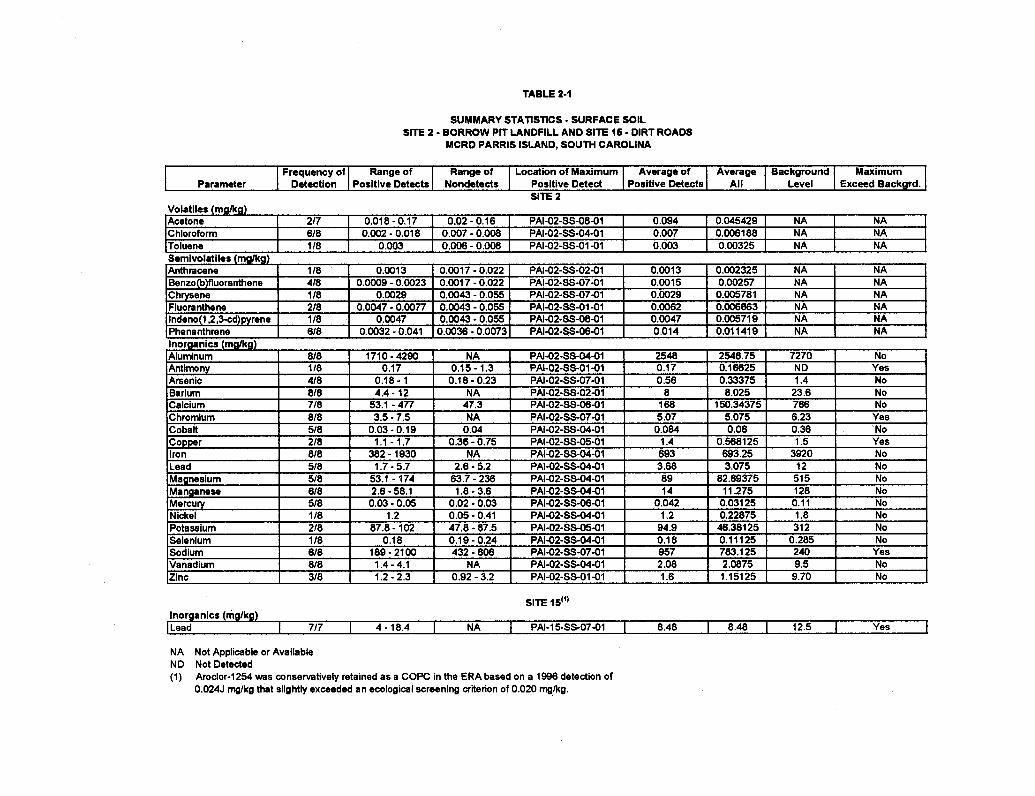
TABLE 2-1
SUMMARY STATISTICS - SURFACE SOIL SlTE 2 - BORROW PIT LANDFILL AND SlTE 15 - DIRT ROADS
MCRD PARRIS ISLAND, SOUTH CAROLINA
SlTE 16'"
Parameter
Inorganics (mglkg) I Lead I 717 I 4-18.4 1 N A I PAI-15-SS-07-01 I 8.48 1 8.48 1 12.5 1 Yes I NA Not Applicable or Available ND Not Detected (1) Aroclor-I 254 was conservatively retained as a COPC in the ERA based on a 1996 detection of
0.024J mglkg that slightly exceeded an ecological screening aibrion of 0.020 mglkg.
SlTE 2
Frequency of Detection
Range of Positive Detects
Range of Nondetects
Average of Positive Detects
Location of Maximum Positive Detect
Average All
Background Level
Maximum Exceed Backgrd.
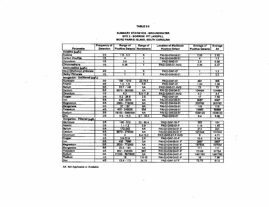
TABLE 2-2
SUMMARY STATISTICS - GROUNDWATER SITE 2 - BORROW PIT LANDFILL
MCRD PARRIS ISLAND, SOUTH CAROLINA
NA Not Applicable or Available
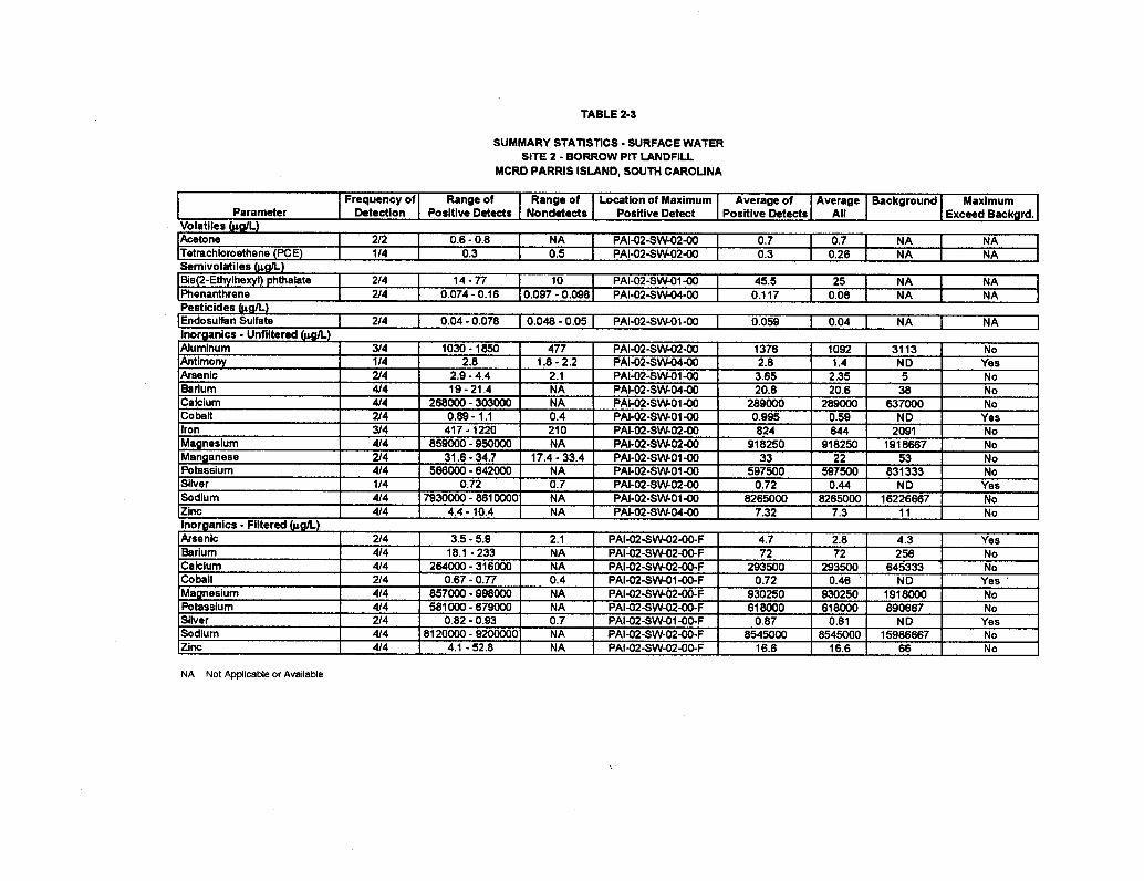
TABLE 2-3
SUMMARY STATISTICS - SURFACE WATER SITE 2 - BORROW PIT LANDFILL
MCRD PARRIS ISLAND, SOUTH CAROLINA
NA Not Applicable or Available
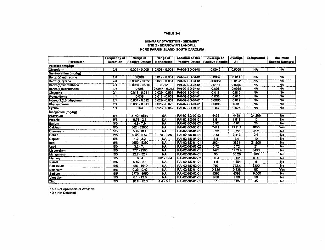
TABLE 2-4
SUMMARY STATISTICS - SEDIMENT SITE 2 - BORROW PIT LANDFILL
MCRD PARRIS ISLAND, SOUTH CAROLINA
NA = Not Applicable or Available ND = Not Detected
TABLE 2-6
SUMMARY STATISTICS - SEDIMENT SITE I S - DIRT ROADS
MCRD PARRIS ISLAND, SOUTH CAROLINA
NA = Not Applicable or Available ND = Not Detected
TABLE 2-6
CHEMICALS RETAINED AS HUMAN HEALTH COPCs SITE 2 - BORROW PIT LANDFILL
MCRD PARRIS ISLAND, SOUTH CAROLINA
UII-IIIIWI I I ~ U I I I wir I uruur~uwawr 1 I I I I dolatile Organlc Compounds lhlnrnfnrm 1 1 I 1 I Y I I I 1
Phs-ire1
Semlvolatl I I I I I I A I I I I I I I Y I
Ile Organic Compounds hnv\rl\ nhthalatn I I I I I I I v I 1
Surface Soil Subsurface Soll b C-11 A l -
I I , . I I 1
Manganese I I I I 1 X I I I 1
Soil to Groundwater Sedlment Surface Water Fish Tlssue t.--m.- As..-&--
Notes - X - Indicates chemical was retained as a COPC.
TABLE 2-7
SUMMARY OF CANCER RISKS AND HAZARD INDICES SITE 2 - BORROW PIT LANDFILL
W R D PARRIS ISLAND, SOUTH CAROLINA
Receptor Media Exposure Cancer Chemicals with Chemlcats with Chemicals with Hazard Chemlcals with Route Risk Cancer Rlsks *lo4 Cancer Rlsks >lo4 Cancer Risks >lo4 Index HI > I
Construction Worker Groundwater Dermal Contact 1 X - 0 8 - - -- 0.09 - Surface Water Ingestion 1.2E-08 -- -- - 0.003 --
Dermal Contact I BE46 -- -- Bis(2-Ethylhexy1)phthalate 0.45 -- Total 1.8E-06 - -- Bii(2-Ethylhexy1)phthalate 0.45 -- Total All Media 1.8E-06 0.54
Adolascent Recreational Surface Water Ingestion 1.1E-08 -- -. -- 0.0002 -- User Dermal Contact 4.4E-06 -- -- Bis(2-E1hylhexyl)phthalate 0.11 -
Total 4.6E-06 - -. Bis(2-Ethylhexynphthalate 0.1 1 - Adult Recreational User Surface Water Ingestion 4.2E-09 - - - 0.0002 -
Dermal Contact 2.6E-06 - - Bk(2-Ethylhexyl)pMhalate 0.1 I - Total 2.6E-06 - - Bis(2-Ethylhexy1)phthalate 0.11 -
Shellffsh Ingestion 1.4E-06 - - cPAHs 0.07 - Total All Media 4.OE-06 0.18
Child Resident Surface Water Ingestion Dermal Contact Total
Groundwater Ingestion Dermal Contact Inhalation Total Total All Media
Adult Resident Surface W e r Ingestion Dermal Contact - . .
I I l Total ITotal All Media
1.7E-08 - -- 0.0002 - I .OE* - Bis(ZIthylhexy()phthable 0.1 I - 1 .OE-05 - Bis(2-Ethylhexyl)phthalate 0.1 I - 2.1E-05 - Arsenic -- . ..= -- I .2 , --- . - .
1
TABLE 2 8
CHEMICALS RETAINED AS ERA STEP 2 ECOLOGICAL COPCs SITE 2 - BORROW PIT LANDFILL
MCRD PARRIS ISLAND, SOUTH CAROLINA
IC hemical I Surface Soil I Groundwater I Surface Water I Sediment I vocs
svocs :~is(2-ethylhexyl) phthalate I I X I X I I Inorganics
Silver I I I X I Vanadium X X I
X
Copper l ron Manganese Selenium
Zinc I I x I I I
X
X
X
X X X
X X
Acetone Carbon disulfide Chloroform l~etrachloroethene
X X X
X
Aluminum Antimony Barium Chromium (hexavalent) Cobalt
X
X
X
X
4
X X X
X
X
X X
X X X
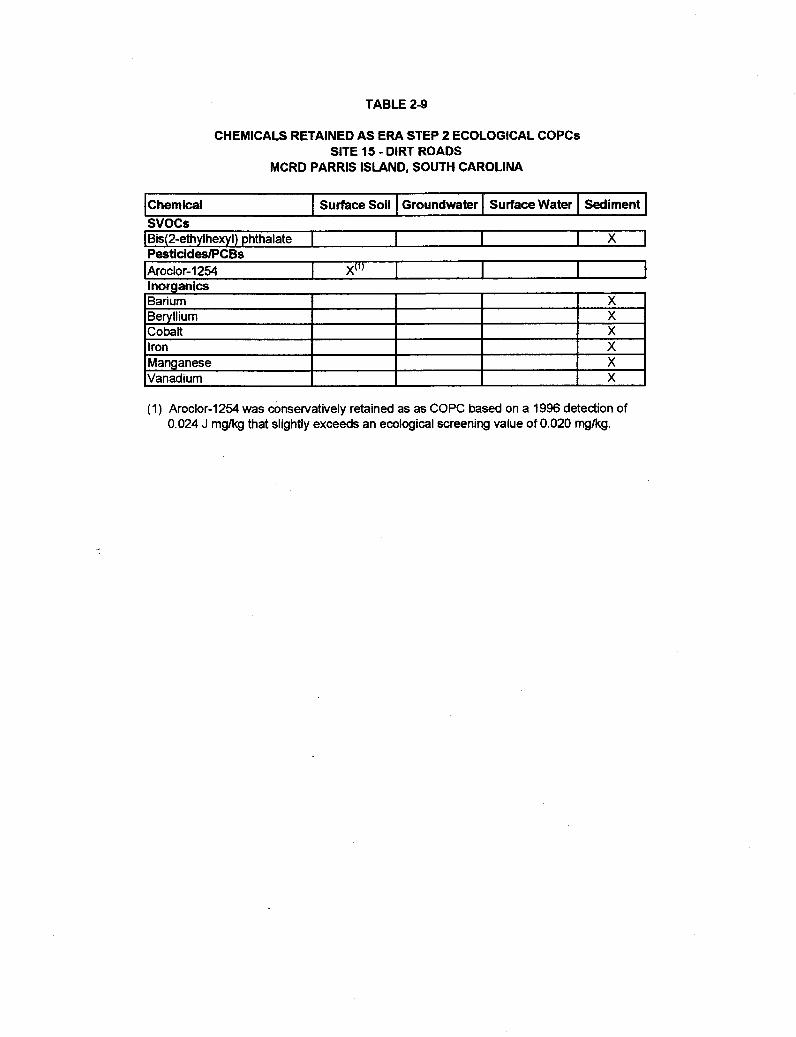
TABLE 2-9
CHEMICALS RETAINED AS ERA STEP 2 ECOLOGICAL COPCs SITE 15 - DIRT ROADS
MCRD PARRIS ISLAND, SOUTH CAROLINA
Chemical I Surface Soil I Groundwater I Surface Water I Sediment I - - - - -
I~is(2-ethylhexyl) phthalate I I I I X I PesticidesPCBs
lnorganics Barium Beryllium Cobalt
(1) Aroclor-1254 was conservatively retained as as COPC based on a 1996 detection of 0.024 J mglkg that slightly exceeds an ecological screening value of 0.020 mglkg.
X X X
Iron Manganese Vanadium
X X X
3.0 RESPONSIVENESS SUMMARY
3.1 STAKEHOLDER ISSUES AND LEAD AGENCY RESPONSES
No comments were made during the public information session for the Proposed Plan for NoAction/No Further Action at Sites 2 and 15. No written comments were received during the publiccomment period for the Proposed Plan. A description of the public review and comment periodactivities is included in Appendix A.
3-1REVISION 1
JUNE 2006
REFERENCES
Brown & Root Environmental, 1998a. RI/RFI/RI Work Plan for Sites/SWMUs 1, 2, 3, and 15 andSWMU 41, March.
Brown & Root Environmental, 1998b. Master Work Plan for MCRD Parris Island, South Carolina,Volumes I, II and III, March.
Calabrese, E. J. and L. A. Baldwin. 1993. Performing Ecological Risk Assessments, LewisPublishers, Chelsea, Michigan.
DON (Department of the Navy). 1999. Navy Policy for Conducting Ecological Risk Assessment.Office of the Chief of Naval Operations, Washington, D. C., April 6.
Glowacz, Michael E., Clyde M. Livingston, Curtis L. Gorman, and Charles R. Clyner, 1980.Economic and Environmental Impact of Land Disposal of Wastes in the Shallow Aquifers of theLower Coastal Plain of South Carolina; Vol. M11: Summary- Beaufort and Jasper Counties. SouthCarolina Department of Health and Environmental Control, Ground-Water Protection Division.
Ingersoll, C. G., T. Dillon, and G. R. Biddinger, 1997. Ecological Risk Assessment of ContaminatedSediments. SETAC Press, Pensacola, FL.
Kearney, A. T. Inc, 1990. RCRA Facility Assessment Report, MCRD Parris Island, South Carolina,April.
McClelland Consultants. May 25, 1990. Remedial Investigation, Verification Step, MCRD ParrisIsland, South Carolina, UIC M00263.
Naval Energy and Environmental Support Activity (NEESA), 1986. Initial Assessment Study ofMCRD Parris Island, South Carolina, NEESA13-095, September.
Stuck, W. M., 1980. Soil Survey of Beaufort and Jasper Counties. South Carolina. U. S. Departmentof Agriculture, Soil Conservation Service.
Suter, Glen W., 1993. "Ecological Risk Assessment"; Lewis Publishers, Chelsea, Michigan, 1993.
TtNUS, 1999. Work Plan Addendum - Test Pitting Operations at Site/SWMU 2 - Borrow PitLandfill, MCRD Parris Island, South Carolina, August 3.
TtNUS, 2000a. RCRA Facilities Investigation1 Remedial Investigation for Site/SWMU 2 - BorrowPit Landfill and Site/SWMU 15 - Dirt Roads, MCRD Parris Island, South Carolina, August.
TtNUS, 2000b. Proposed Plan for Site/SWMU 2 and Site/SWMU 15, No Action/No Further Action,MCRD Parris Island, South Carolina, August.
R-1REVISION 1
JUNE 2006
U.S. EPA (United States Environmental Protection Agency). 1989. Risk Assessment Guidance forSuperfund - Volume I - Human Health Evaluation Manual (Interim Final). EPA/540/1-89/002,Washington, D.C, December.
U.S. EPA (United States Environmental Protection Agency). 1992. Dermal Exposure andAssessment and Principles and Applications. EPA/600/8-91/011B, January.
U.S. EPA (United States Environmental Protection Agency). 1995a. Supplemental Region 4Guidance to RAGS: Human Health Risk Assessment. Atlanta, GA, November.
U.S. EPA (United States Environmental Protection Agency), 1995b. "Supplemental Guidance toRAGS: Region 4 Bulletins, Ecological Risk Assessment", Waste Management Division, Atlanta,Georgia, November.
U.S. EPA (United States Environmental Protection Agency). 1997. Ecological Risk AssessmentGuidance for Superfund: Process for Designing and Conducting Ecological Risk Assessments, June5, Edison, New Jersey.
U.S. EPA (United States Environmental Protection Agency). 1998. Ecological Risk Assessment atMilitary Bases: Process Considerations, Timing of Activities, and Inclusion of Stakeholders.Memorandum from Ted. N. Simon, Region 4 EPA Office of Technological Services, Atlanta,Georgia. December 22.
U.S. EPA (United States Environmental Protection Agency). 1999. U.S. EPA Contract LaboratoryProgram National Functional Guidelines for Organic Data Review. EPA-540/R-99/008(PB99-963506), Office of Emergency and Remedial Response, Washington, D.C., October.
U.S. EPA (United States Environmental Protection Agency). April 13, 2000. Risk-BasedConcentration Table. Philadelphia, PA.
Wentsel, R. S., T. W. LaPoint, M. Simini, R. T. Checkai, D. Ludwig, and LW. Brewer. 1996.Tri-Service Procedural Guidelines for Ecological Risk Assessments, Volume 1. Air Force Centerfor Environmental Excellence, Army Environmental Center, and Naval Facilities EngineeringService Center; U.S. Department of Defense. ADA314323.
R-2
APPENDIX A
RESPONSIVENESS SUMMARY
REVISION 1JUNE 2006
RESPONSIVENESS SUMMARY
A public comment period was held from August 10, 2000 to September 25, 2000 for the ProposedPlan for No Action/No Further Action at Sites 2 and 15. On August 10,2000, the Proposed Plan wasmade available to the public in the Information Repository at the Beaufort County Public Library'sHeadquarters Location at 311 Scott Street, Beaufort, South Carolina 29902. Public notice of theProposed Plan was also published in the Beaufort Gazette on August 11, 17, and 24, 2000. This localnewspaper targets the communities closest to MCRD Parris Island. Furthermore, a publicinformation session was held on August 24, 2000, to present the results of the RI, explain thepreferred remedy, and solicit comments from the community. At this information session,representatives from Southern Division Naval Facilities Engineering Command, MCRD ParrisIsland, U.S. EPA Region 4, and SCDHEC were available to discuss aspects of Sites 2 and 15.
No comments were made during the public information session and none were received during thepublic comment period.
A-1


