422
EPA/ROD/R09-99/046 1999 EPA Superfund Record of Decision: CAMP PENDLETON MARINE CORPS BASE EPA ID: CA2170023533 OU 03 CAMP PENDLETON, CA 02/11/1999
EPA/ROD/R09-99/0461999
EPA Superfund
Record of Decision:
CAMP PENDLETON MARINE CORPS BASEEPA ID: CA2170023533OU 03CAMP PENDLETON, CA02/11/1999
46612
MARINE CORPS BASE CAMP PENDLETON, CALIFORNIA
RECORD OF DECISIONOPERABLE UNIT 3
FINAL11 FEBRUARY 1999
iSCI/1 -98/WPC/Pendleton/R0D12199.wpd
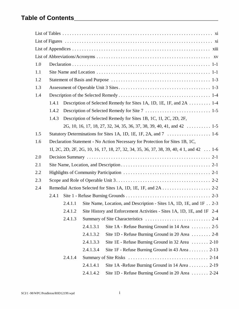
Table of Contents
List of Tables . . . . . . . . . . . . . . . . . . . . . . . . . . . . . . . . . . . . . . . . . . . . . . . . . . . . . . . . . . . . . . xi
List of Figures . . . . . . . . . . . . . . . . . . . . . . . . . . . . . . . . . . . . . . . . . . . . . . . . . . . . . . . . . . . . . xi
List of Appendices . . . . . . . . . . . . . . . . . . . . . . . . . . . . . . . . . . . . . . . . . . . . . . . . . . . . . . . . . xiii
List of Abbreviations/Acronyms . . . . . . . . . . . . . . . . . . . . . . . . . . . . . . . . . . . . . . . . . . . . . . . xv
1.0 Declaration . . . . . . . . . . . . . . . . . . . . . . . . . . . . . . . . . . . . . . . . . . . . . . . . . . . . . . . . . 1-1
1.1 Site Name and Location . . . . . . . . . . . . . . . . . . . . . . . . . . . . . . . . . . . . . . . . . . . . . . . 1-1
1.2 Statement of Basis and Purpose . . . . . . . . . . . . . . . . . . . . . . . . . . . . . . . . . . . . . . . . . 1-3
1.3 Assessment of Operable Unit 3 Sites . . . . . . . . . . . . . . . . . . . . . . . . . . . . . . . . . . . . . . 1-3
1.4 Description of the Selected Remedy . . . . . . . . . . . . . . . . . . . . . . . . . . . . . . . . . . . . . . 1-4
1.4.1 Description of Selected Remedy for Sites 1A, 1D, 1E, 1F, and 2A . . . . . . . . . 1-4
1.4.2 Description of Selected Remedy for Site 7 . . . . . . . . . . . . . . . . . . . . . . . . . . . 1-5
1.4.3 Description of Selected Remedy for Sites 1B, 1C, 1I, 2C, 2D, 2F,
2G, 10, 16, 17, 18, 27, 32, 34, 35, 36, 37, 38, 39, 40, 41, and 42 . . . . . . . . . . 1-5
1.5 Statutory Determinations for Sites 1A, 1D, 1E, 1F, 2A, and 7 . . . . . . . . . . . . . . . . . . 1-6
1.6 Declaration Statement - No Action Necessary for Protection for Sites 1B, 1C,
1I, 2C, 2D, 2F, 2G, 10, 16, 17, 18, 27, 32, 34, 35, 36, 37, 38, 39, 40, 4 1, and 42 . . . 1-6
2.0 Decision Summary . . . . . . . . . . . . . . . . . . . . . . . . . . . . . . . . . . . . . . . . . . . . . . . . . . . 2-1
2.1 Site Name, Location, and Description . . . . . . . . . . . . . . . . . . . . . . . . . . . . . . . . . . . . . 2-1
2.2 Highlights of Community Participation . . . . . . . . . . . . . . . . . . . . . . . . . . . . . . . . . . . . 2-1
2.3 Scope and Role of Operable Unit 3 . . . . . . . . . . . . . . . . . . . . . . . . . . . . . . . . . . . . . . . 2-2
2.4 Remedial Action Selected for Sites 1A, 1D, 1E, 1F, and 2A . . . . . . . . . . . . . . . . . . . . 2-2
2.4.1 Site 1 - Refuse Burning Grounds . . . . . . . . . . . . . . . . . . . . . . . . . . . . . . . . . . . 2-3
2.4.1.1 Site Name, Location, and Description - Sites 1A, 1D, 1E, and 1F . . 2-3
2.4.1.2 Site History and Enforcement Activities - Sites 1A, 1D, 1E, and 1F 2-4
2.4.1.3 Summary of Site Characteristics . . . . . . . . . . . . . . . . . . . . . . . . . . . 2-4
2.4.1.3.1 Site 1A - Refuse Burning Ground in 14 Area . . . . . . . . 2-5
2.4.1.3.2 Site 1D - Refuse Burning Ground in 20 Area . . . . . . . . 2-8
2.4.1.3.3 Site 1E - Refuse Burning Ground in 32 Area . . . . . . . 2-10
2.4.1.3.4 Site 1F - Refuse Burning Ground in 43 Area . . . . . . . . 2-13
2.4.1.4 Summary of Site Risks . . . . . . . . . . . . . . . . . . . . . . . . . . . . . . . . . 2-14
2.4.1.4.1 Site 1A -Refuse Burning Ground in 14 Area . . . . . . . . 2-19
2.4.1.4.2 Site 1D - Refuse Burning Ground in 20 Area . . . . . . . 2-24
iiSCI/1 -98/WPC/Pendleton/R0D12199.wpd
Table of Contents(Continued)
2.4.1.4.3 Site 1E - Refuse Burning Ground in 32 Area . . . . . . . 2-26
2.4.1.4.4 Site 1F - Refuse Burning Ground in 43 Area . . . . . . . . 2-28
2.4.2 Site 2A - Grease Disposal Pit in 14 Area . . . . . . . . . . . . . . . . . . . . . . . . . . . . 2-31
2.4.2.1 Site Name, Location, and Description . . . . . . . . . . . . . . . . . . . . . . 2-31
2.4.2.2 Site History and Enforcement Activities . . . . . . . . . . . . . . . . . . . . 2-32
2.4.2.3 Summary of Site Characteristics . . . . . . . . . . . . . . . . . . . . . . . . . . 2-32
2.4.2.3.1 Geology and Hydrogeology . . . . . . . . . . . . . . . . . . . . 2-33
2.4.2.3.2 Soil Results . . . . . . . . . . . . . . . . . . . . . . . . . . . . . . . . 2-33
2.4.2.4 Summary of Risks Associated with Site 2A . . . . . . . . . . . . . . . . . . 2-34
2.4.2.4.1 Human Health Risk Characterization . . . . . . . . . . . . . 2-34
2.4.2.4.2 Ecological Risk Assessment . . . . . . . . . . . . . . . . . . . . 2-35
2.4.3 Description of Alternatives - Sites 1A, 1D, 1E, 1F, and 2A . . . . . . . . . . . . . . 2-37
2.4.3.1 Alternative 1: No Action . . . . . . . . . . . . . . . . . . . . . . . . . . . . . . . . 2-37
2.4.3.2 Alternative 2: Excavation/Removal and On-Base Disposal . . . . . . . 2-38
2.4.3.3 Alternative 3: Excavation/Removal and Off-Base Disposal . . . . . . 2-39
2.4.4 Summary of Comparative Analysis of Alternatives - Sites 1A, 1D, 1E,
1F, and 2A . . . . . . . . . . . . . . . . . . . . . . . . . . . . . . . . . . . . . . . . . . . . . . . . . . 2-39
2.4.4.1 Threshold Criteria . . . . . . . . . . . . . . . . . . . . . . . . . . . . . . . . . . . . . 2-40
2.4.4.1.1 Overall Protection of Human Health and the
Environment . . . . . . . . . . . . . . . . . . . . . . . . . . . . . . . . 2-40
2.4.4.1.2 Compliance with ARARs. . . . . . . . . . . . . . . . . . . . . . . 2-40
2.4.4.2 Primary Balancing Criteria . . . . . . . . . . . . . . . . . . . . . . . . . . . . . . 2-41
2.4.4.2.1 Long-Term Effectiveness and Permanence . . . . . . . . . 2-41
2.4.4.2.2 Reduction of Toxicity, Mobility, and Volume
Through Treatment . . . . . . . . . . . . . . . . . . . . . . . . . . 2-41
2.4.4.2.3 Short-Term Effectiveness . . . . . . . . . . . . . . . . . . . . . . 2-41
2.4.4.2.4 Implementability . . . . . . . . . . . . . . . . . . . . . . . . . . . . . 2-42
2.4.4.2.5 Cost . . . . . . . . . . . . . . . . . . . . . . . . . . . . . . . . . . . . . . 2-42
2.4.4.3 Modifying Criteria . . . . . . . . . . . . . . . . . . . . . . . . . . . . . . . . . . . . . 2-43
2.4.4.3.1 State Acceptance . . . . . . . . . . . . . . . . . . . . . . . . . . . . 2-43
2.4.4.3.2 Community Acceptance . . . . . . . . . . . . . . . . . . . . . . . 2-43
2.4.5 Selected Remedy for OU3 Sites 1A, 1D, 1E, 1F, and 2A. . . . . . . . . . . . . . . . 2-43
Table of Contents (Continued)
iiiSC1/1-98/WPC/Pcndleto/R0D12199.wpd
2.4.6 Statutory Determinations . . . . . . . . . . . . . . . . . . . . . . . . . . . . . . . . . 2-46
2.4.6.1 Protection of Human Health and the Environment . . . . . . . 2-47
2.4.6.2 Compliance with Applicable or Relevant and Appropriate
Requirements . . . . . . . . . . . . . . . . . . . . . . . . . . . . . . . . . . 2-47
2.4.6.3 Cost-Effectiveness . . . . . . . . . . . . . . . . . . . . . . . . . . . . . . 2-47
2.4.6.4 Use of Permanent Solutions and Alternative Treatment
Technologies to the Extent Practicable . . . . . . . . . . . . . . . 2-47
2.5 Remedial Action Selected for Site 7 - Box Canyon Landfill . . . . . . . . . . . . . . 2-48
2.5.1 Site Name, Location, and Description - Site 7 . . . . . . . . . . . . . . . . . . 2-48
2.5.2 Site History and Enforcement Activities . . . . . . . . . . . . . . . . . . . . . . 2-49
2.5.3 Summary of Site Characteristics . . . . . . . . . . . . . . . . . . . . . . . . . . . . 2-49
2.5.3.1 Geology and Hydrogeology . . . . . . . . . . . . . . . . . . . . . . . . 2-50
2.5.3.2 Soil Results . . . . . . . . . . . . . . . . . . . . . . . . . . . . . . . . . . . . 2-53
2.5.3.3 Groundwater Results . . . . . . . . . . . . . . . . . . . . . . . . . . . . . 2-53
2.5.3.4 Ambient Air and Soil Gas Results . . . . . . . . . . . . . . . . . . . 2-55
2.5.4 Summary of Site Risks - Site 7 . . . . . . . . . . . . . . . . . . . . . . . . . . . . . 2-56
2.5.4.1 Human Health Risk Characterization . . . . . . . . . . . . . . . . . 2-56
2.5.4.2 Ecological Risk Assessment . . . . . . . . . . . . . . . . . . . . . . . 2-57
2.5.5 Description of Alternatives - Site 7 . . . . . . . . . . . . . . . . . . . . . . . . . . 2-57
2.5.6 Summary of Comparative Analysis of Alternatives - Site 7 . . . . . . . . 2-58
2.5.6.1 Overall Protection of Human Health and the Environment and
Compliance with ARARs . . . . . . . . . . . . . . . . . . . . . . . . . 2-58
2.5.6.2 Long-Tenn Effectiveness and Permanence . . . . . . . . . . . . . 2-58
2.5.6.3 Reduction of Toxicity, Mobility, and Volume Through
Treatment . . . . . . . . . . . . . . . . . . . . . . . . . . . . . . . . . . . . . 2-59
2.5.6.4 Short-Term Effectiveness . . . . . . . . . . . . . . . . . . . . . . . . . 2-59
2.5.6.5 Implementability . . . . . . . . . . . . . . . . . . . . . . . . . . . . . . . . 2-59
2.5.6.6 Cost . . . . . . . . . . . . . . . . . . . . . . . . . . . . . . . . . . . . . . . . . 2-59
2.5.6.7 State Acceptance . . . . . . . . . . . . . . . . . . . . . . . . . . . . . . . 2-60
2.5.6.8 Community Acceptance . . . . . . . . . . . . . . . . . . . . . . . . . . 2-60
2.5.7 Selected Remedy for Site 7 . . . . . . . . . . . . . . . . . . . . . . . . . . . . . . . . 2-60
2.5.8 Statutory Determinations . . . . . . . . . . . . . . . . . . . . . . . . . . . . . . . . . 2-63
2.5.8.1 Protection of Human Health and the Environment . . . . . . . 2-63
Table of Contents (Continued)
ivSC1/1-98/WPC/Pcndleto/R0D12199.wpd
2.5.8.2 Compliance with Applicable or Relevant and Appropriate
Requirements . . . . . . . . . . . . . . . . . . . . . . . . . . . . . . . . . . 2-63
2.5.8.3 Cost-Effectiveness . . . . . . . . . . . . . . . . . . . . . . . . . . . . . . 2-63
2.5.8.4 Use of Permanent Solutions and Alternative Treatment
Technologies to the Extent Practicable . . . . . . . . . . . . . . . 2-64
2.6 No Action Selected for Sites 1B, 1C, 1G, 1I, 2C, 2D, 2F, 2G, 10, 16, 17,
18, 27, 32. 34, 35, 36, 37, 38, 39, 40, 41, and 42 . . . . . . . . . . . . . . . . . . . . . 2-64
2.6.1 Site 1B - Refuse Burning Ground in 11 Area . . . . . . . . . . . . . . . . . . . 2-65
2.6.1.1 Site Name, Location, and Description . . . . . . . . . . . . . . . . 2-65
2.6.1.2 Site History and Enforcement Activities . . . . . . . . . . . . . . 2-65
2.6.1.3 Summary of Site Characteristics . . . . . . . . . . . . . . . . . . . . 2-65
2.6.1.3.1 Geology and Hydrogeology . . . . . . . . . . . . . . 2-66
2.6.1.3.2 Soil Results . . . . . . . . . . . . . . . . . . . . . . . . . . 2-66
2.6.1.4 Summary of Risks Associated with Site 1B . . . . . . . . . . . . 2-66
2.6.1.4.1 Human Health Risk Characterization . . . . . . . 2-67
2.6.1.4.2 Ecological Risk Assessment . . . . . . . . . . . . . . 2-67
2.6.1.5 Description of the No Action Alternative . . . . . . . . . . . . . . 2-68
2.6.2 Site 1C - Refuse Burning Ground in 13 Area . . . . . . . . . . . . . . . . . . . 2-68
2.6.2.1 Site Name, Location, and Description . . . . . . . . . . . . . . . . 2-68
2.6.2.2 Site History and Enforcement Activities . . . . . . . . . . . . . . 2-69
2.6.2.3 Summary of Site Characteristics . . . . . . . . . . . . . . . . . . . . 2-69
2.6.2.3.1 Geology and Hydrogeology . . . . . . . . . . . . . . 2-70
2.6.2.3.2 Soil Results . . . . . . . . . . . . . . . . . . . . . . . . . . 2-70
2.6.2.4 Summary of Risks Associated with Site 1C . . . . . . . . . . . . 2-71
2.6.2.4.1 Human Health Risk Characterization . . . . . . . 2-71
2.6.2.4.2 Ecological Risk Assessment . . . . . . . . . . . . . . 2-72
2.6.2.5 Description of the No Action Alternative . . . . . . . . . . . . . . 2-72
2.6.3 Site 1I - Refuse Burning Ground in 63 Area . . . . . . . . . . . . . . . . . . . 2-72
2.6.3.1 Site Name, Location, and Description . . . . . . . . . . . . . . . . 2-72
2.6.3.2 Site History and Enforcement Activities . . . . . . . . . . . . . . 2-73
2.6.3.3 Summary of Site Characteristics . . . . . . . . . . . . . . . . . . . . 2-74
Table of Contents (Continued)
vSC1/1-98/WPC/Pcndleto/R0D12199.wpd
2.6.3.3.1 Geology and Hydrogeology . . . . . . . . . . . . . . 2-74
2.6.3.3.2 Soil Results . . . . . . . . . . . . . . . . . . . . . . . . . . 2-74
2.6.3.4 Summary of Risks Associated with Site 11 . . . . . . . . . . . . 2-75
2.6.3.4.1 Human Health Risk Characterization . . . . . . . 2-75
2.6.3.4.2 Ecological Risk Assessment . . . . . . . . . . . . . . 2-76
2.6.3.5 Description of the No Action Alternative . . . . . . . . . . . . . . 2-76
2.6.4 Site 2C - Grease Disposal Pit in 33 Area . . . . . . . . . . . . . . . . . . . . . . 2-77
2.6.4.1 Site Name, Location, and Description . . . . . . . . . . . . . . . . 2-77
2.6.4.2 Site History and Enforcement Activities . . . . . . . . . . . . . . 2-78
2.6.4.3 Summary of Site Characteristics . . . . . . . . . . . . . . . . . . . . 2-78
2.6.4.3.1 Geology and Hydrogeology . . . . . . . . . . . . . . 2-78
2.6.4.3.2 Soil Results . . . . . . . . . . . . . . . . . . . . . . . . . . 2-79
2.6.4.4 Summary of Risks Associated with Site 2C . . . . . . . . . . . . 2-81
2.6.4.4.1 Human Health Risk Characterization . . . . . . . 2-81
2.6.4.4.2 Ecological Risk Assessment . . . . . . . . . . . . . . 2-82
2.6.4.5 Description of the No Action Alternative . . . . . . . . . . . . . . 2-83
2.6.5 Site 2D - Grease Disposal Pit in 43 Area . . . . . . . . . . . . . . . . . . . . . . 2-83
2.6.5.1 Site Name, Location, and Description . . . . . . . . . . . . . . . . 2-83
2.6.5.2 Site History and Enforcement Activities . . . . . . . . . . . . . . 2-84
2.6.5.3 Summary of Site Characteristics . . . . . . . . . . . . . . . . . . . . 2-84
2.6.5.3.1 Geology and Hydrogeology . . . . . . . . . . . . . . 2-84
2.6.5.3.2 Soil Results . . . . . . . . . . . . . . . . . . . . . . . . . . 2-85
2.6.5.3.3 Groundwater Results . . . . . . . . . . . . . . . . . . . 2-85
2.6.5.3.4 Ecological Results . . . . . . . . . . . . . . . . . . . . . 2-85
2.6.5.3.5 Summary . . . . . . . . . . . . . . . . . . . . . . . . . . . . 2-86
2.6.5.4 Summary of Risks Associated with Site 2D . . . . . . . . . . . . 2-86
2.6.5.4.1 Human Health Risk Characterization . . . . . . . 2-86
2.6.5.4.2 Ecological Risk Assessment . . . . . . . . . . . . . . 2-88
2.6.5.5 Description of the No Action Alternative . . . . . . . . . . . . . . 2-88
2.6.6 Site 2F - Grease Disposal Pit in 62 Area . . . . . . . . . . . . . . . . . . . . . . 2-89
2.6.6.1 Site Name, Location, and Description . . . . . . . . . . . . . . . . 2-89

Table of Contents (Continued)
viSC1/1-98/WPC/Pcndleto/R0D12199.wpd
2.6.6.2 Site History and Enforcement Activities . . . . . . . . . . . . . . 2-90
2.6.6.3 Summary of Site Characteristics . . . . . . . . . . . . . . . . . . . . 2-90
2.6.6.3.1 Geology and Hydrogeology . . . . . . . . . . . . . . 2-90
2.6.6.3.2 Soil Results . . . . . . . . . . . . . . . . . . . . . . . . . . 2-91
2.6.6.4 Summary of Risks Associated with Site 2F . . . . . . . . . . . . 2-92
2.6.6.4.1 Human Health Risk Characterization . . . . . . . 2-92
2.6.6.4.2 Ecological Risk Assessment . . . . . . . . . . . . . . 2-93
2.6.6.5 Description of the No Action Alternative . . . . . . . . . . . . . . 2-94
2.6.7 Site 2G - Grease Disposal Pit in 31 Area . . . . . . . . . . . . . . . . . . . . . . 2-94
2.6.7.1 Site Name, Location, and Description . . . . . . . . . . . . . . . . 2-94
2.6.7.2 Site History and Enforcement Activities . . . . . . . . . . . . . . 2-95
2.6.7.3 Summary of Site Characteristics . . . . . . . . . . . . . . . . . . . . 2-95
2.6.7.3.1 Geology and Hydrogeology . . . . . . . . . . . . . . 2-95
2.6.7.3.2 Soil Results . . . . . . . . . . . . . . . . . . . . . . . . . . 2-96
2.6.7.3.3 Groundwater Results . . . . . . . . . . . . . . . . . . . 2-96
2.6.7.3.4 Summary . . . . . . . . . . . . . . . . . . . . . . . . . . . . 2-96
2.6.7.4 Summary of Risks Associated with Site 2G . . . . . . . . . . . . 2-96
2.6.7.4.1 Human Health Risk Characterization . . . . . . . 2-97
2.6.7.4.2 Ecological Risk Assessment . . . . . . . . . . . . . . 2-97
2.6.7.5 Description of the No Action Alternative . . . . . . . . . . . . . . 2-98
2.6.8 Site 10 - 26 Area Sewage Sludge Composting Yard . . . . . . . . . . . . . 2-99
2.6.8.1 Site Name, Location, and Description . . . . . . . . . . . . . . . . 2-99
2.6.8.2 Site History and Enforcement Activities . . . . . . . . . . . . . 2-100
2.6.8.3 Summary of Site Characteristics . . . . . . . . . . . . . . . . . . . 2-100
2.6.8.3.1 Geology and Hydrogeology . . . . . . . . . . . . . 2-101
2.6.8.3.2 Soil Results . . . . . . . . . . . . . . . . . . . . . . . . . 2-102
2.6.8.3.3 Groundwater Results . . . . . . . . . . . . . . . . . . 2-103
2.6.8.3.4 Biota Results . . . . . . . . . . . . . . . . . . . . . . . . 2-104
2.6.8.3.5 Summary . . . . . . . . . . . . . . . . . . . . . . . . . . . 2-104
2.6.8.4 Summary of Risks Associated with Site 10 . . . . . . . . . . . 2-104
2.6.8.4.1 Human Health Risk Characterization . . . . . . 2-104
Table of Contents (Continued)
viiSC1/1-98/WPC/Pcndleto/R0D12199.wpd
2.6.8.4.2 Ecological Risk Assessment . . . . . . . . . . . . . 2-106
2.6.8.5 Description of the No Action Alternative . . . . . . . . . . . . . 2-107
2.6.9 Site 16 - 22 Area Buildings 22151 and 22187 Ditch Confluence and
Ditch . . . . . . . . . . . . . . . . . . . . . . . . . . . . . . . . . . . . . . . . . . . . . . . . 2-108
2.6.9.1 Site Name, Location, and Description . . . . . . . . . . . . . . . 2-108
2.6.9.2 Site History and Enforcement Activities . . . . . . . . . . . . . 2-109
2.6.9.3 Summary of Site Characteristics . . . . . . . . . . . . . . . . . . . 2-110
2.6.9.3.1 Geology and Hydrogeology . . . . . . . . . . . . . 2-110
2.6.9.3.2 Soil Results . . . . . . . . . . . . . . . . . . . . . . . . . 2-111
2.6.9.3.3 Groundwater Results . . . . . . . . . . . . . . . . . . 2-113
2.6.9.3.4 Surface-Water and Sediment Results . . . . . . 2-113
2.6.9.3.5 Biota Results . . . . . . . . . . . . . . . . . . . . . . . . 2-113
2.6.9.4 Summary of Risks Associated with Site 16 . . . . . . . . . . . 2-114
2.6.9.4.1 Human Health Risk Characterization . . . . . . 2-114
2.6.9.4.2 Ecological Risk Assessment . . . . . . . . . . . . . 2-115
2.6.9.5 Description of the No Action Alternative . . . . . . . . . . . . . 2-118
2.6.10 Site 17 - 22 Area Building 22187 Marsh and Ditch . . . . . . . . . . . . . 2-118
2.6.10.1 Site Name, Location, and Description . . . . . . . . . . . . . . . 2-118
2.6.10.2 Site History and Enforcement Activities . . . . . . . . . . . . . 2-119
2.6.10.3 Summary of Site Characteristics . . . . . . . . . . . . . . . . . . . 2-120
2.6.10.3.1 Geology and Hydrogeology . . . . . . . . . . . . . 2-120
2.6.10.3.2 Surface-Water and Sediment Results . . . . . . 2-121
2.6.10.4 Summary of Risks Associated with Site 17 . . . . . . . . . . . 2-121
2.6.10.5 Description of the No Action Alternative . . . . . . . . . . . . . 2-123
2.6.11 Site 18 - 13/16 Area Building 1687 Spill and Ditch . . . . . . . . . . . . . 2-123
2.6.11.1 Site Name, Location, and Description . . . . . . . . . . . . . . . 2-123
2.6.11.2 Site History and Enforcement Activities . . . . . . . . . . . . . 2-124
2.6.11.3 Summary of Site Characteristics . . . . . . . . . . . . . . . . . . . 2-124
2.6.11.3.1 Geology and Hydrogeology . . . . . . . . . . . . . 2-124
2.6.11.3.2 Soil Results . . . . . . . . . . . . . . . . . . . . . . . . . 2-125
2.6.11.4 Summary of Risks Associated with Site 18 . . . . . . . . . . . 2-125
2.6.11.4.1 Human Health Risk Characterization . . . . . . 2-126
Table of Contents (Continued)
viiiSC1/1-98/WPC/Pcndleto/R0D12199.wpd
2.6.11.4.2 Ecological Risk Assessment . . . . . . . . . . . . . 2-127
2.6.11.5 Description of the No Action Alternative . . . . . . . . . . . . . 2-127
2.6.12 Site 27 - 22 Area Ditches Behind Building 22210 . . . . . . . . . . . . . . 2-128
2.6.12.1 Site Name, Location, and Description . . . . . . . . . . . . . . . 2-128
2.6.12.2 Site History and Enforcement Activities . . . . . . . . . . . . . 2-129
2.6.12.3 Summary of Site Characteristics . . . . . . . . . . . . . . . . . . . 2-129
2.6.12.3.1 Geology and Hydrogeology . . . . . . . . . . . . . 2-130
2.6.12.3.2 Surface-Water and Sediment Results . . . . . . 2-130
2.6.12.3.3 Biota Results . . . . . . . . . . . . . . . . . . . . . . . . 2-131
2.6.12.4 Summary of Risks Associated with Site 27 . . . . . . . . . . . 2-131
2.6.12.4.1 Human Health Risk Characterization . . . . . . 2-131
2.6.12.4.2 Ecological Risk Assessment . . . . . . . . . . . . . 2-131
2.6.12.5 Description of the No Action Alternative . . . . . . . . . . . . . 2-133
2.6.13 Site 32 - Drum Storage Area and Drainage Between Buildings
41303
and 41366 . . . . . . . . . . . . . . . . . . . . . . . . . . . . . . . . . . . . . . . . . . . . 2-133
2.6.13.1 Site Name, Location, and Description . . . . . . . . . . . . . . . 2-133
2.6.13.2 Site History and Enforcement Activities . . . . . . . . . . . . . 2-134
2.6.13.3 Summary of Site Characteristics . . . . . . . . . . . . . . . . . . . 2-135
2.6.13.3.1 Geology and Hydrogeology . . . . . . . . . . . . . 2-135
2.6.13.3.2 Soil Results . . . . . . . . . . . . . . . . . . . . . . . . . 2-136
2.6.13.3.3 Groundwater Results . . . . . . . . . . . . . . . . . . 2-136
2.6.13.3.4 Summary . . . . . . . . . . . . . . . . . . . . . . . . . . . 2-136
2.6.13.4 Summary of Risks Associated with Site 32 . . . . . . . . . . . 2-137
2.6.13.4.1 Human Health Risk Characterization . . . . . . 2-137
2.6.13.4.2 Ecological Risk Assessment . . . . . . . . . . . . . 2-138
2.6.13.5 Description of the No Action Alternative . . . . . . . . . . . . . 2-139
2.6.14 Site 34 - Combat Engineers Maintenance Facility, Buildings 62580-
62583 . . . . . . . . . . . . . . . . . . . . . . . . . . . . . . . . . . . . . . . . . . . . . . . 2-139
2.6.14.1 Site Name, Location, and Description . . . . . . . . . . . . . . . 2-139
2.6.14.2 Site History and Enforcement Activities . . . . . . . . . . . . . 2-140
2.6.14.3 Summary of Site Characteristics . . . . . . . . . . . . . . . . . . . 2-141
2.6.14.3.1 Geology and Hydrogeology . . . . . . . . . . . . . 2-141
ixSC1/1-98/WPC/Pendleto/ROD12199.wpd
Table of Contents(Continued)2.6.14.3.2 Soil Results. . . . . . . . . . . . . . . . . . . . . . . . . . . . . . . . . . . . . . 2-141
2.6.14.3.3 Groundwater Results . . . . . . . . . . . . . . . . . . . . . . . . . . . . 2-142
2.6.14.3.4 Summary . . . . . . . . . . . . . . . . . . . . . . . . . . . . . . . . . . . . . 2-142
2.6.14.4 Summary of Risks Associated with Site 34 . . . . . . . . . . . . . . . . . . . . . . 2-143
2.6.14.4.1 Human Health Risk Characterization . . . . . . . . . . . . . . . . 2-143
2.6.14.4.2 Ecological Risk Assessment . . . . . . . . . . . . . . . . . . . . . . . 2-145
2.6.14.5 Description of the No Action Alternative . . . . . . . . . . . . . . . . . . . . . . . . 2-146
2.6.15 Site 35 - Former Sewage Treatment Plant Facility in 25 Area . . . . . . . . . . . . . . . . . 2-146
2.6.15.1 Site Name, Location, and Description . . . . . . . . . . . . . . . . . . . . . . . . . . 2-146
2.6.15.2 Site History and Enforcement Activities . . . . . . . . . . . . . . . . . . . . . . . . . 2-147
2.6.15.3 Summary of Site Characteristics . . . . . . . . . . . . . . . . . . . . . . . . . . . . . . 2-148
2.6.15.3.1 Geology and Hydrogeology . . . . . . . . . . . . . . . . . . . . . . . . 2-148
2.6.15.3.2 Soil Results . . . . . . . . . . . . . . . . . . . . . . . . . . . . . . . . . . . 2-149
2.6.15.3.3 Groundwater Results . . . . . . . . . . . . . . . . . . . . . . . . . . . . 2-150
2.6.15.4 Summary of Risks Associated with Site 35 . . . . . . . . . . . . . . . . . . . . . . 2-151
2.6.15.4.1 Human Health Risk Characterization . . . . . . . . . . . . . . . . 2-151
2.6.15.4.2 Ecological Risk Assessment . . . . . . . . . . . . . . . . . . . . . . . 2-151
2.6.15.5 Description of the No Action Alternative . . . . . . . . . . . . . . . . . . . . . . . . 2-152
2.6.16 Site 36 - Debris Pile Area Behind Ponds at Sewage Treatment Plant 11 . . . . . . . . . . 2-153
2.6.16.1 Site Name, Location, and Description . . . . . . . . . . . . . . . . . . . . . . . . . . 2-153
2.6.16.2 Site History, Enforcement Activities, and Site Characteristics . . . . . . . . 2-153
2.6.16.3 Summary of Risks Associated with Site 36 . . . . . . . . . . . . . . . . . . . . . . 2-154
2.6.16.4 Description of the No Action Alternative . . . . . . . . . . . . . . . . . . . . . . . . 2-154
2.6.17 Site 37 - Pesticide- and POL-Handling Areas at San Clemente Ranch . . . . . . . . . . . 2-154
2.6.17.1 Site Name, Location, and Description . . . . . . . . . . . . . . . . . . . . . . . . . . 2-154
2.6.17.2 Site History and Enforcement Activities . . . . . . . . . . . . . . . . . . . . . . . . . 2-155
2.6.17.3 Summary of Site Characteristics . . . . . . . . . . . . . . . . . . . . . . . . . . . . . . 2-156
2.6.17.3.1 Geology and Hydrogeology . . . . . . . . . . . . . . . . . . . . . . . . 2-156
2.6.17.3.2 Soil Results . . . . . . . . . . . . . . . . . . . . . . . . . . . . . . . . . . . 2-156
2.6.17.3.3 Groundwater Results . . . . . . . . . . . . . . . . . . . . . . . . . . . . 2-157
2.6.17.3.4 Summary . . . . . . . . . . . . . . . . . . . . . . . . . . . . . . . . . . . . . 2-158
xSC1/1-98/WPC/Pendleto/ROD12199.wpd
Table of Contents(Continued)2.6.17.4 Summary of Risks Associated with Site 37 . . . . . . . . . . . . . . . . . . . . . . 2-158
2.6.17.4.1 Human Health Risk Characterization . . . . . . . . . . . . . . . . 2-158
2.6.17.4.2 Ecological Risk Assessment . . . . . . . . . . . . . . . . . . . . . . . 2-160
2.6.17.5 Description of the No Action Alternative . . . . . . . . . . . . . . . . . . . . . . . . 2-160
2.6.18 Sites 38, 39, 41, and 42 . . . . . . . . . . . . . . . . . . . . . . . . . . . . . . . . . . . . . . . . . . . . . 2-161
2.6.18.1 Site Name, Location, Description, and History . . . . . . . . . . . . . . . . . . . . 2-161
2.6.18.2 Summary of Site Characteristics . . . . . . . . . . . . . . . . . . . . . . . . . . . . . . 2-162
26.18.3 Summary of Risks Associated with Sites 38, 39, 41, and 42 . . . . . . . . . . 2-162
2.6.18.4 Description of the No Action Alternative . . . . . . . . . . . . . . . . . . . . . . . . 2-163
2.6.19 Site 40 - 13 Area Sewer Line, Building 13103 . . . . . . . . . . . . . . . . . . . . . . . . . . . . 2-163
2.6.19.1 Site Name, Location, and Description . . . . . . . . . . . . . . . . . . . . . . . . . . 2-163
2.6.19.2 Site History and Enforcement Activities . . . . . . . . . . . . . . . . . . . . . . . . . 2-164
2.6.19.3 Summary of Site Characteristics . . . . . . . . . . . . . . . . . . . . . . . . . . . . . . 2-165
2.6.19.3.1 Geology and Hydrogeology . . . . . . . . . . . . . . . . . . . . . . . . 2-165
2.6.19.3.2 Analytical Results . . . . . . . . . . . . . . . . . . . . . . . . . . . . . . . . . 2-165
2.6.19.4 Summary of Risks Associated with Site 40 . . . . . . . . . . . . . . . . . . . . . . 2-165
2.6.19.4.1 Human Health Risk Characterization . . . . . . . . . . . . . . . . 2-166
2.6.19.4.2 Ecological Risk Assessment . . . . . . . . . . . . . . . . . . . . . . . 2-166
2.6.19.5 Description of the No Action Alternative . . . . . . . . . . . . . . . . . . . . . . . . 2-167
3.0 Responsiveness Summary . . . . . . . . . . . . . . . . . . . . . . . . . . . . . . . . . . . . . . . . . . . . . . . . . . . . . . . . 3-1
4.0 References . . . . . . . . . . . . . . . . . . . . . . . . . . . . . . . . . . . . . . . . . . . . . . . . . . . . . . . . . . . . . . . . . . . 4-1
xiSC1/1-98/WPC/Pendleto/ROD10-27.wpd
List of Tables Table Title
2-1 Remedial Action Goals for Soil at Sites 1A, 1D, 1E, 1F, and 2A
List of FiguresFigure Title
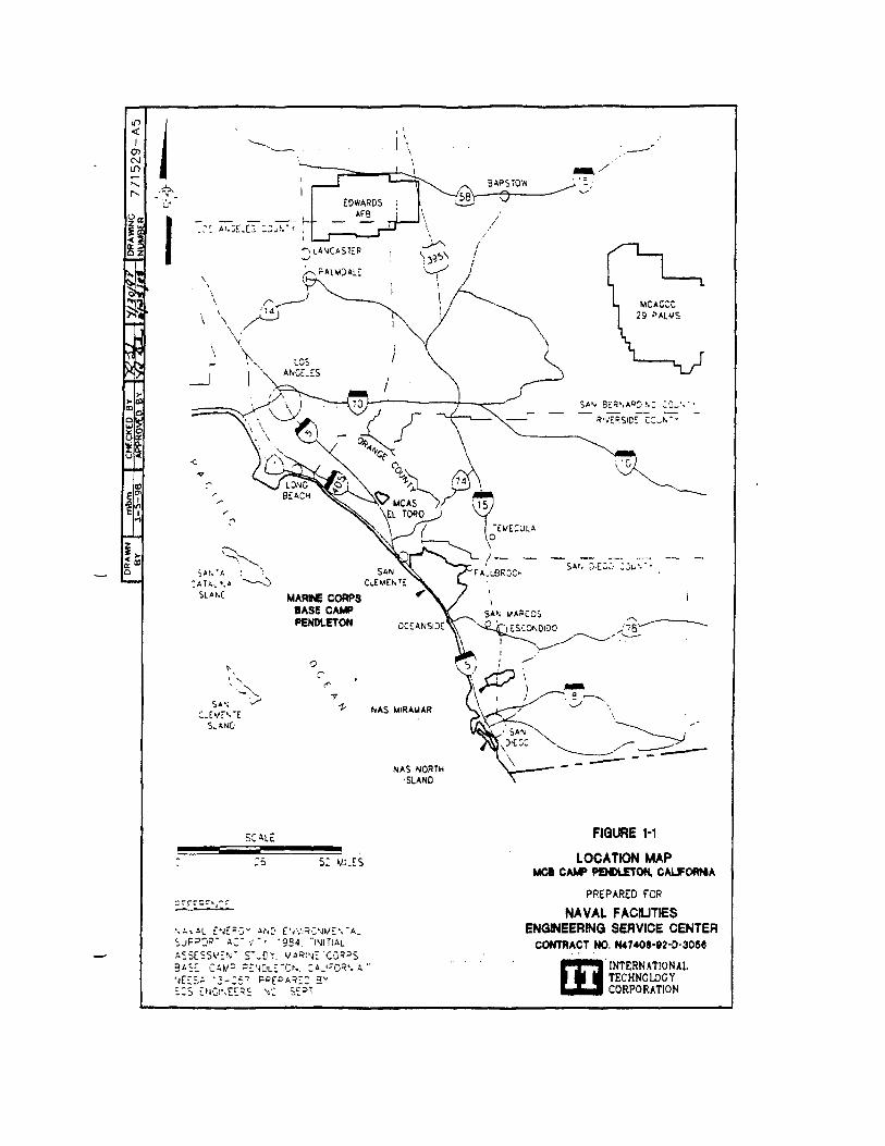
1-1 Location Map
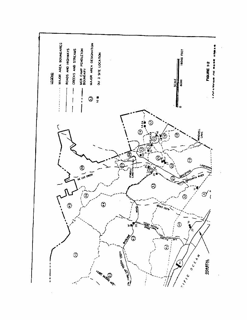
1-2 Locations of Base Areas and Operable Unit 3 Sites
2-1 Site 1A - Refuse Burning Ground in 14 Area, Summary of Soil and Groundwater Analytical Results
2-2 Site 1D - Refuse Burning Ground in 20 Area, Summary of Soil and Groundwater Analytical Results
2-3 Site 1E - Refuse Burning Ground in 32 Area, Summary of Soil Analytical Results
2-4 Site 1F- Refuse Burning Ground in 43 Area, Summary of Soil and Groundwater Analytical Results
2-5 Site 2A - Grease Disposal Pit in 14 Area, Summary of Soil Analytical Results
2-6 Site 1A - Refuse Burning Ground in 14 Area, Excavation Area
2-7 Site 1D - Refuse Burning Ground in 20 Area, Excavation Area
2-8 Site 1E - Refuse Burning Ground in 20 Area, Excavation Area
2-9 Site 1F - Refuse Burning Ground in 43 Area, Excavation Area
2-10 Site 2A - Grease Disposal Pit in 14 Area, Excavation Area
2-11 Site 7 - Box Canyon Landfill Soil and Groundwater Sample Locations and Summary of Groundwater Analytical Results
2-12 Site 7 - Evapotranspiration Cover System Profile
2-13 Site 1B - Refuse Burning Ground in 11 Area, Summary of Soil Analytical Results
xiiSC1/1-98/WPC/Pendleto/ROD10-27.wpd
List of Figures (Continued)
2-14 Site 1C - Refuse Burning Ground in 13 Area, Summary of Soil Analytical Results
2-15 Site 11 - Refuse Burning Ground in 63 Area, Summary of Soil Analytical Results
2-16 Site 2C - Grease Disposal Pit in 33 Area, Summary of Soil AnalyticalResults
2-17 Site 2D - Grease Disposal Pit in 43 Area, Summary of Soil and Groundwater Analytical Results
2-18 Site 2F - Grease Disposal Pit in 62 Area, Summary of Soil AnalyticalResults
2-19 Site 2G - Grease Disposal Pit in 31 Area, Summary of Soil andGroundwater Analytical Results
2-20 Site 10 - 26 Area Sewage Sludge Composting Yard, Summary of Soil and Groundwater Analytical Results for Human Health
2-21 Site 10 - 26 Area Sewage Sludge Composting Yard, Summary of SoilAnalytical Results with Ecological Hazard Quotients $1.0
2-22 Site 16 - 22 Area Buildings 22151 and 22187 Ditch Confluence and Ditch, Summary of Soil Analytical Results for Human Health
2-23 Site 16 - 22 Area Buildings 22151 and 22187 Ditch Confluence and Ditch, Summary of Soil, Sediment, and Surface-Water Analytical Results with Ecological Hazard Quotients $1.0
2-24 Site 17 - 22 Area Building 22187 Marsh and Ditch, Summary ofSurface-Water and Sediment Analytical Results with Ecological Hazard Quotients $1.0
2-25 Site 18 - 13/16 Area Building 1687 Spill and Ditch, Summary of Soil Analytical Results
2-26 Site 27 - 22 Area Ditches Behind Building 22210, Summary ofSurface-Water and Sediment Analytical Results with Ecological Hazard Quotients $1.0
2-27 Site 32 - Drum Storage Area and Drainage Between Buildings 41303 and 41366, Summary of Soil and Groundwater Analytical Results
2-28 Site 34 - Combat Engineers Maintenance Facility, Building 62580-62583, Summary of Soil and Groundwater Analytical Results
xiiiSC1/1-98/WPC/Pendleto/ROD10-27.wpd
List of Figures (continued)
2-29 Site 34 - Combat Engineers Maintenance Facility, Buildings 62580- 62583, Summary of Soil Analytical Results with Hazard Quotients $1.0
2-30 Site 35 - Former Sewage Treatment Plant Facility in 25 Area,Summary of Soil and Groundwater Analytical Results
2-31 Site 36 - Debris Pile Area Behind Ponds at Sewage Treatment Plant 11,Summary of Soil Analytical Results
2-32 Site 37 - Pesticide- and POL-Handling Areas at San Clemente Ranch,Summary of Soil and Groundwater Analytical Results
2-33 Site 38 - 52 Area Sewer Line, Building 52188. Summary of Soil Analytical Results
2-34 Site 39 - 41 Area Sewer Line, Buildings 41300 and 41346, Summary of Soil Analytical Results
2-35 Sites 41 and 42 - 13 Area Sewer Lines, Summary of Soil Analytical Results
2-36 Site 40 - 13 Area Sewer Line, Building 13103, Summary of Soil Analytical Results
List of Appendices
Appendix A Transcript of the Public Meeting
Appendix B Applicable or Relevant and Appropriate Requirements
Appendix C Administrative Record Index
xivSC1/1-98/WPC/Pendleto/ROD10-27.wpd
(intentionally blank)
List of Abbreviations/Acronyms
xvSCI/10-98/WPC/Pendleto/ROD10-27.wpd
APCD Air Pollution Control District
AC/S,ES Assistant Chief of Staff, Environmental Security
ARAR Applicable or Relevant and Appropriate Requirement
AWQC Aquatic Water-Quality Criteria
Cal/EPA California Environmental Protection Agency
Cal/OSHA California Occupational Safety and Health Administration
CAMU Corrective Action Management Unit
CERCLA Comprehensive Environmental Response, Compensation,and Liability Act of 1980
CFR Code of Federal Regulations
COC Chemical of Concern
COEC Chemical of Ecological Concern
COPC Chemical of Potential Concern
COPEC Chemical of Potential Ecological Concern
CRDL Contract Required Detection Limit
DCA Dichloroethane
DCE Dichloroethene
DDD Dichlorodiphenyldichloroethene
DDE Dichlorodiphenylethene
DDT Dichlorodiphenyltrichloroethene
DI WET Deionized Water Waste Extraction Test
DLM Designated Level Methodology
DTSC Department of Toxic Substances Control
EcoRA Ecological Risk Assessment
EE/CA Engineering Evaluation/Cost Analysis
EPA U.S. Environmental Protection Agency
FFA Federal Facility Agreement
FID Flame-Ionization Detector
FS Feasibility Study
HEAST Health Effects Assessment Summary Tables
List of Abbreviations/Acronyms (Continued)
xviSCI/10-98/WPC/Pendleto/ROD10-27.wpd
HHRA Human Health Risk Assessment
HI Hazard Index
HpCDD Heptachlorodibenzo-dioxins
HpCDF Heptachlodibenzofuran
HQ Hazard Quotient
HxCDD Hexachlorodibenzo-p-dioxins
IAS Initial Assessment Study
IDL Instrument Detection Limit
ILCR Incremental Lifetime Cancer Risk
IRIS Integrated Risk Information System
IRP Installation Restoration Program
Jacobs Jacobs Engineering Group Inc.
LUFT Leaking Underground Fuel Tank
MCAS Marine Corp Air Station
MCB Marine Corps Base
MCL Maximum Contaminant Level (Federal or State)
MCTSSA Marine Corps Tactical System Support Activity
mg/dl Milligrams per Deciliter
mg/kg Milligrams per Kilogram
mg/kg-day Milligrams per Kilogram per Day
mg/l Milligrams per Liter
msl Mean Sea Level
NCP National Oil and Hazardous Substances Pollution Contingency Plan
NEESA Naval Energy and Environmental Support Activity (currently NFESC)
NOAEL No Observed Adverse Effect Level
NPL National Priorities List
OU Operable Unit
List of Abbreviations/Acronyms (Continued)
xviiSCI/10-98/WPC/Pendleto/ROD10-27.wpd
PAH Polycyclic Aromatic Hydrocarbons
PCB Polychlorinated Biphenyl
PCE Tetrachloroethene
PCP Pentachlorophenol
PLE Preliminary Limit of Exposure
POL Petroleum, Oil, and Lubricants
PPE Personal Protective Equipment
ppm Parts per Million
PR Preliminary Review
PRG Preliminary Remediation Goal
RAGS Remedial Action Guidance for Superfund
RAO Remedial Action Objective
RCRA Resource Conservation and Recovery Act
RFA RCRA Facility Assessment
RfD Reference Dose
RI Remedial Investigation
RI/FS Remedial Investigation/Feasibility Study
RME Reasonable Maximum Exposure
ROD Record of Decision
RWQCB California Regional Water Quality Control Board
SARA Superfund Amendments and Reauthorization Act of 1986
SCS Soil Conservation Service
SF Slope Factor
SPLP Synthetic Precipitation Leaching Procedure
SV Sampling Visit
SVOC Semivolatile Organic Compound
SWDIV Southwest Division Naval Facilities Engineering Command
SWRCB California State Water Resources Control Board
List of Abbreviations/Acronyms (Continued)
xviiiSCI/10-98/WPC/Pendleto/ROD10-27.wpd
TAL Target Analyte List
TCA Trichloroethane
TCE Trichloroethene
TCLP Total Concentration Leaching Procedure
TPH Total Petroleum Hydrocarbons
TSS Total Suspended Solids
TVH Total Volatile Hydrocarbons
UCL Upper Confidence Limit
UST Underground Storage Tank
VOC Volatile Organic Compound
Fg/kg Micrograms per Kilogram
Fg/l Micrograms per Liter
1-1SCI/1-98/WPC/Pendleto/ROD12199.wpd
1.0 Declaration
This Record of Decision (ROD) addresses 28 sites that constitute Operable Unit (OU) 3 at
Marine Corps Base (MCB) Camp Pendleton, California.
1.1 Site Name and Location
MCB Camp Pendleton is located along the Pacific coast, about halfway between Los Angeles and
San Diego (Figure 1-1). The vast majority of the base is within San Diego County, and a small
portion of the northwest corner of the base is in Orange County.
Installation Restoration Program (IRP) sites at MCB Camp Pendleton were assigned to one of
four groups (A, B, C, and D) during the investigation phase according to potential impact to
human health and the environment. Group A sites were believed to have the highest potential for
such impact; Group D sites have the lowest. OU3 includes the following sites from Groups B, C,
and D:
• Group B: Site 7 soil and groundwater
• Group C: Sites 1D, 1E, 2A, 10, and 35 soil and groundwater; Sites 16 and 27 soil;and Site 17 sediment and surface water
• Group D: Sites 1A, 1B, 1C, 1F, 1I ,2C, 2D, 2F, 2G, 18, 32, 34, 36, 37, 38, 39, 40,41, and 42 soil and groundwater.
The base is divided into 35 major area designations for location of base activities. The OU3 sites
are located in various areas throughout the base, as shown in Figure 1-2. The OU3 site names are
as follows:
• Site 1A - Refuse Burning Ground in 14 Area• Site 1B - Refuse Burning Ground in 11 Area• Site 1C - Refuse Burning Ground in 13 Area• Site 1D - Refuse Burning Ground in 20 Area• Site 1E - Refuse Burning Ground in 32 Area
1-2SCI/1-98/WPC/Pendleto/ROD12199.wpd
• Site 1F - Refuse Burning Ground in 43 Area• Site 1I - Refuse Burning Ground in 63 Area• Site 2A - Grease Disposal Pit in 14 Area• Site 2C - Grease Disposal Pit in 33 Area• Site 2D - Grease Disposal Pit in 43 Area• Site 2F - Grease Disposal Pit in 62 Area• Site 2G - Grease Disposal Pit in 31 Area• Site 7 - Box Canyon Landfill• Site 10 - 26 Area Sewage Sludge Composting Yard• Site 16 - 22 Area Buildings 22151 and 22187 Ditch Confluence and Ditch• Site 18 - 22 Area Building 22187 Marsh and Ditch• Site 19 - 13/16 Area Building 1687 Spill and Ditch• Site 27 - 22 Area Ditches Behind Building 22210• Site 32 - Drum Storage Area and Drainage Between Buildings 41303 and 41366• Site 34 - Combat Engineers Maintenance Facility, Buildings 62580-62583• Site 35 - Former Sewage Treatment Plant Facility in 25 Area• Site 36 - Debris Pile Area Behind Ponds at Sewage Treatment Plant II• Site 37 - Pesticide- and POL-Handling Areas at San Clemente Ranch• Site 38 - 52 Area Sewer Line, Building 52188• Site 39 - 41 Area Sewer Line, Buildings 41300 and 41346• Site 40 - 13 Area Sewer Line, Building 13103• Site 41 - 13 Area Sewer Line, Building 13128• Site 42 - 13 Area Sewer Line, Building 13129.
Sites 1G, 2E, 29, 1H, and 30 were also originally included in OU3 in accordance with the Federal
Facility Agreement (FFA) (U.S. Environmental Protection Agency [EPA], 1990a; as amended).
Site 1G is part of Site 14 - San Onofre Landfill, an active disposal facility that was removed from
the Comprehensive Environmental Response, Compensation, and Liability Act (CERCLA)
process. Therefore, Site IG was also removed from the CERCLA process and will be addressed
with Site 14 under the State's landfill program. Site 2E - Grease Disposal Pit in 53 Area, could
not be located during surveying, historical aerial photograph surveys, or during field
reconnaissance. If in the future Site 2E is located, it will be addressed as a new site. Site 29 - 25
Area Skeet Range, is an active facility and no plans have been made for its closure. Site 29 has
been excluded from CERCLA in an amendment to the FFA (EPA, 1998) and will be addressed in
accordance with the Department of Defense range rule, which is in draft form and is currently
available for public comment. Site 1H - Refuse Burning Ground in 62 Area and Site 30 - Firing
1-3SCI/1-98/WPC/Pendleto/ROD12199.wpd
Range Soil Fill in 31 Area have been moved to OU4 in order to further address site-specific
technical issues.
1.2 Statement of Basis and Purpose
This decision document presents the selected remedial actions for Sites 1A, 1D, 1E, 1F, 2A, and
7. In addition, this document sets forth the basis for the no action decisions for Sites 1B, 1C, 1I,
2C, 2D, 2F, 2G, 10, 16, 17, 18, 27, 32, 34, 35, 36, 37, 38, 39, 40, 41, and 42. The actions
selected for these sites were chosen in accordance with CERCLA 1980, as amended by the
Superfund Amendments and Reauthorization Act (SARA) of 1986, and to the extent practicable,
the National Oil and Hazardous Substances Pollution Contingency Plan (NCP).
The decisions for these sites are based on the information contained in the administrative record
file for MCB Camp Pendleton. The primary documents used for the basis of the decisions are the
remedial investigation (RI) report for Group C sites (1 November 1996), the RI for Group D sites
(16 July 1997), and the RI and feasibility study (FS) report for OU3 (12 December 1997).
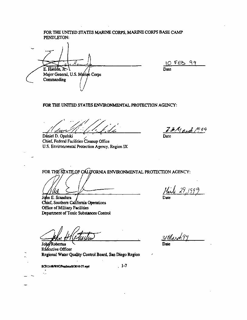
The U.S. Marine Corps, the EPA, the Department of Toxic Substances Control (DTSC) and the
San Diego Regional Water Quality Control Board (RWQCB) of the California Environmental
Protection Agency (Cal/EPA) concur with the selected remedy for each OU3 site.
1.3 Assessment of Operable Unit 3 Sites
In accordance with the EPA's Interim Final Guidance on Preparing Superfund Decision
Documents (EPA, 1989a), this assessment section applies only to Sites 1A, 1D, 1E, 1F, 2A, and 7
and not to the sites in this ROD requiring no further action.
If Sites 1A, 1D, 1E, 1F, 2A, and 7 are not addressed by implementing the response actions
selected in this ROD, actual or threatened releases of hazardous substances from these sites could
present current or potential future threats to the public health, welfare, or the environment.
1-4SCI/1-98/WPC/Pendleto/ROD12199.wpd
1.4 Description of the Selected Remedy
RI sites at MCB Camp Pendleton were separated into four groups (Groups A, B, C, and D) for
investigation based on potential impact to human health and the environment. As investigations
were completed, sites were grouped into OUs for selection of cleanup alternatives. The ROD for
OU1 was signed in December 1995 and addresses the selected remedies for soil and groundwater
at Site 9, soil at Site 4/4A, and soil and groundwater at Site 24, all of which are Group A Sites.
The ROD for OU2 was signed in September 1997 and includes 13 Group A, Group B, and Group
C sites. These sites include Sites 2B and 31 soil; Sites 28 and 43 groundwater; Site 3 soil,
sediment, and surface water; Site 5 soil and groundwater; Sites 19, 20, and 22 soil, sediment,
groundwater, and surface water; Sites 8A and 44 sediment and surface water; and Sites 6 and 45
soil, sediment, and surface water.
This ROD addresses the remedies for OU3, which includes sites from Groups B, C, and D, as
listed in Section 1.1. Descriptions of the selected remedies for OU3 sites are presented in the
following sections.
1.4.1 Description of Selected Remedy for Sites 1A, ID, 1E, 1F, and 2A
The same remedy, excavation and on-base disposal, was selected for Sites 1A, 1D, 1E, 1F, and
2A. The major components of the selected remedy are as follows:
• Excavation of contaminated soils; for ecological concerns the maximum excavationdepth is 5 feet and for human health concerns the maximum excavation depth is10 feet.
• Confirmation sampling on bottom and side walls of excavation in accordance withEPA guidance Methods for Evaluating the Attainment of Cleanup Standards,Volume I: Soils and Media, PB89-234959.
• Transportation to and disposal of soil that meets the technical and legalrequirements (i.e., specified in 40 CFR 264.552[c]) at an on-basc landfill, IR Site7 - Box Canyon Landfill, a designated CAMU
1-5SCI/1-98/WPC/Pendleto/ROD12199.wpd
• Backfilling, of the excavation with clean soil upon confirmation that cleanup goalshave been met; if goals have not been met at the maximum excavation depths. i.e.,5 feet for ecological concerns and 10 feet for human health concerns, 5 or 10 feetof clean fill will be placed as relevant.
• Site regrading and revegetating.
The low-level threats posed by the contaminants at the sites specified are addressed by removing
the contaminated soils and/or eliminating the exposure pathway.
1.4.2 Description of Selected Remedy for Site 7
An evapotranspiration (ET) cover was selected as the final remedy for the Site 7 landfill closure.
The major components of the selected remedy are as follows:
• Installation of an ET cover consisting of a vegetated topsoil layer, a minimallycompacted soil layer, and a compacted low-permeability bottom layer.
• Installation of lined ditches between the landfill benches on the north face of thelandfill.
• Long-term monitoring.
• Land use restrictions.
The low-level threats posed by the contaminants at Site 7 are addressed through containment of
the wastes, elimination of exposure pathways, and continued monitoring and maintenance.
1.4.3 Description of Selected Action for Sites 1B, 1C, 1I, 2C, 2D, 2F, 2G, 1010, 16, 17, 18, 27, 32, 34, 35, 36, 37, 38, 39, 40, 41, and 42
No action was selected for soil and groundwater at Sites 1B, 1C, 1I, 2C, 2D, 2F, 2G, 10, 18, 32,
34, 35, 36, 37, 38, 39, 40, 41, and 42. No action was also selected for soil, sediment, and surface
water at Site 16 and for sediment and surface water at Sites 17 and 27.
1-6SCI/1-98/WPC/Pendleto/ROD12199.wpd
1.5 Statutory Determinations for Sites 1A, 1D, 1E, 1F, 2A, and 7
The remedies selected for Sites 1A, 1D, 1E, 1F, 2A, and 7 use permanent solutions to the
maximum extent practicable. The remedy for Sites 1A, 1D, 1E, 1F, and 2A will not result in
hazardous substance remaining on site because contaminated soil will be removed. Therefore, no
5-year reviews are required. At Site 7, landfilled wastes remain in place and 5-year reviews will be
conducted to ensure protection of human health and the environment.
The selected remedies are protective of human health and the environment, comply with Federal
and State requirements that are legally applicable or relevant and appropriate to the remedial
actions, and are cost-effective.
1.6 Declaration Statement - No Action Necessary for Protection for Sites 1B,1C, 1I, 2C, 2D, 2F, 2G, 10, 16, 17, 18, 27, 32, 34, 35, 36, 37, 38, 39, 40, 41, and42
No unacceptable human health or ecological risks are presented by soil and groundwater at
Sites 1B, 1C, 1I, 2C, 2D, 2F, 2G, 10, 18, 32, 34, 35, 36, 37, 38, 39, 40, 41, and 42; soil, surface
water, and sediment at Sites 16; or sediment and surface water at Sites 17 and 27. Therefore, no
remedial action is necessary to ensure protection of human health and the environment.
Consequently, 5-year reviews are not required for these sites.
SCI/10-98/WPC/Pendleto/ROD10-27.wpd 2-1
2.0 Decision Summary
General information about MCB Camp Pendleton and information common to the individual sites are
presented first in this section, followed by information specific to each site. The general discussion includes
a general site description, site history and enforcement activities, the scope and role of OU3, and the history
of community participation.
2.1 Site Name, Location, and Description
MCB Camp Pendleton is the primary Marine Corps amphibious training center on the west coast. Located
between the cities of Los Angeles and San Diego, California, MCB Camp Pendleton covers approximately
125,000 acres, almost entirely in San Diego County (Figure 1-1). Camp Talega, in the 64 Area near the
northwestern border of the base, extends into Orange County. Surrounding communities include San
Clemente to the northwest, Fallbrook to the east, and Oceanside to the south. The base is bordered on the
west by the Pacific Ocean and encompasses 17 miles of coastal area; rolling hills and valleys stretch inland
from the coast an average of 10 to 12 miles.
Site History and Enforcement
Construction of MCB Camp Pendleton started in March 1942, and the base was dedicated as a permanent
base in October 1944. The base currently supports more than 36,000 military personnel and employs
approximately 4,600 civilians (Innis-Tennebaum Architects, Inc., 1990).
On 15 November 1989, MCB Camp Pendleton was added to the National Priorities List (NPL), primarily
because a herbicide was detected in two base drinking water production wells.
2.2 Highlights of Community Participation
The proposed plan for OU3 was released to the public on 1 May 1998. This document and supporting
documents were made available to the public in the information repositories at the Base Library and the
Oceanside Public Library. The public was also made aware of the availability of these documents in the
Administrative Record file, which is maintained at the Southwest Division Navy offices in San Diego. The
notice of availability for the proposed plan and supporting documents was published in the North County
Times, both Inland and Coastal Editions, the Sun Post News, and the Scout newspapers on 1 May 1998.
In addition, a public meeting was held on
SCI/10-98/WPC/Pendleto/ROD10-27.wpd 2-2
14 May 1998. Base, EPA, San Diego RWQCB, and Southwest Division Navy representatives attended the
public meeting. No members of the public attended the meeting. A verbatim transcript of the pubic meeting
was prepared in compliance with CERCLA Section 117(a)(2) and is presented in Appendix A. No
comments were received during the public comment period or the public meeting.
2.3 Scope end Role of Operable Unit 3
For investigative purposes, the sites at MCB Camp Pendleton were assigned to groups based on their
potential impact to human health and the environment. Those sites that pose the highest threat were
addressed first and were designated Group A sifts. OU1 consists of Group A Sites 9 and 24 soil and
groundwater and Site 4/4A soil. The final ROD for OU1 (Southwest Division Naval Facilities Engineering
Command [SWDIV], 1995a) was signed on 12 December 1995.
Other sites with lesser degrees of potential threat were investigated as Group B, C, or D sites. The OU2
ROD includes sites from Groups A, B, and C as follows:
• Group A Sites: Site 3 soil, sediment, and groundwater, Site 5 soil and groundwater; Site 6soil, sediment, and surface water
• Group B Sites: Site 8A sediment and surface water, Sites 19, 20, and 22 soil, sediment,groundwater, and surface water
• Group C sites: Sites 2B and 31 soil; Sites 28 and 43 groundwater; Site 44 sediment andsurface water, Site 45 soil, sediment, and groundwater.
The final OU2 ROD was signed and issued on 30 September 1997 (SWDIV, 1997a).
OU3 includes 29 sites as listed in Section 1.1. OU4 includes groundwater at the 22/23 Area sites plus Sites
1H, 21, 30, 33, and 1111. The final ROD for OU4 is scheduled for December 1999.
2.4 Remedial Action Selected for Site 1A, 1D, 1E, 1F, and 2A
This section addresses five of the six OU3 sites requiring remedial action. Sites 1A, 1D, 1E, 1F, and 2A
are discussed together due to the similar nature of the remedial actions proposed for each site. Site 7, the
other OU3 site requiring remedial action, is presented separately in Section 2.5. A description of each site
is provided, followed by a summary of site characteristics and potential site risks. In general, only those
parameters that exceed screening criteria are shown in the site-
SCI/10-98/WPC/Pendleto/ROD10-27.wpd 2-3
specific figures because the decision was made to pursue remedial action for these sites. A description of
the alternatives evaluated for each site, a summary of the evaluation, and the rationale for selection of the
remedies follow the site descriptions, characteristics, and risks. Four of the sites (Sites 1A, 1D, 1E, and 1F)
are former refuse burning grounds and one site (Site 2A) is a former grease disposal pit.
2.4.1 Site 1-Refuse Burning Grounds
Four refuse burning grounds located throughout the base. Sites 1A, 1D, 1E, and 1F, require remedial
action. These four burning grounds are discussed concurrently.
2.4.1.1 Site Name, Location, and Description - Site 1A, 1D, 1E, and 1F
Site 1 - Refuse Burning Grounds, consists of nine different areas that were used as burning grounds for
base refuse. The nine burning grounds are labeled 1A through 1I (Figure 1-2) following the convention
used in the initial assessment study (IAS) (Naval Energy and Environmental Support Activity [NEESA],
1984). One of the burning grounds, Site 1G, is part of the San Onofre landfill (Site 14), which has been
removed from the CERCLA process and is addressed under the State's landfill program. Four of the
burning grounds require remediation and are discussed in this section. No action has been selected for the
other four burning grounds, as discussed in Section 2.5.
Site 1A is located in a densely vegetated, undeveloped training region in 14 Area, immediately northeast of
base sewage treatment plant No. 1 (Figure 2-1). The 14 Area burning ground is no longer in operation and
land surrounding the site is covered with natural vegetation. The nearest troop housing is approximately
0.25 mile west of the site and the nearest family housing, De Luz Housing, is approximately 2 miles north
of the site.
Site 1D is located in 20 Area, immediately north of the intersection of Vandegrift Boulevard and Stuart
Mesa Road (Figure 2-2). The burning ground covers an area of approximately 400 by 220 feet.
Surrounding the site on the east and south are plateaus that rise 150 feet above the burning ground. The site
is bordered on the north and west by relatively flat land containing moderate to dense vegetation; the Santa
Margarita River flows through this area. To the northeast is the Box Canyon landfill; to the south, across
Stuart Mesa Road, is the Twin Lake Sewage Disposal Plant. An unpaved road runs along the northern
boundary of the site.
SCI/10-98/WPC/Pendleto/ROD10-27.wpd 2-4
Site 1E is located in 32 Area, along MACS Road, approximately 0.75 mile northwest of Stuart Mesa
Road, and approximately 3,000 feet from the Santa Margarita River (Figure 2-3). The burning ground
covers an area of approximately 200 by 120 feet.
Site 1F is located in 43 Area, approximately 250 feet northeast of Basilone Road and immediately
northwest of its intersection with Las Pulgas Road (Figure 2-4). The burning ground covers an area of
approximately 275 by 280 feet. The site is bordered on the southeast by Sites 2D and 20, on the north and
east by moderate to dense vegetation, and on the west and south by vegetation and Basilone Road. The site
slopes gently to the southeast and eventually drains into Pulgas Creek. The surrounding area generally
consists of low rolling hills.
2.4.1.2 Site History and Enforcement Activities - Sites 1A, 1D, 1E and 1F
The refuse burning grounds were used from 1942 through the early 1970s to bum refuse generated by base
operations. The areas were not necessarily operated concurrently (NEESA, 1984). No information is
available on the specific years of operation or the volume of refuse disposed of by burning at each burning
ground. Until 1970, a refuse at the base was disposed of by burning. The entire base generated an estimated
20,000 to 28,000 tons of solid wastes annually, the entire volume of which is assumed to have been
distributed to the nine burning grounds.
Although them are no confirmed reports of hazardous waste disposal at these sites, the burning grounds
were the primary on-base disposal areas and, thus, could have been used for disposal of hazardous wastes.
The refuse burning grounds were closed sometime between the late 1960s and 1971. The burning grounds
were covered with native soil and allowed to revert to natural vegetation. Visual inspection of the sites
during 1994 revealed no evidence of environmental contamination (NEESA, 1984). However, the cover
material has since eroded, thereby exposing refuse at some of the sites. Areas of stressed vegetation and
stains have also been observed.
2.4.1.3 Summary of Site Characteristics
This section describes the investigations performed at Sites 1A, 1D, 1E, and 1F and summarizes the
geology/hydrogeology and sampling results for each.
2-5SCI/10-98/WPC/Pendleto/ROD10-27.wpd
2.4.1.3.1 Site 1A - Refuse Burning Ground in 14 Area
A Phase 1 RI was conducted during June and July 1996 and a Phase 2 RI was conducted from May
through June 1997 at Site 1A. Characterization of the site involved surface and subsurface soil and
groundwater sampling to evaluate potential contamination from the burning ground and impact to human
health and ecological receptors. Detailed results of the Phase 1 RI are presented in the draft final Group D
RI report (SWDIV, 1997b) and results of the Phase 2 RI are presented in Appendix A of the draft final
RI/FS for OU3 (SWDIV, 1998a). The results of these investigations are summarized in this section.
A total of 18 soil samples, including 2 duplicates, were collected from six soil boring locations during
Phase 1. Sample locations am shown on Figure 2-1. Samples were analyzed for target analyte list (TAL)
metals, molybdenum, chromium VI, volatile organic compounds (VOCs), semivolatile organic compounds
(SVOCs), pesticides and polychlorinated biphenyls (PCBs), and dioxins and furans. During Phase 2, a
composite surface soil sample was collected from locations 1AB-01, 1AB-02, and 1AB-03 and a surface
sample was collected from location 1AB-05. These samples were split for TAL metals plus molybdenum
analyses and lettuce and earthworm bioassay studies.
One temporary well was drilled adjacent to boring location 1AB-01 as part of the Phase 1 investigation. A
groundwater sample was collected at the water table (about 5.5 feet below ground surface) and analyzed
for TAL metals, molybdenum, chromium VI, VOCs, SVOCs, and general chemistry.
Habitat receptor surveys and habitat mapping were conducted at Site 1A during June 1996 and May 1997.
Dominant vegetation types and corresponding wildlife were identified and mapped. Wildlife surveys and
small mammal trapping were also conducted in May 1997. Sherman live-traps were used. Trapped animals
were identified, marked with a nontoxic marker, and released in the location where they were trapped.
Special-status species surveys for the arroyo toad, the California gnatcatcher, and the least Bell’s vireo
were conducted at Site 1A in late spring and early summer 1997. Also during May 1997, terrestrial
invertebrate samples, plant samples, and small mammal samples were collected in the vicinity of sample
locations 1AB-01, 1AB-02, 1AB-03, and 1AB-05. Nine plant tissue samples,
2-6SCI/10-98/WPC/Pendleto/ROD10-27.wpd
two invertebrate samples, and two mammal tissue samples were analyzed for TAL metals plus
molybdenum. Sample locations are shown in Figure 2-1.
Geology and Hydrogeology
Geologic data were derived from the site boring logs. Shallow geology consists of unconsolidated to poorly
consolidated alluvium overlying granitic rock. The alluvium consists of silty sand from ground surface to
maximum depth of 18 feet. The remainder of the alluvium consists of fine- to medium-grained sand.
Groundwater was encountered between 5.4 and 18.6 feet. No perennial surface water is present in the
vicinity of the Site 1A burning ground.
Soil Results
The analytical results for soil samples collected during the Phase 1 and Phase 2 RI am summarized in
Figure 2-1.
Organics
With the exception of benzo(a)pyrene, no organic compounds were detected at concentrations exceeding
preliminary remediation goals (PRGs) in soil samples from Site 1A. Benzo(a)pyrene was detected at a
concentration of 0.3 milligram per kilogram (mg/kg) in the duplicate sample from a depth of 10 feet in
boring 1AB-02; this concentration is below the contract-required detection limit (CRDL) but exceeds the
PRG of 0.061 mg/kg.
Acetone was detected at a depth of 5 feet in two borings; the maximum concentration was 0.005 mg/kg.
Trichloroethene (TCE) was detected at a concentration of 0.01 mg/kg at 5 feet in boring 1AB-02. Benzoic
acid was detected in the surface sample from boring 1AB-05 at a concentration of 0.094 mg/kg. Low
concentrations of eight polycyclic aromatic hydrocarbons (PAHs) were detected in the duplicate sample at
the 10-foot interval of boring 1AB-02; the highest PAH concentration detected was 0.5 mg/kg for
benzo(k)fluoranthene. Chlorinated pesticides (4.4'-DDD, 4,4'-DDE, and 4,4'-DDT) were generally detected
at low concentrations from ground surface to 10 feet; the maximum concentration was 0.2 mg/kg.
Concentrations of 4,4'-DDE in soil samples collected from 1AB-01, 1AB-02, and 1AB-05 and 4,4'-DDT in
soil samples collected from 1AB-01 exceeded preliminary limits of exposure (PLEs). No other organic
compounds exceeded PLEs.
2-7SCI/10-98/WPC/Pendleto/ROD10-27.wpd
Inorganics
Six metals were detected at concentrations exceeding PRGs: arsenic, beryllium, copper, lead, manganese,
and thallium. In general, arsenic concentrations were near background levels and were higher in the
northern portion of the site. Five arsenic detections exceeded the background concentration. Lead exceeded
the PRG and background in 10 samples. Lead concentrations were generally higher in the northeastern
portion of the site. The remaining four parameters exceeded PRGs only once each, at depths from ground
surface to 5 feet. Of these four parameters, beryllium was below background.
The following 16 inorganic constituents were detected at concentrations exceeding PLEs: antimony,
arsenic, barium, boron, cadmium chromium, copper, iron, lead, manganese, mercury, molybdenum,
selenium, thallium, vanadium and zinc. Inorganic constituents were detected in all six soil sampling
locations (1AB-01 through 1AB-06) at concentrations exceeding PLEs. The maximum concentrations of
the 16 metals detected also exceeded background concentrations.
Groundwater Result
Groundwater results from the sample collected from temporary well 1AGWT-01 are summarized in the
following paragraphs. Only detections above PRGs or MCLs are shown in Figure 2-1.
No organic compounds exceeded maximum contaminant levels (MCLs) or tap-water PRGs. Two organic
compounds, acetone and benzoic acid, were detected at concentrations of 1 and 7 micrograms per liter
(µg/l), respectively.
With the exception of manganese, no inorganics were detected at concentrations exceeding the evaluation
criteria. Manganese was detected at a concentration of 2,200 µg/l, which exceeds the tap-water PRG of
1,700 µg/l.
Manganese has been detected in groundwater throughout MCB Camp Pendleton. In general, manganese
concentrations have been higher in hydropunch samples than in samples from permanent monitoring wells,
possibly because silts and total suspended solids (TSS) am not as efficiently filtered in undeveloped
temporary wells and hydropunch samples compared with fully developed permanent wells. Because
temporary well and hydropunch samples typically contain more suspended solids, more nondissolved
particles pass through the filter. Some manganese
2-8SCI/10-98/WPC/Pendleto/ROD10-27.wpd
particles may be small enough to pass through the 0.45-micron filter used in the field (Hem, 1985).
2.4.1.3.2 Site 1D - Refuse Burning Ground in 20 Area
RI work was conducted at Site 1D between December 1993 and October 1995 and between May and July
1997. The RI involved surface and subsurface soil, groundwater, and biological sampling to evaluate
potential contamination from the burning ground and impact to human health and the environment. Details
of the investigations and results are presented in the Group C report (SWDIV, 1996a) and the draft final
RI/FS for OU3 (SWDIV, 1998a). In October and November 1996, a supplemental field investigation was
conducted by Kleinfelder to refine the vertical and lateral extent of soil contamination (Kleinfelder, 1997).
During the Phase 1 RI, 22 soil samples were collected from four soil boring locations and four separate
surface soil locations to characterize soil contamination in the vicinity of the burning ground at Site 1D.
The soil samples were analyzed for TAL metals, molybdenum, VOCs, SVOCs, pesticides and PCBs,
gasoline, diesel, dioxins, furans, and chlorinated herbicides. During the supplemental Kleinfelder
investigation, an additional 19 shallow soil samples were collected and analyzed for metals. Sample
locations are shown in Figure 2-2.
Biological surveys were conducted at Site 1D during March through June 1995 and May through July
1997. Habitat receptor surveys included mapping of dominant vegetation types and corresponding wildlife.
Wildlife surveys included bird, mammal, and herpetile (amphibian and reptile) surveys and photographic
surveys to document site use by nocturnal mammals. During October 1995, biota sampling was conducted.
Plant and invertebrate samples were collected, as well as soil samples for bioassay testing (Figure 2-2).
Samples were analyzed for TAL metals plus molybdenum. Special-status species surveys for the California
gnatcatcher, least Bell’s vireo, and Pacific pocket mouse were conducted at Site 1D during May, June, and
July 1997.
Three shallow groundwater wells were drilled at Site 1D to evaluate the potential for, and lateral extent of,
groundwater contamination. Three rounds of groundwater sampling were conducted in March, July, and
October 1994. Samples were analyzed for TAL metals and molybdenum, VOCs, SVOCs, gasoline, diesel,
and general chemistry.
2-9SCI/10-98/WPC/Pendleto/ROD10-27.wpd
Geology and Hydrogeology
Site 1D is located on the south edge of the alluvial plain in the lower portion of the Santa Margarita Basin,
approximately 2 miles upstream from the Pacific Ocean. The geology of the basin consists of
stream-deposited younger and older Quaternary alluvium overlying bedrock of the San Mateo Formation.
Site 1D is underlain by older alluvium consisting of interbedded, fine-to-coarse-grained, unconsolidated to
poorly consolidated sand, silt, and gravel interspersed with clay lenses. The regional groundwater flow
direction in the valley-fill aquifer is to the west. The current main channel of the Santa Margarita River is
approximately 150 feet north of Site 1D.
Soil Results
Analytical results for soil samples collected during the RI and the supplemental investigation are presented
in Figure 2-2. Only detections that exceeded PRGs or PLEs and background, as applicable, are shown.
Organics
No organic compounds were reported at concentrations exceeding PRGs or PLEs.
Toluene was detected at a concentration of 2 mg/kg in boring 1DB-01. The maximum concentration of
bis(2-ethylhexyl)phthalate was 640 mg/kg in surface soil sample 1DSS003. Chlorinated pesticides were
detected in the upper 5 feet of soil across the site, with the highest concentrations reported in surface soil
samples. Total petroleum hydrocarbons (TPH) as diesel and as gasoline were detected in two surface soil
samples, at maximum concentrations of 90 and 910 mg/kg, respectively.
Inorganics
Of the 19 metals detected in Site 1D soil, five (antimony, arsenic, beryllium, chromium, and lead) were
reported at concentrations exceeding PRGs.
The antimony concentration in 1DB-03 exceeded the PRG and background. Beryllium was detected in
1DB-01 at a concentration exceeding the PRG but below background. Arsenic and chromium
concentrations exceeding PRGs were reported for all soil boring and surface sample locations. Surface soil
samples 1DSS001, 1DSS002, and 1DSS003 contained arsenic, chromium,and lead at concentrations
exceeding PRGs and background.
2-10SCI/10-98/WPC/Pendleto/ROD10-27.wpd
Inorganic constituents detected at concentrations exceeding background levels were reported at all sampling
locations, with the exception of 1DB-01, 1DB-03, and 1DSS004. Of the inorganic constituents exceeding
background concentrations, antimony, arsenic, boron, chromium, copper, iron, lead, manganese, and zinc
also exceeded the respective PLEs. The majority of the constituents exceeding background and PLEs were
reported in surface samples 1DSS001, 1DSS002, and 1DSS003.
The soil investigation conducted by Kleinfelder (1997) confirmed that elevated concentrations of antimony,
boron, cadmium, lead, mercury, and zinc are present in site soil. Abundant metal and glass debris was
observed scattered on the ground surface at or between locations of most of the exploratory borings
advanced by Kleinfelder. Most of the detected contamination is in surface or near-surface soil. Inorganic
concentrations exceeding PRGs and/or PLEs and background were reported at locations K1DB-01,
K1DB-03, K1DB-06. K1DB-09, K1DB-10, K1DB-12, K1DB-15, K1DB-16, K1DB-17, K1DB-18, and
K1DB-19.
Groundwater Results
Groundwater results are summarized in Figure 2-2. Only constituents exceeding MCLs or PRGs are
shown. During July 1994 (3rd quarter), 1,2-dichloroethane (DCA) was detected in well 1DW-01 at a
concentration of 0.6 µg/l, which exceeds both the MCL and PRG. Benzoic acid, butylbenzylphthalate,
di-n-butylphthalate, diethylphthalate, and bis(2-ethylhexyl)phthalate were detected in Site 1D wells during
the July and October 1994 sampling events. Three PAH compounds were detected in well 1DW-01 during
October 1994, each at a maximum concentration of 1 µg/l. Each of these detections were below respective
MCLs or PRGs.
Three metals were detected at concentrations exceeding tap-water PRGs: arsenic, beryllium, and
manganese. Arsenic exceeded background in well 1DW-03 during May (2nd quarter) and October 1994
(4th quarter). Beryllium exceeded the PRG but not the MCL in wells 1DW-02 and 1DW-03 during July
1994 (3rd quarter). The manganese concentration in well 1DW-03 during October 1994 exceeded the PRG
and background.
2.4.1.3.3 Site 1E - Refuse Burning Ground in 32 Area
RI work at Site 1E involved surface/subsurface soil sampling and biological sampling to investigate
potential contamination from the burning ground and impact to human health and ecological receptors. No
groundwater investigation was performed because groundwater is
2-11SCI/10-98/WPC/Pendleto/ROD10-27.wpd
estimated to be more than 100 feet below ground surface in the vicinity of the site. At the completion of the
RI, a supplemental investigation was conducted by Kleinfelder (1997) during October and November 1996
to refine the extent of soil contamination.
During the RI, 23 soil samples were collected from seven soil borings, five surface soil locations, and one
background surface soil location to characterize potential soil contamination in the vicinity of the burning
ground at Site 1E. Sample locations am shown in Figure 2-3. The samples were analyzed for TAL metals,
VOCs, SVOCs, gasoline, diesel, pesticides, PCBs, dioxins, furans, and chlorinated herbicides. During the
supplemental investigation in 1996, 11 additional soil samples were collected and analyzed for TAL metals.
These sample locations am also shown in Figure 2-3.
Ecological investigations were also performed during the RI. A habitat and receptor survey was conducted
in March 1995 and dominant vegetation habitats were mapped. Bird and general wildlife surveys were
conducted to evaluate the potential presence of special-status species. Mammal trapping, using Sherman
live-traps, was conducted to identify small mammal use of the site. All small mammals caught in the traps
were identified and released.
During June 1995, one plant sample and one invertebrate composite sample were collected from the three
soil locations having the highest detections of pesticides and metals (1EB-02, 1EB-03, and 1EB-06) (Figure
2-3). These samples were analyzed for TAL metals plus molybdenum, pesticides, and PCBs. Special-status
species surveys for the California gnatcatcher, least Bell’s vireo, and Pacific pocket mouse were conducted
at Site 1E during May, June, and July 1997 .
Geology and Hydrogeology
Site 1E is within the Santa Margarita Basin. The geology of this basin consists of stream-deposited
younger and older Quaternary alluvium overlying bedrock of the San Mateo Formation. Site 1E is
underlain by older alluvium, which consists of interbedded, fine- to coarse-grained, unconsolidated to
poorly consolidated sand, silt, and gravel interspersed with clay lenses.
Based on the site geology, groundwater is assumed to flow to the southwest, following the surface
topography.
2-12SCI/10-98/WPC/Pendleto/ROD10-27.wpd
No perennial surface water is present in the vicinity of the burning ground area; however, surface-water
flow is present in a lagoon downgradient from the site. During the winter, the tributary canyon derives
some of its water from runoff originating from the burning ground. Ephemeral water from this canyon
flows to an effluent lagoon and ultimately reaches the Santa Margarita River.
Soil Results
Soil analytical results are summarized in Figure 2-3. Only detections that exceed background, if available,
and PRGs or PLEs are presented.
Organics
No organic compounds were reported at concentrations exceeding PRGs or PLEs.
Inorganics
Of the 19 metals detected in Site 1E soil, the following 6 exceeded PRGs: antimony, arsenic, beryllium,
cadmium, chromium, and lead. The majority of the metals that exceeded PRGs were reported in shallow (0
to 5 feet) soil from borings 1EB-01, 1EB-02, 1EB-03, 1EB-04, and 1EB-06.
Antimony was detected at concentrations exceeding the PRG and background at locations 1ESS002 and
1EB-05. Lead concentrations exceeded the PRG and background in surface samples 1ES002 and
1ESS003. Concentrations of arsenic and chromium exceeded PRGs and background at locations 1ESS002,
1ESS003, and 1EB-03. Beryllium, cadmium. and chromium exceeded PRGs sporadically in several
borings.
Inorganic constituents detected at concentrations exceeding PLEs (i.e., aluminum, antimony, barium,
boron, cobalt, copper, iron, lead, molybdenum, silver, and zinc) were reported at sampling locations
1EB-01, 1EB-03, 1ESS02, and 1ES003. With the exception of boron, the maximum concentrations of
these constituents also exceeded background concentrations. A background concentration is not available
for boron.
The soil investigation conducted by Kleinfelder (1997) focused on the area near the bottom of an existing
canyon to evaluate potential impact from surface runoff and contaminant transport. Overall, this
investigation confirmed that antimony, arsenic, boron, cadmium, chromium, cobalt, lead, and zinc
concentrations in Site 1E soil are elevated. Inorganic concentrations exceeding
2-13SCI/10-98/WPC/Pendleto/ROD10-27.wpd
PRGS and/or PLEs and background concentrations were reported at K1EB-01, K1EB-06, and K1EB-07.
2.4.1.3.4 Site 1F - Refuse Burning Ground in 43 Area
Phase 1 of the RI was conducted at Site 1F in June and July 1996 and Phase 2 was conducted in May,
June, and July 1997. Details of the investigation and results are provided in the draft final Group D RI
report (SWDIV, 1997b) and the draft final RI/FS for OU3 (SWDIV, 1998a) and are summarized here. The
RI work involved surface/subsurface soil sampling, groundwater sampling, and biological surveys and
sampling.
A total of 23 samples, including 2 duplicate samples were collected from four soil borings and one surface
soil location during Phase 1 to characterize potential soil contamination in the vicinity of the burning
ground at Site 1F. Sample locations are shown in Figure 2-4. Samples were analyzed for TAL metals,
molybdenum, chromium VI, VOCs, SVOCs, pesticides, and PCBs. In addition, a temporary well
(1FGWT-01) common to site boring 1FB-03 was installed and sampled during Phase 1 (Figure 2-4). The
groundwater sample was analyzed for TAL metals, molybdenum, chromium VI, VOCs, SVOCs, and
general chemistry. A habitat and receptor survey was also conducted, and dominant vegetation types and
corresponding wildlife habitats were identified and mapped.
During the Phase 2 RI, special-status species surveys were conducted for the California gnatcatcher and
least Bell’s vireo.
Geology and Hydrogeology
Based on the soil borings advanced at the site, shallow geology consists of unconsolidated and
semiconsolidated alluvium overlying the La Jolla Group. The alluvium is fine- to medium-grained sand,
silty sand, and clayey sand with thin discontinuous lenses of clay. Groundwater is assumed to flow to the
southeast following surface topography.
No perennial surface water is present in the vicinity of Site 1F. Surface water at the site is ephemeral and
follows the gently sloping ground surface to the southeast.
2-14SCI/10-98/WPC/Pendleto/ROD10-27.wpd
Soil Results
Analytical results for soil samples collected from Site 1F are summarized in Figure 2-4. Only constituents
that exceed both background and PRGs or PLEs are shown.
Organics
No organic compounds were detected in Site 1F soil samples at concentrations exceeding PRGs or PLEs.
Chlorinated pesticides (4,4'-DDD, 4,4'-DDE, and 4,4'-DDT) were detected at low concentrations at the 5-
and 10-foot intervals in borings 1FB-03 and 1FB-04; the maximum chlorinated pesticide concentration was
0.026 mg/kg for 4,4'-DDE.
Inorganics
Six metals were detected at concentrations exceeding PRGs: antimony, arsenic, beryllium, cadmium, lead,
and copper. All but three of the arsenic concentrations and all of the beryllium concentrations that exceeded
PRGs were below background levels. Antimony, cadmium, copper, and lead concentrations that exceeded
PRGs also exceeded background levels. These detections occurred in the 5-foot interval samples from
borings 1FB-03 and 1FB-04.
Concentrations of antimony, arsenic, boron, chromium, cobalt, copper, iron, lead, manganese,
molybdenum, silver, and zinc at sample locations 1FB-03 and 1FB-04 exceeded PLEs. With the exception
of boron, for which no background concentration is available, the maximum concentrations of these
inorganic constituents also exceeded background concentrations. The iron concentration reported at a depth
of 20 feet at location 1FB-02 exceeded the PLE and background. However, this iron detection is not of
ecological concern because of its depth.
Groundwater Results
No organics were detected in the groundwater sample collected at Site 1F. Arsenic was detected at a
concentration of 23.4 µg/l, which exceeds the tap-water PRG but is below the MCL. The detected
concentration is consistent with concentrations observed in groundwater throughout the base and is most
likely representative of background water quality.
2.4.1.4 Summary of Site Risks
The human health and ecological risk methodologies used for the OU3 sites are summarized in this section.
The assessments are presented in detail in the draft final RI report for Group C sites and the draft final RI
report for Group D sites (SWDIV, 1996a and 1997b).
2-15SCI/10-98/WPC/Pendleto/ROD10-27.wpd
Human Health Risk Assessment Methodology
The environmental sampling data were collected in accordance with knowledge-based, purposive sampling
decision logic, with additional samples to provide data in areas of high, medium, and low contamination.
All RI data were validated and evaluated in accordance with the EPA’s Risk Assessment Guidance for
Superfund (RAGS) (EPA, 1989b).
Exposure scenarios were developed based on available media at the site and current and future land use.
The reasonable maximum exposure (RME) receptor was assumed to be present on site for all exposure
scenarios.
Toxicity values for the chemicals of concern (COCs) were compiled from the Integrated Risk Information
System (IRIS) (EPA, 1992a), Health Effects Assessment Summary Tables (HEAST) (EPA, 1992b), a
Cal/EPA memorandum on criteria for carcinogens (Cal/EPA, 1992a), and tetrachloroethene (PCE) and
TCE profiles from the Superfund Health Risk Technical Support Center (EPA, 1994). For the more recent
risk assessments conducted after the EPA PRG tables (EPA, 1995 and 1996a) were developed, toxicity
values were cited from the above sources, as well as from the National Center for Environmental
Assessment.
Cancer slope factors (SFs) have been developed by the EPA for estimating excess lifetime cancer risks
associated with exposure to potentially carcinogenic chemicals. SF values, expressed in milligrams per
kilogram per day (mg/kg-day)-1, are multiplied by the estimated intake of a potential carcinogen (expressed
in mg/kg-day) to provide an upper-bound estimate of the excess lifetime cancer risk associated with
exposure at that intake level. The term “upper bound” reflects the conservative estimate of the risks
calculated from the SF. This approach makes underestimation of the actual cancer risk highly unlikely.
Cancer SF values am derived from the results of human epidemiological studies or chronic animal
bioassays using animal-to-human extrapolation and uncertainty factors.
Reference doses (RfDs) have been developed by the EPA to indicate the potential for adverse health effects
from exposure to chemicals exhibiting noncarcinogenic effects. RfDs (expressed in mg/kg-day) are
estimates of lifetime daily exposure levels for humans, including sensitive individuals. Estimated intakes of
chemicals from environmental media (e.g., the amount of a chemical ingested from contaminated drinking
water) can be compared with the RfD. RfDs are derived from human epidemiological studies or animal
studies and incorporate uncertainty factors
2-16SCI/10-98/WPC/Pendleto/ROD10-27.wpd
(e.g., to account for the use of animal data to predict effects on humans). These uncertainty factors help
ensure that the RfDs will not underestimate the potential for adverse effects.
Excess lifetime cancer risks are determined by multiplying the intake level with the cancer SF value. These
risks are probabilities that are generally expressed in scientific notation (e.g., 1x10⁻⁶). An excess lifetime
cancer risk of 1x10⁻⁶ indicates that, as a plausible upper bound, an individual has a one in one million
chance of developing cancer as a result of site-related exposure to a carcinogen over a 70-year lifetime
under the specific exposure conditions at a site.
Potential concern for noncarcinogenic effects of a single contaminant in a single medium is expressed as the
hazard quotient (HQ) (or the ratio of the estimated intake derived from the contaminant concentration in a
given medium to the RfD for the contaminant). The hazard index (HI) can be derived by adding the HQs
for all contaminants within a medium or across all media to which a given population could reasonably be
exposed. The HI provides a useful reference point for gaging the potential significance of multiple
contaminant exposures within a single medium or across media.
Lead was evaluated separately using both the Federal (EPA, 1991) and State (Cal/EPA, 1992b) lead
models. Evaluation of soil and groundwater lead concentrations using Federal and State blood lead models
indicated that blood lead concentrations would meet health protection target criteria. The target criteria are
less than 10 micrograms per deciliter (mg/dl) for 95 percent of children (age range 0 to 6 years) using the
Federal model and for 99 percent of children using the State model.
The EPA has developed a list of media-specific concentrations (PRGs) that represent a 1x10⁻⁶ risk level
(EPA, 1995 and 1996a). Soil and groundwater pathways were evaluated using the methodology described
above to calculate excess lifetime cancer risk and noncarcinogenic effects. The target risk level of 1x10⁻⁶
and upper-bound intake parameters were used to calculate concentrations. Site concentrations were then
compared against these concentrations to calculate risks and hazard .
The quantitative results of the baseline risk assessments were compared against target risk criteria. An
RME excess lifetime cancer risk of 10-6 is considered the point of departure above which risk management
should be considered, according to Title 40, Code of Federal Regulations (CFR),
2-17SCI/10-98/WPC/Pendleto/ROD10-27.wpd
Section 300.430(e)(2)(i)(A)(2). An excess lifetime cancer risk exceeding 10-4 generally requires
remediation. Risk management should also be considered for an RME exposure with an HI greater than
1.0.
Risks/hazards associated with chemicals of potential concern (COPCs) were evaluated using maximum and
representative (95 percent upper confidence limit [UCL]) concentrations for residential land use and
commercial industrial exposure scenarios.
Ecological Risk Assessment Methodology
The baseline ecological risk assessment (EcoRA) methodology is presented in detail in the RI reports and
work plans for the sites included in this ROD (SWDIV, 1991, 1993a, 1993b, 1995b, 1996a, and 1998).
This section summarizes the approach and methodology for the baseline EcoRA.
To address the EcoRA objectives, a phased approach is used, as suggested by the EPA (1992c). This
approach consists of three phases: site characterization and screening, initial determination of ecological
impact, and bioassessment.
• Phase I - Site Characterization and Screening, involves identifying the presence and concentrations
of chemicals of potential ecological concern (COPECs) at the sites and evaluating whether
exposure pathways to ecological receptors exist.
• Phase II - Initial Determination of Ecological Impact, involves conducting ecological comparisons
between potentially impacted and nonimpacted areas. The comparison can include parameters such
as the presence or absence of species, health of plants and animals, community structure, and
contaminant concentrations in the tissues of plants and animals in order to assess potential
food-chain exposure. This phase includes habitat and wildlife surveys and collection of biota to
measure bioaccumulation in plants, terrestrial invertebrates, and small mammals.
• Phase III - Bioassessment, involves further laboratory studies to determine what COPEC
concentrations result in measurable effects. Information collected as part of this phase is used to
help make decisions about potential remediation.
Quantification of potential risks to representative species was conducted using an HQ approach. An HQ
was calculated for each preliminary COPEC (soil and biota) or sample location (sediment and surface
water). The HQ was calculated by dividing the maximum detected concentration by
2-18SCI/10-98/WPC/Pendleto/ROD10-27.wpd
the PLE for each representative species. Because there is uncertainty in the PLE derivation process, the
magnitude of the HQ is used as an indication of potential ecological effects and is discussed in broad terms,
i.e., an HQ <1.0 represents no or low risk, 1.0 to 10 represents low to medium risk, 10 to 100 represents
medium to high risk, and >100 represents high to very high risk). This results of the HQ approach are
evaluated in conjunction with qualitative site-specific factors such as the extent of contamination or
frequency of detection, habitat quality, and the home range of representative mammals and birds (which
indicates the amount of time each representative species would potentially spend at each site).
A complete EcoRA requires several components. Although each is essential to the risk assessment, not all
contribute equal weight to the development of conclusions. In addition, limitations and uncertainties are
associated with each component. The conclusions of the EcoRA are based on an assessment of the
following:
• Field surveys of receptor populations and habitats
• Home range of representative species
• Chemical concentrations in various media, including biota
• Potential toxicity to primary receptors, as determined through comparisons with reported and
calculated effect levels (PLEs)
• Potential bioaccumulation of contaminants in primary receptors, as determined through
accumulation measurements using site-collected plants, aquatic, and terrestrial invertebrates and
comparison with concentrations measured in biota from reference locations
• Potential bioaccumulation of contaminants in aquatic invertebrates to secondary receptors, as
determined through quantitative comparisons with PLEs for dietary intake.
Potential bioaccumulation of detected chemicals by primary and secondary receptors was also evaluated
during the COPEC selection process. Bioaccumulation in primary receptors (terrestrial plants and aquatic
and terrestrial invertebrates) was evaluated by comparing chemical concentrations detected in
field-collected biota with concentrations detected in similar biota collected from several reference locations
in the vicinity of the sites or at upstream locations. Bioaccumulation in secondary receptors (representative
mammals and birds) was evaluated by
2-19SCI/10-98/WPC/Pendleto/ROD10-27.wpd
calculating bioaccumulation factors from field-collected plants, terrestrial invertebrates, and mice. These
bioaccumulation factors were combined with toxicity information and dietary composition to derive soil
PLEs for mammals and birds. Bioaccumulation in secondary receptors was also evaluated by calculating
dietary PLEs for mammalian ingestion of aquatic invertebrates.
Potential chemical migration and exposure pathways were evaluated for each site. Current land use
scenarios were used in the assessment. Results of the exposure assessment indicated that exposure to
terrestrial plants and wildlife could occur through the following major pathways:
• Ingestion of soil
• Ingestion of surface water
• Root absorption of chemicals in soil (plants).
Exposures to aquatic plants and organisms could occur through the following pathways:
• Ingestion of sediment
• Ingestion of surface water
• Inhalation (across gill surfaces) of dissolved chemicals in surface water
• Dermal absorption of chemicals in surface water or sediment
• Root absorption of chemicals in sediment or surface water (plants).
Results of the field surveys, COPEC selection process, exposure assessment, and ecological effects
assessment were evaluated in the risk characterization to identify final COPECs for each site. The
recommendations for each site are based on both the quantitative and qualitative evaluations.
The PLEs for bird and mammal representative species were modified during the risk estimation based on a
site-use factor calculated from the area of contamination for each COPEC and the foraging area for each
representative bird or mammal species. The size of the area of concern was divided by the foraging range
for each representative species to estimate the site-use factor. PLEs were modified only for COPECs that
exceeded PLEs in the initial screening.
2.4.1.4.1 Site 1A - Refuse Burning Ground in 14 Area
This section summarizes the results of the human health risk assessment (HHRA) and EcoRA for Site 1A.
2-20SCI/10-98/WPC/Pendleto/ROD10-27.wpd
Human Health Risk Characterization
The probable sources of contamination at Site 1A am the refuse burning ground, surface soils, and
subsurface soils. Potential transport and/or retention medium are surface-water runoff, air, and surface and
subsurface soils. The potential receptors are residents or site workers, and the primary exposure points are
air and surface/subsurface soils. A secondary exposure point for potential future residents is groundwater.
Because only the residential land use scenario was used to determine whether a site was recommended for
further action, this is the only land use scenario discussed in this section.
Analytical results from the Group D RI (SWDIV, 1997b) were used as a basis for the HHRA. The HHRA
was conducted using only the results from the Phase 1 investigation because additional soil samples for
Phase 2 were collected from Phase 1 locations and the results were similar.
The risk screening for soil exposure using maximum concentrations of COPCs results in a cumulative
residential risk of 1.4x10⁻⁴ and is primarily attributable to arsenic. Excluding that portion of the risk
attributable to naturally occurring metals, the EPA Region IX and Cal/EPA incremental lifetime cancer
risk (ILCR) values are 9.7x10⁻⁵ and 9.9x10⁻⁵, respectively. Both values are within the risk management
range.
Replacing the maximum concentrations with the 95 percent UCL concentrations of the COPCs and
excluding the portion of the risk attributable to naturally occurring metals results in EPA Region IX and
Cal/EPA ILCRs of 9.1x10 -5 and 9.2x10⁻⁵, respectively. These values are also within the risk management
range.
The cumulative residential HI for maximum detected COPCs is 19.0. Using the representative
concentrations, the cumulative residential HI is 14.0. Background metals contribute an incremental hazard
of 1.7. The primary contributors to the HI are arsenic, copper, and thallium, each of which has an
individual HI exceeding 1.0. The maximum lead concentration is 8,800 mg/kg. This exceeds the
background concentration for the San Luis Ray Basin (10.2 mg/kg) and is at least one order of magnitude
greater than the EPA residential soil PRG of 400 mg/kg and the Cal/EPA residential soil PRG of 130
mg/kg.
As presented in the Group D RI report (SWDIV, 1997b), Site 1A soil represents an acceptable cancer risk
under the residential exposure but may present an unacceptable noncarcinogenic
2-21SCI/10-98/WPC/Pendleto/ROD10-27.wpd
hazard; the HI exceeds the threshold value of 1.0. Final human health COCs for soils are arsenic, copper,
thallium, and lead.
Excess cancer risk and noncarcinogenic health hazard for the future residential exposure scenario were
evaluated for the groundwater pathway. No cancer risk was estimated because no carcinogenic
contaminants were detected in groundwater. The HI is 1.6 and is primarily attributable to manganese
(approximately 81 percent of the total hazard). For individual target organs, only the central nervous
system exceeds the noncarcinogenic hazard criterion of 1.0 (HQ 1.3).
Uncertainty in the RfD used to calculate the PRG for manganese could result in an overestimation of
hazard. In addition, uncertainty is associated with the results for the groundwater sample, which was
collected from a temporary well. Temporary well groundwater samples usually have higher TSS (the
sample is usually muddy) than samples from permanent wells because of the disturbance associated with
the sampling method. Because samples from temporary wells contain more particles, more nondissolved
particles could pass through the filter used in the field (Hem, 1985) and could result in a higher
concentration of manganese in temporary well samples. Manganese is also naturally occurring, and some of
the manganese in groundwater at Site 1A is assumed to be within the background concentration.
Groundwater at Site 1A is considered protective of human health for the following reasons:
• No carcinogenic chemicals were detected in groundwater.
• The HI only slightly exceeds 1.0 (HQ 1.3) for one target organ, the central nervous system, and the
uncertainty associated with toxicity of manganese could result in an overestimation of hazard.
• A portion of the manganese concentration is likely background rather than site related.
Summed Groundwater and Soil Human Health Risk and Hazard
If it is conservatively assumed that under the future unrestricted residential use scenario a hypothetical
resident could be exposed to soil contaminants and groundwater through domestic use, the incremental site
risks and hazards for soil and groundwater can be summed for an overall residential exposure. Because no
carcinogenic COPCs were detected in groundwater at Site 1A,
2-22SCI/10-98/WPC/Pendleto/ROD10-27.wpd
the incmmental site risk (9x10⁻⁵) is completely attributable to soil, primarily due to arsenic. The
incremental site hazard from soil (HI 12.3) combined with groundwater (HI 1.6) results in a total
residential hazard of approximately 14.0. As discussed previously, the only target organ exceeding a hazard
of 1.0 for groundwater was the central nervous system as a result of manganese. Consequently, the
noncarcinogenic health hazard for Site 1A is primarily associated with site soil, specifically with metals.
Individually, the potential exposure to either soil or groundwater represents the upper-bound RME; when
combined, the potential exposure is likely much more conservative than the RME. The combined exposure
should be considered a worst-case exposure scenario, especially given the low likelihood of residential use
of this site combined with a low likelihood of placing a drinking water well at the point of the plume
corresponding to maximum groundwater concentrations.
Ecological Risk Assessment
Site 1A consists primarily of area of California sagebrush series habitat with some disturbed areas. Some
downstream portions of the site and its drainage pathway have riparian habitat. Representative species
were selected for (this site) based on habitat types and expected occurrence of special-status species. The
representative species include plants, terrestrial invertebrates, California gnatcatcher, California quail, least
Bell’s vireo, Belding’s savannah sparrow, California mouse, and deer mouse. Although portions of the site
are disturbed, several wildlife species were observed onsite, including the California gnatcatcher. The
California gnatcatcher is a listed Federal threatened species and a State special-status species.
Soil concentrations for 17 preliminary inorganic COPECs exceeded background values. These inorganics
and all detected organic COPECs were retained for the initial ecological risk screening. The results of the
initial risk screening indicated that several inorganic constituents and a few organic compounds exceeded
PLEs. COPECs exceeding PLEs were identified at all six soil sampling locations.
A final risk screening was conducted by modifying the PLEs for birds and mammals based on the foraging
range and the size of the area of concern. These screening results indicated that modified PLEs were
exceeded for plants, invertebrates, California quail, California gnatcatcher, least Bell’s vireo, Belding’s
savannah sparrow, California mouse, and deer mouse. The following contaminants exceeded modified
PLEs: antimony, arsenic, barium, boron, cadmium, chromium,
2-23SCI/10-98/WPC/Pendleto/ROD10-27.wpd
copper, iron, lead, manganese, mercury, molybdenum, nickel, selenium, thallium, vanadium, zinc,
4,4'-DDE, and 4,4'-DDT.
Subsequent to the risk screenings, biota tissue collected from site plants, invertebrates, and mice were
compared against reference concentrations to evaluate adverse effects to ecological receptors due to
bioaccumulation. Comparisons against reference concentrations for plants showed that site tissue
concentrations of arsenic, chromium, copper, iron, lead, manganese, molybdenum, and zinc exceeded
reference tissue concentrations. The tissue quotients are close to 1.0 for chromium (1.1), copper (1.2), and
iron (1.6). However, tissue quotients for arsenic, lead, manganese, molybdenum, and zinc indicated that
these COPECs are bioaccumulating and could result in adverse effects directly to plants or to receptors
feeding on the plants. Comparison against reference concentrations for invertebrates were similar to those
for plants and indicated that arsenic, copper, lead, manganese, and zinc are bioaccumulating in
invertebrates and could result in either direct toxicity or food-chain transfer.
Comparison against reference concentrations for mice indicated that only manganese and nickel were
present at concentrations greater than reference location concentrations. However, nickel did not exceed
PLEs in the final screening and the tissue quotient is close to 1.0 (1.2), indicating the potential
bioaccumulation risk from nickel is low. The tissue quotient for manganese is 2.9, indicating that
manganese is bioaccumulating and could result in adverse effects directly to mice or to receptors feeding on
them.
All COPECs that exceeded modified PLEs were retained as chemicals of ecological concern (COECs) with
the exception of cadmium, molybdenum, selenium, 4,4'-DDE, and 4.4'-DDT. The HQs for cadmium,
molybdenum, 4,4'-DDE, and 4,4'-DDT are very close to 1.0, indicating low potential risk. Selenium
exceeded PLEs in only one sample (1AB-01) and had HQs close to 1.0, also indicating low potential risk.
The results of the EcoRA indicate that several inorganic chemicals are present in Site 1A soils at
concentrations that could be directly toxic to ecological receptors or could bioaccumulate in the wildlife
food chain. The final COECs for Site 1A are antimony, arsenic, barium, boron, chromium, copper, iron,
lead, manganese, mercury, thallium, vanadium, and zinc.
2-24SCI/10-98/WPC/Pendleto/ROD10-27.wpd
2.4.1.4.2 Site 1D - Refuse Burning Ground in 20 Area
This section summarizes the results of the HHRA and EcoRA for Site 1D.
Human Health Risk Characterization
The conceptual site model for Site 1D indicates that current/future workers and future residents could be
exposed to soil contaminants through incidental ingestion, dermal contact, and inhalation of VOCs and soil
particulates. The model also shows that future workers and residents could be exposed to groundwater
contaminants through inhalation of VOCs, ingestion of groundwater, and dermal contact with groundwater.
The primary source of contaminan is burned and/or partially burned refuse, and the secondary source is
underlying or adjacent soils. Analytical results collected during the Group C RI (SWDIV, 1996a) were
used for the risk assessment.
The risk screening for soil exposure using maximum detected chemical concentrations for residential land
use results in a cumulative residential risk of 2x10⁻⁴. Subtracting the portion of risk contributed by
background concentrations, the ILCR is 3x10⁻⁵. The HI for the same scenario (i.e., removing the
contribution from background) is 10.1. The primary contributors to risk and/or hazard are antimony,
arsenic, and chromium. In addition, the maximum lead concentration (1,100 mg/kg) exceeds background,
the EPA residential soil PRG of 400 mg/kg, and the Cal/EPA residential soil PRG of 130 mg/kg. The
site-related risk and hazard indicate that further action is necessary.
To evaluate potential risks due to groundwater exposure, maximum concentrations were used for a
residential scenario. The site-related carcinogenic risk, ILCR, is 2x10⁻⁴ and the HI is 1.2. The potential risk
was evaluated further using representative concentrations and resulted in an ILCR of 4x10⁻⁵ and an HI of
less than 1.0. Beryllium. detected in only 2 of 10 samples, contributes more than 99 percent of the 4x10⁻⁵
ILCR. Although beryllium is a risk contributor in soil at Site 1D, no on-base activities are known or
suspected of generating beryllium wastes. The average site concentration of beryllium is 1.27 µg/l, and the
background concentration is 1 µg/l. As such, the beryllium concentration is likely representative of
background. Based on the reasons presented, potential groundwater risks at Site 1D are considered
acceptable.
Ecological Risk Assessment
The predominant habitat at Site 1D is California sagebrush series, interspersed with areas of open
disturbed habitat. Various herpetiles, birds, and mammals were observed during general wildlife
2-25SCI/10-98/WPC/Pendleto/ROD10-27.wpd
surveys of the site. Coastal California gnatcatchers, a special-status species, were also observed.
Representative species were selected for this site based on predominant habitat types and include plants,
terrestrial invertebrates, California mouse, California quail, and California gnatcatcher.
Concentrations of inorganic chemicals at Site 1D were compared with background values for the Santa
Margarita Basin. Concentrations of 13 preliminary inorganic COPECs exceeded available background
values and were retained for the initial ecological risk screening, along with all preliminary organic
COPECs plus boron. The results of the initial screening indicated that the maximum concentrations of 10
inorganic constituents exceeded PLEs. None of the detected organics exceeded PLEs.
Biota tissue collected from plants and invertebrates were compared against reference concentrations to
evaluate adverse effects to ecological receptors due to bioaccumulation. Comparisons against reference
concentrations for plants indicated that site tissue concentrations of arsenic, manganese, and zinc were
close to the reference concentrations and indicate that exposure to these COPECs will not result in any
increased risk to plants. No site invertebrate tissue concentrations exceeded reference concentrations.
A final risk screening was conducted by modifying PLEs. COPECs and HQs greater than 1.0 were grouped
into areas of concern based on sample locations where PLEs were exceeded for any representative species.
The size of the areas were estimated and the PLEs for birds and mammals were modified based on the
foraging range for each representative species and the size of the area of concern. The final risk screening
results indicated that modified PLEs were exceeded for plants, invertebrates, California quail, California
gnatcatcher, and California mouse. The COPECs exceeding modified PLEs were antimony, arsenic, boron,
chromium, copper, iron, lead, manganese, mercury, and zinc. Antimony, copper, iron, lead, and zinc were
retained as COECs. Arsenic, boron, chromium, and manganese were not retained because HQs for each
species, with the exception of birds, were less than 1.0. The HQs for birds were close to 1.0, indicating low
potential risk. In addition, incremental risk above background concentrations resulted in HQs less than 1.0,
indicating that the majority of risk is due to background levels. Mercury was not retained because it was
detected only once, at location 1DSS003, and HQs were less than 1.0 for all species except the California
mouse, which had an HQ of 1.2. which is close to 1.0.
2-26SCI/10-98/WPC/Pendleto/ROD10-27.wpd
The results of the EcoRA indicate that antimony, copper, iron, lead, and zinc are present in Site 1D soils at
concentrations that could be directly toxic to ecological receptors or could bioaccumulate in the wildlife
food chain.
2.4.1.4.3 Site 1E - Refuse Burning Ground in 32 Area
This section summarizes the results of the HHRA and EcoRA for Site 1E.
Human Health Risk Characterization
The conceptual site model for Site 1E indicates that current/future workers and potential future residents
could be exposed to soil contaminants through incidental ingestion, dermal contact, and inhalation of VOCs
and soil particulates. There are no complete groundwater exposure pathways at this site. The primary
source of contaminants is burned and/or partially burned refuse; the secondary source is underlying or
adjacent soils. Analytical results collected during the Group C RI (SWDIV, 1996a) were used for the risk
assessment.
The risk screening for soil exposure using maximum detected concentrations for residential land use results
in a cumulative residential risk of 6x10⁻⁴ and an HI of 20.1. Subtracting the portion of risk and hazard
contributed by background concentrations, the ILCR is 4x10⁻⁴ and the HI is 18.4. The site-related primary
contributors to risk and/or hazard are antimony, arsenic, and chromium. In addition, the maximum lead
concentration of 1,610 mg/kg exceeds background, the EPA residential PRG of 400 mg/kg, and the
Cal/EPA residential soil PRG of 130 mg/kg.
The ILCR and the HI both exceed EPA acceptable levels, and evaluation of remedial actions was
recommended.
Ecological Risk Assessment
Habitat at Site 1E consists primarily of California sagebrush series habitat. Various herpetiles, birds, and
mammals were observed on site during general wildlife surveys. Pairs of coastal California gnatcatchers, a
special-status species, were also observed at Site 1E. Representative species were selected for this site
based on habitat types and include plants, terrestrial invertebrates, Pacific pocket mouse, California quail,
and California gnatcatcher.
Concentrations of inorganic chemicals at Site 1E were compared with background values for the Santa
Margarita Basin. Concentrations of 17 preliminary inorganic COPECs exceeded available

2-27SCI/10-98/WPC/Pendleto/ROD10-27.wpd
background values and were retained for the initial ecological risk screening along with all detected
preliminary organic COPECs and boron. The results of this screening indicated that the maximum
concentrations of 15 inorganic constituents exceeded PLEs.
Biota tissue collected from site plants and invertebrates were compared against reference concentrations to
evaluate adverse effects to ecological receptors due to bioaccumulation. Comparisons against reference
concentrations for plants indicated that site tissue concentrations of arsenic and mercury were greater than
reference location concentrations. The tissue quotient for arsenic (1.6) indicated that concentrations are
close to reference concentrations and are not expected to result on any increased risk to plants or receptors
feeding on plants at the site. The tissue quotient for mercury is 2.3; however, this COPEC did not exceed
PLEs for plants in either the initial or final screening, indicating only a small potential risk to receptors.
Comparisons against reference concentrations for invertebrates indicated that site tissue concentrations of
cadmium, copper, and zinc were slightly greater than reference location concentrations. Tissue quotients
were 1.6 for cadmium, 7.0 for copper, and 1.3 for zinc. Cadmium and zinc concentrations are close to the
reference concentrations and indicate that exposure to these COPECs by invertebrates at the site would not
result in increased risk. The tissue quotient for copper indicates that copper concentrations may pose an
increased risk to invertebrates and receptors feeding on invertebrates at the site.
A final risk screening was conducted by modifying the PLEs for birds and mammals based on the foraging
range for each representative species and the size of the area of concern. The final risk screening results
indicated that modified PLEs were exceeded for plants, invertebrates, California quail, California
gnatcatcher, and Pacific pocket mouse. COPECs exceeding modified PLEs are aluminum, antimony,
barium, boron, cobalt, copper, iron, lead, molybdenum silver, and zinc. With the exception of barium,
boron, molybdenum, and silver, these contaminants were retained as COECs.
Barium was not considered to pose a risk because HQs above 1.0 were due largely to background
concentrations. Although the HQ for the representative Pacific pocket mouse still exceeds 1.0, excluding
background, small mammals using this site are not expected to spend all of their time at Site 1E. In
addition, no Pacific pocket mice were observed on site during surveys. Boron was not retained because the
HQs were close to 1.0 (1.2 to 1.5). Molybdenum was not retained because

2-28SCI/10-98/WPC/Pendleto/ROD10-27.wpd
plants were the only representative species for which PLEs were exceeded, and the HQs are close to 1.0.
Silver was detected at locations 1ESS002 and 1ESS003 only. At 1ESS002, the HQs for silver only slightly
exceeded the plant PLE (HQ of 1.04). At 1ESS003, only one of the detected results exceeded the plant and
invertebrate PLEs; the HQs for the other detected silver concentrations were less than 1.0.
The results of the EcoRA indicate that several inorganic chemicals are present in Site 1E soils at
concentrations that could be directly toxic to ecological receptors or could bioaccumulate in the wildlife
food chain.
2.4.1.4.4 Site 1F - Refuse Burning Ground in 43 Area
This section summarizes the results of the HHRA and EcoRA for Site 1F.
Human Health Risk Characterization
The conceptual site model for Site 1F indicates that current/future residents could be exposed to soil
contaminant through incidental ingestion, dermal contact, and inhalation. The model also indicates that
potential future residents could be exposed to groundwater contaminants through ingestion, inhalation of
VOCs, and dermal contact. The primary source of contaminants is burned or partially burned refuse, and
the secondary source is underlying or adjacent soils. Analytical results from samples collected during the
Group D RI (SWDIV, 1997b) were used for the risk assessment.
The risk screening for soils using the maximum detected chemical concentrations results in a cumulative
residential risk of 3x10⁻⁵. Subtracting the portion of total risk attributable to naturally occurring metals or
background, the ILCR is 2.2x10⁻⁵. The cumulative residential HI for maximum detected contaminants is
8.7. Subtracting the portion attributable to background metals, the incremental HI is 7.5. The maximum
lead concentration (1,260 mg/kg) exceeds the EPA residential soil screening value of 400 mg/kg and the
Cal/EPA residential soil PRG of 130 mg/kg.
Because the HI exceeds the threshold criterion of 1.0. further risk evaluation for soil was conducted using a
more reasonable value, the 95 percent UCL of the average concentration. Using the 95 percent UCL, the
ILCRs for the residential scenario based on Region IX and Cal/EPA PRGs are 9.9x10⁻⁶ and 1.2x 10⁻⁵. The
incremental HI is 7.3. The HI results primarily from a single high detection of copper at 12,500 mg/kg.
This detection is a duplicate of the original sample,
2-29SCI/10-98/WPC/Pendleto/ROD10-27.wpd
which had a reported concentration of 821 mg/kg. As such, a degree of uncertainty is associated with the
copper results. Lead and antimony are the other main contributors to hazard.
Potential residential carcinogenic risks for soil are within the risk management range and are considered
acceptable for this site. However, potential noncarcinogenic hazard exceeds the acceptable criterion of 1.0,
thus requiring further action.
To evaluate potential risks due to groundwater exposure, maximum concentrations were used for a
residential scenario. The ILCR is 5.2x10⁻⁴ and is completely attributable to arsenic. However, the
maximum reported value of arsenic, 23.4 micrograms per liter (µg/l), is less than the MCL of 50 µg/l. The
noncarcinogenic HI is 3.9 and is primarily attributable to arsenic and boron. As stated, the maximum
arsenic concentration is less than the MCL and would not likely represent a threat to human health via
ingestion. Boron is not likely a result of site-related activities. For the above stated reasons, groundwater at
Site 1F is considered protective of human health.
Ecological Risk Assessment
Two brushfires have disturbed the habitat at Site 1F. One fire occurred in June 1996, just prior to the
initial site habitat evaluation. The second brushfire occurred in early summer 1997 between site visits to
evaluate special-status species. Prior to the second fire, the site was sparsely vegetated with California
sagebrush series habitat. Various birds, the black-tailed hare, house mice, and deer mice were observed at
the site. No coastal California gnatcatchers or least Bell’s vireos, both special-status species, were
observed at the site prior to the 1997 brushfire. However, least Bell’s vireos were identified in riparian
vegetation along Pulgas Crock adjacent to the site. The representative species selected for evaluation of this
site include plants, terrestrial invertebrates, Belding’s savannah sparrow, and deer mouse.
Potential ecological risks at Site 1F were evaluated using the RI data and sampling locations presented in
the draft final Group D RI report (SWDIV, 1997b).
Concentrations of inorganic chemicals detected at the site were compared with background values for the
Las Flores Basin background area Background values were available for all inorganic chemicals detected
except boron. Concentrations of 14 preliminary inorganic COPECs exceeded available background values
and were retained for the initial ecological risk screening, along with boron and all detected preliminary
organics. The results of the initial screening indicated that the
2-30SCI/10-98/WPC/Pendleto/ROD10-27.wpd
maximum concentrations of 13 inorganic constituents exceeded PLEs. None of the detected organics
exceeded PLEs.
In accordance with the work plan, biota samples (i.e., plants, terrestrial invertebrates, and small mammals)
were not collected for tissue analysis at this site during the Phase 2 sampling conducted in May 1997. The
site is similar to Site 1A in historical, use, habitat types, and potential ecological receptors. Because of their
similarities, the biota sampling and bioassays conducted at Site 1A were extrapolated to Site 1F. Both sites
are historical refuse burning grounds that consist of coastal sage scrub and disturbed habitat. The
representative species for Site 1F included plants, terrestrial invertebrates, Beldings’s savannah sparrow,
and deer mouse. These species were also among those selected for Site 1A.
Biota tissue collected at Site 1A included plants, invertebrates, and mice. These tissue concentrations were
also compared against reference concentrations for the chemicals detected at Site 1F. Comparisons for
plants indicated that tissue concentrations of arsenic (tissue quotient of 3), chromium (1.1), copper (1.2),
iron (1.6), lead (10), manganese (2.9), molybdenum (3.4), and zinc (9.2) were elevated compared with
reference plants. Soil concentrations of arsenic, chromium, manganese, and molybdenum at Site 1F did not
exceed plant PLEs, but only zinc slightly exceeded the PLE (1.2) at one sampling location (B-3). Copper,
iron, and lead exceeded plant PLEs at two sampling locations (B-3 and B-4). Results of soil and biota
evaluations indicate that copper and iron may bioaccumulate to a limited degree but are of more concern
with regard to direct toxicity to plants. Zinc is bioaccumulating and could result in adverse effects directly
to plants or to those receptors feeding on them.
Comparisons against reference concentrations for invertebrates were generally similar to those for plants.
Resulting tissue quotients for arsenic (3.4), copper (10), lead (12), manganese (5.1), and zinc (4) indicated
that these chemicals were accumulating in invertebrates collected from Site 1A. However, none of these
chemicals exceeded soil PLEs for invertebrates in Site 1F, indicating that any potential risk at the site
would be through food-chain transfer rather than direct toxicity.
Comparisons against reference concentrations for mice indicated that only manganese and nickel were
present at concentrations exceeding reference values. Tissue quotients were 2.9 and 1.2, respectively.
Manganese did not exceed small mammal PLEs in the final screening and nickel did not exceed small
mammal PLEs in either the initial or final screening. These results indicate that
2-31SCI/10-98/WPC/Pendleto/ROD10-27.wpd
soil concentrations of manganese and nickel at Site 1F are of limited concern to mammals through either
direct toxicity or food-chain transfer.
COPECs with HQs greater than 1.0 were grouped into areas of concern based on sample locations where
PLEs were exceeded for any representative species. The size of the areas were estimated and the PLEs for
birds and mammals were modified based on size of the area of concern relative to the foraging area for
each representative species. The modified PLEs were then used for the final risk screening.
The final risk screening results indicated that modified PLEs were exceeded for plants, invertebrates,
Belding's sparrow, and deer mouse. COPECs with HQs exceeding 1.0 are antimony, arsenic, boron,
chromium, cobalt, copper, iron, lead, manganese, molybdenum, silver, and zinc. Arsenic, boron, chromium,
cobalt, manganese, molybdenum, and silver were not retained as COECs because of their low potential risk
indicated by low HQs, near background concentrations, and/or low frequency of detections.
The results of the EcoRA indicate that several inorganic chemicals are present in Site 1F soils at
concentrations that could be directly toxic to ecological receptors or could bioaccumulate in the wildlife
food chain.
2.4.2 Site 24 - Grease Disposal Pit in 14 Area
This section addresses Site 2A and summarizes site history and characteristics and associated risks.
2.4.2.1 Site Name, Location, and Description
Site 2A - Grease Disposal Pit in 14 Area, is located off Pilgrim Creek East Trails Road (Figure 2-5) and is
one of seven mess hall grease pits scattered throughout the base. The grease disposal pit boundary is
approximately 200 feet long and 300 feet wide. The site is bordered on the west and southwest by Site 1A
and on the north, east, and south by areas of light to moderate vegetation. Site 2A slopes gently to the
southwest and eventually drains into a stream-cut canyon adjacent to Site 1A. The surrounding area is
characterized by low rolling hills.
2-32SCI/10-98/WPC/Pendleto/ROD10-27.wpd
2.4.2.2 Site History and Enforcement Activities
Grease disposal pits, typically less than 10 feet deep, were used throughout the base from 1942 to 1980 for
disposal of mess hall grease. Petroleum, oil, and lubricants (POLs) may have also been placed in the pits.
No information is available on the specific years of operation or the amount of grease disposed of in the pit
at Site 2A. A burn area is adjacent to the disposal pit at 2A.
The pit at Site 2A was closed by allowing the disposed materials to decay to a semisolid state and then
backfilling with native soil.
2.4.2.3 Summary of Site Characteristics
RI work at Site 2A involved surface/subsurface soil sampling and ecological surveys. No groundwater or
surface-water sampling was performed. The investigation was conducted in two phases. Phase 1 was
conducted in June 1996, and Phase 2 was conducted in May through July 1997. Detailed results of Phase 1
are presented in the draft final Group D RI report (SWDIV, 1997b) and results of the Phase 2 RI are
presented in Appendix A of the draft final RI/FS for OU3 (SWDIV, 1998a). A summary is presented in
this section.
A total of 19 samples. including 1 duplicate, were collected from five soil boring locations as part of Phase
1. Sample locations are shown in Figure 2-5. The borings were terminated when granitic material was
encountered at depths between 15 and 20 feet below grade. The soil samples were analyzed for TAL
metals, molybdenum. chromium VI, VOCs, SVOCs, dioxins, and furans.
A habitat and receptor survey was conducted in June 1996. Dominant vegetation types and corresponding
wildlife habitats were identified. During the 1997 Phase 2 investigation, small mammal trapping was
conducted using Sherman live-trap. Trapped animals were identified, marked with a nontoxic marker, and
released in the location where they were trapped. Surveys for special-status species, the California,
gnatcatcher and least Bell’s vireo, were also conducted as part of the Phase 2 effort. Soil, plant tissue, and
animal tissue were collected during Phase 2 for chemical analyses and bioassay studies to refine the
conclusions of the EcoRA. Five plant samples, two invertebrate samples, and two mice samples were
collected at Site 2A. One surface soil sample and one duplicate were collected from sample location
2AB-05. Soil and tissue samples were analyzed for TAL metals plus molybdenum and for organochlorine
pesticides.
2-33SCI/10-98/WPC/Pendleto/ROD10-27.wpd
2.4.2.3.1 Geology and Hydrogeology
Geologic data were derived from the five soil borings advanced at the site. Shallow geology at the site is
characterized by semiconsolidated to consolidated alluvium consisting of fine-to medium-grained, poorly
graded sand, silt, and sand with silt. The alluvium overlies massive granitic basement rock. Basement
granitic rock was encountered in all five soil borings at depths ranging from 3.5 to 18 feet. Based on site
geology, groundwater is assumed to flow to the southwest, following surface topography. Using
groundwater elevations from a nearby site and ground surface elevations, the depth to groundwater at site
2A is estimated to be nearly 100 feet below grade. No perennial surface water is present in the vicinity of
Site 2A.
2.4.2.3.2 Soil Results
The analytical results for soil are summarized in Figure 2-5. Only results that exceed background and
PRGs or PLEs are shown.
Organics
Two chlorinated pesticides were detected at concentrations at or exceeding PRGs at Site 2A: 4,4'-DDD in
the 5-foot interval sample and 4,4'-DDE in the 5- and 10-foot interval samples from boring 2AB-05. In
addition, 15 other organic contaminants were detected at concentrations below PRGs. Four VOCs were
detected at low concentrations: acetone, 2-butanone, ethylbenzene, and total xylenes. The highest VOC
concentration detected at Site 2A was 0.047 mg/kg for acetone. The SVOCs benzoic acid (3.8 mg/kg),
bis(2-ethylhexyl)phthalate (0.13 mg/kg), and phenanthrene (0.18 mg/kg) were each detected once in borings
2AB-03, 2AB-05, and 2AB-01, respectively. Eight dioxin/furans were detected in the 5- and 10-foot
samples from boring 2AB-05 at concentrations of 0.001 mg/kg or less.
1,2,3,4,6,7,8-Heptachlorodibenzo-p-dioxin (1,2,3,4,6,7,8-HpCDD), 4,4'-DDE, 4,4'-DDT, and total
heptachlorodibenzo-p-doxins (total HpCDD) exceeded PLEs in soil samples collected from boring 2AB-05
during June 1996. The sampling conducted during May 1997 confirmed the presence of these pesticides.
Inorganics
A total of 9 metals were detected at concentrations exceeding PRGs: antimony, arsenic, beryllium,
cadmium, copper, lead, manganese, thallium, and zinc. Although all arsenic detections exceeded the PRG,
the concentrations were at or near background. All beryllium concentrations
2-34SCI/10-98/WPC/Pendleto/ROD10-27.wpd
were below the calculated background level. Antimony, cadmium, copper, lead, manganese, thallium, and
zinc concentrations exceeded PRGs and background concentrations in samples from boring 2AB-05. In
addition, the lead concentration for the 5-foot sample from boring 2AB-03 exceeded the PRG and
background.
Concentrations of aluminum, antimony, barium, boron, cadmium, chromium, cobalt, copper, iron, lead,
manganese, mercury, molybdenum, nickel, silver, thallium, vanadium, and zinc exceeded PLEs in various
boring locations. The maximum concentrations of these inorganic constituents also exceeded background
concentrations. Boring location 2AB-05 had the greatest number of inorganic constituents with
concentrations exceeding PLEs. The results for the surface samples collected near boring location 2AB-05
in 1997 are similar to the results for soil samples collected from the same location in June 1996.
2.4.2.4 Summary of Risks Associated with Site 2A
The HHRA was completed using data from the Phase 1 RI (SWDIV, 1997b). Because the samples for the
Phase 2 RI (SWDIV, 1998a) were collected from the same locations as Phase 1 samples and the results
were similar for both phases, the HHRA was not revised. The EcoRA was completed using both Phase 1
and Phase 2 results.
2.4.2.4.1 Human Health Risk Characterization
Based on the conceptual site model developed in the RI, current/future residents could be exposed to soil
contaminants through incidental ingestion, dermal contact, and inhalation of VOCs and particulates.
Groundwater was not considered a complete exposure pathway for current/future workers or residents.
Data collected during the Group D RI were used for the risk assessment.
The cancer risk and noncarcinogenic hazard for the residential and industrial/commercial scenarios were
evaluated using maximum detected contaminant concentrations in soils. Only the residential scenario is
summarized here because decisions for the site were based on this scenario. The cumulative residential risk
is 5x10⁻⁵ and is attributable primarily to arsenic. Subtracting the portion of total risk attributable to
background metals, the ILCRs based on Region IX and Cal/EPA PRGs are 5.6x10⁻⁶ and 1.2x10⁻⁵,
respectively. The cumulative residential HI is 150. The primary hazard contributors are manganese,
thallium, and zinc. Manganese and zinc concentrations exceed background concentrations by more than
three orders of magnitude.
2-35SCI/10-98/WPC/Pendleto/ROD10-27.wpd
The highest detections of contaminants, driving both the cancer risk and the noncancer hazard, were found
at boring location 2AB-05, which is located in the adjacent burn area. Therefore, the site was viewed as
two separate area, the grease disposal pit area and the burn area, and the risks were reassessed.
The maximum concentrations for the grease disposal pit, excluding the samples from the burn area at
boring 2AB-05, were compared against EPA Region IX soil PRGs. The results were a cumulative ILCR of
9.8x 10⁻⁶ and an HI of 1.8. The only contributors are arsenic and beryllium, both of which are within the
range of background concentrations. Subtracting the contribution from background, the ILCR for the
residential scenario using EPA Region IX and Cal/EPA PRGs are less than 1x10⁻⁸ and 1x10⁻⁶ respectively.
The HI is 1.0. Based on this assessment, soil in the grease disposal pit area is considered protective of
human health. However, the area surrounding boring 2AB-05 appears to present both an unacceptable
carcinogenic risk and noncarcinogenic hazard. The human health COCs in this area are 4.4'-DDD,
4.4'-DDE, antimony, arsenic, cadmium, copper, lead, manganese, thallium, and zinc.
2.4.2.4.2 Ecological Risk Assessment
Vegetation at Site 2A burned during a brushfire in June 1997. Most of the existing California sagebrush
series habitat and disturbed habitat were destroyed. Bird species observed prior to the fire included cliff
swallow. California quail, California towhee, and song sparrow. Mammals observed included black-tail
hare, cactus mouse, California mouse, deer mouse, desert woodrat, dusky-footed woodrat, and house
mouse. Surveys for the California gnatcatcher and the arroyo toad, both special-status species, were
conducted in May 1997, but none were observed. Surveys conducted in 1996 identified least Bell’s vireos,
also a special-status species, in riparian vegetation adjacent to the site. The representative species selected
for evaluation at this site based on habitat types present are plants, terrestrial invertebrates, California
gnatcatcher, Belding’s savannah sparrow, California mouse, and deer mouse.
Concentrations of inorganic chemicals detected at Site 2A were compared against background
concentrations for the San Luis Rey Basin. Inorganic contaminants that exceeded background, boron, and
all organic contaminants detected were retained for the initial ecological risk screening. Results of the initial
ecological risk screening indicated that 18 inorganics, 2 organochlorine pesticides, and 2 dioxin analytes
had HQs exceeding 1.0.
2-36SCI/10-98/WPC/Pendleto/ROD10-27.wpd
Biota tissue collected from plants, invertebrates, and mice were compared against reference concentrations
to evaluate adverse effects to ecological receptors due to bioaccumulation. Comparisons against reference
concentrations for plants indicated that several metals are present at concentrations exceeding reference
samples. The plant tissue quotients for aluminum (1.9), cobalt (1.2), iron (1.7), lead (1.7), molybdenum
(1.3), and silver (1.3) are close to 1.0, indicating only a slightly increased accumulation. Tissue quotients
for copper (2.3), manganese (2.8), and zinc (8.8) indicated that these chemicals are accumulating in plant
tissue and could result in either direct toxicity or food-chain transfer.
Comparisons against reference concentrations for invertebrates were similar to those for plants and
indicated that cadmium (1.04) and manganese (1.6) concentrations are similar to those for reference
invertebrates. Copper (2.7), lead (3), and zinc (2.1) are accumulating in invertebrates at higher levels than
in reference invertebrates and could result in either direct toxicity or food-chain transfer.
Comparisons against reference concentrations for mice indicated that manganese concentrations slightly
exceed reference values. The tissue quotient is very close to 1.0 (1.4), indicating a relatively low potential
increase in accumulation over reference levels.
For the final risk screening, COPECs with HQs greater than 1.0 were grouped into two areas of concern
based on sample locations where PLEs were exceeded for any representative species. The PLEs for birds
and mammals were then modified based on the size of the area of concern and the foraging range for each
representative species. Based on the modified PLEs, COPECs with HQs exceeding 1.0 are aluminum,
antimony, barium, boron, cadmium chromium, cobalt, copper, iron, lead, manganese, mercury,
molybdenum, nickel, silver, thallium, vanadium, zinc, 4.4'-DDE, and 4,4'-DDT.
Qualitative factors such as habitat quality, severity of potential adverse effects, frequency of PLE
exceedances, frequency of detection, and uncertainty were used to evaluate COPECs further and to select
COECs. The following compounds were retained as COECs: antimony, barium, cadmium, chromium,
cobalt, copper, iron, lead, manganese, mercury, molybdenum, thallium, silver, and zinc. Aluminum, nickel,
vanadium, 4.4'-DDF, and 4.4'-DDT were not retained based on qualitative factors.
2-37SCI/10-98/WPC/Pendleto/ROD12199.wpd
2.4.3 Description of Alternatives - Sites 1A, 1D, 1E, 1F, and 2A
As recommended by EPA guidance and the NCP (EPA, 1989a and 1990b), acceptable engineering
practices that relate to site-specific conditions were considered during development of the remedial action
alternatives for Sites 1A, 1D, 1E, 1F, and 2A. The selected alternatives satisfy the requirements of 40 CFR
300.430(e), which specify that alternatives be developed to include no action; institutional actions; little or
no treatment alternatives; and alternatives that reduce toxicity, mobility, or volume of contaminants.
Soils at OU3 Sites 1A, 1D, 1E, 1F, and 2A contain metals at concentrations that pose a potential threat to
human health and the environment and could potentially impact groundwater. The soils that pose these
potential risks are at depths of up to 10 feet below ground surface over areas approximated using historical
information, geophysical survey data, sample results, and natural site boundaries. The remedial action
objectives (RAOs) consist of media-specific goals for protecting human health and the environment,
including groundwater. RAOs generally consider COCs, exposure pathways and receptors, and acceptable
contaminant levels or range of levels for each exposure route. In addition to being protective of human
health and the environment, the objective of the remedial action is to ensure that no further action is
required in the future. The remedial action goals for Sites 1A, 1D, 1E, 1F, and 2A are listed in Table 2-1.
The remedial action goals are based on the human health, ecological, or background levels.
The following alternatives were developed for remediation of soil at Sites 1A, 1D, 1E, 1F, and 2A:
• No action
• Excavation/removal and on-base disposal
• Excavation/removal and off-base disposal.
2.4.3.1 Alternative 1: No Action
The no action alternative provides no remediation, monitoring, or security activities at the sites to reduce
risk to human health or the environment. The NCP (40 CFR 300.430[e][6]) requires that the no action
response be carried through the detailed analysis of alternatives. This response action is further evaluated
as a baseline for comparison with other remedial alternatives developed for contaminated soil.
2-38SCI/1-98/WPC/Pendleto/ROD12199.wpd
2.4.3.2 Alternative 2: Excavation/Removal and On-Base Disposal
This alternative includes removal of contaminated soils via mechanical excavation. Upon removal, the
impacted soils from Sites 1A, 1D, 1E, 1F, and 2A would be transported to Site 7 - Box Canyon Landfill,
which is a designated corrective action management unit (CAMU). The process for CAMU designation is
described in Appendix B, and was also included in the OU3 RI/FS (SWDIV, 1998a) and OU3 proposed
plan for public review.
Heavy earthmoving equipment such as track-mounted excavators, bulldozers, graders, and front-end
loaders will be used to remove impacted soils. For excavations greater than 2 feet deep, excavation
sidewalls will be maintained at an approximate 2:1 (horizontal:vertical) engineered slope. Maintenance of
the side slopes will provide stability and reduce the need for shoring. During inactive periods, excavation
and stockpile areas will be secured with barrier tape and warning signs will be posted. Potential exposure
and protection procedures for site workers will be addressed in the site-specific health and safety plan.
Risks associated with exposure of site personnel to dust emissions and direct contact with impacted soil
during excavation will be minimized by spraying water on stockpiled soil and the excavation areas, using
appropriate personal protective equipment (PPE), and observing proper decontamination procedures.
Detailed field procedures for management and maintenance of open excavation areas and temporary storage
stockpiles will be provided in the remedial design documents.
The impacted soil will be loaded onto dump trucks for disposal at Site 7 - Box Canyon Landfill. All loads
will be covered with a secured tarp to prevent fugitive dust emissions during transport. Because volatile
compounds are not of primary concern, any potential risk to the public in case of a traffic accident would
involve release of particulates and dust and/or physical injuries.
Following completion of excavation to the target depths, confirmation sampling will be performed for CLP
metals analysis to meet remedial action standards for sod specified in Table 2- 1. For costing purposes in
the FS, the confirmation sampling frequency was estimated at one sample per 10,000 square feet; this
frequency will be finalized during remedial design in accordance with the EPA Guidance Methods for
Evaluating the Attainment of Cleanup Standards, Volume I: Soils and Media, PB89-234959. Clean fill
will then be obtained from a suitable nearby source and transported to the site for backfilling, compaction,
and grading. The site will be graded to original contours to the extent possible, and the final grade will be
confirmed via land surveying. The site will then be revegetated to restore habitat and limit erosion.
2-39
The time to complete this alternative varies for each of the six sites based on the volume of contaminated
soil. This alternative would be completed in approximately 10 weeks for Site 1A, 9 weeks for Sites 1A and
1F, 6 weeks for Site 2A, and 3 weeks for Site 1E.
2.4.3.3 Alternative 3. Excavation/Removal and Off-Base Disposal
This alternative involves excavation of contaminated soil, transportation to an off-base disposal facility,
and backfilling of the excavated area using clean imported soil. All of the components of this alternative are
identical to Alternative 2 with the exception of the disposal location.
For costing purposes in the FS, excavated soil is expected to be managed as hazardous waste and would
require Class I landfill disposal because total metals concentrations exceed 20 times the toxicity
characteristic leaching potential (TCLP) criteria. Leachability testing is planned prior to disposal.
Excavated soils will be transported off base to an approved hazardous waste facility. The Kettleman Hills
landfill, a hazardous waste landfill operated by Waste Management, Inc., in King County, California, was
selected as the probable disposal facility. The contaminated soil would be transported in covered trucks on
interstate highway systems. The Kettleman Hills landfill is approximately 250 miles north of MCB Camp
Pendleton and 55 miles south of Fresno, California. The route to the landfill is along Interstate 5, which
passes through central Orange County, the Los Angeles metropolitan area, and the northwestern part of
Los Angeles County. The route continues through western portions of Kern and Kings Counties.
Confirmation sampling and backfilling of clean imported soil will be performed in the same manner as for
Alternative 2. Safeguards, measures, and management and maintenance procedures discussed for
Alternative 2 will also be implemented for this remedial action alternative. The time frames to complete
cleanup for each site varies based on soil volumes and would be greater than described for Alternative 2
due largely to the greater transportation distances involved. Time frames are approximately 20 weeks for
Site 1D, 18 weeks for Site 1F, 16 weeks for Site 1A, 10 weeks for Site 2A, and 4 weeks for Site 1E.
2.4.4 Summary of Comparative Analysis of Alternatives - Sites 1A, 1D, 1E, 1F, and 2A
This section summarizes the comparison of alternatives based on the nine evaluation criteria provided in the
NCP. The nine criteria are grouped into three categories: threshold criteria,
2-40
primary balancing criteria, and modifying criteria. The evaluation is the same for Sites 1A, 1D, 1E, 1F,
and 2A and the summary, therefore, applies to each of the five sites.
2.4.4.1 Threshold Criteria
These two criteria relate directly to statutory findings that must ultimately be made in the ROD; selected
alternatives must meet these criteria.
2.4.4.1.1 Overall Protection of Human Health and the Environment
The no action alternative includes no treatment and no control of exposure pathways. The contaminated
soil would be left in place. Under this alternative, the potential long-term risks would be the same as those
calculated in the baseline HHRA and EcoRA. This alternative is not protective of human health and the
environment and does not prevent potential leaching of soil contamination to groundwater.
Alternatives 2 and 3 would provide protection of human health and the environment by removing and
disposing of contaminated soils in on-base or off-base facilities. The excavated areas would be backfilled
with clean soil under both alternatives. Both alternatives would eliminate the threat to groundwater because
the contaminated soil would be removed and could not leach to groundwater at the sites.
2.4.4.1.2 Compliance with ARARs
No applicable or relevant and appropriate requirements (ARARs) were identified for Alternative 1, since no
action is taken. Both Alternatives 2 and 3 comply with ARARs. On-site disposal under Alternative 2 is in
compliance with RCRA CAMU requirements because the excavated soil would be placed at Site 7 - Box
Canyon Landfill, a designated CAMU (Appendix B). Soil would be screened using the designated level
methodology (DLM) to model leachability and DI WET leachability testing would be conducted as required
to comply with groundwater ARARs for Site 7. The excavation for Alternatives 2 and 3 would meet
Federal and State endangered species ARARs. Mitigation could be required for some of the sites after
consultation with the U.S. Fish and Wildlife Service. Excavation and transportation of sod to Site 7 would
comply with San Diego Air Pollution Control District (APCD) ARARs by limiting fugitive dust emissions
using engineering controls.
2-41
2.4.2 Primary Balancing Criteria
These criteria represent the primary criteria upon which the analysis is based and take into account
technical, cost, institutional, and risk concerns.
2.4.4.2.1 Long-Term Effectiveness and Permanence
The risks associated with the Alternative 1 - No Action were evaluated in the baseline HHRA and the
EcoRA (SWDIV, 1997b and 1998). Alternative 1 would not provide additional actions or controls to
reduce existing contaminant concentrations and the associated risks to human health and the environment.
As a result, the reliability and adequacy of such actions or controls cannot be assessed. In addition,
Alternative 1 would leave contaminated material undisturbed at the site. Therefore, Alternative 1 provides
no long-term effectiveness and permanence.
Alternatives 2 and 3 would enhance long-term effectiveness through permanent removal of contaminated
soil from the sites, resulting in adequate and reliable reduction of exposure pathways and potential human
health and ecological risks. Alternatives 2 and 3 would satisfy all RAOs, including the objective for no
future action at the site following implementation of the remedial action. Any remaining detections of
COCs or COECs would be below acceptable levels for human health and ecological risks. Alternatives 2
and 3 would provide a high degree of long-term effectiveness and permanence.
2.4.4.2.2 Reduction of Toxicity, Mobility, and Volume Through Treatment
Alternatives 1, 2, and 3 do not entail on-site treatment of contaminated soil. Accordingly, no reduction in
toxicity. mobility, or volt, would occur due to treatment.
2.4.4.2.3 Short-Term Effectiveness
No remedial actions would be implemented under Alternative 1 and, therefore, effectiveness during
implementation cannot be evaluated.
Potential exposure and protection procedures for workers during implementation of Alternatives 2 and 3
would be addressed in the site-specific health and safety plan. Risks associated with exposure of site
personnel and nearby receptors to dust emissions and direct contact with contaminated soil during
excavation would be minimized using dust suppressants and appropriate PPE.
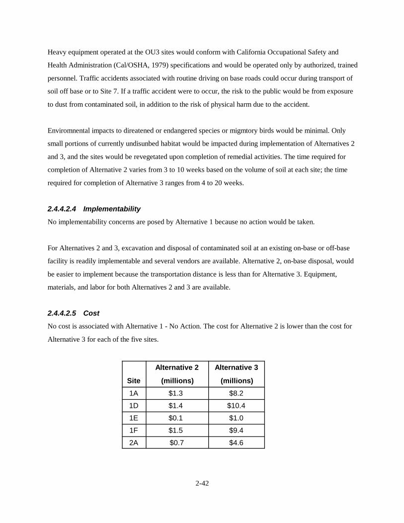
2-42
Heavy equipment operated at the OU3 sites would conform with California Occupational Safety and
Health Administration (Cal/OSHA, 1979) specifications and would be operated only by authorized, trained
personnel. Traffic accidents associated with routine driving on base roads could occur during transport of
soil off base or to Site 7. If a traffic accident were to occur, the risk to the public would be from exposure
to dust from contaminated soil, in addition to the risk of physical harm due to the accident.
Enviromnental impacts to direatened or endangered species or migmtory birds would be minimal. Only
small portions of currently undisunbed habitat would be impacted during implementation of Alternatives 2
and 3, and the sites would be revegetated upon completion of remedial activities. The time required for
completion of Alternative 2 varies from 3 to 10 weeks based on the volume of soil at each site; the time
required for completion of Alternative 3 ranges from 4 to 20 weeks.
2.4.4.2.4 Implementability
No implementability concerns are posed by Alternative 1 because no action would be taken.
For Alternatives 2 and 3, excavation and disposal of contaminated soil at an existing on-base or off-base
facility is readily implementable and several vendors are available. Alternative 2, on-base disposal, would
be easier to implement because the transportation distance is less than for Alternative 3. Equipment,
materials, and labor for both Alternatives 2 and 3 are available.
2.4.4.2.5 Cost
No cost is associated with Alternative 1 - No Action. The cost for Alternative 2 is lower than the cost for
Alternative 3 for each of the five sites.
Site
Alternative 2
(millions)
Alternative 3
(millions)
1A $1.3 $8.2
1D $1.4 $10.4
1E $0.1 $1.0
1F $1.5 $9.4
2A $0.7 $4.6
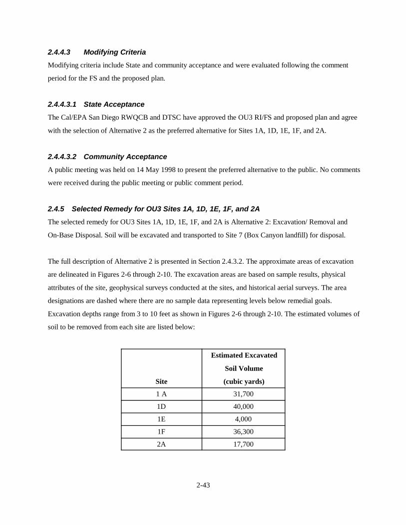
2-43
2.4.4.3 Modifying Criteria
Modifying criteria include State and community acceptance and were evaluated following the comment
period for the FS and the proposed plan.
2.4.4.3.1 State Acceptance
The Cal/EPA San Diego RWQCB and DTSC have approved the OU3 RI/FS and proposed plan and agree
with the selection of Alternative 2 as the preferred alternative for Sites 1A, 1D, 1E, 1F, and 2A.
2.4.4.3.2 Community Acceptance
A public meeting was held on 14 May 1998 to present the preferred alternative to the public. No comments
were received during the public meeting or public comment period.
2.4.5 Selected Remedy for OU3 Sites 1A, 1D, 1E, 1F, and 2A
The selected remedy for OU3 Sites 1A, 1D, 1E, 1F, and 2A is Alternative 2: Excavation/ Removal and
On-Base Disposal. Soil will be excavated and transported to Site 7 (Box Canyon landfill) for disposal.
The full description of Alternative 2 is presented in Section 2.4.3.2. The approximate areas of excavation
are delineated in Figures 2-6 through 2-10. The excavation areas are based on sample results, physical
attributes of the site, geophysical surveys conducted at the sites, and historical aerial surveys. The area
designations are dashed where there are no sample data representing levels below remedial goals.
Excavation depths range from 3 to 10 feet as shown in Figures 2-6 through 2-10. The estimated volumes of
soil to be removed from each site are listed below:
Site
Estimated Excavated
Soil Volume
(cubic yards)
1 A 31,700
1D 40,000
1E 4,000
1F 36,300
2A 17,700
2-44
Additional data was collected in May 1998 as part of the preconstruction effort to refine the extent of
contamination. While estimated boundaries and volumes of soils to be excavated changed for individual
sites, based on the additional data, the combined site soil volume remained essentially the same. Results are
provided in the Energy Dispersive X-ray Fluorescence Field Investigation Report, dated 5 August 1998.
The additional data results will be incorporated into the remedial design report for these sites.
The excavation strategy for each site is to minimize the excavation depth while meeting the remedial
objectives. In areas driven by ecological risk only, the maximum excavation depth will be 5 feet. During the
site restoration phase, this area will be covered with a minimum of 5 feet of clean soil to eliminate future
risk of ecological exposure to any residual contamination remaining below a 5-foot depth. The same
strategy will apply to areas driven by human health risks. The maximum excavation depth will be limited to
10 feet. The area will be backfilled with a minimum of 10 feet of clean soil if contaminant concentrations at
10 feet still exceed remedial goals.
The excavated soil will be transported to Site 7 - Box Canyon Landfill, which has been designated as a
CAMU for these remedial actions. The Site 7 landfill has been inactive since May 1984. A removal action
has been implemented at Site 7 for a phased installation of a landfill cap. The second phase of the landfill
cap was designed to use the excavated soil from the OU3 sites as part of the fill (SWDIV, 1997c). The
CAMU designation of Site 7 was publicly reviewed as part of the OU3 proposed plan. The criteria, as
specified in 40 CFR 264.552(c), and rationale for designation follow:
• The CAMU shall facilitate the implementation of reliable, effective, protective, and cost-effective
corrective action measures.
The use of Site 7 as a CAMU for the disposal of excavated soil from OU3 sites is a reliable,
effective, and protective remedy. A landfill cap will be placed over the excavated soil to limit
mobilization of contaminants and minimize potential exposure. The use of Site 7 as a CAMU is
more cost-effective than other alternatives evaluated such as off-site disposal.
• Waste management activities associated with the CAMU shall not create unacceptable risks to
humans or to the environment resulting from exposure to hazardous wastes, hazardous substances,
or hazardous constituents.
2-45SCI/10-98/WPC/Pendleto/ROD10-27.wpd
The excavated soils from OU3 sites are not expected to result in any unacceptable risks at Site 7.The landfill cap will prevent direct future exposure to humans and the environment. In addition,site data has been evaluated to assess if soils from Sites 1A, 1D, 1E, 1F, and 2A would impactgroundwater beneath Site 7. Results of the DLM using RI data and leachability testing of site soilsshow that placement of the wastes at Site 7 from these five sites would not have a detrimentalimpact on groundwater. Further evaluation of existing soil and groundwater data, soil pH, landfillgas generation, features of the planned cap at Site 7, and local rainfall data was performed toassess the leaching potential from the site soils. Each of the factors evaluated indicate that metalspresent in the soils to be placed at Site 7 will not adversely impact groundwater. Details of thisevaluation are presented in the Technical Memorandum for Leaching Potential of Sites 1A, 1D,1E, 1F, and 2A dated 2 October 1998 (SWDIV, 1998c). Review of this evaluation by the EPA’sOffice of Research and Development found the evaluation to be technically acceptable and foundlittle risk of metals mobilization from the consolidated/capped contaminated soils (EPA, 1998b).
• The CAMU shall include uncontaminated areas of the facility, only if including such areas of thepurpose of managing remediation waste is more protective than management of such wastes atcontaminated areas of the facility.
Excavated soil from OU3 sites will only be located within the existing footprint of the Site 7landfill and will not include uncontaminated areas.
• Area within the CAMU, where wastes remain in place after closure of the CAMU, shall bemanaged and contained so as to minimize future releases, to the extent practicable.
The Site 7 landfill will be capped to contain the excavated soil and minimize the potential forfuture releases from the soil to groundwater.
• The CAMU shall expedite the timing of corrective action activity implementation, whenappropriate and practicable.
Using Site 7 for disposal of excavated soil from OU3 sites will expedite the remedial actionbecause it will take less time than off-site disposal.
• The CAMU shall enable the use, when appropriate, of technologies (including innovativetechnologies) to enhance the long-term effectiveness of corrective actions by reducing the toxicity,mobility, or volume of wastes that will remain in place after closure of the CAMU.
The mobility of contaminants in the soil excavated from the OU3 sites will be reduced when placedat Site 7 because the depth to groundwater at Site 7 is greater than the OU3 remedial action sitesand the landfill cap will be placed over the excavated soil.
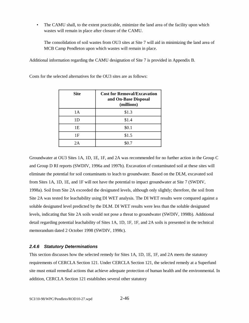
2-46SCI/10-98/WPC/Pendleto/ROD10-27.wpd
• The CAMU shall, to the extent practicable, minimize the land area of the facility upon whichwastes will remain in place after closure of the CAMU.
The consolidation of soil wastes from OU3 sites at Site 7 will aid in minimizing the land area ofMCB Camp Pendleton upon which wastes will remain in place.
Additional information regarding the CAMU designation of Site 7 is provided in Appendix B.
Costs for the selected alternatives for the OU3 sites are as follows:
Site Cost for Removal/Excavationand On-Base Disposal
(millions)
1A $1.3
1D $1.4
1E $0.1
1F $1.5
2A $0.7
Groundwater at OU3 Sites 1A, 1D, 1E, 1F, and 2A was recommended for no further action in the Group C
and Group D RI reports (SWDIV, 1996a and 1997b). Excavation of contaminated soil at these sites will
eliminate the potential for soil contaminants to leach to groundwater. Based on the DLM, excavated soil
from Sites 1A, 1D, 1E, and 1F will not have the potential to impact groundwater at Site 7 (SWDIV,
1998a). Soil from Site 2A exceeded the designated levels, although only slightly; therefore, the soil from
Site 2A was tested for leachability using DI WET analysis. The DI WET results were compared against a
soluble designated level predicted by the DLM. DI WET results were less than the soluble designated
levels, indicating that Site 2A soils would not pose a threat to groundwater (SWDIV, 1998b). Additional
detail regarding potential leachability of Sites 1A, 1D, 1F, 1F, and 2A soils is presented in the technical
memorandum dated 2 October 1998 (SWDIV, 1998c).
2.4.6 Statutory Determinations
This section discusses how the selected remedy for Sites 1A, 1D, 1E, 1F, and 2A meets the statutory
requirements of CERCLA Section 121. Under CERCLA Section 121, the selected remedy at a Superfund
site must entail remedial actions that achieve adequate protection of human health and the environmental. In
addition, CERCLA Section 121 establishes several other statutory
2-47SCI/10-98/WPC/Pendleto/ROD10-27.wpd
requirements and preferences specifying that, when complete, the selected remedial action must comply
with ARARs established under Federal and State environmental laws unless a statutory waiver is justified.
The selected remedy must also be cost-effective and must entail permanent solutions and alternative
treatment technologies or resource recovery technologies to the maximum extent practicable. Finally, the
statute includes a preference for remedies that employ, as their principal element, treatment technologies
that permanently and significantly reduce the volume, toxicity, or mobility of hazardous wastes.
2.4.6.1 Protection of Human Health and The Environment
Under current conditions, human health risks associated with Sites 1A, 1D, 1E, 1F, and 2A are within the
EPA cancer risk management range of 10-6 to 10-4, however, the noncancer HQ for humans is greater than
1.0 for each site and lead exceeds acceptable criteria set by the EPA and DTSC for most sites. The risk to
ecological receptors also exceeds acceptable levels. The selected remedy was chosen because soil
contamination will be reduced to acceptable levels for both human and ecological receptors. Removal of
contaminated soil will also eliminate the potential for migration of soil contaminants to groundwater. The
potential risk for workers implementing the remedial actions for these five sites will be addressed in a
site-specific health and safety plan.
2.4.6.2 Compliance with Applicable or Relevant and Appropriate Requirements
The selected remedy will comply with all Federal and State ARARs. The ARARs for Alternative 2 at Sites
1A, 1D, 1E, 1F, and 2A are discussed in Appendix B.
2.4.6.3 Cost-Effectiveness
The selected remedy was evaluated for cost-effectiveness in comparison with the other two alternatives.
The no action alternative is less expensive than the selected alternative but does not reduce risk at the sites
to acceptable levels. The selected alternative is the least expensive alternative that will be protective of
human health and the environment and comply with ARARs.
2.4.6.4 Use of Permanent Solutions and Alternative Treatment Technologies tothe Extent Practicable
The selected remedy uses permanent solutions and treatment technologies to the maximum extent possible
for Sites 1A, 1D, 1E, 1F, and 2A. Because of the nature and concentration of contaminants, treatment was
not found to be a practical solution. However, capping will reduce the mobility of contaminants by
reducing infiltration.
2-48SCI/10-98/WPC/Pendleto/ROD10-27.wpd
The selected alternative provides the best balance between effectiveness and cost of the three alternatives
considered with respect to the five EPA balancing criteria (i.e., long-term effectiveness; reduction of
toxicity, mobility, or volume through treatment; short-term effectiveness; implementability; and cost).
Alternative 1 would leave contaminated soil in place. The selected alternative and Alternative 3 both
provide a high degree of long-term effectiveness and permanence because contaminated soil would be
removed. Under the selected alternative the contaminated soil will be excavated, placed into a CAMU, and
covered with an engineered cap.
None of the alternatives would reduce mobility, toxicity, or volume of the waste because treatment was
found to be neither practical nor feasible. Treatment technologies evaluated were not considered feasible
because they did not meet RAOs, were energy-intensive and costly, or were not effective for the COCs. The
selected alternative was the greatest short-term effectiveness. Although excavation and earthmoving
activities we the same for Alternatives 2 and 3, potential exposure during implementation is greater for
Alternative 3 because transportation distances and implementation schedules are longer.
Alternative 2 is slightly easier to implement than Alternative 3. Alternative 3 includes longer transportation
distances and compliance with permitting requirements for off-base disposal.
For each of the five sites, Alternative 2 is less expensive than Alternative 3. Because Alternatives 2 and 3
are considered approximately equal with regard to three of the other four balancing criteria, the least costly
alternative has been selected.
2.5 Remedial Action Selection for Site 7 - Box Canyon Landfill
2.5.1 Side Name, Location, and Description - Site 7
Site 7 - Box Canyon Landfill is located near the southwest corner of the base in 20 Area to the east of
Vandegrift Boulevard less than a mile northeast of Stuart Men Road (Figure 2-11).
The inactive landfill covers an area of approximately 28 acres. The majority of Box Canyon in which
landfilling activities were conducted has been filled with landfill material to the surface of the surrounding
marine terrace, which is approximately 140 feet above the Santa Margarita
2-49SCI/10-98/WPC/Pendleto/ROD10-27.wpd
riverbed. Near the canyon entrance, the landfill slopes steeply down to the north and terrninates
approximately 1,000 feet from the Santa Margarita River.
2.5.2 Site Historyand Enforcement Activities
The site was used for quarry operations from approximately 1946 to 1970. The site began Class III landfill
operations in May 1974 which ended in 1984. The landfill has been inactive since 1984. Typical wastes
accepted for landfilling reportedly included household and construction refuse consisting of tree and lawn
clippings, scrap lumber and metal, appliances, furniture, paper, fill, dirt, asphalt, concrete, tile, cans,
containers, magazines, and boxes. The site also reportedly received dry cleaning sludges containing
stoddard solvent; contaminated soil and dumpster waste containing fuels, POLs, solvents, thinners,
strippers, epoxies, sealants, paint wastes, and chemical cleaners.
Based on the nature of wastes disposed at Site 7, a removal action to cap the landfill following the EPA
Presumptive Remedy guidance (EPA, 1993) was proposed in the Group B RI (SWDIV, 1995b). Because
of the large volume and heterogeneity of the contents of municipal landfills, treatment usually is
impracticable and the EPA considers containment to be the appropriate response action, or the presumptive
remedy, for the source areas of municipal landfill sites.
An engineering evaluation/cost analysis (EE/CA) was prepared to evaluate closure of Site 7 (SWDIV,
1995d). An addendum to the EE/CA was prepared in 1997 to evaluate an additional cap option (SWDIV,
1997c). Capping alternatives were evaluated as discussed in Section 2.5.5. Since Site 7 is a landfill and the
presumptive remedy approach was used in the EE/CA, the level of detail provided in the EE/CA is
considered adequate to meet the requirements of an FS, and is used as such for this ROD. Phase 1 of the
cap was completed in October 1997. Phase 2 is planned to coincide with disposal of soils from the OU3
remedial action sites.
2.5.3 Summary of Site Characteristics
The initial RI work at Site 7 was conducted during March 1993 through March of 1994. Four soil samples
were collected from the surface of the landfill and one soil sample was collected from the surface just
outside the northwest edge of the landfill (Figure 2-11). Soil samples were analyzed for VOCs, SVOCs,
gasoline, diesel, pesticides, PCBs, and herbicides. Twenty new groundwater monitoring wells were installed
and sampled at Site 7. Three groundwater monitoring wells installed during a previous investigation at the
site were also sampled (Figure 2-11). Three rounds
2-50SCI/10-98/WPC/Pendleto/ROD10-27.wpd
of groundwater monitoring were conducted during the initial RI. Samples were analyzed for metals, VOCs,
SVOCs, gasoline, diesel, pesticides. PCBs, herbicides, and general chemistry. Three additional rounds of
groundwater sampling of the 23 wells were conducted between June 1994 and July 1995. An ecological
survey was conducted to identify potential special-status species habitats and trappings were conducted to
determine presence of the Pacific pocket mouse. No special-status species were identified at Site 7.
Samples were analyzed for metals, VOCs, SVOCs, gasoline, diesel, pesticides, PCBs, herbicides, and
general chemistry.
A 24-hour meteorological survey was conducted on 8 and 9 September 1993. Based on the results of the
meteorological survey, four 24-hour ambient air samples were collected from 9 to 10 September 1993.
Ambient air and air traps (e.g., stairwells, crawl spaces, confined spaces, vents and vaults) were sampled
for methane and hydrogen sulfide.
The results of the initial RI at Site 7 are reported in the Group B RI report (SWDIV, 1995b). The results of
additional sampling and surveys are presented in the technical addendum to the Group B RI report
(SWDIV, 1996c). These results are summarized in the following sections.
2.5.3.1 Geology and Hydrogeology
This section summarizes the geology and hydrogeology for Site 7 from the Group B RI (SWDIV, 1996c).
Five distinct geologic units were encountered during the RI at Site 7. These are, from youngest to oldest,
the younger alluvium of the Santa Margarita River, Pleistocene marine terrace deposits, the
Plio-Pleistocene San Mateo Formation, post-mid-Miocene/pre-Pleistocene sandy and gravelly alluvial
deposits, and the mid-Miocene San Onofre Breccia.
The San Onofre Breccia is unconformably overlain by Pleistocene terrace deposits on the west side of the
landfill and by the sandy and gravelly alluvial deposits on the north and cast sides of the landfill. Field
measurements indicate that the San Onofre Breccia strikes to the northwest and dips 10 to 15 degrees to the
southwest.
The San Onofre Breccia is not expected to contain or transmit substantial quantities of groundwater
(Palmer, 1990). Although this formation is considered an aquitard because of its poor sorting and high
percentage of fine-grained materials (Palmer, 1990), two aquifers were encountered in the lower member of
the San Onofre Breccia. No significant groundwater was observed in the upper member of the San Onofre
Breccia.
2-51SCI/10-98/WPC/Pendleto/ROD10-27.wpd
The sandy and gravelly alluvium unconformably overlies the San Onofre Breccia and has several
characteristics that make it a potential preferential pathway for leachate migration from the Box Canyon
landfill. Thus, leachate from the Box Canyon landfill could potentially migrate downgradient through the
sandy and gravelly alluvium to the Santa Margarita Basin.
The Plio-Pleistocene San Mateo Formation is exposed in cliffs along Ash Road, approximately 1,500 feet
southwest of the Box Canyon landfill, and unconformably overlies the San Onofre Breccia. The contact
between the two units is concealed. This unit was not encountered during well installation or soil sampling
activities; it is offset by a normal fault that may be related to other faults in the vicinity of Site 7.
The Pleistocene marine terrace deposits unconformably overlie the San Onofre Breccia on the south, west,
and north sides of the Box Canyon landfill and the sandy and gravelly alluvium on the cast side of the
landfill.
The younger alluvium was encountered only in the wells installed in the Santa Margarita Basin, adjacent to
the Box Canyon landfill. The alluvium thickens northward and westward toward the Santa Margarita River
(away from the landfill).
Evidence of at least two sets of faults was observed in the vicinity of Site 7. One set strikes northeast, and
the other strikes northwest. The evidence of faulting includes offset bedding, drag folding, slickensides,
fault gouge, and lineations in aerial photographs.
Monitoring wells at Site 7 were installed in three geologic units having distinct hydrogeologic
characteristics: Pleistocene marine terrace deposits, San Onofre Breccia Formation, and sandy and gravelly
alluvium
The Pleistocene marine terrace deposits are generally restricted to the uppermost 60 feet of strata and do
not appear to act as a separate aquifer. These deposits locally may act as a perched aquifer; however, the
presence of sandstone and cobble conglomerate (at the base of the deposits) probably allows percolation of
surface waters to the underlying formations.
Nine groundwater monitoring wells were installed in the San Onofre Breccia Formation. Groundwater was
encountered in two distinct zones: a shallow zone that extends from 110 to
2-52SCI/10-98/WPC/Pendleto/ROD10-27.wpd
150 feet below grade, and a deep zone that extends from approximately 150 to 190 feet below grade. The
two saturated zones appear to be separated by an aquitard of variable thickness and moisture content (dry
to moist).
Six groundwater monitoring wells were installed in the sandy and gravelly alluvium. Groundwater was first
encountered within the alluvium at depths of approximately 144 and 160 feet below ground surface and
was found to be continuous to at least 220 feet in wells 7W-03 and 7W-06C. In monitoring wells 7W-08B
and 7W-08C, the sandy and gravelly alluvium extends from approximately 45 to 117 feet below ground
surface and, again, appears to be a continuous aquifer.
No confining zones or changes in water content were observed during drilling, which further indicates that
the alluvium acts as one continuous aquifer. The unit is expected to be highly permeable because of its
relatively coarse overall grain size and low percentage of fine grains.
Groundwater recharged through the sandy and gravelly alluvium near well cluster 7W-03 would tend to
flow toward the landfill. The northwesterly groundwater flow direction through the sandy and gravelly
alluvium near well cluster 7W-06 suggests that a pathway may exist for leachate migration from the
landfill toward the Santa Margarita River. The planned cover will minimize the potential for rainfall
infiltration and the generation of leachate at concentrations above acceptable criteria.
Five groundwater monitoring wells were installed in the alluvium of the Santa Margarita Basin.
Groundwater was encountered 12 to 21 feet below ground surface. Observations during drilling and aquifer
testing indicate that the alluvium acts as a continuous aquifer from an elevation of 10 feet msl to its
intersection with consolidated bedrock. This depth varies and generally increases with distance (to the
north) from the marine terrace.
The groundwater flow direction at the site is southwest to northwest. The hydraulic gradient, as determined
from water levels measured on 20 April 1994 and 21 August 1995, ranges from approximately 0.076 ft/ft
northwest of the landfill to approximately 0.40 ft/ft southwest of the landfill.
The direction of the horizontal hydraulic gradient in the deeper water-bearing units generally is similar to
that of the first-encountered groundwater, with the exception of the area in the vicinity
2-53SCI/10-98/WPC/Pendleto/ROD10-27.wpd
of well 7W- 11. Site 7 lies within a recharge area, as indicated by lower head readings in deep monitoring
wells compared with shallow wells.
2.5.3.2 Soil Results
Soil sample locations are shown in Figure 2-11. Low concentrations (ranging from approximately 10 to
100 µg/kg) of several polycyclic aromatic hydrocarbon (PAH) compounds were detected in sample
07SD004. Two other organics, toluene and bis(2-ethylhexyl)phthalate were detected in four of the five
surface soil samples. Toluene was detected at a concentration of 1J µg/kg in samples 07SD002-LABQC
and 07SD005. Bis(2-ethylhexyl)phthalate concentrations ranged from 150J to 1,800B µg/kg.
2.5.3.3 Groundwater Results
Figure 2-11 presents groundwater analytical results for organic contaminants detected at concentrations
exceeding MCLs or PRGs in at least one Site 7 well. The figure also presents the breakdown products
associated with these organics even though they did not exceed MCLs or PRGs. Metals were all below
background and/or MCLs during the last four quarters of monitoring. Therefore, no inorganics are shown
in the figure.
Groundwater analytical results for the RI are briefly described below:
• 1,2-DCA was detected during the second quarter 1993 above the MCL in one well. 7W-11B, at2.0J µg/l. The MCL for 1,2-DCA is at the detection limit, 0.5 µg/l. 1,2-DCA was detected in7W-11C during the third quarter 1993 at 0.5 µg/l and in well 7W-11A during the first quarter1994 at 0.6 µg/l. It was detected in wells 7W-11A, 7W-11B and 7W-11C during the fourth quarter1994 at 0.7, 1.0, and 0.6 µg/l. respectively. 1,2-DCA was not detected in any of these three wellsduring the first and second quarters 1995.
• 1,2-DCA was detected in well 7W-06A in a duplicate sample during the fourth quarter 1994 at 0.5µg/l but not in the two subsequent rounds of sampling. It was not detected in the other well of the2-well cluster, 7W-06B.
• PCE was detected below its MCL (5 µg/l) in well 7W-06A during the second and third quarters1993 and during the first and fourth quarters 1994 at 1.0, 2.0, 2.0, and 1.0 µg/l, respectively. Itwas not detected in subsequent quarters in well 7W-06A or in the other well of the 2-well cluster,7W-06B.
2-54SCI/10-98/WPC/Pendleto/ROD10-27.wpd
• PCE was detected once below its MCL (5 µg/l) in well 7W-07 during first quarter 1994 at 2.0µg/l, but was not detected in three subsequent quarters.
• PCE was not detected in well 7W-11C. It was detected in wells 7W-11A and 7W-11B but did notexceed MCLs. PCE was detected in well 7W-11B during the second and third quarters 1993 andthe first quarter 1994 at 0.5, 0.9, and 0.7 µg/l. respectively. It was not detected in 7W-11B duringthe fourth quarter 1994, it was detected in the first quarter 1995 at 0.7 µg/l, but was not detectedduring the second quarter 1995. PCE was detected in 7W-11A during the second and third quarters1990, the first and fourth quarters 1994, and the first and second quarters 1995 at 1.5, 1.2, 1.0,1.0, 1.0, and 0.7 µg/l, respectively.
• 1,1-DCA was detected below its MCL (5.0 µg/1) in wells 7W-06A, 7W-11A, 7W-11B, and 7W-11C. It was detected in well 7W-06A during the first and fourth quarters 1994 (maximum 1.0 µg/l)but not during the two subsequent quarters. It was detected in 7W-11A, 7W-11B, and 7W-11Cduring the first and fourth quarters 1994 and the first and second quarters 1995 at a maximumconcentration of 3 µg/l.
• TCE was detected once above its MCL (5.0 µg/l) at its maximum concentration in well 7MW-02at 5.2 µg/l during the third quarter 1990 but was not detected during six subsequent quarters. TCEwas detected below its MCL (5.0 µg/l) in wells 7W-06A, 7W-07, 7W-11A, 7W-11B, and7W-11C. It was only detected once at 3.0 µg/l in 7W-07 during the first quarter of 1994 but it wasnot detected in this well during three subsequent quarters. TCE was detected twice in 7W-06A at0.9 µg/l during the third quarter 1993 and the first quarter 1994 but not during three subsequentquarters. TCE was detected in well 7W-11A during the second and third quarters 1990, the firstand fourth quarters 1994, and the first quarter 1995 at 2.0, 1.6. 2.0. 1.0, and 0.9 µg/l, respectively,but was not detected during the second quarter 1995. TCE was detected in well 7W-11B during thesecond and third quarter 1993, the first and fourth quarters 1994, and the first and second quarters1995 at 0.8, 0.9, 1.0, 0.7, 0.9, and 0.9 µg/l, respectively. TCE was detected once in well 7W-11Cduring the second quarter 1993 at 0.4 µg/l, but was not detected during five subsequent quarters.
• Benzene was only detected once in Site 7 groundwater. It was detected below its MCL in well7W-07 at 1 µg/l during the first quarter 1994, but was not detected during three subsequentquarters.
• Carbon tetrachloride was detected twice in Site 7 groundwater. It was detected above its MCL (0.5µg/l) in wells 7W-07 at 7.0 µg/l during the first quarter 1994 and at its MCL in 7W-11C at 0.5µg/l during the third quarter 1993. It has not been detected since in at least three quarters aftereach detection.
• 1,4-dichlorobenzene was detected below its MCL (5 µg/l) in 7W-11A during the fourth quarter1994 and the first quarter 1995 at 0.5 and 2.0 µg/l, respectively, but was not
SCI/10-98/WPC/Pendleto/ROD10-27.wpd 2-55
detected during the second quarter 1995. It was also detected in well 7W-11B during the first andsecond quarters 1995 at 2.0, and 0.6 µg/l.
• Dibromochloromethane, 1,3-dichlorobenzene, bromodichloromethane, phenol, benzoic acid,bromoform, and chloromethane were detected once or twice in the last four quarters ofgroundwater sampling but did not exceed MCLs or did not have MCLs. The maximum detectedconcentrations were 2.0, 0.6, 3.0, 19, 5.0, 3.0, and 5.0 µg/l, respectively.
• Antimony, barium, chromium, manganese, molybdenum, nickel, selenium, thallium, and vanadiumwere detected at maximum concentrations that exceeded upgradient background concentrations.However, the 95 percent upper confidence limit of the mean site concentrations of these metals didnot exceed background except for barium. The maximum concentrations of other metals detectedwere less than background. There was no background for antimony or thallium available. Bariumwas detected in 48 of 85 groundwater samples at Site 7. The maximum barium concentration was362 µg/l which is less than its MCL (1,000 µg/1). Antimony was detected in 2 of 85 groundwatersamples. It was detected at 13.3 µg/l in wells 7W-4A and 7W-5A during the second quarter of1993. The detected antimony concentrations exceed the MCL (6 µg/1). Antimony was not detectedduring the last four quarters of sampling in 1994 and 1995. Thallium was detected in 4 of 85groundwater samples. The maximum thallium concentration was 26 µg/l which exceeds its MCL(2 µg/l). All other detections were less than the MCL. Thallium was not detected during the lastfour quarters of sampling in 1994 and 1995.
• Nitrate was detected at a concentration exceeding its MCL (10 µg/1) only once in an upgradientwell 7W-01A during the first quarter 1994 at 14.3 µgl.
2.5.3.4 Ambient Air and Soil Gas Results
Ambient air monitoring consisted of a 24-hour meteorological survey of wind speed and direction,
collection of 24-hour ambient air samples, and direct testing of hydrogen sulfide and methane
concentrations. Four soil-gas samples were collected, in duplicate, at the Santa Margarita School and the
Wire Mountain Housing Area. The presence of an impenetrable caliche-type soil layer limited sampling
depths to 1.5 feet instead of the proposed 3 to 6 feet. The areal extent of the caliche layer is not well
defined. Based on the four soil-vapor sample locations, it may extend about 800 feet in a north/south
direction. This unit could act as a capping layer that would restrict the upward migration of soil vapors.
SCI/10-98/WPC/Pendleto/ROD10-27.wpd 2-56
Air sampling results are summarized below:
• Four ambient air samplers were placed at the Box Canyon landfill in accordance with CARBrequirements. Low levels (1.2 to 2.0 ppb) of 1,1,1-TCA were detected in all four samples. Thepresence of 1,1,1-TCA in the upwind samples indicates that the landfill is probably not the sourcefor this compound. It is difficult to determine the source of these low levels of 1,1,1-TCA.However, sampling locations were relatively close to roads and developed areas.
• Hydrogen sulfide and methane were not detected in any of the tests at the specified instrumentdetection limits.
No halogenated volatile compounds were detected in the soil-gas samples. Complete analyticalresults for the soil-gas samples are, presented in Appendix G of the technical memorandum forGroup B sites (SWDIV, 1993d).
2.5.4 Summary of Site Risks - Site 7
2.5.4.1 Human Health Risk Characterization
The HHRA for Site 7 soil was an interim screening assessment because of the planned capping of
the landfill; capping of this landrill began in 1997, and Phase I was completed 17 November 1997.
PAH compounds in one sample, 07SD004, were the primary contributors to risk and resulted in a
maximum total site-related risk (residential scenario) of l x 10-5 for soil at Site 7. No individual
PAH exceeded the incremental lifetime cancer risk (ILCR) of 1 x 10⁻⁶ for ingestion, and
benzo(a)pyrene toxicity values were used for PAH compounds of probable lesser toxicity. The
total maximum hazard index (HI for soil was less than the target criterion of 1.0. Because of the
small number of soil samples collected and the placement of the landfill cap, no further risk
assessment evaluation was conducted for Site 7 soil.
The landfill material is assumed to be contaminated and sampling of the fill material was not
conducted consistent with the EPA presumptive remedy guidance. The site was investigated to
determine the potential for off-site gas migration and the potential impact to groundwater during
the remedial investigation. The potential for gas migration was determined not to be a concern
based on results of air monitoring at the site and at the neighboring residential area and elementary
school.
SCI/10-98/WPC/Pendleto/ROD10-27.wpd 2-57
There were groundwater contaminants detected intermittently in some of the 23 monitoring wells at the site.
The noncancer hazard index was 3.2 due to antimony (1.7 HQ) and thallium (1.4 HQ). Neither thallium
nor antimony were detected during the latest 2 rounds of sampling. The main contributors to the
groundwater cancer risk were 1,2-dichloroethane (1,2-DCA), tetrachloroethene, and trichloroethene. The
cancer risk was calculated to be within the risk management range (1 x 10⁻⁵). The results of the latest 2
rounds of sampling (first and second quarter of 1995) were nondetect for 1,2-DCA and the other risk
contributors were less than their MCLs. The risk/hazard for groundwater is within the NCP risk
management range and is determined to be acceptable.
2.5.4.2 Ecological Risk Assessment
No ecological risk assessment was conducted for Site 7 because no special-status species or habitat were
identified and a landfill cap was planned to be instaIlled.
2.5.5 Description of Alternatives - Site 7
The landfdl presumptive remedy approach was used to assess alternatives for Site 7. The components of
the landfill presumptive remedy include: a landfill cap, source area groundwater control to contain the
plume, leachate collection and treatment, landfill gas collection and treatment, and institutional controls.
An EE/CA was prepared to evaluate capping options for Site 7 (SWDIV, 1995d). Four cap alternatives
were evaluated for Site 7. All four alternatives include drainage controls, gas monitoring, groundwater
monitoring and land use restrictions. No landfill gas collection/control system is required because it has
been determined that the landfill does not have the potential to generate significant amounts of gas. Three of
the alternatives, Alternatives 1, 2, and 3, consisted of the four layers of a prescriptive cap, but the barrier
layer material was varied. The prescriptive cap layers are as follows:
Foundation layer: minimum 2-foot-thick layer of soil over the waste, compacted to provideadequate structural support for successive layers
Barrier layer: infiltration barrier layer composed of low-permeability material
Drainage layer: soil or geocomposite layer with high permeability to permit drainage of infiltrationthrough the topmost protective soil layer
SCI/9-98/WPC/Pendle/ROD9-28.wpd 2-58
Protective soil layer: minimum 12-inch soil layer to protect the barrier layer, control surfaceerosion, and provide a medium for vegetation
The different barrier layers for Alternatives 1, 2, and 3, respectively, are as follows:
1. Low permeability clay layer 2. Native soil mixed with bentonite to reduce permeability 3. A textured high-density polyethylene (HDPE) flexible membrane liner (FML).
One additional cap alternative, an evapotranspiration (ET) cover (Alternative 4), was evaluated in the
Technical Addendum to the EE/CA (SWDIV, 1997d). This cap includes a vegetated topsoil layer (1 foot
thick) over a minimally compacted 3- to 4-foot soil layer. The bottom layer consists of a 1-foot compacted
low-permeability (1 x 10⁻⁵ centimeters per second [cm/s]) soil layer.
2.5.6 Summary of Comparative Analysis of Alternatives - Site 7
The four cap alternatives were evaluated on the basis of effectiveness, implementability, cost, and
compliance with ARARS. A summary of the evaluation is provided in the following sections.
2.5.6.1 Overall Protection of Human Health and the Environment andCompliance With ARARs
Each of the four alternatives would provide adequate overall protection of human health and the
environment. For each alternative, the major threat is addressed through containment and
appropriate continued monitoring and maintenance. Each of the alternatives also comply with
ARARs. Details are provided in Appendix B.
2.5.6.2 Long-Term Effectiveness and Permanence
Each of the alternatives provide a high degree of long-term effectiveness and permanence. The cap and
monitoring activities provide adequate and reliable reduction of exposure pathways and potential human
health and ecological risks. The ET cover, however, will require less maintenance than the other cap
options since the cover is inherently self-renewing and not damaged by long-term wetting and drying. Also,
the ET cover will not include synthetic materials and therefore will not be prone to potential deterioration
over time.
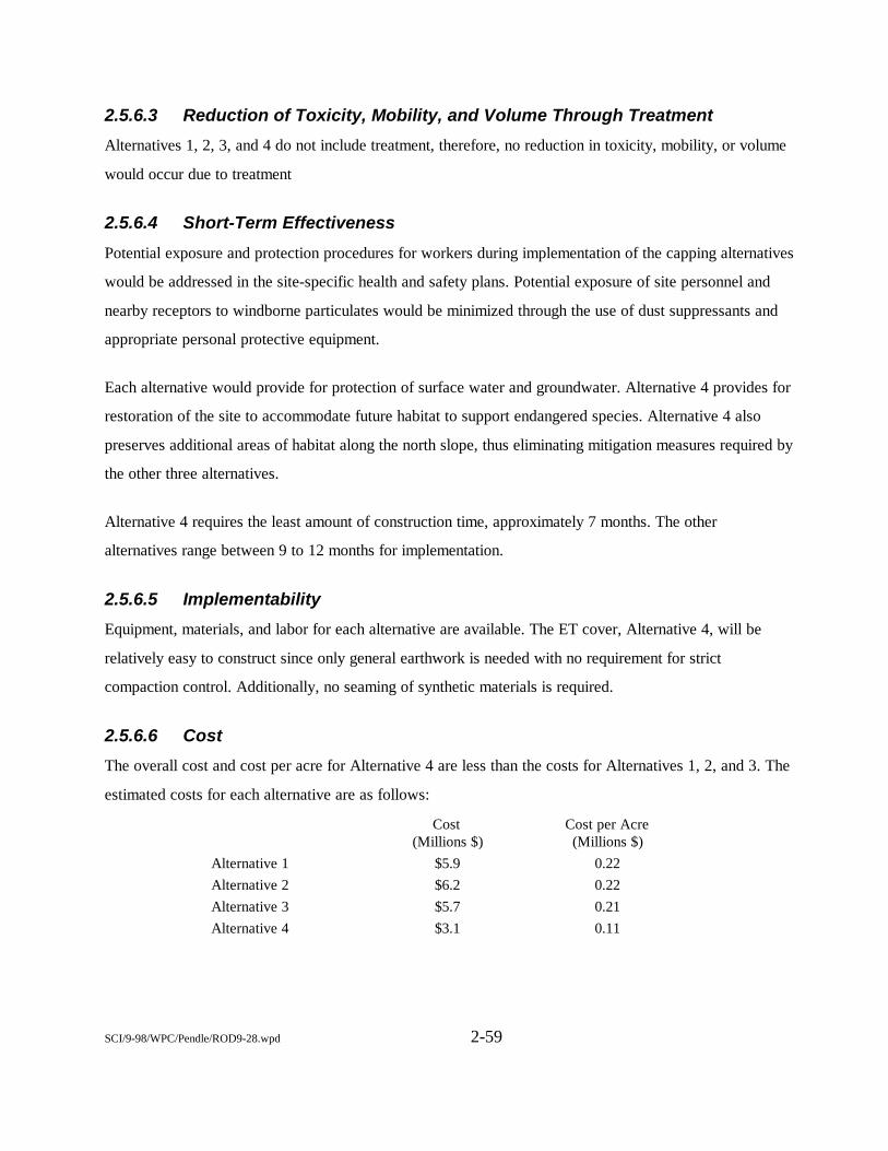
SCI/9-98/WPC/Pendle/ROD9-28.wpd 2-59
2.5.6.3 Reduction of Toxicity, Mobility, and Volume Through Treatment
Alternatives 1, 2, 3, and 4 do not include treatment, therefore, no reduction in toxicity, mobility, or volume
would occur due to treatment
2.5.6.4 Short-Term Effectiveness
Potential exposure and protection procedures for workers during implementation of the capping alternatives
would be addressed in the site-specific health and safety plans. Potential exposure of site personnel and
nearby receptors to windborne particulates would be minimized through the use of dust suppressants and
appropriate personal protective equipment.
Each alternative would provide for protection of surface water and groundwater. Alternative 4 provides for
restoration of the site to accommodate future habitat to support endangered species. Alternative 4 also
preserves additional areas of habitat along the north slope, thus eliminating mitigation measures required by
the other three alternatives.
Alternative 4 requires the least amount of construction time, approximately 7 months. The other
alternatives range between 9 to 12 months for implementation.
2.5.6.5 Implementability
Equipment, materials, and labor for each alternative are available. The ET cover, Alternative 4, will be
relatively easy to construct since only general earthwork is needed with no requirement for strict
compaction control. Additionally, no seaming of synthetic materials is required.
2.5.6.6 Cost
The overall cost and cost per acre for Alternative 4 are less than the costs for Alternatives 1, 2, and 3. The
estimated costs for each alternative are as follows:
Cost (Millions $)
Cost per Acre (Millions $)
Alternative 1 $5.9 0.22Alternative 2 $6.2 0.22Alternative 3 $5.7 0.21Alternative 4 $3.1 0.11
SCI/9-98/WPC/Pendle/ROD9-28.wpd 2-60
2.5.6.7 State Acceptance
The DTSC and San Diego RWQCB agree with the selection of the ET cap and associated actions for Site
7.
2.5.6.8 Community Acceptance
No comments were received from the public during the review for the Site 7 EE/CA.
2.5.7 Selected Remedy for Site 7
The selected remedy for Site 7 is Alternative 4 - Evapotranspiration Cover. This alternative includes
construction of an ET cover system for the top dock of Box Canyon landfill. No additional cover material
for the north slope of the landfill is planned. The north slope is approximately 4 acres in size with densely
vegetated slopes of 2.0-2.5 horizontal on 1.0 vertical and includes approximately 5 feet of existing cover
material. Since this slope is considerably steep, a majority of rainfall runs off the slope with very little
actually infiltrating the slope. The TR-55 runoff model developed by the Soil Conservation Service (SCS)
indicates that for a 24-hour, 100-year storm event (3.3 inches of rain) approximately 2.54 inches runs off
and only 0.75 inch infiltrates into the slope. Due to the dense vegetation on the north slope, ET processes
are effective at controlling the low percentage of infiltration on the steep slopes. However, lined drainage
ditches will be installed at the benches to eliminate infiltration along the relatively flat terraces.
The ET cover utilizes the natural process of surface runoff, storage, evaporation, and transpiration to
control infiltration of water through the landfill cover. The basic profile of an ET cover includes a
vegetated top soil layer, a minimally compacted soil layer and an optional low-permeability layer. The
purpose of the topsoil layer is to promote vigorous plant growth, and the purpose of the underlying
minimally compacted soil layer is to provide substantial water storage for removal by the natural process of
evapotranspiration. The basic purpose of the low permeability bottom layer is to act as a barrier between
the cover and the waste. Soils most suitable for ET covers are those with a high available water retention
capacity and an adequate supply of nutrients to support vigorous plant growth. Vegetation’s most suitable
for ET covers are generally a wide mixture of native grass species so that high transpiration is maintained
even under adverse growing conditions and during long-term climatic changes.
SCI/1-99/WPC/Pendleto/ROD12199.wpd 2-61
ET covers, in general, require less maintenance than traditional covers since this type of cover system is
inherently self renewing. Also, ET covers are generally more easily constructed since only general
earthwork is required and strict compaction control is generally not required. Additionally, labor intensive
details associated with synthetic materials are not required.
The ET cover selected for Site 7 includes a vegetated topsoil layer (1-foot-thick) underlain by a minimally
compacted 3- to 4-foot soil layer with a 1- to 3-foot compacted, low-permeability bottom layer. A
schematic diagram of this cross-section is shown in Figure 2-12. The cap will cover 28 acres. This
alternative would include grading the existing surface, transporting on-base borrow soils as necessary, and
importing topsoil. On-base borrow soil will be obtained from the Lemon Grove area of MCB Camp
Pendleton. Lemon Grove is located approximately 1 mile southwest of Site 7. The borrow soil sites have
been screened for biological and archaeological concerns. A vernal pool area was identified near the borrow
sites. The vernal pool will be fenced prior to removal activities. No archaeological concerns were identified.
To ensure that human health and the environment are protected in the future, no breaching of the soil cap at
Site 7, through trenching, excavation, or any other similar activity may occur unless prior approval of the
FFA signatories is obtained. This restriction does not apply to maintenance activities for purposes of
preservation or restoration of the physical integrity of the cap. Maintenance activities may include cleaning
of drainage channels and pipes, replacement of erosion control materials, regrading of channels, and
replacement of pipes, inlets, or catch basins. Also, if significant erosion results from heavy rain episodes,
partial excavation of the cover soil and import and placement of additional cover soil, as well as reseeding
of the cover, would be conducted. Access roads and the landfill perimeter road will be maintained and
improved as necessary. Signs and fencing will also be repaired or replaced as part of the maintenance
activities. If major land use changes are planned, including any change that is inconsistent with the
exposure assumptions in the risk assessment, that is specifically prohibited to protect human health or the
environment, that may disrupt the effectiveness of the remedy, or that might alter or negate the need for the
land use restriction, the FFA signatories must be provided with written notification of such a proposed
action at least 60 days prior to the beginning of the implementation of the proposed action. MCB Camp
Pendleton shall prepare and include an evaluation of the risk to human health and the environment and an
evaluation of any need for additional remedial action resulting from the proposed action and shall propose
any necessary changes to the remedial action selected in the OU3 ROD in the written notification of a
proposed
SCI/1-99/WPC/Pendleto/ROD12199.wpd 2-62
change. The EPA will advise whether a ROD amendment or an explanation of significant difference is
required. The FFA signatories must provide written concurrence with MCB Camp Pendleton’s evaluation
of risk and proposal regarding any necessary changes in the remedial action, if required, within 30 days of
receipt of the written notification from MCB Camp Pendleton.
MCB Camp Pendleton shall notify the FFA signatories of any plan to lease or transfer Site 7 real property
to a non-Federal or Federal entity. Such notification shall be provided at least 30 days in advance of the
lease or transfer conveyance. The land use restriction shall be incorporated as part of the lease or transfer
agreement; including FOSL and FOST procedures. MCB Camp Pendleton shall comply with Section
120(h)(3) of CERCLA in any such transfers to a non-Federal entity.
The MCB Camp Pendleton Base Master Plan will be amended to incorporate the abovementioned use
limitations and notice requirements for Site 7. The Master Plan amendments will also include language that
describes the risk to human health and the environinent that exists at Site 7; will reference the MCB Camp
Pendleton Group C and Group D RI reports, the Site 7 EE/CA, the OU3 FS report, and the OU3 ROD;
and will provide a legal description (metes and bounds) of the boundaries of Site 7. The language in the
Master Plan amendments will also include the title and dates of the above-listed documents and their
storage location. These amendments to the Master Plan will be completed by MCB Camp Pendleton within
1 year of signing the MCB, Camp Pendleton OU3 ROD. The FFA signatories will be provided with a copy
of the amendments to the Master Plan reflecting the land use limitations at Site 7. The land use restriction
will be reviewed and verified during the CERCLA 5-year review process.
Long-term groundwater monitoring will also be conducted. Selected groundwater monitoring wells will be
analyzed biannually for 5 years. The collected groundwater monitoring wells will be analyzed for volatile
and semivolatile organics, metals, and general chemistry. These groundwater monitoring results will be
assessed at the end of 5 years, or sooner if appropriate, to determine if any additional sampling is required.
No remediation for groundwater at Site 7 is necessary. The carcinogenic human health risk is within the
EPA’s risk management range.
The estimated cost for this alternative is $3.1 million. The cost per acre is $109,300.
SCI/1-99/WPC/Pendleto/ROD12199.wpd 2-63
2.5.8 Statutory Determinations
This section discusses how the selected remedy for Site 7 meets the statutory requirements of CERCLA
Section 121. Under CERCLA Section 121, the selected remedy at a Superfund site must entail remedial
actions that achieve adequate protection of human health and the environment. In addition, CERCLA
Section 121 establishes several other statutory requirements and preferences specifying that, when
complete, the selected remedial action must comply with ARARs established under Federal and State
environmental laws unless a statutory waiver is justified. The selected remedy must also be cost-effective
and must entail permanent solutions and alternative treatment technologies or resource recovery
technologies to the maximum extent practicable. Finally, the statute includes a preference for remedies that
employ, as their principal element, treatment technologies that permanently and significantly reduce the
volume, toxicity, or mobility of hazardous wastes.
2.5.8.1 Protection of Human Health and the Environment
The remedy selected for Site 7 will provide protection of human health and the environment by eliminating
direct contact of landfilled wastes or inhalation of particulates by humans and animals. The cap will also
minimize infiltration of water and leaching of contaminants to the groundwater. Cleanup levels were not
established because the type of cap selected and associated actions were determined by ARARs. Short-term
potential risks to workers and nearby receptors will be addressed in the site-specific health and safety plan;
dust suppression measures and protective clothing will be specified.
2.5.8.2 Compliance with Applicable or Relevant and Appropriate Requirements
The selected remedy will comply with all Federal and State ARARs. The ARARs for Alternative 4 at Site
7 are discussed in Appendix B.
2.5.8.3 Cost-Effectiveness
The selected remedy was evaluated for cost-effectiveness in comparison with the other three alternatives.
The selected alternative is the least expensive alternative that will be protective of human health and the
environment and comply with ARARs.
SCI/1-99/WPC/Pendleto/ROD12199.wpd 2-64
2.5.8.4 Use of Permanent Solutions and Alternative Treatment Technologies tothe Extent Practicable
The selected remedy uses permanent solutions and treatment technologies to the maximum extent possible.
Because the site is an inactive landfill, the presumptive remedy was considered appropriate for Site 7.
The selected alternative provides the best balance between effectiveness and cost of the four alternatives
considered with respect to the five EPA balancing criteria (i.e., long-term effectiveness; reduction of
toxicity, mobility, or volume through treatment; short-term effectiveness; implementability; and cost).
The selected alternative and Alternatives 1, 2, and 3 provide a high degree of long-term effectiveness and
permanence because wastes would be appropriately contained. Under the selected alternative the wastes
would be covered with an engineered ET cap.
None of the alternatives would reduce mobility, toxicity, or volume of the waste because treatment was
found to be neither practical nor feasible. Treatment technologies were not specifically evaluated because
based on presumptive remedy guidance, they are routinely and appropriately screened out on the basis of
effectiveness, feasibility, and cost. The selected alternative provided the greatest short-term effectiveness,
due to the shorter timeframe required for implementation.
Alternative 4 is easier to implement than the other alternatives, because seaming and placement of synthetic
materials are not components of the ET cap.
Alternative 4 is less expensive than Alternatives 1, 2, and 3. Because Alternative 4 provides greater
long-term and short-term effectiveness, the most cost-effective alternative has been selected.
2.6 No Action Selected for Sites 1B, 1C, 1G, 1I, 2C, 2D, 2F, 2G, 10, 16, 17, 18,27, 32, 34, 35, 36, 37, 38, 39, 40, 41, and 42
This section presents descriptions, histories, characteristics, and risks associated with the OU3 no
action sites. For the no action sites, all inorganics exceeding screening criteria and any detected
organics are typically shown in the site-specific figures.
2-65SCI/1-99/WPC/Pendleto/ROD12199.wpd
2.6.1 Site 1 B - Refuse Burning Ground in 11 Area
Site 1B is a former refuse burning ground in the 11 Area.
2.6. 1. 1 Site Name, Location, and Description
Site 1B - Refuse Burning Ground in 11 Area, is located in the San Luis Rey Basin, on an unpaved road
intersecting 14th Street, approximately 0.5 mile southeast of Vandegrift Boulevard (Figure 1-2). The
former burning ground is approximately 340 feet long and 100 feet wide. The site is bordered on the east
and south by a densely vegetated stream-cut canyon. To the north and west of Site 1B are low rolling hills
with light to moderate vegetation.
No perennial surface water is present in the vicinity of the site. During significant rainfall events, surface
water percolates into the subsurface, evaporates, or runs off the site and eventually discharges into Pilgrim
Creek, approximately 0.5 mile to the east.
The burning ground is no longer in use and military and civilian personnel are not on site on a regular
basis. The nearest residential housing is approximately 0.25 mile southwest of the site. No base production
wells are located within a 1-mile radius of Site 1B. There are no water production wells in the San Luis
Rey Basin.
2.6.1.2 Site History and Enforcement Activities
Site history and enforcement activities for refuse burning grounds are described in Section 2.4.1.2.
2.6.1.3 Summary of Site Characteristics
Site 1B was investigated in June and July 1996 during the RI for Group D sites. Five soil samples were
collected from two borings and were analyzed for metals, VOCs, SVOCs, and pesticides and PCBs. No
sediment or surface-water samples were collected because no surface water was present on site. No
groundwater samples were collected because drilling refusal occurred at less than 50 feet below ground
surface, before encountering sufficient groundwater for sampling.
2-66SCI/1-99/WPC/Pendleto/ROD12199.wpd
2.6.1.3.1 Geology and Hydrogeology
Shallow geology at Site 13 consists of Quaternary alluvium overlying granitic rock (bedrock basement
complex). Groundwater is assumed to flow to the east, following surface topography. The depth to
groundwater is estimated to be more than 80 feet below grade.
2.6.1.3.2 Soil Results
This section discusses analytical results from soil sampling at Site 1B. Results are summarized in Figure
2-13, which presents detected organics and any inorganics that exceed risk/hazard criteria.
Organics
No organic compounds were detected at Site 1B at concentrations exceeding PRGs (Figure 2-13).
Chlorinated pesticides (4,4'-DDD, 4,4'-DDE, and 4,4'-DDT) were detected at low concentrations in the
surface sample from boring 1BB-02; the highest concentration was 0.011 mg/kg. In addition, 4,4'-DDT
was detected at a concentration of 0.003 mg/kg in the 5-foot sample from the same boring. No organics
were detected at concentrations exceeding ecological risk screening criteria.
Inorganics
Two metals, arsenic and beryllium, were detected at concentrations exceeding PRGs in two of five and four
of five samples, respectively (Figure 2-13). All detections were below background levels. Only lead
exceeded ecological risk screening criteria.
Summary
No organics were detected in soil at concentrations exceeding PRGs; arsenic and beryllium were the only
inorganics detected, but concentrations were below background. Because only a few low-level detections of
inorganics were reported and the depth to groundwater at the site is about 80 feet below ground surface,
groundwater is not expected to be impacted. No significant site-related contamination exists at Site 1B.
2.6.1.4 Summary of Risks Associated with Site 1B
Human health and ecological risk assessments were conducted for Site 1B using data collected during the
Group D RI. Risk assessment methodologies are summarized in Section 2.4.1.4. Risk assessment
summaries for Site 1B are presented in this section.
2-67SCI/1-99/WPC/Pendleto/ROD12199.wpd
2.6.1.4.1 Human Health Risk Characterization
COPCs in Site 1B soil include metals and pesticides. Based on the conceptual site model, current/future
workers and future residents could be exposed to soil contaminants through incidental ingestion, dermal
contact, and inhalation of particulates.
The total residential cancer risk for maximum reported COPCs is 1.1 x 10⁻⁵. The primary contributors to
risk are arsenic (approximately 76 percent of the total risk) and beryllium (approximately 24 percent of the
total risk). However, arsenic and beryllium concentrations at Site 1B are below the respective background
concentrations. Excluding arsenic and beryllium as naturally occurring, the incremental site risks calculated
using EPA and Cal/EPA PRGs are both 1.4 x 10⁻⁸, which is below the lower end of the risk management
range. The cumulative residential hazard (noncarcinogenic) for maximum detected COPCs is 0.51.
The Site 1B residential cancer risk and noncarcinogenic hazard are less than the risk and hazard criteria. In
addition, the maximum lead concentration in soil (26.8 mg/kg) at Site 1B is below the EPA and Cal/EPA
residential PRGs of 400 and 130 mg/kg, respectively. Therefore, Site 1B soil is considered protective of
human health.
Groundwater is not considered a complete exposure pathway for either current/future workers or future
residents. Groundwater sampling was not performed at Site 1B because drilling refusal occurred before
encountering sufficient groundwater for sampling. Site 1B is not located above a shallow aquifer associated
with any of the four major groundwater basins at MCB Camp Pendleton (i.e., San Mateo, San Onofre, Las
Flores, or Santa Margarita Basin). The site is topographically higher than, and isolated from, the aquifers
associated with these major basins. Therefore, groundwater at Site 1B was not evaluated further in the
HHRA.
2.6.1.4.2 Ecological Risk AssessmentLead was the only preliminary COPEC with an HQ exceeding 1.0 (Figure 2-13). The HQ for lead (1.5)
exceeds but is close to 1.0 for deer mouse, indicating that the potential for toxicity is relatively low. HQs
are less than 1.0 for the other representative species evaluated.
Site 1B includes nonnative grasslands and coastal sage scrub habitat. Several wildlife species were
observed, and special-status species could be present on site.
2-68SCI/1-99/WPC/Pendleto/ROD12199.wpd
None of the preliminary COPECs were retained as final COPECs. The potential for exposure and effects is
considered low. The HQs for all but one of the representative species are less than 1.0, indicating little or
no potential for toxicity. In addition, because of its small size (approximately 1.3 acres) and proximity to
developed areas, this site would provide only a limited proportion of the habitat available for the
representative wildlife species. Therefore, ecological receptors would not likely be sufficiently exposed to
potentially harmfull contaminant concentrations to cause adverse effects.
2.6.1.5 Description of the No Action AlternativeThe no action alternative selected for Site 1B includes no institutional controls. Site 1B is considered
protective of human health and the environment for the following reasons:
• Under the future residential exposure scenario, maximum soil concentrations resulted in an ILCRless than 1 x 10⁻⁶ and an HI less than 1.0.
• The maximum lead concentration is below the screening values.
• Groundwater is not considered a complete exposure pathway for either current/futureworkers or future residents.
• The refuse burning ground is no longer in operation, and military and civilianpersonnel are on site infrequently.
• Evaluation of potential ecological risks from exposure to soil indicated that thepotential for exposure and effects is low and will not likely pose a risk to ecologicalreceptors.
2.6.2 Site 1C - Refuse Burning Ground in 13 Area
Site 1C is a former refuse burning ground in the 13 Area.
2.6.2.1 Site Name, Location, and Description
Site 1C - Refuse Burning Ground in 13 Area, is located along “A” Street and Reservoir Road,
approximately 0.5 mile southwest of Rattlesnake Canyon Road (Figure 1-2). The refuse burning ground is
approximately 300 feet long and 200 feet wide. The site is bordered on the east by “A” Street, on the north
by Reservoir Road, and on the west and south by light to moderate vegetation. Site 1C slopes gently to the
south and eventually drains into a stream-cut canyon.
2-69SCI/1-99/WPC/Pendleto/ROD12199.wpd
An unpaved dirt road runs directly through the middle of the site, and low rolling hills surround the site.
No perennial surface water is present in the vicinity of the Site 1C burning ground. During significant
rainfall events, surface water percolates into the subsurface, evaporates, or runs off the site and discharges
into the Santa Margarita River approximately 1 mile to the east.
No development is located in the immediate vicinity of the site. The refuse burning ground is no longer in
operation, and military and civilian personnel are present on site infrequently. The undeveloped area
surrounding the site is classified as a maneuver area with gently sloping topography covered by natural
vegetation (Innis-Tennebaum Architects, Inc., 1990). The nearest troop housing is approximately 0.25 mile
southeast of the site. The nearest family housing, the Ranch House, is located about 1 mile west of the site.
No base production wells are located within a 1-mile radius of Site 1C.
The dominant habitat at Site 1C is nonnative grassland consisting primarily of wild oat and mustard.
Coastal sage scrub habitat consists of coyote bush and castor bean, with a few sage interspersed.
Special-status wildlife species potentially present at this site include California gnatcatcher. Bird species
observed during the reconnaissance survey include western meadowlark and cliff swallow.
2.6.2.2 Site History and Enforcement Activities
Site history and enforcement activities for refuse burning grounds are described in Section 2.4.1.2.
2.6.2.3 Summary of Site Characteristics
Site 1C was investigated in June and July 1996 during the RI for Group D sites. Eight soil samples were
collected from two borings and were analyzed for metals, VOCs, SVOCs, and pesticides and PCBs. No
sediment or surface-water samples were collected because no surface water was present on site. No
groundwater samples were collected because drilling refusal occurred before encountering sufficient
groundwater for sampling.
2-70SCI/1-99/WPC/Pendleto/ROD12199.wpd
2.6.2.3.1 Geology and Hydrogeology
Shallow geology at this site consists of Quaternary alluvium that was deposited by broad surface erosion.
The alluvium is fine- to medium-grained, unconsolidated to poorly consolidated sand and interbedded silty
sand. The alluvium is underlain by interbedded sandstone and siltstone bedrock of the La Jolla Group.
Based on site geology, groundwater is assumed to flow to the south, following surface topography. Soil
borings were drilled to a maximum depth of 35 feet below ground surface at Site 1C. Groundwater was
encountered at a depth of 34.5 feet in boring 1CB-02 but is interpreted to represent a localized,
discontinuous perched layer of groundwater rather than a major water-bearing zone (aquifer) because Site
1C is located in a topographically elevated area and is isolated from the alluvial aquifer at the basin floor.
Groundwater was consistently encountered at a depth of about 20 feet below grade in boreholes drilled for
underground storage tank (UST) studies at the adjacent 12 and 13 Areas approximately 0.75 mile northeast
of Site 1C (SWDIV, 1996b). Because topographically the 12 and 13 Areas are about 100 feet lower than
Site 1C, the groundwater table at Site 1C is estimated to be nearly 120 feet below ground surface.
2.6.2.3.2 Soil Results
This section discusses analytical results from soil sampling at Site 1C. Results are summarized in Figure
2-14, which presents detected organics and any inorganics that exceed risk/hazard criteria.
Organics
No organic compounds were detected in soil at Site 1C at concentrations exceeding PRGs (Figure 2-14).
Low concentrations of acetone were detected in samples from both borings at Site 1C; the highest
concentration was 0.024 mg/kg. In addition, 2-butanone and Aroclor-1254 were detected at concentrations
of 0.003 and 0.0 19 mg/kg, respectively, in the 10-foot sample from boring 1CB-01. None of the detected
organics exceeded ecological screening levels.
Inorganics
Beryllium was the only inorganic compound detected in Site. 1C soil at concentrations exceeding PRGs.
Although beryllium exceeded the PRG in all nine samples, concentrations were below the background
concentration of 1.42 mg/kg and below the ecological screening value.
2-71SCI/1-99/WPC/Pendleto/ROD12199.wpd
Summary
No organics were detected in soil at concentrations exceeding PRGs or PLEs; beryllium was the only
inorganic compound detected, but concentrations were below background. Groundwater is estimated to be
120 feet below ground surface and is not expected to be impacted. No significant site-related contamination
exists at Site 1C.
2.6.2.4 Summary of Risks Associated with Site 1C
Human health and ecological risk assessments were conducted for Site 1C using data collected during the
Group D RI. Risk assessment methodologies are summarized in Section 2.4.1.4. Risk assessment
summaries for Site 1C are presented in this section.
2.6.2.4.1 Human Health Risk Characterization
COPCs detected in Site 1C soil include metals, VOCs, and PCBs (Aroclor-1242). Current/future workers
and future residents could be exposed to soil contaminants through incidental ingestion, dermal contact, and
inhalation of VOCs or particulates.
The cumulative residential cancer risk for maximum detected COPCs in soil is 5.1 x 10⁻⁶. The primary
contributor to risk is beryllium (approximately 94 percent of the total risk). The maximum concentration of
beryllium detected at Site 1C is less than the background concentration for the San Luis Rey Basin.
Excluding beryllium as naturally occurring, the incremental cancer risk is less than 1 x 10⁻⁶.
The cumulative residential HI for maximum detected COPCs is 0.78 and is attributable primarily to metals.
Excluding the portion of total hazard attributable to background metals, the incremental site HI is 0.2,
which is below the threshold criterion of 1.0.
The Site 1C residential cancer risk and noncarcinogenic hazard do not exceed risk and hazard criteria. In
addition, the maximum lead concentration (6.2 mg/kg) is below the EPA and Cal/EPA residential soil
PRGs of 400 and 130 mg/kg, respectively. Therefore, Site 1C soil is considered protective of human health.
Groundwater is not considered a complete exposure pathway for either current/future workers or future
residents. Groundwater sampling was not performed at Site 1C during the RI because drilling refusal
occurred in weathered bedrock less than 50 feet below ground surface, before
2-72SCI/1-99/WPC/Pendleto/ROD12199.wpd
encountering sufficient groundwater for sampling. Site 1C is not located above a shallow aquifer associated
with any of the four major groundwater basins at MCB Camp Pendleton (i.e., San Mateo, San Onofre, Las
Flores, or Santa Margarita Basin). The site is topographically higher than, and isolated from, the aquifers
associated with these major basins. Therefore, groundwater at Site 1C was not evaluated further in the
HHRA.
2.6.2.4.2 Ecological Risk Assessment
None of the preliminary inorganic COPECs exceeded available background values. All preliminary organic
COPECs were evaluated for potential toxicity. None of the preliminary COPECs had HQs exceeding 1.0;
therefore, no final COPECs were identified for this site. Site 1C is considered protective of ecological
receptors.
2.6.2.5 Description of the No Action Alternative
The no action alternative selected for Site 1C includes no institutional controls. Site 1C is considered
protective of human health and the environment for the following reasons:
• Under the future residential exposure scenario, maximum soil concentrations resulted in an ILCRless than 1 x 10⁻⁶ and an HI less than 1.0.
• The maximum lead concentration is less than the screening values.
• Groundwater is not considered a complete exposure pathway for either current/futureworkers or future residents.
• The refuse burning ground is no longer in operation, and military and civilianpersonnel are on site only infrequently.
• Evaluation of potential ecological risks from exposure to soil indicated that thepotential for exposure and effects is low and will not likely pose a risk to ecologicalreceptors.
2.6.3 Site 1I - Refuse Burning Ground in 63 Area
Site 1I consists of a former refuse burning ground in the 63 Area.
2.6.3.1 Site Name, Location, and Description
Site 1I - Refuse Burning Ground in 63 Area, is located approximately 1,250 feet east of
Cristianitos Road (Figure 1-2), northeast of its intersection with San Mateo Road. The refuse
2-73SCI/1-99/WPC/Pendleto/ROD12199.wpd
burning ground is approximately 425 feet long and 125 feet wide. The site is bordered on the north and
south by steep hills that rise 200 feet above the site and are covered with moderate to dense vegetation, on
the south by a paved access road, and on the west and east by a vegetated stream-cut canyon. Site 1I is in
the center of a stream-cut canyon that slopes to the west and eventually drains into Cristianitos Creek,
approximately 1,500 feet west of the site. The surrounding area is characterized by low rolling hills.
No perennial surface water is present in the vicinity of Site 1I. Surface water at the site is ephemeral and
follows the gently sloping ground surface to the west. During significant rainfall events, surface water
percolates into the subsurface, evaporates, or runs off the site and discharges into Cristianitos Creek.
The Site 1I burning ground is no longer in operation, and military and civilian personnel are present on site
only infrequently. The undeveloped area to the north, east, and south of the site is classified as a maneuver
area and consists of steep slopes covered by moderate to dense vegetation. To the west of the site is the
Cristianitos Area, which contains a fire station, two clubs, and a fleet hospital training complex. The
nearest troop housing is approximately 1 mile southwest of the site in the 62 Area. No family housing is
located within several miles of the site and none is planned. The nearest base production well is
approximately 0.5 mile south of Site 1I.
The dominant habitats at Site 1I are coastal sage scrub and nonnative grassland. The site is densely
vegetated with sage, coyote bush, fennel, laurel sumac, and mulefat. Special-status species potentially
present on site include California gnatcatcher and least Bell’s vireo. Bird species observed during the
reconnaissance survey include California towhee, mourning dove, American kestrel, red-tailed hawk, scrub
jay, and rufous-sided towhee. Evidence of coyote use (scat) was observed, along with active small mammal
burrows and holes.
2.6.3.2 Site History and Enforcement Activities
Site history and enforcement activities for refuse burning grounds are described in Section 2.4.1.2.
2-74SCI/1-99/WPC/Pendleto/ROD12199.wpd
2.6.3.3 Summary of Site Characteristics
Site 1I was investigated in June and July 1996 during the RI for Group D sites. Six soil samples were
collected from two borings and were analyzed for metals, VOCs, SVOCs, and pesticides and PCBs. No
sediment or surface-water samples were collected because no surface water was present on site. No
groundwater samples were collected because groundwater was not encountered during sampling.
Groundwater is estimated to occur in bedrock at a depth of more than 100 feet.
2.6.3.3.1 Geology and Hydrogeology
Shallow geology at this site is characterized by unconsolidated to poorly consolidated alluvium consisting
of very fine grained to fine-grained sand with silt and clay. The alluvium overlies bedrock of the La Jolla
Group.
Based on site geology, groundwater is assumed to flow to the southwest, following surface topography.
Soil borings were drilled to a maximum depth of 10 feet below ground surface at Site 1I without
encountering groundwater.
The nearest RI site at which groundwater was encountered is Site 34, which is approximately 1.5 miles
south of Site 1I. Groundwater was encountered in a gravel unit at a depth of about 12 feet below grade at
Site 34. Because Site 1I is topographically higher than Site 34 by about 100 feet, the groundwater table at
Site 1I is expected to be deeper than 100 feet below ground surface.
No other site-specific groundwater level data were collected in the San Mateo Basin near Site 1I. However,
the alluvial units at Site 1I and the bedrock underneath the alluvium are not expected to receive or retain a
significant or beneficial amount of groundwater, Groundwater in the San Mateo Basin is concentrated
primarily in the alluvium along the basin floor (where Site 34 is located) and not in the adjacent
topographically higher areas (where Site 1I is located).
2.6.3.3.2 Soil Results
This section discusses analytical results from soil sampling at Site 1I. Results are summarized in Figure
2-15, which presents detected organics and any inorganics that exceed risk/hazard criteria.
2-75SCI/1-99/WPC/Pendleto/ROD12199.wpd
Organics
No organic compounds were detected in soil samples from Site 1I (Figure 2-15).
Inorganics
Arsenic was detected in four of seven samples and beryllium was detected in all seven samples from both
site borings at concentrations exceeding PRGs but below background concentrations (Figure 2-15). No
inorganics were detected at concentrations exceeding PLEs. The maximum arsenic and beryllium
concentrations were 2.9 and 1 mg/kg, respectively.
Summary
No organics were detected in soil; arsenic and beryllium were the only inorganic compounds detected, but
concentrations were below background. Groundwater is estimated to be deeper than 100 feet below ground
surface at Site 1I and is not expected to be impacted. No site-related contamination exists at Site 1I.
2.6.3.4 Summary of Risks Associated with Site 1I
Human health and ecological risk assessments were conducted for Site 1I using data collected during the
Group D RI. Risk assessment methodologies are summarized in Section 2.4.1.4. Risk assessment
summaries for Site 1I are presented in this section.
2.6.3.4.1 Human Health Risk Characterization
COPCs in Site 1I soil are limited to metals. Current/future workers and future residents could be exposed
to soil contaminants through incidental ingestion, dermal contact, and inhalation of particulates.
The cumulative residential risk for maximum detected COPCs in soil is 1.2x10⁻⁵. The primary risks drivers
are arsenic (approximately 63 percent of the total risk) and beryllium (approximately 37 percent of the total
risk). However, arsenic and beryllium concentrations are below background. Excluding arsenic and
beryllium as naturally occurring, no site-related carcinogenic COPCs are present at Site 1I.
The cumulative residential hazard for maximum detected COPCs is 0.57. Excluding the portion of total
hazard attributable to background metals, the incremental residential site hazard is less than 0.01.
Excluding arsenic and beryllium as naturally occurring background levels, the Site 1I
2-76SCI/1-99/WPC/Pendleto/ROD12199.wpd
residential cancer risk and noncarcinogenic hazard are less than the risk and hazard criteria. In addition, the
maximum lead concentration (9.6 mg/kg) is less than the EPA and Cal/EPA residential PRGs of 400 and
130 mg/kg, respectively. Therefore, Site 1I soil is considered protective of human health.
Groundwater is not considered a complete exposure pathway for either current/future workers or future
residents. Groundwater sampling was not performed at Site 1I during the Group D RI because drilling
refusal occurred in weathered bedrock less than 50 feet below ground surface, before encountering
sufficient groundwater for sampling purposes. Site 1I is not located above a shallow aquifer associated
with any of the four major groundwater basins at MCB Camp Pendleton (i.e., San Mateo, San Onofre, Las
Flores, or Santa Margarita Basin). The site is topographically higher than, and isolated from, the aquifers
associated with these major basins. Therefore, groundwater at Site 1I was not evaluated further in the
HHRA and is considered protective of human health.
2.6.3.4.2 Ecological Risk Assessment
None of the preliminary inorganic COPECs exceeded background values, and no organic chemicals were
detected. Therefore, no final COPECs were identified for Site 1I; the site is considered protective of
ecological receptors.
2.6.3.5 Description of the No Action Alternative
The no action alternative selected for Site 1I includes no institutional controls. Site 1I is considered
protective of human health and the environment for the following reasons:
• No carcinogenic chemicals were detected at concentrations exceeding background.Under the future residential exposure scenario, maximum soil concentrations resultedin an HI less than 1.0.
• The maximum lead concentration is below the screening values.
• Groundwater is not considered a complete exposure pathway for either current/future workers orfuture residents.
• The refuse burning ground is no longer in operation, and military and civilianpersonnel are on site only infrequently.
2-77SCI/1-99/WPC/Pendleto/ROD12199.wpd
• Evaluation of potential ecological risks from exposure to soil indicated that no COPECs exceededbackground concentrations and the site is protective of ecological receptors.
2.6.4 Site 2C - Grease Disposal Pit in 33 Area
Site 2C consists of a former grease disposal pit in the 33 Area.
2.6.4.1 Site Name, Location, and Description
Site 2C - Grease Disposal Pit in 33 Area, is located approximately 1,800 feet southwest of the intersection
of Basilone and Stagecoach Roads (Figure 1-2). The grease pit is approximately 80 feet long and 70 feet
wide. The site is bordered on the east by an unpaved road and is on a plateau surrounded by light to
moderate vegetation. The site slopes gently to the northwest and drains into a flat land at an elevation
approximately 65 feet lower than the site. The surrounding area consists of low rolling hills.
No perennial surface water is present in the vicinity of Site 2C. During the rainy season, surface-water
runoff originating from the grease disposal pit percolates into the subsurface, evaporates, runs off the site,
or drains northwesterly into the flatland and a tributary canyon that eventually discharges into the Santa
Margarita River.
The grease pit is no longer in operation, and military and civilian personnel are present on site only
infrequently. Land surrounding Site 2C is covered with natural vegetation. The area farther northwest is
used primarily for training and contains a temporary biotreatment facility. The area north, east, and south
of the site is undeveloped and is classified as a maneuver area; this area consists of gently rolling hills
covered by natural vegetation (Innis-Tennebaum Architects, Inc., 1990). The nearest family housing, the
Ranch House, is about 1 mile southeast of the site. The nearest designated troop housing is in the Vado Del
Rio (25) Area, approximately 1 mile northeast of the site. No other family housing is located within several
miles of the site and none is planned. The nearest base production well is approximately 1,700 feet
northwest of Site 2C.
The dominant habitats at Site 2C are nonnative grassland and coastal sage scrub. Dominant plant species
in the nonnative grassland include turkey mullein, annual grass (wild oat, brome), fivehook bassia, and
yellow star-thistle. Black and white sage and coyote brush dominate the coastal sage scrub habitat. A
wildlife survey of Site 2C was conducted in October 1995, after the main breeding period for many bird
species. Nine species of birds were observed. No small
2-78SCI/1-99/WPC/Pendleto/ROD12199.wpd
mammal trapping was conducted; however, active runways and holes associated with small mammals were
observed. Botta's pocket gopher mounds were also present on site. No reptiles or amphibians were
observed.
2.6.4.2 Site History and Enforcement Activities
Grease disposal pits were used between 1942 and 1980 for disposal of mess hall grease; the exact operation
dates for most of the sites are unknown. No information is available on specific volumes of grease disposed
of in the pits. Although there are no confirmed reports of hazardous waste disposal in these pits, the
potential for such disposal practices cannot be altogether discounted. The pits were closed by allowing the
greasy materials to decay to a semisolid state and then backfilling with native soil (NEESA, 1984). Visual
inspection during the RI indicated that POLs may also have been disposed of in some pits. Field
reconnaissance of the pits did not reveal any obvious stress to local vegetation.
2.6.4.3 Summary of Site Characteristics
Site 2C was initially investigated in 1993 and 1994 during the RI for Group C sites. Phase 2 RI was
conducted at Site 2C in June and July 1996 during the RI for Group D sites. A total of 13 soil samples
were collected from two borings and six surface sample locations. Sample locations, arc shown in Figure
2-16. Samples were analyzed for metals, VOCs, and SVOCs, pesticides and PCBs, TPH as diesel and
gasoline, and leachability of lead and diesel. No sediment or surface-water samples were collected because
no surface water was present on site. No groundwater samples were collected because groundwater was not
encountered during sampling. Groundwater is estimated to occur in bedrock at a depth of more than 50 feet
below ground surface.
2.6.4.3.1 Geology and Hydrogeology
Subsurface geology at Site 2C consists of artificial fill to about 9.5 feet below ground surface and older
Quaternary alluvium from about 9.5 to 13.5 feet. The artificial fill was originally native soil used to
backfill the grease disposal pit upon closure. The alluvium was deposited by both stream and broad surface
erosion and consists of undifferentiated, fine- to coarse-grained, unconsolidated to poorly consolidated
sand, silt, gravel, and minor clay. The alluvium overlies massive granitic basement rock. Weathered
granitic rock was encountered at 11 feet below ground surface in boring 2CB-01 and extended to refusal at
16 feet below ground surface. Similar granitic material forced termination of boring 2CB-02 at 13 feet
(Figure 2-16).
2-79SCI/1-99/WPC/Pendleto/ROD12199.wpd
Based on site topography, local groundwater is assumed to flow to the northwest. Soil borings were drilled
to a maximum depth of 16 feet below ground surface without encountering groundwater. Groundwater was
encountered at about 10 feet below grade in wells installed in the nearby Santa Margarita Basin, which is
about 100 feet lower in elevation than Site 2C. Based on this difference in topography, the groundwater
table at Site 2C is estimated to be deeper than 100 feet below ground surface. The alluvium and bedrock at
the site are not expected to receive or retain a significant or beneficial amount of groundwater.
Groundwater in the Santa Margarita Basin is concentrated primarily in the alluvium along the basin floor
and not in the adjacent topographically higher areas (where Site 2C is located).
2.6.4.3.2 Sod Results
This section discusses analytical results from soil sampling at Site 2C. Results are summarized in Figure
2-16, which presents detected organics and any inorganics that exceed risk/hazard criteria.
Organics
No organic compounds were detected at concentrations exceeding PRGs in Site 2C soil (Figure 2-16).
Diesel was detected at concentrations of 120 and 2,500 mg/kg in the 9-foot sample from boring 2CB-1 and
surface sample 2CSS001, respectively; these concentrations exceed the 100-mg/kg screening level for
diesel recommended by the LUFT Field Manual guidance (California State Water Resources Control
Board [SWRCB], 1989).
In addition, 15 other organics were detected at Site 2C at concentrations below evaluation criteria:
ethylbenzene, TCE, total xylenes, 1,1,1-trichloroethane (TCA), benzoic acid, bis(2-ethylhexyl)phthalate,
di-n-butylphthalate, butylbenzylphthalate, benzo(b)fluoranthene, chrysene, pyrene, 4,4'-DDE, dieldrin,
Aroclor- 1254, and gasoline. The maximum concentration detected was 12 mg/kg for toluene. TCE was
detected once at 0.11 mg/kg in the 9-foot sample from 2CSB-01 but was not detected in the two samples
collected at deeper intervals in the same boring or in any other soil samples collected at the site.
The 2CSS001 location was resampled (Sample ID - 2CSS001A) for leachability testing during the Phase 2
RI. The sample was analyzed for TPH-diesel but no diesel was detected. The duplicate sample analysis
from the same location (2CSS201A-01) yielded a diesel concentration of 1,800 mg/kg but was qualified,
indicating that the detection did not match the diesel
2-80SCI/1-99/WPC/Pendleto/ROD12199.wpd
calibration standard. The sample was further analyzed for volatiles using the synthetic precipitation
leaching procedure (SPLP); the only detection was toluene at a concentration of 4.6 pg/l. Based on the
SPLP results, volatiles are not expected to ]each at unacceptable concentrations.
To evaluate the leachability of diesel, the 2CSS001 location was sampled for a third time (sample
2CSS001B) and subjected to TPH-diesel analysis and SPLP analysis for diesel. The total analysis
indicated a diesel concentration of 260 mg/kg, and the SPLP analysis indicated a concentration of 2.6
milligrams per liter (mg/1). The same sample was reanalyzed once more (as sample 2CSS001C) by an
independent laboratory to confirm the leachability. The total analysis showed a diesel concentration of 718
mg/kg, whereas the SPLP analysis for diesel indicated a concentration of 51.3 mg/l. These results indicated
that diesel would not adversely impact groundwater.
Inorganics
Beryllium was detected in 4 of 12 samples and lead was detected in 1 sample at concentrations exceeding
PRGs (Figure 2-16). Beryllium concentrations were below background (1.42 mg/kg). The lead
concentration in surface sample 2CSS001 exceeded the PRG and background.
The 2CSS001 location was resampled (sample 2CSS001A) during the Phase 2 RI and was analyzed for
total lead and leachable lead; the corresponding results were 4.7 mg/kg and nondetect (detection limit of 0.5
mg/1), respectively. To confirm the lead analytical results, location 2CSS001 was sampled for a third time
(sample 2CSS001B). Lead was detected at a concentration of 65 mg/kg, but was not detected in the
leachable lead analysis. Based on these results, lead is not expected to impact groundwater.
Summary
No organics were detected in soil at concentrations exceeding PRGs. Diesel was detected in two locations
at concentrations exceeding the 100-mg/kg screening level. Beryllium and lead were detected at
concentrations exceeding PRGs. All beryllium concentrations were below background. As discussed
previously, the high lead detection was not confirmed during subsequent resampling efforts. TCE was
detected in soil at a concentration below the PRG but was not detected in deeper samples at the same
location or in any other samples collected at the site. Because no organic or inorganic compounds in Site
2C soil pose a concern, impacts to
2-81SCI/1-99/WPC/Pendleto/ROD12199.wpd
groundwater from site-specific contamination are unlikely. In addition, leachability testing indicated that
diesel concentrations in soil would not adversely impact groundwater.
2.6.4.4 Summary of Risks Associated with Site 2C
Human health and ecological risk assessments were conducted for Site 2C using data collected during the
Group C and Group D RIs. Risk assessment methodologies are summarized in Section 2.4.1.4. Risk
assessment summaries for Site 2C are presented in this section.
2.6.4.4.1 Human Health Risk Characterization
COPCs in Site 2C soil include metals, VOCs, SVOCs, pesticides, and PCBs. Current/future workers and
future residents could be exposed to soil contaminants through incidental ingestion, dermal contact, and
inhalation of VOCs or particulates.
The cumulative residential risk from the maximum detected COPCs is 8.0x10⁻⁶ and is primarily
attributable to beryllium (approximately 88 percent of the total risk). The maximum reported concentration
of beryllium (0.98 mg/kg) is below the associated background concentration (1.42 mg/kg) and was
excluded from the risk evaluation as naturally occurring. Excluding the portion of total risk attributable to
background metals, the incremental residential risk from maximum detected COPCs is 9.5x10⁻⁷.
The cumulative residential HI from maximum detected COPCs is 0.32 and is primarily attributable to
metals (approximately 81 percent of the total hazard). Excluding the portion of total hazard attributable to
background metals, the incremental residential site hazard is 0.06, which is below the threshold criterion of
1.0.
The results of the HHRA indicate that the incremental residential site risk (9.5x10⁻⁷) for Site 2C is below
the lower end of the risk management range and the incremental residential site hazard (0.06) is below the
threshold criterion of 1.0. The maximum reported lead concentration (421 mg/kg) exceeds the EPA and
Cal/EPA residential PRGs of 400 and 130 mg/kg, respectively, but is below the EPA and Cal/EPA
industrial soil PRGs of 1,000 and 3,289 mg/kg, respectively. The duplicate sample for the maximum lead
concentration was substantially lower (114 mg/kg), and the remaining nine detections of lead were below
the background concentration of 21.7 mg/kg. Therefore, no adverse health impacts are expected. Based on
the results of the HHRA, Site 2C soil is considered protective of human health.
2-82SCI/1-99/WPC/Pendleto/ROD12199.wpd
Groundwater is not considered a complete exposure pathway for either current/future workers or future
residents. Groundwater sampling was not performed at Site 2C during the RI because drilling refusal
occurred in weathered bedrock less than 50 feet below ground surface, before encountering sufficient
groundwater for sampling. Site 2C is not located above a shallow aquifer associated with any of the four
major groundwater basins at MCB Camp Pendleton (i.e., San Mateo, San Onofre, Las Flores, or Santa
Margarita Basin). The site is topographically higher than, and isolated from, the aquifers associated with
these major basins. Therefore, groundwater at Site 2C was not evaluated further in the HHRA and is
considered protective of human health.
2.6.4.4.2 Ecological Risk Assessment
The HQs for two preliminary COPECs (lead and diesel) exceed 1.0 (Figure 2-16). HQs were calculated for
representative species for each of six soil samples, which were analyzed for 119 inorganic and organic
chemicals. With one exception, the HQs that exceed 1.0 are less than 10, indicating that the potential for
toxicity is relatively low; one HQ for lead exceeds 10 (23 for deer mouse), indicating medium potential for
toxicity. Lead HQs for all other representative species are less than 1.0. The frequencies of detection for
lead and diesel were 100 and 67 percent, respectively.
Site 2C consists of nonnative grassland and disturbed habitat. Birds were observed at the site, but
special-status species are not expected to be present because of the lack of suitable habitat. Representative
species for this site with HQs exceeding 1.0 include terrestrial invertebrates, deer mouse, and Savannah
sparrow.
None of the preliminary COPECs were retained as final COPECs because the potential for exposure and
effects is considered low. The toxicity estimates for lead are based on a single detection at a high
concentration; all other lead concentrations are within background. The toxicity estimates for diesel are also
based on a single high value, the remaining diesel concentrations are less than the PLEs for representative
species. The site is less than 0.1 acre in size, which is considerably smaller than the home range size for
representative bird and mammal species. The habitat quality at the site is somewhat less suitable than the
surrounding areas. For these reasons, wildlife receptors are not likely to spend a significant proportion of
time at the site. Therefore, the level of exposure to preliminary COPECs at the site is not expected to result
in adverse effects to wildlife receptors.
2-83SCI/1-99/WPC/Pendleto/ROD12199.wpd
2.6.4.5 Description of the No Action Alternative
The no action alternative selected for Site 2C includes no institutional controls. Site 2C is considered
protective of human health and the environment for the following reasons:
• Under the future residential exposure scenario, maximum site-related soil concentrations resulted inan ILCR less than 1x10⁻⁶ and an HI less than 1.0.
• Lead concentrations in soil are not expected to pose a threat to human health.
• Groundwater is not considered a complete exposure pathway for either current/futureworkers or future residents.
• The grease pit is no longer in operation, and military and civilian personnel are on siteinfrequently.
• Evaluation of potential ecological risks from exposure to soil indicated that the site isprotective of ecological receptors.
2.6.5 Site 2D - Grease Disposal Pit in 43 Area
Site 2D consists of a former grease disposal pit in the 43 Area.
2.6.5.1 Site Name, Location, and Description
Site 2D - Grease Disposal Pit in 43 Area, is located approximately 300 feet northeast of Basilone Road,
immediately northwest of its intersection with Las Pulgas Road (Figure 1-2). The grease disposal pit is
approximately 110 feet long and 90 feet wide. The site is bordered on the southeast by Site 20, on the
northeast by Site 1F, and on the west and south by light to moderate vegetation and Basilone Road. Site 2D
slopes gently to the southeast and eventually drains into Pulgas Creek, approximately 500 feet southeast of
Site 20. The surrounding area is characterized by low rolling hills.
No perennial surface water is present in the vicinity of Site 2D. Surface water at the site is ephemeral and
follows the gently sloping ground surface to the southeast. During significant rainfall events, surface water
percolates into the subsurface, evaporates, or runs off the site and discharges into Pulgas Creek.
The grease pit is no longer in operation, and military and civilian personnel are present on site only
infrequently. West of Site 2D, 43 Area contains several hundred buildings that are used for
2-84SCI/1-99/WPC/Pendleto/ROD12199.wpd
a variety of purposes, including personnel training, troop housing, mess, recreation, administration, vehicle
fueling and storage, maintenance and repair, and artillery storage and repair. The undeveloped area
southeast of the site, beyond Basilone Road, is classified as a maneuver area (Innis-Tennebaum Architects,
Inc., 1990). No family housing is located within several miles of the site and none is planned. Base
production wells in the Las Flores Basin are located approximately 5 miles south-southwest of Site 2D.
2.8.5.2 Site History and Enforcement Activities
Site history and enforcement activities for grease disposal pits are described in Section 2.6.4.2.
2.6.5.3 Summary of Site Characteristics
Site 2D was investigated in June and July 1996 during the RI for Group D sites, A total of 12 soil samples
were collected from three borings and were analyzed for metals, VOCs, SVOCs. No sediment or
surface-water samples were collected because no surface water was present on site. Groundwater sampled
at Site 1F is considered representative of Site 2D because the sites are directly adjacent to one another. No
additional groundwater samples were collected at Site 2D.
Site 2D was included in additional ecological surveys, as part of Site 1F, conducted during May and June
1997. The surveys included habitat receptor surveys, wildlife surveys, small mammal trapping, and
special-status species surveys. Sites 1F and 2D were combined for the surveys because of their proximity.
The surveys for special-status species included the California gnatcatcher and least Bell's vireo.
2.6.5.3.1 Geology and Hydrogeology
Shallow geology at this site is characterized by unconsolidated to semiconsolidated alluvium consisting of
interbedded, fine- to medium-grained sand, sand with silt, and sand with clay overlying the La Jolla Group.
Based on site geology, groundwater is assumed to flow to the southeast following surface topography. Soil
borings were drilled to a maximum depth of 30 feet below ground surface at Site 2D without encountering
groundwater. Groundwater was encountered at a depth of about 17 feet below grade at adjacent Site 1F
and about 19 feet below grade at nearby Site 20. The surface elevation at Site 2D is approximately 260 feet
above mean sea level (msl), which is approximately the same elevation as the groundwater sample location
at Site 1F. The surface
2-85SC1/1-99/WPC/Pendleto/ROD12199 wpd
elevation at the Site 20 groundwater sample location was approximately 245 feet msl. Site 2D is located within
450 feet of both groundwater sampling locations. Although groundwater was not encountered to a depth of 30
feet at Site 2D, the depth to groundwater at the site is estimated to be fairly close to 30 feet based on the depth
to groundwater at Sites 1F and 20. The same aquifer encountered at Sites 1F and 20 is expected to underlie
Site 2D.
2.6.5.3.2 Soil Results
This section discusses analytical results from soil sampling at Site 2D. Results are summarized in Figure 2-17,
which presents detected organics and any inorganics exceeding risk/hazard criteria.
Organics
No organic compounds were detected in soil samples from Site 2D (Figure 2-17).
Inorganics
Arsenic was detected in 11 of 12 samples and beryllium was detected in 2 of 12 samples at
concentrations exceeding PRGs but generally below or near background. Arsenic and beryllium
each exceeded background once.
2.6.5.3.3 Groundwater Results
One groundwater sample was collected from temporary groundwater well 1FGWT-01 at Site 1F to represent
conditions at both Sites 1F and 2D. Analytical results are discussed in Section 2.4.1.3.4 and are summarized
in Figures 2-4 and 2-17.
2.6.5.3.4 Ecological Results
Vegetation on Site 2D burned in a brushfire in June 1997, prior to the fifth survey visit. Most of the original
habitat (coastal sage scrub) was burned. Prior to the fire, disturbed habitat was found on the site and was
sparsely vegetated with fennel, coyote brush, thistle, mustard, and wild oat.
No coastal California gnatcatchers were observed on Site 2D during surveys prior to the fire. Habitat destroyed
by the fire was considercd marginal. Although no least Bell’s vireos were observed on site, surveys conducted
in 1996 identified least Bell’s vireos in riparian vegetation along Pulgas Creek, approximately 1,000 feet
downstream from the site.
2-86SC1/1-99/WPC/Pendleto/ROD12199 wpd
2.6.5.3.5 Summary
No organics were detected in soil; arsenic and beryllium were the only inorganic compounds detected, but
concentrations were near background. Groundwater data for Site 1F are also representative of Site 2D
groundwater. No site-specific contamination was detected in groundwater. Accordingly, no evidence of
site-related contamination was observed at Site 2D.
2.6.5.4 Summary of Risks Associated with Site 2D
Human health and ecological risk assessments were conducted for Site 2D using data collected during the
Group D RI. Risk assessment methodologies are summarized in Section 2.4.1.4. Risk assessment summaries
for Site 2D are presented in this section.
2.6.5.4.1 Human Health Risk Characterization
COPCs in Site 2D soil are limited to metals. Current/future workers and future residents could be exposed to
soil contaminants through incidental ingestion, dermal contact, and inhalation of particulates.
The cumulative residential risk for maximum detected COPCs is 3.1 x 10⁻⁵. The primary risk drivers are
arsenic (approximately 66 percent of the total risk) and beryllium (approximately 44 percent of the total risk),
both of which exceeded background concentrations for the Las Flores Basin once but are not considered
COPCs for the expected waste streams at this site. Excluding the portion of total risk attributable to
background metals, the ILCR is 1.1 x 10⁻⁵. The 95 percent UCL soil concentration for arsenic is 4.3 mg/kg.
The 95 percent UCL concentration for arsenic and the maximum concentration for beryllium are close to the
95th percentile background concentrations (4.25 and 1.2 mg/kg, respectively). From ground surface to 10 feet,
the depth of interest for the HHRA, beryllium was detected in only one of nine samples, at a concentration of
1.5 mg/kg. Although arsenic was detected in nine of nine samples within the same depth interval (10 feet), it
exceeded background in only one sample. Excluding the portion of total risk attributable to background, the
incremental residential risk is 2x 10⁻⁶ and is solely attributable to beryllium; this risk value is at the lower end
of the risk management range.
The cumulative residential hazard for maximum detected COPCs in soil is 1.1. This estimated hazard is
primarily attributable to aluminum (approximately 43 percent of the total hazard), arsenic (approximately 23
percent of the total hazard), manganese (approximately 10 percent of the total hazard), and vanadium
(approximately 17 percent of the total hazard). Excluding the portion of total hazard attributable to background
metals, the incremental residential site hazard
2-87SC1/1-99/WPC/Pendleto/ROD12199 wpd
is 0.5, which is below the threshold criterion of 1.0. The maximum lead concentration (103 mg/kg) is less than
the EPA and Cal/EPA residential PRGs of 400 and 130 mg/kg, respectively.
The cumulative industrial risk and hazard for maximum detected COPCs are 4.7 x 10⁻⁶ and 0.55, respectively.
Arsenic and beryllium are the main contributors. Excluding background concentrations, the risk is 1.8 x 10⁻⁶.
Using the 95 percent UCL soil concentrations and excluding background, the industrial risk is 3 x 10⁻⁷. The
industrial risk is below the lower end of the risk management range, and the hazard is less than the threshold
criterion of 1.0.
Soil at Site 2D is considered protective of human health for the following reasons:
• The HI is less than 1.0 and the maximum lead concentration is less than the EPA screening value.
• The incremental cancer risk for the residential scenario (2x10⁻⁶) is at the lower end of the riskmanagement range.
• The only significant contributors to cancer risk are arsenic and beryllium, which were detected atconcentrations that are very close to background concentrations.
• Arsenic was detected in nine of nine samples to a depth of 10 feet but only once at a concentrationexceeding background and beryllium was detected only once at 10 feet.
Site 2D is adjacent to Site 1F and the groundwater contaminants characterized for Site 1F are used as the
groundwater COPCs for Site 2D. The COPCs detected in groundwater at Site 1F are limited to metals. Future
residents could be exposed to groundwater contaminants through ingestion.
The residential ILCR from ingestion of groundwater is 5.2 x 10 -4 and is completely attributable to arsenic.
However, the maximum reported groundwater concentration of arsenic (23.4 µg/l) is below the MCL (50 µg/l,
which corresponds to an incremental cancer risk of 1 x 10⁻³).
The total noncarcinogenic health hazard is 3.8 and is primarily attributable to arsenic (55 percent of the total
hazard) and boron (26 percent of the total hazard). Although the HI exceeds 1.0, the maximum groundwater
concentration of arsenic is below the MCL and would not likely represent a threat to human health via
ingestion. Furthermore, boron is not expected to be
2-88SC1/1-99/WPC/Pendleto/ROD12199 wpd
present in groundwater as a result of site-related activities. Therefore, groundwater at Site 2D is considered
protective of human health.
2.6.5.4.2 Ecological Risk Assessment
The EcoRA for Site 2D was revised based on additional data collected in May and June 1997 (SWDIV,
1998a). Most of the HQs that exceed 1.0 are in the 1 to 10 range, indicating a low potential for toxicity. All
preliminary COPECs detected are metals and most had relatively high frequencies of detection (greater than
80 percent).
Site 2D is presumed to have been primarily coastal sage scrub, but had been disturbed by burning prior to the
habitat evaluations. Birds were observed, but special-status species are not expected to be present on site
because of the site disturbance. The final risk screening results indicated that modified PLEs were exceeded
for plants, invertebrates, Belding’s savannah sparrow, and deer mouse. Preliminary COPECs with HQs
exceeding 1.0 are shown in Figure 2-17.
HQs for aluminum exceeded 1.0 for plants (5.9), invertebrates (3.9), and mammals (7.4); however, only one
detection of aluminum exceeded background and, thus, the overall risk from aluminum was determined to be
low. The HQ for cobalt exceeded 1.0 for mammals (1.7) at one location and was partially due to background.
The overall risk from cobalt was determined to be low. HQs for iron exceeded 1.0 for plants (3.8), invertebrates
(1.03), birds (3.6), and mammals (16). Most of the risk was due to background concentrations; the overall risk
due to iron was determined to be low. HQs for lead exceeded 1.0 for mammals (1.5 to 8.7). The average
concentration of site-related lead resulted in an HQ less than 1.0. The overall site risk due to lead was
determined to be low. The HQ for vanadium exceeded 1.0 for mammals (3.1) but was mostly due to
background. The average site concentration of vanadium results in an HQ less than 1.0, and the overall risk
due to vanadium was determined to be low.
No final COECs were identified at Site 2D. The risk to ecological receptors was determined to be low.
2.6.5.5 Description of the No Action Alternative
The no action alternative selected for Site 2D includes no institutional controls. Site 2D is considered protective
of human health and the environment for the following reasons:
2-89SC1/1-99/WPC/Pendleto/ROD12199 wpd
• The HI for soil is less than 1.0, and the maximum lead concentration in soil is below the screeningcriteria.
• The incremental cancer risk (2 x 10⁻⁶) for soil under the residential scenario is at the lower end of therisk management range. The only significant contributors to soil cancer risk are arsenic and berylliumat concentrations that are close to background concentrations. Arsenic was detected in nine of nine soilsamples to a depth of 10 feet but only once at a concentration exceeding background, and berylliumwas detected only once at a depth of 10 feet.
• Groundwater was determined to be protective of human health based on background contribution ofthe risk contributors and assuming that there is no current or planned future use of groundwater at thesite.
• Evaluation of potential ecological risks from exposure to soil identified no COECS.
2.6.6 Site 2F - Grease Disposal Pit in 62 Area
Site 2F consists of a former grease disposal pit in the 62 Area.
2.6.6.1 Site Name, Location, and Description
Site 2F - Grease Disposal Pit in 62 Area, is located approximately 1,200 feet north of San Mateo Road (Figure
1-2). The grease disposal pit is approximately 100 feet long and 75 feet wide. The site is bordered on the east
by a paved road and Site 1H, on the north and west by moderate to dense vegetation. and to the south by
vegetation and San Mateo Road. The surrounding area is characterized by low rolling hills.
No perennial surface water is present in the vicinity of Site 2F. The area receives only low annual rainfall,
primarily during the winter months. Surface water at the site is generally ephemeral and follows the gently
sloping ground surface to the south. During significant rainfall events, surface water percolates into the
subsurface, evaporates, or runs off the site and eventually discharges into San Mateo Creek.
The 62 Area grease pit is no longer in operation, and military and civilian personnel are present on site only
occasionally. The undeveloped area surrounding the site is classified as a maneuver area and is covered by
natural vegetation (Innis-Tennebaum Architects, Inc., 1990). Site 1H is east of Site 2F. The area south of Site
2F contains several hundred buildings that are used for a variety of purposes, including personnel training,
troop housing, mess, recreation, and
2-90SC1/1-99/WPC/Pendleto/ROD12199 wpd
administration. No family housing is located within several miles of the site and none is planned. The nearest
base production well is approximately 1 mile south-southwest of Site 2F. Site 2F contains predominantly
nonnative grassland habitat. Dominant grass species include wild oat and brome. Herbaceous species include
pearly everlasting and mustard. A few tree tobacco, coyote bush, and sage plants are also present. No
special-status species are expected to be present at this site. Wildlife species observed during the
reconnaissance survey include cliff swallow, American crow, sparrow (species not identified), black-tailed hare,
and western fence lizard.
2.6.6.2 Site History and Enforcement Activities
Site history and enforcemcnt activities for grease disposal pits are described in Section 2.6.4.2.
2.6.6.3 Summary of Site Characteristics
Site 2F was initially investigated in June and July 1996 during the RI for Group D sites. A total of 10 soil
samples and 1 duplicate were collected from four borings at Site 2F. The samples were analyzed for metals,
VOCs, and SVOCs. No surface-water or sediment samples were collected because no surface was present on
site. Groundwater is estimated to be greater than 200 feet below grade. Because drilling reftisal occurred at
a maximum depth of 13.5 feet no groundwater samples were collected. Further sampling was conducted in
October 1997 to evaluate site-specific background concentrations of arsenic. At that time, 12 soil samples were
collected from four boring locations with similar lithology and settings as the samples collected during the 1996
RI. The samples were analyzed for metals to establish a site-specific background for arsenic because
concentrations of arsenic detected at Site 2F during the 1996 RI were consistently higher than surrogate
background concentrations from the Santa Margarita Basin.
2.6.6.3.1 Geology and Hydrogeology
Shallow geology at Site 2F is characterized by unconsolidated and semiconsolidated alluvium consisting of
interbedded, fine- to medium-grained sand, sand with silt, gravel, and clay. The alluvium at Site 2F overlies
massive granitic basement rock. Weathered granitic rock was encountered at 9.5 feet and drilling refusal
occurred at 13.5 feet below ground surface in boring 2FB-04.
Based on site geology, groundwater is assumed to flow to the south or southwest, following surface
topography. Soil borings were drilled to a maximum depth of 13.5 feet below ground surface at Site 2F without
encountering groundwater.
2-91SC1/1-99/WPC/Pendleto/ROD12199 wpd
The nearest RI site at which groundwater was encountered is Site 34 (groundwater level of 12 feet below
ground surface), which is approximately 1.25 miles south of Site 2F. Because Site 2F is topographically higher
than Site 34 by about 230 feet, the groundwater table at Site 2F is expected to be deeper than 200 feet below
ground surface.
No other site-specific groundwater level data were collected in the San Mateo Basin near Site 2F. However,
the alluvial units and underlying bedrock at Site 2F are not expected to receive or retain a significant or
beneficial amount of groundwater. Groundwater in the San Mateo Basin is concentrated primarily in the
alluvium along the basin floor (where Site 34 is located) and not in adjacent topographically elevated areas
(where Site 2F is located).
2.6.6.3.2 Soil Results
This section discusses analytical results from soil sampling at Site 2F. Results are summarized in Figure 2-18,
which presents detected organics and any inorganics that exceed risk/hazard criteria. The initial 10 soil samples
and 1 duplicate were used for site characterization. The additional 12 soil samples were used to characterize
background.
Organics
No organic compounds were detected in soil at concentrations exceeding PRGs (Figure 2-18), but 11 organics
were detected at concentrations below the evaluation criteria: acetone, 2-butanone, 4-methyl-2-pentanone,
ethylbenzene, toluene, total xylenes, chrysene, 2-methylnaphthalene, phenanthrene, diethylphthalate, and
dimethylphthalate. Of these 11 compounds, phenanthrene was reported at the highest concentration (12 mg/kg).
Inorganics
Concentrations of arsenic in 9 of 11 samples and beryllium in all 11 samples exceeded PRGs in soil (Figure
2-18). Beryllium concentrations were below the background concentration of 1.42 mg/kg. Three arsenic
detections exceeded the Santa Margarita Basin background concentration of 4.25 mg/kg. The highest arsenic
concentration was 15 mg/kg.
Arsenic was detected in all 12 site-specific background samples. The site-specific background concentrations
ranged from 1.4 to 10.9 mg/kg. The 95th percentile of the site-specific background concentration was
calculated to be 10.9 mg/kg using equation 13.24 from Gilbert (1987) and assuming a lognormal distribution.
This result was compared against arsenic concentrations detected during the 1996 RI. The site-specific
background concentration was
2-92SC1/1-99/WPC/Pendleto/ROD12199 wpd
exceeded by three detected concentrations at Site 2F (15, 11.8, and 11 mg/kg). However, the duplicate sample
of the maximum detected concentration was less than background. The 95 percent UCL of the mean arsenic
concentration detected at Site 2F was calculated to be 10.9 mg/kg using the EPA’s supplemental guidance for
calculating the concentration term (EPA, 1992d). The UCL of the mean arsenic concentration at Site 2F is
equal to the site-specific background concentration.
Summary
No organics were detected in soil at concentrations exceeding PRGs. Arsenic and beryllium were the only
inorganics that exceeded PRGs; however, concentrations were within background. As a result, groundwater,
which is estimated to be more than 100 feet below ground surface, is not expected to be impacted.
2.6.6.4 Summary of Risks Associated with Site 2F
Human health and ecological risk assessments were conducted for Site 2F using data collected
during the Group D RI. Risk assessment methodologies are summarized in Section 2.4.1.4. Risk
assessment summaries for Site 2F are presented in this section.
2.6.6.4.1 Human Health Risk Characterization
COPCs in Site 2F soil include metals, VOCs, and SVOCs (PAHs). Current/future workers and future residents
could be exposed to soil contaminants through incidental ingestion, dermal contact, and inhalation of VOCs
or particulates.
The cumulative residential risk for maximum detected COPCs is 4.6 x 10⁻⁵ and is primarily attributable to
arsenic (approximately 85 percent of the total risk) and beryllium (approximately 14 percent of the total risk).
However, arsenic and beryllium are within background concentrations and are not considered COPCs for the
expected waste streams at this site. Excluding the portion of total risk attributable to background metals, the
incremental site risk for maximum detected COPCs is less than 1 x 10⁻⁶.
The cumulative residential hazard is 1.2. The primary hazard is due to arsenic, which is within background.
Excluding the portion of total hazard attributable to background metals, the incremental residential site hazard
is 0.5, which is below the threshold criterion of 1.0.
2-93SC1/1-99/WPC/Pendleto/ROD12199 wpd
The cumulative industrial risk for maximum detected COPCs is 7.2 x 10⁻⁶ and is primarily attributable to
arsenic (approximately 89 percent of the total risk) and beryllium (approximately 11 percent of the total risk).
Excluding the portion of total risk attributable to background metals, the incremental industrial site risk is less
than 1 x 10⁻⁶. The incremental industrial hazard for maximum detected COPCs is 0.04.
Based on the results of the HHRA, the incremental site risks arc within the risk management range and the
incremental site hazards are below the threshold criterion of 1.0 under both the residential and industrial
exposure scenarios. In addition, the maximum lead concentration (25.8 mg/kg) is below the screening criteria.
Therefore, Site 2F soil is considered protective of human health under both the residential and industrial land
use scenarios.
Groundwater is not considered a complete exposure pathway for either current/future workers or future
residents. Groundwater sampling was not performed at Site 2F during the RI because drilling refusal occurred
in weathered bedrock at less than 50 feet below ground surface, before encountering sufficient groundwater
for sampling purposes. Site 2F is not located above a shallow aquifer associated with any of the four major
groundwater basins at MCB Camp Pendleton (i.e., San Mateo, San Onofre, Las Flores, or Santa Margarita
Basin). The site is topographically higher than and isolated from the aquifers associated with these major
basins. Therefore, groundwater at Site 2F was not evaluated further in the HHRA and is considered protective
of human health.
2.6.6.4.2 Ecological Risk Assessment
Three preliminary COPECs (arsenic, 2-methyinaphthalene, and phenanthrene) had HQs exceeding 1.0 (Figure
2-18). HQs were calculated for representative species for each of nine soil samples. The HQs that exceed 1.0
are all close to 1.0, indicating that the potential for toxicity is relatively low. Arsenic had a relatively high
frequency of detection (90 percent) but is considered to be within background. Although HQs for phenanthrene
and 2-methylnaphthalene exceed 1.0, these compounds were detected in only one of nine samples collected at
depths of ecological concern.
Site 2F is predominantly nonnative grasslands. Representative species for this site with HQs exceeding 1.0
include plants, terrestrial invertebrates, deer mouse, and Savannah sparrow.
2-94SC1/1-99/WPC/Pendleto/ROD12199 wpd
None of the preliminary COPECs were retained as final COECs because the potential for exposure and effects
is considered low for the chemicals and exposure pathways present. HQs for most of the chemicals detected
are less than 1.0, indicating little or no potential toxicity, and those that exceed 1.0 are relatively low. The size
of this site is approximately 0.14 acre, which is smaller than the home ranges for the representative mammal
and bird receptor species (deer mouse and Savannah sparrow). Given the habitat quality of the site and
surrounding areas, these receptors would likely be present on the site for only limited periods of time.
Therefore, ecological receptors are not expected to suffer adverse effects because they would not be exposed
to site contaminants on a consistent basis.
2.6.6.5 Description of the No Action Alternative
The no action alternative selected for Site 2F includes no institutional controls. Site 2F is considered protective
of human health and the environment for the following reasons:
• Under the residential scenario, the incremental cancer risk for soil is less than 1 x 10⁻⁶.
• Excluding background, the HI for soil is less than 1.0 and the maximum lead concentration in soil isless than the screening criteria.
• Groundwater was determined to be protective of human health based on the depth togroundwater and the lack of significant soil contamination. There is no current orplanned future use of groundwater at the site.
• Evaluation of potential ecological risks from exposure to soil identified no COECS and indicated thatthe site is protective of ecological receptors.
2.6.7 Site 2G -Grease Disposal Pit in 31 Area
Site 2G consists of a former grease disposal pit in the 31 Area.
2.6.7.1 Site Name, Location, and Description
Site 2G - Grease Disposal Pit in 31 Area, is located southwest of the Marine Corps Tactical System Support
Activity (MCTSSA), along an unpaved dirt road approximately 0.75 mile southwest of Stuart Mesa Road
(Figure 1-2). The grease disposal pit is approximately 190 feet long and 115 feet wide. Site 2G is located in
a stream-cut canyon surrounded by a gently sloping marine terrace. The site is bordered on the northeast by
the MCTSSA, on the east and southeast by agricultural fields, on the north by light to moderate vegetation,
and on the west and south by the Pacific Ocean, which is about 300 feet from the site.

2-95SC1/1-99/WPC/Pendleto/ROD12199 wpd
The grease pit is no longer in operation, and military and civilian personnel are present on site only
occasionally. The undeveloped area surrounding the site on the north, northeast, and east is classified as a
clear zone for operation of various types of radar associated with MCTSSA. The agricultural outlease area
east and southeast of the site consists of a marine terrace covered by natural vegetation (Innis-Tennebaum
Architects, Inc., 1990). The nearest family housing, Stuart Mesa Housing, is approximately 1.5 miles
northeast of the site. Troop housing is located approximately 0.5 mile north of the site.
No perennial surface water is present in the vicinity of Site 2G. Surface water at the site is ephemeral.
Runoff originating from the agricultural fields or from significant rainfall events flows into the intermittent
stream-cut canyon and discharges into the Pacific Ocean, percolates into the subsurface, or evaporates. No
base production wells are located within the Cockleburr Basin or within a 1-mile radius of Site 2G.
Disturbed habitat is the dominant habitat at Site 2G. The site is vegetated by a variety of ice plants,
including buckwheat, wild oat, brome, common reed, tree tobacco, ice plant, and curly dock. Except for the
nonnative grasses, most of the vegetation is confined to the arroyo that traverses the site. No special-status
species are expected to be present at this site.
2.6.7.2 Site History and Enforcement Activities
Site history and enforcement activities for grease disposal pits are described in Section 2.6.4.2.
2.6.7.3 Summary of Site Characteristics
Site 2G was investigated in June and July 1996 during the RI for Group D sites. A total of 10 soil samples
were collected from three boring locations and one surface location (Figure 2-19). Soil samples were
analyzed for metals, VOCs, and SVOCs. A groundwater sample was collected from a temporary well
placed in an estimated downgradient location (Figure 2-19). The water sample was analyzed for the same
parameters as soil, plus general chemistry. A habitat and receptor survey was conducted to identify wildlife
present on site.
2.6.7.3.1 Geology and Hydrogeology
Shallow geology at this site is characterized by serniconsolidated alluvium consisting of very fine grained to
fine-grained sand, sand with silt, gravel, and clay. Based on site geology, groundwater is assumed to flow
to the southwest, following surface topography. Groundwater was encountered at a depth of 14 feet below
ground surface in the three borings completed at the site
2-96SC1/1-99/WPC/Pendleto/ROD12199 wpd
and at approximately 2 feet below ground surface in temporary well 2GGWT-01, which was placed in a
shallow location on the beach near the center of the canyon.
2.6.7.3.2 Soil Results
This section discusses analytical results from soil sampling at Site 2G. Results are summarized in Figure
2-19, which presents detected organics and any inorganics that exceed risk/hazard screening criteria.
Organics
No organic compounds were detected in soil at Site 2G.
Inorganics
Arsenic was detected in two of eight samples and beryllium was detected in four of eight samples at
concentration exceeding PRGs but below background levels (Figure 2-19). The detections were primarily in
surface samples.
2.6.7.3.3 Groundwater Results
No organic compounds were detected in the groundwater sample from Site 2G (Figure 2-19). With the
exception of arsenic, no inorganics were detected at concentrations exceeding MCLs or tap-water PRGs
(Figure 2-19). Arsenic was detected at a concentration of 16.9 Fg/l, which exceeds the tap-water PRG of
0.045 Fg/l but is below the MCL of 50 Fg/l.
2.6.7.3.4 Summary
No organics were detected in soil; arsenic and beryllium were the only inorganic compounds detected, but
concentrations were below background. With the exception of arsenic at a concentration observed basewide
and below the MCL, no other contaminants were detected in groundwater.
2.6.7.4 Summary of Risks Associated with Site 2G
Human health and ecological risk assessments were conducted for Site 2G using data collected during the
Group D RI. Risk assessment methodologies are summarized in Section 2.4.1.4. Risk assessment
summaries for Site 2G are presented in this section.
2-97SC1/1-99/WPC/Pendleto/ROD12199 wpd
2.6.7.4.1 Human Health Risk Characterization
COPCs in Site 2G soil are limited to metals. Current/future workers and future residents could be exposed
to soil contaminants through incidental ingestion, dermal contact, and inhalation of particulates.
The cumulative residential risk for the maximum detected COPCs is 1.1 x 10⁻⁵ and is primarily attributable
to arsenic (approximately 64 percent of the total risk) and beryllium (approximately 36 percent of the total
risk). The maximum detected concentrations of these metals are less than Site 2G background
concentrations; there are no site-related carcinogenic COPCs after exclusion of naturally occurring
background.
The cumulative residential HI from the maximum detected metals is 1.0. Excluding the portion of total risk
attributable to background metals, the incremental residential site hazard for maximum detected metals is
0.14, which is below the threshold criterion of 1.0.
The Site 2G residential cancer risk and noncarcinogenic hazard are less than the risk and hazard criteria. In
addition, the maximum lead concentration in soil (16.2 mg/kg) is below residential screening criteria.
Therefore, Site 2G soil is considered protective of human health.
The COPCs detected in groundwater at Site 2G are limited to metals. Future residents could be exposed to
groundwater contaminants through ingestion.
The cumulative residential cancer risk from ingestion of groundwater is 3.8 x 10⁻⁴ and is completely
attributable to arsenic. However, the maximum reported groundwater concentration of arsenic ( 16.9 Fg/1)
is below the MCL (50 Fg/l, which corresponds to an incremental cancer risk of 1 x 10⁻³). Furthermore,
because the maximum detected concentration of arsenic in soil is within naturally occurring background,
the groundwater concentration of arsenic is also likely naturally occurring. The total noncarcinogenic
hazard associated with ingestion of groundwater is 1.9 and is primarily attributable to arsenic (1.5 HI).
Because arsenic in groundwater is likely naturally occurring, groundwater at Site 2G is considered
protective of human health.
2.6.7.4.2 Ecological Risk Assessment
Site 2G is within the background area for marine terrace deposits; background values were available for 16
of the 17 inorganic chemicals detected in site soils. Background values were not
2-98SC1/1-99/WPC/Pendleto/ROD12199 wpd
available for boron. Two preliminary inorganic COPECs (iron and zinc) exceed available background
values. Boron, iron, zinc, and all preliminary organic COPECs were evaluated for potential toxicity.
Three preliminary COPECs (boron, iron, and zinc) had HQs exceeding 1.0 (Figure 2-19). HQs were
calculated for representative species for each of six soil samples, which were analyzed for 146 inorganic
and organic chemicals, including VOCs, SVOCs, pesticides, and PCBs. The HQs that exceed 1.0 are all
less than 10, with the exception of boron (32 for plants) and zinc (19 for deer mouse). Iron and zinc had
relatively high frequencies of detection (100 percent), but boron was detected in only one of six samples.
Site 2G is predominantly disturbed habitat. Most of the vegetation was confined to a small arroyo that
traverses the site. Representative species for this site with HQs exceeding 1.0 include plants, terrestrial
invertebrates, deer mouse, and Savannah sparrow.
None of the preliminary COPECs were retained as final COECs even though some had HQs greater than
1.0. The potential for exposure and effects is considered low for these chemicals. The HQs for most of the
chemicals detected are less than 1.0, indicating little or no potential toxicity. Only two HQs exceed 10 and
the highest, for boron, was detected only once. Zinc was detected in all six samples; HQs for mammals are
less than 1.0 at three locations, in the low toxicity range (1 to 10) at two locations, and in the medium
toxicity range (10 to 100) at one location. The HQs for zinc exceed 1.0 only for a single species, the deer
mouse. The size of the contaminated area is approximately 0.4 acre. The suitable habitat is primarily
limited to an arroyo that traverses the site; as a result, the actual area where exposure would occur is
considerably smaller than the home range size of any of the representative bird or mammal species for this
site. None of the ecological receptors are expected to be sufficiently exposed to the preliminary COPECs at
this site for adverse effects to occur.
2.6.7.5 Description of the No Action Alternative
The no action alternative selected for Site 2G includes no institutional controls. Site 2G is considered
protective of human health and the environment for the following reasons:
• No site-related carcinogens were detected.
2-99SC1/1-99/WPC/Pendleto/ROD12199 wpd
• The incremental residential site-related hazard for maximum metals concentrations is below thethreshold criterion of 1.0.
• The maximum lead concentration in soil is below residential screening criteria.
• Arsenic was the only contributor to the risk and hazard for groundwater but was determined to benaturally occurring.
• There is no potential use for groundwater at the site. Site 2G is close to the ocean and is not in abeneficial use zone, primarily because of the potential for saltwater intrusion.
• Evaluation of potential ecological risks from exposure to soil identified no COECS and indicatedthat the site is protective of ecological receptors.
2.6.8 Site 10 - 26 Area Sewage Sludge Composting Yard
Site 10 was used for composting sewage sludge.
2.6.81 Site Name, Location, and Description
Site 10 - 26 Area Sewage Sludge Composting Yard, is located in 26 Area, approximately 600 feet
southwest of the intersection of Vandegrift Boulevard and Santa Margarita Road (Figure 1-2). The site
consists of a level, open field. A pile of sewage sludge approximately 100 feet long, 90 feet wide, and 15
feet high was removed in 1997 from the site area and placed at Box Canyon landfill on base. The site is
bordered on the north and west by graded piles of concrete mixing facility materials, light vegetation, and
an unpaved road; on the east by moderate vegetation; and farther east by a ridge that rises up to 250 feet
above the composting yard. South of the site is the 26 Area maintenance yard, which is surrounded by a
chain-link fence. The site slopes gently to the southwest, parallel to the Santa Margarita River, and
eventually drains into the river farther downstream. The Santa Margarita River is approximately 2,500 feet
west, Sites 3 and 28 are southwest, and Site 24 is northeast of the composting yard.
The only perennial surface water in the vicinity of Site 10 is the Santa Margarita River. Ephemeral water is
often visible in pools during the rainy season. During significant rainfall events, surface water percolates
into the subsurface, evaporates, or runs off the site and eventually discharges into the Santa Margarita
River.
2-100SC1/1-99/WPC/Pendleto/ROD12199 wpd
Land use in the vicinity of Site 10 consists of activities associated with MCB facilities and maintenance
operations. Structures in the area include maintenance buildings, administrative buildings, heavy equipment
facilities, base joint safety centers, communications/electronics outside plant, and MCB laundry facilities.
Military and civilian personnel are present in the immediate vicinity of the site on a daily basis.
Approximately 2,000 feet north of the site is Lake O'Neill, a recreation area. The Santa Margarita River is
west of the site. East of the site is an undeveloped hill classified as a maneuver area; the hill has a steep
slope and is covered by natural vegetation (Innis-Tennebaum Architects, Inc., 1990). The nearest
designated troop housing areas are the Vado Del Rio (25) and 24 Areas, approximately 1.5 miles northwest
of the site. The nearest family housing, the Ranch House, is about 1.75 miles southwest of the site. The
nearest base production well is approximately 1/2 mile northeast of Site 10.
Dominant habitats at Site 10 are nonnative grassland and disturbed habitat. Ripgut brome, red brome, and
wild oat are the dominant grass species in the nonnative grassland habitat. Pineapple weed, mustard, and
filaree are found in the disturbed habitat, which also contains a small grove of eucalyptus trees. During
surveys, 21 species of birds were observed on the site; song sparrow and California towhee were the most
prevalent. Least Bell's vireo, a special-status species, was observed on the site during the bird surveys.
Small mammals captured during live-trapping include western harvest mouse, deer mouse, California
mouse, and California ground squirrel. Audubon cottontail and bats (unidentified species) were also
observed during the surveys. A western toad was caught in a live-trap; however, no reptiles were observed.
2.6.8.2 Site History and Enforcement Activities
Composting operations consisted of placing sewage sludge from base sewage treatment facilities into small
piles (less than 10 cubic yards) and allowing it to air dry in an area where groundwater is approximately 11
to 13 feet below ground surface. After the sludge dried, it was composted and stockpiled and was
reportedly either used as soil supplement at various base locations or hauled off base. No information is
available on the dates of composting operations in the 26 Area.
2.6.8.3 Summary of Site Characteristics
Site 10 was initially investigated in 1993 and 1994 during the RI for Group C sites. Phase 2 RI was
conducted at Site 10 in June and July 1996 during the RI for Group D sites. A total of 29 soil samples were
collected from 10 borings. Boring locations are shown in Figure 2-20. Samples were analyzed for metals,
VOCs, SVOCs, pesticides and PCBs, and TPH as diesel and
2-101SC1/1-99/WPC/Pendleto/ROD12199 wpd
gasoline. SPLP and deionized waste extraction test (DI WET) leachability analyses were conducted on
samples from resampled locations where diesel, SVOCs, and lead were detected during the Phase 1 RI. No
sediment or surface-water samples were collected because no surface water was present on site. Two
groundwater monitoring wells were installed and three rounds of groundwater samples were collected
during 1994 (Figure 2-20). The groundwater samples were analyzed for metals, VOCs, SVOCs, TPH as
diesel and gasoline, and general chemistry. Two sets of plants and invertebrates were collected at random
locations from the sludge pile. The biota samples (plants and invertebrates) were analyzed for metals,
PCBs, and pesticides.
2.6.8.3.1 Geology and Hydrogeology
Geology at Site 10 consists primarily of stream-deposited alluvium of Holocene age. The predominant
lithology is poorly graded to well-graded sand, with discontinuous lenses of lower permeability silty sand,
silt, and clay. Poorly graded sand and less abundant lenses of lowpermeability sand (e.g., silty sand and
clayey sand), silt, and clay underlie the sludge composting yard. The shallow geology indicates that Site 10
is underlain by up to 10 feet of strata consisting predominantly of silt and clay. The fine-grained strata are
unsaturated. The top 10 to 20 feet of the saturated portion of the aquifer occurs within strata consisting
primarily of sand.
No borings were advanced to bedrock at Site 10; however, borings at Group A Site 24 in the Santa
Margarita River floodplain and within 1 mile of Site 10 encountered the La Jolla Group, suggesting that the
alluvium is up to 50 feet thick.
The La Jolla Group crops out on hillsides surrounding the 26 Area. This unit consists of fine- to
medium-grained sandstone interbedded with silty sandstone, clayey sandstone, siltstone, and claystone.
Site 10 is located on the alluvial plain of the Santa Margarita Basin, on the east edge of the Upper
subbasin. The groundwater flow direction beneath the site is primarily southwest, parallel to the long axis
of the basin. Local groundwater flow is southwest, parallel to the long axis of the basin, and is consistent
with regional flow, which is parallel to the long axis of the Upper subbasin.
2-102SC1/1-99/WPC/Pendleto/ROD12199 wpd
2.6.8.3.2 Soil Results
This section discusses analytical results from soil sampling at Site 10. Results are summarized in Figures
2-20 and 2-21, which present detected organics and any inorganics that exceed risk/hazard criteria.
Organics
With the exception of 2,4-dinitrotoluene, N-nitroso-di-n-propylamine, pentachlorophenol (PCP),
benzo(a)pyrenc, and diesel, none of the organic compounds detected in Site 10 soil exceeded human
evaluation criteria (Figure 2-20). Diesel and PCP concentrations in boring 10B-03 exceeded ecological
evaluation criteria (Figure 2-21). Six detections of diesel in samples from five soil borings exceeded the
100-mg/kg screening level. The highest diesel concentration was 4,300 mg/kg in the 7-foot sample from
boring 10B-03. The other four detected organics exceeded PRGs only once in the surface sample from
boring 10B-03.
In addition, the following 25 organics were detected in Site 10 soil but at concentrations below PRGs:
acetone, 2-butanone, toluene, benzoic acid, bis(2-ethylhexyl)phthalate, 4-chloroanitine,
4-chloro-3-methylphenol, 2-chlorophenol, chrysene, 1,2-dichlorobenzene, 1,4-dichlorobenzene,
4-methylphenol, 4-nitrophenol, phenol, pyrene, 1,2,4-trichlorobenzene, acenaphthene,
benzo(b)fluoranthene, diethylphthalate, dimethylphthalate, di-n-butylphthatate, dieldrin, 4,4'-DDD,
4,4'-DDE, and 4,4'-DDT. Most of the detections were from 10B-03, which also had the highest
concentrations of PCP (32 mg/kg), 4-chloroaniline (13 mg/kg), and diesel (4,300 mg/kg) and the only
detections of N-nitroso-di-n-propylamine (1.8 mg/kg), benzo(a)pyrene (6.4 mg/kg), and 2,4-dinitrotoluene
(2.5 mg/kg).
Sample location 10B - 03 was resampled during the Phase 2 RI (sample 10SS003) for SVOC analysis.
Only bis(2-ethylhexyl)phthalate (2.3 mg/kg) and 4-chloroaniline (1.7 mg/kg) were detected.
Benzo(a)pyrene, 2,4-dinitrotoluene, N-nitroso-di-n-propylamine, and PCP, which were reported at
concentrations exceeding the PRGs during the Phase 1 RI, were not detected during this round of sampling.
In an effort to confirm these results, the same location was sampled for a third time (sample 10SS003A)
and analyzed for TPH-diesel, SPLP-diesel, total SVOCs, and SPLP SVOCs. Total and leachable diesel
concentrations were 100 mg/kg and 2.8 mg/l, respectively. The only SVOC detected was 4-chloroaniline at
3.4 mg/kg; no leachable SVOCs were detected. To confirm the leachability of diesel, the sample was
reanalyzed (as sample 10SS003B). Total and leachable diesel concentrations were reported at 2,160 mg/kg
and 55.4 mg/l, respectively.
2-103SC1/1-99/WPC/Pendleto/ROD12199 wpd
Although diesel was detected in soil at leachable concentrations, no leachable semivolatile organic
compounds were detected, indicating that no toxic constituents of diesel were leachable. No volatile
organics or sernivolatile organic constituents of diesel were detected in groundwater. Therefore, the diesel
concentrations detected in soil are not considered a threat to groundwater or human health. Diesel was
evaluated in the ecological risk assessment and was determined not to be a significant threat to the
environment.
Inorganics
Out of the 23 samples analyzed for metals, concentrations of arsenic in 6 samples, beryllium in 14 samples,
lead in 1 sample, and manganese in 1 sample exceeded PRGs (Figure 2-20).
Arsenic was detected in surface samples from six boring locations and at depth in one boring location at
concentrations exceeding the PRG but below background. Although beryllium concentrations exceeded the
PRG in several samples at Site 10, the concentrations were only slightly higher than the regional
background concentration (1.42 mg/kg); the maximum concentration for beryllium was 2.2 mg/kg.
Antimony, barium, chromium, copper, lead, mercury, molybdenum, silver, and zinc exceeded ecological
screening criteria (Figure 2-21).
2.6.8.3.3 GroundwaterResults
No organics detected in groundwater exceeded MCLs or tap-water PRGs (Figure 2-20). Benzoic acid was
detected once in well 10W-02 (approximate groundwater level of 8 feet below ground surface) and
bis(2-ethylhexyl)phthalate, butylbenzylphthalate, and diethylphthalate were detected once in well 10W-01
(approximate groundwater level of 7 feet below ground surface). No other organics were detected in Site 10
groundwater.
No inorganics exceeded MCLs; however, arsenic and beryllium were detected at concentrations exceeding
tap-water PRGs (Figure 2-20).
Beryllium was detected twice (2 and 2.2 Fg/l) in well 10W-01 at concentrations exceeding the tap-water
PRG. Arsenic was detected twice (3.3 and 2.8 Fg/1) in well 10W-01 and twice (3.7 and 4.4 Fg/l) in well
10W-02 at concentrations exceeding the tap-water PRG.
2-104SC1/1-99/WPC/Pendleto/ROD12199 wpd
2.6.8.3.4 Biota Results
Terrestrial plant and invertebrate samples were collected from the main portion of the site and the sludge
piles. The maximum detected tissue concentrations in biota collected from the main portion of the site were
compared with similar biota collected from reference areas. For plants, most chemical concentrations were
1 to 10 times higher than reference levels, indicating uptake of these chemicals at levels exceeding
background. None of the tissue concentrations in terrestrial invertebrates exceed the reference value. The
maximum detected tissue concentrations in biota collected from the sludge pile were compared with similar
biota collected from reference areas, but no tissue concentrations exceeded those from the reference areas.
2.6.8.3.5 Summary
Four semivolatile organics were detected in one surface sample at concentrations exceeding PRGs but were
not detected in subsequent boring intervals or elsewhere in Site 10 soil. Diesel was detected at various
locations at concentrations exceeding the evaluation criterion, but is not a threat to groundwater or human
health. Manganese, lead, and mercury exceeded PRGs but only once each in 23 soil samples, indicating
that inorganics in soil do not pose a concern. Four organics and two inorganics were detected in Site 10
groundwater but at concentrations below MCLs.
2.6.8.4 Summary of Risks Associated with Site 10
Human health and ecological risk assessments were conducted for Site 10 using data collected during the
Group C and Group D RIs. Risk assessment methodologies are summarized in Section 2.4.1.4. Risk
assessment summaries for Site 10 are presented in this section.
2.6.8.4.1 Human Health Risk Characterization
COPCs in Site 10 soil include metals, VOCs, SVOCs, and pesticides. Soil results from the sludge pile were
not included in the human health assessment because of the planned removal of the pile. Current/future
workers and future residents could be exposed to soil contaminants through incidental ingestion, dermal
contact, and inhalation of VOCs or particulates.
The cumulative residential risk from the maximum detected COPCs in soil is 7.2 x 10⁻⁵ and is primarily
attributable to arsenic (approximately 11 percent of the total risk), beryllium (22 percent of the total risk),
N-nitraso-di-n-propylamine (approximately 42 percent of the total risk), PCP (approximately 18 percent of
the total risk), and 2,4-dinitrotoluene (approximately 5 percent
2-105SCI/1-99/WPC/Pendleto/ROD12199.wpd
of the total risk). Arsenic is below the associated background concentration and was excluded from the risk
evaluation as naturally occurring. N-nitroso-di-n-propylamine has been shown to be a laboratory
contaminant in the past, was detected only once during the Group C Phase 1 RI, and has never been
associated with site-related activities. Both PCP and 2,4-dinitrotoluene were detected only once at
concentrations exceeding PRGs. The sample location (10SB003 surface sample) at which these compounds
were detected was resampled twice during the Group D RI but no detections of these compounds were
reported. Therefore, N-nitroso-di-n-propylamine, PCP, and 2,4-dinitrotoluene were excluded from the risk
evaluation. Excluding the portion of total risk attributable to background metals and to
N-nitroso-di-n-propylamine, PCP, and 2,4-dinitrotoluene, the incremental residential site risk is 6x10⁻⁶. The
only contributor exceeding 1x10⁻⁶ is beryllium. The maximum detected beryllium concentration is 2.2
mg/kg and exceeds the background concentration of 1.42 mg/kg by only 0.78 mg/kg.
The cumulative residential noncarcinogenic hazard from maximum detected COPCs is 2.4 and is primarily
attributable to metals (approximately 92 percent of the total hazard). Excluding the portion of total hazard
attributable to background metals, the incremental residential site hazard is 1.3, just above the threshold
criterion of 1.0. However, the incremental residential hazard (site total hazard minus the hazard attributable
to background metals) is below the threshold criterion of 1.0 for each target organ, indicating that soil
COPCs will not result in adverse health effects for future residential land use.
The cumulative industrial cancer risk from maximum detected COPCs is 1.6x10⁻⁵. Excluding the portion of
total risk attributable to background metals and N-nitroso-di-n-propylamine, PCP, and 2,4-dinitrotoluene,
the incremental industrial site risk is 1x10⁻⁶. The cumulative noncarcinogenic hazard from maximum
detected COPCs is 0.41 and is primarily attributable to metals. Excluding the portion of total hazard
attributable to background metals, the incremental industrial site hazard is 0.15.
The results of the HHRA indicate that the incremental residential (6x 10⁻⁶) risk at Site 10 is within the risk
management range and the incremental residential site hazard by target organ is below the threshold
criterion of 1.0. In addition, the maximum reported lead concentration (95 mg/kg) is below screening
criteria. Based on the results of the HHRA, Site 10 soil is considered protective of human health.
2-106SCI/1-99/WPC/Pendleto/ROD12199.wpd
Detected COPCs in groundwater include metals and SVOCs. Future residents could be exposed to
groundwater contaminants through ingestion.
The cumulative residential cancer risk from ingestion of groundwater is 2.4x10⁻⁴ and is primarily
attributable to arsenic (approximately 41 percent of the total risk) and beryllium (approximately 58 percent
of the total risk).
The total noncarcinogenic health hazard is 1.4 and is primarily attributable to metals in groundwater,
specifically manganese (HQ 0.71) and arsenic (HQ 0.4). The incremental residential hazard is below the
threshold criterion of 1.0 for each target organ evaluated, indicating that groundwater COPCs will not
result in adverse health effects for future domestic use of groundwater.
2.6.8.4.2 Ecological Risk Assessment
The site was divided into the main portion and the sludge pile for purposes of the EcoRA. The sludge pile
has limited ecological habitat but was included in the EcoRA because it could provide prey items (e.g., soil
invertebrates) for secondary receptors. Samples collected from each area include soil (0 to 6 feet below
ground surface) and biota (plants and terrestrial invertebrates).
COPECs that exceed background and that have HQs exceeding 1.0 are shown in Figure 2-2 1. The
COPECs are mostly metals but include maximum detected concentrations of diesel and PCP at one
location. Most chemicals were not considered COECs because they had a low frequency of detection and/or
of exceeding an HQ of 1.0, average concentrations that resulted in HQs less than or close to 1.0, or were
not found in tissue samples representing species of concern. The main contributors to ecological risk are
lead, copper and zinc. Representative species for this site with HQs exceeding 1.0 include plants, terrestrial
invertebrates, California mouse, deer mouse, American robin, and Swainson's hawk.
The HQs for lead and mercury in soil in areas of concern at the Site 10 main site and sludge pile range
from approximately 1.0 to 5 and 1.0 to 4, respectively. These HQs indicate low potential risk. Average
detected concentrations of lead and mercury were 46 and 2.2 mg/kg, respectively. Background
concentrations of lead and mercury are 29 and 0.08 mg/kg, respectively. The site-
2-107SCI/1-99/WPC/Pendleto/ROD12199.wpd
related portion of the average concentration of lead results in an HQ less than 1.0. The site-related portion
of the average concentration of mercury results in an HQ of 2.2.
The HQs for copper range from 1.0 to 73. The average detected concentration of copper (440 mg/kg)
results in an HQ of 21. The receptors of concern for copper are mammals. The laboratory test species used
to derive the PLEs for mammals is the rat. The toxicity for copper is based on a subchronic no observed
adverse effect level (NOAEL); the adverse effects measured or observed are impairment of learning ability,
hyperactivity, and behavioral aberrations. These subtle adverse effects have not been measured in the field
and are not fatal. Samples of representative mammal species at Sites 1A and 2A, where similar or higher
concentrations of lead, copper, and mercury were detected in soil, were analyzed for these metals. The
detected concentrations in the representative species did not exceed reference concentrations. This indicates
that these metals are not significantly bioaccumulating in mammals or their diets at the concentrations
detected in Site 10 soil and that these metals may not be in a bioavailable chemical state for mammals.
Sewage sludge composting has not made Site 10 a favorable area for mammals. Cover vegetation is limited
relative to surrounding areas, and the site appears to be a less favorable habitat than surrounding areas.
The site is near base maintenance facilities and land use is not likely to change from industrial use.
Although a few chemicals present a potential low to medium risk at Site 10, the overall potential risk is
low.
2.6.8.5 Description of the No Action Alternative
The no action alternative selected for Site 10 includes no institutional controls. Site 10 is considered
protective of human health and the environment for the following reasons:
• The HI for soil does not exceed the 1.0 criterion for individual target organs.
• The ILCR is at the lower end of the NCP range of 10 -6 to 10-4 for risk management evaluation.
• At least some portions of the main groundwater risk contributors (arsenic and beryllium) are likely,
and are assumed to be, within background.
2-108SCI/1-99/WPC/Pendleto/ROD12199.wpd
• Beryllium detections were limited to the first two rounds of sampling in well 10W-01; berylliumwas not detected in 10W-01 during the third round of sampling and was not detected in the otherSite 10 well (10W-02).
• The arsenic and beryllium detections were qualified with a "B," indicating that these compoundswere detected below the CRDL but at or above the IDL.
• The likelihood of installing a drinking water well at the point of maximum arsenic and berylliumconcentrations is considered low.
• The maximum arsenic and beryllium groundwater concentrations are less than one-half therespective MCLs (50 and 4 µg/l).
• Although a few chemicals pose a potential low to medium ecological risk at Site 10, the overallpotential risk is low.
2.6.9 Site 16 - 22 Area Buildings 22151 and 22187 Ditch Confluence and Ditch
Site 16 is the ditch and ditch confluence between Buildings 22151 and 22187.
2.6.9.1 Site Name, Location, and Description
Site 16 - 22 Area Buildings 22151 and 22187 Ditch Confluence and Ditch, is located about 0.25 mile
southeast of the Marine Corps Air Station (MCAS) and approximately 1 mile from the Santa Margarita
River (Figure 1-2). Seasonal surface water flows in a highly vegetated, unlined ditch at this site. The ditch
is approximately 10 feet wide and 2 to 8 feet deep. Site 16 is adjacent to the south corner of the base
motorpool and is immediately northwest of Site 17. The nearest base production well is approximately 2
miles west-southwest of Site 16.
The site includes the Buildings 22151 and 22187 ditch confluence and ditch and an oil/water separator. The
site is bordered on the northeast side by a fenced, asphalt-paved area (motor transportation/ maintenance
facility) north of the ditches and by an asphalt parking lot south of the ditches, on the southwest and
northwest by light to moderate vegetation; and on the southeast by grass. An elevated concrete walkway
crosses perpendicular to the ditch. The Santa Margarita River is approximately 1 mile north, Site 17 is
south, and Site 27 is southwest of the ditch confluence.
No perennial surface water is present in the vicinity of Site 16. The area receives only low annual rainfall,
primarily during winter months. Surface water at the site is generally ephemeral,
2-109SCI/1-99/WPC/Pendleto/ROD12199.wpd
follows the gently sloping ground surface, and drains southwesterly in well-defined ditches. In addition, the
Site 16 ditch drains into the Site 27 ditches, which flow southwesterly and eventually discharge into the
Santa Margarita River. The remaining surface water either percolates into the subsurface or evaporates.
The ditch confluence between Buildings 22151 and 22187 is within the Santa Margarita River floodplain.
Land use in the vicinity of Site 16 consists of activities associated with major warehousing and food
storage functions for the base. Structures in the area include maintenance shops, motor pools, fueling
facilities, administrative buildings, scrap yards, recreation areas, troop housing, and industrial and
warehouse buildings. Military and civilian personnel are present on roads and buildings in the vicinity of
the site on a daily basis. The nearest designated troop housing areas are located in the Chappo (22) Area,
approximately 200 feet from the site. The nearest family housing is the Ranch House, about 1.5 miles
northeast of Site 16. The nearest base production well is approximately 3,400 feet northwest of Site 16.
Site 16 contains a 30-foot-wide strip of riparian habitat that runs parallel to Avenue "D." Cottonwood and
willow are the dominant tree species; mulefat, tree tobacco, and cattail are found in the understory.
Nonnative grassland habitat surrounds the riparian strip and is mowed along Avenue "D." Southeast of the
riparian strip is a small patch of coastal sage scrub. Sagebrush, coyote brush, and deerweed are the
dominant species in this habitat. During the surveys, 17 bird species were identified. Common species
include European starling, common yellowthroat, and California towhee. A least Bell's vireo (a
special-status species) was observed in the riparian strip parallel to Avenue "D." Deer mice, western
harvest mice, and house mice were observed on site. Audubon cottontails were observed throughout the
site. No amphibians were observed. A western diamondback rattlesnake was found in a rock pile near the
riparian strip.
2.6.9.2 Site History and Enforcement Activities
Site 16 consists of a naturally occurring drainage ditch that could have received hazardous materials from
an oil/water separator and from previous operations at the base motorpool north of the site. Adjacent to the
ditch is an oil/water separator that was installed in the mid-1980s and used until the late 1980s, when
operational problems were observed. Petroleum and oil could have spilled into the ditch during that time;
however, no information is available on the constituents or the quantity of effluent from the separator.
Facilities in the area include a lube
2-110SCI/1-99/WPC/Pendleto/ROD12199.wpd
bay, maintenance shop, auto shop, welding facility, steam-cleaning pad, frame-straightening rack, and auto
grease rack. These facilities have been operating for more than 20 years and use or store materials such as
POLs and solvents.
2.6.9.3 Summary of Site Characteristics
Site 16 was initially investigated in 1993 and 1994 during the RI for Group C sites. Phase 2 RI was
conducted in June and July 1996 during the RI for Group D sites. A total of 18 soil samples were collected
from 10 borings and 3 surface locations (Figure 2-22). Samples were analyzed for metals, VOCs, SVOCs,
and TPH as diesel and gasoline. SPLP and DI WET methods were used for leachability tests on samples
from resampled locations where diesel and lead were detected during the Phase 1R1.
A total of 14 surface-water samples were collected from eight locations during three sampling events in
1994 and 1995 (Figure 2-23). The surface-water samples were analyzed for the same analytes as soil, plus
general chemistry. Three sediment samples were collected during the June and July 1996 investigation. The
sediment samples were analyzed for metals, PCBs and pesticides. In addition, leachability tests were run on
the sediment samples for toluene, ethylbenzene, xylenes, TCE, and total lead. Groundwater at Site 16 is
included in OU4.
A habitat and receptor survey was conducted and dominant vegetative habitats were noted during March
1995. Bird and general wildlife surveys were conducted, along with mammal trappings conducted to
identify small mammal use of the site.
During June 1995, one composite plant sample and one composite invertebrate sample were collected.
Additional crayfish samples were collected at location 7 during Phase 2 to evaluate organochlorine
pesticide (e.g., 4,4'-DDT) bioavailability at the site and potential sources of pesticides previously detected
in downstream sediment (Site 27). The samples were analyzed for metals, PCBs, and pesticides.
2.6.9.3.1 Geology and Hydrogeology
The geology of Site 16 consists primarily of stream-deposited alluvium of Holocene age overlying the La
Jolla Group bedrock of Eocene age. Soil at this site consists of alluvial sand, silt, and clay deposited as
discontinuous lenses. Poorly graded to well-graded sand is the predominant lithology in the area, with
discontinuous lenses of lower permeability silty sand,
2-111SCI/1-99/WPC/Pendleto/ROD12199.wpd
silt, and clay. Poorly graded sand and less abundant lenses of low-permeability silty sand, clayey sand, silt,
and clay underlie the ditch confluence area. The La Jolla Group crops out on hillsides surrounding 22 Area
and consists of fine- to medium-grained sandstone interbedded with silty sandstone, clayey sandstone,
siltstone, and claystone.
Site 16 is located on the alluvial plain of the Santa Margarita Basin, on the south edge of the Chappo
subbasin. The groundwater flow direction beneath the site is primarily southwest, parallel to the long axis
of the basin. Local groundwater flow is west-southwest, parallel to the long axis of the Chappo subbasin
and consistent with regional groundwater flow. Depth to the groundwater table at Site 16 ranges from 5 to
10 feet below ground surface.
Complicated localized variations in the water table were observed throughout the south side of the Chappo
subbasin, particularly along the basin edge. The water-level variations could be caused by a combination of
factors, including the lower hydraulic conductivities of the abundant fine-grained strata on the edge of the
basin, numerous anthropogenic influences (such as pavement and buildings) that decrease
evapotranspiration in some areas, and extensive storm-water control measures that channel and redirect
surface-water flow and infiltration.
2.6.9.3.2 Soil Results
This section discusses analytical results from soil sampling at Site 16. Results are summarized in Figure
2-22, which presents detected organics and any inorganics that exceed risk/hazard criteria.
Organics
With the exception of diesel, none of the organic compounds detected in Site 16 soil exceeded evaluation
criteria (Figure 2-22).
Diesel concentrations in samples from four soil borings exceeded the 100-mg/kg screening level. The
highest diesel concentration was 1,000 mg/kg, at sample location 16B-04, which exceeds the LUFT
Manual guidance and the ecological screening criterion.
The following nine organics were detected in Site 16 soil at concentrations below the evaluation criteria:
acetone, toluene, 1,1,1-TCA, methylene chloride, benzoic acid, bis(2-ethylhexyl)-phthalate,
butylbenzylphthalate, diethylphthalate, and 4,4'-DDT. Of these nine analytes, the highest concentration was
0.2 mg/kg for benzoic acid.
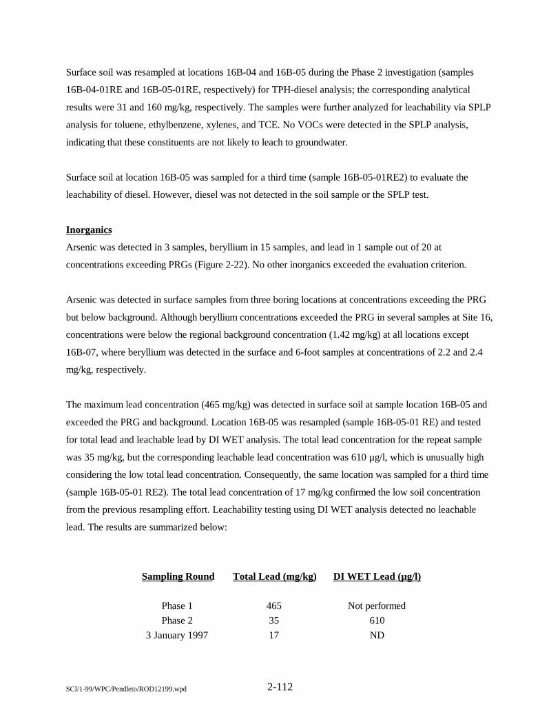
2-112SCI/1-99/WPC/Pendleto/ROD12199.wpd
Surface soil was resampled at locations 16B-04 and 16B-05 during the Phase 2 investigation (samples
16B-04-01RE and 16B-05-01RE, respectively) for TPH-diesel analysis; the corresponding analytical
results were 31 and 160 mg/kg, respectively. The samples were further analyzed for leachability via SPLP
analysis for toluene, ethylbenzene, xylenes, and TCE. No VOCs were detected in the SPLP analysis,
indicating that these constituents are not likely to leach to groundwater.
Surface soil at location 16B-05 was sampled for a third time (sample 16B-05-01RE2) to evaluate the
leachability of diesel. However, diesel was not detected in the soil sample or the SPLP test.
Inorganics
Arsenic was detected in 3 samples, beryllium in 15 samples, and lead in 1 sample out of 20 at
concentrations exceeding PRGs (Figure 2-22). No other inorganics exceeded the evaluation criterion.
Arsenic was detected in surface samples from three boring locations at concentrations exceeding the PRG
but below background. Although beryllium concentrations exceeded the PRG in several samples at Site 16,
concentrations were below the regional background concentration (1.42 mg/kg) at all locations except
16B-07, where beryllium was detected in the surface and 6-foot samples at concentrations of 2.2 and 2.4
mg/kg, respectively.
The maximum lead concentration (465 mg/kg) was detected in surface soil at sample location 16B-05 and
exceeded the PRG and background. Location 16B-05 was resampled (sample 16B-05-01 RE) and tested
for total lead and leachable lead by DI WET analysis. The total lead concentration for the repeat sample
was 35 mg/kg, but the corresponding leachable lead concentration was 610 µg/l, which is unusually high
considering the low total lead concentration. Consequently, the same location was sampled for a third time
(sample 16B-05-01 RE2). The total lead concentration of 17 mg/kg confirmed the low soil concentration
from the previous resampling effort. Leachability testing using DI WET analysis detected no leachable
lead. The results are summarized below:
Sampling Round Total Lead (mg/kg) DI WET Lead (µg/l)
Phase 1 465 Not performedPhase 2 35 610
3 January 1997 17 ND
2-113SCI/1-99/WPC/Pendleto/ROD12199.wpd
Based on this testing, the original elevated lead detection is considered anomalous, as confirmed by the low
concentrations detected during the two subsequent resampling efforts. Given the low total lead
concentration of 35 mg/kg, a leachable lead value of 610 µg/l seems to be erroneously high, The final DI
WET analysis data support this contention and indicate that leaching of lead to groundwater is unlikely for
lead concentrations in this range.
2.6.9.3.3 Groundwater Results
Groundwater at Site 16 is included in OU4 and results are not presented here.
2.6.9.3.4 Surface-Water and Sediment Results
Results of surface-water and sediment sampling arc summarized in Figure 2-23. Because no pathways for
human exposure exist for sediment or surface water, contaminants detected in these media are of concern
only for ecological receptors. Accordingly, the results are not compared against human health evaluation
criteria. Instead, the analytical results for these media are screened against ecological risk criteria.
Diesel and 4,4'-DDT are the only organic compounds that exceeded ecological screening criteria. Diesel
exceeded ecological screening criteria at three surface-water sample locations, with a maximum
concentration of 1,580 µg/l. The 4,4'-DDT concentration in sediment sample 16SD003 was 3.6 µg/kg,
which exceeds the screening criteria.
Barium exceeded screening criteria at three sediment sample locations, with a maximum concentration of
124 mg/kg. Barium, copper, iron, and zinc exceeded screening criteria in surface-water samples, with
maximum concentrations of 169, 28.5, 2,280, and 220 µg/l, respectively.
2.9.3.5 Biota Results
Terrestrial plant and aquatic invertebrate samples were collected at Site 16. Biota collected from the site
included terrestrial plants and aquatic invertebrates. The maximum detected tissue concentrations were
compared with similar biota collected from reference areas. For terrestrial plants, all reference HQs are less
than 1.0, indicating that bioaccumulation from site-related chemicals is less than that for reference areas.
2-114SCI/1-99/WPC/Pendleto/ROD12199.wpd
Aquatic invertebrates (crayfish) were compared with reference values from two different reference areas, as
well as with PLEs for ingestion by raccoons. One reference area (R8) was located upstream of sample
station 7, in an arm of the drainage into Sites 16 and 27; this location had not been sampled previously and
was not expected to be affected by site-related activities. The second reference area (R4) was located above
the inlet to the upper end of Lake O'Neill and was used to represent background conditions for the base.
Aluminum, barium, copper, and iron at sample station 1 and nickel at station 7 exceeded both R4 and R8
reference values. Manganese and nickel at sample station 1 and cobalt and copper at sample station 7
exceeded only R8 reference values. Arsenic at sample station 1 and aluminum and silver at sample station 7
exceeded only R4 reference values. With the exception of nickel at sample station 7, reference HQs were
less than 10, indicating that tissue levels were relatively close to those at unaffected reference areas. Tissue
concentrations could be representative of local ambient concentrations because no significant differences
were observed in upstream locations compared with downstream sample locations. In addition, the
organochlorine pesticide 4,4'-DDT, which exceeded sediment PLEs at Site 27, was not detected in crayfish
tissues, indicating that biota are not bioaccumulating this chemical. A comparison of crayfish tissue
concentrations against PLEs for ingestion by raccoons indicated that concentrations could reflect general
ambient conditions because PLEs were exceeded by the same chemicals in tissues collected from both the
site and the Lake O’Neill reference area.
2.6.9.4 Summary of Risks Associated with Site 16
Human health and ecological risk assessments were conducted for Site 16 using data collected during the
RI. Risk assessment methodologies are summarized in Section 2.4.1.4. Risk assessment summaries for Site
16 are presented in this section.
2.6.9.4.1 Human Health Risk Characterization
The HHRA evaluated soil only. Groundwater at Site 16 is included in OU4. The pathways for human
exposure to surface water and sediment are not complete and, thus, were not evaluated.
Detected COPCs in soil include metals, SVOCs, and VOCs. Current/future workers and future residents
could be exposed to soil contaminants through incidental ingestion, dermal contact, and inhalation of VOCs
or particulates.
2-115SCI/1-99/WPC/Pendleto/ROD12199.wpd
The cumulative residential risk from maximum detected COPCs is 1.9x10⁻⁵ and is primarily attributable to
arsenic (approximately 10 percent of the total risk) and beryllium (approximately 90 percent of the total
risk). The maximum concentration of arsenic (0.7 mg/kg) is below the background value (4.25 mg/kg),
whereas the maximum concentration of beryllium (2.4 mg/kg) exceeds background (1.42 mg/kg).
Excluding the portion of total risk attributable to background metals, the incremental residential site risk is
7x10⁻⁶. Assuming that beryllium is lognormally distributed throughout the soil at Site 16, the estimated 95
percent UCL soil concentration for beryllium is 1.2 mg/kg. Excluding the portion of total risk attributable
to background, the incremental residential site risk for the 95 percent UCL soil concentration is 2.0x10⁻⁷.
The cumulative residential noncarcinogenic hazard for the maximum detected COPCs is 0.64 and is
primarily attributable to metals (approximately 99 percent of the total hazard). Excluding the portion of
total hazard attributable to background metals, the incremental residential site hazard is 0.1.
The incremental residential cancer risk is less than 1x10⁻⁶ and the incremental noncarcinogenic hazard is
less than 1.0. The maximum lead concentration (465 mg/kg) exceeds the residential soil PRG. During two
resampling events at the location where the maximum lead concentration was detected, lead concentrations
were 35 and 17 mg/kg. The other 18 detections of lead were below residential PRGs. The single high
concentration of lead is not uniformly distributed throughout site soil, as indicated by the lower detections
of lead in subsequent sampling at the maximum concentration location and at other locations. Based on the
conservative assumptions used, no adverse health impacts are expected from lead at Site 16. Therefore,
Site 16 soil is considered protective of human health.
2.6.9.4.2 Ecological Risk Assessment
Seven preliminary COPECs (six inorganics and one organic) in soil had HQs exceeding 1.0 (Figure 2-23).
HQs were calculated for representative species for multiple soil samples at seven locations; the samples
were analyzed for 119 inorganic and organic chemicals. Most of the HQs that exceed 1.0 are less than 10,
indicating that the potential for toxicity is relatively low. HQs for beryllium, cadmium, chromium, lead, and
zinc are in the medium toxicity range (10 to 100). The frequencies of detection for chemicals with HQs
greater than 1.0 were high (100 percent), with the exception of cadmium (13 percent) and diesel (47
percent).
2-116SCI/1-99/WPC/Pendleto/ROD12199.wpd
HQs for two preliminary sediment COPECs, barium and 4,4'-DDT, exceed 1.0 (Figure 2-23). HQs exceed
1.0 for barium at sample locations 2, 3, and 7 and for 4,4'-DDT at sample station 3. All HQs that exceed
1.0 are less than 10, indicating that potential toxicity is relatively low. The highest HQ is 6.2 for barium at
station 7, but barium concentrations are less than those detected at a reference area (R8) located upstream
from Site 27 and are considerably less than soil background levels for the Santa Margarita Basin.
HQs for five preliminary surface-water COPECs (barium, copper, iron, zinc, and diesel) exceed 1.0 for
chronic exposure by aquatic organisms. HQs that exceed 1.0 are all less than 10, with the exception of
barium at sample stations 1 and 3, where HQs are in the medium toxicity range (10 to 100). HQs for
barium at sample stations 1 and 3 and zinc at sample station 3 exceed 1.0 for acute exposure but are close
to 1.0, indicating that the potential for acute toxicity is relatively low. Chemicals exceeding aquatic water
quality criteria (AWQC) include iron at station 2 and copper and zinc at station 3. Iron exceeded chronic
AWQC only once. Copper was detected in only one of four samples and did not exceed the acute AWQC.
Zinc was detected in all four samples collected from the station, but only one sample exceeded chronic and
acute AWQC values. This sample was collected in 1994, and the subsequent sample collected in 1995
contained much lower zinc concentrations. The HQs for terrestrial representative species exposed to
surface water are all less than 1.0.
Birds, small mammals, reptiles, and aquatic invertebrates were observed at the site. The least Bell's vireo (a
special-status species) could use the site but is not expected to establish territories or nests because of the
limited suitable habitat. Representative species for this site with HQs exceeding 1.0 include plants,
terrestrial invertebrates, deer mouse, raccoon, least Bell's vireo, and Swainson's hawk for soil and aquatic
organisms for sediment and surface water.
None of the preliminary COPECs in soil were retained as final COPECs because the potential for exposure
and effects is considered low. Additional confirmation sampling of the soils was conducted at Site 16 for
lead and TPH, including leachability testing. The results indicated that these chemicals do not have a
significant potential for leaching and transport.
The total lead concentration at the highest soil location (16B-05) was originally reported as 465 mg/kg.
Two subsequent soil sampling events at the same location resulted in 35 and 17 mg/kg, respectively. Boring
16B-04, which originally had a lead concentration of
2-117SCI/1-99/WPC/Pendleto/ROD12199.wpd
80.5 mg/kg, was resampled and a concentration of 12.6 mg/kg was detected. This indicates that the
concentrations and extent of lead contamination at the site are not as high as indicated by the initial
sampling.
Other preliminary COPECs with HQs exceeding 1.0 include beryllium, cadmium, chromium, copper, and
zinc. HQs for these chemicals are in the low and medium toxicity ranges. Soil leachability testing
demonstrated that leaching of these chemicals from soil into sediments and surface water is insignificant.
The actual areas of the site where contamination is present is likely a limited proportion of the overall site
area. These areas are generally smaller than the home range sizes of representative bird and mammal
species. Given the relative lack of suitable habitat compared with surrounding areas, ecological receptors
would not likely be sufficiently exposed to preliminary COPECs at the site to result in adverse effects.
None of the preliminary COPECs in sediment were retained as final COPECs because the potential for
exposure and effects is considered low. Barium was not retained as a final COPEC because concentrations
were less than upstream reference concentrations and soil background levels, indicating that barium
concentrations in the ditches are reflective of background conditions for the area. The pesticide 4,4'-DDT
was not retained because HQs were low and it was detected only once on site. This compound was not
detected in aquatic invertebrate (crayfish) tissues collected from the on-site drainage ditches or in crayfish
samples collected from a downstream location at Site 27.
None of the preliminary COPECs in surface water were retained as final COPECs because the potential for
exposure and effects is considered low. The HQs indicated low potential toxicity, and barium and diesel
were the only chemicals exceeding PLEs at more than one sample station within the site. Barium and diesel
were not retained as final COPECs because concentrations of barium could be reflective of underlying
sediment concentrations or ambient conditions for the area and the HQs for diesel were generally in the low
toxicity range (1 to 10). Diesel was detected in only two surface-water samples. The source of the diesel
contamination likely is attributable to storm-water runoff from roadway areas at the different sites that
contribute drainage to the ditch. Potential sources that may have contributed to the diesel detections in the
stormwater runoff near Site 16 include the motor transportation/maintenance facility immediately northeast
of the site and the asphalt parking lot south of the site. Soil leachability studies demonstrated that residual
contamination in on-site soils is probably not a significant contributor
2-118SCI/1-99/WPC/Pendleto/ROD12199.wpd
to surface water at the site. Three preliminary COPECs exceeded PLEs based on AWQC (iron, copper,
and zinc). These constituents were not retained as final COPECs because they were detected at
concentrations exceeding AWQC only once and at only one location within the site. Subsequent samples
were either below AWQC or were nondetects, indicating that concentrations are not consistently at
potentially toxic levels. In addition, the ditch is only seasonally wet and, as such, does not support higher
tropic level aquatic organisms (e.g., fish).
2.6.9.5 Description of the No Action Alternative
The no action alternative selected for Site 16 soil, sediment, and surface water includes no institutional
controls. Site 16 is considered protective of human health and the environment for the following reasons:
• The human health HI for maximum detected soil concentrations is less than 1.0.
• The incremental cancer risk for representative concentrations at the site that exceed background isless than 1x10⁻⁶.
• Although a few chemicals pose a potential ecological risk at Site 16, the overall potential risk islow. The potential for exposure and adverse effects is considered low for soil, surface water, andsediment.
2.6.10 Site 17 - 22 Area Building 22187 Marsh and Ditch
Site 17 consists of a marsh and ditch near Building 22187 in 22 Area.
2.6.10.1 Site Name, Location, and Description
Site 17 - 22 Area Building 22187 Marsh and Ditch, consists of an unlined, densely vegetated ditch located
about 0.25 mile southeast of the MCAS and approximately 1 mile from the Santa Margarita River (Figure
1-2). Seasonal surface water flows in the unlined ditch, which is approximately 10 feet wide and 2 to 8 feet
deep.
Site 17 is bordered on the west and northwest by light to moderate vegetation, on the cast by grass, and on
the south by Building 22187. An elevated concrete walkway traverses the ditch. The site is situated in a flat
part of the floodplain, is drained by two northwest-flowing ditches, and receives runoff from the Building
22187 area. The confluence of several ditches widens and creates a marsh at the site. Site 16 is north and
Site 27 is downstream to the west of the marsh and ditch. Ridges to the cast and south rise 350 feet above
the site (Figure 2-24).
2-119SCI/1-99/WPC/Pendleto/ROD12199.wpd
No perennial surface water is present in the immediate vicinity of Site 17. The area receives only low
annual rainfall, primarily during winter months. Surface water at the site is generally ephemeral and
follows the gently sloping ground surface to the southwest. The Site 17 ditch drains into Site 16 and Site 27
ditches, which eventually discharge southwest into the Santa Margarita River. Any surface water that does
not drain to the ditches either percolates into the subsurface or evaporates.
Land use in the vicinity of Site 17 consists of activities associated with major warehousing and food
storage functions for the base. Structures in the area include maintenance shops, motor pools, fueling
facilities, administrative buildings, scrap yards, recreation areas, troop housing, and industrial and
warehouse buildings. Military and civilian personnel are present in the immediate vicinity of the site on a
daily basis. An elevated walkway crosses Site 17 and Site 16 to the north. The nearest designated troop
housing areas are in the Chappo (22) Area, approximately 500 feet from the site. The nearest family
housing, the Ranch House, is about 1.25 miles northeast of Site 17. The nearest base production well
(10S/05W-13R02) is approximately 1 mile northwest of Site 17.
Site 17 contains predominantly nonnative grassland habitat. Dominant grass species include ripgut brome
and wild oat. The two ditches that traverse the site contain remnant strips of riparian habitat, including
cottonwood, willow, and cattail. No special-status species were observed during the site surveys. A least
Bell's vireo was tentatively identified on the site but could not be confirmed. During ecological surveys, 19
bird species were identified on site, including song sparrow, red-winged blackbird, Anna’s hummingbird,
and red-shouldered hawk. House mice and California ground squirrels were caught in live-traps during the
March 1995 survey. No reptiles were observed. Aquatic and terrestrial invertebrates were observed at the
site during the March, June, and October 1995 surveys.
2.6.10.2 Site History and Enforcement Activities
Site 17 consists of a naturally occurring drainage ditch that could have received hazardous materials. The
ditch received runoff from the Building 22187 area. Building 22187 is a steam generation plant that was
built in 1952. POLs and corrosives (descalers) were used during previous operations and are currently
stored in the Building 22187 area. A diesel spill reportedly flowed into the drainage ditch immediately north
of Building 22187. In addition, thousands of gallons of diesel from an overflowing UST reportedly spilled
into the ditch in the late 1980s. In
2-120SCI/1-99/WPC/Pendleto/ROD12199.wpd
March 1992, two USTs were removed from the area as part of the Navy's UST program. The tanks stored
diesel and had capacities of 12,000 and 6,000 gallons. No additional information is available on the
quantities of other contaminants received by the ditch.
An initial study of two diesel USTs near Site 17 was conducted in 1985. Organic vapor concentrations in
borings and wells ranged from 200 ppm to more than 1.000 ppm, as measured using a flame-ionization
detector (FID). Petroleum hydrocarbon concentrations were 15,000 and 19,000 ppm at approximately 15
feet below ground surface. No other analyses were performed on these samples during the initial study
(Dames and Moore, 1986). A later investigation resulted in the installation of two soil borings and three
groundwater wells after the removal of the USTs (SWDIV, 1993c). A maximum petroleum hydrocarbon
concentration of 9,900 ppm was detected in the soil samples collected as part of the UST removal program.
2.6.10.3 Summary of Site Characteristics
Site 17 was investigated during the RI for Group C sites and was initially reported in the Group C RI
report (SWDIV, 1996a). Additional ecological sampling was conducted during the RI for Group D sites
(SWDIV, 1997b). The results of the Rl indicated that soil contaminants were limited to petroleum
hydrocarbons. Site 17 soil was excluded from CERCLA and will be addressed under the base UST
program as documented in an amendment to the FFA (EPA, 1996b). Groundwater at Site 17 is included in
OU4.
Three surface-water samples were collected from two locations at Site 17 and were analyzed for metals,
VOCs, SVOCs, TPH as diesel and gasoline, and general chemistry. Three sediment samples were collected
from three locations at Site 17 and were analyzed for metals, PCBs, and pesticides. Sample locations are
shown in Figure 2-24.
A habitat and receptor survey was conducted and dominant vegetative habitats were identified at Site 17
during March 1995. Bird and general wildlife surveys were conducted to evaluate the potential presence of
special-status wildlife species. Mammal trapping (using Sherman live-traps) was conducted to identify
small mammal use of the site.
2.6.10.3.1 Geology and Hydrogeology
The Building 22187 marsh and ditch area is within the Santa Margarita River floodplain. The geology of
Site 17 consists primarily of stream-deposited alluvium of Holocene age overlying La
2-121SCI/1-99/WPC/Pendleto/ROD12199.wpd
Jolla Group bedrock of Eocene age. Soil at this site consists of alluvial sand, silt, and clay deposited as
discontinuous lenses. The predominant lithology in the area is poorly graded to well-graded sand, with
discontinuous lenses of lower permeability silty sand, silt, and clay. Poorly graded sand and less abundant
lenses of low-permeability silty sand, clayey sand, silt, and clay underlie the ditch confluence area.
The alluvium at Site 17 extends to depths of at least 84 feet. The La Jolla Group was encountered at a
depth of 71 feet below ground surface in one well close to the eastern hillslope, suggesting a thickening of
alluvium downstream. The La Jolla Group crops out on hillsides surrounding 22 Area and consists of fine-
to medium-grained sandstone interbedded with silty sandstone, clayey sandstone, siltstone, and claystone.
Boring logs and geologic cross-sections for Site 17 are presented in the draft final RI report for Group C
sites (SWDIV, 1996a).
Site 17 is located on the alluvial plain of the Santa Margarita Basin, on the south edge of the Chappo
subbasin. The regional groundwater flow direction is primarily southwest, parallel to the long axis of the
basin. Depth to the water table at Site 17 ranges from 5 to 10 feet below ground surface. Local
groundwater flows west-southwest, parallel to the long axis of the Chappo subbasin and consistent with
regional groundwater flow.
2.6.10.3.2 Surface-Water and Sediment Results
Because no pathways for human exposure exist for surface water or sediment, the contaminants detected in
these media are of concern only for ecological receptors. Accordingly, the results are not compared against
human health evaluation criteria. The analytical results are summarized in Figure 2-24.
2.6.10.4 Summary of Risks Associated with Site 17
An EcoRA was conducted for Site 17 using data collected during the Group C and Group D RIs. Risk
assessment methodology is summarized in Section 2.4.1.4.
HQs for four preliminary sediment COPECs (barium, cadmium, 4.4'-DDE, and 4,4'-DDT) exceed 1.0
(Figure 2-24). Three sediment samples were collected and analyzed for 119 inorganic and organic
chemicals. HQs for cadmium exceed 1.0 at one location (sample station 1). HQs for barium exceed 1.0 at
sample stations 1, 2, and 3. HQs for 4,4'-DDE and 4,4'-DDT exceed 1.0 at sample station 1. All HQs that
exceed 1.0 are very close to 1.0, indicating that the potential for
2-122SCI/1-99/WPC/Pendleto/ROD12199.wpd
toxicity is relatively low. Barium concentrations detected at all stations are less than those at the reference
area upstream from Site 27 and are considerably less than soil background levels for the Santa Margarita
Basin.
HQs for two preliminary surface-water COPECs (barium and silver) exceed 1.0 for chronic exposure by
aquatic organisms (Figure 2-24). The HQs for barium are in the medium toxicity range (10 to 100) at
sample stations 1 and 4. Silver was detected only once, at sample station 1, with an HQ in the high toxicity
range (100 to 1,000) based on comparison with the chronic AWQC. Both chemicals also exceed PLEs for
acute exposure by aquatic organisms, but all HQs are less than 10, indicating that the potential for toxicity
is relatively low. The frequencies of detection for the preliminary COPECs with HQs exceeding 1.0 are low
for both barium and silver at sample station 1 (one detect out of three samples) and only one sample was
collected at location 4. The HQs for terrestrial representative species exposed to surface water are all less
than 1.0.
Birds, small mammals, reptiles, and aquatic invertebrates were observed at the site. The least Bell's vireo (a
special-status species) could use the site but is not expected to establish territories or nests. Representative
species for this site with HQs exceeding 1.0 for sediment and surface water consist of aquatic organisms.
None of the preliminary sediment COPECs were retained as final COPECs. The potential for exposure to
and effects/toxicity from all preliminary COPECs with HQs exceeding 1.0 is considered low. Barium was
not retained as a final COPEC because concentrations are less than the upstream reference concentrations
and soil background levels, indicating that barium concentrations in the ditches could reflect background
conditions for the area. Cadmium was not retained because it was detected at only one station, with an HQ
indicating a low potential for toxicity. The organochlorine pesticides 4,4'-DDE and 4,4'-DDT were not
retained as final COPECs because they were detected at only one sample station. These constituents were
not detected in sediment collected from upstream or downstream sample locations and were not detected in
crayfish collected from downstream sites, indicating that bioaccumulation is not occurring, consistent with
the risk characterizations for Sites 16 and 27 (Sections 2.6.9.4.2 and 2.6.12.4.2).
2-123SCI/1-99/WPC/Pendleto/ROD12199.wpd
None of the preliminary surface-water COPECs were retained as final COPECs. Silver exceeded the
AWQC in a duplicate sample but could not be verified through subsequent sampling because the station
was dry. In addition, silver was detected only once at the site and was not detected in underlying sediment
samples, suggesting a potential artifact of sampling. Barium was not retained because the potential for
exposure and effects is considered low and concentrations of barium could reflect underlying sediment
concentrations or ambient conditions for the area.
2.6.10.5 Description of the No Action Alternative
The no action alternative selected for Site 17 sediment and surface water includes no institutional controls.
Site 17 surface water and sediment are considered protective of human health and the environment for the
following reasons:
• There is no complete human exposure pathway.
• Although a few chemicals pose a potential ecological risk, the overall potential risk is low. Thepotential for exposure and adverse effects is considered low for surface water and sediment.
2.6.11 Site 18 - 13/16 Area Building 1687 Spill and Ditch
Site 18 consists of ditches and spill areas near Building 1687 in 13/16 Area.
2.6.11.1 Site Name, Location, and Description
Site 18 - 13/16 Area Building 1687 Spill and Ditch, is located in the southern part of the Headquarters
Area, approximately 1,250 feet west of Vandegrift Boulevard (Figure 1-2). The ditch is an ephemeral
drainage that runs southward down a slight hill, away from two motor pool areas, a large parking area, and
an oil/water separator. The drainage ditch runs along "B" Street, into a concrete-lined ditch approximately
200 feet north of the intersection of 6th and "B" Streets. In the vicinity of Site 18, the concrete-lined ditch
runs west to east, parallel to 6th Street. The area receives only low annual rainfall, primarily during winter
months. The concrete-lined ditches drain east into Pilgrim Creek (approximately 1 mile to the east), flow
southwest into Windmill Lake, and eventually discharge into the San Luis Rey River.
No perennial surface water is present in the vicinity of Site 18. Any surface water that does not drain to the
ditch either percolates into the subsurface or evaporates. No drinking water wells are located within a
1-mile radius of Site 18.
2-124SCI/1-99/WPC/Pendleto/ROD12199.wpd
Structures in the vicinity of Site 18 include maintenance shops, motor pools, fueling facilities,
administrative buildings, and troop housing. Military and civilian personnel are present in the immediate
vicinity of the ditches on a daily basis. Designated troop housing areas are located within 13/16 Area. The
nearest family housing, Serra Mesa Housing, is about 0.5 mile east of Site 18.
Site 18 consists primarily of defined drainages, most of which are concrete-lined. However, one section is
vegetated with freshwater emergent wetland species such as bulrush and cattail. Young willows and
cottonwoods also grow in this section of the ditch. No special-status species are expected to be present on
this site. Wildlife species observed during the reconnaissance survey include cliff swallow, American crow,
and California ground squirrel.
2.6.11.2 Site History and Enforcement Activities
Site 18 was added to the RI/FS after a visit by the Navy and Jacobs Engineering Group Inc. (Jacobs) team
in May 1990. Base personnel reported a history of fuel spills at this site. In addition, the spill ditch near
Building 1687 received runoff from two motor pool areas that housed battery shops, storage areas, and a
bulk fuel area. POLs, solvents, and corrosives represent typical waste types spilled at this site.
2.6.11.3 Summary of Site Characteristics
Site 18 was investigated in June and July 1996 during the RI for Group D sites. A total of 20 soil samples
were collected from eight boring locations (Figure 2-25). The samples were analyzed for metals, VOCs,
and SVOCs. Poor recovery precluded the collection of groundwater samples. No surface-water or sediment
samples were collected because no surface water was present on site.
2.6.11.3.1 Geology and Hydrogeology
Surface geology at Site 18 consists primarily of alluvium of Holocene age overlying the La Jolla Group
bedrock of Eocene age. The predominant lithology at the site is poorly graded sand, with discontinuous
lenses of lower permeability silty sand, clayey sand, and silt. Bedrock was not encountered in boring
18B-02; alluvium extends to a depth of at least 23 feet at this location. The La Jolla Group was
encountered at depths of 9 and 13 feet in borings 18B-03 and 18B-06, respectively. These two borings are
located near opposing south and north hillslope walls. The
2-125SCI/1-99/WPC/Pendleto/ROD12199.wpd
La Jolla Group crops out on hillsides surrounding 13/16 Area and consists of fine- to medium-grained
sandstone interbedded with silty sandstone, clayey sandstone, siltstone, and claystone.
Based on site geology, groundwater is assumed to flow to the south, following surface topography. Soil
borings were drilled to a maximum depth of 40 feet below ground surface at Site 18; perched groundwater
was encountered at a depth of 9.2 feet in boring 18B-04. Field observations indicated that the continuous
water-bearing aquifer at Site 18 is more than 40 feet below ground surface.
2.6.11.3.2 Soil Results
This section discusses analytical results from soil sampling at Site 18. Results are summarized in Figure
2-25, which presents detected organics and any inorganics that exceed risk/hazard criteria.
Organics
No organics were detected in Site 18 soil at concentrations exceeding PRGs (Figure 2-25). Acetone,
benzoic acid, 2,4-dinitrotoluene. bis(2-ethylhexyl)phthalate, butylbenzylphthalate, and di-n-octylphthalate
were detected at low concentrations; the highest concentration detected was 0.52 mg/kg for
bis(2-ethylhexyl)phthalate.
lnorganics
Arsenic was detected in 9 of 22 samples and beryllium was detected in 19 of 22 samples at concentrations
exceeding PRGs but below background (Figure 2-25).
Summary
No organics were detected in soil at concentrations exceeding PRGs; arsenic and beryllium were the only
inorganics that exceeded PRGs, but concentrations were below background. Despite attempts to collect
water samples, groundwater was not encountered at Site 18. Based on soil concentrations and the deep
water table, groundwater is not expected to be impacted. No significant site-related contamination exists at
Site 18.
2.6.11.4 Summary of Risks Associated with Site 18
Human health and ecological risk assessments were conducted for Site 18 using data collected during the
RI. Risk assessment methodologies are summarized in Section 2.4.1.4. Risk assessment summaries are
presented in this section.
2-126SCI/1-99/WPC/Pendleto/ROD12199.wpd
26.11.4.1 Human Health Risk Characterization
Detected COPCs in soil include metals, VOCs, and SVOCs. Current/future workers and future residents
could be exposed to soil contaminants through incidental ingestion, dermal contact, and inhalation of VOCs
or particulates.
The cumulative residential risk from maximum detected COPCs is 3.4x10⁻⁵ and is primarily attributable to
arsenic (approximately 83 percent of the total risk) and beryllium (approximately 17 percent of the total
risk). The maximum concentrations of arsenic (10.6 mg/kg) and beryllium (0.91 mg/kg) are less than their
respective background concentrations. Excluding background concentrations, the incremental residential
site risk is 2.1x10⁻⁹.
The cumulative residential HI from maximum detected COPCs in soil is 1.5 and is primarily attributable to
aluminum (approximately 21 percent of the total hazard), arsenic (approximately 34 percent of the total
hazard), barium (approximately 20 percent of the total hazard), and manganese (approximately 17 percent
of the total hazard). Excluding the portion of total noncarcinogcnic hazard attributable to background
metals, the incremental residential site hazard for maximum detected COPCs is 0.5.
Based on the results of the HHRA, the incremental residential risk for soil is below the lower end of the risk
management range and the incremental residential hazard is less than the threshold criterion of 1.0. In
addition, the maximum lead concentration (29.6 mg/kg) is below the residential screening criteria.
Therefore, Site 18 soil is considered protective of human health.
Groundwater is not considered a complete exposure pathway for either current/future workers or future
residents. Groundwater sampling was not performed at Site 18 during the RI because drilling refusal
occurred in weathered bedrock less than 50 feet below ground surface, before encountering sufficient
groundwater for sampling purposes. Perched groundwater encountered at 9.2 feet below ground surface did
not supply sufficient quantities to sample. The site is not located above a shallow aquifer associated with
any of the four major groundwater basins at MCB Camp Pendleton (i.e., San Mateo, San Onofre, Las
Flores, or Santa Margarita Basin). The site is topographically higher than, and isolated from, the aquifers
associated with these major basins. Therefore, groundwater at Site 18 was not evaluated further in the
HHRA and is considered protective of human health.
2-127SCI/1-99/WPC/Pendleto/ROD12199.wpd
2.6.11.4.2 Ecological Risk Assessment
HQs for seven preliminary COPECs exceed 1.0 (Figure 2-25) for one or two representative species; HQs
are less than 1.0 for the other species. HQs were calculated for representative species for each of 11 soil
samples, which were analyzed for 119 inorganic and organic chemicals. Most of the HQs exceeding 1.0 are
less than 10, indicating that the potential for toxicity is relatively low. Aluminum, barium, and mercury had
HQs in the medium toxicity range (10 to 100). The highest HQs for barium (12) and for aluminum (12)
were calculated for the American robin. Aluminum and barium also had high frequencies of detection (100
percent). The highest HQ calculated for mercury was 20 for the deer mouse, indicating potentially high
toxicity; however, mercury was detected in only 1 of 11 samples and most of the other HQs were less than
1.0.
Site 18 consists primarily of concrete-lined ditches that have low habitat value for terrestrial receptors. One
section is unlined and characterized by emergent wetland species. No special-status species are expected to
be present on site. Representative species for this site with HQs exceeding 1.0 include terrestrial
invertebrates, deer mouse, and American robin.
None of the preliminary COPECs were retained as final COPECs because the potential for exposure and
effects is considered low. The HQs for most of the chemicals detected are less than 1.0, indicating little or
no toxicity. Aluminum, barium, and mercury had HQs greater than 10, but the frequency of detection for
mercury was low and the remaining HQs are generally less than 1.0. In addition, the site is mostly
developed and the available habitat is very limited. The home ranges of the representative mammal and bird
species are generally larger than the available site habitat in which contaminants were detected. Given the
limited on-site habitat and relatively good habitat surrounding the site, representative wildlife species would
likely only be present on site for limited periods of time. Therefore, exposure of wildlife receptors to the
preliminary COPECs at the site is not expected to result in any adverse effects.
2.6.11.5 Description of the No Action Alternative
The no action alternative selected for Site 18 soil and groundwater includes no institutional controls. Site
18 soil and groundwater are considered protective of human health and the environment for the following
reasons:
• The incremental cancer risk for soil is less than 1x10⁻⁶.
2-128SCI/1-99/WPC/Pendleto/ROD12199.wpd
• Excluding background, the HI for soil is less than 1.0.
• The human exposure pathway to groundwater is not complete based on the poor recovery from thegeological formation below the site.
• Although a few chemicals present a potential ecological risk, the overall potential risk is low. Thepotential for exposure and adverse effects is considered low for soil based on the frequency atwhich risk contributors were detected and the limited site habitat.
2.6.12 Site 27 - 22 Area Ditches Behind Building 22210
Site 27 consists of ditches behind Building 22210 in 22 Area.
2.6.12.1 Site Name, Location, and Description
Site 27 - 22 Area Ditches Behind Building 22210, is approximately 0.25 mile southeast of the MCAS and
approximately mile from the Santa Margarita River (Figure 1-2). Seasonal surface water flows in the
highly vegetated drainage ditches at this site. The ditches are approximately 10 feet wide and 5 to 8 feet
deep; they begin behind Building 22210 and flow northwest until they converge into a southwest-flowing
ditch along the southeast side of Avenue D. The ditches are unlined and receive runoff from various
maintenance facilities and hazardous material transfer and storage lots in 22 Area. The site ditches drain
the area and eventually discharge southwest into the Santa Margarita River. Surface water not drained
through the ditches either percolates into the subsurface or evaporates. No perennial surface water is
present in the immediate vicinity of Site 27.
Land use in the vicinity of Site 27 consists of activities associated with major warehousing and food
storage functions for the base. Structures in the area include maintenance shops, motor pools, fueling
facilities, administrative buildings, scrap yards, recreation areas, troop housing, and industrial and
warehouse buildings. Military and civilian personnel are present on roads and in buildings in the vicinity of
the ditches on a daily basis. The nearest designated troop housing areas are in the Chappo (22) Area,
approximately 200 feet from the site. The nearest family housing is the Ranch House, about 1.5 miles
northeast of Site 27. The nearest base production well is approximately 4,200 feet northwest of Site 27.
Site 27 contains a 30-foot-wide strip of riparian habitat that runs parallel to Avenue D. Cottonwood and
willow are the dominant tree species; mulefat, tree tobacco, and cattail are found in the understory.
Nonnative grassland habitat surrounds the riparian strip and is mowed
2-129SCI/1-99/WPC/Pendleto/ROD12199.wpd
along Avenue D. Southeast of the riparian strip is a small patch of coastal sage scrub. Sagebrush, coyote
brush, and deerweed are the dominant species in this habitat. During the surveys, 24 bird species were
identified. Common species include European starling, common yellowthroat, and California towhee. A
least Bell's vireo (a special-status species) was observed in the riparian strip parallel to Avenue D. During
the March survey, deer mice, western harvest mice, and house mice were caught in live-traps. Audubon
cottontails were observed throughout the site. No amphibians were observed. A western diamondback
rattlesnake was found in a rock pile near the riparian strip. Aquatic and terrestrial invertebrates were
observed at the site during the March, June, and October 1995 surveys.
2.6.12.2 Site History and Enforcement Activities
Site 27 consists of naturally occurring drainage ditches that could have received hazardous materials from
various facilities in the 22 Area. Site 27 is downstream from the Site 16 and Site 17 ditches, from
storm-water discharge pipes entering the drainage from the 22 Area, and from previously detected
contamination. Facilities in the area include warehouses and industrial operations. No information is
available on the quantities of contaminants received by the ditches.
Previous investigations at Site 27 were limited to a sampling visit (SV) conducted as part of the RFA for
SV Site 111. The SV analysis included six surface soil samples and four subsurface soil samples from six
hand-augered soil borings that were advanced in the 22 Area drainage ditches to investigate potential
contamination associated with runoff entering the ditches. The SV borings were advanced during the
summer when the ditches were dry. Groundwater was encountered in all borings at depths of 2 to 6 feet
below surface. No groundwater samples were collected as part of the SV. Chlorinated solvents detected in
two soil borings included 1,1-dichloroethene (DCE), TCE, chlorobenzene, methylene chloride, and PCE
(SWDIV, 1993a).
2.6.12.3 Summary of Site Characteristics
Site 27 was investigated with the Group C sites (SWDIV, 1996a). Additional ecological sampling was
conducted during the RI for Group D Sites (SWDIV, 1997b). Site 27 groundwater is part of OU4. Eight
surface-water and eight sediment samples were collected from the Site 27 ditches (Figure 2-26) and were
analyzed for metals, VOCs, SVOCs, TPH as diesel and gasoline, and pesticides and PCBs. The
surface-water samples were also analyzed for general chemistry. No soil samples were collected because
the ditches were saturated.
2-130SCI/1-99/WPC/Pendleto/ROD12199.wpd
During March 1995, a habitat and receptor survey was conducted and dominant vegetative habitats were
identified. Bird and general wildlife surveys were conducted to evaluate the potential presence of
special-status wildlife species. Mammal trapping (using Sherman live-traps) was conducted to identify
small mammal use of the site.
One aquatic invertebrate (crayfish) sample and one terrestrial invertebrate (mixed insects) sample were
collected in June 1995 and two aquatic invertebrate (crayfish) samples (one sample and one duplicate) were
collected in June 1996 from the areas containing the highest inorganic and organochlorine pesticide
concentrations (27SD001 and 27SD002) (Figure 2-26). In October 1995, terrestrial invertebrates (sowbugs
and grasshoppers) were collected from the seasonally flooded playground area along 10th Street, southeast
of Phase 1 RI sampling location 27SD001.
2.6.12.3.1 Geology and Hydrogeology
The geology of Site 27 consists primarily of stream-deposited alluvium of Holocene age overlying the La
Jolla Group bedrock of Eocene age. The alluvium is predominantly silt and poorly graded sand containing
varying amounts of silt and interbedded clay lenses. The thickness of the alluvium at Site 27 was not fully
penetrated during drilling; however, alluvium near well cluster 6W-06, approximately 2,000 feet southwest
of 27W-02, extends to a depth of at least 142 feet. Depth to bedrock decreases significantly toward the hills
south of the site. The La Jolla Group crops out on hillsides surrounding 22 Area and consists of fine- to
medium-grained sandstone interbedded with silty sandstone, clayey sandstone, siltstone, and claystone.
Site 27 is located on the alluvial plain of the Santa Margarita Basin, on the south edge of the Chappo
subbasin. The regional groundwater flow direction is primarily southwest, parallel to the long axis of the
basin. Depth to the water table at Site 27 ranges from 5 to 10 feet below ground surface. Local
groundwater flow is west-southwest, parallel to the long axis of the Chappo subbasin and consistent with
regional groundwater flow.
2.6.12.3.2 Surface-Water and Sediment Results
A summary of analytical results is presented in Figure 2-26. Because no pathways for human exposure
exist for surface water or sediment, the contaminants detected in these media are of concern only for
ecological receptors. Accordingly, the results are not compared against human health evaluation criteria,
but rather against ecological risk criteria.
2-131SCI/1-99/WPC/Pendleto/ROD12199.wpd
2.6.12.3.3 Biota Results
Biota collected from the site included terrestrial and aquatic invertebrates. The maximum detected tissue
concentrations were compared with similar biota collected from reference areas. Tissue concentrations in
terrestrial invertebrates exceeded reference values at sample station 1 (seven inorganics), sample station 3
(seven inorganics), and sample station 4 (two inorganics). The reference quotients are all less than 10 and
most are very close to 1.0, indicating that tissue levels are very similar to those found in unaffected areas.
Organochlorine pesticides were not detected in terrestrial invertebrates.
Tissue concentrations in aquatic invertebrates (crayfish) were compared with reference values from two
different reference areas (R8 and R4) and with PLEs for ingestion by raccoons. The following preliminary
COPECs exceeded values for both reference areas: aluminum, barium, chromium, cobalt, copper, iron,
manganese, nickel, silver, zinc, and 4,4'-DDE. Vanadium exceeded only R8 reference values. All reference
HQs are less than 10, indicating that tissue levels are relatively close to those at unimpacted reference
areas.
Crayfish tissue concentrations were also compared with PLEs for ingestion by raccoons. This comparison
indicated that crayfish tissue concentrations could be reflective of local ambient conditions because PLEs
were exceeded by the same chemicals in tissues collected on site and from the R4 reference area.
2.6.12.4 Summary of Risks Associated with Site 27
Human health and ecological risk assessments were conducted for Site 27 using data collected during the
Group C and Group D RIs. Risk assessment methodologies are summarized in Section 2.4.1.4. Risk
assessment summaries for Site 27 are presented in this section.
2.6.12.4.1 Human Health Risk Characterization
The exposure pathways for surface water and sediment are incomplete for human receptors. Humans are
not present at the site frequently enough to support a chronic exposure. Therefore, site surface water and
sediment are considered protective of human health.
2.6.12.4.2 Ecological Risk Assessment
HQs for 12 preliminary sediment COPECs (8 inorganics and 4 organics) exceed 1.0 (Figure 2-26) but are
generally less than 10, indicating a low potential for toxicity, with the following
2-132SCI/1-99/WPC/Pendleto/ROD12199.wpd
exceptions: 4,4'-DDE at sample stations 1 and 2, 4,4'-DDT at sample stations 1 and 4, and barium at
sample stations 5 and 6. Barium, 4,4'-DDE, and 4,4'-DDT were the only preliminary COPECs detected at
several of the stations along the main portion of the ditch, but only one or two samples were collected at
each sample station. Concentrations of barium, cadmium, manganese, and nickel are within soil
background levels for the Santa Margarita Basin and could represent local background conditions. In
addition, barium concentrations are less than those detected at a reference area upstream from Site 27.
Concentrations of the remaining inorganics (copper, iron, lead, and zinc) exceed soil background levels but
resulted in HQs close to 1.0 (ranging from 1.1 to 2.5).
HQs for 11 preliminary surface-water COPECs (8 inorganics and 3 organics) exceed 1.0 for chronic
exposure by aquatic organisms (Figure 2-26). HQs are generally less than 10. The exceptions are barium at
sample stations 1, 2, 6, 7, 8, and 9; mercury at sample station 1; and silver at sample station 7. The HQs
for preliminary COPECs at these sample stations are in the medium toxicity range (10 to 100). Preliminary
COPECs exceeding chronic AWQC include aluminum. chloride, cyanide, iron, mercury, and silver.
Aluminum, cyanide, mercury, and silver were detected only once (out of three or four samples). Chloride
and iron were detected in all samples (for a particular sample station) but exceeded AWQC values only
once. Preliminary COPECs with HQs exceeding 1.0 for acute exposure by aquatic organisms include
barium, cyanide, and silver, but all HQs are less than 10, indicating a low potential for toxicity. The
frequencies of detection for the preliminary COPECs with HQs exceeding 1.0 ranged from 30 to 100
percent (within each sample station). The HQs for terrestrial representative species exposed to surface
water are all less than 1.0.
None of the preliminary sediment COPECs were retained as final COPECs because the potential for
exposure and effects is considered low. The HQs for most of the preliminary COPECs are close to 1.0;
only a few HQs exceed 10. Inorganics were not retained because concentrations are less than or close to
background soil levels and could reflect background conditions for the area. Organochlorine pesticides were
not retained because most of the associated HQs are less than 10, indicating low potential toxicity. In
addition, the crayfish collected from Site 27, as well as those from upstream (Site 16 and R8 [reference
area]), showed very little bioaccumulation of 4,4'-DDT or its metabolites in the aquatic food web.
2-133SCI/1-99/WPC/Pendleto/ROD12199.wpd
None of the preliminary surface-water COPECs were retained as final COPECs because the potential for
exposure and effects is considered low. The HQs indicated low potential toxicity for most preliminary
COPECs based on chronic comparisons and for all preliminary COPECs based on acute comparisons.
Preliminary COPECs exceeding PLEs based on AWQC values were not retained as final COPECs because
the chemicals were either detected only once or exceeded AWQC values only once, indicating that they are
not present at high concentrations on a consistent basis. In addition, the ditches are only seasonally wet and
chemicals exceeding acute AWQC were detected only once. Other preliminary COPECs exceeding acute
PLEs had HQs very close to 1.0, indicating low potential toxicity.
2.6.12.5 Description of the No Action Alternative
The no action alternative selected for Site 27 surface water and sediment includes no institutional controls.
Site 27 surface water and sediment are considered protective of human health and the environment for the
following reasons:
• There is no complete exposure pathway for human receptors.
• Although a few chemicals in surface water and sediments pose a potential ecological risk, theoverall potential risk is low based on the low potential for bioaccumulation, the frequency at whichrisk contributors were detected, and the background contribution to risk.
2.6.13 Site 32 - Drum Storage Area and Drainage Between Buildings 41303 and 41366
Site 32 consists of a drum storage area and drainage in 41 Area.
2.6.13.1 Site Name, Location, and Description
Site 32 - Drum Storage Area and Drainage Between Buildings 41303 and 41366, is located within the Las
Flores Area, approximately 1,000 feet northeast of Stuart Mesa Road and immediately east of its
intersection with El Camino Real (Figure 1-2). The site consists of an inactive waste oil UST, lube rack,
wash rack, oil/water separator, hazardous waste drum storage area, and partially lined drainage ditch. The
ditch is approximately 1,500 feet long and runs along the northern side of, and parallel to, El Camino Real.
The wash rack, lube rack, oil/water separator, and drum storage area are immediately adjacent to the
drainage at various points along the ditch. In addition, some petroleum-stained soil was observed
approximately 200 feet
2-134SCI/1-99/WPC/Pendleto/ROD12199.wpd
northeast of the eastern end of the ditch. The flow direction of the ditch is southeast to northwest. Pulgas
Creek is approximately 0.75 mile northwest of Site 32. The surrounding area is characterized by rolling
hills.
A small vegetated area is present at the eastern end of the drainage. Dominant plant species include willow,
fennel, sage, mulefat, mustard, and curly dock. Special-status species, if present, would likely be limited to
least Bell's vireo and would be confined primarily to the eastern end of the site. Bird species observed
during the reconnaissance survey include common raven and mourning dove.
No perennial surface water is present in the immediate vicinity of Site 32. The area receives only low
annual rainfall, primarily during winter months. Surface water at the site is generally ephemeral and
follows the gently sloping ground surface to the southwest and eventually discharges into the Pacific
Ocean. During significant rainfall events, surface water percolates into the subsurface, evaporates, or runs
off site.
The Las Flores Area contains an industrial area (tank park, maintenance, and supply), a troop housing
area, medical and training facilities, and tank training ranges in the north and recreation areas in the south.
Military and civilian personnel are present on roads and at buildings in the vicinity of the site on a daily
basis. The nearest designated troop housing areas are located 300 to 600 feet south of the site, within the
Las Flores Area. The nearest family housing, Stuart Mesa Housing, is approximately 3 miles southeast of
Site 32. The nearest base production well is approximately 1 mile west of Site 32.
2.6.13.2 Site History and Enforcement Activities
Site 32 has been used solely as a vehicle maintenance area. Past maintenance operations reportedly resulted
in oil/water separator overflows, spills, and discharges to the ditch. Although the area is still used for
maintenance, the practices that led to its inclusion in the RI have ended. As a general practice, wastes that
had been containerized on site were later transported to the base hazardous waste disposal office for
disposal. However, no specific information is available on the quantities of waste or the disposal location.
This area was recommended for RI during the preliminary review (PR) (PR Sites 200, 203, and 204) and,
thus, no sampling was conducted during the RFA.
2-135SCI/1-99/WPC/Pendleto/ROD12199.wpd
2.6.13.3 Summary of Site Characteristics
Prior to 1995, no sampling had been conducted at this site; however, in late 1995, Bechtel collected a
surface soil sample and a groundwater sample from the locations shown in Figure 2-27. The purpose of
this sampling effort was to support SWDIV in estimating and prioritizing funding needs for future
environmental restoration work. The samples were analyzed for VOCs, SVOCs, and metals. The
groundwater sample was not filtered but was preserved with acid; as a result, the analytical results for
metals were not usable. No other analytes were detected at concentrations exceeding MCLs or PRGs.
Site 32 was investigated during the RI for Group D Sites (SWDIV, 1997b). A total of 40 soil samples were
collected from eight boring locations and one surface location, including the Bechtel 1995 samples. The
samples were analyzed for metals, VOCs, and SVOCs. A groundwater sample was collected using a
direct-push method during the 1995 sampling event. Groundwater samples could not be collected from
permanent wells during the 1996 RI because sufficient water was not encountered to a depth of
approximately 50 feet below ground surface. No surface water was present on site.
A habitat and receptor survey was conducted at Site 32 during June 1996. Dominant vegetation types and
corresponding wildlife habitats were identified. Wildlife observed and evidence of wildlife use (i.e., scat or
tracks) were also noted.
2.6.13.3.1 Geology and Hydrogeology
Geology at this site is primarily marine terrace deposits. These materials consist predominantly of
interbedded fine-grained sand, silty and clayey sand, and clay and gravel lenses and were probably
deposited in near-shore marine and/or estuarine conditions during periods of fluctuating sea levels.
Based on site geology, groundwater is assumed to flow to the southwest, following surface topography.
During the 1995 investigation, Bechtel collected a hydropunch sample at 47 feet below ground surface.
During the RI, soil borings were drilled to a maximum depth of 50 feet below ground surface at Site 32;
groundwater was encountered at a depth of 37.5 feet in boring 32B-01. However, data from the boring
indicate that shallow groundwater is present only within small, localized, discontinuous perched zones and
a distinct continuous water-bearing zone (aquifer) does not exist above 50 feet below grade at this site.
2-136SCI/1-99/WPC/Pendleto/ROD12199.wpd
2.6.13.3.2 Soil Results
This section discusses analytical results from soil sampling at Site 32. Results are summarized in Figure
2-27, which presents detected organics and any inorganics that exceed risk/hazard criteria.
Organics
No organic compounds were detected in soil at concentrations exceeding PRGs (Figure 2-27). However,
2-butanone and 2-methyinaphthalene were detected at concentrations of 0.001 and 0.27 mg/kg,
respectively, in the upper 5 feet of boring 32B-03.
Inorganics
Concentrations of three metals exceeded PRGs: arsenic, beryllium, and chromium VI (Figure 2-27). All
beryllium detections were below the background concentration of 1.52 mg/kg. Arsenic concentrations were
generally close to the background concentration of 2.67 mg/kg; the highest arsenic concentration was 3.7
mg/kg. No background value was available for chromium VI, which was detected at concentrations above
the PRG only at depths between 10 and 30 feet in three samples from boring 32MW-01. The maximum
concentration was 1.2 mg/kg.
2.6.13.3.3 Groundwater Results
No organics were detected at concentrations exceeding MCLs or tap-water PRGs in the groundwater
sample from Site 32 (hydropunch sample 104CP61; approximate groundwater level of 47 feet below
ground surface). The only organic compound detected was di-n-butylphthalate at a concentration of 1.3
µg/l (Figure 2-27).
The groundwater sample was not filtered and was preserved with acid. As a result, metals concentrations
were partially attributable to dissolved particles suspended in the sample. Accordingly, this sample was
rejected from the inorganics data set.
2.6.13.3.4 Summary
No organics were detected in soil at concentrations exceeding PRGs. Of the inorganics detected, arsenic
and beryllium concentrations were either below or not significantly higher than background. No
background is available for chromium VI, but this constituent was detected only at low concentrations
between depths of 10 to 30 feet in one boring. Therefore, soil contamination is not considered a problem.
Despite attempts to collect water samples during the
2-137SCI/1-99/WPC/Pendleto/ROD12199.wpd
1996 investigation, groundwater was not encountered to a depth of 50 feet. Based on the 1995 hydropunch
sample (104CP61), none of the contaminant data exceed evaluation criteria. Based on the soil
concentrations and the deep water table, groundwater contamination is not of concern.
2.6.13.4 Summary of Risks Associated with Site 32
Human health and ecological risk assessments were conducted for Site 32 using data collected during the
Group D RI. Risk assessment methodologies are summarized in Section 2.4.1.4. Risk assessment
summaries for Site 32 are presented in this section.
2.6.13.4.1 Human Health Risk Characterization
Soil COPCs include metals, VOCs, and SVOCs. Current/future workers and future residents could be
exposed to soil contaminants through incidental ingestion of soil, dermal contact with soil, and inhalation of
VOCs or soil particulates.
The cumulative residential risk from the maximum detected COPCs is 1.4x10⁻⁵. The primary risk drivers
are arsenic (approximately 54 percent of the total risk) and beryllium (approximately 26 percent of the total
risk). The maximum concentration of beryllium is less than the background concentration for the basin, and
the maximum arsenic concentration is only slightly higher than the background concentration. Excluding
the portion of total risk attributable to background metals, the incremental residential site risk from
maximum detected COPCs is 2.7xl0-6. Assuming that metals are distributed lognormally throughout the
soil, the 95 percent UCL for arsenic, 2.7 mg/kg, is less than the background value. Excluding the portion of
total risk attributable to background metals, the incremental residential risk from the more representative
soil concentrations (e.g., 95 percent UCLs) is less than 1x10⁻⁶.
The cumulative residential HI from the maximum detected COPCs is 1.4 and is primarily attributable to
aluminum (approximately 25 percent of the total hazard), arsenic (approximately 12 percent of the total
hazard), manganese (approximately 30 percent of the total hazard), and vanadium (approximately 11
percent of the total hazard). Excluding the portion of total hazard attributable to background, the
incremental residential site hazard is 0.2, which is below the threshold criterion of 1.0.
The results of the HHRA for Site 32 indicate that the incremental residential cancer risk is below the lower
end of the risk management range and the incremental residential noncarcinogenic
2-138SCI/1-99/WPC/Pendleto/ROD12199.wpd
hazard is below the threshold criterion of 1.0. In addition, the maximum lead concentration ( 10.7 mg/kg) is
below the screening criteria. Therefore, Site 32 soil is considered protective of human health.
Groundwater is not considered a complete exposure pathway for either current/future workers or future
residents. However, a hydropunch sample was collected in 1995 as part of another study. No organic
compounds were detected at concentrations exceeding PRGs, and the inorganic sample results were
rejected. Groundwater sampling was not performed at Site 32 during the 1996 investigation because
drilling refusal occurred in weathered bedrock at less than 50 feet below ground surface, before
encountering sufficient groundwater for sampling purposes. Site 32 is not located above a shallow aquifer
associated with any of the four major groundwater basins at MCB Camp Pendleton (i.e., San Mateo, San
Onofre, Las Flores, or Santa Margarita Basin). The site is topographically higher than, and isolated from,
the aquifers associated with these major basins.
Based on the results of the groundwater sample collected in 1995, the depth to groundwater, the lack of soil
contamination, and the incomplete exposure pathway from groundwater to humans, Site 32 groundwater is
considered protective of human health.
2.6.13.4.2 Ecological Risk Assessment
The HQs for six preliminary COPECs (aluminum, arsenic, chromium, iron, nickel, and vanadium) exceed
1.0 (Figure 2-27). HQs were calculated for representative species for each of 17 soil samples, which were
analyzed for 119 inorganic and organic chemicals. Most of the HQs that exceed 1.0 are less than 10,
indicating that the potential for toxicity is relatively low. The HQs for aluminum and chromium are in the
medium toxicity range (10 to 100). All preliminary COPECs with HQs exceeding 1.0 also had high
frequencies of detection (100 percent in 17 samples).
Representative species for this site with HQs exceeding 1.0 include plants, terrestrial invertebrates, deer
mouse, raccoon, and least Bell's vireo.
None of the preliminary COPECs were retained as final COPECs because the potential for exposure and
effects is considered low. The HQs for most of the chemicals detected are less than 10, indicating low
potential toxicity, with the exception of aluminum and chromium for
2-139SCI/1-99/WPC/Pendleto/ROD12199.wpd
raccoons. The maximum detected concentrations of all preliminary COPECs with HQs exceeding 1.0 are
close to background levels, and concentrations for most of the remaining samples are close to or less than
background levels. In addition, the habitat at the site is primarily mowed, and only a small portion east of
the site could provide adequate habitat for special-status species. The limited available habitat at the site is
generally smaller than the home ranges for the representative bird and mammal species. Given the
developed nature of the site, representative wildlife species are not expected to be on site for significant
periods of time. Therefore, exposure of these receptors is probably minimal and is not likely to result in
adverse effects.
2.6.13.5 Description of the No Action Alternative
The no action alternative selected for Site 32 soil and groundwater includes no institutional controls. Site
32 soil and groundwater are considered protective of human health and the environment for the following
reasons:
• There is no complete pathway for exposure of human receptors to groundwater.
• The incremental cancer risk under the residential scenario using representative concentrations isless than 1x10⁻⁶.
• The incremental HI under the residential exposure scenario using maximum concentrations is lessthan 1.0 and the maximum lead concentration is less than the screening criteria.
• Although a few chemicals pose a potential ecological risk, the overall potential risk is low. Thepotential for exposure and adverse effects is considered low for soil based on frequency at whichrisk contributors were detected, the background contribution to risk, and the low potential forexposure in the developed site area.
2.6.14 Site 34 - Combat Engineers Maintenance Facility, Buildings 62580-62583
Site 34 is a maintenance facility near Buildings 62580-62583.
2.6.14.1 Site Name, Location, and Description
Site 34 - Combat Engineers Maintenance Facility, Buildings 62580-62583, is located in 62 Area,
approximately 0.5 mile southeast of the intersection of San Mateo and Cristianitos Roads (Figure 1-2). The
facility consists of a lube rack, several wash racks, a large maintenance and motor transport area, a former
hazardous waste storage area, and an adjacent drainage. The wash
2-140SCI/1-99/WPC/Pendleto/ROD12199.wpd
rack, lube rack, and maintenance and motor transport areas are located south of Building 62580, and the
former hazardous waste storage area is located to the north. Two storm-water drains adjacent to the wash
racks and lube rack discharge storm water toward the drainage ditch that flows east to west at the southern
end of Site 34. The site is bordered on the west by Sewage Treatment Plant No. 12, on the south by an
unpaved access road and San Mateo Creek, and on the north and east by 62 Area buildings. Site 34 is
1,200 feet due south of Site 11. Cristianitos Creek is west of the site.
No perennial surface water is present in the vicinity of Site 34. Surface water at this site is ephemeral and
follows the gently sloping topography to the south. The area receives only low annual rainfall, primarily
during winter months, and surface flow is generally intermittent. During significant rainfall events, surface
water percolates into the subsurface, evaporates, or runs off the site and discharges into San Mateo Creek,
which eventually discharges into the Pacific Ocean approximately 3 miles downstream from the site.
A large portion of Site 34 has been disturbed. Remnant vegetation types include coastal sage scrub,
nonnative grassland, and freshwater emergent wetland. Plant species in the coastal sage scrub include sage
and coyote bush. Wild oat is the dominant grass species in the nonnative grassland habitat. Bulrush is the
dominant plant species in the freshwater emergent wetland habitat. No special-status species are expected
to be present on this site. Black phoebes and western kingbirds were observed during the reconnaissance
survey. The nearest base production well is approximately 1 mile southwest of Site 34.
The Combat Engineers Maintenance Facility is currently active and is expected to remain so. Military and
civilian personnel use the site frequently. The San Mateo (62) Area, where Site 34 is located, is used for
personnel training, recreation, troop housing, vehicle maintenance, mess, and administration. An
undeveloped area north of the site across San Mateo Road is classified as a maneuver area and is covered
by natural vegetation. The nearest designated troop housing is in the San Mateo (62) Area, approximately
800 feet from the site. No family housing is located within several miles of the site and none is planned.
2.6.14.2 Site History and Enforcement Activities
Site 34 has been operated as a large maintenance facility for approximately 28 years and has a history of
spills. Wastes include waste oil, used vehicle fluids, and solvents. This facility was
2-141SCI/1-99/WPC/Pendleto/ROD12199.wpd
recommended for RI during the PR (PR Site 275) and, thus, no sampling was conducted during the RFA.
2.6.14.3 Summary of Site Characteristics
Prior to scheduled RI fieldwork for Group D sites in 1996, eight borings (34B-0 1 through 34B-08) were
drilled in the vicinity of three wash racks that were used throughout the history of Site 34 and the nearby
lube rack and maintenance area. This sampling was conducted during March through May 1993 to support
scheduled construction at Site 34. The data were also used for RI characterization. A total of 43 soil
samples were collected and analyzed for metals, VOCs, and SVOCs. Sample locations are shown in Figure
2-28.
2.6.14.3.1 Geology and Hydrogeology
Shallow geology at this site consists of a cobble zone overlain by alluvial silty sands, clayey sands, and
thin, discontinuous lenses of fine-grained sand. Groundwater was encountered at a depth of 11 feet below
ground surface in boring 34B-11 and at a depth of 13 feet in monitoring well 34MW-01. Based on site
geology, groundwater is assumed to flow to the south, following surface topography; however, because
groundwater measurements were taken on separate dates, consistent data are not available to confirm this
assumption.
2.6.14.3.2 Soil Results
This section discusses analytical results from soil sampling at Site 34. Results are summarized in Figure
2-28, which presents detected organics and any inorganics that exceed risk/hazard criteria.
Organics
No organic compounds were detected at concentrations exceeding PRGs in Site 34 soil (Figure 2-28).
However, diesel was detected in the 2-foot sample from boring 34B-03 and the surface sample from boring
34B-04 at concentrations of 290 and 150 mg/kg, respectively; these concentrations exceed the 100-mg/kg
screening level.
The following 14 organics were detected in Site 34 soil at concentrations below evaluation criteria: acetone,
2-butanone, methylene chloride, carbon disulfide, toluene, 1,1,1-TCA, bis(2-ethylhexyl)phthalate,
2-methylnaphthalene, benzo(a)pyrene, fluorene, diethylphthalate, dimethylphthalate, di-n-butylphthalate,
and total volatile hydrocarbons (TVH). The highest concentration was 0. 18 mg/kg for
bis(2-ethylhexyl)phthalate.
2-142SCI/1-99/WPC/Pendleto/ROD12199.wpd
Inorganics
Arsenic and beryllium concentrations consistently exceeded PRGs (Figure 2-28). However, beryllium
concentrations were below background (1.42 mg/kg), and arsenic concentrations were generally not
significantly higher than background (4.25 mg/kg). The maximum concentration for arsenic was 8 mg/kg.
26.14.3.3 Groundwater Results
No organic compounds were detected in Site 34 groundwater (Figure 2-28).
Manganese (2,050 µg/1) and arsenic (8.4 µg/1) concentrations in well 34 GWT-01 (approximate
groundwater level of 11 feet below ground surface) exceeded tap-water PRGs (Figure 2-28). Chromium VI
(4 µg/l), arsenic (11.8 µg/l), and beryllium (0.04 µg/l) also exceeded tap-water PRGs in the sample from
well 34MW-01 (approximate groundwater level of 13 feet below ground surface). However, the result for
chromium VI was higher than for total chromium (1.9 µg/l) and was rejected during data validation. No
other inorganics were detected at concentrations exceeding evaluation criteria.
As discussed for Site 1A, the elevated manganese result is likely due to relatively poor filtration of silts and
small suspended particles in undeveloped hydropunch and temporary well samples. In contrast, the
sandpack and well development activities for permanent wells are much more efficient in keeping the
smallest suspended particles outside the well screen. Nondissolved particles of manganese could pass
through the 0.45-micron filter used in the field, which would result in higher manganese concentrations for
samples with higher TSS (i.e., temporary well samples, see Section 4.1.1.2). The groundwater data from
temporary well 340WT-01 and nearby permanent well 34MW-01 clearly depict this variation (Figure
2-28). Manganese was detected at 2,050 µg/l in 34GWT-01 but was not detected in the permanent
monitoring well. Furthermore, the detected concentration from 34GWT-01 is not significantly higher than
the tapwater PRG for manganese.
2.6.14.3.4 Summary
No organics were detected in soil at concentrations exceeding PRGs. Although diesel was detected in soil at
potentially leachable concentrations (greater than 100 mg/kg), no volatile or semivolatile organic
compounds were detected in the soil above PRGs indicating that the toxic constituents of diesel are not a
concern. Arsenic and beryllium were the only inorganics detected
2-143SCI/1-99/WPC/Pendleto/ROD12199.wpd
above PRGs, but concentrations were either below or only slightly above background. Therefore,
significant site-specific soil contamination does not exist at Site 34. No volatile or sernivolatile organic
compounds were detected in groundwater. Therefore, the diesel concentrations detected in soil are not
considered a threat to groundwater or human health. Accordingly, Site 34 groundwater does not appear to
be impacted.
2.6.14.4 Summary of Risks Associated with Site 34
Human health and ecological risk assessments were conducted for Site 34 using data collected during the
RI. Risk assessment methodologies are summarized in Section 2.4.1.4. Risk assessment summaries for Site
34 are presented in this section.
2.6.14.4.1 Human Health Risk Characterization
Soil COPCs include metals, VOCs, and SVOCs (PAHs). Current/future workers and future residents could
be exposed to soil contaminants through incidental ingestion, dermal contact, inhalation of VOCs, and
inhalation of particulates.
The cumulative residential risk from maximum detected soil COPCs is 2.7x 10⁻⁵. The primary risk drivers
are arsenic (approximately 78 percent of the total risk) and beryllium (approximately 21 percent of the total
risk). Site-specific background was not available; therefore, Santa Margarita Basin background levels were
used as surrogate values. Arsenic exceeds and beryllium is less than the respective surrogate background
concentrations. Neither metal is related to the waste streams associated with the maintenance facility.
Excluding the portion of total risk attributable to background metals, the incremental residential site risk
from maximum detected COPCs is 1x10⁻⁵. Assuming that metals are distributed lognormally throughout
the soil, the 95 percent UCL soil concentration of arsenic is 4.4 mg/kg, which is essentially the same as the
background concentration (4.25 mg/kg). Excluding the portion of total risk attributable to background
metals, the incremental residential risk from the more representative soil concentrations is less than 1x10⁻⁶.
The cumulative residential hazard from the maximum detected COPCs is 1.4 and is primarily attributable
to metals. Excluding the portion of total hazard attributable to background metals, the incremental
residential site hazard from the maximum detected COPCs is less than 1.0.
2-144SCI/1-99/WPC/Pendleto/ROD12199.wpd
The results of the Site 34 HHRA indicate that the incremental residential cancer risk is below the
lower end of the risk management range and the incremental residential noncarcinogenic hazard is
below the threshold criterion of 1.0. In addition, the maximum lead concentration (29.5 mg/kg) is
below the screening criteria. Based on the results of the HHRA, soil at Site 34 is considered
protective of human health.
Future residents could be exposed to groundwater contaminants through ingestion. The
cumulative residential cancer risk from ingestion of groundwater is 2.6x10⁻⁴ and is completely
attributable to arsenic and beryllium. However, the maximum concentrations of arsenic (11.8 µg/l)
and beryllium (0.04 µg/l) are below the respective MCLs of 50 and 4 µg/l, respectively.
Furthermore, because arsenic and beryllium in soil are within background concentrations,
groundwater concentrations of arsenic and beryllium are also likely due, at least in part, to
background concentrations.
The total noncarcinogenic hazard associated with ingestion of groundwater is 3.4 and is primarily
attributable to manganese (1.2) and arsenic (1.1). The HIs for individual target organs exceed 1.0
for the central nervous system and skin due to manganese (1.2) and arsenic (1.1). Arsenic and
manganese are within background concentrations for soil and are also likely within naturally
occurring background concentrations for groundwater. Some uncertainty is associated with the
RfD used to calculate the PRG for manganese and could result in an overestimation of the hazard.
Manganese was not detected in the permanent monitoring well located within 200 feet of the
temporary well in which the manganese concentration of concern was detected. Some uncertainty
is associated with the results from the temporary well even though samples from both wells were
filtered in the field. Groundwater samples from temporary wells usually contain higher TSS (the
samples are muddy) due to the disturbance associated with the sampling method. Permanently
installed wells are developed prior to sampling; as a result, samples typically have much lower
TSS prior to filtering than temporary well samples. Because temporary well samples contain more
particles, nondissolved particles could pass through the filter. Some manganese particles could be
small enough to pass through the 0.45-micron filter used in the field (Hem, 1985) and could result
in a higher concentration of manganese in the temporary well sample. Many of the other detected
metals are also naturally occurring and may be within background.
1-145SCI/1-99/WPC/Pendleto/ROD12199.wpd
Groundwater at Site 34 is considered protective of human health for the following reasons:
• The calculated incremental residential cancer risk is 2.6x10⁻⁴ and is completely attributableto arsenic and beryllium.
• Detected concentrations of arsenic and beryllium are less than the respective MCLs.
• Residential HIs due to manganese and arsenic exceed the 1.0 criterion only slightly forindividual target organs; uncertainty could result in an overestimation of hazarddue to manganese.
• At least some portions of the metals of concern (arsenic, beryllium, and manganese) areassumed to be within background.
2.6.14.4.2 Ecological Risk Assessment
HQs for nine preliminary COPECs (all inorganics) exceed 1.0 (Figure 2-29). HQs were calculated
for representative species for all 29 soil samples, which were analyzed for 119 inorganic and
organic chemicals. Most of the HQs are less than 10, indicating that the potential for toxicity is
relatively low. HQs for aluminum, boron, and chromium are in the medium toxicity range (10 to
100). The frequencies of detection for preliminary COPECs with HQs exceeding 1.0 ranged from
20 to 100 percent. Both aluminum and chromium were detected in all samples collected, but
concentrations exceeded background in only one sample for aluminum and two samples for
chromium. Representative species for this site with HQs exceeding 1.0 include plants, terrestrial
invertebrates, deer mouse, raccoon, California gnatcatcher, and Savannah sparrow.
None of the preliminary COPECs were retained as final COPECs because the potential for
exposure and effects is considered low. Maximum detected concentrations are close to
background levels, and concentrations in the remaining samples are similar to or less than
background. Aluminum and chromium, which had potential toxicity in the medium range,
exceeded background levels in only 1 or 2 of the 29 samples analyzed. In addition, most of the
site is disturbed and has limited habitat. Because the habitat conditions of the surrounding areas
are of higher quality, wildlife receptors are not likely to spend much time on the site. The
potentially contaminated areas of the site are generally smaller than the home range sizes of the
representative species. For these reasons, wildlife receptors are not expected to be exposed to the
preliminary COPECs at the site long enough to result in adverse effects.
1-146SCI/1-99/WPC/Pendleto/ROD12199.wpd
2.6.14.5 Description of the No Action Alternative
The no action alternative selected for Site 34 soil and groundwater includes no institutional
controls. Site 34 soil and groundwater are considered protective of human health and the
environment for the following reasons:
• The incremental cancer risk for soil under the residential scenario using representativeconcentrations is less than 1 x10⁻⁶.
• The incremental HI for soil under the residential exposure scenario using maximumconcentrations is less than 1.0 and the maximum lead concentration is less than thescreening criteria.
• The potential risk from groundwater is due to metals that are considered background,and maximum concentrations are below drinking water standards (MCLs).
• Although a few chemicals pose a potential ecological risk, the overall potential risk islow. The potential for exposure and adverse effects is considered low for soil basedon the frequency at which risk contributors were detected, the backgroundcontribution to risk, and the low potential for exposure.
2.6.15 Site 35 - Former Sewage Treatment Plant Facility in 25 Area
Site 35 consists of a former sewage treatment plant facility in 25 Area.
2.6.15.1 Site Name, Location, and Description
Site 35 - Former Sewage Treatment Plant Facility in 25 Area, is located approximately 0.9 mile
north of the intersection of Basilone Road and Vandegrift Boulevard (Figure 1-2). This site is an
abandoned wastewater treatment facility area that was reportedly subject to overflows. The site is
approximately 160 feet long and 140 feet wide. Adjacent to the treatment facility are four
abandoned drying beds, each approximately 100 feet long and 60 feet wide. These beds were
probably used in conjunction with the treatment facility. Three of the four borings drilled at the
drying beds showed a clay or silt layer about 10 feet below ground surface, suggesting that this
site may have been lined. Both the facility and drying beds are on a level surface. The facility is
partially fenced, and the drying beds are completely surrounded by fencing.
The only perennial surface water in the vicinity of Site 35 is the Santa Margarita River. The
current main channel of the river is approximately 600 feet east of the site. Water is often visible
in the drying beds. The area receives only low annual rainfall, primarily during winter months.
1-147SCI/1-99/WPC/Pendleto/ROD12199.wpd
Excess surface water from significant rainfall events percolates into the subsurface, evaporates, or
runs off the site and discharges into the Santa Margarita River.
The Santa Margarita River is a perennial braided stream that flows southwesterly. At the Basilone
Road bridge in the immediate vicinity of Site 35, the banks of the river are 10 to 15 feet high and
are artificially maintained by loose riprap. The bridge is approximately 25 feet above the stream
bottom and typically does not restrict surface flow in the channel, even during winter months. The
banks of the Santa Margarita River are not artificially maintained upstream or downstream of Site
35.
The 25 Area former sewage treatment plant facility is no longer in operation. Military and civilian
personnel are on site only occasionally. The Vado Del Rio (25) Area is used for personnel
training, recreation, troop housing, vehicle maintenance, mess, and administration. The
undeveloped area north of the 25 Area is classified as a maneuver area and consists of gently
rolling hills covered by natural vegetation (Innis-Tennebaum Architects, Inc., 1990). The nearest
family housing is the Ranch House, located about 1 mile south of the site. The nearest designated
troop housing is in the Vado Del Rio (25) Area, approximately 200 feet from the site. No other
family housing is located within several miles of the site and none is planned. The nearest base
production well is less than 1 mile downgradient from Site 35.
Dominant habitats at Site 35 include nonnative grassland and southern willow scrub. Coastal sage
scrub habitat is found southwest of the former sewage treatment plant. The willow scrub habitat is
dominated by willow, tree tobacco, and mulefat. Nonnative grassland species include wild oat,
brome, prickly sowthistle, and black mustard. White sage and coyote brush are the dominant plant
species in the coastal sage habitat. Bird species observed at Site 35 during the March 1995 survey
include Anna’s hummingbird, bushtit, common yellowthroat, red-tailed hawk, and greater
roadrunner. Deer mice, San Diego pocket mice, brush mice, and house mice were trapped during
the March survey. No reptiles or amphibians were observed during the surveys. Aquatic and
terrestrial invertebrates were observed during March, June, and October 1995 surveys.
2.6.15.2 Site History and Enforcement Activities
Operations at former Sewage Treatment Plant No. 7 began in 1951 and ended in the late 1970s or
early 1980s. The facility overflowed in the past, but no staining is present. AC/S,ES office staff
1-148SCI/1-99/WPC/Pendleto/ROD12199.wpd
indicated that samples were not collected when the facility overflowed, and no additional
information is available on the chemistry, extent, or date of such incidents. After RI sampling of
other portions of the site, the drying beds were discovered by base personnel while clearing brush
in the area.
Site 35 was investigated in 1991 and 1992 as part of the RFA SV for Site 129. Two surface and
three subsurface samples were collected from two soil borings advanced around the site
perimeter. Groundwater was encountered at a depth of 6 to 11 feet below surface. No
groundwater samples were collected. Arsenic and antimony were detected in soil at
concentrations of 7.1 and 35.6 ppm, respectively (SWDIV, 1993a).
2.6.15.3 Summary of Site Characteristics
Site 35 was investigated in 1995 during the Group C RI (SWDIV, 1996a). A total of 84 soil
samples were collected from 13 borings for metals analysis. A groundwater sample was also
collected at one of the beds by hydropunch methods for metals analysis. Sample locations are
shown in Figure 2-30.
A habitat and receptor survey was conducted and dominant vegetative habitats were identified at
Site 35 during March 1995. Bird and general wildlife surveys were conducted to evaluate the
potential presence of special-status wildlife species. Mammal trapping (using Sherman live-traps)
was conducted to identify small mammal use of the site. During May through July 1997,
additional biological surveys were conducted at Site 35 to evaluate whether special-status species
(i.e., California gnatcatcher and Least Bell's vireo) were present.
2.6.15.3.1 Geology and Hydrogeology
The geology of Site 35 consists of older Quaternary alluvium underlain by pre-Tertiary granitic
basement complex rocks. The alluvium consists of poorly graded to well-graded sand, sand with
varying amounts of silt, and lenses of silt and clay. No borings were advanced to bedrock at Site
35. Borings at Site 29, approximately 1,500 feet north of the site, encountered granitic basement
rock approximately 15 feet below ground surface. Similar geologic conditions are expected at Site
35. The thickness of the alluvium at Site 35 was not determined during drilling but is assumed to
be more than 50 feet.
1-149SCI/1-99/WPC/Pendleto/ROD12199.wpd
Groundwater was encountered at a depth of approximately 50 feet below ground surface at Site
35. Based on site geology, groundwater is assumed to flow to the southwest, following surface
topography. No groundwater monitoring wells were installed at this site because, at the time,
depth to groundwater was unknown but was estimated to be 30 to 100 feet.
26.15.3.2 Soil Results
This section discusses analytical results from soil sampling at Site 35. Results are summarized in
Figure 2-30, which presents detected organics and any inorganics that exceed risk/hazard criteria.
OrganicsThe only organic compound that exceeded PRGs was benzo(a)pyrene in 35SS012 (Figure 2-30).
Acenaphthene, benz(a)anthracene, benzo(b)fluoranthene, benzo(k)fluoranthene,
benzo(g,h,i)perylene, benzo(a)pyrene, chrysene, fluoranthene, indeno(1,2,3-cd)pyrene,
phenanthrene, and pyrene were detected at concentrations ranging from 35 to 350 mg/kg.
Acenaphthene and pyrene were detected in the intermediate soil zone (5 to 10 feet), each at a
maximum concentration of 38 mg/kg. Most of the PAHs were detected primarily at or near
surface soil sample 35SS012.
Acetone and methylene chloride were detected in the lower drying bed area of Site 35. Acetone
was detected only once, at a depth greater than 10 feet. Methylene chloride was detected at all
depth intervals.
Benzoic acid was detected at depths greater than 10 feet at a maximum concentration of 120
mg/kg. Samples 35SS011 and 35SS012 contained 4-chloroanaline at concentrations of 180 and
2,200 mg/kg, respectively. N-nitroso-di-n-propylamine was detected at a concentration of 36
mg/kg at 7.5 feet in soil boring 35B-10. Phthalates were detected at depths greater than 10 feet at
concentrations of up to 81 mg/kg.
InorganicsThe following metals exceeded PRGs: arsenic, beryllium, chromium, and manganese. Arsenic and
chromium concentrations in most soil borings exceeded PRGs and background at all depth
intervals. Beryllium exceeded the PRG in 35B-05, 35B-11, and 35B-12 but exceeded background
only in 35B-05 at a depth greater than 10 feet. Manganese exceeded the PRG only at depths
greater than 10 feet. Analytical results for soil borings 35B-01, 35B-02, 35B-03, and
1-150SCI/1-99/WPC/Pendleto/ROD12199.wpd
35B-04 are not included in Figure 2-30 because they were used for site-specific background
analysis.
2.6.15.3.3 Groundwater Results
No background values were calculated for Site 35 because there are no upgradient wells near the
site and few data points are available for comparison. One groundwater hydropunch sample was
collected at Site 35 during the second quarter 1995.
Because of the recent discovery of a lower area previously covered by dense vegetation, the work
plan addendum for additional work at Site 35 (SWDIV, 1995c) specified the collection of one
hydropunch groundwater sample to assess whether mobile COCs in soil are migrating to
groundwater. Although groundwater was originally estimated to be within 20 feet of ground
surface (soil sampling range) in this lower area, groundwater was not encountered within the
20-foot-depth interval. Instead, a boring was advanced to 40 feet and a groundwater sample was
collected.
Benzene exceeded the tap-water PRG, and bis(2-ethylhexyl)phthalate exceeded the tap-water
PRG and MCL. Di-n-butylphthalate was detected at a concentration of 0.6 Fg/l; 2-butanone was
detected at a concentration of 3 Fg/l; 4-methylphenol, benzene, and toluene were each detected at
a concentration of 1 Fg/l. Bis(2-ethylhexyl)phthalate, a common laboratory contaminant, was the
only organic compound detected in both soil and groundwater samples.
Of the 12 metals detected in groundwater, the following exceeded PRGs and MCLs: aluminum,
chromium, barium, lead, cadmium, and nickel. The following metals exceeded tap-water PRGs
but have no established MCLs: manganese, molybdenum, vanadium. A review of the request for
analysis and field logs indicated that the groundwater sample was not filtered in the field and was
preserved with hydrochloric acid. The high metals concentrations evidently are a result of
suspended solids reacting with the acid preservative prior to analysis. No inorganics detected in
soil at concentrations that exceeded PRGs and background (arsenic) or organics detected at
concentrations that exceeded PRGs (benzo[a]pyrene) were detected in the groundwater sample,
indicating that these compounds have not migrated from soil to groundwater. As previously
stated, bis(2-ethylhexyl)phthalate was the only organic compound detected in both soil and
groundwater samples.
1-151SCI/1-99/WPC/Pendleto/ROD12199.wpd
2.6.15.4 Summary of Risks Associated with Site 35
Human health and ecological risk assessments were conducted for Site 35 using data collected
during the RI. Risk assessment methodologies are summarized in Section 2.4.1.4. Risk assessment
summaries for Site 35 are presented in this section.
2.6.15.4.1 Human Health Risk Characterization
Metals (inorganics, including cyanide), SVOCs, and one VOC were detected in Site 35 soil.
Maximum concentrations for inorganics were detected at soil depth intervals extending from
ground surface to 1 foot and from 8.5 to 10 feet. Organics were detected primarily in the depth
interval from ground surface to 1 foot, with the exception of benzoic acid (9.5 to 10 feet),
acenaphthene (5.5 to 7 feet), and N-nitrosodi-n-propylamine (5.5 to 7 feet).
Representative concentrations for a residential exposure scenario, with consideration for
background, yielded a summed site-related risk of 4x10⁻⁶ ILCR and a hazard of less than 1.0 HI.
The same concentrations under the commercial/industrial scenario resulted in a risk of less than 1
x10-6. There are no plans to use this site for residential purposes, and the risk for residential
receptors was determined to be acceptable.
The groundwater pathway to humans is not currently complete, but groundwater could be used as
a drinking water source in the future. However, no site-related contaminants were detected in
groundwater at Site 35 and there is no indication that soil contaminants are leaching to
groundwater. Therefore. groundwater is considered protective of human health and the
environment.
2.6.15.4.2 Ecological Risk Assessment
The final risk screening results indicated that modified PLEs were exceeded for plants and the
California mouse. HQs for the following COPECs exceed 1.0, as shown in Figure 2-30: barium,
copper, lead, mercury, benzo(a)pyrene, and benzo(g,h,i)perylene.
Barium was not retained as a COEC because HQs for the California mouse are close to 1.0 (1.6,
2.5, and 1.9, respectively). The background concentration of barium (97.7 mg/kg) contributed
more than half of the HQs. The incremental HQs above background are less than or close to 1.0,
indicating low potential risk.
1-152SCI/1-99/WPC/Pendleto/ROD12199.wpd
Copper was not retained as a COEC because the average concentration is less than background
levels and the HQ for the average concentration is less than 1.0.
Lead was not retained as a COEC because the only HQ exceeding 1.0 was for the California
mouse (1.9) and is close to 1.0, indicating low potential risk. HQs for all other representative
species are less than 1.0. The average concentration of lead in the depth interval extending from
ground surface to 5 feet is less than background and the HQ for the average concentration is less
than 1.0.
Mercury was not retained as a COEC because the only HQ exceeding 1.0 was for the California
mouse. HQs for all other representative species are less than 1.0. The average concentration of
mercury results in an HQ of 2.8 and indicates a low potential risk.
Benzo(a)pyrene and benzo(g,h,i)perylene were detected only once. The maximum detected
concentrations resulted in HQs of 6.5 and 5.3, respectively, indicating a low to medium potential
risk. The detected concentrations were flagged by the laboratory with a “J” qualifier, indicating
that the concentrations were estimated. The detected values were estimated at levels below the
CRDL (330 Fg/kg). Based on the uncertainty associated with the detected concentrations, the
frequency of detection (one of four samples), and the low potential exposure to maximum
concentrations, benzo(a)pyrene and benzo(g,h,i)peryiene were not retained as COECs.
No COECs were identified because COPECs generally were not detected at concentrations
exceeding background and/or resulted in low potential risk to the environment.
2.6.15.5 Description of the No Action Alternative
The no action alternative selected for Site 35 soil and groundwater includes no institutional
controls. Site 35 soil and groundwater are considered protective of human health and the
environment for the following reasons:
• The incremental cancer risk for soil using representative concentrations is 4x10⁻⁶
under the future residential scenario and less than 1x10⁻⁶ under the currentcommercial industrial scenario.
• The incremental HI for soil using representative concentrations is less than 1.0 under theresidential exposure scenario.
1-153SCI/1-99/WPC/Pendleto/ROD12199.wpd
• There is no current pathway to groundwater at the site. Future risk to humans fromgroundwater is unlikely because concentrations of contaminants detected in groundwaterwere determined not to pose a threat to human health and the environment.
• Although a few chemicals pose a potential ecological risk, the overall potential risk is low.The potential for exposure and adverse effects is considered low for soil based on thefrequency at which risk contributors were detected, the background contribution to risk,and the low potential for exposure.
26.16 Site 36 -Debris Pile Area Behind Ponds at Sewage Treatment Plant 11
Site 36 consists of debris piles at Sewage Treatment Plant No. 11.
26.16.1 Site Name, Location, and Description
Site 36 - Debris Pile Area Behind Ponds at Sewage Treatment Plant 11, is an area of debris piles
containing glass bottles and scrap metal (Figure 1-2). Glass and metal debris appear to have been
dumped down a nearby hillside and scattered between the trash piles. A geophysical survey and
SV sampling performed in this area indicated that the depth of debris between the piles is very
shallow and that the debris piles are 2 to 3 feet high. The maximum depth of debris is
approximately 2 feet below ground surface. Groundwater was encountered at approximately 6.5
feet below ground surface. Vegetation in this area is quite dense and includes sensitive plant
species such as willows.
2.6.16.2 Site History, Enforcement Activities, and Site Characteristics
Little is known about the history of Site 36. Bottles dating from the 1950s and scrap metal were
found in the debris piles. The actual debris piles were not discovered until a fire exposed them in
1990.
Sampling was conducted at Site 36 during the RFA (SV Site 207). SV soil samples were
collected from three borings adjacent to the two largest debris piles and in the area between the
piles (Figure 2-31).
SV soil samples were analyzed for VOCs, SVOCs, and metals. Except for low concentrations of
toluene (less than 200 mg/kg), no VOCs or SVOCs were detected. Chromium, cadmium, lead,
and mercury were detected at concentrations below risk-based levels (SWDIV, 1993a). The only
analyte detected at a concentration exceeding PRGs was arsenic, at 4.3 mg/kg in one sample.
1-154SCI/1-99/WPC/Pendleto/ROD12199.wpd
The PRG for arsenic is 0.38 mg/kg for the cancer endpoint and 22 mg/kg for the noncancer
endpoint.
The background concentration of arsenic for the Santa Margarita Basin is 4.25 mg/kg (SWDIV,
1996a). The Santa Margarita Basin background data set is the largest and most representative of
the base and is used as background for sites for which no background data are available. Two of
the three soil samples analyzed for metals during the RFA SV contained no detectable
concentrations of arsenic (Figure 2-31). The one soil sample concentration of 4.3 mg/kg is
considered representative of natural occurring conditions. Based on the visual inspection of the
site during the SV and the soil sample analytical results, the debris at this site appears to be
municipal waste and past disposal of hazardous waste in this area is considered unlikely.
2.6.16.3 Summary of Risks Associated with Site 36
No risk assessment was necessary for Site 36 because constituent concentrations were within
background or were less than the RFA screening criteria.
2.6.16.4 Description of the No Action Alternative
The no action alternative selected for Site 36 soil and groundwater includes no institutional
controls. Site 36 soil and groundwater are considered protective of human health and the
environment because detected constituent concentrations are below risk screening criteria or are
within background.
2.6.17 Site 37 - Pesticide- and POL-Handling Areas at San Clemente Ranch
Site 37 is part of an agricultural lease area at MCB Camp Pendleton.
2.6.17.1 Site Name, Location, and Description
Site 37 - Pesticide- and POL-Handling Areas at San Clemente Ranch, is located in the 61 Area,
approximately 0.5 mile southeast of Cristianitos Road (Figure 1-2) and consists of a pesticide-
handling area and a POL-handling area. The pesticide-handling area contains a sump that was
previously used for rinsing pesticide containers and other equipment. The POL-handling area
includes a stained spill area adjacent to the former locations of pure product fuel USTs.
No perennial surface water is present in the vicinity of Site 37. Surface water at the site is
ephemeral and follows the gently sloping ground surface to the southwest. During significant-
2-155SCI/1-99/WPC/Pendleto/ROD12199.wpd
rainfall events, surface water percolates into the subsurface, evaporates, or runs off the site and drains into
San Mateo Creek, which eventually discharges into the Pacific Ocean approximately 1 mile downstream
from the site.
Land use in the vicinity of Site 37 consists of activities associated with agricultural farmland. The site is
crossed frequently by civilian personnel associated with farm operations. Land surrounding Site 37
includes agricultural fields and natural vegetation. The area south of the site is undeveloped and contains
coastal wetland vegetation. The nearest designated troop housing area is San Mateo (62) Area,
approximately 2 miles north-northwest of the site. The nearest base production well is approximately 1
mile southwest of Site 37.
No special-status species are expected to be present on the site because the site area consists of bare ground
and an assortment of buildings and storage areas. Wildlife species observed near the site during the
reconnaissance survey include western kingbird, American crow, cliff swallow, cottontail, and California
ground squirrel.
2.6.17.2 Site History and Enforcement Activities
Chemicals associated with farming operations at the San Clemente Ranch are the probable source of
contamination at Site 37. This site was added to the list of RI/FS sites following the RFA (SWDIV,
1993a). In addition, in 1994, a hand-dug well from which farm workers regularly drank was discovered
near the pesticide mixing area. This well and another were abandoned on 15 May 1996, in accordance with
State and County codes and under San Diego County Department of Environmental Health Permit Nos.
W63158 and W63159.
Sampling was conducted at the San Clemente Ranch during the RFA as SV Site 255. Soil samples from the
pesticide-handling area were analyzed for VOCs, SVOCs, pesticides and PCBs, and chlorinated herbicides.
Samples were analyzed using a mobile laboratory, and confirmation analysis was provided by an off-site
laboratory. Both pesticides and herbicides were detected in soil at concentrations exceeding PRGs. A water
sample was also collected from the nearby hand-dug well. The water sample was analyzed for pesticides
and PCBs, chlorinated herbicides, and general chemistry, but no contaminants were detected. Depth to
groundwater in this well was 20 feet below ground surface.
2-156SCI/1-99/WPC/Pendleto/ROD12199.wpd
During the RFA, a sediment sample (SV255B-05) was also collected in the drainage ditch at Site 37 to
evaluate runoff. This sample location was recommended for no further action because detected metals and
pesticides were below screening levels.
The POL-handling area contained a fuel dispensing area and underground fuel tanks. The contaminants in
this area were limited to petroleum product constituents. This area has been addressed under the UST
program at the base (SWDIV, 1993c).
2.6.17.3 Summary of Site Characteristics
Site 37 was investigated in June and July 1996 during the RI for Group D sites (SWDIV, 1997b). A total
of 27 soil samples were collected from six borings and two surface locations. Samples were analyzed for
metals, PCBs, pesticides, and chlorinated herbicides. Groundwater was sampled from three temporary well
locations and one permanent well. Groundwater was analyzed for the same parameters as soil, plus general
chemistry. Sample locations are shown in Figure 2-32.
2.6.17.3.1 Geology and Hydrogeology
Shallow geology at this site is characterized by poorly consolidated alluvium consisting of silty sand
overlying very fine grained to fine-grained sand. Groundwater was encountered at a depth of 15 feet below
ground surface at Site 37. Based on site geology, groundwater is assumed to flow to the southwest,
following surface topography.
2.6.17.3.2 Soil Results
This section discusses soil analytical results from RI activities at Site 37. Results are summarized in Figure
2-32, which presents detected organics and any inorganics that exceed risk/hazard criteria.
Organics
The chlorinated pesticides 4,4'-DDE and 4,4'-DDT exceeded PRGs in surface samples from borings
37B-01, 37B-03, and 37B-04. In addition, 4,4'-DDE exceeded the PRG in surface sample 37SS001, as did
4,4'-DDT in surface sample 37SS002 (Figure 2-32). The maximum detected concentrations of 4,4'-DDE
and 44'-DDT were 1.7 and 3.8 mg/kg, respectively.
2-157SCI/1-99/WPC/Pendleto/ROD12199.wpd
Toxaphene was detected in the surface sample from 37MW-01 at a concentration (4.7 mg/kg) exceeding
the PRG (0.4 mg/kg). The chlorinated pesticide 4,4'-DDD was also detected in a few samples but at
concentrations below the evaluation criterion. The maximum detected concentration of 4,4'-DDD was 0.43
mg/kg. Nine other organic compounds were detected in the surface sample from boring 37MW-01 at
concentrations below evaluation criteria: gamma-chlordane, alpha-chlordane, endosulfan I, endosulfan II,
endrin, endrin aldehyde, endrin ketone, aldrin, and methoxychlor. Of these compounds, endosulfan I had the
highest concentration at 0.19 mg/kg.
Inorganics
Arsenic was detected in 24 samples and beryllium was detected in 18 out of 30 samples at concentrations
exceeding PRGs in Site 37 soil (Figure 2-32). All beryllium detections were below the background
concentration of 1.42 mg/kg. In general, detected arsenic results only slightly exceeded the background
concentration of 4.25 mg/kg; the maximum arsenic concentration was 6 mg/kg.
2.6.17.3.3 Groundwater Results
This section discusses groundwater analytical results from RI activities at Site 37.
Organics
No organics were detected at concentrations exceeding MCLs; however, the dieldrin concentration of
0.0065 µg/l in the sample from well 37MW-01 (approximate groundwater level of 16 feet below ground
surface) exceeds the tap-water PRG of 0.0042 µg/l (Figure 2-32). Six other organics were detected in well
37MW-01 at concentrations below evaluation criteria: 4,4'-DDD, 4,4'-DDE, 4,4'-DDT, endosulfan I,
endosulfan II, and endosulfan sulfate. Endosulfan I was also detected in the sample from temporary well
37GWT-03 (approximate groundwater level of 16 feet below ground surface) at a concentration of 0.026
µg/l, which is the highest organic concentration measured in Site 37 groundwater.
Inorganics
No inorganics were detected at concentrations exceeding MCLs (Figure 2-32) or tap-water PRGs. A
detection of chromium VI, reported at 7 µg/l in well 37MW-01. was rejected during data evaluation
because it exceeds the total chromium concentration by approximately one order of magnitude.
2-158SCI/1-99/WPC/Pendleto/ROD12199.wpd
2.6.17.3.4 Summary
Chlorinated pesticides 4,4'-DDD, 4,4'-DDE, and 4,4'-DDT generally were found in the upper 5 feet of soil
throughout the site; however, 4,4'-DDE and 4,4'-DDT exceeded PRGs only in surface samples. Arsenic
and beryllium were the only inorganics detected at concentrations exceeding PRGs, but concentrations were
either below or only slightly above background. None of the parameters detected in Site 37 groundwater
exceeded MCLs.
2.6.17.4 Summary of Risks Associated with Site 37
Human health and ecological risk assessments were conducted for Site 37 using data collected during the
RI. Risk assessment methodologies are summarized in Section 2.4.1.4. Risk assessment summaries for Site
37 are presented in this section.
2.6.17.4.1 Human Health Risk Characterization
Current/future workers and future residents could be exposed to soil contaminants through incidental
ingestion, dermal contact, and inhalation of particulates. The cumulative residential risk from the maximum
detected COPCs in soil is 4x10⁻⁵ and is primarily attributable to arsenic (approximately 40 percent of the
total risk), beryllium (approximately 10 percent of the total risk), and pesticides (approximately 40 percent
of the total risk). Excluding the portion of total risk attributable to background metals, the incremental
residential site risk from maximum concentrations detected is 2.1x10⁻⁵. Using more representative
concentrations (95 percent UCL), the incremental residential cancer risk is 1.8x10⁻⁵, with the majority of
risk attributable to pesticides (approximately 89 percent of the risk).
The cumulative residential HI from the maximum detected COPCs is 1.1 and is primarily attributable to
metals (approximately 86 percent of the total hazard). Excluding the portion of total hazard attributable to
background metals, the incremental residential site hazard from maximum detected COPCs is 0.2.
The cumulative industrial cancer risk from maximum detected COPCs in soil is 7.4x10⁻⁶ and is primarily
attributable to arsenic (approximately 34 percent of the total risk), beryllium (approximately 7 percent of
the total risk), and pesticides (approximately 51 percent of the total risk). Excluding the portion of risk
attributable to background metals, the incremental industrial site risk from maximum detected COPCs in
soil is 4.5x10⁻⁶. The incremental industrial site hazard is 0.02. Using the more representative soil
concentration for arsenic and excluding the
2-159SCI/1-99/WPC/Pendleto/ROD12199.wpd
portion of total risk and hazard attributable to background metals, the incremental industrial site risk and
hazard are 4x10⁻⁶ and 0.01, respectively.
The results of the HHRA indicate that the incremental residential (1.8x10⁻⁵) and industrial (4x10⁻⁶) cancer
risks at Site 37 are within the risk management range and the incremental residential (0.2) and industrial
(0.01) hazard indices are below the threshold criterion of 1.0. The maximum lead concentration (40.1
mg/kg) is below the residential screening criteria. The main risk contributors are pesticides associated with
the current use of the site as a farm. Toxaphene is the main contributor to risk but was detected in only 1 of
20 samples, in the surface sample from boring 37MW-01.
The site is currently used as a farm and there are no plans to change the land use. The risk for the current
commercial/industrial scenario is 4x10⁻⁶ for the pesticide-handling area. Receptors are not expected to be in
the pesticide-handling area their entire time on site. Therefore, the soil is considered protective of human
health.
Future residents could be exposed to groundwater contaminants through ingestion, although there is no
current complete pathway. The residential risk from ingestion of groundwater using maximum detected
concentrations is 5.8x10⁻⁵ and is primarily attributable to arsenic (approximately 97 percent of the total
risk). Arsenic detections in Site 37 soil were approximately within the background concentration. The 95
percent UCL concentration of arsenic in soil at Site 37 was calculated to be 4.9 mg/kg and the background
concentration is 4.25 mg/kg. Arsenic is expected to be naturally occurring in groundwater as well. The
maximum reported groundwater concentration of arsenic (2.5 µg/l) is below the MCL (50 µg/l). The
majority of the risk from groundwater is likely due to naturally occurring arsenic and is not a site-related
threat to human health. Pesticides represent an incremental risk of 2x10⁻⁶. The pesticide contributors
include 4,4'-DDD, along with its isomers, and dieldrin. These pesticides were detected in only one of the
four groundwater samples collected at Site 37 (37MW-01). The total noncarcinogenic health hazard
associated with ingestion of groundwater is 0.8, which is below the threshold criterion of 1.0.
Groundwater at Site 37 is considered protective of human health because there is no current pathway for
human receptors to groundwater. The risk above background is at the lower end of the risk management
range (2x10⁻⁶) and is due to pesticides, as would be expected given the
2-160SCI/1-99/WPC/Pendleto/ROD12199.wpd
current farming practices at the site. Furthermore, groundwater COCs were not detected consistently (one
of four samples). Potential future use of groundwater would most likely be from locations upgradient of the
site. Topographically, the ocean is less than 1 mile downgradient from the farm.
2.6.17.4.2 Ecological Risk Assessment
Site 37 was not carried through the quantitative or qualitative ecological evaluations because suitable
wildlife habitat is not available on site and none of the potential exposure pathways are expected to be
complete. Site 37 includes a pesticide-handling area located amid agricultural fields at the San Clemente
Ranch. No surface water was observed in the pesticide-handling area at the site. An ephemeral
surface-water drainage runs through the POL-handling area downstream from the pesticide-handling area
and was sampled during the RFA (SWDIV, 1993a). The sediment sample collected in the drainage area
contained contaminant concentrations below the risk screening action levels. Based on the RFA, no further
action was recommended for the drainage area and it was not evaluated during the RI.
2.6.17.5 Description of the No Action Alternative
The no action alternative selected for Site 37 soil and groundwater includes no institutional controls. Site
37 soil and groundwater are considered protective of human health and the environment for the following
reasons:
• The incremental HI for soil under the residential exposure scenario using maximum concentrationsis less than 1.0.
• The incremental cancer risk for soil is within the risk management range. The cancer risk is 1.8x10⁻⁵ under the future residential scenario using representative concentrations and 4x10⁻⁶ under thecurrent commercial industrial scenario.
• Human exposure is limited because receptors are not expected to be in the pesticide-handling areaan entire day.
• There is no current pathway to groundwater at the site. Future risk to humans is unlikely becausefollowing the destruction of the hand-dug well discussed in Section 2.5.18.2, the San ClementeRanch water supply was connected to the base water supply system.
2-161SCI/1-99/WPC/Pendleto/ROD12199.wpd
• Wildlife habitat does not exist at the site, which is used for farm operations and is surrounded byagricultural fields. There are no complete pathways for ecological receptors. As such, the site isconsidered protective.
2.6.18 Sites 38, 39, 41, and 42
Sites 38, 39, 41, and 42 were recommended for inclusion in the MCB Camp Pendleton RI/FS because
elevated concentrations of arsenic were detected along sewer lines in several base areas, as reported in the
draft final RFA report (SWDIV, 1993a). Because arsenic is the only COPC at these sites and the selected
alternative is the same, the discussion/rationale presented in this section pertains to the sites collectively.
2.6.18.1 Site Name, Location, Description, and History
The sewer lines include the following:
• Site 38 - 52 Area Sewer Line, Building 52188
• Site 39 - 41 Area Sewer Line, Buildings 41300 and 41346
• Site 41 - 13 Area Sewer Line, Building 13128
• Site 42 - 13 Area Sewer Line, Building 13129.
Site locations are shown in Figure 1-2. These sites were selected during the RFA to represent potential
impact to human health and the environment from sewer line breaks. Locations were selected near
industrial facilities and where sewer lines crossed major roads. Sewer line sites in the 13 Area were selected
where previous unauthorized discharges were reported.
Soil samples were collected along sewer lines during the RFA because interviews indicated that chemicals,
although not specifically arsenic, could have been disposed of in sewer lines in the past. The soil samples
were analyzed for VOCs, SVOCS, and metals. No COPCs were identified other than arsenic, which
exceeded the calculated PRG. Because, at that time, background concentrations of metals had not yet been
determined for any base area, the sites with elevated arsenic concentrations were recommended for further
investigation under CERCLA. No interviews or other evidence indicated any disposal of arsenic-containing
chemicals in sewer lines and no evidence, past or present, was found to suggest that arsenic-containing
chemicals were disposed of in the sewer lines.
2-162SCI/1-99/WPC/Pendleto/ROD12199.wpd
2.6.18.2 Summary of Site Characteristics
Arsenic results and sample locations investigated during the RFA are shown in Figure 2-33 for Site 38,
Figure 2-34 for Site 34, and Figure 2-35 for Sites 41 and 42. Site-specific background concentrations of
metals in soil were not determined. The RFA data were compared against Santa Margarita Basin
background during preparation of the revised work plan for Group D RI sites. The Santa Margarita Basin
background data set is considered representative of Sites 38, 39, 40, 41, and 42 because it is the largest
background data set for the base and is in geographic proximity to these sites, which are located in the San
Luis Rey Basin. Background for the latter basin had not yet been determined.
As part of the RI for Group C sites (SWDIV, 1996a), Santa Margarita Basin background for arsenic in
soil was determined statistically to be 4.25 mg/kg. The average detected concentration of arsenic in the
RFA soil samples for Sites 38, 39, 41, and 42 is 4.0 mg/kg. This value was determined by assigning a
value of one-half the reporting limit (reporting limit is 3.0 mg/kg for arsenic) for samples reported as
"nondetects." On this basis, arsenic concentrations appear to be within background.
No consistency was observed in the data relative to the depth of the sewer lines. If elevated concentrations
of arsenic were due to disposal of arsenic-containing materials in sewer lines and sewer line leakage to the
surrounding soil, higher concentrations of arsenic should be found at or below the depth of the sewer line,
not above the line. However, this is not the case. Six of the samples containing detectable concentrations of
arsenic were collected above the sewer line. This suggests that the concentrations of arsenic are not due to
disposal of arsenic-containing chemicals in the sewer lines.
2.6.18.3 Summary of Risks Associated with Sites 38, 39, 41, and 42
A risk assessment was not conducted for Sites 38, 39, 41, and 42. The only chemical that did not meet the
risk screening criteria of the RFA was arsenic, which was shown to be within background concentrations.
Ecological pathways were determined to be incomplete because the sewer line sites are located in developed
areas where there is little or no wildlife habitat. Soil and groundwater at Sites 38, 39, 41, and 42 were
determined to be protective of human health for the following reasons:
2-163SCI/1-99/WPC/Pendleto/ROD12199.wpd
• The concentrations of arsenic in RFA soil samples are due to naturally occurring processes, not toany site-specific disposal practices, past or present.
• The concentrations of arsenic in soil are found above and below the depth of the sewer lines, thusindicating that the sewer lines are not the source.
• No evidence was found to suggest that any past or present operations in these areas could havebeen responsible for elevated concentrations of arsenic in soil.
• Using the noncancer endpoint of 22.0 mg/kg, the only sample exceeding an HI of 1.0 is 264B2(Site 41 ), which was collected at a depth of 13 to 15 feet and below the 10-foot depth generallyaccepted as the maximum for human exposure under a future residential scenario. Using anindustrial scenario, the noncancer endpoint for arsenic in soil is 380 mg/kg.
• The lack of soil contamination eliminates the potential for impact to groundwater. Therefore,groundwater is considered protective of human health.
2.6.18.4 Description of the No Action Alternative
The no action alternative selected for Sites 38, 39, 41, and 42 soil and groundwater includes no institutional
controls. Sites 38, 39, 41, and 42 soil and groundwater are considered protective of human health and the
environment for the following reasons:
• The detected soil concentrations were less than risk screening criteria or were within backgroundconcentrations.
• The lack of soil contamination eliminates the potential for impact to groundwater from these sites.
• The sewer line sites are in developed areas with little or no wildlife habitat and no completepathway to ecological receptors.
2.6.19 Site 40 - 13 Area Sewer Line, Building 13103
Site 40 consists of the sewer line near Building 13103.
2.6.19.1 Site Name, Location, and Description
Site 40 - 13 Area Sewer Line, Building 13103, is located approximately 0.25 mile east of the intersection
of 14th Street and Vandegrift Boulevard (Figure 1-2). The site is on the north side of
2-164SCI/1-99/WPC/Pendleto/ROD12199.wpd
14th Street, directly in front of Building 13182, approximately 1,200 feet from the crest of a hill. The
surface of the site slopes gently to the cast and drains toward Vandegrift Boulevard.
Site 40 consists primarily of a buried sewer pipeline and an aboveground manhole adjacent to Building
13182 and the surrounding parking lot. A limited amount of landscaping (lawn) surrounds the site. The site
contains no habitat suitable for special-status species and no such species are expected to be present.
Wildlife species observed near the site during the reconnaissance survey include American crow and
western kingbird; no animals were seen directly on site.
No perennial surface water is present in the vicinity of Site 40. Surface water at the site is generally
ephemeral and follows the gently sloping ground surface to the east. The area receives only low annual
rainfall, primarily during winter months. During significant rainfall events, surface water percolates into
the subsurface, evaporates, or runs off the site.
The 13 Area is used for training activities, recreation, troop housing, vehicle maintenance, mess, and
administration. The nearest family housing, Serra Mesa Housing, is about 0.75 mile southeast of the site.
The nearest designated troop housing is within the 13 Area. No base production wells are located in the San
Luis Rey Basin or within a 1-mile radius of Site 40.
2.6.19.2 Site History and Enforcement Activities
Sewer line sites were selected during the RFA to represent potential impact to human health and the
environment from sewer line breaks. Locations were selected near industrial facilities and where sewer lines
crossed major roads. Sewer line sites in the 13 Area were selected where previous unauthorized discharges
were reported.
Soil samples were collected along sewer lines during the RFA because interviews indicated that chemicals,
although not specifically arsenic, could have been disposed of in sewer lines in the past. The soil samples
were analyzed for VOCs, SVOCS, and metals. No COPCs were identified other than arsenic, which
exceeded the PRG. Because, at that time, background concentrations of metals had not yet been determined
for any base area, Site 40 was recommended for further investigation under CERCLA. Further evaluation
of the RFA data comparing results with background levels calculated during the RI for Group C sites
(SWDIV,
2-165SCI/1-99/WPC/Pendleto/ROD12199.wpd
1996a) indicated that the arsenic concentration in one soil sample from Site 40 significantly exceeded
background.
2.6.19.3 Summary of Site Characteristics
Site 40 was investigated in June and July 1996 during the RI for Group D sites (SWDIV, 1997b). Seven
soil samples were collected from one boring (Figure 2-36) and were analyzed for metals. Groundwater was
not sampled because none was encountered prior to drilling refusal at 40 feet below ground surface. A
habitat and receptor survey was conducted and dominant vegetation types and corresponding wildlife
habitats were identified. Wildlife observed and evidence of wildlife use (e.g., scat or tracks) were also
noted.
2.6.19.3.1 Geology and Hydrogeology
Shallow geology at Site 40 consists primarily of stream-deposited alluvium of Holocene age overlying the
Eocene-age La Jolla Group bedrock. The alluvium consists of poorly graded to well-graded sand and
varying amounts of silt.
Based on site geology, groundwater is assumed to flow to the east, following surface topography. Boring
40B-01 was drilled to a maximum depth of 40 feet below ground surface without encountering
groundwater. Groundwater was consistently encountered at a depth of about 20 feet below grade in
boreholes drilled for UST studies at the adjacent 12 and 13 Areas, approximately 0.2 mile north of Site 40
(SWDIV, 1996b). However, 12 and 13 Areas are topographically lower than Site 40 by about 80 feet. As
such, groundwater at Site 40 is estimated to be more than 50 feet below grade.
2.6.19.3.2 Analytical Results
No organics were detected in soil; arsenic and beryllium were the only inorganic compounds detected, but
concentrations were below background (Figure 2-36). Despite efforts to collect water samples,
groundwater was not encountered at Site 40.
2.6.19.4 Summary of Risks Associated with Site 40
Human health and ecological risk assessments were conducted for Site 40 using data collected during the
RI. Risk assessment methodologies are summarized in Section 2.4.1.4. Risk assessment summaries for Site
40 are presented in this section.
2-166SCI/1-99/WPC/Pendleto/ROD12199.wpd
2.6.19.4.1 Human Health Risk Characterization
COPCs detected in soil are limited to metals. Current/future workers and future residents could be exposed
to soil contaminants through incidental ingestion of soil, dermal contact with soil, and inhalation of soil
particulates.
The cumulative residential risk from maximum detected soil COPCs is 5.0x10⁻⁶ and is completely
attributable to beryllium. The maximum concentration of beryllium (0.7 mg/kg) is less than the background
concentration for beryllium in the San Luis Rey Basin. Excluding the portion of risk attributable to
background metals, the incremental site risk is less than 1x10⁻⁶.
The cumulative residential HI from maximum detected metals is 0.35. Excluding the portion of total hazard
attributable to background metals, the incremental residential hazard from the maximum detected COPCs
is 0.03. The maximum lead concentration (12.6 mg/kg) is below residential screening criteria.
Site 40 soil is considered protective of human health because the incremental risk and hazard are less than
1x10⁻⁶ and 1.0, respectively.
Groundwater is not considered a complete exposure pathway for either current/future workers or future
residents. Groundwater sampling was not performed at Site 40 during the RI because drilling refusal
occurred in weathered bedrock at less than 50 feet below ground surface, before encountering sufficient
groundwater for sampling purposes. Site 40 is not located above a shallow aquifer associated with any of
the four major groundwater basins at MCB Camp Pendleton (i.e., San Mateo, San Onofre, Las Flores, or
Santa Margarita Basin). The site is topographically higher than and isolated from the aquifers associated
with these major basins. Based on the above, groundwater at Site 40 is considered protective of human
health.
2.6.19.4.2 Ecological Risk Assessment
Site 40 was not carried through the quantitative or qualitative ecological evaluation because suitable
wildlife habitat is not available on site and none of the potential exposure pathways are expected to be
complete.
2-167SCI/1-99/WPC/Pendleto/ROD12199.wpd
2.6.19.5 Description of the No Action Alternative
The no action alternative selected for Site 40 soil and groundwater includes no institutional controls. Site
40 soil and groundwater are considered protective of human health and the environment for the following
reasons:
• The incremental cancer risk for soil is less than 1x10⁻⁶
• The incremental hazard index for soil is less than 1.0
• Site 40 has no suitable wildlife habitat and no complete pathways to ecological receptors.

2-168SCI/1-99/WPC/Pendleto/ROD12199.wpd
(intentionally blank)
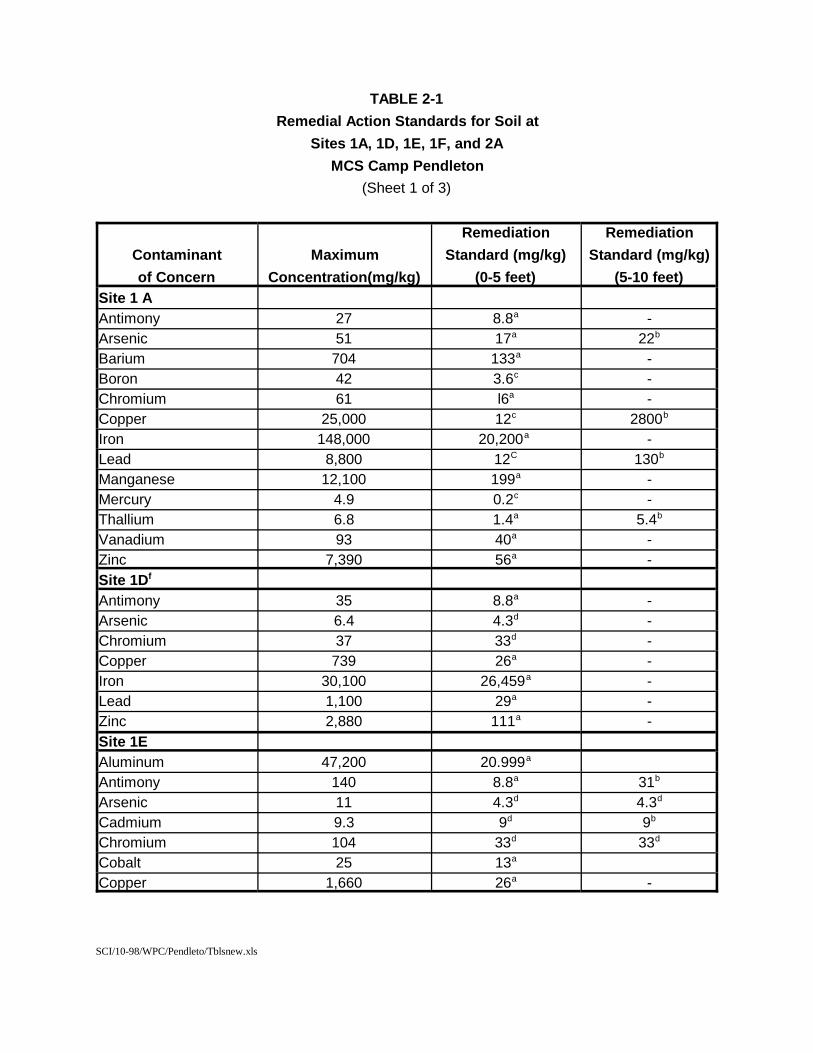
SCI/10-98/WPC/Pendleto/Tblsnew.xls
TABLE 2-1Remedial Action Standards for Soil at
Sites 1A, 1D, 1E, 1F, and 2AMCS Camp Pendleton
(Sheet 1 of 3)
Contaminantof Concern
MaximumConcentration(mg/kg)
RemediationStandard (mg/kg)
(0-5 feet)
RemediationStandard (mg/kg)
(5-10 feet)Site 1 AAntimony 27 8.8a -Arsenic 51 17a 22b
Barium 704 133a -Boron 42 3.6c -Chromium 61 l6a -Copper 25,000 12c 2800b
Iron 148,000 20,200a -Lead 8,800 12C 130b
Manganese 12,100 199a -Mercury 4.9 0.2c -Thallium 6.8 1.4a 5.4b
Vanadium 93 40a -Zinc 7,390 56a -Site 1Df
Antimony 35 8.8a -Arsenic 6.4 4.3d -Chromium 37 33d -Copper 739 26a -Iron 30,100 26,459a -Lead 1,100 29a -Zinc 2,880 111a -Site 1EAluminum 47,200 20.999a
Antimony 140 8.8a 31b
Arsenic 11 4.3d 4.3d
Cadmium 9.3 9d 9b
Chromium 104 33d 33d
Cobalt 25 13a
Copper 1,660 26a -
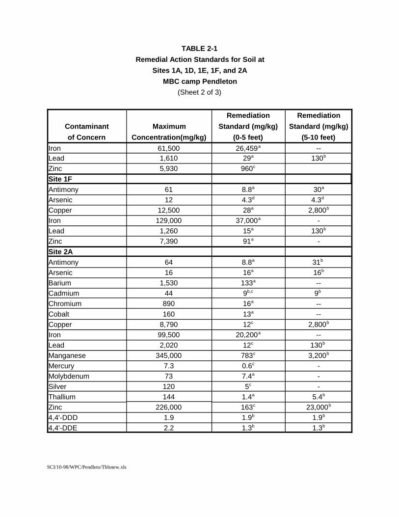
SCI/10-98/WPC/Pendleto/Tblsnew.xls
TABLE 2-1Remedial Action Standards for Soil at
Sites 1A, 1D, 1E, 1F, and 2AMBC camp Pendleton
(Sheet 2 of 3)
Contaminantof Concern
MaximumConcentration(mg/kg)
RemediationStandard (mg/kg)
(0-5 feet)
RemediationStandard (mg/kg)
(5-10 feet)Iron 61,500 26,459a --Lead 1,610 29a 130b
Zinc 5,930 960c
Site 1FAntimony 61 8.8a 30a
Arsenic 12 4.3d 4.3d Copper 12,500 28a 2,800b
Iron 129,000 37,000a -Lead 1,260 15a 130b
Zinc 7,390 91a -Site 2AAntimony 64 8.8a 31b Arsenic 16 16a 16b
Barium 1,530 133a --Cadmium 44 9b,c 9b Chromium 890 16a --Cobalt 160 13a --Copper 8,790 12c 2,800b
Iron 99,500 20,200a --Lead 2,020 12c 130b Manganese 345,000 783c 3,200b
Mercury 7.3 0.6c -Molybdenum 73 7.4a -Silver 120 5c -Thallium 144 1.4a 5.4b
Zinc 226,000 163c 23,000b
4,4'-DDD 1.9 1.9b 1.9b
4,4'-DDE 2.2 1.3b 1.3b
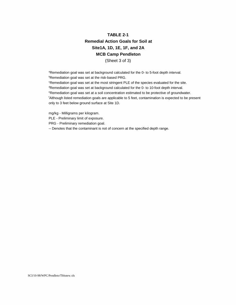
SCI/10-98/WPC/Pendleto/Tblsnew.xls
TABLE 2-1Remedial Action Goals for Soil at
Site1A, 1D, 1E, 1F, and 2AMCB Camp Pendleton
(Sheet 3 of 3)
aRemediation goal was set at background calculated for the 0- to 5-foot depth interval.bRemediation goal was set at the risk-based PRG.cRemediation goal was set at the most stringent PLE of the species evaluated for the site. dRemediation goal was set at background calculated for the 0- to 10-foot depth interval. eRemediation goal was set at a soil concentration estimated to be protective of groundwater. fAlthough listed remediation goals are applicable to 5 feet, contamination is expected to be present only to 3 feet below ground surface at Site 1D.
mg/kg - Milligrams per kilogram.PLE - Preliminary limit of exposure.PRG - Preliminary remediation goal.-- Denotes that the contaminant is not of concern at the specified depth range.
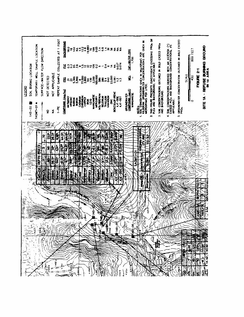
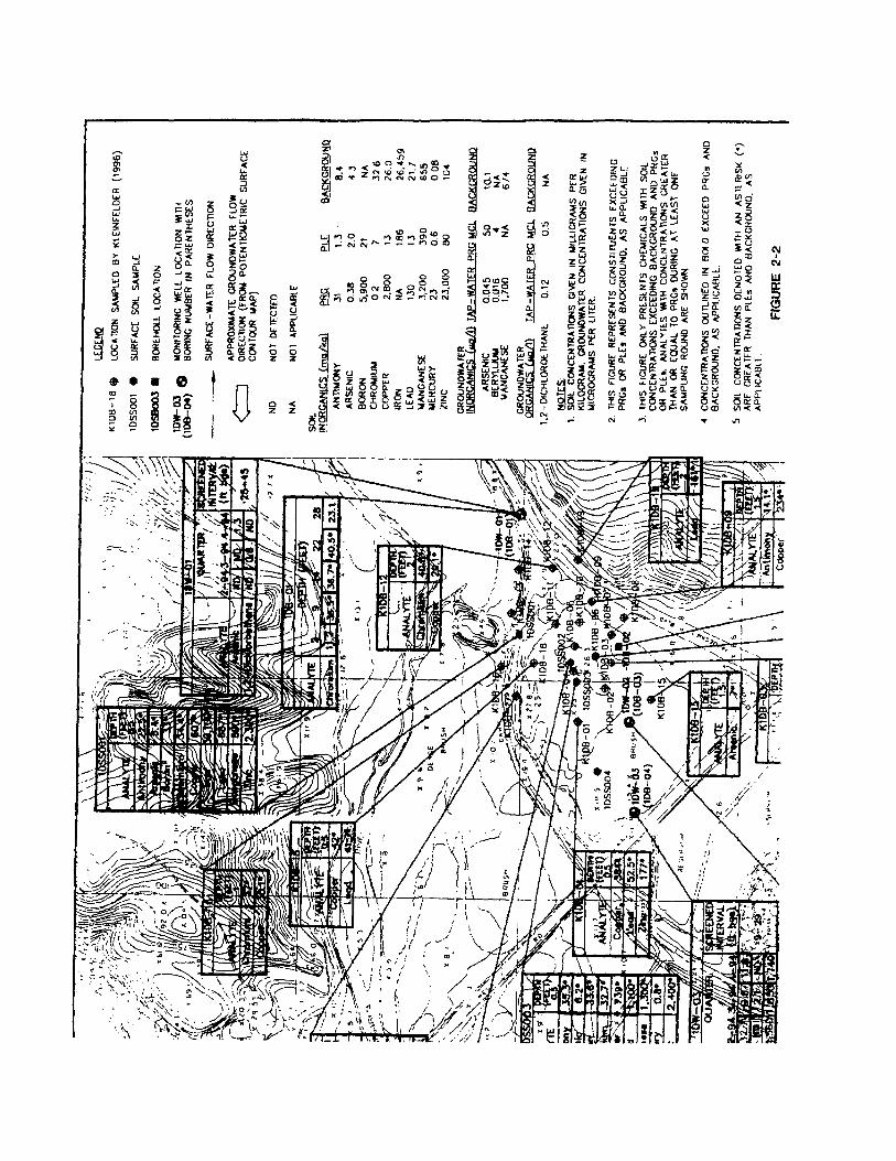
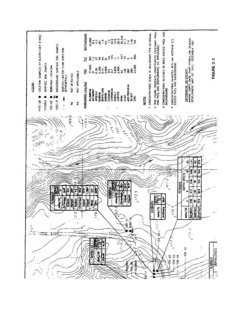
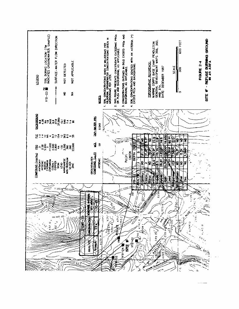
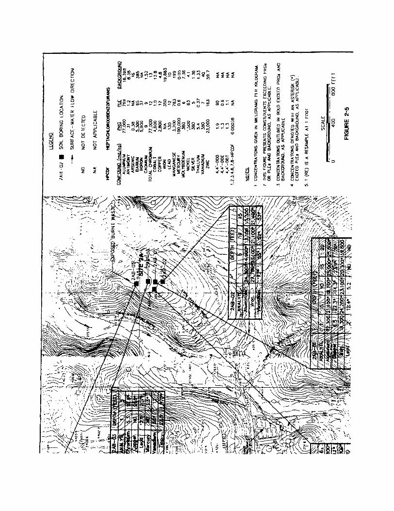
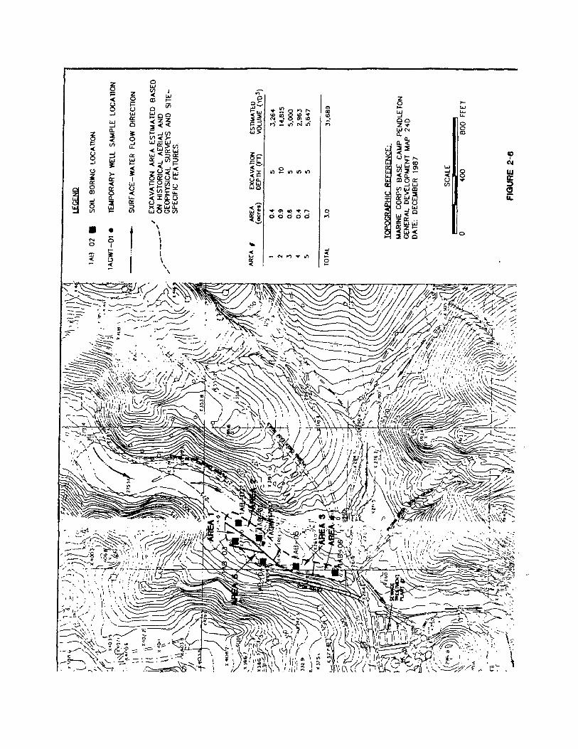
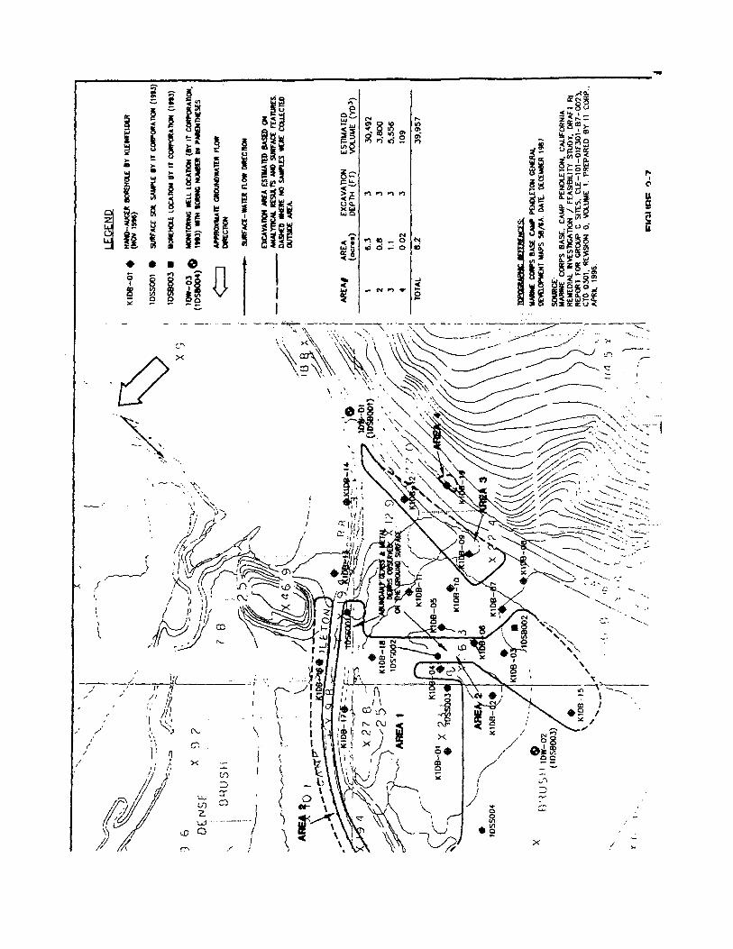
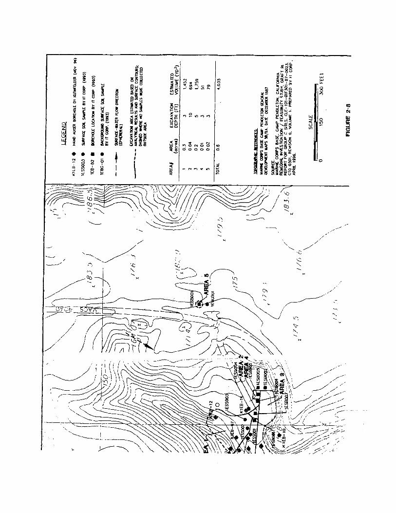
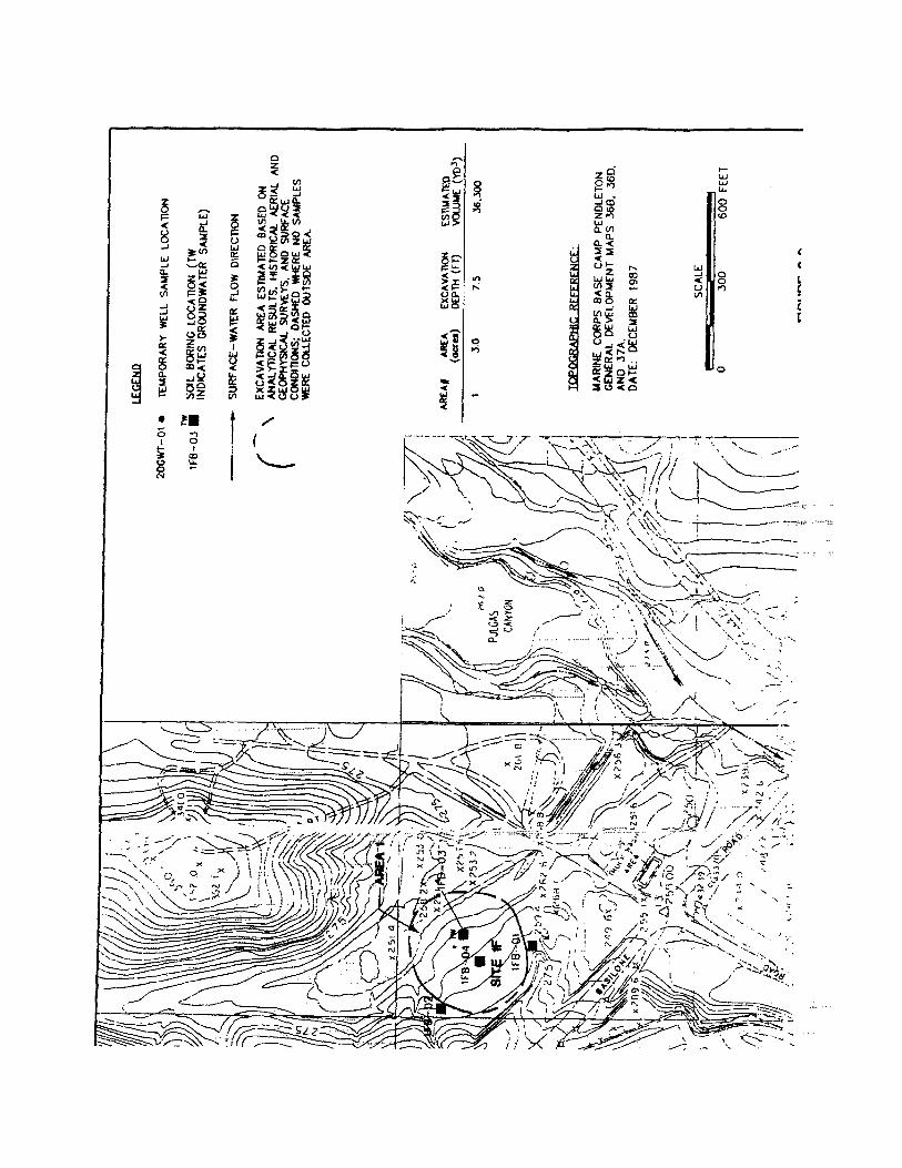
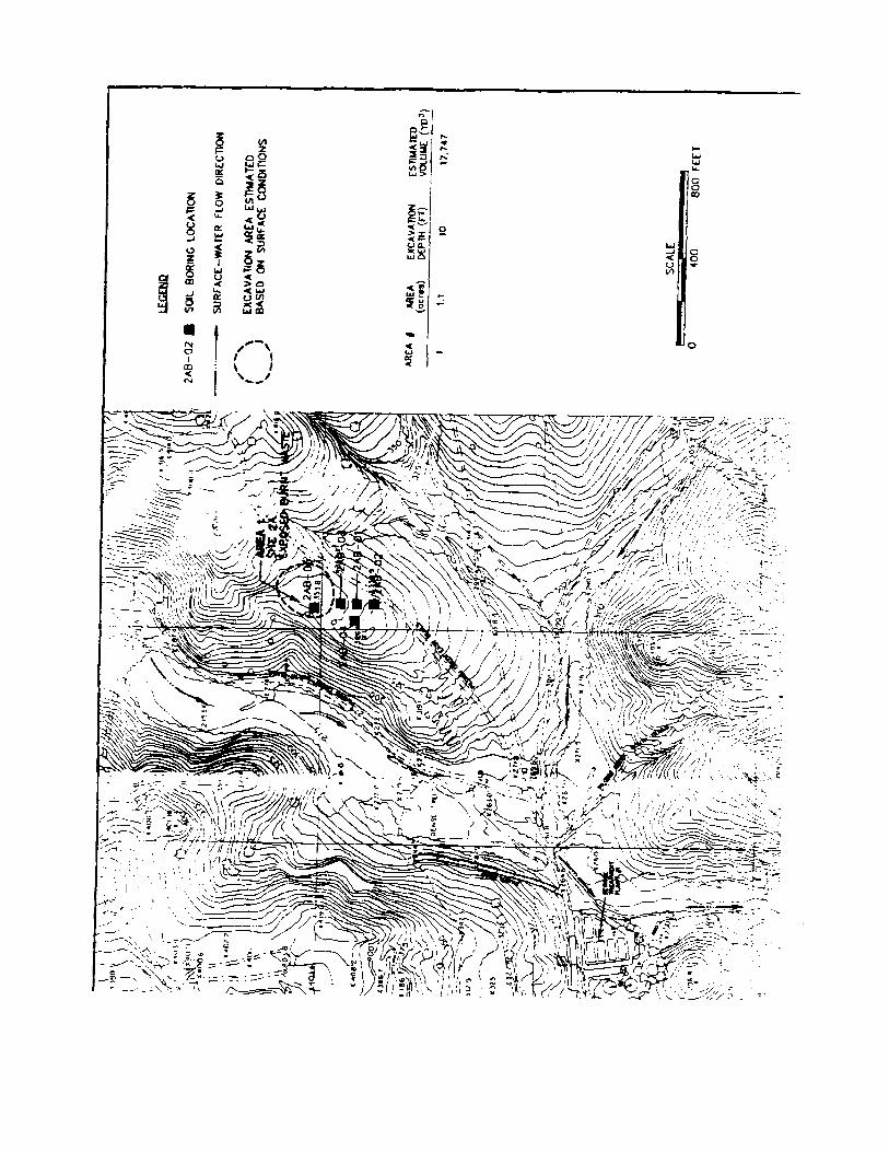
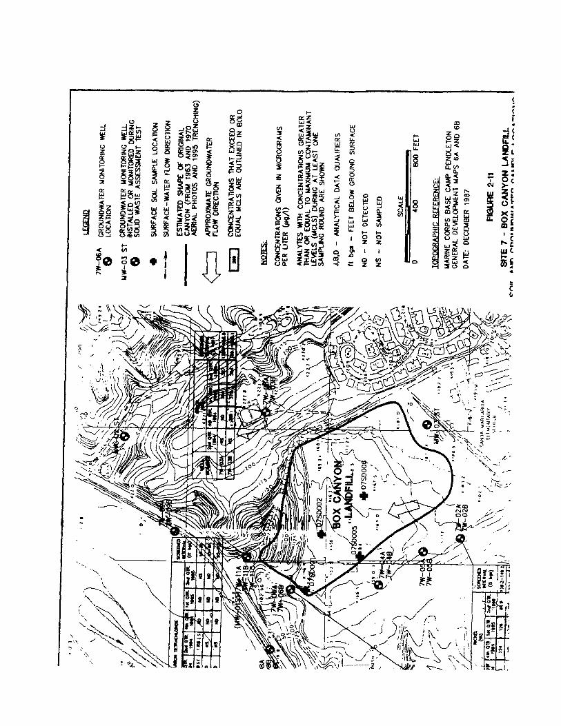
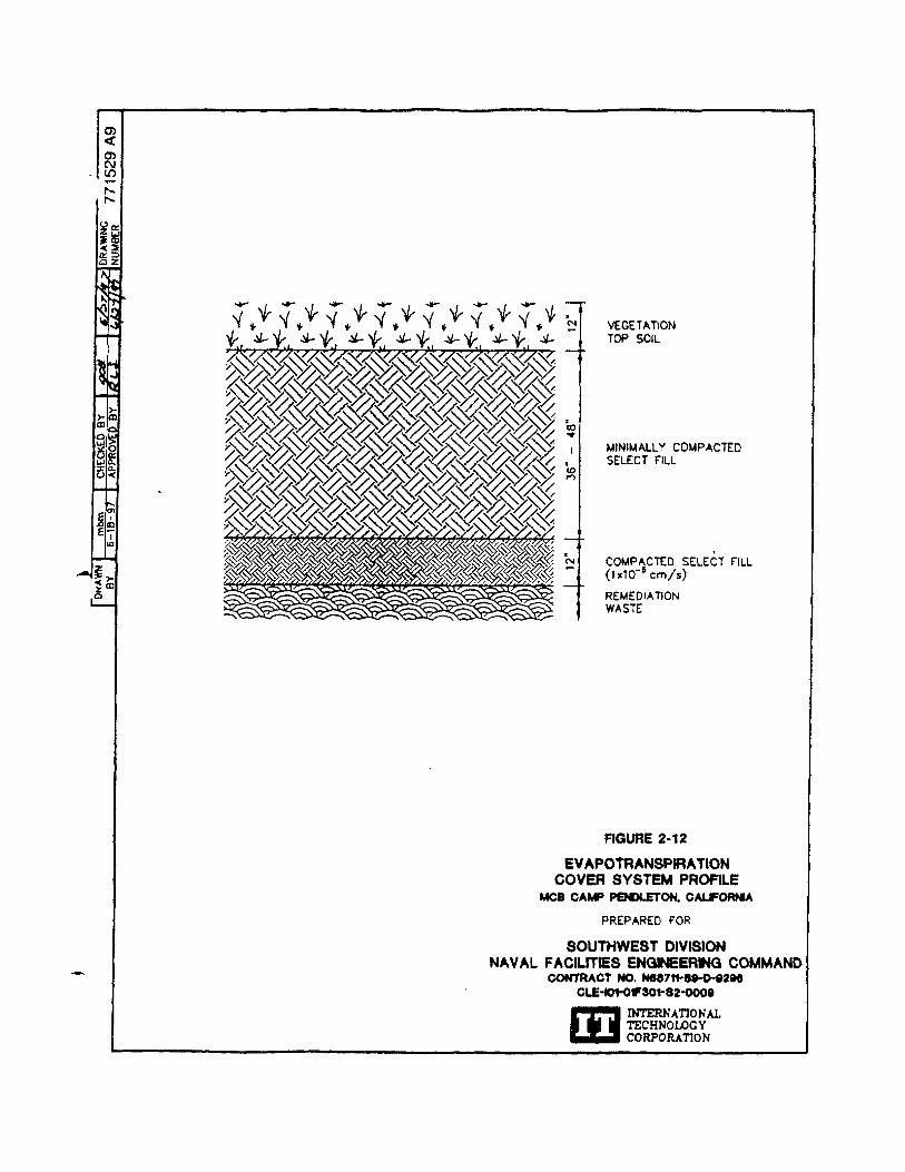
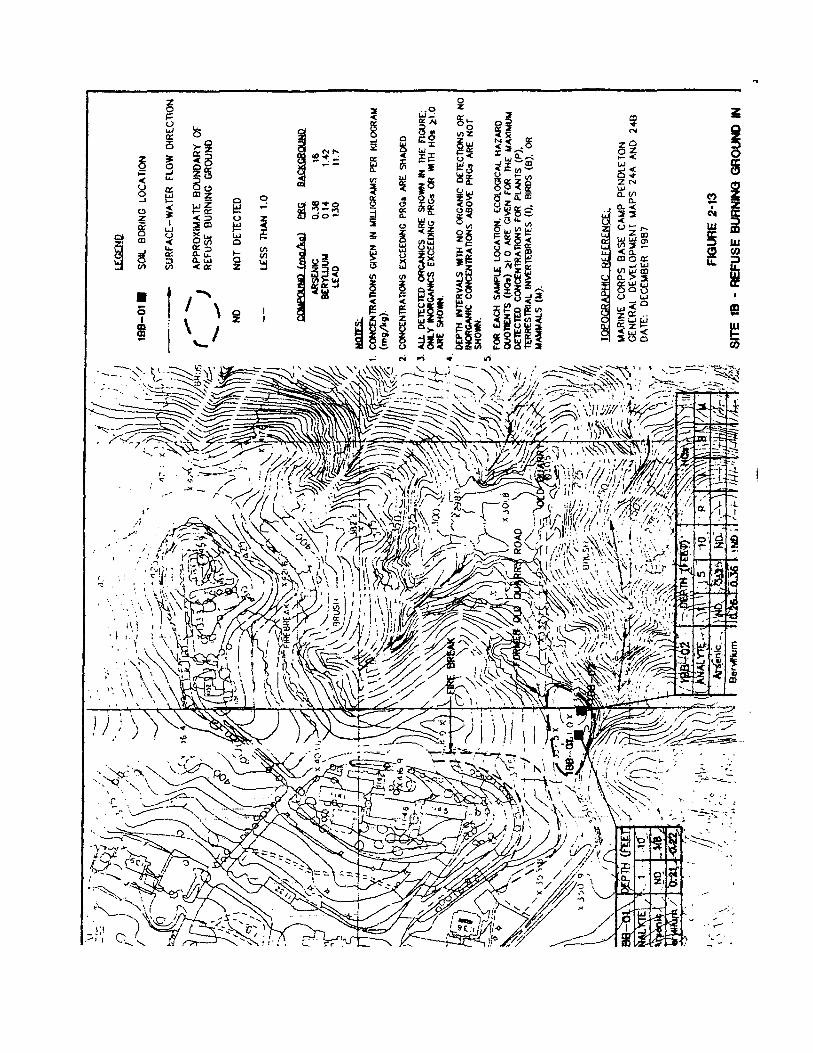
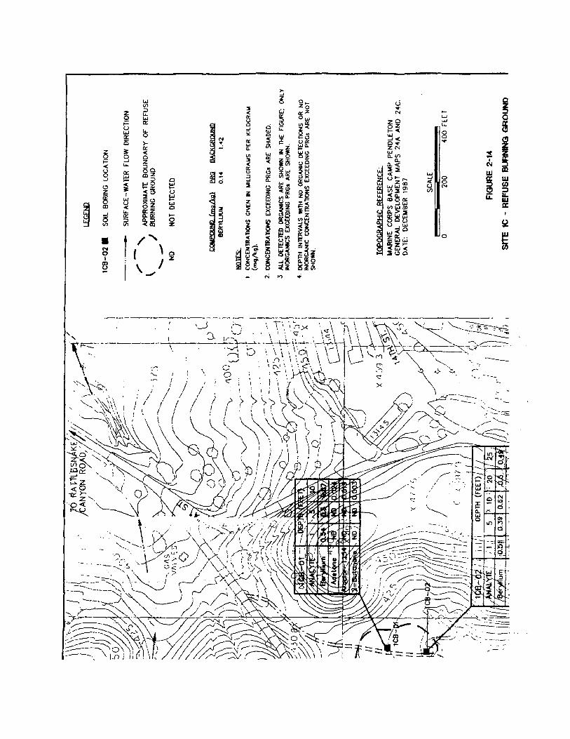
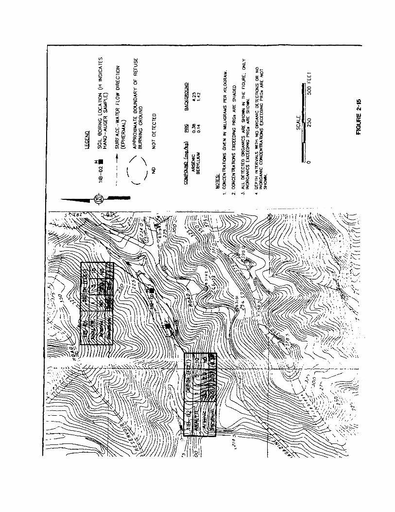
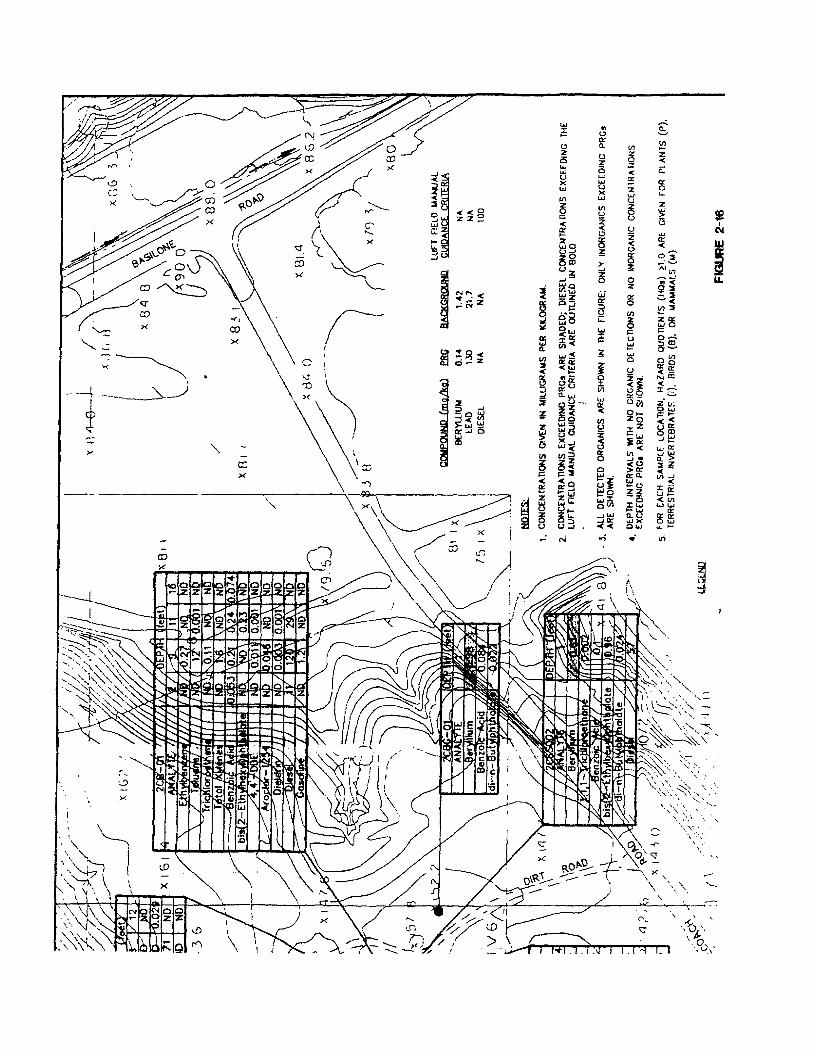
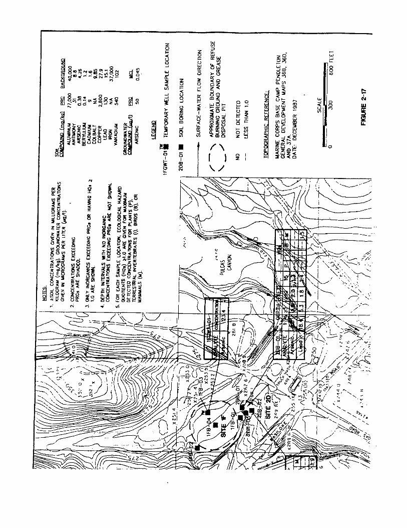
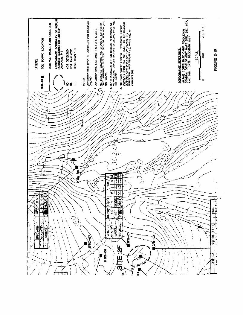
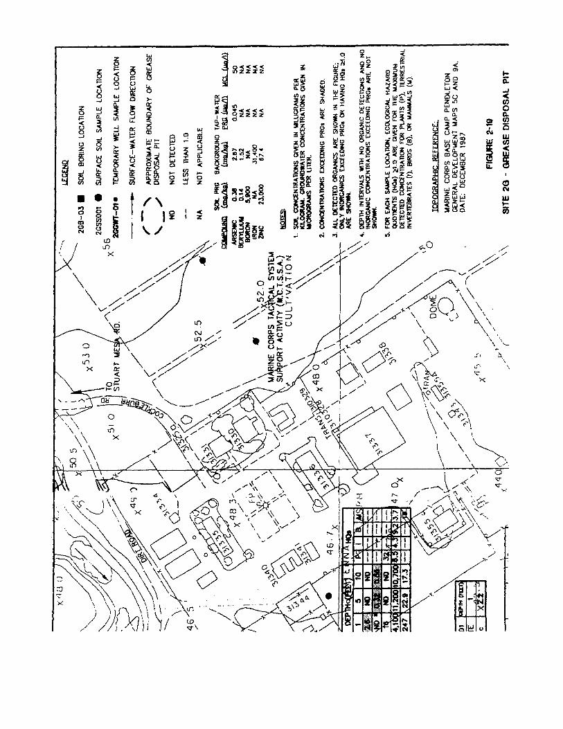
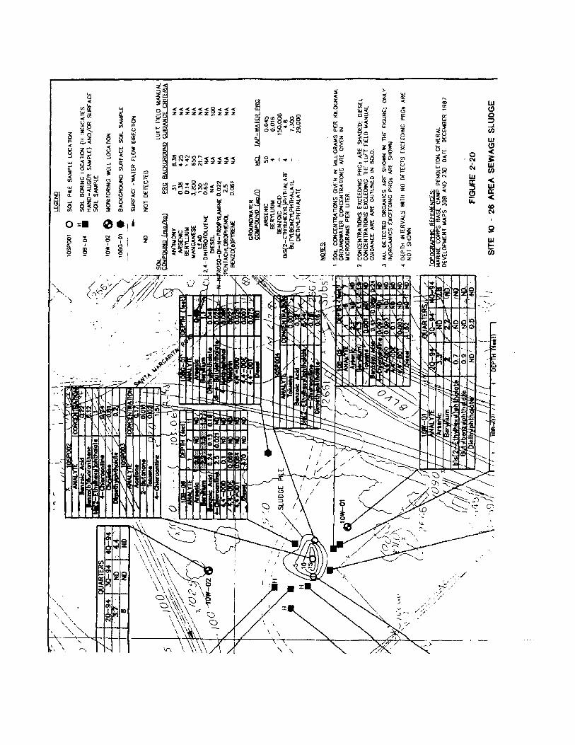
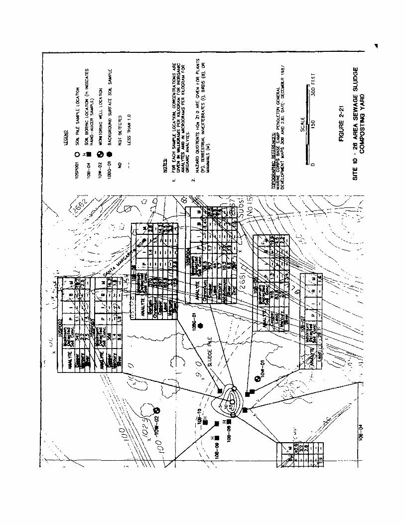
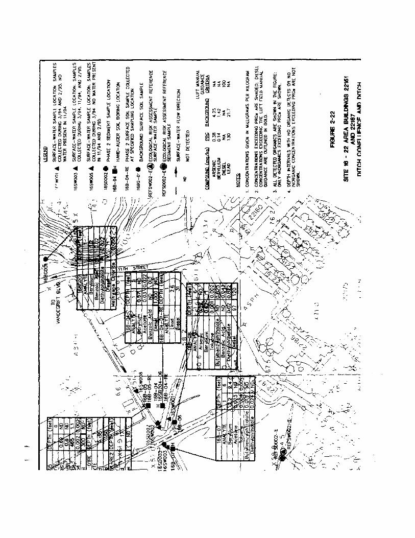
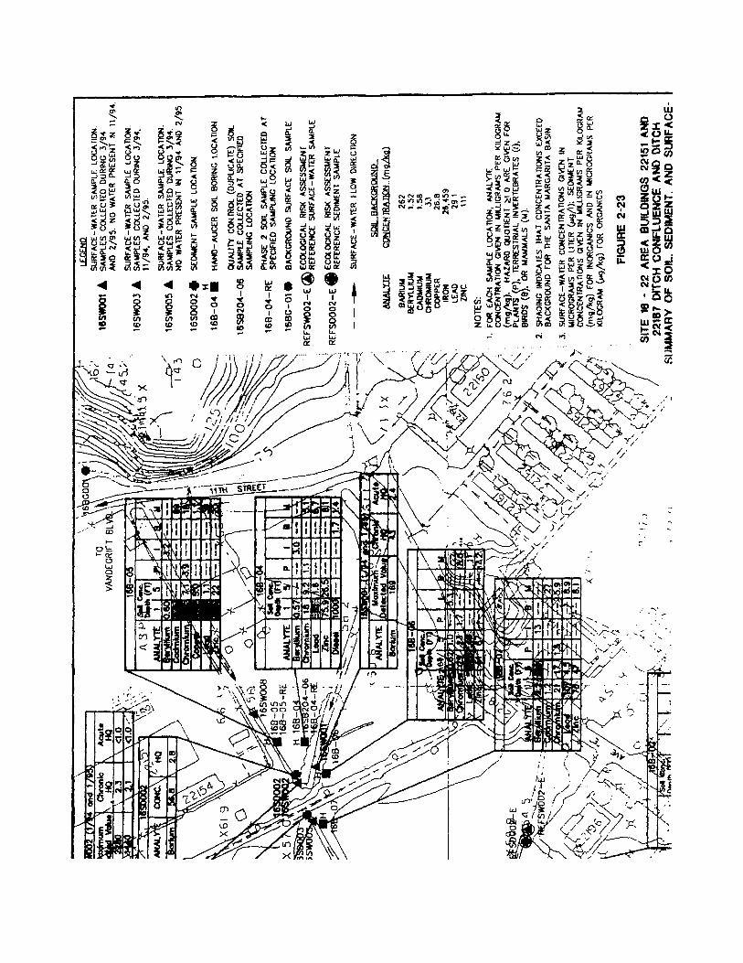
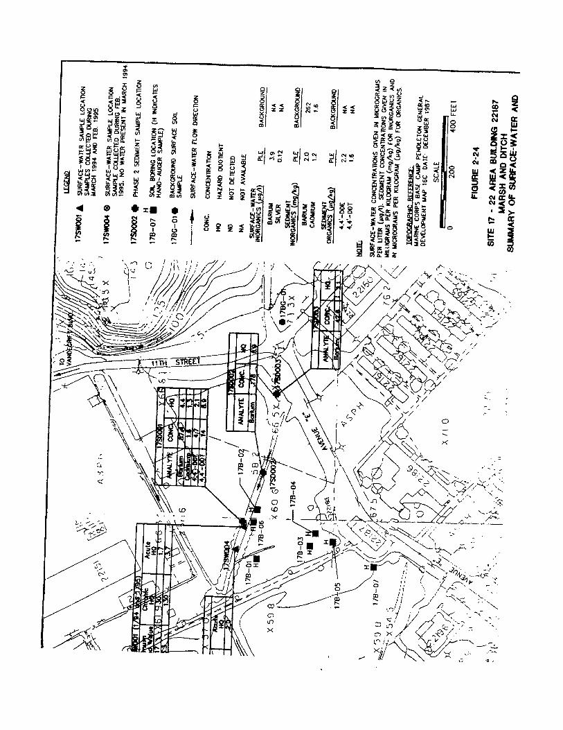
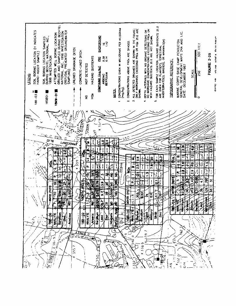
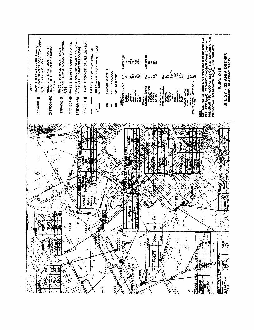
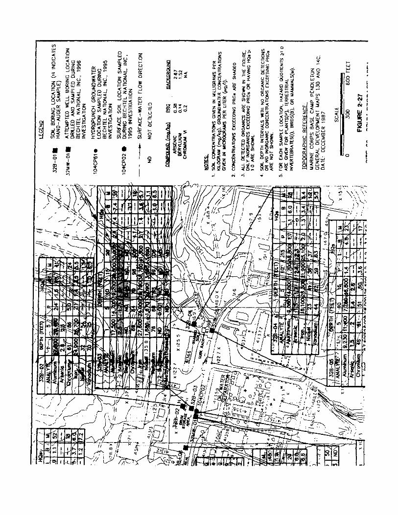
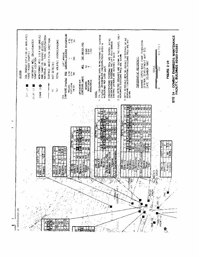
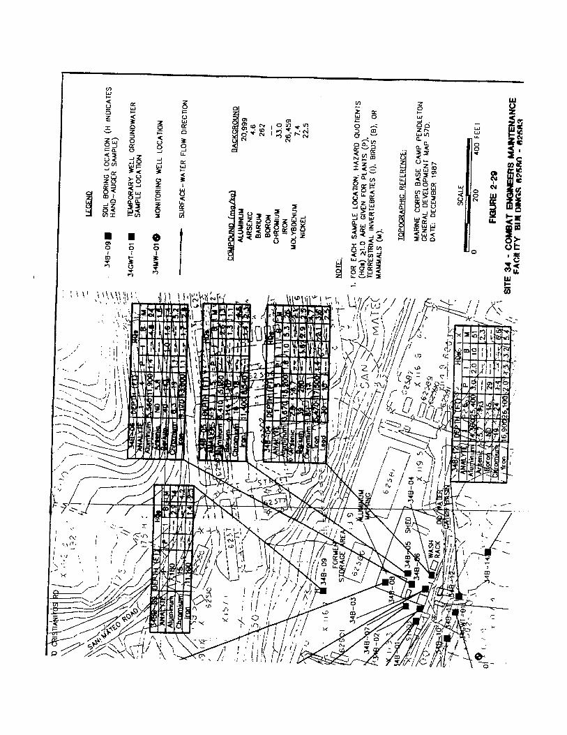
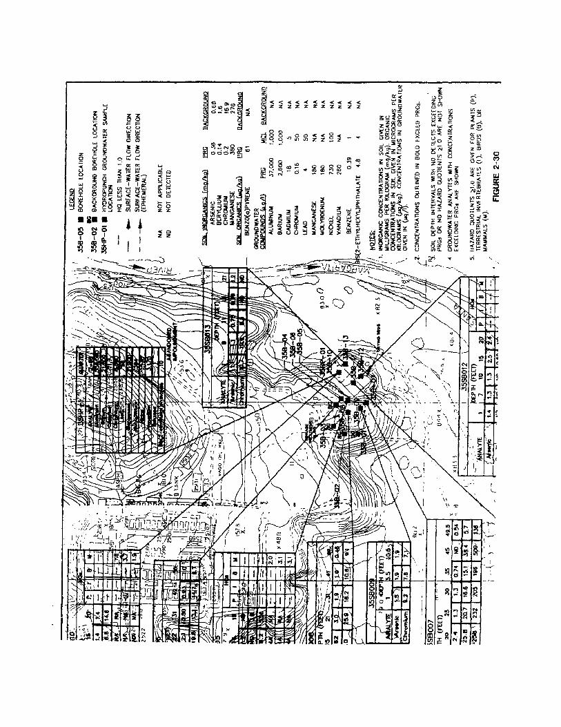
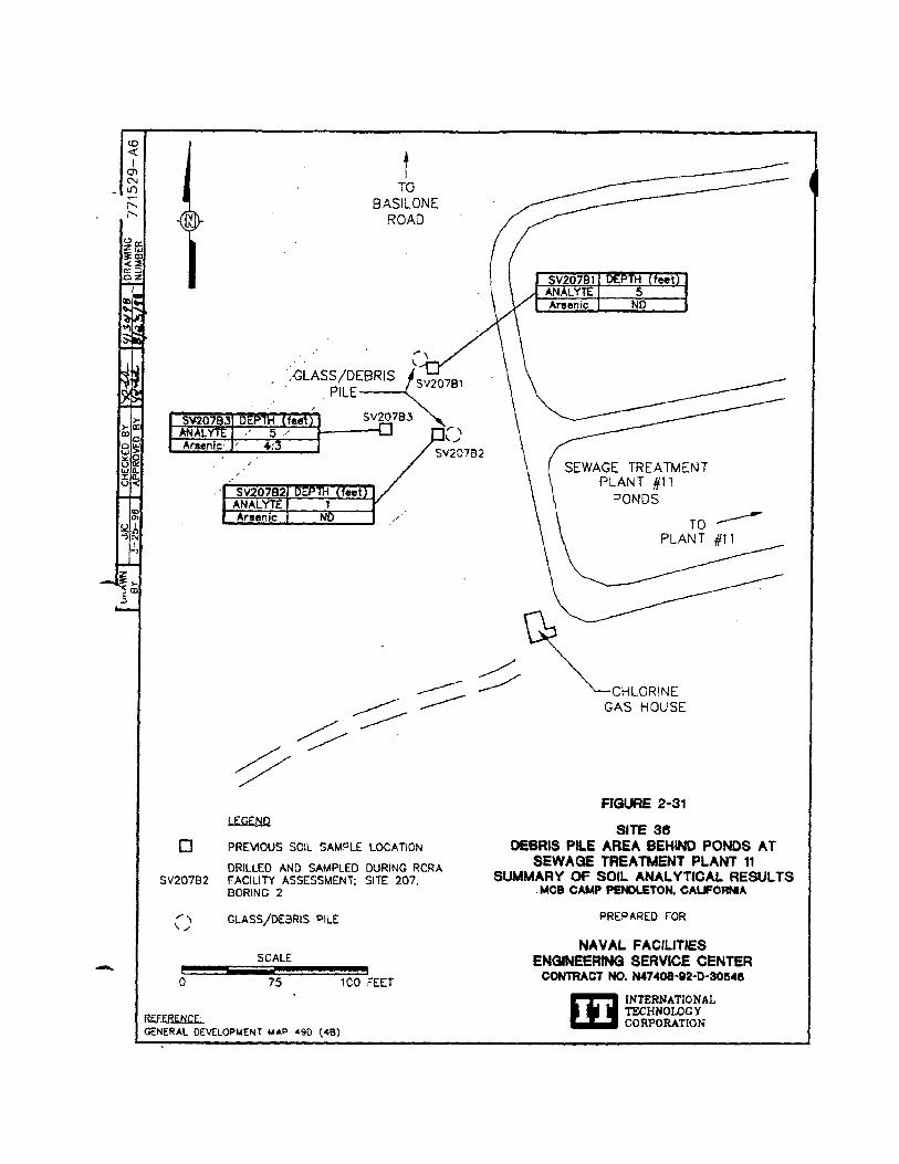
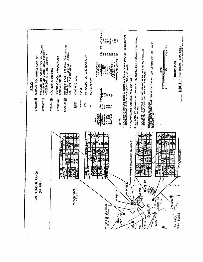
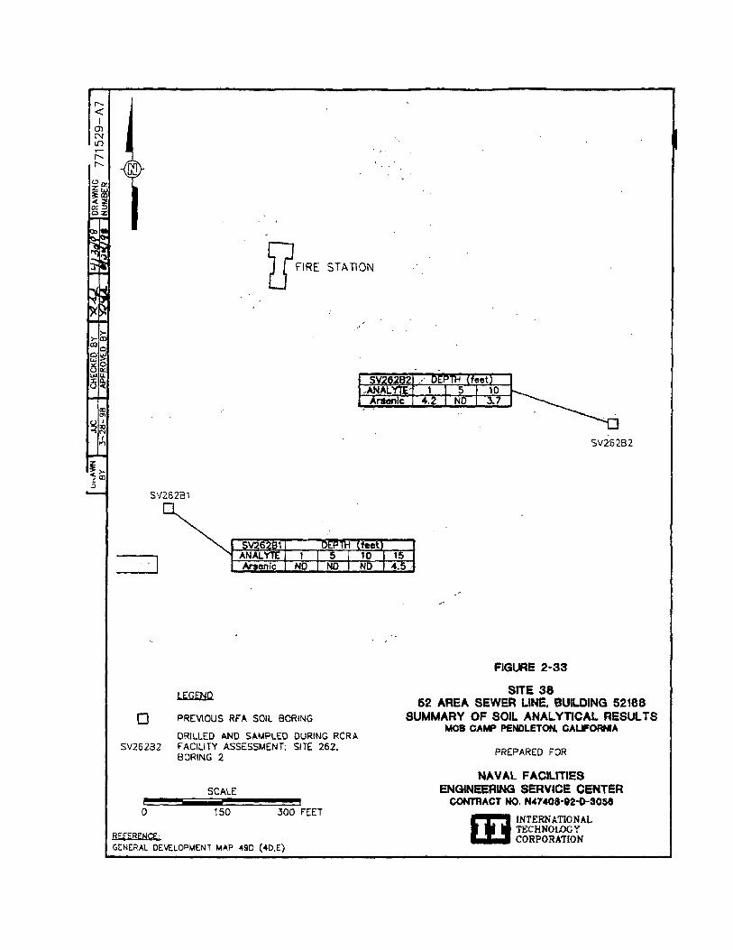
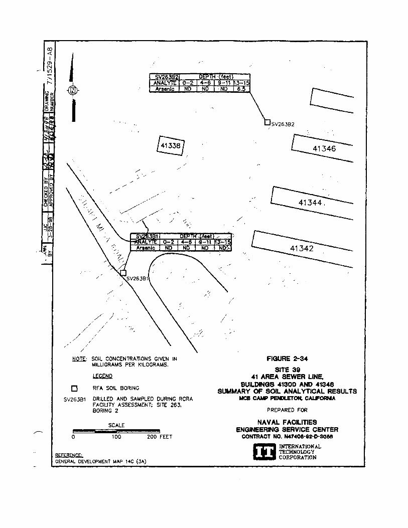
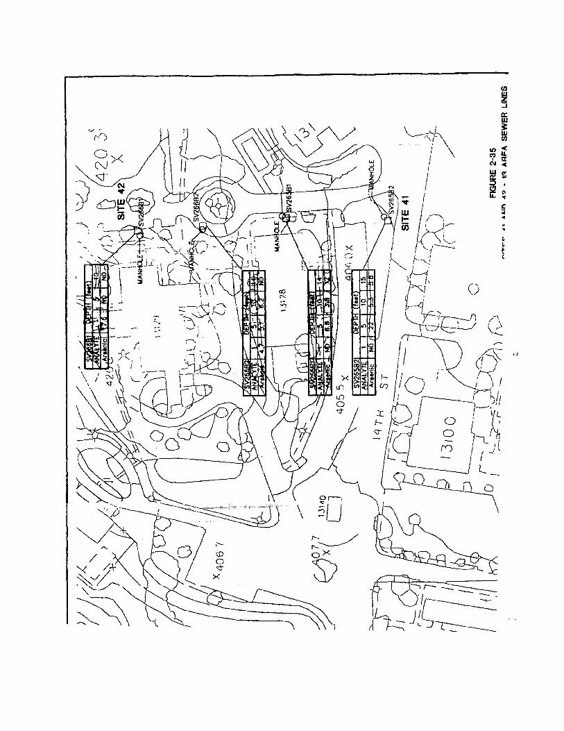
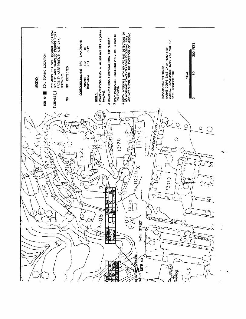
3-1SCI/9-98/WPC/Pendleton/ROD9-28.wpd
3.0 Responsiveness Summary
As previously discussed in Section 2.2, documents leading to the decisions presented in this ROD have
been released to the public and are included in the Administrative Record available for public review. The
main documents were made available to the public in the information repositories maintained at the base
and at the Oceanside Public Library. The public was informed of the availability of the complete
Administrative Record, which is maintained at the AC/S,ES offices at MCB Camp Pendleton and at the
SWDIV offices in San Diego. Notices of availability were published in local newspapers, as were notices
of public meetings and public review and comment periods. No questions or comments were received from
any source during the public comment periods. Therefore, a responsiveness summary is not required and is
not part of the Administrative Record. This decision document presents the selected remedies for MCB
Camp Pendleton OU3 sites, chosen in accordance with CERCLA, as amended by SARA, and to the extent
practicable, the NCP. The decisions for these sites are based on the Administrative Record.
3-2SCI/9-98/WPC/Pendleton/ROD9-28.wpd
(intentionally blank)
4-1SCI/9-98/WPC/Pendleton/ROD9-28.wpd
4.0 References
Cal/EPA, see California Environmental Protection Agency.
California Environmental Protection Agency, 1992a, “California Cancer Potency Factors,” memorandum,Standards and Criteria Work Group, Office of the Science Advisor, Sacramento, CA, 18 June.
California Environmental Protection Agency, 1992b, Supplemental Guidance for Human HealthMultimedia Risk Assessments of Hazardous Waste Sites and Permitted Facilities, Department of ToxicSubstances Control, July.
California Environmental Protection Agency, 1994, Preliminary Endangerment Assessment GuidanceManual, Department of Toxic Substances Control, January.
California Occupational Safety and Health Administration, 1979, Cal/OSHA Guide for the ConstructionIndustry, Department of Industrial Relations, August.
California State Water Resources Control Board, 1989, Leaking Underground Fuel Tank Field Manual:Guidelines for Site Assessment, Cleanup, and Underground Storage Tank Closure, issued by the LeakingUnderground Fuel Tank Task Force, October.
Cal/OSHA, see California Occupational Safety and Health Administration.
Dames and Moore, 1986. “Draft Report Vapor Well Installation Project,” Marine Corps Base CampPendleton, 1 May.
EPA. see U.S. Environmental Protection Agency.
Gilbert, R.O., 1987, Statistical Methods for Environmental Pollution Monitoring, Van NorstrandRheinhold, NY.
Hem, John D., 1985, Study and Interpretation of the Chemical Characteristics of Natural Water, 3rdedn., U.S. Geological Survey Water-Supply Paper 2254, U.S. Government Printing Office.
Innis-Tennebaum Architects, Inc., 1990, “Marine Corps Base Camp Pendleton, California, Masterplan,”Volumes 1and 2, Draft, prepared for Southwest Division Naval Facilities Engineering Command, August.
Kleinfelder, Inc., 1997, “Draft Engineering Evaluation/Cost Analysis for Sites 1D/1003, 1E/1004, 30, and35, Marine Corps Base Camp Pendleton, California,” prepared for Southwest Division Naval Facilities Engineering Command, 18 March. NEESA, see Naval Energy and Environmental Support Activity.
4-2SCI/9-98/WPC/Pendleton/ROD9-28.wpd
Naval Energy and Environmental Support Activity, 1984, “Initial Assessment Study of Marine CorpsBase, Camp Pendleton, California,” NEESA 13-057, prepared by SCS Engineers, Inc., September.
Palmer, M.A., 1990, “Hydrogeological Investigation of Las Flores Basin San Diego County, California,”unpublished Master's Thesis, San Diego State University, San Diego, California.
Southwest Division Naval Facilities Engineering Command, 1991, “Draft Final Work Plan, RemedialInvestigation/Feasibility Study, Marine Corps Base Camp Pendleton, California,” prepared by JacobsEngineering Group Inc., 24 May.
Southwest Division Naval Facilities Engineering Command. 1993a, “Draft Final RCRA FacilityAssessment Report, Marine Corps Base Camp Pendleton, California,” prepared by Jacobs EngineeringGroup Inc., 25 June.
Southwest Division Naval Facilities Engineering Command, 1993b, “Ecological Risk Assessment - DraftFinal Sampling and Analysis Plan, Remedial Investigation/Feasibility Study - Group A Sites, MarineCorps Base Camp Pendleton, California,” prepared by Jacobs Engineering Group Inc., 26 February.
Southwest Division Naval Facilities Engineering Command, 1993c, “Draft Underground Storage Tank SiteAssessment Report, Marine Corps Base Camp Pendleton, California,” prepared by Jacobs EngineeringGroup Inc.. 5 April.
Southwest Division Naval Facilities Engineering Command, 1993d, “ Marine Corps Base Camp Pendleton,California, Remedial Investigation/Feasibility Study. Phase 1 RI Technical Memorandum, Group B Sites,”10 December.
Southwest Division Naval Facilities Engineering Command. 1995a. “Draft Final Record of Decision forOperable Unit 1 - Site 9 and Group A No Action Sites, Marine Corp Base Camp Pendleton, California,”Revision 1, prepared by Jacobs Engineering Group Inc., 2 October.
Southwest Division Naval Facilities Engineering Command, 1995b, “Draft Final RI Report for Group BSites, Remedial Investigation/Feasibility Study, Marine Corps Base Camp Pendleton, California,” preparedby Jacobs Engineering Group Inc., 17 March.
Southwest Division Naval Facilities Engineering Command, 1995c, “Draft Final Human Health RiskAssessment Work Plan Addendum, RI/FS Group C Sites, Marine Corps Base Camp Pendleton,California,” prepared by Jacobs Engineering Group Inc., 14 August.
Southwest Division Naval Facilities Engineering Command, 1995d, “Engineering Evaluation/Cost Analysis(EE/CA) for Installation of a Cap at Site 7 - Box Canyon Landfill, Marines Corps Base Camp Pendleton,California,” draft final, 25 September.
4-3SCI/9-98/WPC/Pendleton/ROD9-28.wpd
Southwest Division Naval Facilities Engineering Command, 1996a, “Draft Final RI Report for Group CSites, Remedial Investigation/Feasibility Study, Marine Corps Base Camp Pendleton, California,” preparedby Jacobs Engineering Group Inc., 12 November.
Southwest Division Naval Facilities Engineering Command, 1996b, “Final Site Assessment Report, 12 and13 Areas, Marine Corps Base Camp Pendleton, California,” prepared by Jacobs Engineering Group Inc.,19 July.
Southwest Division Naval Facilities Engineering Command, 1996c, “Technical Addendum to the RI Reportfor Group B Sites, Marine Corps Base Camp Pendleton, California,” draft final, 15 November.
Southwest Division Naval Facilities Engineering Command, 1996d, “Closure and PostclosureMaintenance Plan, Box Canyon Landfill, Marine Corps Base Camp Pendleton, California, “ 20 September.
Southwest Division Naval Facilities Engineering Command, 1997a, “Final Record of Decision, OperableUnit 2, Marine Corps Base Camp Pendleton, California.” 30 September.
Southwest Division Naval Facilities Engineering Command, 1997b, “Draft Final RI Report for Group DSites, Remedial Investigation/Feasibility Study, Marine Corps Base Camp Pendleton, California,” preparedby Jacobs Engineering Group Inc., 16 July.
Southwest Division Naval Facilities Engineering Command, 1997c, “Final Action Memorandum forNon-Time-Critical Removal Action, Site 7 - Box Canyon Landfill,” prepared by Jacobs Engineering GroupInc., 9 September.
Southwest Division Naval Facilities Engineering Command, 1997d, “Technical Addendum to theEngineering Evaluation/Cost Analysis (EE/CA) for Installation of a Cap at Site 7 - Box Canyon Landfill,”18 June.
Southwest Division Naval Facilities Engineering Command, 1998a “Draft Final Remedial Investigationand Feasibility Study for Operable Unit 3, Marine Corps Base Camp Pendleton, California,” prepared byIT Corporation, 1 May.
Southwest Division Naval Facilities Engineering Command, 1998b, “Final Minutes of the Forty-ThirdFFA Project Managers' Meeting,” prepared by IT Corporation, 20 August.
Southwest Division Naval Facilities Engineering Command, 1998c, “'Technical Memorandum, MCBCamp Pendleton, Leaching Potential of Sites 1A, 1D, 1E, 1F, and 2A.” prepared by IT Corporation, 2October.
SWDIV, see Southwest Division Naval Facilities Engineering Command.
4-4SCI/9-98/WPC/Pendleton/ROD9-28.wpd
SWRCB, see California State Water Resources Control Board.
U.S. Environmental Protection Agency, 1999a, Interim Final Guidance on Preparing Superfund DecisionDocuments: The Proposed Plan, The Record of Decision, Explanation of Significant Differences, TheRecord of Decision Amendment, Office of Emergency and Remedial Response. OSWER Directive9355.3-02, June.
U.S. Environmental Protection Agency, 1989b, Risk Assessment Guidance for Supedfund: Volume I -Human Health Evaluation Manual (Part A), Interim Final, EPA/540/1-89/002, Office of EmergencyResponse, Washington, DC, December.
U.S. Environmental Protection Agency, 1990a, EPA Region IX/State of California Marine Corps FederalFacility Agreement, Marine Corps Base Camp Pendleton October.
U.S. Environmental Protection Agency, 1990b, “National Oil and Hazardous Substances PollutionContingency Plan,” Final Rule (40 CPR 300). Federal Register, Vol. 55, No. 46, 8 March.
U.S. Environmental Protection Agency, 1991, User's Guide for Lead: A PC Software Application of theUptake/Biokinetic model, Version 0.50, First Draft, ECAO-CIN, Environmental Criteria and AssessmentOffice, Cincinnati, OH. January.
U.S. Environmental Protection Agency, 1992, Integrated Risk Information System, on-line toxicologicaldata base, National Library of Medicine, Bethesda, MD.
U.S. Environmental Protection Agency, 1992b, Health Effects Assessment Summary Tables, FY 1992,OERR 9200.6-303-(92-1), Office of Solid Waste and Emergency Response. Washington. DC, March.
U.S. Environmental Protection Agency, 1992c, Framework for Ecological Risk Assessment,EPA/630/R-92-001, Risk Assessment Forum, Washington, DC.
U.S. Environmental Protection Agency, 1992d, Supplemental Guidance to RAGS: Calculating theConcentration Term, Office of Solid Waste and Emergency Response, OSWER Publication 9285.7-081.
U.S. Environmental Protection Agency, 1993, “Presumptive Remedy for CERCLA Municipal LandfillSites,” Office of Solid Waste and Emergency Response, Directive No. 9355.0-49FS, EPA 540-F-93-035,September.
U.S. Environmental Protection Agency, 1994, “Trichloroethylene and Tetrachloroethylene Profiles,”facsimile provided by the Superfund Health Risk Technical Support Center, ECOA-Cincinnati, OH, 21July.
4-5SCI/9-98/WPC/Pendleton/ROD9-28.wpd
U.S. Environmental Protection Agency, 1995, “Region IX Preliminary Remediation Goals (PRGs) SecondHalf 1996,” memorandum from Stanford J. Smucker to PRG Table Mailing List, 1 September.
U.S. Environmental Protection Agency, 1996a, “Region IX Preliminary Remediation Goals (PRGs) 1996,”memorandum from Stanford J. Smucker, Regional Toxicologist, 1 August.
U.S. Environmental Protection Agency, 1996b, “Federal Facility Agreement (FFA) Revision, IncludingMilestones and Deadlines for the Group D Sites and OU3, MCB Camp Pendleton,” letter from MichaelGill to Davis Mangold, 27 September.
U.S. Environmental Protection Agency, 1998a, Amendment to FFA.
U.S. Environmental Protection Agency, 1999b, memorandum regarding MCB Camp PendletonConsolidation and Capping of Metal Contaminated Soils, Office of Research and Development, 21October.
APPENDIX ATRANSCRIPT OF THE PUBLIC MEETING
SCI/10-98/WPC/Pendleto/ROD12-27.apd
A public meeting was held at the Oceanside Senior Citizens Center in Oceanside, California on 14 May
1998 at 7:00 p.m. for the Operable Unit 3 sites. A display session was held prior to the meeting at the
Senior Citizens Center from 5:00 p.m. to 7:00 p.m. Displays included photographs and information relating
to the Operable Unit 3 sites, as well as general information regarding the environmental program at MCB
Camp Pendleton. Personnel from the base, Southwest Division Navy, U.S. Environmental Protection
Agency, California Environmental Protection Agency Department of Toxic Substances Control and San
Diego Regional Water Quality Control Board, and the Navy's environmental contractor were present to
provide information to the public and to answer any questions or concerns. No members of the public
attended the display session or the public meeting. The base did not receive any telephone calls or written
comments during the 30-day public comment period.
The meeting was publicized in four local newspapers, the North County Times, both Inland and Coastal
Editions, the Sun Post, and the Scout, on 1 May 1998.
The transcripts of the meeting are provided in this appendix. Because no members of the public attended
the meeting, it lasted only several minutes, however, base, Navy, and agency representatives remained at
the Senior Citizens Center for an additional ½ hour to ensure that no late arrivals from the public were
missed.
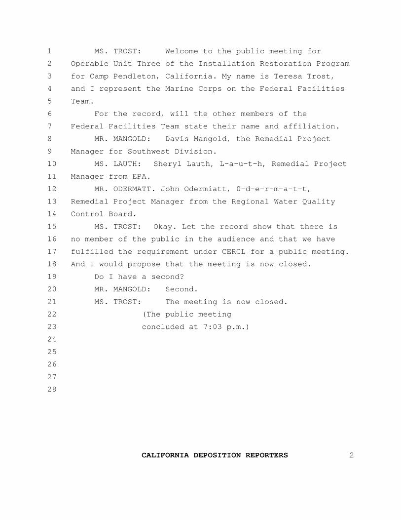
1 MS. TROST: Welcome to the public meeting for2 Operable Unit Three of the Installation Restoration Program3 for Camp Pendleton, California. My name is Teresa Trost,4 and I represent the Marine Corps on the Federal Facilities5 Team.6 For the record, will the other members of the7 Federal Facilities Team state their name and affiliation.8 MR. MANGOLD: Davis Mangold, the Remedial Project9 Manager for Southwest Division.10 MS. LAUTH: Sheryl Lauth, L-a-u-t-h, Remedial Project11 Manager from EPA.12 MR. ODERMATT. John Odermiatt, 0-d-e-r-m-a-t-t,13 Remedial Project Manager from the Regional Water Quality14 Control Board.15 MS. TROST: Okay. Let the record show that there is16 no member of the public in the audience and that we have17 fulfilled the requirement under CERCL for a public meeting.18 And I would propose that the meeting is now closed.19 Do I have a second?20 MR. MANGOLD: Second.21 MS. TROST: The meeting is now closed.22 (The public meeting23 concluded at 7:03 p.m.)2425262728
CALIFORNIA DEPOSITION REPORTERS 2
REPORTER'S CERTIFICATE
I, LESLIE R. JOHNSON, Certified Shorthand Reporter for the
State of California, do hereby certify:
That said public meeting was taken before me at the time and
place therein stated and was thereafter transcribed into print
under my direction and supervision, and I hereby certify the
foregoing public meeting is a full, true and correct transcript
of my shorthand notes so taken.
APPENDIX B
APPLICABLE OR RELEVANT AND APPROPRIATE REQUIREMENTS FOR OU3 SITES 1A, 1D, 1E, A2 AND 7
B-iSCI/10-98/WPC/Pendleto/ROD12-27.apd
Table of Contents
List of Tables . . . . . . . . . . . . . . . . . . . . . . . . . . . . . . . . . . . . . . . . . . . . . . . . . . . . . . . . . . . .B-iii
Abbreviations/Acronyms . . . . . . . . . . . . . . . . . . . . . . . . . . . . . . . . . . . . . . . . . . . . . . . . . . . .B-v
1.0 Introduction . . . . . . . . . . . . . . . . . . . . . . . . . . . . . . . . . . . . . . . . . . . . . . . . . . . . . . . .B-1
2.0 ARARs for the Selected Remedies for OU3 Sites 1A, 1D, 1E, 1F, 2A, AND 7. . . . . . B-3
2.1 ARARs for Sites 1A, 1D, 1E, 1F, and 2A . . . . . . . . . . . . . . . . . . . . . . . . . . . .B-4
2.2 ARARs for Site 7 . . . . . . . . . . . . . . . . . . . . . . . . . . . . . . . . . . . . . . . . . . . . . .B-8
3.0 References . . . . . . . . . . . . . . . . . . . . . . . . . . . . . . . . . . . . . . . . . . . . . . . . . . . . . . .B-13
List of Tables
Table B-1 Applicable or Relevant and Appropriate Requirements for OU3 Sites 1A, 1D, 1E, 1F, and 2A
Table B-2 Applicable or Relevant and Appropriate Requirements for Site 7

B-iiSCI/10-98/WPC/Pendleto/ROD12-27.apd
B-iiiSCI/10-98/WPC/Pendleto/ROD12-27.apb
Abbreviations/Acronyms
APCD Air Pollution Control DistrictARAR Applicable or Relevant and Appropriate RequirementCAA Clean Air ActCAMU Corrective Action Management UnitCCC California Coastal CommissionCCR California Code of RegulationsCERCLA Comprehensive Environmental Response, Compensation, and
Liability ActCFR Code of Federal RegulationsCIWMB California Integrated Waste Management BoardDLM Designated Level MethodologyDON Department of the NavyEE/CA Engineering Evaluation/Cost AnalysisEPA U.S. Environmental ProtectionFR Federal RegisterMCB Marine Corps BaseMSWLF Municipal Solid Waste LandfillNCP National Oil and Hazardous Substances Pollution Contingency PlanOU Operable UnitRCRA Resource Conservation and Recovery ActRI Remedial InvestigationRWQCB California Regional Water Quality Control BoardSIP State Implementation PlanSWDIV Southwest Division Naval Facilities Engineering CommandSVRCB California State Water Resources Control BoardTBC To Be ConsideredUSC United States Code

B-ivSCI/10-98/WPC/Pendleto/ROD12-27.apb
B-1SCI/10-98/WPC/Pendleto/ROD12-27.apb
1.0 Introduction
Section 121 (d) of the Comprehensive Environmental Response, Compensation, and Liability Act of 1980(CERCLA) states that remedial actions at CERCLA sites must attain (or the decision document justify thewaiver of) any Federal or more stringent State environmental standards, requirements, criteria, orlimitations that are determined to be legally applicable or relevant and appropriate.
Applicable requirements are those cleanup standards, standards of control, and other substantiveenvironmental protection requiremnts, criteria, or limitations promulgated under Federal or State law thatspecifically address the situation at a CERCLA site. The requirement is applicable if the jurisdictionalprerequisites of the standard show a direct correspondence when objectively compared with conditions atthe site. If the requirement is not legally applicable, the requirement is evaluated to determine whether it isrelevant and appropriate. Relevant and appropriate requirements are those cleanup standards, standards ofcontrol, and other substantive environmental protection requirements, criteria, or limitations promulgatedunder Federal or State law that, although not applicable, address problems or situations sufficiently similarto the circumstances of the proposed response action and are well-suited to the conditions of the site (U.S.Environmental Protection Agency [EPA], 1988). The criteria for determining relevance andappropriateness are listed in Title 40, Code of Federal Regulations (CFR), Section 300.400(g)(2).
To qualify as a State applicable or relevant and appropriate requirement (ARAR) under CERCLA and theNational Oil and Hazardous Substances Pollution Contingency Plan (NCP), a State requirement must beall of the following:
• A State law • An environmental or facility siting law • Promulgated (of general applicability and legally enforceable) • Substantive (not procedural or administrative) • More stringent than the Federal requirement • Identified in a timely manner • Consistently applied.
B-2SCI/10-98/WPC/Pendleto/ROD12-27.apb
In order to constitute an ARAR, a requirement must be substantive. Therefore, only substantive provisionsof requirements identified are considered ARARs. The ARARs identified for the selected remedial actionalternative for Operable Unit (OU) 3 Sites 1A, 1D, 1E, 1F, and 2A at Marine Corps Base (MCB) CampPendleton are summarized in the following sections, Table B-1 and Table B-2. Table B-1 provides ARARsfor Sites 1A, 1D, 1E, 1F, and 2A. Table B-2 provides ARARs for Site 7 and includes landfill cap ARARsoriginally presented in the Site 7 engineering evaluation/cost analysis (EE/CA) for installation of a landfillcap (SWDIV, 1995), in addition to groundwater monitoring and postclosure maintenance ARARs notpreviously included in the EE/CA ARARs.
Although, the cap ARARs were identified for a removal action, they are considered complete due to theDepartment of the Navy's (DON's) policy to comply with EPA's promulgated requirement that removalactions ". . . shall, to the extent practicable considering the exigencies of the situation, attain applicable orrelevant and appropriate requirements under federal environmental or state environmental or facility sitinglaws" (40 CFR 300.415[i]). Groundwater ARARs were not addressed in the EE/CA because thegroundwater remedial investigation (RI) was not complete. Subsequent to completion of the EE/CA, the RIrecommended no remedial action for Site 7 groundwater based on the results of the risk assessment(SWDIV, 1996a). Groundwater monitoring ARARs for the presumptive remedy cap and postclosuremaintenance of the landfill are however, included in Table B-2. Subsequent to the time that Site 7 ARARswere presented in the EE/CA, State Water Quality Control Board (SWQCB) landfill requirements of Title23 California Code of Regulations (CCR) and California Integrated Waste Management Board (CIWMB)landfill requirements of Title 14 have since been replaced by the combined SWRCB/CIWMB Regulationsin Title 27 CCR. Updated citations are provided in Table B-2 in addition to the former citations.
B-3SCI/10-98/WPC/Pendleto/ROD12-27.apb
2.0 ARARs for the Selected Remedies for OU3 Sites 1A, 1D, IE, 1F, 2A, and 7
Remedial action for soil was selected for the following OU 3 sites at MCB Camp Pendleton:
• 1A - Refuse Burning Ground in 14 Area
• 1D - Refuse Burning Ground in 20 Area
• 1E - Refuse Burning Ground in 32 Area
• 1F - Refuse Burning Ground in 43 Area
• 2A - Grease Disposal Pit in 14 Area
• 7 - Box Canyon Landfill
The same action was selected for Sites 1A, 1D, 1E, 1F, and 2A: soil excavation and on-base disposal; no
further action for groundwater. No further action was recommended for groundwater at these sites during
the RI (SWDIV, 1996b and 1997). The risk assessment identified no unacceptable risks from groundwater.
The selected remedy involves no treatment because the RI results indicate that contaminated soils at Sites
1A, 1D, 1E, 1F, and 2A would not leach to groundwater, and meet the requirements for fill at Site 7 - Box
Canyon Landfill. Based on the Designated Level Methodology (DLM) (California Regional Water Quality
Control Board [RWQCB], 1986), excavated soil from Sites 1A, 1D, 1E, and 1F would not impact
groundwater at Site 7 (SWDIV, 1998a). Soil from Site 2A exceeded the designated levels, although only
slightly; therefore, the soil from Site 2A was tested for leachability using DI WET analysis. The DI WET
results were compared against a soluble designated level predicted by the DLM. DI WET results were less
than the soluble designated levels, indicating that Site 2A soils would not pose a threat to groundwater
(SWDIV, 1998b). 'The identified ARARs for Sites 1A, 1D, 1E, 1F, and 2A are listed in Table B-1.
The action selected for Site 7 includes installation of an evapotranspiration cap and associated long-term
monitoring. Groundwater monitoring will be conducted to measure the effectiveness of the landfill cap, as
part of the presumptive remedy, and to comply with postclosure maintenance requirements identified in the
EE/CA. ARARs for Site 7 are identified in this appendix and are listed in Table B-2.
B-4SCI/10-98/WPC/Pendleto/ROD12-27.apb
2.1 ARARs for Sites 1A, 1D, 1E, 1F, and 2A
The Department of the Navy (DON) has determined that 22 CCR 66264.94 is a “relevant and appropriate”
Federal ARAR for the selected remedies for the OU3 sites. The DON considers 22 CCR 66264.94 a
federal ARAR because it was approved by the EPA in its 23 July 1992 authorization of the State of
California Resource Conservation and Recovery Act (RCRA) program and is federally enforceable (see 57
Federal Register [FR] 32727, 23 July 1992, and 55 FR 8742, 8 March 1990; see also Wyckoff v. EPA 796
F.2d 1197, [9th Cir. 1986]). The State of California disagrees that 22 CCR 66264.94 is a "Federal"
ARAR. This regulation is a part of the State's authorized hazardous waste control program. It is the State's
position that it is a "State" ARAR and are a "Federal" ARAR. See 55 FR 8765, 8 March 1990, and U.S. v.
State of Colorado, 990 F.2d 1565, (1993).
For the same reasons stated above for 22 CCR 66264.94, the DON has determined that other specifically
identified substantive requirements of Title 22 CCR approved under the authorized State RCRA program
are Federal ARARs for the selected remedies for the OU3 sites. The State of California disagrees with
finding the other substantive requirements under the authorized State RCRA program “Federal” ARARs
for the reasons set forth above. It is the State's position that these requirements are "State” ARARs not
"Federal” ARARs.
The DON has determined that the SWRCB Resolution No. 92-49 and 27 CCR 20400 (formerly 23 CCR
2550.4) do not constitute ARARs for the selected remedies for OU3 because they are State requirements
and we are not more stringent than the Federal ARAR provisions of 22 CCR 66264.94. The NCP, as set
forth in 40 CFR 300.400(g), provides that only state standards more stringent than Federal standards may
be ARARs (see also Section 121[d][2][A][ii] of CERCLA).
The provisions of 22 CCR 66264.94 and 27 CCR 20400 (formerly 23 CCR 2550.4) that address soil
concentration limits are identical. Therefore, 27 CCR 20400 is not more stringent than 22 CCR 66264.94
and its provisions we not ARARs. SWRCB Resolution No. 92-49 was promulgated by the SWRCB as
policies and procedures to be followed by Regional Water Boards for oversight of investigations and
cleanup and abatement orders. It is, therefore, not of general applicability and is not an "applicable"
ARAR. However, it was evaluated as a potential "relevant and appropriate” State ARAR, Section III.G of
B-5SCI/10-98/WPC/Pendleto/ROD12-27.apb
SWRCB Resolution 92-49 provides in relevant part that regional boards, shall “...in approving any
alternative cleanup levels less stringent than background, apply Section 2550.4... [now 27 CCR 20400].”
Because this resolution incorporates and relies upon the provisions of 23 CCR 2550.4 (now 27 CCR
20400), which are not more stringent than 22 CCR 66264.94, SWRCB Resolution No. 92-49 is also not
more stringent and, hence, its provisions are not State ARARs.
The State of California disagrees with the DON's assertion that SWRCB Resolution No. 92-49 is not an
ARAR and believes the resolution is an applicable requirement for the OU3 remedial actions. It requires
compliance with more than 66264.94. Resolution No. 92-49 requires compliance with 23 CCR 2550.4, but
Sections III.F and III.G also have additional requirements that must be met. To the extent that Resolution
No. 92-49 includes provisions that are the same as 22 CCR 66264.94, the State believes it is appropriate
for the DON to defer to the State's interpretation of 22 CCR 66264.94.
Despite the disagreement on whether identified ARARs are "federal" or "state," the State has decided to
exercise its discretion not to invoke dispute resolution for this Record of Decision for the following reasons:
• The State believes excavation of soil from the OU3 sites and placement under the landfill cover at
the Site 7 CAMU is the best remedy and complies with all substantive State requirements
• The soil from OU3 Sites 1A, 1D, 1E, 1F, and 2A are contaminated with metals that, when placed
under the landfill cover already approved by the State for the Site 7 CAMU, will be protective of
groundwater
• The cleanup levels for the soil at Sites 1A, 1D, 1E, 1F, and 2A will be protective of groundwater
and comply with all substantive requirements.
The excavation, transportation, and handling of soil at the OU3 remedial action sites could result in fugitive
emissions of particulate matter. San Diego County Air Pollution Control District (APCD) Rule 50(d)(1)
has been identified as an applicable Federal ARAR for such emissions (Table B-1). This rule is considered
a Federal ARAR because it is included in the approved State Implementation Plan (SIP) under Section 110
of the Clean Air Act (CAA).
B-6SCI/10-98/WPC/Pendleto/ROD12-27.apb
The DON has determined that substantive provisions of 22 CCR 66262.10(a) and 66262.11 are ARARs
for determination of hazardous waste. The soils at Sites 1A, 1D, 1E, 1F, and 2A have been identified as
hazardous waste by applying knowledge of the hazard characteristic of the waste in light of the materials or
processes used to generate the wastes.
The substantive provisions of 22 CCR 66264.13(a) and (b) are also determined to be ARARs. The
substantive provisions at 22 CCR 66264.13(a) require analysis of hazardous waste "before an owner or
operator transfers, treats, stores, or disposes of any hazardous waste." Representative samples of the soil
from the OU3 sites have been analyzed during the RI and in a recent field sampling effort in May 1998 to
ftirther delineate the sites. This analysis included the information necessary for acceptance into the CAMU
designated at Site 7. The requirements at 22 CCR 66264.13(b) require an analysis plan. Work plans for
the RI and the additional sampling for further delineation were written to satisfy the substantive provisions
for analysis plans in 22 CCR 66264.13(b) and concurrence was received from DTSC, RWQCB, and EPA.
The sampling and analysis provided adequate information for placing the waste at the Site 7 CAMU even if
it was assumed to be hazardous waste and therefore, no additional sampling and analysis to determine
whether the waste is hazardous was necessary.
The Department of the Navy has determined that substantive provisions of 27 CCR 20230(a) and (b) are
the controlling ARARs for soil discharge levels for the Site 7 - Box Canyon Landfill (Table B-1). To
assess if the soils at Sites 1A, 1D, 1E, 1F, and 2A meet these requirements, a two-phased screening process
was conducted. The first phase included using the designated level methodology (DLM) (California
Regional Water Quality Control Board [RWQCB], 1986). Acceptable soil concentrations are calculated
through the use of DLM equation and compared to actual soil concentrations. Soil concentrations at Sites
1A, 1D, 1E, and 1F met the requirements. The soil at Site 2A did not meet DLM criteria. Because of the
conservative nature of the DLM, the second phase of screening was applied for Site 2A and leachability
analysis using DI WET, was conducted for Site 2A soils. The DI WET results were compared against a
soluble designated level predicted by the DLM. DI WET results were less than the soluble designated
levels, indicating that Site 2A soils also meet State discharge requirements (SWDIV, 1998b).
B-7SCI/10-98/WPC/Pendleto/ROD12-27.apb
The Department of the Navy has determined that the DLM is a method for determining acceptable
contaminant concentrations in soil to meet State discharge requirements, specifically 27 CCR 20230.
However, failure of site soil to meet DLM does not indicate noncompliance. Further testing and/or
evaluation may indicate compliance.
Federal- and State-listed threatened and endangered species are present at or near remedial action Sites 1A,
1D, 1E, 1F, and 2A. The California gnatcatcher (Federal-listed endangered species) was observed on Sites
1A, 1D, and 1E and is suspected at Sites 1F and 2A, where habitat had burned prior to field surveys
(SWDIV, 1998a). The least Bell's vireo (State-listed endangered species) was observed near Sites 1A and
1D. The Federal and State endangered species requirements are identified as ARARs as indicated in Table
B-1. The Migratory Bird Act set forth in 16 USC 703 is a Federal ARAR for the remedial actions at Sites
1A, 1D, and 1E and may also be an ARAR for Sites 2A and 1F after the habitat recovers from the 1997
brushfire.
The substantive provisions of 36 CFR 800.4 for historical property identification are considered applicable
Federal ARARs for the OU3 remedial action sites. An archaeologist will monitor excavation activities. If
previously unidentified archaeological resources are identified during the remedial actions, substantive
provisions of 32 CFR 229.1 et seq. will be applicable Federal ARARs. These sections require protection of
archaeological resources on Federal lands by consultation with the State Historic Preservation Officer.
Sites 1D and 1E are located within the designated boundary of the coastal zone, as indicated on California
Coastal Commission (CCC) maps that delineate the extent of the coastal zone (CCC, 1993). The Federal
and State requirements are applicable for controlling direct significant impacts on coastal waters and for
protecting State and national interests in California coastal resources. The coastal zone requirements are
ARARs.
Site 1D is located within the 100-year floodplain and is subject to Federal ARARs identified at 22 CCR
66264.18(b) and 40 CFR Part 6.
B-8SCI/10-98/WPC/Pendleto/ROD12-27.apb
2.2 ARARs for Site 7
The ARAR evaluation for Site 7 focused on the action-specific closure and postclosure cam requirements
of the Resource Conservation and Recovery Act (RCRA) and the State municipal solid waste landfill
(MSWLF) requirements. Air, vadose zone, and groundwater action-specific requirements are discussed as
appropriate. Limited location-specific ARARs are discussed because the location of the landfill is fixed and
only those requirements that pertain to the selected removal action alternative are identified.
RCRA closure and postclosure requirements are set forth in Subtitle D for MSWLFs and in Subtitle C for
hazardous waste landfill. State requirements other than RCRA requirements for closure and postclosure
care of landfills are set forth in Title 27 CCR Division 2, Subdivision 1. California implemented portions of
RCRA Subtitle D requirements in Title 27 CCR, Division 2, Subdivision 1, and in SWRCB Resolution
No. 93-62. These requirements are discussed further in the following paragraphs.
RCRA Subtitle C requirements are applicable if the waste is a listed or characteristic waste under RCRA
and was treated, stored, or disposed of after the effective date of the RCRA requirements or the activity at
the CERCLA site constitutes treatment, storage, or disposal as defined by RCRA (EPA, 1988). The wastes
disposed of at Site 7 are not considered listed wastes because their source cannot be identified. Because of
the heterogeneous nature of the landfilled wastes and because a representative sample could not be obtained
from the landfill, the hazardous characteristics of the waste were not tested. The landfill stopped accepting
municipal waste in 1984, after the effective date (1980) of the RCRA requirements for hazardous waste.
However, the hazardous wastes reportedly disposed of at the site (Naval Energy and Environmental
Support Activity, 1984) likely were deposited before the effective date of RCRA. The capping of waste in
place does not constitute RCRA placement or disposal (EPA, 1988). Therefore, RCRA Subtitle C
requirements are not applicable for the Site 7 cap.
Although RCRA requirements are not applicable for Site 7, because of the similarity of the landfill waste to
a RCRA hazardous waste, the similarity of the site to a hazardous waste landfill, and the similarity of the
selected action to RCRA closure, those RCRA closure and postclosure care requirements for landfills set
forth in 22 CCR 66264.310 that are pertinent and substantive are considered relevant and appropriate
requirements and are
B-9SCI/10-98/WPC/Pendleto/ROD12-27.apb
considered Federal ARARs (Table B-2). Section 66264.310(a) requires the owner or operator ofa landfill to cover the landfill during final closure. The design and construction requirements aredetailed in Table B-2.
Significant provisions of RCRA Subtitle D requirements are set forth in 40 CFR 258 - Criteria forMunicipal Solid Waste Landfills. The purpose of the Subtitle D requirements is to establishminimum national criteria under RCRA for all MSWLF units to ensure the protection of humanhealth and the environment. The criteria apply to owners and operators of new MSWLF units andexisting MSLWF units that received waste after 9 October 1991. The requirements do not applyto Site 7 because waste receipts at the Box Canyon landfill stopped in 1984. However, most ofthe closure and postclosure care requirements set forth in 40 CFR 258.60 and 258.61 are relevantand appropriate substantive requirements. Section 258.60(a) requires owners or operators toinstall a final cover system. Detailed substantive RCRA Subtitle D requirements that are FederalARARs for Site 7 are listed in Table B-2.
In October 1991, the EPA promulgated revised Federal laws and regulations on solid wastedisposal under RCRA Subtitle D (56 Federal Register 50978, 9 October 1991). On 7 October1993, the EPA issued a final determination of the adequacy for California's MSWLF permitprogram, in compliance with 40 CFR 258 (58 Federal Register 52300, 7 October 1993). TheEPA expects any owner or operator complying with the provisions of a State program approvedby the EPA to be in compliance with the Federal criteria (56 Federal Register 50978 and 50995,9 October 1991).
CIWMB and SWRCB have combined their regulations for solid waste into Title 27 CCR whichbecame effective on July 18, 1997. Regulations for closure and postclosure of solid waste disposalsites for both agencies are listed in Table B-2. These regulations include landfill cover designspecifications, maintenance and monitoring requirements, and other requirements pertinent tolandfill capping.
SWRCB requirements for discharges of waste to land went into effect on 27 November 1984.Because operations at the Box Canyon landfill ended in May 1984, the site is considered aninactive unit. Therefore, these closure and postclosure care requirements are not applicable butmay be relevant and appropriate if they are more stringent than Federal
B-10SCI/10-98/WPC/Pendleto/ROD12-27.apb
ARARs. The substantive provisions of 27 CCR that are more stringent than Federal ARARs are
listed in Table B-2 as State ARARs for Site 7.
Air emission requirements are identified in the SIP as Federal ARARs that affect the design of
landfill covers and implementation of construction activities. San Diego County APCD
requirements not included in the SIP have been identified as State ARARs that may affect the
design and construction of the proposed removal action. Pertinent and substantive air
requirements are listed in Table B-2, along with their ARAR status.
The Department of the Navy has determined that substantive provisions of 22 CCR 66264.98 are
controlling ARARs for groundwater monitoring to measure the landfill cap effectiveness and for
postclosure landfill maintenance (Table B-2). Title 22 CCR 66264.98 is considered "relevant and
appropriate" and is a Federal ARAR because it was approved by the EPA in its 23 July 1992
authorization of the State of California's RCRA program Title 22 CCR 66264.98 requires that a
detection monitoring program be implemented and is essentially the same as 27 CCR 20420
(formerly 23 CCR 2550.8). The Federal ARAR (22 CCR 66264.98) is controlling because the
State monitoring requirements (27 CCR 20420) are not more stringent and are, therefore, not
potential ARARs. The NCP (40 CFR 300.400[g]) provides that only State standards more
stringent than Federal standards may be ARARs (see also Section 121[d][2][A][ii] of CERCLA).
The corrective action management unit (CAMU) requirements are Federal ARARs for Site 7,
where the excavated soil from the OU3 remedial action sites will be placed. These requirements
are set forth in 40 CFR 264.552(c) and (e); they allow for consolidation of wastes in a more
cost-effective approach while still protecting human health and the environment. Placement of
remediation wastes into or within a CAMU does not constitute land disposal of hazardous waste
or creation of a unit subject to minimum technology requirements and, as such, are not subject to
land disposal requirements. The Department of the Navy has designated Site 7 as a CAMU for the
consolidation of excavated soil from OU3 Sites 1A, 1D, 1E, 1F, and 2A by applying the
substantive CAMU regulations but not the procedural requirements. The following seven criteria
of 40 CFR 264.552(c) were evaluated based on the Site 7 rationale provided after each:
B-11SCI/10-98/WPC/Pendleto/ROD12-27.apb
1. The CAMU shall facilitate the implementation of reliable, effective, protective, andcost-effective corrective action measures.
The use of Site 7 as a CAMU for the disposal of excavated soil from OU3 sites is a reliable,effective, and protective remedy. A landffil cap will be placed over the excavated soil to limitmobilization of contaminants and minimize potential exposure. The use of Site 7 as a CAMUis more cost-effective than other alternatives evaluated such as off-site disposal.
2. Waste management activities associated with the CAMU shall not create unacceptable risks tohumans or to the environment resulting from exposure to hazardous wastes, hazardoussubstances, or hazardous constituents.
The excavated soils from OU3 sites are not expected to result in any unacceptable risks at Site7. In addition, site data has been evaluated to assess if soils from Sites 1A, 1D, 1E, 1F, and2A would impact groundwater beneath Site 7. Results of the DLM using RI data andleachability testing of site soils show that placement of the wastes at Site 7 from these fivesites would not have a detrimental impact on groundwater. Further evaluation of existing soiland groundwater data, soil pH, landfill gas generation, features of the planned cap at Site 7,and local rainfall data was performed to assess the leaching potential from the site soils. Eachof the factors evaluated indicate that metals present in the soils to be placed at Site 7 will notadversely impact groundwater. Details of this evaluation are presented in the TechnicalMemorandum for Leaching Potential of Sites 1A, 1D, 1E, 1F, and 2A dated 2 October 1998(SWDIV, 1998c). Review of this evaluation by the EPA’s Office of Research andDevelopment found the evaluation to be technically acceptable and found little risk of metalsmobilization from the consolidated/capped contaminated soils (EPA, 1998).
3. The CAMU shall include uncontaminated areas of the facility, only if including such areas ofthe purpose of managing remediation waste is more protective than management of suchwastes at contaminated areas of the facility.
Excavated soil from OU3 sites will only be located within the existing footprint of the Site 7landfill and will not include uncontaminated areas.
4. Areas within the CAMU, where wastes remain in place after closure of the CAMU, shall bemanaged and contained so as to minimize future releases, to the extent practicable.
The Site 7 landfill will be capped to contain the excavated soil and minimize the potential forfuture releases from the soil to groundwater.
5. The CAMU shall expedite the timing of corrective action activity implementation, whenappropriate and practicable.
B-12SCI/10-98/WPC/Pendleto/ROD12-27.apb
Using Site 7 for disposal of excavated soil from OU3 sites will expedite the remedial actionbecause it will take less time than off-site disposal.
6. The CAMU shall enable the use, when appropriate, of technologies (including innovativetechnologies) to enhance the long-term effectiveness of corrective actions by reducing thetoxicity, mobility, or volume of wastes that will remain in place after closure of the CAMU.
The mobility of contaminants in the soil excavated from the OU3 sites will be reduced whenplaced at Site 7 because the depth to groundwater at Site 7 is greater than the OU3 remedialaction sites and the landfill cap will be placed over the excavated soil.
7. The CAMU shall, to the extent practicable, minimize the land area of the facility upon whichwastes will remain in place after closure of the CAMU.
The consolidation of soil wastes from OU3 sites at Site 7 will aid in minimizing the land areaof MCB Camp Pendleton upon which wastes will remain in place.
The substantive provisions of 40 CFR 264.552(e) require the following to be specified:
• The areal configuration of the CAMU
• Remediation waste management including applicable design. operation, and closurerequirements
• Requirements for groundwater monitoring
• Closure and post-closure requirements
The areal configuration of the Site 7 CAMU is shown in Figure 2-11 of the main text. The design,
operation, and closure and post-closure requirements for the CAMU are identified in Table B-2
and Appendix A of the Site 7 EE/CA. The requirements for groundwater monitoring at Site 7
have been identified in this appendix and are included in Table B-2. As identified in Table B-2, the
substantive detection monitoring requirements at 22 CCR 66264.98 and the concentration limits
at 22 CCR 66264.94 have been determined to be relevant and appropriate Federal ARARs for
groundwater monitoring at the Site 7 CAMU.
The substantive requirements set forth in 22 CCR 66264.111 (a) and (b) are Federal ARARs for
closing the OU3 remedial action sites after excavation of the contaminated soil and replacement of
clean fill. These provisions require elimination of the need for further
B-13SCI/10-98/WPC/Pendleto/ROD12-27.apb
maintenance and control of the sites and elimination of the postclosure escape of hazardous
waste. The excavation of the contaminated soil will comply with these requirements.
3.0 ReferencesCalifornia Coastal Commission, 1993, Maps indicating coastal zone designations for County ofSan Diego, June.
California Regional Water Quality Control Board, 1986, The Designated Level Methodology forWaste Classification and Cleanup Level Determination, updated June 1989.
CCC, see California Coastal Commission.
EPA, see U.S. Environmental Protection Agency.
RWQCB, see California Regional Water Quality Control Board, Central Valley Region.
Naval Energy and Environmental Support Activity, 1984, "Initial Assessment Study of MarineCorps Base, Camp Pendleton, California,"NEESA, 13-057, prepared by SCS Engineers, Inc.,September.
Southwest Division Naval Facilities Engineering Command, 1995, "Marine Corps Base CampPendleton, California, Engineering Evaluation/Cost Analysis (EE/CA) for Installation of a Cap atSite 7 - Box Canyon Landfill," Draft Final, 25 September.
Southwest Division Naval Facilities Engineering Command, 1996a, "Marine Corps Base CampPendleton, California, Remedial Investigation/Feasibility Study, Technical Addendum to the RIReport for Group B Sites," Draft Final, 15 November.
Southwest Division Naval Facilities Engineering Command, 1996b, “Marine Corps Base CampPendleton, California, Remedial Investigation/Feasibility Study, RI Report for Group C Sites,”Draft Final, prepared by Jacobs Engineering Group Inc., 12 November.
Southwest Division Naval Facilities Engineering Command, 1997, “Marine Corps Base CampPendleton, California, Remedial Investigation/Feasibility Study, Remedial Investigation for GroupD Sites,” Draft Final, 16 July.
Southwest Division Naval Facilities Engineering Command, 1998a, “Marine Corps Base CampPendleton, California, Remedial Investigation and Feasibility Study for Operable Unit 3,” DraftFinal, 1 May.
B-14SCI/10-98/WPC/Pendleto/ROD12-27.apb
Southwest Division Naval Facilities Engineering Command, 1998b, “Final Minutes o theForty-Third FFA Project Managers’ Meeting for MCB Camp Pendleton,” prepared by ITCorporation, 20 August.
Southwest Division Naval Facilities Engineering Command, 1998c, “Technical Memorandum,MCB Camp Pendleton, Leaching Potential of Sites 1A, 1D, 1E, 1F, and 2A,” prepared by ITCorporation, 2 October 1998.
SWDIV, see Southwest Division Naval Facilities Engineering Command.
SWRCB, see California State Water Resources Control Board.
U.S. Environmental Protection Agency, 1988, CERCLA Compliance with Other Laws Manual,Draft Guidance, EPA/540/G-89/006, Office of Emergency and Remedial Response, Washington.DC, August.
U.S. Environmental Protection Agency, 1993, Presumptive Remedy for CERCLA MunicipalLandfill Sites, Directive No. 9355.0-49FS, EPA 540-F-93-035, Office of Solid Waste andEmergency Response, September.
U.S. Environmental Protection Agency, 1998, memorandum regarding MCB Camp PendletonConsolidation and Capping of Metal Contaminated Soils, Office of Research and Development,21 October.
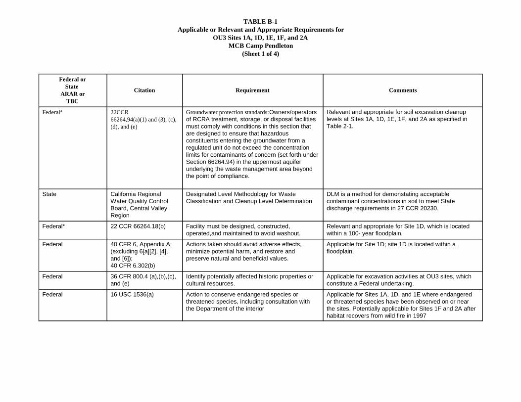
TABLE B-1Applicable or Relevant and Appropriate Requirements for
OU3 Sites 1A, 1D, 1E, 1F, and 2AMCB Camp Pendleton
(Sheet 1 of 4)
Federal orState
ARAR orTBC
Citation Requirement Comments
Federala 22CCR66264,94(a)(1) and (3), (c),(d), and (e)
Groundwater protection standards:Owners/operatorsof RCRA treatment, storage, or disposal facilitiesmust comply with conditions in this section thatare designed to ensure that hazardousconstituents entering the groundwater from aregulated unit do not exceed the concentrationlimits for contaminants of concern (set forth underSection 66264.94) in the uppermost aquiferunderlying the waste management area beyondthe point of compliance.
Relevant and appropriate for soil excavation cleanuplevels at Sites 1A, 1D, 1E, 1F, and 2A as specified inTable 2-1.
State California RegionalWater Quality ControlBoard, Central ValleyRegion
Designated Level Methodology for WasteClassification and Cleanup Level Determination
DLM is a method for demonstating acceptablecontaminant concentrations in soil to meet Statedischarge requirements in 27 CCR 20230.
Federal* 22 CCR 66264.18(b) Facility must be designed, constructed,operated,and maintained to avoid washout.
Relevant and appropriate for Site 1D, which is locatedwithin a 100- year floodplain.
Federal 40 CFR 6, Appendix A;(excluding 6[a][2], [4],and [6]);40 CFR 6.302(b)
Actions taken should avoid adverse effects,minimize potential harm, and restore andpreserve natural and beneficial values.
Applicable for Site 1D; site 1D is located within afloodplain.
Federal 36 CFR 800.4 (a),(b),(c),and (e)
Identify potentially affected historic properties orcultural resources.
Applicable for excavation activities at OU3 sites, whichconstitute a Federal undertaking.
Federal 16 USC 1536(a) Action to conserve endangered species orthreatened species, including consultation withthe Department of the interior
Applicable for Sites 1A, 1D, and 1E where endangeredor threatened species have been observed on or nearthe sites. Potentially applicable for Sites 1F and 2A afterhabitat recovers from wild fire in 1997
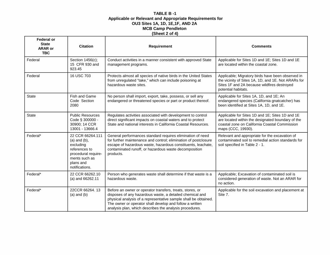
TABLE B -1 Applicable or Relevant and Appropriate Requirements for
OU3 Sites 1A, 1D, 1E,1F, AND 2A MCB Camp Pendleton
(Sheet 2 of 4)Federal or
State ARAR or
TBC
Citation Requirement Comments
Federal Section 1456(c);15 CFR 930 and923.45
Conduct activities in a manner consistent with approved Statemanagement programs.
Applicable for Sites 1D and 1E; Sites 1D and 1Eare located within the coastal zone.
Federal 16 USC 703 Protects almost all species of native birds in the United Statesfrom unregulated “take,” which can include poisoning athazardous waste sites.
Applicable; Migratory birds have been observed inthe vicinity of Sites 1A, 1D, and 1E. Not ARARs forSites 1F and 2A because wildfires destroyedpotential habitats.
State Fish and GameCode Section2080
No person shall import, export, take, possess, or sell anyendangered or threatened species or part or product thereof.
Applicable for Sites 1A, 1D, and 1E; Anendangered species (California gnatcatcher) hasbeen identified at Sites 1A, 1D, and 1E.
State Public ResourcesCode § 300000 -30900; 14 CCR13001 - 13666.4
Regulates activities associated with development to controldirect significant impacts on coastal waters and to protectState and national interests in California Coastal Resources.
Applicable for Sites 1D and 1E; Sites 1D and 1Eare located within the designated boundary of thecoastal zone on California Coastal Commissionmaps (CCC, 19930).
Federal* 22 CCR 66264.111(a) and (b),excludingreferences toprocedural require-ments such asplans andnotifications.
General performances standard requires elimination of needfor further maintenance and control; elimination of postclosureescape of hazardous waste, hazardous constituents, leachate,contaminated runoff, or hazardous waste decompositionproducts.
Relevant and appropriate for the excavation ofcontaminated soil to remedial action standards forsoil specified in Table 2 - 1.
Federal* 22 CCR 66262.10(a) and 66262.11
Person who generates waste shall determine if that waste is ahazardous waste.
Applicable; Excavation of contaminated soil isconsidered generation of waste. Not an ARAR forno action.
Federal* 22CCR 66264. 13(a) and (b)
Before an owner or operator transfers, treats, stores, ordisposes of any hazardous waste, a detailed chemical andphysical analysis of a representative sample shall be obtained.The owner or operator shall develop and follow a writtenanalysis plan, which describes the analysis procedures.
Applicable for the soil excavation and placement atSite 7.
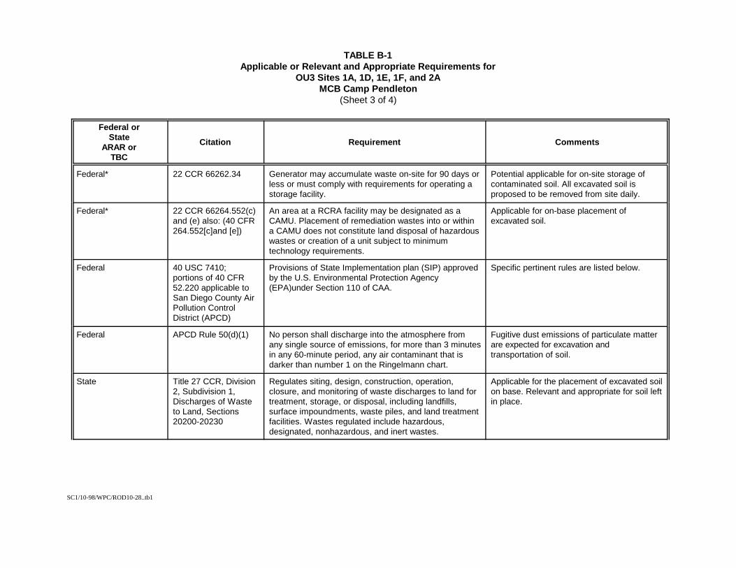
SC1/10-98/WPC/ROD10-28..tb1
TABLE B-1Applicable or Relevant and Appropriate Requirements for
OU3 Sites 1A, 1D, 1E, 1F, and 2AMCB Camp Pendleton
(Sheet 3 of 4)
Federal orState
ARAR orTBC
Citation Requirement Comments
Federal* 22 CCR 66262.34 Generator may accumulate waste on-site for 90 days orless or must comply with requirements for operating astorage facility.
Potential applicable for on-site storage ofcontaminated soil. All excavated soil isproposed to be removed from site daily.
Federal* 22 CCR 66264.552(c)and (e) also: (40 CFR264.552[c]and [e])
An area at a RCRA facility may be designated as aCAMU. Placement of remediation wastes into or withina CAMU does not constitute land disposal of hazardouswastes or creation of a unit subject to minimumtechnology requirements.
Applicable for on-base placement ofexcavated soil.
Federal 40 USC 7410;portions of 40 CFR52.220 applicable toSan Diego County AirPollution ControlDistrict (APCD)
Provisions of State Implementation plan (SIP) approvedby the U.S. Environmental Protection Agency(EPA)under Section 110 of CAA.
Specific pertinent rules are listed below.
Federal APCD Rule 50(d)(1) No person shall discharge into the atmosphere fromany single source of emissions, for more than 3 minutesin any 60-minute period, any air contaminant that isdarker than number 1 on the Ringelmann chart.
Fugitive dust emissions of particulate matterare expected for excavation andtransportation of soil.
State Title 27 CCR, Division2, Subdivision 1,Discharges of Wasteto Land, Sections20200-20230
Regulates siting, design, construction, operation,closure, and monitoring of waste discharges to land fortreatment, storage, or disposal, including landfills,surface impoundments, waste piles, and land treatmentfacilities. Wastes regulated include hazardous,designated, nonhazardous, and inert wastes.
Applicable for the placement of excavated soilon base. Relevant and appropriate for soil leftin place.
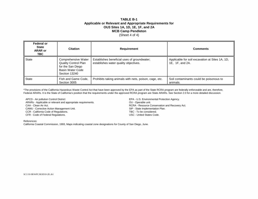
SC1/10-98/WPC/ROD10-28..tb1
TABLE B-1Applicable or Relevant and Appropriate Requirements for
OU3 Sites 1A, 1D, 1E, 1F, and 2AMCB Camp Pendleton
(Sheet 4 of 4)
Federal orState
ARAR orTBC
Citation Requirement Comments
State Comprehensive WaterQuality Control Planfor the San DiegoBasin Water CodeSection 13240
Establishes beneficial uses of groundwater;establishes water quality objectives.
Applicable for soil excavation at Sites 1A, 1D,1E, 1F, and 2A.
State Fish and Game Code,Section 3005
Prohibits taking animals with nets, poison, cage, etc. Soil contaminants could be poisonous toanimals.
*The provisions of the California Hazardous Waste Control Act that have been approved by the EPA as part of the State RCRA program are federally enforceable and are, therefore,Federal ARARs. It is the State of California’s position that the requirements under the approved RCRA program are State ARARs. See Section 2.0 for a more detailed discussion.
APCD - Air pollution Control District EPA - U.S. Environmental Protection Agency. ARARs - Applicable or relevant and appropriate requirements. OU - Operable unit. CAA - Clean Air Act. RCRA - Resource Conservation and Recovery Act. CAMU - Corrective Action Management Unit. SIP - State Implementation Plan. CCR - California Code of Regulations. TBC - To be considered. CFR - Code of Federal Regulations. USC - United States Code.
References:California Coastal Commission, 1993, Maps indicating coastal zone designations for County of San Diego, June.
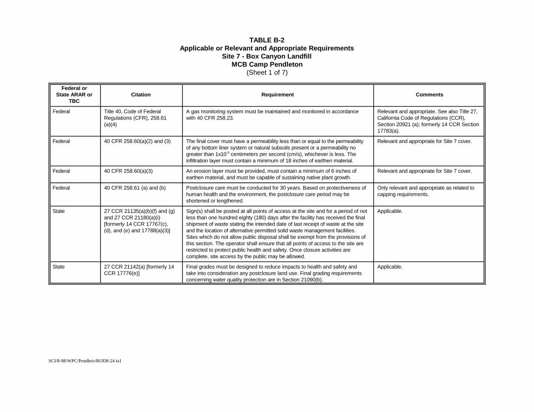
SCI/8-98/WPC/Pendleto/ROD8-24 ta1
TABLE B-2Applicable or Relevant and Appropriate Requirements
Site 7 - Box Canyon LandfillMCB Camp Pendleton
(Sheet 1 of 7)
Federal orState ARAR or
TBCCitation Requirement Comments
Federal Title 40, Code of FederalRegulations (CFR), 258.61(a)(4)
A gas monitoring system must be maintained and monitored in accordancewith 40 CFR 258.23.
Relevant and appropriate. See also Title 27,California Code of Regulations (CCR),Section 20921 (a); formerly 14 CCR Section17783(a).
Federal 40 CFR 258.60(a)(2) and (3) The final cover must have a permeability less than or equal to the permeabilityof any bottom liner system or natural subsoils present or a permeability nogreater than 1x10⁻⁵ centimeters per second (cm/s), whichever is less. Theinfiltration layer must contain a minimum of 18 inches of earthen material.
Relevant and appropriate for Site 7 cover.
Federal 40 CFR 258.60(a)(3) An erosion layer must be provided, must contain a minimum of 6 inches ofearthen material, and must be capable of sustaining native plant growth.
Relevant and appropriate for Site 7 cover.
Federal 40 CFR 258.61 (a) and (b) Postclosure care must be conducted for 30 years. Based on protectiveness ofhuman health and the environment, the postclosure care period may beshortened or lengthened.
Only relevant and appropriate as related tocapping requirements.
State 27 CCR 21135(a)(b)(f) and (g)and 27 CCR 21180(a)(i)[formerly 14 CCR 17767(c),(d), and (e) and 17788(a)(3)]
Sign(s) shall be posted at all points of access at the site and for a period of notless than one hundred eighty (180) days after the facility has received the finalshipment of waste stating the intended date of last receipt of waste at the siteand the location of alternative permitted solid waste management facilities.Sites which do not allow public disposal shall be exempt from the provisions ofthis section. The operator shall ensure that all points of access to the site arerestricted to protect public health and safety. Once closure activities arecomplete, site access by the public may be allowed.
Applicable.
State 27 CCR 21142(a) [formerly 14CCR 17776(e)]
Final grades must be designed to reduce impacts to health and safety andtake into consideration any postclosure land use. Final grading requirementsconcerning water quality protection are in Section 21090(b).
Applicable.
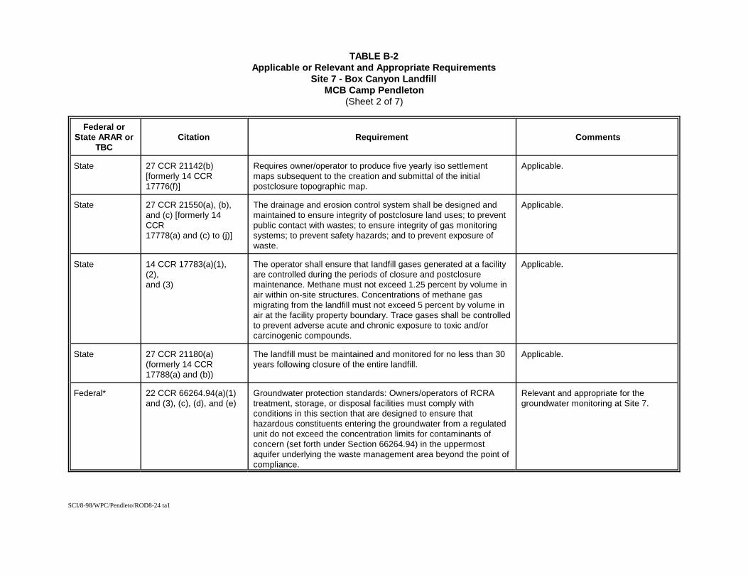
SCI/8-98/WPC/Pendleto/ROD8-24 ta1
TABLE B-2Applicable or Relevant and Appropriate Requirements
Site 7 - Box Canyon LandfillMCB Camp Pendleton
(Sheet 2 of 7)
Federal orState ARAR or
TBCCitation Requirement Comments
State 27 CCR 21142(b)[formerly 14 CCR17776(f)]
Requires owner/operator to produce five yearly iso settlementmaps subsequent to the creation and submittal of the initialpostclosure topographic map.
Applicable.
State 27 CCR 21550(a), (b),and (c) [formerly 14CCR17778(a) and (c) to (j)]
The drainage and erosion control system shall be designed andmaintained to ensure integrity of postclosure land uses; to preventpublic contact with wastes; to ensure integrity of gas monitoringsystems; to prevent safety hazards; and to prevent exposure ofwaste.
Applicable.
State 14 CCR 17783(a)(1),(2),and (3)
The operator shall ensure that Iandfill gases generated at a facilityare controlled during the periods of closure and postclosuremaintenance. Methane must not exceed 1.25 percent by volume inair within on-site structures. Concentrations of methane gasmigrating from the landfill must not exceed 5 percent by volume inair at the facility property boundary. Trace gases shall be controlledto prevent adverse acute and chronic exposure to toxic and/orcarcinogenic compounds.
Applicable.
State 27 CCR 21180(a)(formerly 14 CCR17788(a) and (b))
The landfill must be maintained and monitored for no less than 30years following closure of the entire landfill.
Applicable.
Federal* 22 CCR 66264.94(a)(1)and (3), (c), (d), and (e)
Groundwater protection standards: Owners/operators of RCRAtreatment, storage, or disposal facilities must comply withconditions in this section that are designed to ensure thathazardous constituents entering the groundwater from a regulatedunit do not exceed the concentration limits for contaminants ofconcern (set forth under Section 66264.94) in the uppermostaquifer underlying the waste management area beyond the point ofcompliance.
Relevant and appropriate for thegroundwater monitoring at Site 7.
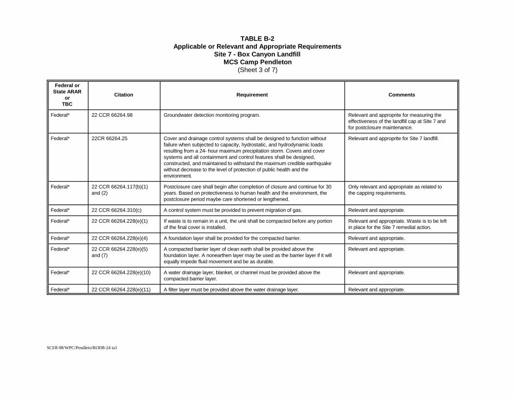
SCI/8-98/WPC/Pendleto/ROD8-24 ta1
TABLE B-2Applicable or Relevant and Appropriate Requirements
Site 7 - Box Canyon LandfillMCS Camp Pendleton
(Sheet 3 of 7)
Federal orState ARAR
orTBC
Citation Requirement Comments
Federal* 22 CCR 66264.98 Groundwater detection monitoring program. Relevant and approprite for measuring theeffectiveness of the landfill cap at Site 7 andfor postclosure maintenance.
Federal* 22CR 66264.25 Cover and drainage control systems shall be designed to function withoutfailure when subjected to capacity, hydrostatic, and hydrodynamic loadsresulting from a 24- hour maximum precipitation storm. Covers and coversystems and all containment and control features shall be designed,constructed, and maintained to withstand the maximum credible earthquakewithout decrease to the level of protection of public health and theenvironment.
Relevant and approprite for Site 7 landfill.
Federal* 22 CCR 66264.117(b)(1)and (2)
Postclosure care shall begin after completion of closure and continue for 30years. Based on protectiveness to human health and the environment, thepostclosure period maybe care shortened or lengthened.
Only relevant and appropriate as related tothe capping requirements.
Federal* 22 CCR 66264.310(c) A control system must be provided to prevent migration of gas. Relevant and appropriate.
Federal* 22 CCR 66264.228(e)(1) If waste is to remain in a unit, the unit shall be compacted before any portionof the final cover is installed.
Relevant and appropriate. Waste is to be leftin place for the Site 7 remedial action.
Federal* 22 CCR 66264.228(e)(4) A foundation layer shall be provided for the compacted barrier. Relevant and appropriate.
Federal* 22 CCR 66264.228(e)(5)and (7)
A compacted barrier layer of clean earth shall be provided above thefoundation layer. A nonearthen layer may be used as the barrier layer if it willequally impede fluid movement and be as durable.
Relevant and appropriate.
Federal* 22 CCR 66264.228(e)(10) A water drainage layer, blanket, or channel must be provided above thecompacted barrier layer.
Relevant and appropriate.
Federal* 22 CCR 66264.228(e)(11) A filter layer must be provided above the water drainage layer. Relevant and appropriate.
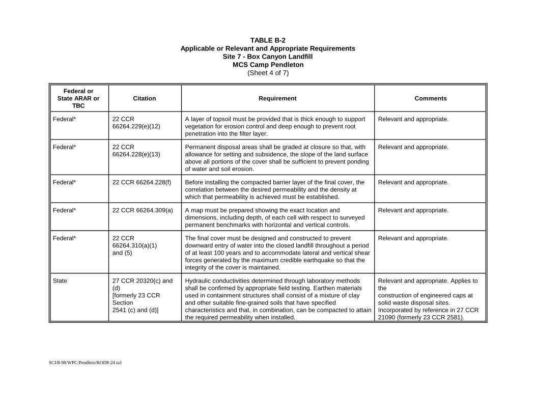
SCI/8-98/WPC/Pendleto/ROD8-24 ta1
TABLE B-2Applicable or Relevant and Appropriate Requirements
Site 7 - Box Canyon LandfillMCS Camp Pendleton
(Sheet 4 of 7)
Federal orState ARAR or
TBCCitation Requirement Comments
Federal* 22 CCR66264.229(e)(12)
A layer of topsoil must be provided that is thick enough to supportvegetation for erosion control and deep enough to prevent rootpenetration into the filter layer.
Relevant and appropriate.
Federal* 22 CCR66264.228(e)(13)
Permanent disposal areas shall be graded at closure so that, withallowance for setting and subsidence, the slope of the land surfaceabove all portions of the cover shall be sufficient to prevent pondingof water and soil erosion.
Relevant and appropriate.
Federal* 22 CCR 66264.228(f) Before installing the compacted barrier layer of the final cover, thecorrelation between the desired permeability and the density atwhich that permeability is achieved must be established.
Relevant and appropriate.
Federal* 22 CCR 66264.309(a) A map must be prepared showing the exact location anddimensions, including depth, of each cell with respect to surveyedpermanent benchmarks with horizontal and vertical controls.
Relevant and appropriate.
Federal* 22 CCR66264.310(a)(1)and (5)
The final cover must be designed and constructed to preventdownward entry of water into the closed landfill throughout a periodof at least 100 years and to accommodate lateral and vertical shearforces generated by the maximum credible earthquake so that theintegrity of the cover is maintained.
Relevant and appropriate.
State 27 CCR 20320(c) and(d)[formerly 23 CCRSection2541 (c) and (d)]
Hydraulic conductivities determined through laboratory methodsshall be confirmed by appropriate field testing. Earthen materialsused in containment structures shall consist of a mixture of clayand other suitable fine-grained soils that have specifiedcharacteristics and that, in combination, can be compacted to attainthe required permeability when installed.
Relevant and appropriate. Applies totheconstruction of engineered caps atsolid waste disposal sites.Incorporated by reference in 27 CCR21090 (formerly 23 CCR 2581).
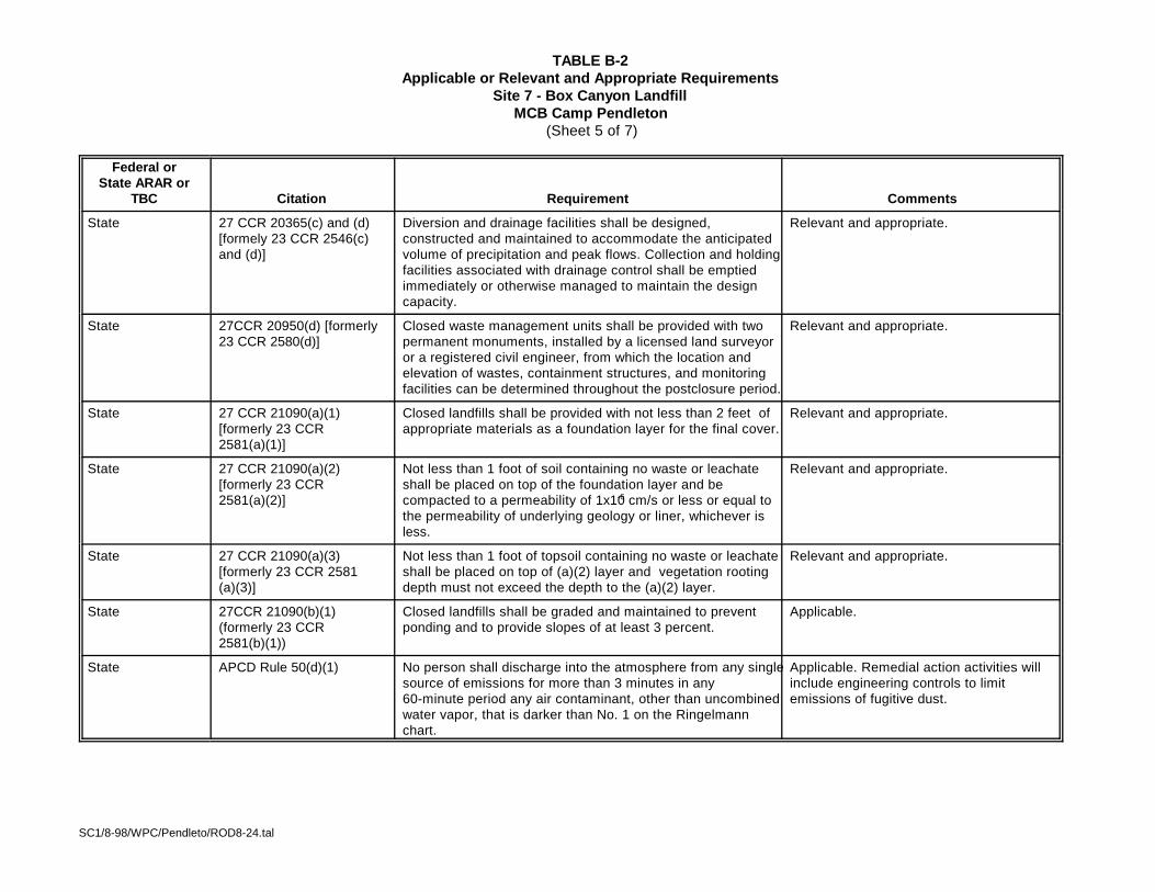
SC1/8-98/WPC/Pendleto/ROD8-24.tal
TABLE B-2Applicable or Relevant and Appropriate Requirements
Site 7 - Box Canyon LandfillMCB Camp Pendleton
(Sheet 5 of 7)
Federal orState ARAR or
TBC Citation Requirement Comments
State 27 CCR 20365(c) and (d)[formely 23 CCR 2546(c)and (d)]
Diversion and drainage facilities shall be designed,constructed and maintained to accommodate the anticipatedvolume of precipitation and peak flows. Collection and holdingfacilities associated with drainage control shall be emptiedimmediately or otherwise managed to maintain the designcapacity.
Relevant and appropriate.
State 27CCR 20950(d) [formerly23 CCR 2580(d)]
Closed waste management units shall be provided with twopermanent monuments, installed by a licensed land surveyoror a registered civil engineer, from which the location andelevation of wastes, containment structures, and monitoringfacilities can be determined throughout the postclosure period.
Relevant and appropriate.
State 27 CCR 21090(a)(1)[formerly 23 CCR2581(a)(1)]
Closed landfills shall be provided with not less than 2 feet ofappropriate materials as a foundation layer for the final cover.
Relevant and appropriate.
State 27 CCR 21090(a)(2)[formerly 23 CCR2581(a)(2)]
Not less than 1 foot of soil containing no waste or leachateshall be placed on top of the foundation layer and becompacted to a permeability of 1x10⁻⁶ cm/s or less or equal tothe permeability of underlying geology or liner, whichever isless.
Relevant and appropriate.
State 27 CCR 21090(a)(3)[formerly 23 CCR 2581(a)(3)]
Not less than 1 foot of topsoil containing no waste or leachateshall be placed on top of (a)(2) layer and vegetation rootingdepth must not exceed the depth to the (a)(2) layer.
Relevant and appropriate.
State 27CCR 21090(b)(1)(formerly 23 CCR2581(b)(1))
Closed landfills shall be graded and maintained to preventponding and to provide slopes of at least 3 percent.
Applicable.
State APCD Rule 50(d)(1) No person shall discharge into the atmosphere from any singlesource of emissions for more than 3 minutes in any 60-minute period any air contaminant, other than uncombinedwater vapor, that is darker than No. 1 on the Ringelmannchart.
Applicable. Remedial action activities willinclude engineering controls to limitemissions of fugitive dust.
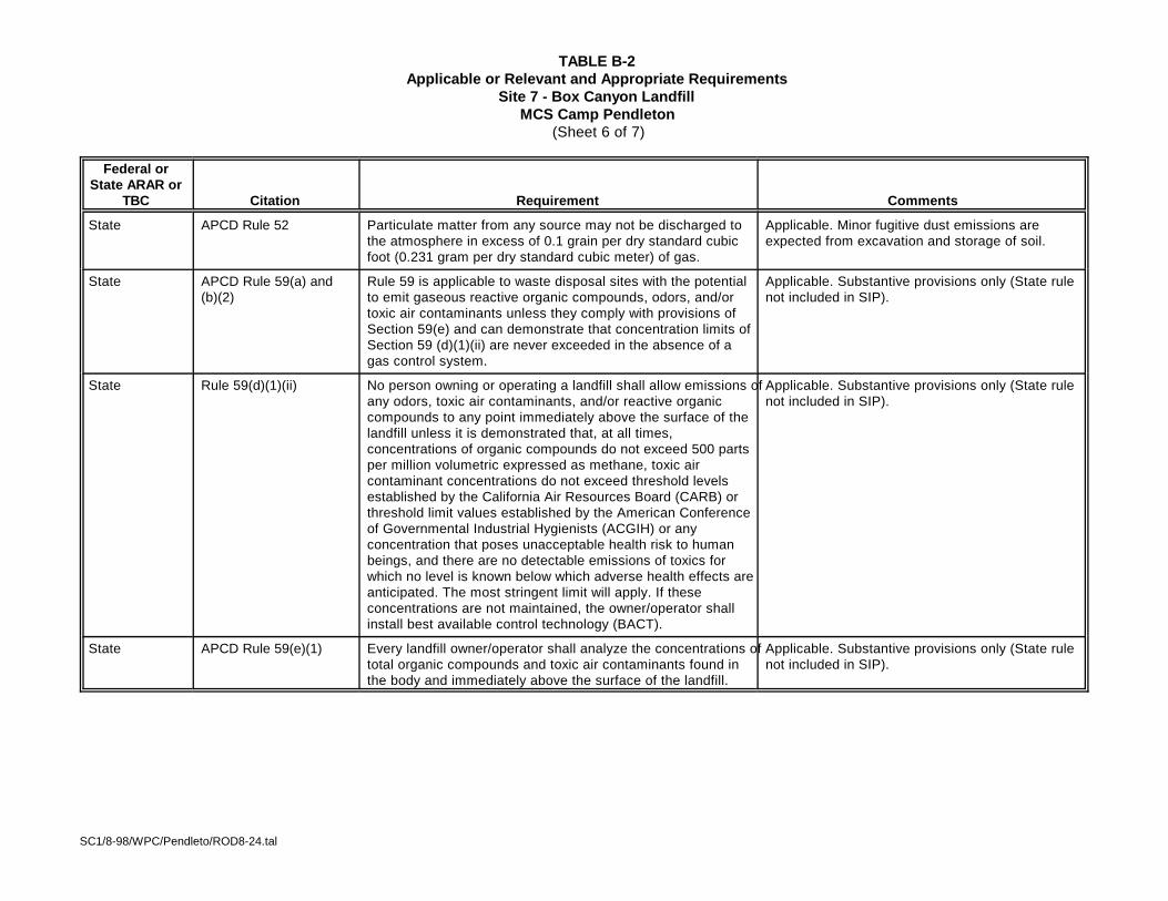
SC1/8-98/WPC/Pendleto/ROD8-24.tal
TABLE B-2Applicable or Relevant and Appropriate Requirements
Site 7 - Box Canyon LandfillMCS Camp Pendleton
(Sheet 6 of 7)
Federal orState ARAR or
TBC Citation Requirement Comments
State APCD Rule 52 Particulate matter from any source may not be discharged tothe atmosphere in excess of 0.1 grain per dry standard cubicfoot (0.231 gram per dry standard cubic meter) of gas.
Applicable. Minor fugitive dust emissions areexpected from excavation and storage of soil.
State APCD Rule 59(a) and(b)(2)
Rule 59 is applicable to waste disposal sites with the potentialto emit gaseous reactive organic compounds, odors, and/ortoxic air contaminants unless they comply with provisions ofSection 59(e) and can demonstrate that concentration limits ofSection 59 (d)(1)(ii) are never exceeded in the absence of agas control system.
Applicable. Substantive provisions only (State rulenot included in SIP).
State Rule 59(d)(1)(ii) No person owning or operating a landfill shall allow emissions ofany odors, toxic air contaminants, and/or reactive organiccompounds to any point immediately above the surface of thelandfill unless it is demonstrated that, at all times,concentrations of organic compounds do not exceed 500 partsper million volumetric expressed as methane, toxic aircontaminant concentrations do not exceed threshold levelsestablished by the California Air Resources Board (CARB) orthreshold limit values established by the American Conferenceof Governmental Industrial Hygienists (ACGIH) or anyconcentration that poses unacceptable health risk to humanbeings, and there are no detectable emissions of toxics forwhich no level is known below which adverse health effects areanticipated. The most stringent limit will apply. If theseconcentrations are not maintained, the owner/operator shallinstall best available control technology (BACT).
Applicable. Substantive provisions only (State rulenot included in SIP).
State APCD Rule 59(e)(1) Every landfill owner/operator shall analyze the concentrations oftotal organic compounds and toxic air contaminants found inthe body and immediately above the surface of the landfill.
Applicable. Substantive provisions only (State rulenot included in SIP).
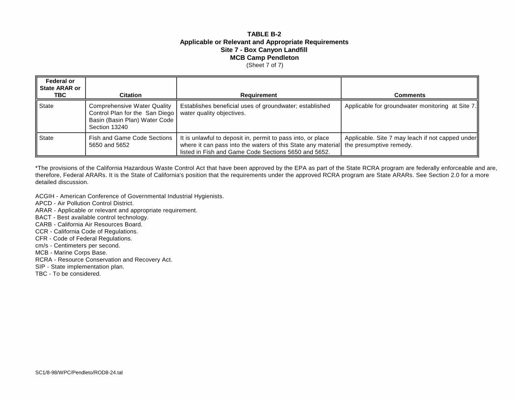
SC1/8-98/WPC/Pendleto/ROD8-24.tal
TABLE B-2Applicable or Relevant and Appropriate Requirements
Site 7 - Box Canyon LandfillMCB Camp Pendleton
(Sheet 7 of 7)
Federal orState ARAR or
TBC Citation Requirement Comments
State Comprehensive Water QualityControl Plan for the San DiegoBasin (Basin Plan) Water CodeSection 13240
Establishes beneficial uses of groundwater; establishedwater quality objectives.
Applicable for groundwater monitoring at Site 7.
State Fish and Game Code Sections5650 and 5652
It is unlawful to deposit in, permit to pass into, or placewhere it can pass into the waters of this State any materiallisted in Fish and Game Code Sections 5650 and 5652.
Applicable. Site 7 may leach if not capped underthe presumptive remedy.
*The provisions of the California Hazardous Waste Control Act that have been approved by the EPA as part of the State RCRA program are federally enforceable and are,therefore, Federal ARARs. It is the State of California's position that the requirements under the approved RCRA program are State ARARs. See Section 2.0 for a moredetailed discussion.
ACGIH - American Conference of Governmental Industrial Hygienists. APCD - Air Pollution Control District.ARAR - Applicable or relevant and appropriate requirement.BACT - Best available control technology.CARB - California Air Resources Board.CCR - California Code of Regulations.CFR - Code of Federal Regulations.cm/s - Centimeters per second.MCB - Marine Corps Base.RCRA - Resource Conservation and Recovery Act.SIP - State implementation plan.TBC - To be considered.
APPENDIX CADMINISTRATIVE RECORD INDEX
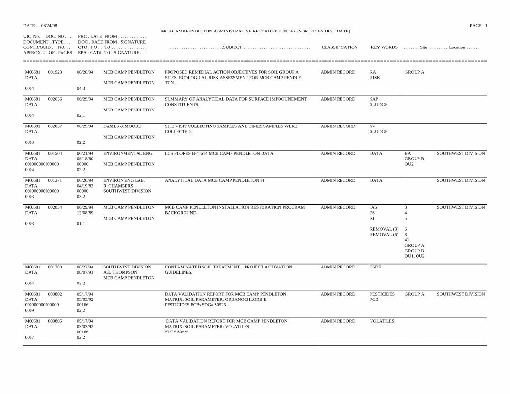
DATE - 08/24/98 PAGE - 1MCB CAMP PENDLETON ADMINISTRATIVE RECORD FILE INDEX (SORTED BY DOC. DATE)
UIC No. DOC. NO . . . PRC . DATE FROM . . . . . . . . . . . . .DOCUMENT . TYPE . . . DOC . DATE FROM . SIGNATURECONTR/GUID . . NO. . . CTO . NO . . TO . . . . . . . . . . . . . . . . . . . . . . . . . . . . . . . . . . . . . . . . .SUBJECT . . . . . . . . . . . . . . . . . . . . . . . . . . . . . . CLASSIFICATION KEY WORDS . . . . . . . Site . . . . . . . . Location . . . . . .APPROX. # . OF . PAGES EPA . CAT# TO . SIGNATURE . . .
M00681 001923 06/28/94 MCB CAMP PENDLETON PROPOSED REMEDIAL ACTION OBJECTIVES FOR SOIL GROUP A ADMIN RECORD RA GROUP ADATA SITES. ECOLOGICAL RISK ASSESSMENT FOR MCB CAMP PENDLE- RISK
MCB CAMP PENDLETON TON.0004 04.3
M00681 002036 06/29/94 MCB CAMP PENDLETON SUMMARY OF ANALYTICAL DATA FOR SURFACE IMPOOUNDMENT ADMIN RECORD SAPDATA CONSTITUENTS. SLUDGE
MCB CAMP PENDLETON0004 02.1
M00681 002037 06/29/94 DAMES & MOORE SITE VISIT COLLECTING SAMPLES AND TIMES SAMPLES WERE ADMIN RECORD SVDATA COLLECTED. SLUDGE
MCB CAMP PENDLETON0003 02.2
M00681 001504 06/21/94 ENVIRONMENTAL ENG. LOS FLORES B-41614 MCB CAMP PENDLETON DATA ADMIN RECORD DATA BA SOUTHWEST DIVISIONDATA 09/18/80 GROUP B000000000000000 00000 MCB CAMP PENDLETON OU20004 02.2
M00681 001371 06/20/94 ENVIRON ENG LAB. ANALYTICAL DATA MCB CAMP PENDLETON #1 ADMIN RECORD DATA SOUTHWEST DIVISIONDATA 04/19/82 R. CHAMBERS000000000000000 00000 SOUTHWEST DIVISION0003 03.2
M00681 002054 06/29/94 MCB CAMP PENDLETON MCB CAMP PENDLETON INSTALLATION RESTORATION PROGRAM ADMIN RECORD IAS 3 SOUTHWEST DIVISIONDATA 12/08/89 BACKGROUND. FS 4
MCB CAMP PENDLETON RI 50003 01.1
REMOVAL (3) 6REMOVAL (6) 8
41GROUP AGROUP BOU1, OU2
M00681 001780 06/27/94 SOUTHWEST DIVISION CONTAMINATED SOIL TREATMENT. PROJECT ACTIVATION ADMIN RECORD TSDFDATA 08/07/91 A.E. THOMPSON GUIDELINES.
MCB CAMP PENDLETON0004 03.2
M00681 000802 05/17/94 DATA VALIDATION REPORT FOR MCB CAMP PENDLETON ADMIN RECORD PESTICIDES GROUP A SOUTHWEST DIVISIONDATA 03/03/92 MATRIX: SOIL PARAMETER: ORGANOCHLORINE PCB000000000000000 00166 PESTICIDES PCBs SDG# S05250009 02.2
M00681 000805 05/17/94 DATA VALIDATION REPORT FOR MCB CAMP PENDLETON ADMIN RECORD VOLATILESDATA 03/03/92 MATRIX: SOIL PARAMETER: VOLATILES
00166 SDG# S05250007 02.2
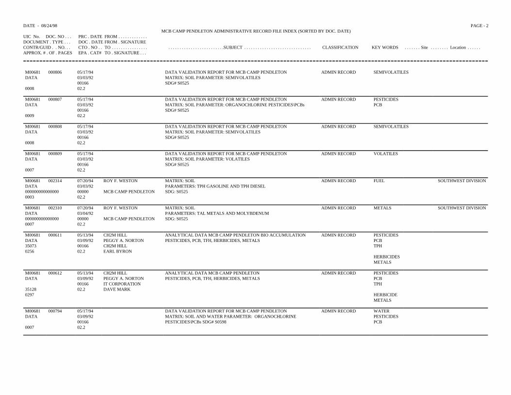
DATE - 08/24/98 PAGE - 2MCB CAMP PENDLETON ADMINISTRATIVE RECORD FILE INDEX (SORTED BY DOC. DATE)
UIC No. DOC. NO . . . PRC . DATE FROM . . . . . . . . . . . . .DOCUMENT . TYPE . . . DOC . DATE FROM . SIGNATURECONTR/GUID . . NO. . . CTO . NO . . TO . . . . . . . . . . . . . . . . . . . . . . . . . . . . . . . . . . . . . . . . .SUBJECT . . . . . . . . . . . . . . . . . . . . . . . . . . . . . . CLASSIFICATION KEY WORDS . . . . . . . Site . . . . . . . . Location . . . . . .APPROX. # . OF . PAGES EPA . CAT# TO . SIGNATURE . . .
M00681 000806 05/17/94 DATA VALIDATION REPORT FOR MCB CAMP PENDLETON ADMIN RECORD SEMIVOLATILESDATA 03/03/92 MATRIX: SOIL PARAMETER: SEMIVOLATILES
00166 SDG# S05250008 02.2
M00681 000807 05/17/94 DATA VALIDATION REPORT FOR MCB CAMP PENDLETON ADMIN RECORD PESTICIDESDATA 03/03/92 MATRIX: SOIL PARAMETER: ORGANOCHLORINE PESTICIDES\PCBs PCB
00166 SDG# S05250009 02.2
M00681 000808 05/17/94 DATA VALIDATION REPORT FOR MCB CAMP PENDLETON ADMIN RECORD SEMIVOLATILESDATA 03/03/92 MATRIX: SOIL PARAMETER: SEMIVOLATILES
00166 SDG# S05250008 02.2
M00681 000809 05/17/94 DATA VALIDATION REPORT FOR MCB CAMP PENDLETON ADMIN RECORD VOLATILESDATA 03/03/92 MATRIX: SOIL PARAMETER: VOLATILES
00166 SDG# S05250007 02.2
M00681 002314 07/20/94 ROY F. WESTON MATRIX: SOIL ADMIN RECORD FUEL SOUTHWEST DIVISIONDATA 03/03/92 PARAMETERS: TPH GASOLINE AND TPH DIESEL000000000000000 00000 MCB CAMP PENDLETON SDG: S05250003 02.2
M00681 002310 07/20/94 ROY F. WESTON MATRIX: SOIL ADMIN RECORD METALS SOUTHWEST DIVISIONDATA 03/04/92 PARAMETERS: TAL METALS AND MOLYBDENUM000000000000000 00000 MCB CAMP PENDLETON SDG: S05250007 02.2
M00681 000611 05/13/94 CH2M HILL ANALYTICAL DATA MCB CAMP PENDLETON BIO ACCUMULATION ADMIN RECORD PESTICIDESDATA 03/09/92 PEGGY A. NORTON PESTICIDES, PCB, TFH, HERBICIDES, METALS PCB35073 00166 CH2M HILL TPH0256 02.2 EARL BYRON
HERBICIDESMETALS
M00681 000612 05/13/94 CH2M HILL ANALYTICAL DATA MCB CAMP PENDLETON ADMIN RECORD PESTICIDESDATA 03/09/92 PEGGY A. NORTON PESTICIDES, PCB, TFH, HERBICIDES, METALS PCB
00166 IT CORPORATION TPH35128 02.2 DAVE MARK0297 HERBICIDE
METALS
M00681 000794 05/17/94 DATA VALIDATION REPORT FOR MCB CAMP PENDLETON ADMIN RECORD WATERDATA 03/09/92 MATRIX: SOIL AND WATER PARAMETER: ORGANOCHLORINE PESTICIDES
00166 PESTICIDES\PCBs SDG# S0598 PCB0007 02.2
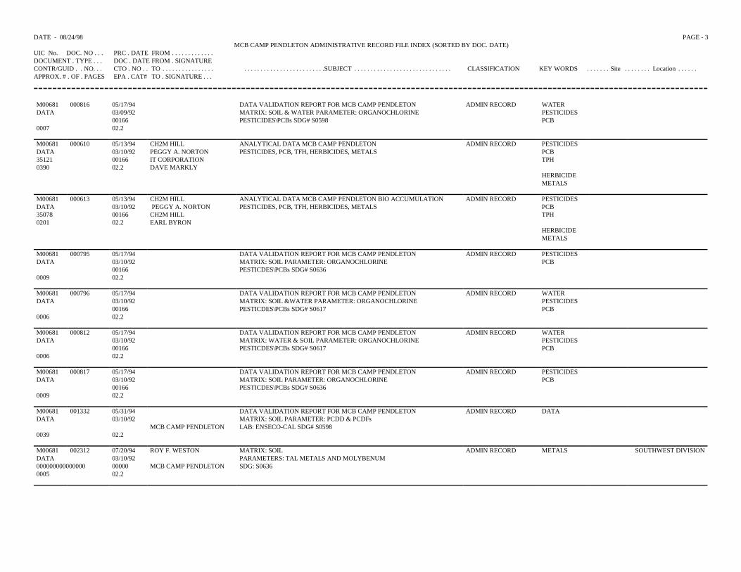
DATE - 08/24/98 PAGE - 3MCB CAMP PENDLETON ADMINISTRATIVE RECORD FILE INDEX (SORTED BY DOC. DATE)
UIC No. DOC. NO . . . PRC . DATE FROM . . . . . . . . . . . . .DOCUMENT . TYPE . . . DOC . DATE FROM . SIGNATURECONTR/GUID . . NO. . . CTO . NO . . TO . . . . . . . . . . . . . . . . . . . . . . . . . . . . . . . . . . . . . . . . .SUBJECT . . . . . . . . . . . . . . . . . . . . . . . . . . . . . . CLASSIFICATION KEY WORDS . . . . . . . Site . . . . . . . . Location . . . . . .APPROX. # . OF . PAGES EPA . CAT# TO . SIGNATURE . . .
M00681 000816 05/17/94 DATA VALIDATION REPORT FOR MCB CAMP PENDLETON ADMIN RECORD WATERDATA 03/09/92 MATRIX: SOIL & WATER PARAMETER: ORGANOCHLORINE PESTICIDES
00166 PESTICIDES\PCBs SDG# S0598 PCB0007 02.2
M00681 000610 05/13/94 CH2M HILL ANALYTICAL DATA MCB CAMP PENDLETON ADMIN RECORD PESTICIDESDATA 03/10/92 PEGGY A. NORTON PESTICIDES, PCB, TFH, HERBICIDES, METALS PCB35121 00166 IT CORPORATION TPH0390 02.2 DAVE MARKLY
HERBICIDEMETALS
M00681 000613 05/13/94 CH2M HILL ANALYTICAL DATA MCB CAMP PENDLETON BIO ACCUMULATION ADMIN RECORD PESTICIDESDATA 03/10/92 PEGGY A. NORTON PESTICIDES, PCB, TFH, HERBICIDES, METALS PCB35078 00166 CH2M HILL TPH0201 02.2 EARL BYRON
HERBICIDEMETALS
M00681 000795 05/17/94 DATA VALIDATION REPORT FOR MCB CAMP PENDLETON ADMIN RECORD PESTICIDESDATA 03/10/92 MATRIX: SOIL PARAMETER: ORGANOCHLORINE PCB
00166 PESTICDES\PCBs SDG# S06360009 02.2
M00681 000796 05/17/94 DATA VALIDATION REPORT FOR MCB CAMP PENDLETON ADMIN RECORD WATERDATA 03/10/92 MATRIX: SOIL &WATER PARAMETER: ORGANOCHLORINE PESTICIDES
00166 PESTICDES\PCBs SDG# S0617 PCB0006 02.2
M00681 000812 05/17/94 DATA VALIDATION REPORT FOR MCB CAMP PENDLETON ADMIN RECORD WATERDATA 03/10/92 MATRIX: WATER & SOIL PARAMETER: ORGANOCHLORINE PESTICIDES
00166 PESTICDES\PCBs SDG# S0617 PCB0006 02.2
M00681 000817 05/17/94 DATA VALIDATION REPORT FOR MCB CAMP PENDLETON ADMIN RECORD PESTICIDESDATA 03/10/92 MATRIX: SOIL PARAMETER: ORGANOCHLORINE PCB
00166 PESTICDES\PCBs SDG# S06360009 02.2
M00681 001332 05/31/94 DATA VALIDATION REPORT FOR MCB CAMP PENDLETON ADMIN RECORD DATADATA 03/10/92 MATRIX: SOIL PARAMETER: PCDD & PCDFs
MCB CAMP PENDLETON LAB: ENSECO-CAL SDG# S05980039 02.2
M00681 002312 07/20/94 ROY F. WESTON MATRIX: SOIL ADMIN RECORD METALS SOUTHWEST DIVISIONDATA 03/10/92 PARAMETERS: TAL METALS AND MOLYBENUM000000000000000 00000 MCB CAMP PENDLETON SDG: S06360005 02.2
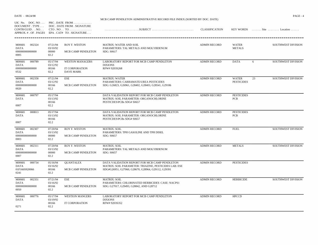
DATE - 08/24/98 PAGE - 4MCB CAMP PENDLETON ADMINISTRATIVE RECORD FILE INDEX (SORTED BY DOC. DATE)
UIC No. DOC. NO . . . PRC . DATE FROM . . . . . . . . . . . . .DOCUMENT . TYPE . . . DOC . DATE FROM . SIGNATURECONTR/GUID . . NO. . . CTO . NO . . TO . . . . . . . . . . . . . . . . . . . . . . . . . . . . . . . . . . . . . . . . .SUBJECT . . . . . . . . . . . . . . . . . . . . . . . . . . . . . . CLASSIFICATION KEY WORDS . . . . . . . Site . . . . . . . . Location . . . . . .APPROX. # . OF . PAGES EPA . CAT# TO . SIGNATURE . . .
M00681 002324 07/21/94 ROY F. WESTON MATRIX: WATER AND SOIL ADMIN RECORD WATER SOUTHWEST DIVISIONDATA 03/10/92 PARAMETERS: TAL METALS AND MOLYBDENUM METALS000000000000000 00000 MCB CAMP PENDLETON SDG: S06170005 02.2
M00681 000789 05/17/94 WESTON MANAGERS LABORATORY REPORT FOR MCB CAMP PENDLETON ADMIN RECORD DATA 6 SOUTHWEST DIVISIONDATA 03/12/92 DIXIONS000000000000000 00166 IT CORPORATION RFW# 9203S2680532 02.2 DAVE MARK
M00681 002358 07/21/94 ESE MATRIX: WATER ADMIN RECORD WATER 23 SOUTHWEST DIVISIONDATA 03/12/92 PARAMETERS: CARBAMATE/UREA PESTICIDES PESTICIDES000000000000000 00166 MCB CAMP PENDLETON SDG: G26823, G26961, G28402, G28403, G28541, G291860020 02.2
M00681 000797 05/17/94 DATA VALIDATION REPORT FOR MCB CAMP PENDLETON ADMIN RECORD PESTICIDESDATA 03/13/92 MATRIX: SOIL PARAMETER: ORGANOCHLORINE PCB
00166 PESTICDES\PCBs SDG# S06570007 02.2
M00681 000813 05/17/94 DATA VALIDATION REPORT FOR MCB CAMP PENDLETON ADMIN RECORD PESTICIDESDATA 03/13/92 MATRIX: SOIL PARAMETER: ORGANOCHLORINE PCB
00166 PESTICDES\PCBs SDG# S06570007 02.2
M00681 002307 07/20/94 ROY F. WESTON MATRIX: SOIL ADMIN RECORD FUEL SOUTHWEST DIVISIONDATA 03/13/92 PARAMETERS: TPH GASOLINE AND TPH DISEL000000000000000 00000 MCB CAMP PENDLETON SDG: S06570003 02.2
M00681 002311 07/20/94 ROY F. WESTON MATRIX: SOIL ADMIN RECORD METALS SOUTHWEST DIVISIONDATA 03/13/92 PARAMETERS: TAL METALS AND MOLYBDENUM000000000000000 00000 MCB CAMP PENDLETON SDG: S06570007 02.2
M00681 000734 05/16/94 QUANTALEX DATA VALIDATION REPORT FOR MCB CAMP PENDLETON ADMIN RECORD PESTICIDESDATA 03/16/92 MATRIX: SOIL PARAMETER: TRIAZINE, PESTICIDES LAB: ESE01F166S920066 00166 MCB CAMP PENDLETON SDG#G26951, G27060, G28670, G28964, G29112, G293910241 02.2
M00681 002351 07/21/94 ESE MATRIX: SOIL ADMIN RECORD HERBICIDE SOUTHWEST DIVISIONDATA 03/16/92 PARAMETERS: CHLORINATED HERBICIDES CASE: NACPS1000000000000000 00166 MCB CAMP PENDLETON SDG: G27017, G29493, G28842, AND G287120050 02.2
M00681 000776 05/17/94 WESTION MANGERS LABORATORY REPORT FOR MCB CAMP PENDLETON ADMIN RECORD HPCCDDATA 03/19/92 DIXIONS
00166 IT CORPORATION RFW# 9203S3520271 02.2
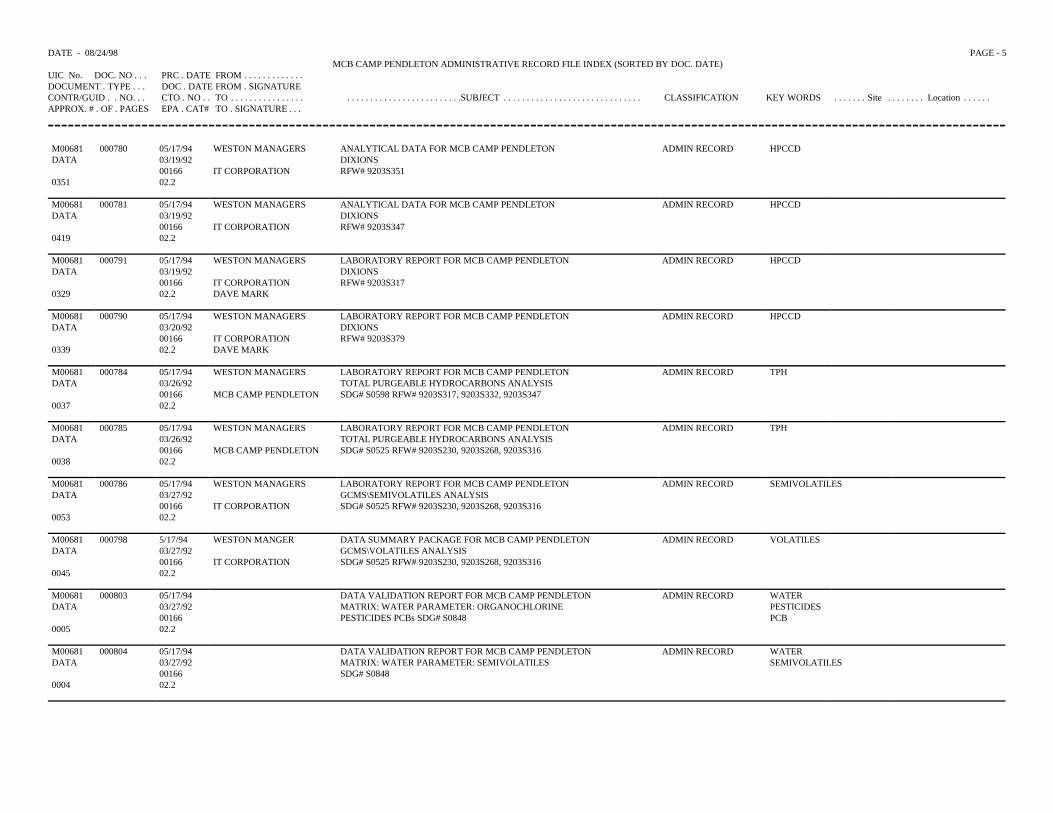
DATE - 08/24/98 PAGE - 5MCB CAMP PENDLETON ADMINISTRATIVE RECORD FILE INDEX (SORTED BY DOC. DATE)
UIC No. DOC. NO . . . PRC . DATE FROM . . . . . . . . . . . . .DOCUMENT . TYPE . . . DOC . DATE FROM . SIGNATURECONTR/GUID . . NO. . . CTO . NO . . TO . . . . . . . . . . . . . . . . . . . . . . . . . . . . . . . . . . . . . . . . .SUBJECT . . . . . . . . . . . . . . . . . . . . . . . . . . . . . . CLASSIFICATION KEY WORDS . . . . . . . Site . . . . . . . . Location . . . . . .APPROX. # . OF . PAGES EPA . CAT# TO . SIGNATURE . . .
M00681 000780 05/17/94 WESTON MANAGERS ANALYTICAL DATA FOR MCB CAMP PENDLETON ADMIN RECORD HPCCDDATA 03/19/92 DIXIONS
00166 IT CORPORATION RFW# 9203S3510351 02.2
M00681 000781 05/17/94 WESTON MANAGERS ANALYTICAL DATA FOR MCB CAMP PENDLETON ADMIN RECORD HPCCDDATA 03/19/92 DIXIONS
00166 IT CORPORATION RFW# 9203S3470419 02.2
M00681 000791 05/17/94 WESTON MANAGERS LABORATORY REPORT FOR MCB CAMP PENDLETON ADMIN RECORD HPCCDDATA 03/19/92 DIXIONS
00166 IT CORPORATION RFW# 9203S3170329 02.2 DAVE MARK
M00681 000790 05/17/94 WESTON MANAGERS LABORATORY REPORT FOR MCB CAMP PENDLETON ADMIN RECORD HPCCDDATA 03/20/92 DIXIONS
00166 IT CORPORATION RFW# 9203S3790339 02.2 DAVE MARK
M00681 000784 05/17/94 WESTON MANAGERS LABORATORY REPORT FOR MCB CAMP PENDLETON ADMIN RECORD TPHDATA 03/26/92 TOTAL PURGEABLE HYDROCARBONS ANALYSIS
00166 MCB CAMP PENDLETON SDG# S0598 RFW# 9203S317, 9203S332, 9203S3470037 02.2
M00681 000785 05/17/94 WESTON MANAGERS LABORATORY REPORT FOR MCB CAMP PENDLETON ADMIN RECORD TPHDATA 03/26/92 TOTAL PURGEABLE HYDROCARBONS ANALYSIS
00166 MCB CAMP PENDLETON SDG# S0525 RFW# 9203S230, 9203S268, 9203S3160038 02.2
M00681 000786 05/17/94 WESTON MANAGERS LABORATORY REPORT FOR MCB CAMP PENDLETON ADMIN RECORD SEMIVOLATILESDATA 03/27/92 GCMS\SEMIVOLATILES ANALYSIS
00166 IT CORPORATION SDG# S0525 RFW# 9203S230, 9203S268, 9203S3160053 02.2
M00681 000798 5/17/94 WESTON MANGER DATA SUMMARY PACKAGE FOR MCB CAMP PENDLETON ADMIN RECORD VOLATILESDATA 03/27/92 GCMS\VOLATILES ANALYSIS
00166 IT CORPORATION SDG# S0525 RFW# 9203S230, 9203S268, 9203S3160045 02.2
M00681 000803 05/17/94 DATA VALIDATION REPORT FOR MCB CAMP PENDLETON ADMIN RECORD WATERDATA 03/27/92 MATRIX: WATER PARAMETER: ORGANOCHLORINE PESTICIDES
00166 PESTICIDES PCBs SDG# S0848 PCB0005 02.2
M00681 000804 05/17/94 DATA VALIDATION REPORT FOR MCB CAMP PENDLETON ADMIN RECORD WATER DATA 03/27/92 MATRIX: WATER PARAMETER: SEMIVOLATILES SEMIVOLATILES
00166 SDG# S08480004 02.2
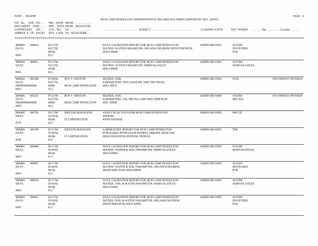
DATE - 08/24/98 PAGE - 6MCB CAMP PENDLETON ADMINISTRATIVE RECORD FILE INDEX (SORTED BY DOC. DATE)
UIC No. DOC. NO . . . PRC . DATE FROM . . . . . . . . . . . . .DOCUMENT . TYPE . . . DOC . DATE FROM . SIGNATURECONTR/GUID . . NO. . . CTO . NO . . TO . . . . . . . . . . . . . . . . . . . . . . . . . . . . . . . . . . . . . . . . .SUBJECT . . . . . . . . . . . . . . . . . . . . . . . . . . . . . . CLASSIFICATION KEY WORDS . . . . . . . Site . . . . . . . . Location . . . . . .APPROX. # . OF . PAGES EPA . CAT# TO . SIGNATURE . . .
M00681 000810 05/17/94 DATA VALIDATION REPORT FOR MCB CAMP PENDLETON ADMIN RECORD WATERDATA 03/27/92 MATRIX: WATER PARAMETER: ORGANOCHLORINE PESTICIDES\PCB PESTICIDES
00166 SDG# S0848 PCB0005 02.2
M00681 000811 05/17/94 DATA VALIDATION REPORT FOR MCB CAMP PENDLETON ADMIN RECORD WATERDATA 03/27/92 MATRIX: WATER PARAMETER: SEMIVOLATILES SEMIVOLATILES
00166 SDG# S08480004 02.2
M00681 002308 07/20/94 ROY F. WESTON MATRIX: SOIL ADMIN RECORD FUEL SOUTHWEST DIVISIONDATA 03/27/92 PARAMETERS: TPH GASOLINE AND TPH DIESEL000000000000000 00000 MCB CAMP PENDLETON SDG: S08720003 02.2
M00681 002325 07/21/94 ROY F. WESTON MATRIX: SOIL ADMIN RECORD WATER SOUTHWEST DIVISIONDATA 03/27/92 PARAMETERS: TAL METALS AND MOLYBDENUM METALS000000000000000 00000 MCB CAMP PENDLETON SDG: S08480005 02.2
M00681 000783 05/17/94 WESTON MANAGERS ANALYTICAL DATA FOR MCB CAMP PENDLETON ADMIN RECORD HPCCDDATA 03/28/92 DIXIONS
00166 IT CORPORATION RFW# 9203S4380270 02.2
M00681 000799 05/17/94 WESTON MANAGER LABORATORY REPORT FOR MCB CAMP PENDLETON ADMIN RECORD TPHDATA 03/30/92 PURGEABLE PETROLEUM HYDROCARBONS ANALYSIS
00166 IT CORPORATION SDG# S0636 RFW# 9203S350, 9203S3510028 02.2
M00681 000800 05/17/94 DATA VALIDATION REPORT FOR MCB CAMP PENDLETON ADMIN RECORD WATERDATA 03/30/92 MATRIX: WATER & SOIL PARAMETER: SEMIVOLATILES SEMIVOLATILES
00166 SDG# S09090005 02.2
M00681 000801 05/17/94 DATA VALIDATION REPORT FOR MCB CAMP PENDLETON ADMIN RECORD WATERDATA 03/30/92 MATRIX: WATER & SOIL PARAMETER: ORGANOCHLORINE PESTICIDES
00166 PESTICIDES PCBs SDG# S0909 PCB0005 02.2
M00681 000814 05/17/94 DATA VALIDATION REPORT FOR MCB CAMP PENDLETON ADMIN RECORD WATERDATA 03/30/92 MATRIX: SOIL & WATER PARAMETER: SEMIVOLATILES SEMIVOLATILES
00166 SDG# S09090005 02.2
M00681 000815 05/17/94 DATA VALIDATION REPORT FOR MCB CAMP PENDLETON ADMIN RECORD WATERDATA 03/30/92 MATRIX: SOIL & WATER PARAMETER: ORGANOCHLORINE PESTICIDES
00166 PESTICIDES\PCBs SDG# S0909 PCB0005 02.2
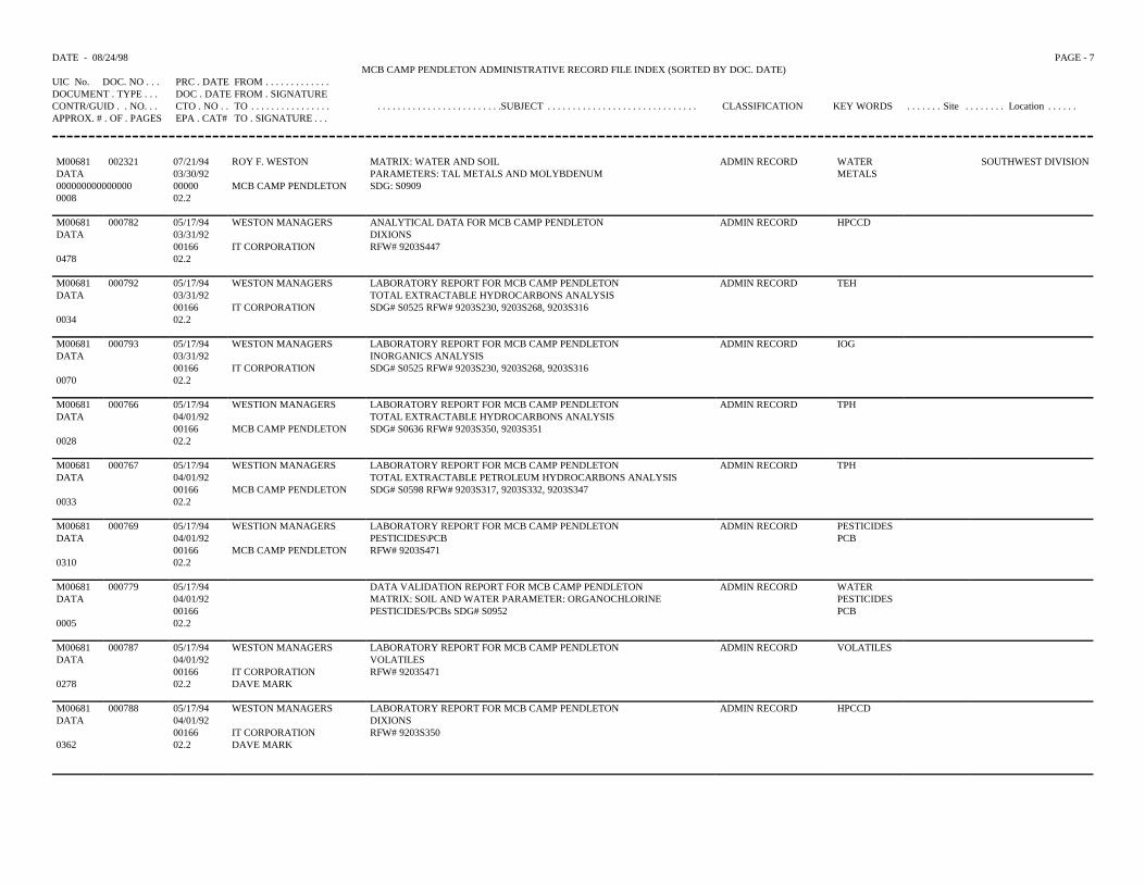
DATE - 08/24/98 PAGE - 7MCB CAMP PENDLETON ADMINISTRATIVE RECORD FILE INDEX (SORTED BY DOC. DATE)
UIC No. DOC. NO . . . PRC . DATE FROM . . . . . . . . . . . . .DOCUMENT . TYPE . . . DOC . DATE FROM . SIGNATURECONTR/GUID . . NO. . . CTO . NO . . TO . . . . . . . . . . . . . . . . . . . . . . . . . . . . . . . . . . . . . . . . .SUBJECT . . . . . . . . . . . . . . . . . . . . . . . . . . . . . . CLASSIFICATION KEY WORDS . . . . . . . Site . . . . . . . . Location . . . . . .APPROX. # . OF . PAGES EPA . CAT# TO . SIGNATURE . . .
M00681 002321 07/21/94 ROY F. WESTON MATRIX: WATER AND SOIL ADMIN RECORD WATER SOUTHWEST DIVISIONDATA 03/30/92 PARAMETERS: TAL METALS AND MOLYBDENUM METALS000000000000000 00000 MCB CAMP PENDLETON SDG: S09090008 02.2
M00681 000782 05/17/94 WESTON MANAGERS ANALYTICAL DATA FOR MCB CAMP PENDLETON ADMIN RECORD HPCCDDATA 03/31/92 DIXIONS
00166 IT CORPORATION RFW# 9203S4470478 02.2
M00681 000792 05/17/94 WESTON MANAGERS LABORATORY REPORT FOR MCB CAMP PENDLETON ADMIN RECORD TEHDATA 03/31/92 TOTAL EXTRACTABLE HYDROCARBONS ANALYSIS
00166 IT CORPORATION SDG# S0525 RFW# 9203S230, 9203S268, 9203S3160034 02.2
M00681 000793 05/17/94 WESTON MANAGERS LABORATORY REPORT FOR MCB CAMP PENDLETON ADMIN RECORD IOGDATA 03/31/92 INORGANICS ANALYSIS
00166 IT CORPORATION SDG# S0525 RFW# 9203S230, 9203S268, 9203S3160070 02.2
M00681 000766 05/17/94 WESTION MANAGERS LABORATORY REPORT FOR MCB CAMP PENDLETON ADMIN RECORD TPHDATA 04/01/92 TOTAL EXTRACTABLE HYDROCARBONS ANALYSIS
00166 MCB CAMP PENDLETON SDG# S0636 RFW# 9203S350, 9203S3510028 02.2
M00681 000767 05/17/94 WESTION MANAGERS LABORATORY REPORT FOR MCB CAMP PENDLETON ADMIN RECORD TPHDATA 04/01/92 TOTAL EXTRACTABLE PETROLEUM HYDROCARBONS ANALYSIS
00166 MCB CAMP PENDLETON SDG# S0598 RFW# 9203S317, 9203S332, 9203S3470033 02.2
M00681 000769 05/17/94 WESTION MANAGERS LABORATORY REPORT FOR MCB CAMP PENDLETON ADMIN RECORD PESTICIDESDATA 04/01/92 PESTICIDES\PCB PCB
00166 MCB CAMP PENDLETON RFW# 9203S4710310 02.2
M00681 000779 05/17/94 DATA VALIDATION REPORT FOR MCB CAMP PENDLETON ADMIN RECORD WATERDATA 04/01/92 MATRIX: SOIL AND WATER PARAMETER: ORGANOCHLORINE PESTICIDES
00166 PESTICIDES/PCBs SDG# S0952 PCB0005 02.2
M00681 000787 05/17/94 WESTON MANAGERS LABORATORY REPORT FOR MCB CAMP PENDLETON ADMIN RECORD VOLATILESDATA 04/01/92 VOLATILES
00166 IT CORPORATION RFW# 920354710278 02.2 DAVE MARK
M00681 000788 05/17/94 WESTON MANAGERS LABORATORY REPORT FOR MCB CAMP PENDLETON ADMIN RECORD HPCCDDATA 04/01/92 DIXIONS
00166 IT CORPORATION RFW# 9203S3500362 02.2 DAVE MARK
DATE - 08/24/98 PAGE - 8MCB CAMP PENDLETON ADMINISTRATIVE RECORD FILE INDEX (SORTED BY DOC. DATE)
UIC No. DOC. NO . . . PRC . DATE FROM . . . . . . . . . . . . .DOCUMENT . TYPE . . . DOC . DATE FROM . SIGNATURECONTR/GUID . . NO. . . CTO . NO . . TO . . . . . . . . . . . . . . . . . . . . . . . . . . . . . . . . . . . . . . . . .SUBJECT . . . . . . . . . . . . . . . . . . . . . . . . . . . . . . CLASSIFICATION KEY WORDS . . . . . . . Site . . . . . . . . Location . . . . . .APPROX. # . OF . PAGES EPA . CAT# TO . SIGNATURE . . .
M00681 002326 07/21/94 ROY F. WESTON MATRIX: SOIL AND WATER ADMIN RECORD WATER SOUTHWEST DIVISIONDATA 04/01/92 PARAMETERS: TAL METALS AND MOLYBDENUM METALS000000000000000 00000 MCB CAMP PENDLETON SDG: S09520008 02.2
M00681 000762 05/17/94 WESTION MANAGERS LABORATORY REPORT FOR MCB CAMP PENDLETON ADMIN RECORD TPHDATA 04/02/92 TOTAL PETROELUM HYDROCARBONS ANALYSIS
00166 MCB CAMP PENDLETON SDG# S0657 RFW# 9203S352, 920353740027 02.2
M00681 000763 05/17/94 WESTION MANAGERS LABORATORY REPORT FOR MCB CAMP PENDLETON ADMIN RECORD TPHDATA 04/02/92 TOTAL PURGEABLE PETROELUM HYDROCARBONS ANALYSIS
00166 MCB CAMP PENDLETON SDG# S0617 RFW# 9203S362, 9203S363, 9203S364, 9203S3990041 02.2
M00681 000764 05/17/94 WESTION MANAGERS LABORATORY REPORT FOR MCB CAMP PENDLETON ADMIN RECORD VOLATILESDATA 04/02/92 GC\MS VOLATILES ANALYSIS
00166 MCB CAMP PENDLETON SDG# S0636 RFW# 9203S350, 9203S3510043 02.2
M00681 000765 05/17/94 WESTION MANAGERS LABORATORY REPORT FOR MCB CAMP PENDLETON ADMIN RECORD PESTICIDESDATA 04/02/92 ORGANOPHOSPHOROUS PESTICIDES
00166 MCB CAMP PENDLETON SDG# S0525 RFW# 9203S3610037 02.2
M00681 000768 05/17/94 WESTION MANAGERS LABORATORY REPORT FOR MCB CAMP PENDLETON ADMIN RECORD HPCCDDATA 04/02/92 DIOXINS\FURANS
00166 MCB CAMP PENDLETON RFW# 9203S4830328 02.2
M00681 000771 05/17/94 WESTION MANAGERS LABORATORY REPORT FOR MCB CAMP PENDLETON ADMIN RECORD HPCCDDATA 04/02/92 DIXIONS
00166 MCB CAMP PENDLETON RFW# 9203S4850243 02.2
M00681 000772 05/17/94 WESTION MANAGERS LABORATORY REPORT FOR MCB CAMP PENDLETON ADMIN RECORD TPHDATA 04/02/92 TOTAL EXTRACTABLE PETROLEUM HYDROCARBONS ANALYSIS
00166 MCB CAMP PENDLETON SDG# S0657 RFW# 9203S352, 9203S3740027 02.2
M00681 000773 05/17/94 WESTION MANAGERS LABORATORY REPORT FOR MCB CAMP PENDLETON ADMIN RECORD PESTICIDESDATA 04/02/92 ORGANOPHOSPHOROUS PESTICIDES
00166 MCB CAMP PENDLETON SDG# S0598, RFW# 9203S317, 9203S332, 9203S3470050 02.2
M00681 000775 05/17/94 WESTION MANAGERS LABORATORY REPORT FOR MCB CAMP PENDLETON ADMIN RECORD SEMIVOLATILESDATA 04/02/92 SEMIVOLATILES
00166 IT CORPORATION RFW# 9203S4830487 02.2
DATE - 08/24/98 PAGE - 9MCB CAMP PENDLETON ADMINISTRATIVE RECORD FILE INDEX (SORTED BY DOC. DATE)
UIC No. DOC. NO . . . PRC . DATE FROM . . . . . . . . . . . . . . . .DOCUMENT . TYPE . . . DOC . DATE FROM . SIGNATURE . . .CONTR/GUID . . NO. . . CTO . NO . . TO . . . . . . . . . . . . . . . . . . . . . . . . . . . . . . . . . . . . . . . . . . . . .SUBJECT . . . . . . . . . . . . . . . . . . . . . . . CLASSIFICATION KEY WORDS . . . . . Site . . . . . . . . . . . . .Location . . . . . . . . .APPROX. # . OF . PAGES EPA . CAT# TO . SIGNATURE . . . . . .
M00681DATA
0268
000777 05/17/9404/02/920016602.2
WESTION MANAGERS
IT CORPORATION
LABORATORY REPORT FOR MCB CAMP PENDLETONPESTICIDES PCBRFW# 9203S483
ADMIN RECORD PESTICIDESPCB
M00681DATA
0219
000778 05/17/9404/02/920016602.2
WESTION MANAGERS
IT CORPORATION
LABORATORY REPORT FOR MCB CAMP PENDLETONVOARFW# 9203S483
ADMIN RECORD VOA
M00681DATA
00019
000761 05/17/9404/03/920016602.2
WESTION MANAGERS
MCB CAMPPENDLETON
LABORATORY REPORT FOR MCB CAMP PENDLETONTOTAL PURGEABLE PETROELUM HALOCARBONS ANALYSISSDG# S0848 RFW# 9203S463
ADMIN RECORD TPH
M00681DATA
0217
000774 05/17/9404/03/920016602.2
WESTION MANAGERS
IT CORPORATIONDAVE MARK
LABORATORY REPORT FOR MCB CAMP PENDLETONINORGANICSRFW# 9203S483
ADMIN RECORD IOG
M00681DATA
0525
000900 05/18/9404/03/520016602.2
WESTON MANAGERS
IT CORPORATION
LABORATORY REPORT FOR MCB CAMP PENDLETONDIXIONSRFW# 9204S501
ADMIN RECORD HPCCD
M00681DATA324610022
000640 05/13/9404/06/92 0016602.2
CH2M HILLPEGGY A. NORTONIT CORPORATIONDAVE MARK
DATA VALIDATION REPORT FOR MCB CAMP PENDLETONORGANICS
ADMIN RECORD DATA
M0681DATA323640091
000641 05/13/9404/06/920016602.2
CH2M HILLPEGGY A. NORTONIT CORPORATIONDAVE MARK
DATA VALIDATION REPORT FOR MCB CAMP PENDLETONORGANICS VOLATILES
ADMIN RECORD VOC
M00681DATA324610104
000642 05/13/9404/06/920016602.2
CH2M HILLPEGGY A. NORTONIT CORPORATIONDAVE MARK
DATA VALIDATION REPORT FOR MCB CAMP PENDLETONINORGANICS
ADMIN RECORD IOG
M00681DATA323644610226
000643 05/13/9404/06/920016602.2
CH2M HILLPEGGY A. NORTONIT CORPORATIONDAVE MARK
DATA VALIDATION REPORT FOR MCB CAMP PENDLETONINORGANICS
ADMIN RECORD IOG
M00681DATA
0540
000685 05/13/9404/06/920016602.2
ROY F. WESTION INC
IT CORPORATION
ANALYTICAL DATA PACKAGE FOR MCB CAMP PENDLETONANALYSISRFW# 9204S506
ADMIN RECORD DATA
DATE - 08/24/98 PAGE - 10MCB CAMP PENDLETON ADMINISTRATIVE RECORD FILE INDEX (SORTED BY DOC. DATE)
UIC No. DOC. NO . . . PRC . DATE FROM . . . . . . . . . . . . . . . .DOCUMENT . TYPE . . . DOC . DATE FROM . SIGNATURE . . .CONTR/GUID . . NO. . . CTO . NO . . TO . . . . . . . . . . . . . . . . . . . . . . . . . . . . . . . . . . . . . . . . . . . . .SUBJECT . . . . . . . . . . . . . . . . . . . . . . . CLASSIFICATION KEY WORDS . . . . . Site . . . . . . . . . . . . .Location . . . . . . . . .APPROX. # . OF . PAGES EPA . CAT# TO . SIGNATURE . . . . . .
M00681DATA
0049
000652 05/13/9404/07/920016602.2
WESTIONMANAGERS
IT CORPORATION
LABORATORY REPORT FOR MCB CAMP PENDLETONORGANOCHLORINE PESTICIDES & PCBs ANALYSISSDG# S0525 RFW# 9203S230, 9203S268, 9203S316
ADMIN RECORD PESTICIDESPCB
M00681DATA
0040
000653 05/13/9404/07/920016602.2
WESTIONMANAGERS
IT CORPORATION
LABORATORY REPORT FOR MCB CAMP PENDLETONHERBICIDES ANALYSISSDG# S0598 RFW# 9203S332, 9203S347
ADMIN RECORD HERBICIDE
M00681DATA
0063
000654 05/13/9404/07/920016602.2
WESTIONMANAGERS
IT CORPORATION
LABORATORY REPORT FOR MCB CAMP PENDLETONINORGANICS ANALYSISSDG# S0598 RFW# 9203S317, 9203S332, 9203S347
ADMIN RECORD IOG
M00681DATA
0036
000648 05/13/9404/10/920016602.2
WESTIONMANAGERS
IT CORPORATION
LABORATORY REPORT FOR MCB CAMP PENDLETONTOTAL EXTRACABLE PETROLEUM HYDROCARBONS ANALYSISSDG# S0617 RFW# 9203S363, 9203S364, 9203S399
ADMIN RECORD TPH
M00681DATA
0025
000649 05/13/9404/10/920016602.2
WESTIONMANAGERS
IT CORPORATION
LABORATORY REPORT FOR MCB CAMP PENDLETONTOTAL PURGEABLE PETROLEUM HYDROCARBONS ANALYSISSDG# S0872 RFW# 9203S471, 9203S483
ADMIN RECORD TPH
M00681DATA
0043
000650 05/13/9404/10/920016602.2
WESTIONMANAGERS
IT CORPORATION
LABORATORY REPORT FOR MCB CAMP PENDLETONGC\MS SEMIVOLATILES ANALYSISSDG# S0617 RFW# 9203S362, 9203S363, 9203S364
ADMIN RECORD SOLVENTS
M00681DATA
0025
000651 05/13/9404/10/920016602.2
WESTIONMANAGERS
IT CORPORATION
LABORATORY REPORT FOR MCB CAMP PENDLETONTOTAL PURGEABLE PETROLEUM HYDROCARBONS ANALYSISSDG# S0872 RFW# 9203S471, 9203S483
ADMIN RECORD TPH
M00681DATA
0037
000655 05/13/9404/10/920016602.2
WESTIONMANAGERS
IT CORPORATION
LABORATORY REPORT FOR MCB CAMP PENDLETONHERBICIDES ANALYSISSDG# S0636 RFW# 9203S350, 9203S351
ADMIN RECORD HERBICIDE
M00681DATA
0071
000656 05/13/9404/10/920016602.2
WESTIONMANAGERS
IT CORPORATION
LABORATORY REPORT FOR MCB CAMP PENDLETONINORGANICS ANALYSISSDG# S0636 RFW# 9204S488
ADMIN RECORD IOG
M00681DATA
0036
000669 05/13/9404/10/920016602.2
WESTIONMANAGERS
IT CORPORATION
LABORATORY REPORT FOR MCB CAMP PENDLETONGC\MS VOLATILE ANALYSISSDG# S0657 RFW# 9203S352, 9203S374
ADMIN RECORD VOC
DATE - 08/24/98 PAGE - 11MCB CAMP PENDLETON ADMINISTRATIVE RECORD FILE INDEX (SORTED BY DOC. DATE)
UIC No. DOC. NO . . . PRC . DATE FROM . . . . . . . . . . . . . . . .DOCUMENT . TYPE . . . DOC . DATE FROM . SIGNATURE . . .CONTR/GUID . . NO. . . CTO . NO . . TO . . . . . . . . . . . . . . . . . . . . . . . . . . . . . . . . . . . . . . . . . . . . .SUBJECT . . . . . . . . . . . . . . . . . . . . . . . CLASSIFICATION KEY WORDS . . . . . Site . . . . . . . . . . . . .Location . . . . . . . . .APPROX. # . OF . PAGES EPA . CAT# TO . SIGNATURE . . . . . .
M00681DATA326990212
000639 05/13/9404/11/920016602.2
CH2M HILL
MCB CAMP PENDLETON
DATA VALIDATION REPORT FOR MCB CAMP PENDLETONVOLATILES
ADMIN RECORD HERBICIDEWATERPESTICIDES
M00681DATA
0035
000672 05/13/9404/13/920016602.2
WESTION MANAGERS
IT CORPORATION
LABORATORY REPORT FOR MCB CAMP PENDLETONGC\MS SEMIVOLATILES ANALYSISSDG# S0636 RFW# 9203S350, 9203S351
ADMIN RECORD SOLVENTS
M00681DATA
0093
000679 05/13/9404/13/920016602.2
ESE LABORATROY REPORT FOR MCB CAMP PENDLETONMETALS
ADMIN RECORD METALS
M00681DATA
0049
000657 05/13/9404/14/920016602.2
WESTION MANAGERS
IT CORPORATION
LABORATORY REPORT FOR MCB CAMP PENDLETONORGANOCHLORINE PESTICIDES AND PCBs ANALYSISSDG# S0598 RFW# 9203S317, 9203S332, 9203S347
ADMIN RECORD PESTICIDESPCB
M00681DATA
0069
000670 05/13/9404/14/920016602.2
WESTION MANAGERS
IT CORPORATION
LABORATORY REPORT FOR MCB CAMP PENDLETONINORGANICS ANALYSIS 9203S399SDG# S0617 RFW# 9203S362, 9203S363, 9203S364, 9203S379
ADMIN RECORD IOG
M00681DATA
0021
000671 05/13/9404/14/920016602.2
WESTION MANAGERS
IT CORPORATION
LABORATORY REPORT FOR MCB CAMP PENDLETONGC\MS VOLATILES ANALYSISSDG# S0848 RFW# 9203S463
ADMIN RECORD VOC
M00681DATA
0435
000683 05/13/9404/14/920016602.2
ROY F. WESTION INC
IT CORPORATION
ANALYTICAL DATA PACKAGE FOR MCB CAMP PENDLETONANALYSISRFW# 9204S580
ADMIN RECORD DATA
M00681DATA
0410
000684 05/13/9404/14/920016602.2
ROY F. WESTION INC
IT CORPORATION
ANALYTICAL DATA PACKAGE FOR MCB CAMP PENDLETONANALYSISRFW# 9204S571
ADMIN RECORD DATA
M00681DATA327170215
000638 05/13/9404/15/920016602.2
CH2M HILLMCB CAMP PENDLETON
DATA VALIDATION REPORT FOR MCB CAMP PENDLETONVOLATILES
ADMIN RECORD VOC
M00681DATA327171379
000644 05/13/9404/15/920016602.2
CH2M HILLPEGGY A. MORTONIT CORPORATIONDAVE MARK
DATA VALIDATION REPORT FOR MCB CAMP PENDLETONSEMIVOLATILES (missing pages 00001-000278)
ADMIN RECORD SOLVENTS
DATE - 08/24/98 PAGE - 12MCB CAMP PENDLETON ADMINISTRATIVE RECORD FILE INDEX (SORTED BY DOC. DATE)
UIC No. DOC. NO . . . PRC . DATE FROM . . . . . . . . . . . . . . . .DOCUMENT . TYPE . . . DOC . DATE FROM . SIGNATURE . . .CONTR/GUID . . NO. . . CTO . NO . . TO . . . . . . . . . . . . . . . . . . . . . . . . . . . . . . . . . . . . . . . . . . . . .SUBJECT . . . . . . . . . . . . . . . . . . . . . . . CLASSIFICATION KEY WORDS . . . . . Site . . . . . . . . . . . . .Location . . . . . . . . .APPROX. # . OF . PAGES EPA . CAT# TO . SIGNATURE . . . . . .
M00681DATA
0053
000658 05/13/9404/16/920016602.2
WESTION MANAGERS
IT CORPORATION
LABORATORY REPORT FOR MCB CAMP PENDLETONGC\MS SEMIVOLATILES ANALYSISSDG# S0598 RFW# 9203S317, 9203S332, 9203S347
ADMIN RECORD SOLVENTS
M00681DATA
0065
000659 05/13/9404/16/920016602.2
WESTION MANAGERS
IT CORPORATION
LABORATORY REPORT FOR MCB CAMP PENDLETONGC\MS VOLATILES ANALYSISSDG# S0598 RFW# 9203S317, 9203S332, 9203S347
ADMIN RECORD VOC
M00681DATA
0047
000662 05/13/9404/16/920016602.2
WESTION MANAGERS
IT CORPORATION
LABORATORY REPORT FOR MCB CAMP PENDLETONORGANOPHOSPHOROUS PESTICIDES ANALYSISSDG# S0617 RFW# 9203S362, 9203S363, 9203S364
ADMIN RECORD PESTICIDES
M00681DATA
0021
000665 05/13/9404/17/920016602.2
WESTION MANAGERS
IT CORPORATION
LABORATORY REPORT FOR MCB CAMP PENDLETONGC\MS SEMIVOLATILES ANALYSISSDG# S0848 RFW# 9203S463
ADMIN RECORD SOLVENTS
M00681DATA
0629
000681 05/13/9404/17/920016602.2
ROY F. WESTION INC
IT CORPORATION
ANALYTICAL DATA PACKAGE FOR MCB CAMPPENDLETONANALYSISRFW# 9204S607
ADMIN RECORD DATA
M00681DATA
0516
000682 05/13/9404/18/920016602.2
ROY F. WESTION INC
IT CORPORATION
ANALYTICAL DATA PACKAGE FOR MCB CAMPPENDLETONANALYSISRFW# 9204S616
ADMIN RECORD DATA
M00681 002323DATA00000000000000000005
07/21/9404/19/920000002.2
ROY F. WESTON
MCB CAMP PENDLETON
MATRIX: WATER AND SOILPARAMETERS: TAL METALS AND MOLYBDENUMSDG: S0598
ADMIN RECORD WATERMETALS
SOUTHWEST DIVISION
M00681DATA
0018
000645 05/13/9404/20/920016602.2
WESTION MANAGERS
IT CORPORATION
LABORATORY REPORT FOR MCB CAMP PENDLETONTOTAL PURGEABLE PETROLEUM HYDROCARBONSSDG# S0952 RFW# 9204S506
ADMIN RECORD TPH
M00681DATA
0022
000646 05/13/9404/20/920016602.2
WESTION MANAGERS
IT CORPORATION
LABORATORY REPORT FOR MCB CAMP PENDLETONTOTAL PURGEABLE PETROLEUM HYDROCARBONSSDG# S0848 RFW# 9203S463
ADMIN RECORD TPH
M00681DATA
0026
000647 05/13/9404/20/920016602.2
WESTION MANAGERS
IT CORPORATION
LABORATORY REPORT FOR MCB CAMP PENDLETONTOTAL PURGEABLE PETROLEUM HYDROCARBONSSDG# S0909 RFW# 9204S485, 9204S501
ADMIN RECORD TPH
DATE - 08/24/98 PAGE - 13MCB CAMP PENDLETON ADMINISTRATIVE RECORD FILE INDEX (SORTED BY DOC. DATE)
UIC No. DOC. NO . . . PRC . DATE FROM . . . . . . . . . . . . . . . .DOCUMENT . TYPE . . . DOC . DATE FROM . SIGNATURE . . .CONTR/GUID . . NO. . . CTO . NO . . TO . . . . . . . . . . . . . . . . . . . . . . . . . . . . . . . . . . . . . . . . . . . . .SUBJECT . . . . . . . . . . . . . . . . . . . . . . . CLASSIFICATION KEY WORDS . . . . . Site . . . . . . . . . . . . .Location . . . . . . . . .APPROX. # . OF . PAGES EPA . CAT# TO . SIGNATURE . . . . . .
M00681DATA
0065
000660 05/13/9404/20/920016602.2
WESTION MANAGERS
IT CORPORATION
LABORATORY REPORT FOR MCB CAMP PENDLETONORGANOPHOSPHOROUS PESTICIDES ANALYSISSDG# S0636 RFW# 9203S350, 9203S351
ADMIN RECORD PESTICIDES
M00681DATA
0107
000661 05/13/9404/20/920016602.2
WESTION MANAGERS
IT CORPORATION
LABORATORY REPORT FOR MCB CAMP PENDLETONORGANOPHOSPHOROUS PESTICIDES ANALYSISSDG# S0657 RFW# 9203S352, 9203S374
ADMIN RECORD PESTICIDES
M00681DATA
0007
000674 05/13/9404/20/920016602.2
WESTION MANAGERS
IT CORPORATION
DATA VALIDATION REPORT FOR MCB CAMP PENDLETONMATRIX: SOIL & WATER PARAMETER: VOLATILESLAB: ROY F. WESTON SDG# S1126
ADMIN RECORD WATER
M00681DATA
0006
000675 05/13/9404/20/920016602.2
WESTION MANAGERS
IT CORPORATION
DATA VALIDATION REPORT FOR MCB CAMP PENDLETONMATRIX: SOIL & WATER PARAMETER: SEMIVOLATILESLAB: ROY F. WESTON SDG# S1126
ADMIN RECORD SOLVENTSWATER
M00681DATA
0006
000676 05/13/9404/20/920016602.2
WESTION MANAGERS
IT CORPORATION
DATA VALIDATION REPORT FOR MCB CAMP PENDLETONMATRIX: SOIL & WATER PARAMERTER:ORGANOCHLORINEPFSTICIDES\PCBs LAB: ROY F. WESTON SDG# S1126
ADMIN RECORD PESTICIDESPCBWATER
M00681 002320DATA0000000000000000007
07/21/9404/20/920000002.2
ROY F. WESTON
MCB CAMP PENDLETON
MATRIX: WATER AND SOILPARAMETERS: TAL METALS AND MOLYBDENUMSDG: S1126
ADMIN RECORD WATERMETALS
SOUTHWEST DIVISION
M00681DATA
0052
000678 05/13/9404/21/920016602.2
ESE LABORATROY REPORT FOR MCB CAMP PENDLET0MANALYSIS
ADMIN RECORD DATA
M00681DATA
0054
000663 05/13/9404/22/920016602.2
WESTION MANAGERS
IT CORPORATION
LABORATORY REPORT FOR MCB CAMP PENDLETONORGANOPHOSPHOROUS PESTICIDES & PCBs ANALYSISSDG# S0636 RFW# 9203S350, 9203S351
ADMIN RECORD PESTICIDESPCB
M00681DATA
0042
000664 05/13/9404/22/920016602.2
WESTION MANAGERS
IT CORPORATION
LABORATORY REPORT FOR MCB CAMP PENDLETONGC\MS VOLATILES ANALYSISSDG# S0617 RFW# 9203S362, 9203S363, 9203S364, 92O3S399
ADMIN RECORD VOC
M00681DATA
0042
000677 05/13/9404/22/920016602.2
WESTION MANAGERS
IT CORPORATION
LABORATROY REPORT FOR MCB CAMP PENDLETONCHLORINATED HERBICIDES ANALYSISSDG# S0657 RFW# 9203S352, 9203S374
ADMIN RECORD HERBICIDE
DATE - 08/24/98 PAGE - 14MCB CAMP PENDLETON ADMINISTRATIVE RECORD FILE INDEX (SORTED BY DOC. DATE)
UIC No. DOC. NO . . . PRC . DATE FROM . . . . . . . . . . . . . . . .DOCUMENT . TYPE . . . DOC . DATE FROM . SIGNATURE . . .CONTR/GUID . . NO. . . CTO . NO . . TO . . . . . . . . . . . . . . . . . . . . . . . . . . . . . . . . . . . . . . . . . . . . .SUBJECT . . . . . . . . . . . . . . . . . . . . . . . CLASSIFICATION KEY WORDS . . . . . Site . . . . . . . . . . . . .Location . . . . . . . . .APPROX. # . OF . PAGES EPA . CAT# TO . SIGNATURE . . . . . .
M00681DATA
0060
000680 05/13/9404/22/920016602.2
ESE LABORATROY REPORT FOR MCD CAMP PENDLETONCHLORINATED HERBICIDES ANALYSISSDG# S0617 RFW# 9203S363, 9203S364,9203S399
ADMIN RECORD HERBICIDES
M00681DATA
0007
001330 05/31/9404/22/92
02.2MCB CAMPPENDLETON
DATA VALIDATION REPORT MCB CAMP PENDLETONMATRIX: WATER, SOIL PARAMETERS: SEMIVOALTILESLAB: ROY F. WESTON SDG# S1166
ADMIN RECORD WATER SEMIVOLATILES
M00681 002284DATA0000000000000000006
07/20/9404/22/920000002.2
ROY F. WESTON
MCB CAMPPENDLETON
MATRIX: WATER AND SOILPARAMETERS: CLP METALS AND MOLYBDENUMSDG: S1166
ADMIN RECORD WATERMETALS
SOUTHWEST DIVISION
M00681DATA
0056
000666 05/13/9404/23/920016602.2
WESTION MANAGERS
IT CORPORATION
LADORATORY REPORT FOR MCB CAMP PENDLETONINORGANICS ANALYSISSDG# S0657 RFW# 9203S352, 9203S374
ADMIN RECORD IOG
M00681DATA
0026
000667 05/13/9404/23/920016602.2
WESTION MANAGERS
IT CORPORATION
LABORATORY REPORT FOR MCB CAMP PENDLETONINORGANICS NONCLP ANALYSISSDG# S0848 RFW# 9203S463, 9203S447
ADMIN RECORD IOG
M00681DATA
0031
000668 05/13/9404/23/920016602.2
WESTION MANAGERS
IT CORPORATION
1ABORATORY REPORT FOR MCB CAMP PENDLETONGC\MS SEMIVOIATILE ANALYSISSDG# S0657 RFW# 9203S352, 9203S374
ADMIN RECORD SOLVENTS
M00681DATA
0042
000673 05/13/9404/23/920016602.2
WESTION MANAGERS
IT CORPORATION
LABORATORY REPORT FOR MCB CAMP PENDLETONGC\MS VOLATILES ANALYSISSDG# S0909 RFW# 9204S485, 9204S501
ADMIN RECORD VOC
M00681DATA324590468
000576 05/12/9404/28/92 0016602.2
CH2M HILLPEGGA. NORTONIT CORPORATIONDAVE MARK
LABORATORY REPORT FOR MCB CAMP PENDLETON IT CORP.VOLATILES, HERBICIDES
ADMIN RECORD VOCHERBICIDES
M00681DATA
0026
000588 05/12/9404/28/920016602.2
WESTION MANAGERS
MCB CAMPPENDLETON
LABORATORY REPORT FOR MCB CAMP PENDLETON IT CORP.GC\MS VOLATILES ANLYSIS SDG# S0952RFW# 9204S506
ADMIN RECORD VOC
M00681DATA
0028
000589 05/12/9404/28/920016602.2
WESTION MANAGERS
MCB CAMPPENDLETON
LABORATORY REPORT FOR MCB CAMP PENDLETON IT CORP.TOTAL EXTRACTABLE PETROLEUM HYDROCARBONSANALYSISSDG# S204S483 RFW# 9203S471, 9204S483
ADMIN RECORD TPH
DATE - 08/24/98 PAGE - 15MCB CAMP PENDLETON ADMINISTRATIVE RECORD FILE INDEX (SORTED BY DOC. DATE)
UIC No. DOC. NO. PRC . DATE FROM . . . . . . . . . . . . . . . . .DOCUMENT . TYPE . . . DOC . DATE FROM . SIGNATURE . . . .CONTR/GUID . . NO . . CTO . NO . . TO . . . . . . . . . . . . . . . . . . . . . . . . . . . . . . . . . . . . . . . . . . . . . . .SUBJECT . . . . . . . . . . . . . . . . . . . . . . . . . . . CLASSIFICATION KEY WORDS . . . . . Site . . . . . . . Location . . . . . . .APPROX. # . OF . PAGES EPA . CAT# TO . SIGNATURE . . . . . . .
M00481 000601 05/13/94 WESTION MANAGERS DATA VALIDATION REPORT FOR MCB CAMP PENDLET0N ADMIN RECORD WATERDATA 04/28/92 MATRIX: SOIL & WATER PARAMETER: SEMIVOLATILES SOLVENTS
00166 MCB CAMP PENDLETON LAB: ROY F. WESTON SDG# S11660011 02.2
M00681 002313 07/20/54 ROY F. WESTON MATRIX: SOIL, WATER ADMIN RECORD WATER SOUTHWEST DIVISIONDATA 04/28/92 PARAMETERS: VOLATILES VOLATILES000000000000000 00000 MCB CAMP PENDLETON SDG: S11880006 02.2
M00681 000587 05/12/94 WESTION MANAGERS LABORATORY REPORT FOR MCB CAMP PENDLETON IT CORP. ADMIN RECORD IOGDATA 04/29/92 INORGANICS ANALYSIS SDC# S0909 RFW# 9204S485, 9204S50l
00166 MCB CAMP PENDLETON0073 02.2
M00681 002283 07/20/94 ROY F. WESTON MATRIX: WATER AND SOIL ADMIN RECORD WATER SOUTHWEST DIVISIONDATA 04/29/92 PARAMETERS: CLP METALS AND MOLYBDENUM METALS000000000000000 00000 MCB CAMP PENDLETON SDG: S11880006 02.2
M00681 000591 05/12194 WESTION MANAGERS LABORATORY REPORT FOR MCB CAMP PENDLETON IT CORP. ADMIN RECORD PWSTICIDESDATA 04/30/92 ORGANOPHOSPHOROUS PESTICIDES ANALYSIS
00166 MCB CAMP PENDLETON SDG# S0657 RFW# 9203S352, 9203S3740052 02.2
M00681 000602 05/13/94 WESTION MANAGERS DATA VALAIDATION REPORT FOR MCB CAMP PENDLET0N ADMIN RECORD WATERDATA 04/30/92 MATRIX: SOIL & WATER PARAMETER: ORGANOCHLORINE PESTICIDES
00166 MCB CAMP PENDLETON PESTICIDES\PCBs LAB: ROY F. WESTON SDG# S1197 PCB0007 02.2
M00681 000603 05/13/94 WESTION MANAGERS DATA VALAIDATION REPORT FOR MCB CAMP PENDLETON ADMIN RECORD WATERDATA 04/30/92 MATRIX: SOIL & WATER PARAMETER: VOLATILES VOC
00166 MCB CAMP PENDLETON LAB: ROY F. WESTON SDG# S11970006 02.2
M00681 000604 05/13/94 WESTION MANAGERS DATA VALAIDATION REPORT FOR MCB CAMP PENDLETON ADMIN RECORD WATERDATA 04/30/92 MATRIX: SOIL & WATER PARAMETER: SEMIVOLATILES SOLVENTS
00166 MCB CAMP PENDLETON LAB: ROY F. WESTON SDG# S11970004 02.2
M00681 001327 05/31/94 DATA VALIDATION REPORT MCB CAMP PENDLETON ADMIN RECORD WATERDATA 04/30/92 MATRIX: WATER, SOIL PARAMETERS: VOLATILES VOLATILES
MCB CAMP PENDLETON LAB: ROY F. WESTON SDG# S11970006 02.2
M00681 001328 05/31/94 DATA VALIDATION REPORT MCB CAMP PENDLETON ADMIN RECORD WATERDATA 04/30/92 MATRIX: WATER, SOIL PARAMETERS: ORGANOCHLORINE PESTICIDES
MCB CAMP PENDLETON PESTICIDES PCBs LAB: ROY F. WESTON SDG# S1197 PCB0007 02.2
DATE - 08/24/98 PAGE - 16MCB CAMP PENDLETON ADMINISTRATIVE RECORD FILE INDEX (SORTED BY DOC. DATE)
UIC No. DOC. NO. PRC . DATE FROM . . . . . . . . . . . . . . . . .DOCUMENT . TYPE . . . DOC . DATE FROM . SIGNATURE . . . .CONTR/GUID . . NO . . CTO . NO . . TO . . . . . . . . . . . . . . . . . . . . . . . . . . . . . . . . . . . . . . . . . . . . . . .SUBJECT . . . . . . . . . . . . . . . . . . . . . . . . . . . CLASSIFICATION KEY WORDS . . . . . Site . . . . . . . Location . . . . . . .APPROX. # . OF . PAGES EPA . CAT# TO . SIGNATURE . . . . . . .
M00681 001329 05/31/94 DATA VALIDATION REPORT MCB CAMP PENDLETON ADMIN RECORD WATERDATA 04/30/92 MATRIX: WATER, SOIL PARAMETERS: SEMIVOLATILES SEMIVOLATILES
MCB CAMP PENDLETON LAB: ROY F. WESTON SDG# S11970004 02.2
M00681 002322 07/21/94 ROY F. WESTON MATRIX: WATER AND SOIL ADMIN RECORD WATER SOUTHWEST DIVISIONDATA 04/30/92 PARAMETERS: TAL METALS AND MOLYBDENUM METALS000000000000000 00000 MCB CAMP PENDLETON SDG: S11970005 02.2
M00681 000577 05/12/94 CH2M HILL LABORATORY REPORT FOR MCB CAMP PENDLETON IT CORP. ADMIN RECORD IOGDATA 05/01/92 PEGGA. NORTON INORGANICS REP# 32510, 3252032452 00166 IT CORPORATION0079 02.2 DAVE MARK
M00681 000578 05/12/94 CH2M HILL LABORATORY REPORT FOR MCB CAMP PENDLETON IT CORP. ADMIN RECORD PESTICIDESDATA 05/01/92 PEGGA. NORTON ORGANICS, PESTICIDES, PCB, HERBICIDES, TPH PCB32452 00166 IT CORPORATION HERBICIDE0148 02.2 DAVE MARK
TFH
M00681 000590 05/12/94 WESTION MANGERS LABORATORY REPORT FOR MCB CAMP PENDLETON IT CORP. ADMIN RECORD PESTICIDESDATA 05/04/92 ORGANOPHOSPHOROUS PESTICIDES ANALYSIS
00166 MCB CAMP PENDLETON SDG# S0848 RFW# 9203S4630034 02.2
M00681 000593 05/12/94 WESTION MANAGERS LABORATORY REPORT FOR MCB CAMP PENDLETON IT CORP. ADMIN RECORD TPHDATA 05/04/92 TOTAL EXTRACTABLE PETROLEUM HYDROCARBONS ANALYSIS
00166 MCB CAMP PENDLETON SDG# S0909 RFW# 9204S485, 9204S5010040 02.2
M00681 000594 05/12/94 WESTION MANAGERS LABORATORY REPORT FOR MCB CAMP PENDLETON IT CORP. ADMIN RECORD SOLVENTSDATA 05/04/92 GC\MS SEMIVOLATILES ANALYSIS
00166 MCB CAMP PENDLETON SDG# S0909 RFW# 9204S485, 9204S5010027 02.2
M00681 000595 05/12/94 WESTION MANAGERS LABORATORY REPORT FOR MCB CAMP PENDLETON IT CORP. ADMIN RECORD IOGDATA 05/04/92 INORGANICS ANALYSIS
00166 MCB CAMP PENDLETON SDG# S0952 RFW# 9204S5060051 02.2
M00681 000607 05/13/94 ENSECO CAL LAB DATA VAIDATION REPORT FOR MCB CAMP PENDLETON ADMIN RECORD HXCDDDATA 05/04/92 MARK BECHTHOLD DIXION FURAN ANALYSES LAB ID: 063255
00166 WESTION, INC.0250 02.2 LYNDA KELLY
M00681 000609 05/13/94 CH2M HILL ANALYTICAL DATA MCB CAMP PENDLETON ADMIN RECORD IOGDATA 05/04/92 PEGGY A. NORTON ORGANIC AND INORGANIC PARAMETERS35548 00166 IT CORPORATION0914 02.2 DAVE MARKLY
DATE - 08/24/98 PAGE - 17MCB CAMP PENDLETON ADMINISTRATIVE RECORD FILE INDEX (SORTED BY DOC. DATE)
UIC No. DOC. NO. PRC . DATE FROM . . . . . . . . . . . . . . . . .DOCUMENT . TYPE . . . DOC . DATE FROM . SIGNATURE . . . .CONTR/GUID . . NO . . CTO . NO . . TO . . . . . . . . . . . . . . . . . . . . . . . . . . . . . . . . . . . . . . . . . . . . . . .SUBJECT . . . . . . . . . . . . . . . . . . . . . . . . . . . CLASSIFICATION KEY WORDS . . . . . Site . . . . . . . Location . . . . . . .APPROX. # . OF . PAGES EPA . CAT# TO . SIGNATURE . . . . . . .
M00681 002061 06/29/94 INTERNATIONAL TECH CONSTRUCTION REPRESENTATIVES REPORT FOR CAMP PENDLETON ADMIN RECORD DATA 569
SOUTHWEST DIVISIONDATA 05/04/92
166 MCB CAMP PENDLETON0012 01.2
24GROUP AOU1
M00681 000596 05/12/94 WESTION MANAGERS LABORATORY REPORT FOR MCB CAMP PENDLETON IT CORP.GC\MS SEMIVOLATILES ANALYSISSDG# S0952 RFW# 9204S506
ADMIN RECORD SOLVENTSDATA 05/05/92
00166 MCB CAMP PENDLETON0029 02.2
M00681 000598 05/12/94 WESTION MANAGERS LABORATORY REPORT FOR MCB CAMP PENDLETON IT CORP.TOTAL PURGEABLE PETROLEUM HYDROCARBONS ANALYSISSDG# S1105 RFW# 9204S622, 9204S623
ADMIN RECORD TPHDATA 05/05/92
00166 MCB CAMP PENDLETON0021 02.2
M00681 000608 05/13/94 CH2M HILL ANALYTICAL DATA MCB CAMP PENDLETON ADMIN RECORD IOGDATA 05/05/92 PEGGY A. NORTON ORGANIC AND INORGANIC PARAMETERS35569 00166 IT CORPORATION0615 02.2 DAVE MARKLY
M00681 001331 05/31/94 DATA VALIDATION REPORT MCB CAMP PENDLETONMATRIX: WATER, SOIL PARAMETERS: SEMIVOALTILESLAB: ROY F. WESTON SDG# S1224
ADMIN RECORD WATERSEMIVOLATILESDATA 05/05/92
MCB CAMP PENDLETON0006 02.2
M00681 002327 07/21/94 ROY F. WESTON MATRIX: SOIL AND WATERPARAMETERS: CLP METALS AND MOLYBDENUM
ADMIN RECORD WATER SOUTHWEST DIVISIONDATA 05/05/92 METALS000000000000000 00000 MCB CAMP PENDLETON SDG: S12240005 02.2
M00681 000597 05/12/94 WESTION MANAGERS LABORATORY REPORT FOR MCB CAMP PENDLETON IT CORP. ADMIN RECORD PESTICIDESDATA 05/07/92 ORGANOCHLORINE PESTICIDES ANALYSIS
00166 MCB CAMP PENDLETON SDG# S0848 RFW# 9203S4630039 02.2
M00681 000605 05/13/94 WESTION MANAGERS DATA VALAIDATION REPORT FOR MCB CAMP PENDLETONORGANOPHOSPHOROUS PESTICIDES ANALYSIS
ADMIN RECORD PESTICIDESDATA 05/07/92
00166 MCB CAMP PENDLETON SDG# S0909 RFW# 9204S4850035 02.2
M00681 000599 05/12/94 WESTION MANAGERS LABORATORY REPORT FOR MCB CAMP PENDLETON IT CORP.TOTAL PURGEABLE PETROLEUM HYDROCARBONS ANALYSIS
ADMIN RECORD TPHDATA 05/08/92
00166 MCB CAMP PENDLETON SDG# S0952 RFW# 9204S5060031 02.2
M00681 000600 05/12/94 WESTION MANAGERS LABORATORY REPORT FOR MCB CAMP PENDLETON IT CORP.GC\MS VOLATILES ANLYSIS
ADMIN RECORD VOCDATA 05/08/92
00166 MCB CAMP PENDLETON SDG# S1105 RFW# 9204S622, 9204S6230030 02.2
DATE - 08/24/98 PAGE - 18MCB CAMP PENDLETON ADMINISTRATIVE RECORD FILE INDEX (SORTED BY DOC. DATE)
UIC No. DOC. NO. PRC . DATE FROM . . . . . . . . . . . . . . . . .DOCUMENT . TYPE . . . DOC . DATE FROM . SIGNATURE . . . .CONTR/GUID . . NO . . CTO . NO . . TO . . . . . . . . . . . . . . . . . . . . . . . . . . . . . . . . . . . . . . . . . . . . . . .SUBJECT . . . . . . . . . . . . . . . . . . . . . . . . . . . CLASSIFICATION KEY WORDS . . . . . Site . . . . . . . Location . . . . . . .APPROX. # . OF . PAGES EPA . CAT# TO . SIGNATURE . . . . . . .
M00681 000606 05/13/94 WESTION MANGERS DATA VALAIDATION REPORT FOR MCB CAMP PENDLETONORGANOPHOSPHOROUS PESTICIDES AND PCBsSDG# S0617 RFW# 9203S362, 9203S363, 923S364, 9203S399
ADMIN RECORD PESTICIDESPCBDATA 05/08/92
00166 MCB CAMP PENDLETON0059 02.2
M00681 002062 06/29/94 INTERNATIONAL TECH CONSTRUCTION REPRESENTATIVES REPORT FOR CAMPPENDLETON
ADMIN RECORD DATA 5 SOUTH WEST DIVISION
DATA 05/08/92 6166 MCB CAMP PENDLETON 9
0008 01.224GROUP AOU1
M00681 000579 05/12/94 CH2M HILL LABORATORY REPORT FOR MCB CAMP PENDLETON IT CORP. ADMIN RECORD PESTICIDESDATA 05/11/92 PEGGA. NORTON ORGANICS, PESTICIDES, PCB, HERBICIDES, TFH PCB32510 00166 IT CORPORATION HERBICIDE0275 02.2 DAVE MARK
TFH
M00681 000585 05/12/94 CH2M HILL LABORATORY REPORT FOR MCB CAMP PENDLETON IT CORP. ADMIN RECORD IOGDATA 05/12/92 PEGGA. NORTON INORGANICS32521 00166 IT CORPORATION0372 02.2 DAVE MARK
M00681 000586 05/12/94 CH2M HILL LABORATORY REPORT FOR MCB CAMP PENDLETON IT CORP. ADMIN RECORD PESTICIDESDATA 05/12/92 PEGGA. NORTON ORGANICS, PESTICIDES, PCB, HERBICIDES, TFH PCB32521 00166 IT CORPORATION HERBICIDE0384 02.2 DAVE MARK
TFH
M00681 002063 06/29/94 INTERNATIONAL TECH CONSTRUCTION REPRESENTATIVES REPORT FOR CAMPPENDLETON
ADMIN RECORD DATA 6 SOUTH WEST DIVISION
DATA 05/12/92 9166 MCB CAMP PENDLETON 24
0004 01.2GROUP AOU1
M00681 000580 05/12/94 CH2M HILLPEGGA. NORTON
LABORATORY REPORT FOR MCB CAMP PENDLETON IT CORP.ORGANICS, PESTICIDES, PCB, HERBICIDES, TFH
ADMIN RECORD PESTICIDESPCBHERBICIDE
DATA 05/13/9232531 00166 IT CORPORATION0130 02.2 DAVE MARK
TFH
M00681 000581 05/12/94 CH2M HILLPEGGA. NORTON
LABORATORY REPORT FOR MCB CAMP PENDLETON IT CORP.ORGANICS, PESTICIDES, PCB, HERBICIDES, TFH
ADMIN RECORD PESTICIDESPCBHERBICIDE
DATA 05/13/9432576 00166 IT CORPORATION0229 02.2 DAVE MARK
TFH
DATE - 08/24/98 PAGE - 19MCB CAMP PENDLETON ADMINISTRATIVE RECORD FILE INDEX (SORTED BY DOC. DATE)
UIC No. DOC. NO. PRC . DATE FROM . . . . . . . . . . . . . . . . .DOCUMENT . TYPE . . . DOC . DATE FROM . SIGNATURE . . . .CONTR/GUID . . NO . . CTO . NO . . TO . . . . . . . . . . . . . . . . . . . . . . . . . . . . . . . . . . . . . . . . . . . . . . .SUBJECT . . . . . . . . . . . . . . . . . . . . . . . . . . . CLASSIFICATION KEY WORDS . . . . . Site . . . . . . . Location . . . . . . .APPROX. # . OF . PAGES EPA . CAT# TO . SIGNATURE . . . . . . .
M00681 000582 05/12/94 CH2M HILL LABORATORY REPORT FOR MCB CAMP PENDLETON IT CORP. ADMIN RECORD PESTICIDESDATA 05/13/92 PEGGA. NORTON ORGANICS, PESTICIDES, PCB, HERBICIDES, TFH PCB32576 00166 IT CORPORATION REF# 32587, 32594 HERBICIDE0100 02.2 DAVE MARK
TFH
M00681 000583 05/12/94 CH2M HILL LABORATORY REPORT FOR MCB CAMP PENDLETON IT CORP. ADMIN RECORD IOGDATA 05/13/92 PEGGA. NORTON INORGANICS.32531 00166 IT CORPORATION0039 02.2 DAVE MARK
M00681 000584 05/12/94 CH2M HILL LABORATORY REPORT FOR MCB CAMP PENDLETON IT CORP. ADMIN RECORD PESTICIDESDATA 05/13/92 PEGGA. NORTON ORGANICS, PESTICIDES, PCBs, HERBICIDES, TFH PCB32520 00166 IT CORPORATION HERBICIDE0268 02.2 DAVE MARK
TFH
M00681 000592 05/12/94 WESTION MANGERS LABORATORY REPORT FOR MCB CAMP PENDLETON IT CORP. ADMIN RECORD VOCDATA 05/13/92 GC\MS VOLATILE ANALYSIS
00166 MCB CAMP PENDLETON SDG# S1126 RFW# 9204S635, 9204S6460049 02.2
M00681 001183 05/25/94 CH2M HILL ANALYTICAL DATA FOR MCB CAMP PENDLETON ADMIN RECORD VOLATILESDATA 05/13/92 PEGGA. NORTON VOLATILES, SEMIVOLATILES, PESTICIDES, PCBs, SEMIVOLATILES32520 00166 IT CORPORATION TFH, HERBICIDES PESTICIDES0271 02.2 DAVE MARK
PCBTFHHERBICIDE
M00681 002064 06/29/94 INTERNATIONAL TECH CONSTRUCTION REPRESENTATIVES REPORT FOR CAMP PENDLETON ADMIN RECORD DATA 6DATA 05/13/92 9
166 MCB CAMP PENDLETON 240004 01.2
GROUP AOU1
M00681 000569 05/12/94 CH2M HILL LABORATORY REPORT FOR MCB CAMP PENDLETON IT CORP. ADMIN RECORD SOLVENTSDATA 05/14/92 PEGGA. NORTON ORGANCIS, VOLATILES, SEMIVOLATILES, PESTICIDES\PCBs PESTICIDES32587 00166 IT CORPORATION TFH, HERBICIDES PCB0340 02.2 DAVE MARK
TFHHERBICIDES
M00681 000570 05/12/94 CH2M HILL LABORATORY REPORT FOR MCB CAMP PENDLETON IT CORP. ADMIN RECORD SOLVENTSDATA 05/14/92 PEGGA. NORTON ORGANCIS, VOLATILES, SEMIVOLATILES, PESTICIDES\PCBs PESTICIDES32594 00166 IT CORPORATION TFH, HERBICIDES PCB0176 02.2 DAVE MARK
TFHHERBICIDES
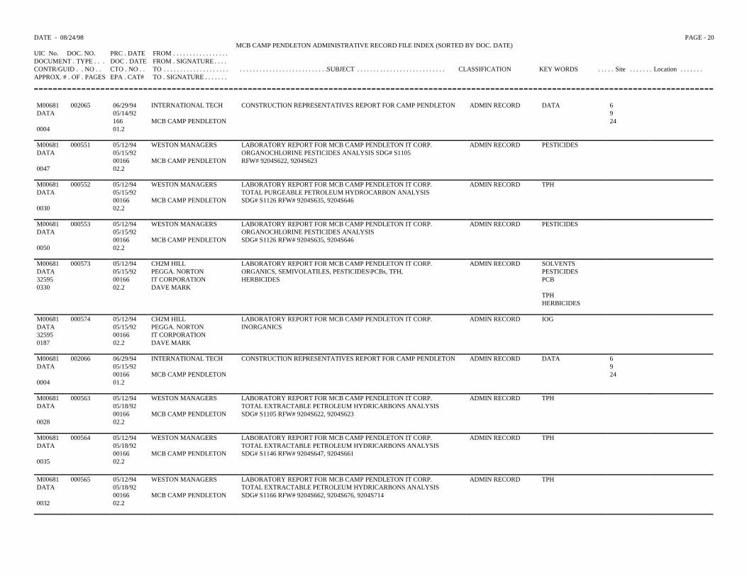
DATE - 08/24/98 PAGE - 20MCB CAMP PENDLETON ADMINISTRATIVE RECORD FILE INDEX (SORTED BY DOC. DATE)
UIC No. DOC. NO. PRC . DATE FROM . . . . . . . . . . . . . . . . .DOCUMENT . TYPE . . . DOC . DATE FROM . SIGNATURE . . . .CONTR/GUID . . NO . . CTO . NO . . TO . . . . . . . . . . . . . . . . . . . . . . . . . . . . . . . . . . . . . . . . . . . . . . .SUBJECT . . . . . . . . . . . . . . . . . . . . . . . . . . . CLASSIFICATION KEY WORDS . . . . . Site . . . . . . . Location . . . . . . .APPROX. # . OF . PAGES EPA . CAT# TO . SIGNATURE . . . . . . .
M00681 002065 06/29/94 INTERNATIONAL TECH CONSTRUCTION REPRESENTATIVES REPORT FOR CAMP PENDLETON ADMIN RECORD DATA 6DATA 05/14/92 9
166 MCB CAMP PENDLETON 240004 01.2
M00681 000551 05/12/94 WESTON MANAGERS LABORATORY REPORT FOR MCB CAMP PENDLETON IT CORP. ADMIN RECORD PESTICIDESDATA 05/15/92 ORGANOCHLORINE PESTICIDES ANALYSIS SDG# S1105
00166 MCB CAMP PENDLETON RFW# 9204S622, 9204S6230047 02.2
M00681 000552 05/12/94 WESTON MANAGERS LABORATORY REPORT FOR MCB CAMP PENDLETON IT CORP. ADMIN RECORD TPHDATA 05/15/92 TOTAL PURGEABLE PETROLEUM HYDROCARBON ANALYSIS
00166 MCB CAMP PENDLETON SDG# S1126 RFW# 9204S635, 9204S6460030 02.2
M00681 000553 05/12/94 WESTON MANAGERS LABORATORY REPORT FOR MCB CAMP PENDLETON IT CORP. ADMIN RECORD PESTICIDESDATA 05/15/92 ORGANOCHLORINE PESTICIDES ANALYSIS
00166 MCB CAMP PENDLETON SDG# S1126 RFW# 9204S635, 9204S6460050 02.2
M00681 000573 05/12/94 CH2M HILL LABORATORY REPORT FOR MCB CAMP PENDLETON IT CORP. ADMIN RECORD SOLVENTSDATA 05/15/92 PEGGA. NORTON ORGANICS, SEMIVOLATILES, PESTICIDES\PCBs, TFH, PESTICIDES32595 00166 IT CORPORATION HERBICIDES PCB0330 02.2 DAVE MARK
TPHHERBICIDES
M00681 000574 05/12/94 CH2M HILL LABORATORY REPORT FOR MCB CAMP PENDLETON IT CORP. ADMIN RECORD IOGDATA 05/15/92 PEGGA. NORTON INORGANICS32595 00166 IT CORPORATION0187 02.2 DAVE MARK
M00681 002066 06/29/94 INTERNATIONAL TECH CONSTRUCTION REPRESENTATIVES REPORT FOR CAMP PENDLETON ADMIN RECORD DATA 6DATA 05/15/92 9
00166 MCB CAMP PENDLETON 240004 01.2
M00681 000563 05/12/94 WESTON MANAGERS LABORATORY REPORT FOR MCB CAMP PENDLETON IT CORP. ADMIN RECORD TPHDATA 05/18/92 TOTAL EXTRACTABLE PETROLEUM HYDRICARBONS ANALYSIS
00166 MCB CAMP PENDLETON SDG# S1105 RFW# 9204S622, 9204S6230028 02.2
M00681 000564 05/12/94 WESTON MANAGERS LABORATORY REPORT FOR MCB CAMP PENDLETON IT CORP. ADMIN RECORD TPHDATA 05/18/92 TOTAL EXTRACTABLE PETROLEUM HYDRICARBONS ANALYSIS
00166 MCB CAMP PENDLETON SDG# S1146 RFW# 9204S647, 9204S6610035 02.2
M00681 000565 05/12/94 WESTON MANAGERS LABORATORY REPORT FOR MCB CAMP PENDLETON IT CORP. ADMIN RECORD TPHDATA 05/18/92 TOTAL EXTRACTABLE PETROLEUM HYDRICARBONS ANALYSIS
00166 MCB CAMP PENDLETON SDG# S1166 RFW# 9204S662, 9204S676, 9204S7140032 02.2
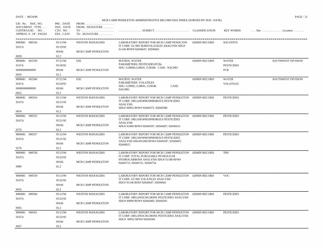
DATE - 08/24/98 PAGE - 21MCB CAMP PENDLETON ADMINISTRATIVE RECORD FILE INDEX (SORTED BY DOC. DATE)
UIC No. DOC. NO. PRC . DATE FROM . . . . . . . . . . . . . . . . . . . .DOCUMENT . TYPE . . . DOC . DATE FROM . SIGNATURE . . . . . . .CONTR/GUID . . NO . . CTO . NO . . TO . . . . . . . . . . . . . . . . . . . . . . . . . . . . . . . . . . . . . . . . SUBJECT . . . . . . . . . . . . . . . . . . . . . . . . CLASSIFICATION KEY WORDS . . . Site . . . . . . . . . . . . . . Location . . . . . . .APPROX. # . OF . PAGES EPA . CAT# TO . SIGNATURE . . . . . . . . . .
M00681 000556 05/12/94 WESTON MANAGERS LABORATORY REPORT FOR MCB CAMP PENDLTONIT CORP. GC/MS SEMIVOLATILES ANALYSIS SDG#S1146 RFW# 9204S647, 9204S661
ADMIN RECORD SOLVENTS
DATA 05/19/92
00166 MCB CAMP PENDLETON
0039 02.2
M00681 002359 07/21/94 ESE MATRIX: WATERPARAMETERS: PESTICIDES/PCBsSDG: G28606,G28641, G28346 CASE: NACPB1
ADMIN RECORD WATER SOUTHWEST DIVISION
DATA 05/20/92 PESTICIDES
00000000000000 00166 MCB CAMP PENDLETON PCB
0020 02.2
M00681 002360 07/21/94 ESE MATRIX: WATERPARAMETERS: VOLATILESSDG: G29002, G28641, G28346 CASE: NACPB1
ADMIN RECORD WATER SOUTHWEST DIVISION
DATA 05/20/92 VOLATILES
00000000000000 00166 MCB CAMP PENDLETON
0025 02.2
M00681 000554 05/12/94 WESTON MANAGERS LABORATORY REPORT FOR MCB CAMP PENDLETONIT CORP. ORGANOPHOSPHOROUS PESTICIDESANALYSISSDG# S0952 RFW# 9204S571, 9204S580
ADMIN RECORD PESTICIDES
DATA 05/21/92
00166 MCB CAMP PENDLETON
0054 02.2
M00681 000555 05/12/94 WESTON MANAGERS LABORATORY REPORT FOR MCB CAMP PENDLETONIT CORP. ORGANOPHOSPHOROUS PESTICIDESANALYSISSDG# S1069 RFW# 9204S597, 9204S607, 9204S615
ADMIN RECORD PESTICIDES
DATA 05/21/92
00166 MCB CAMP PENDLETON
0276 02.2
M00681 000557 05/12/94 WESTON MANAGERS LABORATORY REPORT FOR MCB CAMP PENDLETONIT CORP. ORGANOPHOSPHOROUS PESTICIDESANALYSIS SDG#S1069 RFW# 9204S597, 9204S607,9204S615
ADMIN RECORD PESTICIDES
DATA 05/21/92
00166 MCB CAMP PENDLETON
0276 02.2
M00681 000558 05/12/94 WESTON MANAGERS LABORATORY REPORT FOR MCB CAMP PENDLETONIT CORP. TOTAL PURGEABLE PETROLEUMHYDROCARBONS ANALYSIS SDG# S1188 RFW#9204S715, 9204S721, 9204S754
ADMIN RECORD TPH
DATA 05/22/92
00166 MCB CAMP PENDLETON
0080 02.2
M00681 000559 05/12/94 WESTON MANAGERS LABORATORY REPORT FOR MCB CAMP PENDLETONIT CORP. GC/MS VOLATILES ANALYSISSDG# S1146 RFE# 9204S647, 9204S661
ADMIN RECORD VOC
DATA 05/22/92
00166 MCB CAMP PENDLETON
0035 02.2
M00681 000560 05/12/94 WESTON MANAGERS LABORATORY REPORT FOR MCB CAMP PENDLETONIT CORP. ORGANOCHLORINE PESTICIDES ANALYSISSDG# S0909 RFW# 9204S485, 9204S501
ADMIN RECORD PESTICIDES
DATA 05/22/92
00166 MCB CAMP PENDLETON
0045 02.2
M00681 000561 05/12/94 WESTON MANAGERS LABORATORY REPORT FOR MCB CAMP PENDLETONIT CORP. ORGANOCHLORINE PESTICIDES ANALYSISSDG# S0952 RFW# 9204S506
ADMIN RECORD PESTICIDES
DATA 05/22/92
00166 MCB CAMP PENDLETON
0037 02.2
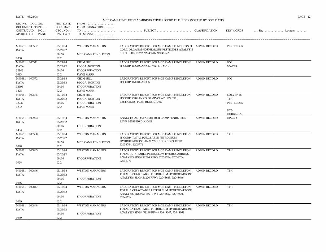
DATE - 08/24/98 PAGE - 22MCB CAMP PENDLETON ADMINISTRATIVE RECORD FILE INDEX (SORTED BY DOC. DATE)
UIC No. DOC. NO. PRC . DATE FROM . . . . . . . . . . . . . . . . . . . .DOCUMENT . TYPE . . . DOC . DATE FROM . SIGNATURE . . . . . . .CONTR/GUID . . NO . . CTO . NO . . TO . . . . . . . . . . . . . . . . . . . . . . . . . . . . . . . . . . . . . . . . SUBJECT . . . . . . . . . . . . . . . . . . . . . . . . CLASSIFICATION KEY WORDS . . . Site . . . . . . . . . . . . . . Location . . . . . . .APPROX. # . OF . PAGES EPA . CAT# TO . SIGNATURE . . . . . . . . . .
M00681 000562 05/12/94 WESTON MANAGERS LABORATORY REPORT FOR MCB CAMP PENDLTON ITCORP. ORGANOPHOSPHOROUS PESTICIDES ANALYSISSDG# S1105 RFW# 9204S616, 9204S622
ADMIN RECORD PESTICIDESDATA 05/22/92
00166 MCB CAMP PENDLETON0030 02.2M00681 000571 05/21/94 CH2M HILL LABORATORY REPORT FOR MCB CAMP PENDLETON
IT CORP. INORGANICS, WATER, SOILADMIN RECORD IOG
DATA 05/22/92 PEGGA. NORTON WATER32948 00166 IT CORPORATION0613 02.2 DAVE MARKM00681 000572 05/21/94 CH2M HILL LABORATORY REPORT FOR MCB CAMP PENDLETON
IT CORP. INORGANICSADMIN RECORD IOG
DATA 05/22/92 PEGGA. NORTON32698 00166 IT CORPORATION0425 02.2 DAVE MARKM00681 000575 05/12/94 CH2M HILL LABORATORY REPORT FOR MCB CAMP PENDLETON
IT CORP. ORGANICS, SEMIVOLATILES, TFH,PESTICIDES, PCBs, HERBICIDES
ADMIN RECORD SOLVENTSDATA 05/22/92 PEGGA. NORTON TFH32732 00166 IT CORPORATION PESTICIDES0292 02.2 DAVE MARK
PCBHERBICIDE
M00681 000993 05/18/94 WESTON MANAGERS ANALYTICAL DATA FOR MCB CAMP PENDLETONRFW# 9205S880 DIXIONS
ADMIN RECORD HPCCDDATA 05/23/92
00166 IT CORPORATION0494 02.2M00681 000568 05/12/94 WESTON MANAGERS LABORATORY REPORT FOR MCB CAMP PENDLETON
IT CORP. TOTAL PURGEABLE PETROLEUMHYDROCARBONS ANALYSIS SDG# S1224 RFW#9205S764, 920S771
ADMIN RECORD TPHDATA 05/26/92
00166 MCB CAMP PENDLETON0028 02.2M00681 000845 05/18/94 WESTON MANAGERS LABORATORY REPORT FOR MCB CAMP PENDLETON
TOTAL PURGEABLE PETROLEUM HYDROCARBONSANALYSIS SDG# S1224 RFW# 9205S764, 9205S764,9205S771
ADMIN RECORD TPHDATA 05/26/92
00166 IT CORPORATION0028 02.2
M00681 000846 05/18/94 WESTON MANAGERS LABORATORY REPORT FOR MCB CAMP PENDLETON TOTAL EXTRACTABLE PETROLEUM HYDROCARBONSANALYSIS SDG# S1226 RFW# 9204S635, 9204S646
ADMIN RECORD TPHDATA 05/26/92
00166 IT CORPORATION0046 02.2M00681 000847 05/18/94 WESTON MANAGERS LABORATORY REPORT FOR MCB CAMP PENDLETON
TOTAL EXTRACTABLE PETROLEUM HYDROCARBONSANALYSIS SDG# S1166 RFW# 9204S662, 9204S676,9204S714
ADMIN RECORD TPH
DATA 05/26/92
00166 IT CORPORATION
0039 02.2M00681 000848 05/18/94 WESTON MANAGERS LABORATORY REPORT FOR MCB CAMP PENDLETON
TOTAL EXTRACTABLE PETROLEUM HYDROCARBONSANALYSIS SDG# S1146 RFW# 9204S647, 9204S661
ADMIN RECORD TPHDATA 05/26/92
00166 IT CORPORATION0039 02.2
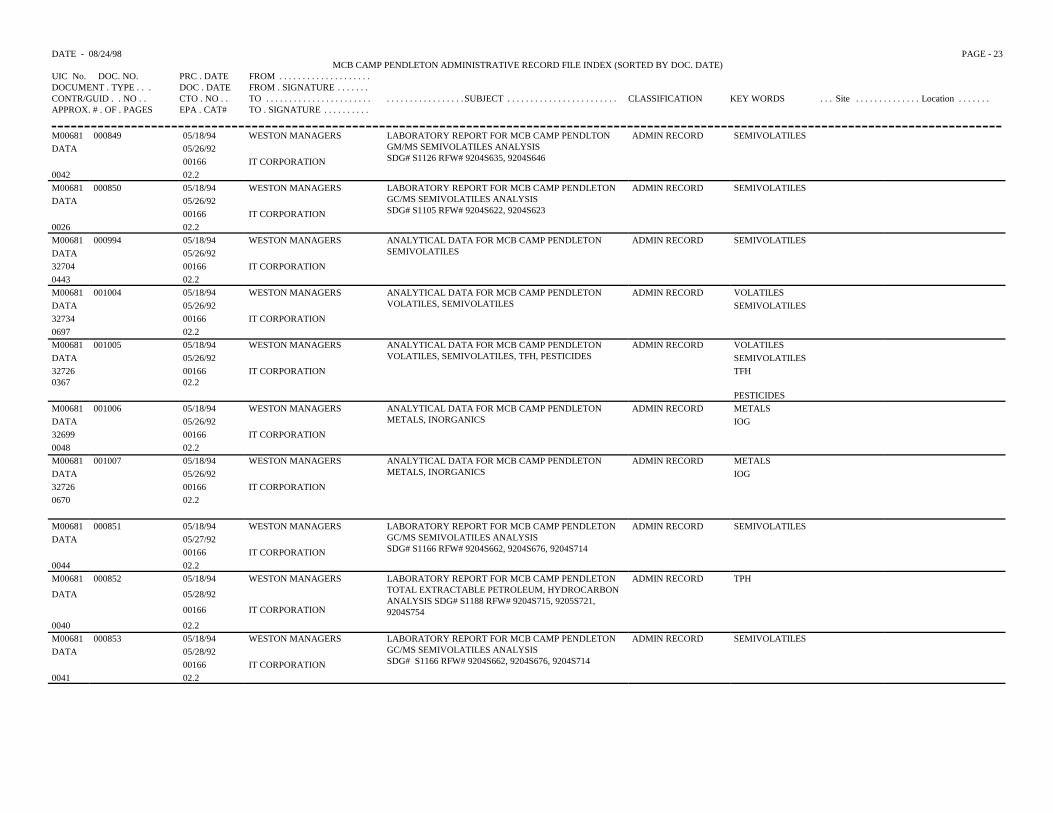
DATE - 08/24/98 PAGE - 23MCB CAMP PENDLETON ADMINISTRATIVE RECORD FILE INDEX (SORTED BY DOC. DATE)
UIC No. DOC. NO. PRC . DATE FROM . . . . . . . . . . . . . . . . . . . .DOCUMENT . TYPE . . . DOC . DATE FROM . SIGNATURE . . . . . . .CONTR/GUID . . NO . . CTO . NO . . TO . . . . . . . . . . . . . . . . . . . . . . . . . . . . . . . . . . . . . . . . SUBJECT . . . . . . . . . . . . . . . . . . . . . . . . CLASSIFICATION KEY WORDS . . . Site . . . . . . . . . . . . . . Location . . . . . . .APPROX. # . OF . PAGES EPA . CAT# TO . SIGNATURE . . . . . . . . . .
M00681 000849 05/18/94 WESTON MANAGERS LABORATORY REPORT FOR MCB CAMP PENDLTON GM/MS SEMIVOLATILES ANALYSISSDG# S1126 RFW# 9204S635, 9204S646
ADMIN RECORD SEMIVOLATILESDATA 05/26/92
00166 IT CORPORATION0042 02.2M00681 000850 05/18/94 WESTON MANAGERS LABORATORY REPORT FOR MCB CAMP PENDLETON
GC/MS SEMIVOLATILES ANALYSISSDG# S1105 RFW# 9204S622, 9204S623
ADMIN RECORD SEMIVOLATILESDATA 05/26/92
00166 IT CORPORATION0026 02.2M00681 000994 05/18/94 WESTON MANAGERS ANALYTICAL DATA FOR MCB CAMP PENDLETON
SEMIVOLATILESADMIN RECORD SEMIVOLATILES
DATA 05/26/9232704 00166 IT CORPORATION0443 02.2M00681 001004 05/18/94 WESTON MANAGERS ANALYTICAL DATA FOR MCB CAMP PENDLETON
VOLATILES, SEMIVOLATILESADMIN RECORD VOLATILES
DATA 05/26/92 SEMIVOLATILES32734 00166 IT CORPORATION0697 02.2M00681 001005 05/18/94 WESTON MANAGERS ANALYTICAL DATA FOR MCB CAMP PENDLETON
VOLATILES, SEMIVOLATILES, TFH, PESTICIDESADMIN RECORD VOLATILES
DATA 05/26/92 SEMIVOLATILES327260367
0016602.2
IT CORPORATION TFH
PESTICIDESM00681 001006 05/18/94 WESTON MANAGERS ANALYTICAL DATA FOR MCB CAMP PENDLETON
METALS, INORGANICSADMIN RECORD METALS
DATA 05/26/92 IOG32699 00166 IT CORPORATION0048 02.2M00681 001007 05/18/94 WESTON MANAGERS ANALYTICAL DATA FOR MCB CAMP PENDLETON
METALS, INORGANICSADMIN RECORD METALS
DATA 05/26/92 IOG32726 00166 IT CORPORATION0670 02.2
M00681 000851 05/18/94 WESTON MANAGERS LABORATORY REPORT FOR MCB CAMP PENDLETONGC/MS SEMIVOLATILES ANALYSISSDG# S1166 RFW# 9204S662, 9204S676, 9204S714
ADMIN RECORD SEMIVOLATILESDATA 05/27/92
00166 IT CORPORATION0044 02.2M00681 000852 05/18/94 WESTON MANAGERS LABORATORY REPORT FOR MCB CAMP PENDLETON
TOTAL EXTRACTABLE PETROLEUM, HYDROCARBONANALYSIS SDG# S1188 RFW# 9204S715, 9205S721,9204S754
ADMIN RECORD TPH
DATA 05/28/92
00166 IT CORPORATION
0040 02.2M00681 000853 05/18/94 WESTON MANAGERS LABORATORY REPORT FOR MCB CAMP PENDLETON
GC/MS SEMIVOLATILES ANALYSISSDG# S1166 RFW# 9204S662, 9204S676, 9204S714
ADMIN RECORD SEMIVOLATILESDATA 05/28/92
00166 IT CORPORATION0041 02.2
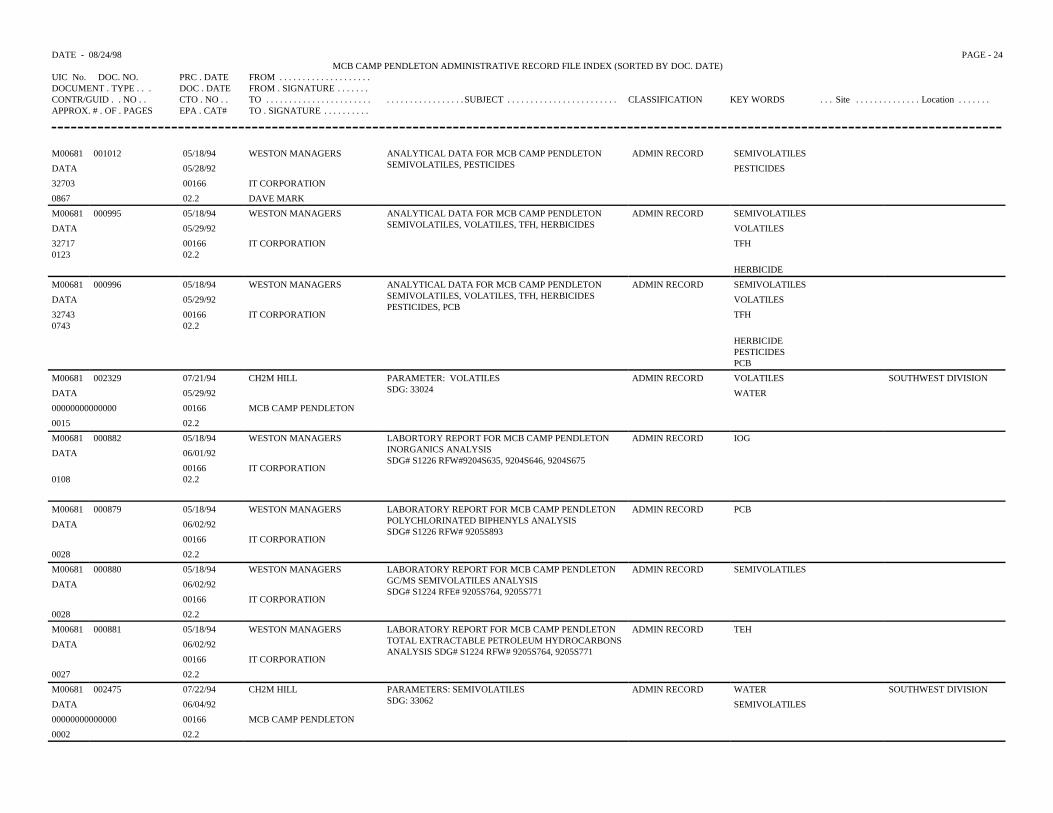
DATE - 08/24/98 PAGE - 24MCB CAMP PENDLETON ADMINISTRATIVE RECORD FILE INDEX (SORTED BY DOC. DATE)
UIC No. DOC. NO. PRC . DATE FROM . . . . . . . . . . . . . . . . . . . .DOCUMENT . TYPE . . . DOC . DATE FROM . SIGNATURE . . . . . . .CONTR/GUID . . NO . . CTO . NO . . TO . . . . . . . . . . . . . . . . . . . . . . . . . . . . . . . . . . . . . . . . SUBJECT . . . . . . . . . . . . . . . . . . . . . . . . CLASSIFICATION KEY WORDS . . . Site . . . . . . . . . . . . . . Location . . . . . . .APPROX. # . OF . PAGES EPA . CAT# TO . SIGNATURE . . . . . . . . . .
M00681 001012 05/18/94 WESTON MANAGERS ANALYTICAL DATA FOR MCB CAMP PENDLETONSEMIVOLATILES, PESTICIDES
ADMIN RECORD SEMIVOLATILES
DATA 05/28/92 PESTICIDES
32703 00166 IT CORPORATION
0867 02.2 DAVE MARK
M00681 000995 05/18/94 WESTON MANAGERS ANALYTICAL DATA FOR MCB CAMP PENDLETONSEMIVOLATILES, VOLATILES, TFH, HERBICIDES
ADMIN RECORD SEMIVOLATILES
DATA 05/29/92 VOLATILES
327170123
0016602.2
IT CORPORATION TFH
HERBICIDE
M00681 000996 05/18/94 WESTON MANAGERS ANALYTICAL DATA FOR MCB CAMP PENDLETONSEMIVOLATILES, VOLATILES, TFH, HERBICIDESPESTICIDES, PCB
ADMIN RECORD SEMIVOLATILES
DATA 05/29/92 VOLATILES
327430743
0016602.2
IT CORPORATION TFH
HERBICIDEPESTICIDESPCB
M00681 002329 07/21/94 CH2M HILL PARAMETER: VOLATILESSDG: 33024
ADMIN RECORD VOLATILES SOUTHWEST DIVISION
DATA 05/29/92 WATER
00000000000000 00166 MCB CAMP PENDLETON
0015 02.2
M00681 000882 05/18/94 WESTON MANAGERS LABORTORY REPORT FOR MCB CAMP PENDLETONINORGANICS ANALYSISSDG# S1226 RFW#9204S635, 9204S646, 9204S675
ADMIN RECORD IOG
DATA 06/01/92
01080016602.2
IT CORPORATION
M00681 000879 05/18/94 WESTON MANAGERS LABORATORY REPORT FOR MCB CAMP PENDLETON POLYCHLORINATED BIPHENYLS ANALYSISSDG# S1226 RFW# 9205S893
ADMIN RECORD PCB
DATA 06/02/92
00166 IT CORPORATION
0028 02.2
M00681 000880 05/18/94 WESTON MANAGERS LABORATORY REPORT FOR MCB CAMP PENDLETONGC/MS SEMIVOLATILES ANALYSISSDG# S1224 RFE# 9205S764, 9205S771
ADMIN RECORD SEMIVOLATILES
DATA 06/02/92
00166 IT CORPORATION
0028 02.2
M00681 000881 05/18/94 WESTON MANAGERS LABORATORY REPORT FOR MCB CAMP PENDLETONTOTAL EXTRACTABLE PETROLEUM HYDROCARBONSANALYSIS SDG# S1224 RFW# 9205S764, 9205S771
ADMIN RECORD TEH
DATA 06/02/92
00166 IT CORPORATION
0027 02.2
M00681 002475 07/22/94 CH2M HILL PARAMETERS: SEMIVOLATILESSDG: 33062
ADMIN RECORD WATER SOUTHWEST DIVISION
DATA 06/04/92 SEMIVOLATILES
00000000000000 00166 MCB CAMP PENDLETON
0002 02.2
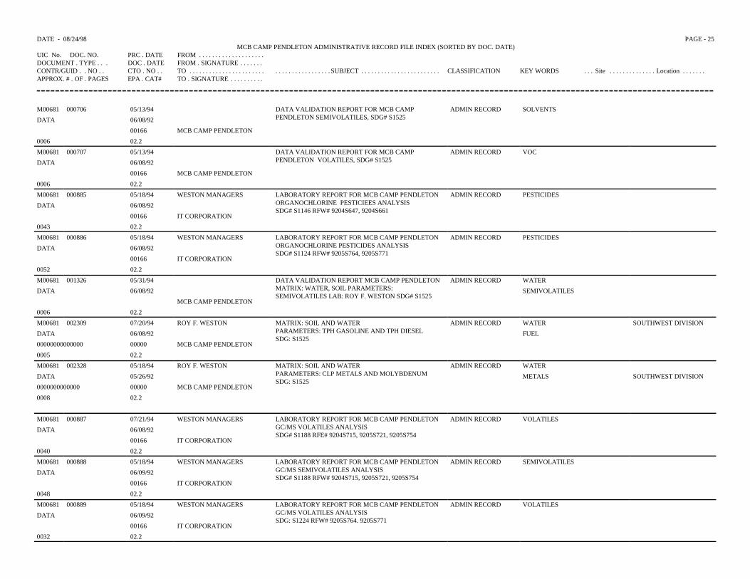
DATE - 08/24/98 PAGE - 25MCB CAMP PENDLETON ADMINISTRATIVE RECORD FILE INDEX (SORTED BY DOC. DATE)
UIC No. DOC. NO. PRC . DATE FROM . . . . . . . . . . . . . . . . . . . .DOCUMENT . TYPE . . . DOC . DATE FROM . SIGNATURE . . . . . . .CONTR/GUID . . NO . . CTO . NO . . TO . . . . . . . . . . . . . . . . . . . . . . . . . . . . . . . . . . . . . . . . SUBJECT . . . . . . . . . . . . . . . . . . . . . . . . CLASSIFICATION KEY WORDS . . . Site . . . . . . . . . . . . . . Location . . . . . . .APPROX. # . OF . PAGES EPA . CAT# TO . SIGNATURE . . . . . . . . . .
M00681 000706 05/13/94 DATA VALIDATION REPORT FOR MCB CAMPPENDLETON SEMIVOLATILES, SDG# S1525
ADMIN RECORD SOLVENTS
DATA 06/08/92
00166 MCB CAMP PENDLETON
0006 02.2
M00681 000707 05/13/94 DATA VALIDATION REPORT FOR MCB CAMPPENDLETON VOLATILES, SDG# S1525
ADMIN RECORD VOC
DATA 06/08/92
00166 MCB CAMP PENDLETON
0006 02.2
M00681 000885 05/18/94 WESTON MANAGERS LABORATORY REPORT FOR MCB CAMP PENDLETONORGANOCHLORINE PESTICIEES ANALYSISSDG# S1146 RFW# 9204S647, 9204S661
ADMIN RECORD PESTICIDES
DATA 06/08/92
00166 IT CORPORATION
0043 02.2
M00681 000886 05/18/94 WESTON MANAGERS LABORATORY REPORT FOR MCB CAMP PENDLETONORGANOCHLORINE PESTICIDES ANALYSISSDG# S1124 RFW# 9205S764, 9205S771
ADMIN RECORD PESTICIDES
DATA 06/08/92
00166 IT CORPORATION
0052 02.2
M00681 001326 05/31/94 DATA VALIDATION REPORT MCB CAMP PENDLETONMATRIX: WATER, SOIL PARAMETERS:SEMIVOLATILES LAB: ROY F. WESTON SDG# S1525
ADMIN RECORD WATER
DATA 06/08/92 SEMIVOLATILES
MCB CAMP PENDLETON
0006 02.2
M00681 002309 07/20/94 ROY F. WESTON MATRIX: SOIL AND WATERPARAMETERS: TPH GASOLINE AND TPH DIESELSDG: S1525
ADMIN RECORD WATER SOUTHWEST DIVISION
DATA 06/08/92 FUEL
00000000000000 00000 MCB CAMP PENDLETON
0005 02.2
M00681 002328 05/18/94 ROY F. WESTON MATRIX: SOIL AND WATERPARAMETERS: CLP METALS AND MOLYBDENUMSDG: S1525
ADMIN RECORD WATER
DATA 05/26/92 METALS SOUTHWEST DIVISION
0000000000000 00000 MCB CAMP PENDLETON
0008 02.2
M00681 000887 07/21/94 WESTON MANAGERS LABORATORY REPORT FOR MCB CAMP PENDLETONGC/MS VOLATILES ANALYSISSDG# S1188 RFE# 9204S715, 9205S721, 9205S754
ADMIN RECORD VOLATILES
DATA 06/08/92
00166 IT CORPORATION
0040 02.2
M00681 000888 05/18/94 WESTON MANAGERS LABORATORY REPORT FOR MCB CAMP PENDLETONGC/MS SEMIVOLATILES ANALYSISSDG# S1188 RFW# 9204S715, 9205S721, 9205S754
ADMIN RECORD SEMIVOLATILES
DATA 06/09/92
00166 IT CORPORATION
0048 02.2
M00681 000889 05/18/94 WESTON MANAGERS LABORATORY REPORT FOR MCB CAMP PENDLETONGC/MS VOLATILES ANALYSISSDG: S1224 RFW# 9205S764. 9205S771
ADMIN RECORD VOLATILES
DATA 06/09/92
00166 IT CORPORATION
0032 02.2

DATE - 08/24/98 PAGE - 26MCB CAMP PENDLETON ADMINISTRATIVE RECORD FILE INDEX (SORTED BY DOC. DATE)
UIC No. DOC. NO. PRC . DATE FROM . . . . . . . . . . . . . . . . . . . .DOCUMENT . TYPE . . . DOC . DATE FROM . SIGNATURE . . . . . . .CONTR/GUID . . NO . . CTO . NO . . TO . . . . . . . . . . . . . . . . . . . . . . . . . . . . . . . . . . . . . . . . SUBJECT . . . . . . . . . . . . . . . . . . . . . . . . CLASSIFICATION KEY WORDS . . . Site . . . . . . . . . . . . . . Location . . . . . . .APPROX. # . OF . PAGES EPA . CAT# TO . SIGNATURE . . . . . . . . . .
M00681 000854 05/18/94 WESTON MANAGERS LABORATORY REPORT FOR MCB CAMP PENDLETONINORGANICS ANALYSISSDG# S1188 RFW# 9204S715, 9205S721, 9205S754
ADMIN RECORD IOGDATA 06/10/92
00166 IT CORPORATION0100 02.2M00681 000694 05/13/94 CH2M HILL ANALYTICAL DATA FOR MCB CAMP PENDLETON
ORGANICSADMIN RECORD DATA
DATA 06/11/92 PEGGS A. NORTON32948 00166 IT CORPORATION1079 02.2 DAVE MARKM00681 000708 05/13/94 CH2M HILL ANALYTICAL DATA FOR MCB CAMP PENDLETON
INORGANICS SDG# ITCORP17ADMIN RECORD IOG
DATA 06/11/92 PEGGY A. NORTON32948 00166 IT CORPORATION0606 02.2 DAVE MARKM00681 000710 05/13/94 CH2M HILL ANALYTICAL DATA FOR MCB CAMP PENDLETON
ORGANICSADMIN RECORD DATA
DATA 06/11/92 PEGGY A. NORTON32943 00166 IT CORPORATION1287 02.2 DAVE MARKM00681 000884 05/18/94 WESTON MANAGERS LABORTORY REPORT FOR MCB CAMP PENDLETON
INORGANICS ANALYSISSDG# S1166 RFW#9204S662, 9204S676, 9204S714
ADMIN RECORD IOGDATA 06/11/92
00166 IT CORPORATION0088 02.2M00681 001003 05/18/94 WESTON MANAGERS ANALYTICAL DATA FOR MCB CAMP PENDLETON
METALSADMIN RECORD METALS
DATA 06/11/9232943 00166 IT CORPORATION0298 02.2M00681 000695 05/13/94 CH2M HILL ANALYTICAL DATA FOR MCB CAMP PENDLETON
INORGANICSADMIN RECORD IOG
DATA 06/12/92 PEGGY A. NORTON32953 00166 IT CORPORATION0083 02.2 DAVE MARK
M00681 000697 05/13/94 CH2M HILL ANALYTICAL DATA FOR MCB CAMP PENDLETONORGANICS
ADMIN RECORD WATERDATA 06/12/92 PEGGY A. NORTON32946 00166 IT CORPORATION0550 02.2 DAVE MARKM00681 000699 05/13/94 CH2M HILL ANALYTICAL DATA FOR MCB CAMP PENDLETON
ORGANICSADMIN RECORD PESTICIDES
DATA 06/12/92 PEGGY A. NORTON PCB329360220
0016602.2
IT CORPORATIONDAVE MARK
TFH
HERBICIDEM00681 000700 05/13/94 CH2M HILL ANALYTICAL DATA FOR MCB CAMP PENDLETON
ORGANICSADMIN RECORD WATER
DATA 06/12/92 PEGGY A. NORTON32936 00166 IT CORPORATION0088 02.2 DAVE MARK
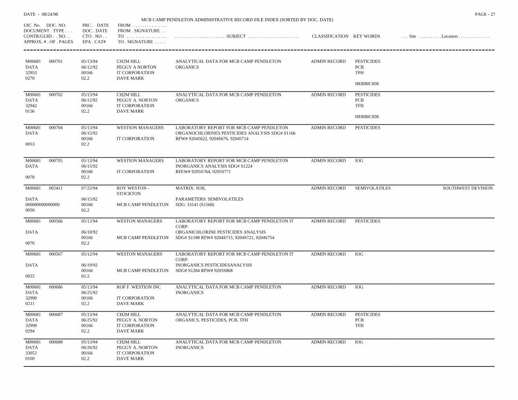
DATE - 08/24/98 PAGE - 27MCB CAMP PENDLETON ADMINISTRATIVE RECORD FILE INDEX (SORTED BY DOC. DATE)
UIC No. DOC. NO. PRC . DATE FROM . . . . . . . . . . . . . . .DOCUMENT . TYPE . . . DOC . DATE FROM . SIGNATURE . .CONTR/GUID . . NO . . CTO . NO . . TO . . . . . . . . . . . . . . . . . . . . . . . . . . . . . . . . . . . . . . . . .SUBJECT . . . . . . . . . . . . . . . . . . . . . . . CLASSIFICATION KEY WORDS . . . Site . . . . . . . . . . Location . . . . . . . . . . . . . .APPROX. # . OF . PAGES EPA . CAT# TO . SIGNATURE . . . . .
M00681 000701 05/13/94 CH2M HILL ANALYTICAL DATA FOR MCB CAMP PENDLETON ADMIN RECORD PESTICIDESDATA 06/12/92 PEGGY A NORTON ORGANICS PCB32953 00166 IT CORPORATION TPH0270 02.2 DAVE MARK
HERBICIDE
M00681 000702 05/13/94 CH2M HILL ANALYTICAL DATA FOR MCB CAMP PENDLETON ADMIN RECORD PESTICIDES DATA 06/12/92 PEGGY A. NORTON ORGANICS PCB32942 00166 IT CORPORATION TFH0156 02.2 DAVE MARK
HERBICIDE
M00681 000704 05/13/94 WESTION MANAGERS LABORATORY REPORT FOR MCB CAMP PENDLETON ADMIN RECORD PESTICIDESDATA 06/15/92 ORGANOCHLORINES PESTICIDES ANALYSIS SDG# S1166
00166 IT CORPORATION RFW# 92045622, 9204S676, 920457140053 02.2
M00681 000705 05/13/94 WESTION MANAGERS LABORATORY REPORT FOR MCB CAMP PENDLETON ADMIN RECORD IOGDATA 06/15/92 INORGANICS ANALYSIS SDG# S1224
00166 IT CORPORATION RFEW# 9205S764, 9205S7710078 02.2
M00681 002411 07/22/94 ROY WESTON -STOCKTON
MATRIX: SOIL ADMIN RECORD SEMIVOLATILES SOUTHWEST DEVISION
DATA 06/15/92 PARAMETERS: SEMIVOLATILES000000000000000 00166 MCB CAMP PENDLETON SDG: 33141 (S1568)0050 02.2
M00681 000566 05/12/94 WESTON MANAGERS LABORATORY REPORT FOR MCB CAMP PENDLETON ITCORP.
ADMIN RECORD PESTICIDES
DATA 06/18/92 ORGANICHLORINE PESTICIDES ANALYSIS00166 MCB CAMP PENDLETON SDG# S1188 RFW# 9204S715, 9204S721, 9204S754
0076 02.2
M00681 000567 05/12/94 WESTON MANAGERS LABORATORY REPORT FOR MCB CAMP PENDLETON ITCORP.
ADMIN RECORD IOG
DATA 06/19/92 INORGANICS PESTICIDESANALYSIS00166 MCB CAMP PENDLETON SDG# S1284 RFW# 9205S868
0022 02.2.
M00681 000686 05/13/94 ROF F. WESTION INC ANALYTICAL DATA FOR MCB CAMP PENDLETON ADMIN RECORD IOGDATA 06/25/92 INORGANICS32990 00166 IT CORPORATION0211 02.2 DAVE MARK
M00681 000687 05/13/94 CH2M HILL ANALYTICAL DATA FOR MCB CAMP PENDLETON ADMIN RECORD PESTICIDESDATA 06/25/92 PEGGY A. NORTON ORGANICS, PESTICIDES, PCB, TFH PCB32990 00166 IT CORPORATION TFH0294 02.2 DAVE MARK
M00681 000688 05/13/94 CH2M HILL ANALYTICAL DATA FOR MCB CAMP PENDLETON ADMIN RECORD IOGDATA 06/26/92 PEGGY A. NORTON INORGANICS33052 00166 IT CORPORATION0100 02.2 DAVE MARK
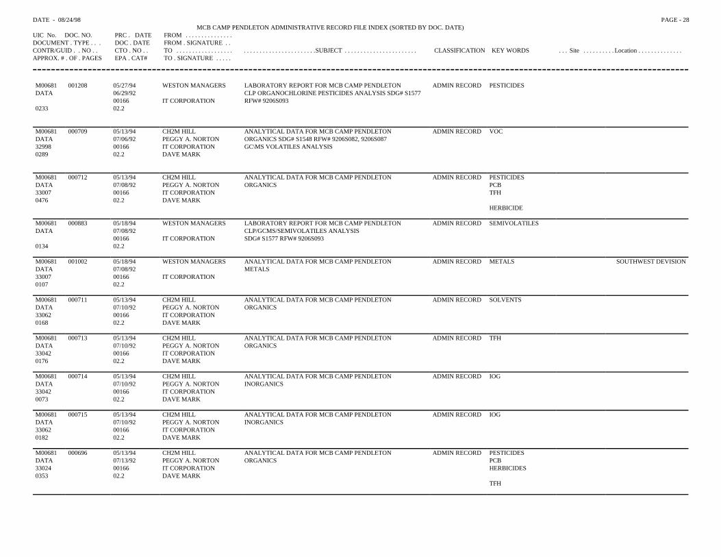
DATE - 08/24/98 PAGE - 28MCB CAMP PENDLETON ADMINISTRATIVE RECORD FILE INDEX (SORTED BY DOC. DATE)
UIC No. DOC. NO. PRC . DATE FROM . . . . . . . . . . . . . . .DOCUMENT . TYPE . . . DOC . DATE FROM . SIGNATURE . .CONTR/GUID . . NO . . CTO . NO . . TO . . . . . . . . . . . . . . . . . . . . . . . . . . . . . . . . . . . . . . . . .SUBJECT . . . . . . . . . . . . . . . . . . . . . . . CLASSIFICATION KEY WORDS . . . Site . . . . . . . . . . Location . . . . . . . . . . . . . .APPROX. # . OF . PAGES EPA . CAT# TO . SIGNATURE . . . . .
M00681 001208 05/27/94 WESTON MANAGERS LABORATORY REPORT FOR MCB CAMP PENDLETON ADMIN RECORD PESTICIDESDATA 06/29/92 CLP ORGANOCHLORINE PESTICIDES ANALYSIS SDG# S1577
00166 IT CORPORATION RFW# 9206S0930233 02.2
M00681 000709 05/13/94 CH2M HILL ANALYTICAL DATA FOR MCB CAMP PENDLETON ADMIN RECORD VOCDATA 07/06/92 PEGGY A. NORTON ORGANICS SDG# S1548 RFW# 9206S082, 9206S08732998 00166 IT CORPORATION GC\MS VOLATILES ANALYSIS0289 02.2 DAVE MARK
M00681 000712 05/13/94 CH2M HILL ANALYTICAL DATA FOR MCB CAMP PENDLETON ADMIN RECORD PESTICIDESDATA 07/08/92 PEGGY A. NORTON ORGANICS PCB33007 00166 IT CORPORATION TFH0476 02.2 DAVE MARK
HERBICIDE
M00681 000883 05/18/94 WESTON MANAGERS LABORATORY REPORT FOR MCB CAMP PENDLETON ADMIN RECORD SEMIVOLATILESDATA 07/08/92 CLP/GCMS/SEMIVOLATILES ANALYSIS
00166 IT CORPORATION SDG# S1577 RFW# 9206S0930134 02.2
M00681 001002 05/18/94 WESTON MANAGERS ANALYTICAL DATA FOR MCB CAMP PENDLETON ADMIN RECORD METALS SOUTHWEST DEVISIONDATA 07/08/92 METALS33007 00166 IT CORPORATION0107 02.2
M00681 000711 05/13/94 CH2M HILL ANALYTICAL DATA FOR MCB CAMP PENDLETON ADMIN RECORD SOLVENTSDATA 07/10/92 PEGGY A. NORTON ORGANICS33062 00166 IT CORPORATION0168 02.2 DAVE MARK
M00681 000713 05/13/94 CH2M HILL ANALYTICAL DATA FOR MCB CAMP PENDLETON ADMIN RECORD TFHDATA 07/10/92 PEGGY A. NORTON ORGANICS33042 00166 IT CORPORATION0176 02.2 DAVE MARK
M00681 000714 05/13/94 CH2M HILL ANALYTICAL DATA FOR MCB CAMP PENDLETON ADMIN RECORD IOGDATA 07/10/92 PEGGY A. NORTON INORGANICS33042 00166 IT CORPORATION0073 02.2 DAVE MARK
M00681 000715 05/13/94 CH2M HILL ANALYTICAL DATA FOR MCB CAMP PENDLETON ADMIN RECORD IOGDATA 07/10/92 PEGGY A. NORTON INORGANICS33062 00166 IT CORPORATION0182 02.2 DAVE MARK
M00681 000696 05/13/94 CH2M HILL ANALYTICAL DATA FOR MCB CAMP PENDLETON ADMIN RECORD PESTICIDESDATA 07/13/92 PEGGY A. NORTON ORGANICS PCB33024 00166 IT CORPORATION HERBICIDES0353 02.2 DAVE MARK
TFH
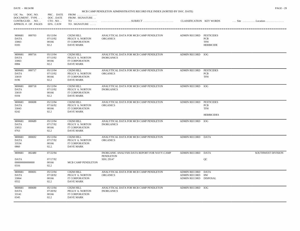
DATE - 08/24/98 PAGE - 29MCB CAMP PENDLETON ADMINISTRATIVE RECORD FILE INDEX (SORTED BY DOC. DATE)
UIC No. DOC. NO. PRC . DATE FROM . . . . . . . . . . . . . . .DOCUMENT . TYPE . . . DOC . DATE FROM . SIGNATURE . .CONTR/GUID . . NO . . CTO . NO . . TO . . . . . . . . . . . . . . . . . . . . . . . . . . . . . . . . . . . . . . . . .SUBJECT . . . . . . . . . . . . . . . . . . . . . . . CLASSIFICATION KEY WORDS . . . Site . . . . . . . . . . Location . . . . . . . . . . . . . .APPROX. # . OF . PAGES EPA . CAT# TO . SIGNATURE . . . . .
M00681 000703 05/13/94 CH2M HILL ANALYTICAL DATA FOR MCB CAMP PENDLETON ADMIN RECORD PESTICIDESDATA 07/13/92 PEGGY A. NORTON ORGANICS PCB33063 00166 IT CORPORATION TFH0183 02.2 DAVE MARK HERBICIDE
M00681 000716 05/13/94 CH2M HILL ANALYTICAL DATA FOR MCB CAMP PENDLETON ADMIN RECORD IOGDATA 07/13/92 PEGGY A. NORTON INORGANICS 33063 00166 IT CORPORATION0084 02.2 DAVE MARK
M00681 000717 05/13/94 CH2M HILL ANALYTICAL DATA FOR MCB CAMP PENDLETON ADMIN RECORD PESTICIDESDATA 07/13/92 PEGGY A. NORTON ORGANICS PCB33019 00166 IT CORPORATION TFH0196 02.2 DAVE MARK
M00681 000718 05/13/94 CH2M HILL ANALYTICAL DATA FOR MCB CAMP PENDLETON ADMIN RECORD IOGDATA 07/13/92 PEGGY A. NORTON INORGANICS33019 00166 IT CORPORATION0104 02.2 DAVE MARK
M00681 000698 05/13/94 CH2M HILL ANALYTICAL DATA FOR MCB CAMP PENDLETON ADMIN RECORD PESTICIDESDATA 07/16/92 PEGGY A. NORTON ORGANICS PCB33043 00166 IT CORPORATION TFH0242 02.2 DAVE MARK
HERBICIDES
M00681 000689 05/13/94 CH2M HILL ANALYTICAL DATA FOR MCB CAMP PENDLETON ADMIN RECORD IOGDATA 07/17/92 PEGGY A. NORTON INORGANICS33053 00166 IT CORPORATION0763 02.2 DAVE MARK
M00681 000692 05/13/94 CH2M HILL ANALYTICAL DATA FOR MCB CAMP PENDLETON ADMIN RECORD DATADATA 07/17/92 PEGGY A. NORTON ORGANICS33534 00166 IT CORPORATION0860 02.2. DAVE MARK
M00681 002480 07/22/94 INORGANIC ANALYSIS DATA REPORT FOR NAVY-CAMPPENDLETON
ADMIN RECORD DATA SOUTHWEST DIVISION
DATA 07/17/92 SDG 29147 QC000000000000000 00166 MCB CAMP PENDLETON0316 02.2
M00681 000691 05/13/94 CH2M HILL ANALYTICAL DATA FOR MCB CAMP PENDLETON ADMIN RECORD DATADATA 07/18/92 PEGGY A. NORTON ORGANICS ADMIN RECORD HW33064 00166 IT CORPORATION ADMIN RECORD DISPOSAL0552 02.2 DAVE MARK
M00681 000690 05/13/94 CH2M HILL ANALYTICAL DATA FOR MCB CAMP PENDLETON ADMIN RECORD IOGDATA 07/20/92 PEGGY A. NORTON INORGANICS33141 00166 IT CORPORATION0345 02.2 DAVE MARK
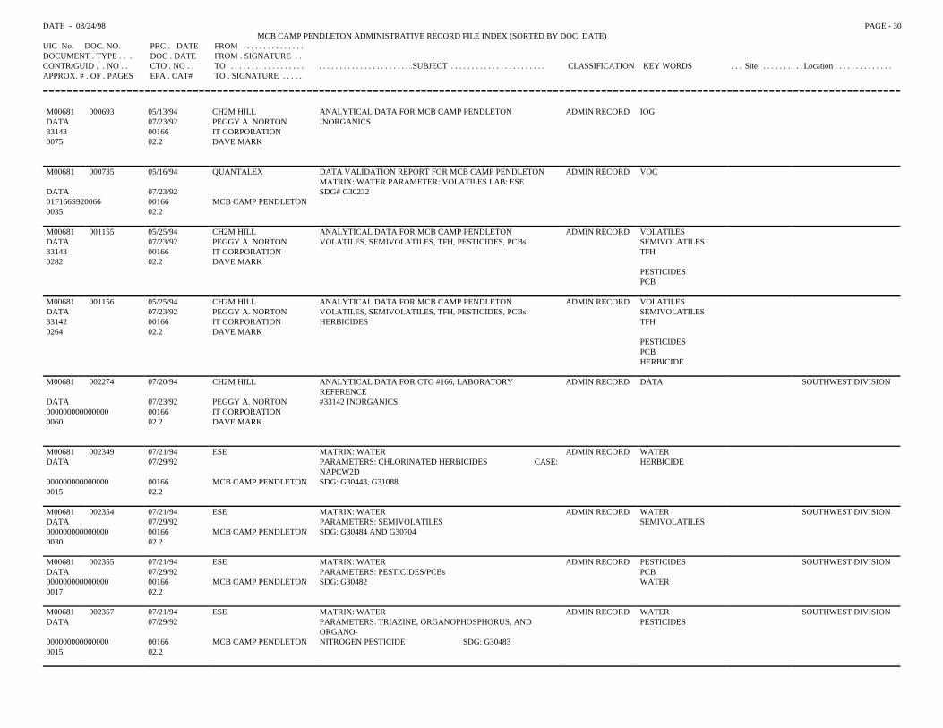
DATE - 08/24/98 PAGE - 30MCB CAMP PENDLETON ADMINISTRATIVE RECORD FILE INDEX (SORTED BY DOC. DATE)
UIC No. DOC. NO. PRC . DATE FROM . . . . . . . . . . . . . . .DOCUMENT . TYPE . . . DOC . DATE FROM . SIGNATURE . .CONTR/GUID . . NO . . CTO . NO . . TO . . . . . . . . . . . . . . . . . . . . . . . . . . . . . . . . . . . . . . . . .SUBJECT . . . . . . . . . . . . . . . . . . . . . . . CLASSIFICATION KEY WORDS . . . Site . . . . . . . . . . Location . . . . . . . . . . . . . .APPROX. # . OF . PAGES EPA . CAT# TO . SIGNATURE . . . . .
M00681 000693 05/13/94 CH2M HILL ANALYTICAL DATA FOR MCB CAMP PENDLETON ADMIN RECORD IOGDATA 07/23/92 PEGGY A. NORTON INORGANICS33143 00166 IT CORPORATION0075 02.2 DAVE MARK
M00681 000735 05/16/94 QUANTALEX DATA VALIDATION REPORT FOR MCB CAMP PENDLETON ADMIN RECORD VOCMATRIX: WATER PARAMETER: VOLATILES LAB: ESE
DATA 07/23/92 SDG# G3023201F166S920066 00166 MCB CAMP PENDLETON0035 02.2
M00681 001155 05/25/94 CH2M HILL ANALYTICAL DATA FOR MCB CAMP PENDLETON ADMIN RECORD VOLATILESDATA 07/23/92 PEGGY A. NORTON VOLATILES, SEMIVOLATILES, TFH, PESTICIDES, PCBs SEMIVOLATILES33143 00166 IT CORPORATION TFH0282 02.2 DAVE MARK
PESTICIDESPCB
M00681 001156 05/25/94 CH2M HILL ANALYTICAL DATA FOR MCB CAMP PENDLETON ADMIN RECORD VOLATILES DATA 07/23/92 PEGGY A. NORTON VOLATILES, SEMIVOLATILES, TFH, PESTICIDES, PCBs SEMIVOLATILES33142 00166 IT CORPORATION HERBICIDES TFH0264 02.2 DAVE MARK
PESTICIDESPCBHERBICIDE
M00681 002274 07/20/94 CH2M HILL ANALYTICAL DATA FOR CTO #166, LABORATORYREFERENCE
ADMIN RECORD DATA SOUTHWEST DIVISION
DATA 07/23/92 PEGGY A. NORTON #33142 INORGANICS000000000000000 00166 IT CORPORATION0060 02.2 DAVE MARK
M00681 002349 07/21/94 ESE MATRIX: WATER ADMIN RECORD WATERDATA 07/29/92 PARAMETERS: CHLORINATED HERBICIDES CASE:
NAPCW2DHERBICIDE
000000000000000 00166 MCB CAMP PENDLETON SDG: G30443, G310880015 02.2
M00681 002354 07/21/94 ESE MATRIX: WATER ADMIN RECORD WATER SOUTHWEST DIVISIONDATA 07/29/92 PARAMETERS: SEMIVOLATILES SEMIVOLATILES000000000000000 00166 MCB CAMP PENDLETON SDG: G30484 AND G307040030 02.2.
M00681 002355 07/21/94 ESE MATRIX: WATER ADMIN RECORD PESTICIDES SOUTHWEST DIVISIONDATA 07/29/92 PARAMETERS: PESTICIDES/PCBs PCB000000000000000 00166 MCB CAMP PENDLETON SDG: G30482 WATER0017 02.2
M00681 002357 07/21/94 ESE MATRIX: WATER ADMIN RECORD WATER SOUTHWEST DIVISIONDATA 07/29/92 PARAMETERS: TRIAZINE, ORGANOPHOSPHORUS, AND
ORGANO-PESTICIDES
000000000000000 00166 MCB CAMP PENDLETON NITROGEN PESTICIDE SDG: G304830015 02.2
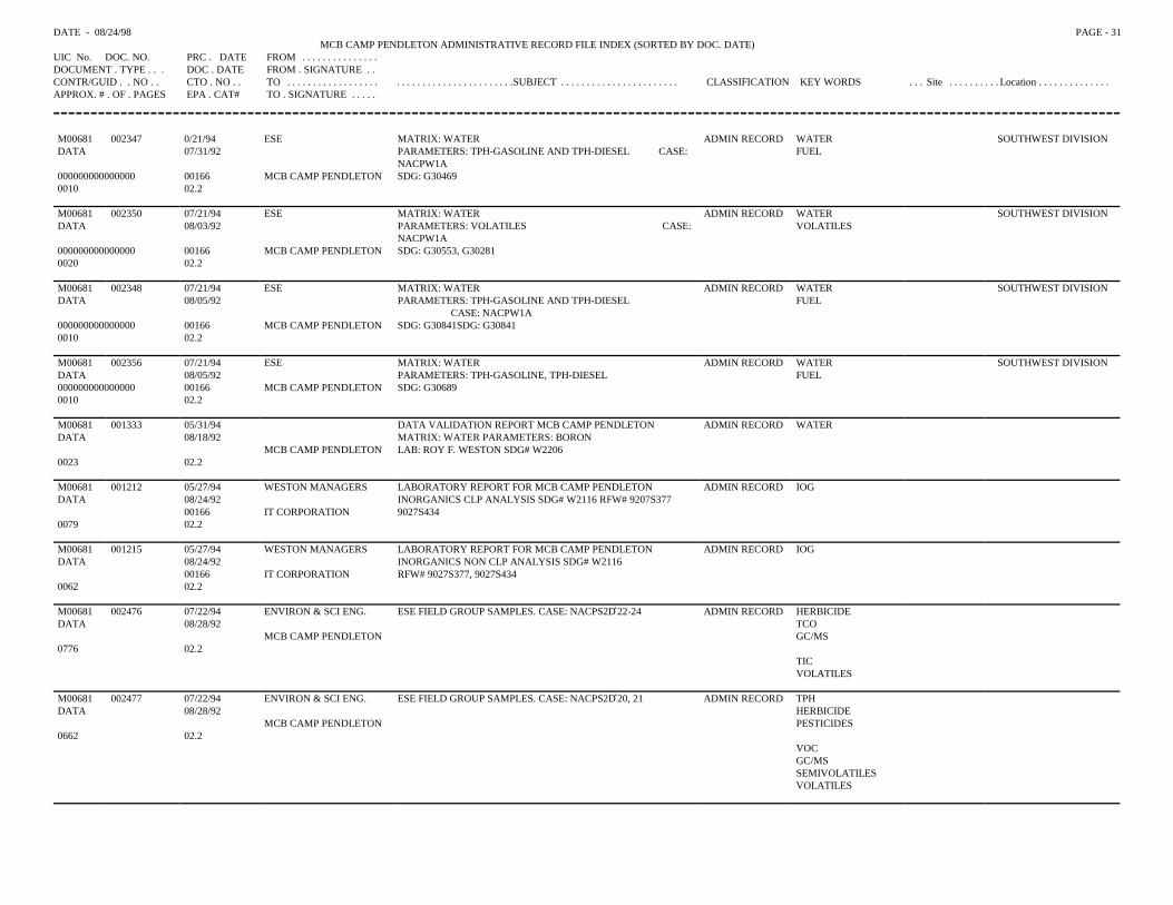
DATE - 08/24/98 PAGE - 31MCB CAMP PENDLETON ADMINISTRATIVE RECORD FILE INDEX (SORTED BY DOC. DATE)
UIC No. DOC. NO. PRC . DATE FROM . . . . . . . . . . . . . . .DOCUMENT . TYPE . . . DOC . DATE FROM . SIGNATURE . .CONTR/GUID . . NO . . CTO . NO . . TO . . . . . . . . . . . . . . . . . . . . . . . . . . . . . . . . . . . . . . . . .SUBJECT . . . . . . . . . . . . . . . . . . . . . . . CLASSIFICATION KEY WORDS . . . Site . . . . . . . . . . Location . . . . . . . . . . . . . .APPROX. # . OF . PAGES EPA . CAT# TO . SIGNATURE . . . . .
M00681 002347 0/21/94 ESE MATRIX: WATER ADMIN RECORD WATER SOUTHWEST DIVISIONDATA 07/31/92 PARAMETERS: TPH-GASOLINE AND TPH-DIESEL CASE:
NACPW1AFUEL
000000000000000 00166 MCB CAMP PENDLETON SDG: G304690010 02.2
M00681 002350 07/21/94 ESE MATRIX: WATER ADMIN RECORD WATER SOUTHWEST DIVISIONDATA 08/03/92 PARAMETERS: VOLATILES CASE:
NACPW1AVOLATILES
000000000000000 00166 MCB CAMP PENDLETON SDG: G30553, G302810020 02.2
M00681 002348 07/21/94 ESE MATRIX: WATER ADMIN RECORD WATER SOUTHWEST DIVISIONDATA 08/05/92 PARAMETERS: TPH-GASOLINE AND TPH-DIESEL
CASE: NACPW1AFUEL
000000000000000 00166 MCB CAMP PENDLETON SDG: G30841SDG: G308410010 02.2
M00681 002356 07/21/94 ESE MATRIX: WATER ADMIN RECORD WATER SOUTHWEST DIVISIONDATA 08/05/92 PARAMETERS: TPH-GASOLINE, TPH-DIESEL FUEL000000000000000 00166 MCB CAMP PENDLETON SDG: G306890010 02.2
M00681 001333 05/31/94 DATA VALIDATION REPORT MCB CAMP PENDLETON ADMIN RECORD WATERDATA 08/18/92 MATRIX: WATER PARAMETERS: BORON
MCB CAMP PENDLETON LAB: ROY F. WESTON SDG# W22060023 02.2
M00681 001212 05/27/94 WESTON MANAGERS LABORATORY REPORT FOR MCB CAMP PENDLETON ADMIN RECORD IOGDATA 08/24/92 INORGANICS CLP ANALYSIS SDG# W2116 RFW# 9207S377
00166 IT CORPORATION 9027S4340079 02.2
M00681 001215 05/27/94 WESTON MANAGERS LABORATORY REPORT FOR MCB CAMP PENDLETON ADMIN RECORD IOGDATA 08/24/92 INORGANICS NON CLP ANALYSIS SDG# W2116
00166 IT CORPORATION RFW# 9027S377, 9027S4340062 02.2
M00681 002476 07/22/94 ENVIRON & SCI ENG. ESE FIELD GROUP SAMPLES. CASE: NACPS2D*22-24 ADMIN RECORD HERBICIDEDATA 08/28/92 TCO
MCB CAMP PENDLETON GC/MS0776 02.2
TICVOLATILES
M00681 002477 07/22/94 ENVIRON & SCI ENG. ESE FIELD GROUP SAMPLES. CASE: NACPS2D*20, 21 ADMIN RECORD TPHDATA 08/28/92 HERBICIDE
MCB CAMP PENDLETON PESTICIDES0662 02.2
VOCGC/MSSEMIVOLATILESVOLATILES
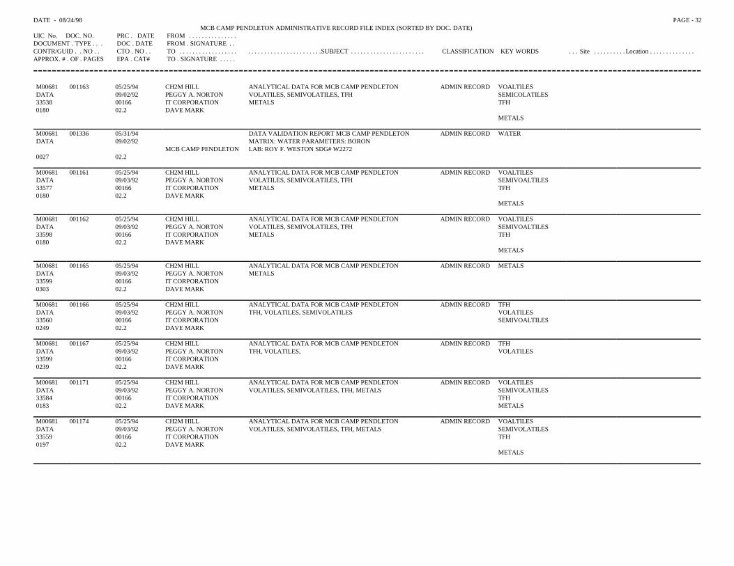
DATE - 08/24/98 PAGE - 32MCB CAMP PENDLETON ADMINISTRATIVE RECORD FILE INDEX (SORTED BY DOC. DATE)
UIC No. DOC. NO. PRC . DATE FROM . . . . . . . . . . . . . . .DOCUMENT . TYPE . . . DOC . DATE FROM . SIGNATURE . .CONTR/GUID . . NO . . CTO . NO . . TO . . . . . . . . . . . . . . . . . . . . . . . . . . . . . . . . . . . . . . . . .SUBJECT . . . . . . . . . . . . . . . . . . . . . . . CLASSIFICATION KEY WORDS . . . Site . . . . . . . . . . Location . . . . . . . . . . . . . .APPROX. # . OF . PAGES EPA . CAT# TO . SIGNATURE . . . . .
M00681 001163 05/25/94 CH2M HILL ANALYTICAL DATA FOR MCB CAMP PENDLETON ADMIN RECORD VOALTILESDATA 09/02/92 PEGGY A. NORTON VOLATILES, SEMIVOLATILES, TFH SEMICOLATILES33538 00166 IT CORPORATION METALS TFH0180 02.2 DAVE MARK
METALS
M00681 001336 05/31/94 DATA VALIDATION REPORT MCB CAMP PENDLETON ADMIN RECORD WATERDATA 09/02/92 MATRIX: WATER PARAMETERS: BORON
MCB CAMP PENDLETON LAB: ROY F. WESTON SDG# W22720027 02.2
M00681 001161 05/25/94 CH2M HILL ANALYTICAL DATA FOR MCB CAMP PENDLETON ADMIN RECORD VOALTILESDATA 09/03/92 PEGGY A. NORTON VOLATILES, SEMIVOLATILES, TFH SEMIVOALTILES33577 00166 IT CORPORATION METALS TFH0180 02.2 DAVE MARK
METALS
M00681 001162 05/25/94 CH2M HILL ANALYTICAL DATA FOR MCB CAMP PENDLETON ADMIN RECORD VOALTILESDATA 09/03/92 PEGGY A. NORTON VOLATILES, SEMIVOLATILES, TFH SEMIVOALTILES33598 00166 IT CORPORATION METALS TFH0180 02.2 DAVE MARK
METALS
M00681 001165 05/25/94 CH2M HILL ANALYTICAL DATA FOR MCB CAMP PENDLETON ADMIN RECORD METALSDATA 09/03/92 PEGGY A. NORTON METALS33599 00166 IT CORPORATION0303 02.2 DAVE MARK
M00681 001166 05/25/94 CH2M HILL ANALYTICAL DATA FOR MCB CAMP PENDLETON ADMIN RECORD TFHDATA 09/03/92 PEGGY A. NORTON TFH, VOLATILES, SEMIVOLATILES VOLATILES33560 00166 IT CORPORATION SEMIVOALTILES0249 02.2 DAVE MARK
M00681 001167 05/25/94 CH2M HILL ANALYTICAL DATA FOR MCB CAMP PENDLETON ADMIN RECORD TFHDATA 09/03/92 PEGGY A. NORTON TFH, VOLATILES, VOLATILES33599 00166 IT CORPORATION0239 02.2 DAVE MARK
M00681 001171 05/25/94 CH2M HILL ANALYTICAL DATA FOR MCB CAMP PENDLETON ADMIN RECORD VOLATILES DATA 09/03/92 PEGGY A. NORTON VOLATILES, SEMIVOLATILES, TFH, METALS SEMIVOLATILES33584 00166 IT CORPORATION TFH0183 02.2 DAVE MARK METALS
M00681 001174 05/25/94 CH2M HILL ANALYTICAL DATA FOR MCB CAMP PENDLETON ADMIN RECORD VOALTILESDATA 09/03/92 PEGGY A. NORTON VOLATILES, SEMIVOLATILES, TFH, METALS SEMIVOLATILES33559 00166 IT CORPORATION TFH0197 02.2 DAVE MARK
METALS
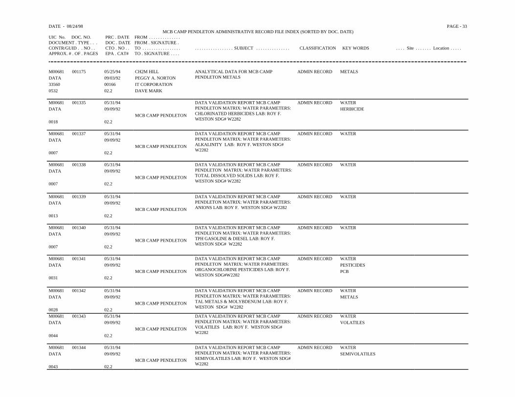
DATE - 08/24/98 PAGE - 33MCB CAMP PENDLETON ADMINISTRATIVE RECORD FILE INDEX (SORTED BY DOC. DATE)
UIC No. DOC. NO. PRC . DATE FROM . . . . . . . . . . . . . .DOCUMENT . TYPE . . . DOC . DATE FROM . SIGNATURE .CONTR/GUID . . NO . . CTO . NO . . TO . . . . . . . . . . . . . . . . . . . . . . . . . . . . . . . . . . SUBJECT . . . . . . . . . . . . . . . CLASSIFICATION KEY WORDS . . . . Site . . . . . . . Location . . . . .APPROX. # . OF . PAGES EPA . CAT# TO . SIGNATURE . . . .
M00681 001175 05/25/94 CH2M HILL ANALYTICAL DATA FOR MCB CAMPPENDLETON METALS
ADMIN RECORD METALSDATA 09/03/92 PEGGY A. NORTON 33560 00166 IT CORPORATION0532 02.2 DAVE MARK
M00681 001335 05/31/94 DATA VALIDATION REPORT MCB CAMPPENDLETON MATRIX: WATER PARAMETERS:CHLORINATED HERBICIDES LAB: ROY F.WESTON SDG# W2282
ADMIN RECORD WATERDATA 09/09/92 HERBICIDE
MCB CAMP PENDLETON0018 02.2
M00681 001337 05/31/94 DATA VALIDATION REPORT MCB CAMPPENDLETON MATRIX: WATER PARAMETERS:ALKALINITY LAB: ROY F. WESTON SDG# W2282
ADMIN RECORD WATERDATA 09/09/92
MCB CAMP PENDLETON0007 02.2
M00681 001338 05/31/94 DATA VALIDATION REPORT MCB CAMPPENDLETON MATRIX: WATER PARAMETERS:TOTAL DISSOLVED SOLIDS LAB: ROY F. WESTON SDG# W2282
ADMIN RECORD WATERDATA 09/09/92
MCB CAMP PENDLETON0007 02.2
M00681 001339 05/31/94 DATA VALIDATION REPORT MCB CAMPPENDLETON MATRIX: WATER PARAMETERS:ANIONS LAB: ROY F. WESTON SDG# W2282
ADMIN RECORD WATERDATA 09/09/92
MCB CAMP PENDLETON0013 02.2
M00681 001340 05/31/94 DATA VALIDATION REPORT MCB CAMPPENDLETON MATRIX: WATER PARAMETERS:TPH GASOLINE & DIESEL LAB: ROY F. WESTON SDG# W2282
ADMIN RECORD WATERDATA 09/09/92
MCB CAMP PENDLETON0007 02.2
M00681 001341 05/31/94 DATA VALIDATION REPORT MCB CAMPPENDLETON MATRIX: WATER PARMETERS:ORGANOCHLORINE PESTICIDES LAB: ROY F.WESTON SDG#W2282
ADMIN RECORD WATERDATA 09/09/92 PESTICIDES
MCB CAMP PENDLETON PCB0031 02.2
M00681 001342 05/31/94 DATA VALIDATION REPORT MCB CAMPPENDLETON MATRIX: WATER PARAMETERS:TAL METALS & MOLYBDENUM LAB: ROY F. WESTON SDG# W2282
ADMIN RECORD WATERDATA 09/09/92 METALS
MCB CAMP PENDLETON0028 02.2M00681 001343 05/31/94 DATA VALIDATION REPORT MCB CAMP
PENDLETON MATRIX: WATER PARAMETERS:VOLATILES LAB: ROY F. WESTON SDG#W2282
ADMIN RECORD WATERDATA 09/09/92 VOLATILES
MCB CAMP PENDLETON0044 02.2
M00681 001344 05/31/94 DATA VALIDATION REPORT MCB CAMPPENDLETON MATRIX: WATER PARAMETERS:SEMIVOLATILES LAB: ROY F. WESTON SDG#W2282
ADMIN RECORD WATERDATA 09/09/92 SEMIVOLATILES
MCB CAMP PENDLETON0043 02.2
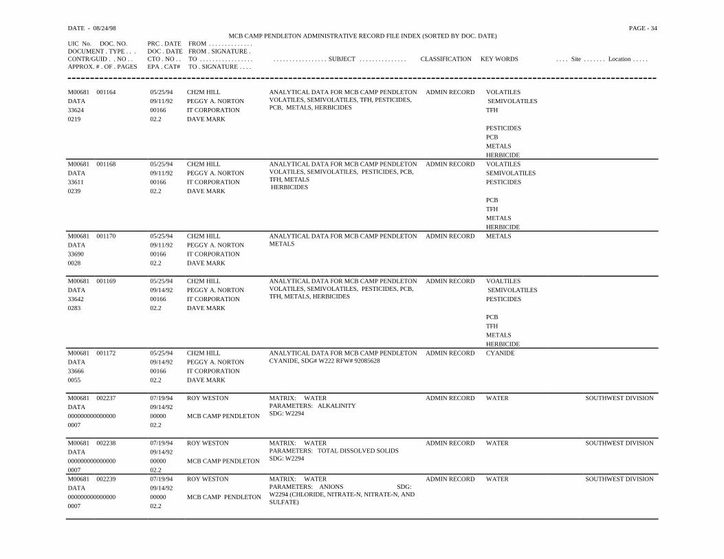
DATE - 08/24/98 PAGE - 34MCB CAMP PENDLETON ADMINISTRATIVE RECORD FILE INDEX (SORTED BY DOC. DATE)
UIC No. DOC. NO. PRC . DATE FROM . . . . . . . . . . . . . .DOCUMENT . TYPE . . . DOC . DATE FROM . SIGNATURE .CONTR/GUID . . NO . . CTO . NO . . TO . . . . . . . . . . . . . . . . . . . . . . . . . . . . . . . . . . SUBJECT . . . . . . . . . . . . . . . CLASSIFICATION KEY WORDS . . . . Site . . . . . . . Location . . . . .APPROX. # . OF . PAGES EPA . CAT# TO . SIGNATURE . . . .
M00681 001164 05/25/94 CH2M HILL ANALYTICAL DATA FOR MCB CAMP PENDLETON VOLATILES, SEMIVOLATILES, TFH, PESTICIDES,PCB, METALS, HERBICIDES
ADMIN RECORD VOLATILESDATA 09/11/92 PEGGY A. NORTON SEMIVOLATILES33624 00166 IT CORPORATION TFH0219 02.2 DAVE MARK
PESTICIDES PCBMETALS HERBICIDE
M00681 001168 05/25/94 CH2M HILL ANALYTICAL DATA FOR MCB CAMP PENDLETONVOLATILES, SEMIVOLATILES, PESTICIDES, PCB,TFH, METALS HERBICIDES
ADMIN RECORD VOLATILESDATA 09/11/92 PEGGY A. NORTON SEMIVOLATILES33611 00166 IT CORPORATION PESTICIDES0239 02.2 DAVE MARK
PCB TFHMETALS HERBICIDE
M00681 001170 05/25/94 CH2M HILL ANALYTICAL DATA FOR MCB CAMP PENDLETON METALS
ADMIN RECORD METALSDATA 09/11/92 PEGGY A. NORTON33690 00166 IT CORPORATION0028 02.2 DAVE MARK
M00681 001169 05/25/94 CH2M HILL ANALYTICAL DATA FOR MCB CAMP PENDLETONVOLATILES, SEMIVOLATILES, PESTICIDES, PCB,TFH, METALS, HERBICIDES
ADMIN RECORD VOALTILESDATA 09/14/92 PEGGY A. NORTON SEMIVOLATILES33642 00166 IT CORPORATION PESTICIDES0283 02.2 DAVE MARK
PCB TFHMETALS HERBICIDE
M00681 001172 05/25/94 CH2M HILL ANALYTICAL DATA FOR MCB CAMP PENDLETON CYANIDE, SDG# W222 RFW# 92085628
ADMIN RECORD CYANIDEDATA 09/14/92 PEGGY A. NORTON33666 00166 IT CORPORATION0055 02.2 DAVE MARK
M00681 002237 07/19/94 ROY WESTON MATRIX: WATERPARAMETERS: ALKALINITYSDG: W2294
ADMIN RECORD WATER SOUTHWEST DIVISIONDATA 09/14/92000000000000000 00000 MCB CAMP PENDLETON0007 02.2
M00681 002238 07/19/94 ROY WESTON MATRIX: WATERPARAMETERS: TOTAL DISSOLVED SOLIDS SDG: W2294
ADMIN RECORD WATER SOUTHWEST DIVISIONDATA 09/14/92000000000000000 00000 MCB CAMP PENDLETON0007 02.2M00681 002239 07/19/94 ROY WESTON MATRIX: WATER
PARAMETERS: ANIONS SDG:W2294 (CHLORIDE, NITRATE-N, NITRATE-N, ANDSULFATE)
ADMIN RECORD WATER SOUTHWEST DIVISIONDATA 09/14/92000000000000000 00000 MCB CAMP PENDLETON0007 02.2
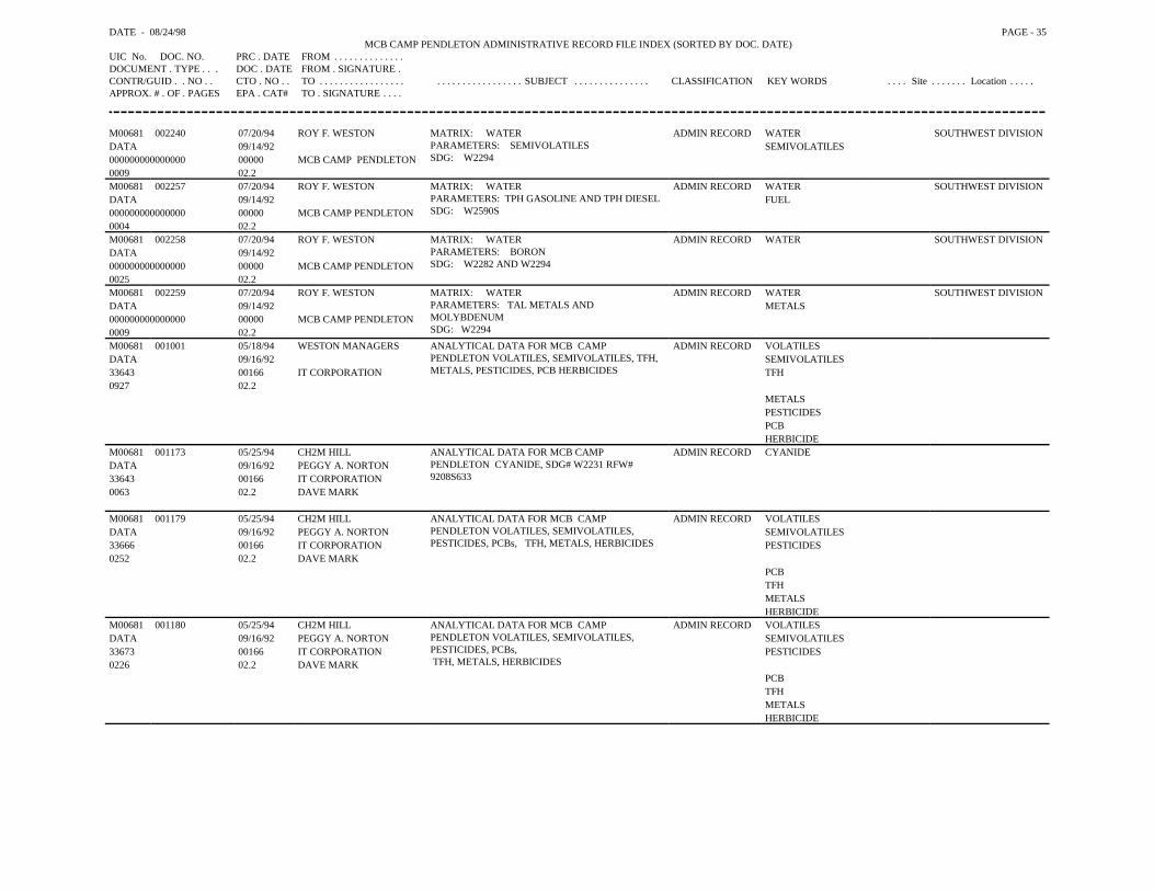
DATE - 08/24/98 PAGE - 35MCB CAMP PENDLETON ADMINISTRATIVE RECORD FILE INDEX (SORTED BY DOC. DATE)
UIC No. DOC. NO. PRC . DATE FROM . . . . . . . . . . . . . .DOCUMENT . TYPE . . . DOC . DATE FROM . SIGNATURE .CONTR/GUID . . NO . . CTO . NO . . TO . . . . . . . . . . . . . . . . . . . . . . . . . . . . . . . . . . SUBJECT . . . . . . . . . . . . . . . CLASSIFICATION KEY WORDS . . . . Site . . . . . . . Location . . . . .APPROX. # . OF . PAGES EPA . CAT# TO . SIGNATURE . . . .
M00681 002240 07/20/94 ROY F. WESTON MATRIX: WATERPARAMETERS: SEMIVOLATILESSDG: W2294
ADMIN RECORD WATER SOUTHWEST DIVISIONDATA 09/14/92 SEMIVOLATILES000000000000000 00000 MCB CAMP PENDLETON0009 02.2M00681 002257 07/20/94 ROY F. WESTON MATRIX: WATER
PARAMETERS: TPH GASOLINE AND TPH DIESELSDG: W2590S
ADMIN RECORD WATER SOUTHWEST DIVISIONDATA 09/14/92 FUEL000000000000000 00000 MCB CAMP PENDLETON0004 02.2M00681 002258 07/20/94 ROY F. WESTON MATRIX: WATER
PARAMETERS: BORONSDG: W2282 AND W2294
ADMIN RECORD WATER SOUTHWEST DIVISIONDATA 09/14/92000000000000000 00000 MCB CAMP PENDLETON0025 02.2M00681 002259 07/20/94 ROY F. WESTON MATRIX: WATER
PARAMETERS: TAL METALS ANDMOLYBDENUMSDG: W2294
ADMIN RECORD WATER SOUTHWEST DIVISIONDATA 09/14/92 METALS000000000000000 00000 MCB CAMP PENDLETON0009 02.2M00681 001001 05/18/94 WESTON MANAGERS ANALYTICAL DATA FOR MCB CAMP
PENDLETON VOLATILES, SEMIVOLATILES, TFH,METALS, PESTICIDES, PCB HERBICIDES
ADMIN RECORD VOLATILESDATA 09/16/92 SEMIVOLATILES33643 00166 IT CORPORATION TFH0927 02.2
METALSPESTICIDESPCBHERBICIDE
M00681 001173 05/25/94 CH2M HILL ANALYTICAL DATA FOR MCB CAMPPENDLETON CYANIDE, SDG# W2231 RFW#9208S633
ADMIN RECORD CYANIDEDATA 09/16/92 PEGGY A. NORTON33643 00166 IT CORPORATION0063 02.2 DAVE MARK
M00681 001179 05/25/94 CH2M HILL ANALYTICAL DATA FOR MCB CAMPPENDLETON VOLATILES, SEMIVOLATILES,PESTICIDES, PCBs, TFH, METALS, HERBICIDES
ADMIN RECORD VOLATILESDATA 09/16/92 PEGGY A. NORTON SEMIVOLATILES33666 00166 IT CORPORATION PESTICIDES0252 02.2 DAVE MARK
PCBTFHMETALSHERBICIDE
M00681 001180 05/25/94 CH2M HILL ANALYTICAL DATA FOR MCB CAMPPENDLETON VOLATILES, SEMIVOLATILES,PESTICIDES, PCBs, TFH, METALS, HERBICIDES
ADMIN RECORD VOLATILESDATA 09/16/92 PEGGY A. NORTON SEMIVOLATILES33673 00166 IT CORPORATION PESTICIDES0226 02.2 DAVE MARK
PCBTFHMETALSHERBICIDE
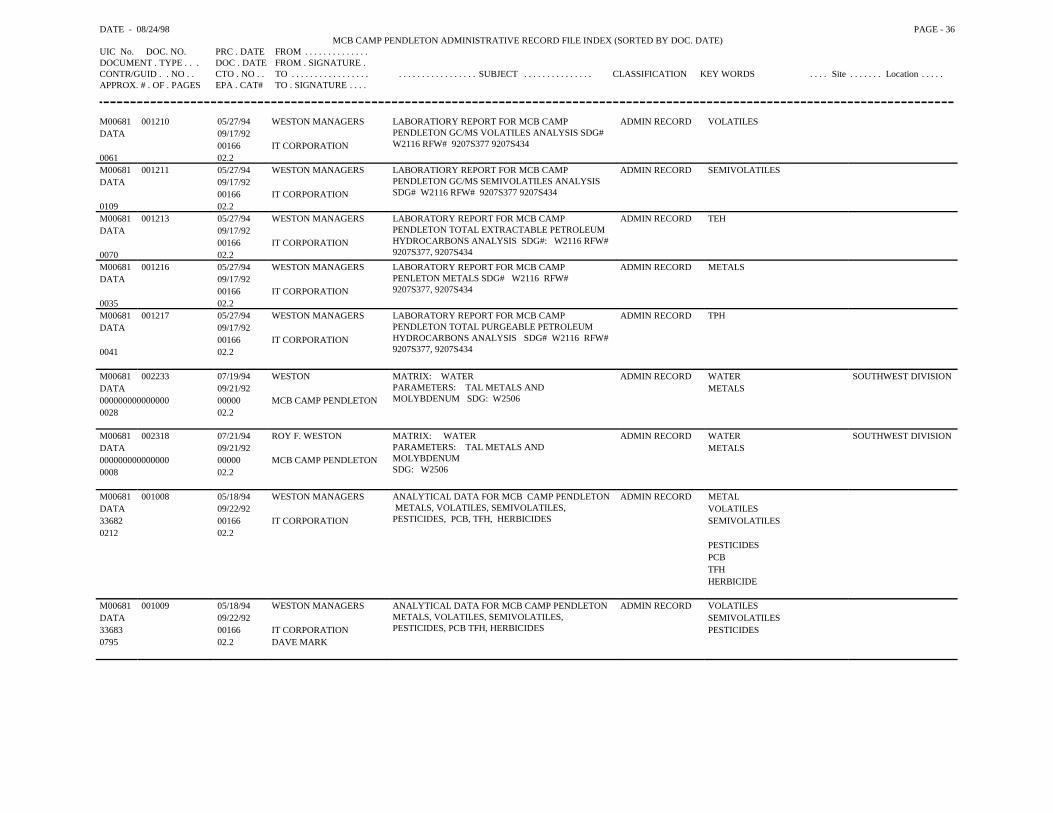
DATE - 08/24/98 PAGE - 36MCB CAMP PENDLETON ADMINISTRATIVE RECORD FILE INDEX (SORTED BY DOC. DATE)
UIC No. DOC. NO. PRC . DATE FROM . . . . . . . . . . . . . .DOCUMENT . TYPE . . . DOC . DATE FROM . SIGNATURE .CONTR/GUID . . NO . . CTO . NO . . TO . . . . . . . . . . . . . . . . . . . . . . . . . . . . . . . . . . SUBJECT . . . . . . . . . . . . . . . CLASSIFICATION KEY WORDS . . . . Site . . . . . . . Location . . . . .APPROX. # . OF . PAGES EPA . CAT# TO . SIGNATURE . . . .
M00681 001210 05/27/94 WESTON MANAGERS LABORATIORY REPORT FOR MCB CAMPPENDLETON GC/MS VOLATILES ANALYSIS SDG# W2116 RFW# 9207S377 9207S434
ADMIN RECORD VOLATILESDATA 09/17/92
00166 IT CORPORATION0061 02.2M00681 001211 05/27/94 WESTON MANAGERS LABORATIORY REPORT FOR MCB CAMP
PENDLETON GC/MS SEMIVOLATILES ANALYSISSDG# W2116 RFW# 9207S377 9207S434
ADMIN RECORD SEMIVOLATILESDATA 09/17/92
00166 IT CORPORATION0109 02.2M00681 001213 05/27/94 WESTON MANAGERS LABORATORY REPORT FOR MCB CAMP
PENDLETON TOTAL EXTRACTABLE PETROLEUMHYDROCARBONS ANALYSIS SDG#: W2116 RFW# 9207S377, 9207S434
ADMIN RECORD TEHDATA 09/17/92
00166 IT CORPORATION0070 02.2M00681 001216 05/27/94 WESTON MANAGERS LABORATORY REPORT FOR MCB CAMP
PENLETON METALS SDG# W2116 RFW# 9207S377, 9207S434
ADMIN RECORD METALSDATA 09/17/92
00166 IT CORPORATION0035 02.2M00681 001217 05/27/94 WESTON MANAGERS LABORATORY REPORT FOR MCB CAMP
PENDLETON TOTAL PURGEABLE PETROLEUMHYDROCARBONS ANALYSIS SDG# W2116 RFW# 9207S377, 9207S434
ADMIN RECORD TPHDATA 09/17/92
00166 IT CORPORATION0041 02.2
M00681 002233 07/19/94 WESTON MATRIX: WATERPARAMETERS: TAL METALS ANDMOLYBDENUM SDG: W2506
ADMIN RECORD WATER SOUTHWEST DIVISIONDATA 09/21/92 METALS000000000000000 00000 MCB CAMP PENDLETON0028 02.2
M00681 002318 07/21/94 ROY F. WESTON MATRIX: WATERPARAMETERS: TAL METALS ANDMOLYBDENUMSDG: W2506
ADMIN RECORD WATER SOUTHWEST DIVISIONDATA 09/21/92 METALS000000000000000 00000 MCB CAMP PENDLETON0008 02.2
M00681 001008 05/18/94 WESTON MANAGERS ANALYTICAL DATA FOR MCB CAMP PENDLETON METALS, VOLATILES, SEMIVOLATILES, PESTICIDES, PCB, TFH, HERBICIDES
ADMIN RECORD METALDATA 09/22/92 VOLATILES33682 00166 IT CORPORATION SEMIVOLATILES0212 02.2
PESTICIDESPCBTFHHERBICIDE
M00681 001009 05/18/94 WESTON MANAGERS ANALYTICAL DATA FOR MCB CAMP PENDLETONMETALS, VOLATILES, SEMIVOLATILES,PESTICIDES, PCB TFH, HERBICIDES
ADMIN RECORD VOLATILESDATA 09/22/92 SEMIVOLATILES33683 00166 IT CORPORATION PESTICIDES0795 02.2 DAVE MARK
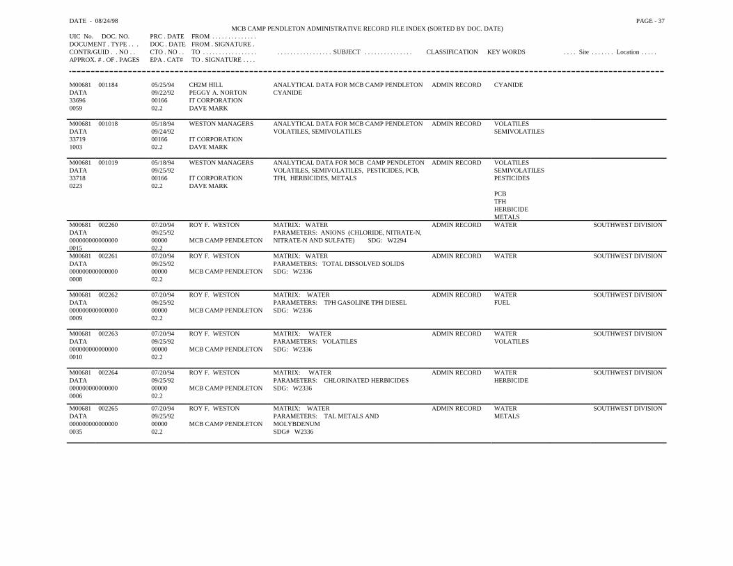
DATE - 08/24/98 PAGE - 37MCB CAMP PENDLETON ADMINISTRATIVE RECORD FILE INDEX (SORTED BY DOC. DATE)
UIC No. DOC. NO. PRC . DATE FROM . . . . . . . . . . . . . .DOCUMENT . TYPE . . . DOC . DATE FROM . SIGNATURE .CONTR/GUID . . NO . . CTO . NO . . TO . . . . . . . . . . . . . . . . . . . . . . . . . . . . . . . . . . SUBJECT . . . . . . . . . . . . . . . CLASSIFICATION KEY WORDS . . . . Site . . . . . . . Location . . . . .APPROX. # . OF . PAGES EPA . CAT# TO . SIGNATURE . . . .
M00681 001184 05/25/94 CH2M HILL ANALYTICAL DATA FOR MCB CAMP PENDLETONCYANIDE
ADMIN RECORD CYANIDEDATA 09/22/92 PEGGY A. NORTON33696 00166 IT CORPORATION0059 02.2 DAVE MARK
M00681 001018 05/18/94 WESTON MANAGERS ANALYTICAL DATA FOR MCB CAMP PENDLETONVOLATILES, SEMIVOLATILES
ADMIN RECORD VOLATILESDATA 09/24/92 SEMIVOLATILES33719 00166 IT CORPORATION1003 02.2 DAVE MARK
M00681 001019 05/18/94 WESTON MANAGERS ANALYTICAL DATA FOR MCB CAMP PENDLETONVOLATILES, SEMIVOLATILES, PESTICIDES, PCB,TFH, HERBICIDES, METALS
ADMIN RECORD VOLATILESDATA 09/25/92 SEMIVOLATILES33718 00166 IT CORPORATION PESTICIDES0223 02.2 DAVE MARK
PCBTFHHERBICIDEMETALS
M00681 002260 07/20/94 ROY F. WESTON MATRIX: WATERPARAMETERS: ANIONS (CHLORIDE, NITRATE-N,NITRATE-N AND SULFATE) SDG: W2294
ADMIN RECORD WATER SOUTHWEST DIVISIONDATA 09/25/92000000000000000 00000 MCB CAMP PENDLETON0015 02.2M00681 002261 07/20/94 ROY F. WESTON MATRIX: WATER
PARAMETERS: TOTAL DISSOLVED SOLIDSSDG: W2336
ADMIN RECORD WATER SOUTHWEST DIVISIONDATA 09/25/92000000000000000 00000 MCB CAMP PENDLETON0008 02.2
M00681 002262 07/20/94 ROY F. WESTON MATRIX: WATERPARAMETERS: TPH GASOLINE TPH DIESELSDG: W2336
ADMIN RECORD WATER SOUTHWEST DIVISIONDATA 09/25/92 FUEL000000000000000 00000 MCB CAMP PENDLETON0009 02.2
M00681 002263 07/20/94 ROY F. WESTON MATRIX: WATERPARAMETERS: VOLATILESSDG: W2336
ADMIN RECORD WATER SOUTHWEST DIVISIONDATA 09/25/92 VOLATILES000000000000000 00000 MCB CAMP PENDLETON0010 02.2
M00681 002264 07/20/94 ROY F. WESTON MATRIX: WATERPARAMETERS: CHLORINATED HERBICIDESSDG: W2336
ADMIN RECORD WATER SOUTHWEST DIVISIONDATA 09/25/92 HERBICIDE000000000000000 00000 MCB CAMP PENDLETON0006 02.2
M00681 002265 07/20/94 ROY F. WESTON MATRIX: WATERPARAMETERS: TAL METALS ANDMOLYBDENUMSDG# W2336
ADMIN RECORD WATER SOUTHWEST DIVISIONDATA 09/25/92 METALS000000000000000 00000 MCB CAMP PENDLETON0035 02.2
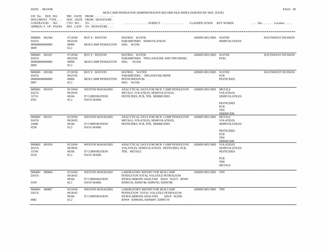
DATE - 08/24/98 PAGE - 38MCB CAMP PENDLETON ADMINISTRATIVE RECORD FILE INDEX (SORTED BY DOC. DATE)
UIC No. DOC. NO. PRC . DATE FROM . . . . . . . . . . . . . .DOCUMENT . TYPE . . . DOC . DATE FROM . SIGNATURE .CONTR/GUID . . NO . . CTO . NO . . TO . . . . . . . . . . . . . . . . . . . . . . . . . . . . . . . . . . SUBJECT . . . . . . . . . . . . . . . CLASSIFICATION KEY WORDS . . . . Site . . . . . . . Location . . . . .APPROX. # . OF . PAGES EPA . CAT# TO . SIGNATURE . . . .
M00681 002266 07/20/94 ROY F. WESTON MATRIX: WATERPARAMETERS: SEMIVOLATILESSDG: W2336
ADMIN RECORD WATER SOUTHWEST DIVISIONDATA 09/25/92 SEMIVOLATILES000000000000000 00000 MCB CAMP PENDLETON0009 02.2
M00681 002267 07/20/94 ROY F. WESTON MATRIX: WATERPARAMETERS: TPH GASOLINE AND TPH DIESELSDG: W2336
ADMIN RECORD WATER SOUTHWEST DIVISIONDATA 09/25/92 FUEL000000000000000 00000 MCB CAMP PENDLETON0009 02.2
M00681 002268 07/20/94 ROY F. WESTON MATRIX: WATERPARAMETERS: ORGANOCHLORINEPESTICIDES/PCBsSDG: W2336
ADMIN RECORD WATER SOUTHWEST DIVISIONDATA 09/25/92 PCB000000000000000 00000 MCB CAMP PENDLETON PESTICIDES0007 02.2
M00681 001010 05/18/94 WESTON MANAGERS ANALYTICAL DATA FOR MCB CAMP PENDLETONMETALS, VOLATILES, SEMIVOLATILES, PESTICIDES, PCB, TFH, HERBICIDES
ADMIN RECORD METALSDATA 09/26/92 VOLATILES33733 00166 IT CORPORATION SEMIVOLATILES0301 02.2 DAVE MARK
PESTICIDESPCBTFHHERBICIDE
M00681 001011 05/18/94 WESTON MANAGERS ANALYTICAL DATA FOR MCB CAMP PENDLETONMETALS, VOLATILES, SEMIVOLATILES, PESTICIDES, PCB, TFH, HERBICIDES
ADMIN RECORD METALSDATA 09/26/92 VOLATILES33696 00166 IT CORPORATION SEMIVOLATILES0230 02.2 DAVE MARK
PESTICIDESPCBTFHHERBICIDE
M00681 001020 05/18/94 WESTON MANAGERS ANALYTICAL DATA FOR MCB CAMP PENDLETONVOLATILES, SEMIVOLATILES, PESTICIDES, PCB,TFH, METALS
ADMIN RECORD VOLATILESDATA 09/28/92 SEMIVOLATILES33740 00166 IT CORPORATION PESTICIDES0218 02.2 DAVE MARK
PCBTFHMETALS
M00681 000866 05/18/94 WESTON MANAGERS LABORATORY REPORT FOR MCB CAMPPENDLETON TOTAL VOLATILE PETROLEUMHYROCARBONS ANALYSIS SDG# W2272 RFW# 9209S726, 9209S748, 9209S765, 9209S780
ADMIN RECORD TPHDATA 09/30/92
00166 IT CORPORATION0109 02.2 DAVE MARK
M00681 000867 05/18/94 WESTON MANAGERS LABORATORY REPORT FOR MCB CAMPPENDLETON TOTAL VOLATILE PETROLEUMHYROCARBONS ANALYSIS SDG# W2206 RFW# 9208S595, 9209S697, 9209S719
ADMIN RECORD TPHDATA 09/30/92
00166 IT CORPORATION0082 02.2
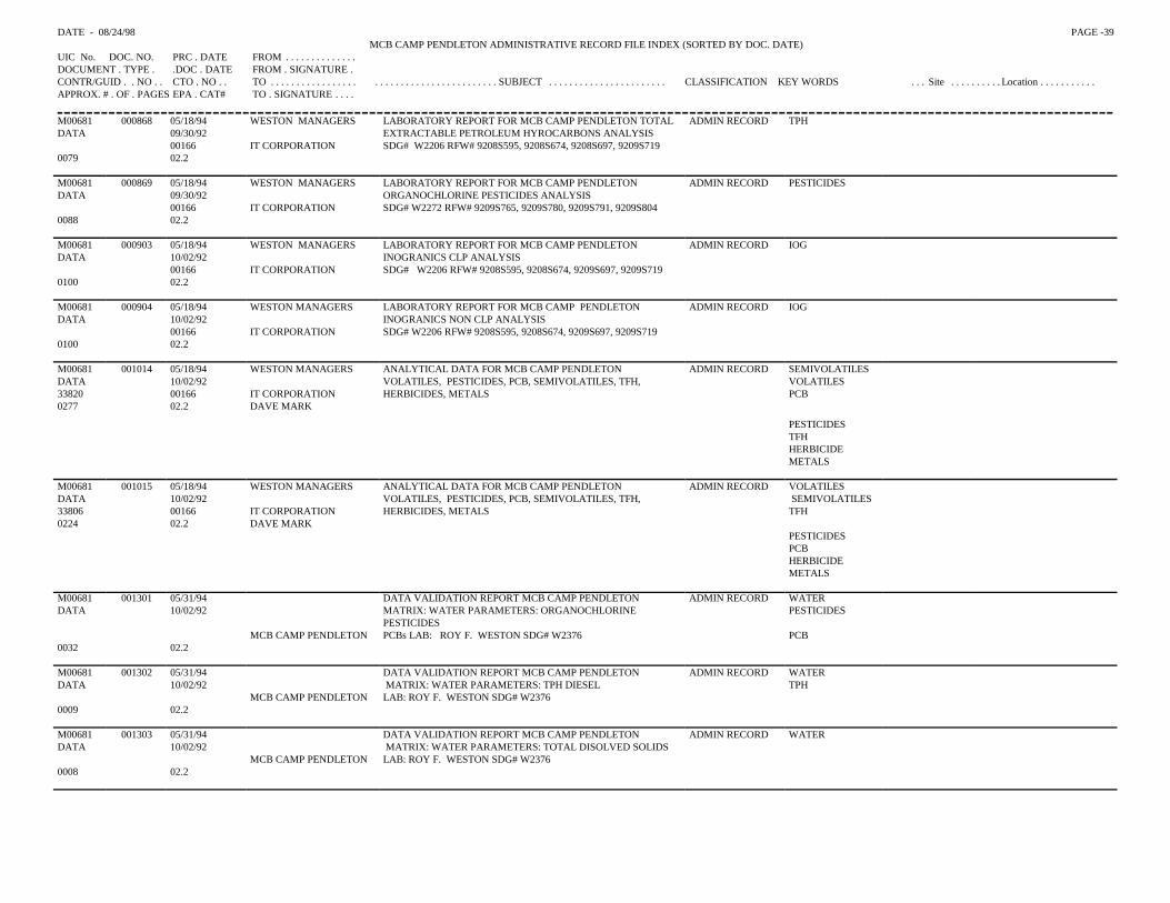
DATE - 08/24/98 PAGE -39MCB CAMP PENDLETON ADMINISTRATIVE RECORD FILE INDEX (SORTED BY DOC. DATE)
UIC No. DOC. NO. PRC . DATE FROM . . . . . . . . . . . . . .DOCUMENT . TYPE . .DOC . DATE FROM . SIGNATURE .CONTR/GUID . . NO . . CTO . NO . . TO . . . . . . . . . . . . . . . . . . . . . . . . . . . . . . . . . . . . . . . . . SUBJECT . . . . . . . . . . . . . . . . . . . . . . . CLASSIFICATION KEY WORDS . . . Site . . . . . . . . . . Location . . . . . . . . . . .APPROX. # . OF . PAGES EPA . CAT# TO . SIGNATURE . . . .
M00681 000868 05/18/94 WESTON MANAGERS LABORATORY REPORT FOR MCB CAMP PENDLETON TOTAL ADMIN RECORD TPHDATA 09/30/92 EXTRACTABLE PETROLEUM HYROCARBONS ANALYSIS
00166 IT CORPORATION SDG# W2206 RFW# 9208S595, 9208S674, 9208S697, 9209S7190079 02.2
M00681 000869 05/18/94 WESTON MANAGERS LABORATORY REPORT FOR MCB CAMP PENDLETON ADMIN RECORD PESTICIDESDATA 09/30/92 ORGANOCHLORINE PESTICIDES ANALYSIS
00166 IT CORPORATION SDG# W2272 RFW# 9209S765, 9209S780, 9209S791, 9209S8040088 02.2
M00681 000903 05/18/94 WESTON MANAGERS LABORATORY REPORT FOR MCB CAMP PENDLETON ADMIN RECORD IOGDATA 10/02/92 INOGRANICS CLP ANALYSIS
00166 IT CORPORATION SDG# W2206 RFW# 9208S595, 9208S674, 9209S697, 9209S7190100 02.2
M00681 000904 05/18/94 WESTON MANAGERS LABORATORY REPORT FOR MCB CAMP PENDLETON ADMIN RECORD IOGDATA 10/02/92 INOGRANICS NON CLP ANALYSIS
00166 IT CORPORATION SDG# W2206 RFW# 9208S595, 9208S674, 9209S697, 9209S7190100 02.2
M00681 001014 05/18/94 WESTON MANAGERS ANALYTICAL DATA FOR MCB CAMP PENDLETON ADMIN RECORD SEMIVOLATILESDATA 10/02/92 VOLATILES, PESTICIDES, PCB, SEMIVOLATILES, TFH, VOLATILES 33820 00166 IT CORPORATION HERBICIDES, METALS PCB0277 02.2 DAVE MARK
PESTICIDES TFHHERBICIDEMETALS
M00681 001015 05/18/94 WESTON MANAGERS ANALYTICAL DATA FOR MCB CAMP PENDLETON ADMIN RECORD VOLATILES DATA 10/02/92 VOLATILES, PESTICIDES, PCB, SEMIVOLATILES, TFH, SEMIVOLATILES 33806 00166 IT CORPORATION HERBICIDES, METALS TFH0224 02.2 DAVE MARK
PESTICIDES PCBHERBICIDE METALS
M00681 001301 05/31/94 DATA VALIDATION REPORT MCB CAMP PENDLETON ADMIN RECORD WATERDATA 10/02/92 MATRIX: WATER PARAMETERS: ORGANOCHLORINE
PESTICIDESPESTICIDES
MCB CAMP PENDLETON PCBs LAB: ROY F. WESTON SDG# W2376 PCB0032 02.2
M00681 001302 05/31/94 DATA VALIDATION REPORT MCB CAMP PENDLETON ADMIN RECORD WATERDATA 10/02/92 MATRIX: WATER PARAMETERS: TPH DIESEL TPH
MCB CAMP PENDLETON LAB: ROY F. WESTON SDG# W23760009 02.2
M00681 001303 05/31/94 DATA VALIDATION REPORT MCB CAMP PENDLETON ADMIN RECORD WATERDATA 10/02/92 MATRIX: WATER PARAMETERS: TOTAL DISOLVED SOLIDS
MCB CAMP PENDLETON LAB: ROY F. WESTON SDG# W23760008 02.2
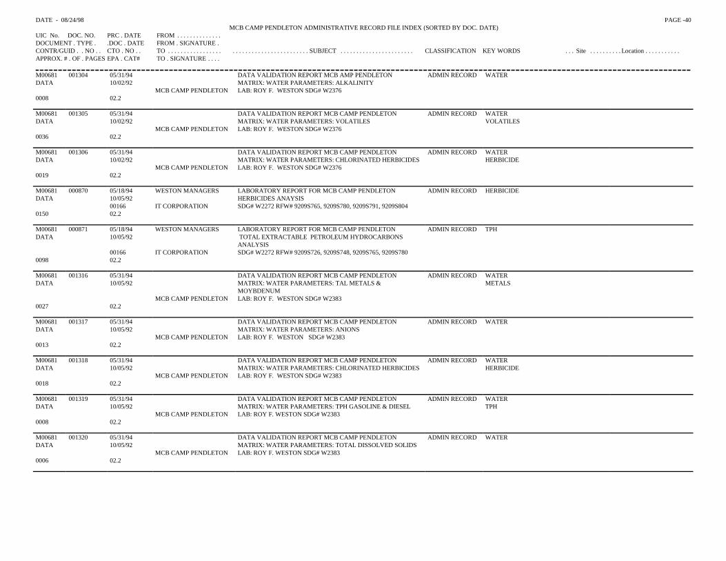
DATE - 08/24/98 PAGE -40MCB CAMP PENDLETON ADMINISTRATIVE RECORD FILE INDEX (SORTED BY DOC. DATE)
UIC No. DOC. NO. PRC . DATE FROM . . . . . . . . . . . . . .DOCUMENT . TYPE . .DOC . DATE FROM . SIGNATURE .CONTR/GUID . . NO . . CTO . NO . . TO . . . . . . . . . . . . . . . . . . . . . . . . . . . . . . . . . . . . . . . . . SUBJECT . . . . . . . . . . . . . . . . . . . . . . . CLASSIFICATION KEY WORDS . . . Site . . . . . . . . . . Location . . . . . . . . . . .APPROX. # . OF . PAGES EPA . CAT# TO . SIGNATURE . . . .
M00681 001304 05/31/94 DATA VALIDATION REPORT MCB AMP PENDLETON ADMIN RECORD WATERDATA 10/02/92 MATRIX: WATER PARAMETERS: ALKALINITY
MCB CAMP PENDLETON LAB: ROY F. WESTON SDG# W23760008 02.2
M00681 001305 05/31/94 DATA VALIDATION REPORT MCB CAMP PENDLETON ADMIN RECORD WATERDATA 10/02/92 MATRIX: WATER PARAMETERS: VOLATILES VOLATILES
MCB CAMP PENDLETON LAB: ROY F. WESTON SDG# W23760036 02.2
M00681 001306 05/31/94 DATA VALIDATION REPORT MCB CAMP PENDLETON ADMIN RECORD WATERDATA 10/02/92 MATRIX: WATER PARAMETERS: CHLORINATED HERBICIDES HERBICIDE
MCB CAMP PENDLETON LAB: ROY F. WESTON SDG# W23760019 02.2
M00681 000870 05/18/94 WESTON MANAGERS LABORATORY REPORT FOR MCB CAMP PENDLETON ADMIN RECORD HERBICIDEDATA 10/05/92 HERBICIDES ANAYSIS
00166 IT CORPORATION SDG# W2272 RFW# 9209S765, 9209S780, 9209S791, 9209S8040150 02.2
M00681 000871 05/18/94 WESTON MANAGERS LABORATORY REPORT FOR MCB CAMP PENDLETON ADMIN RECORD TPHDATA 10/05/92 TOTAL EXTRACTABLE PETROLEUM HYDROCARBONS
ANALYSIS00166 IT CORPORATION SDG# W2272 RFW# 9209S726, 9209S748, 9209S765, 9209S780
0098 02.2
M00681 001316 05/31/94 DATA VALIDATION REPORT MCB CAMP PENDLETON ADMIN RECORD WATERDATA 10/05/92 MATRIX: WATER PARAMETERS: TAL METALS &
MOYBDENUMMETALS
MCB CAMP PENDLETON LAB: ROY F. WESTON SDG# W23830027 02.2
M00681 001317 05/31/94 DATA VALIDATION REPORT MCB CAMP PENDLETON ADMIN RECORD WATERDATA 10/05/92 MATRIX: WATER PARAMETERS: ANIONS
MCB CAMP PENDLETON LAB: ROY F. WESTON SDG# W23830013 02.2
M00681 001318 05/31/94 DATA VALIDATION REPORT MCB CAMP PENDLETON ADMIN RECORD WATERDATA 10/05/92 MATRIX: WATER PARAMETERS: CHLORINATED HERBICIDES HERBICIDE
MCB CAMP PENDLETON LAB: ROY F. WESTON SDG# W23830018 02.2
M00681 001319 05/31/94 DATA VALIDATION REPORT MCB CAMP PENDLETON ADMIN RECORD WATERDATA 10/05/92 MATRIX: WATER PARAMETERS: TPH GASOLINE & DIESEL TPH
MCB CAMP PENDLETON LAB: ROY F. WESTON SDG# W23830008 02.2
M00681 001320 05/31/94 DATA VALIDATION REPORT MCB CAMP PENDLETON ADMIN RECORD WATERDATA 10/05/92 MATRIX: WATER PARAMETERS: TOTAL DISSOLVED SOLIDS
MCB CAMP PENDLETON LAB: ROY F. WESTON SDG# W23830006 02.2
DATE - 08/24/98 PAGE -41MCB CAMP PENDLETON ADMINISTRATIVE RECORD FILE INDEX (SORTED BY DOC. DATE)
UIC No. DOC. NO. PRC . DATE FROM . . . . . . . . . . . . . .DOCUMENT . TYPE . .DOC . DATE FROM . SIGNATURE .CONTR/GUID . . NO . . CTO . NO . . TO . . . . . . . . . . . . . . . . . . . . . . . . . . . . . . . . . . . . . . . . . SUBJECT . . . . . . . . . . . . . . . . . . . . . . . CLASSIFICATION KEY WORDS . . . Site . . . . . . . . . . Location . . . . . . . . . . .APPROX. # . OF . PAGES EPA . CAT# TO . SIGNATURE . . . .
M00681 001321 05/31/94 DATA VALIDATION REPORT MCB CAMP PENDLETONMATRIX: WATER PARAMETERS: ORGANOCHLORINEPESTICIDE PCBs LAB: ROY F. WESTON SDG# W2383
ADMIN RECORD WATERDATA 10/05/92 PESTICIDES
MCB CAMP PENDLETON PCB0029 02.2
M00681 001322 05/31/94 DATA VALIDATION REPORT MCB CAMP PENDLETONMATRIX: WATER PARAMETERS: ALKALINITY LAB: ROY F. WESTON SDG# W2383
ADMIN RECORD WATERDATA 10/05/92
MCB CAMP PENDLETON0007 02.2
M00681 001323 05/31/94 DATA VALIDATION REPORT MCB CAMP PENDLETONMATRIX: WATER PARAMETERS: SEMIVOLATILESLAB: ROY F. WESTON SDG# W2383
ADMIN RECORD WATERDATA 10/05/92 SEMIVOLATILES
MCB CAMP PENDLETON0058 02.2
M00681 001324 05/31/94 DATA VALIDATION REPORT MCB CAMP PENDLETONMATRIX: WATER PARAMETERS: VOLATILESLAB: ROY F. WESTON SDG# W2383
ADMIN RECORD WATERDATA 10/05/92 VOLATILES
MCB CAMP PENDLETON0041 02.2
M00681 001325 05/31/94 DATA VALIDATION REPORT MCB CAMP PENDLETONMATRIX: WATER PARAMETERS: ANIONSLAB: ROY F. WESTON SDG# W2376
ADMIN RECORD WATERDATA 10/05/92
00166 MCB CAMP PENDLETON0017 02.2
M00681 000872 05/18/94 WESTON MANAGERS LABORATORY REPORT FOR MCB CAMP PENDLETON CLP/ORGANOCHLORINE PESTICIDES ANALYSIS SDG# W2282 RFW# 9209S779
ADMIN RECORD PESTICIDESDATA 10/13/92
IT CORPORATION0194 02.2
M00681 000899 05/18/94 WESTON MANAGERS LABORATORY REPORT FOR MCB CAMP PENDLETONCLP/GCMS/SEMIVOLATILE ANALYSISSDG# W2282 RFW# 9209S779, 9209S909
ADMIN RECORD SEMIVOLATILESDATA 10/13/92
00166 IT CORPORATION0207 02.2
M00681 000901 05/18/94 WESTON MANAGERS LABORATORY REPORT FOR MCB CAMP PENDLETONVOLATILE PURGEABLE PETROLEUM HYDROCARBONSANAYSIS SDG# W2282 RFW# 9209S779, 9209S909
ADMIN RECORD VOLATILESDATA 10/13/92
00166 IT CORPORATION0114 02.2
M00681 000905 05/18/94 WESTON MANAGERS LABORATORY REPORT FOR MCB CAMP PENDLETON HERBICIDES ANALYSISSDG# W2282 RFW# 9209S779
ADMIN RECORD HERBICIDEDATA 10/13/92
00166 IT CORPORATION0144 02.2
M00681 000906 05/18/94 WESTON MANAGERS LABORATORY REPORT FOR MCB CAMP PENDLETON TOTAL EXTRACTABLE HYDROCARBONS ANALYSISSDG# W2282 RFW# 9209S779, 9209S909
ADMIN RECORD TEHDATA 10/13/92
00166 IT CORPORATION0101 02.2
DATE - 08/24/98 PAGE -42MCB CAMP PENDLETON ADMINISTRATIVE RECORD FILE INDEX (SORTED BY DOC. DATE)
UIC No. DOC. NO. PRC . DATE FROM . . . . . . . . . . . . . .DOCUMENT . TYPE . .DOC . DATE FROM . SIGNATURE .CONTR/GUID . . NO . . CTO . NO . . TO . . . . . . . . . . . . . . . . . . . . . . . . . . . . . . . . . . . . . . . . . SUBJECT . . . . . . . . . . . . . . . . . . . . . . . CLASSIFICATION KEY WORDS . . . Site . . . . . . . . . . Location . . . . . . . . . . .APPROX. # . OF . PAGES EPA . CAT# TO . SIGNATURE . . . .
M00681 000890 05/18/94 WESTON MANAGERS LABORATORY REPORT FOR MCB CAMP PENDLETONGC/MS SEMIVOLATILES ANALYSISSDG# W2206 RFW# 92098S595, 9208S674, 9209S697, 9209S719
ADMIN RECORD SEMIVOLATILESDATA 10/14/92
00166 IT CORPORATION0137 02.2
M00681 000902 05/18/94 WESTON MANAGERS LABORATORY REPORT FOR MCB CAMP PENDLETONGC/MS VOLATILES ANALYSISSDG# W2206 RFW# 9208S595, 9208S674, 9209S697, 9209S719
ADMIN RECORD VOLATILESDATA 10/14/92
00166 IT CORPORATION0084 02.2
M00681 000891 05/18/94 WESTON MANAGERS LABORATORY REPORT FOR MCB CAMP PENDLETONCLP/GCMS/VOLATILES ANALYSISSDG# W2282 RFW# 9209S779, 9209S909
ADMIN RECORD VOLATILESDATA 10/15/92
00166 IT CORPORATION0174 02.2
M00681 000894 05/18/94 WESTON MANAGERS LABORATORY REPROT FOR MCB CAMP PENDLETONGC/MS VOLATILES ANALYSISSDG# W2272 RFW# 9209S726, 9209S748, 9209S780, 9209S791
ADMIN RECORD VOLATILESDATA 10/19/92
00166 IT CORPORATION0130 02.2
M00681 001311 05/31/94 DATA VALIDATION REPORT MCB CAMP PENDLETONMATRIX: WATER PARAMETERS: ALKALINITYLAB: ROY F. WESTON SDG# S2506
ADMIN RECORD WATERDATA 10/19/92
MCB CAMP PENDLETON0008 02.2
M00681 000892 05/18/94 ROY F. WESTON LABORATORY REPORT FOR MCB CAMP PENDLETONINORGANICS NON CLP ANALYSISSDG: W2272 RFW# 9209S726, 9209S765, 9209S765, 9209S780
ADMIN RECORD IOGDATA 10/20/92
00166 IT CORPORATION0250 02.2
M00681 000895 05/18/94 WESTON MANAGERS LABORATORY REPORT FOR MCB CAMP PENDLETONINORGANICS CLP ANALYSISSDG: W2272 RFW# 9209S726, 9209S748, 9209S765, 9209S780
ADMIN RECORD IOGDATA 10/20/92
00166 IT CORPORATION0200 02.2
M00681 000893 05/18/94 WESTON MANAGERS LABORATORY REPORT FOR MCB CAMP PENDLETONTOTAL VOLATILE PETROLEUM HYDROCARBONS ANALYSISSDG: W2336 RFW# 9209S942, 9209S949, 9209S957, 9210S004
ADMIN RECORD TPHDATA 10/21/92
00166 IT CORPORATION0102 02.2
M00681 000896 05/18/94 WESTON MANAGERS LABORATORY REPORT FOR MCB CAMP PENDLETONGC/MS MOLATILES ANALYSISSDG# W2336 RFW# 9209S942, 9209S949, 9209S957, 9210S004
ADMIN RECORD VOLATILESDATA 10/21/92
00166 IT CORPORATION0120 02.2
M00681 000897 05/18/94 WESTON MANAGERS LABORATORY REPORT FOR MCB CAMP PENDLETON ADMIN RECORD TPHDATA 10/21/92 TOTAL VOLATILE PETROLEUM HYDROCARBONS ANALYSIS
00166 IT CORPORATIONS SDG# W2294 RFW# 9209S816, 9209S832, 9209S886, 9209S9100090 02.2
DATE - 08/24/98 PAGE -43MCB CAMP PENDLETON ADMINISTRATIVE RECORD FILE INDEX (SORTED BY DOC. DATE)
UIC No. DOC. NO. PRC . DATE FROM . . . . . . . . . . . . . .DOCUMENT . TYPE . .DOC . DATE FROM . SIGNATURE .CONTR/GUID . . NO . . CTO . NO . . TO . . . . . . . . . . . . . . . . . . . . . . . . . . . . . . . . . . . . . . . . . SUBJECT . . . . . . . . . . . . . . . . . . . . . . . CLASSIFICATION KEY WORDS . . . Site . . . . . . . . . . Location . . . . . . . . . . .APPROX. # . OF . PAGES EPA . CAT# TO . SIGNATURE . . . .
M00681 000898 05/18/94 WESTON MANAGERS LABORATORY REPORT FOR MCB CAMP PENDLETONVOLATILE PURGEABLE PETROLEUM HYDROCARBONSANALYSIS SDG# W2383 RFW# 9210S064, 9210S038
ADMIN RECORD VOLATILESDATA 10/21/92
00166 IT CORPORATION0136 02.2
M00681 000947 05/18/94 WESTON MANAGERS LABORATORY REPORT FOR MCB CAMP PENDLETONTOTAL EXTRACTABLE PETROLEUM HYDROCARBONSANALYSIS SDG# W2294 RFW# 9209S816, 9209S832, 9209S886, 9209S910
ADMIN RECORD TEH DATA 10/21/92
00166 IT CORPORATION0072 02.2
M00681 000952 05/18/94 WESTON MANAGERS LABORATORY REPORT FOR MCB CAMP PENDLETONTOTAL EXTRACTABLE PETROLEUM HYDROCARBONSANALYSISSDG: W2336 RFW# 9209S942, 9209S949, 9209S957, 9201S004
ADMIN RECORD TEHDATA 10/21/92
00166 IT CORPORATION0078 02.2
M00681 001307 05/31/94 DATA VALIDATION REPORT MCB CAMP PENDLETONMATRIX: WATER PARAMETERS: ORGANOCHLORINEPESTICIDES PCBs LAB: ROY F. WESTON SDG# S2506
ADMIN RECORD WATERDATA 10/21/92 PESTICIDE
MCB CAMPPENDLETON
PCB
0034 02.2
M00681 001308 05/31/94 DATA VALIDATION REPORT MCB CAMP PENDLETON MATRIX: WATER PARAMETERS: CHLORINATED HERBICIDESLAB: ROY F. WESTON SDG# W2506
ADMIN RECORD WATERDATA 10/21/92 HERBICIDE
MCB CAMPPENDLETON
0019 02.2
M00681 001309 05/31/94 DATA VALIDATION REPORT MCB CAMP PENDLETON MATRIX: WATER PARAMETERS: TPH GASOLINE & DIESELLAB: ROY F. WESTON SDG# W2506
ADMIN RECORD WATERDATA 10/21/92 TPH
MCB CAMPPENDLETON
0008 02.2
M00681 001310 05/31/94 DATA VALIDATION REPORT MCB CAMP PENDLETONMATRIX: WATER PARAMETERS: VOLATILESLAB: ROY F. WESTON SDG# S2506
ADMIN RECORD WATERDATA 10/21/92 VOLATILES
MCB CAMPPENDLETON
0052 02.2
M00681 001312 05/31/94 DATA VALIDATION REPORT MCB CAMP PENDLETONMATRIX: WATER PARAMETERS: ANIONS (CHLORIDE,NITRATE-N, NITRITE-N & SULFATE) LAB: ROY F. WESTON SDG# W2506
ADMIN RECORD WATERDATA 10/21/92
MCB CAMPPENDLETON0016 02.2
M00681 001313 05/31/94 DATA VALIDATION REPORT MCB CAMP PENDLETONMATRIX: WATER PARAMETERS: TOTAL DISSOLVED SOLIDES LAB: ROY F. WESTON SDG# W2506
ADMIN RECORD WATERDATA 10/21/92
MCB CAMPPENDLETON0005 02.2
M00681 001314 05/31/94 DATA VALIDATION REPORT MCB CAMP PENDLETONMATRIX: WATER PARAMETERS: SEMIVOLATILES LAB: ROY F. WESTON SDG# S2506
ADMIN RECORD WATERDATA 10/21/92 SEMIVOLATILES
MCB CAMPPENDLETON0062 02.2
DATE - 08/24/98 PAGE -44MCB CAMP PENDLETON ADMINISTRATIVE RECORD FILE INDEX (SORTED BY DOC. DATE)
UIC No. DOC. NO. PRC . DATE FROM . . . . . . . . . . . . . .DOCUMENT . TYPE . .DOC . DATE FROM . SIGNATURE .CONTR/GUID . . NO . . CTO . NO . . TO . . . . . . . . . . . . . . . . . . . . . . . . . . . . . . . . . . . . . . . . . SUBJECT . . . . . . . . . . . . . . . . . . . . . . . CLASSIFICATION KEY WORDS . . . Site . . . . . . . . . . Location . . . . . . . . . . .APPROX. # . OF . PAGES EPA . CAT# TO . SIGNATURE . . . .
M00681 001315 05/31/94 DATA VALIDATION REPORT MCB CAMP PENDLETONMATRIX: WATER PARAMETRS: METAL & MOLYBDENUMLAB: ROY F. WESTON SDG# W2506
ADMIN RECORD WATERDATA 10/21/92 METALS
MCB CAMP PENDLETON0029 02.2
M00681 000950 05/18/94 WESTON MANAGERS LABORATORY REPORT FOR MCB CAMP PENDLETONORGANOCHLORINE PESTICIDES ANALYSIS SDG# W2294RFW# 9209S816, 9209S832, 9209S886, 9209S919, 9209S934
ADMIN RECORD PESTICIDES DATA 10/22/92
00166 IT CORPORATION0080 02.2
M00681 000951 05/18/94 WESTON MANAGERS LABORATORY REPORT FOR MCB CAMP PENDLETONORGANOCHLORINE PESTICIDES ANALYSIS SDG# W2336 RFW# 9209S942, 9209S949, 9209S957, 9201S004, 9210S015
ADMIN RECORD PESTICIDESDATA 10/22/92
00166 IT CORPORATION0224 02.2
M00681 000944 05/18/94 WESTON MANAGERS LABORATORY REPORT FOR MCB CAMP PENDLETONINORGANICS CLP ANALYSIS SDG# W2294 RFW# 9209S816,9209S832, 9209S886, 9209S910, 9209S919, 9209S934
ADMIN RECORD IOGDATA 10/23/92
00166 IT CORPORATION0090 02.2
M00681 000945 05/18/94 WESTON MANAGERS LABORATORY REPORT FOR MCB CAMP PENDLETONINORGANICS NON CLP ANALYSIS SDG# 2282 RFW# 9209S779,9209S909
ADMIN RECORD IOGDATA 10/23/92
00166 IT CORPORATION0180 02.2
M00681 000953 05/18/94 WESTON MANAGERS LABORATORY REPORT FOR MCB CAMP PENDLETONINORGANICS NON CLP ANALYSIS SDG# W2294 RFW#9209S8169209S832, 9209S886, 9209S910, 9209S919, 9209S934
ADMIN RECORD IOGDATA 10/23/92
00166 IT CORPORATION0325 02.2
M00681 000956 05/18/94 WESTON MANAGERS LABORATORY REPORT FOR MCB CAMP PENDLETONTOTAL EXTRACTABLE HYDROCARBONS ANALYSIS SDG#W2383RFW# 9210S038, 9210S064
ADMIN RECORD TEHDATA 10/23/92
00166 IT CORPORATION0093 02.2
M00681 000957 05/18/94 WESTON MANAGERS LABORATORY REPORT FOR MCB CAMP PENDLETONCLP INORGANIC METALS ANALYSIS SDG# W2282 RFW#9209S7799209S909
ADMIN RECORD IOGDATA 10/23/92 METALS
00166 IT CORPORATION0162 02.2
M00681 000946 05/18/94 WESTON MANAGERS LABORATORY REPORT FOR MCB CAMP PENEDLETONGC/MS SEMIVOLATILES ANALYSIS SDG# W2336 RFW#9209S942,9209S949, 9209S957, 9210S004, 9210S015
ADMIN RECORD SEMIVOLATILES
DATA 10/26/92
00166 IT CORPORATION0180 02.2
M00681 000948 05/18/94 WESTON MANAGERS LABORATORY REPORT FOR MCB CAMP PENDLETON ADMIN RECORD HERBICIDEDATA 10/28/92 HERBICIDES ANALYSIS SDG# W2336 RFW# 9209S942,
9209S949,00166 IT CORPORATION 9209S957, 9210S004, 9210S015
0100 02.2
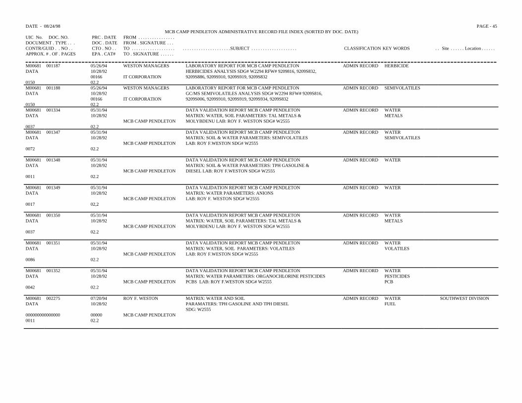
DATE - 08/24/98 PAGE - 45MCB CAMP PENDLETON ADMINISTRATIVE RECORD FILE INDEX (SORTED BY DOC. DATE)
UIC No. DOC. NO. PRC . DATE FROM . . . . . . . . . . . . . . . .DOCUMENT . TYPE . . . DOC . DATE FROM . SIGNATURE . . .CONTR/GUID . . NO . . CTO . NO . . TO . . . . . . . . . . . . . . . . . . . . . . . . . . . . . . . . . . . . . . . .SUBJECT . . . . . . . . . . . . . . . . . . . . CLASSIFICATION KEY WORDS . . Site . . . . . . Location . . . . . .APPROX. # . OF . PAGES EPA . CAT# TO . SIGNATURE . . . . . .
M00681 001187 05/26/94 WESTON MANAGERS LABORATORY REPORT FOR MCB CAMP PENDLETON ADMIN RECORD HERBICIDEDATA 10/28/92 HERBICIDES ANALYSIS SDG# W2294 RFW# 9209816, 9209S832,
00166 IT CORPORATION 9209S886, 9209S910, 9209S919, 9209S8320150 02.2M00681 001188 05/26/94 WESTON MANAGERS LABORATORY REPORT FOR MCB CAMP PENDLETON ADMIN RECORD SEMIVOLATILESDATA 10/28/92 GC/MS SEMIVOLATILES ANALYSIS SDG# W2294 RFW# 9209S816,
00166 IT CORPORATION 9209S006, 9209S910, 9209S919, 9209S934, 9209S8320150 02.2M00681 001334 05/31/94 DATA VALIDATION REPORT MCB CAMP PENDLETON ADMIN RECORD WATERDATA 10/28/92 MATRIX: WATER, SOIL PARAMETERS: TAL METALS & METALS
MCB CAMP PENDLETON MOLYBDENU LAB: ROY F. WESTON SDG# W25550037 02.2M00681 001347 05/31/94 DATA VALIDATION REPORT MCB CAMP PENDLETON ADMIN RECORD WATERDATA 10/28/92 MATRIX: SOIL & WATER PARAMETERS: SEMIVOLATILES SEMIVOLATILES
MCB CAMP PENDLETON LAB: ROY F.WESTON SDG# W25550072 02.2
M00681 001348 05/31/94 DATA VALIDATION REPORT MCB CAMP PENDLETON ADMIN RECORD WATERDATA 10/28/92 MATRIX: SOIL & WATER PARAMETERS: TPH GASOLINE &
MCB CAMP PENDLETON DIESEL LAB: ROY F.WESTON SDG# W25550011 02.2
M00681 001349 05/31/94 DATA VALIDATION REPORT MCB CAMP PENDLETON ADMIN RECORD WATERDATA 10/28/92 MATRIX: WATER PARAMETERS: ANIONS
MCB CAMP PENDLETON LAB: ROY F. WESTON SDG# W25550017 02,2
M00681 001350 05/31/94 DATA VALIDATION REPORT MCB CAMP PENDLETON ADMIN RECORD WATERDATA 10/28/92 MATRIX: WATER, SOIL PARAMETERS: TAL METALS & METALS
MCB CAMP PENDLETON MOLYBDENU LAB: ROY F. WESTON SDG# W25550037 02.2
M00681 001351 05/31/94 DATA VALIDATION REPORT MCB CAMP PENDLETON ADMIN RECORD WATERDATA 10/28/92 MATRIX: WATER, SOIL PARAMETERS: VOLATILES VOLATILES
MCB CAMP PENDLETON LAB: ROY F.WESTON SDG# W25550086 02.2
M00681 001352 05/31/94 DATA VALIDATION REPORT MCB CAMP PENDLETON ADMIN RECORD WATERDATA 10/28/92 MATRIX: WATER PARAMETERS: ORGANOCHLORINE PESTICIDES PESTICIDES
MCB CAMP PENDLETON PCBS LAB: ROY F.WESTON SDG# W2555 PCB0042 02.2
M00681 002275 07/20/94 ROY F. WESTON MATRIX: WATER AND SOIL ADMIN RECORD WATER SOUTHWEST DIVISIONDATA 10/28/92 PARAMATERS: TPH GASOLINE AND TPH DIESEL
SDG: W2555FUEL
000000000000000 00000 MCB CAMP PENDLETON0011 02.2
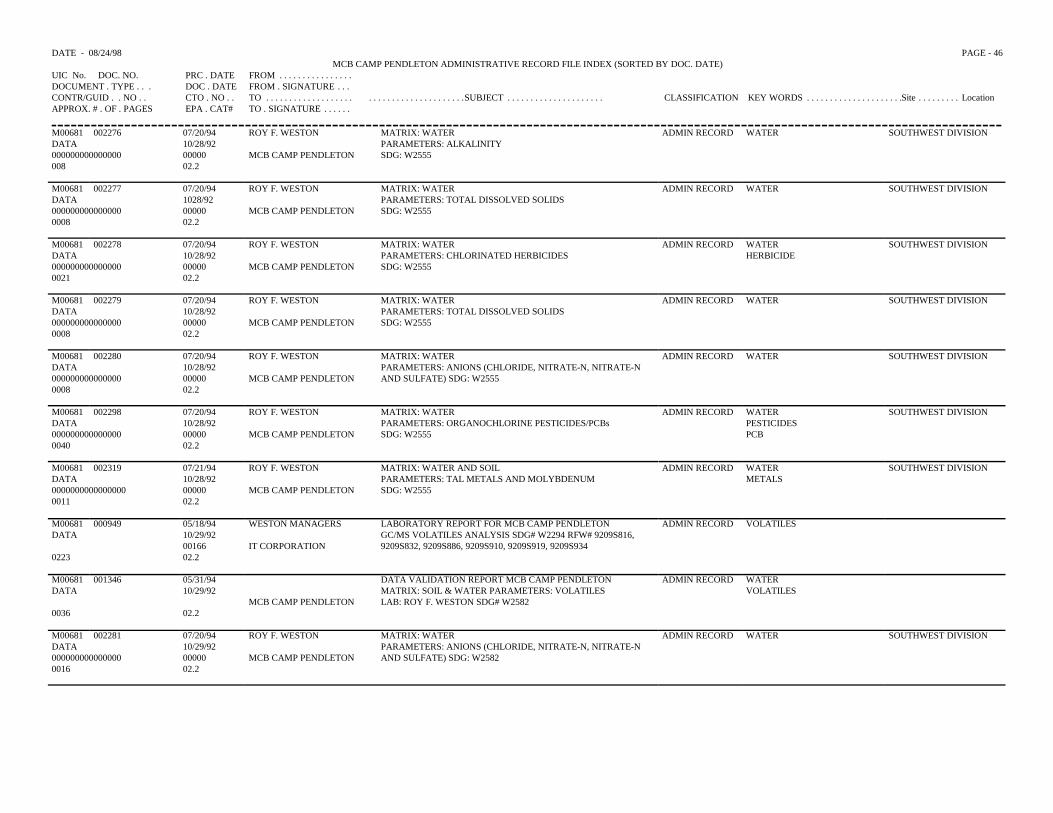
DATE - 08/24/98 PAGE - 46MCB CAMP PENDLETON ADMINISTRATIVE RECORD FILE INDEX (SORTED BY DOC. DATE)
UIC No. DOC. NO. PRC . DATE FROM . . . . . . . . . . . . . . . .DOCUMENT . TYPE . . . DOC . DATE FROM . SIGNATURE . . .CONTR/GUID . . NO . . CTO . NO . . TO . . . . . . . . . . . . . . . . . . . . . . . . . . . . . . . . . . . . . . . .SUBJECT . . . . . . . . . . . . . . . . . . . . . CLASSIFICATION KEY WORDS . . . . . . . . . . . . . . . . . . . . .Site . . . . . . . . . LocationAPPROX. # . OF . PAGES EPA . CAT# TO . SIGNATURE . . . . . .
M00681 002276 07/20/94 ROY F. WESTON MATRIX: WATER ADMIN RECORD WATER SOUTHWEST DIVISIONDATA 10/28/92 PARAMETERS: ALKALINITY000000000000000 00000 MCB CAMP PENDLETON SDG: W2555008 02.2
M00681 002277 07/20/94 ROY F. WESTON MATRIX: WATER ADMIN RECORD WATER SOUTHWEST DIVISIONDATA 1028/92 PARAMETERS: TOTAL DISSOLVED SOLIDS000000000000000 00000 MCB CAMP PENDLETON SDG: W25550008 02.2
M00681 002278 07/20/94 ROY F. WESTON MATRIX: WATER ADMIN RECORD WATER SOUTHWEST DIVISIONDATA 10/28/92 PARAMETERS: CHLORINATED HERBICIDES HERBICIDE000000000000000 00000 MCB CAMP PENDLETON SDG: W25550021 02.2
M00681 002279 07/20/94 ROY F. WESTON MATRIX: WATER ADMIN RECORD WATER SOUTHWEST DIVISIONDATA 10/28/92 PARAMETERS: TOTAL DISSOLVED SOLIDS000000000000000 00000 MCB CAMP PENDLETON SDG: W25550008 02.2
M00681 002280 07/20/94 ROY F. WESTON MATRIX: WATER ADMIN RECORD WATER SOUTHWEST DIVISIONDATA 10/28/92 PARAMETERS: ANIONS (CHLORIDE, NITRATE-N, NITRATE-N000000000000000 00000 MCB CAMP PENDLETON AND SULFATE) SDG: W25550008 02.2
M00681 002298 07/20/94 ROY F. WESTON MATRIX: WATER ADMIN RECORD WATER SOUTHWEST DIVISIONDATA 10/28/92 PARAMETERS: ORGANOCHLORINE PESTICIDES/PCBs PESTICIDES000000000000000 00000 MCB CAMP PENDLETON SDG: W2555 PCB0040 02.2
M00681 002319 07/21/94 ROY F. WESTON MATRIX: WATER AND SOIL ADMIN RECORD WATER SOUTHWEST DIVISIONDATA 10/28/92 PARAMETERS: TAL METALS AND MOLYBDENUM METALS0000000000000000 00000 MCB CAMP PENDLETON SDG: W25550011 02.2
M00681 000949 05/18/94 WESTON MANAGERS LABORATORY REPORT FOR MCB CAMP PENDLETON ADMIN RECORD VOLATILESDATA 10/29/92 GC/MS VOLATILES ANALYSIS SDG# W2294 RFW# 9209S816,
00166 IT CORPORATION 9209S832, 9209S886, 9209S910, 9209S919, 9209S9340223 02.2
M00681 001346 05/31/94 DATA VALIDATION REPORT MCB CAMP PENDLETON ADMIN RECORD WATERDATA 10/29/92 MATRIX: SOIL & WATER PARAMETERS: VOLATILES VOLATILES
MCB CAMP PENDLETON LAB: ROY F. WESTON SDG# W25820036 02.2
M00681 002281 07/20/94 ROY F. WESTON MATRIX: WATER ADMIN RECORD WATER SOUTHWEST DIVISIONDATA 10/29/92 PARAMETERS: ANIONS (CHLORIDE, NITRATE-N, NITRATE-N000000000000000 00000 MCB CAMP PENDLETON AND SULFATE) SDG: W25820016 02.2
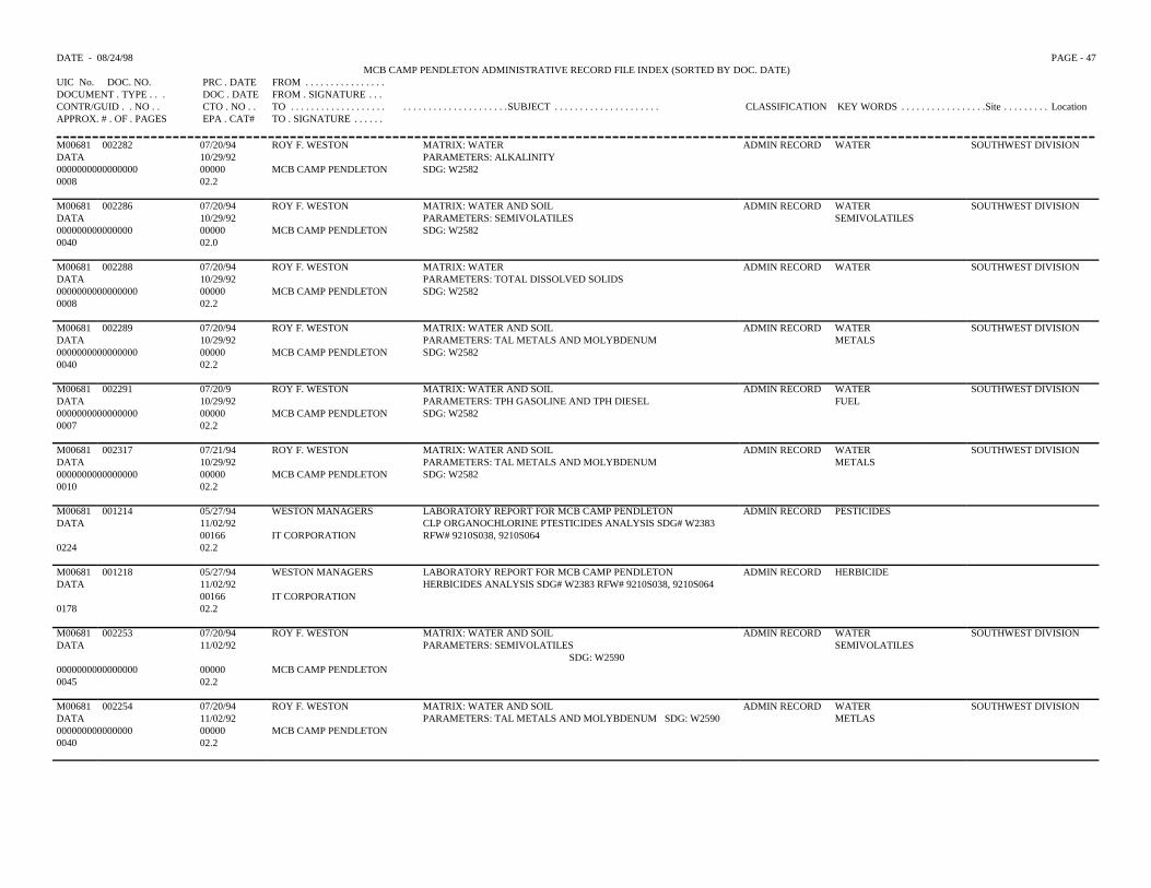
DATE - 08/24/98 PAGE - 47MCB CAMP PENDLETON ADMINISTRATIVE RECORD FILE INDEX (SORTED BY DOC. DATE)
UIC No. DOC. NO. PRC . DATE FROM . . . . . . . . . . . . . . . .DOCUMENT . TYPE . . . DOC . DATE FROM . SIGNATURE . . .CONTR/GUID . . NO . . CTO . NO . . TO . . . . . . . . . . . . . . . . . . . . . . . . . . . . . . . . . . . . . . . .SUBJECT . . . . . . . . . . . . . . . . . . . . . CLASSIFICATION KEY WORDS . . . . . . . . . . . . . . . . .Site . . . . . . . . . LocationAPPROX. # . OF . PAGES EPA . CAT# TO . SIGNATURE . . . . . .
M00681 002282 07/20/94 ROY F. WESTON MATRIX: WATER ADMIN RECORD WATER SOUTHWEST DIVISIONDATA 10/29/92 PARAMETERS: ALKALINITY0000000000000000 00000 MCB CAMP PENDLETON SDG: W25820008 02.2
M00681 002286 07/20/94 ROY F. WESTON MATRIX: WATER AND SOIL ADMIN RECORD WATER SOUTHWEST DIVISIONDATA 10/29/92 PARAMETERS: SEMIVOLATILES SEMIVOLATILES000000000000000 00000 MCB CAMP PENDLETON SDG: W25820040 02.0
M00681 002288 07/20/94 ROY F. WESTON MATRIX: WATER ADMIN RECORD WATER SOUTHWEST DIVISIONDATA 10/29/92 PARAMETERS: TOTAL DISSOLVED SOLIDS0000000000000000 00000 MCB CAMP PENDLETON SDG: W25820008 02.2
M00681 002289 07/20/94 ROY F. WESTON MATRIX: WATER AND SOIL ADMIN RECORD WATER SOUTHWEST DIVISIONDATA 10/29/92 PARAMETERS: TAL METALS AND MOLYBDENUM METALS0000000000000000 00000 MCB CAMP PENDLETON SDG: W25820040 02.2
M00681 002291 07/20/9 ROY F. WESTON MATRIX: WATER AND SOIL ADMIN RECORD WATER SOUTHWEST DIVISIONDATA 10/29/92 PARAMETERS: TPH GASOLINE AND TPH DIESEL FUEL0000000000000000 00000 MCB CAMP PENDLETON SDG: W25820007 02.2
M00681 002317 07/21/94 ROY F. WESTON MATRIX: WATER AND SOIL ADMIN RECORD WATER SOUTHWEST DIVISIONDATA 10/29/92 PARAMETERS: TAL METALS AND MOLYBDENUM METALS0000000000000000 00000 MCB CAMP PENDLETON SDG: W25820010 02.2
M00681 001214 05/27/94 WESTON MANAGERS LABORATORY REPORT FOR MCB CAMP PENDLETON ADMIN RECORD PESTICIDESDATA 11/02/92 CLP ORGANOCHLORINE PTESTICIDES ANALYSIS SDG# W2383
00166 IT CORPORATION RFW# 9210S038, 9210S0640224 02.2
M00681 001218 05/27/94 WESTON MANAGERS LABORATORY REPORT FOR MCB CAMP PENDLETON ADMIN RECORD HERBICIDEDATA 11/02/92 HERBICIDES ANALYSIS SDG# W2383 RFW# 9210S038, 9210S064
00166 IT CORPORATION0178 02.2
M00681 002253 07/20/94 ROY F. WESTON MATRIX: WATER AND SOIL ADMIN RECORD WATER SOUTHWEST DIVISIONDATA 11/02/92 PARAMETERS: SEMIVOLATILES
SDG: W2590SEMIVOLATILES
0000000000000000 00000 MCB CAMP PENDLETON0045 02.2
M00681 002254 07/20/94 ROY F. WESTON MATRIX: WATER AND SOIL ADMIN RECORD WATER SOUTHWEST DIVISIONDATA 11/02/92 PARAMETERS: TAL METALS AND MOLYBDENUM SDG: W2590 METLAS000000000000000 00000 MCB CAMP PENDLETON0040 02.2
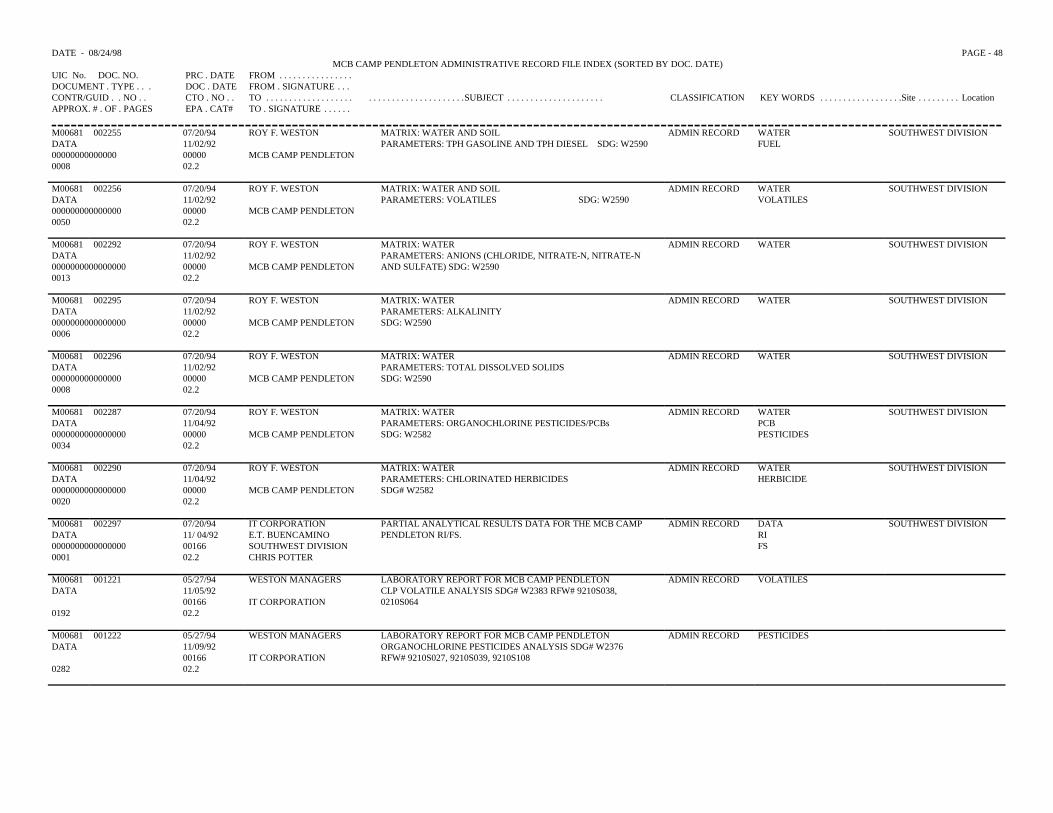
DATE - 08/24/98 PAGE - 48MCB CAMP PENDLETON ADMINISTRATIVE RECORD FILE INDEX (SORTED BY DOC. DATE)
UIC No. DOC. NO. PRC . DATE FROM . . . . . . . . . . . . . . . .DOCUMENT . TYPE . . . DOC . DATE FROM . SIGNATURE . . .CONTR/GUID . . NO . . CTO . NO . . TO . . . . . . . . . . . . . . . . . . . . . . . . . . . . . . . . . . . . . . . .SUBJECT . . . . . . . . . . . . . . . . . . . . . CLASSIFICATION KEY WORDS . . . . . . . . . . . . . . . . . .Site . . . . . . . . . LocationAPPROX. # . OF . PAGES EPA . CAT# TO . SIGNATURE . . . . . .
M00681 002255 07/20/94 ROY F. WESTON MATRIX: WATER AND SOIL ADMIN RECORD WATER SOUTHWEST DIVISIONDATA 11/02/92 PARAMETERS: TPH GASOLINE AND TPH DIESEL SDG: W2590 FUEL00000000000000 00000 MCB CAMP PENDLETON0008 02.2
M00681 002256 07/20/94 ROY F. WESTON MATRIX: WATER AND SOIL ADMIN RECORD WATER SOUTHWEST DIVISIONDATA 11/02/92 PARAMETERS: VOLATILES SDG: W2590 VOLATILES000000000000000 00000 MCB CAMP PENDLETON0050 02.2
M00681 002292 07/20/94 ROY F. WESTON MATRIX: WATER ADMIN RECORD WATER SOUTHWEST DIVISIONDATA 11/02/92 PARAMETERS: ANIONS (CHLORIDE, NITRATE-N, NITRATE-N0000000000000000 00000 MCB CAMP PENDLETON AND SULFATE) SDG: W25900013 02.2
M00681 002295 07/20/94 ROY F. WESTON MATRIX: WATER ADMIN RECORD WATER SOUTHWEST DIVISIONDATA 11/02/92 PARAMETERS: ALKALINITY0000000000000000 00000 MCB CAMP PENDLETON SDG: W25900006 02.2
M00681 002296 07/20/94 ROY F. WESTON MATRIX: WATER ADMIN RECORD WATER SOUTHWEST DIVISIONDATA 11/02/92 PARAMETERS: TOTAL DISSOLVED SOLIDS000000000000000 00000 MCB CAMP PENDLETON SDG: W25900008 02.2
M00681 002287 07/20/94 ROY F. WESTON MATRIX: WATER ADMIN RECORD WATER SOUTHWEST DIVISIONDATA 11/04/92 PARAMETERS: ORGANOCHLORINE PESTICIDES/PCBs PCB0000000000000000 00000 MCB CAMP PENDLETON SDG: W2582 PESTICIDES0034 02.2
M00681 002290 07/20/94 ROY F. WESTON MATRIX: WATER ADMIN RECORD WATER SOUTHWEST DIVISIONDATA 11/04/92 PARAMETERS: CHLORINATED HERBICIDES HERBICIDE0000000000000000 00000 MCB CAMP PENDLETON SDG# W25820020 02.2
M00681 002297 07/20/94 IT CORPORATION PARTIAL ANALYTICAL RESULTS DATA FOR THE MCB CAMP ADMIN RECORD DATA SOUTHWEST DIVISIONDATA 11/ 04/92 E.T. BUENCAMINO PENDLETON RI/FS. RI0000000000000000 00166 SOUTHWEST DIVISION FS0001 02.2 CHRIS POTTER
M00681 001221 05/27/94 WESTON MANAGERS LABORATORY REPORT FOR MCB CAMP PENDLETON ADMIN RECORD VOLATILESDATA 11/05/92 CLP VOLATILE ANALYSIS SDG# W2383 RFW# 9210S038,
00166 IT CORPORATION 0210S0640192 02.2
M00681 001222 05/27/94 WESTON MANAGERS LABORATORY REPORT FOR MCB CAMP PENDLETON ADMIN RECORD PESTICIDESDATA 11/09/92 ORGANOCHLORINE PESTICIDES ANALYSIS SDG# W2376
00166 IT CORPORATION RFW# 9210S027, 9210S039, 9210S1080282 02.2
DATE - 08/24/98 PAGE - 49MCB CAMP PENDLETON ADMINISTRATIVE RECORD FILE INDEX (SORTED BY DOC. DATE)
UIC No. DOC. NO. PRC . DATE FROM . . . . . . . . . . . . . . .DOCUMENT . TYPE . . . DOC . DATE FROM . SIGNATURE . .CONTR/GUID . . NO . . CTO . NO . . TO . . . . . . . . . . . . . . . . . . . . . . . . . . . . . . . . . . . . . . .SUBJECT . . . . . . . . . . . . . . . . . . . . . CLASSIFICATION KEY WORDS . . . . . . . . . . . . . . . . . .Site . . . . . . . . . LocationAPPROX. # . OF . PAGES EPA . CAT# TO . SIGNATURE . . . . .
M00681 001223 05/27/94 WESTON MANAGERS LABORATORY REPORT FOR MCB CAMP PENDLETON ADMIN RECORD TEHDATA 11/09/92 TOTAL EXTRACTABLE PETROLEUM HYDROCARBONS ANALYSIS TPH
00166 IT CORPORATION SDG# W2376 RFW# 9210S027, 9210S039, 9210S065, 9210S1080199 02.2M00681 001227 05/27/94 WESTON MANAGERS LABORATORY REPORT FOR MCB CAMP PENDLETON ADMIN RECORD VOLATILESDATA 11/09/92 GC/MS VOLATILES ANALYSIS SDG# W2376 RFW# 9210S027,
00166 IT CORPORATION 9210S039, 9210S065, 9210S1080349 02.0M00681 002293 07/20/94 ROY F. WESTON MATRIX: WATER ADMIN RECORD WATER SOUTHWEST DIVISIONDATA 11/10/92 PARAMETERS: ORGANOCHLORINE PESTICIDES/PCBs PESTICIDES0000000000000000 00000 MCB CAMP PENDLETON SDG: W2590 PCB0035 02.2M00681 002294 07/20/94 ROY F. WESTON MATRIX: WATER ADMIN RECORD WATER SOUTHWEST DIVISIONDATA 11/10/92 PARAMETERS: CHLORINATED HERBICIDES HERBICIDE0000000000000000 00000 MCB CAMP PENDLETON SDG: W25900018 02.2
M00681 001219 05/27/94 WESTON MANAGERS LABORATORY REPORT FOR MCB CAMP PENDLETON ADMIN RECORD IOGDATA 11/11/92 INORGANICS NON CLP ANALYSIS SDG# W2336 RFW# 9209S942,
00166 IT CORPORATION 9209S949, 9209S957, 9210S004, 9210S0150186 02.2
M00681 001220 05/27/94 WESTON MANAGERS LABORATORY REPORT FOR MCB CAMP PENDLETON ADMIN RECORD IOGDATA 11/11/92 INORGANICS CLP ANALYSIS SDG# W2336 RFW# 9209S942,
00166 IT CORPORATION 9209S949, 9209S957, 9210S004, 9210S90150173 02.2
M00681 001181 05/25/94 CH2M HILL ANALYTICAL DATA FOR MCB CAMP PENDLETON ADMIN RECORD VOLATILESDATA 11/12/92 PEGGY A. NORTON VOLATILES, SEMIVOLATILES, PESTICIDES, PCBs, SEMIVOLATILES34118 00166 IT CORPORATION TFH PESTICIDES0319 02.2 DAVE MARK
PCBTFH
M00681 001182 05/25/94 CH2M HILL ANALYTICAL DATA FOR MCB CAMP PENDLETON ADMIN RECORD VOLATILESDATA 11/12/92 PEGGY A. NORTON VOLATILES, SEMIVOLATILES, PESTICIDES, PCBs, SEMIVOLATILES34117 00166 IT CORPORATION TFH, HERBICIDES AND METALS PESTICIDES0255 02.2 DAVE MARK
PCBTFHHERBICIDEMETALS
M00681 001230 05/27/94 WESTON MANAGERS LABORATORY REPORT FOR MCB CAMP PENDLETON ADMIN RECORD SEMIVOLATILESDATA 11/13/92 CLP SEMI VOLATILES ANALYSIS SDG# W2383 RFW# 9210S038
00166 IT CORPORATION 9210S0640323 02.2
DATE - 08/24/98 PAGE - 50MCB CAMP PENDLETON ADMINISTRATIVE RECORD FILE INDEX (SORTED BY DOC. DATE)
UIC No. DOC. NO. PRC . DATE FROM . . . . . . . . . . . . . . . .DOCUMENT . TYPE . . . DOC . DATE FROM . SIGNATURE . . .CONTR/GUID . . NO . . CTO . NO . . TO . . . . . . . . . . . . . . . . . . . . . . . . . . . . . . . . . . . . . . . .SUBJECT . . . . . . . . . . . . . . . . . . . . . . . . . . . . CLASSIFICATION KEY WORDS . . . Site . . . . . . . . . . Location . . . . . . . . . . . .APPROX. # . OF . PAGES EPA . CAT# TO . SIGNATURE . . . . . .
M00681 001345 05/31/94 DATA VALIDATION REPORT MCB CAMP PENDLETON ADMIN RECORD SEMIVOLATILESDATA 11/16/92 MATRIX: SOIL PARAMETERS: SEMIVOLATILES
MCB CAMP PENDLETON LAB: ROY F. WESTON SDG# W26280030 02.2
M00681 002269 07/20/94 ROY F. WESTON MATRIX: WATER AND SOIL ADMIN RECORD WATER SOUTHWEST DIVISIONDATA 11/16/92 PARAMETERS: VOLATILES VOLATILES0000000000000000 00000 MCB CAMP PENDLETON SDG: W26300036 02.0
M00681 002270 07/20/94 ROY F. WESTON MATRIX: WATER AND SOIL ADMIN RECORD WATER SOUTHWEST DIVISIONDATA 11/16/92 PARAMETERS: TPH GASOLINE AND TPH DIESEL FUEL0000000000000000 00000 MCB CAMP PENDLETON SDG: W26300008 02.2
M00681 002271 07/20/94 ROY F. WESTON MATRIX: WATER ADMIN RECORD WATER SOUTHWEST DIVISIONDATA 11/16/92 PARAMETERS: CHLORINATED HERBICIDES HERBICIDE0000000000000000 00000 MCB CAMP PENDLETON SDG: W26300018 02.2
M00681 002272 07/20/9 ROY F. WESTON MATRIX: WATER ADMIN RECORD WATER SOUTHWEST DIVISIONDATA 11/16/92 PARAMETERS: ORGANOCHLORINE PESTICIDES/PCBs PESTICIDES0000000000000000 00000 MCB CAMP PENDLETON SDG: W26300033 02.2
M00681 002273 07/20/94 ROY F. WESTON MATRIX: WATER AND SOIL ADMIN RECORD WATER SOUTHWEST DIVISIONDATA 11/16/92 PARAMETERS: SEMIVOLATILES SEMIVOLATILES0000000000000000 00000 MCB CAMP PENDLETON SDG: W26300040 02.2
M00681 002299 07/20/94 ROY F. WESTON MATRIX: SOIL ADMIN RECORD FUEL SOUTHWEST DIVISIONDATA 11/16/92 PARAMETERS: TPH GASOLINE AND TPH DIESEL0000000000000000 00000 MCB CAMP PENDLETON SDG: W26280006 02.2
M00681 002300 07/20/94 ROY F. WESTON MATRIX: WATER AND SOIL ADMIN RECORD WATER SOUTHWEST DIVISIONDATA 11/16/92 PARAMETERS: TAL METALS AND MOLYBDENUM METALS0000000000000000 00000 MCB CAMP PENDLETON SDG: W2628/W26300040 02.2
M00681 002301 07/20/94 ROY F. WESTON MATRIX: WATER ADMIN RECORD WATER SOUTHWEST DIVISIONDATA 11/16/92 PARAMETERS: ALKALINITY0000000000000000 00000 MCB CAMP PENDLETON SDG: W2628/W26300006 02.2
M00681 002302 07/20/94 ROY F. WESTON MATRIX: WATER ADMIN RECORD WATER SOUTHWEST DIVISIONDATA 11/16/92 PARAMATERS: TOTAL DISSOLVED SOLIDS000000000000000 00000 MCB CAMP PENDLETON SDG: W2628/W26300006 02.2
DATE - 08/24/98 PAGE - 51MCB CAMP PENDLETON ADMINISTRATIVE RECORD FILE INDEX (SORTED BY DOC. DATE)
UIC No. DOC. NO. PRC . DATE FROM . . . . . . . . . . . . . . . . . . .DOCUMENT . TYPE . . . DOC . DATE FROM . SIGNATURE . . . . .CONTR/GUID . . NO . . CTO . NO . . TO . . . . . . . . . . . . . . . . . . . . . . . . . . . . . . . . . . . . . . . . . . . . . . . . . . . . . . . . . .SUBJECT . . . . . . . . . . . . . . . . . . . . . . . . . . . . . . CLASSIFICATION KEY WORDS ...Site . . . . Location . . . . . . .APPROX. # . OF . PAGES EPA . CAT# TO . SIGNATURE . . . . . . . .
M00681 002303DATA0000000000000000011
07/20/9411/16/920000002.2
ROY F. WESTON
MCB CAMP PENDLETON
MATRIX: WATERPARAMETERS: ANIONS (CHLORIDE, NITRATE-N, NITRATE-NAND SULFATE) SDG: W2628/W2630
ADMIN RECORD WATER SOUTHWEST DIVISION
M00681 002304DATA0000000000000000030
07/20/9411/16/920000002.2
ROY F. WESTON
MCB CAMP PENDLETON
MATRIX: SOILPARAMETERS: VOLATILESSDG: W2628
ADMIN RECORD VOLATILES
M00681 002316DATA0000000000000000010
07/21/9411/16/920000002.2
ROY F. WESTON
MCB CAMP PENDLETON
MATRIX: WATER AND SOILPARAMETERS: TAL METALS AND MOLYBDENUMSDG: W2628/W2630
ADMIN RECORD WATERMETALS
M00681 000873DATA
0111
05/18/9411/17/920016602.2
WESTON MANAGERS
IT CORPORATION
LABORATORY REPORT FOR MCB CAMP PENDLETONBORON ANALYSISSDG# W2282 & W2294 RFW# 9209S779, 9209S816, 9209S832
ADMIN RECORD DATA
M00681 000874DATA
0098
05/18/9411/17/920016602.2
WESTON MANAGERS
IT CORPORATION
LABORATORY REPORT FOR MCB CAMP PENDLETONBORON ANALYSISSDG# W2272 RFW# 9209S726, 9209S748, 9209S765, 9209S780
ADMIN RECORD DATA
MO0681 000875DATA
0072
05/18/9411/17/92 0016602.2
WESTON MANAGERS
IT CORPORATION
LABORATORY REPORT FOR MCB CAMP PENDLETON BORON ANALYSISSDG# W2206 RFW# 9208S595, 9208S674, 9209S697, .9209S719
ADMIN RECORD DATA
M00681DATA
0232
000878 05/18/9411/17/920016602.2
WESTON MANAGERS
IT CORPORATION
LABORATORY REPORT FOR MCB CAMP PENDLETONCLP/GCMS/SEMIVOLATILE ANALYSISSDG# W2582 RFW# 9210S249, 920S278, 9210S292, 9211S306
ADMIN RECORD SEMIVOLATILE
M00681DATA342370176
000998 05/18/9411/17/920016602.2
WESTON MANAGERS
IT CORPORATION
ANALYTICAL DATA FOR MCB CAMP PENDLETONVOLATILES, SEMIVOLATILES, TFH, METALS
ADMIN RECORD VOIATILESSEMIVOLATILESTFH
METALSM00681DATA342180245
000999 05/18/9411/17/920016602.2
WESTON MANAGERS
IT CORPORATION
ANALYTICAL DATA FOR MCB CAMP PENDLETONVOLATILES, SEMIVOLATILES, TFH, METALS
ADMIN RECORD VOLATILESSEMIVOLATILESTFH
METALSM00681DATA
0274
000857 05/18/9411/18/920016602.2
WESTON MANAGERS
IT CORPORATION
LABORATORY REPORT FOR MCB CAMP PENDLETONVOLATILE PURGEABLE PETROLEUM HYDROCARBONS ANALYSISSDG# W2582 RFW# 9210S249, 9290S292, 9210S278, 9210S306
ADMIN RECORD VOLATILES
DATE - 08/24/98 PAGE - 52MCB CAMP PENDLETON ADMINISTRATIVE RECORD FILE INDEX (SORTED BY DOC. DATE)
UIC No. DOC. NO. PRC . DATE FROM . . . . . . . . . . . . . . .DOCUMENT . TYPE . . . DOC . DATE FROM . SIGNATURE . .CONTR/GUID . . NO . . CTO . NO . . TO . . . . . . . . . . . . . . . . . . . . . . . . . . . . . . . . . . . . . . .SUBJECT . . . . . . . . . . . . . . . . . . . . . . . . . . . . . CLASSIFICATION KEY WORDS . . . . . . . . . . . . . . . . . . . . . .Site . . . . . . . . . LocationAPPROX. # . OF . PAGES EPA . CAT# TO . SIGNATURE . . . . .
M00681 000858 05/18/94 WESTON MANAGERS LABORATORY REPORT FOR MCB CAMP PENDLETONCLP/GC/MS VOLATILES ANALYSISSDG# W2582 RFW# 9210S249, 9211S278, 9211S292, 9211S306
ADMIN RECORD VOLATILESDATA 11/19/92
00166 IT CORPORATION0324 02.2
M00681 000859 05/18/94 WESTON MANAGERS LABORATORY REPORT FOR MCB CAMP PENDLETONHERBICIDES ANALYSISSDG# W2376 RFW# 9210S027, 9210S039, 9210S065, 9210S108
ADMIN RECORD HERBICIDEDATA 11/19/92
00166 IT CORPORATION0357 02.2
M00681 000855 05/18/94 WESTON MANAGERS LABORATORY REPORT FOR MCB CAMP PENDLETONCLP/INORGANIC METALS ANALYSISSDG# W2383 RFW# 9210S038, 9210S064
ADMIN RECORD IOGDATA 11/20/92 METALS
00166 IT CORPORATION0171 02.2
M00681 000856 05/18/94 WESTON MANAGERS LABORATORY REPORT FOR MCB CAMP PENDLETONINORGANIC NON CLP ANALYSISSDG# W2383 RFW# 9210S038, 9210S064
ADMIN RECORD IOGDATA 11/20/92
00166 IT CORPORATION0188 02.2
M00681 000876 05/18/94 WESTON MANAGERS LABORATORY REPORT FOR MCB CAMP PENDLETONGC/MS SEMIVOLATILE ANALYSISSDG# W2506 RFW# 9210S164, 9210S192, 9210S219, 9210S248
ADMIN RECORD SEMIVOLATILESDATA 11/20/92
00166 IT CORPORATION0536 02.2
M00681 000877 05/18/94 WESTON MANAGERS LABORATORY REPORT FOR MCB CAMP PENDLETONGC/MS VOLATILE ANALYSISSDG# W2506 RFW# 9210S164, 9210S192, 9210S219, 9210S248
ADMIN RECORD VOLATILESDATA 11/20/92
00166 IT CORPORATION0354 02.2
M00681 001141 05/25/94 CH2M HILL ANALYTICAL DATA FOR MCB CAMP PENDLETONVOLATILES, SEMIVOLATILES, TFH, METALS
ADMIN RECORD VOLATILESDATA 11/23/92 PEGGY A. NORTON SEMIVOLATILES3427 IT CORPORATION TFH0223 02.2 DAVE MARK
METALS
M00681 001145 05/25/94 CH2M HILL ANALYTICAL DATA FOR MCB CAMP PENDLETONVOLATILES, SEMIVOLATILES, TFH, METALS
ADMIN RECORD VOLATILESDATA 11/23/92 PEGGY A. NORTON SEMIVOLATILES34314 IT CORPORATION TFH0191 02.2 DAVE MARK
METALSM00681 001146 05/25/94 CH2M HILL ANALYTICAL DATA FOR MCB CAMP PENDLETON
VOLATILES, SEMIVOLATILES, TFH, METALSADMIN RECORD VOLATILES
DATA 11/23/92 PEGGY A. NORTON SEMIVOLATILES34297 IT CORPORATION TFH0178 02.2 DAVE MARK
METALSM00681 001185 05/26/94 WESTON MANAGERS LABORATORY REPORT FOR MCBCAMP PENDLETON
GC/MS VOLATILES ANALYSIS SDG# W2555 RFW# 9210S237,9210S265, 9211S293, 9211S307, 9211S323
ADMIN RECORD VOLATILESDATA 11/24/92
00166 IT CORPORATION0573 02.2
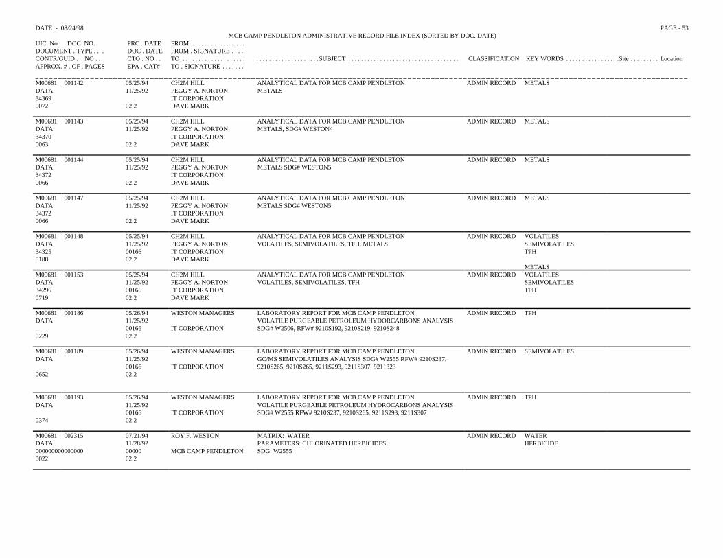
DATE - 08/24/98 PAGE - 53MCB CAMP PENDLETON ADMINISTRATIVE RECORD FILE INDEX (SORTED BY DOC. DATE)
UIC No. DOC. NO. PRC . DATE FROM . . . . . . . . . . . . . . . . .DOCUMENT . TYPE . . . DOC . DATE FROM . SIGNATURE . . . .CONTR/GUID . . NO . . CTO . NO . . TO . . . . . . . . . . . . . . . . . . . . . . . . . . . . . . . . . . . . . . . .SUBJECT . . . . . . . . . . . . . . . . . . . . . . . . . . . . . . . . . . . CLASSIFICATION KEY WORDS . . . . . . . . . . . . . . . . .Site . . . . . . . . . LocationAPPROX. # . OF . PAGES EPA . CAT# TO . SIGNATURE . . . . . . .
M00681 001142 05/25/94 CH2M HILL ANALYTICAL DATA FOR MCB CAMP PENDLETON ADMIN RECORD METALSDATA 11/25/92 PEGGY A. NORTON METALS34369 IT CORPORATION0072 02.2 DAVE MARK
M00681 001143 05/25/94 CH2M HILL ANALYTICAL DATA FOR MCB CAMP PENDLETON ADMIN RECORD METALSDATA 11/25/92 PEGGY A. NORTON METALS, SDG# WESTON434370 IT CORPORATION0063 02.2 DAVE MARK
M00681 001144 05/25/94 CH2M HILL ANALYTICAL DATA FOR MCB CAMP PENDLETON ADMIN RECORD METALSDATA 11/25/92 PEGGY A. NORTON METALS SDG# WESTON534372 IT CORPORATION0066 02.2 DAVE MARK
M00681 001147 05/25/94 CH2M HILL ANALYTICAL DATA FOR MCB CAMP PENDLETON ADMIN RECORD METALSDATA 11/25/92 PEGGY A. NORTON METALS SDG# WESTON534372 IT CORPORATION0066 02.2 DAVE MARK
M00681 001148 05/25/94 CH2M HILL ANALYTICAL DATA FOR MCB CAMP PENDLETON ADMIN RECORD VOLATILESDATA 11/25/92 PEGGY A. NORTON VOLATILES, SEMIVOLATILES, TFH, METALS SEMIVOLATILES34325 00166 IT CORPORATION TPH0188 02.2 DAVE MARK
METALSM00681 001153 05/25/94 CH2M HILL ANALYTICAL DATA FOR MCB CAMP PENDLETON ADMIN RECORD VOLATILESDATA 11/25/92 PEGGY A. NORTON VOLATILES, SEMIVOLATILES, TFH SEMIVOLATILES34296 00166 IT CORPORATION TPH0719 02.2 DAVE MARK
M00681 001186 05/26/94 WESTON MANAGERS LABORATORY REPORT FOR MCB CAMP PENDLETON ADMIN RECORD TPHDATA 11/25/92 VOLATILE PURGEABLE PETROLEUM HYDORCARBONS ANALYSIS
00166 IT CORPORATION SDG# W2506, RFW# 9210S192, 9210S219, 9210S2480229 02.2
M00681 001189 05/26/94 WESTON MANAGERS LABORATORY REPORT FOR MCB CAMP PENDLETON ADMIN RECORD SEMIVOLATILESDATA 11/25/92 GC/MS SEMIVOLATILES ANALYSIS SDG# W2555 RFW# 9210S237,
00166 IT CORPORATION 9210S265, 9210S265, 9211S293, 9211S307, 92113230652 02.2
M00681 001193 05/26/94 WESTON MANAGERS LABORATORY REPORT FOR MCB CAMP PENDLETON ADMIN RECORD TPHDATA 11/25/92 VOLATILE PURGEABLE PETROLEUM HYDROCARBONS ANALYSIS
00166 IT CORPORATION SDG# W2555 RFW# 9210S237, 9210S265, 9211S293, 9211S3070374 02.2
M00681 002315 07/21/94 ROY F. WESTON MATRIX: WATER ADMIN RECORD WATERDATA 11/28/92 PARAMETERS: CHLORINATED HERBICIDES HERBICIDE000000000000000 00000 MCB CAMP PENDLETON SDG: W2555 0022 02.2
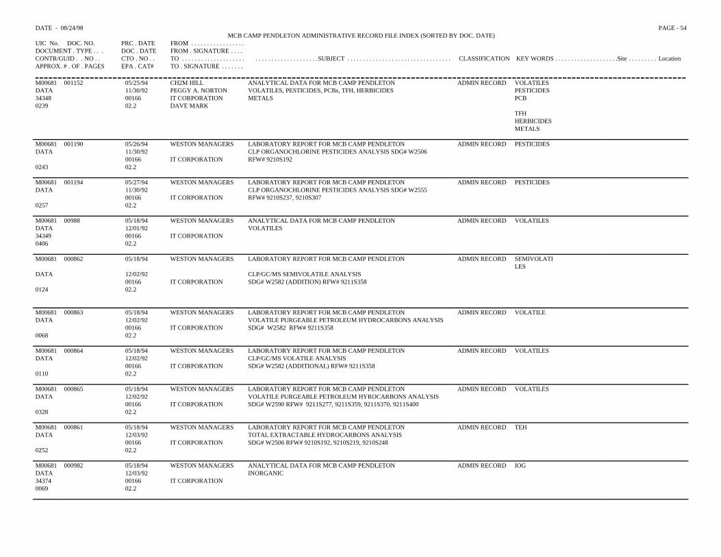
DATE - 08/24/98 PAGE - 54MCB CAMP PENDLETON ADMINISTRATIVE RECORD FILE INDEX (SORTED BY DOC. DATE)
UIC No. DOC. NO. PRC . DATE FROM . . . . . . . . . . . . . . . . .DOCUMENT . TYPE . . . DOC . DATE FROM . SIGNATURE . . . .CONTR/GUID . . NO . . CTO . NO . . TO . . . . . . . . . . . . . . . . . . . . . . . . . . . . . . . . . . . . . . . .SUBJECT . . . . . . . . . . . . . . . . . . . . . . . . . . . . . . . . . CLASSIFICATION KEY WORDS . . . . . . . . . . . . . . . . . . . .Site . . . . . . . . . LocationAPPROX. # . OF . PAGES EPA . CAT# TO . SIGNATURE . . . . . . .
M00681 001152 05/25/94 CH2M HILL ANALYTICAL DATA FOR MCB CAMP PENDLETON ADMIN RECORD VOLATILESDATA 11/30/92 PEGGY A. NORTON VOLATILES, PESTICIDES, PCBs, TFH, HERBICIDES PESTICIDES34348 00166 IT CORPORATION METALS PCB0239 02.2 DAVE MARK
TFHHERBICIDESMETALS
M00681 001190 05/26/94 WESTON MANAGERS LABORATORY REPORT FOR MCB CAMP PENDLETON ADMIN RECORD PESTICIDESDATA 11/30/92 CLP ORGANOCHLORINE PESTICIDES ANALYSIS SDG# W2506
00166 IT CORPORATION RFW# 9210S1920243 02.2
M00681 001194 05/27/94 WESTON MANAGERS LABORATORY REPORT FOR MCB CAMP PENDLETON ADMIN RECORD PESTICIDESDATA 11/30/92 CLP ORGANOCHLORINE PESTICIDES ANALYSIS SDG# W2555
00166 IT CORPORATION RFW# 9210S237, 9210S3070257 02.2
M00681 00988 05/18/94 WESTON MANAGERS ANALYTICAL DATA FOR MCB CAMP PENDLETON ADMIN RECORD VOLATILESDATA 12/01/92 VOLATILES34349 00166 IT CORPORATION0406 02.2
M00681 000862 05/18/94 WESTON MANAGERS LABORATORY REPORT FOR MCB CAMP PENDLETON ADMIN RECORD SEMIVOLATILES
DATA 12/02/92 CLP/GC/MS SEMIVOLATILE ANALYSIS00166 IT CORPORATION SDG# W2582 (ADDITION) RFW# 9211S358
0124 02.2
M00681 000863 05/18/94 WESTON MANAGERS LABORATORY REPORT FOR MCB CAMP PENDLETON ADMIN RECORD VOLATILEDATA 12/02/92 VOLATILE PURGEABLE PETROLEUM HYDROCARBONS ANALYSIS
00166 IT CORPORATION SDG# W2582 RFW# 9211S3580068 02.2
M00681 000864 05/18/94 WESTON MANAGERS LABORATORY REPORT FOR MCB CAMP PENDLETON ADMIN RECORD VOLATILESDATA 12/02/92 CLP/GC/MS VOLATILE ANALYSIS
00166 IT CORPORATION SDG# W2582 (ADDITIONAL) RFW# 9211S3580110 02.2
M00681 000865 05/18/94 WESTON MANAGERS LABORATORY REPORT FOR MCB CAMP PENDLETON ADMIN RECORD VOLATILESDATA 12/02/92 VOLATILE PURGEABLE PETROLEUM HYROCARBONS ANALYSIS
00166 IT CORPORATION SDG# W2590 RFW# 9211S277, 9211S359, 9211S370, 9211S4000328 02.2
M00681 000861 05/18/94 WESTON MANAGERS LABORATORY REPORT FOR MCB CAMP PENDLETON ADMIN RECORD TEHDATA 12/03/92 TOTAL EXTRACTABLE HYDROCARBONS ANALYSIS
00166 IT CORPORATION SDG# W2506 RFW# 9210S192, 9210S219, 9210S2480252 02.2
M00681 000982 05/18/94 WESTON MANAGERS ANALYTICAL DATA FOR MCB CAMP PENDLETON ADMIN RECORD IOGDATA 12/03/92 INORGANIC34374 00166 IT CORPORATION0069 02.2
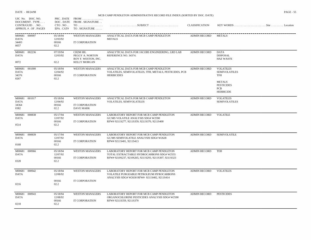
DATE - 08/24/98 PAGE - 55MCB CAMP PENDLETON ADMINISTRATIVE RECORD FILE INDEX (SORTED BY DOC. DATE)
UIC No. DOC. NO. PRC . DATE FROM . . . . . . . . . . . . . . .DOCUMENT . TYPE . . . DOC . DATE FROM . SIGNATURE . .CONTR/GUID . . NO . . CTO . NO . . TO . . . . . . . . . . . . . . . . . . . . . . . . . . . . . . . . . . . . . .SUBJECT . . . . . . . . . . . . . . . . . . . . . CLASSIFICATION KEY WORDS . . . . . . . . . . . . . . . . . . . . . . . .Site . . . . . . . . . LocationAPPROX. # . OF . PAGES EPA . CAT# TO . SIGNATURE . . . . .
M00681 000997 05/18/94 WESTON MANAGERS ANALYTICAL DATA FOR MCB CAMP PENDLETON ADMIN RECORD METALSDATA 12/03/92 METALS34403 00166 IT CORPORATION0057 02.2
M00681 002236 07/19/94 CH2M HIL ANALYTICAL DATA FOR JACOBS ENGINEERING, LRD LAB ADMIN RECORD DATADATA 12/03/92 PEGGY A. NORTON REFERENCE NO. 34374. DISPOSAL
ROY F. WESTON, INC. HAZ WASTE0072 02.2 KELLY MORGAN
M00681 001000 05/18/94 WESTON MANAGERS ANALYTICAL DATA FOR MCB CAMP PENDLETON ADMIN RECORD VOLATILESDATA 12/04/92 VOLATILES, SEMIVOLATILES, TFH, METALS, PESTICIDES, PCB SEMIVOLATILES34376 00166 IT CORPORATION HERBICIDES TFH0267 02.2
METALS PESTICIDESPCBHERBICIDE
M00681 001017 05/18/94 WESTON MANAGERS ANALYTICAL DATA FOR MCB CAMP PENDLETON ADMIN RECORD VOLATILESDATA 12/04/92 VOLATILES, SEMIVOLATILES SEMIVOLATILES34364 00166 IT CORPORATION0382 02.2 DAVE MARK
M00681 000838 05/17/94 WESTON MANAGERS LABORATORY REPORT FOR MCB CAMP PENDLETON ADMIN RECORD VOLATILEDATA 12/07/92 GC/MS VOLATILE ANALYSIS SDG# W2590
00166 IT CORPORATION RFW# 9211S277, 9211S359, 9211S370, 9211S4000514 02.2
M00681 000839 05/17/94 WESTON MANAGERS LABORATORY REPORT FOR MCB CAMP PENDLETON ADMIN RECORD SEMIVOLATILEDATA 12/07/92 GC/MS SEMIVOLATILE ANALYSIS SDG# W2628
00166 IT CORPORATION RFW# 9211S401, 9211S4130168 02.2
M00681 000966 05/18/94 WESTON MANAGERS LABORATORY REPORT FOR MCB CAMP PENDLETON ADMIN RECORD TEHDATA 12/07/92 TOTAL EXTRACTABLE HYDROCARBONS SDG# W2555
00166 IT CORPORATION RFW# 9210S237, 9210S265, 9211S293, 9211S307, 9211S3230328 02.2
M00681 000942 05/18/94 WESTON MANAGERS LABORATORY REPORT FOR MCB CAMP PENDLETON ADMIN RECORD VOLATILESDATA 12/08/92 VOLATILE PURGEABLE PETROLEUM HYROCARBONS
ANALYSIS SDG# W2630 RFW# 9211S402, 9211S41400166 IT CORPORATION
0216 02.2
M00681 000943 05/18/94 WESTON MANAGERS LABORATORY REPORT FOR MCB CAMP PENDLETON ADMIN RECORD PESTICIDESDATA 12/08/92 ORGANOCHLORINE PESTICIDES ANALYSIS SDG# W2590
00166 IT CORPORATION RFW# 9211S359, 9211S3700218 02.2
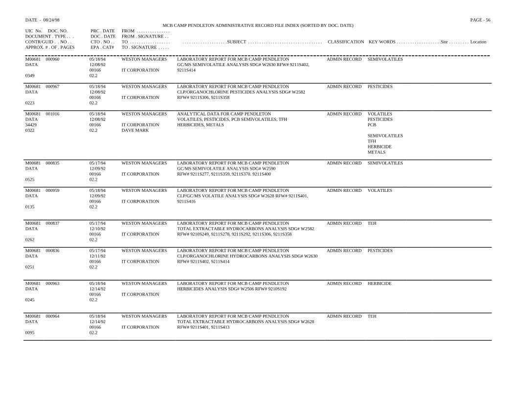
DATE - 08/24/98 PAGE - 56MCB CAMP PENDLETON ADMINISTRATIVE RECORD FILE INDEX (SORTED BY DOC. DATE)
UIC No. DOC. NO. PRC . DATE FROM . . . . . . . . . . . . . . .DOCUMENT . TYPE . . . DOC . DATE FROM . SIGNATURE . .CONTR/GUID . . NO . . CTO . NO . . TO . . . . . . . . . . . . . . . . . . . . . . . . . . . . . . . . . . . . . .SUBJECT . . . . . . . . . . . . . . . . . . . . . . . . . . . . . . . . . CLASSIFICATION KEY WORDS . . . . . . . . . . . . . . . . . . . .Site . . . . . . . . . LocationAPPROX. # . OF . PAGES EPA . CAT# TO . SIGNATURE . . . . .
M00681 000960 05/18/94 WESTON MANAGERS LABORATORY REPORT FOR MCB CAMP PENDLETON ADMIN RECORD SEMIVOLATILESDATA 12/08/92 GC/MS SEMIVOLATILE ANALYSIS SDG# W2630 RFW# 9211S402,
00166 IT CORPORATION 9211S4140349 02.2
M00681 000967 05/18/94 WESTON MANAGERS LABORATORY REPORT FOR MCB CAMP PENDLETON ADMIN RECORD PESTICIDESDATA 12/08/92 CLP/ORGANOCHLORINE PESTICIDES ANALYSIS SDG# W2582
00166 IT CORPORATION RFW# 9211S306, 9211S3580223 02.2
M00681 001016 05/18/94 WESTON MANAGERS ANALYTICAL DATA FOR CAMP PENDLETON ADMIN RECORD VOLATILESDATA 12/08/92 VOLATILES, PESTICIDES, PCB SEMIVOLATILES, TFH PESTICIDES34429 00166 IT CORPORATION HERBICIDES, METALS PCB0322 02.2 DAVE MARK
SEMIVOLATILESTFHHERBICIDEMETALS
M00681 000835 05/17/94 WESTON MANAGERS LABORATORY REPORT FOR MCB CAMP PENDLETON ADMIN RECORD SEMIVOLATILESDATA 12/09/92 GC/MS SEMIVOLATILE ANALYSIS SDG# W2590
00166 IT CORPORATION RFW# 9211S277, 9211S359, 9211S370. 9211S4000525 02.2
M00681 000959 05/18/94 WESTON MANAGERS LABORATORY REPORT FOR MCB CAMP PENDLETON ADMIN RECORD VOLATILESDATA 12/09/92 CLP/GC/MS VOLATILE ANALYSIS SDG# W2628 RFW# 9211S401,
00166 IT CORPORATION 9211S4160135 02.2
M00681 000837 05/17/94 WESTON MANAGERS LABORATORY REPORT FOR MCB CAMP PENDLETON ADMIN RECORD TEHDATA 12/10/92 TOTAL EXTRACTABLE HYDROCARBONS ANALYSIS SDG# W2582
00166 IT CORPORATION RFW# 9210S249, 9211S278, 9211S292, 9211S306, 9211S3580262 02.2
M00681 000836 05/17/94 WESTON MANAGERS LABORATORY REPORT FOR MCB CAMP PENDLETON ADMIN RECORD PESTICIDESDATA 12/11/92 CLP/ORGANOCHLORINE HYDROCARBONS ANALYSIS SDG# W2630
00166 IT CORPORATION RFW# 9211S402, 9211S4140251 02.2
M00681 000963 05/18/94 WESTON MANAGERS LABORATORY REPORT FOR MCB CAMP PENDLETON ADMIN RECORD HERBICIDEDATA 12/14/92 HERBICIDES ANALYSIS SDG# W2506 RFW# 9210S192
00166 IT CORPORATION0245 02.2
M00681 000964 05/18/94 WESTON MANAGERS LABORATORY REPORT FOR MCB CAMP PENDLETON ADMIN RECORD TEHDATA 12/14/92 TOTAL EXTRACTABLE HYDROCARBONS ANALYSIS SDG# W2628
00166 IT CORPORATION RFW# 9211S401, 9211S4130095 02.2
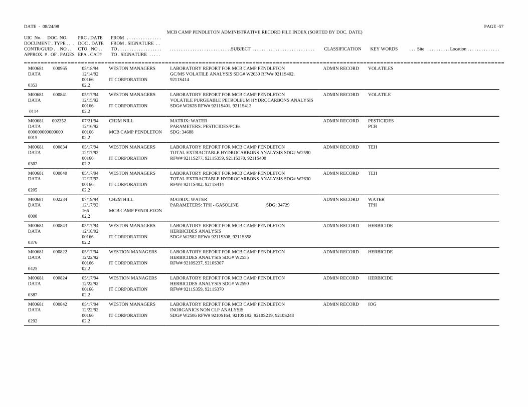
DATE - 08/24/98 PAGE -57 MCB CAMP PENDLETON ADMINISTRATIVE RECORD FILE INDEX (SORTED BY DOC. DATE)
UIC No. DOC. NO. PRC . DATE FROM . . . . . . . . . . . . . . .DOCUMENT . TYPE . . . DOC . DATE FROM . SIGNATURE . .CONTR/GUID . . NO . . CTO . NO . . TO . . . . . . . . . . . . . . . . . . . . . . . . . . . . . . . . . . . . . . . . . . . . . .SUBJECT . . . . . . . . . . . . . . . . . . . . . . . . . . . CLASSIFICATION KEY WORDS . . . Site . . . . . . . . . . Location . . . . . . . . . . . . . .APPROX. # . OF . PAGES EPA . CAT# TO . SIGNATURE . . . . .
M00681DATA
0353
000965 05/18/9412/14/920016602.2
WESTON MANAGERS
IT CORPORATION
LABORATORY REPORT FOR MCB CAMP PENDLETONGC/MS VOLATILE ANALYSIS SDG# W2630 RFW# 9211S402,9211S414
ADMIN RECORD VOLATILES
M00681 DATA
0114
000841 05/17/9412/15/920016602.2
WESTON MANAGERS
IT CORPORATION
LABORATORY REPORT FOR MCB CAMP PENDLETONVOLATILE PURGEABLE PETROLEUM HYDROCARBONS ANALYSISSDG# W2628 RFW# 9211S401, 9211S413
ADMIN RECORD VOLATILE
M00681 002352DATA0000000000000000015
07/21/9412/16/920016602.2
CH2M NILL
MCB CAMP PENDLETON
MATRIX: WATERPARAMETERS: PESTICIDES/PCBsSDG: 34688
ADMIN RECORD PESTICIDESPCB
M00681DATA
0302
000834 05/17/9412/17/920016602.2
WESTON MANAGERS
IT CORPORATION
LABORATORY REPORT FOR MCB CAMP PENDLETONTOTAL EXTRACTABLE HYDROCARBONS ANALYSIS SDG# W2590RFW# 9211S277, 9211S359, 9211S370, 9211S400
ADMIN RECORD TEH
M00681DATA
0205
000840 05/17/9412/17/920016602.2
WESTON MANAGERS
IT CORPORATION
LABORATORY REPORT FOR MCB CAMP PENDLETONTOTAL EXTRACTABLE HYDROCARBONS ANALYSIS SDG# W2630RFW# 9211S402, 9211S414
ADMIN RECORD TEH
M00681DATA
0008
002234 07/19/9412/17/9216602.2
CH2M HILL
MCB CAMP PENDLETON
MATRIX: WATERPARAMETERS: TPH - GASOLINE SDG: 34729
ADMIN RECORD WATERTPH
M00681DATA
0376
000843 05/17/9412/18/920016602.2
WESTON MANAGERS
IT CORPORATION
LABORATORY REPORT FOR MCB CAMP PENDLETONHERBICIDES ANALYSISSDG# W2582 RFW# 9211S308, 9211S358
ADMIN RECORD HERBICIDE
M00681DATA
0425
000822 05/17/9412/22/920016602.2
WESTION MANAGERS
IT CORPORATION
LABORATORY REPORT FOR MCB CAMP PENDLETONHERBICIDES ANALYSIS SDG# W2555RFW# 9210S237, 9210S307
ADMIN RECORD HERBICIDE
M00681DATA
0387
000824 05/17/9412/22/920016602.2
WESTION MANAGERS
IT CORPORATION
LABORATORY REPORT FOR MCB CAMP PENDLETONHERBICIDES ANALYSIS SDG# W2590RFW# 9211S359, 9211S370
ADMIN RECORD HERBICIDE
M00681DATA
0292
000842 05/17/9412/22/920016602.2
WESTON MANAGERS
IT CORPORATION
LABORATORY REPORT FOR MCB CAMP PENDLETONINORGANICS NON CLP ANALYSISSDG# W2506 RFW# 9210S164, 9210S192, 9210S219, 9210S248
ADMIN RECORD IOG
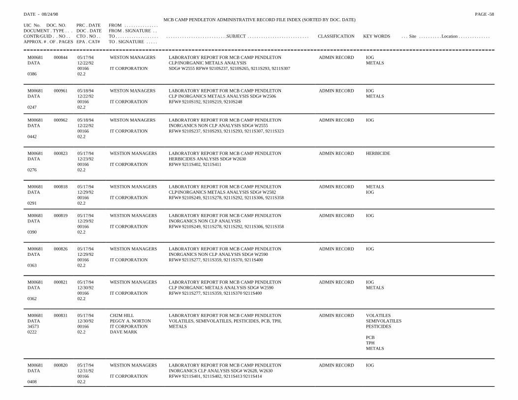
DATE - 08/24/98 PAGE -58 MCB CAMP PENDLETON ADMINISTRATIVE RECORD FILE INDEX (SORTED BY DOC. DATE)
UIC No. DOC. NO. PRC . DATE FROM . . . . . . . . . . . . . . .DOCUMENT . TYPE . . . DOC . DATE FROM . SIGNATURE . .CONTR/GUID . . NO . . CTO . NO . . TO . . . . . . . . . . . . . . . . . . . . . . . . . . . . . . . . . . . . . . . . . . . . . .SUBJECT . . . . . . . . . . . . . . . . . . . . . . . . . . . CLASSIFICATION KEY WORDS . . . Site . . . . . . . . . . Location . . . . . . . . . . . . . .APPROX. # . OF . PAGES EPA . CAT# TO . SIGNATURE . . . . .
M00681DATA
0386
000844 05/17/9412/22/920016602.2
WESTON MANAGERS
IT CORPORATION
LABORATORY REPORT FOR MCB CAMP PENDLETONCLP/INORGANIC METALS ANALYSISSDG# W2555 RFW# 9210S237, 9210S265, 9211S293, 9211S307
ADMIN RECORD IOGMETALS
M00681DATA
0247
000961 05/18/9412/22/920016602.2
WESTON MANAGERS
IT CORPORATION
LABORATORY REPORT FOR MCB CAMP PENDLETONCLP INORGANICS METALS ANALYSIS SDG# W2506RFW# 9210S192, 9210S219, 9210S248
ADMIN RECORD IOGMETALS
M00681DATA
0442
000962 05/18/9412/22/920016602.2
WESTON MANAGERS
IT CORPORATION
LABORATORY REPORT FOR MCB CAMP PENDLETONINORGANICS NON CLP ANALYSIS SDG# W2555RFW# 9210S237, 9210S293, 9211S293, 9211S307, 9211S323
ADMIN RECORD IOG
M00681DATA
0276
000823 05/17/9412/23/920016602.2
WESTION MANAGERS
IT CORPORATION
LABORATORY REPORT FOR MCB CAMP PENDLETONHERBICIDES ANALYSIS SDG# W2630RFW# 9211S402, 9211S411
ADMIN RECORD HERBICIDE
M00681DATA
0291
000818 05/17/9412/29/920016602.2
WESTION MANAGERS
IT CORPORATION
LABORATORY REPORT FOR MCB CAMP PENDLETONCLP\INORGANICS METALS ANALYSIS SDG# W2582RFW# 9210S249, 9211S278, 9211S292, 9211S306, 9211S358
ADMIN RECORD METALSIOG
M00681DATA
0390
000819 05/17/9412/29/920016602.2
WESTION MANAGERS
IT CORPORATION
LABORATORY REPORT FOR MCB CAMP PENDLETONINORGANICS NON CLP ANALYSISRFW# 9210S249, 9211S278, 9211S292, 9211S306, 9211S358
ADMIN RECORD IOG
M00681DATA
0363
000826 05/17/9412/29/920016602.2
WESTION MANAGERS
IT CORPORATION
LABORATORY REPORT FOR MCB CAMP PENDLETONINORGANICS NON CLP ANALYSIS SDG# W2590RFW# 9211S277, 9211S359, 9211S370, 9211S400
ADMIN RECORD IOG
M00681DATA
0362
000821 05/17/9412/30/920016602.2
WESTION MANAGERS
IT CORPORATION
LABORATORY REPORT FOR MCB CAMP PENDLETONCLP INORGANIC METALS ANALYSIS SDG# W2590RFW# 9211S277, 9211S359, 9211S370 9211S400
ADMIN RECORD IOGMETALS
M00681DATA345730222
000831 05/17/9412/30/920016602.2
CH2M HILLPEGGY A. NORTONIT CORPORATIONDAVE MARK
LABORATORY REPORT FOR MCB CAMP PENDLETONVOLATILES, SEMIVOLATILES, PESTICIDES, PCB, TPH,METALS
ADMIN RECORD VOLATILESSEMIVOLATILESPESTICIDES
PCBTPHMETALS
M00681DATA
0408
000820 05/17/9412/31/920016602.2
WESTION MANAGERS
IT CORPORATION
LABORATORY REPORT FOR MCB CAMP PENDLETONINORGANICS CLP ANALYSIS SDG# W2628, W2630RFW# 9211S401, 9211S402, 9211S413 9211S414
ADMIN RECORD IOG
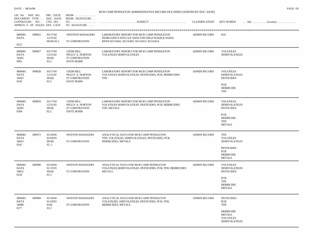
DATE - 08/24/98 PAGE -59 MCB CAMP PENDLETON ADMINISTRATIVE RECORD FILE INDEX (SORTED BY DOC. DATE)
UIC No. DOC. NO. PRC . DATE FROM . . . . . . . . . . . . . . .DOCUMENT . TYPE . . . DOC . DATE FROM . SIGNATURE . .CONTR/GUID . . NO . . CTO . NO . . TO . . . . . . . . . . . . . . . . . . . . . . . . . . . . . . . . . . . . . . . . . . . . . .SUBJECT . . . . . . . . . . . . . . . . . . . . . . . . . . . CLASSIFICATION KEY WORDS . . . Site . . . . . . . . . . Location . . . . . . . . . . . . . .APPROX. # . OF . PAGES EPA . CAT# TO . SIGNATURE . . . . .
M00681DATA
0212
000825 05/17/9412/31/9200166 02.2
WESTION MANAGERS
IT CORPORATION
LABORATORY REPORT FOR MCB CAMP PENDLETONINORGANICS NON CLP ANALYSIS SDG# W2628 & W2630RFW# 9211S401, 9211S402, 9211S413, 9211S414
ADMIN RECORD IOG
M00681DATA345850061
000827 05/17/94 12/31/920016602.2
CH2M HILLPEGGY A. NORTONIT CORPORATIONDAVE MARK
LABORATORY REPORT FOR MCB CAMP PENDLETONVOLATILES SEMIVOLATILES
ADMIN RECORD VOLATILESSEMIVOLATILES
M00681DATA345630245
000828 05/17/9412/31/920016602.2
CH2M HILLPEGGY A. NORTONIT CORPORATIONDAVE MARK
LABORATORY REPORT FOR MCB CAMP PENDLETONVOLATILES SEMIVOLATILES, PESTICIDES, PCB, HERBICIDESTFH
ADMIN RECORD VOLATILESSEMIVOLATILESPESTICIDES
PCBHERBICIDETFH
M00681DATA345830284
000829 05/17/9412/31/920016602.2
CH2M HILLPEGGY A. NORTONIT CORPORATIONDAVE MARK
LABORATORY REPORT FOR MCB CAMP PENDLETONVOLATILES SEMIVOLATILES, PESTICIDES, PCB, HERBICIDESTFH, METALS
ADMIN RECORD VOLATILESSEMIVOLATILESPESTICIDES
PCBHERBICIDETFHMETALS
M00681DATA346330241
000972 05/18/94 01/04/930016602. 2
WESTON MANAGERS
IT CORPORATION
ANALYTICAL DATA FOR MCB CAMP PENDLETONTFH, VOLATILES, SEMIVOLATILES, PESTICIDES, PCB,HERBICIDES, METALS
ADMIN RECORD TFHVOLATILESSEMIVOLATILES
PESTICIDESPCBHERBICIDEMETALS
M00681DATA346520226
000990 05/18/9401/15/930016602.2
WESTON MANAGERS
IT CORPORATION
ANALYTICAL DATA FOR MCB CAMP PENDLETONVOLATILES,SEMIVOLATILES, PESTICIDES, PCB, TFH, HERBICIDESMETALS
ADMIN RECORD VOLATILESSEMIVOLATILESPESTICIDES
PCBTFHHERBICIDEMETALS
M00681DATA346880277
000968 05/18/9401/18/93016602.2
WESTON MANAGERS
IT CORPORATION
ANALYTICAL DATA FOR MCB CAMP PENDLETONVOLATILIES, SMIVOLATILES, PESTICIDES, PCB, TFH,HERBICIDES, METALS
ADMIN RECORD PESTICIDESPCBTFH
HERBICIDEMETALSVOLATILESSEMIVOLATILES
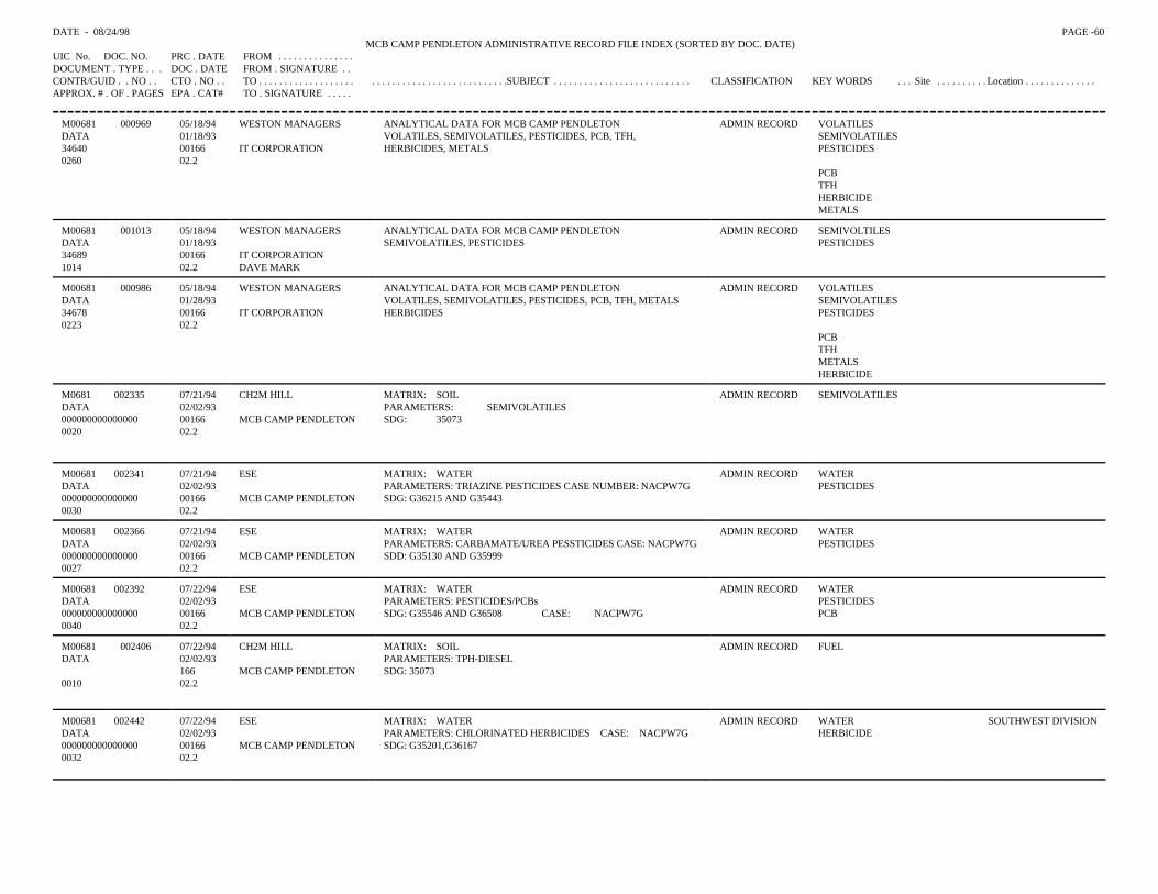
DATE - 08/24/98 PAGE -60 MCB CAMP PENDLETON ADMINISTRATIVE RECORD FILE INDEX (SORTED BY DOC. DATE)
UIC No. DOC. NO. PRC . DATE FROM . . . . . . . . . . . . . . .DOCUMENT . TYPE . . . DOC . DATE FROM . SIGNATURE . .CONTR/GUID . . NO . . CTO . NO . . TO . . . . . . . . . . . . . . . . . . . . . . . . . . . . . . . . . . . . . . . . . . . . . .SUBJECT . . . . . . . . . . . . . . . . . . . . . . . . . . . CLASSIFICATION KEY WORDS . . . Site . . . . . . . . . . Location . . . . . . . . . . . . . .APPROX. # . OF . PAGES EPA . CAT# TO . SIGNATURE . . . . .
M00681DATA346400260
000969 05/18/94 01/18/930016602.2
WESTON MANAGERS
IT CORPORATION
ANALYTICAL DATA FOR MCB CAMP PENDLETONVOLATILES, SEMIVOLATILES, PESTICIDES, PCB, TFH,HERBICIDES, METALS
ADMIN RECORD VOLATILESSEMIVOLATILESPESTICIDES
PCBTFHHERBICIDEMETALS
M00681DATA346891014
001013 05/18/9401/18/930016602.2
WESTON MANAGERS
IT CORPORATIONDAVE MARK
ANALYTICAL DATA FOR MCB CAMP PENDLETONSEMIVOLATILES, PESTICIDES
ADMIN RECORD SEMIVOLTILESPESTICIDES
M00681DATA346780223
000986 05/18/9401/28/930016602.2
WESTON MANAGERS
IT CORPORATION
ANALYTICAL DATA FOR MCB CAMP PENDLETONVOLATILES, SEMIVOLATILES, PESTICIDES, PCB, TFH, METALSHERBICIDES
ADMIN RECORD VOLATILESSEMIVOLATILESPESTICIDES
PCBTFHMETALSHERBICIDE
M0681 002335DATA0000000000000000020
07/21/9402/02/930016602.2
CH2M HILL
MCB CAMP PENDLETON
MATRIX: SOILPARAMETERS: SEMIVOLATILESSDG: 35073
ADMIN RECORD SEMIVOLATILES
M00681 002341DATA0000000000000000030
07/21/9402/02/930016602.2
ESE
MCB CAMP PENDLETON
MATRIX: WATERPARAMETERS: TRIAZINE PESTICIDES CASE NUMBER: NACPW7GSDG: G36215 AND G35443
ADMIN RECORD WATERPESTICIDES
M00681 002366DATA0000000000000000027
07/21/9402/02/930016602.2
ESE
MCB CAMP PENDLETON
MATRIX: WATERPARAMETERS: CARBAMATE/UREA PESSTICIDES CASE: NACPW7GSDD: G35130 AND G35999
ADMIN RECORD WATERPESTICIDES
M00681 002392DATA0000000000000000040
07/22/9402/02/930016602.2
ESE
MCB CAMP PENDLETON
MATRIX: WATERPARAMETERS: PESTICIDES/PCBsSDG: G35546 AND G36508 CASE: NACPW7G
ADMIN RECORD WATERPESTICIDESPCB
M00681DATA
0010
002406 07/22/9402/02/9316602.2
CH2M HILL
MCB CAMP PENDLETON
MATRIX: SOILPARAMETERS: TPH-DIESELSDG: 35073
ADMIN RECORD FUEL
M00681 002442DATA000000000000000 0032
07/22/9402/02/930016602.2
ESE
MCB CAMP PENDLETON
MATRIX: WATERPARAMETERS: CHLORINATED HERBICIDES CASE: NACPW7GSDG: G35201,G36167
ADMIN RECORD WATERHERBICIDE
SOUTHWEST DIVISION
DATE - 08/24/98 PAGE -61 MCB CAMP PENDLETON ADMINISTRATIVE RECORD FILE INDEX (SORTED BY DOC. DATE)
UIC No. DOC. NO. PRC . DATE FROM . . . . . . . . . . . . . . .DOCUMENT . TYPE . . . DOC . DATE FROM . SIGNATURE . .CONTR/GUID . . NO . . CTO . NO . . TO . . . . . . . . . . . . . . . . . . . . . . . . . . . . . . . . . . . . . . . . . . . . . .SUBJECT . . . . . . . . . . . . . . . . . . . . . . . . . . . CLASSIFICATION KEY WORDS . . . Site . . . . . . . . . . Location . . . . . . . . . . . . . .APPROX. # . OF . PAGES EPA . CAT# TO . SIGNATURE . . . . .
M00681 002342DATA0000000000000000019
07/21/9402/03/930016602.2
ESE
MCB CAMP PENDLETONPARAMETERS: TRIAZINE PESTICIDES CASE NUMBER: NACPS4ESDG: G35419 AND G35426
ADMIN RECORD PESTICIDES
M00681 002364DATA0000000000000000015
07/21/9402/03/930016602.2
ESE
MCB CAMP PENDLETON
MATRIX: WATERPARAMETERS: GENERAL CHEMISTRY CASE: NACPW8DSDG:G36526, G36446, G36442, G36029, G35334, G35493, G35103
ADMIN RECORD WATER
M00681 002365DATA0000000000000000018
07/21/9402/03/9300016602.2
ESE
MCB CAMP PENDLETONPARAMETERS: CARBAMATE/UREA PESSTICIDES CASE: NACPS4ESDG: G35299 AND G35301
ADMIN RECORD PESTICIDESWATER
M00681 002393DATA0000000000000000032
07/22/9402/03/930016602.2
ESE
MCB CAMP PENDLETON
MATRIX: WATERPARAMETERS: PESTICIDES/PCBsSDG: G35671 AND G36519 CASE: NACPW8D
ADMIN RECORD WATERPESTICIDESPCB
M00681 002397DATA0000000000000000015
07/22/9402/03/930016602.2
ESE
MCB CAMP PENDLETON
MATRIX: WATERPARAMETERS: CARBANATE/UREA PESTICIDESSDG: G35284 AND G35941 CASE: NACPW7G
ADMIN RECORD WATERPESTICIDES
M00681 002399DATA0000000000000000022
07/22/9402/03/930016602.2
ESE
MCB CAMP PENDLETON
MATRIX: WATER CASE: NACPW8DPARAMETERS: TRIAZINE PESTICIDESSDG: G35408 AND G36215
ADMIN RECORD WATERPESTICIDES
M00681 002441DATA0000000000000000020
07/22/9402/03/930016602.2
ESE
MCB CAMP PENDLETON
MATRIX: WATERPARAMETERS: CHLORINATED HERBICIDES CASE: NACPW8DSDG: G35333 , G36167
ADMIN RECORD WATERHERBICIDE
SOUTHWESTDIVISION
M00681 002331DATA0000000000000000021
07/21/9402/04/930016602.2
CH2M HILL
MCB CAMP PENDLETON
MATRIX: WATERPARAMETERS: SEMIVOLATILESSDG: 35078
ADMIN RECORD WATERSEMIVOLATILES
M00681 002374DATA0000000000000000030
07/21/9402/04/930016602.2
CH2M HILL
MCB CAMP PENDLETON
MATRIX: SOIL AND WATERPARAMETERS: TCL METALS WITH MOLYBDENUMSDG: 35104
ADMIN RECORD WATERMETALS
M00681 002396DATA0000000000000000015
07/22/9402/04/930016602.2
ESE
MCB CAMP PENDLETON
MATRIX: WATERPARAMETERS: TPH-GASOLINE AND TPH-DIESELSDG: G35304 CASE: NACPW7G
ADMIN RECORD WATERFUEL
DATE - 08/24/98 PAGE -62 MCB CAMP PENDLETON ADMINISTRATIVE RECORD FILE INDEX (SORTED BY DOC. DATE)
UIC No. DOC. NO. PRC . DATE FROM . . . . . . . . . . . . . . .DOCUMENT . TYPE . . . DOC . DATE FROM . SIGNATURE . .CONTR/GUID . . NO . . CTO . NO . . TO . . . . . . . . . . . . . . . . . . . . . . . . . . . . . . . . . . . . . . . . . . . . . .SUBJECT . . . . . . . . . . . . . . . . . . . . . . . . . . . CLASSIFICATION KEY WORDS . . . Site . . . . . . . . . . Location . . . . . . . . . . . . . .APPROX. # . OF . PAGES EPA . CAT# TO . SIGNATURE . . . . .
M00681DATA
0006
002246 07/20/9402/10/93
02.2
ROY F. WESTON
MCB CAMP PENDLETON
MATRIX: WATER AND SOILPARAMETERS: CLP METALS AND MOLYBDENUM SDG: W2666
ADMINRECORD
WATERMETALS
M00681DATA
0004
002247 07/20/9402/10/93
02.2
ROY F. WESTON
MCB CAMP PENDLETON
MATRIX: WATER AND SOILPARAMETERS: TPH GASOLINE AND TPH DIESEL SDG: W2666
ADMINRECORD
WATERFUEL
M00681 002248DATA0000000000000000004
07/20/9402/10/930000002.2
ROY F. WESTON
MCB CAMP PENDLETON
MATRIX: WATER AND SOILPARAMETERS: VOLATILES SDG: W2666
ADMINRECORD
WATERVOA
SOUTHWESTDIVISION
M00681 002249DATA0000000000000000010
07/20/9402/10/930000002.2
ROY F. WESTON
MCB CAMP PENDLETON
MATRIX: WATER AND SOILPARAMETERS: SEMIVOLATILES SDG: W2666
ADMINRECORD
WATERSEMIVOLATILES
SOUTHWESTDIVISION
M00681DATA
0008
002241 07/20/9402/11/93
02.2
ROY F. WESTON
MCB CAMP PENDLETON
MATRIX: WATER AND SOILPARAMETERS: CLP METALS AND MOLYBKENUM SDG: W2684
ADMINRECORD
WATER
M00681 002250DATA0000000000000000008
07/20/9402/11/930000002.2
ROY F. WESTON
MCB CAMP PENDLETON
MATRIX: WATER AND SOILPARAMETERS: VOLATILES SDG: W2684
ADMINRECORD
WATERVOA
SOUTHWESTDIVISION
M00681 002251DATA0000000000000000004
07/20/94 02/11/930000002.2
ROY F. WESTON
MCB CAMP PENDLETON
MATRIX: WATER AND SOILPARAMETERS: TPH GASOLINE AND TPH DIESEL SDG: W2684
ADMINRECORD
WATERFUEL
SOUTHWESTDIVISION
M00681 002252DATA0000000000000000008
07/20/94 02/11/930000002.2
ROY F. WESTON
MCB CAMP PENDLETON
MATRIX: WATER AND SOILPARAMETERS: SEMIVOLATILES SDG: W2684
ADMINRECORD
WATERSEMIVOLATILES
SOUTHWESTDIVISION
M00681DATA347290847
000830 05/17/94 02/12/930016602.2
CH2M HILLPEGGY A. NORTONIT CORPORATIONDAVE MARK
LABORATORY REPORT FOR MCB CAMP PENDLETONVOLATILES
ADMINRECORD
VOLATILES
M00681DATA347280326
000832 05/17/9402/12/930016602.2
CH2M HILLPEGGY A. NORTONIT CORPORATIONDAVE MARK
LABORATORY REPORT FOR MCB CAMP PENDLETONVOLATILES, SEMIVOLATILES, PESTICIDES, PCB, TPH,METALS, HERBICIDES
ADMINRECORD
VOLATILESSEMIVOLATILESPESTICIDES
PCBTPHMETALSHERBICIDE
DATE - 08/24/98 PAGE - 63MCB CAMP PENDLETON ADMINISTRATIVE RECORD FILE INDEX (SORTED BY DOC. DATE)
UIC No. DOC. NO. PRC . DATE FROM . . . . . . . . . . . . .DOCUMENT . TYPE . . . DOC . DATE FROM . SIGNATURECONTR/GUID . . NO . . CTO . NO . . TO . . . . . . . . . . . . . . . . . . . . . . . . . . . . . . . . . . . . .SUBJECT . . . . . . . . . . . . . . . . . . . . . . . . . CLASSIFICATION KEY WORDS . . . Site . . . . . . . . . . Location . . . . . . . . . . . . . .APPROX. # . OF . PAGES EPA . CAT# TO . SIGNATURE . . .
M00681 000833 05/17/94 CH2M HILL LABORATORY REPORT FOR MCB CAMP PENDLETON ADMIN RECCORD VOLATILESDATA 02/12/93 PEGGY A. NORTON VOLATILES, SEMIVOLATILES, PESTICIDES, PCB, TFH, SEMIVOLATILES34681 00166 IT CORPORATION METALS, HERBICIDES PESTICIDES0328 02.2 DAVE MARK
PCBTFHMETALSHERBICIDE
M00681 002242 07/20/94 ROY F. WESTON MATRIX: SOIL ADMIN RECORD SEMIVOLATILESDATA 02/12/93 PARAMETERS: SEMIVOLATILES SDG: W2684
MCB CAMPPENDLETON
0028 02.2M00681 002243 07/20/94 ROY F. WESTON MATRIX: SOIL ADMIN RECORD VOADATA 02/12/93 PARAMETERS: VOLATILES SDG: W2684
MCB CAMPPENDLETON
0027 02.2M00681 002244 07/20/94 ROY F. WESTON MATRIX: WATER AND SOIL ADMIN RECORD WATERDATA 02/12/93 PARAMETERS: TPH GASOLINE AND TPH DIESEL SDG: W2684 FUEL
MCB CAMPPENDLETON
0006 02.2
M00681 002245 07/20/94 ROY F. WESTON MATRIX: WATER AND SOIL ADMIN RECORD WATERDATA 02/12/93 PARAMETERS: CLP METALS AND MOLYBDENUM SDG: W2684 METALS
MCB CAMPPENDLETON
0030 02.2
M00681 002343 07/21/94 ESE MATRIX: WATER ADMIN RECORD WATERDATA 02/16/93 PARAMETERS: VOLATILES CASE
NUMBER: NACPW5EVOLATILES
000000000000000 00166 MCB CAMP PENDLETON
SDG: G35790, G35792, G35793, G36496
0050 02.2
M00681 002367 07/21/94 ESE MATRIX: WATER ADMIN RECORD WATER SOUTHWEST DIVISIONDATA 02/16/93 PARAMETERS: TCL METALS WITH BORON, CYANIDE, AND
CARBAMAMETALS
000000000000000 00166 MCB CAMP PENDLETON
MOLYBDENUM SDG: G35648, G35733, G35767, G35818. CYANIDE
0050 02.2
M00681 002394 07/22/94 ESE MATRIX: WATER ADMIN RECORD WATER SOUTHWEST DIVISIONDATA 02/16/93 PARAMETERS: TPH-GASOLINE AND TPH-DIESEL FUEL000000000000000 00166 MCB CAMP
PENDLETONSDG: G35623, G35615, G36420, G365503, G36494, G35812.
0029 02.2M00681 002438 07/22/94 CH2M HILL MATRIX: WATER ADMIN RECORD WATER SOUTHWEST DIVISIONDATA 02/16/93 PARAMETERS: GENERAL CHEMISTRY CASE: NACPW5E000000000000000 00166 MCB CAMP
PENDLETONSDG: G35849, G35881, G36526, G35950, G35951, G36442, G35896
0030 02.2
DATE - 08/24/98 PAGE - 64MCB CAMP PENDLETON ADMINISTRATIVE RECORD FILE INDEX (SORTED BY DOC. DATE)
UIC No. DOC. NO. PRC . DATE FROM . . . . . . . . . . . . . . .DOCUMENT . TYPE . . . DOC . DATE FROM . SIGNATURE . .CONTR/GUID . . NO . . CTO . NO . . TO . . . . . . . . . . . . . . . . . . . . . . . . . . . . . . . . . . . . . . .SUBJECT . . . . . . . . . . . . . . . . . . . CLASSIFICATION KEY WORDS . . . Site . . . . . . . . . . Location . . . . . . . . . . . .APPROX. # . OF . PAGES EPA . CAT# TO . SIGNATURE . . . . .
M00681 001255 05/27/94 WESTON MANAGERS LABORATORY REPORT FOR MCB CAMP PENDLETON ADMIN RECORD IOGDATA 02/18/93 INORGANIC RFW# 9302S098
00166 IT CORPORATION0016 02.2
M00681 002361 07/21/94 CH2M HILL MATRIX: WATER ADMIN RECORD WATERDATA 02/25/93 PARAMETERS: CHLORINATED HERBICIDES HERBICIDE000000000000000 00166 MCB CAMP PENDLETON SDG: 35235 0015 02.2
M00681 000722 05/16/94 WESTON MANAGERS LABORATORY REPORT FOR MCB CAMP PENDLTON ADMIN RECORD TPHDATA 02/26/93 TOTAL EXTRACTABLE HYDROCARBONS ANALYSIS
SDG# W266600166 MCB CAMP PENDLETON RFW# 9302S098, 9302S111
0238 02.2
M00681 000723 05/16/94 WESTON MANAGERS LABORATORY REPORT FOR MCB CAMP PENDLTON ADMIN RECORD TPHDATA 02/26/93 VOLATILE PURGEABLE PETROLEUM HYDROCARBON
ANALYSIS00166 MCB CAMP PENDLETON SDG# W2666 RFW# 9302S098, 9302S111
0158 02.2
M00681 000724 05/16/94 WESTON MANAGERS LABORATORY REPORT FOR MCB CAMP PENDLTON ADMIN RECORD TEHDATA 02/26/93 TOTAL EXTRACTABLE HYDROCARBONS ANALYSIS
00166 MCB CAMP PENDLETON SDG# W2684 RFW# 9302S11120156 02.2
M00681 000721 05/16/94 WESTON MANAGERS LABORATORY REPORT FOR MCB CAMP PENDLTON ADMIN RECORD VOCDATA 02/28/93 CLP\GS\MS VOLATILE ANALYSIS SDG# W2666
00166 MCB CAMP PENDLETON RFW# 9302S098, 9302S1110318 02.2
M00681 000619 05/13/94 WESTON MANAGERS LABORATORY REPORT FOR MCB CAMP PENDLETON ADMIN RECORD VOCDATA 03/01/93 CLP\GC\MS VOLATILE ANALYSIS SDG# W2684
00166 IT CORPORATION RFW# 9302S112, 9302S1330496 02.2
M00681 000726 05/16/94 WESTON MANAGERS LABORATORY REPORT FOR MCB CAMP PENDLTON ADMIN RECORD SOLVENTSDATA 03/01/93 CLP/GS/MS SEMIVOLATILE ANALYSIS
00166 MCB CAMP PENDLETON SDG# W2666 RFW# 9302S098, 9302S1110542 02.2
M00681 000727 05/16/94 WESTON MANAGERS LABORATORY REPORT FOR MCB CAMP PENDLTON ADMIN RECORD TPHDATA 03/01/93 VOALTILE PURGEABLE PETROLEUM
HYDROCARBONSANALYSIS00166 MCB CAMP PENDLETON SDG# W2684 RFW# 9302S112
0121 02.2
M00681 000728 05/16/94 WESTON MANAGERS LABORATORY REPORT FOR MCB CAMP PENDLTON ADMIN RECORD IOGDATA 03/01/93 CLP AND NO-CLP\ INOGRANICS ANALYSIS
00166 MCB CAMP PENDLETON SDG# W2666 RFW# 9302S098, 9302S1110316 02.2
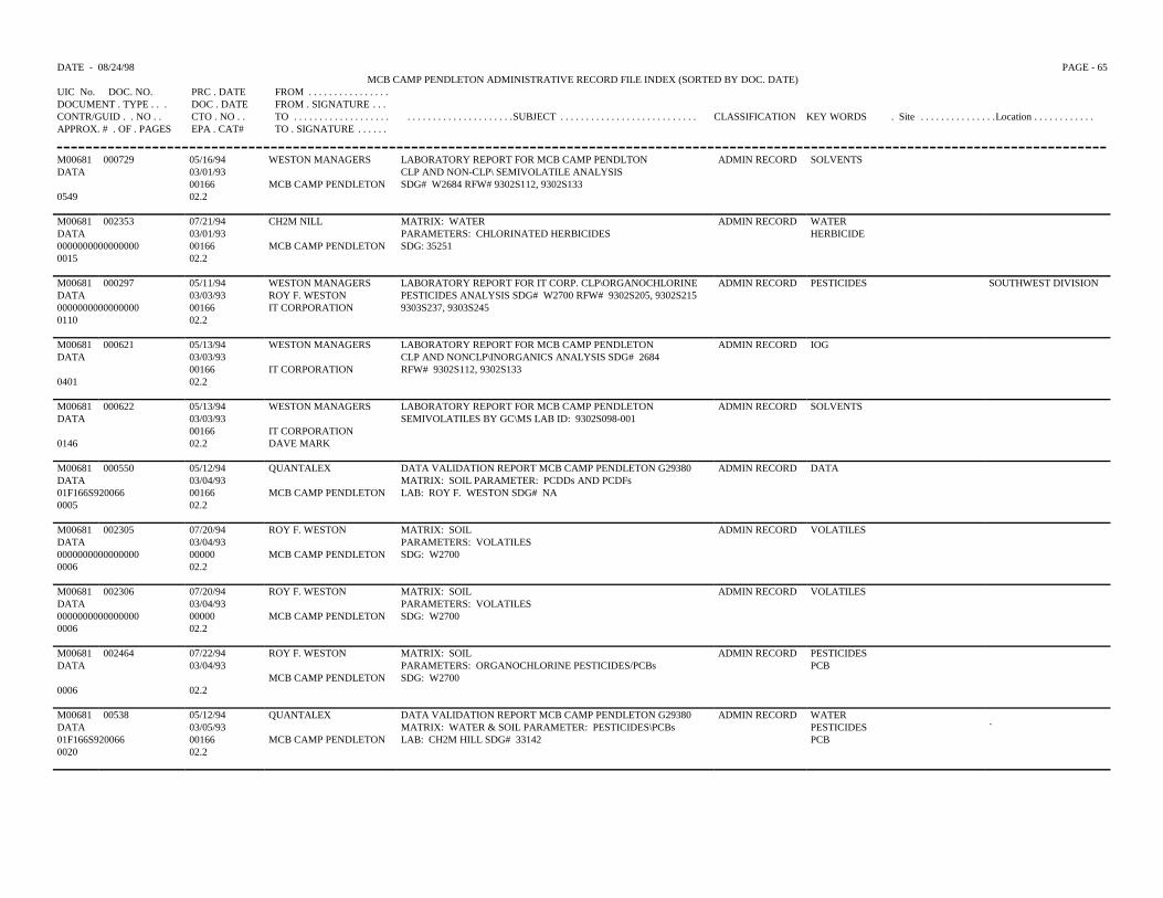
DATE - 08/24/98 PAGE - 65MCB CAMP PENDLETON ADMINISTRATIVE RECORD FILE INDEX (SORTED BY DOC. DATE)
UIC No. DOC. NO. PRC . DATE FROM . . . . . . . . . . . . . . . .DOCUMENT . TYPE . . . DOC . DATE FROM . SIGNATURE . . .CONTR/GUID . . NO . . CTO . NO . . TO . . . . . . . . . . . . . . . . . . . . . . . . . . . . . . . . . . . . . . . .SUBJECT . . . . . . . . . . . . . . . . . . . . . . . . . . . CLASSIFICATION KEY WORDS . Site . . . . . . . . . . . . . . .Location . . . . . . . . . . . .APPROX. # . OF . PAGES EPA . CAT# TO . SIGNATURE . . . . . .
M00681 000729 05/16/94 WESTON MANAGERS LABORATORY REPORT FOR MCB CAMP PENDLTON ADMIN RECORD SOLVENTSDATA 03/01/93 CLP AND NON-CLP\ SEMIVOLATILE ANALYSIS
00166 MCB CAMP PENDLETON SDG# W2684 RFW# 9302S112, 9302S1330549 02.2
M00681 002353 07/21/94 CH2M NILL MATRIX: WATER ADMIN RECORD WATERDATA 03/01/93 PARAMETERS: CHLORINATED HERBICIDES HERBICIDE0000000000000000 00166 MCB CAMP PENDLETON SDG: 352510015 02.2
M00681 000297 05/11/94 WESTON MANAGERS LABORATORY REPORT FOR IT CORP. CLP\ORGANOCHLORINE ADMIN RECORD PESTICIDES SOUTHWEST DIVISIONDATA 03/03/93 ROY F. WESTON PESTICIDES ANALYSIS SDG# W2700 RFW# 9302S205, 9302S2150000000000000000 00166 IT CORPORATION 9303S237, 9303S2450110 02.2
M00681 000621 05/13/94 WESTON MANAGERS LABORATORY REPORT FOR MCB CAMP PENDLETONCLP AND NONCLP\INORGANICS ANALYSIS SDG# 2684RFW# 9302S112, 9302S133
ADMIN RECORD IOGDATA 03/03/93
00166 IT CORPORATION0401 02.2
M00681 000622 05/13/94 WESTON MANAGERS LABORATORY REPORT FOR MCB CAMP PENDLETONSEMIVOLATILES BY GC\MS LAB ID: 9302S098-001
ADMIN RECORD SOLVENTSDATA 03/03/93
00166 IT CORPORATION0146 02.2 DAVE MARK
M00681 000550 05/12/94 QUANTALEX DATA VALIDATION REPORT MCB CAMP PENDLETON G29380MATRIX: SOIL PARAMETER: PCDDs AND PCDFsLAB: ROY F. WESTON SDG# NA
ADMIN RECORD DATADATA 03/04/9301F166S920066 00166 MCB CAMP PENDLETON0005 02.2
M00681 002305 07/20/94 ROY F. WESTON MATRIX: SOILPARAMETERS: VOLATILESSDG: W2700
ADMIN RECORD VOLATILESDATA 03/04/930000000000000000 00000 MCB CAMP PENDLETON0006 02.2
M00681 002306 07/20/94 ROY F. WESTON MATRIX: SOILPARAMETERS: VOLATILESSDG: W2700
ADMIN RECORD VOLATILESDATA 03/04/930000000000000000 00000 MCB CAMP PENDLETON0006 02.2
M00681 002464 07/22/94 ROY F. WESTON MATRIX: SOILPARAMETERS: ORGANOCHLORINE PESTICIDES/PCBsSDG: W2700
ADMIN RECORD PESTICIDESDATA 03/04/93 PCB
MCB CAMP PENDLETON0006 02.2
M00681 00538 05/12/94 QUANTALEX DATA VALIDATION REPORT MCB CAMP PENDLETON G29380MATRIX: WATER & SOIL PARAMETER: PESTICIDES\PCBsLAB: CH2M HILL SDG# 33142
ADMIN RECORD WATERDATA 03/05/93 PESTICIDES `01F166S920066 00166 MCB CAMP PENDLETON PCB0020 02.2
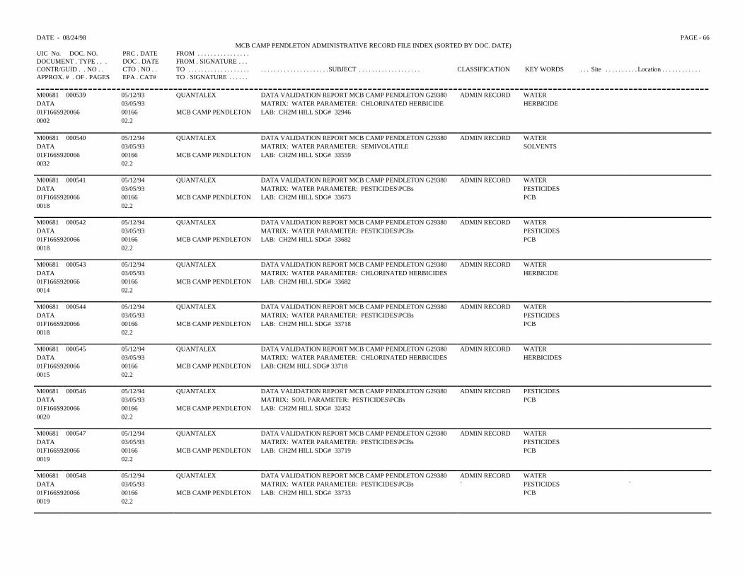
DATE - 08/24/98 PAGE - 66MCB CAMP PENDLETON ADMINISTRATIVE RECORD FILE INDEX (SORTED BY DOC. DATE)
UIC No. DOC. NO. PRC . DATE FROM . . . . . . . . . . . . . . . .DOCUMENT . TYPE . . . DOC . DATE FROM . SIGNATURE . . .CONTR/GUID . . NO . . CTO . NO . . TO . . . . . . . . . . . . . . . . . . . . . . . . . . . . . . . . . . . . . . . .SUBJECT . . . . . . . . . . . . . . . . . . . CLASSIFICATION KEY WORDS . . . Site . . . . . . . . . . Location . . . . . . . . . . . .APPROX. # . OF . PAGES EPA . CAT# TO . SIGNATURE . . . . . .
M00681 000539 05/12/93 QUANTALEX DATA VALIDATION REPORT MCB CAMP PENDLETON G29380 ADMIN RECORD WATERDATA 03/05/93 MATRIX: WATER PARAMETER: CHLORINATED HERBICIDE HERBICIDE01F166S920066 00166 MCB CAMP PENDLETON LAB: CH2M HILL SDG# 329460002 02.2
M00681 000540 05/12/94 QUANTALEX DATA VALIDATION REPORT MCB CAMP PENDLETON G29380 ADMIN RECORD WATERDATA 03/05/93 MATRIX: WATER PARAMETER: SEMIVOLATILE SOLVENTS01F166S920066 00166 MCB CAMP PENDLETON LAB: CH2M HILL SDG# 335590032 02.2
M00681 000541 05/12/94 QUANTALEX DATA VALIDATION REPORT MCB CAMP PENDLETON G29380 ADMIN RECORD WATERDATA 03/05/93 MATRIX: WATER PARAMETER: PESTICIDES\PCBs PESTICIDES01F166S920066 00166 MCB CAMP PENDLETON LAB: CH2M HILL SDG# 33673 PCB0018 02.2
M00681 000542 05/12/94 QUANTALEX DATA VALIDATION REPORT MCB CAMP PENDLETON G29380 ADMIN RECORD WATERDATA 03/05/93 MATRIX: WATER PARAMETER: PESTICIDES\PCBs PESTICIDES01F166S920066 00166 MCB CAMP PENDLETON LAB: CH2M HILL SDG# 33682 PCB0018 02.2
M00681 000543 05/12/94 QUANTALEX DATA VALIDATION REPORT MCB CAMP PENDLETON G29380 ADMIN RECORD WATERDATA 03/05/93 MATRIX: WATER PARAMETER: CHLORINATED HERBICIDES HERBICIDE01F166S920066 00166 MCB CAMP PENDLETON LAB: CH2M HILL SDG# 336820014 02.2
M00681 000544 05/12/94 QUANTALEX DATA VALIDATION REPORT MCB CAMP PENDLETON G29380 ADMIN RECORD WATERDATA 03/05/93 MATRIX: WATER PARAMETER: PESTICIDES\PCBs PESTICIDES01F166S920066 00166 MCB CAMP PENDLETON LAB: CH2M HILL SDG# 33718 PCB0018 02.2
M00681 000545 05/12/94 QUANTALEX DATA VALIDATION REPORT MCB CAMP PENDLETON G29380 ADMIN RECORD WATERDATA 03/05/93 MATRIX: WATER PARAMETER: CHLORINATED HERBICIDES HERBICIDES01F166S920066 00166 MCB CAMP PENDLETON LAB: CH2M HILL SDG# 337180015 02.2
M00681 000546 05/12/94 QUANTALEX DATA VALIDATION REPORT MCB CAMP PENDLETON G29380 ADMIN RECORD PESTICIDESDATA 03/05/93 MATRIX: SOIL PARAMETER: PESTICIDES\PCBs PCB01F166S920066 00166 MCB CAMP PENDLETON LAB: CH2M HILL SDG# 324520020 02.2
M00681 000547 05/12/94 QUANTALEX DATA VALIDATION REPORT MCB CAMP PENDLETON G29380 ADMIN RECORD WATERDATA 03/05/93 MATRIX: WATER PARAMETER: PESTICIDES\PCBs PESTICIDES01F166S920066 00166 MCB CAMP PENDLETON LAB: CH2M HILL SDG# 33719 PCB0019 02.2
M00681 000548 05/12/94 QUANTALEX DATA VALIDATION REPORT MCB CAMP PENDLETON G29380 ADMIN RECORD WATERDATA 03/05/93 MATRIX: WATER PARAMETER: PESTICIDES\PCBs ` PESTICIDES `01F166S920066 00166 MCB CAMP PENDLETON LAB: CH2M HILL SDG# 33733 PCB0019 02.2

DATE - 08/24/98 PAGE - 67MCB CAMP PENDLETON ADMINISTRATIVE RECORD FILE INDEX (SORTED BY DOC. DATE)
UIC No. DOC. NO. PRC . DATE FROM . . . . . . . . . . . . . . .DOCUMENT . TYPE . . . DOC . DATE FROM . SIGNATURE . .CONTR/GUID . . NO . . CTO . NO . . TO . . . . . . . . . . . . . . . . . . . . . . . . . . . . . . . . . . . . . . .SUBJECT . . . . . . . . . . . . . . . . . . . . CLASSIFICATION KEY WORDS . . Site . . . . . . . . . . Location . . . . . . . . . . . .APPROX. # . OF . PAGES EPA . CAT# TO . SIGNATURE . . . . .
M00681 000549 05/12/94 QUANTALEX DATA VALIDATION REPORT MCB CAMP PENDLETON G29380 ADMIN RECORD WATERDATA 03/05/93 MATRIX: WATER PARAMETER: CHLORINATED HERBICIDE HERBICIDE01F166S920066 00166 MCB CAMP PENDLETON LAB: CH2M HILL SDG# 329460014 02.2
M00681 000628 05/13/94 QUANTALEX DATA VALIDATION REPORT FOR MCB CAMP PENDLETON ADMIN RECORD WATERDATA 03/05/93 MATRIX: WATER PARAMETER: PESTICIDES\PCBs PESTICIDES01F166S920066 00166` MCB CAMP PENDLETON LAB: CH2M HILL SDG# 34118 PCB0018 02.2
M00681 000629 05/13/94 QUANTALEX DATA VALIDATION REPORT FOR MCB CAMP PENDLETON ADMIN RECORD WATERDATA 03/05/93 MATRIX: WATER PARAMETER: PESTICIDES\PCBs PESTICIDES01F166S920066 00166 MCB CAMP PENDLETON LAB: CH2M HILL SDG# 34348 PCB0018 02.2
M00681 000630 05/13/94 QUANTALEX DATA VALIDATION REPORT FOR MCB CAMP PENDLETON ADMIN RECORD WATERDATA 03/05/93 MATRIX: WATER PARAMETER: PESTICIDES\PCBs PESTICIDES01F166S920066 00166 MCB CAMP PENDLETON LAB: CH2M HILL SDG# 34349 PCB0019 02.2
M00681 000631 05/13/94 QUANTALEX DATA VALIDATION REPORT FOR MCB CAMP PENDLETON ADMIN RECORD WATERDATA 03/05/93 MATRIX: WATER PARAMETER: GENERAL CHEMISTRY01F166S920066 00166 MCB CAMP PENDLETON LAB: CH2M HILL SDG# 342970013 02.2
M00681 000632 05/13/94 QUANTALEX DATA VALIDATION REPORT FOR MCB CAMP PENDLETON ADMIN RECORD WATERDATA 03/05/93 MATRIX: WATER PARAMETER: TPH GASOLINE TPH01F166S920066 00166 MCB CAMP PENDLETON LAB: CH2M HILL SDG# 338200013 02.2
M00681 000633 05/13/94 QUANTALEX DATA VALIDATION REPORT FOR MCB CAMP PENDLETON ADMIN RECORD WATERDATA 03/05/93 MATRIX: WATER PARAMETER: TPH GASOLINE TPH01F166S920066 00166 MCB CAMP PENDLETON LAB: CH2M HILL SDG# 343140013 02.2
M00681 000634 05/13/94 QUANTALEX DATA VALIDATION REPORT FOR MCB CAMP PENDLETON ADMIN RECORD WATERDATA 03/05/93 MATRIX: WATER PARAMETER: TPH GASOLINE TPH01F166S920066 00166 MCB CAMP PENDLETON LAB: CH2M HILL SDG# 342960013 02.2
M00681 000635 05/13/94 QUANTALEX DATA VALIDATION REPORT FOR MCB CAMP PENDLETON ADMIN RECORD WATERDATA 03/05/93 MATRIX: WATER PARAMETER: TPH DIESEL TPH01F166S920066 00166 MCB CAMP PENDLETON LAB: CH2M HILL SDG# 338200013 02.2
M00681 000636 05/13/94 QUANTALEX DATA VALIDATION REPPORT FOR MCB CAMP PENDLETON ADMIN RECORD WATERDATA 03/05/93 MATRIX: WATER PARAMETER: TPH DIESEL TPH `01F166S920066 00166 MCB CAMP PENDLETON LAB: CH2M HILL SDG# 343140012 02.2
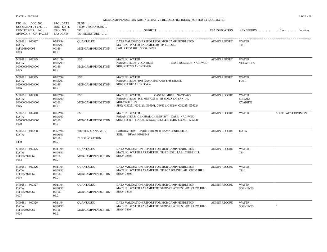
DATE - 08/24/98 PAGE - 68MCB CAMP PENDLETON ADMINISTRATIVE RECORD FILE INDEX (SORTED BY DOC. DATE)
UIC No. DOC. NO. PRC . DATE FROM . . . . . . . . . . . . . . .DOCUMENT . TYPE . . . DOC . DATE FROM . SIGNATURE . .CONTR/GUID . . NO . . CTO . NO . . TO . . . . . . . . . . . . . . . . . . . . . . . . . . . . . . . . . . . .SUBJECT . . . . . . . . . . . . . . . . . . . . . . . . . . . . . . . . . . . CLASSIFICATION KEY WORDS . . . . . . . . . . . . . . . .Site . . . . . . . . . LocationAPPROX. # . OF . PAGES EPA . CAT# TO . SIGNATURE . . . . .
M00681 000637 05/13/94 QUANTALEX DATA VALIDATION REPORT FOR MCB CAMP PENDLETONMATRIX: WATER PARAMETER: TPH DIESELLAB: CH2M HILL SDG# 34296
ADMIN REPORT WATERDATA 03/05/93 TPH01F166S920066 00166 MCB CAMP PENDLETON0013 02.2
M00681 002345 07/21/94 ESE MATRIX: WATERPARAMETERS: VOLATILES CASE NUMBER: NACPW6DSDG: G35793 AND G36496
ADMIN REPORT WATERDATA 03/05/93 VOLATILES0000000000000000 00166 MCB CAMP PENDLETON0025 02.2
M00681 002395 07/22/94 ESE MATRIX: WATERPARAMETERS: TPH-GASOLINE AND TPH-DIESELSDG: G35812 AND G36494
ADMIN REPORT WATERDATA 03/05/93 FUEL0000000000000000 00166 MCB CAMP PENDLETON0016 02.2
M00681 002398 07/22/94 ESE MATRIX: WATER CASE NUMBER: NACPW6DPARAMETERS: TCL METALS WITH BORON, CYANIDE,MOLYBDENUNSDG: G36251, G36110, G36361, G36331, G36246, G36245, G36224
ADMIN RECORD WATERDATA 03/05/93 METALS0000000000000000 00166 MCB CAMP PENDLETON CYANIDE0045 02.2
M00681 002440 07/22/94 ESE MATRIX: WATERPARAMETERS: GENERAL CHEMISTRY CASE: NACPW6DSDG: G35881, G26526, G36442, G36234, G36446, G35961, G36031
ADMIN RECORD WATER SOUTHWEST DIVISIONDATA 03/05/930000000000000000 00166 MCB CAMP PENDLETON0020 02.2
M00681 001258 05/27/94 WESTON MANAGERS LABORATORY REPORT FOR MCB CAMP PENDLETONSOIL RFW# 9303S245
ADMIN RECORD DATADATA 03/06/93
00166 IT CORPORATION0450 02.2
M00681 000325 05/11/94 QUANTALEX DATA VALIDATION REPORT FOR MCB CAMP PENDLETONMATRIX: WATER PARAMETER: TPH DIESEL LAB: CH2M HILLSDG# 33806
ADMIN RECORD WATERDATA 03/08/93 TPH01F166S920066 00166 MCB CAMP PENDLETON0013 02.2
M00681 000326 05/11/94 QUANTALEX DATA VALIDATION REPORT FOR MCB CAMP PENDLETONMATRIX: WATER PARAMETER: TPH GASOLINE LAB: CH2M HILLSDG# 33806
ADMIN RECORD WATERDATA 03/08/93 TPH01F166S920066 00166 MCB CAMP PENDLETON0014 02.2
M00681 000327 05/11/94 QUANTALEX DATA VALIDATION REPORT FOR MCB CAMP PENDLETONMATRIX: WATER PARAMETER: SEMIVOLATILES LAB: CH2M HILLSDG# 34325
ADMIN RECORD WATERDATA 03/08/93 SOLVENTS01F166S920066 00166 MCB CAMP PENDLETON0027 02.2
M00681 000328 05/11/94 QUANTALEX DATA VALIDATION REPORT FOR MCB CAMP PENDLETONMATRIX: WATER PARAMETER: SEMIVOLATILES LAB: CH2M HILLSDG# 34364
ADMIN RECORD WATERDATA 03/08/93 SOLVENTS `01F166S920066 00166 MCB CAMP PENDLETON0024 02.2
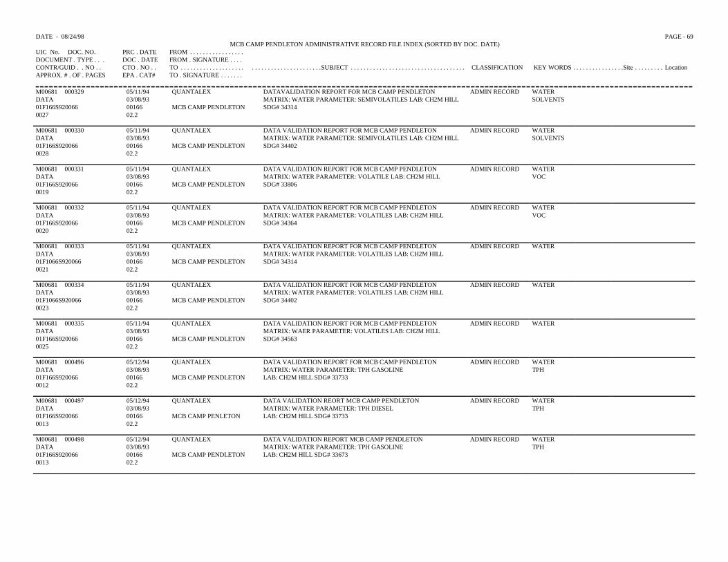
DATE - 08/24/98 PAGE - 69MCB CAMP PENDLETON ADMINISTRATIVE RECORD FILE INDEX (SORTED BY DOC. DATE)
UIC No. DOC. NO. PRC . DATE FROM . . . . . . . . . . . . . . . . .DOCUMENT . TYPE . . . DOC . DATE FROM . SIGNATURE . . . .CONTR/GUID . . NO . . CTO . NO . . TO . . . . . . . . . . . . . . . . . . . . . . . . . . . . . . . . . . . . . . . . . .SUBJECT . . . . . . . . . . . . . . . . . . . . . . . . . . . . . . . . . . . . CLASSIFICATION KEY WORDS . . . . . . . . . . . . . . . .Site . . . . . . . . . LocationAPPROX. # . OF . PAGES EPA . CAT# TO . SIGNATURE . . . . . . .
M00681 000329 05/11/94 QUANTALEX DATAVALIDATION REPORT FOR MCB CAMP PENDLETON MATRIX: WATER PARAMETER: SEMIVOLATILES LAB: CH2M HILL SDG# 34314
ADMIN RECORD WATERDATA 03/08/93 SOLVENTS 01F166S920066 00166 MCB CAMP PENDLETON 0027 02.2
M00681 000330 05/11/94 QUANTALEX DATA VALIDATION REPORT FOR MCB CAMP PENDLETONMATRIX: WATER PARAMETER: SEMIVOLATILES LAB: CH2M HILL SDG# 34402
ADMIN RECORD WATER DATA 03/08/93 SOLVENTS 01F166S920066 00166 MCB CAMP PENDLETON 0028 02.2
M00681 000331 05/11/94 QUANTALEX DATA VALIDATION REPORT FOR MCB CAMP PENDLETON MATRIX: WATER PARAMETER: VOLATILE LAB: CH2M HILL SDG# 33806
ADMIN RECORD WATER DATA 03/08/93 VOC01F166S920066 00166 MCB CAMP PENDLETON 0019 02.2
M00681 000332 05/11/94 QUANTALEX DATA VALIDATION REPORT FOR MCB CAMP PENDLETON MATRIX: WATER PARAMETER: VOLATILES LAB: CH2M HILL SDG# 34364
ADMIN RECORD WATER DATA 03/08/93 VOC01F166S920066 00166 MCB CAMP PENDLETON 0020 02.2
M00681 000333 05/11/94 QUANTALEX DATA VALIDATION REPORT FOR MCB CAMP PENDLETON MATRIX: WATER PARAMETER: VOLATILES LAB: CH2M HILL SDG# 34314
ADMIN RECORD WATER DATA 03/08/9301F1066S920066 00166 MCB CAMP PENDLETON 0021 02.2
M00681 000334 05/11/94 QUANTALEX DATA VALIDATION REPORT FOR MCB CAMP PENDLETON MATRIX: WATER PARAMETER: VOLATILES LAB: CH2M HILL SDG# 34402
ADMIN RECORD WATER DATA 03/08/9301F1066S920066 00166 MCB CAMP PENDLETON 0023 02.2
M00681 000335 05/11/94 QUANTALEX DATA VALIDATION REPORT FOR MCB CAMP PENDLETON ADMIN RECORD WATER DATA 03/08/93 MATRIX: WAER PARAMETER: VOLATILES LAB: CH2M HILL 01F166S920066 00166 MCB CAMP PENDLETON SDG# 34563 0025 02.2
M00681 000496 05/12/94 QUANTALEX DATA VALIDATION REPORT FOR MCB CAMP PENDLETON MATRIX: WATER PARAMETER: TPH GASOLINE LAB: CH2M HILL SDG# 33733
ADMIN RECORD WATER DATA 03/08/93 TPH01F166S920066 00166 MCB CAMP PENDLETON 0012 02.2
M00681 000497 05/12/94 QUANTALEX DATA VALIDATION REORT MCB CAMP PENDLETON ADMIN RECORD WATER DATA 03/08/93 MATRIX: WATER PARAMETER: TPH DIESEL TPH 01F166S920066 00166 MCB CAMP PENLETON LAB: CH2M HILL SDG# 337330013 02.2
M00681 000498 05/12/94 QUANTALEX DATA VALIDATION REPORT MCB CAMP PENDLETON MATRIX: WATER PARAMETER: TPH GASOLINE LAB: CH2M HILL SDG# 33673
ADMIN RECORD WATER DATA 03/08/93 TPH01F166S920066 00166 MCB CAMP PENDLETON 0013 02.2
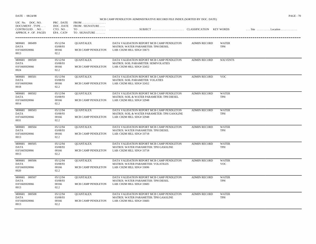
DATE - 08/24/98 PAGE - 70MCB CAMP PENDLETON ADMINISTRATIVE RECORD FILE INDEX (SORTED BY DOC. DATE)
UIC No. DOC. NO. PRC . DATE FROM . . . . . . . . . . . . . . . . .DOCUMENT . TYPE . . . DOC . DATE FROM . SIGNATURE . . . .CONTR/GUID . . NO . . CTO . NO . . TO . . . . . . . . . . . . . . . . . . . . . . . . . . . . . . . . . . . . . . . . . .SUBJECT . . . . . . . . . . . . . . . . . . . . . . . CLASSIFICATION KEY WORDS . . . Site . . . . . . . . . . Location . . . . . . . . . . . .APPROX. # . OF . PAGES EPA . CAT# TO . SIGNATURE . . . . . . .
M00681 000499 05/12/94 QUANTALEX DATA VALIDATION REPORT MCB CAMP PENDLETON MATRIX: WATER PARAMETER: TPH DIESEL LAB: CH2M HILL SDG# 33673
ADMIN RECORD WATER DATA 03/08/93 TPH01F166S920066 00166 MCB CAMP PENDLETON 0013 02.2
M00681 000500 05/12/94 QUANTALEX DATA VALIDATION REPORT MCB CAMP PENDLETON MATRIX: SOIL PARAMETER: SEMIVOLATIES LAB: CH2M HILL SDG# 32452
ADMIN RECORD SOLVENTS DATA 03/08/9301F166S920066 00166 MCB CAMP PENDLETON 0024 02.2
M00681 000501 05/12/94 QUANTALEX DATA VALIDATION REPORT MCB CAMP PENDLETON MATRIX: SOIL PARAMETER: VOLATIES LAB: CH2M HILL SDG# 32452
ADMIN RECORD VOC DATA 03/08/93 01F166S92066 00166 MCB CAMP PENDLETON 0018 02.2
M00681 000502 05/12/94 QUANTALEX DATA VALIDATION REPORT MCB CAMP PENDLETON MATRIX: SOIL & WATER PARAMETER: TPH DIESEL LAB: CH2M HILL SDG# 32948
ADMIN RECORD WATER DATA 03/08/93 TPH01F166S920066 00166 MCB CAMP PENDLETON 0014 02.2
M00681 000503 05/12/94 QUANTALEX DATA VALIDATION REPORT MCB CAMP PENDLETON MATRIX: SOIL & WATER PARAMETER: TPH GASOLINE LAB: CH2M HILL SDG# 32948
ADMIN RECORD WATER DATA 03/08/93 TPH01F166S920066 00166 MCB CAMP PENDLETON 0031 02.2
M00681 000504 05/12/94 QUANTALEX DATA VALIDATION REPORT MCB CAMP PENDLETON ADMIN RECORD WATER DATA 03/08/93 MATRIX: WATER PARAMETER: TPH DIESEL TPH01F166S920066 00166 MCB CAMP PENDLETON LAB: CH2M HILL SDG# 337180013 02.2
M00681 000505 05/12/94 QUANTALEX DATA VALIDATION REPORT MCB CAMP PENDLETON ADMIN RECORD WATER DATA 03/08/93 MATRIX: WATER PARAMETER: TPH GASOLINE TPH01F1665920066 00166 MCB CAMP PENDLETON LAB: CH2M HILL SDG# 33718 0013 02.2
M00681 000506 05/12/94 QUANTALEX DATA VALIDATION REPORT MCB CAMP PENDLETON MATRIX: WATER PARAMETER: VOLATILESLAB: CH2M HILL SDG# 33696
ADMIN RECORD WATER DATA 03/08/93 VOC01F166S920066 00166 MCB CAMP PENDLETON 0020 02.2
M00681 000507 05/12/94 QUANTALEX DATA VALIDATION REPORT MCB CAMP PENDLETON ADMIN RECORD WATER DATA 03/08/93 MATRIX: WATER PARAMETER: TPH DIESEL TPH 01F166S920066 00166 MCB CAMP PENDLETON LAB: CH2M HILL SDG# 336830013 02.2
M00681 000508 05/12/94 QUANTALEX DATA VALIDATION REPORT MCB CAMP PENDLETON ADMIN RECORD WATER DATA 03/08/93 MATRIX: WATER PARAMETER: TPH GASOLINE TPH 01F166S920066 00166 MCB CAMP PENDLETON LAB: CH2M HILL SDG# 336830013 02.2
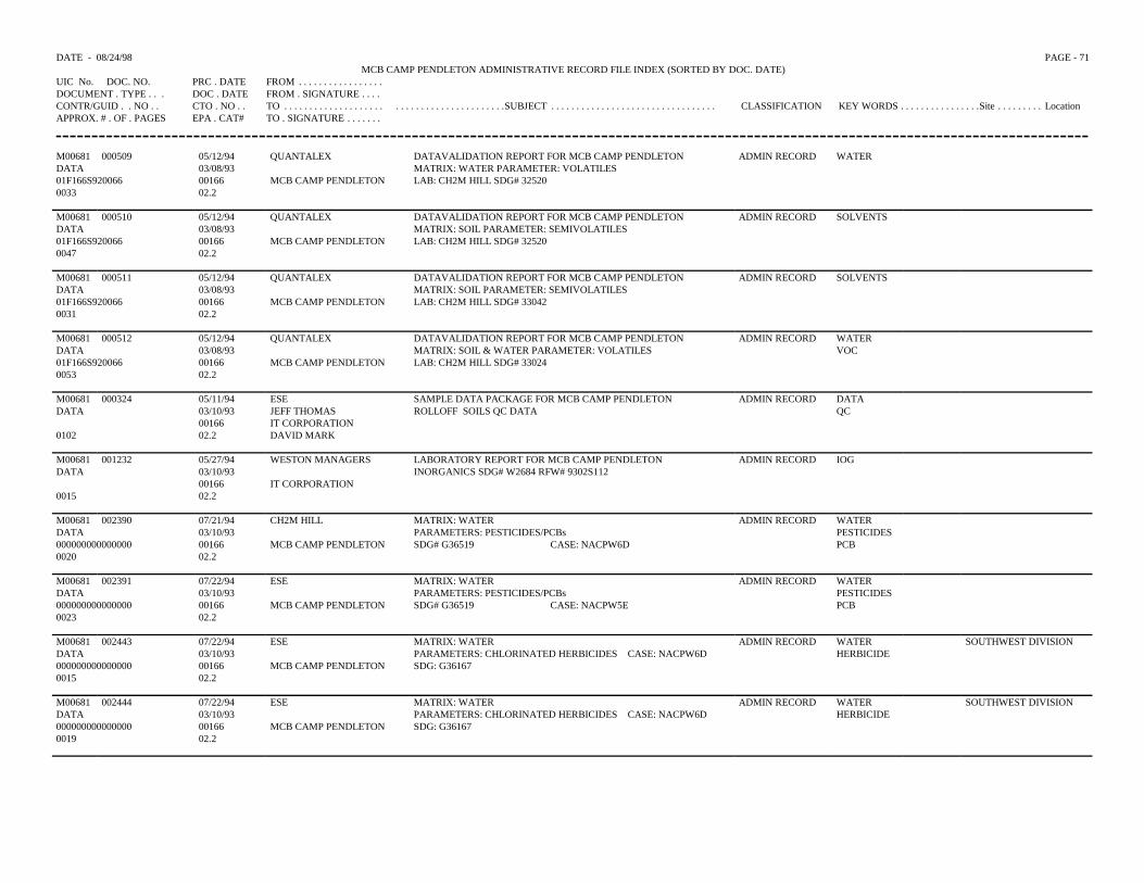
DATE - 08/24/98 PAGE - 71MCB CAMP PENDLETON ADMINISTRATIVE RECORD FILE INDEX (SORTED BY DOC. DATE)
UIC No. DOC. NO. PRC . DATE FROM . . . . . . . . . . . . . . . . .DOCUMENT . TYPE . . . DOC . DATE FROM . SIGNATURE . . . .CONTR/GUID . . NO . . CTO . NO . . TO . . . . . . . . . . . . . . . . . . . . . . . . . . . . . . . . . . . . . . . . . .SUBJECT . . . . . . . . . . . . . . . . . . . . . . . . . . . . . . . . . CLASSIFICATION KEY WORDS . . . . . . . . . . . . . . . .Site . . . . . . . . . LocationAPPROX. # . OF . PAGES EPA . CAT# TO . SIGNATURE . . . . . . .
M00681 000509 05/12/94 QUANTALEX DATAVALIDATION REPORT FOR MCB CAMP PENDLETON MATRIX: WATER PARAMETER: VOLATILES LAB: CH2M HILL SDG# 32520
ADMIN RECORD WATER DATA 03/08/9301F166S920066 00166 MCB CAMP PENDLETON 0033 02.2
M00681 000510 05/12/94 QUANTALEX DATAVALIDATION REPORT FOR MCB CAMP PENDLETON MATRIX: SOIL PARAMETER: SEMIVOLATILES LAB: CH2M HILL SDG# 32520
ADMIN RECORD SOLVENTS DATA 03/08/9301F166S920066 00166 MCB CAMP PENDLETON 0047 02.2
M00681 000511 05/12/94 QUANTALEX DATAVALIDATION REPORT FOR MCB CAMP PENDLETON MATRIX: SOIL PARAMETER: SEMIVOLATILES LAB: CH2M HILL SDG# 33042
ADMIN RECORD SOLVENTS DATA 03/08/9301F166S920066 00166 MCB CAMP PENDLETON 0031 02.2
M00681 000512 05/12/94 QUANTALEX DATAVALIDATION REPORT FOR MCB CAMP PENDLETON MATRIX: SOIL & WATER PARAMETER: VOLATILES LAB: CH2M HILL SDG# 33024
ADMIN RECORD WATER DATA 03/08/93 VOC01F166S920066 00166 MCB CAMP PENDLETON 0053 02.2
M00681 000324 05/11/94 ESE SAMPLE DATA PACKAGE FOR MCB CAMP PENDLETON ROLLOFF SOILS QC DATA
ADMIN RECORD DATA DATA 03/10/93 JEFF THOMAS QC
00166 IT CORPORATION 0102 02.2 DAVID MARK
M00681DATA
0015
001232 05/27/9403/10/930016602.2
WESTON MANAGERS
IT CORPORATION
LABORATORY REPORT FOR MCB CAMP PENDLETON INORGANICS SDG# W2684 RFW# 9302S112
ADMIN RECORD IOG
M00681 002390 07/21/94 CH2M HILL MATRIX: WATER PARAMETERS: PESTICIDES/PCBs SDG# G36519 CASE: NACPW6D
ADMIN RECORD WATER DATA 03/10/93 PESTICIDES 000000000000000 00166 MCB CAMP PENDLETON PCB 0020 02.2
M00681 002391 07/22/94 ESE MATRIX: WATER PARAMETERS: PESTICIDES/PCBs SDG# G36519 CASE: NACPW5E
ADMIN RECORD WATER DATA 03/10/93 PESTICIDES 000000000000000 00166 MCB CAMP PENDLETON PCB 0023 02.2
M00681 002443 07/22/94 ESE MATRIX: WATER ADMIN RECORD WATER SOUTHWEST DIVISIONDATA 03/10/93 PARAMETERS: CHLORINATED HERBICIDES CASE: NACPW6D HERBICIDE000000000000000 00166 MCB CAMP PENDLETON SDG: G36167 0015 02.2
M00681 002444 07/22/94 ESE MATRIX: WATER ADMIN RECORD WATER SOUTHWEST DIVISIONDATA 03/10/93 PARAMETERS: CHLORINATED HERBICIDES CASE: NACPW6D HERBICIDE 000000000000000 00166 MCB CAMP PENDLETON SDG: G36167 0019 02.2
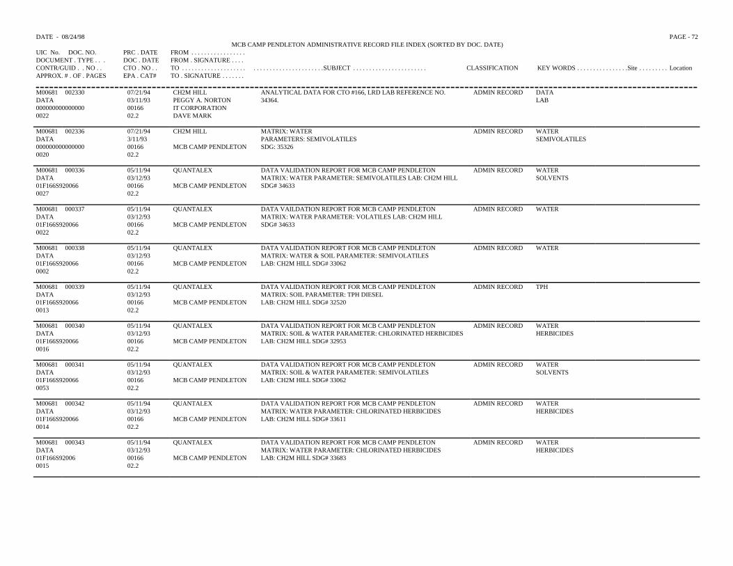
DATE - 08/24/98 PAGE - 72MCB CAMP PENDLETON ADMINISTRATIVE RECORD FILE INDEX (SORTED BY DOC. DATE)
UIC No. DOC. NO. PRC . DATE FROM . . . . . . . . . . . . . . . . .DOCUMENT . TYPE . . . DOC . DATE FROM . SIGNATURE . . . .CONTR/GUID . . NO . . CTO . NO . . TO . . . . . . . . . . . . . . . . . . . . . . . . . . . . . . . . . . . . . . . . . .SUBJECT . . . . . . . . . . . . . . . . . . . . . . . CLASSIFICATION KEY WORDS . . . . . . . . . . . . . . . .Site . . . . . . . . . LocationAPPROX. # . OF . PAGES EPA . CAT# TO . SIGNATURE . . . . . . .
M00681 002330 07/21/94 CH2M HILL ANALYTICAL DATA FOR CTO #166, LRD LAB REFERENCE NO.34364.
ADMIN RECORD DATADATA 03/11/93 PEGGY A. NORTON LAB000000000000000 00166 IT CORPORATION0022 02.2 DAVE MARK
M00681 002336 07/21/94 CH2M HILL MATRIX: WATERPARAMETERS: SEMIVOLATILESSDG: 35326
ADMIN RECORD WATERDATA 3/11/93 SEMIVOLATILES000000000000000 00166 MCB CAMP PENDLETON0020 02.2
M00681 000336 05/11/94 QUANTALEX DATA VALIDATION REPORT FOR MCB CAMP PENDLETONMATRIX: WATER PARAMETER: SEMIVOLATILES LAB: CH2M HILLSDG# 34633
ADMIN RECORD WATERDATA 03/12/93 SOLVENTS01F166S920066 00166 MCB CAMP PENDLETON0027 02.2
M00681 000337 05/11/94 QUANTALEX DATA VAILDATION REPORT FOR MCB CAMP PENDLETONMATRIX: WATER PARAMETER: VOLATILES LAB: CH2M HILLSDG# 34633
ADMIN RECORD WATERDATA 03/12/9301F166S920066 00166 MCB CAMP PENDLETON0022 02.2
M00681 000338 05/11/94 QUANTALEX DATA VALIDATION REPORT FOR MCB CAMP PENDLETONMATRIX: WATER & SOIL PARAMETER: SEMIVOLATILESLAB: CH2M HILL SDG# 33062
ADMIN RECORD WATERDATA 03/12/9301F166S920066 00166 MCB CAMP PENDLETON0002 02.2
M00681 000339 05/11/94 QUANTALEX DATA VALIDATION REPORT FOR MCB CAMP PENDLETONMATRIX: SOIL PARAMETER: TPH DIESELLAB: CH2M HILL SDG# 32520
ADMIN RECORD TPHDATA 03/12/9301F166S920066 00166 MCB CAMP PENDLETON0013 02.2
M00681 000340 05/11/94 QUANTALEX DATA VALIDATION REPORT FOR MCB CAMP PENDLETONMATRIX: SOIL & WATER PARAMETER: CHLORINATED HERBICIDESLAB: CH2M HILL SDG# 32953
ADMIN RECORD WATERDATA 03/12/93 HERBICIDES01F166S920066 00166 MCB CAMP PENDLETON0016 02.2
M00681 000341 05/11/94 QUANTALEX DATA VALIDATION REPORT FOR MCB CAMP PENDLETONMATRIX: SOIL & WATER PARAMETER: SEMIVOLATILESLAB: CH2M HILL SDG# 33062
ADMIN RECORD WATERDATA 03/12/93 SOLVENTS01F166S920066 00166 MCB CAMP PENDLETON0053 02.2
M00681 000342 05/11/94 QUANTALEX DATA VALIDATION REPORT FOR MCB CAMP PENDLETONMATRIX: WATER PARAMETER: CHLORINATED HERBICIDESLAB: CH2M HILL SDG# 33611
ADMIN RECORD WATERDATA 03/12/93 HERBICIDES01F166S920066 00166 MCB CAMP PENDLETON0014 02.2
M00681 000343 05/11/94 QUANTALEX DATA VALIDATION REPORT FOR MCB CAMP PENDLETONMATRIX: WATER PARAMETER: CHLORINATED HERBICIDESLAB: CH2M HILL SDG# 33683
ADMIN RECORD WATERDATA 03/12/93 HERBICIDES01F166S92006 00166 MCB CAMP PENDLETON0015 02.2
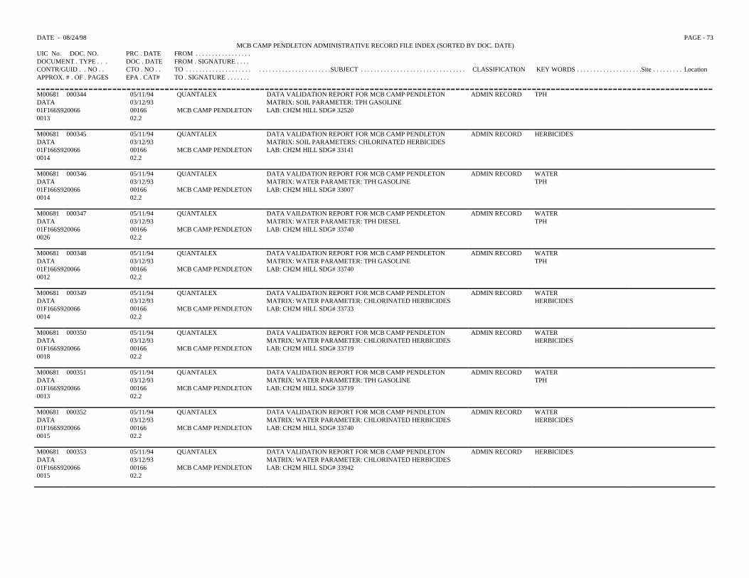
DATE - 08/24/98 PAGE - 73MCB CAMP PENDLETON ADMINISTRATIVE RECORD FILE INDEX (SORTED BY DOC. DATE)
UIC No. DOC. NO. PRC . DATE FROM . . . . . . . . . . . . . . . . .DOCUMENT . TYPE . . . DOC . DATE FROM . SIGNATURE . . . .CONTR/GUID . . NO . . CTO . NO . . TO . . . . . . . . . . . . . . . . . . . . . . . . . . . . . . . . . . . . . . . . . .SUBJECT . . . . . . . . . . . . . . . . . . . . . . . . . . . . . . . . CLASSIFICATION KEY WORDS . . . . . . . . . . . . . . . . . . . .Site . . . . . . . . . LocationAPPROX. # . OF . PAGES EPA . CAT# TO . SIGNATURE . . . . . . .
M00681 000344 05/11/94 QUANTALEX DATA VALIDATION REPORT FOR MCB CAMP PENDLETONMATRIX: SOIL PARAMETER: TPH GASOLINELAB: CH2M HILL SDG# 32520
ADMIN RECORD TPHDATA 03/12/9301F166S920066 00166 MCB CAMP PENDLETON0013 02.2
M00681 000345 05/11/94 QUANTALEX DATA VALIDATION REPORT FOR MCB CAMP PENDLETONMATRIX: SOIL PARAMETERS: CHLORINATED HERBICIDESLAB: CH2M HILL SDG# 33141
ADMIN RECORD HERBICIDESDATA 03/12/9301F166S920066 00166 MCB CAMP PENDLETON0014 02.2
M00681 000346 05/11/94 QUANTALEX DATA VALIDATION REPORT FOR MCB CAMP PENDLETONMATRIX: WATER PARAMETER: TPH GASOLINELAB: CH2M HILL SDG# 33007
ADMIN RECORD WATERDATA 03/12/93 TPH01F166S920066 00166 MCB CAMP PENDLETON0014 02.2
M00681 000347 05/11/94 QUANTALEX DATA VAILDATION REPORT FOR MCB CAMP PENDLETONMATRIX: WATER PARAMETER: TPH DIESELLAB: CH2M HILL SDG# 33740
ADMIN RECORD WATERDATA 03/12/93 TPH01F166S920066 00166 MCB CAMP PENDLETON0026 02.2
M00681 000348 05/11/94 QUANTALEX DATA VALIDATION REPORT FOR MCB CAMP PENDLETONMATRIX: WATER PARAMETER: TPH GASOLINELAB: CH2M HILL SDG# 33740
ADMIN RECORD WATERDATA 03/12/93 TPH01F166S920066 00166 MCB CAMP PENDLETON0012 02.2
M00681 000349 05/11/94 QUANTALEX DATA VALIDATION REPORT FOR MCB CAMP PENDLETONMATRIX: WATER PARAMETER: CHLORINATED HERBICIDESLAB: CH2M HILL SDG# 33733
ADMIN RECORD WATERDATA 03/12/93 HERBICIDES01F166S920066 00166 MCB CAMP PENDLETON0014 02.2
M00681 000350 05/11/94 QUANTALEX DATA VALIDATION REPORT FOR MCB CAMP PENDLETONMATRIX: WATER PARAMETER: CHLORINATED HERBICIDESLAB: CH2M HILL SDG# 33719
ADMIN RECORD WATERDATA 03/12/93 HERBICIDES01F166S920066 00166 MCB CAMP PENDLETON0018 02.2
M00681 000351 05/11/94 QUANTALEX DATA VALIDATION REPORT FOR MCB CAMP PENDLETONMATRIX: WATER PARAMETER: TPH GASOLINELAB: CH2M HILL SDG# 33719
ADMIN RECORD WATERDATA 03/12/93 TPH01F166S920066 00166 MCB CAMP PENDLETON0013 02.2
M00681 000352 05/11/94 QUANTALEX DATA VALIDATION REPORT FOR MCB CAMP PENDLETONMATRIX: WATER PARAMETER: CHLORINATED HERBICIDESLAB: CH2M HILL SDG# 33740
ADMIN RECORD WATERDATA 03/12/93 HERBICIDES01F166S920066 00166 MCB CAMP PENDLETON0015 02.2
M00681 000353 05/11/94 QUANTALEX DATA VALIDATION REPORT FOR MCB CAMP PENDLETONMATRIX: WATER PARAMETER: CHLORINATED HERBICIDESLAB: CH2M HILL SDG# 33942
ADMIN RECORD HERBICIDESDATA 03/12/9301F166S920066 00166 MCB CAMP PENDLETON0015 02.2
DATE - 08/24/98 PAGE - 74MCB CAMP PENDLETON ADMINISTRATIVE RECORD FILE INDEX (SORTED BY DOC. DATE)
UIC No. DOC. NO. PRC . DATE FROM . . . . . . . . . . . . . . . . .DOCUMENT . TYPE . . . DOC . DATE FROM . SIGNATURE . . . .CONTR/GUID . . NO . . CTO . NO . . TO . . . . . . . . . . . . . . . . . . . . . . . . . . . . . . . . . . . . . . . . . .SUBJECT . . . . . . . . . . . . . . . . . . . . . . . . . . . . . . . . . . . . . . . CLASSIFICATION KEY WORDS . . . Site . . . . . . . . . . . . . Location . . . . .APPROX. # . OF . PAGES EPA . CAT# TO . SIGNATURE . . . . . . .
M00681 000354 05/11/94 QUANTALEX DATA VALIDATION REPORT FOR MCB CAMP PENDLETONMATRIX: WATER PARAMETER: CHLORINATED HERBICIDESLAB: CH2M HILL SDG# 33643
ADMIN RECORD WATERDATA 03/12/93 HERBICIDES01F166S920066 00166 MCB CAMP PENDLETON0015 02.2
M00681 000355 05/11/94 QUANTALEX DATA VALIDATION REPORT FOR MCB CAMP PENDLETONMATRIX: WATER PARAMETERS: CHLORINATED HERBICIDESLAB: CH2M HILL SDG# 33624
ADMIN RECORD WATERDATA 03/12/93 HERBICIDES01F166S920066 00166 MCB CAMP PENDLETON0016 02.2
M00681 000356 05/11/94 QUANTALEX DATA VALIDATION REPORT FOR MCB CAMP PENDLETONMATRIX: WATER PARAMETER: CHLORINATED HERBICIDESLAB: CH2M HILL SDG# 33673
ADMIN RECORD WATERDATA 03/12/93 HERBICIDES01F166S920066 00166 MCB CAMP PENDLETON0013 02.2
M00681 000357 05/11/94 QUANTALEX DATA VAILDATION REPORT FOR MCB CAMP PENDLETONMATRIX: WATER PARAMETER: CHLORINATED HERBICIDESLAB: CH2M HILL SDG# 34689
ADMIN RECORD WATERDATA 03/12/93 HERBICIDES01F166S920066 00166 MCB CAMP PENDLETON0019 02.2
M00681 000358 05/11/94 QUANTALEX DATA VALIDATION REPORT FOR MCB CAMP PENDLETONMATRIX: WATER & SOIL PARAMETER: CHLORINATED HERBICIDESLAB: CH2M HILL SDG# 32948
ADMIN RECORD WATERDATA 03/12/93 HERBICIDES01F166S920066 00166 MCB CAMP PENDLETON0019 02.2
M00681 000359 05/11/94 QUANTALEX DATA VALIDATION REPORT FOR MCB CAMP PENDLETONMATRIX: SOIL PARAMETER: TPH DIESELLAB: CH2M HILL SDG# 32452
ADMIN RECORD TPHDATA 03/12/9301F166S920066 00166 MCB CAMP PENDLETON0013 02.2
M00681 000360 05/11/94 QUANTALEX DATA VALIDATION REPORT FOR MCB CAMP PENDLETONMATRIX: SOIL PARAMETER: TPH GASOLINELAB: CH2M HILL SDG# 32452
ADMIN RECORD TPHDATA 03/12/9301F166S920066 00166 MCB CAMP PENDLETON0012 02.2
M00681 000361 05/11/94 QUANTALEX DATA VALIDATION REPORT FOR MCB CAMP PENDLETONMATRIX: SOIL & WATER PARAMETER: CHLORINATED HERBICIDESLAB: CH2M HILL SDG# 32936
ADMIN RECORD WATERDATA 03/12/93 HERBICIDES01F166S920066 00166 MCB CAMP PENDLETON0016 02.2
M00681 000362 05/11/94 QUANTALEX DATA VALIDATION REPORT FOR MCB CAMP PENDLETONMATRIX: SOIL PARAMETER: CHLORINATED HERBICIDESLAB: CH2M HILL SDG# 32943
ADMIN RECORD HERBICIDESDATA 03/12/9301F166S920066 00166 MCB CAMP PENDLETON0018 02.2
M00681 000431 05/11/94 QUANTALEX DATA VALIDATION REPORT FOR MCB CAMP PENDLETONMATRIX: WATER PARAMETER: VOLATILESLAB: CH2M HILL SDG# 34325
ADMIN RECORD WATERDATA 03/12/93 VOC01F166S920066 00166 MCB CAMP PENDLETON0021 02.2
DATE - 08/24/98 PAGE -75 MCB CAMP PENDLETON ADMINISTRATIVE RECORD FILE INDEX (SORTED BY DOC. DATE)
UIC No. DOC. NO. PRC . DATE FROM . . . . . . . . . . . . .DOCUMENT . TYPE . . . DOC . DATE FROM . SIGNATURECONTR/GUID . . NO . . CTO . NO . . TO . . . . . . . . . . . . . . . . . . . . . . . . . . . . . . . . . . . . . . . .SUBJECT . . . . . . . . . . . . . . . . . . . . . . . . . . . CLASSIFICATION KEY WORDS . . Site . . . . . . . Location . . . . . . . . .APPROX. # . OF . PAGES EPA . CAT# TO . SIGNATURE . . .
M00681 000432 05/12/94 QUANTALEX DATA VALIDATION REPORT FOR MCB CAMP PENDLETON ADMIN RECORD WATERDATA 03/12/93 MATRIX: WATER PARAMETER: VOLATILES VOC01F166S920066 00166 MCB CAMP PENDLETON LAB: CH2MHILL SDG# 343650017 02.2
M00681 000433 05/12/94 QUANTALEX DATA VALIDATION REPORT FOR MCB CAMP PENDLETON ADMIN RECPRD WATERDATA 03/12/93 MATRIX: WATER PARAMETER: VOLATILES VOC01F166S920066 00166 MCB CAMP PENDLETON LAB: CH2MHILL SDG# 343760021 02.2
M00681 000434 05/12/94 QUANTALEX DATA VALIDATION REPORT FOR MCB CAMP PENDLETON ADMIN RECORD WATERDATA 03/12/93 MATRIX: WATER PARAMETER: VOLATILES VOC01F166S920066 00166 MCB CAMP PENDLETON LAB: CH2MHILL SDG# 343760033 02.2
M00681 000435 05/12/94 QUANTALEX DATA VALIDATION REPORT FOR MCB CAMP PENDLETON ADMIN RECORD WATERDATA 03/12/93 MATRIX: WATER PARAMETER: VOLATILES VOC01F166S920066 00166 MCB CAMP PENDLETON LAB: CH2MHILL SDG# 344140026 02.2
M00681 000436 05/12/94 QUANTALEX DATA VALIDATION REPORT FOR MCB CAMP PENDLETON ADMIN RECORD WATERDATA 3/12/93 MATRIX: WATER PARAMETER: VOLATILES VOC01F166S920066 00166 MCB CAMP PENDLETON LAB: CH2M HILL SDG# 345830020 02.2
M00681 000437 05/12/94 QUANTALEX DATA VALIDATION REPORT FOR MCB CAMP PENDLETON ADMIN RECORD WATERDATA 03/12/93 MATRIX: WATER PARAMETER: VOLATILES VOC01F166S920066 00166 MCB CAMP PENDLETON LAB: CH2MHILL SDG# 344290023 02.2
M00681 000438 05/12/94 QUANTALEX DATA VALIDATION REPORT FOR MCB CAMP PENDLETON ADMIN RECORD WATERDATA 03/12/93 MATRIX: WATER PARAMETER: CHLORINATED HERBICIDE HERBICIDE01F166S920066 00166 MCB CAMP PENDLETON LAB: CH2MHILL SDG# 341180016 02.2.
M00681 000439 05/12/94 QUANTALEX DATA VALIDATION REPORT FOR MCB CAMP PENDLETON ADMIN RECORD WATERDATA 03/12/93 MATRIX: WATER PARAMETER: GENERAL CHEMISTRY01F166S920066 00166 MCB CAMP PENDLETON LAB: CH2MHILL SDG# 343480013 02.2
M00681 000440 05/12/94 QUANTALEX DATA VALIDATION REPORT FOR MCB CAMP PENDLETON ADMIN RECORD WATERDATA 03/12/93 MATRIX: WATER PARAMETER: TCL METALS W\MOLYBDENUM BORON01F166S920066 00166 MCB CAMP PENDLETON LAB:CH2MHILL SDG# 343140029 02.2
M00681 000441 05/12/94 QUANTALEX DATA VALIDATION REPORT FOR MCB CAMP PENDLETON ADMIN RECORD WATERDATA 03/12/93 MATRIX: WATER PARAMETER: SEMIVOLATILES SOLVENTS01F166S920066 00166 MCB CAMP PENDLETON LAB: CH2MHILL SDG# 343650022 02.2
DATE - 08/24/98 PAGE -76 MCB CAMP PENDLETON ADMINISTRATIVE RECORD FILE INDEX (SORTED BY DOC. DATE)
UIC No. DOC. NO. PRC . DATE FROM . . . . . . . . . . . . .DOCUMENT . TYPE . . . DOC . DATE FROM . SIGNATURECONTR/GUID . . NO . . CTO . NO . . TO . . . . . . . . . . . . . . . . . . . . . . . . . . . . . . . . . . . . . . . .SUBJECT . . . . . . . . . . . . . . . . . . . . . . . . . . . . CLASSIFICATION KEY WORDS . . . Site . . . . . . . . . . Location . . . . . . . . . . . .APPROX. # . OF . PAGES EPA . CAT# TO . SIGNATURE . . .
M00681 000442 05/12/94 QUANTALEX DATA VALIDATION REPORT FOR MCB CAMP PENDLETON ADMIN RECORD WATERDATA 03/12/93 MATRIX: WATER PARAMETER: SEMIVOLATILES ADMIN RECORD SOLVENTS01F166S920066 00166 MCB CAMP PENDLETON LAB: CH2MHILL SDG# 342370027 02.2
M0681 000443 05/12/94 QUANTALEX DATA VALIDATION REPORT FOR MCB CAMP PENDLETON ADMIN RECORD WATERDATA 03/12/93 MARTIX: WATER PARAMETER: SEMIVOLATILES SOLVENTS01F166S920066 00166 MCB CAMP PENDLETON LAB: CH2MHILL SDG# 343760024 02.2
M00681 000444 05/12/94 QUANTALEX DATA VALIDATION FOR MCB CAMP PENDLETON ADMIN RECORD WATERDATA 03/12/93 MATRIX: WATER PARAMETER: SEMIVOLATILES01F166S920066 00166 MCB CAMP PENDLETON LAB: CH2MHILL SDG# 343760060 02.2
M00681 000445 05/12/94 QUANTALEX DATA VALIDATION REPORT MCB CAMP PENDLETON ADMIN RECORD WATERDATA 03/12/93 MATRIX: WATER PARAMETER: SEMIVOLATILES SOLVENTS01F166S920066 00166 MCB CAMP PENDLETON LAB: CH2M HILL SDG# 344140032 02.2
M00681 000446 05/12/94 QUANTALEX DATA VALIDATION REPORT MCB CAMP PENDLETON ADMIN RECORD WATERDATA 03/12/93 MATRIX: WATER PARAMETER: SEMIVOLATILES SOLVENTS01F166S920066 00166 MCN CAMP PENDLETON LAB: CH2M HILL SDG# 344290029 02.2
M00681 000447 05/12/94 QUANTALEX DATA VALIDATION REPORT MCB CAMP PENDLETON ADMIN RECORD WATERDATA 03/12/93 MATRIX: WATER PARAMETER: SEMIVOLATILES SOLVENTS01F166S920066 00166 MCB CAMP PENDLETON LAB: CH2M HILL SDG# 345830025 02.2
M00681 000323 05/11/94 WESTION MANAGERS LABORATORY REPORT FOR IT CORP. MCB CAMP PENDELTON ADMIN RECORD VOCDATA 03/15/93 ROY F. WESTON CLP/GC/MS VOLATILE ANALYSIS SDG# W2700
00166 IT CORPORATION RFW# 93024S205, 9302S215, 9303S237, 9303S2450436 02.2
M00681 002334 07/21/94 CN2M HILL MARTIX: WATER ADMIN RECIRD WATERDATA 03/17/93 PARAMETERS: SEMIVOLATILES SEMIVOLATILES000000000000000 00166 MCB CAMP PENDLETON SDG: 353770025 02.2
M00681 002434 07/22/94 CH2M HILL MATRIX: WATER ADMIN RECORD WATERDATA 03/17/93 PARAMETERS: TLC METALS WITH BORON, CYANIDE, AND METALS
166 MCB CAMP PENDLETON MOLYBDENUM SDG: 35377 CYANIDE0030 02.2
M0681 000316 05/11/94 CH2M HILL ANALYTICAL DATA BIO ACCUMULATION, PESTICIDES\PCBs ADMIN RECORD PESTICIDESDATA 03/18/93 PEGGY A. NORTON ORGNAICS, INORGANICS PCB35104 00166 MCB CAMP PENDLETON SDG# 35104 IOG1837 02.2
DATE - 08/24/98 PAGE -77 MCB CAMP PENDLETON ADMINISTRATIVE RECORD FILE INDEX (SORTED BY DOC. DATE)
UIC No. DOC. NO. PRC . DATE FROM . . . . . . . . . . . . .DOCUMENT . TYPE . . . DOC . DATE FROM . SIGNATURECONTR/GUID . . NO . . CTO . NO . . TO . . . . . . . . . . . . . . . . . . . . . . . . . . . . . . . . . . . . . . . .SUBJECT . . . . . . . . . . . . . . . . . . . . . . . CLASSIFICATION KEY WORDS . . . Site . . . . . . . . . . . . Location . . . . . . . . . . . . . . .APPROX. # . OF . PAGES EPA . CAT# TO . SIGNATURE . . .
M00681 000315 05/11/94 QUANTALEX DATA VALIDATION REPORT FOR MCB CAMP PENDLETON ADMIN RECORD WATERDATA 03/19/93 MATRIX: WATER PARAMETER: PESTICIDES\PCBs PESTICIDES01F166S920066 00166 MCB CAMP PENDLETON LAB: CH2M HILL SDG# 34365 PCB0017 02.2
M0681 000320 05/11/94 WESTION MANAGERS LABORATORY REPORT FOR IT CORP. VOLATILE PURGEABLE ADMIN RECORD TPHDATA 03/19/93 ROY P. WESTON PETROLEUM HYDROCARBONS ANALYSIS SDG# W2700
00166 IT CORPORATION RFW# 9302S205, 9303S2450083 02.2
M00681 000387 05/11/94 QUANTALEX DATA VALIDATION FOR MCB CAMP PENDLETON ADMIN RECORD WATERDATA 03/19/93 MATRIX: WATER PARAMETER: TPH DIESEL TPH01F166S920066 00166 MCB CAMP PENDLETON LAB: CH2M HILL SDG# 336240012 02.2
M00681 000388 05/11/94 QUANTALEX DATA VALIDATION REPORT MCB CAMP PENDLETON ADMIN RECORD WATERDATA 03/19/93 MATRIX: WATER PARAMETER: PESTICIDES\PCBs PESTICIDES01F166S920066 00166 MCB CAMP PENDLETON LAB: CH2M HILL SDG# 33642 PCB0018 02.2
M00681 000389 05/11/94 QUANTALEX DATA VALIDATION REPORT MCB CAMP PENDLETON ADMIN RECORD WATERDATA 03/19/93 MATRIX: WATER PARAMETER: PESTICIDES\PCBs PESTICIDES01F166S920066 00166 MCB CAMP PENDLETON LAB: CH2M HILL SDG# 34689 PCB0020 02.2
M00681 000390 05/11/94 QUANTALEX DATA VALIDATION REPORT FOR MCB CAMP PENDLETON ADMIN RECORD HERBICIDEDATA 03/19/93 MATRIX: SEDIMENT PARAMETER: CHLORAINATED HERBICIDE01F166S920066 00166 MCB CAMP PENDLETON LAB: CH2M HILL SDG# 324520018 02.2
M00681 000391 05/11/94 QUANTALEX DATA VALIDATION REPORT FOR MCB CAMP PENDLETON ADMIN RECORD WATERDATA 03/19/93 MATRIX: WATER PARAMETER: VOLATILES VOC01F166S920066 00166 MCB CAMP PENDLETON LAB: CH2M HILL SDG# 346880020 02.2
M00681 000392 05/11/94 QUANTALEX DATA VALIDATION REPORT FOR MCB CAMP PENDLETON ADMIN RECIRD WATERDATA 03/19/93 MARTIX: WATER PARAMETER: TPH DIESEL TPH01F166S920066 00166 MCB CAMP PENDLETON LAB: CH2M HILL SDG# 346880012 02.2
M00681 000393 05/11/94 QUANTALEX DATA VALIDATION REPORT FOR MCB CAMP PENDLETON ADMIN RECORD WATERDATA 03/19/93 MATRIX: WATER PARAMETER: TPH GASOLINE TPH01F166S920066 00166 MCB CAMP PENDLETON LAB: CH2M HILL SDG# 346880012 02.2
M0681 000394 05/11/94 QUANTALEX DATA VALIDATION REPORT FOR MCB CAMP PENDLETON ADMIN RECORD WATERDATA 03/19/93 MATRIX: WATER PARAMETER: CHLORINATED HERBICIDE HERBICIDE01F166S920066 00166 MCB CAMP PENDLETON LAB: CH2M HILL SDG# 346880017 02.2
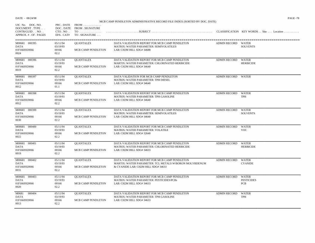
DATE - 08/24/98 PAGE -78 MCB CAMP PENDLETON ADMINISTRATIVE RECORD FILE INDEX (SORTED BY DOC. DATE)
UIC No. DOC. NO. PRC . DATE FROM . . . . . . . . . . . . .DOCUMENT . TYPE . . . DOC . DATE FROM . SIGNATURECONTR/GUID . . NO . . CTO . NO . . TO . . . . . . . . . . . . . . . . . . . . . . . . . . . . . . . . . . . . . . . .SUBJECT . . . . . . . . . . . . . . . . . . . . . . . . . . . . . . . . . . . . . . . . . . . . CLASSIFICATION KEY WORDS . . Site . . . Location . . . . . . . . . . .APPROX. # . OF . PAGES EPA . CAT# TO . SIGNATURE . . .
M00681 000395 05/11/94 QUANTALEX DATA VALIDATION REPORT FOR MCB CAMP PENDLETON ADMIN RECORD WATERDATA 03/19/93 MATRIX: WATER PARAMETER: SEMIVOLATILES SOLVENTS01F166S920066 00166 MCB CAMP PENDLETON LAB: CH2M HILL SDG# 346880024 02.2
M00681 000396 05/11/94 QUANTALEX DATA VALIDATION REPORT FOR MCB CAMP PENDLETON ADMIN RECORD WATERDATA 03/19/93 MARTIX: WATER PARAMETER: CHLORINATED HERBICIDE HERBICIDE01F166S920066 00166 MCB CAMP PENDLETON LAB: CH2M HILL SDG# 346400019 02.2
M00681 000397 05/11/94 QUANTALEX DATA VALIDATION FOR MCB CAMP PENDLETON ADMIN RECORD WATERDATA 03/19/93 MATRIX: WATER PARAMETER: TPH DIESEL01F166S920066 00166 MCB CAMP PENDLETON LAB: CH2M HILL SDG# 346400012 01.1
M00681 000398 05/11/94 QUANTALEX DATA VALIDATION REPORT FOR MCB CAMP PENDLETON ADMIN RECORD WATERDATA 03/19/93 MATRIX: WATER PARAMETER: TPH GASOLINE TPH01F166S920066 00166 MCB CAMP PENDLETON LAB: CH2M HILL SDG# 346400012 02.2
M00681 000399 05/11/94 QUANTALEX DATA VALIDATION REPORT FOR MCB CAMP PENDLETON ADMIN RECORD WATERDATA 03/19/93 MATRIX: WATER PARAMETER: SEMIVOLATILES SOLVENTS01F166S920066 00166 MCB CAMP PENDLETON LAB: CH2M HILL SDG# 346400030 02.2
M00681 000400 05/11/94 QUANTALEX DATA VALIDATION REPORT FOR MCB CAMP PENDLETON ADMIN RECORD WATERDATA 03/19/93 MATRIX: WATER PARAMETER: VOLATILE VOC01F166S920066 00166 MCB CAMP PENDLETON LAB: CH2M HILL SDG# 326400022 02.2
M00681 000401 05/11/94 QUANTALEX DATA VALIDATION REPORT FOR MCB CAMP PENDLETON ADMIN RECORD WATERDATA 03/19/93 MATRIX: WATER PARAMETER: CHLORINATED HERBICIDE HERBICIDE01F166S920066 00166 MCB CAMP PENDLETON LAB: CH2M HILL SDG# 346330019 02.2
M00681 000402 05/11/94 QUANTALEX DATA VALIDATION REPORT FOR MCB CAMP PENDLETON ADMIN RECORD WATERDATA 03/19/93 MARTIX: WATER PARAMETER: TCL METALS W\BORON MOLYBDENUM CYANIDE01F166S920066 00166 MCB CAMP PENDLETON & CYANIDE LAB: CH2M HILL SDG# 346330031 02.2
M00681 000403 05/11/94 QUANTALEX DATA VALIDATION REPORT FOR MCB CAMP PENDLETON ADMIN RECORD WATERDATA 03/19/93 MATRIX: WATER PARAMETER: PESTICIDES\PCBs PESTICIDES01F166S920066 00166 MCB CAMP PENDLETON LAB: CH2M HILL SDG# 34633 PCB0020 02.2
M0681 000404 05/11/94 QUANTALEX DATA VALIDATION REPORT FOR MCB CAMP PENDLETON ADMIN RECORD WATERDATA 03/19/93 MATRIX: WATER PARAMETER: TPH GASOLINE TPH01F166S920066 00166 MCB CAMP PENDLETON LAB: CH2M HILL SDG# 346330013 02.2
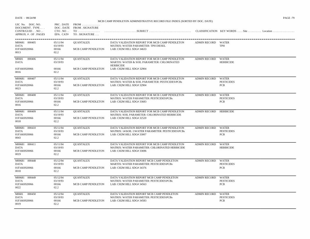
DATE - 08/24/98 PAGE -79 MCB CAMP PENDLETON ADMINISTRATIVE RECORD FILE INDEX (SORTED BY DOC. DATE)
UIC No. DOC. NO. PRC . DATE FROM . . . . . . . . . . . . .DOCUMENT . TYPE . . . DOC . DATE FROM . SIGNATURECONTR/GUID . . NO . . CTO . NO . . TO . . . . . . . . . . . . . . . . . . . . . . . . . . . . . . . . . . . . . . . .SUBJECT . . . . . . . . . . . . . . . . . . . . . . . . . . . . . . . CLASSIFICATION KEY WORDS . . . . Site . . . . . . . . . . Location . . . . . . . . . . . . . . . .APPROX. # . OF . PAGES EPA . CAT# TO . SIGNATURE . . .
M00681 000405 05/11/94 QUANTALEX DATA VALIDATION REPORT FOR MCB CAMP PENDLETON ADMIN RECORD WATERDATA 03/19/93 MATRIX: WATER PARAMETER: TPH DIESEL TPH01F166S920066 00166 MCB CAMP PENDLETON LAB: CH2M HILL SDG# 346330013 02.2
M0681 000406 05/11/94 QUANTALEX DATA VALIDATION REPORT FOR MCB CAMP PENDLETON ADMIN RECORD WATERDATA 03/19/93 MARTIX: WATER & SOIL PARAMETER: CHLORINATED
HERBICIDEHERBICIDE
01F166S920066 00166 MCB CAMP PENDLETON LAB: CH2M HILL SDG# 329040016 02.2
M00681 000407 05/11/94 QUANTALEX DATA VALIDATION REPORT FOR MCB CAMP PENDLETON ADMIN RECORD WATERDATA 03/19/93 MATRIX: WATER & SOIL PARAMETER: PESTICIDES\PCBs PESTICIDES01F166S920066 00166 MCB CAMP PENDLETON LAB: CH2M HILL SDG# 32904 PCB0023 02.2
M00681 000408 05/11/94 QUANTALEX DATA VALIDATION REPORT FOR MCB CAMP PENDLETON ADMIN RECORD WATERDATA 03/19/93 MATRIX: WATER PARAMETER: PESTICIDES\PCBs PESTICIDES01F166S920066 00166 MCB CAMP PENDLETON LAB: CH2M HILL SDG# 33683 PCB0016 02.2
M00681 000409 05/11/94 QUANTALEX DATA VALIDATION REPORT FOR MCB CAMP PENDLETON ADMIN RECORD HERBICIDEDATA 03/19/93 MATRIX: SOIL PARAMETER: CHLORINATED HERBICIDE01F166S920066 00166 MCB CAMP PENDLETON LAB: CH2M HILL SDG# 325200018 02.2
M00681 000410 05/11/94 QUANTALEX DATA VALIDATION REPORT FOR MCB CAMP PENDLETON ADMIN RECORD WATERDATA 03/19/93 MATRIX: 14\SOIL 1\WATER PARAMETER: PESTICIDES\PCBs PESTICIDES01F166S920066 00166 MCB CAMP PENDLETON LAB: CH2M HILL SDG# 33007 PCB0043 02.2
M00681 000411 05/11/94 QUANTALEX DATA VALIDATION REPORT FOR MCB CAMP PENDLETON ADMIN RECORD WATERDATA 03/19/93 MATRIX: WATER PARAMETER: CHLORINATED HERBICIDE HERBICIDE01F166S920066 00166 MCB CAMP PENDLETON LAB: CH2M HILL SDG# 336960019 02.2
M00681 000448 05/12/94 QUANTALEX DATA VALIDATION REPORT MCB CAMP PENDLETON ADMIN RECORD WATERDATA 03/19/93 MARTIX: WATER PARAMETER: PESTICIDES\PCBs PESTICIDES01F166S920066 00166 MCB CAMP PENDLETON LAB: CH2M HILL SDG# 34376 PCB0018 02.2
M00681 000449 05/12/94 QUANTALEX DATA VALIDATION REPORT MCB CAMP PENDLETON ADMIN RECORD WATERDATA 03/19/93 MATRIX: WATER PARAMETER: PESTICIDES\PCBs PESTICIDES01F166S920066 00166 MCB CAMP PENDLETON LAB: CH2M HILL SDG# 34563 PCB0022 02.2
M0681 000450 05/12/94 QUANTALEX DATA VALIDATION REPORT MCB CAMP PENDLETON ADMIN RECORD WATERDATA 03/19/93 MATRIX: WATER PARAMETER: PESTICIDES\PCBs PESTICIDES01F166S920066 00166 MCB CAMP PENDLETON LAB: CH2M HILL SDG# 34583 PCB0019 02.2
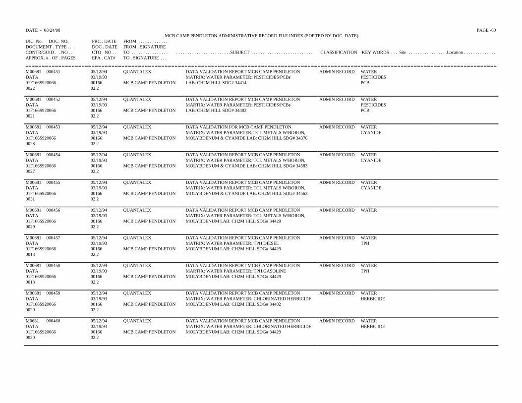
DATE - 08/24/98 PAGE -80 MCB CAMP PENDLETON ADMINISTRATIVE RECORD FILE INDEX (SORTED BY DOC. DATE)
UIC No. DOC. NO. PRC . DATE FROM . . . . . . . . . . . . .DOCUMENT . TYPE . . . DOC . DATE FROM . SIGNATURECONTR/GUID . . NO . . CTO . NO . . TO . . . . . . . . . . . . . . . . . . . . . . . . . . . . . . . . . . . . . . . .SUBJECT . . . . . . . . . . . . . . . . . . . . . . . . . . . CLASSIFICATION KEY WORDS . . . Site . . . . . . . . . . . . . . . . .Location . . . . . . . . . . . . . .APPROX. # . OF . PAGES EPA . CAT# TO . SIGNATURE . . .
M00681 000451 05/12/94 QUANTALEX DATA VALIDATION REPORT MCB CAMP PENDLETON ADMIN RECORD WATERDATA 03/19/93 MATRIX: WATER PARAMETER: PESTICIDES\PCBs PESTICIDES01F166S920066 00166 MCB CAMP PENDLETON LAB: CH2M HILL SDG# 34414 PCB0022 02.2
M00681 000452 05/12/94 QUANTALEX DATA VALIDATION REPORT MCB CAMP PENDLETON ADMIN RECORD WATERDATA 03/19/93 MARTIX: WATER PARAMETER: PESTICIDES\PCBs PESTICIDES01F166S920066 00166 MCB CAMP PENDLETON LAB: CH2M HILL SDG# 34402 PCB0021 02.2
M00681 000453 05/12/94 QUANTALEX DATA VALIDATION FOR MCB CAMP PENDLETON ADMIN RECORD WATERDATA 03/19/93 MATRIX: WATER PARAMETER: TCL METALS W\BORON, CYANIDE01F166S920066 00166 MCB CAMP PENDLETON MOLYBDENUM & CYANIDE LAB: CH2M HILL SDG# 343760028 02.2
M00681 000454 05/12/94 QUANTALEX DATA VALIDATION REPORT MCB CAMP PENDLETON ADMIN RECORD WATERDATA 03/19/93 MATRIX: WATER PARAMETER: TCL METALS W\BORON, CYANIDE01F166S920066 00166 MCB CAMP PENDLETON MOLYBDENUM & CYANIDE LAB: CH2M HILL SDG# 345830027 02.2
M00681 000455 05/12/94 QUANTALEX DATA VALIDATION REPORT MCB CAMP PENDLETON ADMIN RECORD WATERDATA 03/19/93 MATRIX: WATER PARAMETER: TCL METALS W\BORON, CYANIDE01F166S920066 00166 MCB CAMP PENDLETON MOLYBDENUM & CYANIDE LAB: CH2M HILL SDG# 345630031 02.2
M00681 000456 05/12/94 QUANTALEX DATA VALIDATION REPORT MCB CAMP PENDLETON ADMIN RECORD WATERDATA 03/19/93 MATRIX: WATER PARAMETER: TCL METALS W\BORON,01F166S920066 00166 MCB CAMP PENDLETON MOLYBDENUM LAB: CH2M HILL SDG# 344290029 02.2
M00681 000457 05/12/94 QUANTALEX DATA VALIDATION REPORT MCB CAMP PENDLETON ADMIN RECORD WATERDATA 03/19/93 MATRIX: WATER PARAMETER: TPH DIESEL TPH01F166S920066 00166 MCB CAMP PENDLETON MOLYBDENUM LAB: CH2M HILL SDG# 344290013 02.2
M00681 000458 05/12/94 QUANTALEX DATA VALIDATION REPORT MCB CAMP PENDLETON ADMIN RECORD WATERDATA 03/19/93 MARTIX: WATER PARAMETER: TPH GASOLINE TPH01F166S920066 00166 MCB CAMP PENDLETON MOLYBDENUM LAB: CH2M HILL SDG# 344290013 02.2
M00681 000459 05/12/94 QUANTALEX DATA VALIDATION REPORT MCB CAMP PENDLETON ADMIN RECORD WATERDATA 03/19/93 MATRIX: WATER PARAMETER: CHLORINATED HERBICIDE HERBICIDE01F166S920066 00166 MCB CAMP PENDLETON MOLYBDENUM LAB: CH2M HILL SDG# 344020020 02.2
M0681 000460 05/12/94 QUANTALEX DATA VALIDATION REPORT MCB CAMP PENDLETON ADMIN RECORD WATERDATA 03/19/93 MATRIX: WATER PARAMETER: CHLORINATED HERBICIDE HERBICIDE01F166S920066 00166 MCB CAMP PENDLETON MOLYBDENUM LAB: CH2M HILL SDG# 344290020 02.2
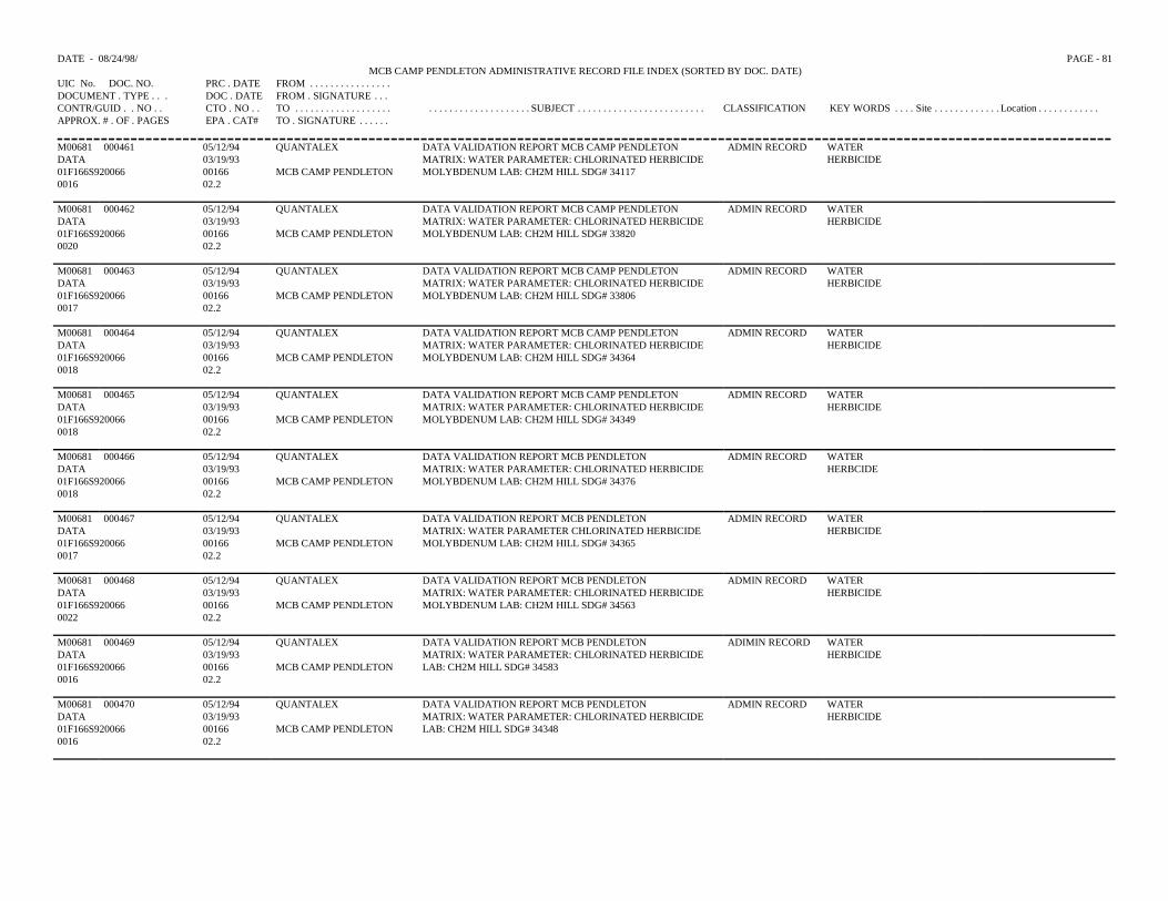
DATE - 08/24/98/ PAGE - 81MCB CAMP PENDLETON ADMINISTRATIVE RECORD FILE INDEX (SORTED BY DOC. DATE)
UIC No. DOC. NO. PRC . DATE FROM . . . . . . . . . . . . . . . .DOCUMENT . TYPE . . . DOC . DATE FROM . SIGNATURE . . .CONTR/GUID . . NO . . CTO . NO . . TO . . . . . . . . . . . . . . . . . . . . . . . . . . . . . . . . . . . . . . . SUBJECT . . . . . . . . . . . . . . . . . . . . . . . . . CLASSIFICATION KEY WORDS . . . . Site . . . . . . . . . . . . . Location . . . . . . . . . . . .APPROX. # . OF . PAGES EPA . CAT# TO . SIGNATURE . . . . . .
M00681 000461 05/12/94 QUANTALEX DATA VALIDATION REPORT MCB CAMP PENDLETON ADMIN RECORD WATER DATA 03/19/93 MATRIX: WATER PARAMETER: CHLORINATED HERBICIDE HERBICIDE01F166S920066 00166 MCB CAMP PENDLETON MOLYBDENUM LAB: CH2M HILL SDG# 341170016 02.2
M00681 000462 05/12/94 QUANTALEX DATA VALIDATION REPORT MCB CAMP PENDLETON ADMIN RECORD WATERDATA 03/19/93 MATRIX: WATER PARAMETER: CHLORINATED HERBICIDE HERBICIDE01F166S920066 00166 MCB CAMP PENDLETON MOLYBDENUM LAB: CH2M HILL SDG# 338200020 02.2
M00681 000463 05/12/94 QUANTALEX DATA VALIDATION REPORT MCB CAMP PENDLETON ADMIN RECORD WATER DATA 03/19/93 MATRIX: WATER PARAMETER: CHLORINATED HERBICIDE HERBICIDE01F166S920066 00166 MCB CAMP PENDLETON MOLYBDENUM LAB: CH2M HILL SDG# 338060017 02.2
M00681 000464 05/12/94 QUANTALEX DATA VALIDATION REPORT MCB CAMP PENDLETONMATRIX: WATER PARAMETER: CHLORINATED HERBICIDEMOLYBDENUM LAB: CH2M HILL SDG# 34364
ADMIN RECORD WATER DATA 03/19/93 HERBICIDE01F166S920066 00166 MCB CAMP PENDLETON0018 02.2
M00681 000465 05/12/94 QUANTALEX DATA VALIDATION REPORT MCB CAMP PENDLETON MATRIX: WATER PARAMETER: CHLORINATED HERBICIDEMOLYBDENUM LAB: CH2M HILL SDG# 34349
ADMIN RECORD WATERDATA 03/19/93 HERBICIDE01F166S920066 00166 MCB CAMP PENDLETON0018 02.2
M00681 000466 05/12/94 QUANTALEX DATA VALIDATION REPORT MCB PENDLETONMATRIX: WATER PARAMETER: CHLORINATED HERBICIDEMOLYBDENUM LAB: CH2M HILL SDG# 34376
ADMIN RECORD WATERDATA 03/19/93 HERBCIDE01F166S920066 00166 MCB CAMP PENDLETON0018 02.2
M00681 000467 05/12/94 QUANTALEX DATA VALIDATION REPORT MCB PENDLETONMATRIX: WATER PARAMETER CHLORINATED HERBICIDEMOLYBDENUM LAB: CH2M HILL SDG# 34365
ADMIN RECORD WATERDATA 03/19/93 HERBICIDE01F166S920066 00166 MCB CAMP PENDLETON0017 02.2
M00681 000468 05/12/94 QUANTALEX DATA VALIDATION REPORT MCB PENDLETONMATRIX: WATER PARAMETER: CHLORINATED HERBICIDEMOLYBDENUM LAB: CH2M HILL SDG# 34563
ADMIN RECORD WATERDATA 03/19/93 HERBICIDE01F166S920066 00166 MCB CAMP PENDLETON0022 02.2
M00681 000469 05/12/94 QUANTALEX DATA VALIDATION REPORT MCB PENDLETONMATRIX: WATER PARAMETER: CHLORINATED HERBICIDELAB: CH2M HILL SDG# 34583
ADIMIN RECORD WATERDATA 03/19/93 HERBICIDE01F166S920066 00166 MCB CAMP PENDLETON0016 02.2
M00681 000470 05/12/94 QUANTALEX DATA VALIDATION REPORT MCB PENDLETONMATRIX: WATER PARAMETER: CHLORINATED HERBICIDELAB: CH2M HILL SDG# 34348
ADMIN RECORD WATERDATA 03/19/93 HERBICIDE01F166S920066 00166 MCB CAMP PENDLETON0016 02.2
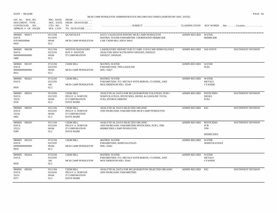
DATE - 08/24/98/ PAGE - 82MCB CAMP PENDLETON ADMINISTRATIVE RECORD FILE INDEX (SORTED BY DOC. DATE)
UIC No. DOC. NO. PRC . DATE FROM . . . . . . . . . . . . . . . .DOCUMENT . TYPE . . . DOC . DATE FROM . SIGNATURE . . .CONTR/GUID . . NO . . CTO . NO . . TO . . . . . . . . . . . . . . . . . . . . . . . . . . . . . . . . . . . . . . . . . . . . SUBJECT . . . . . . . . . . . . . . . . . . . . . . . . . . . CLASSIFICATION KEY WORDS . . Site . . . . . . . Location . . . . . . . . . . . . . . .APPROX. # . OF . PAGES EPA . CAT# TO . SIGNATURE . . . . . .
M00681 000471 05/12/94 QUANTALEX DATA VALIDATION REPORT MCB CAMP PENDLETONMATRIX: WATER PARAMETER: CHORINATED HERBICIDE LAB: CH2M HILL SDG# 34414
ADMIN RECORD WATERDATA 03/19/93 HERBICIDE01F166S920066 00166 MCB CAMP PENDLETON0020 02.2
M00681 000298 05/11/94 WESTON MANAGERS LABORATORY REPORT FOR IT CORP. CLP\GC\MS SEMIVOLATILEANALYSIS SDG# W2700 RFW# 9302S205, 9302S2159303S237, 9303S245
ADMIN RECORD SOLVENTS SOUTHWEST DIVISIONDATA 03/22/93 ROY F. WESTON000000000000000 00166 IT CORPORATION0488 02.2
M00681 002337 07/21/94 CH2M HILL MATRIX: WATER PARAMETERS: TPH-GASOLINESDG: 35427
ADMIN RECORD WATER DATA 03/22/93 FUEL000000000000000 00166 MCB CAMP PENDLETON0012 02.2
M00681 002421 07/22/94 CH2M HILL MATRIX: WATERPARAMETERS: TCL METALS WITH BORON, CYANIDE, ANDMOLYBDENUM SDG: 35549
ADMIN RECORD WATERDATA 03/22/93 METALS
166 MCB CAMP PENDLETON CYANIDE0030 02.2
M00681 000253 05/10/94 CH2M HILL ANALYTICAL DATA FOR MCLB BARSTOW VOLATILES, PCB’s ADMIN RECORD PESTICIDES SOUTHWEST DIVISIONDATA 03/23/93 PEGGY A. NORTON SEMIVOLATILES, PESTICIDES, DIESEL & GASOLINE TOTAL DIESEL 35235 00166 IT CORPORATION FUEL HYDROCARBONS FUEL0336 02.2 DAVE MARK
M00681 000291 05/11/94 CH2M HILL ANALYTICAL DATA SELECTED ORGANICAND INORGANIC PARAMETERS MCB CAMP PENDLETON
ADMIN RECORD IOG SOUTHWEST DIVISIONDATA 03/23/93 PEGGY A. NORTON35218 00166 IT CORPORATION0402 02.2 DAVE MARK
M00681 000293 05/11/94 CH2M HILL ANALYTICAL DATA SELECTED ORGANICAND INORGANIC PARAMETERS PESTICIDES, PCB’s, TPH,HERBICIDES CAMP PENDLETON
ADMIN RECORD PESTICIDES SOUTHWEST DIVISIONDATA 03/23/93 PEGGY A. NORTON PCB 35223 00166 IT CORPORATION TPH0289 02.2 DAVE MARK
HERBICIDES
M00681 002333 07/21/94 CH2M HILL MATRIX: WATER ADMIN RECORD WATERDATA 03/23/93 PARAMETERS: SEMIVOLATILES SEMIVOLATILES000000000000000 00166 MCB CAMP PENDLETON SDG: 354410019 02.2
M00681 002424 07/22/94 CH2M HILL MATRIX: WATERPARAMETERS: TCL METALS WITH BORON, CYANIDE, ANDMOLYBDENUM SDG: 35441
ADMIN RECORD WATERDATA 03/23/93 METALS
166 MCB CAMP PENDLETON CYANIDE0020 02.2
M00681 000292 05/11/94 CH2M HILL ANALYTICAL DATA FOR MCLB BARSTOW SELECTED ORGANICAND INORGANIC PARAMETERS
ADMIN RECORD IOG SOUTHWEST DIVISIONDATA 03/24/93 PEGGY A. NORTON 35251 00166 IT CORPORATION0371 02.2 DAVE MARK
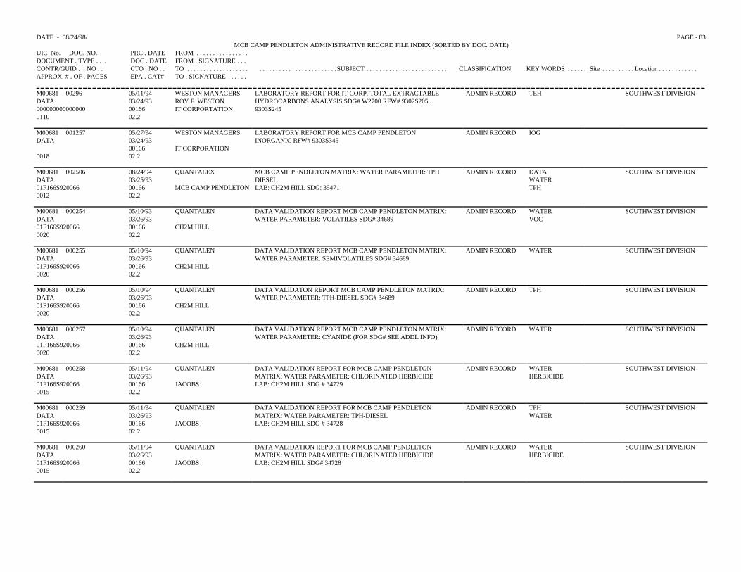
DATE - 08/24/98/ PAGE - 83MCB CAMP PENDLETON ADMINISTRATIVE RECORD FILE INDEX (SORTED BY DOC. DATE)
UIC No. DOC. NO. PRC . DATE FROM . . . . . . . . . . . . . . . .DOCUMENT . TYPE . . . DOC . DATE FROM . SIGNATURE . . .CONTR/GUID . . NO . . CTO . NO . . TO . . . . . . . . . . . . . . . . . . . . . . . . . . . . . . . . . . . . . . . . . . .SUBJECT . . . . . . . . . . . . . . . . . . . . . . . . . CLASSIFICATION KEY WORDS . . . . . . Site . . . . . . . . . . Location . . . . . . . . . . . .APPROX. # . OF . PAGES EPA . CAT# TO . SIGNATURE . . . . . .
M00681 00296 05/11/94 WESTON MANAGERS LABORATORY REPORT FOR IT CORP. TOTAL EXTRACTABLEHYDROCARBONS ANALYSIS SDG# W2700 RFW# 9302S205,9303S245
ADMIN RECORD TEH SOUTHWEST DIVISIONDATA 03/24/93 ROY F. WESTON000000000000000 00166 IT CORPORTATION0110 02.2
M00681 001257 05/27/94 WESTON MANAGERS LABORATORY REPORT FOR MCB CAMP PENDLETONINORGANIC RFW# 9303S345
ADMIN RECORD IOGDATA 03/24/93
00166 IT CORPORATION0018 02.2
M00681 002506 08/24/94 QUANTALEX MCB CAMP PENDLETON MATRIX: WATER PARAMETER: TPHDIESELLAB: CH2M HILL SDG: 35471
ADMIN RECORD DATA SOUTHWEST DIVISIONDATA 03/25/93 WATER01F166S920066 00166 MCB CAMP PENDLETON TPH0012 02.2
M00681 000254 05/10/93 QUANTALEN DATA VALIDATION REPORT MCB CAMP PENDLETON MATRIX:WATER PARAMETER: VOLATILES SDG# 34689
ADMIN RECORD WATER SOUTHWEST DIVISIONDATA 03/26/93 VOC01F166S920066 00166 CH2M HILL0020 02.2
M00681 000255 05/10/94 QUANTALEN DATA VALIDATION REPORT MCB CAMP PENDLETON MATRIX:WATER PARAMETER: SEMIVOLATILES SDG# 34689
ADMIN RECORD WATER SOUTHWEST DIVISIONDATA 03/26/9301F166S920066 00166 CH2M HILL0020 02.2
M00681 000256 05/10/94 QUANTALEN DATA VALIDATON REPORT MCB CAMP PENDLETON MATRIX:WATER PARAMETER: TPH-DIESEL SDG# 34689
ADMIN RECORD TPH SOUTHWEST DIVISIONDATA 03/26/9301F166S920066 00166 CH2M HILL0020 02.2
M00681 000257 05/10/94 QUANTALEN DATA VALIDATION REPORT MCB CAMP PENDLETON MATRIX:WATER PARAMETER: CYANIDE (FOR SDG# SEE ADDL INFO)
ADMIN RECORD WATER SOUTHWEST DIVISIONDATA 03/26/9301F166S920066 00166 CH2M HILL0020 02.2
M00681 000258 05/11/94 QUANTALEN DATA VALIDATION REPORT FOR MCB CAMP PENDLETONMATRIX: WATER PARAMETER: CHLORINATED HERBICIDELAB: CH2M HILL SDG # 34729
ADMIN RECORD WATER SOUTHWEST DIVISIONDATA 03/26/93 HERBICIDE01F166S920066 00166 JACOBS0015 02.2
M00681 000259 05/11/94 QUANTALEN DATA VALIDATION REPORT FOR MCB CAMP PENDLETONMATRIX: WATER PARAMETER: TPH-DIESELLAB: CH2M HILL SDG # 34728
ADMIN RECORD TPH SOUTHWEST DIVISIONDATA 03/26/93 WATER01F166S920066 00166 JACOBS0015 02.2
M00681 000260 05/11/94 QUANTALEN DATA VALIDATION REPORT FOR MCB CAMP PENDLETONMATRIX: WATER PARAMETER: CHLORINATED HERBICIDELAB: CH2M HILL SDG# 34728
ADMIN RECORD WATER SOUTHWEST DIVISIONDATA 03/26/93 HERBICIDE01F166S920066 00166 JACOBS0015 02.2
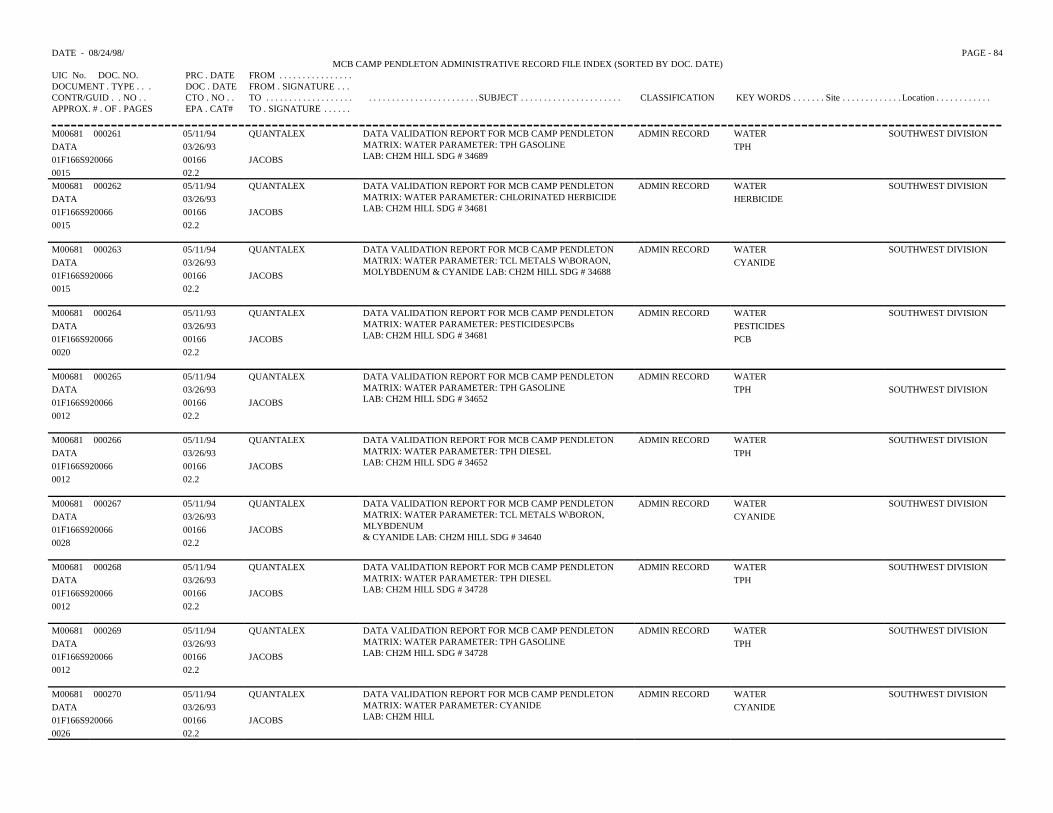
DATE - 08/24/98/ PAGE - 84MCB CAMP PENDLETON ADMINISTRATIVE RECORD FILE INDEX (SORTED BY DOC. DATE)
UIC No. DOC. NO. PRC . DATE FROM . . . . . . . . . . . . . . . .DOCUMENT . TYPE . . . DOC . DATE FROM . SIGNATURE . . .CONTR/GUID . . NO . . CTO . NO . . TO . . . . . . . . . . . . . . . . . . . . . . . . . . . . . . . . . . . . . . . . . . .SUBJECT . . . . . . . . . . . . . . . . . . . . . . CLASSIFICATION KEY WORDS . . . . . . . Site . . . . . . . . . . . . . Location . . . . . . . . . . . .APPROX. # . OF . PAGES EPA . CAT# TO . SIGNATURE . . . . . .
M00681 000261 05/11/94 QUANTALEX DATA VALIDATION REPORT FOR MCB CAMP PENDLETONMATRIX: WATER PARAMETER: TPH GASOLINELAB: CH2M HILL SDG # 34689
ADMIN RECORD WATER SOUTHWEST DIVISIONDATA 03/26/93 TPH01F166S920066 00166 JACOBS0015 02.2M00681 000262 05/11/94 QUANTALEX DATA VALIDATION REPORT FOR MCB CAMP PENDLETON
MATRIX: WATER PARAMETER: CHLORINATED HERBICIDELAB: CH2M HILL SDG # 34681
ADMIN RECORD WATER SOUTHWEST DIVISIONDATA 03/26/93 HERBICIDE01F166S920066 00166 JACOBS0015 02.2
M00681 000263 05/11/94 QUANTALEX DATA VALIDATION REPORT FOR MCB CAMP PENDLETONMATRIX: WATER PARAMETER: TCL METALS W\BORAON,MOLYBDENUM & CYANIDE LAB: CH2M HILL SDG # 34688
ADMIN RECORD WATER SOUTHWEST DIVISIONDATA 03/26/93 CYANIDE01F166S920066 00166 JACOBS0015 02.2
M00681 000264 05/11/93 QUANTALEX DATA VALIDATION REPORT FOR MCB CAMP PENDLETONMATRIX: WATER PARAMETER: PESTICIDES\PCBsLAB: CH2M HILL SDG # 34681
ADMIN RECORD WATER SOUTHWEST DIVISIONDATA 03/26/93 PESTICIDES01F166S920066 00166 JACOBS PCB0020 02.2
M00681 000265 05/11/94 QUANTALEX DATA VALIDATION REPORT FOR MCB CAMP PENDLETONMATRIX: WATER PARAMETER: TPH GASOLINELAB: CH2M HILL SDG # 34652
ADMIN RECORD WATERDATA 03/26/93 TPH SOUTHWEST DIVISION01F166S920066 00166 JACOBS0012 02.2
M00681 000266 05/11/94 QUANTALEX DATA VALIDATION REPORT FOR MCB CAMP PENDLETONMATRIX: WATER PARAMETER: TPH DIESEL LAB: CH2M HILL SDG # 34652
ADMIN RECORD WATER SOUTHWEST DIVISIONDATA 03/26/93 TPH01F166S920066 00166 JACOBS0012 02.2
M00681 000267 05/11/94 QUANTALEX DATA VALIDATION REPORT FOR MCB CAMP PENDLETONMATRIX: WATER PARAMETER: TCL METALS W\BORON,MLYBDENUM& CYANIDE LAB: CH2M HILL SDG # 34640
ADMIN RECORD WATER SOUTHWEST DIVISIONDATA 03/26/93 CYANIDE01F166S920066 00166 JACOBS0028 02.2
M00681 000268 05/11/94 QUANTALEX DATA VALIDATION REPORT FOR MCB CAMP PENDLETONMATRIX: WATER PARAMETER: TPH DIESELLAB: CH2M HILL SDG # 34728
ADMIN RECORD WATER SOUTHWEST DIVISIONDATA 03/26/93 TPH01F166S920066 00166 JACOBS0012 02.2
M00681 000269 05/11/94 QUANTALEX DATA VALIDATION REPORT FOR MCB CAMP PENDLETONMATRIX: WATER PARAMETER: TPH GASOLINELAB: CH2M HILL SDG # 34728
ADMIN RECORD WATER SOUTHWEST DIVISIONDATA 03/26/93 TPH01F166S920066 00166 JACOBS0012 02.2
M00681 000270 05/11/94 QUANTALEX DATA VALIDATION REPORT FOR MCB CAMP PENDLETONMATRIX: WATER PARAMETER: CYANIDELAB: CH2M HILL
ADMIN RECORD WATER SOUTHWEST DIVISIONDATA 03/26/93 CYANIDE01F166S920066 00166 JACOBS0026 02.2
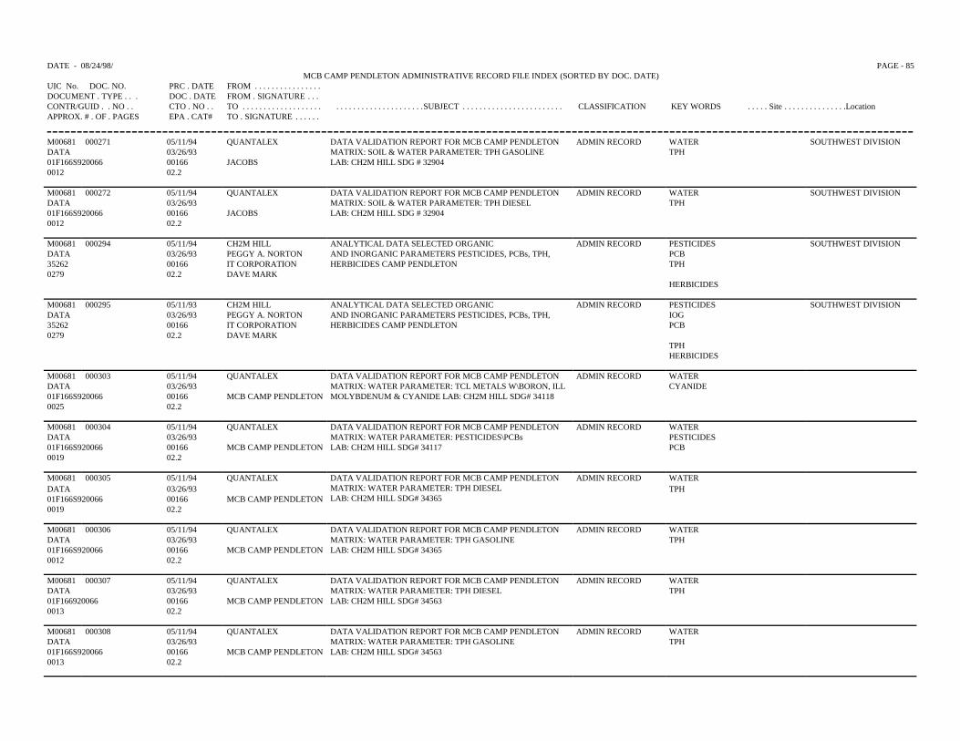
DATE - 08/24/98/ PAGE - 85MCB CAMP PENDLETON ADMINISTRATIVE RECORD FILE INDEX (SORTED BY DOC. DATE)
UIC No. DOC. NO. PRC . DATE FROM . . . . . . . . . . . . . . . .DOCUMENT . TYPE . . . DOC . DATE FROM . SIGNATURE . . .CONTR/GUID . . NO . . CTO . NO . . TO . . . . . . . . . . . . . . . . . . . . . . . . . . . . . . . . . . . . . . . .SUBJECT . . . . . . . . . . . . . . . . . . . . . . . . CLASSIFICATION KEY WORDS . . . . . Site . . . . . . . . . . . . . . .LocationAPPROX. # . OF . PAGES EPA . CAT# TO . SIGNATURE . . . . . .
M00681 000271 05/11/94 QUANTALEX DATA VALIDATION REPORT FOR MCB CAMP PENDLETONMATRIX: SOIL & WATER PARAMETER: TPH GASOLINELAB: CH2M HILL SDG # 32904
ADMIN RECORD WATER SOUTHWEST DIVISIONDATA 03/26/93 TPH01F166S920066 00166 JACOBS0012 02.2
M00681 000272 05/11/94 QUANTALEX DATA VALIDATION REPORT FOR MCB CAMP PENDLETONMATRIX: SOIL & WATER PARAMETER: TPH DIESELLAB: CH2M HILL SDG # 32904
ADMIN RECORD WATER SOUTHWEST DIVISIONDATA 03/26/93 TPH01F166S920066 00166 JACOBS0012 02.2
M00681 000294 05/11/94 CH2M HILL ANALYTICAL DATA SELECTED ORGANICAND INORGANIC PARAMETERS PESTICIDES, PCBs, TPH,HERBICIDES CAMP PENDLETON
ADMIN RECORD PESTICIDES SOUTHWEST DIVISIONDATA 03/26/93 PEGGY A. NORTON PCB35262 00166 IT CORPORATION TPH0279 02.2 DAVE MARK
HERBICIDES
M00681 000295 05/11/93 CH2M HILL ANALYTICAL DATA SELECTED ORGANICAND INORGANIC PARAMETERS PESTICIDES, PCBs, TPH,HERBICIDES CAMP PENDLETON
ADMIN RECORD PESTICIDES SOUTHWEST DIVISIONDATA 03/26/93 PEGGY A. NORTON IOG35262 00166 IT CORPORATION PCB0279 02.2 DAVE MARK
TPHHERBICIDES
M00681 000303 05/11/94 QUANTALEX DATA VALIDATION REPORT FOR MCB CAMP PENDLETONMATRIX: WATER PARAMETER: TCL METALS W\BORON, ILLMOLYBDENUM & CYANIDE LAB: CH2M HILL SDG# 34118
ADMIN RECORD WATERDATA 03/26/93 CYANIDE01F166S920066 00166 MCB CAMP PENDLETON0025 02.2
M00681 000304 05/11/94 QUANTALEX DATA VALIDATION REPORT FOR MCB CAMP PENDLETONMATRIX: WATER PARAMETER: PESTICIDES\PCBsLAB: CH2M HILL SDG# 34117
ADMIN RECORD WATERDATA 03/26/93 PESTICIDES01F166S920066 00166 MCB CAMP PENDLETON PCB0019 02.2
M00681 000305 05/11/94 QUANTALEX DATA VALIDATION REPORT FOR MCB CAMP PENDLETONMATRIX: WATER PARAMETER: TPH DIESELLAB: CH2M HILL SDG# 34365
ADMIN RECORD WATERDATA 03/26/93 TPH01F166S920066 00166 MCB CAMP PENDLETON 0019 02.2
M00681 000306 05/11/94 QUANTALEX DATA VALIDATION REPORT FOR MCB CAMP PENDLETONMATRIX: WATER PARAMETER: TPH GASOLINELAB: CH2M HILL SDG# 34365
ADMIN RECORD WATERDATA 03/26/93 TPH01F166S920066 00166 MCB CAMP PENDLETON0012 02.2
M00681 000307 05/11/94 QUANTALEX DATA VALIDATION REPORT FOR MCB CAMP PENDLETONMATRIX: WATER PARAMETER: TPH DIESELLAB: CH2M HILL SDG# 34563
ADMIN RECORD WATERDATA 03/26/93 TPH01F166920066 00166 MCB CAMP PENDLETON0013 02.2
M00681 000308 05/11/94 QUANTALEX DATA VALIDATION REPORT FOR MCB CAMP PENDLETON MATRIX: WATER PARAMETER: TPH GASOLINELAB: CH2M HILL SDG# 34563
ADMIN RECORD WATERDATA 03/26/93 TPH01F166S920066 00166 MCB CAMP PENDLETON0013 02.2
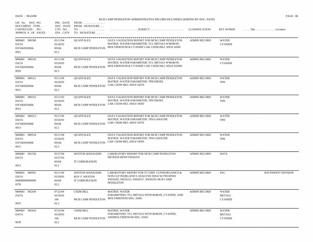
DATE - 08/24/98/ PAGE - 86MCB CAMP PENDLETON ADMINISTRATIVE RECORD FILE INDEX (SORTED BY DOC. DATE)
UIC No. DOC. NO. PRC . DATE FROM . . . . . . . . . . . . . . . .DOCUMENT . TYPE . . . DOC . DATE FROM . SIGNATURE . . .CONTR/GUID . . NO . . CTO . NO . . TO . . . . . . . . . . . . . . . . . . . . . . . . . . . . . . . . . . . . . . . .SUBJECT . . . . . . . . . . . . . . . . . . . . . . . . CLASSIFICATION KEY WORDS . . . . . Site . . . . . . . . . . . . . . .LocationAPPROX. # . OF . PAGES EPA . CAT# TO . SIGNATURE . . . . . .
M00681 000309 05/11/94 QUANTALEX DATA VALIDATION REPORT FOR MCB CAMP PENDLETONMATRIX: WATER PARAMETER: TCL METALS W\BORON,MOLYBDENUM & CYANIDE LAB: CH2M HILL SDG# 34365
ADMIN RECORD WATER DATA 03/26/93 CYANIDE01F166S920066 00166 MCB CAMP PENDLETON0025 02.2
M00681 000310 05/11/94 QUANTALEX DATA VALIDATION REPORT FOR MCB CAMP PENDLETONMATRIX: WATER PARAMETER: TCL METALS W\BORON,MOLYBDENUM & CYANIDE LAB: CH2M HILL SDG# 342966
ADMIN RECORD WATERDATA 03/26/93 CYANIDE01F166S920066 00166 MCB CAMP PENDLETON0026 02.2
M00681 000311 05/11/94 QUANTALEX DATA VALIDATION REPORT FOR MCB CAMP PENDLETONMATRIX: WATER PARAMETER: TPH DIESELLAB: CH2M HILL SDG# 34376
ADMIN RECORD WATER DATA 03/26/93 TPH01F166S920066 00166 MCB CAMP PENDLETON0012 02.2
M00681 000312 05/11/93 QUANTALEX DATA VALIDATION REPORT FOR MCB CAMP PENDLETONMATRIX: WATER PARAMETER: TPH DIESEL LAB: CH2M HILL SDG# 34583
ADMIN RECORD WATERDATA 03/26/93 TPH01F166S920066 00166 MCB CAMP PENDLETON0012 02.2
M00681 000313 05/11/94 QUANTALEX DATA VALIDATION REPORT FOR MCB CAMP PENDLETONMATRIX: WATER PARAMETER: TPH GASOLINELAB: CH2M HILL SDG# 34376
ADMIN RECORD WATERDATA 03/26/93 TPH01F166S920066 00166 MCB CAMP PENDLETON0013 02.2
M00681 000314 05/11/94 QUANTALEX DATA VALIDATION REPORT FOR MCB CAMP PENDLETONMATRIX: WATER PARAMETER: TPH GASOLINE LAB: CH2M HILL SDG# 34583
ADMIN RECORD WATERDATA 03/26/93 TPH01F166S920066 00166 MCB CAMP PENDLETON0012 02.2
M00681 001256 05/27/94 WESTON MANAGERS LABORATORY REPORT FOR MCB CAMP PENDLETONDIOXION RFW# 9303L019
ADMIN RECORD DATADATA 03/27/93
00166 IT CORPORATION0013 02.2
M00681 000301 05/11/94 WESTON MANAGERS LABORATORY REPORT FOR IT CORP. CLP\INORGANICS &NON-CLP INORGANICS ANALYSIS SDG# W2700 RFW#9302S205, 9302S215, 9303S237, 9303S245 MCB CAMPPENDLETON
ADMIN RECORD IOG SOUTHWEST DIVISIONDATA 03/29/93 ROY F. WESTON000000000000000 00166 IT CORPORATION0378 02.2
M00681 002430 07/22/94 CH2M HILL MATRIX: WATERPARAMETERS: TCL METALS WITH BORON, CYANIDE, AND MOLYBDENUM SDG: 35491
ADMIN RECORD WATERDATA 03/29/93 METALS
166 MCB CAMP PENDLETON CYANIDE0025 02.2
M00681 002433 07/22/94 CH2M HILL MATRIX: WATERPARAMETERS: TCL METALS WITH BORON, CYANIDE,ANDMOLYBDENUM SDG: 35502
ADMIN RECORD WATERDATA 03/30/93 METALS
166 MCB CAMP PENDLETON CYANIDE0030 02.2
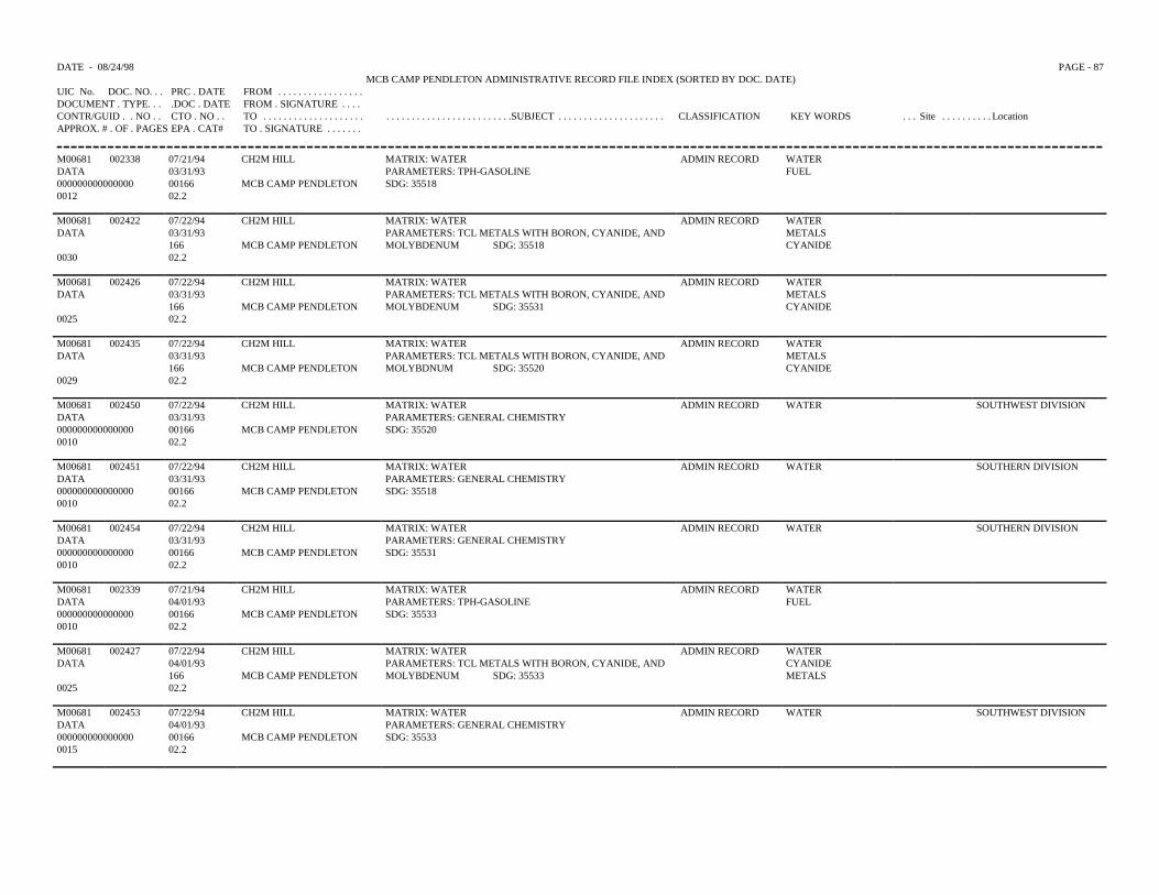
DATE - 08/24/98 PAGE - 87MCB CAMP PENDLETON ADMINISTRATIVE RECORD FILE INDEX (SORTED BY DOC. DATE)
UIC No. DOC. NO. . . PRC . DATE FROM . . . . . . . . . . . . . . . . .DOCUMENT . TYPE. . . .DOC . DATE FROM . SIGNATURE . . . .CONTR/GUID . . NO . . CTO . NO . . TO . . . . . . . . . . . . . . . . . . . . . . . . . . . . . . . . . . . . . . . . . . . . .SUBJECT . . . . . . . . . . . . . . . . . . . . . CLASSIFICATION KEY WORDS . . . Site . . . . . . . . . . LocationAPPROX. # . OF . PAGES EPA . CAT# TO . SIGNATURE . . . . . . .
M00681 002338 07/21/94 CH2M HILL MATRIX: WATER ADMIN RECORD WATERDATA 03/31/93 PARAMETERS: TPH-GASOLINE FUEL000000000000000 00166 MCB CAMP PENDLETON SDG: 355180012 02.2
M00681 002422 07/22/94 CH2M HILL MATRIX: WATER ADMIN RECORD WATERDATA 03/31/93 PARAMETERS: TCL METALS WITH BORON, CYANIDE, AND METALS
166 MCB CAMP PENDLETON MOLYBDENUM SDG: 35518 CYANIDE0030 02.2
M00681 002426 07/22/94 CH2M HILL MATRIX: WATER ADMIN RECORD WATERDATA 03/31/93 PARAMETERS: TCL METALS WITH BORON, CYANIDE, AND METALS
166 MCB CAMP PENDLETON MOLYBDENUM SDG: 35531 CYANIDE0025 02.2
M00681 002435 07/22/94 CH2M HILL MATRIX: WATER ADMIN RECORD WATERDATA 03/31/93 PARAMETERS: TCL METALS WITH BORON, CYANIDE, AND METALS
166 MCB CAMP PENDLETON MOLYBDNUM SDG: 35520 CYANIDE0029 02.2
M00681 002450 07/22/94 CH2M HILL MATRIX: WATER ADMIN RECORD WATER SOUTHWEST DIVISIONDATA 03/31/93 PARAMETERS: GENERAL CHEMISTRY000000000000000 00166 MCB CAMP PENDLETON SDG: 355200010 02.2
M00681 002451 07/22/94 CH2M HILL MATRIX: WATER ADMIN RECORD WATER SOUTHERN DIVISIONDATA 03/31/93 PARAMETERS: GENERAL CHEMISTRY000000000000000 00166 MCB CAMP PENDLETON SDG: 355180010 02.2
M00681 002454 07/22/94 CH2M HILL MATRIX: WATER ADMIN RECORD WATER SOUTHERN DIVISIONDATA 03/31/93 PARAMETERS: GENERAL CHEMISTRY000000000000000 00166 MCB CAMP PENDLETON SDG: 355310010 02.2
M00681 002339 07/21/94 CH2M HILL MATRIX: WATER ADMIN RECORD WATERDATA 04/01/93 PARAMETERS: TPH-GASOLINE FUEL000000000000000 00166 MCB CAMP PENDLETON SDG: 355330010 02.2
M00681 002427 07/22/94 CH2M HILL MATRIX: WATER ADMIN RECORD WATERDATA 04/01/93 PARAMETERS: TCL METALS WITH BORON, CYANIDE, AND CYANIDE
166 MCB CAMP PENDLETON MOLYBDENUM SDG: 35533 METALS0025 02.2
M00681 002453 07/22/94 CH2M HILL MATRIX: WATER ADMIN RECORD WATER SOUTHWEST DIVISIONDATA 04/01/93 PARAMETERS: GENERAL CHEMISTRY000000000000000 00166 MCB CAMP PENDLETON SDG: 355330015 02.2
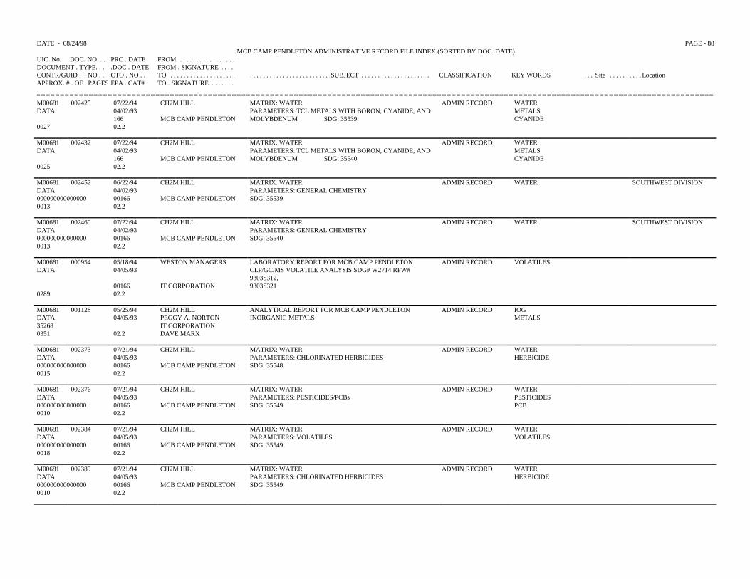
DATE - 08/24/98 PAGE - 88MCB CAMP PENDLETON ADMINISTRATIVE RECORD FILE INDEX (SORTED BY DOC. DATE)
UIC No. DOC. NO. . . PRC . DATE FROM . . . . . . . . . . . . . . . . .DOCUMENT . TYPE. . . .DOC . DATE FROM . SIGNATURE . . . .CONTR/GUID . . NO . . CTO . NO . . TO . . . . . . . . . . . . . . . . . . . . . . . . . . . . . . . . . . . . . . . . . . . . .SUBJECT . . . . . . . . . . . . . . . . . . . . . CLASSIFICATION KEY WORDS . . . Site . . . . . . . . . . LocationAPPROX. # . OF . PAGES EPA . CAT# TO . SIGNATURE . . . . . . .
M00681 002425 07/22/94 CH2M HILL MATRIX: WATER ADMIN RECORD WATERDATA 04/02/93 PARAMETERS: TCL METALS WITH BORON, CYANIDE, AND METALS
166 MCB CAMP PENDLETON MOLYBDENUM SDG: 35539 CYANIDE0027 02.2
M00681 002432 07/22/94 CH2M HILL MATRIX: WATER ADMIN RECORD WATERDATA 04/02/93 PARAMETERS: TCL METALS WITH BORON, CYANIDE, AND METALS
166 MCB CAMP PENDLETON MOLYBDENUM SDG: 35540 CYANIDE0025 02.2
M00681 002452 06/22/94 CH2M HILL MATRIX: WATER ADMIN RECORD WATER SOUTHWEST DIVISIONDATA 04/02/93 PARAMETERS: GENERAL CHEMISTRY000000000000000 00166 MCB CAMP PENDLETON SDG: 355390013 02.2
M00681 002460 07/22/94 CH2M HILL MATRIX: WATER ADMIN RECORD WATER SOUTHWEST DIVISIONDATA 04/02/93 PARAMETERS: GENERAL CHEMISTRY000000000000000 00166 MCB CAMP PENDLETON SDG: 355400013 02.2
M00681 000954 05/18/94 WESTON MANAGERS LABORATORY REPORT FOR MCB CAMP PENDLETON ADMIN RECORD VOLATILESDATA 04/05/93 CLP/GC/MS VOLATILE ANALYSIS SDG# W2714 RFW#
9303S312,00166 IT CORPORATION 9303S321
0289 02.2
M00681 001128 05/25/94 CH2M HILL ANALYTICAL REPORT FOR MCB CAMP PENDLETON ADMIN RECORD IOGDATA 04/05/93 PEGGY A. NORTON INORGANIC METALS METALS35268 IT CORPORATION0351 02.2 DAVE MARX
M00681 002373 07/21/94 CH2M HILL MATRIX: WATER ADMIN RECORD WATERDATA 04/05/93 PARAMETERS: CHLORINATED HERBICIDES HERBICIDE000000000000000 00166 MCB CAMP PENDLETON SDG: 355480015 02.2
M00681 002376 07/21/94 CH2M HILL MATRIX: WATER ADMIN RECORD WATERDATA 04/05/93 PARAMETERS: PESTICIDES/PCBs PESTICIDES000000000000000 00166 MCB CAMP PENDLETON SDG: 35549 PCB0010 02.2
M00681 002384 07/21/94 CH2M HILL MATRIX: WATER ADMIN RECORD WATERDATA 04/05/93 PARAMETERS: VOLATILES VOLATILES000000000000000 00166 MCB CAMP PENDLETON SDG: 355490018 02.2
M00681 002389 07/21/94 CH2M HILL MATRIX: WATER ADMIN RECORD WATERDATA 04/05/93 PARAMETERS: CHLORINATED HERBICIDES HERBICIDE000000000000000 00166 MCB CAMP PENDLETON SDG: 355490010 02.2
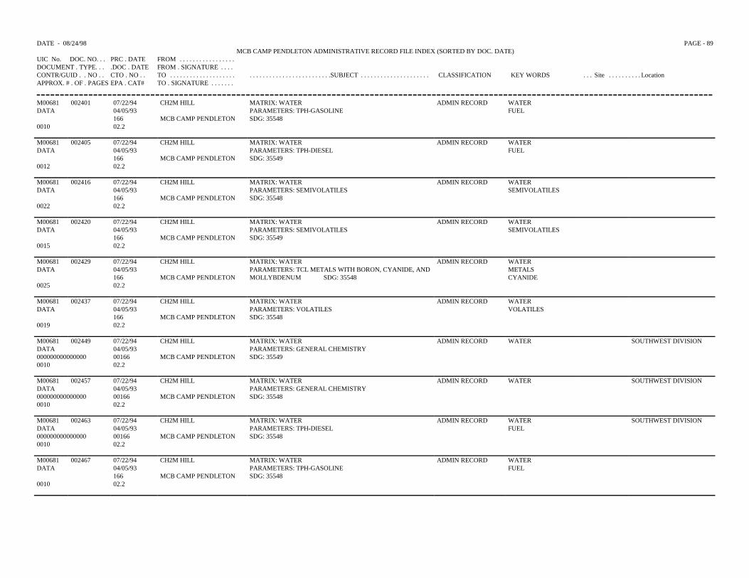
DATE - 08/24/98 PAGE - 89MCB CAMP PENDLETON ADMINISTRATIVE RECORD FILE INDEX (SORTED BY DOC. DATE)
UIC No. DOC. NO. . . PRC . DATE FROM . . . . . . . . . . . . . . . . .DOCUMENT . TYPE. . . .DOC . DATE FROM . SIGNATURE . . . .CONTR/GUID . . NO . . CTO . NO . . TO . . . . . . . . . . . . . . . . . . . . . . . . . . . . . . . . . . . . . . . . . . . . .SUBJECT . . . . . . . . . . . . . . . . . . . . . CLASSIFICATION KEY WORDS . . . Site . . . . . . . . . . LocationAPPROX. # . OF . PAGES EPA . CAT# TO . SIGNATURE . . . . . . .
M00681 002401 07/22/94 CH2M HILL MATRIX: WATER ADMIN RECORD WATERDATA 04/05/93 PARAMETERS: TPH-GASOLINE FUEL
166 MCB CAMP PENDLETON SDG: 355480010 02.2
M00681 002405 07/22/94 CH2M HILL MATRIX: WATER ADMIN RECORD WATERDATA 04/05/93 PARAMETERS: TPH-DIESEL FUEL
166 MCB CAMP PENDLETON SDG: 355490012 02.2
M00681 002416 07/22/94 CH2M HILL MATRIX: WATER ADMIN RECORD WATERDATA 04/05/93 PARAMETERS: SEMIVOLATILES SEMIVOLATILES
166 MCB CAMP PENDLETON SDG: 355480022 02.2
M00681 002420 07/22/94 CH2M HILL MATRIX: WATER ADMIN RECORD WATERDATA 04/05/93 PARAMETERS: SEMIVOLATILES SEMIVOLATILES
166 MCB CAMP PENDLETON SDG: 355490015 02.2
M00681 002429 07/22/94 CH2M HILL MATRIX: WATER ADMIN RECORD WATERDATA 04/05/93 PARAMETERS: TCL METALS WITH BORON, CYANIDE, AND METALS
166 MCB CAMP PENDLETON MOLLYBDENUM SDG: 35548 CYANIDE0025 02.2
M00681 002437 07/22/94 CH2M HILL MATRIX: WATER ADMIN RECORD WATERDATA 04/05/93 PARAMETERS: VOLATILES VOLATILES
166 MCB CAMP PENDLETON SDG: 355480019 02.2
M00681 002449 07/22/94 CH2M HILL MATRIX: WATER ADMIN RECORD WATER SOUTHWEST DIVISIONDATA 04/05/93 PARAMETERS: GENERAL CHEMISTRY000000000000000 00166 MCB CAMP PENDLETON SDG: 355490010 02.2
M00681 002457 07/22/94 CH2M HILL MATRIX: WATER ADMIN RECORD WATER SOUTHWEST DIVISIONDATA 04/05/93 PARAMETERS: GENERAL CHEMISTRY000000000000000 00166 MCB CAMP PENDLETON SDG: 355480010 02.2
M00681 002463 07/22/94 CH2M HILL MATRIX: WATER ADMIN RECORD WATER SOUTHWEST DIVISIONDATA 04/05/93 PARAMETERS: TPH-DIESEL FUEL000000000000000 00166 MCB CAMP PENDLETON SDG: 355480010 02.2
M00681 002467 07/22/94 CH2M HILL MATRIX: WATER ADMIN RECORD WATERDATA 04/05/93 PARAMETERS: TPH-GASOLINE FUEL
166 MCB CAMP PENDLETON SDG: 355480010 02.2
DATE - 08/24/98 PAGE - 90MCB CAMP PENDLETON ADMINISTRATIVE RECORD FILE INDEX (SORTED BY DOC. DATE)
UIC No. DOC. NO. . . PRC . DATE FROM . . . . . . . . . . . . . . . . .DOCUMENT . TYPE. . . .DOC . DATE FROM . SIGNATURE . . . .CONTR/GUID . . NO . . CTO . NO . . TO . . . . . . . . . . . . . . . . . . . . . . . . . . . . . . . . . . . . . . . . . . . . .SUBJECT . . . . . . . . . . . . . . . . . . . . . CLASSIFICATION KEY WORDS . . . Site . . . . . . . . . . LocationAPPROX. # . OF . PAGES EPA . CAT# TO . SIGNATURE . . . . . . .
M00681 002472 07/22/94 CH2M HILL MATRIX: WATER ADMIN RECORD WATERDATA 04/05/93 PARAMETERS: TPH-GASOLINE FUEL
166 MCB CAMP PENDLETON SDG: 355490012 02.2
M00681 001252 05/27/94 WESTON MANGAGERS LABORATORY REPORT FOR MCB CAMP PENDLETON ADMIN RECORD SEMIVOLATILESDATA 04/06/93 CLP GCMS SEMIVOLATILES ANALYSIS SDG# W2714
166 IT CORPORATION RFW# 9303S312, 9303S3210559 02.2
M00681 000979 05/18/94 WESTON MANAGERS ANALYTICAL DATA FOR MCB CAMP PENDLETON ADMIN RECORD VOLATILESDATA 04/07/93 VOLATILES, SEMIVOLATILES, TFH, METALS SEMIVOLATILES35352 00166 IT CORPORATION TFH0219 02.2
METALS
M00681 000981 05/18/94 WESTON MANAGERS ANALYTICAL DATA FOR MCB CAMP PENDLETON ADMIN RECORD VOLATILESDATA 04/07/93 VOLATILES, SEMIVOLATILES, TFH, METALS, PESTICIDES,
PCBSEMIVOLATILES
35337 00166 IT CORPORATION HERBICIDES TFH0325 02.2
METALSPESTICIDESPCBHERBICIDES
M00681 001133 05/25/94 CH2M HILL ANALYTICAL DATA FOR MCB CAMP PENDLETON ADMIN RECORD VOLATILESDATA 04/07/93 PEGGY A. NORTON VOLATILES, SEMIVOLATILES, TFH, METALS, PESTICIDES,
PCB,SEMIVOLATILES
35326 IT CORPORATION HERBICIDES TFH0387 02.2 DAVE MARK
METALSPESTICIDESPCBHERBICIDE
M00681 002370 07/21/94 CH2M HILL MATRIX: WATER ADMIN RECORD WATERDATA 04/07/93 PARAMETERS: CHLORINATED HERBICIDES HERBICIDE000000000000000 00166 MCB CAMP PENDLETON SDG: 355650013 02.2
M00681 002372 07/21/94 CH2M HILL MATRIX: WATER ADMIN RECORD WATERDATA 04/07/93 PARAMETERS: CHLORINATED HERBICIDES HERBICIDE000000000000000 00166 MCB CAMP PENDLETON SDG: 355690015 02.2
M00681 002375 07/21/94 CH2M HILL MATRIX: WATER ADMIN RECORD WATERDATA 04/07/93 PARAMETERS: PESTICIDES/PCBs PESTICIDEES000000000000000 00166 MCB CAMP PENDLETON SDG: 35565 PCB0020 02.2
DATE - 08/24/98 PAGE - 91MCB CAMP PENDLETON ADMINISTRATIVE RECORD FILE INDEX (SORTED BY DOC. DATE)
UIC No. DOC. NO. . . PRC . DATE FROM . . . . . . . . . . . . . . . . .DOCUMENT . TYPE. . . .DOC . DATE FROM . SIGNATURE . . . .CONTR/GUID . . NO . . CTO . NO . . TO . . . . . . . . . . . . . . . . . . . . . . . . . . . . . . . . . . . . . . . . . . . . .SUBJECT . . . . . . . . . . . . . . . . . . . . . CLASSIFICATION KEY WORDS . . . Site . . . . . . . . . . LocationAPPROX. # . OF . PAGES EPA . CAT# TO . SIGNATURE . . . . . . .
M00681 002379 07/21/94 CH2M HILL MATRIX: WATER ADMIN RECORD WATERDATA 04/07/93 PARAMETERS: VOLATILES VOLATILES00000000000000 00166 MCB CAMP PENDLETON SDG: 355650020 02.2
M00681 002380 07/21/94 CH2M HILL MATRIX: WATER ADMIN RECORD WATERDATA 04/07/93 PARAMETERS: VOLATILES VOLATILES00000000000000 00166 MCB CAMP PENDLETON SDG: 355690013 02.2
M00681 002403 07/22/94 CH2M HILL MATRIX: WATER ADMIN RECORD WATERDATA 04/07/93 PARAMETERS: TPH-DIESEL FUEL
166 MCB CAM PENDLETON SDG: 355690013 02.2
M00681 002409 07/22/94 CH2M HILL MATRIX: WATER ADMIN RECORD WATERDATA 04/07/93 PARAMETERS: TPH-DIESEL FUEL
166 MCB CAMP PENDLETON SDG: 355650010 02.2
M00681 002413 07/22/94 CH2M HILL MATRIX: WATER ADMIN RECORD WATERDATA 04/07/93 PARAMETERS: SEMIVOLATILES SEMIVOLATILES
166 MCB CAMP PENDLETON SDG: 355650025 02.2
M00681 002415 07/22/94 CH2M HILL MATRIX: WATER ADMIN RECORD WATERDATA 04/07/93 PARAMETERS: SEMIVOLATILES SEMIVOLATILES
166 MCB CAMP PENDLETON SDG: 355690020 02.2
M00681 002423 07/22/94 CH2M HILL MATRIX: WATER ADMIN RECORD WATERDATA 04/07/93 PARAMETERS: TCL METALS WITH BORON, CYANIDE, AND METALS
166 MCB CAMP PENDLETON MOLYBDENUM SDG: 35569 CYANIDE0025 02.2
M00681 002448 07/22/94 CH2M HILL MATRIX: WATER ADMIN RECORD WATER SOUTHWEST DIVISIONDATA 04/07/93 PARAMETERS: GENERAL CHEMISTRY00000000000000 00166 MCB CAMP PENDLETON SDG: 355650013 02.2
M00681 002461 07/22/94 CH2M HILL MATRIX: WATER ADMIN RECORD WATER SOUTHWEST DIVISIONDATA 04/07/93 PARAMETERS: GENERAL CHEMISTRY000000000000000 00166 MCB CAMP PENDLETON SDG: 355690013 02.2
M00681 002470 07/22/94 CH2M HILL MATRIX: WATER ADMIN RECORD WATERDATA 04/07/93 PARAMETERS: TPH-GASOLINE FUEL
166 MCB CAMP PENDLETON SDG: 355690010 02.2
DATE - 08/24/98 PAGE - 92MCB CAMP PENDLETON ADMINISTRATIVE RECORD FILE INDEX (SORTED BY DOC. DATE)
UIC No. DOC. NO. . . PRC . DATE FROM . . . . . . . . . . . . . . . . .DOCUMENT . TYPE. . . .DOC . DATE FROM . SIGNATURE . . . .CONTR/GUID . . NO . . CTO . NO . . TO . . . . . . . . . . . . . . . . . . . . . . . . . . . . . . . . . . . . . . . . . . . . .SUBJECT . . . . . . . . . . . . . . . . . . . . . CLASSIFICATION KEY WORDS . . . Site . . . . . . . . . . LocationAPPROX. # . OF . PAGES EPA . CAT# TO . SIGNATURE . . . . . . .
M00681 002473 07/22/94 CH2M HILL MATRIX: WATER ADMIN RECORD WATERDATA 04/07/93 PARAMETERS: TPH-GASOLINE FUEL
166 MCB CAMP PENDLETON SDG: 355650010 02.2
M00681 002368 07/21/94 CH2M HILL MATRIX: WATER ADMIN RECORD WATERDATA 04/08/93 PARAMETERS: CHLORINATED HERBICIDES HERBICIDE00000000000000 00166 MCB CAMP PENDLETON SDG: 355760020 02.2
M00681 002377 07/21/94 CH2M HILL MATRIX: WATER ADMIN RECORD WATERDATA 04/08/93 PARAMETERS: PESTICIDES/PCBs PESTICIDES000000000000000 00166 MCB CAM PENDLETON SDG: 35576 PCB0013 02.2
M00681 002417 07/22/94 CH2M HILL MATRIX: WATER ADMIN RECORD WATERDATA 04/08/93 PARAMETERS: SEMIVOLATILES SEMIVOLATILES
166 MCB CAMP PENDLETON SDG: 355760032 02.2
M00681 002428 07/22/94 CH2M HILL MATRIX: WATER ADMIN RECORD WATERDATA 04/08/93 PARAMETERS: TCL METALS WITH BORON, CYANIDE, AND METALS
166 MCB CAMP PENDLETON MOLYBDENUM SDG: 35576 CYANIDE0035 02.2
M00681 002436 07/22/94 CH2M HILL MATRIX: WATER ADMIN RECORD WATERDATA 04/08/93 PARAMETERS: VOLATILES VOLATILES
166 MCB CAMP PENDLETON SDG: 355200020 02.2
M00681 002458 07/22/94 CH2M HILL MATRIX: WATER ADMIN RECORD WATER SOUTHWEST DIVISIONDATA 04/08/93 PARAMETERS: GENERAL CHEMISTRY000000000000000 00166 MCB CAMP PENDLETON SDG: 355760015 02.2
M00681 002471 07/22/94 CH2M HILL MATRIX: WATER ADMIN RECORD WATERDATA 04/08/93 PARAMETERS: TPH-GASOLINE FUEL
166 MCB CAMP PENDLETON SDG: 355760010 02.2
M00681 002371 07/21/94 CH2M HILL MATRIX: WATER ADMIN RECORD WATERDATA 04/09/93 PARAMETERS: CHLORINATED HERBICIDES HERBICIDES000000000000000 00166 MCB CAMP PENDLETON SDG: 355830015 02.2
M00681 002378 07/21/94 CH2M HILL MATRIX: WATER ADMIN RECORD WATERDATA 04/09/93 PARAMETERS: PESTICIDES/PCBs PESTICIDES000000000000000 00166 MCB CAMP PENDLETON SDG: 35583 PCB0018 02.2
DATE - 08/24/98 PAGE -93 MCB CAMP PENDLETON ADMINISTRATIVE RECORD FILE INDEX (SORTED BY DOC. DATE)
UIC No. DOC. NO. PRC . DATE FROM . . . . . . . . . . . . . . . .DOCUMENT . TYPE . . . DOC . DATE FROM . SIGNATURE . . .CONTR/GUID . . NO . . CTO . NO . . TO . . . . . . . . . . . . . . . . . . . . . . . . . . . . . . . . . . . . . . . . . . . . . . .SUBJECT . . . . . . . . . . . . . . . . . CLASSIFICATION KEY WORDS . . . Site . . . . . . . . . . LocationAPPROX. # . OF . PAGES EPA . CAT# TO . SIGNATURE . . . . . .
M00681 002382 07/21/94 CH2M HILL MATRIX: WATER ADMIN RECORD WATERDATA 04/09/93 PARAMETERS: VOLATILES VOLATILES000000000000000 00166 MCB CAMP PENDLETON SDG: 355830020 02.2
M00681 002410 07/22/94 CH2M HILL MATRIX: WATER ADMIN RECORD WATERDATA 04/09/93 PARAMETERS: TPH-DIESEL FUEL
166 MCB CAMP PENDLETON SDG: 355830010 02.2
M00681 002419 07/22/94 CH2M HILL MATRIX: WATER ADMIN RECORD WATERDATA 04/09/93 PARAMETERS: SEMIVOLATILES SEMIVOLATILES
166 MCB CAMP PENDLETON SDG: 355830025 02.2
M00681 002447 07/22/94 CH2M HILL MATRIX: WATER ADMIN RECORD WATER SOUTHWEST DIVISIONDATA 04/09/93 PARAMETERS: GENERAL CHEMISTRY000000000000000 00166 MCB CAMP PENDLETON SDG: 355830010 02.2
M00681 002465 07/22/94 CH2M HILL MATRIX: WATER ADMIN RECORD WATERDATA 04/09/93 PARAMETERS: TPH-GASOLINE FUEL
166 MCB CAMP PENDLETON SDG: 355830012 02.2
M00681 002478 07/22/94 ENVIRON & SCI ENG. ESE FIELD GROUP SAMPLES. CASE: NACPW8D*1-4 ADMIN RECORD QCDATA 04/09/93 GC/MS
MCB CAMP PENDLETON VOLATILES2020 02.2
SEMIVOLATILES
M00681 001135 05/25/94 CH2M HILL ANALYTICAL DATA FOR MCB CAMP PENDLETON ADMIN RECORD METALSDATA 04/12/93 PEGGY A. NORTON METALS35335 IT CORPORATION0281 02.2 DAVE MARK
M00681 001286 05/27/94 WESTON MANAGERS LABORATORY REPORT FOR MCB CAMP PENDLETON ADMIN RECORD VOLATILESDATA 04/12/93 VOLATILE PURGEABLE PETROLEUM HYDROCARBONS
ANALYSIS00166 IT CORPORATION SDG# W2763 RFW# 9304S448
0100 02.2
M00681 002369 07/21/94 CH2M HILL MATRIX: WATER ADMIN RECORD WATERDATA 04/13/93 PARAMETERS: CHLORINATED HERBICIDES HERBICIDE000000000000000 00166 MCB CAMP PENDLETON SDG: 356010013 02.2
M00681 002407 07/22/94 CH2M HILL MATRIX: WATER ADMIN RECORD WATERDATA 04/13/93 PARAMETERS: TPH-DIESEL FUEL
166 MCB CAMP PENDLETON SDG: 356010013 02.2
DATE - 08/24/98 PAGE -94 MCB CAMP PENDLETON ADMINISTRATIVE RECORD FILE INDEX (SORTED BY DOC. DATE)
UIC No. DOC. NO. PRC . DATE FROM . . . . . . . . . . . . . . . .DOCUMENT . TYPE . . . DOC . DATE FROM . SIGNATURE . . .CONTR/GUID . . NO . . CTO . NO . . TO . . . . . . . . . . . . . . . . . . . . . . . . . . . . . . . . . . . . . . . . . . . . . . .SUBJECT . . . . . . . . . . . . . . . . . CLASSIFICATION KEY WORDS . . . Site . . . . . . . . . . LocationAPPROX. # . OF . PAGES EPA . CAT# TO . SIGNATURE . . . . . .
M00681 002456 07/2294 CH2M HILL MATRIX: WATER ADMIN RECORD WATER SOUTHWEST DIVISIONDATA 04/13/93 PARAMETERS: GENERAL CHEMISTRY000000000000000 00166 MCB CAMP PENDLETON SDG: 356010013 02.2
M00681 002474 07/22/94 CH2M HILL MATRIX: WATER ADMIN RECORD WATERDATA 04/13/93 PARAMETERS: TPH-GASOLINE FUEL
166 MCB CAMP PENDLETON SDG: 356010013 02.2
M00681 001134 05/25/94 CH2M HILL ANALYTICAL DATA FOR MCB CAMP PENDLETON ADMIN RECORD VOLATILESDATA 04/14/93 PEGGY A. NORTON VOLATILES, SEMIVOLATILES, TFH, METALS SEMIVOLATILES35377 IT CORPORATION TFH0332 02.2 DAVE MARK
METALS
M00681 002381 07/21/94 CH2M HILL MATRIX: WATER ADMIN RECORD WATERDATA 04/14/93 PARAMETERS: VOLATILES VOLATILES000000000000000 00166 MCB CAMP PENDLETON SDG: 356230027 02.2
M00681 002387 07/21/94 CH2M HILL MATRIX: WATER ADMIN RECORD WATERDATA 04/14/93 PARAMETERS: CHLORINATED HERBICIDES HERBICIDE000000000000000 00166 MCB CAMP PENDLETON SDG: 356230020 02.2
M00681 002418 07/22/94 CH2M HILL MATRIX: WATER ADMIN RECORD WATERDATA 04/14/93 PARAMETERS: SEMIVOLATILES SEMIVOLATILES
166 MCB CAMP PENDLETON SDG: 356230030 02.2
M00681 002462 07/22/94 CH2M HILL MATRIX: WATER ADMIN RECORD WATER SOUTHWEST DIVISIONDATA 04/14/93 PARAMETERS: TPH-DIESEL FUEL000000000000000 00166 MCB CAMP PENDLETON SDG: 356230010 02.2
M00681 002468 07/22/94 CH2M HILL MARTIX: WATER ADMIN RECORD WATERDATA 04/14/93 PARAMETERS: TPH-GASOLINE FUEL
166 MCB CAMP PENDLETON SDG: 356230010 02.2
M00681 000926 05/18/94 WESTON MANAGERS LABORATORY REPORT FOR MCB CAMP PENDLETONCLP/GC/MS VOLATILE ANALYSIS SDG# W2763 RFW#9304S448 9304S462
ADMIN RECORD VOLATILESDATA 04/15/93
00166 IT CORPORATION0205 02.2
M00681 001131 05/25/94 CH2M HILL ANALYTICAL DATA FOR MCB CAMP PENDLETON ADMIN RECORD VOLATILESDATA 04/15/93 PEGGY A. NORTON VOLATILES, SEMIVOLATILES, TFH, METALS SEMIVOLATILES35441 IT CORPORATION TFH0184 02.2 DAVE MARK
DATE - 08/24/98 PAGE -95 MCB CAMP PENDLETON ADMINISTRATIVE RECORD FILE INDEX (SORTED BY DOC. DATE)
UIC No. DOC. NO. PRC . DATE FROM . . . . . . . . . . . . . . . .DOCUMENT . TYPE . . . DOC . DATE FROM . SIGNATURE . . .CONTR/GUID . . NO . . CTO . NO . . TO . . . . . . . . . . . . . . . . . . . . . . . . . . . . . . . . . . . . . . . . . . . . . . .SUBJECT . . . . . . . . . . . . . . . . . CLASSIFICATION KEY WORDS . . . Site . . . . . . . . . . LocationAPPROX. # . OF . PAGES EPA . CAT# TO . SIGNATURE . . . . . .
M00681 001132 05/25/94 CH2M HILL ANALYTICAL DATA FOR MCB CAMP PENDLETON ADMIN RECORD VOLATILESDATA 04/15/93 PEGGY A. NORTON VOLATILES, SEMIVOLATILES, TFH, METALS SEMIVOLATILES35427 IT CORPORATION TFH0196 02.2 DAVE MARK
METALS
M00681 001136 05/25/94 CH2M HILL ANALYTICAL DATA FOR MCB CAMP PENDLETON ADMIN RECORD VOLATILESDATA 04/15/93 PEGGY A. NORTON VOLATILES, SEMIVOLATILES, TFH, METALS SEMIVOLATILES35379 IT CORPORATION TFH0224 02.2 DAVE MARK
METALS
M00681 001138 05/25/94 CH2M HILL ANALYTICAL DATA FOR MCB CAMP PENDLETON ADMIN RECORD VOLATILESDATA 04/15/93 PEGGY A. NORTON VOLATILES, SEMIVOLATILES, TFH, METALS SEMIVOLATILES35407 IT CORPORATION TFH0173 02.2 DAVE MARK
METALS
M00681 001287 05/27/94 WESTON MANAGERS LABORATORY REPORT FOR MCB CAMP PENDLETON ADMIN RECORD VOLATILESDATA 04/15/93 VOLATILES RFW# 9303S383
00166 IT CORPORATION0048 02.2
M00681 001288 05/27/94 WESTON MANAGERS LABORATORY REPORT FOR MCB CAMP PENDLETON ADMIN RECORD VOLATILESDATA 04/15/93 VOLATILES RFW# 9303S390
00166 IT CORPORATION0071 02.2
M00681 002383 07/21/94 CH2M HILL MATRIX: WATER ADMIN RECORD WATERDATA 04/15/93 PARAMETERS: VOLATILES VOLATILES000000000000000 00166 MCB CAMP PENDLETON SDG: 356330020 02.2
M00681 002388 07/21/94 CH2M HILL MATRIX: WATER ADMIN RECORD WATERDATA 04/15/93 PARAMETERS: CHLORINATED HERBICIDES HERBICIDE000000000000000 00166 MCB CAMP PENDLETON SDG: 356330018 02.2
M00681 002402 07/22/94 CH2M HILL MATRIX: WATER ADMIN RECORD WATER04/15/93 PARAMETERS: TPH-DIESEL FUEL
0010 166 MCB CAMP PENDLETON SDG: 3563302.2
M00681 002412 07/22/94 CH2M HILL MATRIX: WATER ADMIN RECORD WATERDATA 04/15/93 PARAMETERS: SEMIVOLATILES SEMIVOLATILES
166 MCB CAMP PENDLETON SDG: 356330023 02.2
M00681 002431 07/22/94 CH2M HILL MATRIX: WATER ADMIN RECORD WATERDATA 04/15/93 PARAMETERS: TLC METALS WITH BORON, CYANIDE, METALS
166 MCB CAMP PENDLETON AND MOLYBDENUM SDG: 35633 CYANIDE0029 02.2
DATE - 08/24/98 PAGE -96 MCB CAMP PENDLETON ADMINISTRATIVE RECORD FILE INDEX (SORTED BY DOC. DATE)
UIC No. DOC. NO. PRC . DATE FROM . . . . . . . . . . . . . . . .DOCUMENT . TYPE . . . DOC . DATE FROM . SIGNATURE . . .CONTR/GUID . . NO . . CTO . NO . . TO . . . . . . . . . . . . . . . . . . . . . . . . . . . . . . . . . . . . . . . . . . . . . . .SUBJECT . . . . . . . . . . . . . . . . . CLASSIFICATION KEY WORDS . . . Site . . . . . . . . . . LocationAPPROX. # . OF . PAGES EPA . CAT# TO . SIGNATURE . . . . . .
M00681 002455 07/22/94 CH2M HILL MATRIX: WATER ADMIN RECORD WATER SOUTHWEST DIVISIONDATA 04/15/93 PARAMETERS: GENERAL CHEMISTRY000000000000000 00166 MCB CAMP PENDLETON SDG: 356330010 02.2
M00681 002469 07/22/94 CH2M HILL MATRIX: WATER ADMIN RECORD WATERDATA 04/15/93 PARAMETERS: TPH-GASOLINE FUEL
166 MCB CAMP PENDLETON SDG: 356330010 02.2
M00681 002385 07/21/94 CH2M HILL MATRIX: WATER ADMIN RECORD WATERDATA 04/16/93 PARAMETERS: VOLATILES VOLATILES000000000000000 00166 MCB CAMP PENDLETON SDG: 356370018 02.2
M00681 002386 07/21/94 CH2M HILL MATRIX: WATER ADMIN RECORD WATERDATA 04/16/93 PARAMETERS: CHLORINATED HERBICIDES HERBICIDE000000000000000 00166 MCB CAMP PENDLETON SDG: 356370016 02.2
M00681 002408 07/22/94 CH2M HILL MATRIX: WATER ADMIN RECORD WATERDATA 04/16/93 PARAMETERS: TPH-DIESEL FUEL
166 MCB CAMP PENDLETON SDG: 356370013 02.2
M00681 002414 07/22/94 CH2M HILL MATRIX: WATER ADMIN RECORD WATERDATA 04/16/93 PARAMETERS: SEMIVOLATILES SEMIVOLATILES
166 MCB CAMP PENDLETON SDG: 356370015 02.2
M00681 002459 07/22/94 CH2M HILL MATRIX: WATER ADMIN RECORD WATER SOUTHWEST DIVISIONDATA 04/16/93 PARAMETERS: GENERAL CHEMISTRY000000000000000 00166 MCB CAMP PENDLETON SDG: 356370010 02.2
M00681 002466 07/22/94 CH2M HILL MATRIX: WATER ADMIN RECORD WATERDATA 04/16/93 PARAMETERS: TPH-GASOLINE FUEL
166 MCB CAMP PENDLETON SDG: 356370008 02.2
M00681 000976 05/18/94 WESTON MANAGERS ANALYTICAL DATA FOR MCB CAMP PENDLETON ADMIN RECORD DIESEL FUELDATA 04/19/93 DIESEL FUEL35091 00166 IT CORPORATION0067 02.2
M00681 002285 07/20/94 ROY F. WESTON MATRIX: WATER ADMIN RECORD WATER SOUTHWEST DIVISIONDATA 04/19/93 PARAMETERS: CYANIDE CYANIDE000000000000000 00000 MCB CAMP PENDLETON SDG: S12840005 02.2
DATE - 08/24/98 PAGE -97 MCB CAMP PENDLETON ADMINISTRATIVE RECORD FILE INDEX (SORTED BY DOC. DATE)
UIC No. DOC. NO. PRC . DATE FROM . . . . . . . . . . . . . . . .DOCUMENT . TYPE . . . DOC . DATE FROM . SIGNATURE . . .CONTR/GUID . . NO . . CTO . NO . . TO . . . . . . . . . . . . . . . . . . . . . . . . . . . . . . . . . . . . . . . . . . . . . . .SUBJECT . . . . . . . . . . . . . . . . . CLASSIFICATION KEY WORDS . . . Site . . . . . . . . . . LocationAPPROX. # . OF . PAGES EPA . CAT# TO . SIGNATURE . . . . . .
M00681 000977 05/18/94 WESTON MANAGERS ANALYTICAL DATA FOR MCB CAMP PENDLETON ADMIN RECORD PESTICIDESDATA 04/20/93 PESTICIDES PCBs PCB35235 00166 IT CORPORATION0074 02.2
M00681 000978 05/18/94 WESTON MANAGERS ANALYTICAL DATA FOR MCB CAMP PENDLETON ADMIN RECORD PESTICIDESDATA 04/20/93 PESTICIDES PCBs PCB35223 00166 IT CORPORATION0064 02.2
M00681 002235 07/19/94 CH2M HILL ANALYTICAL DATA FOR CTO #166, LRD LAB REFERENCE ADMIN RECORD DATADATA 04/20/93 PEGGY A. NORTON NO. 35218 LAB
166 IT CORPORATION0068 02.2 DAVE MARK
M00681 000958 05/18/94 WESTON MANAGERS LABORATORY REPORT FOR MCB CAMP PENDLETON ADMIN RECORD VOADATA 04/21/93 VOA RFW# 9303S407
00166 IT CORPORATION0041 02.2
M00681 000971 05/18/94 WESTON MANAGERS ANALYTICAL DATA FOR MCB CAMP PENDLETON ADMIN RECORD TFHDATA 04/21/93 TFH35458 00166 IT CORPORATION0719 02.2
M00681 000973 05/18/94 WESTON MANAGERS ANALYTICAL DATA FOR MCB CAMP PENDLETON ADMIN RECORD TFHDATA 04/21/93 TFH, VOLATILES, SEMIVOLATILES VOLATILES35471 00166 IT CORPORATION METALS SEMIVOLATILES0210 02.2
METALS
M00681 000974 05/18/94 WESTON MANAGERS ANALYTICAL DATA FOR MCB CAMP PENDLETON ADMIN RECORD TFHDATA 04/21/93 TFH, VOLATILES, SEMIVOLATILES VOLATILES35502 00166 IT CORPORATION METALS SEMIVOLATILES0240 02.2
METALS
M00681 000980 05/18/94 WESTON MANAGERS ANALYTICAL DATA FOR MCB CAMP PENDLETON ADMIN RECORD VOLATILESDATA 04/21/93 VOLATILES, SEMIVOLATILES, TFH, METALS SEMIVOLATILES35479 00166 IT CORPORATION TFH0245 02.2
METALS
M00681 000991 05/18/94 WESTON MANAGERS ANALYTICAL DATA FOR MCB CAMP PENDLETON ADMIN RECORD VOLATILESDATA 04/21/93 VOLATILES35470 00166 IT CORPORATION0623 02.2
M00681 000992 05/18/94 WESTON MANAGERS ANALYTICAL DATA FOR MCB CAMP PENDLETON ADMIN RECORD VOLATILESDATA 04/21/93 VOLATILES, SEMIVOLATILES, TFH, METALS SEMIVOLATILES35491 00166 IT CORPORATION TFH0282 02.2
METALS
DATE - 08/24/98 PAGE -98 MCB CAMP PENDLETON ADMINISTRATIVE RECORD FILE INDEX (SORTED BY DOC. DATE)
UIC No. DOC. NO. PRC . DATE FROM . . . . . . . . . . . . . . . .DOCUMENT . TYPE . . . DOC . DATE FROM . SIGNATURE . . .CONTR/GUID . . NO . . CTO . NO . . TO . . . . . . . . . . . . . . . . . . . . . . . . . . . . . . . . . . . . . . . . . . . . . . .SUBJECT . . . . . . . . . . . . . . . . . CLASSIFICATION KEY WORDS . . . Site . . . . . . . . . . LocationAPPROX. # . OF . PAGES EPA . CAT# TO . SIGNATURE . . . . . .
M00681 000970 05/18/94 WESTON MANAGERS ANALYTICAL DATA FOR MCB CAMP PENDLETON ADMIN RECORD VOLATILESDATA 04/23/93 VOLATILES, SEMIVOLATILES, PESTICIDES, PCB, TFH SEMIVOLATILES35532 00166 IT CORPORATION METALS PESTICIDES0244 02.2
PCBTFHMETALS
M00681 000987 05/18/94 WESTON MANAGERS ANALYTICAL DATA FOR MCB CAMP PENDLETONVOLATILES, SEMIVOLATILES, PESTICIDES, PCB, TFH,METALS
ADMIN RECORD VOLATILES DATA 04/23/93 SEMIVOLATILES35520 00166 IT CORPORATION PESTICIDES0315 02.2
PCBTFHMETALS
M00681 000989 05/18/94 WESTON MANAGERS ANALYTICAL DATA FOR MCB CAMP PENDLETON ADMIN RECORD PESTICIDESDATA 04/23/93 PESTICIDES, PCB, SEMIVOLATILES PCB35531 00166 IT CORPORATION SEMIVOLATILES0754 02.2
M00681 002479 07/22/94 ENVIRON & SCI ENG. ESE FIELD GROUP SAMPLES. CASE: NACPW5E*3-34 ADMIN RECORD QCDATA 04/23/93 GC/MS
MCB CAMP PENDLETON METALS0421 02.2
TPFPESTICIDESPCB
M00681 000983 05/18/94 WESTON MANAGERS ANALYTICAL DATA FOR MCB CAMP PENDLETON ADMIN RECORD VOLATILESDATA 04/26/93 VOLATILES, SEMIVOLATILES, TFH, METALS SEMIVOLATILES35518 00166 IT CORPORATION TFH0270 02.2
METALS
M00681 000984 05/18/94 WESTON MANAGERS ANALYTICAL DATA FOR MCB CAMP PENDLETON ADMIN RECORD SEMIVOLATILESDATA 04/26/93 GC/MS SEMIVOLATILES35533 00166 IT CORPORATION0774 02.2
M00681 000985 05/18/94 WESTON MANAGERS ANALYTICAL DATA FOR MCB CAMP PENDLETONVOLATILES, SEMIVOLATILES, PESTICIDES, PCB, TFH,METALS
ADMIN RECORD VOLATILESDATA 04/26/93 SEMIVOLATILES35540 00166 IT CORPORATION PESTICIDES0241 02.2
PCBTFHMETALS
M00681 000730 05/16/94 LABORATORY REPORT FOR MCB CAMP PENDLETON ADMIN RECORD DATADATA 04/27/93
00166 MCB CAMP PENDLETON0145 02.2
DATE - 08/24/98 PAGE - 99MCB CAMP PENDLETON ADMINISTRATIVE RECORD FILE INDEX (SORTED BY DOC. DATE)
UIC No. DOC. NO. PRC . DATE FROM . . . . . . . . . . . . . . . . . . .DOCUMENT . TYPE . . . DOC . DATE FROM . SIGNATURE . . . . . .CONTR/GUID . . NO . . CTO . NO . . TO . . . . . . . . . . . . . . . . . . . . . . . . . . . . . . . . . . . . . . . . . . . . . .SUBJECT . . . . . . . . . . . . . . . . . . . . . CLASSIFICATION KEY WORDS . . . . . . . . . Site . . . . . . . . . . .Location . . . . . .APPROX. # . OF . PAGES EPA . CAT# TO . SIGNATURE . . . . . . . . .
M00681 000731 05/16/94 CH2M HILL ANALYTICAL DATA FOR MCB CAMP PENDLTON ORGANICAND INORGANIC PARAMETERS
ADMIN RECORD 10GDATA 04/28/93 PEGGY A. NORTON35539 00166 IT CORPORATION0815 02.2 DAVE MARKM00681 000860 05/18/94 WESTON MANAGERS LABORATORY REPORT FOR MCB CAMP PENDLETON
CLP/GC/MS VOLATILE ANALYSISSDG# W2763 RFW# 9304S569
ADMIN RECORD VOLATILEDATA 04/28/93
00166 IT CORPORATION0091 02.2M00681 000719 05/16/94 ANALYSIS DATA FOR MCB CAMP PENDLETON ADMIN RECORD PESTICIDESDATA 04/29/93 PCB
00166 MCB CAMP PENDLETON VOC1073 02.2M00681 000720 05/16/94 ANALYSIS DATA FOR MCB CAMP PENDLETON ADMIN RECORD PESTICIDESDATA 04/29/93 PCB
00166 MCB CAMP PENDLETON VOC1018 02.2
M00681 000732 05/16/94 CH2M HILL ANALYTICAL DATA FOR MCB CAMP PENDLTONPESTICIDES/PCBs
ADMIN RECORD PESTICIDESDATA 04/29/93 PEGGY A. NORTON PCB35091 00166 CH2M HILL0125 02.2 EARL HILLM00681 000520 05/12/94 QUANTALEX DATA VALIDATION REPORT MCB CAMP PENDLETON
MATRIX: SOIL PARAMETER: TPH GASOLINE TPH DIESELLAB: CH2M HILL SDG# G28558
ADMIN RECORDDATA 04/30/9301F166S920066 00166 MCB CAMP PENDLETON0015 02.2
M00681 000521 05/12/94 QUANTALEX DATA VALIDATION REPORT MCB CAMP PENDLETONMATRIX: WATER PARAMETER: SEMIVOLATILES CASE#NACPBI LAB: ESE SDG# G29064,G28950,G28341,G28342
ADMIN RECORD WATERDATA 04/30/93 SOLVENTS01F166S920066 00166 MCB CAMP PENDLETON0037 02.2
M00681 00052 05/12/94 QUANTALEX DATA VALIDATION REPORT MCB CAMP PENDLETONMATRIX: WATER PARAMETER: TPH GASOLINE TPH DIESELCASE# NACPB1 LAB: ESE SDG# G28572,G28726,G29172,G29354
ADMIN RECORD WATERDATA 04/30/93 TPH01F166S920066 00166 MCB CAMP PENDLETON0021 02.2
M00681 000523 05/12/94 QUANTALEX DATA VALIDATION REPORT MCB CAMP PENDLETON G28371MATRIX: WATER PARAMETER: CHLORINATED HERBICIDESCASE# NACPB1 LAB: SDG# G29116,G28115,G28458,G28994
ADMIN RECORD WATERDATA 04/30/93 HERBICIDE01F166S920066 00166 MCB CAMP PENDLETON0025 02.2
M00681 000524 05/12/94 QUANTALEX DATA VALIDATION REPORT MCB CAMP PENDLETON G29380MATRIX: WATER PARAMETER: TRIAZINE, PESTICIDESCASE# NACPB1 LAB: ESE SDG# G29289, G29015,G28626,G27029
ADMIN RECORD WATERDATA 04/30/93 PESTICIDES01F166S920066 00166 MCB CAMP PENDLETON0062 02.2
DATE - 08/24/98 PAGE - 100MCB CAMP PENDLETON ADMINISTRATIVE RECORD FILE INDEX (SORTED BY DOC. DATE)
UIC No. DOC. NO. PRC . DATE FROM . . . . . . . . . . . . . . . . . . .DOCUMENT . TYPE . . . DOC . DATE FROM . SIGNATURE . . . . . .CONTR/GUID . . NO . . CTO . NO . . TO . . . . . . . . . . . . . . . . . . . . . . . . . . . . . . . . . . . . . . . . . . . . . .SUBJECT . . . . . . . . . . . . . . . . . . . . . CLASSIFICATION KEY WORDS . . . . . . . . . Site . . . . . . . . . . .Location . . . . . .APPROX. # . OF . PAGES EPA . CAT# TO . SIGNATURE . . . . . . . . .
M00681 000525 05/12/94 QUANTALEX DATA VALIDATION REPORT MCB CAMP PENDLETON G29380MATRIX: SOIL PARAMETER: PESTICIDES/PCBsCASE# NACPB1 LAB: ESE SDG# G29292,G28783,G29104
ADMIN RECORD PESTICIIDESDATA 04/30/93 PCB01F166S920066 00166 MCB CAMP PENDLETON0096 02.2
M00681 000526 05/12/94 QUANTALEX DATA VALIDATION REPORT MCB CAMP PENDLETON G29380MATRIX: SOIL PARAMETER: SEMIVOLATILESCASE# NACPB1 LAB: ESE SDG# G26992
ADMIN RECORD SOLVENTSDATA 04/30/9301F166S920066 00166 MCB CAMP PENDLETON0026 02.2
M00681 000530 05/12/94 QUANTALEX DATA VALIDATION REPORT MCB CAMP PENDLETON G29380MATRIX: SOIL PARAMETER: TCL METALSW/MOLYBDENUMLAB: ESE SDG# G28859 (SEE ADDL INFO)
ADMIN RECORD METALSDATA 04/30/9301F166S920066 00166 MCB CAMP PENDLETON0106 02.2
M00681 000531 05/12/94 QUANTALEX DATA VALIDATION REPORT MCB CAMP PENDLETON G29380MATRIX: WATER PARAMETER: TCL METALSW/MOLYBDENUMLAB: ESE SDG# 228728 (SEE DOCUMENT FOR MORE SDG#’S)
ADMIN RECORD WATERDATA 04/30/93 METALS01F166S92066 00166 MCB CAMP PENDLETON0045 02.2
M00681 000532 05/12/94 QUANTALEX DATA VALIDATION REPORT MCB CAMP PENDLETON G29380MATRIX: SOIL PARAMETER: PESTICIDES/PCBsLAB: ESE SDG# G29554 & G28757
ADMIN RECORD PESTICIDESDATA 04/30/93 PCB01F166S920066 00166 MCB CAMP PENDLETON0024 02.2
M00681 000533 05/12/94 QUANTALEX DATA VALIDATION REPORT MCB CAMP PENDLETON G29380MATRIX: SOIL PARAMETER: PESTICIDES, TRIAZINELAB: ESE SDG# G29565 & G28910
ADMIN RECORD PESTICICIDESDATA 04/30/9301F166S920066 00166 MCB CAMP PENDLETON0033 02.2
M00681 000620 05/13/94 WESTON MANAGERS LABORATORY REPORT FOR MCB CAMP PENDLETONCLP/GC/SEMIVOLATILE ANALYSIS SDG# W2763RFW# 9304S448, 9304S462, 9304S569
ADMIN RECORD SOLVENTSDATA 04/30/93
00166 IT CORPORATION0379 02.2
M00681 000736 05/16/94 QUANTALEX DATA VALIDATION REPORT FOR MCB CAMP PENDLETONMATRIX: SOIL PARAMETER: TPH GASLINE TPH DIESELLAB: ESE SDG# G29107
ADMIN RECORD TPHDATA 04/30/9301F166S920066 00166 MCB CAMP PENDLETON0014 02.2
M00681 000737 05/16/94 QUANTALEX DATA VALIDATION REPORT FOR MCB CAMP PENDLETONMATRIX: SOIL PARAMETER: VOLATILESLAB: ESE SDG# G28751
ADMIN RECORD VOLATILESDATA 04/30/9301F166S920066 00166 MCB CAMP PENDLETON0020 02.2
M00681 000738 05/16/94 QUANTALEX DATA VALIDATION REPORT FOR MCB CAMP PENDLETON MATRIX: SOIL PARAMETER: SEMIVOLATILESLAB: ESE SDG# G28609
ADMIN RECORD SEMIVOLATILES
DATA 04/30/9301F166S920066 00166 MCB CAMP PENDLETON0024 02.2
DATE - 08/24/98 PAGE - 101MCB CAMP PENDLETON ADMINISTRATIVE RECORD FILE INDEX (SORTED BY DOC. DATE)
UIC No. DOC. NO. PRC . DATE FROM . . . . . . . . . . . . . . . . . . .DOCUMENT . TYPE . . . DOC . DATE FROM . SIGNATURE . . . . . .CONTR/GUID . . NO . . CTO . NO . . TO . . . . . . . . . . . . . . . . . . . . . . . . . . . . . . . . . . . . . . . . . . . . . .SUBJECT . . . . . . . . . . . . . . . . . . . . . CLASSIFICATION KEY WORDS . . . . . . . . . Site . . . . . . . . . . .Location . . . . . .APPROX. # . OF . PAGES EPA . CAT# TO . SIGNATURE . . . . . . . . .
M00681 000739 05/16/94 QUANTALEX DATA VALIDATION REPORT FOR MCB CAMP PENDLETONMATRIX: WATER PARAMETER: CARBAMATE/UREAPESTICIDESLAB: ESE SDG# G32675
ADMIN RECORD PESTICIIDESDATA 04/30/93 WATER01F166S920066 00166 MCB CAMP PENDLETON0015 02.2
M00681 000740 05/16/94 QUANTALEX DATA VALIDATION REPORT FOR MCB CAMP PENDLETONMATRIX: SOIL PARAMETER: TRIAZINE, PESTICIDESLAB: ESE SDG# G32752
ADMIN RECORD WATERDATA 04/30/93 PESTICIDES01F166S920066 00166 MCB CAMP PENDLETON0027 02.2
M00681 000741 05/16/94 QUANTALEX DATA VALIDATION REPORT FOR MCB CAMP PENDLETON MATRIX: WATER PARAMETER: CHLORINATEDHERBICIDESLAB: ESE SDG# G33069
ADMIN RECORD WATERDATA 04/30/93 HERBICIDE01F166S920066 00166 MCB CAMP PENDLETON0017 02.2
M00681 000742 05/16/94 QUANTALEX DATA VALIDATION REPORT FOR MCB CAMP PENDLETONMATRIX: WATER PARAMETER: CARBAMATE/UREAPESTICIDESLAB: ESE SDG# G28540, G29189
ADMIN RECORD WATERDATA 04/30/93 PESTICIDES01F166S92066 00166 MCB CAMP PENDLETON0026 02.2
M00681 000743 05/16/94 QUANTALEX DATA VALIDATION REPORT FOR MCB CAMP PENDLETONMATRIX: SOIL PARAMETER: CHLORINATED HERBICIDESLAB: ESE SDG# G28841, G29573
ADMIN RECORD HERBICIDEDATA 04/30/9301F166S920066 00166 MCB CAMP PENDLETON0022 02.2
M00681 000744 05/16/94 QUANTALEX DATA VALIDATION REPORT FOR MCB CAMP PENDLETONMATRIX: WATER PARAMETER: CHLORINATEDHERBICIDESLAB: ESE SDG# G31087, G30577, G30271
ADMIN RECORD WATERDATA 04/30/93 HERBICIDE01F166S920066 00166 MCB CAMP PENDLETON0050 02.2
M00681 000745 05/16/94 QUANTALEX DATA VALIDATION REPORT FOR MCB CAMP PENDLETONMATRIX: WATER PARAMETER: SEMIVOLATILESLAB: ESE SDG# G30674
ADMIN RECORD WATERDATA 04/30/9301F166S920066 00166 MCB CAMP PENDLETON0082 02.2
M00681 000746 05/16/94 QUANTALEX DATA VALIDATION REPORT FOR MCB CAMP PENDLETONMATRIX: WATER PARAMETER: TCL METALS W/BORONCYANIDE& MOLYBDENUM LAB: ESE SDG# G30457, G30624, G30428
ADMIN RECORD WATERDATA 04/30/93 METALS01F166S920066 00166 MCB CAMP PENDLETON CYANIDE0041 02.2
M00681 000747 05/16/94 QUANTALEX DATA VALIDATION REPORT FOR MCB CAMP PENDLETONMATRIX: SOIL PARAMETER: TCL METALSW/MOLYBDENUMLAB: ESE SDG# G29147, G28759, G29521, ETC.
ADMIN RECORD METALSDATA 04/30/9301F166S920066 00166 MCB CAMP PENDLETON0066 02.2
M00681 000748 05/16/94 QUANTALEX DATA VALIDATION REPORT FOR MCB CAMP PENDLETONMATRIX: WATER PARAMETER: GENERAL CHEMISTRYLAB: ESE SDG# 34681
ADMIN RECORD WATERDATA 04/30/9301F166S920066 00166 MCB CAMP PENDLETON0014 02.2
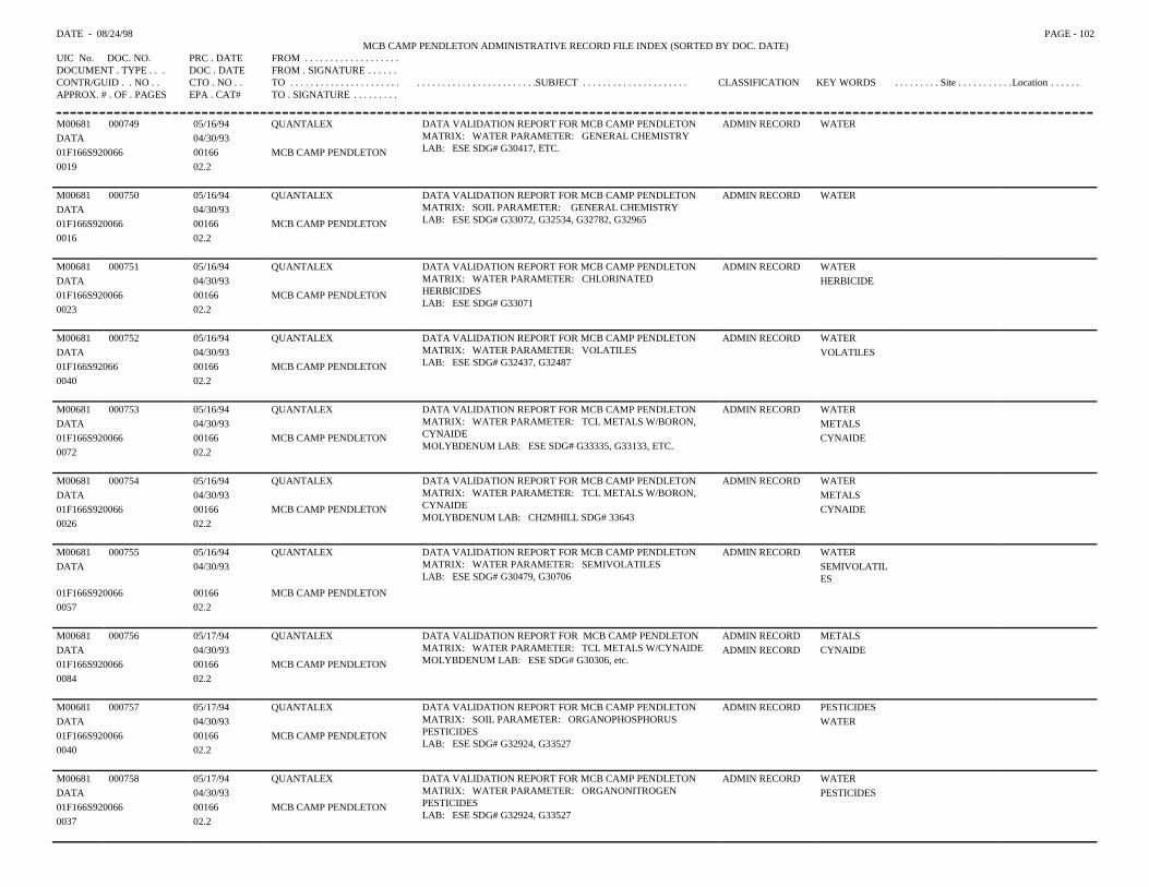
DATE - 08/24/98 PAGE - 102MCB CAMP PENDLETON ADMINISTRATIVE RECORD FILE INDEX (SORTED BY DOC. DATE)
UIC No. DOC. NO. PRC . DATE FROM . . . . . . . . . . . . . . . . . . .DOCUMENT . TYPE . . . DOC . DATE FROM . SIGNATURE . . . . . .CONTR/GUID . . NO . . CTO . NO . . TO . . . . . . . . . . . . . . . . . . . . . . . . . . . . . . . . . . . . . . . . . . . . . .SUBJECT . . . . . . . . . . . . . . . . . . . . . CLASSIFICATION KEY WORDS . . . . . . . . . Site . . . . . . . . . . .Location . . . . . .APPROX. # . OF . PAGES EPA . CAT# TO . SIGNATURE . . . . . . . . .
M00681 000749 05/16/94 QUANTALEX DATA VALIDATION REPORT FOR MCB CAMP PENDLETONMATRIX: WATER PARAMETER: GENERAL CHEMISTRYLAB: ESE SDG# G30417, ETC.
ADMIN RECORD WATERDATA 04/30/9301F166S920066 00166 MCB CAMP PENDLETON0019 02.2
M00681 000750 05/16/94 QUANTALEX DATA VALIDATION REPORT FOR MCB CAMP PENDLETONMATRIX: SOIL PARAMETER: GENERAL CHEMISTRYLAB: ESE SDG# G33072, G32534, G32782, G32965
ADMIN RECORD WATERDATA 04/30/9301F166S920066 00166 MCB CAMP PENDLETON0016 02.2
M00681 000751 05/16/94 QUANTALEX DATA VALIDATION REPORT FOR MCB CAMP PENDLETON MATRIX: WATER PARAMETER: CHLORINATEDHERBICIDESLAB: ESE SDG# G33071
ADMIN RECORD WATERDATA 04/30/93 HERBICIDE01F166S920066 00166 MCB CAMP PENDLETON0023 02.2
M00681 000752 05/16/94 QUANTALEX DATA VALIDATION REPORT FOR MCB CAMP PENDLETONMATRIX: WATER PARAMETER: VOLATILESLAB: ESE SDG# G32437, G32487
ADMIN RECORD WATERDATA 04/30/93 VOLATILES01F166S92066 00166 MCB CAMP PENDLETON0040 02.2
M00681 000753 05/16/94 QUANTALEX DATA VALIDATION REPORT FOR MCB CAMP PENDLETONMATRIX: WATER PARAMETER: TCL METALS W/BORON,CYNAIDEMOLYBDENUM LAB: ESE SDG# G33335, G33133, ETC.
ADMIN RECORD WATERDATA 04/30/93 METALS01F166S920066 00166 MCB CAMP PENDLETON CYNAIDE0072 02.2
M00681 000754 05/16/94 QUANTALEX DATA VALIDATION REPORT FOR MCB CAMP PENDLETONMATRIX: WATER PARAMETER: TCL METALS W/BORON,CYNAIDEMOLYBDENUM LAB: CH2MHILL SDG# 33643
ADMIN RECORD WATERDATA 04/30/93 METALS01F166S920066 00166 MCB CAMP PENDLETON CYNAIDE0026 02.2
M00681 000755 05/16/94 QUANTALEX DATA VALIDATION REPORT FOR MCB CAMP PENDLETONMATRIX: WATER PARAMETER: SEMIVOLATILESLAB: ESE SDG# G30479, G30706
ADMIN RECORD WATERDATA 04/30/93 SEMIVOLATIL
ES01F166S920066 00166 MCB CAMP PENDLETON0057 02.2
M00681 000756 05/17/94 QUANTALEX DATA VALIDATION REPORT FOR MCB CAMP PENDLETONMATRIX: WATER PARAMETER: TCL METALS W/CYNAIDEMOLYBDENUM LAB: ESE SDG# G30306, etc.
ADMIN RECORD METALSDATA 04/30/93 ADMIN RECORD CYNAIDE01F166S920066 00166 MCB CAMP PENDLETON0084 02.2
M00681 000757 05/17/94 QUANTALEX DATA VALIDATION REPORT FOR MCB CAMP PENDLETONMATRIX: SOIL PARAMETER: ORGANOPHOSPHORUSPESTICIDESLAB: ESE SDG# G32924, G33527
ADMIN RECORD PESTICIDESDATA 04/30/93 WATER01F166S920066 00166 MCB CAMP PENDLETON0040 02.2
M00681 000758 05/17/94 QUANTALEX DATA VALIDATION REPORT FOR MCB CAMP PENDLETONMATRIX: WATER PARAMETER: ORGANONITROGENPESTICIDESLAB: ESE SDG# G32924, G33527
ADMIN RECORD WATERDATA 04/30/93 PESTICIDES01F166S920066 00166 MCB CAMP PENDLETON0037 02.2
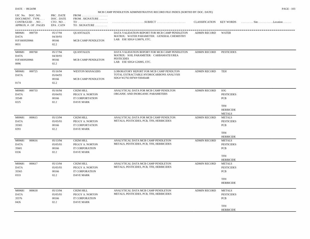
DATE - 08/24/98 PAGE - 103MCB CAMP PENDLETON ADMINISTRATIVE RECORD FILE INDEX (SORTED BY DOC. DATE)
UIC No. DOC. NO. PRC . DATE FROM . . . . . . . . . . . . . . . . . . .DOCUMENT . TYPE . . . DOC . DATE FROM . SIGNATURE . . . . . .CONTR/GUID . . NO . . CTO . NO . . TO . . . . . . . . . . . . . . . . . . . . . . . . . . . . . . . . . . . . . . . . . . . . . .SUBJECT . . . . . . . . . . . . . . . . . . . . . CLASSIFICATION KEY WORDS . . . . . . . . . Site . . . . . . . . . . .Location . . . . . .APPROX. # . OF . PAGES EPA . CAT# TO . SIGNATURE . . . . . . . . .
M00681 000759 05/17/94 QUANTALEX DATA VALIDATION REPORT FOR MCB CAMP PENDLETONMATRIX: WATER PARAMETER: GENERAL CHEMISTRYLAB: ESE SDG# G30076, ETC.
ADMIN RECORD WATERDATA 04/30/9301F166S920066 00166 MCB CAMP PENDLETON0031 02.2
M00681 000760 05/17/94 QUANTALEX DATA VALIDATION REPORT FOR MCB CAMP PENDLETONMATRIX: SOIL PARAMETER: CARBAMATE/UREAPESTICIDESLAB: ESE SDG# G26905, ETC.
ADMIN RECORD PESTICIDESDATA 04/30/9301F166S920066 00166 MCB CAMP PENDLETON0096 02.2
M00681 000725 05/16/94 WESTON MANAGERS LOBORATORY REPORT FOR MCB CAMP PENDLTONTOTAL EXTRACTABLE HYDROCARBONS ANALYSISSDG# W2763 RFW# 9304S448
ADMIN RECORD TEHDATA 05/04/93
00166 MCB CAMP PENDLETON0174 02.2
M00681 000733 05/16/94 CH2M HILL ANALYTICAL DATA FOR MCB CAMP PENDLTONORGANIC AND INORGANIC PARAMETERS
ADMIN RECORD IOGDATA 05/04/93 PEGGY A. NORTON PESTICIDES35549 00166 IT CORPORTATION PCB0225 02.2 DAVE MARK
TFHHERBICIDEMETALS
M00681 000615 05/13/94 CH2M HILL ANALYTICAL DATA FOR MCB CAMP PENDLTONMETALS, PESTICIDES, PCB, TFH, HERBICIDES
ADMIN RECORD METALSDATA 05/05/93 PEGGY A. NORTON PESTICIDES35583 00166 IT CORPORTATION PCB0293 02.2 DAVE MARK
TFHHERBICIDE
M00681 000616 05/13/94 CH2M HILL ANALYTICAL DATA MCB CAMP PENDLETONMETALS, PESTICIDES, PCB, TFH, HERBICIDES
ADMIN RECORD METALSDATA 05/05/93 PEGGY A. NORTON PESTICIDES35601 00166 IT CORPORATION PCB0336 02.2 DAVE MARK
TFHHERBICIDE
M00681 000617 05/13/94 CH2M HILL ANALYTICAL DATA MCB CAMP PENDLETONMETALS, PESTICIDES, PCB, TFH, HERBICIDES
ADMIN RECORD METALSDATA 05/05/93 PEGGY A. NORTON PESTICIDES35565 00166 IT CORPORATION PCB0333 02.2 DAVE MARK
TFHHERBICIDE
M00681 000618 05/13/94 CH2M HILL ANALYTICAL DATA MCB CAMP PENDLETONMETALS, PESTICIDES, PCB, TFH, HERBICIDES
ADMIN RECORD METALSDATA 05/05/93 PEGGY A. NORTON PESTICIDES35576 00166 IT CORPORATION PCB0426 02.2 DAVE MARK
TFHHERBICIDE
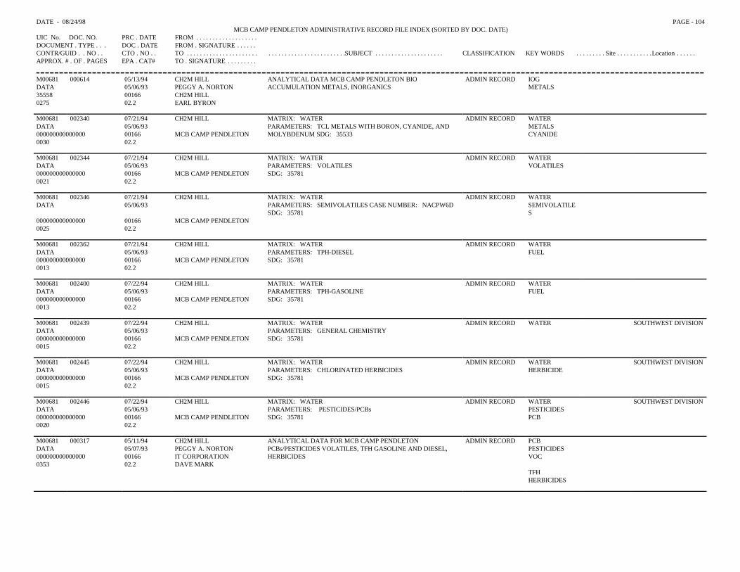
DATE - 08/24/98 PAGE - 104MCB CAMP PENDLETON ADMINISTRATIVE RECORD FILE INDEX (SORTED BY DOC. DATE)
UIC No. DOC. NO. PRC . DATE FROM . . . . . . . . . . . . . . . . . . .DOCUMENT . TYPE . . . DOC . DATE FROM . SIGNATURE . . . . . .CONTR/GUID . . NO . . CTO . NO . . TO . . . . . . . . . . . . . . . . . . . . . . . . . . . . . . . . . . . . . . . . . . . . . .SUBJECT . . . . . . . . . . . . . . . . . . . . . CLASSIFICATION KEY WORDS . . . . . . . . . Site . . . . . . . . . . .Location . . . . . .APPROX. # . OF . PAGES EPA . CAT# TO . SIGNATURE . . . . . . . . .
M00681 000614 05/13/94 CH2M HILL ANALYTICAL DATA MCB CAMP PENDLETON BIOACCUMULATION METALS, INORGANICS
ADMIN RECORD IOGDATA 05/06/93 PEGGY A. NORTON METALS35558 00166 CH2M HILL0275 02.2 EARL BYRON
M00681 002340 07/21/94 CH2M HILL MATRIX: WATERPARAMETERS: TCL METALS WITH BORON, CYANIDE, ANDMOLYBDENUM SDG: 35533
ADMIN RECORD WATERDATA 05/06/93 METALS000000000000000 00166 MCB CAMP PENDLETON CYANIDE0030 02.2
M00681 002344 07/21/94 CH2M HILL MATRIX: WATERPARAMETERS: VOLATILESSDG: 35781
ADMIN RECORD WATERDATA 05/06/93 VOLATILES000000000000000 00166 MCB CAMP PENDLETON0021 02.2
M00681 002346 07/21/94 CH2M HILL MATRIX: WATERPARAMETERS: SEMIVOLATILES CASE NUMBER: NACPW6DSDG: 35781
ADMIN RECORD WATERDATA 05/06/93 SEMIVOLATILE
S000000000000000 00166 MCB CAMP PENDLETON0025 02.2
M00681 002362 07/21/94 CH2M HILL MATRIX: WATERPARAMETERS: TPH-DIESELSDG: 35781
ADMIN RECORD WATERDATA 05/06/93 FUEL000000000000000 00166 MCB CAMP PENDLETON0013 02.2
M00681 002400 07/22/94 CH2M HILL MATRIX: WATERPARAMETERS: TPH-GASOLINESDG: 35781
ADMIN RECORD WATERDATA 05/06/93 FUEL000000000000000 00166 MCB CAMP PENDLETON0013 02.2
M00681 002439 07/22/94 CH2M HILL MATRIX: WATERPARAMETERS: GENERAL CHEMISTRYSDG: 35781
ADMIN RECORD WATER SOUTHWEST DIVISIONDATA 05/06/93000000000000000 00166 MCB CAMP PENDLETON0015 02.2
M00681 002445 07/22/94 CH2M HILL MATRIX: WATERPARAMETERS: CHLORINATED HERBICIDESSDG: 35781
ADMIN RECORD WATER SOUTHWEST DIVISIONDATA 05/06/93 HERBICIDE000000000000000 00166 MCB CAMP PENDLETON0015 02.2
M00681 002446 07/22/94 CH2M HILL MATRIX: WATERPARAMETERS: PESTICIDES/PCBsSDG: 35781
ADMIN RECORD WATER SOUTHWEST DIVISIONDATA 05/06/93 PESTICIDES000000000000000 00166 MCB CAMP PENDLETON PCB0020 02.2
M00681 000317 05/11/94 CH2M HILL ANALYTICAL DATA FOR MCB CAMP PENDLETONPCBs/PESTICIDES VOLATILES, TFH GASOLINE AND DIESEL,HERBICIDES
ADMIN RECORD PCBDATA 05/07/93 PEGGY A. NORTON PESTICIDES000000000000000 00166 IT CORPORATION VOC0353 02.2 DAVE MARK
TFHHERBICIDES
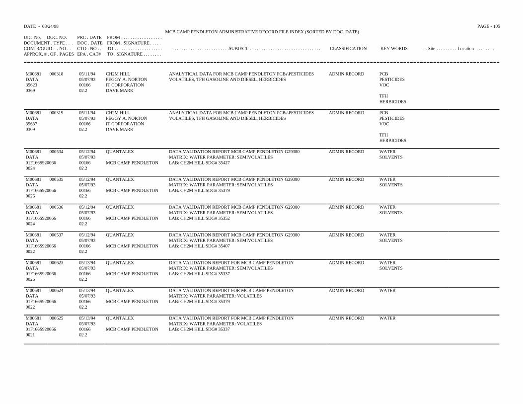
DATE - 08/24/98 PAGE - 105MCB CAMP PENDLETON ADMINISTRATIVE RECORD FILE INDEX (SORTED BY DOC. DATE)
UIC No. DOC. NO. PRC . DATE FROM . . . . . . . . . . . . . . . . . .DOCUMENT . TYPE . . . DOC . DATE FROM . SIGNATURE . . . . .CONTR/GUID . . NO . . CTO . NO . . TO . . . . . . . . . . . . . . . . . . . . . . . . . . . . . . . . . . . . . . . . . . . . . .SUBJECT . . . . . . . . . . . . . . . . . . . . . . . . . . . . . . . CLASSIFICATION KEY WORDS . . Site . . . . . . . . . Location . . . . . . . .APPROX. # . OF . PAGES EPA . CAT# TO . SIGNATURE . . . . . . . .
M00681 000318 05/11/94 CH2M HILL ANALYTICAL DATA FOR MCB CAMP PENDLETON PCBs\PESTICIDES ADMIN RECORD PCBDATA 05/07/93 PEGGY A. NORTON VOLATILES, TFH GASOLINE AND DIESEL, HERBICIDES PESTICIDES35623 00166 IT CORPORATION VOC0369 02.2 DAVE MARK
TFHHERBICIDES
M00681 000319 05/11/94 CH2M HILL ANALYTICAL DATA FOR MCB CAMP PENDLETON PCBs\PESTICIDES ADMIN RECORD PCBDATA 05/07/93 PEGGY A. NORTON VOLATILES, TFH GASOLINE AND DIESEL, HERBICIDES PESTICIDES35637 00166 IT CORPORATION VOC0309 02.2 DAVE MARK
TFHHERBICIDES
M00681 000534 05/12/94 QUANTALEX DATA VALIDATION REPORT MCB CAMP PENDLETON G29380 ADMIN RECORD WATERDATA 05/07/93 MATRIX: WATER PARAMETER: SEMIVOLATILES SOLVENTS01F166S920066 00166 MCB CAMP PENDLETON LAB: CH2M HILL SDG# 354270024 02.2
M00681 000535 05/12/94 QUANTALEX DATA VALIDATION REPORT MCB CAMP PENDLETON G29380 ADMIN RECORD WATERDATA 05/07/93 MATRIX: WATER PARAMETER: SEMIVOLATILES SOLVENTS01F166S920066 00166 MCB CAMP PENDLETON LAB: CH2M HILL SDG# 353790026 02.2
M00681 000536 05/12/94 QUANTALEX DATA VALIDATION REPORT MCB CAMP PENDLETON G29380 ADMIN RECORD WATERDATA 05/07/93 MATRIX: WATER PARAMETER: SEMIVOLATILES SOLVENTS01F166S920066 00166 MCB CAMP PENDLETON LAB: CH2M HILL SDG# 353520024 02.2
M00681 000537 05/12/94 QUANTALEX DATA VALIDATION REPORT MCB CAMP PENDLETON G29380 ADMIN RECORD WATERDATA 05/07/93 MATRIX: WATER PARAMETER: SEMIVOLATILES SOLVENTS01F166S920066 00166 MCB CAMP PENDLETON LAB: CH2M HILL SDG# 354070022 02.2
M00681 000623 05/13/94 QUANTALEX DATA VALIDATION REPORT FOR MCB CAMP PENDLETON ADMIN RECORD WATERDATA 05/07/93 MATRIX: WATER PARAMETER: SEMIVOLATILES SOLVENTS01F166S920066 00166 MCB CAMP PENDLETON LAB: CH2M HILL SDG# 353370026 02.2
M00681 000624 05/13/94 QUANTALEX DATA VALIDATION REPORT FOR MCB CAMP PENDLETON ADMIN RECORD WATERDATA 05/07/93 MATRIX: WATER PARAMETER: VOLATILES01F166S920066 00166 MCB CAMP PENDLETON LAB: CH2M HILL SDG# 353790022 02.2
M00681 000625 05/13/94 QUANTALEX DATA VALIDATION REPORT FOR MCB CAMP PENDLETON ADMIN RECORD WATERDATA 05/07/93 MATRIX: WATER PARAMETER: VOLATILES01F166S920066 00166 MCB CAMP PENDLETON LAB: CH2M HILL SDG# 353370021 02.2
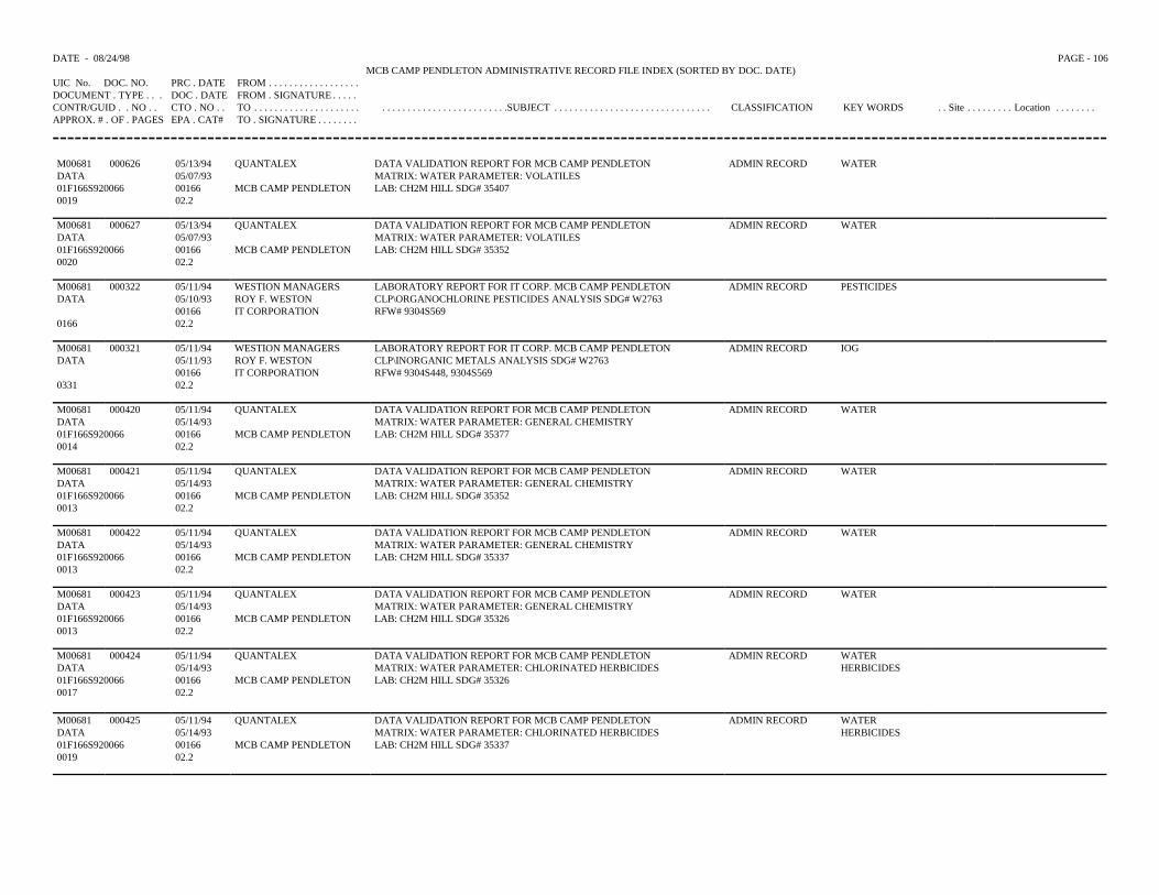
DATE - 08/24/98 PAGE - 106MCB CAMP PENDLETON ADMINISTRATIVE RECORD FILE INDEX (SORTED BY DOC. DATE)
UIC No. DOC. NO. PRC . DATE FROM . . . . . . . . . . . . . . . . . .DOCUMENT . TYPE . . . DOC . DATE FROM . SIGNATURE . . . . .CONTR/GUID . . NO . . CTO . NO . . TO . . . . . . . . . . . . . . . . . . . . . . . . . . . . . . . . . . . . . . . . . . . . . .SUBJECT . . . . . . . . . . . . . . . . . . . . . . . . . . . . . . . CLASSIFICATION KEY WORDS . . Site . . . . . . . . . Location . . . . . . . .APPROX. # . OF . PAGES EPA . CAT# TO . SIGNATURE . . . . . . . .
M00681 000626 05/13/94 QUANTALEX DATA VALIDATION REPORT FOR MCB CAMP PENDLETON ADMIN RECORD WATERDATA 05/07/93 MATRIX: WATER PARAMETER: VOLATILES01F166S920066 00166 MCB CAMP PENDLETON LAB: CH2M HILL SDG# 354070019 02.2
M00681 000627 05/13/94 QUANTALEX DATA VALIDATION REPORT FOR MCB CAMP PENDLETON ADMIN RECORD WATERDATA 05/07/93 MATRIX: WATER PARAMETER: VOLATILES01F166S920066 00166 MCB CAMP PENDLETON LAB: CH2M HILL SDG# 353520020 02.2
M00681 000322 05/11/94 WESTION MANAGERS LABORATORY REPORT FOR IT CORP. MCB CAMP PENDLETON ADMIN RECORD PESTICIDESDATA 05/10/93 ROY F. WESTON CLP\ORGANOCHLORINE PESTICIDES ANALYSIS SDG# W2763
00166 IT CORPORATION RFW# 9304S5690166 02.2
M00681 000321 05/11/94 WESTION MANAGERS LABORATORY REPORT FOR IT CORP. MCB CAMP PENDLETON ADMIN RECORD IOGDATA 05/11/93 ROY F. WESTON CLP\INORGANIC METALS ANALYSIS SDG# W2763
00166 IT CORPORATION RFW# 9304S448, 9304S5690331 02.2
M00681 000420 05/11/94 QUANTALEX DATA VALIDATION REPORT FOR MCB CAMP PENDLETON ADMIN RECORD WATERDATA 05/14/93 MATRIX: WATER PARAMETER: GENERAL CHEMISTRY01F166S920066 00166 MCB CAMP PENDLETON LAB: CH2M HILL SDG# 353770014 02.2
M00681 000421 05/11/94 QUANTALEX DATA VALIDATION REPORT FOR MCB CAMP PENDLETON ADMIN RECORD WATERDATA 05/14/93 MATRIX: WATER PARAMETER: GENERAL CHEMISTRY01F166S920066 00166 MCB CAMP PENDLETON LAB: CH2M HILL SDG# 353520013 02.2
M00681 000422 05/11/94 QUANTALEX DATA VALIDATION REPORT FOR MCB CAMP PENDLETON ADMIN RECORD WATERDATA 05/14/93 MATRIX: WATER PARAMETER: GENERAL CHEMISTRY01F166S920066 00166 MCB CAMP PENDLETON LAB: CH2M HILL SDG# 353370013 02.2
M00681 000423 05/11/94 QUANTALEX DATA VALIDATION REPORT FOR MCB CAMP PENDLETON ADMIN RECORD WATERDATA 05/14/93 MATRIX: WATER PARAMETER: GENERAL CHEMISTRY01F166S920066 00166 MCB CAMP PENDLETON LAB: CH2M HILL SDG# 353260013 02.2
M00681 000424 05/11/94 QUANTALEX DATA VALIDATION REPORT FOR MCB CAMP PENDLETON ADMIN RECORD WATERDATA 05/14/93 MATRIX: WATER PARAMETER: CHLORINATED HERBICIDES HERBICIDES01F166S920066 00166 MCB CAMP PENDLETON LAB: CH2M HILL SDG# 353260017 02.2
M00681 000425 05/11/94 QUANTALEX DATA VALIDATION REPORT FOR MCB CAMP PENDLETON ADMIN RECORD WATERDATA 05/14/93 MATRIX: WATER PARAMETER: CHLORINATED HERBICIDES HERBICIDES01F166S920066 00166 MCB CAMP PENDLETON LAB: CH2M HILL SDG# 353370019 02.2
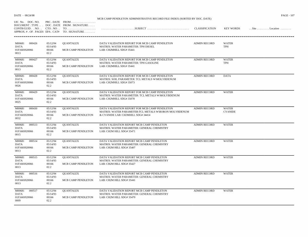
DATE - 08/24/98 PAGE - 107MCB CAMP PENDLETON ADMINISTRATIVE RECORD FILE INDEX (SORTED BY DOC. DATE)
UIC No. DOC. NO. PRC . DATE FROM . . . . . . . . . . . . . . . . . .DOCUMENT . TYPE . . . DOC . DATE FROM . SIGNATURE . . . . .CONTR/GUID . . NO . . CTO . NO . . TO . . . . . . . . . . . . . . . . . . . . . . . . . . . . . . . . . . . . . . . . . . . . . .SUBJECT . . . . . . . . . . . . . . . . . . . . . . . . . . . . . . . CLASSIFICATION KEY WORDS . . Site . . . . . . . . . Location . . . . . . . .APPROX. # . OF . PAGES EPA . CAT# TO . SIGNATURE . . . . . . . .
M00681 000426 05/12/94 QUANTALEX DATA VALIDATION REPORT FOR MCB CAMP PENDLETON ADMIN RECORD WATERDATA 05/14/93 MATRIX: WATER PARAMETER: TPH DIESEL TPH01F166S920066 00166 MCB CAMP PENDLETON LAB: CH2MHILL SDG# 354410013 02.2
M00681 000427 05/12/94 QUANTALEX DATA VALIDATION REPORT FOR MCB CAMP PENDLETON ADMIN RECORD WATERDATA 05/14/93 MATRIX: WATER PARAMETER: TPH GASOLINE TPH01F166S920066 00166 MCB CAMP PENDLETON LAB: CH2MHILL SDG# 354410013 02.2
M00681 000428 05/12/94 QUANTALEX DATA VALIDATION REPORT FOR MCB CAMP PENDLETON ADMIN RECORD DATADATA 05/14/93 MATRIX: SOIL PARAMETER: TCL METALS W\MOLYBDENUM01F166S920066 00166 MCB CAMP PENDLETON LAB: CH2MHILL SDG# 350730026 02.2
M00681 000429 05/12/94 QUANTALEX DATA VALIDATION REPORT FOR MCB CAMP PENDLETON ADMIN RECORD WATERDATA 05/14/93 MATRIX: WATER PARAMETER: TCL METALS W\MOLYBDENUM01F166S920066 00166 MCB CAMP PENDLETON LAB: CH2MHILL SDG# 350780025 02.2
M00681 000430 05/12/94 QUANTALEX DATA VALIDATION REPORT FOR MCB CAMP PENDLETON ADMIN RECORD WATERDATA 05/14/93 MATRIX: WATER PARAMETER:TCL METALS W\BORON MOLYBDENUM CYANIDE01F166S920066 00166 MCB CAMP PENDLETON & CYANIDE LAB: CH2MHILL SDG# 344140032 02.2
M00681 000513 05/12/94 QUANTALEX DATA VALIDATION REPORT MCB CAMP PENDLETON ADMIN RECORD WATERDATA 05/14/93 MATRIX: WATER PARAMETER: GENERAL CHEMISTRY01F166S920066 00166 MCB CAMP PENDLETON LAB: CH2M HILL SDG# 354710015 02.2
M00681 000514 05/12/94 QUANTALEX DATA VALIDATION REPORT MCB CAMP PENDLETON ADMIN RECORD WATERDATA 05/14/93 MATRIX: WATER PARAMETER: GENERAL CHEMISTRY01F166S920066 00166 MCB CAMP PENDLETON LAB: CH2M HILL SDG# 354070013 02.2
M00681 000515 05/12/94 QUANTALEX DATA VALIDATION REPORT MCB CAMP PENDLETON ADMIN RECORD WATERDATA 05/14/93 MATRIX: WATER PARAMETER: GENERAL CHEMISTRY01F166S920066 00166 MCB CAMP PENDLETON LAB: CH2M HILL SDG# 354270013 02.2
M00681 000516 05/12/94 QUANTALEX DATA VALIDATION REPORT MCB CAMP PENDLETON ADMIN RECORD WATERDATA 05/14/93 MATRIX: WATER PARAMETER: GENERAL CHEMISTRY01F166S920066 00166 MCB CAMP PENDLETON LAB: CH2M HILL SDG# 354410013 02.2
M00681 000517 05/12/94 QUANTALEX DATA VALIDATION REPORT MCB CAMP PENDLETON ADMIN RECORD WATERDATA 05/14/93 MATRIX: WATER PARAMETER: GENERAL CHEMISTRY01F166S920066 00166 MCB CAMP PENDLETON LAB: CH2M HILL SDG# 354700009 02.2
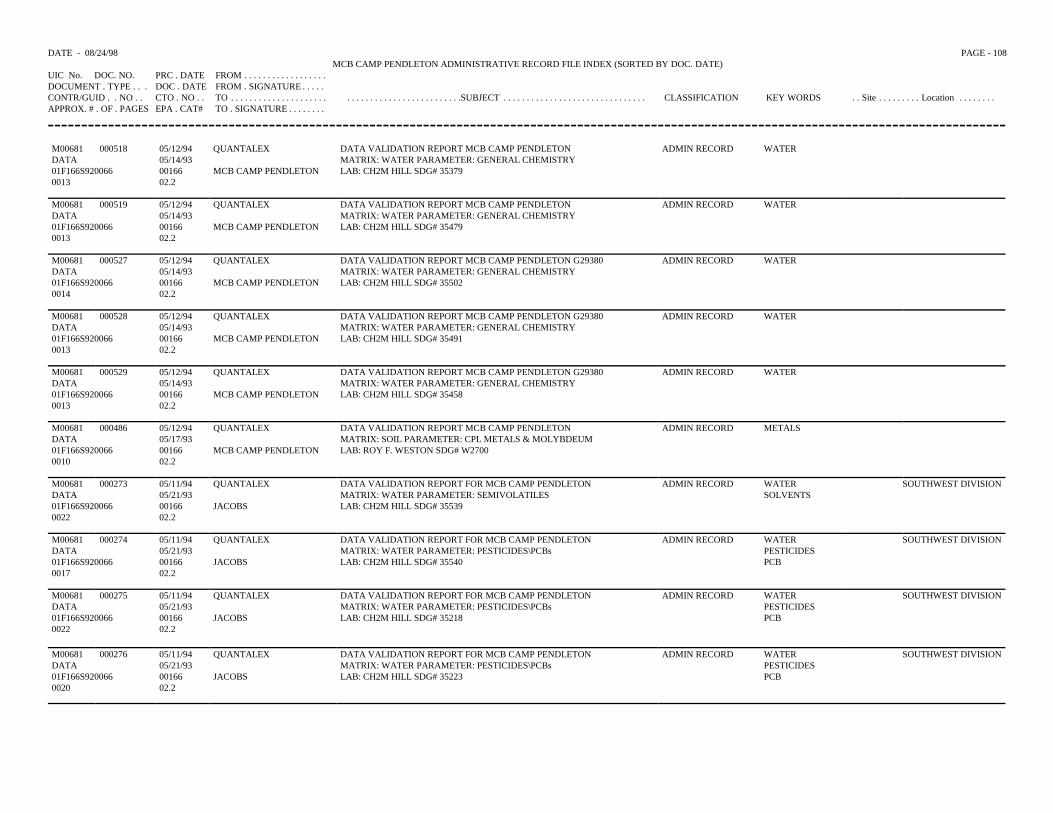
DATE - 08/24/98 PAGE - 108MCB CAMP PENDLETON ADMINISTRATIVE RECORD FILE INDEX (SORTED BY DOC. DATE)
UIC No. DOC. NO. PRC . DATE FROM . . . . . . . . . . . . . . . . . .DOCUMENT . TYPE . . . DOC . DATE FROM . SIGNATURE . . . . .CONTR/GUID . . NO . . CTO . NO . . TO . . . . . . . . . . . . . . . . . . . . . . . . . . . . . . . . . . . . . . . . . . . . . .SUBJECT . . . . . . . . . . . . . . . . . . . . . . . . . . . . . . . CLASSIFICATION KEY WORDS . . Site . . . . . . . . . Location . . . . . . . .APPROX. # . OF . PAGES EPA . CAT# TO . SIGNATURE . . . . . . . .
M00681 000518 05/12/94 QUANTALEX DATA VALIDATION REPORT MCB CAMP PENDLETON ADMIN RECORD WATERDATA 05/14/93 MATRIX: WATER PARAMETER: GENERAL CHEMISTRY01F166S920066 00166 MCB CAMP PENDLETON LAB: CH2M HILL SDG# 353790013 02.2
M00681 000519 05/12/94 QUANTALEX DATA VALIDATION REPORT MCB CAMP PENDLETON ADMIN RECORD WATERDATA 05/14/93 MATRIX: WATER PARAMETER: GENERAL CHEMISTRY01F166S920066 00166 MCB CAMP PENDLETON LAB: CH2M HILL SDG# 354790013 02.2
M00681 000527 05/12/94 QUANTALEX DATA VALIDATION REPORT MCB CAMP PENDLETON G29380 ADMIN RECORD WATERDATA 05/14/93 MATRIX: WATER PARAMETER: GENERAL CHEMISTRY01F166S920066 00166 MCB CAMP PENDLETON LAB: CH2M HILL SDG# 355020014 02.2
M00681 000528 05/12/94 QUANTALEX DATA VALIDATION REPORT MCB CAMP PENDLETON G29380 ADMIN RECORD WATERDATA 05/14/93 MATRIX: WATER PARAMETER: GENERAL CHEMISTRY 01F166S920066 00166 MCB CAMP PENDLETON LAB: CH2M HILL SDG# 354910013 02.2
M00681 000529 05/12/94 QUANTALEX DATA VALIDATION REPORT MCB CAMP PENDLETON G29380 ADMIN RECORD WATERDATA 05/14/93 MATRIX: WATER PARAMETER: GENERAL CHEMISTRY01F166S920066 00166 MCB CAMP PENDLETON LAB: CH2M HILL SDG# 354580013 02.2
M00681 000486 05/12/94 QUANTALEX DATA VALIDATION REPORT MCB CAMP PENDLETON ADMIN RECORD METALSDATA 05/17/93 MATRIX: SOIL PARAMETER: CPL METALS & MOLYBDEUM01F166S920066 00166 MCB CAMP PENDLETON LAB: ROY F. WESTON SDG# W27000010 02.2
M00681 000273 05/11/94 QUANTALEX DATA VALIDATION REPORT FOR MCB CAMP PENDLETON ADMIN RECORD WATER SOUTHWEST DIVISIONDATA 05/21/93 MATRIX: WATER PARAMETER: SEMIVOLATILES SOLVENTS01F166S920066 00166 JACOBS LAB: CH2M HILL SDG# 355390022 02.2
M00681 000274 05/11/94 QUANTALEX DATA VALIDATION REPORT FOR MCB CAMP PENDLETON ADMIN RECORD WATER SOUTHWEST DIVISIONDATA 05/21/93 MATRIX: WATER PARAMETER: PESTICIDES\PCBs PESTICIDES01F166S920066 00166 JACOBS LAB: CH2M HILL SDG# 35540 PCB0017 02.2
M00681 000275 05/11/94 QUANTALEX DATA VALIDATION REPORT FOR MCB CAMP PENDLETON ADMIN RECORD WATER SOUTHWEST DIVISIONDATA 05/21/93 MATRIX: WATER PARAMETER: PESTICIDES\PCBs PESTICIDES01F166S920066 00166 JACOBS LAB: CH2M HILL SDG# 35218 PCB0022 02.2
M00681 000276 05/11/94 QUANTALEX DATA VALIDATION REPORT FOR MCB CAMP PENDLETON ADMIN RECORD WATER SOUTHWEST DIVISIONDATA 05/21/93 MATRIX: WATER PARAMETER: PESTICIDES\PCBs PESTICIDES01F166S920066 00166 JACOBS LAB: CH2M HILL SDG# 35223 PCB0020 02.2
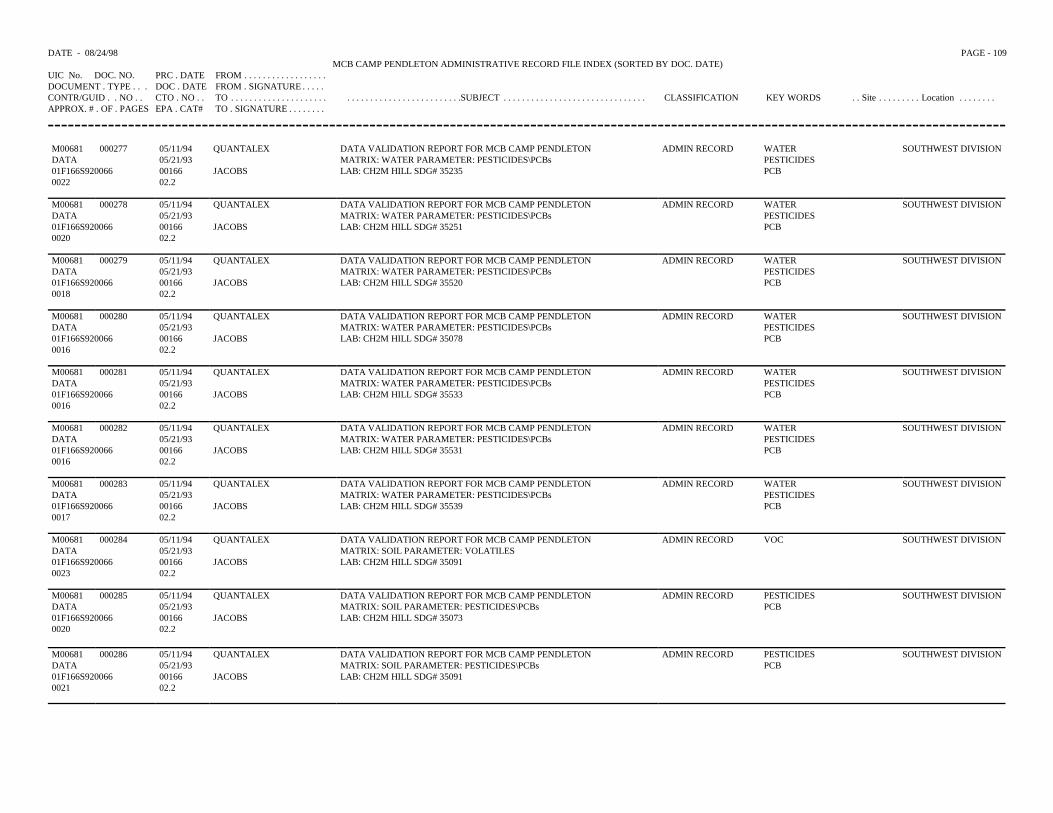
DATE - 08/24/98 PAGE - 109MCB CAMP PENDLETON ADMINISTRATIVE RECORD FILE INDEX (SORTED BY DOC. DATE)
UIC No. DOC. NO. PRC . DATE FROM . . . . . . . . . . . . . . . . . .DOCUMENT . TYPE . . . DOC . DATE FROM . SIGNATURE . . . . .CONTR/GUID . . NO . . CTO . NO . . TO . . . . . . . . . . . . . . . . . . . . . . . . . . . . . . . . . . . . . . . . . . . . . .SUBJECT . . . . . . . . . . . . . . . . . . . . . . . . . . . . . . . CLASSIFICATION KEY WORDS . . Site . . . . . . . . . Location . . . . . . . .APPROX. # . OF . PAGES EPA . CAT# TO . SIGNATURE . . . . . . . .
M00681 000277 05/11/94 QUANTALEX DATA VALIDATION REPORT FOR MCB CAMP PENDLETON ADMIN RECORD WATER SOUTHWEST DIVISIONDATA 05/21/93 MATRIX: WATER PARAMETER: PESTICIDES\PCBs PESTICIDES01F166S920066 00166 JACOBS LAB: CH2M HILL SDG# 35235 PCB0022 02.2
M00681 000278 05/11/94 QUANTALEX DATA VALIDATION REPORT FOR MCB CAMP PENDLETON ADMIN RECORD WATER SOUTHWEST DIVISIONDATA 05/21/93 MATRIX: WATER PARAMETER: PESTICIDES\PCBs PESTICIDES01F166S920066 00166 JACOBS LAB: CH2M HILL SDG# 35251 PCB0020 02.2
M00681 000279 05/11/94 QUANTALEX DATA VALIDATION REPORT FOR MCB CAMP PENDLETON ADMIN RECORD WATER SOUTHWEST DIVISIONDATA 05/21/93 MATRIX: WATER PARAMETER: PESTICIDES\PCBs PESTICIDES01F166S920066 00166 JACOBS LAB: CH2M HILL SDG# 35520 PCB0018 02.2
M00681 000280 05/11/94 QUANTALEX DATA VALIDATION REPORT FOR MCB CAMP PENDLETON ADMIN RECORD WATER SOUTHWEST DIVISIONDATA 05/21/93 MATRIX: WATER PARAMETER: PESTICIDES\PCBs PESTICIDES01F166S920066 00166 JACOBS LAB: CH2M HILL SDG# 35078 PCB0016 02.2
M00681 000281 05/11/94 QUANTALEX DATA VALIDATION REPORT FOR MCB CAMP PENDLETON ADMIN RECORD WATER SOUTHWEST DIVISIONDATA 05/21/93 MATRIX: WATER PARAMETER: PESTICIDES\PCBs PESTICIDES01F166S920066 00166 JACOBS LAB: CH2M HILL SDG# 35533 PCB0016 02.2
M00681 000282 05/11/94 QUANTALEX DATA VALIDATION REPORT FOR MCB CAMP PENDLETON ADMIN RECORD WATER SOUTHWEST DIVISIONDATA 05/21/93 MATRIX: WATER PARAMETER: PESTICIDES\PCBs PESTICIDES01F166S920066 00166 JACOBS LAB: CH2M HILL SDG# 35531 PCB0016 02.2
M00681 000283 05/11/94 QUANTALEX DATA VALIDATION REPORT FOR MCB CAMP PENDLETON ADMIN RECORD WATER SOUTHWEST DIVISIONDATA 05/21/93 MATRIX: WATER PARAMETER: PESTICIDES\PCBs PESTICIDES01F166S920066 00166 JACOBS LAB: CH2M HILL SDG# 35539 PCB0017 02.2
M00681 000284 05/11/94 QUANTALEX DATA VALIDATION REPORT FOR MCB CAMP PENDLETON ADMIN RECORD VOC SOUTHWEST DIVISIONDATA 05/21/93 MATRIX: SOIL PARAMETER: VOLATILES01F166S920066 00166 JACOBS LAB: CH2M HILL SDG# 350910023 02.2
M00681 000285 05/11/94 QUANTALEX DATA VALIDATION REPORT FOR MCB CAMP PENDLETON ADMIN RECORD PESTICIDES SOUTHWEST DIVISIONDATA 05/21/93 MATRIX: SOIL PARAMETER: PESTICIDES\PCBs PCB01F166S920066 00166 JACOBS LAB: CH2M HILL SDG# 350730020 02.2
M00681 000286 05/11/94 QUANTALEX DATA VALIDATION REPORT FOR MCB CAMP PENDLETON ADMIN RECORD PESTICIDES SOUTHWEST DIVISIONDATA 05/21/93 MATRIX: SOIL PARAMETER: PESTICIDES\PCBs PCB01F166S920066 00166 JACOBS LAB: CH2M HILL SDG# 350910021 02.2
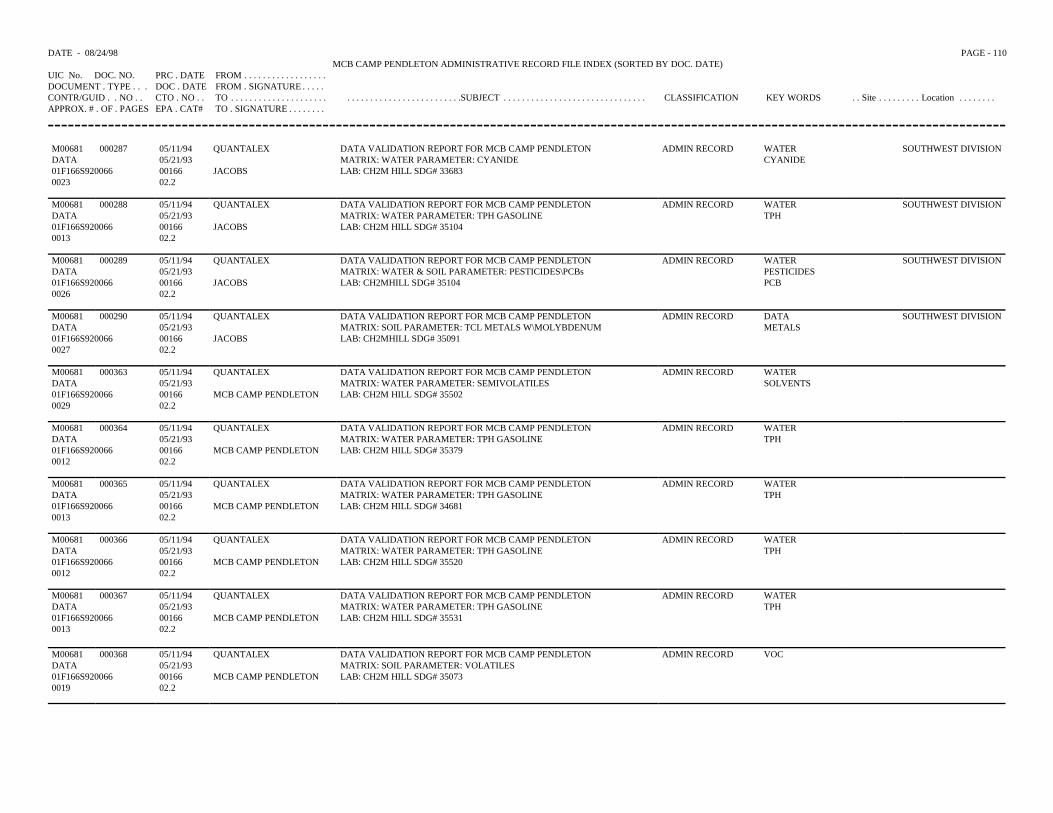
DATE - 08/24/98 PAGE - 110MCB CAMP PENDLETON ADMINISTRATIVE RECORD FILE INDEX (SORTED BY DOC. DATE)
UIC No. DOC. NO. PRC . DATE FROM . . . . . . . . . . . . . . . . . .DOCUMENT . TYPE . . . DOC . DATE FROM . SIGNATURE . . . . .CONTR/GUID . . NO . . CTO . NO . . TO . . . . . . . . . . . . . . . . . . . . . . . . . . . . . . . . . . . . . . . . . . . . . .SUBJECT . . . . . . . . . . . . . . . . . . . . . . . . . . . . . . . CLASSIFICATION KEY WORDS . . Site . . . . . . . . . Location . . . . . . . .APPROX. # . OF . PAGES EPA . CAT# TO . SIGNATURE . . . . . . . .
M00681 000287 05/11/94 QUANTALEX DATA VALIDATION REPORT FOR MCB CAMP PENDLETON ADMIN RECORD WATER SOUTHWEST DIVISIONDATA 05/21/93 MATRIX: WATER PARAMETER: CYANIDE CYANIDE01F166S920066 00166 JACOBS LAB: CH2M HILL SDG# 336830023 02.2
M00681 000288 05/11/94 QUANTALEX DATA VALIDATION REPORT FOR MCB CAMP PENDLETON ADMIN RECORD WATER SOUTHWEST DIVISIONDATA 05/21/93 MATRIX: WATER PARAMETER: TPH GASOLINE TPH01F166S920066 00166 JACOBS LAB: CH2M HILL SDG# 351040013 02.2
M00681 000289 05/11/94 QUANTALEX DATA VALIDATION REPORT FOR MCB CAMP PENDLETON ADMIN RECORD WATER SOUTHWEST DIVISIONDATA 05/21/93 MATRIX: WATER & SOIL PARAMETER: PESTICIDES\PCBs PESTICIDES01F166S920066 00166 JACOBS LAB: CH2MHILL SDG# 35104 PCB0026 02.2
M00681 000290 05/11/94 QUANTALEX DATA VALIDATION REPORT FOR MCB CAMP PENDLETON ADMIN RECORD DATA SOUTHWEST DIVISIONDATA 05/21/93 MATRIX: SOIL PARAMETER: TCL METALS W\MOLYBDENUM METALS01F166S920066 00166 JACOBS LAB: CH2MHILL SDG# 350910027 02.2
M00681 000363 05/11/94 QUANTALEX DATA VALIDATION REPORT FOR MCB CAMP PENDLETON ADMIN RECORD WATERDATA 05/21/93 MATRIX: WATER PARAMETER: SEMIVOLATILES SOLVENTS01F166S920066 00166 MCB CAMP PENDLETON LAB: CH2M HILL SDG# 355020029 02.2
M00681 000364 05/11/94 QUANTALEX DATA VALIDATION REPORT FOR MCB CAMP PENDLETON ADMIN RECORD WATERDATA 05/21/93 MATRIX: WATER PARAMETER: TPH GASOLINE TPH01F166S920066 00166 MCB CAMP PENDLETON LAB: CH2M HILL SDG# 353790012 02.2
M00681 000365 05/11/94 QUANTALEX DATA VALIDATION REPORT FOR MCB CAMP PENDLETON ADMIN RECORD WATERDATA 05/21/93 MATRIX: WATER PARAMETER: TPH GASOLINE TPH01F166S920066 00166 MCB CAMP PENDLETON LAB: CH2M HILL SDG# 346810013 02.2
M00681 000366 05/11/94 QUANTALEX DATA VALIDATION REPORT FOR MCB CAMP PENDLETON ADMIN RECORD WATERDATA 05/21/93 MATRIX: WATER PARAMETER: TPH GASOLINE TPH01F166S920066 00166 MCB CAMP PENDLETON LAB: CH2M HILL SDG# 355200012 02.2
M00681 000367 05/11/94 QUANTALEX DATA VALIDATION REPORT FOR MCB CAMP PENDLETON ADMIN RECORD WATERDATA 05/21/93 MATRIX: WATER PARAMETER: TPH GASOLINE TPH01F166S920066 00166 MCB CAMP PENDLETON LAB: CH2M HILL SDG# 355310013 02.2
M00681 000368 05/11/94 QUANTALEX DATA VALIDATION REPORT FOR MCB CAMP PENDLETON ADMIN RECORD VOCDATA 05/21/93 MATRIX: SOIL PARAMETER: VOLATILES01F166S920066 00166 MCB CAMP PENDLETON LAB: CH2M HILL SDG# 350730019 02.2
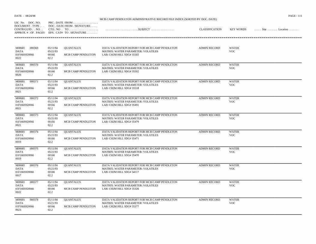
DATE - 08/24/98 PAGE - 111MCB CAMP PENDLETON ADMINISTRATIVE RECORD FILE INDEX (SORTED BY DOC. DATE)
UIC No. DOC. NO. PRC . DATE FROM . . . . . . . . . . . . . . . . . .DOCUMENT . TYPE . . . DOC . DATE FROM . SIGNATURE . . . . .CONTR/GUID . . NO . . CTO . NO . . TO . . . . . . . . . . . . . . . . . . . . . . . . . . . . . . . . . . . . . . . . . . . . .SUBJECT . . . . . . . . . . . . . . . . . CLASSIFICATION KEY WORDS . . . . . Site . . . . . . . Location . . . . . . .APPROX. # . OF . PAGES EPA . CAT# TO . SIGNATURE . . . . . . . .
M00681 000369 05/11/94 QUANTALEX DATA VALIDATION REPORT FOR MCB CAMP PENDLETON ADMIN RECORD WATERDATA 05/21/93 MATRIX: WATER PARAMETER: VOLATILES VOC01F166S920066 00166 MCB CAMP PENDLETON LAB: CH2M HILL SDG# 355020022 02.2
M00681 000370 05/11/94 QUANTALEX DATA VALIDATION REPORT FOR MCB CAMP PENDLETON ADMIN RECORD WATERDATA 05/21/93 MATRIX: WATER PARAMETER: VOLATILES VOC01F166S920066 00166 MCB CAMP PENDLETON LAB: CH2M HILL SDG# 355020020 02.2
M00681 000371 05/11/94 QUANTALEX DATA VALIDATION REPORT FOR MCB CAMP PENDLETON ADMIN RECORD WATERDATA 05/21/93 MATRIX: WATER PARAMETER: VOLATILES VOC01F166S920066 00166 MCB CAMP PENDLETON LAB: CH2M HILL SDG# 355180021 02.2
M00681 000372 05/11/94 QUANTALEX DATA VALIDATION REPORT FOR MCB CAMP PENDLETON ADMIN RECORD WATERDATA 05/21/93 MATRIX: WATER PARAMETER: VOLATILES VOC01F166S920066 00166 MCB CAMP PENDLETON LAB: CH2M HILL SDG# 354910021 02.2
M00681 000373 05/11/94 QUANTALEX DATA VALIDATION REPORT FOR MCB CAMP PENDLETON ADMIN RECORD WATERDATA 05/21/93 MATRIX: WATER PARAMETER: VOLATILES VOC01F166S920066 00166 MCB CAMP PENDLETON LAB: CH2M HILL SDG# 354790021 02.2
M00681 000374 05/11/94 QUANTALEX DATA VALIDATION REPORT FOR MCB CAMP PENDLETON ADMIN RECORD WATERDATA 05/21/93 MATRIX: WATER PARAMETER: VOLATILES VOC01F166S920066 00166 MCB CAMP PENDLETON LAB: CH2M HILL SDG# 354710019 02.2
M00681 000375 05/11/94 QUANTALEX DATA VALIDATION REPORT FOR MCB CAMP PENDLETON ADMIN RECORD WATERDATA 05/21/93 MATRIX: WATER PARAMETER: VOLATILES VOC01F166S920066 00166 MCB CAMP PENDLETON LAB: CH2M HILL SDG# 354700019 02.2
M00681 000376 05/11/94 QUANTALEX DATA VALIDATION REPORT FOR MCB CAMP PENDLETON ADMIN RECORD WATERDATA 05/21/93 MATRIX: WATER PARAMETER: VOLATILES VOC01F166S920066 00166 MCB CAMP PENDLETON LAB: CH2M HILL SDG# 341170017 02.2
M00681 000377 05/11/94 QUANTALEX DATA VALIDATION REPORT FOR MCB CAMP PENDLETON ADMIN RECORD WATERDATA 05/21/93 MATRIX: WATER PARAMETER: VOLATILES VOC01F166S920066 00166 MCB CAMP PENDLETON LAB: CH2M HILL SDG# 353260022 02.2
M00681 000378 05/11/94 QUANTALEX DATA VALIDATION REPORT FOR MCB CAMP PENDLETON ADMIN RECORD WATERDATA 05/21/93 MATRIX: WATER PARAMETER: VOLATILES VOC01F166S920066 00166 MCB CAMP PENDLETON LAB: CH2M HILL SDG# 353770023 02.2
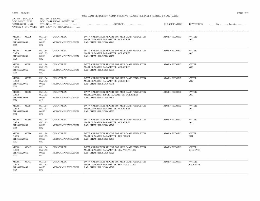
DATE - 08/24/98 PAGE - 112MCB CAMP PENDLETON ADMINISTRATIVE RECORD FILE INDEX (SORTED BY DOC. DATE)
UIC No. DOC. NO. PRC . DATE FROM . . . . . . . . . . . . . . . . . .DOCUMENT . TYPE . . . DOC . DATE FROM . SIGNATURE . . . . .CONTR/GUID . . NO . . CTO . NO . . TO . . . . . . . . . . . . . . . . . . . . . . . . . . . . . . . . . . . . . . . . . . . . .SUBJECT . . . . . . . . . . . . . . . . . CLASSIFICATION KEY WORDS . . . . . Site . . . . . . . Location . . . . . . .APPROX. # . OF . PAGES EPA . CAT# TO . SIGNATURE . . . . . . . .
M00681 000379 05/11/94 QUANTALEX DATA VALIDATION REPORT FOR MCB CAMP PENDLETON ADMIN RECORD WATERDATA 05/21/93 MATRIX: WATER PARAMETER: VOLATILES VOC01F166S920066 00166 MCB CAMP PENDLETON LAB: CH2M HILL SDG# 354410019 02.2
M00681 000380 05/11/94 QUANTALEX DATA VALIDATION REPORT FOR MCB CAMP PENDLETON ADMIN RECORD WATERDATA 05/21/93 MATRIX: WATER PARAMETER: VOLATILES VOC01F166S920066 00166 MCB CAMP PENDLETON LAB: CH2M HILL SDG# 354580020 02.2
M00681 000381 05/11/94 QUANTALEX DATA VALIDATION REPORT FOR MCB CAMP PENDLETON ADMIN RECORD WATERDATA 05/21/93 MATRIX: WATER PARAMETER: VOLATILES VOC01F166S920066 00166 MCB CAMP PENDLETON LAB: CH2M HILL SDG# 355310018 02.2
M00681 000382 05/11/94 QUANTALEX DATA VALIDATION REPORT FOR MCB CAMP PENDLETON ADMIN RECORD WATERDATA 05/21/93 MATRIX: WATER PARAMETER: VOLATILES VOC01F166S920066 00166 MCB CAMP PENDLETON LAB: CH2M HILL SDG# 350780019 02.2
M00681 000383 05/11/94 QUANTALEX DATA VALIDATION REPORT FOR MCB CAMP PENDLETON ADMIN RECORD WATERDATA 05/21/93 MATRIX: WATER & SOIL PARAMETER: VOLATILES VOC01F166S920066 00166 MCB CAMP PENDLETON LAB: CH2M HILL SDG# 351040026 02.2
M00681 000384 05/11/94 QUANTALEX DATA VALIDATION REPORT FOR MCB CAMP PENDLETON ADMIN RECORD WATERDATA 05/21/93 MATRIX: WATER PARAMETER: VOLATILES VOC01F166S920066 00166 MCB CAMP PENDLETON LAB: CH2M HILL SDG# 355330018 02.2
M00681 000385 05/11/94 QUANTALEX DATA VALIDATION REPORT FOR MCB CAMP PENDLETON ADMIN RECORD WATERDATA 05/21/93 MATRIX: WATER PARAMETER: VOLATILES VOC01F166S920066 00166 MCB CAMP PENDLETON LAB: CH2M HILL SDG# 355400019 02.2
M00681 000386 05/11/94 QUANTALEX DATA VALIDATION REPORT FOR MCB CAMP PENDLETON ADMIN RECORD WATERDATA 05/21/93 MATRIX: WATER PARAMETER: TPH DIESEL TPH01F166S920066 00166 MCB CAMP PENDLETON LAB: CH2M HILL SDG# 354910012 02.2
M00681 000412 05/11/94 QUANTALEX DATA VALIDATION REPORT FOR MCB CAMP PENDLETON ADMIN RECORD WATERDATA 05/21/93 MATRIX: WATER PARAMETER: SEMIVOLATILES SOLVENTS01F166S920066 00166 MCB CAMP PENDLETON LAB: CH2M HILL SDG# 355200023 02.2
M00681 000413 05/11/94 QUANTALEX DATA VALIDATION REPORT FOR MCB CAMP PENDLETON ADMIN RECORD WATERDATA 05/21/93 MATRIX: WATER PARAMETER: SEMIVOLATILES SOLVENTS01F166S920066 00166 MCB CAMP PENDLETON LAB: CH2M HILL SDG# 355180029 02.2
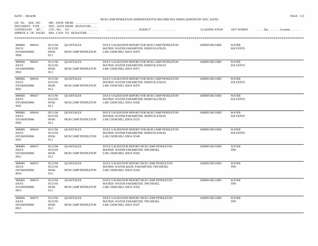
DATE - 08/24/98 PAGE - 113MCB CAMP PENDLETON ADMINISTRATIVE RECORD FILE INDEX (SORTED BY DOC. DATE)
UIC No. DOC. NO. PRC . DATE FROM . . . . . . . . . . . . . . . . . .DOCUMENT . TYPE . . . DOC . DATE FROM . SIGNATURE . . . . .CONTR/GUID . . NO . . CTO . NO . . TO . . . . . . . . . . . . . . . . . . . . . . . . . . . . . . . . . . . . . . . . . . . . .SUBJECT . . . . . . . . . . . . . . . . . CLASSIFICATION KEY WORDS . . . . . Site . . . . . . . Location . . . . . . .APPROX. # . OF . PAGES EPA . CAT# TO . SIGNATURE . . . . . . . .
M00681 000414 05/11/94 QUANTALEX DATA VALIDATION REPORT FOR MCB CAMP PENDLETON ADMIN RECORD WATERDATA 05/21/93 MATRIX: WATER PARAMETER: SEMIVOLATILES SOLVENTS01F166S920066 00166 MCB CAMP PENDLETON LAB: CH2M HILL SDG# 354790028 02.2
M00681 000415 05/11/94 QUANTALEX DATA VALIDATION REPORT FOR MCB CAMP PENDLETON ADMIN RECORD WATERDATA 05/21/93 MATRIX: WATER PARAMETER: SEMIVOLATILES SOLVENTS01F166S920066 00166 MCB CAMP PENDLETON LAB: CH2M HILL SDG# 354710022 02.2
M00681 000416 05/11/94 QUANTALEX DATA VALIDATION REPORT FOR MCB CAMP PENDLETON ADMIN RECORD WATERDATA 05/21/93 MATRIX: WATER PARAMETER: SEMIVOLATILES SOLVENTS01F166S920066 00166 MCB CAMP PENDLETON LAB: CH2M HILL SDG# 354700022 02.2
M00681 000417 05/11/94 QUANTALEX DATA VALIDATION REPORT FOR MCB CAMP PENDLETON ADMIN RECORD WATERDATA 05/21/93 MATRIX: WATER PARAMETER: SEMIVOLATILES SOLVENTS01F166S920066 00166 MCB CAMP PENDLETON LAB: CH2M HILL SDG# 354580023 02.2
M00681 000418 05/11/94 QUANTALEX DATA VALIDATION REPORT FOR MCB CAMP PENDLETON ADMIN RECORD WATERDATA 05/21/93 MATRIX: WATER PARAMETER: SEMIVOLATILES SOLVENTS01F166S920066 00166 MCB CAMP PENDLETON LAB: CH2M HILL SDG# 355330020 02.2
M00681 000419 05/11/94 QUANTALEX DATA VALIDATION REPORT FOR MCB CAMP PENDLETON ADMIN RECORD WATERDATA 05/21/93 MATRIX: WATER PARAMETER: SEMIVOLATILES SOLVENTS01F166S920066 00166 MCB CAMP PENDLETON LAB: CH2M HILL SDG# 355400022 02.2
M00681 000472 05/12/94 QUANTALEX DATA VALIDATION REPORT MCB CAMP PENDLETON ADMIN RECORD WATERDATA 05/21/93 MATRIX: WATER PARAMETER: TPH DIESEL TPH01F166S920066 00166 MCB CAMP PENDLETON LAB: CH2M HILL SDG# 355020012 02.2
M00681 000473 05/12/94 QUANTALEX DATA VALIDATION REPORT MCB CAMP PENDLETON ADMIN RECORD WATERDATA 05/21/93 MATRIX: WATER &SOIL PARAMETER: TPH DIESEL TPH01F166S920066 00166 MCB CAMP PENDLETON LAB: CH2M HILL SDG# 351040014 02.2
M00681 000474 05/12/94 QUANTALEX DATA VALIDATION REPORT MCB CAMP PENDLETON ADMIN RECORD WATERDATA 05/21/93 MATRIX: WATER PARAMETER: TPH DIESEL TPH01F166S920066 00166 MCB CAMP PENDLETON LAB: CH2M HILL SDG# 353260013 02.2
M00681 000475 05/12/94 QUANTALEX DATA VALIDATION REPORT MCB CAMP PENDLETON ADMIN RECORD WATERDATA 05/21/93 MATRIX: WATER PARAMETER: TPH DIESEL TPH01F166S920066 00166 MCB CAMP PENDLETON LAB: CH2M HILL SDG# 353370013 02.2
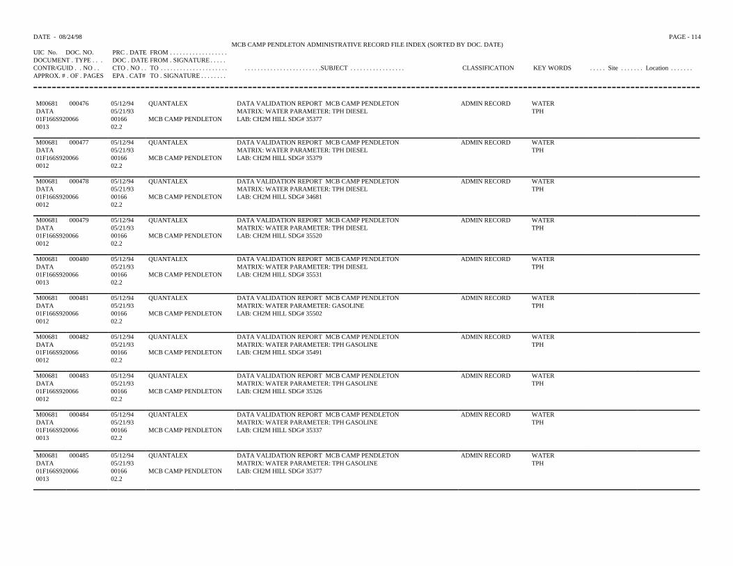
DATE - 08/24/98 PAGE - 114MCB CAMP PENDLETON ADMINISTRATIVE RECORD FILE INDEX (SORTED BY DOC. DATE)
UIC No. DOC. NO. PRC . DATE FROM . . . . . . . . . . . . . . . . . .DOCUMENT . TYPE . . . DOC . DATE FROM . SIGNATURE . . . . .CONTR/GUID . . NO . . CTO . NO . . TO . . . . . . . . . . . . . . . . . . . . . . . . . . . . . . . . . . . . . . . . . . . . .SUBJECT . . . . . . . . . . . . . . . . . CLASSIFICATION KEY WORDS . . . . . Site . . . . . . . Location . . . . . . .APPROX. # . OF . PAGES EPA . CAT# TO . SIGNATURE . . . . . . . .
M00681 000476 05/12/94 QUANTALEX DATA VALIDATION REPORT MCB CAMP PENDLETON ADMIN RECORD WATERDATA 05/21/93 MATRIX: WATER PARAMETER: TPH DIESEL TPH01F166S920066 00166 MCB CAMP PENDLETON LAB: CH2M HILL SDG# 353770013 02.2
M00681 000477 05/12/94 QUANTALEX DATA VALIDATION REPORT MCB CAMP PENDLETON ADMIN RECORD WATERDATA 05/21/93 MATRIX: WATER PARAMETER: TPH DIESEL TPH01F166S920066 00166 MCB CAMP PENDLETON LAB: CH2M HILL SDG# 353790012 02.2
M00681 000478 05/12/94 QUANTALEX DATA VALIDATION REPORT MCB CAMP PENDLETON ADMIN RECORD WATERDATA 05/21/93 MATRIX: WATER PARAMETER: TPH DIESEL TPH01F166S920066 00166 MCB CAMP PENDLETON LAB: CH2M HILL SDG# 346810012 02.2
M00681 000479 05/12/94 QUANTALEX DATA VALIDATION REPORT MCB CAMP PENDLETON ADMIN RECORD WATERDATA 05/21/93 MATRIX: WATER PARAMETER: TPH DIESEL TPH01F166S920066 00166 MCB CAMP PENDLETON LAB: CH2M HILL SDG# 355200012 02.2
M00681 000480 05/12/94 QUANTALEX DATA VALIDATION REPORT MCB CAMP PENDLETON ADMIN RECORD WATERDATA 05/21/93 MATRIX: WATER PARAMETER: TPH DIESEL TPH01F166S920066 00166 MCB CAMP PENDLETON LAB: CH2M HILL SDG# 355310013 02.2
M00681 000481 05/12/94 QUANTALEX DATA VALIDATION REPORT MCB CAMP PENDLETON ADMIN RECORD WATERDATA 05/21/93 MATRIX: WATER PARAMETER: GASOLINE TPH01F166S920066 00166 MCB CAMP PENDLETON LAB: CH2M HILL SDG# 355020012 02.2
M00681 000482 05/12/94 QUANTALEX DATA VALIDATION REPORT MCB CAMP PENDLETON ADMIN RECORD WATERDATA 05/21/93 MATRIX: WATER PARAMETER: TPH GASOLINE TPH01F166S920066 00166 MCB CAMP PENDLETON LAB: CH2M HILL SDG# 354910012 02.2
M00681 000483 05/12/94 QUANTALEX DATA VALIDATION REPORT MCB CAMP PENDLETON ADMIN RECORD WATERDATA 05/21/93 MATRIX: WATER PARAMETER: TPH GASOLINE TPH01F166S920066 00166 MCB CAMP PENDLETON LAB: CH2M HILL SDG# 353260012 02.2
M00681 000484 05/12/94 QUANTALEX DATA VALIDATION REPORT MCB CAMP PENDLETON ADMIN RECORD WATERDATA 05/21/93 MATRIX: WATER PARAMETER: TPH GASOLINE TPH01F166S920066 00166 MCB CAMP PENDLETON LAB: CH2M HILL SDG# 353370013 02.2
M00681 000485 05/12/94 QUANTALEX DATA VALIDATION REPORT MCB CAMP PENDLETON ADMIN RECORD WATERDATA 05/21/93 MATRIX: WATER PARAMETER: TPH GASOLINE TPH01F166S920066 00166 MCB CAMP PENDLETON LAB: CH2M HILL SDG# 353770013 02.2
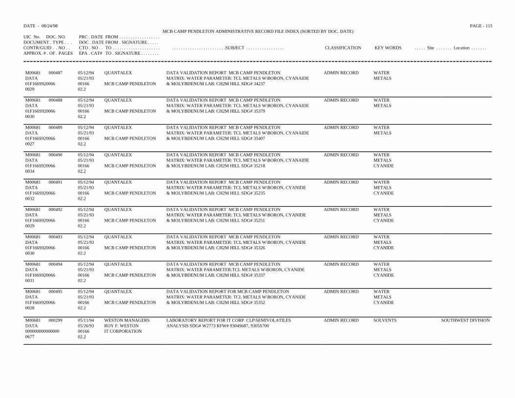
DATE - 08/24/98 PAGE - 115MCB CAMP PENDLETON ADMINISTRATIVE RECORD FILE INDEX (SORTED BY DOC. DATE)
UIC No. DOC. NO. PRC . DATE FROM . . . . . . . . . . . . . . . . . .DOCUMENT . TYPE . . . DOC . DATE FROM . SIGNATURE . . . . .CONTR/GUID . . NO . . CTO . NO . . TO . . . . . . . . . . . . . . . . . . . . . . . . . . . . . . . . . . . . . . . . . . . . .SUBJECT . . . . . . . . . . . . . . . . . CLASSIFICATION KEY WORDS . . . . . Site . . . . . . . Location . . . . . . .APPROX. # . OF . PAGES EPA . CAT# TO . SIGNATURE . . . . . . . .
M00681 000487 05/12/94 QUANTALEX DATA VALIDATION REPORT MCB CAMP PENDLETON ADMIN RECORD WATERDATA 05/21/93 MATRIX: WATER PARAMETER: TCL METALS W\BORON, CYANAIDE METALS01F166S920066 00166 MCB CAMP PENDLETON & MOLYBDENUM LAB: CH2M HILL SDG# 342370029 02.2
M00681 000488 05/12/94 QUANTALEX DATA VALIDATION REPORT MCB CAMP PENDLETON ADMIN RECORD WATERDATA 05/21/93 MATRIX: WATER PARAMETER: TCL METALS W\BORON, CYANAIDE METALS01F166S920066 00166 MCB CAMP PENDLETON & MOLYBDENUM LAB: CH2M HILL SDG# 353790030 02.2
M00681 000489 05/12/94 QUANTALEX DATA VALIDATION REPORT MCB CAMP PENDLETON ADMIN RECORD WATERDATA 05/21/93 MATRIX: WATER PARAMETER: TCL METALS W\BORON, CYANAIDE METALS01F166S920066 00166 MCB CAMP PENDLETON & MOLYBDENUM LAB: CH2M HILL SDG# 354070027 02.2
M00681 000490 05/12/94 QUANTALEX DATA VALIDATION REPORT MCB CAMP PENDLETON ADMIN RECORD WATERDATA 05/21/93 MATRIX: WATER PARAMETER: TCL METALS W\BORON, CYANAIDE METALS01F166S920066 00166 MCB CAMP PENDLETON & MOLYBDENUM LAB: CH2M HILL SDG# 35218 CYANIDE0034 02.2
M00681 000491 05/12/94 QUANTALEX DATA VALIDATION REPORT MCB CAMP PENDLETON ADMIN RECORD WATERDATA 05/21/93 MATRIX: WATER PARAMETER: TCL METALS W\BORON, CYANIDE METALS01F166S920066 00166 MCB CAMP PENDLETON & MOLYBDENUM LAB: CH2M HILL SDG# 35235 CYANIDE0032 02.2
M00681 000492 05/12/94 QUANTALEX DATA VALIDATION REPORT MCB CAMP PENDLETON ADMIN RECORD WATERDATA 05/21/93 MATRIX: WATER PARAMETER: TCL METALS W\BORON, CYANIDE METALS01F166S920066 00166 MCB CAMP PENDLETON & MOLYBDENUM LAB: CH2M HILL SDG# 35251 CYANIDE0029 02.2
M00681 000493 05/12/94 QUANTALEX DATA VALIDATION REPORT MCB CAMP PENDLETON ADMIN RECORD WATERDATA 05/21/93 MATRIX: WATER PARAMETER: TCL METALS W\BORON, CYANIDE METALS01F166S920066 00166 MCB CAMP PENDLETON & MOLYBDENUM LAB: CH2M HILL SDG# 35326 CYANIDE0030 02.2
M00681 000494 05/12/94 QUANTALEX DATA VALIDATION REPORT MCB CAMP PENDLETON ADMIN RECORD WATERDATA 05/21/93 MATRIX: WATER PARAMETER:TCL METALS W\BORON, CYANIDE METALS01F166S920066 00166 MCB CAMP PENDLETON & MOLYBDENUM LAB: CH2M HILL SDG# 35337 CYANIDE0031 02.2
M00681 000495 05/12/94 QUANTALEX DATA VALIDATION REPORT FOR MCB CAMP PENDLETON ADMIN RECORD WATERDATA 05/21/93 MATRIX: WATER PARAMETER: TCL METALS W\BORON, CYANIDE METALS01F166S920066 00166 MCB CAMP PENDLETON & MOLYBDENUM LAB: CH2M HILL SDG# 35352 CYANIDE0028 02.2
M00681 000299 05/11/94 WESTON MANAGERS LABORATORY REPORT FOR IT CORP. CLP\SEMIVOLATILES ADMIN RECORD SOLVENTS SOUTHWEST DIVISIONDATA 05/26/93 ROY F. WESTON ANALYSIS SDG# W2773 RFW# 9304S687, 9305S700000000000000000 00166 IT CORPORATION0677 02.2
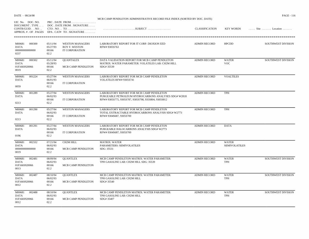
DATE - 08/24/98 PAGE - 116MCB CAMP PENDLETON ADMINISTRATIVE RECORD FILE INDEX (SORTED BY DOC. DATE)
UIC No. DOC. NO. PRC . DATE FROM . . . . . . . . . . . . . . . . . .DOCUMENT . TYPE . . . DOC . DATE FROM . SIGNATURE . . . . .CONTR/GUID . . NO . . CTO . NO . . TO . . . . . . . . . . . . . . . . . . . . . . . . . . . . . . . . . . . . . . . . . . . . .SUBJECT . . . . . . . . . . . . . . . . . CLASSIFICATION KEY WORDS . . . . . Site . . . . . . . Location . . . . . . .APPROX. # . OF . PAGES EPA . CAT# TO . SIGNATURE . . . . . . . .
M00681 000300 05/11/94 WESTON MANAGERS LABORATORY REPORT FOR IT CORP. DIOXION EED ADMIN RECORD HPCDD SOUTHWEST DIVISIONDATA 05/27/93 ROY F. WESTON RFW# 9305S763000000000000000 00166 IT CORPORATION0237 02.2
M00681 000302 05/11/94 QUANTALEX DATA VALIDATION REPORT FOR MCB CAMP PENDLETON ADMIN RECORD WATER SOUTHWEST DIVISIONDATA 05/28/93 MATRIX: WATER PARAMETER: VOLATILES LAB: CH2M HILL VOC01F166S920066 00166 MCB CAMP PENDLETON SDG# 355390019 02.2
M00681 001224 05/27/94 WESTON MANAGERS LABORATORY REPORT FOR MCB CAMP PENDLETON ADMIN RECORD VOALTILESDATA 06/01/93 VOLATILES RFW# 9305S741
00166 IT CORPORATION0059 02.2
M00681 001289 05/27/94 WESTON MANAGERS LABORATORY REPORT FOR MCB CAMP PENDLETON ADMIN RECORD TPHDATA 06/02/93 PURGEABLE PETROLEUM HYDROCARBONS ANALYSES SDG# W2818
00166 IT CORPORATION RFW# 9305S775, 9305S787, 9305S798, 935S804, 9305S8120213 02.2
M00681 001290 05/27/94 WESTON MANAGERS LABORATORY REPORT FOR MCB CAMP PENDLETON ADMIN RECORD TPHDATA 06/02/93 TOTAL EXTRACTABLE HYDROCARBONS ANALYSIS SDG# W2773
00166 IT CORPORATION RFW# 9304S687, 9305S7000213 02.2
M00681 001291 05/27/94 WESTON MANAGERS LABORATORY REPORT FOR MCB CAMP PENDLETON ADMIN RECORD DATADATA 06/02/93 PURGEABLE HALOCARBONS ANALYSIS SDG# W2773
00166 IT CORPORATION RFW# 9304S687, 9305S7000196 02.2
M00681 002332 07/21/94 CH2M HILL MATRIX: WATER ADMIN RECORD WATERDATA 06/02/93 PARAMETERS: SEMIVOLATILES SEMIVOLATILES000000000000000 00166 MCB CAMP PENDLETON SDG: 355310019 02.2
M00681 002481 08/09/94 QUANTLEX MCB CAMP PENDLETON MATRIX: WATER PARAMETER: ADMIN RECORD WATER SOUTHWEST DIVISIONDATA 06/02/93 TPH GASOLINE LAB: CH2M HILL SDG: 35539 TPH01F166S920066 00166 MCB CAMP PENDLETON0013 02.2
M00681 002487 08/10/94 QUANTLEX MCB CAMP PENDLETON MATRIX: WATER PARAMETER: ADMIN RECORD WATER SOUTHWEST DIVISIONDATA 06/02/93 TPH GASOLINE LAB: CH2M HILL TPH01F166S920066 00166 MCB CAMP PENDLETON SDG# 355400012 02.2
M00681 002488 08/10/94 QUANTLEX MCB CAMP PENDLETON MATRIX: WATER PARAMETER: ADMIN RECORD WATER SOUTHWEST DIVISIONDATA 06/02/93 TPH GASOLINE LAB: CH2M HILL TPH01F166S920066 00166 MCB CAMP PENDLETON SDG# 354070012 02.2
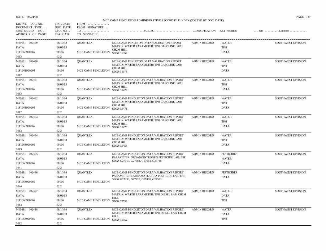
DATE - 08/24/98 PAGE - 117MCB CAMP PENDLETON ADMINISTRATIVE RECORD FILE INDEX (SORTED BY DOC. DATE)
UIC No. DOC. NO. PRC . DATE FROM . . . . . . . . . . . . . . . .DOCUMENT . TYPE . . . DOC . DATE FROM . SIGNATURE . . .CONTR/GUID . . NO . . CTO . NO . . TO . . . . . . . . . . . . . . . . . . . . . . . . . . . . . . . . . . . . . . . .SUBJECT . . . . . . . . . . . . . . . . . . . . . . . CLASSIFICATION KEY WORDS . . . Site . . . . . . . . . . Location . . . . . . . . . . . .APPROX. # . OF . PAGES EPA . CAT# TO . SIGNATURE . . . . . .
M00681 002489 08/10/94 QUANTLEX MCB CAMP PENLETON DATA VALIDATION REPORTMATRIX: WATER PARAMETER: TPH GASOLINE LAB:CH2M HILLSDG# 35352
ADMIN RECORD WATER SOUTHWEST DIVISION
DATA 06/02/93 TPH
01F166S920066 00166 MCB CAMP PENDLETON DATA
0012 02.2
M00681 002490 08/10/94 QUANTLEX MCB CAMP PENLETON DATA VALIDATION REPORTMATRIX: WATER PARAMETER: TPH GASOLINE LAB:CH2M HILLSDG# 35078
ADMIN RECORD WATER SOUTHWEST DIVISION
DATA 06/02/93 TPH
01F166S920066 00166 MCB CAMP PENDLETON DATA
0012 02.2
M00681 002491 08/10/94 QUANTLEX MCB CAMP PENDLETON DATA VALIDATION REPORTMATRIX: WATER PARAMETER: TPH GASOLINE LAB:CH2M HILLSDG# 35479
ADMIN RECORD WATER SOUTHWEST DIVISION
DATA 06/02/93 TPH
01F166S920066 00166 MCB CAMP PENDLETON DATA
0012 02.2
M00681 002492 08/10/94 QUANTLEX MCB CAMP PENDLETON DATA VALIDATION REPORTMATRIX: WATER PARAMETER: TPH GASOLINE LAB:CH2M HILLSDG# 35471
ADMIN RECORD WATER SOUTHWEST DIVISION
DATA 06/02/93 TPH
01F166S920066 00166 MCB CAMP PENDLETON DATA
0012 02.2
M00681 002493 08/10/94 QUANTLEX MCB CAMP PENDLETON DATA VALIDATION REPORTMATRIX: WATER PARAMETER: TPH GASOLINE LAB:CH2M HILLSDG# 35470
ADMIN RECORD WATER SOUTHWEST DIVISION
DATA 06/02/93 TPH
01F166S920066 00166 MCB CAMP PENDLETON DATA
0013 02.2
M00681 002494 08/10/94 QUANTLEX MCB CAMP PENDLETON DATA VALIDATION REPORTMATRIX: WATER PARAMETER: TPH GASOLINE LAB:CH2M HILLSDG# 35458
ADMIN RECORD WATER SOUTHWEST DIVISION
DATA 06/02/93 TPH
01F166S920066 00166 MCB CAMP PENDLETON DATA
0013 02.2
M00681 002495 08/10/94 QUANTLEX MCB CAMP PENDLETON DATA VALIDATION REPORTPARAMETER: ORGANOINTROGEN PESTICIDE LAB: ESESDG# G27557, G27581, G27664, G27718
ADMIN RECORD PESTICIDES SOUTHWEST DIVISION
DATA 06/02/93 WATER
01F166S920066 00166 MCB CAMP PENDLETON DATA
0041 02.2
M00681 002496 08/10/94 QUANTLEX MCB CAMP PENDLETON DATA VALIDATION REPORTPARAMETER: CARBAMATE/UREA PESTICIDE LAB: ESESDG# G27393, G27423, G27468, G27593
ADMIN RECORD PESTICIDES SOUTHWEST DIVISION
DATA 06/02/93 DATA
01F166S920066 00166 MCB CAMP PENDLETON
0044 02.2
M00681 002497 08/10/94 QUANTLEX MCB CAMP PENDLETON DATA VALIDATION REPORTMATRIX: WATER PARAMETER: TPH DIESEL LAB: CH2MHILLSDG# 35533
ADMIN RECORD WATER SOUTHWEST DIVISION
DATA 06/02/93 DATA
01F166S920066 00166 MCB CAMP PENDLETON TPH
0013 02.2
M00681 002498 08/10/94 QUANTLEX MCB CAMP PENDLETON DATA VALIDATION REPORTMATRIX: WATER PARAMETER: TPH DIESEL LAB: CH2MHILLSDG# 35352
ADMIN RECORD WATER SOUTHWEST DIVISION
DATA 06/02/93 DATA
01F166S920066 00166 MCB CAMP PENDLETON TPH
0012 02.2

DATE - 08/24/98 PAGE - 118MCB CAMP PENDLETON ADMINISTRATIVE RECORD FILE INDEX (SORTED BY DOC. DATE)
UIC No. DOC. NO. PRC . DATE FROM . . . . . . . . . . . . . . . .DOCUMENT . TYPE . . . DOC . DATE FROM . SIGNATURE . . .CONTR/GUID . . NO . . CTO . NO . . TO . . . . . . . . . . . . . . . . . . . . . . . . . . . . . . . . . . . . . . . .SUBJECT . . . . . . . . . . . . . . . . . . . . . . . CLASSIFICATION KEY WORDS . . . Site . . . . . . . . . . Location . . . . . . . . . . . .APPROX. # . OF . PAGES EPA . CAT# TO . SIGNATURE . . . . . .
M00681 002499 08/10/94 QUANTLEX MCB CAMP PENDLETON DATA VALIDATION REPORTMATIRX: WATER PARAMETER: TPH DIESEL LAB: CH2MHILLSDG# 35518
ADMIN RECORD WATER SOUTHWEST DIVISION
DATA 06/02/93 DATA
01F166S920066 00166 MCB CAMP PENDLETON TPH
0012 02.2
M00681 002500 08/10/94 QUANTLEX MCB CAMP PENDLETON DATA VALIDATION REPORTMATRIX: WATER PARAMETER: TPH DIESEL LAB: CH2MHILLSDG# 35479
ADMIN RECORD WATER SOUTHWEST DIVISION
DATA 06/02/93 TPH
01F166S920066 00166 MCB CAMP PENDLETON DATA
0012 02.2
M00681 002501 08/10/94 QUANTLEX MCB CAMP PENDLETON DATA VALIDATION REPORTMATRIX: WATER PARAMETER: TPH DIESEL LAB: CH2MHILLSDG# 35539
ADMIN RECORD WATER SOUTHWEST DIVISION
DATA 06/02/93 DATA
01F166S920066 00166 MCB CAMP PENDLETON TPH
0013 02.2
M00681 002502 08/10/94 QUANTLEX MCB CAMP PENDLETON DATA VALIDATION REPORTMATRIX: WATER PARAMETER: TPH DIESEL LAB: CH2MHILLSDG# 35540
ADMIN RECORD WATER SOUTHWEST DIVISION
DATA 06/02/93 DATA
01F166S9220066 00166 MCB CAMP PENDLETON TPH
0012 02.2
M00681 002503 08/10/94 QUANTLEX MCB CAMP PENDLETON DATA VALIDATION REPORTMATRIX: WATER PARAMETER: TPH DIESEL LAB: CH2MHILLSDG# 35427
ADMIN RECORD WATER SOUTHWEST DIVISION
DATA 06/02/93 TPH
01F166S920066 00166 MCB CAMP PENDLETON DATA
0013 02.2
M00681 002504 08/10/94 QUANTLEX MCB CAMP PENDLETON DATA VALIDATION REPORTMATRIX: WATER PARAMETER: TPH DIESEL LAB: CH2MHILLSDG# 35078
ADMIN RECORD WATER SOUTHWEST DIVISION
DATA 06/02/93 TPH
01F166S920066 00166 MCB CAMP PENDLETON DATA
0012 02.2
M00681 002505 08/10/94 QUANTLEX MCB CAMP PENDLETON DATA VALIDATION REPORTMATRIX: WATER PARAMETER: TPH DIESEL LAB: CH2MHILLSDG# 35470
ADMIN RECORD WATER SOUTHWEST DIVISION
DATA 06/02/93 TPH
01F166S920066 00166 MCB CAMP PENDLETON DATA
0013 02.2
M00681 001293 05/27/94 WESTON MANAGERS LABORATORY REPORT FOR MCB CAMP PENDLETONCLP GCMS SEMIVOLATILE ANALYSIS SDG# W2792RFW# 9305S701, 9305S725, 9305S763
ADMIN RECORD SEMIVOLATILES
DATA 06/03/93
00166 IT CORPORATION
0634 02.2
M00681 001297 05/27/94 WESTON MANAGERS LABORATORY REPORT FOR MCB CAMP PENDLETONTOTAL EXTRACTABLE HYDROCARBONS ANALYSISSDG# W2792RFW# 9305S701, 935S725, 9305S763
ADMIN RECORD TEH
DATA 06/07/93
00166 IT CORPORATION
0252 02.2
M00681 001298 05/27/94 WESTON MANAGERS LABORATORY REPORT FOR MCB CAMP PENDLETONCLP GCMS SEMIVOLATILE ANALYSIS SDG# W2818RFW# 9305S775, 9305S787, 9305S798, 9305S804, 9305S812
ADMIN RECORD SEMIVOLATILE
DATA 06/07/93
00166 IT CORPORATION
0520 02.2
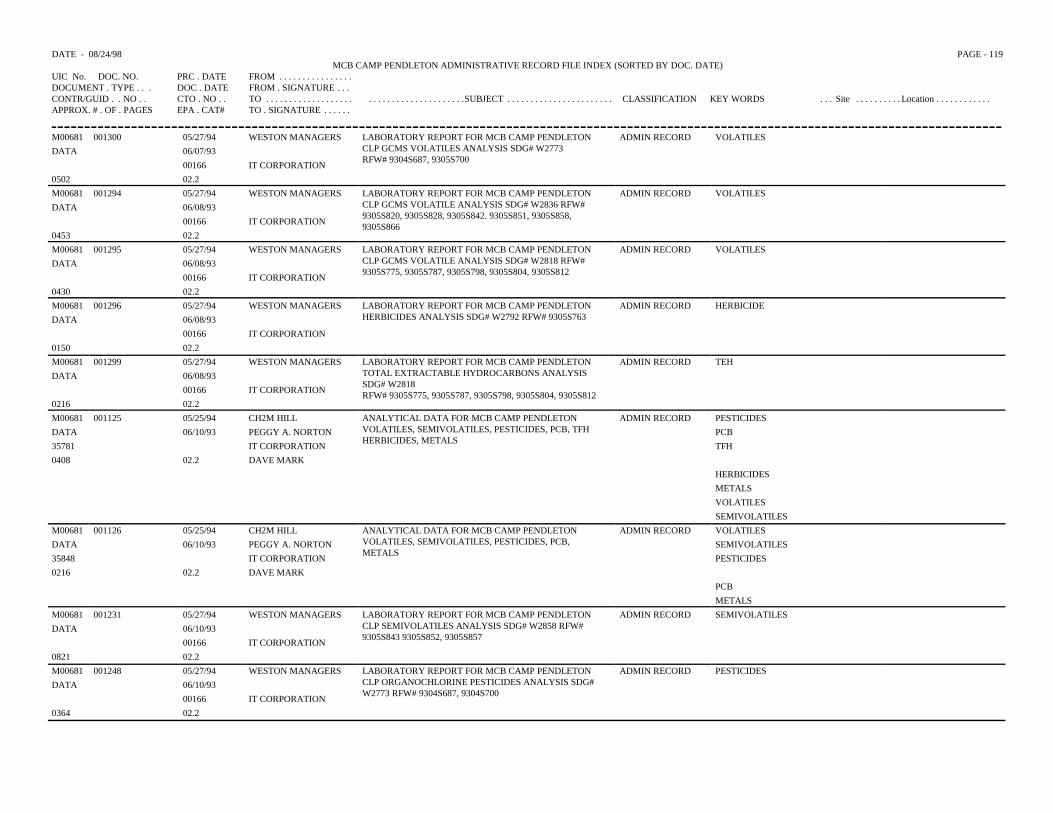
DATE - 08/24/98 PAGE - 119MCB CAMP PENDLETON ADMINISTRATIVE RECORD FILE INDEX (SORTED BY DOC. DATE)
UIC No. DOC. NO. PRC . DATE FROM . . . . . . . . . . . . . . . .DOCUMENT . TYPE . . . DOC . DATE FROM . SIGNATURE . . .CONTR/GUID . . NO . . CTO . NO . . TO . . . . . . . . . . . . . . . . . . . . . . . . . . . . . . . . . . . . . . . .SUBJECT . . . . . . . . . . . . . . . . . . . . . . . CLASSIFICATION KEY WORDS . . . Site . . . . . . . . . . Location . . . . . . . . . . . .APPROX. # . OF . PAGES EPA . CAT# TO . SIGNATURE . . . . . .
M00681 001300 05/27/94 WESTON MANAGERS LABORATORY REPORT FOR MCB CAMP PENDLETONCLP GCMS VOLATILES ANALYSIS SDG# W2773RFW# 9304S687, 9305S700
ADMIN RECORD VOLATILESDATA 06/07/93
00166 IT CORPORATION0502 02.2M00681 001294 05/27/94 WESTON MANAGERS LABORATORY REPORT FOR MCB CAMP PENDLETON
CLP GCMS VOLATILE ANALYSIS SDG# W2836 RFW#9305S820, 9305S828, 9305S842. 9305S851, 9305S858,9305S866
ADMIN RECORD VOLATILESDATA 06/08/93
00166 IT CORPORATION0453 02.2M00681 001295 05/27/94 WESTON MANAGERS LABORATORY REPORT FOR MCB CAMP PENDLETON
CLP GCMS VOLATILE ANALYSIS SDG# W2818 RFW#9305S775, 9305S787, 9305S798, 9305S804, 9305S812
ADMIN RECORD VOLATILESDATA 06/08/93
00166 IT CORPORATION0430 02.2M00681 001296 05/27/94 WESTON MANAGERS LABORATORY REPORT FOR MCB CAMP PENDLETON
HERBICIDES ANALYSIS SDG# W2792 RFW# 9305S763ADMIN RECORD HERBICIDE
DATA 06/08/9300166 IT CORPORATION
0150 02.2M00681 001299 05/27/94 WESTON MANAGERS LABORATORY REPORT FOR MCB CAMP PENDLETON
TOTAL EXTRACTABLE HYDROCARBONS ANALYSISSDG# W2818RFW# 9305S775, 9305S787, 9305S798, 9305S804, 9305S812
ADMIN RECORD TEHDATA 06/08/93
00166 IT CORPORATION0216 02.2M00681 001125 05/25/94 CH2M HILL ANALYTICAL DATA FOR MCB CAMP PENDLETON
VOLATILES, SEMIVOLATILES, PESTICIDES, PCB, TFHHERBICIDES, METALS
ADMIN RECORD PESTICIDESDATA 06/10/93 PEGGY A. NORTON PCB35781 IT CORPORATION TFH0408 02.2 DAVE MARK
HERBICIDESMETALSVOLATILESSEMIVOLATILES
M00681 001126 05/25/94 CH2M HILL ANALYTICAL DATA FOR MCB CAMP PENDLETONVOLATILES, SEMIVOLATILES, PESTICIDES, PCB,METALS
ADMIN RECORD VOLATILESDATA 06/10/93 PEGGY A. NORTON SEMIVOLATILES35848 IT CORPORATION PESTICIDES0216 02.2 DAVE MARK
PCBMETALS
M00681 001231 05/27/94 WESTON MANAGERS LABORATORY REPORT FOR MCB CAMP PENDLETONCLP SEMIVOLATILES ANALYSIS SDG# W2858 RFW#9305S843 9305S852, 9305S857
ADMIN RECORD SEMIVOLATILESDATA 06/10/93
00166 IT CORPORATION0821 02.2M00681 001248 05/27/94 WESTON MANAGERS LABORATORY REPORT FOR MCB CAMP PENDLETON
CLP ORGANOCHLORINE PESTICIDES ANALYSIS SDG#W2773 RFW# 9304S687, 9304S700
ADMIN RECORD PESTICIDESDATA 06/10/93
00166 IT CORPORATION0364 02.2
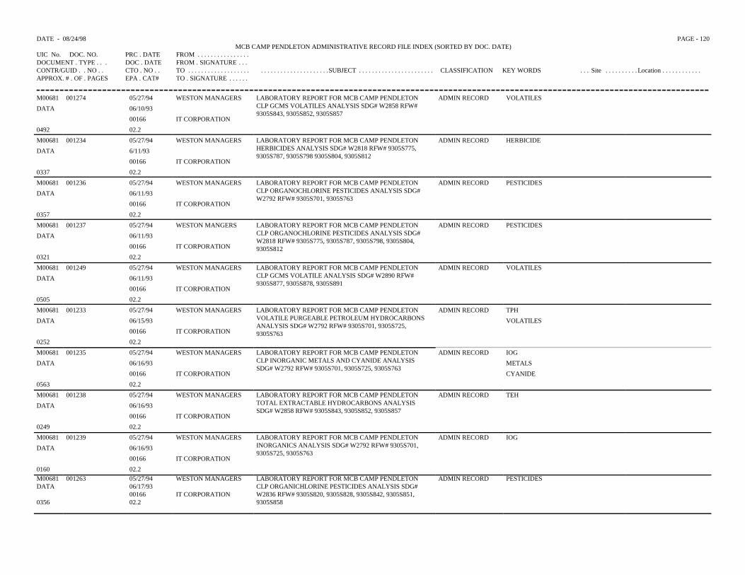
DATE - 08/24/98 PAGE - 120MCB CAMP PENDLETON ADMINISTRATIVE RECORD FILE INDEX (SORTED BY DOC. DATE)
UIC No. DOC. NO. PRC . DATE FROM . . . . . . . . . . . . . . . .DOCUMENT . TYPE . . . DOC . DATE FROM . SIGNATURE . . .CONTR/GUID . . NO . . CTO . NO . . TO . . . . . . . . . . . . . . . . . . . . . . . . . . . . . . . . . . . . . . . .SUBJECT . . . . . . . . . . . . . . . . . . . . . . . CLASSIFICATION KEY WORDS . . . Site . . . . . . . . . . Location . . . . . . . . . . . .APPROX. # . OF . PAGES EPA . CAT# TO . SIGNATURE . . . . . .
M00681 001274 05/27/94 WESTON MANAGERS LABORATORY REPORT FOR MCB CAMP PENDLETONCLP GCMS VOLATILES ANALYSIS SDG# W2858 RFW#9305S843, 9305S852, 9305S857
ADMIN RECORD VOLATILES
DATA 06/10/93
00166 IT CORPORATION
0492 02.2
M00681 001234 05/27/94 WESTON MANAGERS LABORATORY REPORT FOR MCB CAMP PENDLETONHERBICIDES ANALYSIS SDG# W2818 RFW# 9305S775,9305S787, 9305S798 9305S804, 9305S812
ADMIN RECORD HERBICIDE
DATA 6/11/93
00166 IT CORPORATION
0337 02.2
M00681 001236 05/27/94 WESTON MANAGERS LABORATORY REPORT FOR MCB CAMP PENDLETONCLP ORGANOCHLORINE PESTICIDES ANALYSIS SDG#W2792 RFW# 9305S701, 9305S763
ADMIN RECORD PESTICIDES
DATA 06/11/93
00166 IT CORPORATION
0357 02.2
M00681 001237 05/27/94 WESTON MANGERS LABORATORY REPORT FOR MCB CAMP PENDLETONCLP ORGANOCHLORINE PESTICIDES ANALYSIS SDG#W2818 RFW# 9305S775, 9305S787, 9305S798, 9305S804,9305S812
ADMIN RECORD PESTICIDES
DATA 06/11/93
00166 IT CORPORATION
0321 02.2
M00681 001249 05/27/94 WESTON MANAGERS LABORATORY REPORT FOR MCB CAMP PENDLETONCLP GCMS VOLATILE ANALYSIS SDG# W2890 RFW#9305S877, 9305S878, 9305S891
ADMIN RECORD VOLATILES
DATA 06/11/93
00166 IT CORPORATION
0505 02.2
M00681 001233 05/27/94 WESTON MANAGERS LABORATORY REPORT FOR MCB CAMP PENDLETONVOLATILE PURGEABLE PETROLEUM HYDROCARBONSANALYSIS SDG# W2792 RFW# 9305S701, 9305S725,9305S763
ADMIN RECORD TPH
DATA 06/15/93 VOLATILES
00166 IT CORPORATION
0252 02.2
M00681 001235 05/27/94 WESTON MANAGERS LABORATORY REPORT FOR MCB CAMP PENDLETONCLP INORGANIC METALS AND CYANIDE ANALYSISSDG# W2792 RFW# 9305S701, 9305S725, 9305S763
ADMIN RECORD IOG
DATA 06/16/93 METALS
00166 IT CORPORATION CYANIDE
0563 02.2
M00681 001238 05/27/94 WESTON MANAGERS LABORATORY REPORT FOR MCB CAMP PENDLETONTOTAL EXTRACTABLE HYDROCARBONS ANALYSISSDG# W2858 RFW# 9305S843, 9305S852, 9305S857
ADMIN RECORD TEH
DATA 06/16/93
00166 IT CORPORATION
0249 02.2
M00681 001239 05/27/94 WESTON MANAGERS LABORATORY REPORT FOR MCB CAMP PENDLETONINORGANICS ANALYSIS SDG# W2792 RFW# 9305S701,9305S725, 9305S763
ADMIN RECORD IOG
DATA 06/16/93
00166 IT CORPORATION
0160 02.2M00681 001263 05/27/94 WESTON MANAGERS LABORATORY REPORT FOR MCB CAMP PENDLETON
CLP ORGANICHLORINE PESTICIDES ANALYSIS SDG#W2836 RFW# 9305S820, 9305S828, 9305S842, 9305S851,9305S858
ADMIN RECORD PESTICIDESDATA 06/17/93
00166 IT CORPORATION0356 02.2
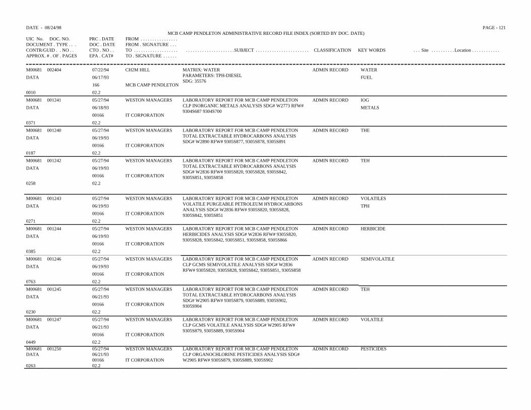
DATE - 08/24/98 PAGE - 121MCB CAMP PENDLETON ADMINISTRATIVE RECORD FILE INDEX (SORTED BY DOC. DATE)
UIC No. DOC. NO. PRC . DATE FROM . . . . . . . . . . . . . . . .DOCUMENT . TYPE . . . DOC . DATE FROM . SIGNATURE . . .CONTR/GUID . . NO . . CTO . NO . . TO . . . . . . . . . . . . . . . . . . . . . . . . . . . . . . . . . . . . . . . .SUBJECT . . . . . . . . . . . . . . . . . . . . . . . CLASSIFICATION KEY WORDS . . . Site . . . . . . . . . . Location . . . . . . . . . . . .APPROX. # . OF . PAGES EPA . CAT# TO . SIGNATURE . . . . . .
M00681 002404 07/22/94 CH2M HILL MATRIX: WATERPARAMETERS: TPH-DIESELSDG: 35576
ADMIN RECORD WATER
DATA 06/17/93 FUEL
166 MCB CAMP PENDLETON
0010 02.2
M00681 001241 05/27/94 WESTON MANAGERS LABORATORY REPORT FOR MCB CAMP PENDLETONCLP INORGANIC METALS ANALYSIS SDG# W2773 RFW#9304S687 9304S700
ADMIN RECORD IOG
DATA 06/18/93 METALS
00166 IT CORPORATION
0371 02.2
M00681 001240 05/27/94 WESTON MANAGERS LABORATORY REPORT FOR MCB CAMP PENDLETONTOTAL EXTRACTABLE HYDROCARBONS ANALYSISSDG# W2890 RFW# 9305S877, 9305S878, 9305S891
ADMIN RECORD THE
DATA 06/19/93
00166 IT CORPORATION
0187 02.2
M00681 001242 05/27/94 WESTON MANAGERS LABORATORY REPORT FOR MCB CAMP PENDLETONTOTAL EXTRACTABLE HYDROCARBONS ANALYSISSDG# W2836 RFW# 9305S820, 9305S828, 9305S842,9305S851, 9305S858
ADMIN RECORD TEH
DATA 06/19/93
00166 IT CORPORATION
0258 02.2
M00681 001243 05/27/94 WESTON MANAGERS LABORATORY REPORT FOR MCB CAMP PENDLETONVOLATILE PURGEABLE PETROLEUM HYDROCARBONSANALYSIS SDG# W2836 RFW# 9305S820, 9305S828,9305S842, 9305S851
ADMIN RECORD VOLATILES
DATA 06/19/93 TPH
00166 IT CORPORATION
0271 02.2
M00681 001244 05/27/94 WESTON MANAGERS LABORATORY REPORT FOR MCB CAMP PENDLETONHERBICIDES ANALYSIS SDG# W2836 RFW# 9305S820,9305S828, 9305S842, 9305S851, 9305S858, 9305S866
ADMIN RECORD HERBICIDE
DATA 06/19/93
00166 IT CORPORATION
0385 02.2
M00681 001246 05/27/94 WESTON MANAGERS LABORATORY REPORT FOR MCB CAMP PENDLETONCLP GCMS SEMIVOLATILE ANALYSIS SDG# W2836RFW# 9305S820, 9305S828, 9305S842, 9305S851, 9305S858
ADMIN RECORD SEMIVOLATILE
DATA 06/19/93
00166 IT CORPORATION
0763 02.2
M00681 001245 05/27/94 WESTON MANAGERS LABORATORY REPORT FOR MCB CAMP PENDLETONTOTAL EXTRACTABLE HYDROCARBONS ANALYSISSDG# W2905 RFW# 9305S879, 9305S889, 9305S902,9305S904
ADMIN RECORD TEH
DATA 06/21/93
00166 IT CORPORATION
0230 02.2
M00681 001247 05/27/94 WESTON MANAGERS LABORATORY REPORT FOR MCB CAMP PENDLETONCLP GCMS VOLATILE ANALYSIS SDG# W2905 RFW#9305S879, 9305S889, 9305S904
ADMIN RECORD VOLATILE
DATA 06/21/93
00166 IT CORPORATION
0449 02.2M00681 001250 05/27/94 WESTON MANAGERS LABORATORY REPORT FOR MCB CAMP PENDLETON
CLP ORGANOCHLORINE PESTICIDES ANALYSIS SDG#W2905 RFW# 9305S879, 9305S889, 9305S902
ADMIN RECORD PESTICIDESDATA 06/21/93
00166 IT CORPORATION0263 02.2
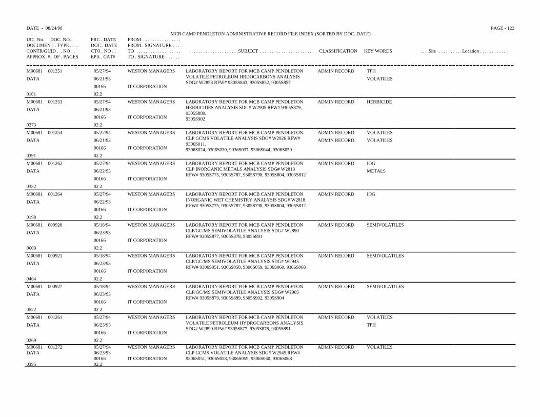
DATE - 08/24/98 PAGE - 122MCB CAMP PENDLETON ADMINISTRATIVE RECORD FILE INDEX (SORTED BY DOC. DATE)
UIC No. DOC. NO. PRC . DATE FROM . . . . . . . . . . . . . . . .DOCUMENT . TYPE . . . DOC . DATE FROM . SIGNATURE . . .CONTR/GUID . . NO . . CTO . NO . . TO . . . . . . . . . . . . . . . . . . . . . . . . . . . . . . . . . . . . . . . .SUBJECT . . . . . . . . . . . . . . . . . . . . . . . CLASSIFICATION KEY WORDS . . . Site . . . . . . . . . . Location . . . . . . . . . . . .APPROX. # . OF . PAGES EPA . CAT# TO . SIGNATURE . . . . . .
M00681 001251 05/27/94 WESTON MANAGERS LABORATORY REPORT FOR MCB CAMP PENDLETONVOLATILE PETROLEUM HRDOCARBONS ANALYSISSDG# W2858 RFW# 9305S843, 9305S852, 9305S857
ADMIN RECORD TPH
DATA 06/21/93 VOLATILES
00166 IT CORPORATION
0101 02.2
M00681 001253 05/27/94 WESTON MANAGERS LABORATORY REPORT FOR MCB CAMP PENDLETONHERBICIDES ANALYSIS SDG# W2905 RFW# 9305S879,9305S889,9305S902
ADMIN RECORD HERBICIDE
DATA 06/21/93
00166 IT CORPORATION
0273 02.2
M00681 001254 05/27/94 WESTON MANAGERS LABORATORY REPORT FOR MCB CAMP PENDLETONCLP GCMS VOLATILE ANALYSIS SDG# W2926 RFW#9306S011,9306S024, 9306S030, 9036S037, 9306S044, 9306S050
ADMIN RECORD VOLATILES
DATA 06/21/93 ADMIN RECORD VOLATILES
00166 IT CORPORATION
0391 02.2
M00681 001262 05/27/94 WESTON MANAGERS LABORATORY REPORT FOR MCB CAMP PENDLETONCLP INORGANIC METALS ANALYSIS SDG# W2818RFW# 9305S775, 9305S787, 9305S798, 9305S804, 9305S812
ADMIN RECORD IOG
DATA 06/22/93 METALS
00166 IT CORPORATION
0332 02.2
M00681 001264 05/27/94 WESTON MANAGERS LABORATORY REPORT FOR MCB CAMP PENDLETONINORGANIC WET CHEMISTRY ANALYSIS SDG# W2818RFW# 9305S775, 9305S787, 9305S798, 9305S804, 9305S812
ADMIN RECORD IOG
DATA 06/22/93
00166 IT CORPORATION
0198 02.2
M00681 000920 05/18/94 WESTON MANAGERS LABORATORY REPORT FOR MCB CAMP PENDLETONCLP/GC/MS SEMIVOLATILE ANALYSIS SDG# W2890RFW# 9305S877, 9305S878, 9305S891
ADMIN RECORD SEMIVOLATILES
DATA 06/23/93
00166 IT CORPORATION
0608 02.2
M00681 000921 05/18/94 WESTON MANAGERS LABORATORY REPORT FOR MCB CAMP PENDLETONCLP/GC/MS SEMIVOLATILE ANALYSIS SDG# W2945RFW# 9306S051, 9306S058, 9306S059, 9306S060, 9306S068
ADMIN RECORD SEMIVOLATILES
DATA 06/23/93
00166 IT CORPORATION
0464 02.2
M00681 000927 05/18/94 WESTON MANAGERS LABORATORY REPORT FOR MCB CAMP PENDLETONCLP/GC/MS SEMIVOLATILE ANALYSIS SDG# W2905RFW# 9305S879, 9305S889, 9305S902, 9305S904
ADMIN RECORD SEMIVOLATILES
DATA 06/23/93
00166 IT CORPORATION
0522 02.2
M00681 001261 05/27/94 WESTON MANAGERS LABORATORY REPORT FOR MCB CAMP PENDLETONVOLATILE PETROLEUM HYDROCARBONS ANALYSISSDG# W2890 RFW# 9305S877, 9305S878, 9305S891
ADMIN RECORD VOLATILES
DATA 06/23/93 TPH
00166 IT CORPORATION
0269 02.2M00681 001272 05/27/94 WESTON MANAGERS LABORATORY REPORT FOR MCB CAMP PENDLETON
CLP GCMS VOLATILE ANALYSIS SDG# W2945 RFW#9306S051, 9306S058, 9306S059, 9306S060, 9306S068
ADMIN RECORD VOLATILESDATA 06/23/93
00166 IT CORPORATION0395 02.2
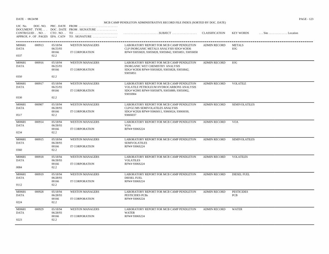
DATE - 08/24/98 PAGE - 123MCB CAMP PENDLETON ADMINISTRATIVE RECORD FILE INDEX (SORTED BY DOC. DATE)
UIC No. DOC. NO. PRC . DATE FROM . . . . . . . . . . . . . . . . . . . . . . . . . . .DOCUMENT . TYPE . . . DOC . DATE FROM . SIGNATURE . . . . . . . . . . . . . .CONTR/GUID . . NO . . CTO . NO . . TO . . . . . . . . . . . . . . . . . . . . . . . . . . . . . . . . . . . . . . . . . . . . . . . . . . . . . . .SUBJECT . . . . . . . . . . . . . . . . . CLASSIFICATION KEY WORDS . . . Site . . . . . . . . . . . . . LocationAPPROX. # . OF . PAGES EPA . CAT# TO . SIGNATURE . . . . . . . . . . . . . . . . .
M00681 000913 05/18/94 WESTON MANAGERS LABORATORY REPORT FOR MCB CAMP PENDLETON ADMIN RECORD METALSDATA 06/25/93 CLP INORGANIC METALS ANALYSIS SDG# W2836 IOG
00166 IT CORPORATION RFW# 9305S820, 9305S828, 9305S842, 9305S851, 9305S8580337 02.2
M00681 000916 05/18/94 WESTON MANAGERS LABORATORY REPORT FOR MCB CAMP PENDLETON ADMIN RECORD IOGDATA 06/25/93 INORGANIC WET CHEMISTRY ANALYSIS
00166 IT CORPORATION SDG# W2836 RFW# 9305S820, 9305S828, 9305S842,9305S851
0350 02.2
M00681 000917 05/18/94 WESTON MANAGERS LABORATORY REPORT FOR MCB CAMP PENDLETON ADMIN RECORD VOLATILEDATA 06/25/93 VOLATILE PETROLEUM HYDROCARBONS ANALYSIS
00166 IT CORPORATION SDG# W2905 RFW# 9305S879, 9305S889, 9305S902,9305S904
0330 02.2
M00681 000907 05/18/94 WESTON MANAGERS LABORATORY REPORT FOR MCB CAMP PENDLETON ADMIN RECORD SEMIVOLATILESDATA 06/28/93 CLP/GC/MS SEMIVOLATILES ANALYSIS
00166 IT CORPORATION SDG# W2926 RFW# 9306S011, 9306S024, 9306S030,9306S0370517 02.2
M00681 000914 05/18/94 WESTON MANAGERS LABORATORY REPORT FOR MCB CAMP PENDLETON ADMIN RECORD VOADATA 06/28/93 VOA
00166 IT CORPORATION RFW# 9306S2240234 02.2
M00681 000915 05/18/94 WESTON MANAGERS LABORATORY REPORT FOR MCB CAMP PENDLETON ADMIN RECORD SEMIVOLATILESDATA 06/28/93 SEMIVOLATILES
00166 IT CORPORATION RFW# 9306S2240360 02.2
M00681 000918 05/18/94 WESTON MANAGERS LABORATORY REPORT FOR MCB CAMP PENDLETON ADMIN RECORD VOLATILESDATA 06/28/93 VOLATILES
00166 IT CORPORATION RFW# 9306S2240084 02.2
M00681 000919 05/18/94 WESTON MANAGERS LABORATORY REPORT FOR MCB CAMP PENDLETON ADMIN RECORD DIESEL FUELDATA 06/28/93 DIESEL FUEL
00166 IT CORPORATION RFW# 9306S2240112 02.2
M00681 000928 05/18/94 WESTON MANAGERS LABORATORY REPORT FOR MCB CAMP PENDLETON ADMIN RECORD PESTICIDESDATA 06/28/93 PESTICIDES PCBs PCB
00166 IT CORPORATION RFW# 9306S2240224 02.2
M00681 000929 05/18/94 WESTON MANAGERS LABORATORY REPORT FOR MCB CAMP PENDLETON ADMIN RECORD WATERDATA 06/28/93 WATER
00166 IT CORPORATION RFW# 9306S2240223 02.2
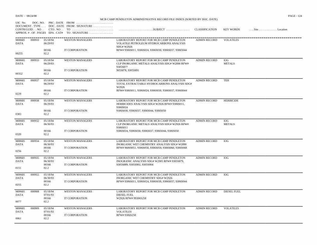
DATE - 08/24/98 PAGE - 124MCB CAMP PENDLETON ADMINISTRATIVE RECORD FILE INDEX (SORTED BY DOC. DATE)
UIC No. DOC. NO. PRC . DATE FROM . . . . . . . . . . . . . . . . . . . . . . . . . . .DOCUMENT . TYPE . . . DOC . DATE FROM . SIGNATURE . . . . . . . . . . . . . .CONTR/GUID . . NO . . CTO . NO . . TO . . . . . . . . . . . . . . . . . . . . . . . . . . . . . . . . . . . . . . . . . . . . . . . . . . . . . . .SUBJECT . . . . . . . . . . . . . . . . . CLASSIFICATION KEY WORDS . . . Site . . . . . . . . . . . . . LocationAPPROX. # . OF . PAGES EPA . CAT# TO . SIGNATURE . . . . . . . . . . . . . . . . .
M00681 000910 05/18/94 WESTON MANAGERS LABORATORY REPORT FOR MCB CAMP PENDLETON ADMIN RECORD VOLATILESDATA 06/29/93 VOLATILE PETROLEUM HYDROCARBONS ANALYSIS
SDG# W292600166 IT CORPORATION RFW# 9306S011, 9306S024, 9306S030, 9306S037, 93065044
00255 02.2
M00681 000933 05/18/94 WESTON MANAGERS LABORATORY REPORT FOR MCB CAMP PENDLETON ADMIN RECORD IOGDATA 06/29/93 CLP INORGANIC METALS ANALYSIS SDG# W2890 RFW#
9305S877METALS
00166 IT CORPORATION 905S878, 9305S89100352 02.2
M00681 000937 05/18/94 WESTON MANAGERS LABORATORY REPORT FOR MCB CAMP PENDLETON ADMIN RECORD TEHDATA 06/29/93 TOTAL EXTRACTABLE HYDROCARBONS ANALYSIS SDG#
W292600166 IT CORPORATION RFW# 9306S011, 9306S024, 9306S030, 9306S037, 9306S044
0229 02.2
M00681 000938 05/18/94 WESTON MANAGERS LABORATORY REPORT FOR MCB CAMP PENDLETON ADMIN RECORD HERBICIDEDATA 06/29/93 HERBICIDES ANALYSIS SDG# W2926 RFW# 9306S011,
9306S02400166 IT CORPORATION 9306S030, 9306S037, 9306S044, 9306S050
0383 02.2
M00681 000932 05/18/94 WESTON MANAGERS LABORATORY REPORT FOR MCB CAMP PENDLETON ADMIN RECORD IOGDATA 06/30/93 CLP INORGANIC METALS ANALYSIS SDG# W2926 RFW#
9306S011METALS
00166 IT CORPORATION 9306S024, 9306S030, 9306S037, 9306S044, 9306S0500320 02.2
M00681 000934 05/18/94 WESTON MANAGERS LABORATORY REPORT FOR MCB CAMP PENDLETON ADMIN RECORD IOGDATA 06/30/93 INORGANIC WET CHEMISTRY ANALYSIS SDG# W2890
00166 IT CORPORATION RFW# 9606S051, 9306S058, 9306S059, 9306S060, 9306S0680256 02.2
M00681 000935 05/18/94 WESTON MANAGERS LABORATORY REPORT FOR MCB CAMP PENDLETONINOGRANIC ANALYSIS SDG# W2905 RFW# 9305S879,9305S889, 9305S902, 9305S904
ADMIN RECORD IOGDATA 06/30/93
00166 IT CORPORATION0151 02.2
M00681 000955 05/18/94 WESTON MANAGERS LABORATORY REPORT FOR MCB CAMP PENDLETON ADMIN RECORD IOGDATA 06/30/93 INORGANIC WET CHEMISTRY SDG# W2926
00166 IT CORPORATION RFW# 9306S011, 9306S024, 9306S030, 9306S037, 9306S0440255 02.2
M00681 000908 05/18/94 WESTON MANAGERS LABORATORY REPORT FOR MCB CAMP PENDLETON ADMIN RECORD DIESEL FUELDATA 07/01/93 DIESEL FUEL
00166 IT CORPORATION W2926 RFW# 99306S2580077 02.2
M00681 000909 05/18/94 WESTON MANAGERS LABORATORY REPORT FOR MCB CAMP PENDLETON ADMIN RECORD VOLATILESDATA 07/01/93 VOLATILES
00166 IT CORPORATION RFW# 9306S2580061 02.2
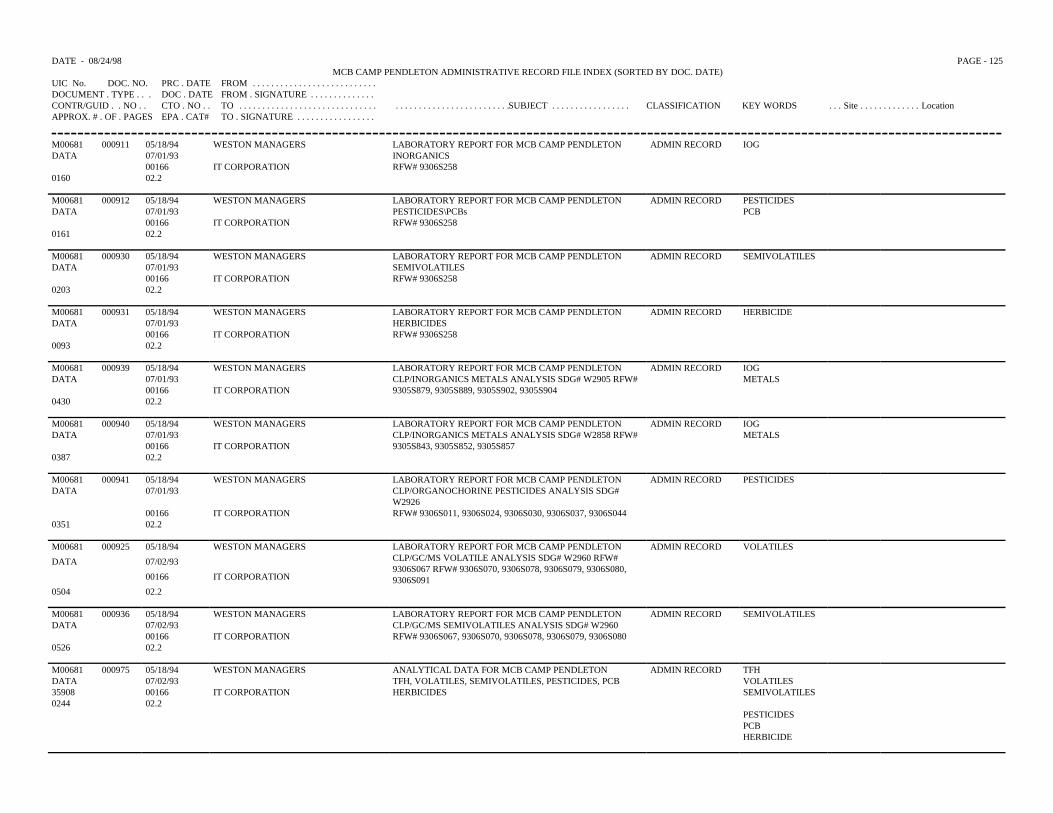
DATE - 08/24/98 PAGE - 125MCB CAMP PENDLETON ADMINISTRATIVE RECORD FILE INDEX (SORTED BY DOC. DATE)
UIC No. DOC. NO. PRC . DATE FROM . . . . . . . . . . . . . . . . . . . . . . . . . . .DOCUMENT . TYPE . . . DOC . DATE FROM . SIGNATURE . . . . . . . . . . . . . .CONTR/GUID . . NO . . CTO . NO . . TO . . . . . . . . . . . . . . . . . . . . . . . . . . . . . . . . . . . . . . . . . . . . . . . . . . . . . . .SUBJECT . . . . . . . . . . . . . . . . . CLASSIFICATION KEY WORDS . . . Site . . . . . . . . . . . . . LocationAPPROX. # . OF . PAGES EPA . CAT# TO . SIGNATURE . . . . . . . . . . . . . . . . .
M00681 000911 05/18/94 WESTON MANAGERS LABORATORY REPORT FOR MCB CAMP PENDLETON ADMIN RECORD IOGDATA 07/01/93 INORGANICS
00166 IT CORPORATION RFW# 9306S2580160 02.2
M00681 000912 05/18/94 WESTON MANAGERS LABORATORY REPORT FOR MCB CAMP PENDLETON ADMIN RECORD PESTICIDESDATA 07/01/93 PESTICIDES\PCBs PCB
00166 IT CORPORATION RFW# 9306S2580161 02.2
M00681 000930 05/18/94 WESTON MANAGERS LABORATORY REPORT FOR MCB CAMP PENDLETON ADMIN RECORD SEMIVOLATILESDATA 07/01/93 SEMIVOLATILES
00166 IT CORPORATION RFW# 9306S2580203 02.2
M00681 000931 05/18/94 WESTON MANAGERS LABORATORY REPORT FOR MCB CAMP PENDLETON ADMIN RECORD HERBICIDEDATA 07/01/93 HERBICIDES
00166 IT CORPORATION RFW# 9306S2580093 02.2
M00681 000939 05/18/94 WESTON MANAGERS LABORATORY REPORT FOR MCB CAMP PENDLETON ADMIN RECORD IOGDATA 07/01/93 CLP/INORGANICS METALS ANALYSIS SDG# W2905 RFW# METALS
00166 IT CORPORATION 9305S879, 9305S889, 9305S902, 9305S9040430 02.2
M00681 000940 05/18/94 WESTON MANAGERS LABORATORY REPORT FOR MCB CAMP PENDLETON ADMIN RECORD IOGDATA 07/01/93 CLP/INORGANICS METALS ANALYSIS SDG# W2858 RFW# METALS
00166 IT CORPORATION 9305S843, 9305S852, 9305S8570387 02.2
M00681 000941 05/18/94 WESTON MANAGERS LABORATORY REPORT FOR MCB CAMP PENDLETON ADMIN RECORD PESTICIDESDATA 07/01/93 CLP/ORGANOCHORINE PESTICIDES ANALYSIS SDG#
W292600166 IT CORPORATION RFW# 9306S011, 9306S024, 9306S030, 9306S037, 9306S044
0351 02.2
M00681 000925 05/18/94 WESTON MANAGERS LABORATORY REPORT FOR MCB CAMP PENDLETONCLP/GC/MS VOLATILE ANALYSIS SDG# W2960 RFW#9306S067 RFW# 9306S070, 9306S078, 9306S079, 9306S080,9306S091
ADMIN RECORD VOLATILES
DATA 07/02/93
00166 IT CORPORATION
0504 02.2
M00681 000936 05/18/94 WESTON MANAGERS LABORATORY REPORT FOR MCB CAMP PENDLETON ADMIN RECORD SEMIVOLATILESDATA 07/02/93 CLP/GC/MS SEMIVOLATILES ANALYSIS SDG# W2960
00166 IT CORPORATION RFW# 9306S067, 9306S070, 9306S078, 9306S079, 9306S0800526 02.2
M00681 000975 05/18/94 WESTON MANAGERS ANALYTICAL DATA FOR MCB CAMP PENDLETON ADMIN RECORD TFHDATA 07/02/93 TFH, VOLATILES, SEMIVOLATILES, PESTICIDES, PCB VOLATILES35908 00166 IT CORPORATION HERBICIDES SEMIVOLATILES 0244 02.2
PESTICIDESPCBHERBICIDE
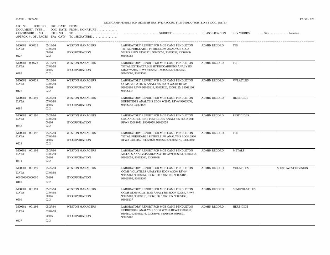
DATE - 08/24/98 PAGE - 126MCB CAMP PENDLETON ADMINISTRATIVE RECORD FILE INDEX (SORTED BY DOC. DATE)
UIC No. DOC. NO. PRC . DATE FROM . . . . . . . . . . . . . . . . . . . . . . . . . . .DOCUMENT . TYPE . . . DOC . DATE FROM . SIGNATURE . . . . . . . . . . . . . .CONTR/GUID . . NO . . CTO . NO . . TO . . . . . . . . . . . . . . . . . . . . . . . . . . . . . . . . . . . . . . . . . . . . . . . . . . . . . . .SUBJECT . . . . . . . . . . . . . . . . . CLASSIFICATION KEY WORDS . . . Site . . . . . . . . . . . . . LocationAPPROX. # . OF . PAGES EPA . CAT# TO . SIGNATURE . . . . . . . . . . . . . . . . .
M00681 000922 05/18/94 WESTON MANAGERS LABORATORY REPORT FOR MCB CAMP PENDLETONTOTAL PURGEABLE PETROLEUM ANALYSIS SDG#W2945 RFW# 9306S501, 9306S058, 9306S059, 9306S060,9306S068
ADMIN RECORD TPHDATA 07/06/93
00166 IT CORPORATION0227 02.2
M00681 000923 05/18/94 WESTON MANAGERS LABORATORY REPORT FOR MCB CAMP PENDLETONTOTAL EXTRACTABLE HYDROCARBONS ANALYSISSDG# W2945 RFW# 9306S501, 9306S058, 9306S059,9306S060, 9306S068
ADMIN RECORD TEHDATA 07/06/93
00166 IT CORPORATION0189 02.2
M00681 000924 05/18/94 WESTON MANAGERS LABORATORY REPORT FOR MCB CAMP PENDLETONGCMS VOLATILES ANALYSIS SDG# W2984 RFW#9306S103 RFW# 9306S119, 9306S120, 9306S135, 9306S136,9306S137
ADMIN RECORD VOLATILESDATA 07/06/93
00166 IT CORPORATION0428 02.2
M00681 001192 05/26/94 WESTON MANAGERS LABORATORY REPORT FOR MCB CAMP PENDLETON ADMIN RECORD HERBICIDEDATA 07/06/93 HERBICIDES ANALYSIS SDG# W2945, RFW# 9306S051,
9306S058 9306S05900166 IT CORPORATION0389 02.2
M00681 001196 05/27/94 WESTON MANAGERS LABORATORY REPORT FOR MCB CAMP PENDLETON ADMIN RECORD PESTICIDESDATA 07/06/93 ORGANOCHLORINE PESTICIDES ANALYSIS SDG# 2945
00166 IT CORPORATION RFW# 9306S051, 9306S058, 9306S0590252 02.2
M00681 001197 05/27/94 WESTON MANAGERS LABORATORY REPORT FOR MCB CAMP PENDLETON ADMIN RECORD TPHDATA 07/06/93 TOTAL PURGEABLE PETROLEUM ANALYSIS SDG# 2960
00166 IT CORPORATION RFW# 9306S067, 9306S070, 9306S078, 9306S079, 9306S0800224 02.2
M00681 001198 05/27/94 WESTON MANAGERS LABORATORY REPORT FOR MCB CAMP PENDLETON ADMIN RECORD METALSDATA 07/06/93 METALS ANALYSIS SDG# 2945 RFW# 9306S051, 9306S058
00166 IT CORPORATION 9306S059, 9306S060, 9306S0680311 02.2
M00681 001199 05/27/94 WESTON MANAGERS LABORATORY REPORT FOR MCB CAMP PENDLETONGCMS VOLATILES ANALYSIS SDG# W3004 RFW#9306S163, 9306S164, 9306S180, 9306S181, 9306S182,9306S192, 9306S205
ADMIN RECORD VOLATILES SOUTHWEST DIVISION
DATA 07/06/93
000000000000000 00166 IT CORPORATION
0409 02.2
M00681 001191 05/26/94 WESTON MANAGERS LABORATORY REPORT FOR MCB CAMP PENDLETONGCMS SEMIVOLATILES ANALYSIS SDG# W2984, RFW#9306S103, 9306S119, 9306S120, 9306S135, 9306S136,9306S137
ADMIN RECORD SEMIVOLATILESDATA 07/07/93
00166 IT CORPORATION0506 02.2
M00681 001195 05/27/94 WESTON MANAGERS LABORATORY REPORT FOR MCB CAMP PENDLETONHERBICIDES ANALYSIS SDG# W2960 RFW# 9306S067,9306S070, 9306S078, 9306S078, 9306S079, 9306S91,9306S102
ADMIN RECORD HERBICIDE
DATA 07/07/93
00166 IT CORPORATION
0327 02.2
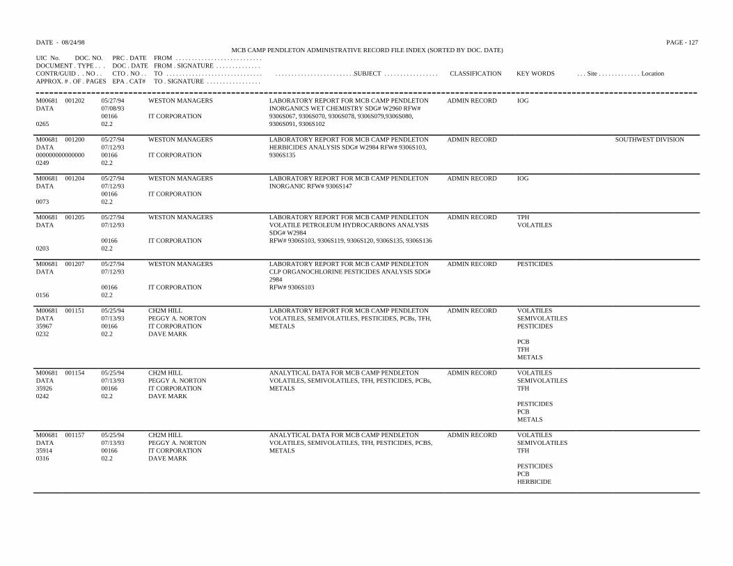
DATE - 08/24/98 PAGE - 127MCB CAMP PENDLETON ADMINISTRATIVE RECORD FILE INDEX (SORTED BY DOC. DATE)
UIC No. DOC. NO. PRC . DATE FROM . . . . . . . . . . . . . . . . . . . . . . . . . . .DOCUMENT . TYPE . . . DOC . DATE FROM . SIGNATURE . . . . . . . . . . . . . .CONTR/GUID . . NO . . CTO . NO . . TO . . . . . . . . . . . . . . . . . . . . . . . . . . . . . . . . . . . . . . . . . . . . . . . . . . . . . . .SUBJECT . . . . . . . . . . . . . . . . . CLASSIFICATION KEY WORDS . . . Site . . . . . . . . . . . . . LocationAPPROX. # . OF . PAGES EPA . CAT# TO . SIGNATURE . . . . . . . . . . . . . . . . .
M00681 001202 05/27/94 WESTON MANAGERS LABORATORY REPORT FOR MCB CAMP PENDLETONINORGANICS WET CHEMISTRY SDG# W2960 RFW#9306S067, 9306S070, 9306S078, 9306S079,9306S080,9306S091, 9306S102
ADMIN RECORD IOGDATA 07/08/93
00166 IT CORPORATION0265 02.2
M00681 001200 05/27/94 WESTON MANAGERS LABORATORY REPORT FOR MCB CAMP PENDLETON ADMIN RECORD SOUTHWEST DIVISIONDATA 07/12/93 HERBICIDES ANALYSIS SDG# W2984 RFW# 9306S103,000000000000000 00166 IT CORPORATION 9306S1350249 02.2
M00681 001204 05/27/94 WESTON MANAGERS LABORATORY REPORT FOR MCB CAMP PENDLETON ADMIN RECORD IOGDATA 07/12/93 INORGANIC RFW# 9306S147
00166 IT CORPORATION0073 02.2
M00681 001205 05/27/94 WESTON MANAGERS LABORATORY REPORT FOR MCB CAMP PENDLETON ADMIN RECORD TPHDATA 07/12/93 VOLATILE PETROLEUM HYDROCARBONS ANALYSIS
SDG# W2984VOLATILES
00166 IT CORPORATION RFW# 9306S103, 9306S119, 9306S120, 9306S135, 9306S1360203 02.2
M00681 001207 05/27/94 WESTON MANAGERS LABORATORY REPORT FOR MCB CAMP PENDLETON ADMIN RECORD PESTICIDESDATA 07/12/93 CLP ORGANOCHLORINE PESTICIDES ANALYSIS SDG#
298400166 IT CORPORATION RFW# 9306S103
0156 02.2
M00681 001151 05/25/94 CH2M HILL LABORATORY REPORT FOR MCB CAMP PENDLETON ADMIN RECORD VOLATILESDATA 07/13/93 PEGGY A. NORTON VOLATILES, SEMIVOLATILES, PESTICIDES, PCBs, TFH, SEMIVOLATILES35967 00166 IT CORPORATION METALS PESTICIDES0232 02.2 DAVE MARK
PCBTFHMETALS
M00681 001154 05/25/94 CH2M HILL ANALYTICAL DATA FOR MCB CAMP PENDLETON ADMIN RECORD VOLATILESDATA 07/13/93 PEGGY A. NORTON VOLATILES, SEMIVOLATILES, TFH, PESTICIDES, PCBs, SEMIVOLATILES35926 00166 IT CORPORATION METALS TFH0242 02.2 DAVE MARK
PESTICIDESPCBMETALS
M00681 001157 05/25/94 CH2M HILL ANALYTICAL DATA FOR MCB CAMP PENDLETON ADMIN RECORD VOLATILESDATA 07/13/93 PEGGY A. NORTON VOLATILES, SEMIVOLATILES, TFH, PESTICIDES, PCBS, SEMIVOLATILES35914 00166 IT CORPORATION METALS TFH0316 02.2 DAVE MARK
PESTICIDESPCBHERBICIDE
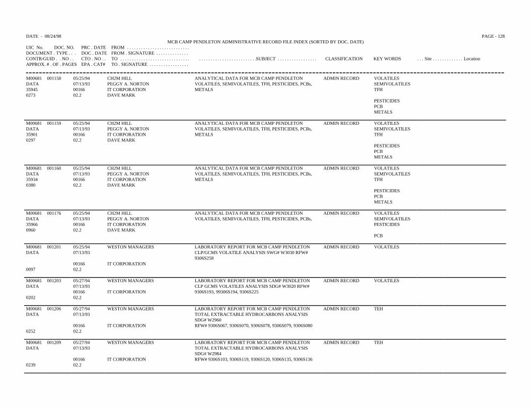
DATE - 08/24/98 PAGE - 128MCB CAMP PENDLETON ADMINISTRATIVE RECORD FILE INDEX (SORTED BY DOC. DATE)
UIC No. DOC. NO. PRC . DATE FROM . . . . . . . . . . . . . . . . . . . . . . . . . . .DOCUMENT . TYPE . . . DOC . DATE FROM . SIGNATURE . . . . . . . . . . . . . .CONTR/GUID . . NO . . CTO . NO . . TO . . . . . . . . . . . . . . . . . . . . . . . . . . . . . . . . . . . . . . . . . . . . . . . . . . . . . . .SUBJECT . . . . . . . . . . . . . . . . . CLASSIFICATION KEY WORDS . . . Site . . . . . . . . . . . . . LocationAPPROX. # . OF . PAGES EPA . CAT# TO . SIGNATURE . . . . . . . . . . . . . . . . .
M00681 001158 05/25/94 CH2M HILL ANALYTICAL DATA FOR MCB CAMP PENDLETON ADMIN RECORD VOLATILESDATA 07/13/93 PEGGY A. NORTON VOLATILES, SEMIVOLATILES, TFH, PESTICIDES, PCBs, SEMIVOLATILES35945 00166 IT CORPORATION METALS TFH0273 02.2 DAVE MARK
PESTICIDESPCBMETALS
M00681 001159 05/25/94 CH2M HILL ANALYTICAL DATA FOR MCB CAMP PENDLETON ADMIN RECORD VOLATILESDATA 07/13/93 PEGGY A. NORTON VOLATILES, SEMIVOLATILES, TFH, PESTICIDES, PCBs, SEMIVOLATILES35901 00166 IT CORPORATION METALS TFH0297 02.2 DAVE MARK
PESTICIDESPCBMETALS
M00681 001160 05/25/94 CH2M HILL ANALYTICAL DATA FOR MCB CAMP PENDLETON ADMIN RECORD VOLATILESDATA 07/13/93 PEGGY A. NORTON VOLATILES, SEMIVOLATILES, TFH, PESTICIDES, PCBs, SEMIVOLATILES35934 00166 IT CORPORATION METALS TFH0380 02.2 DAVE MARK
PESTICIDESPCBMETALS
M00681 001176 05/25/94 CH2M HILL ANALYTICAL DATA FOR MCB CAMP PENDLETON ADMIN RECORD VOLATILESDATA 07/13/93 PEGGY A. NORTON VOLATILES, SEMIVOLATILES, TFH, PESTICIDES, PCBs, SEMIVOLATILES35966 00166 IT CORPORATION PESTICIDES0960 02.2 DAVE MARK
PCB
M00681 001201 05/25/94 WESTON MANAGERS LABORATORY REPORT FOR MCB CAMP PENDLETON ADMIN RECORD VOLATILESDATA 07/13/93 CLP/GCMS VOLATILE ANALYSIS SWG# W3030 RFW#
9306S25800166 IT CORPORATION
0097 02.2
M00681 001203 05/27/94 WESTON MANAGERS LABORATORY REPORT FOR MCB CAMP PENDLETON ADMIN RECORD VOLATILESDATA 07/13/93 CLP GCMS VOLATILES ANALYSIS SDG# W3020 RFW#
9306S193, 99306S194, 9306S22500166 IT CORPORATION0202 02.2
M00681 001206 05/27/94 WESTON MANAGERS LABORATORY REPORT FOR MCB CAMP PENDLETON ADMIN RECORD TEHDATA 07/13/93 TOTAL EXTRACTABLE HYDROCARBONS ANALYSIS
SDG# W296000166 IT CORPORATION RFW# 9306S067, 9306S070, 9306S078, 9306S079, 9306S080
0252 02.2
M00681 001209 05/27/94 WESTON MANAGERS LABORATORY REPORT FOR MCB CAMP PENDLETON ADMIN RECORD TEHDATA 07/13/93 TOTAL EXTRACTABLE HYDROCARBONS ANALYSIS
SDG# W298400166 IT CORPORATION RFW# 9306S103, 9306S119, 9306S120, 9306S135, 9306S136
0239 02.2
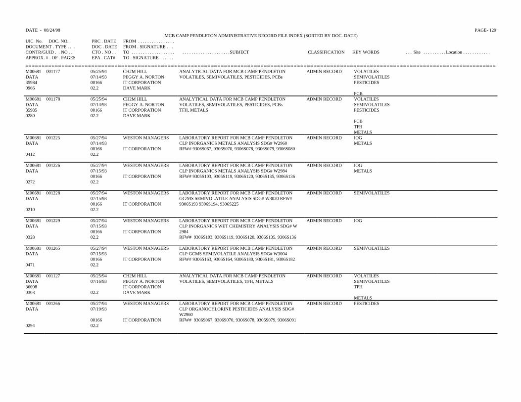
DATE - 08/24/98 PAGE- 129MCB CAMP PENDLETON ADMINISTRATIVE RECORD FILE INDEX (SORTED BY DOC. DATE)
UIC No. DOC. NO. PRC . DATE FROM . . . . . . . . . . . . . . . .DOCUMENT . TYPE . . . DOC . DATE FROM . SIGNATURE . . .CONTR/GUID . . NO . . CTO . NO . . TO . . . . . . . . . . . . . . . . . . . . . . . . . . . . . . . . . . . . . . . .SUBJECT CLASSIFICATION KEY WORDS . . . Site . . . . . . . . . . Location . . . . . . . . . . . .APPROX. # . OF . PAGES EPA . CAT# TO . SIGNATURE . . . . . .
M00681 001177 05/25/94 CH2M HILL ANALYTICAL DATA FOR MCB CAMP PENDLETONVOLATILES, SEMIVOLATILES, PESTICIDES, PCBs
ADMIN RECORD VOLATILESDATA 07/14/93 PEGGY A. NORTON SEMIVOLATILES35984 00166 IT CORPORATION PESTICIDES0966 02.2 DAVE MARK
PCBM00681 001178 05/25/94 CH2M HILL ANALYTICAL DATA FOR MCB CAMP PENDLETON
VOLATILES, SEMIVOLATILES, PESTICIDES, PCBsTFH, METALS
ADMIN RECORD VOLATILESDATA 07/14/93 PEGGY A. NORTON SEMIVOLATILES35985 00166 IT CORPORATION PESTICIDES0280 02.2 DAVE MARK
PCBTFHMETALS
M00681 001225 05/27/94 WESTON MANAGERS LABORATORY REPORT FOR MCB CAMP PENDLETONCLP INORGANICS METALS ANALYSIS SDG# W2960RFW# 9306S067, 9306S070, 9306S078, 9306S079, 9306S080
ADMIN RECORD IOGDATA 07/14/93 METALS
00166 IT CORPORATION0412 02.2
M00681 001226 05/27/94 WESTON MANAGERS LABORATORY REPORT FOR MCB CAMP PENDLETONCLP INORGANICS METALS ANALYSIS SDG# W2984RFW# 9305S103, 9305S119, 9306S120, 9306S135, 9306S136
ADMIN RECORD IOGDATA 07/15/93 METALS
00166 IT CORPORATION0272 02.2
M00681 001228 05/27/94 WESTON MANAGERS LABORATORY REPORT FOR MCB CAMP PENDLETONGC/MS SEMIVOLATILE ANALYSIS SDG# W3020 RFW#9306S193 9306S194, 9306S225
ADMIN RECORD SEMIVOLATILESDATA 07/15/93
00166 IT CORPORATION0210 02.2
M00681 001229 05/27/94 WESTON MANAGERS LABORATORY REPORT FOR MCB CAMP PENDLETONCLP INORGANICS WET CHEMISTRY ANALYSIS SDG# W2984RFW# 9306S103, 9306S119, 9306S120, 9306S135, 9306S136
ADMIN RECORD IOGDATA 07/15/93
00166 IT CORPORATION0328 02.2
M00681 001265 05/27/94 WESTON MANAGERS LABORATORY REPORT FOR MCB CAMP PENDLETON ADMIN RECORD SEMIVOLATILESDATA 07/15/93 CLP GCMS SEMIVOLATILE ANALYSIS SDG# W3004
00166 IT CORPORATION RFW# 9306S163, 9306S164, 9306S180, 9306S181, 9306S1820471 02.2
M00681 001127 05/25/94 CH2M HILL ANALYTICAL DATA FOR MCB CAMP PENDLETON ADMIN RECORD VOLATILESDATA 07/16/93 PEGGY A. NORTON VOLATILES, SEMIVOLATILES, TFH, METALS SEMIVOLATILES36008 IT CORPORATION TPH0303 02.2 DAVE MARK
METALSM00681 001266 05/27/94 WESTON MANAGERS LABORATORY REPORT FOR MCB CAMP PENDLETON ADMIN RECORD PESTICIDESDATA 07/19/93 CLP ORGANOCHLORINE PESTICIDES ANALYSIS SDG#
W296000166 IT CORPORATION RFW# 9306S067, 9306S070, 9306S078, 9306S079, 9306S091
0294 02.2
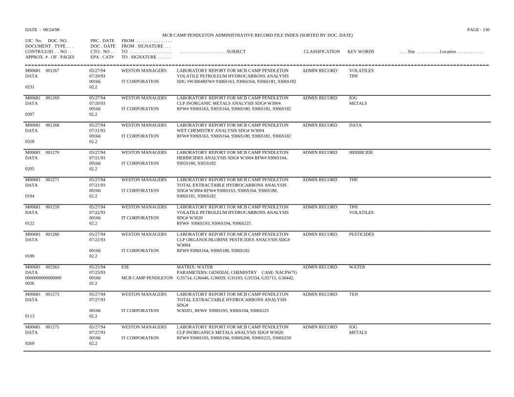
DATE - 08/24/98 PAGE - 130MCB CAMP PENDLETON ADMINISTRATIVE RECORD FILE INDEX (SORTED BY DOC. DATE)
UIC No. DOC. NO. PRC . DATE FROM . . . . . . . . . . . . . . . .DOCUMENT . TYPE . . . DOC . DATE FROM . SIGNATURE . . .CONTR/GUID . . NO . . CTO . NO . . TO . . . . . . . . . . . . . . . . . . . . . . . . . . . . . . . . . . . . . . . .SUBJECT CLASSIFICATION KEY WORDS . . . Site . . . . . . . . . . Location . . . . . . . . . . . .APPROX. # . OF . PAGES EPA . CAT# TO . SIGNATURE . . . . . .
M00681 001267 05/27/94 WESTON MANAGERS LABORATORY REPORT FOR MCB CAMP PENDLETONVOLATILE PETROLEUM HYDROCARBONS ANALYSISSDG #W3004RFW# 9306S163, 9306S164, 9306S181, 9306S182
ADMIN RECORD VOLATILESDATA 07/20/93 TPH
00166 IT CORPORATION0231 02.2
M00681 001269 05/27/94 WESTON MANAGERS LABORATORY REPORT FOR MCB CAMP PENDLETONCLP INORGANIC METALS ANALYSIS SDG# W3004RFW# 9306S163, 9305S164, 9306S180, 9306S181, 9306S182
ADMIN RECORD IOGDATA 07/20/93 METALS
00166 IT CORPORATION0397 02.2
M00681 001268 05/27/94 WESTON MANAGERS LABORATORY REPORT FOR MCB CAMP PENDLETONWET CHEMISTRY ANALYSIS SDG# W3004RFW# 9306S163, 9306S164, 9306S180, 9306S181, 9306S182
ADMIN RECORD DATADATA 07/21/93
00166 IT CORPORATION0318 02.2
M00681 001270 05/27/94 WESTON MANAGERS LABORATORY REPORT FOR MCB CAMP PENDLETONHERBICIDES ANALYSIS SDG# W3004 RFW# 9306S164,9305S180, 9305S182
ADMIN RECORD HERBICIDEDATA 07/21/93
00166 IT CORPORATION0205 02.2
M00681 001271 05/27/94 WESTON MANAGERS LABORATORY REPORT FOR MCB CAMP PENDLETONTOTAL EXTRACTABLE HYDROCARBONS ANALYSISSDG# W3004 RFW# 9306S163, 9306S164, 9306S180,9306S181, 9306S182
ADMIN RECORD THEDATA 07/21/93
00166 IT CORPORATION0194 02.2
M00681 001259 05/27/94 WESTON MANAGERS LABORATORY REPORT FOR MCB CAMP PENDLETONVOLATILE PETROLEUM HYDROCARBONS ANALYSISSDG# W3020RFW# 9306S193, 9306S194, 9306S225
ADMIN RECORD TPHDATA 07/22/93 VOLATILES
00166 IT CORPORATION0122 02.2
M00681 001260 05/27/94 WESTON MANAGERS LABORATORY REPORT FOR MCB CAMP PENDLETON ADMIN RECORD PESTICIDESDATA 07/22/93 CLP ORGANOCHLORINE PESTICIDES ANALYSIS SDG#
W300400166 IT CORPORATION RFW# 9306S164, 9306S180, 9306S182
0189 02.2
M00681 002363 05/25/94 ESE MATRIX: WATER ADMIN RECORD WATERDATA 07/23/93 PARAMETERS: GENERAL CHEMISTRY CASE: NACPW7G0000000000000000 00166 MCB CAMP PENDLETON G35714, G36446, G36029, G35103, G35334, G35715, G36442,0026 02.2
M00681 001273 05/27/94 WESTON MANAGERS LABORATORY REPORT FOR MCB CAMP PENDLETON ADMIN RECORD TEHDATA 07/27/93 TOTAL EXTRACTABLE HYDROCARBONS ANALYSIS
SDG#00166 IT CORPORATION W30201, RFW# 9306S193, 9306S194, 9306S225
0113 02.2
M00681 001275 05/27/94 WESTON MANAGERS LABORATORY REPORT FOR MCB CAMP PENDLETON ADMIN RECORD IOGDATA 07/27/93 CLP INORGANICS METALS ANALYSIS SDG# W3020 METALS
00166 IT CORPORATION RFW# 9306S193, 9306S194, 9306S206, 9306S225, 9306S2590269 02.2
DATE - 08/24/98 PAGE - 131MCB CAMP PENDLETON ADMINISTRATIVE RECORD FILE INDEX (SORTED BY DOC. DATE)
UIC No. DOC. NO. PRC . DATE FROM . . . . . . . . . . . . . . . .DOCUMENT . TYPE . . . DOC . DATE FROM . SIGNATURE . . .CONTR/GUID . . NO . . CTO . NO . . TO . . . . . . . . . . . . . . . . . . . . . . . . . . . . . . . . . . . . . . . .SUBJECT CLASSIFICATION KEY WORDS . . . Site . . . . . . . . . . Location . . . . . . . . . . . .APPROX. # . OF . PAGES EPA . CAT# TO . SIGNATURE . . . . . .
M00681 001276 05/27/94 WESTON MANAGERS LABORATORY REPORT FOR MCB CAMP PENDLETONHERBICIDES ANALYSIS SDG# W3020 RFW# 9306S225
ADMIN RECORD HERBICIDEDATA 07/27/93
00166 IT CORPORATION0153 02.2
M00681 001277 05/27/94 WESTON MANAGERS LABORATORY REPORT FOR MCB CAMP PENDLETONCLP ORGANOCHLORINE PESTICIDES ANALYSIS SDG#W2984RFW# 9307S405, 9306S135
ADMIN RECORD PESTICIDESDATA 07/27/93
00166 IT CORPORATION0193 02.2
M00681 001278 05/27/94 WESTON MANAGERS LABORATORY REPORT FOR MCB CAMP PENDLETONCLP ORGANOCHLORINE PESTICIDES ANALYSIS SDG#W3020RFW# 9306S225
ADMIN RECORD PESTICIDESDATA 07/27/93
00166 IT CORPORATION0161 02.2
M00681 001279 05/27/94 WESTON MANAGERS LABORATORY REPORT FOR MCB CAMP PENDLETONWET CHEMISTRY SDG# W3020 RFW# 9306S193, 9306S194,9306S205, S9306S225, S9306S259
ADMIN RECORD DATADATA 07/28/93
00166 IT CORPORATION0230 02.2
M00681 002482 08/09/94 QUANTLEX MCB CAMP PENLETON MATRIX: WATER PARAMETER:VOLATILES LAB: ESE SDG: G35398, G36497
ADMIN RECORD WATER SOUTHWEST DIVISIONDATA 07/28/93 VOLATILES01F166S920066 00166 MCB CAMP PENDLETON0032 02.2
M00681 002483 08/09/94 QUANTLEX MCB CAMP PENLETON MATRIX: WATER PARAMETER:VOLATILES LAB: ESE SDG: G359397,G35398, G35399,G36496
ADMIN RECORD WATER SOUTHWEST DIVISIONDATA 07/28/9301F166S920066 00166 MCB CAMP PENDLETON0050 02.2
M00681 002484 08/09/94 QUANTLEX MCB CAMP PENLETON MATRIX: WATER PARAMETER:TCL METALS WITH BORON, CYANIDE, ANDMOLYBDENUM SDG: G35338, G36107, G35740, G36332,G35751, G36374, G36336
ADMIN RECORD WATER SOUTHWEST DIVISION
DATA 07/28/93
01F166S920066 00166 MCB CAMP PENDLETON
0063 02.2
M00681 002485 08/10/94 QUAMTLEX MCB CAMP PENLETON MATRIX: WATER PARAMETER:TCL METALS WITH BORON, CTANIDE, ANDMOLYBDENUM LAB: ESE SDG# G36251, G35621
ADMIN RECORD WATER SOUTHWEST DIVISIONDATA 07/28/93 METALS01F166S920066 00166 MCB CAMP PENDLETON CYANIDE0051 02.2
M00681 002486 08/10/94 QUANTLEX MCB CAMP PENLETON MATRIX: WATER PARAMETER: ADMIN RECORD WATER SOUTHWEST DIVISIONDATA 07/28/93 TPH GASOLINE & TPH DIESEL LAB: ESE CASE#
NACPW8DSDG# G35462TPH
01F166S920066 00166 MCB CAMP PENDLETON0014 02.2
M00681 001129 05/25/94 CH2M HILL ANALYTICAL DATA FOR MCB CAMP PENDLETON ADMIN RECORD VOLATILESDATA 07/30/93 PEGGY A. NORTON VOLATILES, SEMIVOLATILES, PESTICIDES, PCB, TFH,
METALSSEMIVOLATILES
36209 IT CORPORATION PESTICIDES0233 02.2 DAVE MARK
PCBTFHMETALS
DATE - 08/24/98 PAGE - 132MCB CAMP PENDLETON ADMINISTRATIVE RECORD FILE INDEX (SORTED BY DOC. DATE)
UIC No. DOC. NO. PRC . DATE FROM . . . . . . . . . . . . . . . .DOCUMENT . TYPE . . . DOC . DATE FROM . SIGNATURE . . .CONTR/GUID . . NO . . CTO . NO . . TO . . . . . . . . . . . . . . . . . . . . . . . . . . . . . . . . . . . . . . . .SUBJECT CLASSIFICATION KEY WORDS . . . Site . . . . . . . . . . Location . . . . . . . . . . . .APPROX. # . OF . PAGES EPA . CAT# TO . SIGNATURE . . . . . .
M00681 001130 05/25/94 CH2M HILL ANALYTICAL DATA FOR MCB CAMP PENDLETONVOLATILES, SEMIVOLATILES, PESTICIDES, PCB, TFH,METALS
ADMIN RECORD VOLATILESDATA 07/30/93 PEGGY A. NORTON SEMIVOALITILES36198 IT CORPORATION PESTICIDES0258 02.2 DAVE MARK
PCBTFHMETALS
M00681 001137 05/25/94 CH2M HILL ANALYTICAL DATA FOR MCB CAMP PENDLETON VOLATILES, SEMIVOLATILES, RISK ASSESSMENT
ADMIN RECORD VOLATILESDATA 08/06/93 PEGGY A. NORTON SEMIVOLATILES36235 IT CORPORATION RA0912 02.2 DAVE MARK
M00681 001139 05/25/94 CH2M HILL ANALYTICAL DATA FOR MCB CAMP PENDLETONVOLATILES, SEMIVOLATILES, RFH, METALS,PESTICIDES, PCB RISK ASSESSMENT
ADMIN RECORD VOALTILESDATA 08/06/93 PEGGAY A. NORTON SEMIVOLATILES36234 IT CORPORATION TFH0332 02.2 DAVE MARK
METALSPESTICIDESPCBRA
M00681 001280 05/27/94 WESTON MANAGERS LABORATORY REPORT FOR MCB CAMP PENDLETONCLP GCMS SEMIVOLATILE ANALYSIS SDG# S3060RFW# 9307S468
ADMIN RECORD SEMIVOLATILESDATA 08/11/93
00166 IT CORPORATION0112 02.2
M00681 001285 05/27/94 WESTON MANAGERS LABORATORY REPORT FOR MCB CAMP PENDLETONCLP GCMS VOLATILE ANALYSIS SDG# S3060 FRW#92\307S468
ADMIN RECORD VOLATILESDATA 08/11/93
00166 IT CORPORATION0096 02.2
M00681 001284 05/27/94 WESTON MANAGERS LABORATORY REPORT FOR MCB CAMP PENDLETONTOTAL PURGEABLE PETROLEUM HYDROCARBONSANALYSISSDG# S3060 RFW# 9307S468
ADMIN RECORD TPHDATA 08/16/93
00166 IT CORPORATION0070 02.2
M00681 001283 05/27/94 WESTON MANAGERS LABORATORY REPORT FOR MCB CAMP PENDLETON ADMIN RECORD HERBICIDE DATA 08/19/93 HERBICIDES ANALYSIS SDG# S3060 RFW# 9307S468
00166 IT CORPORATION0145 02.2
M00681 001282 05/27/94 WESTON MANAGERS LABORATORY REPORT FOR MCB CAMP PENDLETON ADMIN RECORD TEHDATA 08/26/93 TOTAL EXTRACTABLE HYDROCARBONS ANALYSIS
SDG# S306000166 IT CORPORATION RFW#9307S468
0065 02.2
M00681 001281 05/27/94 WESTON MANAGERS LABORATORY REPORT FOR MCB CAMP PENDLETON ADMIN RECORD PESTICIDESDATA 08/31/93 CLP ORGANOCHLORINE PESTICIDES ANALYSIS SDG#
S306000166 IT CORPORATION RFW# 9307S468
0159 02.2
DATE - 08/24/98 PAGE - 133MCB CAMP PENDLETON ADMINISTRATIVE RECORD FILE INDEX (SORTED BY DOC. DATE)
UIC No. DOC. NO. PRC . DATE FROM . . . . . . . . . . . . . . . .DOCUMENT . TYPE . . . DOC . DATE FROM . SIGNATURE . . .CONTR/GUID . . NO . . CTO . NO . . TO . . . . . . . . . . . . . . . . . . . . . . . . . . . . . . . . . . . . . . . .SUBJECT CLASSIFICATION KEY WORDS . . . Site . . . . . . . . . . Location . . . . . . . . . . . .APPROX. # . OF . PAGES EPA . CAT# TO . SIGNATURE . . . . . .
M00681 001292 05/27/94 WESTON MANAGERS LABORATORY REPORT FOR MCB CAMP PENDLETONCLP INORGANIC METALS ANALYSIS SDG# S3060RFW# 9307S468
ADMIN RECORD IOGDATA 09/08/93 METALS
00166 IT CORPORATION0163 02.2
M00681 001108 05/25/94 IT CORPORATION ANALYSIS DATA FOR MCB CAMP PENDLETONSDG# CP002 HERBICIDE
ADMIN RECORD HERBICIDEDATA 09/10/93
01660295 02.2
M00681 001140 05/25/94 CH2M HILL ANALYTICAL DATA FOR MCB CAMP PENDLETONMETALS, RISK ASSESSMENT
ADMIN RECORD METALSDATA 09/17/93 PEGGAY A. NORTON RA36562 IT CORPORATION0322 02.2 DAVE MARK
M00681 001150 05/25/94 CH2M HILL ANALYTICAL DATA FOR MCB CAMP PENDLETONMETALS, RISK ASSESSMENT
ADMIN RECORD METALSDATA 09/17/93 PEGGY A. NORTON RA36563 00166 IT CORPORATION0327 02.2 DAVE MARK
M00681 001091 05/25/94 IT CORPORATION INORGANIC ANALYSIS DATA SHEET FOR MCB CAMPPENDLETON SDG# CP006 MATRIX: SOIL AND WATER
ADMIN RECORD WATERDATA 09/22/93 IOG0000000000000000 000001385 02.2
M00681 001149 05/25/94 CH2M HILL ANALYTICAL DATA FOR MCB CAMP PENDLETONRISK ASSESSMENT, PESTICIDES, PCBs
ADMIN RECORD RADATA 09/24/93 PEGGY A. NORTON PESTICIDES36561 00166 IT CORPORATION PCB0235 02.2 DAVE MARK
M00681 001071 05/24/94 IT CORPORATION CERTIFICATE OF ANALYSIS FOR MCB CAMPPENDLETON
ADMIN RECORD METALS
DATA 10/11/93 SDG# CP003 - A TAL METALS, CYANIDE ANDMOLYBDENUM
CYANIDE
001660460 02.2
M00681 001074 05/24/94 IT CORPORATION CERTIFICATE OF ANALYSIS FOR MCB CAMPPENDLETON
ADMIN RECORD VOC
DATA 10/11/93 SDG# CP003 - B VOLATILE ORGANICS00166
0269 02.2
M00681 001106 05/25/94 IT CORPORATION ANALYSIS DATA FOR MCB CAMP PENDLETON ADMIN RECORD TFHDATA 10/11/93 SDG# CP002 - D GASOLINE FUEL HYDROCARBONS
001660120 02.2
M00681 001107 05/25/94 IT CORPORATION ANALYSIS DATA FOR MCB CAMP PENDLETON ADMIN RECORD PESTICIDESDATA 10/11/93 SDG# CP002 - F PESTICIDES AND PCBs PCB
01660281 02.2
DATE - 08/24/98 PAGE - 134MCB CAMP PENDLETON ADMINISTRATIVE RECORD FILE INDEX (SORTED BY DOC. DATE)
UIC No. DOC. NO. PRC . DATE FROM . . . . . . . . . . . . . . . .DOCUMENT . TYPE . . . DOC . DATE FROM . SIGNATURE . . .CONTR/GUID . . NO . . CTO . NO . . TO . . . . . . . . . . . . . . . . . . . . . . . . . . . . . . . . . . . . . . . .SUBJECT CLASSIFICATION KEY WORDS . . . Site . . . . . . . . . . Location . . . . . . . . . . . .APPROX. # . OF . PAGES EPA . CAT# TO . SIGNATURE . . . . . .
M00681 001109 05/25/94 IT CORPORATION ANALYSIS DATA FOR MCB CAMP PENDLETONSDG# CP002 - C DIESEL FUEL HYDROCARBONS
ADMIN RECORD TFHDATA 10/11/93
01660142 02.2
M00681 001110 05/25/94 IT CORPORATION ANALYSIS DATA FOR MCB CAMP PENDLETON SDG# CP002 - N VOLATILE ORGANICS
ADMIN RECORD VOCDATA 10/11/93
01660360 02.2
M00681 001111 05/25/94 IT CORPORATION ANALYSIS DATA FOR MCB CAMP PENDLETONSDG# CP002 - C SEMIVOLATILES ORGANICS
ADMIN RECORD SEMIVOLATILESDATA 10/11/93
01660696 02.2
M00681 001112 05/25/94 IT CORPORATION ANALYSIS DATA FOR MCB CAMP PENDLETONSDG# CP002 - A METALS, BORON, CYANIDE ANDMOLYBDENUM
ADMIN RECORD METALSDATA 10/11/93 CYANIDE
001660709 02.2
M00681 001069 05/24/94 IT CORPORATION CERTIFICATE OF ANALYSIS FOR MCB CAMP PENDLETONODG# CP003 - C SEMIVOLATILE ORGANICS
ADMIN RECORD SEMIVOLATILESDATA 10/12/93
001660838 02.2
M00681 001070 05/24/94 IT CORPORATION CERTIFICATE OF ANALYSIS FOR MCB CAMP PENDLETONSDG# CP003 - D GASOLINE FUEL HYDROCARBONS
ADMIN RECORD TFHDATA 10/12/93
001660118 02.2
M00681 001072 05/24/94 IT CORPORATION CERTIFICATE OF ANALYSIS FOR MCB CAMP PENDLETON ADMIN RECORD TFHDATA 10/12/93 SDG# CP003 - E DIESEL FUEL HYDROCARBONS
001660122 02.2
M00681 001073 05/24/94 IT CORPORATION CERTIFICATE OF ANALYSIS FOR MCB CAMP PENDLETON ADMIN RECORD PESTICIDESDATA 10/12/93 SDG# CP003 - F PESTICIDES AND PCBs PCB
001660286 02.2
M00681 001119 05/25/94 IT CORPORATION ANALYSIS DATA FOR MCB CAMP PENDLETON ADMIN RECORD SEMIVOLATILESDATA 10/14/93 SDG# CP001 - C SEMIVOLATILE ORGANICS
001660870 02.2
M00681 001120 05/25/94 IT CORPORATION ANALYSIS DATA FOR MCB CAMP PENDLETON ADMIN RECORD WATERDATA 10/14/93 SDG# CP001 - O WATER
001660477 02.2
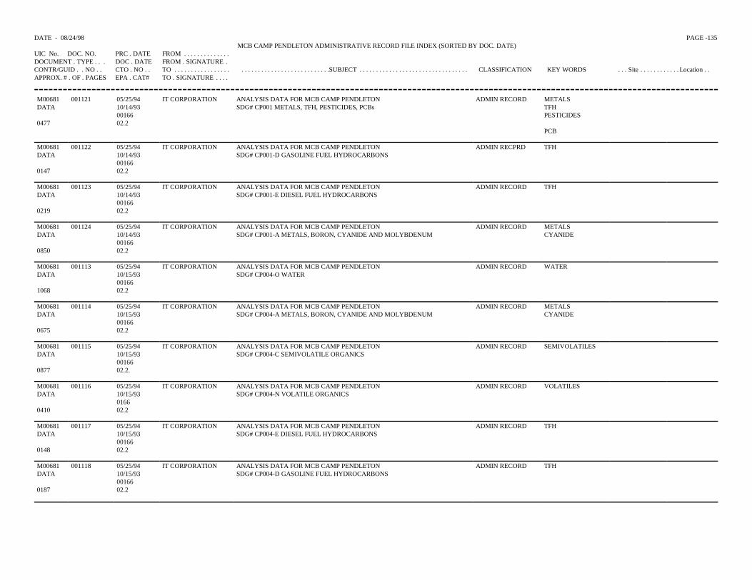
DATE - 08/24/98 PAGE -135 MCB CAMP PENDLETON ADMINISTRATIVE RECORD FILE INDEX (SORTED BY DOC. DATE)
UIC No. DOC. NO. PRC . DATE FROM . . . . . . . . . . . . . .DOCUMENT . TYPE . . . DOC . DATE FROM . SIGNATURE .CONTR/GUID . . NO . . CTO . NO . . TO . . . . . . . . . . . . . . . . . . . . . . . . . . . . . . . . . . . . . . . . . . . .SUBJECT . . . . . . . . . . . . . . . . . . . . . . . . . . . . . . . . . CLASSIFICATION KEY WORDS . . . Site . . . . . . . . . . . . Location . .APPROX. # . OF . PAGES EPA . CAT# TO . SIGNATURE . . . .
M00681 001121 05/25/94 IT CORPORATION ANALYSIS DATA FOR MCB CAMP PENDLETON ADMIN RECORD METALSDATA 10/14/93 SDG# CP001 METALS, TFH, PESTICIDES, PCBs TFH
00166 PESTICIDES0477 02.2
PCB
M00681 001122 05/25/94 IT CORPORATION ANALYSIS DATA FOR MCB CAMP PENDLETON ADMIN RECPRD TFHDATA 10/14/93 SDG# CP001-D GASOLINE FUEL HYDROCARBONS
001660147 02.2
M00681 001123 05/25/94 IT CORPORATION ANALYSIS DATA FOR MCB CAMP PENDLETON ADMIN RECORD TFHDATA 10/14/93 SDG# CP001-E DIESEL FUEL HYDROCARBONS
001660219 02.2
M00681 001124 05/25/94 IT CORPORATION ANALYSIS DATA FOR MCB CAMP PENDLETON ADMIN RECORD METALSDATA 10/14/93 SDG# CP001-A METALS, BORON, CYANIDE AND MOLYBDENUM CYANIDE
001660850 02.2
M00681 001113 05/25/94 IT CORPORATION ANALYSIS DATA FOR MCB CAMP PENDLETON ADMIN RECORD WATERDATA 10/15/93 SDG# CP004-O WATER
001661068 02.2
M00681 001114 05/25/94 IT CORPORATION ANALYSIS DATA FOR MCB CAMP PENDLETON ADMIN RECORD METALSDATA 10/15/93 SDG# CP004-A METALS, BORON, CYANIDE AND MOLYBDENUM CYANIDE
001660675 02.2
M00681 001115 05/25/94 IT CORPORATION ANALYSIS DATA FOR MCB CAMP PENDLETON ADMIN RECORD SEMIVOLATILESDATA 10/15/93 SDG# CP004-C SEMIVOLATILE ORGANICS
001660877 02.2.
M00681 001116 05/25/94 IT CORPORATION ANALYSIS DATA FOR MCB CAMP PENDLETON ADMIN RECORD VOLATILESDATA 10/15/93 SDG# CP004-N VOLATILE ORGANICS
01660410 02.2
M00681 001117 05/25/94 IT CORPORATION ANALYSIS DATA FOR MCB CAMP PENDLETON ADMIN RECORD TFHDATA 10/15/93 SDG# CP004-E DIESEL FUEL HYDROCARBONS
001660148 02.2
M00681 001118 05/25/94 IT CORPORATION ANALYSIS DATA FOR MCB CAMP PENDLETON ADMIN RECORD TFHDATA 10/15/93 SDG# CP004-D GASOLINE FUEL HYDROCARBONS
001660187 02.2
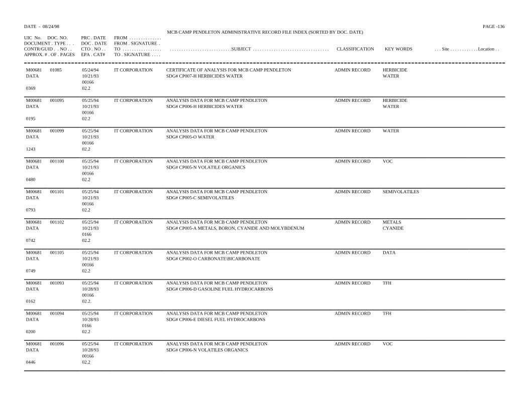
DATE - 08/24/98 PAGE -136 MCB CAMP PENDLETON ADMINISTRATIVE RECORD FILE INDEX (SORTED BY DOC. DATE)
UIC No. DOC. NO. PRC . DATE FROM . . . . . . . . . . . . . .DOCUMENT . TYPE . . . DOC . DATE FROM . SIGNATURE .CONTR/GUID . . NO . . CTO . NO . . TO . . . . . . . . . . . . . . . . . . . . . . . . . . . . . . . . . . . . . . . . . . . .SUBJECT . . . . . . . . . . . . . . . . . . . . . . . . . . . . . . . . . CLASSIFICATION KEY WORDS . . . Site . . . . . . . . . . . . Location . .APPROX. # . OF . PAGES EPA . CAT# TO . SIGNATURE . . . .
M00681 01085 05/24/94 IT CORPORATION CERTIFICATE OF ANALYSIS FOR MCB CAMP PENDLETON ADMIN RECORD HERBICIDEDATA 10/21/93 SDG# CP007-H HERBICIDES WATER WATER
001660369 02.2
M00681 001095 05/25/94 IT CORPORATION ANALYSIS DATA FOR MCB CAMP PENDLETON ADMIN RECORD HERBICIDEDATA 10/21/93 SDG# CP006-H HERBICIDES WATER WATER
001660195 02.2
M00681 001099 05/25/94 IT CORPORATION ANALYSIS DATA FOR MCB CAMP PENDLETON ADMIN RECORD WATERDATA 10/21/93 SDG# CP005-O WATER
001661243 02.2
M00681 001100 05/25/94 IT CORPORATION ANALYSIS DATA FOR MCB CAMP PENDLETON ADMIN RECORD VOCDATA 10/21/93 SDG# CP005-N VOLATILE ORGANICS
001660480 02.2
M00681 001101 05/25/94 IT CORPORATION ANALYSIS DATA FOR MCB CAMP PENDLETON ADMIN RECORD SEMIVOLATILESDATA 10/21/93 SDG# CP005-C SEMIVOLATILES
001660793 02.2
M00681 001102 05/25/94 IT CORPORATION ANALYSIS DATA FOR MCB CAMP PENDLETON ADMIN RECORD METALSDATA 10/21/93 SDG# CP005-A METALS, BORON, CYANIDE AND MOLYBDENUM CYANIDE
01660742 02.2
M00681 001105 05/25/94 IT CORPORATION ANALYSIS DATA FOR MCB CAMP PENDLETON ADMIN RECORD DATADATA 10/21/93 SDG# CP002-O CARBONATE\BICARBONATE
001660749 02.2
M00681 001093 05/25/94 IT CORPORATION ANALYSIS DATA FOR MCB CAMP PENDLETON ADMIN RECORD TFHDATA 10/28/93 SDG# CP006-D GASOLINE FUEL HYDROCARBONS
001660162 02.2.
M00681 001094 05/25/94 IT CORPORATION ANALYSIS DATA FOR MCB CAMP PENDLETON ADMIN RECORD TFHDATA 10/28/93 SDG# CP006-E DIESEL FUEL HYDROCARBONS
01660200 02.2
M00681 001096 05/25/94 IT CORPORATION ANALYSIS DATA FOR MCB CAMP PENDLETON ADMIN RECORD VOCDATA 10/28/93 SDG# CP006-N VOLATILES ORGANICS
001660446 02.2
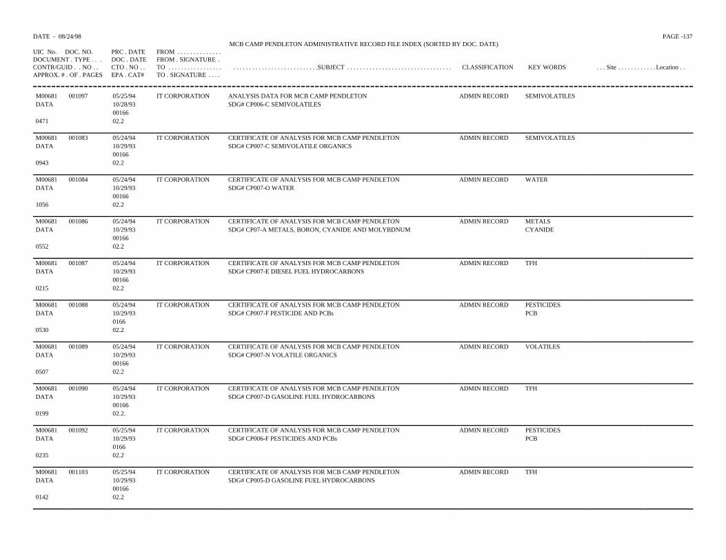
DATE - 08/24/98 PAGE -137 MCB CAMP PENDLETON ADMINISTRATIVE RECORD FILE INDEX (SORTED BY DOC. DATE)
UIC No. DOC. NO. PRC . DATE FROM . . . . . . . . . . . . . .DOCUMENT . TYPE . . . DOC . DATE FROM . SIGNATURE .CONTR/GUID . . NO . . CTO . NO . . TO . . . . . . . . . . . . . . . . . . . . . . . . . . . . . . . . . . . . . . . . . . . .SUBJECT . . . . . . . . . . . . . . . . . . . . . . . . . . . . . . . . . CLASSIFICATION KEY WORDS . . . Site . . . . . . . . . . . . Location . .APPROX. # . OF . PAGES EPA . CAT# TO . SIGNATURE . . . .
M00681 001097 05/25/94 IT CORPORATION ANALYSIS DATA FOR MCB CAMP PENDLETON ADMIN RECORD SEMIVOLATILESDATA 10/28/93 SDG# CP006-C SEMIVOLATILES
001660471 02.2
M00681 001083 05/24/94 IT CORPORATION CERTIFICATE OF ANALYSIS FOR MCB CAMP PENDLETON ADMIN RECORD SEMIVOLATILESDATA 10/29/93 SDG# CP007-C SEMIVOLATILE ORGANICS
001660943 02.2
M00681 001084 05/24/94 IT CORPORATION CERTIFICATE OF ANALYSIS FOR MCB CAMP PENDLETON ADMIN RECORD WATERDATA 10/29/93 SDG# CP007-O WATER
001661056 02.2
M00681 001086 05/24/94 IT CORPORATION CERTIFICATE OF ANALYSIS FOR MCB CAMP PENDLETON ADMIN RECORD METALSDATA 10/29/93 SDG# CP07-A METALS, BORON, CYANIDE AND MOLYBDNUM CYANIDE
001660552 02.2
M00681 001087 05/24/94 IT CORPORATION CERTIFICATE OF ANALYSIS FOR MCB CAMP PENDLETON ADMIN RECORD TFHDATA 10/29/93 SDG# CP007-E DIESEL FUEL HYDROCARBONS
001660215 02.2
M00681 001088 05/24/94 IT CORPORATION CERTIFICATE OF ANALYSIS FOR MCB CAMP PENDLETON ADMIN RECORD PESTICIDESDATA 10/29/93 SDG# CP007-F PESTICIDE AND PCBs PCB
01660530 02.2
M00681 001089 05/24/94 IT CORPORATION CERTIFICATE OF ANALYSIS FOR MCB CAMP PENDLETON ADMIN RECORD VOLATILESDATA 10/29/93 SDG# CP007-N VOLATILE ORGANICS
001660507 02.2
M00681 001090 05/24/94 IT CORPORATION CERTIFICATE OF ANALYSIS FOR MCB CAMP PENDLETON ADMIN RECORD TFHDATA 10/29/93 SDG# CP007-D GASOLINE FUEL HYDROCARBONS
001660199 02.2.
M00681 001092 05/25/94 IT CORPORATION CERTIFICATE OF ANALYSIS FOR MCB CAMP PENDLETON ADMIN RECORD PESTICIDESDATA 10/29/93 SDG# CP006-F PESTICIDES AND PCBs PCB
01660235 02.2
M00681 001103 05/25/94 IT CORPORATION CERTIFICATE OF ANALYSIS FOR MCB CAMP PENDLETON ADMIN RECORD TFHDATA 10/29/93 SDG# CP005-D GASOLINE FUEL HYDROCARBONS
001660142 02.2
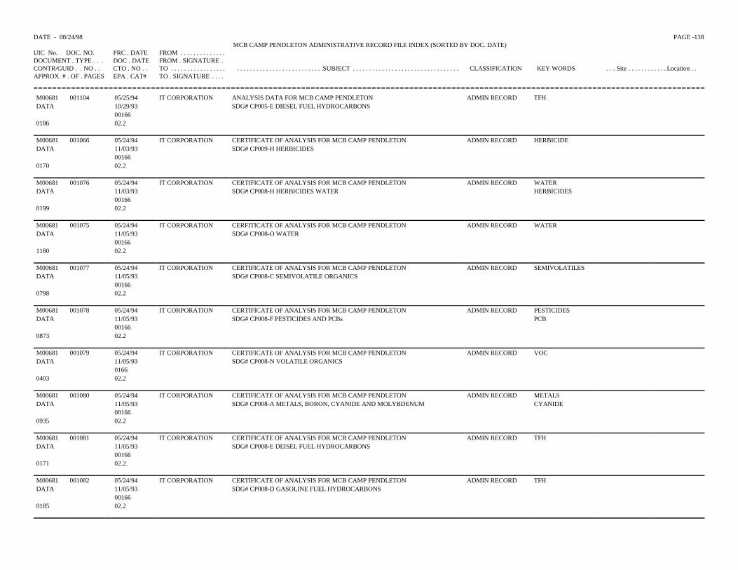
DATE - 08/24/98 PAGE -138 MCB CAMP PENDLETON ADMINISTRATIVE RECORD FILE INDEX (SORTED BY DOC. DATE)
UIC No. DOC. NO. PRC . DATE FROM . . . . . . . . . . . . . .DOCUMENT . TYPE . . . DOC . DATE FROM . SIGNATURE .CONTR/GUID . . NO . . CTO . NO . . TO . . . . . . . . . . . . . . . . . . . . . . . . . . . . . . . . . . . . . . . . . . . .SUBJECT . . . . . . . . . . . . . . . . . . . . . . . . . . . . . . . . . CLASSIFICATION KEY WORDS . . . Site . . . . . . . . . . . . Location . .APPROX. # . OF . PAGES EPA . CAT# TO . SIGNATURE . . . .
M00681 001104 05/25/94 IT CORPORATION ANALYSIS DATA FOR MCB CAMP PENDLETON ADMIN RECORD TFHDATA 10/29/93 SDG# CP005-E DIESEL FUEL HYDROCARBONS
001660186 02.2
M00681 001066 05/24/94 IT CORPORATION CERTIFICATE OF ANALYSIS FOR MCB CAMP PENDLETON ADMIN RECORD HERBICIDEDATA 11/03/93 SDG# CP009-H HERBICIDES
001660170 02.2
M00681 001076 05/24/94 IT CORPORATION CERTIFICATE OF ANALYSIS FOR MCB CAMP PENDLETON ADMIN RECORD WATERDATA 11/03/93 SDG# CP008-H HERBICIDES WATER HERBICIDES
001660199 02.2
M00681 001075 05/24/94 IT CORPORATION CERFITICATE OF ANALYSIS FOR MCB CAMP PENDLETON ADMIN RECORD WATERDATA 11/05/93 SDG# CP008-O WATER
001661180 02.2
M00681 001077 05/24/94 IT CORPORATION CERTIFICATE OF ANALYSIS FOR MCB CAMP PENDLETON ADMIN RECORD SEMIVOLATILESDATA 11/05/93 SDG# CP008-C SEMIVOLATILE ORGANICS
001660798 02.2
M00681 001078 05/24/94 IT CORPORATION CERTIFICATE OF ANALYSIS FOR MCB CAMP PENDLETON ADMIN RECORD PESTICIDESDATA 11/05/93 SDG# CP008-F PESTICIDES AND PCBs PCB
001660873 02.2
M00681 001079 05/24/94 IT CORPORATION CERTIFICATE OF ANALYSIS FOR MCB CAMP PENDLETON ADMIN RECORD VOCDATA 11/05/93 SDG# CP008-N VOLATILE ORGANICS
01660403 02.2
M00681 001080 05/24/94 IT CORPORATION CERTIFICATE OF ANALYSIS FOR MCB CAMP PENDLETON ADMIN RECORD METALSDATA 11/05/93 SDG# CP008-A METALS, BORON, CYANIDE AND MOLYBDENUM CYANIDE
001660935 02.2
M00681 001081 05/24/94 IT CORPORATION CERTIFICATE OF ANALYSIS FOR MCB CAMP PENDLETON ADMIN RECORD TFHDATA 11/05/93 SDG# CP008-E DEISEL FUEL HYDROCARBONS
001660171 02.2.
M00681 001082 05/24/94 IT CORPORATION CERTIFICATE OF ANALYSIS FOR MCB CAMP PENDLETON ADMIN RECORD TFHDATA 11/05/93 SDG# CP008-D GASOLINE FUEL HYDROCARBONS
001660185 02.2
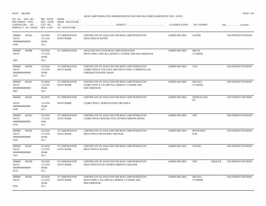
DATE - 08/24/98 PAGE -139 MCB CAMP PENDLETON ADMINISTRATIVE RECORD FILE INDEX (SORTED BY DOC. DATE)
UIC No. DOC. NO. PRC . DATE FROM . . . . . . . . . . . . . .DOCUMENT . TYPE . . . DOC . DATE FROM . SIGNATURE .CONTR/GUID . . NO . . CTO . NO . . TO . . . . . . . . . . . . . . . . . . . . . . . . . . . . . . . . . . . . . . . . . . . .SUBJECT . . . . . . . . . . . . . . . . . . . . . . . . . . . . . . . . . CLASSIFICATION KEY WORDS . . . Site . . . . . . . . . . . . Location . .APPROX. # . OF . PAGES EPA . CAT# TO . SIGNATURE . . . .
M00681 001054 05/24/94 IT CORPORATION CERTIFICATE OF ANALYSIS FOR MCB CAMP PENDLETON ADMIN RECORD WATER SOUTHWEST DIVISIONDATA 11/11/93 DAVE MARK SDG# CP010-H WATER000000000000000 001660100 02.2
M00681 001098 05/25/94 IT CORPORATION ANALYSIS DATA FOR MCB CAMP PENDLETON ADMIN RECORD METALDATA 11/11/93 SDG# CP006-A METALS, BORON, CYANIDE AND MOLYBDENUM CYANIDE
001660581 02.2
M00681 001050 05/24/94 IT CORPORATION CERTIFICATE OF ANALYSIS FOR MCB CAMP PENDLETON ADMIN RECORD VOA SOUTHWEST DIVISIONDATA 11/12/93 DAVE MARK CSQB# CP010-N VOLATILE ORGANICS USING COMBINED GAS000000000000000 00166 CHROMATOGRAPHY-MASS0375 02.2
M00681 001051 05/24/94 IT CORPORATION CERTIFICATE OF ANALYSIS FOR MCB CAMP PENDLETON ADMIN RECORD METALS SOUTHWEST DIVISIONDATA 11/12/93 DAVE MARK CSQB# CP010-A TAL METALS, BORON, CYANIDE AND CYANIDE000000000000000 00166 MOLYBDENUM0667 02.2
M00681 001052 05/24/94 IT CORPORATION CERTIFICATE OF ANALYSIS FOR MCB CAMP PENDLETON ADMIN RECORD SEMIVOLATILES
SOUTHWEST DIVISION
DATA 11/12/93 DAVE MARK CSQB# CP010-C SEMIVOLATILE ORGANICS000000000000000 001660320 02.2
M00681 001053 05/24/94 IT CORPORATION CERTIFICATE OF ANALYSIS FOR MCB CAMP PENDLETON ADMIN RECORD TFH SOUTHWEST DIVISIONDATA 11/12/93 DAVE MARK CSQB# CP010-E BOILING FUEL HYDROCARBONS DIESEL000000000000000 01660141 02.2
M00681 001056 05/24/94 IT CORPORATION CERTIFICATE OF ANALYSIS FOR MCB CAMP PENDLETON ADMIN RECORD PESTICIDES SOUTHWEST DIVISIONDATA 11/12/93 DAVE MARK SDG# CP010-F PESTICIDES AND PCBs PCB000000000000000 001660319 02.2
M00681 001057 05/24/94 IT CORPORATION CERTIFICATE OF ANALYSIS FOR MCB CAMP PENDLETON ADMIN RECORD WATER SOUTHWEST DIVISIONDATA 11/12/93 DAVE MARK SDG# CP010-O WATER000000000000000 001661013 02.2.
M00681 001058 05/24/94 IT CORPORATION CERTIFICATE OF ANALYSIS FOR MCB CAMP PENDLETON ADMIN RECORD TFH GROUP B SOUTHWEST DIVISIONDATA 11/12/93 DAVE MARK SDG# CP010-D FUEL HYDROCARBONS GASOLINE000000000000000 001660124 02.2
M00681 001061 05/24/94 IT CORPORATION CERTIFICATE OF ANALYSIS FOR MCB CAMP PENDLETON ADMIN RECORD METALS SOUTHWEST DIVISIONDATA 11/12/93 DAVE MARK SDG# CP009-A TAL METALS, BORON, CYANIDE AND CYANIDE
00166 MOLYBDENUM0764 02.2
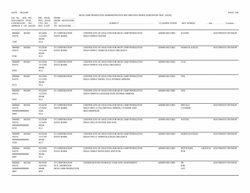
DATE - 08/24/98 PAGE -140 MCB CAMP PENDLETON ADMINISTRATIVE RECORD FILE INDEX (SORTED BY DOC. DATE)
UIC No. DOC. NO. PRC . DATE FROM . . . . . . . . . . . . . .DOCUMENT . TYPE . . . DOC . DATE FROM . SIGNATURE .CONTR/GUID . . NO . . CTO . NO . . TO . . . . . . . . . . . . . . . . . . . . . . . . . . . . . . . . . . . . . . . . . . . .SUBJECT . . . . . . . . . . . . . . . . . . . . . . . . . . . . . . . . . CLASSIFICATION KEY WORDS . . . Site . . . . . . . . . . . . Location . .APPROX. # . OF . PAGES EPA . CAT# TO . SIGNATURE . . . .
M00681 001062 05/24/94 IT CORPORATION CERTIFICATE OF ANALYSIS FOR MCB CAMP PENDLETON ADMIN RECORD WATER SOUTHWEST DIVISIONDATA 11/12/93 DAVE MARK SDG# CP009-O WATER
001661540 02.2
M00681 001064 05/24/94 IT CORPORATION CERTIFICATE OF ANALYSIS FOR MCB CAMP PENDLETON ADMIN RECORD SEMIVOLATILES SOUTHWEST DIVISIONDATA 11/12/93 DAVE MARK SDG# CP009-C SEMICOLATILES ORGANICS
001660746 02.2
M00681 001065 05/24/94 IT CORPORATION CERTIFICATE OF ANALYSIS FOR MCB CAMP PENDLETON ADMIN RECORD VOADATA 11/12/93 DAVE MARK SDG# CP009-N VOLATILE ORGANICS
001660502 02.2
M00681 001067 05/24/94 IT CORPORATION CERTIFICATE OF ANALYSIS FOR MCB CAMP PENDLETON ADMIN RECORD TFHDATA 11/12/93 SDG# CP009-E DIESEL FULE HYDROCARBONS
001660173 02.2
M00681 001068 05/24/94 IT CORPORATION CERTIFICATE OF ANALYSIS FOR MCB CAMP PENDLETON ADMIN RECORD TFHDATA 11/12/93 ODG# CP009-D GASOLINE FUEL HYDROCARBONS
001660162 02.2
M00681 001055 05/24/94 IT CORPORATION CERTIFICATE OF ANALYSIS FOR MCB CAMP PENDLETON ADMIN RECORD METALS SOUTHWEST DIVISIONDATA 11/16/93 DAVE MARK SDG# CP011-A TAL METALS, BORON, CYANIDE AND CYANIDE000000000000000 0166 MOLYBDENUM0382 02.2
M00681 001059 05/24/94 IT CORPORATION CERTIFICATE OF ANALYSIS FOR MCB CAMP PENDLETON ADMIN RECORD WATER SOUTHWEST DIVISIONDATA 11/16/93 DAVE MARK SDG# CP012-H WATER AND SOIL000000000000000 001660150 02.2
M00681 001060 05/24/94 IT CORPORATION CERTIFICATE OF ANALYSIS FOR MCB CAMP PENDLETON ADMIN RECORD SEMIVOLATILES SOUTHWEST DIVISIONDATA 11/17/93 DAVE MARK SDG# CP011-C SEMIVOLATILES ORGANICS000000000000000 001660538 02.2.
M00681 001063 05/24/94 IT CORPORATION CERTIFICATE OF ANALYSIS FOR MCB CAMP PENDLETON ADMIN RECORD PESTICIDES GROUP B SOUTHWEST DIVISIONDATA 11/19/93 DAVE MARK SDG# CP000-F PESTICIDES AND PCBs PCB000000000000000 001660507 02.2
M00681 002168 06/30/94 IT CORPORATION UNDERGROUND STORAGE TANK SITE ASSESSMENT ADMIN RECORD PR SOUTHWEST DIVISIONDATA 12/03/93 W.N. THORNTON ESR000000000000000 00000 MCB CAMP PENDLETON UST0007 00.0
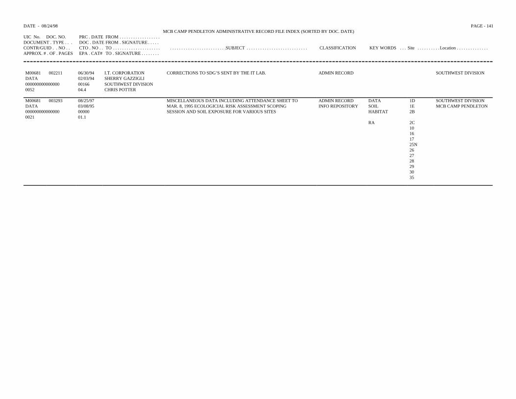
DATE - 08/24/98 PAGE - 141MCB CAMP PENDLETON ADMINISTRATIVE RECORD FILE INDEX (SORTED BY DOC. DATE)
UIC No. DOC. NO. PRC . DATE FROM . . . . . . . . . . . . . . . . . .DOCUMENT . TYPE . . . DOC . DATE FROM . SIGNATURE . . . . .CONTR/GUID . . NO . . CTO . NO . . TO . . . . . . . . . . . . . . . . . . . . . . . . . . . . . . . . . . . . . . . . . . . . . .SUBJECT . . . . . . . . . . . . . . . . . . . . . . . . . . . CLASSIFICATION KEY WORDS . . . Site . . . . . . . . . . Location . . . . . . . . . . . . . .APPROX. # . OF . PAGES EPA . CAT# TO . SIGNATURE . . . . . . . .
M00681 002211 06/30/94 I.T. CORPORATION CORRECTIONS TO SDG’S SENT BY THE IT LAB. ADMIN RECORD SOUTHWEST DIVISIONDATA 02/03/94 SHERRY GAZZIGLI000000000000000 00166 SOUTHWEST DIVISION0052 04.4 CHRIS POTTER
M00681 003293 08/25/97 MISCELLANEOUS DATA INCLUDING ATTENDANCE SHEET TO ADMIN RECORD DATA 1D SOUTHWEST DIVISIONDATA 03/08/95 MAR. 8, 1995 ECOLOGICIAL RISK ASSESSMENT SCOPING INFO REPOSITORY SOIL 1E MCB CAMP PENDLETON000000000000000 00000 SESSION AND SOIL EXPOSURE FOR VARIOUS SITES HABITAT 2B0021 01.1
RA 2C10161725N262728293035
TOTAL RECORDS PRINTED: 1360
REPORT SPECIFICATION FOR: RPT210
TITLE: MCB CAMP PENDLETON ADMINISTRATIVE RECORD FILE INDEX (SORTED BY D
FILE: Central Activity File Documents
SELECTION CRITERIA:(01) Type IS “DATA” & UIC. No. IS “M00681"
SORT CRITERIA:01 Doc. Date
PAGE BREAK LEVEL:00 NO PAGEBBREAK
TYPE REPORT FORMPAPER MASTER ACTIVITY FILE (with key/Add Info)


