UNITED STATES ENVIRONMENTAL PROTECTION AGENCY 5 REGION 2 5 290 BROADWAY „ NEW YORK, NY 10007-1866 SDMS Document AUG 1 4 2007 Captain G.A. Maynard Commanding Officer Naval Weapons Station Earle Code 043 201 Highway 34 South Colts Neck, New Jersey 07722-5014 Re: Transmittal of Signed Record of Decision for Site 26 (Operable Unit 7) at Naval Weapons Station Earle, Colts Neck, New Jersey Dear Captain G. A. Maynard: Enclosed is a copy of the signed Record of Decision for Site 26 (Operable Unit 7) at Naval Weapons Station (NWS) Earle, Colts Neck, New Jersey. Based on our review of NWS Earle's Investigation Report and Feasibility Study, the U.S. Environmental Protection Agency (EPA) concurs with the Record of Decision. The Record of Decision calls for the following action at the facility: Site 26 - Tetrachloroethene (also known as perchloroethylene) component of the solvent plume in Site 26 groundwater: Implementation of land use controls including establishment of a Classification Exception Area. Long-term groundwater monitoring will be conducted to assess contaminant status and potential threats to human health and the environment. This decision document addresses only the above site. Other areas of concern either have already been addressed through removal actions or will be addressed in future Records of Decision. Internet Address (URL) • http:7Avww.epa.gov R*cycl*d/R«cycl«M* • Printed wlh Vegetable Ol Based Into on Recycled Paper (Mkiknum 30%Posdconsumer)
Transcript
UNITED STATES ENVIRONMENTAL PROTECTION AGENCY5 REGION 25 290 BROADWAY „
NEW YORK, NY 10007-1866 SDMS Document
AUG 1 4 2007
Captain G.A. MaynardCommanding OfficerNaval Weapons Station EarleCode 043201 Highway 34 SouthColts Neck, New Jersey 07722-5014
Re: Transmittal of Signed Record of Decision for Site 26 (Operable Unit 7) at Naval WeaponsStation Earle, Colts Neck, New Jersey
Dear Captain G. A. Maynard:
Enclosed is a copy of the signed Record of Decision for Site 26 (Operable Unit 7) atNaval Weapons Station (NWS) Earle, Colts Neck, New Jersey. Based on our review of NWSEarle's Investigation Report and Feasibility Study, the U.S. Environmental Protection Agency(EPA) concurs with the Record of Decision.
The Record of Decision calls for the following action at the facility:
Site 26 - Tetrachloroethene (also known as perchloroethylene) component of thesolvent plume in Site 26 groundwater: Implementation of land use controls includingestablishment of a Classification Exception Area. Long-term groundwater monitoring will beconducted to assess contaminant status and potential threats to human health and theenvironment.
This decision document addresses only the above site. Other areas of concern either havealready been addressed through removal actions or will be addressed in future Records ofDecision.
Internet Address (URL) • http:7Avww.epa.gov
R*cycl*d/R«cycl«M* • Printed wlh Vegetable Ol Based Into on Recycled Paper (Mkiknum 30% Posdconsumer)
If you have any questions regarding the subject of this letter, please contact me or haveyour staff contact Jessica Mollin, EPA Project Manager, at (212) 637-3921.
Sincarely,
George Pavlou, DirectorEmergency and Remedial ResponseDivision
Contract Number N62472-03-D-0057Contract Task Order 033
January 2007
TABLE OF CONTENTS
PART I - DECLARATION
SECTION PAGE
I. SITE NAME AND LOCATION ....1-1
II. STATEMENT OF BASIS AND PURPOSE 1-1
III. ASSESSMENT OF THE SITE I-2
IV. DESCRIPTION OF THE SELECTED REMEDY I-2
V. STATUTORY DETERMINATION I-3
PART II • DECISION SUMMARY
I. SITE NAME, LOCATION AND DESCRIPTION 11-1
II. SITE HISTORY AND ENFORCEMENT ACTIVITY ..II-4
III. HIGHLIGHTS OF COMMUNITY PARTICIPATION 11-11
IV. SCOPE AND ROLE OF OPERABLE UNIT 7 .........11-11
V. SUMMARY OF SITE CHARACTERISTICS.... 11-12
VI. SUMMARY OF SITE RISKS H-20
VII. REMEDIAL ACTION OBJECTIVES AND PRELIMINARY REMEDIATION GOALS II-23
VIII. DESCRIPTION OF REMEDIAL ACTION ALTERNATIVES II-23
IX. SUMMARY OF COMPARATIVE ANALYSIS OF ALTERNATIVES.. .....II-27
X. THE SELECTED REMEDY II-30
XI. STATUTORY DETERMINATIONS 11-31
XII. DOCUMENTATION OF SIGNIFICANT CHANGES . , II-40
PART III • RESPONSIVENESS SUMMARY
I. OVERVIEW 111-1II. BACKGROUND ON COMMUNITY INVOLVEMENT 111-1III. SUMMARY OF MAJOR QUESTIONS AND COMMENTS III-2
L\DOCUMENTS\NAVY\2128\19305 j CTO B43
TABLE OF CONTENTS (Continued)
APPENDICES
A NJDEP Concurrence Letter A-1B Terms Used In the Record of Decision B-1C Attendance Lists - October 5,2004 Public Meeting C-1D Public Comments arid Government Response D-1
TABLES
NUMBER PAGE
1 Groundwater Contaminants of Concern , 11-212 Proposed Groundwater PRGs II-243 Comparative Analysis of Remedial Action Alternatives II-264 Federal Chemical-Specific ARARs and TBCs II-345 State Chemical-Specific ARARs and TBCs II-356 Federal Location-Specific ARARs and TBCs ...II-367 State Location-Specific ARARs and TBCs II-378 Federal Action-Specific ARARs and TBCs II-389 State Action-Specific ARARs and TBCs. II-39
FIGURES
NUMBER PAGE
1 Regional Site Map : II-22 Mainside Area Site 26 Location II-33 Operable Unit 7 Location Map II-54 1997 Groundwater Concentrations above Screening Levels II-75 Pre-Remediation Investigation Groundwater Sample Locations and VOC Concentrations II-86 Permanent Well Location Map 11-107 Pre-Remediation Investigation Septic Tank Orientation and Soil Borings 11-178 Pre-Remediation Investigation Surface Water/Sediment Sediment Sample Locations 11-199 Proposed Classification Exception Area Boundaries II-32
L\DOCUMENTS\NAVY\2128\19305 jj CTO843
RECORD OF DECISIONNAVAL WEAPONS STATION EARLE
OPERABLE UNIT 7 (SITE 26 PCE Plume)
PART I - DECLARATION
I. SITE NAME AND LOCATION
Naval Weapons Station Earle
Colts Neck, Monmouth County, New Jersey
ID Number: NJ0170022172
Operable Unit 7 - Tetrachloroethene (also known as perchloroethylene) component of the solvent plume in
Site 26 groundwater.
II. STATEMENT OF BASIS AND PURPOSE
This Record of Decision (ROD) presents the remedial action alternative selected for Operable Unit 7 (OU
7) to address contamination associated with the tetrachloroethene (PCE) portion of the Site 26 groundwater
solvent plume southwest of Building GB-1 at the Naval Weapons Station (NWS) Earle located in Colts
Neck, New Jersey.
This remedial action decision is in accordance with the Comprehensive Environmental Response,
Compensation and Liability Act of 1980 (CERCLA) as amended by the Superfund Amendments and
Reauthorization Act of 1986 (SARA) and the National Oil and Hazardous Substances Pollution
Contingency Plan (NCR). This decision document explains the factual and legal basis for selecting the
remedial action and is based on the Administrative Record for OU 7. Reports and other information used
in the remedy selection process are part of the Administrative Record file for OU 7, which is available at
the Monmouth County Library, Eastern Branch, Route 35, Shrewsbury, New Jersey.
The New Jersey Department of Environmental Protection (NJDEP) has commented on the selected
remedy and concurs. NJDEP comments have been incorporated into this ROD. A review of the public
response to the Proposed Remedial Action Plan (PRAP) is included in the Responsiveness Summary
(Part III) of this decision document. The state concurrence letter is included in Appendix A. Terms used
in the ROD are presented in Appendix B.
L\DOCUMENTS\NAVY\2128\19305 |--| CTO843
III. ASSESSMENT OF THE SITE
Pursuant to duly delegated authority, I hereby determine, pursuant to Section 106 of CERCLA, 42 U.S.C.
§ 9606, that actual or threatened releases of hazardous substances from OU 7, as discussed in Part II,
Section VI (Summary of Site Risks) of this ROD, if not addressed by implementing the remedial action
selected in this ROD, may present an imminent and substantial endangerment to public health, welfare, or
the environment.
IV. DESCRIPTION OF THE SELECTED REMEDY
The Department of the Navy (Navy) and the United States Environmental Protection Agency (USEPA), in
consultation with NJDEP, have selected the following remedy for OU 7, Site 26. The remedy relies on
long-term monitoring, Land Use Controls (LUCs) and the current OU 3 remediation system (air sparging
with soil vapor extraction (AS/SVE)) to limit exposures to site risks. The' current OU 3 remediation system
began operation in January 2001 to treat the volatile organic contaminant plume [predominately
trichloroethene (TCE)] associated with the Site 26 groundwater plume. The selected remedy for the PCE
portion of the Site 26 volatile organic contaminant plume (OU 7) includes the following major components:
1. LUCs will be implemented by the Navy according to Department of Defense (DoD) guidelines as set
forth in the document entitled "Principles and Procedures for Specifying, Monitoring and Enforcement
of LUCs and Other Post-ROD Actions" as agreed between the USEPA and the DoD. LUCs will be
incorporated into the Base Master Plan to limit future uses of the groundwater as drinking water. Use
of the aquifer beneath the site for purposes other than environmental monitoring and testing without
Navy approval, will be prohibited, until groundwater is found to meet Federal Maximum Contaminant
Levels (MCLs) and New Jersey groundwater quality standards (GWQS). A Classification Exception
Area (CEA) pursuant to N.J.A.C. 7:9-6 will be established to provide the state official notice that the
constituent standards will not be met for a specified duration anticipated not to exceed 10 years
(unless MCLs and GWQS are not met) and to ensure that use of groundwater in the affected area is
prohibited. The Navy is responsible for implementing, maintaining, reporting on and enforcing the
LUCs described in the ROD in accordance with the Base Master Plan, as well as maintaining the
integrity of any current or future remedial or monitoring system such as monitoring wells. LUCs will be
maintained until the contaminant concentrations in groundwater are reduced to levels that allow
unrestricted use and exposure.
LADOCUMENTS\NAVY\2128\19305 |-2 CTO843
The LUC objectives are:
a) Maintain the integrity of the monitoring wells included in the current or future monitoring
system; and
b) Except for environmental monitoring, prevent access or use of untreated groundwater until
cleanup levels are met..
These objectives will be implemented through mechanisms, such as groundwater use restrictions
amended to the Base Master Plan, establishment of the NJDEP-compliant CEA and conduct of a site
review every five years.
2. Long-term periodic groundwater monitoring will be conducted to assess contaminant status and
potential threats to human health and the environment. Since the selected remedy is not expected to
completely remove the contaminants from groundwater during the AS/SVE treatment period, periodic
groundwater monitoring and reporting according to the requirements of the CEA will continue until at
least two consecutive periods result in concentrations below MCLs and GWQS. Site conditions and
risks will be reviewed every five years as required by CERCLA.
A LUC Remedial Design will be prepared as the land use component of the Remedial Design. Within
90 days of ROD signature, the Navy shall prepare and submit to EPA for review and approval a LUC
remedial design that shall contain implementation and maintenance actions, including periodic
inspections. Although the Navy may later transfer these procedural responsibilities to another party by
contract, property, transfer agreement, or through other means, the Navy shall retain ultimate
responsibility for remedy integrity.
The remedial action objective (RAO) for restoration of groundwater at Site 26 will not be immediately
achieved. LUCs that include groundwater use restrictions will reduce risk by preventing potential human
exposure to PCE and other organic compounds in groundwater, until groundwater restoration is achieved.
Long-term periodic monitoring will determine when the RAO for groundwater at Site 26 is achieved. The
RAO for the PCE component of the Site 26 groundwater plume will be achieved when the preliminary
remediation goal (PRG) of 1 ug/l is met.
V. STATUTORY DETERMINATION
The selected remedy for OU 7 at Site 26, in conjunction with the OU 3 remedy currently under
implementation at the Site 26 groundwater plume, is protective of human health and the environment and
is cost effective. The Navy and USEPA believe that the selected remedy will comply with all Federal and
state Applicable or Relevant and Appropriate Requirements (ARARS) such as MCLs and GWQS that are
legally applicable or relevant and appropriate to the remedial action. The selected alternative would be in
L\DOCUMENTS\NAVY\2128\19305 . |-3 CTO 843
compliance with ARARs because a temporary exemption (CEA) from these requirements will be obtained
until the GWQS and MCLs are achieved. Other ARARs, such as the Endangered Species Act of 1973 (16
USC 1531 et seq.); (50 CFR Part 200) and New Jersey Freshwater Wetlands Protection Act Rules (N.J.A.C.
7:7A) may be applicable and have been considered in the preparation of this ROD.
The selected remedy utilizes a permanent solution to the maximum extent practicable.
Because this remedy will result in hazardous substances remaining in Site 26 groundwater at
concentrations above health-based levels, a review by the Navy, USEPA and NJDEP will be conducted
within five years after initiation of the remedial action to ensure that the remedy continues to provide
adequate protection of human health and the environment.
George Pavlou DateDirector, ERRDU.S. Environmental Protection Agency, Region II
G. A. Maynard Date.Captain, U.S. NavyCommanding OfficerNaval Weapons Station Earle
L\DOCUMENTS\NAVY\2128M9305 |-4 CTO843
RECORD OF DECISIONNAVAL WEAPONS STATION EARLE
OPERABLE UNIT 7SITE 26
PART II - DECISION SUMMARY
I. SITE NAME, LOCATION AND DESCRIPTION
A. General
NWS Earle is located in Monmouth County, New Jersey, approximately 47 miles south of New York City.
The station consists of two areas, the 10,248-acre Main Base (Mainside area), located inland and the 706-
acre Waterfront area (Figure 1). The Mainside and Waterfront areas are connected by a narrow strip of land
that serves as a government-controlled right-of-way containing a road and railroad. The facility was
commissioned in 1943 and its primary mission is to supply ammunition to the naval fleet. An estimated 2,500
people either work or live at the NWS Earle station.
The Mainside area is located approximately 10 miles inland from the Atlantic Ocean in Colts Neck, Howell
and Wall Townships and Tinton Falls Borough. The combined population of these municipalities is
approximately 100,000 people. The surrounding area includes agricultural land, vacant land and low-density
housing. The Mainside area consists of a large, undeveloped portion associated with ordnance operations,
production and storage; this portion is encumbered by explosive safety quantity distance (ESQD) arcs,
essentially limiting land use between existing buildings near Site 26 to maintenance activities only. Other
land use in the Mainside administration area consists of residences, offices, workshops, warehouses,
recreational space, open space and undeveloped land. The Waterfront area is located adjacent to Sandy
Hook Bay in Middletown Township, which has a population of approximately 68,200 people.
B. Site 26: Former Munitions Reconditioning and Maintenance Facility
Site 26 is a former munitions reconditioning and maintenance facility which included Building GB-1 and
GB-2. Site 26 is situated at the intersection of Macassar and Midway Roads (Figure 2). Two railway lines
adjacent to the site run toward the northeast. The ground surface at the site is relatively flat, approximately
150 feet above mean sea level. Reportedly, Building GB-1 was used for the reconditioning of munitions
casings/shells. Solvents were used in the reconditioning process. Spent solvents and wash waters were
discarded into an unknown receptacle, possibly a collection tray or utility sink at the formerly used paint spray
booth, which drained to the process leaching system. The GB-1 process leaching system appears to have
been used for the disposal of TCE, 1,2-dichloroethene (1,2-DCE), or related compounds.
L\DOCUMENTS\NAVY\2128\19305 ||-1 • CTO843
2128/0101/2128CM01.DWG 10/18/04 MKB
SANDY HOOKBAY
NWS EARLEWATERFRONT AREA
MONMOUTH COUNTY
STATE OF NEW JERSEY MONMQUTH COUNTY
TFTRA TECHNUS, INC.
REGIONAL SITE MAPNAVAL WEAPONS STATION EARLE
COLTS NECK, NEW JERSEY
SCALE
NOT TO SCALEFILE
2128CM01REV DATE
0 10/18/04FIGURE NUMBER
FIGURE 1
212B/OIOI/2128CM01.DWG 10/18/04 MKB
LOCATION
STREAM WITH FLOWDIRECTION
MAINSIDE AREASITE 26 LOCATION
NAVAL WEAPONS STATION EARLECOLTS NECK, NEW JERSEY
REV DATE0 10/18/04
Former Building GB-2 (demolished in 1998) was located southwest of Building GB-1 and had a
septic/leaching system similar to the leaching system used at Building GB-1. Supplemental subsurface soil
and groundwater investigations performed in 2001 in groundwater between Building GB-1 and former
Building GB-2 indicated that the probable PCE source area (now depleted) may have been in the storage/lay-
down area south of Building GB-1 and east of former Building GB-2.
OU 7 consists of the PCE component of the solvent plume at Site 26. This solvent plume overlaps with the
estimated OU 3 solvent plume currently under active remediation (Figure 3).
II. SITE HISTORY AND ENFORCEMENT ACTIVITY
Potential hazardous substance releases at NWS Earle were addressed in an Initial Assessment Study (IAS)
in 1982, a Site Inspection Study (SI) in 1986 and a Phase I Remedial Investigation (Rl) in 1993. These were
preliminary investigations to determine the number of sources, compile histories of waste-handling and
disposal practices at the sites and acquire data on the types of contaminants present and potential human
health and/or environmental receptors.
In 1990, NWS Earle was placed on the National Priorities List (NPL), which is a list of sites where
uncontrolled hazardous substance releases may present serious threats to human health and the
environment. The sites at NWS Earle were then addressed by Phase II RI activities to determine the nature
and extent of contamination at these sites. Activities included installation and sampling of
groundwater monitoring wells, surface water and sediment sampling and excavation of test pits to observe
wastes and define the southern limit of fill materials.
The IAS in 1983, consisting of a document search and employee interviews, concluded minimal probable
impact at Site 26. The IAS did not recommend actual sampling and analysis of site-related media. Despite
the recommendation of the 1983 IAS, the Navy performed a SI in 1986 and a Phase I Rl was performed in
1993. These were preliminary investigations that included records review as well as actual site-related
groundwater and soil sampling and laboratory analysis to determine the number of sources, compile histories
of waste-handling and disposal practices at the site and acquire data on the types of contaminants present
and potential human health and/or environmental receptors.
Site 26 was subsequently addressed during Phase II Rl activities in 1995 to further define the nature and
extent of contamination at the site. Phase II activities included a soil gas survey, installation and
sampling of groundwater monitoring wells and surface and subsurface soil sampling. The Phase II Rl
was initiated in 1995 and completed in July 1998, when the final Rl addendum report was released.
L\DOCUMENTS\NAVY\2128\19305 \\-4 CTO 843
SCALE
AS NOTED
REV DATE
o 02/08/06
~.
281*'37~~.
( ,) TETRA TECH NUS, INC.
OPERABLE UNIT 7 lOCATION MAPNAVAL WEAPONS STATION EARLE
COl TS NECK, NEW JERSEY
26HPJJ
tA9J'
FILE
02/08/06fiGURE NU~BER
FIGURE 3
/
MONITORING WELL
ACTIVE AIR SPARGING WELL
AIR SPARGING WELL (INACTIVE)
APPROXIMATE PCE LOCATION AND
CONCENTRATiON (ug/L)
APPROXIMATE TCE LOCATION AND
CONCENTRATION (ug/L)
APPROXIMATE AS/SVE SYSTEMLOCATION
PCE AND/OR TCE NON DETECTNDND
lEGEND
61
oo
~
C)
FORMER BUILDING GB-~
PROCESS LEACHTANK LOCATION
,.", JJB
+ + ''+" 25HP07'
+ 26MW07 :;"'+
APPROXIMATE LOCATION OF .:,,!BFORMER BUILDING 08-2 /+ '2BHP02
• / +,
18 r,{7 +\ 1) +
26MW11 \ ~61 \ /2lH~1D~D_:,.
m:&HP~
26MW14
61
2&HPa7
~~HP+4
NO.ND21lHP41
21lHP48NO.
ND
61
26MW16
28HP&o\ JJIb
26MW17
61
.211SW1
m'2~HP&J
2&H~m
SCALE IN FEET
o 100 200
I I I I I I
Nm~>~~"15~o~~i
11-5
The Site 26 Rl (Rl Addendum Report, 1998) delineated a groundwater plume of chlorinated hydrocarbons
that emanated from the former process leach tank at Building GB-1 and extended approximately 350 feet
southwest from this source. The major organic constituents were TCE and 1,2-DCE, which is a
breakdown product of TCE. The TCE concentrations in the vicinity of the leach tank were as high as
9,000 ug/L in the groundwater (at monitoring well 26MW01) and 74.0 ug/kg in the soil. Groundwater
samples obtained from permanent and temporary (direct push) monitoring wells exhibited a wide range of
chlorinated compounds at concentrations above regulatory guidelines. In addition to the TCE and 1,2-
DCE, organic compounds detected at concentrations exceeding regulatory levels included 1,1-DCE,
methylene chloride and PCE. Figure 4 illustrates the location and concentration of compounds in
groundwater exceeding regulatory screening levels in 1997. Although PCE had not been detected at the
leach tank, the presence of PCE within the groundwater in the general vicinity of Building GB-1 was known
at the conclusion of the Rl. No special note of the PCE was taken at that time, as it simply was interpreted
to be one of the volatile organic compound (VOC) components of the site's groundwater plume. Since the
PCE was not yet realized to be a separate source, it was included as a contaminant of concern in the
remedial alternatives selection for OU 3.
Following the Site 26 Rl Reports, a Feasibility Study (FS), PRAP and ROD were developed for OU 3. An
active remediation system designed to remove the solvent components of the OU 3 groundwater plume
through AS/SVE was initiated by the Navy in January 2001. Quarterly sampling of the groundwater
monitoring wells commenced in April 2001. Pre-startup concentrations for TCE and PCE are plotted on
Figure 5. The following observations are drawn from this figure:
• There appear to be different sources for the PCE and the TCE groundwater components. The TCE
component emanates from the former leach tank at building GB-1. The PCE component appears to
emanate from an area south of Building GB-1.
There appears to be a smaller, secondary source of PCE within the eastern portion of the VOC
plume in the vicinity of sampling point 26HP32. These PCE detections are relatively low (at or less
than 10 ug/L) and are coincident with a segment of the OU 3 plume previously identified.
• The downgradient extents of the TCE and PCE components within the VOC plume are approximately
the same. Both components were detected in direct-push screening samples as far downgradient as
sampling point 26HP61, which is located on the opposite (western) side of the Mingamahone Brook.
The detection of VOCs in screening samples located on the western side of the Mingamahone
Brook was not duplicated in samples from actual monitoring wells installed to gauge the possibility of
the source and decrease in the downgradient direction to eventual non-detections) are consistent with the
existence of a steady-state plume emanating from a residual source(s).
During the construction of the AS/SVE system, the Navy installed 7 additional monitoring wells (26MW07
through 26MW-13 (see Figure 5)) to aid in the evaluation of the progress of the groundwater remediation. As
a result of the expanded VOC plume that was delineated through the temporary well program, the Navy
installed an additional 5 monitoring wells (26MW14 through 26 MW18, see Figure 6) downgradient (or
beyond) the delineated plume. Because it was not known whether the plume was at a steady-state condition
or was continuing to migrate, these wells were intentionally installed downgradient of the plume to serve as
downgradient plume limit monitoring wells that would indicate if the plume continued to migrate beyond its
extent as delineated by the screening wells.
F. Current and Potential Future Land and Resource Use
Since NWS Earle in not on the current (thought to be final) Base Realignment and Closure (BRAC) list,
reasonably anticipated future land use at Site 26 is limited to its current military-related mission associated
with ordnance operations with existing encumbrances for explosive safety quantity distance (ESQD) arcs
which essentially limit land use between existing buildings near Site 26 to maintenance activities only.
VI. SUMMARY OF SITE RISKS
As part of the Phase II Rl, a human health risk assessment and an ecological risk assessment were
performed for Site 26. Table 1 presents the contaminants of concern.
A Human Health
The human health risk assessment estimated the potential risks to human health posed by exposure to
contaminated groundwater, surface water and sediment at the site. To assess these risks, the exposure
scenarios listed below were assumed:
• Ingestion of groundwater as a drinking water source.
• Inhalation of contaminants in groundwater (i.e., volatile compounds emitted during showering).
• Dermal exposure to contaminants in groundwater (i.e., showering, hand washing, bathing).
• Dermal contact from contaminated soil.
L\DOCUMENTS\NAVY\2128\19305 ||-20 CTO843
TABLE 1
GROUNDWATER CONTAMINANTS OF CONCERNOU 7 RECORD OF DECISION
NAVAL WEAPONS STATION EARLE, COLTS NECK, NEW JERSEY
Contaminant of Concern
Trichlbroethene
1,1-Dichloroethene
1 ,2-Dichloroethene
Benzene
Carbon tetrachloride
Tetrachloroethene
Cadmium
Exceeds GWQS
X
X
X
X(1)
X(1)
X(1)
x
Exceeds
MCLs
X
-
X
X
X
X
-
Poses Human
Health Risk
X(2)
X (2)
X(3)
-- '
--
--
-
Notes:
• X indicates the basis for selection of the compound or element as a COC.
• The New Jersey State GWQS are ARARs.
• SDWA MCLs regulate organic and inorganic constituents in public drinking water supplies; included as a TBC for comparison
purposes.
• -- Does not exceed GWQS, SWDA MCLs, or pose potential human health risks.
• (1) COC exceeds GWQS, based on direct push sampling and analysis data.
• (2) COC contributes to excess carcinogenic risks for the future residential adult through RME ingestion, dermal and
inhalation exposures.
• (3) COC contributes to HI > 1.0 for future industrial worker, adult resident future under RME exposures, or for residential
child under RME exposures.
L\DOCUMENTS\NAVY\2128\19305 1-21 CTO843
• Inhalation of contaminants in soil (i.e., fugitive dusts).
• Ingestion of contaminated soil.
• Incidental ingestion of surface water and sediment.
• Dermal contact with contaminated surface water and sediment.
These scenarios were applied to various site use categories, including future industrial, residential and
recreational receptors.
The estimated total cancer risk for the most restrictive (future residential receptor) scenario exposure to
groundwater at Site 26 indicated a total risk of 2.0 x 10E-3. TCE and 1,1-dichloroethene (via groundwater
ingestion and inhalation during showering) and arsenic (via ingestion of and dermal contact with soil) are the
principal COPCs that contributed to the cancer risks exceeding guideline limits (1 x 10E-6 to 1 x 10E-4) for
these exposure'scenarios.
Noncarcinogenic risks were estimated using Hazard Indices (HI), where an HI exceeding one is considered
an unacceptable health risk. TCE and 1,2-dichloroethene were the COPCs that exceeded 1.0 or contributed
to the HI exceeding 1.0 for these exposure scenarios. In addition, central tendency risk estimates for
residential and industrial exposure to groundwater yielded His greater than 1.0; affected target organs
include liver, cardiovascular system and central nervous system.
Lead concentrations detected at the site during the Rl were below the groundwater guidelines and are not
expected to be associated with a significant increase in blood-lead levels based on the results of the IEUBK
Lead Model (v. 0.99).
B Ecological
Site 26 is relatively small and consists of turfgrass or developed areas, providing little ecological habitat.
Wooded uplands are present northwest of the site. These upland areas provide excellent habitat for a wide
variety of terrestrial organisms. No wetlands, other sensitive habitats, or threatened or endangered species
of any kind exist in the vicinity of Site 26.
No significant contaminant migration pathways to the upland habitats exist at the site. Overland runoff of
contaminants from, the percolation pit is unlikely since water percolates through and is not expected to
overflow the edges of the pit. Water in the leaching tank/grease trap area is not expected to migrate via
L\DOCUMENTS\NAVY\2128\19305 ||-22 CTO843
overland runoff to the upland areas since water tends to settle in this area and the wooded areas are a few
feet higher on grade than the area next to Building GB-1. Groundwater discharge of contaminants to
surface water is also insignificant since no wetlands or other surface waters are present near the site.
VII. REMEDIAL ACTION OBJECTIVES AND PRELIMINARY REMEDIATION GOALS
The overall objective for the remedy at OU 7 is to protect human health and the environment. Based on
the baseline human health risk assessment, the ecological risk assessment and the Rl results, RAOs
were developed to address environmental media status at the Site 26 PCE plume (OU 7).
Protection of Human Health RAO
• Prevent potential human exposure to organic contaminants in groundwater.
Protection of the Environment RAOs
• Mitigate migration of organic contaminants in groundwater.
• Restoration of groundwater aquifer quality.
These RAOs will be met when the PCE within the site 26 groundwater plume has been removed or reduced
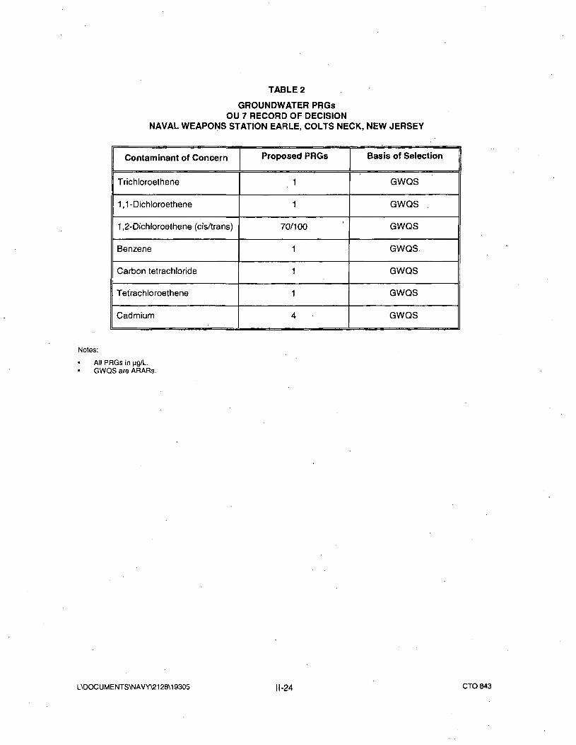
in concentration to below the PRG. The PRG for PCE is 1 ug/l. PRGs for the combined OU 3 and OU .7 Site
26 VOC plume are included in Table 2.
VIII. DESCRIPTION OF REMEDIAL ACTION ALTERNATIVES
The purpose of developing alternatives and the alternative screening process is to assemble an
appropriate range of possible remedial options to achieve the RAOs identified for the site. In this
process, technically feasible technologies are combined to form remedial alternatives that provide varying
levels of risk reduction that comply with Federal (USEPA) and state (NJDEP) guidelines for site
remediation.
Engineering technologies capable of eliminating the unacceptable risks associated with exposure to site-
related soils or groundwater were identified and those alternatives determined to best meet RAOs after
screening were evaluated in detail.
L\DOCUMENTS\NAVY\2128\19305 ||-23 CTO 843
TABLE 2
GROUNDWATER PRGsOU 7 RECORD OF DECISION
NAVAL WEAPONS STATION EARLE, COLTS NECK, NEW JERSEY
Contaminant of Concern
Trichloroethene
1,1-Dichloroethene
1 ,2-Dichloroethene (cis/trans)
Benzene
Carbon tetrachloride
Tetrachloroethene
Cadmium
Proposed PRGs
1
1
70/100
1
1
1
4
Basis of Selection
GWQS
GWQS
GWQS
GWQS.
GWQS
GWQS
GWQS
Notes:
All PRGs in ng/L.GWQS are ARARs.
L\DOCUMENTS\NAVY\2128\19305 11-24 CTO843
A. Detailed Summary of Alternatives
Summaries of the remedial alternatives that passed the screening step for Site 26 OU 7 are presented inthe following sections and summarized on Table 3.
1. Alternative 1: No Action
The no-action alternative is developed as a baseline case, as required by the NCR. No additional
measures (beyond the groundwater remediation underway for OU 3) would be implemented to remove or
contain the groundwater contaminants, to prevent potential human exposure to site groundwater, or to
mitigate contaminant migration in the environment. Because a portion of the OU 7 plume overlaps with
the OU 3 plume currently under active remediation by AS/SVE, under the no action alternative remediation
of the OU 7 PCE groundwater plume will continue. However, no additional actions for OU 7 would be
performed under this alternative.
2. Alternative 2: Limited Action (Long-Term Monitoring)
In addition to the remedial action underway for OU 3, Alternative 2 relies on long-term groundwater
monitoring to achieve the RAOs. Over time, PCE groundwater contamination is expected to decrease by
the active remediation program in place for OU 3 and later by natural effects in the environment. Long-
term annual monitoring and five-year reviews would assess contaminant status and potential threats to
human health and the environment. The annual monitoring and five-year reviews will be required until
clean up goals are achieved and confirmed.
Long-Term Monitoring - Under Alternative 2, the groundwater would be sampled annually to monitor the
migration of PCE-related contaminants from the site and the potential for impacts to downgradient areas.
Background well data would be used for evaluation of site contaminant status'. The data would be
evaluated during the five-year review period.
Five-Year Reviews - Since contaminants remain in groundwater, a review of site conditions and risks
would be conducted every five years, as required by CERCLA. The reviews would consist of evaluating
analytical and hydrogeologic data, assess whether contaminant migration has increased and determining
whether human or ecological receptors or natural resources are at risk.
L\DOCUMENTS\NAVY\2128\19305 ||-25 CTO 843
TABLE 3SITE 26 - OU 7 REMEDIAL ALTERNATIVE COMPONENTS
NWS EARLE, COLTS NECK, NEW JERSEY
1
2
3
ALTERNATIVE
No Action
Limited Action(Long-Term Monitoring)
Limited Action(Long-Term Monitoring andLUCs)
KEY COMPONENTS OF ALTERNATIVE
No actions would be taken.Cost"Long-term annual groundwater monitoringFive-year reviewsCost"Long-term annual groundwater monitoringLUCs (CEA*)Five-year reviewsCost" .
Notes:
* Classification Exception Area pursuant to the New Jersey Groundwater Quality Standards (NJ. A.C
7:9-6) would be established for groundwater that does not meet state GWQS.
** There are no capital or maintenance costs for the no-action alternative (Alternate 1) since no activities
would be performed under this alternative. Under OU 7 Alternatives 2 and 3, there would be no capital
costs. Marginal costs for additional (or exchange of) monitoring wells to monitor state of the OU 3 and OU
7 plumes are minor and can be applied to the approved OU 3 remediation project underway for Site 26.
Additionally, costs for preparing the proposed CEA under Alternative 3 are already budgeted under the OU
3 remediation underway for Site 26.
L\DOCUMENTS\NAVY\2128\19305 II-26 CTO843
3. Alternative 3: Limited Action (Long-Term Monitoring and LUCs)
In addition to the remedial action underway for OU 3, Alternative 3 relies on long-term groundwater
monitoring and LUCs to achieve RAOs. Active treatment (other than that for OU 3) is not employed to
address site contamination. LUCs will be implemented to prevent the use of the groundwater and long-
term monitoring of site groundwater would be conducted to assess contaminant status and potential
threats to human health and the environment. Over time, the contaminants in groundwater (PCE for
OU 7) will likely gradually decrease through adsorption, dispersion and precipitation. However, since
groundwater is above GWQS and MCLs, site conditions and risks would be reviewed every five years.
A LUC Remedial Design will be prepared as the land use component of the Remedial Design. Within
90 days of ROD signature, the Navy shall prepare and submit to EPA for review and approval a LUC
remedial design that shall contain implementation and maintenance actions, including periodic
inspections.
LUCs - Because site groundwater does not meet GWQS, a CEA pursuant to N.J.A.C 7:9-6 would be
established to provide the state official notice that the constituent standards will not be met for a specified
duration, anticipated not to exceed 10 years and to ensure that use of groundwater in the affected area is
suspended until MCLs and GWQS are achieved.
Long-Term Monitoring - Under Alternative 3, additional downgradient wells would be installed to monitor
plume status. The groundwater would be sampled periodically to monitor the migration of PCE-related
contaminants from the site and the potential impacts to downgradient areas. As with Alternative 2,
background well data would be used for comparison to evaluate site contaminant status. The collected
data would be evaluated during the five-year review period. ,
Five-Year Reviews - Because contaminants remain on the site, a review of site conditions and risks would
be conducted every five years, as required by CERCLA. The reviews would consist of evaluation of
analytical and hydrogeologic data to assess whether contaminant migration has increased and whether
human or biological receptors or groundwater resources are at risk.
IX. SUMMARY OF COMPARATIVE ANALYSIS OF ALTERNATIVES
A groundwater remediation program consisting of source removal, AS/SVE, LUCs and long-term monitoring
is underway as a result of the ROD for OU 3. The active remediation program is currently in effect at the
adjacent OU 3 and OU 7 plume, effectively treating areas of higher concentrations in both plumes, ensuring
L\D0CUMENTS\NAVY\2128\19305 ||-27 CTO843
protection of human health and the environment.
None of the three retained OU 7 alternatives contains any proposed action that would protect human health
or the environment more actively than the program already underway. Therefore it is concluded that each of
the three retained remedial alternatives retained for OU 7 would be equally protective of human health and
the environment. However, Alternative 3 includes implementation.of a CEA and long-term monitoring, which
can provide added assurance to address potential long-term future exposure scenarios.
1. Overall Protection of Human Health and the Environment
Alternatives 1 and 2 do not contain proposed action that would provide additional protection of human
health and the environment. Alternative 3 includes the implementation of LUCs in the form of a CEA to be
extended to the PCE component of the Site 26 groundwater VOC plume to address potential future
exposure scenarios.
2. Compliance with ARARs
All three of the OU 7 alternatives provide active treatment of the groundwater as already under
implementation as part of OU 3. With the operation of the AS/SVE remediation system for OU 3 all three
OU 7 alternatives will eventually achieve ARARs. OU 7 Alternatives 1 and 2 do not contain any proposed
action that would provide additional ARAR compliance than is currently a result of the OU 3 remedy
underway. OU 7 Alternative 3 provides for the extension of the CEA to include the PCE component of the
groundwater VOC plume at Site 26 to provide the state official notice that the constituent standards would
not be met for a specified duration, anticipated not to exceed 10 years and to ensure that consumption of
the untreated groundwater is prohibited.
3. Long-Term Effectiveness and Permanence
OU 7 Alterative 1 does not provide any additional long-term effectiveness. Alternatives 2 and 3 require the
Navy to monitor the quality of groundwater beneath and leaving the site, assess potential impacts to the
adjacent lands and downgradient receptors and determine whether additional remedial actions are
necessary through long-term groundwater monitoring and five-year review. By extending the CEA to
include the PCE component of the Site 26 VOC plume under OU 7, Alternative 3 will be effective in
minimizing the risks to downgradient receptors and the environment.
For OU 7 Alternative 1, no new controls would be used to manage the site; therefore, the evaluation of the
adequacy and reliability of controls is not applicable. For OU 7 Alternatives 2 and 3 no difficulties or
L\DOCUMENTS\NAVY\2128\19305 ||-28 CTO843
uncertainties are anticipated in performing the long-term monitoring. Groundwater monitoring wells may
require replacement if damage occurs, but wells would be readily replaceable.
4. Reduction of Toxlcltv. Mobility, or Volume through Treatment
None of the three OU 7 alternatives contain any proposed action that would provide additional treatment
than what is being provided through implementation of the OU 3 ROD currently in process. These
alternatives would not further reduce the toxicity, mobility, or volume through treatment.
5. Short-Term Effectiveness
Since OU 7 Alternative 1 contains no response actions, implementation of this alternative would not pose
additional short-term risks to station personnel or the local community. Implementation of OU 7
Alternatives 2 or 3 is not expected to pose any significant risks to station personnel or the local
community. Workers who implement these alternatives would be adequately safeguarded by using
appropriate engineering safeguards or personal protective equipment (PPE) to prevent exposure to
contaminate media, contaminant-laden dusts and airborne VOCs. OSHA standards would be followed
and proper engineering measures or PPE would be used to protect workers and the environment during
all remediation activities under these alternatives.
No permanent adverse impacts to the environment are anticipated to result from implementing any of the
three OU 7 alternatives.
6. Implementabilltv
Since no response activities would occur under OU 7 Alternative 1, the alternative is readily implementable
and no permits are required. The technical feasibility criteria, including constructability, operability and
reliability, are not relevant to this alternative.
Both OU 7 Alternatives 2 and 3 are implementable. Long-term monitoring (sampling and analyses)
requires readily available resources. Both alternatives allow for assessing contaminant presence,
migration and changes in media quality that may indicate potential impacts to downgradient receptors.
Permits would not be required for these alternatives. However, approval for implementation of the CEA
would be needed from NJDEP. There is ample availability of companies with the trained personnel,
equipment and materials to implement these alternatives. Regulatory personnel and environmental
specialists are readily available to perform five-year reviews associated with these alternatives.
L\DOCUMENTS\NAVY\2128\19305 ||-29 CTO843
Since no treatment is proposed through any of the three OU 7 alternatives, the criterion of availability of
.treatment technologies, treatment and disposal (TSD) facilities and capacity is not applicable.
Under all three OU 7 alternatives, additional actions can be easily implemented in the future, if warranted.
7. Cost
There are no capital or maintenance costs for the no-action alternative (Alternate 1) since no activities
would be performed under this alternative. Under OU 7 Alternatives 2 and 3, there would be no capital
costs. Marginal costs for additional (or exchange of) monitoring wells to monitor state of the OU 3 and OU
7 plumes are minor and can be applied to the approved OU 3 remediation project underway for Site 26.
Additionally, costs for preparing the proposed CEA under Alternative 3 are already budgeted under the OU
3 remediation underway for Site 26.
8. Agency Acceptance
NJDEP has had the opportunity to review and comment on all the documents in the Administrative Record
and has had the opportunity to comment on the draft ROD. Comments received from the NJDEP have been
incorporated into the ROD.
9. Community Acceptance
The community has had the opportunity to review and comment on documents in the Administrative Record,
to participate in regularly scheduled Restoration Advisory Board (RAB) meetings convened to encourage
community involvement and attend a public meeting held to provide the community an opportunity to leam
about the PRAP. The community has not indicated objections to the alternative selected in this ROD. Part
III, Responsiveness Summary, of this ROD presents an overview of community involvement and input to the
selected alternative.
X. THE SELECTED REMEDY
The Navy, with USEPA and NJDEP, has selected Alternative 3 as its preferred remedy for Site 26, OU 7.
Alternative 3 utilizes LUCs to prevent the use of groundwater until the groundwater complies with MCLs
and GWQS levels.
A LUC Remedial Design will be prepared as the land use component of the Remedial Design. Within 90
days of ROD signature, the Navy shall prepare and submit to EPA for review and approval a LUC
L\DOCUMENTS\NAVY\212B\19305 ||-3Q CTO843
remedial design that shall contain implementation and maintenance actions, including periodic
inspections. LUCs will be maintained until the concentrations of hazardous substances in the
groundwater are at such levels to allow for unrestricted use and exposure. Although the Navy may later
transfer these procedural responsibilities to another party by contract, property transfer agreement, or
through other means, the Navy shall retain ultimate responsibility for remedy integrity. Because site
groundwater does not meet MCLs or GWQS, a temporary exemption (CEA) pursuant to N.J.A.C 7:9-6
would be established to provide the state official notice that the constituent standards will not be met for a
specified duration anticipated not to exceed 10 years and to ensure that use of groundwater in the
affected area is suspended until standards are achieved. Additional downgradient wells would be installed
to monitor plume status. Long-term periodic groundwater monitoring will be conducted to assess
contaminant status and potential threats to human health and the environment. Since wastes will be left in
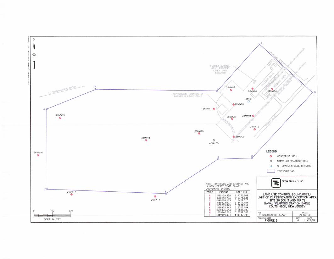
place, site conditions and risks will be reviewed every five years. Figure 9 shows the boundaries of the
land use controls.
XI. STATUTORY DETERMINATIONS
The remedy selected for OU 7 satisfies the remedy selection requirements of CERCLA and the NCR. The
remedy is expected to be protective of human health and the environment, complies with ARARs and is
cost effective. The following sections discuss how the selected remedial action addresses these statutory
requirements.
A. Protection of Human Health and the Environment
The selected remedy will be protective of human health and the environment. The human health risk
assessment concluded that site groundwater poses carcinogenic and non-carcinogenic risks exceeding
USEPA's guideline risk limits under exposure to groundwater scenarios. Establishment of the site as a
groundwater CEA will provide interim protection by prohibiting use of the aquifer until MCLs and GWQS are
achieved.
The long-term periodic monitoring program will allow the responsible agencies to monitor the quality of
groundwater leaving the site, assess potential impacts to downgradient receptors and determine whether
additional remedial actions are necessary.
A LUC Remedial Design will be prepared as the land use component of the Remedial Design. Within 90
days of ROD signature, the Navy shall prepare and submit to EPA for review and approval a LUC
remedial design that shall contain implementation and maintenance actions, including periodic
inspections. Although the Navy retains ultimate responsibility for the performance of these obligations, the
Navy may arrange, by contract or otherwise, for another party(ies) to carry them out. Should any LUC
remedy fail, the Navy will ensure that appropriate actions are taken to reestablish the remedy's
protectiveness and may initiate legal action to either compel action by a third party(ies) and/or to recover
the Navy's costs for remedying any discovered LUC violation(s).
B. Compliance With and Attainment of ARARs
Working in conjunction with the in place OU 3 remedy, the selected remedy for OU 7 will comply with all
applicable or relevant and appropriate chemical-specific, location-specific and action-specific ARARs.
Tables 4 through 9 summarize ARARs and TBCs applicable to OU 7.
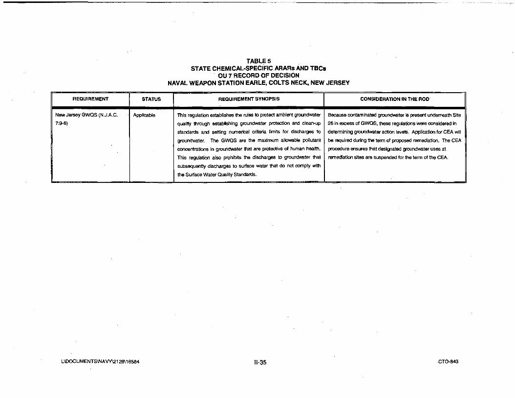
1. Chemical-Specific ARARs
Federal and state chemical-specific ARARs are listed in Tables 4 and 5, respectively.
Implementation of OU 7 Alternative 3 in conjunction with the OU 3 remedy in place will eventually comply with
all ARARs identified in Tables 4 and 5. Because Alternative 3 does not include active treatment of
groundwater, initially the groundwater beneath Site 26 will not meet the constituent concentrations specified
in the GWQS [N.J.A.C. 7:9-6] and MCLs.
However, while the OU 3 remedy in place treats the Site 26 groundwater contamination, the long-term
monitoring associated with OU 7 Alternative 3 will provide information regarding the effectiveness of the OU 3
remedy on PCE in Site 26 groundwater. OU 7 Alternative 3 includes a provision to seek a temporary
exemption (CEA) from the PRG until the GWQS and MCLs are achieved. The CEA will provide the state
official notice that the constituent standards will not be met for a specified duration, anticipated not to exceed
10 years and to ensure that consumption of the untreated groundwater is prohibited.
2. Location-Specific ARARs
Federal and state location-specific ARARs are listed in Tables 6 and 7, respectively.
Currently the groundwater contamination plume associated with Site 26 is not affecting wetlands, floodplains,
water bodies, endangered species, or other sensitive receptors. Implementation of OU 7 Alternative 3 is not
expected to disturb wetlands, floodplains, water bodies, endangered species, or other sensitive receptors.
Implementation of this alternative will ensure that these potential receptors are protected from the
groundwater associated with Site 26. All necessary measures will be taken to comply with the location-
L\DOCUMENTS\NAVY\2128\19305 ||-33 CTO 843
TABLE 4
FEDERAL CHEMICAL-SPECIFIC ARARs AND TBCsOU 7 RECORD OF DECISION
NAVAL WEAPON STATION EARLE, COLTS NECK, NEW JERSEY
REQUIREMENT
Safe Drinking Water Act
{SDWA) - Maximum
Contaminant Levels (MCLs) (40
CFR 141.11-141. 16)
STATUS
Applicable
REQUIREMENT SYNOPSIS
MCLs have been promulgated for a number of common organic and inorganic
contaminants to regulate the concentration of contaminants in public drinking
water supply systems. MCLs may be relevant and appropriate for groundwater
because the aquifer beneath the site is a potential drinking water supply.
CONSIDERATION IN THE ROD
MCLs may be used to establish clean-up levels
for the portion of the aquifer underlying the OU 7
site.
L\DOCUMENTS\NA VY\2128\18584 I-34 CTO-843
TABLE 5STATE CHEMICAL-SPECIFIC ARARs AND TBCs
OU 7 RECORD OF DECISIONNAVAL WEAPON STATION EARLE, COLTS NECK, NEW JERSEY
REQUIREMENT STATUS REQUIREMENT SYNOPSIS CONSIDERATION IN THE ROD
New Jersey GWQS (N.J.A.C.
7:9-6)
Applicable This regulation establishes the rules to protect ambient groundwater
quality through establishing groundwater protection and clean-up
standards and setting numerical criteria limits for discharges to
groundwater. The GWQS are the maximum allowable pollutant
concentrations In groundwater that are protective of human health.
This regulation also prohibits the discharges to groundwater thai
subsequently discharges to surface water that do not comply with
the Surface Water Quality Standards.
Because contaminated groundwater is present underneath Site
26 in excess of GWQS, these regulations were considered in
determining groundwater action levels. Application for CEA will
be required during the term of proposed remediation. The CEA
procedure ensures that designated groundwater uses at
remediation sites are suspended for the term of the CEA.
L\DOCUMENTS\NAVY\2128\18584 II-35 •CTO-843
TABLE 6
FEDERAL LOCATION-SPECIFIC ARARa AND TBCsOU 7 RECORD OF DECISION
NAVAL WEAPON STATION EARLE, COLTS NECK, NEW JERSEY
REQUIREMENT
Endangered Species Act of 1973 (16 USC
1 531 et seq.); (50 CFR Part 200)
STATUS
Applicable, if present
REQUIREMENT SYNOPSIS
Actions shall be taken to conserve endangered or
threatened species or to protect critical habitats.
Consultation with the Department of the Interior is
required.
CONSIDERATION IN THE ROD
The Rl determined that there were no sensitive habitats at
the OU 7 site, but this could become applicable.
L\DOCUMENTS\NAVY\2128\18584 II-36 CTO-843
TABLE?
STATE LOCATION-SPECIFIC ARARs AND TBCsOU 7 RECORD OF DECISION
NAVAL WEAPON STATION EARLE, COLTS NECK, NEW JERSEY
REQUIREMENT STATUS REQUIREMENT SYNOPSIS CONSIDERATION IN THE ROD
New Jersey Freshwater Wetlands
Protection Act Rules
(N.J.A.C. 7:7A)
Applicable Regulate activities that result in the disturbance in
and around freshwater wetland areas including
removing or dredging wetland soils, disturbing the
water level or water table, driving piles, placing
obstructions, destroying plant life and discharging
dredged or fill materials into open water.
Remedial alternatives have been developed to
avoid activities that would be detrimental to the
wetlands located 300 yards northwest of Site 26.
L\DOCUMENTS\NAVY\2128\18584 II-37 CTO-843
TABLES
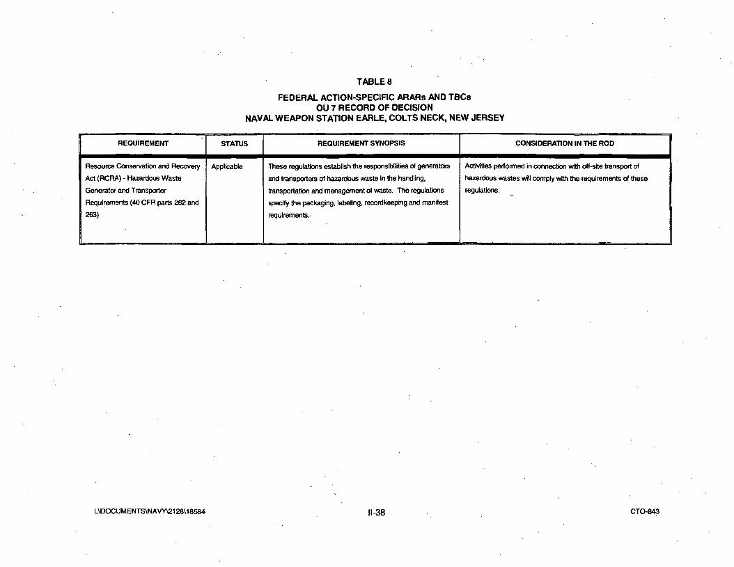
FEDERAL ACTION-SPECIFIC ARARs AND TBCsOU 7 RECORD OF DECISION
NAVAL WEAPON STATION EARLE, COLTS NECK, NEW JERSEY
REQUIREMENT STATUS REQUIREMENT SYNOPSIS CONSIDERATION IN THE ROD
Resource Conservation and Recovery
Act (RCRA) - Hazardous Waste
Generator and Transporter
Requirements (40 CFR parts 262 and
263)
Applicable These regulations establish the responsibilities of generators
and transporters of hazardous waste In the handling,
transportation and management of waste. The regulations
specify the packaging, labeling, recordkeeping and manifest
requirements.
Activities performed in connection with off-site transport of
hazardous wastes will comply with the requirements of these
regulations.
L\DOCUMENTS\N A VY\2128\18584 I-38 CTO-843
TABLE 9
STATE ACTION-SPECIFIC ARARs AND TBCsOU 7 RECORD OF DECISION
NAVAL WEAPON STATION EARLE, COLTS NECK, NEW JERSEY
REQUIREMENT STATUS REQUIREMENT SYNOPSIS COMMENTS
New Jersey Labeling, Records and
Transportation Requirements
(N.J.A.C. 7:26-7)
Applicable These regulations establish the responsibilities of generators
and transporters of hazardous waste In the handling,
transportation and management of waste. The regulations
specify the packaging, labeling, recordkeeping and manifest
requirements.
Activities performed in connection with off-site transport of
hazardous wastes will comply with the requirements of these
regulations.
L\DOCUMENTS\NAVY\2128\18584 II-39 CTO-843
specific Federal and state ARARs identified in Tables 6 and 7. It is expected that Alternative 3 will easily
comply with these ARARs.
3. Action-Specific ARARs
Federal and state action-specific ARARs are listed in Tables 8 and 9, respectively.
The long-term monitoring plan proposed under OU 7 Alternative 3 will comply with Federal, state and
municipal regulations regarding the transportation, storage, labeling and disposal/treatment of generated
waste (liquid and solid). Because this alternative does not include active treatments of the contaminated
groundwater, it is anticipated that generated waste will include purge water and PPE.
4. To Be Considered (TBC) Standards
Federal and state water quality standards, groundwater protection strategies and cleanup criteria were
considered during the development of remedial alternatives for OU 7.
C. Cost-Effectiveness
The Navy and USEPA have determined that the selected remedy for OU 7 is cost effective. There is no
additional cost anticipated to implement OU 7 Alternative 3. Estimated costs to establish the CEA, install
monitoring wells and perform long-term monitoring are included in the funded remediation project for OU 3.
D. Utilization of Permanent Solutions and Alternative Treatment Technologies to the
Maximum Extent Practicable
The Navy and USEPA have determined that the selected remedy represents the maximum extent to
which permanent solutions and treatment technologies can be utilized in a cost-effective manner at OU 7.
E. Preference for Treatment as a Principal Element
The Navy and USEPA have determined that the selected remedy represents the maximum extent to
which permanent solutions and treatment technologies can be utilized in a cost-effective manner at OU 7.
XII. DOCUMENTATION OF SIGNIFICANT CHANGES
No significant changes from the PRAP appear in this ROD.
L\DOCUMENTS\NAVY\2128\19305 ||-40 CTO 843
RECORD OF DECISION
NAVAL WEAPONS STATION EARLE
OPERABLE UNIT 7
PART III - RESPONSIVENESS SUMMARY
The purpose of this Responsiveness Summary is to review public response to the PRAP for OU 7. It also
documents the consideration of comments during the decision-making process and provides answers to any
comments raised during the public comment period.
The Responsiveness Summary for OU 7 is divided into the following sections:
• Overview - This section briefly describes the remedial alternative recommended in the PRAP and any
impacts on the PRAP due to public comment.
• Background on Community Involvement - This section describes community relations activities
conducted with respect to the area of concern.
• Summary of Major Questions and Comments - This section summarizes verbal and written
comments received during the public meeting and the public comment period.
I. OVERVIEW
This Responsiveness Summary addresses public response to the PRAP for OU 7, long-term monitoring and
implementation of LUCs (including a NJDEP CEA). The PRAP and other supporting information are
maintained for public review in the Administrative Record file for OU 7, which is maintained at the Monmouth
County Library-Eastern Branch, Route 35, Shrewsbury, New Jersey.
II. BACKGROUND ON COMMUNITY INVOLVEMENT
This section provides a brief history of community participation in the investigation and interim remedial
planning activities conducted for OU 7. Throughout the investigation period, USEPA and NJDEP reviewed
work plans and reports and provided comments and recommendations which were incorporated into
appropriate documents. A Technical Review Committee (TRC), consisting of representatives from the Navy,
USEPA, the NJDEP, the Monmouth County Health Department and other agencies and local groups
surrounding NWS Earle, was formed. The TRC later was transformed into the RAB to include community
L\DOCUMENTS\NAVY\2128\19305 |||-1 CTO 843
members, as well as the original officials from the TRC. The RAB has been holding periodic meetings to
maintain open lines of communication with the community and to inform all parties of current activities.
On September 29 and 30, 2004 and on October 1,2004, a newspaper notification inviting public comment on
the PRAP appeared in the Asbury Park Press. The public notice summarized the PRAP and the preferred
alternative. The announcement also identified the time and location of the public meeting and specified a
public comment period as well as the address to which written comments could be sent. Public comments
were accepted from October 1, 2004 to October 30, 2004. The newspaper notification identified the
Monmouth County Library - Eastern Branch, Route 35, Shrewsbury, New Jersey as the location of the
Administrative Record.
The public meeting was held on October 5, 2004 at 7:00 PM at the Colts Neck Public Library, 1 Winthrop
Drive, Colts Neck, New Jersey. At this meeting, representatives from the Navy, USEPA and NJDEP were
available to answer questions concerning OU 7 and the preferred alternative. The attendance lists from the
October 5,2004 public meeting is included in Appendix C.
III. SUMMARY OF MAJOR QUESTIONS AND COMMENTS
A. Written Comments
During the public comment period from October. 1, 2004 to October 30, 2004, no written comments were
received from the public pertaining to OU 7. No new comments were received from NJDEP or USEPA.
B. Public Meeting Comments
Questions or comments concerning OU 7 received from the public during the October 5, 2004 public meeting
are presented with the government responsiveness summary in Appendix D.
L\DOCUMENTS\NAVY\2128\19305 |||-2 • CTO843
APPENDIX A
NJDEP CONCURRENCE LETTER
Richard J. Codey Department of Environmental Protection Bradley M- CampbellActing Connor PO Box 402 .
Trenton, NJ 08625-0402
September 12,2005
Ms. Micbele DiGeambeardinoRemedial Project ManagerNaval Facilities Engineering Command10 Industrial HighwayCude 1S21, Mail Slop 82Lester, PA 19113-2090
Dear Ms. DiGeambeardino:
Re: Draft Record of Decision (ROD) for Operable Unit #7Site 26 PCE PlumeNaval Weapons Station EarleColts Neck Twp.,Monihouib=Co.
Tlie New. Jersey s!>fcpMtn^t'^ has reviewed theDecember 2004 draft ROD:prepaied by Tetra Tebh NUS, Inc'.1 on behalf of-Naval Weapons Earle'.for Operable Unit #7 (Site 26 PCE Plume).
The ROD has chosen Natural Attenuation, Institutional Controls and Long Term Monitoring as theremedial alternative for this site. This includes establishing a Classification Exception Area (CEA)to provide official notice that ground water constituent standards will not be met for a specifiedduration and that the use of groundwater in the affected area will be prohibited until such time thatthe groundwater constituent standards are met. A notification will be placed in the Base MasterPlan noting the PCE txceedanoes found in the groundwater.
This particular Operable Unit was originally part of Operable Unit #3 in which an Air Sparging/SoilVapor Extraction Unit (AS/SVE) was installed to address a TCE and DCE plume. As the AS/SVEunit was operating, a PCE plume was found that is partially commingled with the TCE/DCE plume.The PCE was found to come from a different source (on the same site) than the TCE plume. ThePCE plume originates from Building GB-2. The TCE/DCE plume originates from Building GB-1.
The AS/SVE system was installed in January 2001 and has succeeded in removing, the bulk of bothplurnes. Downgradient 'sentry weHs have been-ihstalled to verify.the plume'has not migrated. Todate, VOCs have not been detected in the sentry wells. Quarterly groundwater monitoring andannual evaluation of the AS/SVE system is ongoing.
New Jersey it an Equal Opportunity EmployerRecycled Paper
The NJDEP concurs with the chosen remedial alternative for Operable Unit #7. We appreciate theopportunity to participate in the remedial decision making process.
If you have any questions, please do not hesitate to call Bob Marcolina, of my staff at (609)-633-7237.
RESPONSE TO QUESTIONS AND COMMENTS RECEIVED DURING THE
PUBLIC MEETING HELD ON OCTOBER 5,2004
RESPONSIVENESS SUMMARY
OU 7 ROD (Site 26 PCE Plume)
NAVAL WEAPONS STATION EARLECOLTS NECK, NEW JERSEY
(October 5, 2004 Public Meeting)
Reply to Comments on the OU 7 PRAP
1. A RAB Member referred to a previous presentation slide and asked about groundwater. Did the Navylook at just shallow groundwater or also at the deeper (say 60,100 or 300 feet deep) groundwater quality?Has the Navy checked groundwater quality to the south? Residents have private wells south of the site.
Mr. Turner replied that the Navy has considered deeper groundwater. Partially because of the other OU(3) at the site that has been under a remediation program for several years, the Navy has performedextensive investigations into the groundwater and local geology. A 15-feet-thick impervious clay layer at adepth of about 35 to 50 feet below the ground surface effectively limits contaminant migration to deeperdepths. The Navy sampled groundwater from beneath the clay layer as well from all locations (north,south, east and west) in the upper zone (above the clay layer) to define the extent of the plume. Mr.Marcolina pointed out that the monitoring wells installed outside (including south) of the colored plume onthe presentation slide indicate monitoring wells that were sampled but were found to be contaminant free.
2. A RAB Member mentioned a concern that the head of Shark River is right in the area of this site.
Mr. Turner replied that the groundwater plume and surface water migrate toward a, tributary of theMingamahone creek southwest of the site. The Navy has sampled upstream and dowjijtream from the -site and found that there is no contribution of solvents from the site groundwater to sunace water. Also,
jrf\e Navy installed and sampled a monitoring well on the far side of the stream to be sure thatcontamination is not passing under the stream bed and migrating further south.
3. A member of the public said that he was mainly concerned about how deep the monitoring went at theSite 26 (OU 7 and OU 3) area. How thick is the clay layer and is it impervious? Where could someone(there are two geologists in the family with Master's degrees) review details about the investigation?
Mr. Turner mentioned that the Navy has looked into this issue carefully. Geologists have analyzed resultsfrom numerous studies above, within and below the clay layer. The chlorinated solvents have not enteredor penetrated the clay layer. The clay layer is a typical coastal plain deposit between15 and 25 feet thickdeposited over geologic time and is continuous in the area beneath the OU 7 (and OU 3) contaminationplume. Bob Marcolina added that if someone wants to review the geology in detail, the RemedialInvestigation Report for this site is available at the County Library in Shrewsbury. That document givesthe geology information for each site.
4. A member of the public asked what is the title of the document and how can it be viewed?
Ms. DiGeambeardino explained that the document is called the Remedial Investigation Report for NavalWeapons Station Earle (July 1996) (also see Remedial Investigation Addendum Report, January 1998).These documents are part of the Administrative Record maintained at the County Library in Shrewsbury.Mr. Turner suggested speaking with Mary Jane Kehoe at the library to ask for the "Administrative Recordfor Naval Weapons Station Earle."