Dear NPS 319 Task Force Committee: The Red River Regional Council is pleased to submit to you the revised copy of our 319 NPS Grant Proposal entitled “Red River Riparian Project: High Priority Watersheds in the Lower Red River Basin-Phase V”. There are a few major changes that have been made to our application, particularily with the size of our project area, staff, and budget. We have narrowed the scope of our project area to only include the Park River, Fordville Dam watershed, and the Tolna Coulee subwatershed on the Sheyenne River. Recently, we learned of the NPS Task Force’s approval of the Walsh County SCD’s application for watershed restoration in a portion of the Homme Dam watershed. With their goals in mind, we will work cooperatively with them in addressing riparian needs on the South Branch of the Park River. We will continue to address water quality concerns on the Middle, North, and Main branches of the Park River. The Fordville Dam watershed, and the surrounding impaired river miles surrounding it, is another focus area for riparian improvements. The Fordville Dam reservoir has hyper-eutrophic conditions. A 50% reduction in nutrients of N and P would possibly result in the reservoir being able to meet water quality standards. The Tolna Coulee subwatershed of the Middle Sheyenne River near Pekin, ND will continue to be an area we address. While this may be a small area, there are several livestock producers that would benefit from rotational grazing and off-channel water facility. E. coli is a concern in the larger Middle Sheyenne watershed as it affects Lake Ashtabula. The following is a summary of 319 funding requested: 319 funds needed for Best Management Practices: $ 223,800 Total 319 funds requested: $ 390,315 319 funds needed for other Program objectives: $ 166,515 Thank you for your consideration. Sincerely, Sarah Braaten Johnston Environmental Project Manager Red River Regional Council Enc.
Transcript
Dear NPS 319 Task Force Committee:
The Red River Regional Council is pleased to submit to you the revised copy of our 319 NPS Grant Proposal entitled “Red River Riparian Project: High Priority Watersheds in the Lower Red River Basin-Phase V”. There are a few major changes that have been made to our application, particularily with the size of our project area, staff, and budget.
We have narrowed the scope of our project area to only include the Park River, Fordville Dam watershed, and the Tolna Coulee subwatershed on the Sheyenne River. Recently, we learned of the NPS Task Force’s approval of the Walsh County SCD’s application for watershed restoration in a portion of the Homme Dam watershed. With their goals in mind, we will work cooperatively with them in addressing riparian needs on the South Branch of the Park River. We will continue to address water quality concerns on the Middle, North, and Main branches of the Park River.
The Fordville Dam watershed, and the surrounding impaired river miles surrounding it, is another focus area for riparian improvements. The Fordville Dam reservoir has hyper-eutrophic conditions. A 50% reduction in nutrients of N and P would possibly result in the reservoir being able to meet water quality standards. The Tolna Coulee subwatershed of the Middle Sheyenne River near Pekin, ND will continue to be an area we address. While this may be a small area, there are several livestock producers that would benefit from rotational grazing and off-channel water facility. E. coli is a concern in the larger Middle Sheyenne watershed as it affects Lake Ashtabula.
The following is a summary of 319 funding requested:
319 funds needed for Best Management Practices: $ 223,800
Total 319 funds requested: $ 390,315 319 funds needed for other Program objectives: $ 166,515
Thank you for your consideration.
Sincerely,
Sarah Braaten Johnston Environmental Project Manager Red River Regional Council Enc.
Red River Riparian Project p. 1 of 47
PROJECT TITLE: Red River Riparian Project - High Priority Watersheds in the Lower Red River Basin- Phase V
NAME, ADDRESS, PHONE AND E-MAIL OF LEAD PROJECT SPONSOR/SUBGRANTEE
Coordinate Watershed and RC&D Committee approval of $1,043,305 of 319 Riparian Project cost share funds for BMP’s.
Implement riparian restoration on 75 river miles.
Develop new range/forest Ecological Site Descriptions (ESD), management recommendations & information/ education materials for bottomland hardwood pastures in the Red River Basin.
Red River Riparian Project 2
Total Project Expenditures to Date: Table 1. Total Section 319 Grant Award – June 1, 2008 – September 30, 2014 FY08 Original Section 319 award .................................$ 1,424,966 FY06 Section 319 Funding Reallocation (5/10) ...................109,000 FY08 Section 319 Funding Revision (5/10) ...................... (109,000) FY08 Section 319 Funding Revision (5/11) ...................... (600,000) FY10 Section 319 Funding Reallocation (5/11) ...................400,000 Total Section 319 Funding .................................................1,224,966 Total expended as of August 31, 2013 ........................$1,024,724.57 Table 2. Cumulative Project Expenditures - June 1, 2008 – August 31, 2012
Total .......................................................................$ 1,707,874.28
Local Match/319 Expenditures
Total Section 319 Expenditures: $1,024,724.57
Total Local Match: $ 683,149.71
Total Expenditures: $1,707,874.28
Table 3. Section 319 & Local Match Expenditures
Local cash match for BMPs Producer/sponsor cost share ........................$ 107,066.73 AGSCO ..............................................................4,038.89 Ducks Unlimited ................................................1,000.00 Red River Basin Commission ............................1,920.00 ND Game & Fish Private Land Initiative ..........6,133.34 ND Game & Fish Save Our Lakes Program .........272.67 ND Wetlands Trust ...............................................750.00 Natural Resources Trust .....................................2,500.00 Subtotal .......................................................$ 123,681.63
Red River Riparian Project 3
Local in-kind match for BMPs
Producer/sponsor cost share ........................$ 12,285.86 Local cash match for administration
Lake Agassiz Regional Council .........................3,001.19 NDSU President’s Grant .......................................335.72 Red River Joint Water Resource Districts ............980.40 Red River Basin Commission ............................2,606.43 GFAFB ...............................................................1,670.13 Riparian Field Training .........................................100.00 Subtotal ........................................................$ 8,693.87
Local in-kind match for administration Arbor Day Celebration Attendees ................$ 1,445.97 Producer/Sponsor ...............................................2,000.00 City of Cavalier .....................................................770.00 Landowner Meetings .........................................3,537.53 ND Forest Service ..........................................245,604.55 ND Game & Fish Dept. .....................................1,411.00 NDSU Ctr. For Natural Resources.................161,157.38 ND State Water Commission ...........................11,363.00 Pembina County Water Resource District .........2,119.20 Pembina County Soil Conservation Dist. .............117.99 Pembina County Extension Service ...................1,096.66 Range Tour Participants .....................................2,488.95 Red River Joint Water Resource Districts .........2,306.78 Red River Regional Council and RC&D .........12,401.89 Riparian Advisory Committee ...........................6,801.03 Riparian Kick-Off Meeting Attendees ..................982.80 SWCD TSA-1 ....................................................5,511.72 UND Geology/Geologic Eng. Dept .................37,168.15 Watershed Committees ......................................7,803.82 Subtotal ........................................................$506,088.42
Total Local Match ............................................$650,749.78 Appendix I BMP’s Applied per 12 Digit Hydrologic Unit Code (HUC) as of August 31, 2013. Appendix II Cumulative Section 319 & Producer Expenditures on BMP as of August 31, 2013.
Red River Riparian Project
Red River Riparian Project 4
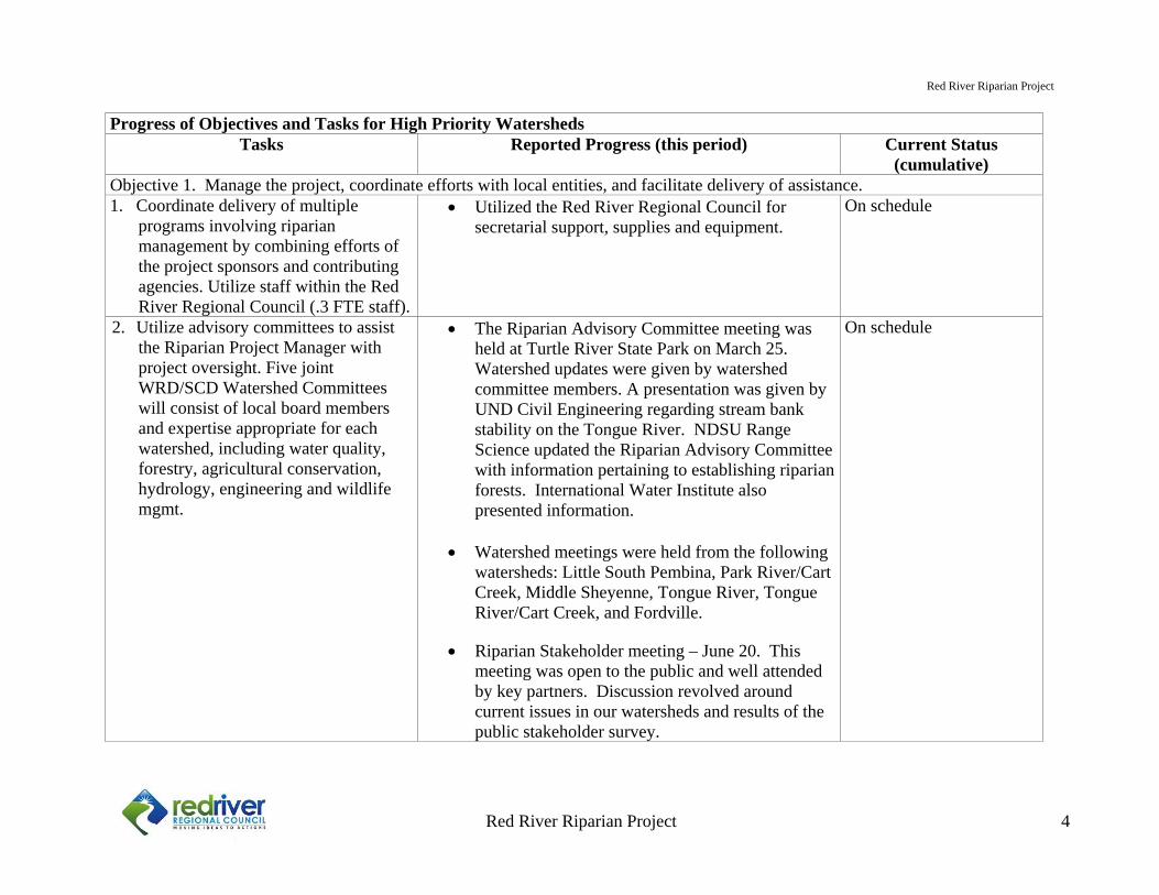
Progress of Objectives and Tasks for High Priority Watersheds
Tasks Reported Progress (this period) Current Status (cumulative)
Objective 1. Manage the project, coordinate efforts with local entities, and facilitate delivery of assistance. 1. Coordinate delivery of multiple
programs involving riparian management by combining efforts of the project sponsors and contributing agencies. Utilize staff within the Red River Regional Council (.3 FTE staff).
Utilized the Red River Regional Council for secretarial support, supplies and equipment.
On schedule
2. Utilize advisory committees to assist the Riparian Project Manager with project oversight. Five joint WRD/SCD Watershed Committees will consist of local board members and expertise appropriate for each watershed, including water quality, forestry, agricultural conservation, hydrology, engineering and wildlife mgmt.
The Riparian Advisory Committee meeting was held at Turtle River State Park on March 25. Watershed updates were given by watershed committee members. A presentation was given by UND Civil Engineering regarding stream bank stability on the Tongue River. NDSU Range Science updated the Riparian Advisory Committee with information pertaining to establishing riparian forests. International Water Institute also presented information.
Watershed meetings were held from the following watersheds: Little South Pembina, Park River/Cart Creek, Middle Sheyenne, Tongue River, Tongue River/Cart Creek, and Fordville.
Riparian Stakeholder meeting – June 20. This meeting was open to the public and well attended by key partners. Discussion revolved around current issues in our watersheds and results of the public stakeholder survey.
On schedule
Red River Riparian Project
Red River Riparian Project 5
Progress of Objectives and Tasks for High Priority Watersheds Tasks Reported Progress (this period) Current Status
(cumulative)3. Provide project management and
riparian technical assistance to landowners.
Directly assist landowners with the protection and effective management and restoration of targeted river reaches within high priority watersheds of the Lower Red River Basin of ND.
Subcontract with the NDFS (0.95 FTE) to develop 90 riparian management plans with coordination of range and engineering technical assistance.
Technical assistance was provided to 27 landowners.
6 Forest Stewardship Plans (FSP) were completed
by the North Dakota Forest Service.
Two projects were implemented during this project period, and numerous others are in the planning stages.
Project management was provided for each project
by the Riparian Project Manager.
North Dakota Forest Service gave notice of the discontinuation of their contract in February 2013. Technical assistance and financial match for the project was pulled. The dedicated match that the NDFS provided the Riparian Project was no longer available as they dedicate that match to another project. Work halted on forest stewardship plans with the resignation of Dave Nowatzki that same month.
Behind schedule
Red River Riparian Project
Red River Riparian Project 6
Progress of Objectives and Tasks for High Priority Watersheds Tasks Reported Progress (this period) Current Status
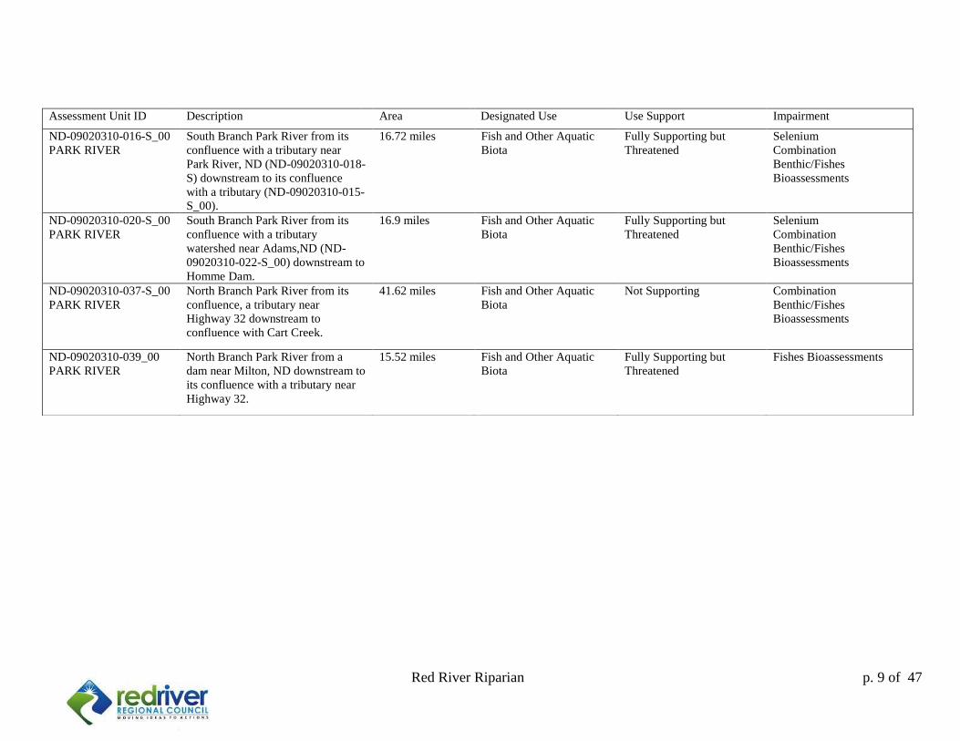
(cumulative)Objective 2. Indentify river reaches in high priority watershed to target for restoration, including seven 303(d) reaches and two additional reaches with severe riparian impairments.
4. Augment current prioritization of project work area with additional GIS data layers including Upper Midwest Aerospace Consortium (UMAC) and landowner surveys for targeting river reaches for riparian restoration. Maximize water quality benefits for riparian restoration by focusing on riparian restoration efforts.
NDFS completed GIS data In Spring 2013, the Riparian Project conducted a
special survey of stakeholders who live or farm along river land in all of the targeted watersheds. Surveys also sent to county commissions, water boards, townships, and natural resource managers. Survey allowed for continued targeting of areas of most critical need after series of three floods this past spring.
Completed
Objective 3. Provide technical and financial assistance to restore, protect and manage riparian areas along a minimum of 75 river miles in the Red River Basin.
5. Provide financial cost sharing assistance to landowners. Develop BMPs for riparian management, grazing management, windbreak plantings and bio-engineering.
Coordinate Watershed and Riparian
Committee approval of $1,046,905 of 319 Riparian Project cost share funds for BMP’s
Cost share provided to landowners: $ 27,062.27 Total project cost: $ 45,103.79
Stream bank stabilization implemented at the
Fedje property in Cavalier, ND in the Tongue River Watershed.
Off-channel watering system installed on the
Middle Sheyenne River near Tolna, ND. System was comprised of a well with two flow through troughs and 150 ft of pipe.
On Schedule
Red River Riparian Project
Red River Riparian Project 7
7. Develop Contract for Services
agreements for range technical assistance including consultation with ranchers and the development of educational media.
Last year, the obligations for these tasks were fulfilled. Technical assistance has been provided by NDSU towards the project in the form of both riparian grazing brochures and the consultation with area farmers with cattle in the Middle Sheyenne River Watershed.
We continue to work with Kevin Sedivec, NDSU Extension Grazing Specialist. He provides rotational grazing advice to farmers.
NDSU was approved for additional funds for site
suitability/soil sampling determinations for tree plantings on riparian sites. They continue to monitor and maintain the riparian tree establishment demonstration sites as well. They are set to complete their work May 2014.
Completed
Table 6. Progress of Objectives and Tasks for High Priority Watersheds
Tasks Reported Progress (this period) Current Status (cumulative)
6. Develop Contract for Services agreements for: 1) Engineering services, including surveying, drafting, restoration design and construction oversight; 2) Hydrology & hydraulics study and report on Cart Creek in cooperation with the SWC and NRCS planning staff.
K2S provided engineering services to the Riparian Project through an agreement with NDDH.
UND Study on the hydrology on the Tongue River from Renwick Dam was completed in January 2013.
Cart Creek Study completed in 2009
Completed
Red River Riparian Project
Red River Riparian Project 8
Objective 4. Increase understanding of riparian ecosystems and riparian management methods focused towards restoration/management of riparian functionality and sustainability in the Lower Red River Basin.8. Instill ownership and provide
stewardship of river reaches through support of local school and volunteer group involvement in restoration implementation & monitoring activities.
Provide technical support for local secondary school curriculums, volunteer groups, or agencies.
September 2012: Eco-Ed water quality seminar presented at Icelandic State Park for Pembina County Soil Conservation District
October 2012: Stream table demonstration booth offered educational opportunities at the Walsh County Fair for two days.
On schedule
9. Develop a Contract for Services agreement to develop new range/forest ecological site descriptions and management recommendations for bottomland hardwood pastures of the Red River Basin.
Completed Completed
Red River Riparian Project
Red River Riparian Project 9
10. Inform and educate basin stakeholder and natural resource professionals on the benefits of healthy riparian areas to influence land management choices that result in measureable watershed health improvements. Develop information and education materials for approved RAC recommendations.
Public stakeholder meeting June 20, 2013 provided educational materials to attendees regarding local watersheds and riparian health.
Educational booth at the Red River Basin Commission.
Riparian Field Tour was open to the public in
August of 2012.
Workgroup meetings are held in Pembina county to discuss riparian and agricultural impacts on the watersheds.
Pembina River Basin Advisory Board presentation.
Networking with natural resources partners
including ND Game and Fish Department, US Fish and Wildlife, NRCS, Great Plains Fish Habitat Partnership, National Wild Turkey Federation, Red River Basin Commission, International Water Institute, North Dakota Forest Service, ND Soil Conservation Districts, MN Department of Natural Resources, and many others.
On schedule
Red River Riparian Project 10
Local Recommendations and Comments
Sarah Braaten Riparian Project Manager The climate conditions of 2013 were much different than we had expected following the drought of 2012, which left us in a hydrologic deficit. The drought of 2012 resulted in a drawdown of water tables and base flows on our streams. Local residents took interest in what the bottom of the rivers looked like. Conditions were much different come spring of 2013. Flooding hit the region in the first week of May with the first flood, which was comprised of runoff from a deep snowpack in the Red River Valley. Flooding occurred again in the third week of May, when heavy rains hit the area and resulted in the widespread overland flooding of the Red, Pembina, Tongue, Forest and Park River watersheds. Renwick Dam became threatened by a potential dam breach due to high flows on the Tongue River. Only two weeks thereafter, an additional flood occurred, resulting in a third crest for the region’s rivers. Stream banks that were no longer able to handle saturation and inundation collapsed. Trees tipped into streams taking the bank with them. Scoured banks resulted from repeated high flows, and stream channels in some locations migrated in their longitude. Stream flows have been high in the northern watersheds of the Pembina and Tongue Rivers, with discharges of around 400 cfs on the Pembina River in August. We continue to work with the conditions that we are given, wet or dry, to restore riparian areas and water quality. The past year has been a busy year with much success in the areas of education of landowners. We have spent many hours with landowners, educating them one on one with what is happening to their stretch of the river and what can be done to help the riparian areas and water quality. While many landowners agree with recommended strategies for effective riparian management, many are at a loss in being able to implement those recommendations. Sometimes the recommendations become impractical when cost is factored in. Sometimes there are issues in getting a qualified contractor who will do the job for the cost that is estimated. Sometimes we just don’t have a long enough project season for those farmers who don’t have time to implement projects and farm at the same time. With these ways projects can fall to the wayside, this spring I asked local stakeholders to answer a few questions pertaining to project planning and implementation. A majority of the demographic who answered are currently farming or having farmed in the past (71.5%) of 130 respondents. Here are the questions we asked and the answers we received:
Red River Riparian Project 11
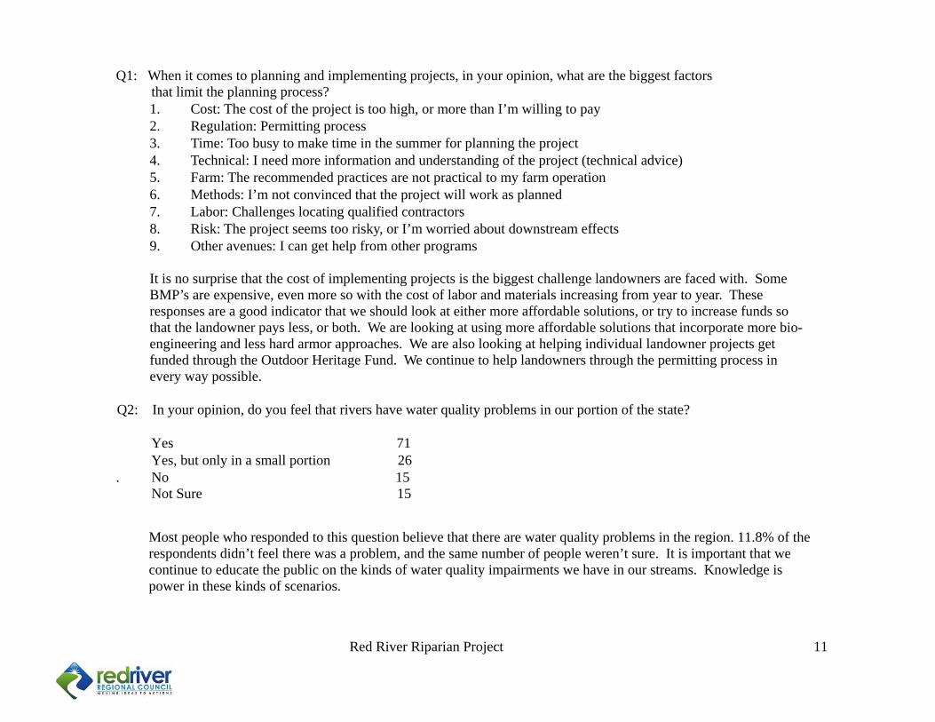
Q1: When it comes to planning and implementing projects, in your opinion, what are the biggest factors that limit the planning process?
1. Cost: The cost of the project is too high, or more than I’m willing to pay 2. Regulation: Permitting process 3. Time: Too busy to make time in the summer for planning the project 4. Technical: I need more information and understanding of the project (technical advice) 5. Farm: The recommended practices are not practical to my farm operation 6. Methods: I’m not convinced that the project will work as planned 7. Labor: Challenges locating qualified contractors 8. Risk: The project seems too risky, or I’m worried about downstream effects 9. Other avenues: I can get help from other programs It is no surprise that the cost of implementing projects is the biggest challenge landowners are faced with. Some BMP’s are expensive, even more so with the cost of labor and materials increasing from year to year. These responses are a good indicator that we should look at either more affordable solutions, or try to increase funds so that the landowner pays less, or both. We are looking at using more affordable solutions that incorporate more bio-engineering and less hard armor approaches. We are also looking at helping individual landowner projects get funded through the Outdoor Heritage Fund. We continue to help landowners through the permitting process in every way possible.
Q2: In your opinion, do you feel that rivers have water quality problems in our portion of the state? Yes 71
Yes, but only in a small portion 26 . No 15 Not Sure 15
Most people who responded to this question believe that there are water quality problems in the region. 11.8% of the respondents didn’t feel there was a problem, and the same number of people weren’t sure. It is important that we continue to educate the public on the kinds of water quality impairments we have in our streams. Knowledge is power in these kinds of scenarios.
Red River Riparian Project 12
Best management practices that received the most votes are listed starting at 1. The Riparian Project will continue to work on reducing sediment loading by continuing to tackle stream bank erosion. Bank stabilization and enhancements of riparian zone vegetation continue to be approaches taken to reduce sediment inputs into streams. Property continues to be damaged by flooding and stream bank erosion. Great care is taken in determining whether or not a riparian project is an appropriate solution for projects that concern inhabitable structures. K2S Engineering is helpful in providing guidance in making these determinations.
Q3: What best management practices or riparian improvements would you like to see the Riparian Project continue to work on?
1. Stream bank stabilization through vegetation, bio-engineering and root wads 2. Erosion control through vegetative buffers 3. Tree and shrub plantings 4. Cribwall structures for streambank stabilization 5. Sediment capture through conifer revetments 6. Enhancing riparian vegetation through planting native plants 7. Deer exclusion fencing for tree plantings 8. Off-site livestock watering/exclusion fencing/grazing assistance
9. Installation of lunkers for fish habitat
Red River Riparian Project 13
APPENDIX I
Red River Riparian Project 14
APPENDIX II
1
Red River Riparian Project p. 1 of 34
Appendix II
RIPARIAN PROJECT SUBCONTRACTOR
AND COOPERATORS
Cooperators
Walsh County Soil Conservation District Pembina County Soil Conservation District Grand Forks County Soil Conservation District Nelson County Soil Conservation District Cavalier County Soil Conservation District Walsh County Water Resources Board Pembina County Water Resources Board Grand Forks County Water Resources Board Nelson County Water Resources Board Cavalier County Water Resources Board Red River Joint Water Board
North Dakota Department of Health North Dakota Game and Fish Department North Dakota State Water Commission
Cooperators Natural Resources Conservation Service Environmental Protection Agency U.S. Army Corps of Engineers U.S. Fish and Wildlife Service Red River Basin Commission Pembina River Basin Advisory Board Great Plains Fish Habitat Partnership International Water Institute “Riverwatch” National Wild Turkey Federation North Dakota Forest Service North Dakota State University Extension Service- Range Sciences North Dakota Natural Resources Trust
2
Red River Riparian Project p. 2 of 34
Appendix III
Red River Regional Council Project Support Technical Fees
The Red River Riparian Project was recently provided approval to use a fee for service structure
by the North Dakota Department of Health. The Red River Regional Council adopted the
following fee policy for the Red River Riparian Project, starting in December 2013. The fee
structure will generate funds to support the planning and implementation of projects.
Each client receives a free consultation visit to their site. Here we provide technical assessment
of the issues taking place, and provide BMP options to the client. After this visit has taken place,
the client applies to the program for project assistance and the application fee is collected. This
step will help to gauge and secure client buy-in to the project, hopefully allowing for a higher rate
of BMP implementation. See “Application Fees” below.