Reed Maxwell 1,2,3 Ian Ferguson 1,3 Shadi Moqbel 1,3 John Williams 1,2,3 Steven Meyerhoff 1,2,3 Erica Siirila 1,2,3 1 Department of Geology and Geologic Engineering 2 Hydrologic Science and Engineering Program 3 International Groundwater Modeling Center Water and Climate Modeling
Transcript
Reed Maxwell1,2,3
Ian Ferguson1,3
Shadi Moqbel1,3
John Williams1,2,3
Steven Meyerhoff1,2,3
Erica Siirila1,2,3
1Department of Geology and Geologic Engineering2Hydrologic Science and Engineering Program3International Groundwater Modeling Center
Water and Climate Modeling
LSM
LSM
LSM
LSM
LSMLSM
LSM
LSM
LSM
LSM
We use the coupled model PF.CLM
Groundwater
Land Surface• PF.CLM= Parflow (PF) +
Common Land Model (CLM) Kollet and Maxwell (2008), Kollet and Maxwell (2006), Maxwell and Miller (2005), Dai et al. (2003), Jones and Woodward (2001); Ashby and Falgout (1996)
• Surface and soil column/root zone hydrology calculated by PF (removed from CLM)
• Overland flow/runoff handled by fully-coupled overland flow BC in PF (Kollet and Maxwell, AWR, 2006)
• CLM is incorporated into PF as a module- fully coupled, fully mass conservative, fully parallel
Dynamically coupled, 2D/3D OF/LS/GW Model
Root Zone
Flow DivideAir
Flo
w L
ines
Vadose ZoneWater Table
Routed Water
Vegetation
Atmospheric Forcing
Fully-coupled, HPC Model of the Hydrologic cycle.
Only “bedrock to top of the atmosphere” model in existence
•PF.WRF•ParFlow: parallel watershed model•Weather Research and Forecast (WRF) Community Mesoscale Atmospheric Model (NCAR)
•Multi-institutional, Interdisciplinary team
•Significant previous coupled model experience
This fully coupled model predicts variations in watershed response driven by atmospheric forcing and feedbacks.
Stochastic Heterogeneous Hillslope ModelingMethods1.Ensembles of heterogeneous permeability generated through Turning Bands algorithm
1.Using ParFlow, we model surface runoff and infiltration after a rain storm
2.Particle Tracking methods will be used to determine travel times of rain particles on surface and in subsurface
Permeability Pattern
Initial Water Table location
Different saturation patterns based on heterogeneity
Sponsor: NSF Hydrologic Sciences
Goals
1.Determine impacts of heterogeneous permeability on dispersion
2.Compare baseflow cases to non-baseflow cases
3.Generate accurate hydrograph separation
4.Upscale processes and parameters to larger scale model
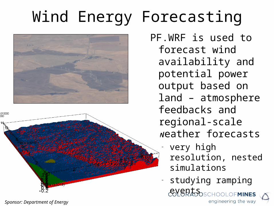
Wind Energy ForecastingPF.WRF is used to forecast
wind availability and potential power output based on land – atmosphere feedbacks and regional-scale weather forecasts
– very high resolution, nested simulations
– studying ramping events
Sponsor: Department of Energy
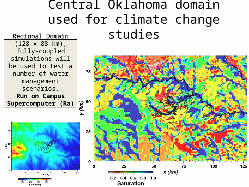
Central Oklahoma domain used for climate change studies
Regional Domain (128 x 88 km), fully-coupled
simulations will be used to test a number of water management
scenarios.Run on Campus
Supercomputer (Ra)
Regional Domain (128 x 88 km), fully-coupled
simulations will be used to test a number of water management
scenarios.Run on Campus
Supercomputer (Ra)
Natural Pumping for Non-Local Consumptive Use
Qgw
Qgw
QirrigQirrig
Pumping for Local Irrigation
Irrigation with Imported Water
Water Management and Local Climate Feedbacks
Impacts of groundwater pumping and irrigation on watershed processes and feedbacks on surface energy balance, land-atmosphere interactions, and local and regional climate
P ET
Q
PET
Q
P ET
Q
P ET
Q
Sponsor: IDB
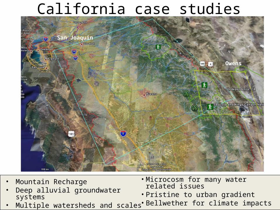
California case studies
• Mountain Recharge• Deep alluvial groundwater systems• Multiple watersheds and scales
• Microcosm for many water related issues• Pristine to urban gradient• Bellwether for climate impacts
Owens
San Joaquin
Central Valley Simulations
Very large (270 x 220 km), fully-coupled
simulations of the San Joaquin Watershed.
Very large (270 x 220 km), fully-coupled
simulations of the San Joaquin Watershed.
Fully-integrated model:
Deep GroundwaterSurface WaterLand Surface
processes
Fully-integrated model:
Deep GroundwaterSurface WaterLand Surface
processes
Sponsor: Department of Energy
Drinking Water Risk Assessment of CO2 leakage
Large, integrated project to determine drinking water risk from CO2 leakage (and byproducts) into groundwater.
End-to-end approach, including experiments and model simulations to indentify high and low risk leakage scenarios
Stochastic, highly resolved approach, combining physical and geochemical heterogeneity via Lagrangian approach