38
Refining and Updating the Wetland Protection Status in the Saginaw Bay Coastal Plain FINAL REPORT June 2012 Submitted to: NOAA Restoration Center Award Number: NA10NMF4630093 Submitted by:

Refining and Updating the Wetland Protection Status in the Saginaw Bay Coastal Plain
FINAL REPORT June 2012
Submitted to:
NOAA Restoration Center Award Number: NA10NMF4630093
Submitted by:
TABLE OF CONTENTS
TABLE OF CONTENTS ................................................................................................................ 2 ACKNOWLEDGEMENTS ............................................................................................................ 3 DISCLAIMER ................................................................................................................................ 3 INTRODUCTION .......................................................................................................................... 4 PROJECT AREA ............................................................................................................................ 5 METHODS ..................................................................................................................................... 6
Updated 585 foot contour (Saginaw Bay Coastal Plain) ............................................................ 6 Updated Conservation and Recreation Layer (CARL) ............................................................... 6 Analysis of wetland conversion since 1980, 1998, and 2005 ..................................................... 6 Analysis of protected wetlands within the Saginaw Bay Coastal Plain ...................................... 7 Analysis of priority wetlands protected in the Saginaw Bay Coastal Plain ................................ 7
RESULTS ....................................................................................................................................... 8 Analysis of wetland conversion since 1980, 1998, and 2005 ..................................................... 8 Analysis of protected wetlands within the Saginaw Bay Coastal Plain .................................... 10 Original analysis of protected wetlands ................................................................................... 10 Updated analysis of protected wetlands ................................................................................... 10 Explanation of differences in analysis ...................................................................................... 13 Analysis of priority wetlands protected in the Saginaw Bay Coastal Plain .............................. 16
REFERENCES ............................................................................................................................. 19 APPENDIX A: Protected areas within the Saginaw Bay Coastal Plain ....................................... 20 APPENDIX B: Landowners of Highest Priority Unprotected Wetlands ..................................... 33
Ducks Unlimited, Inc. 2 May 2012

ACKNOWLEDGEMENTS Funding for this project was provided by the NOAA Restoration Center. This project could not have been accomplished without the past work on the Great Lakes Conservation and Recreation Lands (CARL) GIS layer and the NWI Update for Michigan. The CARL project was funded by grants from the U.S. Fish and Wildlife Service’s Great Lakes Coastal Program, the Saginaw Bay Watershed Initiative Network (WIN), and the U.S. Endowment for Forestry and Communities (National Conservation Easement Database - NCED). The NWI Update for Michigan was funded by Michigan Department of Environmental Quality’s Land and Water Management Division and Coastal Management Program; United States Fish and Wildlife Service: Great Lakes Coastal Program, Upper Mississippi River - Great Lakes Joint Venture, Region 3; United States Environmental Protection Agency, Great Lakes National Program Office and the USDA Forest Service. Ducks Unlimited would also like to acknowledge and thank the many organizations that willingly gave us data for the development of the Great Lakes CARL and NCED layer.
DISCLAIMER This project has been funded wholly or in part by public funds (federal, state, and local). The contents of this document do not necessarily reflect the views and policies of the federal, state or local agencies, nor does mention of trade names or commercial products constitute endorsement or recommendation for use. Ducks Unlimited, Inc. makes no representation or warranty of any kind regarding this material, data and information, including, but not limited to, the accuracy of the material, data and information or its suitability for any purpose. All use of the material, data and information is at the user’s sole risk. By using any of this material, data and information, the user agrees that Ducks Unlimited, Inc. is not responsible for their use of the material, data and information or the results thereof. The Great Lakes CARL layer is a work in progress and may contain both location and attribute errors. In addition, there will be conservation and recreation lands that have not been captured in this layer. Ducks Unlimited is continuing to work on updating this layer. Please contact Robb Macleod at 734-623-2000 or [email protected] if you have updates or additional information that can be added to this layer.
For additional information about the project, reports, or maps, please contact: Ducks Unlimited, Inc., Great Lakes/Atlantic Regional Office, 1220 Eisenhower Place, Ann Arbor, MI 48108, (734)-623-2000.
Ducks Unlimited, Inc. 3 May 2012
INTRODUCTION The Saginaw Bay contains one of the largest areas of freshwater marsh in the world. The 585 foot contour line has been identified as the “boundary” of the area lakeward in which the Michigan Department of Natural Resources (MDNR) would restore coastal wetlands and lake plain prairie within Saginaw Bay if the opportunity was available (Douglas Reeves, MDNR, personal communication, July 2002). The Saginaw Bay Coastal Plain (defined by the definition above for the purposes of this project) is also a highly productive agricultural area, where many of the original wetlands have been converted. The primary goal for wildlife and fish habitat protection and restoration within the Saginaw River/Bay Area of Concern (AOC) is to identify and protect existing high-quality habitat sites as well as the ecosystem processes required to sustain such areas. A secondary goal is to implement strategies that will restore wetlands―particularly high-value coastal marshes and wet-prairie areas―to partially mitigate significant losses of these habitats that have occurred over the last 150 years. This project will assist in meeting these goals by identifying protected wetlands within the Saginaw Bay Coastal Plain, evaluating changes in the extent and distribution of wetlands within the Coastal Plain from 1980, 1998 and 2005, and identifying high priority wetlands that are currently unprotected.
This project is expected to assist with making progress toward the delisting of at least two Beneficial Use Impairments (Loss of Fish and Wildlife Habitat and Degradation of Fish and Wildlife Populations). The project will indirectly benefit economically important species/groups such as waterfowl, wetland birds (including king rail (SE), trumpeter swan (ST), common moorhen (ST), least bittern (ST), Caspian tern (ST), common tern (ST), American bittern (SC), black tern (SC), Forster’s tern (SC), black-crowned night heron (SC), yellow-headed blackbird (SC), marsh wren (SC), bald eagle (SC), northern harrier (SC)), reptiles (including eastern fox snake (SE) and Blanding’s turtle (SC)), amphibians, mollusks, and mammals.
Ducks Unlimited, Inc. 4 May 2012

PROJECT AREA The project area is the area lakeward of the 585 foot contour to the shoreline of Saginaw Bay, loosely defined as the Saginaw Bay Coastal Plain (Fig. 1). This area represents the boundary in which the MDNR would restore coastal wetlands and lake plain prairie within Saginaw Bay if the opportunity was available. The shoreline of Saginaw Bay is defined for this project by the parcel (ownership) boundary and the Saginaw Bay.
Figure 1: Project Area Boundaries
Ducks Unlimited, Inc. 5 May 2012
METHODS
Updated 585 foot contour (Saginaw Bay Coastal Plain)
In 2002, Ducks Unlimited (DU) created a 585 foot contour based on USGS National Hydrography Dataset (NHD) Digital Elevation Models (DEM) (a merge of 90 meter and 30 meter DEMs) to create the 585 foot contour. The original protected wetland analysis used this contour as the basis for the delineation of the Saginaw Bay Coastal Plain. Currently there are much better DEMs available based on LiDAR data and 10-meter NHD DEM. The LiDAR and 10-meter NHD DEM data was collected from the USGS. Arenac and Bay counties recently had lidar data produced, which USGS integrated into their National Elevation Dataset (NED) as a 3-meter DEM. The 3-meter DEM data was not available for Saginaw, Tuscola, and Huron counties, so 10-meter DEMs from the National Elevation Dataset (NED) were used for the contour analysis. The 3m DEMs were mosaicked together and the 10m DEMs were mosaicked together and then both were reclassified where anything 178 m (585 ft) and below was encoded with a ‘1’ and anything above 178 m was encoded with a ‘0’. The line between the two sections was digitized to create the 585 contour line. A shoreline dataset was created from parcel data obtained from the counties within the study area. This dataset was combined with the newly created 585 contour line to generate a polygon that encompassed the area between the 585 contour and the shore.
Updated Conservation and Recreation Layer (CARL) The CARL data layer was updated with data from the National Conservation Easement Database (NCED) (see www.conservationeasement.us) and conservation easement data from the Michigan DEQ, the Saginaw Basin Land Conservancy, and the U.S. Fish and Wildlife Service. The CARL layer was then clipped to the Saginaw Bay Coastal Plain. Recreation properties labeled as country clubs or golf courses were excluded from the data subset. Properties held by Consumers Energy were also excluded from the dataset because they were not permanently held conservation easements. Updates from the Michigan Department of Natural Resources were not added because they were not available at the time of the analysis.
Analysis of wetland conversion since 1980, 1998, and 2005 Ducks Unlimited has updated the National Wetlands Inventory for Michigan using imagery from 1998 and 2005. The update tracked the changes in wetlands over these three time periods (see http://www.ducks.org/conservation/glaro/gis-nwi-update). The wetlands layer was clipped to the Saginaw Bay Coastal Plain and grouped into six categories based on the Cowardin classification code: open water (UB or US codes), aquatic bed (AB), emergent (EM), forested (FO), scrub-shrub (SS), and mixed (for any combination of mixed classes, since it would be hard to definitively put them in one category or another). The data was queried by year, conversion type, whether it was partially or fully converted, and by wetland type to determine how many acres of wetlands were converted between 1980 and 1998, and 1998 and 2005. This data is presented in
Ducks Unlimited, Inc. 6 May 2012

Table 1. Then, the acreage of partially converted wetlands was determined by clipping out the newer intersecting wetlands from the partially converted wetlands layer. This acreage was added to the acreage for the fully converted wetlands. The acreage for additionally created wetlands was found by spatially selecting the wetlands with a more recent image date (1998 and then 2005) that did not intersect the previously existing wetlands. This was added to the “additions” row of Table 1. Lastly, the rows were totaled up to determine which wetland classes saw the most net gain and loss between 1980 and 2005.
Analysis of protected wetlands within the Saginaw Bay Coastal Plain A definition query was applied to the NWI to exclude any wetlands that were no longer in existence (“inactive” wetlands). Then the NWI and CARL layers were intersected to create a layer of protected lands based on wetland classification. A field was added to the attribute table of this layer to group the wetland classifications into the six categories, mentioned above. Acres were recalculated for the data layer, since the CARL polygons had been split up into smaller polygons for each wetland class. The Summary Statistics tool in ArcToolbox was used to do a multiple summarization and produce a table of the total number of acres based on both the managing agency type (federal, state, local, etc.) and the wetland class. These values were entered in a two-dimensional table. Total numbers of acres per wetland class and per managing agency type were taken from the NWI subset and CARL subset, respectively. The total number of unprotected acres was found by taking the total number of wetland acres and subtracting the protected acres.
Analysis of priority wetlands protected in the Saginaw Bay Coastal Plain In order to give a protection priority status to each wetland in the study area, the NWI layer was spatially joined with the Saginaw Bay Coastal Wetland Protection Priority Analysis layer (Schools 2009). The resulting layer was intersected with the CARL layer to give the amount of wetlands protected in each of the status categories (moderate, high, highest priority) and to identify priority wetlands that are not currently protected.
Ducks Unlimited, Inc. 7 May 2012

RESULTS
Analysis of wetland conversion since 1980, 1998, and 2005 Overall, there was a net increase of 67 acres of wetlands between 1980 and 2005, which is a 0.2% increase (Table 1). This increase occurred between 1998 and 2005, with an increase of about 400 acres, compared to a net loss of about 340 acres between 1980 and 1998. The wetland category that saw the most growth was the emergent class, with a net increase of nearly 480 acres over the total time span. The forest and aquatic bed classes showed minor gains, with around 9 acres and 0.35 acres, respectively. Two examples of gains in the emergent wetland class are from the Conservation Reserve Enhancement Program (CREP) and Wetlands Reserve Program (WRP) (Figures 1 and 2).
Table 1: The change in wetland acreage between the 1980s, 1998, and 2005
The largest wetland losses over this period were in the open water class, with a net loss of 216 acres. The other categories that had net losses were the scrub/shrub class, with about 125 acres converted, and the mixed class, with about 83 acres converted.
Ducks Unlimited, Inc. 8 May 2012

Figure 1. An example of an emergent wetland restoration (CREP program) that was protected by a conservation easement held by Saginaw Basin Land Conservancy.
Figure 2. An example of an emergent wetland restoration (WRP program) that was protected by a conservation easement held by the Natural Resources Conservation Service.
Ducks Unlimited, Inc. 9 May 2012

Analysis of protected wetlands within the Saginaw Bay Coastal Plain
Original analysis of protected wetlands The results of the original analysis showed 58% of the wetlands were protected in the Saginaw Bay Coastal Plain (Table 2). This table was produced with the original 585 contour and an older version of CARL. The older version of CARL used the acquisition boundary for the U.S. Fish and Wildlife Service, not the actual ownership boundary and therefore inflated the acreage number for the Federal category. The 2005 version of the NWI wetlands was used for this analysis; however, slight modifications have been made to the wetlands since the analysis (180 acres).
Table 2: 2005 Analysis of Wetland Protection
Updated analysis of protected wetlands The results of the updated analysis showed 60% of the wetlands are protected in the Saginaw Bay Coastal Plain (Table 3 and Fig. 2). There was a noticeable decrease in protection acres from the Federal category mostly due to the U.S. Fish and Wildlife Service boundaries described above. There was a substantial increase in the number of protected wetland by non-government organizations (936 additional acres protected). The difference in the contour delineation between the two time periods caused slight differences in the number of acres protected. It is also important to note that the Michigan Department of Natural Resources is currently updating their parcel boundaries, but this data was unavailable at the time of this analysis. Appendix A lists all of the protected lands used in this analysis.
Ducks Unlimited, Inc. 10 May 2012
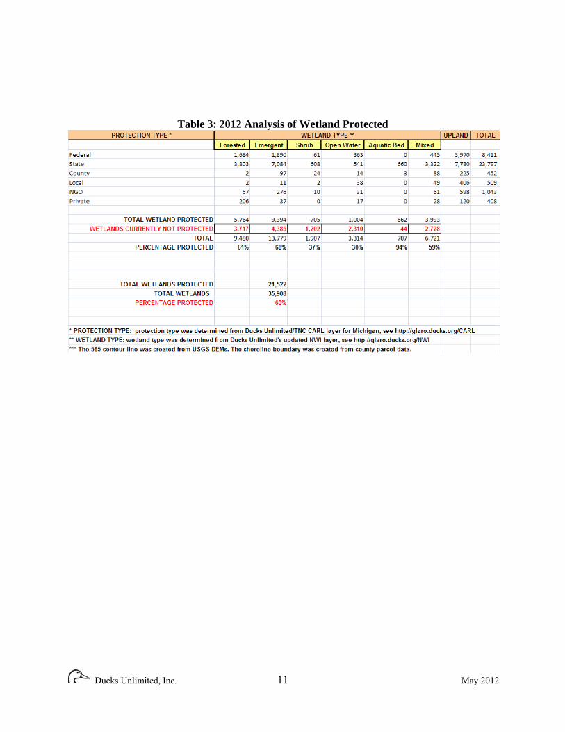
Table 3: 2012 Analysis of Wetland Protected
Ducks Unlimited, Inc. 11 May 2012

Figure 2: Protected Wetlands Map Note: This map does not show sensitive conservation lands.
Ducks Unlimited, Inc. 12 May 2012
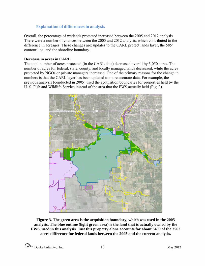
Explanation of differences in analysis Overall, the percentage of wetlands protected increased between the 2005 and 2012 analysis. There were a number of chances between the 2005 and 2012 analysis, which contributed to the difference in acreages. These changes are: updates to the CARL protect lands layer, the 585’ contour line, and the shoreline boundary. Decrease in acres in CARL The total number of acres protected (in the CARL data) decreased overall by 3,050 acres. The number of acres for federal, state, county, and locally managed lands decreased, while the acres protected by NGOs or private managers increased. One of the primary reasons for the change in numbers is that the CARL layer has been updated to more accurate data. For example, the previous analysis (conducted in 2005) used the acquisition boundaries for properties held by the U. S. Fish and Wildlife Service instead of the area that the FWS actually held (Fig. 3).
Figure 3. The green area is the acquisition boundary, which was used in the 2005 analysis. The blue outline (light green area) is the land that is actually owned by the
FWS, used in this analysis. Just this property alone accounts for about 3400 of the 3563 acres difference for federal lands between the 2005 and the current analysis.
Ducks Unlimited, Inc. 13 May 2012

The newly updated 585’ contour line Some changes in acreages are due to the changes in the 585’ contour. Figure 4 shows the boundary for the Bay City State Recreation Area is the same between the 2005 and current CARL layers; however, a small section on the lower left corner was included in the original analysis but has been excluded from the current analysis because it is outside of the updated contour line (shown in yellow).
Figure 4. Changes in the 585 foot contour
The changes in the 585 foot contour also changed the acreage of the wetlands (Fig. 5). The updated contour line excluded some wetlands that were included in the 2005 analysis and included other wetlands that were previously excluded. In the image below, the lime green area was included in the current analysis, while the purple area is the portion of the same wetland that was used in the 2005 analysis.
Ducks Unlimited, Inc. 14 May 2012

Figure 5. The changes in wetland acreage base on the updated contour (lime green
area was included in the current analysis, while the purple area is the portion of the same wetland that was used in the 2005 analysis)
Changes in the shoreline boundary For the 2012 analysis, a new shoreline boundary shapefile was created based on the parcel boundaries obtained from the counties. In the previous analysis, a shapefile from the DEQ had been used to determine the shoreline of the lake. However, this included wetlands in the analysis that were outside of the parcel boundary. Since there are not parcels on these wetlands, they cannot be owned and/or managed for conservation. This also means that they are common land and thus are managed by the State. Because of this, a new shoreline boundary following only the land parcels was created to avoid accidentally including the wetlands that would be considered common land. Changes in NWI classification In the 2005 analysis, whenever there was a mixed classification (for example, PFO1/SS1C, like in the above image), it would be placed in whichever category was listed first. So, the above polygon would have been classified as a forested wetland in the 2005 analysis. However, since the wetland contains both forest and shrub, with no easy way of differentiating one from the other, the acreage should not be assigned to either class exclusively. To deal with this problem, a mixed class category was created for the current analysis. Any wetland that was a mixed class,
Ducks Unlimited, Inc. 15 May 2012

regardless of its components, was assigned to the mixed class for the purposes of analysis. One major difference in the results between the 2005 and current analysis was that there was a much smaller acreage of shrub wetlands in the current analysis than there was in the 2005 analysis. This is most likely due to the change in classification. Any wetlands that were a mix of shrub wetlands and one other wetland type would now be part of the mixed class instead of the shrub class. Secondly, the “other” class in the 2005 analysis was found to be made up primarily of lake and riverine features, so the other class was removed and the wetlands were classified as open water. This explains the dramatic increase in open water acreage. Of the total open water acreage, 483 of the 3807 acres were backyard ponds or other manmade ponds, which is only 12.7% of the total open water acreage. Of these 483 acres, 104 of them fell into protected areas. This would equate out to about 10% of the total protected open water acres.
Analysis of priority wetlands protected in the Saginaw Bay Coastal Plain The results of the priority wetlands showed that a majority (94%) of the existing protected wetlands are in the high and highest priority (Table 4). However, there are still 4,529 acres in the highest protection category that are still unprotected (see Appendix B for a list of properties that contain highest priority wetlands). If all of the highest priority areas were protected, the overall percentage from Table 3 would increase to 72%. Figure 6 shows the spatial distribution of the ranking of the unprotected wetlands.
Table 4: Priority Wetland Analysis Table (Acres)
Ducks Unlimited, Inc. 16 May 2012

Table 6: Priority Wetland Analysis Table (Number)
Ducks Unlimited, Inc. 17 May 2012
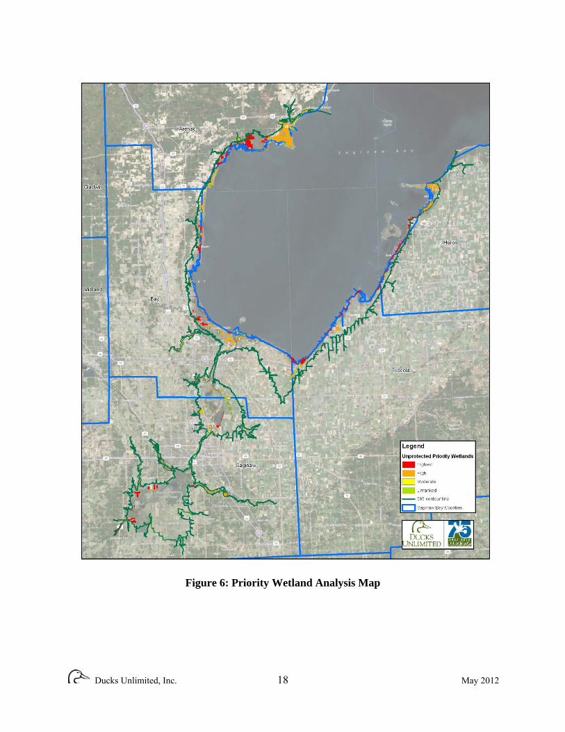
Figure 6: Priority Wetland Analysis Map
Ducks Unlimited, Inc. 18 May 2012

REFERENCES
Schools, Ed. 2009. Methodology Report for Prioritizing Saginaw Bay Wetlands. Final report to: Michigan Department of Environmental Quality, Saginaw Bay Coastal Initiative. 13pp.
Ducks Unlimited, Inc. 19 May 2012

APPENDIX A: Protected wetlands within the Saginaw Bay Coastal Plain SITE_NAME OWNER MGR_DETAIL PROT_DATE ACRES County County of Bay 0.02
County County of Bay 12.73
County County of Bay 38.22
Pinconning County County of Bay 223.03 County Park
County Park County County of Huron 3.28
Green Point County County of 55.66 Nature Center Saginaw
Green Point County County of 55.66 Nature Center Saginaw
Veterans County County of 45.09 Memorial Park Saginaw
Ducks Unlimited, Inc. 20 May 2012

SITE_NAME OWN MGR_DETAIL PROT_DATE ACRES Vanderbilt County County of 18.76 County Park Tuscola
Shiawassee Federal U.S. Fish and 8183.78 National Wildlife Service Wildlife Refuge
Federal USA 0.39
Bigelow Park Local City of Bay City 0.91
Defoe Park Local City of Bay City 0.02
Putz Park Local City of Bay City 1.15
Veteran's Local City of Bay City 40.54 Memorial Park
Wenona Park Local City of Bay City 1.34
Local City of 3.15 Pinconning
Ducks Unlimited, Inc. 21 May 2012

SITE_NAME OWN MGR_DETAIL PROT_DATE ACRES Local City of 0.68 Pinconning
Pinconning City Local City of 0.41 Park Pinconning
Local City of Saginaw 4.83
Local City of Saginaw 36.65
Local City of Saginaw 7.3
Local City of Saginaw 5.6
Local City of Saginaw 0.77
City Park Local City of Saginaw 0.63
Ezra Rust Park Local City of Saginaw 8.42
Ducks Unlimited, Inc. 22 May 2012
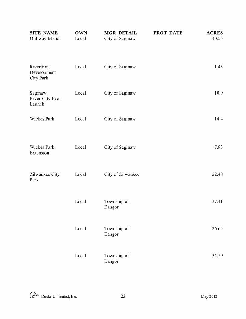
SITE_NAME OWN MGR_DETAIL PROT_DATE ACRES Ojibway Island Local City of Saginaw 40.55
Riverfront Local City of Saginaw 1.45 Development City Park
Saginaw Local City of Saginaw 10.9 River-City Boat Launch
Wickes Park Local City of Saginaw 14.4
Wickes Park Local City of Saginaw 7.93 Extension
Zilwaukee City Local City of Zilwaukee 22.48 Park
Local Township of 37.41 Bangor
Local Township of 26.65 Bangor
Local Township of 34.29 Bangor
Ducks Unlimited, Inc. 23 May 2012
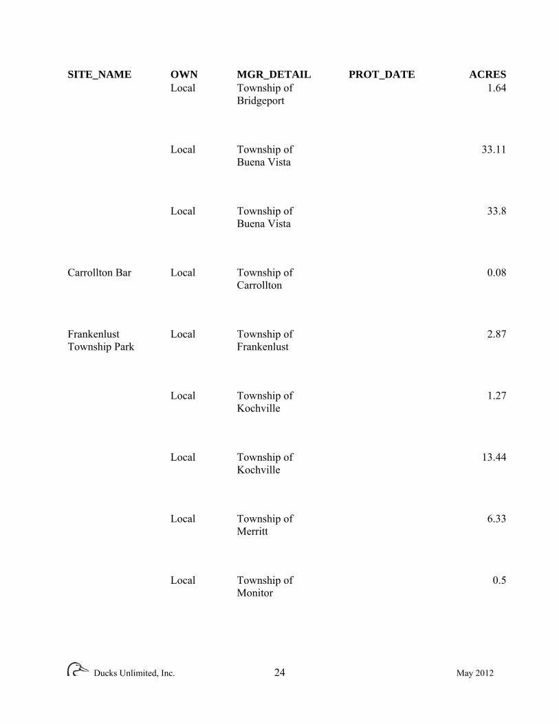
SITE_NAME OWN MGR_DETAIL PROT_DATE ACRES Local Township of 1.64 Bridgeport
Local Township of 33.11 Buena Vista
Local Township of 33.8 Buena Vista
Carrollton Bar Local Township of 0.08 Carrollton
Frankenlust Local Township of 2.87 Township Park Frankenlust
Local Township of 1.27 Kochville
Local Township of 13.44 Kochville
Local Township of 6.33 Merritt
Local Township of 0.5 Monitor
Ducks Unlimited, Inc. 24 May 2012

SITE_NAME OWN MGR_DETAIL PROT_DATE ACRES Local Township of 0.79 Pinconning
Local Township of 0.83 Pinconning
Local Township of 0.23 Pinconning
Local Township of 40.09 Portsmouth
Local Township of 23.13 Portsmouth
Local Township of 15.56 Saginaw
Local Township of 2.47 Saginaw
Local Township of 10.52 Wisner
NGO Archeaological 2.23 Conservancy
Ducks Unlimited, Inc. 25 May 2012

SITE_NAME OWN MGR_DETAIL PROT_DATE ACRES Dubuck Private 81.26 Conservation Club
Duck-N Limited Private 79.59
Gateway Private 2.63 Sportsman's Club
River Bend Private 39.56 Hunt Club
Saginaw Gun Private 3.41 Club
Shiawassee Private 0.89 Conservation Club
SOH Private 2.25 Campground and Marina
Swan Creek Private 78.84 Club
04-73-0047 Private MI Department of 347.5 Environmental
Ducks Unlimited, Inc. 26 May 2012

SITE_NAME OWN MGR_DETAIL PROT_DATE ACRES Saganing Rod Private Sportsmans Club 25.93 and Gun Club
Wigwam Duck Private Wigwam Duck 93.55 Club Club
State MDOT 122.77
State MDOT 33.45
State MI DNR 4.24
State MI DNR 3.77
State MI DNR 1.1
State MI DNR 17.26
State MI DNR 18.42
Ducks Unlimited, Inc. 27 May 2012

SITE_NAME OWN MGR_DETAIL PROT_DATE ACRES State MI DNR 0.6
State MI DNR 18.77
Bay City State State Michigan DNR 2253.22 Recreation Area Parks and Recreation Division Crow Island State Michigan DNR 3610.71 State Game Wildlife Division Area
Fish Point State State Michigan DNR 3513.34 Wildlife Area Wildlife Division
Nayanquing State Michigan DNR 1130.72 Point State Wildlife Division Wildlife Area
Quanicassee State Michigan DNR 1682.17 State Wildlife Wildlife Division Area
Shiawassee State Michigan DNR 7639.97 River State Wildlife Division Game Area
Wigwam Bay State Michigan DNR 2427.28 State Wildlife Wildlife Division
Ducks Unlimited, Inc. 28 May 2012

SITE_NAME OWN MGR_DETAIL PROT_DATE ACRES Wildfowl Bay State Michigan DNR 687.08 State Wildlife Wildlife Division Area
State State of Michigan 9.24
State State of Michigan 0.96
State State of Michigan 0.09
1996 90-08-0152 Private MI Department of 10/30/1996 1.78 Environmental Quality
1997 93-08-0243 Private MI Department of 2/13/1997 38.52 Environmental Quality
1999 98-08-0818 Private MI Department of 7/16/1999 1.13 Environmental Quality
98-08-0818 Private MI Department of 7/16/1999 8.93 Environmental Quality
Ducks Unlimited, Inc. 29 May 2012

SITE_NAME OWN MGR_DETAIL PROT_DATE ACRES 95-08-0401 Private MI Department of 9/6/2000 0.47 Environmental Quality
99-08-1036 Private MI Department of 8/3/2000 10.14 Environmental Quality
2002 00-09-0031 Private MI Department of 4/18/2002 30.92 Environmental Quality
2004 Sillman Tract Local Saginaw Basin 1/27/2004 13.84 CE Land Conservancy
00-00-0001 Private MI Department of 11/30/2004 3.14 Environmental Quality
03-09-0011 Private MI Department of 10/26/2004 0.95 Environmental Quality
03-73-0003 Private MI Department of 7/21/2004 3.51 Environmental Quality
2005 81-08-0008 Private MI Department of 8/8/2005 0.63 Environmental Quality
Ducks Unlimited, Inc. 30 May 2012

SITE_NAME OWN MGR_DETAIL PROT_DATE ACRES 81-08-0008 Private MI Department of 8/8/2005 0.44 Environmental Quality
81-08-0008 Private MI Department of 8/8/2005 0.46 Environmental Quality
2006 Saganing NGO Saginaw Basin 5/24/2006 49.04 Preserve Land Conservancy
05-06-0049 Private MI Department of 4/19/2006 1.62 Environmental Quality
2007 00-32-0090 Private MI Department of 6/21/2007 1.74 Environmental Quality
00-32-0090 Private MI Department of 6/21/2007 4.27 Environmental Quality
01-32-0021-V Private MI Department of 8/2/2007 8.86 Environmental Quality
01-32-0021-V Private MI Department of 8/2/2007 1.82 Environmental Quality
Ducks Unlimited, Inc. 31 May 2012
SITE_NAME OWN MGR_DETAIL PROT_DATE ACRES 05-09-0030 Private MI Department of 1/17/2007 0.94 Environmental Quality
2008 Osentoski NGO Saginaw Basin 8/13/2008 176.62 Preserve Land Conservancy
00-00-0020 Private Michigan 1/15/2008 18.22 Department of Natural Resources and Envi*
2009 00-00-0031 Private Michigan 1/19/2009 0.93 Department of Natural Resources and Envi* 00-00-0031 Private Michigan 1/19/2009 0.71 Department of Natural Resources and Envi*
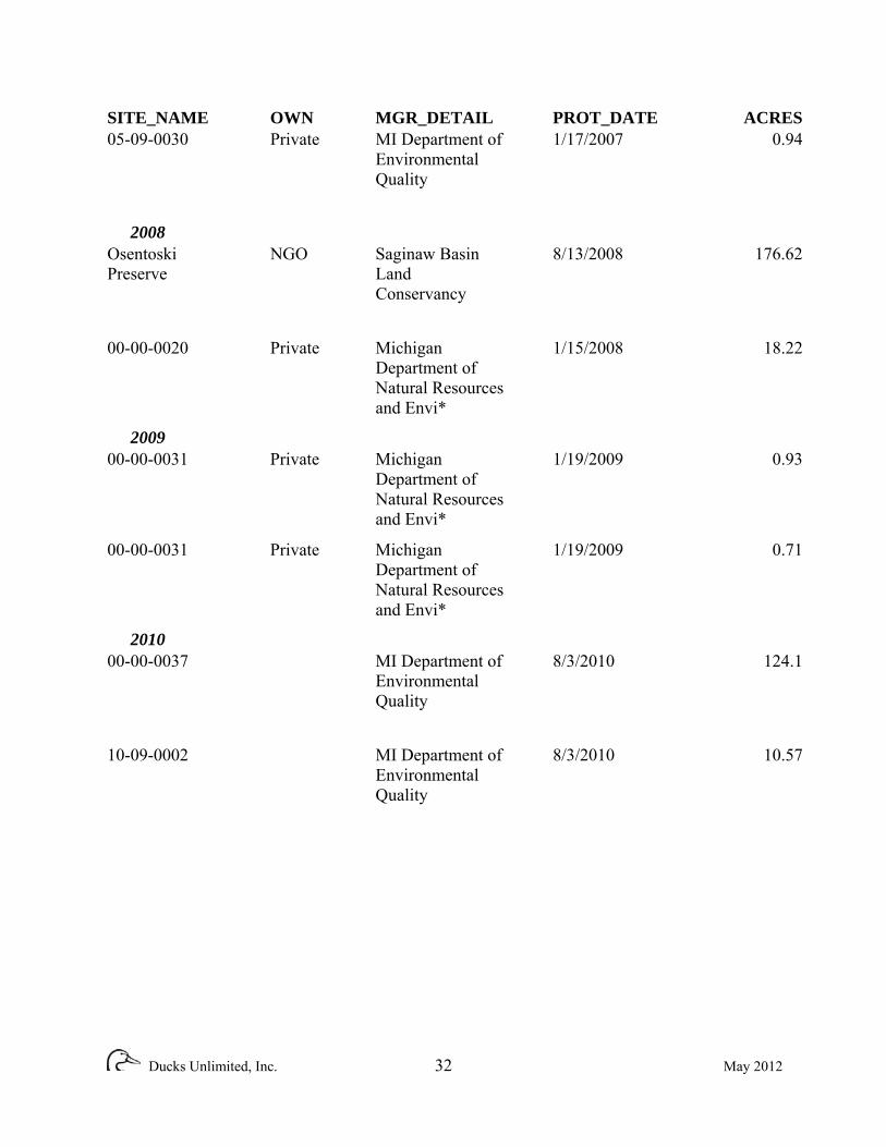
2010 00-00-0037 MI Department of 8/3/2010 124.1 Environmental Quality
10-09-0002 MI Department of 8/3/2010 10.57 Environmental Quality
Ducks Unlimited, Inc. 32 May 2012
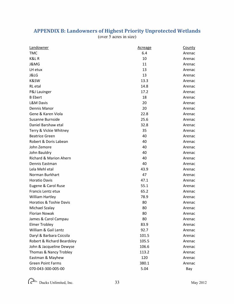
APPENDIX B: Landowners of Highest Priority Unprotected Wetlands (over 5 acres in size)
Landowner Acreage CountyTMC 6.4 ArenacK&L R 10 ArenacJ&MG 11 ArenacLH etux 13 ArenacJ&LG 13 ArenacK&SW 13.3 ArenacRL etal 14.8 ArenacP&J Lauinger 17.2 ArenacB Ebert 18 ArenacL&M Davis 20 ArenacDennis Manor 20 ArenacGene & Karen Viola 22.8 ArenacSusanne Burnside 25.6 ArenacDaniel Barshaw etal 32.8 ArenacTerry & Vickie Whitney 35 ArenacBeatrice Green 40 ArenacRobert & Doris Labean 40 ArenacJohn Zemore 40 ArenacJohn Bauldry 40 ArenacRichard & Marion Ahern 40 ArenacDennis Eastman 40 ArenacLela Mehl etal 43.9 ArenacNorman Burkhart 47 ArenacHoratio Davis 47.1 ArenacEugene & Carol Ruse 55.1 ArenacFrancis Lentz etux 65.2 ArenacWilliam Hartley 78.9 ArenacHoratios & Toshie Davis 80 ArenacMichael Szalay 80 ArenacFlorian Nowak 80 ArenacJames & Carol Campau 80 ArenacElmer Trobley 83.9 ArenacWilliam & Gail Lentz 92.7 ArenacDaryl & Barbara Csicsila 101.5 ArenacRobert & Richard Beardsley 105.5 ArenacJohn & Jacqueline Dewyse 106.6 ArenacThomas & Nancy Trobley 113.2 ArenacEastman & Mayhew 120 ArenacGreen Point Farms 380.1 Arenac070‐043‐300‐005‐00 5.04 Bay
Ducks Unlimited, Inc. 33 May 2012
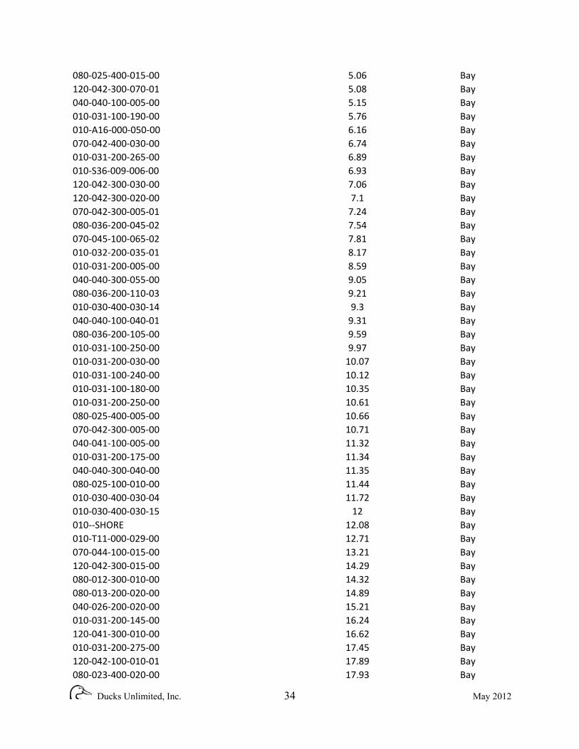
080‐025‐400‐015‐00 5.06 Bay120‐042‐300‐070‐01 5.08 Bay040‐040‐100‐005‐00 5.15 Bay010‐031‐100‐190‐00 5.76 Bay010‐A16‐000‐050‐00 6.16 Bay070‐042‐400‐030‐00 6.74 Bay010‐031‐200‐265‐00 6.89 Bay010‐S36‐009‐006‐00 6.93 Bay120‐042‐300‐030‐00 7.06 Bay120‐042‐300‐020‐00 7.1 Bay070‐042‐300‐005‐01 7.24 Bay080‐036‐200‐045‐02 7.54 Bay070‐045‐100‐065‐02 7.81 Bay010‐032‐200‐035‐01 8.17 Bay010‐031‐200‐005‐00 8.59 Bay040‐040‐300‐055‐00 9.05 Bay080‐036‐200‐110‐03 9.21 Bay010‐030‐400‐030‐14 9.3 Bay040‐040‐100‐040‐01 9.31 Bay080‐036‐200‐105‐00 9.59 Bay010‐031‐100‐250‐00 9.97 Bay010‐031‐200‐030‐00 10.07 Bay010‐031‐100‐240‐00 10.12 Bay010‐031‐100‐180‐00 10.35 Bay010‐031‐200‐250‐00 10.61 Bay080‐025‐400‐005‐00 10.66 Bay070‐042‐300‐005‐00 10.71 Bay040‐041‐100‐005‐00 11.32 Bay010‐031‐200‐175‐00 11.34 Bay040‐040‐300‐040‐00 11.35 Bay080‐025‐100‐010‐00 11.44 Bay010‐030‐400‐030‐04 11.72 Bay010‐030‐400‐030‐15 12 Bay010‐‐SHORE 12.08 Bay010‐T11‐000‐029‐00 12.71 Bay070‐044‐100‐015‐00 13.21 Bay120‐042‐300‐015‐00 14.29 Bay080‐012‐300‐010‐00 14.32 Bay080‐013‐200‐020‐00 14.89 Bay040‐026‐200‐020‐00 15.21 Bay010‐031‐200‐145‐00 16.24 Bay120‐041‐300‐010‐00 16.62 Bay010‐031‐200‐275‐00 17.45 Bay120‐042‐100‐010‐01 17.89 Bay080‐023‐400‐020‐00 17.93 Bay
Ducks Unlimited, Inc. 34 May 2012

040‐001‐400‐020‐00 18.28 Bay080‐036‐200‐040‐00 19.61 Bay080‐013‐100‐020‐00 19.97 Bay040‐040‐300‐005‐00 20.64 Bay040‐026‐400‐070‐01 21.15 Bay070‐040‐200‐005‐00 21.92 Bay010‐‐GAP 24.02 Bay010‐031‐100‐225‐00 24.02 Bay120‐042‐100‐050‐05 25.99 Bay120‐042‐100‐040‐00 27.25 Bay010‐031‐100‐165‐00 27.92 Bay010‐038‐100‐001‐00 28.18 Bay120‐042‐300‐011‐01 28.2 Bay080‐013‐300‐010‐00 36.26 Bay040‐012‐400‐020‐00 36.65 Bay040‐012‐200‐005‐00 38.09 Bay040‐012‐200‐015‐00 38.37 Bay040‐012‐200‐020‐01 38.48 Bay040‐012‐400‐040‐00 38.65 Bay120‐025‐200‐020‐00 39.11 Bay040‐001‐400‐030‐00 39.56 Bay080‐011‐400‐035‐00 40.01 Bay080‐023‐200‐015‐00 41.98 Bay070‐042‐400‐010‐00 45.38 Bay040‐042‐100‐005‐00 47.94 Bay070‐040‐200‐015‐00 48.03 Bay040‐040‐100‐040‐00 48.52 Bay040‐001‐400‐025‐00 49.14 Bay080‐014‐200‐050‐00 52.78 Bay120‐025‐200‐010‐00 54.6 Bay120‐041‐300‐060‐01 57.89 Bay070‐041‐300‐015‐00 61.38 Bay070‐053‐200‐005‐00 61.74 Bay080‐025‐400‐010‐00 64.58 Bay010‐‐RIVER 66.38 Bay070‐055‐200‐005‐00 66.72 Bay080‐014‐200‐025‐01 71 Bay120‐041‐100‐020‐00 71.3 Bay010‐‐ROAD ROW 74.1673 Bay120‐025‐400‐010‐00 74.22 Bay010‐029‐300‐005‐00 76.32 Bay070‐054‐300‐015‐00 79.68 Bay040‐012‐200‐035‐00 80.04 Bay070‐055‐400‐015‐00 89.62 Bay070‐044‐100‐005‐00 100.38 Bay
Ducks Unlimited, Inc. 35 May 2012

010‐032‐200‐005‐00 105.36 Bay080‐012‐300‐005‐00 130.86 Bay070‐053‐100‐005‐00 135.12 Bay070‐055‐200‐010‐00 137.22 Bay070‐040‐200‐020‐00 148.05 Bay080‐025‐200‐010‐00 161.08 Bay010‐030‐100‐005‐00 212.12 Bay070‐001‐200‐005‐00 236.37 Bay080‐025‐100‐005‐00 290.03 Bay070‐041‐100‐005‐00 292.6658 Bay070‐054‐100‐005‐00 344.23 Bay080‐024‐100‐005‐02 462.21 Bay080‐013‐100‐010‐01 521.9 Bay070‐001‐100‐005‐00 885.34 BayKLEINFELD CONRAD J & CHRISTOPHER & 5.1 HuronSIGNATURE BANK 5.6 HuronWIESE ROBERT G & LANETTE R 5.6 HuronJONES DONALD C & LISA A 5.7 HuronKAIN DONALD L JR & BEVERLY M 6.5 HuronKUHL NORMAN A & FLORENCE C 7.5 HuronMORGAN XELLE 7.6 HuronSTEIGER CLARENCE R & THISVI J 7.7 HuronDUNWOODIE BRIAN J 8.1 HuronHENNE DENNIS P & JANET M 8.3 HuronHENNE JOHN 8.8 HuronBROMLEY KAREN L & KUBACKI ALICIA K 9.2 HuronDEMING DOUGLAS A & LATIFAH 9.5 HuronMICHIGAN SUGAR COMPANY 10.9 HuronGILLING STEPHEN L & DONNA J 12.7 HuronDORFMAN ROBERT S & 25.8 HuronUnknown 44.3 HuronCERVA, JAMES D 5.02 SaginawGOODWIN, M R 5.11 SaginawSUMRACK, C J & K K 6.84 SaginawJ & G REAL ESTATE LLC ETAL 7.13 SaginawMCSWEYN, JAMES D 7.31 SaginawCEMETERY 8.27 SaginawWEND, EUGENE ETAL 10.59 SaginawKIMBERLEY OAKS LAND CO LLC 11.53 SaginawSTROEBEL, G W & S J 11.63 SaginawCONSUMERS ENERGY COMPANY 14.7 SaginawWACHOVIA BANK NA 16.18 SaginawGUIETTE, MICHAEL B & JAMIE L 19.37 SaginawGRONSKI, A B & P B 19.43 SaginawSCOTT, MAURICE & JUNE 19.66 Saginaw
Ducks Unlimited, Inc. 36 May 2012

YURGENS, RICHARD & DARLENE 19.79 SaginawSLICK, KRAIG J & ANGELA C 20.23 SaginawKLINE, J A & K T 20.27 SaginawBLONIARCZYK, WILLIAM & VERA J 20.81 SaginawKASPER, J S & C M 21.71 SaginawDAMIC, J E & K L 26.17 SaginawDIETRICH, LOREN C ETAL 30.32 SaginawWESLOCK, LINDA & MARK 30.48 SaginawHULIEN, ERMA 31.78 SaginawPECK, W L & TAYLOR, J J 33.44 SaginawBILLETER, A L & R G 33.48 SaginawSIVEY, JAMES ETAL 33.55 SaginawCONSUMERS ENERGY CO 37.5 SaginawPROKOP, MARIANNE TRUST 38.88 SaginawOLDENBURG, KEN 40.3 SaginawSURDOCK, NORMA J 40.91 SaginawMADDEN, T M & M E 41.38 SaginawGILMOUR, R K TRUST 41.64 SaginawCUSHMAN, J & N 42.23 SaginawVOGELAAR, H & V 43.36 SaginawGROSS D R & J L 43.48 SaginawRIVEREND PRESERVE LLC 44.47 SaginawKAUFMANN, D T TRUSTEE 44.82 SaginawREVARD, MICHAEL & CAROL 47.36 SaginawBUTTS, W & S 47.68 SaginawRIVERENDS PERSERVE LLC 49.31 SaginawBENKERT, L M 57.07 SaginawWEH‐RAN PROPERTIES LLC 60.83 SaginawJESSELAITIS, T & K 62.14 SaginawBOWEN, J O & B A 63.41 SaginawGUSTAVISON, D K & C S 63.57 SaginawBENKERT, R A & M ETAL 64.44 SaginawKAUFMANN, LEONARD & 67.92 SaginawGOSEN, C D & K 78.38 SaginawGARANT, D & J & FELSING, R & P 82.55 SaginawPASIONEK, P A ET AL 84.16 SaginawGARNO, ANDREW 89.93 SaginawSWAN CREEK CLUB INC 92.19 SaginawWOHLFEIL, RAYMOND R 96.99 SaginawPASIONEK, L J & B J 104.54 SaginawFOLTZ, BETTY LOU TRUST 168.49 SaginawMID MICHIGAN GOLF COURSE INC 180.92 SaginawKUNIK, FRANK FARMS INC 320.81 SaginawWASMILLER, DORIS TRUSTEE 332.04 SaginawD & R. Ramon 5 Tuscola
Ducks Unlimited, Inc. 37 May 2012
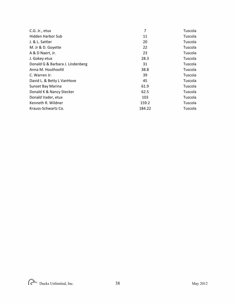
Ducks Unlimited, Inc. 38 May 2012
C.G. Jr., etux 7 TuscolaHidden Harbor Sub 11 TuscolaJ. & L. Sattler 20 TuscolaM. Jr & D. Goyette 22 TuscolaA & D Naert, Jr. 23 TuscolaJ. Gokey etux 28.3 TuscolaDonald G & Barbara J. Lindenberg 31 TuscolaAnna M. Houthoofd 38.8 TuscolaC. Warren Jr. 39 TuscolaDavid L. & Betty L VanHove 45 TuscolaSunset Bay Marina 61.9 TuscolaDonald K & Nancy Stecker 62.5 TuscolaDonald Vader, etux 103 TuscolaKenneth R. Wildner 159.2 TuscolaKrauss‐Schwartz Co. 184.22 Tuscola


