12/23/15 1 Regional Water Board Staff Reponses to Informal Comments Received on The Peer Review Draft Staff Report for the Sediment TMDL in Upper Elk River December 23, 2015 In July 2013, the North Coast Regional Water Quality Control Board (Regional Water Board) made available to the public via its website the Peer Review Draft Staff Report to Support the Technical Sediment Total Maximum Daily Load (TMDL) for the Upper Elk River (Peer Review Draft Staff Report) (Regional Water Board, 2013). The document is accompanied by the peer reviewers’ curricula vitae, their individual comment letters, and the Regional Water Board’s responses to peer review comments. Regional Water Board staff sought input from stakeholders on the Peer Review Draft Staff Report at individual stakeholder and public meetings and several interested stakeholders also reviewed the document and provided comment letters. The Regional Water Board has considered all of these informal stakeholder comments and considered the input in subsequent revisions since the Peer Review Draft Staff Report. Many of the comments have resulted in changes to the approach, which have been integrated into the Upper Elk River Technical Analysis for Sediment produced by Tetra Tech, Inc. (Technical Report) on behalf of the Regional Water Board and was posted on the website on October 21, 2015. The Technical Report represents the full synthesis of all previous analytical work, new data analyses, scientific peer review comments, and all major informal stakeholder comments. It provides the scientific basis for both (1) the adoption of waste discharge requirements and (2) the establishment of asediment TMDL for the Upper Elk River Watershed. The purpose of this document is to describe staff responses to major informal comments received on the Peer Review Draft Staff Report, including a description of the revisions that are now incorporated into the Technical Report. This document is not intended to respond to each and every informal comment submitted. The Regional Water Board will provide responses to all public comment letters received during the formal, publically noticed, public review period when the draft TMDL is ready for public review. As a courtesy, and to ensure clarity and transparency in the TMDL and WDR development processes, the Regional Water Board has categorized the most significant informal comments below, and provided a narrative discussion of the issues and staff’s responses. Informal comment letters were received from the following entities and are posted on the website: • Green Diamond Resource Company (GDRC) (11/21/13), • Humboldt Redwood Company (HRC) (12/2/13), • Friends of Elk River (FOER) (1/15/14), • Lee MacDonald (on behalf of HRC and GDRC) (1/17/14, 2/2/14, and 3/27/14), • Jack Lewis and Randy Klein (3/5/14 and 5/28/14), • Stephanie Bennet Noell (3/25/14), • California Department of Forestry and Fire Protection (CalFire) (4/8/14 and 8/18/14), and • California Department of Fish and Wildlife (CDFW) (10/6/14).
Transcript
12/23/15 1
Regional Water Board Staff Reponses to Informal Comments Received on
The Peer Review Draft Staff Report for the Sediment TMDL in Upper Elk River
December 23, 2015
In July 2013, the North Coast Regional Water Quality Control Board (Regional Water Board) made available to the public via its website the Peer Review Draft Staff Report to Support the Technical Sediment Total Maximum Daily Load (TMDL) for the Upper Elk River (Peer Review Draft Staff Report) (Regional Water Board, 2013). The document is accompanied by the peer reviewers’ curricula vitae, their individual comment letters, and the Regional Water Board’s responses to peer review comments.
Regional Water Board staff sought input from stakeholders on the Peer Review Draft Staff Report at individual stakeholder and public meetings and several interested stakeholders also reviewed the document and provided comment letters. The Regional Water Board has considered all of these informal stakeholder comments and considered the input in subsequent revisions since the Peer Review Draft Staff Report. Many of the comments have resulted in changes to the approach, which have been integrated into the Upper Elk River Technical Analysis for Sediment produced by Tetra Tech, Inc. (Technical Report) on behalf of the Regional Water Board and was posted on the website on October 21, 2015. The Technical Report represents the full synthesis of all previous analytical work, new data analyses, scientific peer review comments, and all major informal stakeholder comments. It provides the scientific basis for both (1) the adoption of waste discharge requirements and (2) the establishment of asediment TMDL for the Upper Elk River Watershed.
The purpose of this document is to describe staff responses to major informal comments received on the Peer Review Draft Staff Report, including a description of the revisions that are now incorporated into the Technical Report. This document is not intended to respond to each and every informal comment submitted. The Regional Water Board will provide responses to all public comment letters received during the formal, publically noticed, public review period when the draft TMDL is ready for public review. As a courtesy, and to ensure clarity and transparency in the TMDL and WDR development processes, the Regional Water Board has categorized the most significant informal comments below, and provided a narrative discussion of the issues and staff’s responses.
Informal comment letters were received from the following entities and are posted on the website:
• Green Diamond Resource Company (GDRC) (11/21/13), • Humboldt Redwood Company (HRC) (12/2/13), • Friends of Elk River (FOER) (1/15/14), • Lee MacDonald (on behalf of HRC and GDRC) (1/17/14, 2/2/14, and 3/27/14), • Jack Lewis and Randy Klein (3/5/14 and 5/28/14), • Stephanie Bennet Noell (3/25/14), • California Department of Forestry and Fire Protection (CalFire) (4/8/14 and
8/18/14), and • California Department of Fish and Wildlife (CDFW) (10/6/14).
Reponses to Informal Comments Received on The Peer Review Draft Staff Report for the Sediment TMDL in Upper Elk River
12/23/15 2
A response to GDRC’s comments was provided to GDRC on January 28, 2014 and that letter, too, is posted on the website.
A range of issues were raised in comment letters and are addressed below by topic. The topics include:
1. Sediment loading capacity and load allocations 2. Natural background loading 3. Deep seated landslide loading estimates 4. Regional Sediment Yield Estimates and Long-term Erosion Rates 5. Tectonic Uplift 6. Comparability of the study subbasins 7. Desired watershed conditions and Instream and Hillslope Water Quality Indicators 8. Water quality trends 9. Program of implementation, monitoring and adaptive management
A large number of the comments received focused on technical elements of the Peer Review Draft Staff Report with suggested methods to update, revise, and refine the given analyses. Many of these suggestions have been incorporated into the Technical Report. While technical in nature, many comments stem from consideration of the regulatory consequences of the technical analysis. Therefore, the discussion on loading capacity below briefly describes how the technical content of a TMDL relates to implementation, particularly in watersheds impaired solely by nonpoint source pollution.
The proposed program of implementation has been significantly modified from what was first presented in the Peer Review Draft Staff Report. The implementation framework strongly relies on coordinated monitoring and adaptive management as the basis for tracking trends, updating scientific understanding, and modifying implementation actions over time. The intention of the proposed altered program of implementation is to focus immediate attention on control of all existing and potential future sediment sources in the upper watershed as phase 1 of the TMDL while a feasibility assessment of sediment and hydrologic remediation and habitat restoration of the impacted reaches and lower watershed is completed. Full scale remediation and restoration of the impacted reaches and lower watershed will precipitate the Regional Water Board’s ability to recalculate the sediment TMDL as phase 2, if appropriate, which recognizes an expanded capacity of the impacted reach and lower watershed to transport sediment and water more normally (e.g., 2-year flood events contained within the stream channel).
1.0 Sediment Loading Capacity and Load Allocations
The Peer Review Draft Staff Report defined the loading capacity of the Upper Elk River Watershed as 20% over natural sediment loading to conform to the Basin Plan’s turbidity objective. For comparison, all of the sediment load allocations applied in other sediment TMDLs developed and/or adopted for the North Coast Region range from 107% to 125% above natural background, with one outlier. An estimate of natural sediment loading was reported in the sediment source analysis and hillslope and instream load allocations were described for each of the sediment source categories identified. Hillslope load allocations
Reponses to Informal Comments Received on The Peer Review Draft Staff Report for the Sediment TMDL in Upper Elk River
12/23/15 3
were developed for such sources as road and skid trail related erosion, harvest area related erosion, sediment source delivery sites, and channel related erosion from low order-channel incision, bank erosion and streamside landslides triggered by management activities conducted in the riparian area. Additionally, instream sediment load allocations were derived based on an estimate of the volume of instream-stored sediment in the impacted reaches (e.g., reach of the lower North and South Forks through the confluence to Berta Road where overbank flooding and property damage occurs), which has reduced the sediment loading capacity of the impacted reaches for additional sediment. The total volume of stored sediment was allocated to each of the upstream landowners according to the proportion of their ownership upstream of storage reaches. A 10-year timeframe was provided to attain the instream deposits allocation; a 20-year timeframe to attain upslope allocations.
Staff received numerous comments expressing concern and objections to the approach to loading capacity and allocations described above in the Peer Review Draft Staff Report. MacDonald commented that setting the allowable load at 120% of the natural load was concerning because of uncertainties in the estimate of natural loading. He voiced particular concern about relying on suspended sediment load estimates as the basis for that determination. Further, he voiced concern about establishing an allocation for the noted instream deposits (i.e., deposits within the impacted reaches), because of his understanding that there are large amounts of sediment stored throughout the channel network. He described concerns with setting hillslope source allocations that may be difficult or unrealistic to attain if they are based upon the loading capacity of 120%. Further, he pointed to the pilot hydrodynamic and sediment transport modeling (Pilot HST modeling), which indicated that localized scour of instream deposits in the impacted reaches could occur under a sediment load regime that is greater than 120% of natural (NHE and Stillwater, 2013).
Calire made similar comments to MacDonald with respect to concern over the determination of natural loading, the effect of the allocation on the hillslope targets, and the attainability of the load allocation. HRC and GDRC commented that an allocation for instream deposits is unreasonable because the timing and permitting of instream remediation are uncertain, if even feasible. GDRC suggested there is no “essential nexus” between the impacts of their past activities and the assignment of an allocation for instream remediation.
At Regional Water Board meetings in May and June 2014, staff indicated they would explore the possibility of recalculating the sediment loading capacity. The recalculation was to be based on the results of Pilot HST modeling, which estimated a sediment load at which localized scour within the compliance reach was predicted to be initiated. CalFire commented that there may be issues with that approach as it would result in an estimate of sediment loading capacity that is still less than regional estimates of natural loading over the long-term.
To address the full range of issues and concerns raised on this issue, staff has proposed that the sediment loading capacity be defined by existing channel conditions, and be established as the first phase of a phased TMDL. This approach is now documented in the Technical
Reponses to Informal Comments Received on The Peer Review Draft Staff Report for the Sediment TMDL in Upper Elk River
12/23/15 4
Report. TMDLs must be established at levels necessary to attain and maintain water quality standards. In a sediment TMDL, the sediment loading capacity of a waterbody for sediment is defined by those levels that attain the suspended material, settleable material, sediment, and turbidity objectives contained in the Basin Plan and prevent nuisance conditions (e.g., elevated rates of overbank flooding). At present, the channel capacity has been so dramatically reduced that nuisance conditions exist and continue to worsen with ongoing aggradation. That is, a proportion of the sediment transported to the impacted reaches remains in the impacted reaches, further reducing the capacity of the reach to transport sediment and water downstream. The revised sediment loading capacity for phase 1 of the TMDL is proposed to be defined as zero, until such time as sediment remediation and channel restoration has expanded the sediment loading capacity.
A TMDL is the sum of individual waste load allocations (WLA) for point sources and load allocations (LA) for nonpoint sources and natural background. (40 CFR 130.2 (i).) A LA is the portion of receiving water’s loading capacity that is attributed either to nonpoint source pollution or to natural background sources. Wherever possible, natural and nonpoint source loads should be distinguished. (40 C.F.R. § 130.2(g).)
The zero LA is necessarily conceptual, since using current technology and techniques, no amount of land use restriction and channel restoration can physically result in zero loading of sediment (i.e., the control of all sediment discharge from the watershed). Unlike a WLA that must be translated into a National Pollution Discharge Elimination System (NPDES) permit as an effluent limit, the Regional Water Board has considerable discretion in how it chooses to implement the LA. A LA is not independently enforceable and must be applied in the statutory context of the appropriate implementation mechanism. What is required to implement a LA is determined in the development of waste discharge requirements or other permitting mechanisms. While a LA is expressed in numeric terms, nonpoint source land use activities are generally regulated through implementation of a range of best management practices and adaptive management. A zero loading capacity helps inform the development of Waste Discharge Requirements for upper watershed landowners and suggests appropriate discharge restrictions that take into account the current limitations of the river to convey waste sediment without further impacting downstream beneficial uses and worsening nuisance conditions.
The updated proposed implementation strategy builds upon existing efforts and now includes WDRs for timberland owners in the upper watershed, instream remediation, and stewardship. The load allocation is no longer based on a percent reduction from individual sediment source categories. Rather, the implementation plan relies on a WDR framework, which would implement BMP-based sediment control measures for new and existing sources. A draft WDR for HRC is now out for public review. Recognizing that attainment of water quality objectives and restoration of beneficial uses cannot be accomplished by source control alone, the WDR updated proposed strategy calls for assessment of the feasibility of remediating instream sediment that may still be stored in the tributary stream channel system from previous land management activities. The WDR also updated proposed strategy calls for projects to benefit downstream landowners currently harmed by the sediment discharges and concomitant overbank flooding.
Reponses to Informal Comments Received on The Peer Review Draft Staff Report for the Sediment TMDL in Upper Elk River
12/23/15 5
Since release of the Peer Review Draft Staff Report, the Regional Water Board has been working with other entities in the Elk River Watershed to develop a stewardship process. A Steering Committee composed of representatives of Humboldt County, the Natural Resources Conservation Service, U.C. Cooperative Extension, CalTrout, and the Regional Water Board has acquired a 319(h) grant to develop a Watershed Stewardship Program. One of the many potential outcomes of a stewardship process could be the voluntary development of funding, permits, and remediation designs sufficient to expand the loading capacity of the impacted reach for sediment and flows without nuisance conditions (e.g., ongoing aggradation and excessive overbank flooding).
Specifics relating to the approach to defining natural sediment loading are elaborated further in subsequent sections of this document.
2.0 Natural Background Loading
In its Peer Review Draft Staff Report, the Regional Water Board relied in part on data collected from a relatively undisturbed subbasin within the Upper Elk River Watershed as a reference (i.e., Upper Little South Fork Elk River) to estimate natural background loading for a subset of sediment source categories. In particular, the reference study subbasin was used to estimate background loading associated with (1) bank erosion and (2) streamside landslides in 1-2 mi2 subbasins. A different approach was used for estimating background delivery from shallow landslides and deep seated features. For example, an estimate of natural rates of sediment delivery from shallow landslides in the Upper Elk River Watershed was based upon estimates of sediment delivery from all shallow landslides in the upper watershed located in areas that had not been harvested in the prior 15-year period. These were not extrapolated from the reference subbasin. Similarly, the estimates of deep-seated landslide loading were based upon all active features as identified on California Geological Survey (CGS) maps (Marshal and Mendes, 2005) and movement rates estimated by Hart Crowser (Palco, 2004) in Upper Elk River. Again, these were not extrapolated from the reference subbasin.
CalFire and MacDonald both voiced concerns that use of a reference study subbasin did not account for variation in watershed processes across the landscape. They argued that the estimated loading rates derived from the reference study subbasin were inappropriately extrapolated and applied to other subbasins in the upper watershed, voicing particular concern about sediment loading influenced by deep-seated features. CalFire commented that the Source Analysis lacked a process-based framework and specifically suggested the use of Elk River deep seated mapping, as well as estimates of deep seated sediment loading from other north coast streams. As described above, the commenters misconstrued the purpose and uses of the reference subbasin study data, which were used only to estimate natural loads associated with bank erosion and streamside landslides in 1-2 mi2 subbasins .
HRC suggested that use of the reference subbasin was statistically problematic and resulted in allocations that are not attainable, even in the absence of new harvesting. They described that due to impacts that predate the Forest Practice Rules (1974) and Habitat Conservation Plan (Palco, 1999), there are existing sediment sources that persist. They
Reponses to Informal Comments Received on The Peer Review Draft Staff Report for the Sediment TMDL in Upper Elk River
12/23/15 6
suggested that background be defined as the sediment loading in the absence of contemporary forest operations in the watershed.
Such a definition is untenable and contrary to the State Water Board Non-point Source Policy (State Water Resources Control Board, 2004) and the TMDL program. The State’s Non-Point Source Program is built on the notion that best management practices are continually evolving as our understanding of landscape effects improves and the ability to control waste discharges from landscape activities likewise improves. In particular, landscape activities in a sensitive watershed or a watershed particularly vulnerable to disturbance, such as the Upper Elk River Watershed, must be moderated based on the given vulnerabilities, including those related to past activities. Further, the TMDL framework requires best available science to estimate natural loading and suggests the use of a reference approach as the basis for such an analysis. That said, the draft revised approach to the load allocation, as described above, does not require a precise distinction between anthropogenic and natural sediment load estimates. Instead, it is based strictly on the sediment loading capacity of the impacted reaches. Such an approach allows use of an array of land management tools (e.g., impacts avoidance and minimization, harvest rate limitations, riparian zone protections, sediment remediation and channel restoration, and other more experimental approaches) to controlling sediment discharge and it’s routing to the impacted reaches.
Commenters also appeared to have misunderstood the use of the reference study subbasin for turbidity and suspended sediment data. For example, HRC staff and MacDonald appear to have inferred that the Regional Water Board used those data to determine natural loading in the sources analysis. Staff did not use these data in the Peer Review Draft Staff Report to estimate natural loading. Rather, these data were used only to explore the relationship between natural turbidity and natural suspended sediment loading and found that a 1:1 relationship exists (i.e. a 20% increase in turbidity is also associated with a 20% increase in suspended sediment loading).
HRC further commented that reliance on the reference study subbasin to inform the relative portion of total streamside landsliding associated with management influences was inappropriate. Sediment discharges from streamside landslides were evaluated in the Peer Review Draft Staff Report based on surveys conducted for HRC by SHN Consulting Engineers and Geologists (SHN). The SHN surveys evaluated landslide features across the upper watershed for clear association with a management activity, either recent or past. These data were used in the Regional Water Board’s analysis; however, the documented landslide features were further evaluated based on the natural landslide characteristics identified by survey data collected from the reference study subbasin. The SHN surveys were very informative, but they were limited by their lack of comparison to reference conditions.
Commenters raised valid concerns with respect to the extrapolation of sediment delivery rates from a small reference study subbasin to other areas of the watershed. The watershed is not homogeneous; as such, spatial and temporal variation exists. However, the reference study did shine light on the suite of landscape characteristics (e.g., soil cover, viable tree roots, complex riparian zone) that successfully serves to minimize sediment
Reponses to Informal Comments Received on The Peer Review Draft Staff Report for the Sediment TMDL in Upper Elk River
12/23/15 7
delivery, even given the highly erodible Wildcat Formation. Further, because of the extensive management signature across the rest of the watershed, it would be difficult to gain these insights without the benefit of a reference study subbasin.
For example, the TMDL-related surveys of watercourses identify the significant role of wood in the reference subbasin. Especially in areas of the soft Wildcat geology, large wood contributes the primary grade control and stabilizing structures in watercourses. Wood loading has accumulated over long time periods, with managed subbasins having notably less instream wood than the reference study subbasin. This is likely due to reduced recruitment because of harvest in riparian areas, clearing of the forest floor of downed wood, and removal of large wood from watercourses. This loss of wood has clearly played a role in channel simplification and gully formation in managed areas.
As a corollary point, HRC commented that fire suppression in the reference study subbasin may have influenced its ecological characteristics and function, including the magnitude of natural sediment loading. While it is true that fire suppression efforts may have led to less natural disturbance in the reference study subbasin, those same effects have limited fire related disturbance in the managed portions of the Upper Elk River, as well.
To address many of these comments, the Technical Report (1) relies less on a fixed loading estimate of natural to set the loading capacity, targets, and implementation program and (2) better reflects the spatial variability of deep seated influences in the watershed, in a manner explained below.
3.0 Deep seated landslide loading estimates
The Peer Review Draft Staff Report relied on HRC’s landslide inventory as the basis for its sediment source analysis. Deep-seated features result in sediment delivery from the toe of the feature in the form of shallow landslides or streamside landslides, which are distinguished from one another depending on their size, location and other characteristics. Sediment delivery from the toe of deep-seated features was categorized not as delivery from the deep seated landslide, but from the secondary feature. This method of stratifying sediment sources is comparable to that used by HRC in its watershed analysis.
CalFire commented that the deep seated loading estimates were underestimated by about two orders of magnitude. Increasing the deep seated landslide sediment delivery estimates by two orders of magnitude, however, would result in double counting, since much of the associated sediment was otherwise accounted for in the shallow landslide and streamside landslide source categories.
Comment letters from both CalFire and MacDonald described that the prevalence of deep-seated landslide features varies across the Upper Elk River Watershed and that these features, especially where they toe into watercourses, can influence the sediment delivery rates from in-channel sources, namely streamside landslides. Staff agrees with this comment and recalculated sediment source estimates accordingly.
Two data sources were used for the recalculation: (1) CGS mapping of deep seated features and (2) Stillwater modeling results of potential deep-seated features based upon DSLED
Reponses to Informal Comments Received on The Peer Review Draft Staff Report for the Sediment TMDL in Upper Elk River
12/23/15 8
results of LIDAR DEM analysis of surface roughness. These data were used in combination with the existing watercourse layer modeled off LIDAR DEM (based upon drainage area of 0.5 hectares). Using each of the above data sources, two estimates of the proportion of streamside landsliding associated with deep-seated features were determined for each of the TMDL analysis subbasins. The two estimates were averaged. The result of this effort was to decrease the estimate of sediment delivered from management-related streamside landsliding and to increase the proportion attributed to natural causes. This has resulted in revised estimates of natural loading, which varies amongst time periods and subbasins. The Technical Report reflects this recalculation.
4.0 Regional Sediment Yield Estimates and Long-term Erosion Rates
As described in the Peer Review Draft Staff Report, a variety of analytical approaches were used to estimate natural and management-related sediment loads to the Upper Elk River Watershed, including use of a reference study subbasin, aerial photographs, GIS mapping, landuse history, field-based erosion monitoring, and application of erosion models. For reference, the Regional Water Board has developed and/or adopted numerous sediment TMDLs for other watersheds in the North Coast Region relying on fewer analytical tools and much less data. These include sediment TMDLs for the Garcia River, Mattole River, Navarro River, Scott River, and Stemple Creek. Further, U.S. EPA likewise has established numerous sediment TMDLs using fewer analytical tools and less data than are available for the Upper Elk . U.S. EPA has established TMDLs for the Albion River, many reaches within the Eel River Watershed, Gualala River, Mad River, Noyo River, Redwood Creek, Ten Mile River, Trinity River, South Fork Trinity River, and Van Duzen River. Because of the heightened public interest of the issues in the Elk River Watershed, the analytical approaches used to develop a sediment TMDL for this watershed were by design far more robust and site-specific than those used in previous sediment TMDLs. In particular, the data and analyses of multiple entities was used in an attempt to represent the wide range of excellent science performed over the years by other agencies, timber companies, private consultants, and research institutions, in addition to that performed by Regional Water Board. For example, site-specific sediment inventory data were provided by Upper Elk landowners and evaluated at a subbasin scale. Where site-specific data were unavailable, sediment load estimates were extrapolated from the results of field surveys in three study subbasins located in the Upper Elk River Watershed.
CalFire commented that the proportion of anthropogenic-to-natural sediment loading in other north coast watersheds is smaller than the estimates presented in the Peer Review Draft Staff Report for the Upper Elk River Watershed. As a result, CalFire concluded that the staff’s estimates of natural sediment delivery are wrong. The comment letter from CalFire includes numerous suggestions for alternate methods of calculation that could in its view improve the estimates as presented in the Peer Review Draft Staff Report. These suggestions are each discussed in turn below.
First, CalFire suggested a comparison of total sediment delivery in the Upper Elk River Watershed with reservoir sedimentation rates. Specifically, CalFire suggested that the rate at which sediment has filled water storage reservoirs in other Coast Range watersheds
Reponses to Informal Comments Received on The Peer Review Draft Staff Report for the Sediment TMDL in Upper Elk River
12/23/15 9
could be used as an indicator of sediment loading to be expected from the Upper Elk River Watershed. If a water storage reservoir existed in the Upper Elk River Watershed, this method could be useful for establishing an annual sediment yield. Since Upper Elk River is undammed, there is not watershed-specific data of this sort. Comparison of reservoir data from other basins does not have strong foundation for use in Elk River for a couple of reasons, including: (1) the unique geologic vulnerabilities present in the Elk River basin that are absent or less significant in other North Coast basins and (2) the presence of homes, roads, and water intakes downstream of timberlands at a change in stream grade, necessarily requiring special considerations of management activities upslope.
Second, CalFire suggested that suspended sediment and bedload estimates from other watersheds be compared to those from the Upper Elk River Watershed as verification. This suggestion has merit, but the unique characteristics of the basin calls for site-specific surveys for the development of the sediment source analysis. The dominant component of the sediment load in Upper Elk River is fine sediment, which is transported as suspended load. While bedload measurements have not been made in Elk River, it is expected that the proportion of bedload in Elk River is much lower than in basins dominated by Franciscan geology. The HTS pilot modeling (NHE and Stillwater, 2013) predict that the total bedload outflux from the confluence reach is a small fraction of the total sediment load within that reach (approximately 0.01%), even under reduced sediment load scenarios (approximately 0.03%). As above, the highly erodible, fine-grained geology of the Elk River Watershed makes this watershed unique.
In its October 2015 report, Tetra Tech (Section 6.2.3.1) compared the estimated total loads from 2004-2011 to those measured at suspended sediment and streamflow gaging stations as presented by Salmon Forever (Lewis 2013) and HRC (2012) for similar drainage areas as a check for reasonableness. The annual average loads in the South Fork Elk River were reported by Lewis as 4.6% lower than the loads calculated from the sediment source analysis. The annual average loads in the North Fork Elk River were reported by Lewis as 12.7% lower, and HRC as approximately 12% lower than the loads calculated from the sediment source analysis. These comparisons confirm the reasonableness of the loading values contained in the sediment source analysis.
Third, CalFire suggested that the Peer Review Draft Staff Report should rely on CGS’s estimates of deep-seated landsliding from other watersheds, including the Gualala River Watershed. CGS mapped deep-seated landslide features in the Gualala River Watershed and estimated rates of sediment delivery from each feature. CGS did not, however, conduct any field verification of the estimated delivery rates. When Regional Water Board staff conducted a field investigation of mapped landslides in the Elk River Watershed, it found that many of the features showed no signs of recent movement (within the past 150 years) and thus were not delivering as much sediment as CGS estimated for the periods of analysis. As further confirmation of the sediment source analysis results, the total loading estimates as presented in the Peer Review Draft Staff Report closely match that presented in HRC’s watershed analysis for the Upper Elk River Watershed. Specifically, the HRC watershed analysis (2014, page 34) states:
Reponses to Informal Comments Received on The Peer Review Draft Staff Report for the Sediment TMDL in Upper Elk River
12/23/15 10
Survey results indicate low rates of streamside mass wasting relative to other studied watersheds within the HRC ownership (Upper Eel 2007, Bear River 2008, Mattole 2012). Field surveys identified just over 6,500 cubic yards of sediment delivery from nearly 26 miles of stream length. Because Elk River is a coastal watershed with moderate topographic relief, stream valleys tend to have broad cross-sections with wide valley bottoms. As such, stream impingement on valley sidewalls is infrequent and undercutting is rare. This condition is in contrast to steeper, more deeply incised stream valleys found elsewhere on the property (e.g. Bear River, Mattole, Eel River tributaries).
This assessment further supports the hypothesis that under natural conditions the Elk River Watershed had lower rates of sediment loading than were the river to cut through deeply incised valleys, producing significant undercut banks and larger rates of soil creep.
Fourth, both CalFire and MacDonald suggested use of estimates of long-term erosions rates developed from other North Coast watersheds by evaluating the concentration of cosmogenic isotopes [e.g., Beryllium 10 (10Be)]. Cosmogenic isotopes have use for estimating watershed-scale mean erosion rates for periods ranging from approximately 2000 to 9000 years. Essentially, quartz in soil once exposed to the sun’s cosmic rays can be measured as 10Be concentrations in stream sediments. As applied in Redwood Creek and Caspar Creek, this technique resulted in estimates of long-term erosion rates lower than those estimated via sediment yield data. Because the long-term erosion rates estimated by this technique for Redwood Creek and Caspar Creek exceed the natural background sediment loading estimates as described in the Peer Review Draft Staff Report, the commenters suggested that the presented natural background estimates be increased and that the proportion of the total sediment load that is described as management-related be lowered.
In response, the revised approach to the load allocation described above does not require a precise distinction between anthropogenic and natural sediment load estimates. Further, it is important to point out that use of 10Be is a technique that requires many different assumptions, which have not yet been made uniform by the scientific community. Assumptions include:
• 10Be concentrations are uniform throughout the watershed (equally distributed and well mixed and contribute proportional to their long-term erosion rates);
• Quartz is evenly distributed throughout the basin; • Mass loss is due primarily from surface lowering (i.e., that the basin does not
contain deep seated sources that could preferentially contribute sediment from depths inaccessible to cosmic rays); and
• Erosion caused by land management activities (e.g., first cycle logging) has little influence over 10Be signatures.
As a final note, the 10Be -based load estimates capture background erosion from several thousands of years, including years during which the Northern California’s climate was significantly wetter than now. The Peer Review Draft Staff Report and Technical Report, on the other hand, is focused on a more recent timeframe relevant to the beneficial uses for
Reponses to Informal Comments Received on The Peer Review Draft Staff Report for the Sediment TMDL in Upper Elk River
12/23/15 11
which the Basin Plan’s water quality objectives were designed to protect (e.g., water intake).
5.0 Tectonic Uplift
The Peer Review Draft Staff Report broadly describes the location of the Elk River Watershed in the context of the Mendocino Triple Junction, where the Pacific, North American and Gorda tectonic plates intersect, with the Gorda Plate subducting beneath the North American plate in the Cascadia Subduction Zone. It further describes uplift occurring both at the ridgeline in the Elk River Watershed, and perhaps at the mouth, as well. The influence of this uplift on historical sedimentation rates, however, was not estimated or quantified.
In his comments, MacDonald identified very high uplift rates in the Elk River Watershed, given the proximity of the triple junction fault, and hypothesized that the effects of uplift may significantly influence natural sediment production in the watershed. To address this, and other similar issues, the Regional Water Board developed and Tetra Tech refined a conceptual model identifying major factors influencing erosion, sediment transport and sedimentation in the Elk River Watershed. The conceptual model identifies tectonics as one of the factors contributing to landscape sensitivity and its vulnerability to disturbance. None of the sediment source estimates were altered as a result of making explicit the role of tectonics with respect to sediment production, however. This is because the sediment source analysis includes substantial field verification of actual voids left on the landscape and the association of actual management activities with each of those voids. Also, as above, the distinction between management-related and natural sediment delivery is less important with the draft revised implementation approach. Thus, MacDonald’s observation should be considered within the context of an adaptive management framework, wherein the implementation and monitoring programs are designed and adapted over time to account for site specific landscape vulnerabilities and conditions. Specifically, an explicit awareness of the importance of tectonics should be factored into all management decisions.
6.0 Comparability of the study subbasins
Data gaps or analytical uncertainties in a sediment source analysis are often addressed by applying regional estimates of specific processes, estimates derived from other more studied watersheds, or applying a margin of safety. In the Upper Elk River Watershed sediment source analysis, such data gaps and analytical uncertainties were addressed by multiple techniques, relying as much as possible on site-specific data. Site-specific data and analyses were favored for this project because of the unique characteristics of the basin and the unique effects of the landscape disturbance. For example, the Regional Water Board conducted detailed surveys in three study subbasins within the upper watershed and extrapolated the findings of those surveys, where appropriate, to the other 14 subbasins. This approach was viewed as most
Reponses to Informal Comments Received on The Peer Review Draft Staff Report for the Sediment TMDL in Upper Elk River
12/23/15 12
appropriate given the unique characteristics of the Upper Elk River Watershed that reduce its comparability to regional conditions or conditions in other north coast basins. Detailed sediment source analyses were conducted these three study subbasins: the South Branch North Fork Elk River (a managed subbasin), Corrigan Creek (a managed subbasin), and the Upper Little South Fork Elk River (a reference study subbasin). Data from these three study subbasins were used to compare the following erosional processes and their relative natural and management-related sediment loads:
• Drainage area needed to initiate headward incision of low-order stream channels; • Rates of streamside landslides; • Rates of stream bank erosion; and • Landslide feature size detection limits for aerial photograph analysis.
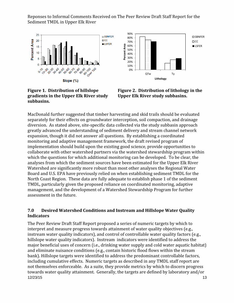
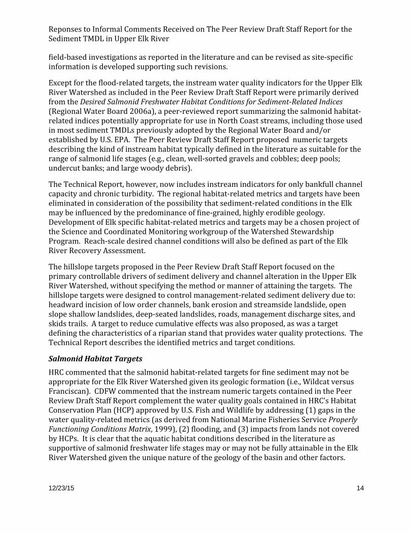
In his comments, MacDonald suggested that the study of subbasins used to discern the drainage density in natural versus managed portions of the watershed are not sufficiently comparable with respect to geology and slope. HRC further suggested that the lithology in Upper Elk River is more dominated by Wildcat (78%) than the reference study subbasin (71%).
Appendix 4A of the Peer Review Draft Staff Report includes a description of the slopes and lithology in the study subbasins, as reproduced below in Figures 1 and 2, respectively. Speaking generally, South Branch North Fork Elk River (SBNFER) and Corrigan Creek (CC) have more of their subwatershed area comprised of <40% slopes than Little South Fork Elk River (LSFER) and LSFER has more of its area in the 40%-80% slope class. However, the basins are within approximately 5% of each other with respect to slope class distribution, indicating reasonable comparability for the purposes of evaluating stream density.
With respect to lithology, the proportion of each study subbasin comprised of Wildcat (QTw) and Yager (Ty) formations is within 8% of each other; though, it should be noted that the mapping of lithology has inherent uncertainty, especially where there are unmapped faults, folds, and fractures. The softer Wildcat overlays the harder Yager and streams down-cut through the Wildcat and expose the Yager. For the purposes of comparing drainage densities, the depth to the Yager at the channel head has a substantial influence on the depth of any gully that initiates. The data collected from the study subbasins with respect to lithology primarily influences the estimate of sediment loading from the Low Order Channel Incision sediment source category. This category is estimated to be approximately 3% of the total current sediment loading. These site-specific data are the best available data from which to compare the current stream channel network to that of a pre-anthropogenically influenced landscape; and indeed, significantly raise the bar with respect to that which has been developed for most other watersheds in the North Coast Region. Further, elsewhere in MacDonald’s letters are recommendations to use regional sedimentation rates and sediment delivery rates from other watersheds, which we declined due to the unique characteristics of the Elk River Watershed. The commenter’s suggested comparisons watersheds present even greater differences than those found between Elk River subbasins.
Reponses to Informal Comments Received on The Peer Review Draft Staff Report for the Sediment TMDL in Upper Elk River
12/23/15 13
Figure 1. Distribution of hillslope gradients in the Upper Elk River study subbasins.
Figure 2. Distribution of lithology in the Upper Elk River study subbasins.
MacDonald further suggested that timber harvesting and skid trails should be evaluated separately for their effects on groundwater interception, soil compaction, and drainage diversion. As stated above, site-specific data collected via the study subbasin approach greatly advanced the understanding of sediment delivery and stream channel network expansion, though it did not answer all questions. By establishing a coordinated monitoring and adaptive management framework, the draft revised program of implementation should build upon the existing good science, provide opportunities to collaborate with other watershed partners via the watershed stewardship program within which the questions for which additional monitoring can be developed. To be clear, the analyses from which the sediment sources have been estimated for the Upper Elk River Watershed are significantly more robust than most other analyses the Regional Water Board and U.S. EPA have previously relied on when establishing sediment TMDL for the North Coast Region. These data are fully adequate to establish phase 1 of the sediment TMDL, particularly given the proposed reliance on coordinated monitoring, adaptive management, and the development of a Watershed Stewardship Program for further assessment in the future.
7.0 Desired Watershed Conditions and Instream and Hillslope Water Quality Indicators
The Peer Review Draft Staff Report proposed a series of numeric targets by which to interpret and measure progress towards attainment of water quality objectives (e.g., instream water quality indicators), and control of controllable water quality factors (e.g., hillslope water quality indicators). Instream indicators were identified to address the major beneficial uses of concern (i.e., drinking water supply and cold water aquatic habitat) and eliminate nuisance conditions (e.g., contain historic flood flows within the stream bank). Hillslope targets were identified to address the predominant controllable factors, including cumulative effects. Numeric targets as described in any TMDL staff report are not themselves enforceable. As a suite, they provide metrics by which to discern progress towards water quality attainment. Generally, the targets are defined by laboratory and/or
0%10%20%30%40%50%60%70%80%90%
QTw Ty
Perc
ent A
rea
Lithology
SBNFERCCLSFER
Reponses to Informal Comments Received on The Peer Review Draft Staff Report for the Sediment TMDL in Upper Elk River
12/23/15 14
field-based investigations as reported in the literature and can be revised as site-specific information is developed supporting such revisions.
Except for the flood-related targets, the instream water quality indicators for the Upper Elk River Watershed as included in the Peer Review Draft Staff Report were primarily derived from the Desired Salmonid Freshwater Habitat Conditions for Sediment-Related Indices (Regional Water Board 2006a), a peer-reviewed report summarizing the salmonid habitat-related indices potentially appropriate for use in North Coast streams, including those used in most sediment TMDLs previously adopted by the Regional Water Board and/or established by U.S. EPA. The Peer Review Draft Staff Report proposed numeric targets describing the kind of instream habitat typically defined in the literature as suitable for the range of salmonid life stages (e.g., clean, well-sorted gravels and cobbles; deep pools; undercut banks; and large woody debris).
The Technical Report, however, now includes instream indicators for only bankfull channel capacity and chronic turbidity. The regional habitat-related metrics and targets have been eliminated in consideration of the possibility that sediment-related conditions in the Elk may be influenced by the predominance of fine-grained, highly erodible geology. Development of Elk specific habitat-related metrics and targets may be a chosen project of the Science and Coordinated Monitoring workgroup of the Watershed Stewardship Program. Reach-scale desired channel conditions will also be defined as part of the Elk River Recovery Assessment.
The hillslope targets proposed in the Peer Review Draft Staff Report focused on the primary controllable drivers of sediment delivery and channel alteration in the Upper Elk River Watershed, without specifying the method or manner of attaining the targets. The hillslope targets were designed to control management-related sediment delivery due to: headward incision of low order channels, bank erosion and streamside landslide, open slope shallow landslides, deep-seated landslides, roads, management discharge sites, and skids trails. A target to reduce cumulative effects was also proposed, as was a target defining the characteristics of a riparian stand that provides water quality protections. The Technical Report describes the identified metrics and target conditions.
Salmonid Habitat Targets
HRC commented that the salmonid habitat-related targets for fine sediment may not be appropriate for the Elk River Watershed given its geologic formation (i.e., Wildcat versus Franciscan). CDFW commented that the instream numeric targets contained in the Peer Review Draft Staff Report complement the water quality goals contained in HRC’s Habitat Conservation Plan (HCP) approved by U.S. Fish and Wildlife by addressing (1) gaps in the water quality-related metrics (as derived from National Marine Fisheries Service Properly Functioning Conditions Matrix, 1999), (2) flooding, and (3) impacts from lands not covered by HCPs. It is clear that the aquatic habitat conditions described in the literature as supportive of salmonid freshwater life stages may or may not be fully attainable in the Elk River Watershed given the unique nature of the geology of the basin and other factors.
Reponses to Informal Comments Received on The Peer Review Draft Staff Report for the Sediment TMDL in Upper Elk River
12/23/15 15
As above, the Technical Report no longer includes habitat-related targets, deferring their development to the Watershed Stewardship Program and Elk River Recovery Assessment.
Hillslope Water Quality Indicators
Riparian Areas
The width of a functional riparian area is defined in the Peer Review Draft Staff Report as 300 feet for Class I and II watercourses and 150 feet for Class III watercourses. Numeric hillslope targets for riparian areas are described as an improving trend in the quality of riparian areas capable of providing wood and complexity to the channel, slope stability, and ensuring adequate ground cover. In the Upper Elk River Watershed, the Class III network comprises approximately 50% of the watercourses and current riparian protections allow harvesting up to the channel, which is not adequately protective.
The Peer Review Draft Staff Report discusses the values of riparian areas. Riparian areas are significant to sediment loading not just for filtration of sediment, but also to support slope stability through root strength and reduce delivery when a landslide happens by holding the sediment on the hillslope under a network of trees. Landslides that deliver sediment to the streams from vegetated riparian areas also deliver wood, which meters and sorts the sediment and ensures structures are delivered that can provide habitat in the form of pool scour and cover.
CDFW voiced support for the definition of riparian area and associated targets as given in the Peer Review Draft Staff Report. GRDC suggested that its riparian protections on Class III watercourses are adequate to reduce peak flows, promote infiltration, and reduce channel incision, including an inner zone that is essentially a no-cut zone of 150 feet on Class I and 75-100 feet on Class II watercourses. MacDonald suggested that if wood delivery is part of the rational for stream buffers, a more convincing argument should be made.
The Technical Report augments the Peer Review Draft Staff Report with a conceptual model of the Elk River watershed processes and ecological risk factors. It describes the watershed setting (e.g., vegetation); management and landuse activities (e.g., timber harvesting); watershed responses (e.g., riparian zone simplification, channel simplification, reduced root strength, reduced canopy interception, and reduction in LWD recruitment trees); watershed effects; and watershed impacts. The Technical Report keeps the riparian area definitions and targets as proposed in the Peer Review Draft Staff Report; however the Framework for Implementation as described in the Technical Report makes clear that it is within the context of WDR that the targets and load allocations will be applied. The Regional Water Board exercises its discretion with respect to how to implement targets and load allocations in a WDR.
Peak flow influence on in-channel sources
The Upper Elk River Watershed is particularly vulnerable to bank erosion and streamside landsliding resulting from landscape disturbance, due in part to the fine grained sediment in the parent material and prevalence of soil pipes and subsurface erosion. Landscape disturbance that results in collapse of soil pipes can lead to a headward incision of the stream channel network as the subsurface flow paths are daylighted and unstable stream
Reponses to Informal Comments Received on The Peer Review Draft Staff Report for the Sediment TMDL in Upper Elk River
12/23/15 16
banks further erode. To address this phenomenon, the Peer Review Draft Staff Report defined a hillslope target to limit harvest-related peak flow increases in Class II and III watercourse catchment areas to 10% in 10 years.
CDFW voiced support for this hillslope numeric target, commenting on its potential to limit headcutting and promote infiltration. MacDonald suggested that perhaps the best means of minimizing headward channel incision is to minimize compaction and maintain at least 60-65% surface cover comprised of litter, wood, and live vegetation. GDRC suggested that its use of shovel logging (rubber tire tractors) and slash left on site as part of their even-aged management regime is sufficient to address soil pipe collapse.
The Peer Review Draft Staff Report and Technical Report describe the headward incision of low-order watercourses as the result of compaction and increased peak flows. As such, both of these mechanisms need to be addressed in the program of implementation. Because of past adjustments to Class II and III channel networks, active gullies could be destabilized by the increase peak flows following harvesting. Additionally, Elk River seems to have a special propensity for subsurface erosion that can include soil pipe collapse and channel lengthening. As such, limiting the canopy removal upslope of channel heads is also important and is described below.
MacDonald specifically cited Pacific Lumber Company’s (Palco) critical assessment of the peak flow model as developed from Caspar Creek data. He offered several cautions; but, made some key points with which the Regional Water Board agrees. Namely, changes in peak flows have the greatest effect in smaller basins and when a basin is 15-20% harvested in a short period of time. Peak flows have the greatest influence on sediment transport when grain sizes are relatively small.
With respect to his cautions, the Regional Water Board is familiar with Palco’s criticisms of the peak flow model as they were the subject of much debate during the drafting of the 2006 WDRs for Palco in Elk River and Freshwater Creek. The models used to support adoption of those WDRs have withstood peer review and have been widely published. They have been applied by other state agencies in the evaluation of the impacts of forest practices in the Elk River and other watersheds in the north coast. Further, they are useful for quantifying the influences of harvesting on watershed hydrology. The Technical Report incorporates a reworded version of the hillslope targets addressing peak flows, as described in the Peer Review Draft Staff Report.
Rate of Harvest
The Peer Review Draft Staff Report identified a hillslope target of a maximum harvest rate of 1.5% as a means of controlling chronic turbidity from new discharges associated with the harvesting and road activities. The Peer Review Draft Staff Report also provided a policy curve describing that while efforts are underway to control new and existing sources of sediment and implement instream remediation to increase loading capacity, harvest rate should start low and step up over time to a maximum of 1.5%. This policy curve was envisioned as conceptual, the shape of which Regional Water Board members would weigh in on and modify.
Reponses to Informal Comments Received on The Peer Review Draft Staff Report for the Sediment TMDL in Upper Elk River
12/23/15 17
Rate of harvest not only indicates the rate and scale of logging area in a given drainage, but also drives road construction and the treatment of management-related sediment discharge sites. Many studies have been conducted to better understand the relationship between harvest rate and cumulative watershed effects, which can result from a complex interaction of many different factors. Such factors include inherent watershed characteristics, such as geology and geomorphology; external natural processes, such as climate and timing of stochastic events (i.e. large storms, earthquakes, fires); and timber harvest practices including type and extent of watershed area disturbed. Several studies referenced below cite specific thresholds for the harvest rate, above which cumulative impacts are likely to occur.
For example, Klein, Lewis, and Buffleben (2012) conducted a study assembling a turbidity data set from 28 north coast watersheds under different ownerships for Hydrologic Years 2004 and 2005. The study was empirical and statistical and not an investigation of processes. At the time of the study, the authors sought data from entities monitoring turbidity in the north coast. Their study demonstrated statistically significant relationships between the 10% exceedance probability for turbidity (10% turbidity) and harvest rate after controlling for other factors. The 10% turbidity was proposed as a representation of chronic conditions during winter base flows, i.e. the level of turbidity to which streams clear between storms. The majority of sediment transport, elevated turbidity, fish feeding impacts, and water supply impacts occur during storm events. Recession in turbidity levels, fish feeding, and water supply replenishment occur between storms. If streams do not clear, then the impacts to these uses have a longer duration, contributing to their level of impairment.
Klein et al evaluated watershed factors through a regression analysis and showed the rate of recent logging explained the greatest amount of variability in 10% turbidity. Klein et al indicated that despite much improved best management practices, contemporary timber harvest can trigger or preserve cumulative watershed effects when a watershed is heavily harvested over a short time period. Klein et al found that the clearcut equivalent (CCE) acres harvested 10-15 years prior and drainage area had highly significant correlations: r2=0.63 (North Coast, n=27); r2=0.82 (Humboldt, n=19), respectively. They found a statistically significant difference in 10% turbidity for watersheds in different harvest level groups: pristine, no harvest over past 15 years, harvest of less than 1.4% in past 15 years, and harvest of equal or greater than 1.5% over past 15 years. While queried and requested, Palco and GDRC (then Simpson) did not provide their data for inclusion in the study; therefore, numerous stations operating in Freshwater Creek and Elk River were not included in Klein et al’s analysis.
In 2013, HRC released a report evaluating trends in turbidity and suspended sediment from 2003- 2012 in Freshwater Creek and Elk River (Sullivan et al, 2012). This report included data that had previously been unavailable to the authors of Klein et al. That paper found a decreasing trend in 10% turbidity with rate of harvest beyond 2005. Sullivan was cited extensively by GDRC, HRC, and MacDonald in their comment letters.
MacDonald provided comments about the regression model used by Klein et al. His comments focused on four main issues: (1) the application of weighting factors for
Reponses to Informal Comments Received on The Peer Review Draft Staff Report for the Sediment TMDL in Upper Elk River
12/23/15 18
different silvicultural methods in normalizing harvest to CCE, (2) the uncertainty associated with causal linkages and processes between harvesting, erosion, sediment transport and chronic turbidity, (3) the robustness of the results and that the Sullivan report found a different result, and 4) the effectiveness of BMPs.
Randy Klein and Jack Lewis provided comments on the Peer Review Draft Staff Report and also presented their assessment to the Board of Forestry Monitoring Study Group where they addressed both the Sullivan results and MacDonald’s comments. Drawing from Klein and Lewis’s presentation, the following are responses to MacDonald’s primary points:
(1) The weighting factors are simply used to normalize the level of canopy removal from various silvicultural methods into a common metric. CCE has been used in the application of the peak flow model by CalFire and the Regional Water Board in the 2006 WDRs for Elk River and Freshwater Creek. The weighting factors are not characterizations of, or proxies for, the physical processes related to erosion.
(2) Many studies have linked specific processes to watershed impacts, such as increased peak flows, turbidity, and landslide-related sediment discharge (e.g. Ziemer 1998, Lewis et al 2001, Reid and Lewis 2007, Reid 2012, Dhakal and Sullivan 2014, Newcombe and MacDonald 1991, Newcombe and Jensen 1996, O’Loughlin and Ziemer 1982). The regression model found a stronger correlation between chronic turbidity and harvest rate than with any other of the numerous watershed variables explored.
Caspar Creek, an experimental forest located in Mendocino County, is one of the most intensively studied watersheds in the northern California coast and Pacific Northwest, substantially advancing the scientific understanding of forest hydrology and sediment delivery. The Caspar Creek studies are uniquely appropriate because it evaluated the hydrologic effects of timber harvest and related activities in second-growth redwood forests. Caspar Creek is also representative of conditions in many northern California coast watersheds. The Caspar Creek watershed is similar to the Elk River Watershed in terms of its coastal location, vegetation, rainfall patterns, and land use. The recent summary of Caspar Creek findings by Cafferata and Reid (2013) describes many of the relevant results from studies conducted over the past 50 years.
(3) With respect to the Sullivan et al (2012) report, Klein and Lewis describe that they had reproduced the Sullivan statistics and identified an additional “site” variable that was highly correlated to harvest rate, possibly confounding the trends found in Sullivan’s report. In their exploration, they removed the “site” variable and applied statistical tests, finding a positive coefficient and statistically significant correlation for harvest rate in the past 10-15 year period and the 10% turbidity for 2003-2011.
(4) In general, the Forest Practice Rules and prescriptions required under the Palco/HRC and GDRC HCPs are BMP-based. Specific BMPs may be effective in some circumstances and not in others varying with, for example, slope steepness, rainfall intensity, sediment and soil composition, drainage area, etc. Ideally, BMPs would be developed and tested through effectiveness monitoring studies. But, a
Reponses to Informal Comments Received on The Peer Review Draft Staff Report for the Sediment TMDL in Upper Elk River
12/23/15 19
comprehensive effectiveness monitoring effort has not yet been completed in a manner to allow EPA to certify the Forest Practice Rules as BMPs. Since implementation of the Palco/HRC HCP, there have been relatively few effectiveness monitoring studies; those that have been conducted focused on (a) turbidity changes following harvest and the collective implementation of sediment control BMPs, and (b) the runoff associated with road surface erosion on storm proofed roads with wet weather restrictions in place. These studies informed the Elk River Sediment Source Analysis and further studies could be designed to verify BMP effectiveness. The relative lack of effectiveness monitoring leaves some uncertainty in the efficacy of BMPs, especially in light of ongoing sediment accumulation in the impacted reach. Effectiveness monitoring testing the individual and collective load reduction measures will go far toward validating that control measures are sufficient to ensure watershed recovery.
HRC suggested that use of a harvest rate to control sediment from existing sources is speculative and without precedent. Yet, harvest rate limits have been used by state regulatory agencies as one of the primary tools to address cumulative watershed effects in Elk River and other north coast watersheds for several years, including in the current Regional Water Board issued Waste Discharge Requirements (WDRs). For example:
o In 1998, in recognition of widespread cumulative watershed effects associated with high rate and intensity of harvesting in the Elk River Watershed, CalFire, in consultation with several other agencies, imposed a conditional moratorium on new timber harvest plan approvals in Elk River that applied to all landowners.
o In 2002, CalFire lifted the moratorium and imposed an annual rate-of-harvest limit of 600 clearcut equivalent (CCE) acres per year on Palco lands. The limit was based on a model relating canopy removal rates to increases in peak flows (Lewis et al, 2001).
o On May 8, 2006, the Regional Water Board adopted WDRs (Order No. R1-2006-0039 as amended by Order No. R1-2008-0100) for Humboldt Redwood Company-owned lands in Elk River (then owned by Palco), imposing further rate-of-harvest restrictions in Elk River based on the results of two models: one relating harvest rate to landslide sediment deliveries (Empirical Harvest-Related Landslide Sediment Delivery Reduction Model a.k.a. landslide model), and the other relating canopy removal rates to increases in peak flows (Empirical Peak Flow Reduction Model a.k.a. peak flow model), which was the same model as used by CalFire in 2002. This permitting action was designed to remain in place until a sediment TMDL could be approved for Elk River and remains in effect on HRC lands in the Elk River Watershed today.
The current Elk River WDRs include a provision allowing HRC to harvest additional acreage above and beyond the limits of the landslide model (referred to as Tier 1 acreage) up to the peak flow limits (referred to as Tier 2 acreage) provided they can demonstrate through an enforceable monitoring plan that no sediment discharges from harvest related landslides occur. Because a peak flow
Reponses to Informal Comments Received on The Peer Review Draft Staff Report for the Sediment TMDL in Upper Elk River
12/23/15 20
limit does not exist in the South Fork Elk River, no overall harvest limit is currently in place for HRC’s South Fork lands.
o On August 9, 2006 the Regional Water Board adopted WDRs (Order No. R1-2006-0043) for Green Diamond Resource Company’s (GDRC) South Fork Elk holdings. GDRC voluntarily agreed to a harvest rate cap that was within the acreage identified by the landslide model. On October 4, 2012, the Regional Water Board adopted the same harvest rate for GDRC’s South Fork Elk River holdings into the WDRs (Order No. R1-2012-0087) for GDRC ownership-wide forest management activities.
The Technical Report describes the importance of harvest rate to sediment production and cumulative effects, but does not include a hillslope target tied to harvest rate. The Regional Water Board has discretion to continue its use of harvest rate limitations in a WDR designed to implement the findings of the Technical Report.
8.0 Water Quality Trends
In 2013, following the Peer Review Draft Staff Report, Jack Lewis authored a Salmon Forever Report, which conducted multivariate trend analyses of suspended sediment concentration (SSC) at the Salmon Forever gage stations located just upstream of the confluence on lower North Fork and lower South Fork as well as in Freshwater Creek. Jack Lewis estimated SSC based upon storm-based turbidity-SSC relationships (i.e. evaluates each storm separately). He found that 50% of the variability in mean SSC was accounted for by storm peak flow and antecedent precipitation index. He evaluated the remainder of the variability in SSC by comparing storm-based SSC to mean SSC for hydrologic years 2003-2013. He found that in Upper Elk River, from 2003-2008, the mean SSC declined and that from 2011-2013 there was an increase in SSC that was not explained by peak flows or storm history. He made the conclusion that after accounting for weather, SSC is increasing in Elk and decreasing in Freshwater.
Sullivan et al (2012) also explored trends in suspended sediment loads in Elk River and Freshwater Creek and found improving trends in annual sediment loads. HRC estimates SSC based upon an annual turbidity-SSC relationship (pooled data from all storms). In the Lewis and Klein comments, they suggest that Sullivan’s trend analysis is influenced by unsupported assumptions, sample size, and the lumping of Elk and Freshwater datasets.
Reviewing these analyses, the Regional Water Board conclude that (1) storm-based SSC multivariate regression analysis appears to be the most robust method for evaluating trends in sediment loads over a range of water years, (2) there are available techniques to discern percent reductions in loads and concentrations, whereas it is difficult to demonstrate attainment of a fixed end point, and (3) it is appropriate under the Watershed Stewardship Program to develop a science and coordinated monitoring work to guide trend monitoring resources, assess techniques, and strive to build agreement with respect to data sharing, so as to avoid conflicting conclusions moving forward.
9.0 Implementation, Monitoring and Adaptive Management
Reponses to Informal Comments Received on The Peer Review Draft Staff Report for the Sediment TMDL in Upper Elk River
12/23/15 21
In his comments, MacDonald supported the concept of adaptive management and pointed out that the Peer Review Draft Staff Report put little emphasis on such an approach to improve upon the program of implementation over time in response to monitoring results. The Technical Report much more clearly describes that a program of implementation needs to be based upon our current best science, supported by a robust and coordinated monitoring program, including compliance, effectiveness, and trend monitoring to inform timely and appropriate adaptive management improvements.
HRC commented that the Regional Water Board adopted a WDR in 2006 allowing for a particular volume of sediment discharge from harvest-related landslides. HRC suggested that because landslides have not been frequent since, this is indicative of a sufficiently effective program of BMPs and that flooding will persist regardless of forest management.
To clarify, the 2006 WDR focused on controlling sediment from harvest-related landslides because those landslides were a large proportion of the sediment discharge during the 1988-1997 and 1998-2003 time periods. The 2006 WDR was an interim permitting strategy while the TMDL was under development. The approach to harvest-related landslides was to look at the ratio of unit landslide delivery volume from recently harvested areas, versus the unit landslide delivery volume from areas not recently harvest (which served as a background estimate). The WDR sought to control harvest related landsliding by controlling harvest acres. Recognizing that landsliding occurs in response to stochastic events, one cannot predict volume-based, landslide-related discharges every year, as HRC seems to suggest. Further, the Peer Review Draft Staff Report, HRC’s Watershed Analysis, and the Technical Report highlight additional priority sources, including in-channel sources (headward incision of low order channels, stream bank failures, and streamside landslides influenced by management activities in the riparian zone and headwater streams) that require control. Finally, the Technical Report documents, and the Elk River Recovery Assessment is further evaluating, the ongoing aggradation within the impacted reaches, which is the result of sediment discharged from the tributaries. As long as sediment from the upper watershed continues to accumulate within the impacted reaches, causing further harm to downstream landowners, additional sediment controls are necessary and appropriate.
10.0 References
Cafferata, P. and Reid, L. 2013. Applications of long-term watershed research to forest management in California: 50 years of learning from the Caspar Creek Experimental Watersheds. California Forestry Report No. 5. State of California, California Natural Resources Agency, Sacramento, CA.
California Department of Fish and Wildlife (CDFW). 2014. Elk River Total Maximum Daily Load Analysis and Technical Report. Informal comment on Peer Review Draft Staff Report to Support the Technical Sediment TMDL for the Upper Elk River. October 6, 2014. Available at: http://www.waterboards.ca.gov/northcoast/water_issues/programs/tmdls/elk_river/pdf/141016/13_California_Department_of_Fish_and_Wildlife.pdf
Reponses to Informal Comments Received on The Peer Review Draft Staff Report for the Sediment TMDL in Upper Elk River
12/23/15 22
California Forest Practice Rules (Forest Practice Rules). 1974. Title 14, California Code of Regulations, Chapter 4, 4.5, and 10. State of California, California Department of Forestry and Fire Protection, Sacramento, CA.
California Department of Forestry and Fire Protection (CalFire). 2014a. Comments on “Peer Review Draft – Staff Report to Support Technical Sediment Total Maximum Daily Load for the Upper Elk River. Informal comment on Peer Review Draft Staff Report to Support the Technical Sediment TMDL for the Upper Elk River. April 8, 2014. Available at: http://www.waterboards.ca.gov/northcoast/water_issues/programs/tmdls/elk_river/pdf/140424/10_CAL_FIRE.pdf
California Department of Forestry and Fire Protection (CalFire). 2014b. Comments on a Revised Strategy for the Total maximum daily Load (TMDL) for the Upper Elk River. Informal comment on Peer Review Draft Staff Report to Support the Technical Sediment TMDL for the Upper Elk River. April 8, 2014. Available at: http://www.waterboards.ca.gov/northcoast/water_issues/programs/tmdls/elk_river/pdf/141016/12_CAL_FIRE.pdf
Clean Water Act of 1972, 40 C.F.R. §130. 2015. Washington, D.C. Available at: http://epw.senate.gov/water.pdf
Dhakal, A.S. and Sullivan, K. 2014. Shallow groundwater response to rainfall on a forested headwater catchment in northern coastal California: implications of topography, rainfall, and throughfall intensities on peak pressure head generation. Hydrological Processes, 28: 446-463.
Friends of the Elk River. 2014. Informal comment on Peer Review Draft Staff Report to Support the Technical Sediment TMDL for the Upper Elk River. January 15, 2014. Available at: http://www.waterboards.ca.gov/northcoast/water_issues/programs/tmdls/elk_river/pdf/140424/4_Friends_of_Elk_River.pdf
Green Diamond Resource Company (GRDC). 2013. Informal comment on Peer Review Draft Staff Report to Support the Technical Sediment TMDL for the Upper Elk River. November 21, 2014. Available at: http://www.waterboards.ca.gov/northcoast/water_issues/programs/tmdls/elk_river/pdf/140424/1_Green_Diamond.pdf
Humboldt Redwood Company (HRC). 2012. Watershed Analysis Revisit for Elk River and Salmon Creek, Sediment Budget. Excel Spreadsheet for 2001-2011.
Humboldt Redwood Company (HRC). 2013. Informal comment on Peer Review Draft Staff Report to Support the Technical Sediment TMDL for the Upper Elk River. January 2, 2013. Available at:
Humboldt Redwood Company (HRC). 2014. Elk River/Salmon Creek Watershed Analysis Revisited. June 13, 2014.
Klein, R.D., Lewis, J., and Buffleben, M.S. 2012. Logging and turbidity in the coastal watersheds of northern California. Geomorphology, 139: 136-144.
Lewis, J., Mori, S. R., Keppeler, E. T., and Ziemer, R. R. 2001. Impacts of logging on storm peak flows, flow volumes and suspended sediment loads in Caspar Creek, California. Water Science and Application, 2: 85-125.
Lewis, J. 2013. Salmon Forever’s 2013 Annual Report on Suspended Sediment, Peak Flows, and Trends in Elk River and Freshwater Creek, Humboldt County, California. Submitted to Redwood Community Action Agency. SWRCB Agreement No. 07-508-551-1. June 2013.
Lewis, J. and Klein, R. 2014. Informal comment on Peer Review Draft Staff Report to Support the Technical Sediment TMDL for the Upper Elk River. March 5, 2014. Available at: http://www.waterboards.ca.gov/northcoast/water_issues/programs/tmdls/elk_river/pdf/140424/7_Lewis_and_Klein.pdf
MacDonald, L. 2014a. Initial Comments on the Peer Review Draft. Informal comment on Peer Review Draft Staff Report to Support the Technical Sediment TMDL for the Upper Elk River. January 17, 2014. Available at: http://www.waterboards.ca.gov/northcoast/water_issues/programs/tmdls/elk_river/pdf/140424/5_Lee_MacDonald_1.pdf
MacDonald, L. 2014b. Additional Comments on the Peer Review Draft. Informal comment on Peer Review Draft Staff Report to Support the Technical Sediment TMDL for the Upper Elk River. February 2, 2014. Available at: http://www.waterboards.ca.gov/northcoast/water_issues/programs/tmdls/elk_river/pdf/140424/6_Lee_MacDonald_2.pdf
MacDonald, L. 2014c. Informal Additional Comments on Peer Review Draft: Elk River Sediment TMDL. Informal comment on Peer Review Draft Staff Report to Support the Technical Sediment TMDL for the Upper Elk River. March 27, 2014. Available at: http://www.waterboards.ca.gov/northcoast/water_issues/programs/tmdls/elk_river/pdf/140424/9_Lee_MacDonald_3.pdf
Marshall, G. J., and Mendes, E. 2005. Geologic and geomorphic features related to landsliding and landslide potential in the Eel River watershed. State of California, Department of Conservation, California Geological Survey, Sacramento, CA.
Newcombe, C.P., and D.D. MacDonald. 1991. Effects of suspended sediments on aquatic ecosystems. North American Journal of Fisheries Management, 11:72-82.
Reponses to Informal Comments Received on The Peer Review Draft Staff Report for the Sediment TMDL in Upper Elk River
12/23/15 24
Newcombe, C.P. and Jensen, J.O.T. 1996. Channel Suspended Sediment and Fisheries: A synthesis for Quantitative Assessment of Risk and Impact. North American Journal of Fisheries Management, 16(4): 693-727.
Noell, S.B. 2014. Informal comment on Peer Review Draft Staff Report to Support the Technical Sediment TMDL for the Upper Elk River. March 25, 2014. Available at: http://www.waterboards.ca.gov/northcoast/water_issues/programs/tmdls/elk_river/pdf/140424/8_Stephanie_Bennet_Noell.pdf
North Coast Regional Water Quality Control Board (Regional Water Board). 2006a. Desired Salmonid Freshwater Habitat Conditions for Sediment-Related Indices. Available at: http://www.waterboards.ca.gov/northcoast/water_issues/programs/tmdls/sediment_tmdl_implementation/110504/060728_desired_conditions_report.pdf
North Coast Regional Water Quality Control Board (Regional Water Board). 2006b. Watershed-wide WDRs for Lands Owned by Pacific Lumber Company in Elk River. Order No. R1-2006-0039. Available at: http://www.waterboards.ca.gov/northcoast/board_decisions/adopted_orders/pdf/2006/060508_R1-2006-0039_Elk_MRP.pdf
North Coast Regional Water Quality Control Board (Regional Water Board). 2006c. Watershed-wide Waste Discharge Requirements for Timber Harvesting Activities Conducted by, or on land owned by the Green Diamond Resource Company in the South Fork Elk River Watershed. Order No. R1-2006-2043. Available at: http://www.waterboards.ca.gov/northcoast/board_decisions/adopted_orders/pdf/2006/060821_0043_WWWDR_GreenDiamond.pdf
North Coast Regional Water Quality Control Board (Regional Water Board). 2008. Minor Amendment to Watershed-wide Waste Discharge Requirements Order No. R1-2006-0039 and Order No. R1-2006-0041. Order No. R1-2008-0100. Available at: http://www.waterboards.ca.gov/northcoast/board_decisions/adopted_orders/pdf/2008/08_100_WWDR_Modified_HRC_Palco.pdf
North Coast Regional Water Quality Control Board (Regional Water Board). 2012. Waste Discharge Requirements for Discharges Related to Green Diamond Resource Company’s Forest Management Activities Conducted within the Area Covered by its Aquatic Habitat Conservation Plan in the North Coast Region: Humboldt and Del Norte Counties. Order No. R1-2012-087. Available at: http://www.waterboards.ca.gov/northcoast/board_decisions/adopted_orders/pdf/2012/121015_12_0087_WDR_GreenDiamond.pdf
North Coast Regional Water Quality Control Board (Regional Water Board). 2013. Peer Review Draft Staff Report to Support the Technical Sediment Total Maximum Daily Load for the Upper Elk River. Available at: http://www.waterboards.ca.gov/northcoast/water_issues/programs/tmdls/elk_riv
North Coast Regional Water Quality Control Board (Regional Water Board). 2014. Green Diamond Resource Company’s November 21, 2013 letter regarding the Total Maximum Daily Load process for the Upper Elk River Watershed. Response to informal comments on the Peer Review Draft Staff Report to Support the Technical Sediment Total Maximum Daily Load for the Upper Elk River. January 28, 2014. Available at: http://www.waterboards.ca.gov/northcoast/water_issues/programs/tmdls/elk_river/pdf/140424/2_Regional_Water_Board_Response_To_GDRC.pdf
Northern Hydrology Engineering and Stillwater Sciences (NHE and Stillwater). 2013. Elk River Hydrodynamic and Sediment Transport Modeling Pilot Project. Final Report, February 5, 2013. Report to Redwood Community Action Agency.
O'Loughlin, C., and R. R. Ziemer. 1982. The importance of root strength and deterioration rates upon edaphic stability in steepland forests. Proceedings of International Union of Forest Research Organizations. “Workshop P.1.07-00 Ecology of Subalpine Ecosystems as a Key to Management.” 2-3 August 1982, Corvallis, Oregon. Oregon State University, Corvallis, Oregon. pp. 70-78.
Pacifc Lumber Company (Palco). 1999. Habitat Conservation Plan. Prepared by Pacific Lumber Company. for Scotia Pacific Holding Company and Salmon Creek Corporation. Scotia, CA.
Pacifc Lumber Company (Palco). 2004. Elk River/Salmon Creek Watershed Analysis. Scotia, CA.
Reid, L.M., Lewis, J., 2007. Rates and implications of rainfall interception in a coastal redwood forest. In: Standiford, R.B., Giusti, G.A., Valachovic, Y., Zielinski, W.J., Furniss, M.J. (Eds.), Proceedings of the Redwood Region Forest Science Symposium: what does the future hold? General Technical Report PSW-GTR-194. U.S. Forest Service Pacific Southwest Research Station, Albany, CA, pp. 107–117.
Reid, L.M. 2012. Comparing hydrologic responses to tractor-yarded selection and cable-yarded clearcut logging in a coast redwood forest. In: Standiford, R.B., Weller, T.J., Piirto, D.D., and Stuart, J.D. (Technical coordinators), Proceedings of the Coast Redwood Forests in a Changing California: a Symposium for Scientists and Managers. General Technical Report PSW-GTR-238. USDA Forest Service, U.S. Forest Service Pacific Southwest Research Station, Albany, CA, pp. 141–151.
State Water Resources Control Board. 2004. Policy for Implementation and Enforcement of the Non-point Source Pollution Control Program (State Water Board Non-point Source Policy). 2004. State of California, Environmental Protection Agency, Sacramento, California. May 20, 2004. Available at:
Sullivan, K., D. Manthorne, R.R, and Griffith, A. 2012. Trend in sediment-related water quality after a decade of forest management implementing an Aquatic Habitat Conservation Plan. Humboldt Redwoods Company, Scotia, CA.
Tetra Tech, Inc. 2015. Upper Elk River Technical Analysis for Sediment. Prepared for North Coast Regional Water Quality Control Board. Fairfax, Virginia. October 16, 2015.
United States Fish & Wildlife Service and California Department of Forestry and Fire Protection (USFWS and Calfire). 1999. Habitat Conservation Plan and Associated Documents for PALCO Lands. Available at: http://www.fws.gov/arcata/es/birds/NSO/documents/Pacific_Lumber_Co_(Humboldt_Redwood_Co.)_1999_Final_HCP.pdf
Ziemer, R. R. 1998. Flooding and stormflows. In Proceedings of the conference on coastal watersheds: the Caspar Creek story. Vol. 6, p. 24.