International Journal of Scientific & Engineering Research Volume 11, Issue 4, April-2020 360 ISSN 2229-5518
IJSER © 2020
http://www.ijser.org
Remote Health Service Delivery Mechanism Using Vehicle Routing And Dijkstra Algorithm In Akure Metropolis
A.D. Babalola1, K.F Akingbade2, A. J. Yakubu3, F.T. Oyediji4
1,,3,4Department of Computer Engineering, Federal Polytechnic, Ile-Oluji, Nigeria.
2Department of Electrical Electronic Engineering, Federal University of Technology Akur,
Nigeria.
E–mail (Corresponding Author: [email protected])
Abstract
Health services in Nigeria are one of the major factors why the majority of the populace
are going abroad. Developing a service delivery mechanisms in health care management limit
the challenges of travelling abroad for medical checkup. In the rural community in Nigeria, most
people find it difficult to visit the hospital when they are ill. They prefer to use the local
medication than visiting the health centres for proper medication diagnostic due to lack of
money. This study attempted bringing the medical expert to the people's homes using the mobile
health van or ambulance in case of an emergency. The vehicle routing algorithm and Dijkstra's
algorithm served as a mechanism to calculate the shortest route or path to get to the patient
location with an optimal distance and minimal cost. Hyper Pre-processor (PHP) was used to
create an online-based registration form to get some information on the patient, consultant, and
the nearest health facilities. Upon registration, the patient will go home with health wearable
devices which will measure the body vital sign like blood pressure, electrical activities of the
heart (ECG), body temperature and blood oxygen level. These wearable devices contain sensors
attached to an Arduino Uno board with GSM/GPS 900. These will collect the measured readings
and forward it to the server or cloud for the assigned medical consultant to render medical advice
and for quick response in times of emergency. Google Earth Pro was used to get the Landsat
and positions for the hospitals to create a database containing the addresses, longitude, and
latitude. In conclusion, the design would allow patients to know the nearest hospital around them
and calculate the shortest path to get to the hospital.
Keyword: Delivery Mechanism; Health Service; Vehicle; Routing; Dijkstra Algorithm
1. Introduction
According to [1] World Health
Organization(WHO) defines health as a state
of physical, mental and social well-being in
which disease and infirmity are absent.
Remote health service delivery is the system
whereby health care resources and services
delivered to the patient at any location. Home
Health Care (HHC) covers a wide range of
services at the homes of the patients. HHC
mainly addresses the needs of the patients
who are over-aged, who have disabilities and
IJSER
International Journal of Scientific & Engineering Research Volume 11, Issue 4, April-2020 361 ISSN 2229-5518
IJSER © 2020
http://www.ijser.org
who have chronic diseases. HHC includes
services such as nursing, medical visits,
home life aids, psychological support, old
people assistance, house cleaning, etc.
Presently, the percentages of
Nigerians living up to the age of 52 and above
have increased significantly, and the existing
health care system had not given these people
attention. The inability of a patient to
find or get a health care centre to receive
treatment when having health challenges like
(heart failure, asthma) sometimes result in
death.
Having observed the Hospital Management
System in Ondo State, the condition is in bad
shape. Currently, the location of the hospitals
based on the different part of the community
in the state, make it impossible to access by
the patient because of distances. This study
used the shortest path problem to finding the
shortest path or route from a patient location
to the nearest healthcare facility.
This aim of this reseatch is to design
a remote health service delivery mechanism
using vehicle routing and Dijkstra's
algorithm in Akure metropolis. This study
allows for quick access to health facilities
remotely and to encourage prompt health
care delivery. The cost of each route, the
travel cost and travel time between each
patient and the care centre must be known. A
health service delivery system for health care
centres can aid in the hospitals for reaching
the patient in a golden hour, i.e. right on time.
Also, it can be useful in the development of a
database for hospitals in the study area. This
study centred on health care centres only in
Akure. It covers the entire hospitals in Akure
using (Geographic Information System) GIS
with the toposheet of Ondo State. The
limitation of this study, it can only find the
health care centres within the patient range or
location.
2. Literature Review
The Vehicle Routing Problem or
simply VRP is a well-known combinatorial
optimization problem and a generalization of
the travelling salesman problem. This
includes the optimal (minimal) routes for a
fleet of vehicles starting from a single point
(depot) to deliver the requested goods in all
customers at different locations. Finding an
optimal solution is an NP-hard problem, so
heuristic strategies for the approximation of
the optimal solution were used in this study.
Vehicle Routing Problem aids management
of vehicle resources effectively and reliably
like the reduction of fuel consumption,
finding a faster route for travel. The design is
required to handle these tasks ranging from a
distance, map of the road, and fuel
consumption to overcome the challenges.
The Vehicle Routing Problem (VRP) in this
study can best describe as the problem of
designing optimal delivery or collection
routes from one or several Hospital of
geographically scattered patient in the cities,
subject to side constraints.
2.1 Constraints Calculation for VRP
Algorithm
The formulation of the TSP by [2] was to
create the two index vehicle flow
formulations for the VRP.
Constraints 1 and 2 states that exactly one
arc enters and exactly one leaves each vertex
associated with a customer, respectively.
Constraints 3 and 4 say that the number of
vehicles leaving the depot is the same as the
number entering. Constraints 5 are the
capacity cut constraints, which impose that
the routes must be connected and that the
demand on each route must not exceed the
vehicle capacity. Finally, constraints 6 are
the integrality constraints.
IJSER
International Journal of Scientific & Engineering Research Volume 11, Issue 4, April-2020 362 ISSN 2229-5518
IJSER © 2020
http://www.ijser.org
2.2 Constraints Calculation for
Dijkstra’s Algorithm
Dijkstra’s algorithm is an algorithm
for finding the shortest paths between nodes
in a graph, which may represent, for example,
road networks and was developed by
computer scientist Edger W. in 1956.
For each visited node v, dist[v] considered
the shortest distance from the source to v;
and for each unvisited node u, dist[u] is
assumed the shortest distance when travelling
via visited nodes only, from source to u. This
assumption is considered if a path exists;
otherwise, the distance set to infinity. In
which case, we choose an
edge vu where u has the least dist[u] of any
unvisited nodes, and the edge vu is such
that dist[u] = dist[v] + length [v, u]. dist[u] is
considered to be the shortest distance
from the source to u because if there were a
shorter path, and if w was the first unvisited
node on that path then by the original
hypothesis dist[w] > dist[u] which creates a
contradiction.
1 function Dijkstra(Graph,
source):
2
3 create vertex set Q
4
5 for each vertex v in
Graph:
6 dist[v] ← INFINITY
7 prev[v] ← UNDEFINED
8 add v to Q 10 dist[source] ← 0
11
12 while Q is not empty:
13 u ← vertex in Q with
min dist[u]
14
15 remove u from Q
16
17 for each neighbour v
of u: // only v that is still
in Q
18 alt ← dist[u] +
length(u, v)
19 if alt < dist[v]:
20 dist[v] ← alt
21 prev[v] ← u
22
23 return dist[], prev[]
2.2 Review of Related Works
The main objective of the Vehicle
Routing Problem (VRP) is to design a set of
minimum cost routed that serves several
places, geographically dispersed, and
fulfilling specific constraints of the problem.
Since its first formulation in 1959, there have
been many publications and has expanded its
scope. In the last decade, there have been
significant advances in terms of the technical
solution to resolve large instances. Another
aspect that has gained interest is the inclusion
of technological innovations in the VRP.
These include global positioning systems,
radio frequency identification and use of
high-capacity computer information
processing [3]
Mohamad, AbdulRauf and
AbdMalekMod [4] work on health care
facility for Joharbahru city, Malaysia. A
network dataset created from the feature
source or sources that participate in the
network. It incorporates an advanced
connectivity model that can represent
complex scenarios, such as multimodal
transportation networks [4] Preparation of the
network analyst such as the Shortest Route
IJSER
International Journal of Scientific & Engineering Research Volume 11, Issue 4, April-2020 363 ISSN 2229-5518
IJSER © 2020
http://www.ijser.org
using Shortest Path tool: the closest facilities
using the closest facility tool.
Tikani and Setak, [5] worked on
Ambulance routing in a disaster response
scenario considering different types of
ambulances and semi-soft time windows
using Heuristic Algorithms based on genetic
algorithm and tabu search. They were able to
find acceptable solutions for a problem in
reasonable computational times, but due to
the NP-hardness of the project, only small-
sized instances solved. Tohidifard and
Partovi [6] were able to calculate the shortest
route using both genetic algorithm and
particle swarm optimization, but only a small
number of instances of it was solved.
Cordeau and Laporte [7] designed a
Dial-a-Ride Problem (DARP): Variants,
modelling issues and algorithms using
dynamic programming, it can accommodate
many users as much as possible but does not
make use of the new technologies like vehicle
positioning system. [8] implemented GIS and
ArcGIS (network analyst) to design the
ambulance management system, but it only
works with Hyderabad (study area) road
network. It finds the accident location on the
road network and locates the nearest
ambulance to the incident site. According to
[9] the nearest location of the hospital can be
calculated based on the user’s location using
Dijkstra’s algorithm and Geographic
Information System (GIS). Still, the system
can only find hospitals in Aurangabad city.
The development of Modeling to Solve the
Multi-depot Vehicle Routing Problem with
Time Window by Considering the Flexible
End Depot in Each Route was solved using
Genetic Algorithm (GA). The Clustering
methods and the result compared between the
K-means and FCM Clustering algorithms,
but the vehicle capacity and time constraint
were not determined [10].
Routing is the process of selecting a
path for traffic in a network or between or
across multiple systems. Several studies
address issues of locating, dispatching, and
the fleet of ambulances as emergency
medical services (EMS). The main concern
of EMS is immediate patient care before
arriving at the hospital. By growing the
demands for EMS, it becomes one of the
active research areas in transportation and
health care management [5].
Polimeni, [11] proposed the Vehicle Routing
Problem with Time Windows for a particular
case of the classical Vehicle Routing
Problem. This work proposed a hybrid
algorithm that combines the metaheuristic
Iterated Local Search, the Variable
Neighborhood Descent procedure and an
exact Set Partitioning model. The algorithm
is of high complexity.
(Contardo and Martinelli, [12]
developed a Column generation and Exact
algorithm for the multi-depot vehicle routing.
The problem under capacity and route length
constraints, it can produce the tightest lower
bounds for two classes of problems, but they
did not consider the future exact algorithms
for the classes of problems. [13] designed an
Application of Vehicle Routing Model to
Mobile-Health Cloud Management in South
Africa and adopted Cloud Computing, Bound
Algorithm, and Lazy Branch as their
methodology. The challenges with the study
involve its applications in an environment
where the numbers of cities or communities
are enormous. It reduces the cost and also the
waiting time of the patient.
Shankar, Mani, and Pandey [14]
developed a GIS-Based Solution of Multi-
Depot Capacitated Vehicle Routing Problem
with Time Window Using Tabu Search
Algorithm. It considered multiple parameters
to get the relative paths, but the road network
not efficiently handled because of its
complexity.
Dabia, Ropke, Woensel, and De Kok
[15] designed a branch and cut and price for
the time-dependent Vehicle Routing Problem
with time windows using column generation
IJSER
International Journal of Scientific & Engineering Research Volume 11, Issue 4, April-2020 364 ISSN 2229-5518
IJSER © 2020
http://www.ijser.org
and Branch and Cut framework; it can
calculate the best dispatch time from the
depot. The only limitation is that it is time-
dependent. According to [16] the vehicle
routing problem in both public safety and
health care can be solved using Heuristics
Algorithms and Decomposition model
(column generation) to develop a Vehicle
Routing Models in Public Safety and Health
Care. Still, continuity constraints cannot hold
because of the absence of a backup nurse.
[17] designed a Vehicle Routing Problem for
Modeling Home Healthcare: a Case Study
using robust optimization, it can handle the
travel time uncertainty properly. It can be
used in the sensitive application when time is
crucial but based for patients with Peritoneal
Dialysis (PD) only. [18] developed a Vehicle
Routing Problem Solver using Google API,
but the system is online-based, the
complexity of the algorithm is low and more
comfortable to implement.
3. Methodology
Four stages will be involved in the
development of this system; Data Collection,
Geo-referencing, Routing mechanism using
VRP and Dijkstra’s algorithms, and Data
Analysis. This is to achieve an effective and
efficient system with the desired result. An
assumption was made in this study, that after
patient registration, the patient will be
provided with wearable devices to measure
the body's vital sign like blood pressure,
oxygen level, temperature and electrical
activities of the heart, i.e. ECG Figure 3.1.
3.1 Design Requirement and
Methology
The project designed implemented
with a Google Earth Pro software used in
getting the latitude and longitude of the
hospitals in Akure metropolis to create a
database. An ArcGIS software, Google API
programming, Dijkstra's algorithm and VRP
algorithm used in the design. The Hypertext
Markup Language (HTML) and Hyper Pre-
processor PHP programming languages for
an online-based Login and Registration
Portal. The design model of the systems
shown in Figure 3.1 depicts the system
design layout used in the methodology for
carrying out the result of the projected
objectives. The methods used in the
methodology includes ;
i. Data Collection using online health
delivery service system.
ii. Geo-referencing using Google Earth
Pro.
iii. Routing mechanism using VRP and
Dijkstra’s algorithms
IJSER
International Journal of Scientific & Engineering Research Volume 11, Issue 4, April-2020 365 ISSN 2229-5518
IJSER © 2020
http://www.ijser.org
Figure 3.1: Pictorial Model of the design
work
3.2 Data Collection (Case Study: Base
Map)
Akure lies about 7°25’ north of the
equator and 5°19’ east of the Meridian. It is
about 700 km Southwest of Abuja and
311 km north of Lagos State. Residential
districts are of varying density, some area
such as Arakale, Ayedun Quarters, Ijoka, and
Oja-Oba consists of over 200 persons per
hectare. In contrast, areas such as Ijapo
Estate, Alagbaka Estate, Avenue and Idofin
have between 60-100 people per hectare. The
town located in the tropical rainforest zone in
Nigeria (Figure 3.2) shows the toposheet of
Ondo State.
Figure 3.2: Toposheet of Ondo State
(https://www.researchgate.net/figure/Map-of-Ondo-State showing-all-local-government-areas_fig2_289567037 IJSER
International Journal of Scientific & Engineering Research Volume 11, Issue 4, April-2020 366 ISSN 2229-5518
IJSER © 2020
http://www.ijser.org
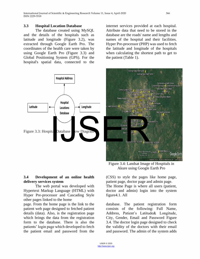
3.3 Hospital Location Database
The database created using MySQL
and the details of the hospitals such as
latitude and longitude (Figure 3.2), was
extracted through Google Earth Pro. The
coordinates of the health care were taken by
using Google Earth Pro (Figure 3.3) and
Global Positioning System (GPS). For the
hospital's spatial data, connected to the
internet services provided at each hospital.
Attribute data that need to be stored in the
database are the roads' name and lengths and
names of the hospital and their facilities.
Hyper Pre-processor (PHP) was used to fetch
the latitude and longitude of the hospitals
when calculating the shortest path to get to
the patient (Table 1).
Figure 3.3: Hospital Database Flow Diagram
Figure 3.4: Landsat Image of Hospitals in
Akure using Google Earth Pro
3.4 Development of an online health
delivery services system
The web portal was developed with
Hypertext Markup Language (HTML) with
Hyper Pre-processor and Cascading Style
(CSS) to style the pages like home page,
patient page, doctor page and admin page.
The Home Page is where all users (patient,
doctor and admin) login into the system
figure4.1. All
other pages linked to the home
page. From the home page is the link to the
patient web page designed to fetched patient
details (data). Also, is the registration page
which brings the data from the registration
form to the database. There is also the
patients’ login page which developed to fetch
the patient email and password from the
database. The patient registration form
consists of the following: Full Name,
Address, Patient’s Latitude& Longitude,
City, Gender, Email and Password Figure
3.4. The doctor login page designed to check
the validity of the doctors with their email
and password. The admin of the system adds
IJSER
International Journal of Scientific & Engineering Research Volume 11, Issue 4, April-2020 367 ISSN 2229-5518
IJSER © 2020
http://www.ijser.org
the doctors. If the Doctor Login details match
what is in the database, then he/she is prompt
to the Doctor dashboard.
Finally, the admin page designed for
administrator login to the system to monitor
the activities that go on in the developed web
portal to check the authentication of the
admin details in the database. The admin has
access to add and also delete doctors. Figure
3.5 shows the data flow chart of the admin
dashboard.
Figure 3.5: Data Flow Diagram of the Home
Page
Figure 3.6 Home Page
Figure 3.7: Patient Registration
IJSER
International Journal of Scientific & Engineering Research Volume 11, Issue 4, April-2020 368 ISSN 2229-5518
IJSER © 2020
http://www.ijser.org
Figure 3.8: Data Flow Chart of the Admin
Dashboard of the design work
3.5 Routing Mechanism using
Dijkstra’s and VRP Algorithm
The routing mechanism designed using
Hyper Pre-processor (PHP). The
arrangement implemented to calculate the
shortest path or route from the patient to the
hospital. VRP and Dijkstra’s algorithms
serve as the routing mechanism for the
system. Figure 3.9 shows the data flow
diagram of the routing mechanism. The VRP
and Dijkstra’s algorithms results were
implemented on different windows or page to
determine the shorter path or route for the
patient.
The shorter path to reach to the patient
location or the hospital determined by the
formula below;
∫ 𝑑𝑖𝑠𝑡 (𝑎𝑚𝑏 → 𝑝𝑎𝑡) + 𝑑𝑖𝑠𝑡(𝑝𝑎𝑡 →𝑎𝑚𝑏→𝑝𝑎𝑡
𝑝𝑎𝑡→ℎ𝑜𝑠𝑝
ℎ𝑜𝑠𝑝) + 𝑑𝑖𝑠𝑡(𝑎𝑚𝑏 → ℎ𝑜𝑠𝑝)
Where, hosp – hospital,
amb – ambulance,
pat – patient,
dist – distance.
IJSER
International Journal of Scientific & Engineering Research Volume 11, Issue 4, April-2020 369 ISSN 2229-5518
IJSER © 2020
http://www.ijser.org
Figure 3.9: Data Flow diagram of the Routing
Mechanism
4. Results and Discussion
The system tested on different
platforms, and certain amendments made to
ensure the system is performing the desired
result. The entire performance test carried
out on the system shows that the system is
delivering the desired outcome and it
justifies the aim and objectives of the study.
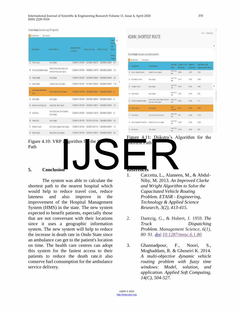
4.1 Results
The software operated to first extract the
details. This details includes the addresses
,distances between the patient and the nearest
hospital. Then it calculates the shortest path
by taking the savings and cost into
consideration. The algorithms find the
shortest path to the nearest hospital facility
and calculate the optimal distance with cost
incured. The shortest route from the
ambulance(depot) to the patient using the
VRP algorithm in Figure 4.10 and for
Dijkstra's Algorithm is shown in Figure 4.11. IJSER
International Journal of Scientific & Engineering Research Volume 11, Issue 4, April-2020 370 ISSN 2229-5518
IJSER © 2020
http://www.ijser.org
Figure 4.10: VRP Algorithm for the Shortest
Path
Figure 4.11: Dijkstra’s Algorithm for the
Shortest Path
5. Conclusion
The system was able to calculate the
shortest path to the nearest hospital which
would help to reduce travel cost, reduce
lateness and also improve in the
improvement of the Hospital Management
System (HMS) in the state. The new system
expected to benefit patients, especially those
that are not conversant with their locations
since it uses a geographic information
system. The new system will help to reduce
the increase in death rate in Ondo State since
an ambulance can get to the patient's location
on time. The health care centres can adopt
this system for the fastest access to their
patients to reduce the death rate.it also
conserve fuel consumption for the ambulance
service delivery.
References
1. Caccetta, L., Alameen, M., & Abdul-
Niby, M. 2013. An Improved Clarke
and Wright Algorithm to Solve the
Capacitated Vehicle Routing
Problem. ETASR - Engineering,
Technology & Applied Science
Research, 3(2), 413-415.
2. Dantzig, G., & Hubert, J. 1959. The
Truck Dispatching
Problem. Management Science, 6(1),
80–91. doi:10.1287/mnsc.6.1.80.
3. Ghannadpour, F., Noori, S.,
Moghaddam, R. & Ghoseiri K. 2014.
A multi-objective dynamic vehicle
routing problem with fuzzy time
windows: Model, solution, and
application. Applied Soft Computing,
14(C), 504-527.
IJSER
International Journal of Scientific & Engineering Research Volume 11, Issue 4, April-2020 371 ISSN 2229-5518
IJSER © 2020
http://www.ijser.org
4. Mohamad, T., Abdul Rauf, A., &
AbdMalekMohd, N. 2012. Reforming
Health Care Facility Using
Geographical Information System.
2012 IEEE Control and System
Graduate Research Colloquium
(lCSGRC), 267-270.
5. Tikani, H., & Setak, M. 2019.
Ambulance routing in disaster
response scenario considering
different types of ambulances and
semi-soft time windows. Journal of
Industrial and Systems Engineering,
5(1), 95-128.
6. Tohidifard, M., & Partovi, M. 2018.
A Multi-Depot Home Care Routing
Problem with Time Windows and
Fuzzy Demands Solving by Particle
Swarm Optimization and Genetic
Algorithm. International Federation
of Automatic Control, 51(11), 358-
363.
7. Cordeau, J. F., & Laporte, G. 2003.
The Dial-a-Ride Problem (DARP):
Variants, modeling issues, and
algorithms. Quarterly Journal of the
Belgian, French & Italian
Operations Research Societies, 1(2),
89-101. DOI: 10.1007/s10288-002-
0009-8.
8. Imtiyaz, P. 2006. Ambulance
management system using GIS.
Unpublished Master’s Thesis.
Department of Computer and
Information Science, Linkoping
University, SE-58183 Linkoping,
Sweden.
9. Dabhade, A., & Kale, K. V. 2014.
GIS-Based Health Care Information
System for Aurangabad City.
International Journal of Engineering
and Innovative Technology (IJEIT),
4(1), 212-216.
10. Polimeni, A. 2012. The role of
Optimization models for rescue
vehicles routes in an evacuation. WIT
Transactions on Information and
Communication Technology, 44(8),
477-489. Doi:10.2495/RISK120401.
11. Contardo, C., & Martinelli, R. 2015.
A new exact algorithm for the multi-
depot vehicle routing problem under
capacity and route length
constraints. INFORMS Journal on
Computing, 27(4), 658-676.
12. Dabhade, A., Kale, K. V., & Gedam,
Y. 2015. Network Analysis for
Finding Shortest Path in Hospital
Information System. International
Journal of Advanced Research in
Computer Science and Software
Engineering, 5(7), 618-623.
13. Akingbesote, A. O., Adigun, O. M.,
Ijeoma, M., & Babalola, A. D. 2017.
Application of Vehicle Routing Model
to Mobile-Health Cloud Management
in South Africa. Journal of Digital
Innovations &Contemp Res. In Sc.,
Eng&Tech, 5(2), 239-248.
14. Shankar, H., Mani, G., & Pandey, K.
2014. GIS Based Solution of Multi-
Depot Capacitated Vehicle Routing
Problem with Time Window Using
Tabu Search Algorithm. International
Journal of Traffic and Transportation
Engineering, 3(2), 83-100. DOI:
10.5923/j.ijtte.20140302.05.
15. Dabia, S., Ropke, S., Woensel, T., &
De Kok, T. 2011. Branch and Cut and
Price for the Time-Dependent Vehicle
IJSER
International Journal of Scientific & Engineering Research Volume 11, Issue 4, April-2020 372 ISSN 2229-5518
IJSER © 2020
http://www.ijser.org
Routing Problem with Time Windows.
Transportation Science, 47(3), 1-19.
16. Li, R., Keskin, B., Mittenthal, J.,
Schmidt, C., Melouk, S., & Lou, Y.
2012. Vehicle Routing Models in
Public Safety and Health Care.
Unpublished Ph.D. Dissertation,
Department of Information Systems,
Statistics and Management Science of
The University of Alabama in
Tuscaloosa, Alabama.
17. Issabakhsh, M., Hosseini-Motlagh,
S., Pishvaee, M., & Saghafi, M. 2018.
A Vehicle Routing Problem for
Modeling Home Health Care: a Case
Study. International Journal of
Transportation Engineering, 5(3),
211-228.
18. Booker, J., Purdy, S., & Shaw, G.
2017. Seeking ambulance treatment
for primary care problems: a
qualitative systematic review of
patient, carer and professional
perspectives. BMJ Open, 7(8),
7:e016832.Doi:10.1136/bmjopen-
2017-016832.
IJSER


![Epidemiology and Remote Health Service Delivery …inclusive growth and sustainable development” [95]. Remote health service delivery can achieve the au agenda by developing Africa’s](https://static.documents.pub/doc/80x56/5f0e88d47e708231d43fb526/epidemiology-and-remote-health-service-delivery-inclusive-growth-and-sustainable.jpg)


