www.kit.edu KIT DEPARTMENT OF CIVIL ENGINEERING, GEO- AND ENVIRONMENTAL SCIENCES KIT – The Research University in the Helmholtz Association Module Handbook Remote Sensing and Geoinformatics Master 2018 (Master of Science (M.Sc.)) SPO 2018 Winter term 2021/22 Date: 20/09/2021
Transcript
www.kit.edu
KIT DEPARTMENT OF CIVIL ENGINEERING, GEO- AND ENVIRONMENTAL SCIENCES
KIT – The Research University in the Helmholtz Association
Module HandbookRemote Sensing and Geoinformatics Master 2018 (Master of Science (M.Sc.))SPO 2018Winter term 2021/22Date: 20/09/2021
Table Of Contents
Remote Sensing and Geoinformatics Master 2018 (Master of Science (M.Sc.))Module Handbook as of 20/09/2021 2
Table Of Contents1. The Handbook of Modules Purpose and Organization ......................................................................................................... 52. Contents and Structure of the Master Program ..................................................................................................................... 63. Qualification Goals of the Program....................................................................................................................................... 134. Overview Over the Courses of the Modules and Modes of Examination .......................................................................... 175. Field of study structure .......................................................................................................................................................... 29
5.2.1. Profile: Computer Vision and Geoinformatics ....................................................................................................... 305.2.2. Profile: Computer Vision and Remote Sensing of the Atmosphere ...................................................................... 305.2.3. Profile: Computer Vision and Environmental Geodesy .........................................................................................315.2.4. Profile: Geoinformatics and Remote Sensing of the Atmosphere .........................................................................315.2.5. Profile: Geoinformatics and Environmental Geodesy ........................................................................................... 325.2.6. Profile: Remote Sensing of the Atmosphere and Environmental Geodesy ...........................................................32
1 THE HANDBOOK OF MODULES PURPOSE AND ORGANIZATION
Remote Sensing and Geoinformatics Master 2018 (Master of Science (M.Sc.))Module Handbook as of 20/09/2021 5
Chapter 1
The Handbook of Modules: Purpose and
Organization
This module handbook is the relevant document providing information on the structure and thecontents of the master’s degree program ”Remote Sensing and Geoinformatics”. It contains help-ful information and offers individual guidance for selecting courses and planning the studies. Theorganization of the degree program and its modules are described in detail. This document ismeant to provide all necessary information for tailoring an interdisciplinary course of studies com-pliant with each student’s personal interests and needs.
Chapter 2 of this document describes the contents and structure of the master program asa whole and an exemplary study plan. In Chapter 3 the qualification targets are summarized.Chapter 4 give an overview over the courses of the modules and the applicable modes of examina-tion. The detailed descriptions of each module are reported in Chapters 5-7. Chapter 8 providescontacts of the study program.
Editor:
KIT-Department of Civil Engineering, Geo and Environmental SciencesKarlsruhe Institute of Technology (KIT)76128 KarlsruheInstitute of Photogrammetry and Remote Sensing (IPF)Geodetic Institute (GIK)Contact: [email protected]
1 The Handbook of Modules Purpose and Organization
2 CONTENTS AND STRUCTURE OF THE MASTER PROGRAM
Remote Sensing and Geoinformatics Master 2018 (Master of Science (M.Sc.))Module Handbook as of 20/09/2021 6
Chapter 2
Contents and Structure of the Master Program
2.1 The Master Program
The purpose of the master’s degree program “Remote Sening and Geoinformatics” offered by theKarslruhe Institute of Technology (KIT) is to deepen and complement the scientific qualificationthe student has acquired in one of the related bachelor programs. The program is composed of abalanced combination of lectures, exercises, and seminars. In the compulsory modules of the topic“Remote Sensing” the students who may have bachelor’s degrees in different fields, will acquirea common basis of knowledge upon which the more specialized courses can build. The selectionof one out of six profiles allows for a specialization according to the student’s interests as well asfor some flexibility to react to the developments of the employment market. First experience inscientific work is gained in “Lab Rotations”. The final step is the master thesis on a topic in thefield of remote sensing and/or geoinformatics; the master thesis shall be finished within 6 months.Successful students are awarded with the degree “Master of Science (M. Sc.)” in “Remote Sensingand Geoinformatics”
The language of the program is English. Some elective courses may also be offered in German.These are, however, not required to finish the program.
2 Contents and Structure of the Master Program
2 CONTENTS AND STRUCTURE OF THE MASTER PROGRAM
Remote Sensing and Geoinformatics Master 2018 (Master of Science (M.Sc.))Module Handbook as of 20/09/2021 7
2.2 The Modular Structure of the Master Program
This master’s degree program is organized in various topics (Remote Sensing, Mathematics andBeyond, etc.), and each topic is in itself organized in multiple modules. Each module consists ofone or multiple successive courses. Usually, a module is finished by passing the related examination.In many cases, for the admission to examinations requirements have to be fulfilled. The amountof work related to a module is reflected by the respective credit points (CP) which are bookedafter the successful finalization of the module. In this master program, some of the modules arecompulsory, but there is a large number of compulsory elective or fully elective modules. Thisallows to tailor this interdisciplinary study program to the needs (both with respect to the timeavailable and the contents) according to personal interests and job perspectives. This modulehandbook describes the modules of the degree program with respect to
• the composition of the modules,
• the number of credit points associated with the module,
• the dependencies of the modules among each other,
• the learning objectives of the module,
• the mode of control of success,
• the calculation of grades.
While the module handbook provides some necessary orientation and is meant to be a useful guidefor planning the studies, it does by no means make the university calendar obsolete, which containsinformation about the actual data of each course (e.g. time and place of a course).
2.2.1 Finalization of a Module
Usually the final examination associated with a module covers the entire content of all coursesof the module on one examination date. The module is successfully completed after passing therelated examination with grade 4.0 or better. The weight of this grade in the calculation of thefinal grade is defined by the credit points of the module. Failed examinations must be repeated(see also below).
Online registration for module examinations is made via the SLE system, where the followingactions are supported
• registration for examination or cancellation of registration
• inquiry about results of the examination
• compilation of a summary of grades achieved so far.
Further information on the “Studierendenportal” is available at
https://studium.kit.edu/
2 CONTENTS AND STRUCTURE OF THE MASTER PROGRAM
Remote Sensing and Geoinformatics Master 2018 (Master of Science (M.Sc.))Module Handbook as of 20/09/2021 8
2.2.2 Repetition of Examinations
Possibilities of repetition of examinations are described in §8 of the “Studien- und Prufungsordnungdes Karlsruher Instituts fur Technologie (KIT) fur den Masterstudiengang Remote Sensing andGeoinformatics”.
2.2.3 Choices of Modules
Within topics there are compulsory modules and compulsory elective modules. The compulsorymodules are associated with fewer credit points than required for the completion of the topic. Themissing credit points can be obtained by compulsory elective modules of this topic of the student’schoice.
Each student selects one out of six profiles. As described above for topics in a general sense,each profile contains compulsory and elective modules. The total number of ECTS points fromthis profile shall be at least 20 in two semesters, whereof 10 have to be gained in the compulsorymodules and 10 in the compulsory elective modules.
Knowledge of a second European language besides English is of great use to improve job marketperspectives. Within the topic “Key Competences Modules” participation in a language course ishighly recommended; for students with no or limited knowledge of German, a German-languagecourse would be advisable. Further, participation in at least one seminar course is compulsory,regardless of which topic the seminar is assigned to. Beyond this, modules from any other profileor modules offered by other degree programs can be selected as part of the topic “SupplementaryModules”. This shall foster interdisciplinarity, but in order to avoid too extravagant choices,approval by the Examination Committee is required.
2.2.4 Voluntary Modules/Additional Examinations
The purpose of voluntary modules is to develop a better interdisciplinary view and to developcompetences overarching over specific fields. The grades of voluntary modules are not relevant forthe final grade. When the student registers for the examination of a voluntary module, this hasto be indicated as such. Retroactive rebooking of credit points and grades achieved for voluntarymodules to compulsory modules, compulsory elective modules or elective modules is not possible.No more than 30 credit points can be acquired for voluntary modules.
2.2.5 Preliminary Examinations
The possibility of preliminary examinations (“Mastervorzugsleistungen”) is regulated by the “Studien-und Prufungsordnung des Karlsruher Instituts fur Technologie (KIT) fur den MasterstudiengangRemote Sensing and Geoinformatics”.
2.2.6 More Details
Information on all legal and official details of this master program are provided by the studyregulations (“Studienordnung”) and the examination regulations (“Prufungsordnung”).
2 CONTENTS AND STRUCTURE OF THE MASTER PROGRAM
Remote Sensing and Geoinformatics Master 2018 (Master of Science (M.Sc.))Module Handbook as of 20/09/2021 9
2.3 Overview over the Structure of the Program and the Courses
The total sum of credit points (CP) is 120. They are distributed over the courses as follows:
• Remote Sensing 23 CP
• Mathematics and Beyond 15 CP
• Profile Courses 20 CP
– Choice of 1 out of 6 profile courses, 20 CP.
– Each profile contains compulsory (10 CP) and optional (10 CP) modules.
• Supplementary Modules 8 CP
• Lab Rotation 20 CP
• Key Competences 4 CP
• Master Thesis 30 CP
Commencement of studies in the winter semester is recommended. However, there is nomandatory sequence for most modules, thus commencement in the summer semester is alsopossible. An exemplary study plan of the study program MSc ‘Remote Sensing and Geoinformatics(begin winter semester) can be found for the exemplary profile choice ‘Profile 5: Geoinformaticsand Environmental Geodesy‘ in Section 2.7.
2.4 Overview over the modules and examination modes
Topic: Remote SensingModule CP Examination mode
RSGI-MRCR Computer Vision and Remote Sensing 8 oral, gradedGEOD-MAGI-2 Geoinformatics 5 oral, gradedRSGI-MRRA Remote Sensing of the Atmosphere 5 oral, gradedRSGI-MRFE Fundamentals of Environmental Geodesy 5 oral, graded
Topic: Mathematics and BeyondModule CP Examination mode
GEOD-MANM-2 Numerical Mathematics 6 oral, gradedRSGI-MMCM-2 Basics of Estimation Theory and its Application in 6 oral, graded
Geoscience Remote Sensing ProjectsIn addition, within the compulsory module ’Scientific Programming’
a total of 3 or more CPs have to be acquired.RSGI-MMCE-1 Scientific Programming 3 not gradedRSGI-MMCE-2 Dummy1 3 tbd2
1 Other courses in scientific programming offered at KIT can be selected. The Examination Com-mission decides about their eligibility.2 tbd: to be determined with respect to the individual choice within the module ’Scientific Pro-gramming’.
2 CONTENTS AND STRUCTURE OF THE MASTER PROGRAM
Remote Sensing and Geoinformatics Master 2018 (Master of Science (M.Sc.))Module Handbook as of 20/09/2021 10
Topic: Profiles (Choice of 1 out of 6)Module CP Examination mode
1: Computer Vision and 2 compulsory modules plus 20 see module descriptionGeoinformatics ∼ 3 compulsory elective modules
2: Computer Vision and 2 compulsory modules plus 20 see module descriptionRemote Sensing of the Atmosphere ∼ 3 compulsory elective modules
3: Computer Vision and 2 compulsory modules plus 20 see module descriptionEnvironmental Geodesy ∼ 4 compulsory elective modules
4: Geoinformatics and 2 compulsory modules plus 20 see module descriptionRemote Sensing of the Atmosphere ∼ 3 compulsory elective modules
5: Geoinformatics and 2 compulsory modules plus 20 see module descriptionEnvironmental Geodesy ∼ 3 compulsory elective modules
6: Remote Sensing of the Atmosphere and 2 compulsory modules plus 20 see module descriptionEnvironmental Geodesy ∼ 3 compulsory elective modules
In each profile, the required number of CPs is 10 for compulsory modules and 10 for compulsoryelective modules.
Choice of modules summing up to 8 CP ∼ 2− 4 elective modules 8 see module description
Topic: Key CompetencesModule CP Examination mode
Choice of modules summing up to 4 CP ∼ 2 elective modules 4 see module description
Topic: Lab RotationModule CP Examination mode
Choice of 2 Lab Rotations 2×10 CP 20 other according to SPO RSGI §4/2
Topic: Master ThesisModule CP Examination mode
Master Thesis 6 months 30 Thesis
2.5 Accreditation of external accomplishments
2.5.1 Accreditation of qualifications obtained outside of the Higher Education System
Accomplishments obtained outside of the higher education system, for example vocational training,can be accredited if the acquired competences contribute to the qualification goals of the MScprogram. At maximum, 50 to the exams committee (Prufungsausschuss). The exams committeeverifies to which extent the acquired competences can be accredited, and which parts of theprogram they can replace. A form is available for this purpose on the web page of the MScprogramme that can be used for the accreditation of externally obtained competences as equivalentto one or several of the modules in the programme, and for competences complementary to theprogram, but contributing to the general qualification goals.
2 CONTENTS AND STRUCTURE OF THE MASTER PROGRAM
Remote Sensing and Geoinformatics Master 2018 (Master of Science (M.Sc.))Module Handbook as of 20/09/2021 11
2.5.2 Accreditation of qualifications obtained inside of the Higher Education System
Accomplishments obtained at other universities, for example credits from another MSc program,can be accredited if the acquired competences contribute to the qualification goals of the MSc pro-gram. A request for accreditation can be submitted to the exams committee (Prufungsausschuss).The exams committee verifies to which extent the acquired competences can be accredited, andwhich parts of the program they can replace. A form is available for this purpose on the webpage of the MSc programme that can be used for the accreditation of externally obtained com-petences as equivalent to one or several of the modules in the programme, and for competencescomplementary to the program, but contributing to the general qualification goals.
2.5.3 Study abroad during the programme
The lab rotations (semester 3) can be completed abroad, and other qualifications obtained inother countries can be accredited as well. Before going abroad, a student will set up a learningagreement together with the student counseller of the programme (Michael Mayer), which theexams committee (Prufungsausschuss) will then agree to, and modify where necessary. Theform for accreditation of external accomplishments is available on the programme web page. Forspecific questions, any lecturer can be contacted. For general enquiries, please talk to the studentcounseller of the programme.
2.6 Students with a Disability or Chronic Disease (§13, SPO)
(1) When organizing degree programs and examinations, the needs of students with a disabilityor chronic disease are to be considered. In particular, students with a disability or chronic diseaseare to be granted preferred access to courses with a limited number of participants and the orderfor passing certain courses shall be adapted to their needs. According to the Federal EqualityAct (Bundesgleich- stellungsgesetz, BGG) and Vol. 9 of the Social Code (SGB IX), students aredisabled, if their bodily function, mental capacity, or emotional health most probably deviates fromthe state typical of the age for a period longer than six months and, hence, their participationin social life is impaired. At the request of the student, the examination committee shall decideon the existence of conditions outlined in clauses 2 and 3. The student shall submit the requiredevidence for this purpose.(2) If a student provides evidence of a disability or chronic disease, as a result of which she/heis not able to pass examinations completely or partly within the planned time or in the formenvisaged, the examination 12committee may permit examinations within other time periods or inanother form. In particular, dis- abled students shall be permitted to use the required aids. (3) Incase students provide evidence of a disability or chronic disease, a a result of which they are notable to attend courses regularly or to pass the required coursework or examinations as outlinedin Article 19, the examination committee may permit at the student’s request passing of certaincoursework and examinations after the expiry of the deadlines given in the present Regulations forStudy and Examination.
2 CONTENTS AND STRUCTURE OF THE MASTER PROGRAM
Remote Sensing and Geoinformatics Master 2018 (Master of Science (M.Sc.))Module Handbook as of 20/09/2021 12
2.7 Exemplary Study Plan
3 QUALIFICATION GOALS OF THE PROGRAM
Remote Sensing and Geoinformatics Master 2018 (Master of Science (M.Sc.))Module Handbook as of 20/09/2021 13
Chapter 3
Qualification Goals of the Program
General Issues
Goals of qualification generally describe
• the subject-specific and overarching competences which students can acquire in this program
• which learning outcomes can/should be achieved during the studies in this program. Theselearning outcomes are specified on three levels. First on the level of the master program,and then on the levels of modules and courses. They describe competences and verifiablelearning outcomes.
Subject-specific competences are related to fundamental as well as specific knowledge and under-standing with respect to methods, tenets, concepts and working approaches in the field of remote
sensing and geoinformatics. Overarching competences are basic as well as specific competenceswhich are applicable in multiple fields and disciplines and which do not depend on a specificsubject. Typical examples are soft skills like the ability of teamwork and of networked thinking,
communication skills and so forth.Learning outcomes describe the success of the learning/studying which is testable by examinationsand allow to determine the level up to which the competence has been formed and developedduring the studies.
3.1 Qualification Goals
In this master’s degree program the scientific qualification acquired in related bachelor programsare deepened and complemented. The goal of this program is to convey the ability to indepen-dently apply scientific knowledge and methods and to evaluate their implications and relevance tothe solution of complex scientific problems.
The degree holders of the master program Remote Sensing and Geoinformatics have well-founded knowledge in current and future-oriented technologies and methods related to the process-ing and analysis of spatially and temporally resolved geoscientific and remotely sensed data. Theyhave detailed technical and methodical knowledge in remote sensing and geoinformatics and havein-depth insight into selected professional fields for remote sensing scientists and geo-informationscientists. Based on broad basic knowledge, they have the ability to identify, characterize andelaborate future scientific and technical key questions with innovation potential in the given sub-ject area. They have actively developed the ability to methodically explore knowledge sources,
3 Qualification Goals of the Program
3 QUALIFICATION GOALS OF THE PROGRAM
Remote Sensing and Geoinformatics Master 2018 (Master of Science (M.Sc.))Module Handbook as of 20/09/2021 14
and are thus capable of acquainting themselves with advanced research problems.
They have the comprehensive ability to autonomously analyze and evaluate tasks in the field ofremote sensing and geoinformatics and to implement related practical solutions. They can, underconsideration of a particular situation, select the adequate methods, apply them in a targetedand problem-solving fashion, and to evaluate them critically. They have the ability to put theknowledge gained to work both in their own field as well as in an interdisciplinary context. Thedegree holders have proven to be able to collect and pre-select all relevant information, particularlyin complex situations, to analyze and evaluate this information, to process, characterize, docu-ment, visualize relevant data and to present results in a compelling manner. They can familiarizethemselves independently with current research topics and complex problems and thoroughly ana-lyze, interpret and evaluate them. They have the ability to autonomously develop and implementconcepts to tackle problems they have identified and analyzed. They classify subject-specific andinterdisciplinary tasks and identify, or, if need be, develop, adequate methods of measurement,data analysis and processing as well as data characterization.
They are able to extensively document, compile, illustrate and interpret results in a goal-orientedmanner. They have the ability to work both independently or in a team and can take leadership ininterdisciplinary projects. They can thoroughly explore technical literature in English, bring forwardtheir argument and defend their stance in topical discussions both with specialists and laypersonsin an adequate language. In the application of their topic-related knowledge they consider societal,scientific, and ethical issues.
The qualification targets of the master program Remote Sensing and Geoinformatics are sum-marized in the following table in a structured manner. Then follow the qualification targets andlearning outcomes on module and course levels.
The following abbreviations are used:DQR: Deutscher QualifikationsrahmenQZ-Nr: Qualifikationszielnummer
DQR QZ-Nr. Qualification targets Moduleon program level
Subject-specific competences “Knowledge and Understanding”
Subject-specific 1 The degree holder has profound knowledge in allcompetence: current and future-oriented techniques andbroadening of methods for processing, characterizationknowledge and analysis of spatially and temporally
resolved geoscientific and remotely senseddata
2 The student has detailed technical and allmethodical knowledge in remote sensing andgeo-informatics and has in-depth insightinto selected professional fields for remotesensing scientists and geo-information
3 QUALIFICATION GOALS OF THE PROGRAM
Remote Sensing and Geoinformatics Master 2018 (Master of Science (M.Sc.))Module Handbook as of 20/09/2021 15
scientists.
Subject-specific 3 Based on broad basic knowledge the degree all,competence: holder can identify, describe and tackle particularlydeepening of advanced scientific questions with innov- modulesknowledge ation potential in the given subject area of the
profiles4 The student has actively developed the all seminars;
ability to methodically explore knowledge lab rotation;sources, is thus capable to acquaint master thesisthemselves with advanced reserach problems.
Instrumental 5 The student has the comprehensive lab rotationscompetence ability to autonomously analyze and master thesis
evaluate tasks in the field of remotesensing and geoinformatics and toimplement related practical solutions.
6 The student can, under consideration of a seminarsparticular situation, select the adequate lab rotationsmethods, apply them in a targeted and Master thesisproblem-solving fashion, and evaluatethem critically.
7 The student has the ability to put the allknowledge gained to work both in their ownfield as well as in an interdisciplinarycontext.
System 8 The degree holder has proven to be able all,Competence to collect and pre-select all relevant in- particularly
formation, particularly in complex seminarssituations, to analyze and evaluate thisinformation, to process, characterize, do-cument, visualize relevant data and to pre-sent results in a compelling manner.
9 The students can familiarize themselves seminarsindependently with current research topics lab rotationsand complex problems and thoroughly master thesisanalyze, interpret and evaluate them.
10 The students have the ability to auto- seminars
nomously develop and implement concepts to lab rotationstackle problems they have identified and master thesisanalyzed.
11 The student classifies subject-specific and lab rotationinterdisciplinary tasks and identifies, or, master thesisif need be, develops, adequate methods ofmeasurement, data analysis and processing
as well as data characterization.12 The student is able to extensively docu- seminars
3 QUALIFICATION GOALS OF THE PROGRAM
Remote Sensing and Geoinformatics Master 2018 (Master of Science (M.Sc.))Module Handbook as of 20/09/2021 16
ment, complile, illustrate and interpret lab rotationresults in a targeted manner. Scientific Writing
Master Thesis13 In the application of the topical know- all
ledge the student considers societal,scientific and ethical issues.
Communication 14 The student has the ability to work both projectsskills independently or in a team and can take lab rotation
leadership in interdisciplinary projects. master thesis15 The student can thoroughly explore tech- all
nical literature in the English language16 The student has the ability to bring for- seminars
ward their argument and defend their stancein topical discussions both with special-ists and laypersons in adequate language.
4 OVERVIEW OVER THE COURSES OF THE MODULES AND MODES OF EXAMINATION
Remote Sensing and Geoinformatics Master 2018 (Master of Science (M.Sc.))Module Handbook as of 20/09/2021 17
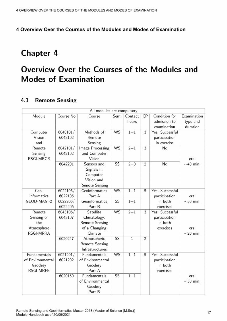
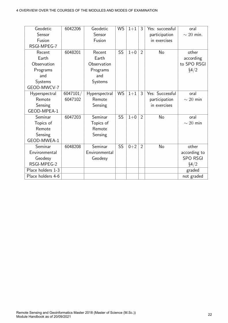
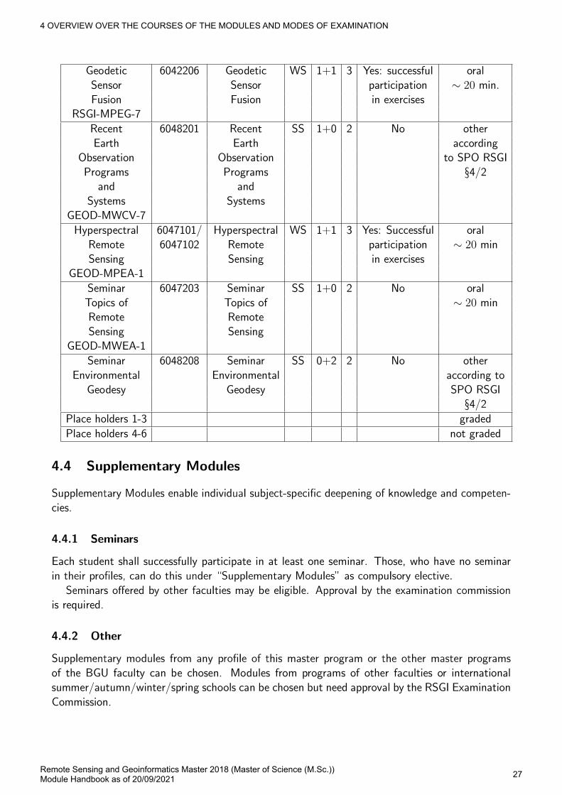
4 Overview Over the Courses of the Modules and Modes of Examination
4 OVERVIEW OVER THE COURSES OF THE MODULES AND MODES OF EXAMINATION
Remote Sensing and Geoinformatics Master 2018 (Master of Science (M.Sc.))Module Handbook as of 20/09/2021 18
4 OVERVIEW OVER THE COURSES OF THE MODULES AND MODES OF EXAMINATION
Remote Sensing and Geoinformatics Master 2018 (Master of Science (M.Sc.))Module Handbook as of 20/09/2021 19
4 OVERVIEW OVER THE COURSES OF THE MODULES AND MODES OF EXAMINATION
Remote Sensing and Geoinformatics Master 2018 (Master of Science (M.Sc.))Module Handbook as of 20/09/2021 20
4 OVERVIEW OVER THE COURSES OF THE MODULES AND MODES OF EXAMINATION
Remote Sensing and Geoinformatics Master 2018 (Master of Science (M.Sc.))Module Handbook as of 20/09/2021 21
4 OVERVIEW OVER THE COURSES OF THE MODULES AND MODES OF EXAMINATION
Remote Sensing and Geoinformatics Master 2018 (Master of Science (M.Sc.))Module Handbook as of 20/09/2021 22
4 OVERVIEW OVER THE COURSES OF THE MODULES AND MODES OF EXAMINATION
Remote Sensing and Geoinformatics Master 2018 (Master of Science (M.Sc.))Module Handbook as of 20/09/2021 23
4 OVERVIEW OVER THE COURSES OF THE MODULES AND MODES OF EXAMINATION
Remote Sensing and Geoinformatics Master 2018 (Master of Science (M.Sc.))Module Handbook as of 20/09/2021 24
4 OVERVIEW OVER THE COURSES OF THE MODULES AND MODES OF EXAMINATION
Remote Sensing and Geoinformatics Master 2018 (Master of Science (M.Sc.))Module Handbook as of 20/09/2021 25
4 OVERVIEW OVER THE COURSES OF THE MODULES AND MODES OF EXAMINATION
Remote Sensing and Geoinformatics Master 2018 (Master of Science (M.Sc.))Module Handbook as of 20/09/2021 26
4 OVERVIEW OVER THE COURSES OF THE MODULES AND MODES OF EXAMINATION
Remote Sensing and Geoinformatics Master 2018 (Master of Science (M.Sc.))Module Handbook as of 20/09/2021 27
4 OVERVIEW OVER THE COURSES OF THE MODULES AND MODES OF EXAMINATION
Remote Sensing and Geoinformatics Master 2018 (Master of Science (M.Sc.))Module Handbook as of 20/09/2021 28
5 FIELD OF STUDY STRUCTURE
Remote Sensing and Geoinformatics Master 2018 (Master of Science (M.Sc.))Module Handbook as of 20/09/2021 29
5 Field of study structure
MandatoryMaster Thesis 30 CR
Profiles 20 CR
Lab Rotations 20 CR
Remote Sensing 23 CR
Mathematics and Beyond 15 CR
Supplementary Modules 8 CR
Key Competences 4 CR
VoluntaryAdditional ExaminationsThis field will not influence the calculated grade of its parent.
5.1 Master Thesis
Credits30
MandatoryM-BGU-104549 Master Thesis 30 CR
5 FIELD OF STUDY STRUCTURE Profiles
Remote Sensing and Geoinformatics Master 2018 (Master of Science (M.Sc.))Module Handbook as of 20/09/2021 30
5.2 Profiles
Credits20
Election block: Profile (1 item)Profile: Computer Vision and Geoinformatics 20 CRProfile: Computer Vision and Remote Sensing of the Atmosphere 20 CRProfile: Computer Vision and Environmental Geodesy 20 CRProfile: Geoinformatics and Remote Sensing of the Atmosphere 20 CRProfile: Geoinformatics and Environmental Geodesy 20 CRProfile: Remote Sensing of the Atmosphere and Environmental Geodesy 20 CR
5.2.1 Profile: Computer Vision and Geoinformatics Part of: Profiles
Credits20
MandatoryM-BGU-101041 GeoDB 5 CRM-BGU-104531 Advanced Topics in Computer Vision 5 CRElection block: Compulsory Elective Modules (at least 10 credits)M-BGU-101042 3D / 4D GIS 4 CRM-BGU-101045 Mobile GIS / Location Based Services 3 CRM-BGU-101047 Augmented Reality 4 CRM-BGU-101052 Tomographic Laser- and Radar Sensing 3 CRM-BGU-101053 Advanced Analysis in GIS 3 CRM-BGU-101057 Seminar Topics of Image Analysis 2 CRM-BGU-101099 Active Sensors for Computer Vision 3 CRM-BGU-104436 Module Wildcard 1 Profile ComVisGeoinf 10 CR
5.2.2 Profile: Computer Vision and Remote Sensing of the Atmosphere Part of: Profiles
Credits20
MandatoryM-BGU-104531 Advanced Topics in Computer Vision 5 CRM-BGU-104532 Remote Sensing of Atmospheric Temperature, Trace Gases, Clouds and Aerosols 5 CRElection block: Compulsory Elective Modules (at least 10 credits)M-BGU-101047 Augmented Reality 4 CRM-BGU-101052 Tomographic Laser- and Radar Sensing 3 CRM-BGU-101057 Seminar Topics of Image Analysis 2 CRM-BGU-101099 Active Sensors for Computer Vision 3 CRM-BGU-104533 Atmospheric Spectroscopy and Middle Atmospheric Research 4 CRM-BGU-104535 Atmospheric Radiation 2 CRM-BGU-104437 Module Wildcard 1 Profile ComVisRemSen 10 CR
5 FIELD OF STUDY STRUCTURE Profiles
Remote Sensing and Geoinformatics Master 2018 (Master of Science (M.Sc.))Module Handbook as of 20/09/2021 31
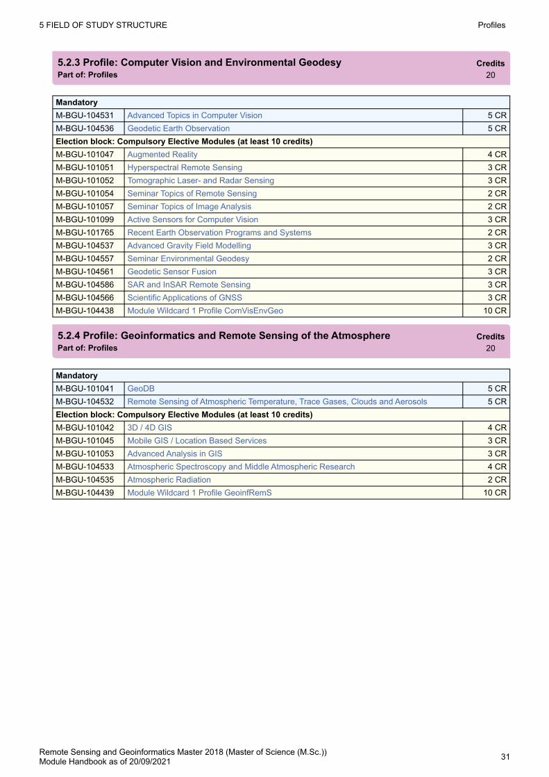
5.2.3 Profile: Computer Vision and Environmental Geodesy Part of: Profiles
Credits20
MandatoryM-BGU-104531 Advanced Topics in Computer Vision 5 CRM-BGU-104536 Geodetic Earth Observation 5 CRElection block: Compulsory Elective Modules (at least 10 credits)M-BGU-101047 Augmented Reality 4 CRM-BGU-101051 Hyperspectral Remote Sensing 3 CRM-BGU-101052 Tomographic Laser- and Radar Sensing 3 CRM-BGU-101054 Seminar Topics of Remote Sensing 2 CRM-BGU-101057 Seminar Topics of Image Analysis 2 CRM-BGU-101099 Active Sensors for Computer Vision 3 CRM-BGU-101765 Recent Earth Observation Programs and Systems 2 CRM-BGU-104537 Advanced Gravity Field Modelling 3 CRM-BGU-104557 Seminar Environmental Geodesy 2 CRM-BGU-104561 Geodetic Sensor Fusion 3 CRM-BGU-104586 SAR and InSAR Remote Sensing 3 CRM-BGU-104566 Scientific Applications of GNSS 3 CRM-BGU-104438 Module Wildcard 1 Profile ComVisEnvGeo 10 CR
5.2.4 Profile: Geoinformatics and Remote Sensing of the Atmosphere Part of: Profiles
Credits20
MandatoryM-BGU-101041 GeoDB 5 CRM-BGU-104532 Remote Sensing of Atmospheric Temperature, Trace Gases, Clouds and Aerosols 5 CRElection block: Compulsory Elective Modules (at least 10 credits)M-BGU-101042 3D / 4D GIS 4 CRM-BGU-101045 Mobile GIS / Location Based Services 3 CRM-BGU-101053 Advanced Analysis in GIS 3 CRM-BGU-104533 Atmospheric Spectroscopy and Middle Atmospheric Research 4 CRM-BGU-104535 Atmospheric Radiation 2 CRM-BGU-104439 Module Wildcard 1 Profile GeoinfRemS 10 CR
5 FIELD OF STUDY STRUCTURE Lab Rotations
Remote Sensing and Geoinformatics Master 2018 (Master of Science (M.Sc.))Module Handbook as of 20/09/2021 32
5.2.5 Profile: Geoinformatics and Environmental Geodesy Part of: Profiles
Credits20
MandatoryM-BGU-101041 GeoDB 5 CRM-BGU-104536 Geodetic Earth Observation 5 CRElection block: Compulsory Elective Modules (at least 10 credits)M-BGU-101042 3D / 4D GIS 4 CRM-BGU-101045 Mobile GIS / Location Based Services 3 CRM-BGU-101051 Hyperspectral Remote Sensing 3 CRM-BGU-101053 Advanced Analysis in GIS 3 CRM-BGU-101054 Seminar Topics of Remote Sensing 2 CRM-BGU-101765 Recent Earth Observation Programs and Systems 2 CRM-BGU-104537 Advanced Gravity Field Modelling 3 CRM-BGU-104557 Seminar Environmental Geodesy 2 CRM-BGU-104561 Geodetic Sensor Fusion 3 CRM-BGU-104566 Scientific Applications of GNSS 3 CRM-BGU-104586 SAR and InSAR Remote Sensing 3 CRM-BGU-104440 Module Wildcard 1 Profile GeoinfEnvGeo 10 CR
5.2.6 Profile: Remote Sensing of the Atmosphere and Environmental Geodesy Part of: Profiles
Credits20
MandatoryM-BGU-104532 Remote Sensing of Atmospheric Temperature, Trace Gases, Clouds and Aerosols 5 CRM-BGU-104536 Geodetic Earth Observation 5 CRElection block: Compulsory Elective Modules (at least 10 credits)M-BGU-101051 Hyperspectral Remote Sensing 3 CRM-BGU-101054 Seminar Topics of Remote Sensing 2 CRM-BGU-101765 Recent Earth Observation Programs and Systems 2 CRM-BGU-104533 Atmospheric Spectroscopy and Middle Atmospheric Research 4 CRM-BGU-104535 Atmospheric Radiation 2 CRM-BGU-104537 Advanced Gravity Field Modelling 3 CRM-BGU-104557 Seminar Environmental Geodesy 2 CRM-BGU-104561 Geodetic Sensor Fusion 3 CRM-BGU-104566 Scientific Applications of GNSS 3 CRM-BGU-104586 SAR and InSAR Remote Sensing 3 CRM-BGU-104441 Module Wildcard 1 Profile RemSenEnvGeo 10 CR
5.3 Lab Rotations
Credits20
MandatoryM-BGU-104588 Lab Rotation I 10 CRM-BGU-104589 Lab Rotation II 10 CR
5 FIELD OF STUDY STRUCTURE Remote Sensing
Remote Sensing and Geoinformatics Master 2018 (Master of Science (M.Sc.))Module Handbook as of 20/09/2021 33
5.4 Remote Sensing
Credits23
MandatoryM-BGU-101011 Geoinformatics 5 CRM-BGU-104517 Computer Vision and Remote Sensing 8 CRM-BGU-104524 Remote Sensing of the Atmosphere 5 CRM-BGU-104553 Fundamentals of Environmental Geodesy 5 CR
5.5 Mathematics and Beyond
Credits15
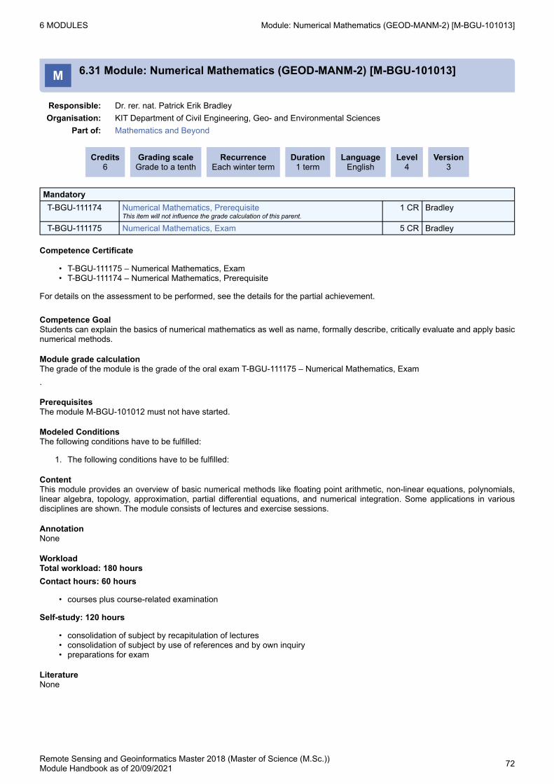
MandatoryM-BGU-101013 Numerical Mathematics 6 CRM-BGU-104530 Scientific Programming 3 CRM-BGU-104918 Basics of Estimation Theory and its Application in Geoscience Remote Sensing 6 CR
M-BGU-101057 Seminar Topics of Image AnalysisFirst usage possible from 2/15/2021.
2 CR
M-BGU-101042 3D / 4D GISFirst usage possible from 2/17/2021.
4 CR
M-BGU-101045 Mobile GIS / Location Based ServicesFirst usage possible from 2/17/2021.
3 CR
M-BGU-101099 Active Sensors for Computer VisionFirst usage possible from 2/17/2021.
3 CR
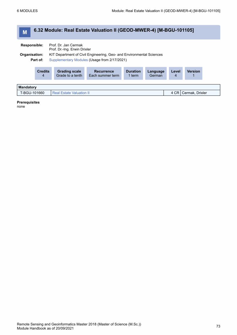
M-BGU-101105 Real Estate Valuation IIFirst usage possible from 2/17/2021.
4 CR
M-BGU-101107 Cartography IIFirst usage possible from 2/17/2021.
1 CR
M-BGU-101765 Recent Earth Observation Programs and SystemsFirst usage possible from 2/17/2021.
2 CR
M-BGU-104557 Seminar Environmental GeodesyFirst usage possible from 2/17/2021.
2 CR
M-BGU-101047 Augmented Reality neu 4 CRM-BGU-104586 SAR and InSAR Remote Sensing neu 3 CRM-BGU-104566 Scientific Applications of GNSS neu 3 CRM-BGU-101021 Visualization of Geodata in 2D, 3D and 4D neu 3 CRM-BGU-104536 Geodetic Earth Observation neu 5 CRM-BGU-104944 Wildcard 1 Supplementary Modules 8 CR
5.7 Key Competences
Credits4
Election block: Key Competences: Elective Modules (at least 4 credits)M-BGU-104711 Further Key Competences 4 CRM-BGU-104712 Further Key Competences 2 CRM-BGU-104943 Wildcard Key Competences 1 2 CR
5 FIELD OF STUDY STRUCTURE Additional Examinations
Remote Sensing and Geoinformatics Master 2018 (Master of Science (M.Sc.))Module Handbook as of 20/09/2021 34
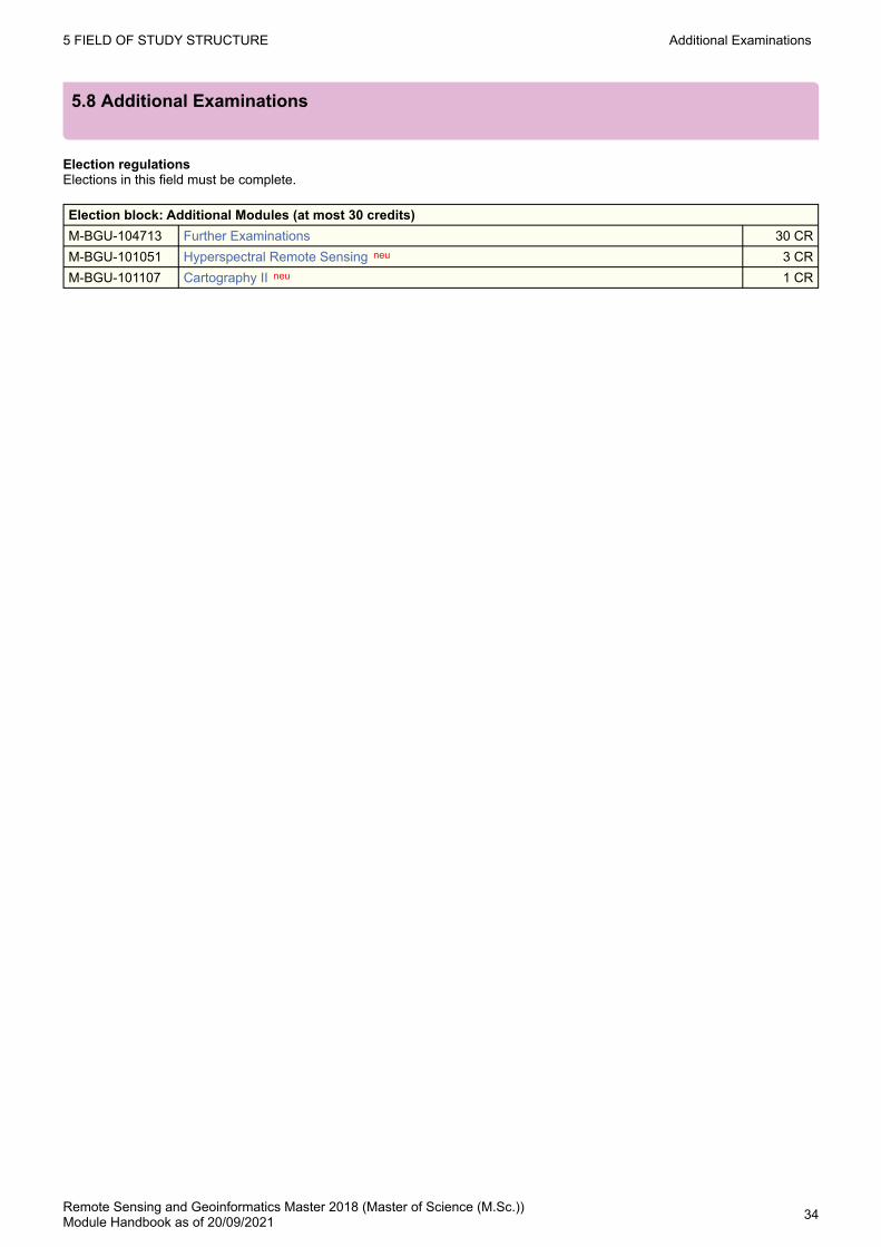
5.8 Additional Examinations
Election regulationsElections in this field must be complete.
Election block: Additional Modules (at most 30 credits)M-BGU-104713 Further Examinations 30 CRM-BGU-101051 Hyperspectral Remote Sensing neu 3 CRM-BGU-101107 Cartography II neu 1 CR
6 MODULES
Remote Sensing and Geoinformatics Master 2018 (Master of Science (M.Sc.))Module Handbook as of 20/09/2021 35
••
6 Modules
M 6.1 Module: 3D / 4D GIS (GEOD-MPGI-2) [M-BGU-101042]
Responsible: Prof. Dr. Martin BreunigOrganisation: KIT Department of Civil Engineering, Geo- and Environmental Sciences
Part of: Supplementary Modules (Usage from 2/17/2021) Profiles / Profile: Computer Vision and Geoinformatics (Compulsory Elective Modules) Profiles / Profile: Geoinformatics and Remote Sensing of the Atmosphere (Compulsory Elective Modules) Profiles / Profile: Geoinformatics and Environmental Geodesy (Compulsory Elective Modules)
Credits4
Grading scaleGrade to a tenth
RecurrenceEach summer term
Duration1 term
LanguageGerman/English
Level4
Version2
MandatoryT-BGU-101781 3D / 4D GIS, Prerequisite
This item will not influence the grade calculation of this parent.1 CR Breunig
T-BGU-101760 3D / 4D GIS 3 CR Breunig
Competence Certificate
T-BGU-101781 3D / 4D GIS, VorleistungT-BGU-101760 3D / 4D GIS
For details on the assessments to be performed, see the details for the partial achievements..
Competence GoalThe students explain the problems of space and time-related issues for the development and application of 3D/4D geoinformation systems. They are able to analyze spatio-temporal extensions to existing geometric and topological data models, spatial data standards, spatial databases and geographic information systems and develop them by themselves. In particular, the students are able to devise solutions for space- and time-related issues by their own and implement them in a programing language. They are able to transfer the learned knowledge to new spatio-temporal applications.
Module grade calculationThe grade of the module is the grade of the oral exam in T-BGU-101760 3D / 4D GIS
PrerequisitesNone
ContentIn the module relevant spatio-temporal concepts and implementations are presented for 3D/4D geoinformation systems. This concerns for example the geometric and topological data modeling, geo-data standardization, geo-data management and geo-data analysis. The concepts are considered with reference to 3D/4D geo-scientific applications. Furthermore, current research issues in the field of 3D/4D geoinformation systems are discussed. Finally, the introduced concepts are engrossed in programming exercises in the practical part of the module.
RecommendationKnowledge in GIS and object-oriented programing is helpful.
AnnotationNone
WorkloadTotal workload: 120 hoursContact hours: 45 hours- courses plus course-related examinationSelf-study: 75 hours- consolidation of subject by recapitulation of lectures- processing of exercises- consolidation of subject by use of references and by own inquiry- preparations for exam
6 MODULES Module: 3D / 4D GIS (GEOD-MPGI-2) [M-BGU-101042]
Remote Sensing and Geoinformatics Master 2018 (Master of Science (M.Sc.))Module Handbook as of 20/09/2021 36
LiteratureNone
6 MODULES Module: Active Sensors for Computer Vision (GEOD-MWEB-3) [M-BGU-101099]
Remote Sensing and Geoinformatics Master 2018 (Master of Science (M.Sc.))Module Handbook as of 20/09/2021 37
•
M 6.2 Module: Active Sensors for Computer Vision (GEOD-MWEB-3) [M-BGU-101099]
Responsible: apl. Prof. Dr. Boris JutziOrganisation: KIT Department of Civil Engineering, Geo- and Environmental Sciences
Part of: Supplementary Modules (Usage from 2/17/2021) Profiles / Profile: Computer Vision and Geoinformatics (Compulsory Elective Modules) Profiles / Profile: Computer Vision and Remote Sensing of the Atmosphere (Compulsory Elective Modules) Profiles / Profile: Computer Vision and Environmental Geodesy (Compulsory Elective Modules)
Credits3
Grading scaleGrade to a tenth
RecurrenceEach summer term
Duration1 term
LanguageGerman/English
Level4
Version2
MandatoryT-BGU-101840 Active Sensors for Computer Vision 3 CR Jutzi
Competence Certificate
T-BGU-101840 Active Sensors for Computer Vision
For details on the assessments to be performed, see the details for the partial achievement.
Competence GoalStudents reproduce the fundamentals of active sensing in Computer Vision. They describe the basic vision processing techniques. Students are able to use their knowledge and transfer it to other fields of applications.
Module grade calculationThe grade of the module is the grade of the oral exam in T-BGU-101840 Active Sensors for Computer Vision
PrerequisitesNone
ContentThis module provides an overview on basic vision processing techniques: introduction to active sensing, measurement technique (atmosphere, navigation, puls-CW, surface & LASER beam), laserscanning (Full-Waveform , quality aspects & system), range imaging (function & systems), triangulation procedures, data pre-processing (registration of point clouds, image-based registration (SIFT)), analyses of point clouds(model and daten-driven approaches, plane detection, RANSAC, building modeling), applications.
RecommendationNone
AnnotationNone
WorkloadTotal workload: 90 hoursContact hours: 30 hours- courses plus course-related examinationSelf-study: 60 hours- consolidation of subject by recapitulation of lectures- consolidation of subject by use of references and by own inquiry- preparations for exam
LiteratureNone
6 MODULES Module: Advanced Analysis in GIS (GEOD-MPEA-3) [M-BGU-101053]
Remote Sensing and Geoinformatics Master 2018 (Master of Science (M.Sc.))Module Handbook as of 20/09/2021 38
•
••••
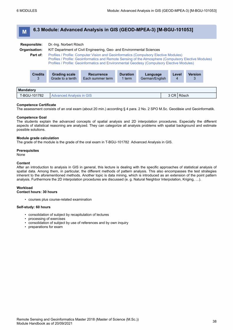
M 6.3 Module: Advanced Analysis in GIS (GEOD-MPEA-3) [M-BGU-101053]
Responsible: Dr.-Ing. Norbert RöschOrganisation: KIT Department of Civil Engineering, Geo- and Environmental Sciences
Part of: Profiles / Profile: Computer Vision and Geoinformatics (Compulsory Elective Modules) Profiles / Profile: Geoinformatics and Remote Sensing of the Atmosphere (Compulsory Elective Modules) Profiles / Profile: Geoinformatics and Environmental Geodesy (Compulsory Elective Modules)
Credits3
Grading scaleGrade to a tenth
RecurrenceEach summer term
Duration1 term
LanguageGerman/English
Level4
Version3
MandatoryT-BGU-101782 Advanced Analysis in GIS 3 CR Rösch
Competence CertificateThe assessment consists of an oral exam (about 20 min.) according § 4 para. 2 No. 2 SPO M.Sc. Geodäsie und Geoinformatik.
Competence GoalThe students explain the advanced concepts of spatial analysis and 2D interpolation procedures. Especially the different aspects of statistical reasoning are analyzed. They can categorize all analysis problems with spatial background and estimate possible solutions.
Module grade calculationThe grade of the module is the grade of the oral exam in T-BGU-101782 Advanced Analysis in GIS.
PrerequisitesNone
ContentAfter an introduction to analysis in GIS in general, this lecture is dealing with the specific approaches of statistical analysis of spatial data. Among them, in particular, the different methods of pattern analysis. This also encompasses the test strategies inherent to the aforementioned methods. Another topic is data mining, which is introduced as an extension of the point pattern analysis. Furthermore the 2D interpolation procedures are discussed (e. g. Natural Neighbor Interpolation, Kriging, …).
WorkloadContact hours: 30 hours
courses plus course-related examination
Self-study: 60 hours
consolidation of subject by recapitulation of lecturesprocessing of exercisesconsolidation of subject by use of references and by own inquirypreparations for exam
6 MODULES Module: Advanced Gravity Field Modelling (RSGI-MPEG-4) [M-BGU-104537]
Remote Sensing and Geoinformatics Master 2018 (Master of Science (M.Sc.))Module Handbook as of 20/09/2021 39
1.
M 6.4 Module: Advanced Gravity Field Modelling (RSGI-MPEG-4) [M-BGU-104537]
Responsible: Dr. Kurt SeitzOrganisation: KIT Department of Civil Engineering, Geo- and Environmental Sciences
Part of: Profiles / Profile: Computer Vision and Environmental Geodesy (Compulsory Elective Modules) Profiles / Profile: Geoinformatics and Environmental Geodesy (Compulsory Elective Modules) Profiles / Profile: Remote Sensing of the Atmosphere and Environmental Geodesy (Compulsory Elective Modules)
Credits3
Grading scaleGrade to a tenth
RecurrenceEach winter term
Duration1 term
LanguageEnglish
Level4
Version3
MandatoryT-BGU-109289 Advanced Gravity Field Modelling, Prerequisite
This item will not influence the grade calculation of this parent.2 CR Seitz
T-BGU-109290 Advanced Gravity Field Modelling, Examination 1 CR Seitz
Competence Certificateoral (ca. 20 min.)
Competence GoalThe students are able to describe the fields of application of highly precise regional modelling of the Earth's gravity field. They explain systems of local base functions used for representation of regional geoid or quasi-geoid models. The students are able to discuss the characteristics of the theories of Stokes and Molodenskii and the related height systems.The students are able to explain the essential reductions which have to be applied to the observations according to the theory of Stokes, in terms of the vectorial as well as the scalar free variant. In this context they are able to describe standard modifications of the Stokes kernel function. The students explain the formulation of the geodetic boundary value problem starting from the non-linear boundary condition to linearization and several levels of approximation. The students are familiar with modern techniques within high-precision geoid and quasi-geoid determination (Remove-Compute-Restore Technique, Residual Terrain Modelling, combination of terrestrial gravity anomalies and geopotential models, high resolution DHM). The students have reflected the challenges within setting up the data basis and collecting different data types. When dealing with different data sources they are sensitized for the impact of various geodetic datums. The students are able to explain the fundamental differences between regional and global gravity field modelling.
PrerequisitesNone
Modeled ConditionsThe following conditions have to be fulfilled:
The course T-BGU-109328 - Fundamentals of Environmental Geodesy Part A must have been passed.
ContentThis module provides advanced insight into the modelling of regional height reference surfaces of orthometric and normal heights. The respective theories of Stokes and Molodenskii are discussed considering their advantages and drawbacks. The reductions which have to be applied to the observations according to the theory of Stokes are presented and the respective hypotheses are explained. Different approaches of discretising topographic and isostatic masses are presented. The tesseroid-method, which was developed at the Geodetic Institute of the KIT, is presented in detail. Modifications of the Stokes function are explained. Their impact on the numerical solution of the disturbing potential is evaluated during a tutorial on this topic. The use of different types of gravity anomalies is discussed. Links to global gravity field modelling are pointed out. The mathematical formalism, on which the geodetic boundary value problem is based, will be explained in detail: non-linear boundary condition, linearization, explanation of several levels of approximation. Non-linear and ellipsoidal effects, as well as the impact of spherical approximation on the solution of the boundary value problem are quantified by the students within exercises. The challenge of data acquisition (digital elevation models, gravity values and anomalies, density models) is discussed. An insight into regional gravity field modelling is provided by presenting current research activities of the institute.
RecommendationBasics of Physical Geodesy. Profile: Any, including the subprofile Environmental Geodesy. Compulsory module: Geodetic Earth Observation
AnnotationIn mutual agreement with the students the lectures and exercises will be presented either in English or in German
6 MODULES Module: Advanced Gravity Field Modelling (RSGI-MPEG-4) [M-BGU-104537]
Remote Sensing and Geoinformatics Master 2018 (Master of Science (M.Sc.))Module Handbook as of 20/09/2021 40
•
••••
WorkloadTotal workload: 90 hours
Contact hours: 30 hours
course plus course-related examination
Self-study: 60 hours
consolidation of subject by recapitulation of lecturesprocessing of exercisesconsolidation of subject by use of references and by own inquirypreparations for exam
6 MODULES Module: Advanced Topics in Computer Vision (RSGI-MPCV-1) [M-BGU-104531]
Remote Sensing and Geoinformatics Master 2018 (Master of Science (M.Sc.))Module Handbook as of 20/09/2021 41
••
•••
M 6.5 Module: Advanced Topics in Computer Vision (RSGI-MPCV-1) [M-BGU-104531]
Responsible: Prof. Dr.-Ing. Stefan HinzDr.-Ing. Martin Weinmann
Organisation: KIT Department of Civil Engineering, Geo- and Environmental SciencesPart of: Profiles / Profile: Computer Vision and Geoinformatics (mandatory)
Profiles / Profile: Computer Vision and Remote Sensing of the Atmosphere (mandatory) Profiles / Profile: Computer Vision and Environmental Geodesy (mandatory)
Competence GoalThe students are able to describe advanced topics in computer vision that are also of great interest for a variety of applications in remote sensing. This includes that the students are able to explain fundamentals of feature extraction, texture analysis, pattern recognition, segmentation, object detection, object tracking, mosaicking, 3D reconstruction, scene analysis, building modeling and change detection. Furthermore, the students are able to discuss recent challenges in machine learning and explain areas of application of techniques from traditional classification approaches to modern deep learning techniques. With the exercise, the students are able to use their knowledge and transfer it to other fields of applications.
Module grade calculationThe grade of the module is the grade of the oral exam.
PrerequisitesNone
ContentThis module addresses a variety of advanced topics in computer vision:feature extraction (e.g. shape, texture and local features), texture analysis (e.g. co-occurrence matrix, Laws filter and Gabor filter), pattern recognition (feature matching), segmentation (e.g. watershed transformation, mean-shift segmentation, normalized cuts), object detection (e.g. cars, road networks or people), object tracking (e.g. cars or people), mosaicking (e.g. creation of aerial mosaic images), 3D reconstruction (e.g. city models), scene analysis (e.g. 3D scene interpretation), change detection (e.g. land-cover and land-use monitoring) and machine learning (e.g. traditional classification approaches, deep learning techniques).
WorkloadTotal Workload: 150 hours
Contact hours: 60 hours
courses plus course-related examinationshort presentations regarding the insights obtained during the exercises
Self-study: 90 hours
consolidation of subject by recapitulation of lecturesconsolidation and preparation of subject by use of references and by own inquirypreparations for exam
Remote Sensing and Geoinformatics Master 2018 (Master of Science (M.Sc.))Module Handbook as of 20/09/2021 42
•••••••••
••
M 6.6 Module: Atmospheric Radiation (RSGI-MPRA-4) [M-BGU-104535]
Responsible: Dr. Frank HaseOrganisation: KIT Department of Civil Engineering, Geo- and Environmental Sciences
Part of: Profiles / Profile: Computer Vision and Remote Sensing of the Atmosphere (Compulsory Elective Modules) Profiles / Profile: Geoinformatics and Remote Sensing of the Atmosphere (Compulsory Elective Modules) Profiles / Profile: Remote Sensing of the Atmosphere and Environmental Geodesy (Compulsory Elective Modules)
Competence GoalStudents describe atmospheric radiation phenomena and explain how they relate to physical principles.
PrerequisitesNone
Content
historical outline of radiation physics and optics;recollection of electromagnetic theory, radiation variables;black-body radiation, interaction of atoms and molecules with radiation;radiation output of the Sun, composition of the terrestrial atmosphere;radiative transfer;optical phenomena in the atmosphere;atmospheric radiation in different spectral regions;radiation and the energy balance of the Earth;remarks on atmospheric remote sensing.
WorkloadTotal workload: 60 hours
Contact hours: 30 hoursSelf study: 30 hours
recapitulation and consolidation by own studypreparation of exam
6 MODULES Module: Atmospheric Spectroscopy and Middle Atmospheric Research (RSGI-MPRA-3) [M-BGU-104533]
Remote Sensing and Geoinformatics Master 2018 (Master of Science (M.Sc.))Module Handbook as of 20/09/2021 43
•••••••••
M 6.7 Module: Atmospheric Spectroscopy and Middle Atmospheric Research (RSGI-MPRA-3) [M-BGU-104533]
Responsible: apl. Prof. Dr. Thomas Clarmann von ClarenauDr. Frank Hase
Organisation: KIT Department of Civil Engineering, Geo- and Environmental SciencesPart of: Profiles / Profile: Computer Vision and Remote Sensing of the Atmosphere (Compulsory Elective
Modules) Profiles / Profile: Geoinformatics and Remote Sensing of the Atmosphere (Compulsory Elective Modules) Profiles / Profile: Remote Sensing of the Atmosphere and Environmental Geodesy (Compulsory Elective Modules)
Credits4
Grading scaleGrade to a tenth
RecurrenceEach summer term
Duration1 term
LanguageEnglish
Level4
Version1
MandatoryT-BGU-109284 Atmospheric Spectroscopy and Middle Atmosphere Research,
Examination4 CR Clarmann von
Clarenau, Hase
Competence Certificateoral (ca. 30 min.)
Competence GoalCourse 1 Atmospheric Spectroscopic Measurements:Students know and are able to explain the fundamentals of atmospheric remote sensing using spectrometric techniques. Strong emphasis is given to the technique of Fourier Transform Spectroscopy, a workhorse for infrared remote sensing of the atmosphere.
Course 2 The Middle Atmosphere: Processes and Research Methods:The students know the most relevant processes in the middle amosphere and explain how related key parameters can be measured by remote sensing methods. Further, the students are familiar with related research methods, particular those involving inverse theory. They can explain the basic applications of inverse theory to atmospheric sciences; they are able to judge which method is adequate for which purpose.
required fundamentals of electromagnetic theory and technical (/imaging) optics;spectroscopic tools: gratings, prisms, heterodyne techniques, interferometers;Fourier transform spectroscopy:Fourier transforms, useful relations;theory of the ideal Fourier spectrometer;discrete sampling, FFT, and spectral data processing;non-ideal interferograms;effects of noise;imaging Fourier spectrometer.
Course 2 The Middle Atmosphere: Processes and Research Methods:An introduction into stratospheric chemistry, the circulation of the middle atmosphere and radiative processes will be given. Remote sensing retrieval, data assimilation, source modelling and the direct inversion of the transport equation are identified as the typical applications of inverse techniques in atmospheric sciences. The mathematical structure of the problem and the interpretation of the variables are discussed in each of the applications. Examples from practical atmospheric sciences are presented.
6 MODULES Module: Atmospheric Spectroscopy and Middle Atmospheric Research (RSGI-MPRA-3) [M-BGU-104533]
Remote Sensing and Geoinformatics Master 2018 (Master of Science (M.Sc.))Module Handbook as of 20/09/2021 44
For details on the assessments to be performed, see the details for the partial achievements.
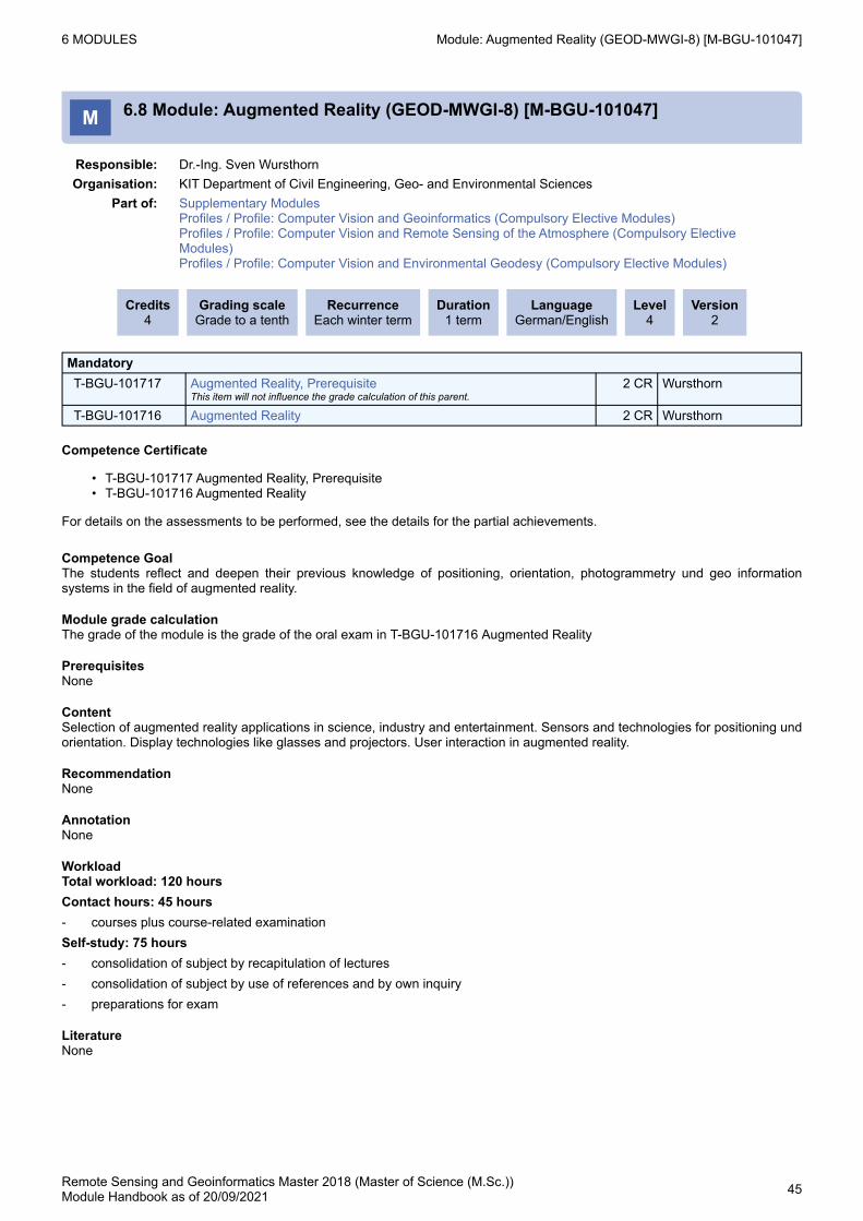
Competence GoalThe students reflect and deepen their previous knowledge of positioning, orientation, photogrammetry und geo information systems in the field of augmented reality.
Module grade calculationThe grade of the module is the grade of the oral exam in T-BGU-101716 Augmented Reality
PrerequisitesNone
ContentSelection of augmented reality applications in science, industry and entertainment. Sensors and technologies for positioning und orientation. Display technologies like glasses and projectors. User interaction in augmented reality.
RecommendationNone
AnnotationNone
WorkloadTotal workload: 120 hoursContact hours: 45 hours- courses plus course-related examinationSelf-study: 75 hours- consolidation of subject by recapitulation of lectures- consolidation of subject by use of references and by own inquiry- preparations for exam
LiteratureNone
6 MODULES Module: Basics of Estimation Theory and its Application in Geoscience Remote Sensing (RSGI-MMCM-2) [M-BGU-104918]
Remote Sensing and Geoinformatics Master 2018 (Master of Science (M.Sc.))Module Handbook as of 20/09/2021 46
•••
••
••••
•◦◦◦◦◦◦◦
M 6.9 Module: Basics of Estimation Theory and its Application in Geoscience Remote Sensing (RSGI-MMCM-2) [M-BGU-104918]
Responsible: Prof. Dr. Jan CermakProf. Dr.-Ing. Stefan Hinz
Organisation: KIT Department of Civil Engineering, Geo- and Environmental SciencesPart of: Mathematics and Beyond
Credits6
Grading scaleGrade to a tenth
RecurrenceEach summer term
Duration1 term
LanguageEnglish
Level4
Version2
MandatoryT-BGU-106633 Data Analysis in Geoscience Remote Sensing Projects, Prerequisite
This item will not influence the grade calculation of this parent.2 CR Cermak
T-BGU-111186 Basics of Estimation Theory, PrerequisiteThis item will not influence the grade calculation of this parent.
1 CR Hinz
T-BGU-109952 Basics of Estimation Theory and its Application in Geoscience Remote Sensing, Examination
3 CR Cermak, Hinz
Competence Certificate
T-BGU-106633 - Data Analysis in Geoscience Remote Sensing Projects, VorleistungT-BGU-111186 - Basics of Estimation Theory, PrerequisiteT-BGU-109952 - Basics of Estimation Theory and its Application in Geoscience Remote Sensing, Examination
For details on the assessments to be performed, see the details for the partial achievements.
Competence GoalStudents explain the theoretical basics and important aspects of detection, classification and parameter estimation. They apply the concepts and methods of estimation theory and deformation analysis to data recorded by geodetic, geophysical or remote sensing sensors. Students explain the application of estimation theory to data analysis problems in the geosciences. Students relate how methods in geoscientific remote sensing are developed, applied and validated. By working self-organized and reflectively the students deepen their knowledge in soft skills, e.g., organization, collaboration and communication.
Module grade calculationThe grade of the module is the grade of the oral exam.
Prerequisites
M-BGU-101015 - Estimation TheoryM-BGU-103314 - Data Analysis in Geoscience Remote Sensing Projects
have not been started
ContentContents of the module include
an introduction into stochastic modelling (starting with the Bayes-Theorem)theoretical models and applied methods of detection of events in signalstheoretical models and applied methods of classification of events in signalsa variety of methods for parameter estimation, e.g. least-squares estimation, transformation of probability density and integration of a-priori knowledge about parameters and observationsapplication of estimation theory explained on examples from the geosciences. Possible contents:
Lidar remote sensing of aerosol propertiesPassive imager remote sensing cloud microphysicsFourier-transform infrared spectroscopy for trace gase remote sensingMulti-instrument land surface cover classificationVegetation remote sensing and validationLand surface temperature estimation and validationRadar remote sensing of precipitation
RecommendationKnowledge in statistics, parameter estimation and numerical mathematics are helpful.
6 MODULES Module: Basics of Estimation Theory and its Application in Geoscience Remote Sensing (RSGI-MMCM-2) [M-BGU-104918]
Remote Sensing and Geoinformatics Master 2018 (Master of Science (M.Sc.))Module Handbook as of 20/09/2021 47
•
••••
WorkloadTotal workload: 180 hours
Contact hours: 75 hours
courses plus course-related examination
Self-study: 105 hours
consolidation of subject by recapitulation of lecturesconsolidation of subject by use of references and by own inquirydata analysis and data processingpreparations for exam
6 MODULES Module: Cartography II (GEOD-MWER-6) [M-BGU-101107]
Remote Sensing and Geoinformatics Master 2018 (Master of Science (M.Sc.))Module Handbook as of 20/09/2021 48
M 6.10 Module: Cartography II (GEOD-MWER-6) [M-BGU-101107]
Responsible: Prof. Dr. Jan CermakDipl.-Ing. Christoph Hermann
Organisation: KIT Department of Civil Engineering, Geo- and Environmental SciencesPart of: Supplementary Modules (Usage from 2/17/2021)
Additional Examinations
Credits1
Grading scaleGrade to a tenth
RecurrenceEach summer term
Duration1 term
LanguageGerman
Level4
Version1
MandatoryT-BGU-101662 Cartography II 1 CR Cermak, Hermann
Prerequisitesnone
6 MODULES Module: Computer Vision and Remote Sensing (RSGI-MRCR) [M-BGU-104517]
Remote Sensing and Geoinformatics Master 2018 (Master of Science (M.Sc.))Module Handbook as of 20/09/2021 49
M 6.11 Module: Computer Vision and Remote Sensing (RSGI-MRCR) [M-BGU-104517]
Responsible: Prof. Dr.-Ing. Stefan HinzOrganisation: KIT Department of Civil Engineering, Geo- and Environmental Sciences
Part of: Remote Sensing
Credits8
Grading scaleGrade to a tenth
RecurrenceEach term
Duration2 terms
LanguageEnglish
Level4
Version1
MandatoryT-BGU-101759 Methods of Remote Sensing, Prerequisite 1 CR WeidnerT-BGU-109269 Computer Vision and Remote Sensing, Examination 7 CR Hinz
Competence Certificateoral (ca. 40 min.)
Competence GoalCourse 1 Methods of Remote Sensing:Students are able to explain the fundamentals of multispectral remote sensing, namely the basics of pixel- and segment-based classification approaches, their communalities and their differences. Students are able to use their knowledge and transfer it to other fields of applications.Course 2 Image Processing and Computer Vision:Students are able to explain the fundamentals of image processing and computer vision. They describe the basic approaches and concepts including robust techniques and are able to use their knowledge and transfer it to other fields of applications.Course 3 Sensors and Signals in Computer Vision and Remote Sensing:Students reproduce the fundamentals of sensors and signals in Computer Vision and Remote Sensing. They describe the basic signal processing techniques. Students are able to use their knowledge and transfer it to other fields of applications.
Module grade calculationThe grade of the module is the grade of the oral exam.
PrerequisitesNone
ContentCourse 1 Methods of Remote Sensing:This course provides an overview of multispectral remote sensing. It introduces to concepts of data processing, also including sensor aspects where required. Based on a selection of applications like land cover/used classification and change detection / monitoring approaches are presented and compared. The module consists of lectures and labs.Course 2 Image Processing and Computer Vision:This course provides an overview of basic approaches of image processing and computer vision, starting from image filters like linear and non-linear filters, gradient and curvature operators and leading to concepts of object extraction based on point, line and segment extraction and their applications. The module consists of lectures and labs.Course 3 Sensors and Signals in Computer Vision and Remote Sensing:This course provides an overview on basic signal processing techniques: Mathematical principles, Systems and signals, Fourier-series, Delta function, Convolution, Fourier-Transformation, LTI-systems and modulation, Digital signal processing, Random Signals, Signal reconstruction, Interpolation, Multi-dimensional system theory.
6 MODULES Module: Computer Vision and Remote Sensing (RSGI-MRCR) [M-BGU-104517]
Remote Sensing and Geoinformatics Master 2018 (Master of Science (M.Sc.))Module Handbook as of 20/09/2021 50
Competence GoalThe students understand the basic principles of geodetic satellite missions. They know geodetic reference systems as well as the mathematical representation of the Earth's gravity field and are aware of their specific characteristics and research-related problems. The learners know the basic concepts of GNSS positioning and are able to familiarize themselves with new GNSS-related topics. They analyze real GOCE data and discuss the interactions of the various gravity satellite missions. The students work autonomous and self-organized in the field of environmental geodesy and have communicative as well as organizational competences with respect to collaboration, presentation and discussion. The students understand how geodetic and geo-scientific observation systems and techniques contribute to environmental geodesy.
Module grade calculationThe grade of the module is the grade of the examination (20 minutes) of T-BGU-109330 - Fundamentals of Environmental Geodesy, Examination.
PrerequisitesNone
ContentThe courses 1 and 2 focus on the role of geodetic observation systems in environmental geodesy.Course 1:
Mathematical representation of the gravity field of the Earth as well as its fundamental characteristics;Geodetic gravity missions like Grace, GOCE, ICEsat;Orbit parameters, resolution, accuracy;
Course 2:
Theoretical basics and research as well as praxis orientated principles of important satellite missions like GNSS, VLBI, SLR, DORIS;Geodetic reference frames and systems, plate tectonics;GNSS positioning;InSAR;
AnnotationCourse 1: Fundamentals of Environmental Geodesy Part A (WS)Course 2: Fundamentals of Environmental Geodesy Part B (SS)
6 MODULES Module: Fundamentals of Environmental Geodesy (RSGI-MRFE) [M-BGU-104553]
Remote Sensing and Geoinformatics Master 2018 (Master of Science (M.Sc.))Module Handbook as of 20/09/2021 52
•◦
•◦◦◦◦◦
•◦
•◦◦◦◦
WorkloadTotal workload Course 1: 75 hours
Contact hours: 25 hourscourse plus course-related examination
Self-study: 50 hoursconsolidation of subject by recapitulation of lecturesprocessing of exercisesconsolidation of subject by use of references and by own inquiryexercises and scientific bullentinpreparations for the examination
Total workload Course 2: 75 hours
Contact hours: 25 hoursCourse plus course-related examination
Self-study: 50 hoursconsolidation of subject by recapitulation of lecturesconsolidation of subject by use of references and by own inquiryexercises and presentationpreparations for the examination
Total workload of both courses: 150 hours
6 MODULES Module: Further Examinations [M-BGU-104713]
Remote Sensing and Geoinformatics Master 2018 (Master of Science (M.Sc.))Module Handbook as of 20/09/2021 53
M 6.13 Module: Further Examinations [M-BGU-104713]
Organisation: KIT Department of Civil Engineering, Geo- and Environmental SciencesPart of: Additional Examinations
Credits30
Grading scalepass/fail
RecurrenceEach term
Duration2 terms
LanguageGerman
Level4
Version1
Election block: Further Examinations (at most 30 credits)T-BGU-109599 Wildcard Additional Examinations 1 2 CRT-BGU-109604 Wildcard Additional Examinations 6 5 CR
6 MODULES Module: Further Key Competences [M-BGU-104712]
Remote Sensing and Geoinformatics Master 2018 (Master of Science (M.Sc.))Module Handbook as of 20/09/2021 54
M 6.14 Module: Further Key Competences [M-BGU-104712]
Organisation: KIT Department of Civil Engineering, Geo- and Environmental SciencesPart of: Key Competences
Credits2
Grading scalepass/fail
RecurrenceEach term
Duration2 terms
Level4
Version2
Election block: Further Key Competences (at least 2 credits)T-BGU-109594 Wildcard Further Key Competences 1 ub 1 CRT-BGU-109595 Wildcard Further Key Competences 2 ub 1 CRT-BGU-111648 Wildcard Further Key Competences 5 1 CRT-BGU-111649 Wildcard Further Key Competences 6 1 CR
Prerequisitesnone
6 MODULES Module: Further Key Competences [M-BGU-104711]
Remote Sensing and Geoinformatics Master 2018 (Master of Science (M.Sc.))Module Handbook as of 20/09/2021 55
M 6.15 Module: Further Key Competences [M-BGU-104711]
Organisation: KIT Department of Civil Engineering, Geo- and Environmental SciencesPart of: Key Competences
Credits4
Grading scalepass/fail
RecurrenceEach term
Duration2 terms
Level4
Version2
Election block: Further Key Competences (at least 4 credits)T-BGU-109594 Wildcard Further Key Competences 1 ub 1 CRT-BGU-109595 Wildcard Further Key Competences 2 ub 1 CRT-BGU-109596 Wildcard Further Key Competences 3 ub 1 CRT-BGU-109597 Wildcard Further Key Competences 4 ub 1 CRT-BGU-111648 Wildcard Further Key Competences 5 1 CRT-BGU-111649 Wildcard Further Key Competences 6 1 CRT-BGU-111706 SelfAssignment-MScRSGI-1-graded 2 CRT-BGU-111707 SelfAssignment-MScRSGI-2-graded 2 CRT-BGU-111708 SelfAssignment-MScRSGI-3-ungraded 2 CRT-BGU-111709 SelfAssignment-MScRSGI-4-ungraded 2 CR
Remote Sensing and Geoinformatics Master 2018 (Master of Science (M.Sc.))Module Handbook as of 20/09/2021 56
••
M 6.16 Module: GeoDB (GEOD-MPGI-1) [M-BGU-101041]
Responsible: Prof. Dr. Martin BreunigOrganisation: KIT Department of Civil Engineering, Geo- and Environmental Sciences
Part of: Profiles / Profile: Computer Vision and Geoinformatics (mandatory) Profiles / Profile: Geoinformatics and Remote Sensing of the Atmosphere (mandatory) Profiles / Profile: Geoinformatics and Environmental Geodesy (mandatory)
Credits5
Grading scaleGrade to a tenth
RecurrenceEach winter term
Duration1 term
LanguageGerman/English
Level4
Version2
MandatoryT-BGU-101754 GeoDB, Prerequisite
This item will not influence the grade calculation of this parent.1 CR Breunig
T-BGU-101753 GeoDB 4 CR Breunig
Competence Certificate
T-BGU-101754 GeoDB, VorleistungT-BGU-101753 GeoDB
For details on the assessments to be performed, see the details for the partial achievements..
Competence GoalThe students explain the basic concepts of spatial data management. They are able to analyze object-oriented spatial data models, the structure and algorithms of spatial access methods. They know how to use geo-database management systems in theory and in practice. They are able to apply the mediated concepts and implementations to related problems. The students are able to transfer the learned knowledge to advanced topics such as 3D or spatio-temporal geo-databases.
Module grade calculationThe grade of the module is the grade of the oral exam in T-BGU-101753 GeoDB.
PrerequisitesNone
ContentThe module provides students with an insight into the essential concepts and the state of the art in geo-data management. Standardized geospatial data models are introduced. The effect of multi-dimensional indexing of spatial data is explained and the structure and algorithms of specific spatial access methods are explained (e.g. quadtree, grid files, R trees, Generalized Search Tree). The theoretical aspects are implemented in practical exercises, for example, using object-relational spatial database systems (e.g PostGIS). Finally, the module refers to more advanced topics (e.g. topological databases) and current research in the field of geo-databases.
RecommendationKnowledge in database systems is helpful.
AnnotationNone
WorkloadTotal workload: 120 hoursContact hours: 45 hours- courses plus course-related examinationSelf-study: 75 hours- consolidation of subject by recapitulation of lectures- processing of exercises- consolidation of subject by use of references and by own inquiry- preparations for exam
Competence GoalThe students have a deepened knowledge about the mathematical representation of the gravity field of the Earth and its temporal variations. They know how to process and to analyze relevant terrestrial or satellite data and are familiar with fundamental methods to derive models for changing environmental parameters. The students understand active deformation processes of the 'rigid' Earth as a prominent source of changes in the Earth system. They know the special demands on measurement techniques and the basic methods to derive reliable estimations of surface displacements. In the exercises the students use real data examples to model system response functions as well as source signals, and they assess the results. They are able to apply the imparted concepts to related problems and to transfer the learned knowledge to other research topics (e.g., sensing the atmosphere).
Module grade calculationThe grade of the module is the grade of the oral exam.Thereby both courses are weighted equally.
PrerequisitesNone
ContentCourse 1 Mass Variations:
Investigation of temporal gravity variationsDerivation of mass variations in the Earth systemGeodetic contribution in the field of environmental changes with a focus on ground water storageAccompanying methods like Radar altimetry
Course 2 Deformation Processes:
Deformation processes of the EarthInterseismic, coseismic and postseismic deformations at plate margins;Anthropogenic surface displacements due to mining activites and fluid extraction;Advanced methods of deformation measurements (e.g., SAR interferometry, GNSS)
RecommendationCourse 1 Mass Variations: Fundamentals of Environmental Geodesy (Part A)Course 2 Deformation Processes: Fundamentals of Environmental Geodesy (Part B)
AnnotationIn mutual agreement with the students the lectures and exercises will be presented either in English or in German
Remote Sensing and Geoinformatics Master 2018 (Master of Science (M.Sc.))Module Handbook as of 20/09/2021 58
•
••••
•
••••
WorkloadTotal workload Course 1 Mass Variations: 75 hours
Contact hours: 25 hours
courses plus course-related examination
Self-study: 50 hours
consolidation of subject by recapitulation of lecturesprocessing of exercisesconsolidation of subject by use of references and by own inquirypreparations for exam
Total workload Course 2 Deformation Processes: 75 hours
Contact hours: 25 hours
courses plus course-related examination
Self-study: 50 hours
consolidation of subject by recapitulation of lecturesprocessing of exercisesconsolidation of subject by use of references and by own inquirypreparations for exam
Competence GoalThe students discuss the strengths and weaknesses of different geodetic observation methods. They understand and evaluate strategies to derive improved products from a multi sensor fusion which is an important field of recent and future geodetic research. Students apply their knowledge and transfer it to other fields of applications. They sharpen their research interests with respect to topics to be worked upon during Lab Rotations and master thesis.
Module grade calculationThe grade of the module is the grade of the exam.
PrerequisitesNone
Content
Integration of physical and geometrical sensors and observationsMulti-technique approachesTheory of interpolation and collocationGlobal Geodetic Observing System (GGOS)International Terrestrial Reference Frame (multi-techniques geodesy and geodynamics)
RecommendationFundamentals of Environmental Geodesy, Part A+B
WorkloadTotal workload: 90 hours
Contact hours: 21 hourscourse plus course-related examination
Self-study: 69 hoursconsolidation of subject by recapitulation of lecturesprocessing of exercisesconsolidation of subject by use of references and by own inquirypreparations for exam
For details on the assessments to be performed, see the details for the partial achievements.
Competence GoalThe students explain the fundamental concepts of Geoinformatics and their implementations, i.e. they penetrate them in theory and practice. Furthermore, they transform them to geo-applications. In particular, geo-data models and methods for geo-data management are analszed. The students transfer the learned content on advanced topics of Geoinformatics.
Module grade calculationThe grade of the module is the grade of the oral exam in T-BGU-101742 Geoinformatics.
PrerequisitesThe module M-BGU-101010 must not have startet.
Modeled ConditionsThe following conditions have to be fulfilled:
The following conditions have to be fulfilled:
ContentThe module provides students with an insight into concepts and practical methods of Geoinformatics based on data models, geo-referenced data structures and algorithms, database systems, access methods, etc. In the practical part, the proposed methods are implemented in a programing language using relevant tools of Geoinformatics.
consolidation of subject by recapitulation of lecturesprocessing of exercisesconsolidation of subject by use of references and by own inquirypreparations for exam
For details on the assessments to be performed, see the details for the partial achievements..
Competence GoalStudents are able to explain the fundamentals of hyperspectral remote sensing, its possibilities and challenges with respect to multispectral remote sensing, including data processing specifically designed for hyperspectral data. Students are able to use their knowledge and transfer it to other fields of applications.
Module grade calculationThe grade of the module is the grade of the oral exam in T-BGU-101720 Hyperspectral Remote Sensing.
Prerequisitesnone
ContentThis module provides an overview of hyperspectral remote sensing. It introduces students to sensor systems and concepts of data processing. A selection of approaches is presented and compared to classical approaches for the processing and classification of multispectral data. The module consists of lectures and labs.
RecommendationKnowledge in multispectral remote sensing is recommended.
WorkloadTotal workload: 90 hoursContact hours: 30 hours- courses plus course-related examinationSelf-study: 60 hours- consolidation of subject by recapitulation of lectures- consolidation of subject by use of references and by own inquiry- preparations for exam
6 MODULES Module: Lab Rotation I (RSGI-ML-1) [M-BGU-104588]
Remote Sensing and Geoinformatics Master 2018 (Master of Science (M.Sc.))Module Handbook as of 20/09/2021 62
•••
M 6.21 Module: Lab Rotation I (RSGI-ML-1) [M-BGU-104588]
Responsible: Prof. Dr. Martin BreunigProf. Dr. Jan CermakProf. Dr.-Ing. Stefan Hinzapl. Prof. Dr. Boris JutziProf. Dr.-Ing. Hansjörg KuttererProf. Dr.-Ing. Markus Ulrich
Organisation: KIT Department of Civil Engineering, Geo- and Environmental SciencesPart of: Lab Rotations
Credits10
Grading scaleGrade to a tenth
RecurrenceEach term
Duration1 term
LanguageGerman
Level5
Version1
MandatoryT-BGU-109412 Lab Rotation I 10 CR
Competence CertificateOther according to SPO RSGI §4/2
Competence GoalThe student will get insight in lab work, will learn to work in a selforganizedway. Further the student will deepen his or her knowledge in thetopic of choice and will then be better qualified to select the topicand the research groups which fits best to his or her personal interest.
Module grade calculationThe grade of the module is the grade of the written report.
PrerequisitesAt least 45 CP shall have been acquired before a lab rotation isstarted.
ContentThe student works on a selected topic in one of the research groupsof the involved institutes. Lab rotations at external institutions areallowable. The selection of the topic is made in agreement of thesupervisor and the student. The student familiarizes his or herself with thetopic, carries out the lab work, and prepares a report.
WorkloadTotal workload: 300 hours
Literature study: 50 hoursLab work: 190 hoursPreparation of report and presentation: 60 hours
6 MODULES Module: Lab Rotation II (RSGI-ML-1) [M-BGU-104589]
Remote Sensing and Geoinformatics Master 2018 (Master of Science (M.Sc.))Module Handbook as of 20/09/2021 63
•••
M 6.22 Module: Lab Rotation II (RSGI-ML-1) [M-BGU-104589]
Responsible: Prof. Dr. Jan CermakProf. Dr.-Ing. Stefan Hinzapl. Prof. Dr. Boris JutziProf. Dr.-Ing. Hansjörg KuttererProf. Dr.-Ing. Markus Ulrich
Organisation: KIT Department of Civil Engineering, Geo- and Environmental SciencesPart of: Lab Rotations
Credits10
Grading scaleGrade to a tenth
RecurrenceEach term
Duration1 term
LanguageGerman
Level5
Version1
MandatoryT-BGU-109413 Lab Rotation II 10 CR
Competence CertificateOther according to SPO RSGI §4/2
Competence GoalThe student will get insight in lab work, will learn to work in a selforganizedway. Further the student will deepen his or her knowledge in thetopic of choice and will then be better qualified to select the topicand the research groups which fits best to his or her personal interest.
Module grade calculationThe grade of the module is the grade of the written report.
PrerequisitesAt least 45 CP shall have been acquired before a lab rotation isstarted.
ContentThe student works on a selected topic in one of the research groupsof the involved institutes. Lab rotations at external institutions areallowable. The selection of the topic is made in agreement of thesupervisor and the student. The student familiarizes his or herself with thetopic, carries out the lab work, and prepares a report.
WorkloadTotal workload: 300 hours
Literature study: 50 hoursLab work: 190 hoursPreparation of report and presentation: 60 hours
Remote Sensing and Geoinformatics Master 2018 (Master of Science (M.Sc.))Module Handbook as of 20/09/2021 64
••••
1.◦◦◦◦◦◦
M 6.23 Module: Master Thesis (RSGI-M) [M-BGU-104549]
Responsible: Prof. Dr. Jan CermakOrganisation: KIT Department of Civil Engineering, Geo- and Environmental Sciences
Part of: Master Thesis
Credits30
Grading scaleGrade to a tenth
RecurrenceEach term
Duration1 term
LanguageEnglish
Level5
Version1
MandatoryT-BGU-109321 Master Thesis 30 CR Cermak
Competence CertificateWritten
Competence GoalThe student gets further insight in lab work and will learn to work in a self-organized way. The student analyzes the given task, understands related problems, evaluates available methods to solve these problems and applies the method finally chosen. With this, the student will deepen his/her knowledge in the topic of choice and will then be better qualified to select the topic and the research groups which fits best to his/her personal interest.Learning outcomes:
Application of the subject-specific knowledge and methods learned during the studies.Self-organized conception and independent execution of a scientific project.Explanation and analysis of results.Interpretation and communication of the obtained results in written form.
Module grade calculationThe thesis will be evaluated by the supervisor and another examiner of the faculty. One of these must be professor or junior professor. In the case of disagreeing grades the arithmetic mean is calculated. The grade of the module is the grade of the thesis.
PrerequisitesAt least 70 CP shall have been acquired before the master thesis is started.
Modeled ConditionsThe following conditions have to be fulfilled:
You need to earn at least 70 credits in the following fields:Key CompetencesLab RotationsMathematics and BeyondProfilesRemote SensingSupplementary Modules
ContentExecution of a scientific project under supervision.
WorkloadTotal workload: 6 months, appr. 900 hours
6 MODULES Module: Mobile GIS / Location Based Services (GEOD-MWGI-2) [M-BGU-101045]
Remote Sensing and Geoinformatics Master 2018 (Master of Science (M.Sc.))Module Handbook as of 20/09/2021 65
••
•
••••
M 6.24 Module: Mobile GIS / Location Based Services (GEOD-MWGI-2) [M-BGU-101045]
Responsible: Prof. Dr. Martin BreunigOrganisation: KIT Department of Civil Engineering, Geo- and Environmental Sciences
Part of: Supplementary Modules (Usage from 2/17/2021) Profiles / Profile: Computer Vision and Geoinformatics (Compulsory Elective Modules) Profiles / Profile: Geoinformatics and Remote Sensing of the Atmosphere (Compulsory Elective Modules) Profiles / Profile: Geoinformatics and Environmental Geodesy (Compulsory Elective Modules)
Credits3
Grading scaleGrade to a tenth
RecurrenceEach summer term
Duration1 term
LanguageEnglish
Level4
Version2
MandatoryT-BGU-101713 Mobile GIS / Location Based Services, Prerequisite
This item will not influence the grade calculation of this parent.2 CR Breunig
T-BGU-101712 Mobile GIS / Location Based Services 1 CR Breunig
Competence Certificate
T-BGU-101713 Mobile GIS / Location Based Services, PrerequisiteT-BGU-101712 Mobile GIS / Location Based Services
For details of the performance assessment to be carried out, see the information provided with the individual partial achievements.
Competence GoalThe students explain the basics of mobile GIS and Location Based Services (LBS) including suitable transaction concepts. In practical use, they can, for example, acquire geodata with different hardware, manage them in a mobile database and synchronize them with a central database. Furthermore, students are able to develop an exemplary LBS application.
Module grade calculationThe grade of the modul is identical with the grade of the exam in T-BGU-101712 Mobile GIS / Location Based Services.
Prerequisitesnone
ContentThe module presents and discusses the history and basics of mobile GIS and Location Based Services. The corresponding techniques are applied in practical use with different hardware. Examples are mobile geodata acquisition and mobile geodata management as well as synchronization with a central database. Furthermore, the students learn about the principles of exemplary developments and to apply them in practice.
AnnotationIn mutual agreement with the students the lectures and exercises will be presented either in English or in German.
WorkloadTotal amount of work: 90 hoursAttendance time: 30 hours
Courses including module exams
Self study: 60 hours
Deepening of the study contents by reworking the lecture content at homeProcessing of exercisesDeepening of the study contents on the basis of suitable literature and internet researchPreparation for the module examination
For details on the assessment to be performed, see the details for the partial achievement.
Competence GoalStudents can explain the basics of numerical mathematics as well as name, formally describe, critically evaluate and apply basic numerical methods.
Module grade calculationThe grade of the module is the grade of the oral exam T-BGU-111175 – Numerical Mathematics, Exam.
PrerequisitesThe module M-BGU-101012 must not have started.
Modeled ConditionsThe following conditions have to be fulfilled:
The following conditions have to be fulfilled:
ContentThis module provides an overview of basic numerical methods like floating point arithmetic, non-linear equations, polynomials, linear algebra, topology, approximation, partial differential equations, and numerical integration. Some applications in various disciplines are shown. The module consists of lectures and exercise sessions.
consolidation of subject by recapitulation of lecturesconsolidation of subject by use of references and by own inquirypreparations for exam
LiteratureNone
6 MODULES Module: Real Estate Valuation II (GEOD-MWER-4) [M-BGU-101105]
Remote Sensing and Geoinformatics Master 2018 (Master of Science (M.Sc.))Module Handbook as of 20/09/2021 73
M 6.32 Module: Real Estate Valuation II (GEOD-MWER-4) [M-BGU-101105]
Responsible: Prof. Dr. Jan CermakProf. Dr.-Ing. Erwin Drixler
Organisation: KIT Department of Civil Engineering, Geo- and Environmental SciencesPart of: Supplementary Modules (Usage from 2/17/2021)
Credits4
Grading scaleGrade to a tenth
RecurrenceEach summer term
Duration1 term
LanguageGerman
Level4
Version1
MandatoryT-BGU-101660 Real Estate Valuation II 4 CR Cermak, Drixler
Prerequisitesnone
6 MODULES Module: Recent Earth Observation Programs and Systems (GEOD-MWCV-7) [M-BGU-101765]
Remote Sensing and Geoinformatics Master 2018 (Master of Science (M.Sc.))Module Handbook as of 20/09/2021 74
•
1.
M 6.33 Module: Recent Earth Observation Programs and Systems (GEOD-MWCV-7) [M-BGU-101765]
Responsible: Dr.-Ing. Uwe WeidnerOrganisation: KIT Department of Civil Engineering, Geo- and Environmental Sciences
Part of: Supplementary Modules (Usage from 2/17/2021) Profiles / Profile: Computer Vision and Environmental Geodesy (Compulsory Elective Modules) Profiles / Profile: Geoinformatics and Environmental Geodesy (Compulsory Elective Modules) Profiles / Profile: Remote Sensing of the Atmosphere and Environmental Geodesy (Compulsory Elective Modules)
Credits2
Grading scaleGrade to a tenth
RecurrenceEach summer term
Duration1 term
LanguageEnglish
Level4
Version2
MandatoryT-BGU-103407 Recent Earth Observation Programs and Systems 2 CR Weidner
Competence Certificate
T-BGU-103407 Recent Earth Observation Programs and Systems
For details on the assessments to be performed, see the details for partial achivement.
Competence GoalStudents are aware of recent and planned Earth observation missions and able to relate the programs and sensors to each other, but also to former Earth observation programs and systems.
Module grade calculationThe grade of the module is the grade of the oral exam in T-BGU-103407 Recent Earth Observation Programs and Systems
PrerequisitesThe module M-BGU-101824 Missions and Methods of Remote Sensing must not have started.
Modeled ConditionsThe following conditions have to be fulfilled:
The following conditions have to be fulfilled:
ContentThis module provides an introduction to recent and planned Earth observation programs and systems. The module addresses aspects of the sensors, but also planned and possible applications.
AnnotationKnowledge in remote sensing sensors is recommended.
WorkloadTotal workload: 60 hoursContact hours: 15 hours- courses plus course-related examinationSelf-study: 45 hours- consolidation of subject by recapitulation of lectures- consolidation of subject by use of references and by own inquiry- preparations for exam
6 MODULES Module: Remote Sensing of Atmospheric Temperature, Trace Gases, Clouds and Aerosols (RSGI-MPRA) [M-BGU-104532]
Remote Sensing and Geoinformatics Master 2018 (Master of Science (M.Sc.))Module Handbook as of 20/09/2021 75
••
•••••
M 6.34 Module: Remote Sensing of Atmospheric Temperature, Trace Gases, Clouds and Aerosols (RSGI-MPRA) [M-BGU-104532]
Responsible: Prof. Dr. Jan Cermakapl. Prof. Dr. Thomas Clarmann von Clarenau
Organisation: KIT Department of Civil Engineering, Geo- and Environmental SciencesPart of: Profiles / Profile: Computer Vision and Remote Sensing of the Atmosphere (mandatory)
Profiles / Profile: Geoinformatics and Remote Sensing of the Atmosphere (mandatory) Profiles / Profile: Remote Sensing of the Atmosphere and Environmental Geodesy (mandatory)
Credits5
Grading scaleGrade to a tenth
RecurrenceEach term
Duration2 terms
LanguageEnglish
Level4
Version2
MandatoryT-BGU-111184 Remote Sensing of Aerosols and Clouds, Prerequisite
This item will not influence the grade calculation of this parent.1 CR Cermak, Clarmann
von ClarenauT-BGU-109282 Remote Sensing of Atmospheric Temperature, Trace Gases, Clouds
and Aerosols, Examination4 CR Cermak, Clarmann
von Clarenau
Competence Certificate
T-BGU-111184 - Remote Sensing of Aerosols and Clouds, PrerequisiteT-BGU-109282 - Remote Sensing of Atmospheric Temperature, Trace Gases, Clouds and Aerosols, Examination (oral ca. 30 min.)
For details on the assessments to be performed, see the details for the partial achievements.
Competence GoalCourse 1 Passive Remote Sensing of Atmospheric Temperature and Composition:The students can explain the basics of passive remote sensing of atmospheric temperature and composition and the underlying radiative transfer principles. They know the advantages and drawbacks of different observation geometries, frequency ranges, and technical realizations. They know the common methods of data analysis and data characterization. Knowledge of the technical terminology enables them to read technical literature, to participate in related discussions and to prepare a master thesis in this field.
Course 2 Remote Sensing of Aerosols and Clouds:Students explain techniques used in remote sensing of aerosols and clouds, and their specific advantages. They relate how remote sensing assessments help improve the understanding of processes involving aerosols and clouds. Students independently choose and apply methods and data sets suited for the analysis of aerosols and clouds.
Module grade calculationThe grade of the module is the grade of oral exam.
PrerequisitesNone
ContentCourse 1 Passive Remote Sensing of Atmospheric Temperature and Composition:The use of remote sensing techniques for atmospheric measurements will be motivated. An introduction into the technical terminology is given. Measurement geometries (nadir, upward, limb, in emission and absorption) are presented and discussed. The fundamentals of radiative transfer will be recapitulated. Advantages and drawbacks of different spectral regions (UV, visible, infrared, microwave) are discussed. Exemplar satellite missions are presented. Data analysis by inverse methods applied to ill-posed problems is explained, as well as data characterization in terms of uncertainties and spatial resolution. Validation approaches are presented. An overview over career opportunities in this field is given.
Course 2 Remote Sensing of Aerosols and Clouds:
Passive-sensor remote sensing of aerosolsPassive-sensor remote sensing of cloudsActive-sensor remote sensing of aerosolsActive-sensor remote sensing of cloudsAssessment of cloud processes and aerosol-cloud interactions
RecommendationBasics of physics and basics of matrix algebra are required. Knowledge in geosciences/climate and statistics are helpful.
6 MODULES Module: Remote Sensing of Atmospheric Temperature, Trace Gases, Clouds and Aerosols (RSGI-MPRA) [M-BGU-104532]
Remote Sensing and Geoinformatics Master 2018 (Master of Science (M.Sc.))Module Handbook as of 20/09/2021 76
•
••••
•
••••
WorkloadTotal workload course 1 Passive Remote Sensing of Atmospheric Temperature and Composition: 75 hours
Contact hours: 40 hours
courses plus course-related examination
Self-study: 35 hours
consolidation of subject by recapitulation of lecturesprocessing of exercisesconsolidation of subject by use of references and by own inquirypreparations for exam
Total workload course 2 Remote Sensing of Aerosols and Clouds: 75 hours
Contact hours: 30 hours
courses plus course-related examination
Self-study: 45 hours
consolidation of subject by preparation of presentationsconsolidation of subject by use of references and by own inquiryprocessing of exercisespreparations for exam
6 MODULES Module: Remote Sensing of the Atmosphere (RSGI-MRRA) [M-BGU-104524]
Remote Sensing and Geoinformatics Master 2018 (Master of Science (M.Sc.))Module Handbook as of 20/09/2021 77
•••
••
••
◦◦
•◦◦
••
M 6.35 Module: Remote Sensing of the Atmosphere (RSGI-MRRA) [M-BGU-104524]
Responsible: Prof. Dr. Jan CermakOrganisation: KIT Department of Civil Engineering, Geo- and Environmental Sciences
Part of: Remote Sensing
Credits5
Grading scaleGrade to a tenth
RecurrenceEach term
Duration2 terms
LanguageEnglish
Level4
Version2
MandatoryT-BGU-110304 Satellite Climatology: Remote Sensing of a Changing Climate,
PrerequisteThis item will not influence the grade calculation of this parent.
1 CR Cermak
T-BGU-111185 Atmospheric Remote Sensing Infrastructures, PrerequisiteThis item will not influence the grade calculation of this parent.
1 CR Cermak
T-BGU-109274 Remote Sensing of the Atmosphere, Examination 3 CR Cermak
Competence Certificate
T-BGU-110304 - Satellite Climatology: Remote Sensing of a Changing Climate, PrerequisteT-BGU-111185 - Atmospheric Remote Sensing Infrastructures, PrerequisiteT-BGU-109274 - Remote Sensing of the Atmosphere, Examination
For details on the assessments to be performed, see the details for the partial achievements.
Competence GoalStudents explain the contribution of remote sensing to the assessment of climate change and its consequences in time and space. They relate how remote sensing assessments help further the understanding of processes driving global change. Students independently choose and apply methods and data sets suited for the analysis of specific aspects of global change.
Module grade calculationThe grade of the module is the grade of the exam.
Prerequisites
M-BGU-105095 - Satellite Climatology: Remote Sensing of a Changing ClimateM-BGU-103313 - Remote Sensing of a Changing Climate
have not been started
Content
Basics of global change: Mechanisms and patternsRemote sensing approaches to analysing patterns of global change:
Land and ocean surfaceAtmosphere
Remote sensing approaches to analysing mechanisms of global change:Land and ocean surfaceAtmosphere
Links between remote sensing and other methods in global change researchInfrastructures and systems for atmospheric remote sensing
RecommendationKnowledge in geosciences/climate and statistics are helpful.
6 MODULES Module: Remote Sensing of the Atmosphere (RSGI-MRRA) [M-BGU-104524]
Remote Sensing and Geoinformatics Master 2018 (Master of Science (M.Sc.))Module Handbook as of 20/09/2021 78
courses plus course-related examinationvisits of atmospheric remote sensing infrastructures
Self-study: 95 hours
consolidation of subject matters by recapitulation of lecturesconsolidation of subject matters by use of references and by own inquirydata analysis and data processingpreparations for exam
6 MODULES Module: SAR and InSAR Remote Sensing (RSGI-MPEG-6) [M-BGU-104586]
Remote Sensing and Geoinformatics Master 2018 (Master of Science (M.Sc.))Module Handbook as of 20/09/2021 79
M 6.36 Module: SAR and InSAR Remote Sensing (RSGI-MPEG-6) [M-BGU-104586]
Responsible: Prof. Dr.-Ing. Stefan HinzDr. Malte Westerhaus
Organisation: KIT Department of Civil Engineering, Geo- and Environmental SciencesPart of: Supplementary Modules
Profiles / Profile: Computer Vision and Environmental Geodesy (Compulsory Elective Modules) Profiles / Profile: Geoinformatics and Environmental Geodesy (Compulsory Elective Modules) Profiles / Profile: Remote Sensing of the Atmosphere and Environmental Geodesy (Compulsory Elective Modules)
Credits3
Grading scaleGrade to a tenth
RecurrenceEach summer term
Duration1 term
LanguageEnglish
Level4
Version1
MandatoryT-BGU-109409 SAR and InSAR Remote Sensing, Prerequisite 2 CR Hinz, WesterhausT-BGU-109410 SAR and InSAR Remote Sensing, Examination 1 CR Hinz, Westerhaus
Competence Certificateoral (ca. 20 min.).
Competence GoalThe students understand the basic concepts of SAR remote sensing as well as SAR interferometry. They explain important aspects of SAR image generation with special focus on synthetic aperture and signal focusing. They are familiar with the basics of the interferometric processing of SAR images with public domain tools like SNAP. They know important applications of SAR and are able to identify and interpret fundamental signatures caused by deformations of the Earth's surface or moving objects. The students know the different characteristics of frequency bands used by the three satellite based SAR systems (X-, C- and L-band) and assess their fields of application. They are familiar with the ordering procedure of SAR scenes via the ESA or TerraSAR-X archives. With this lecture, the learners acquire the necessary knowledge to conduct a SAR/InSAR project from the planning phase until the interpretation of results.
Module grade calculationThe grade of the module is the grade of the exam
PrerequisitesNone
ContentThe module delivers basic knowledge about the use of radar satellite imagery in the frame of Remote Sensing and Geodesy. The contents reach from technical aspects concerning image generation until the evaluation of results. Focus of the lectures and exercises is the whole processing chain, including signal focusing, interferometric processing and geocoding. Further emphasis is put on the "reading" of amplitude and phase images as well as the interpretation of different signal contributions. The theoretical concepts are accompanied by practical exercises with a total fraction of 50%, which foster the ability of the learners to process and visualize SAR data. Recent and former SAR missions whose data archives form the basis of most researchand application-orientated projects, are discussed. In the frame of a praxis-orientated scenario, the students gain insight into the ordering process of SAR scenes via the software EOLI-AS which is provided by the European Space Agency (ESA).
RecommendationBasics of signal processing (Fourier-Transformation, digital filters)
AnnotationIn mutual agreement with the students the lectures and exercises will be presented either in English or in German.
6 MODULES Module: SAR and InSAR Remote Sensing (RSGI-MPEG-6) [M-BGU-104586]
Remote Sensing and Geoinformatics Master 2018 (Master of Science (M.Sc.))Module Handbook as of 20/09/2021 80
•
••••
WorkloadTotal workload: 90 hours
Contact hours: 21 hours
course plus course-related examination
Self-study: 69 hours
consolidation of subject by recapitulation of lecturesprocessing of exercisesconsolidation of subject by use of references and by own inquirypreparations for exam
6 MODULES Module: Scientific Applications of GNSS (RSGI-MPEG-3) [M-BGU-104566]
Remote Sensing and Geoinformatics Master 2018 (Master of Science (M.Sc.))Module Handbook as of 20/09/2021 81
•
•
•
•
•
••
M 6.37 Module: Scientific Applications of GNSS (RSGI-MPEG-3) [M-BGU-104566]
Responsible: Dr.-Ing. Hael SumayaOrganisation: KIT Department of Civil Engineering, Geo- and Environmental Sciences
Part of: Supplementary Modules Profiles / Profile: Computer Vision and Environmental Geodesy (Compulsory Elective Modules) Profiles / Profile: Geoinformatics and Environmental Geodesy (Compulsory Elective Modules) Profiles / Profile: Remote Sensing of the Atmosphere and Environmental Geodesy (Compulsory Elective Modules)
Credits3
Grading scaleGrade to a tenth
RecurrenceEach summer term
Duration1 term
LanguageEnglish
Level4
Version1
MandatoryT-BGU-109349 Scientific Applications of GNSS, Examination 3 CR Mayer
Competence Certificateother according to SPO RSGI x4/2
Competence GoalSubject-related competencies:
The students are enabled to process GNSS data using scientific software (e.g., Bernese GNSS software) and to evaluate derived results.The learners are aware of characteristics of scientific GNSS software, especially in contrast to non-scientific software resp. online services. Therefore, they are able to adequately problem-orientated choose the most suitable software.The students are sensitized to datum-related GNSS aspects within Scientific Applications of GNSS (e.g. products, antenna modelling) and enabled to estimate their effects results-orientated.The learners realize recent research related to scientific GNSS data processing within regional GNSS networks.
Multi-disciplinary competencies:
The learners are enabled to work self-organized, independently and reflectively. They have a good command of communication and organization skills, especially related to collaboration, presentation and discussion.The students recognize, re-order and explain complex GNSS contexts from a general perspective.The learners handle, organize and analyze large data sets.
Module grade calculationThe grade of the module is the grade of the assessment of success of other type.
PrerequisitesNone
ContentThe main goal of this module is to generate deep insight into the processing of GNSS data of regional networks using scientific GNSS software. Therefore, basic fundamentals of geodetic datum in the context of products and antenna modelling are treated. The effects of selected modelling and processing strategies are analyzed in the coordinate domain with respect to strongly correlated parameters, such as tropospheric parameters.
AnnotationIn mutual agreement with the students the lectures and exercises will be presented either in English or in German
6 MODULES Module: Scientific Applications of GNSS (RSGI-MPEG-3) [M-BGU-104566]
Remote Sensing and Geoinformatics Master 2018 (Master of Science (M.Sc.))Module Handbook as of 20/09/2021 82
••
WorkloadTotal workload: 90 hoursClassroom lectures: 7,5 hoursTaking the subject-related competencies of the students into account, in the beginning of the module the recent status of Scientific Applications of GNSS is presented in order to establish a fundamental basis for the project work. Self-study: 20 hoursTaking the individual GNSS knowledge of the learners into account, scientific papers are used to deepen and advance the subject-related knowledge. Therefore, the students have to carry out individually
consolidation by recapitulation of lectures,consolidation by use of references and by own inquiry.
Project meetings: 4,5 hoursDuring the project work, team meetings are regularly held in order to give status reports and discuss recent challenges. These meetings are of fundamental importance regarding scrutiny and systematic collaborative progress of the project. Project work: 58 hoursThe main workload is on the joint project dealing with a scientific question related to the scope of the module.
Learning typeThe fundamental requirement for the assessment is the significant contribution to the project work carried out in the framework of the module. The project is conducted in teams (head count per team: max. 3). The assessment takes into account individual (in particular portfolio-based reflection) and team-related (in particular joint research project) achievements. The results of the project work have to be presented and discussed constructively (Audience: Academic staff).
Remote Sensing and Geoinformatics Master 2018 (Master of Science (M.Sc.))Module Handbook as of 20/09/2021 83
M 6.38 Module: Scientific Programming (RSGI-MMCE-1) [M-BGU-104530]
Responsible: Prof. Dr. Jan CermakOrganisation: KIT Department of Civil Engineering, Geo- and Environmental Sciences
Part of: Mathematics and Beyond
Credits3
Grading scaleGrade to a tenth
RecurrenceEach winter term
Duration1 term
LanguageGerman
Level4
Version1
MandatoryT-BGU-106765 Introduction to Matlab 3 CR Ehret
Competence GoalThe students know the syntax and structure of the selected programming language and are apply it in the sense of programming scientific algorithms
PrerequisitesNone
RecommendationIt is recommended to select a programming language which is actually used in the groups where lab rotation or master thesis in made, if such courses are available.
Competence Certificateother according to SPO RSGI x4/2; The assessment consists in the independent thorough scientific treatment of a recent research topic within the field of Earth system observation. Starting from a seminal article in a scientific journal the student acquires new topical competences and presents these in a didactically adequate manner, e.g. as an oral presentation of 20-25 minutes to the other students and the scientific staff. It follows a defense of the content of the presentation. Further, active participation in seminar events of this module is compulsory (e.g., documented attendance at six presentations).
Competence GoalSubject-related competences:
The students describe fundamental recent concepts of Earth observation and are aware of the width of this research field.The students are able to explore detailed technical literature with different foci, collect and structure the information provided, and are able to explain its content.The students contribute to the learning outcome of the seminar group by subject-specific arguments.
Inter-disciplinary competences:
The students are able to self-responsibly organize their work and to carry it out in an independent and selfcritical manner.They have communication and organization skills in the fields of presentation and discussion.The students are able to rate the presentation skills of other team members and can give and receive constructive criticism.The students are able to understand and analyze technical literature in English language.
Module grade calculationThe grade of the module is the grade of the examination.
PrerequisitesNone
ContentThis course provides detailed and focused insight to the student in recent fields of Earth system observation. To achieve this, the students participate in a series of scientific seminars. The field of Earth system observation is of high current relevance, leading to a rapid change of the foci of research. This dynamical characteristic is accounted for and the most up-to-date issues find their way into the seminar which can vary from semester to semester. The topical focus will be agreed with the student and is of the fields of global navigation satellite systems (GNSS), gravity field missions, and geodynamics (e.g. InSAR) with a special focus on environmental geodesy.
RecommendationThe students shall hold advanced knowledge in at least one topic (space-borne geodesy, physical geodesy, geodynamics).
AnnotationIn mutual agreement with the students the seminar will be held either in English of in German.
Remote Sensing and Geoinformatics Master 2018 (Master of Science (M.Sc.))Module Handbook as of 20/09/2021 85
•◦
•◦
WorkloadTotal workload: 60 hours
Contact time: 15 hoursDuring the contact hours individually selected topics will be explored and presented to the other students. Active participation in the seminars is compulsory.
Self-study: 45 hoursIndependent and focused assessment of the content; preparation and presentation of a seminar talk including defense.
6 MODULES Module: Seminar Topics of Image Analysis (GEOD-MWEB-1) [M-BGU-101057]
Remote Sensing and Geoinformatics Master 2018 (Master of Science (M.Sc.))Module Handbook as of 20/09/2021 86
•
M 6.40 Module: Seminar Topics of Image Analysis (GEOD-MWEB-1) [M-BGU-101057]
Responsible: Prof. Dr.-Ing. Stefan HinzOrganisation: KIT Department of Civil Engineering, Geo- and Environmental Sciences
Part of: Supplementary Modules (Usage from 2/15/2021) Profiles / Profile: Computer Vision and Geoinformatics (Compulsory Elective Modules) Profiles / Profile: Computer Vision and Remote Sensing of the Atmosphere (Compulsory Elective Modules) Profiles / Profile: Computer Vision and Environmental Geodesy (Compulsory Elective Modules)
Credits2
Grading scaleGrade to a tenth
RecurrenceEach winter term
Duration1 term
LanguageGerman/English
Level4
Version2
MandatoryT-BGU-101725 Seminar Topics of Image Analysis 2 CR Hinz
Competence Certificate
T-BGU-101725 Seminar Topics of Image Analysis
For details on the assessment to be performed, see the details for the partial achievement..
Competence GoalStudents learn – in the form of a seminar – selected state-of-the-art topics of image analyses. These will vary from year to year. Overall goal of this seminar is to get an insight into ways of investigating, selecting and condensing scientific work of the computer vision community, and to prepare it in such a way that the other students will benefit from it.
Module grade calculationThe grade of the module is the grade of the oral exam in T-BGU-101725 Seminar Topics of Image Analysis.
Prerequisitesnone
ContentContents of the module include- introduction into selected topic- overview of boards, conferences, journals, books and the general structure of the image analysis and computer vision community- investigating and selecting important literature- condensing the nucleus of the respective topic- preparing hand-out and oral presentation
RecommendationNone
AnnotationNone
WorkloadTotal workload: 60 hoursContact hours: 15 hours- introductory courses plus course-related examination- presentationsSelf-study: 45 hours- consolidation of subject by recapitulation of introductory lectures- consolidation and preparation of subject by use of references and by own inquiry- preparations for exam
LiteratureNone
6 MODULES Module: Seminar Topics of Remote Sensing (GEOD-MWEA-1) [M-BGU-101054]
Remote Sensing and Geoinformatics Master 2018 (Master of Science (M.Sc.))Module Handbook as of 20/09/2021 87
•
M 6.41 Module: Seminar Topics of Remote Sensing (GEOD-MWEA-1) [M-BGU-101054]
Responsible: Dr.-Ing. Uwe WeidnerOrganisation: KIT Department of Civil Engineering, Geo- and Environmental Sciences
Part of: Profiles / Profile: Computer Vision and Environmental Geodesy (Compulsory Elective Modules) Profiles / Profile: Geoinformatics and Environmental Geodesy (Compulsory Elective Modules) Profiles / Profile: Remote Sensing of the Atmosphere and Environmental Geodesy (Compulsory Elective Modules)
Credits2
Grading scaleGrade to a tenth
RecurrenceEach summer term
Duration1 term
LanguageGerman/English
Level4
Version2
MandatoryT-BGU-101722 Seminar Topics of Remote Sensing 2 CR Weidner
Competence Certificate
T-BGU-101722 Seminar Topics of Remote Sensing
For details on the assessment to be performed, see the details for the partial achievement.
Competence GoalStudents are able to prepare a subject on their own based on introductory lectures, given references and their own inquiry.
Module grade calculationThe grade of the module is the grade of the exam in T-BGU-101722 Seminar Topics of Remote Sensing.
PrerequisitesNone
ContentThis module gives insight in selected topics of remote sensing. Topics are close to actual research topics of interest and recent research of the Institute.
RecommendationNone
AnnotationKnowledge of fundamentals in remote sensing sensors is recommended.
WorkloadTotal workload: 60 hoursContact hours: 8 hours- introductory courses plus course-related examination- presentationsSelf-study: 52 hours- consolidation of subject by recapitulation of introductory lectures- consolidation and preparation of subject by use of references and by own inquiry- preparations for exam
LiteratureNone
6 MODULES Module: Tomographic Laser- and Radar Sensing (GEOD-MWCV-8) [M-BGU-101052]
Remote Sensing and Geoinformatics Master 2018 (Master of Science (M.Sc.))Module Handbook as of 20/09/2021 88
••
1.
M 6.42 Module: Tomographic Laser- and Radar Sensing (GEOD-MWCV-8) [M-BGU-101052]
Responsible: Prof. Dr.-Ing. Stefan Hinzapl. Prof. Dr. Boris Jutzi
Organisation: KIT Department of Civil Engineering, Geo- and Environmental SciencesPart of: Profiles / Profile: Computer Vision and Geoinformatics (Compulsory Elective Modules)
Profiles / Profile: Computer Vision and Remote Sensing of the Atmosphere (Compulsory Elective Modules) Profiles / Profile: Computer Vision and Environmental Geodesy (Compulsory Elective Modules)
Credits3
Grading scaleGrade to a tenth
RecurrenceEach summer term
Duration1 term
LanguageEnglish
Level4
Version2
MandatoryT-BGU-101724 Tomographic Laser- and Radar Sensing, Prerequisite
This item will not influence the grade calculation of this parent.1 CR Hinz, Jutzi
T-BGU-101723 Tomographic Laser- and Radar Sensing 2 CR Hinz, Jutzi
Competence Certificate
T-BGU-101724 Tomographic Laser- and Radar Sensing, VorleistungT-BGU-101723 Tomographic Laser- and Radar Sensing
For details on the assessments to be performed, see the details for the partial achievements..
Competence GoalStudents can describe the basics of tomography applied to remote sensing data. They understand how (quasi-)volumetric scattering are reconstructed from remote sensing data. Further they understand the advanced processing of Synthetic Aperture Radar (SAR) data and multi-echo or full waveform Laser data applied to tasks like automatic object characterization, atmospheric sounding and forest parameter estimation.
Module grade calculationThe grade of the module is the grade of the oral exam in T-BGU-101723 Tomographic Laser- and Radar Sensing
PrerequisitesThe module M-BGU-101828 Interferometric and Tomographic Laser- and Radar Sensing must not have started
Modeled ConditionsThe following conditions have to be fulfilled:
The following conditions have to be fulfilled:
ContentContents of the module include- introduction into tomography- SAR-Tomography- GNSS-Tomography- Full waveform Laserscanning- 3D atmospheric soundingThe theoretical aspects are applied to best-practise examples during labs and home work.
AnnotationNone
6 MODULES Module: Tomographic Laser- and Radar Sensing (GEOD-MWCV-8) [M-BGU-101052]
Remote Sensing and Geoinformatics Master 2018 (Master of Science (M.Sc.))Module Handbook as of 20/09/2021 89
WorkloadTotal workload: 90 hoursContact hours: 30 hours- introductory courses plus course-related examination- presentationsSelf-study: 60 hours- consolidation of subject by recapitulation of introductory lectures- consolidation and preparation of subject by use of references and by own inquiry- preparations for exam
LiteratureNone
6 MODULES Module: Visualization of Geodata in 2D, 3D and 4D (GEOD-MWCV-5) [M-BGU-101021]
Remote Sensing and Geoinformatics Master 2018 (Master of Science (M.Sc.))Module Handbook as of 20/09/2021 90
••
M 6.43 Module: Visualization of Geodata in 2D, 3D and 4D (GEOD-MWCV-5) [M-BGU-101021]
Responsible: Dr.-Ing. Sven WursthornOrganisation: KIT Department of Civil Engineering, Geo- and Environmental Sciences
Part of: Supplementary Modules
Credits3
Grading scaleGrade to a tenth
RecurrenceEach summer term
Duration1 term
LanguageGerman/English
Level4
Version2
MandatoryT-BGU-101703 Visualization of Geodata in 2D, 3D and 4D, Prerequisite
This item will not influence the grade calculation of this parent.1 CR Wursthorn
T-BGU-101702 Visualization of Geodata in 2D, 3D and 4D 2 CR Wursthorn
Competence Certificate
T-BGU-101703 Visualisierung von Geodaten in 2D, 3D und 4D, VorleistungT-BGU-101702 Visualisierung von Geodaten in 2D, 3D und 4D
For details on the assessments to be performed, see the details for the partial achievements.
Competence GoalThe students describe the visualization basics and possibilities of two and three dimensional spatial data and objects. For this purpose, they use design means such as color or transparency in addition to lighting and shading models. Furthermore, they explain and implement markup languages for 3D models and programming interfaces for developing 2D as well as 3D visualizations. The students are familiar with the basic concepts of representing temporal profiles (4D). The impart knowledge of visualization concepts and methods can transferred by the students on new issues.
Module grade calculationThe grade of the module is the grade of the oral exam in T-BGU-101702 Visualisierung von Geodaten in 2D, 3D und 4D
PrerequisitesModule M-BGU-101096:Visualization of Spatial Data in 2D, 3D and 4D must not have started.
ContentThe module provides students an overview of the main concepts in the field of visualization of two and three dimensional spatial objects. The effects of lighting and shading models will mediated. The module focuses on the use and application of programming interfaces such as OpenGL for 2D and 3D representation. Based on OpenGL skills, the module introduces the Web Graphics Library (WebGL) for a browser-based visualization of spatial objects. Above that an markup language for 3D models (e.g. X3D) as well as the rendering process at all (e.g. OGC Styled Layer Descriptor (SLD) for 2D, Blender for 3D and 4D) will introduced. The theoretical aspects are put into practice by concrete applications and examples and work on a small project.
RecommendationNone
AnnotationProgramming skills as well as knowledge of projective geometry and markup languages, such as XML, are helpful.
WorkloadTotal workload: 90 hoursContact hours: 30 hours- courses plus course-related examinationSelf-study: 60 hours- consolidation of subject by recapitulation of lectures- consolidation of subject by use of references and by own inquiry- work on a project- preparations for exam
Competence CertificateThe assessment consists of a coursework according § 4 para. 3 SPO M.Sc. Geodäsie und Geoinformatik based on elaboration of excercise sheets.
Prerequisitesnone
RecommendationKnowledge in GIS and object-oriented programing is helpful.
Remote Sensing and Geoinformatics Master 2018 (Master of Science (M.Sc.))Module Handbook as of 20/09/2021 102
T 7.10 Course: Atmospheric Remote Sensing Infrastructures, Prerequisite [T-BGU-111185]
Responsible: Prof. Dr. Jan CermakOrganisation: KIT Department of Civil Engineering, Geo- and Environmental Sciences
Part of: M-BGU-104524 - Remote Sensing of the Atmosphere
TypeCompleted coursework
Credits1
Grading scalepass/fail
RecurrenceEach summer term
Expansion1 terms
Version1
Competence CertificateThe assessment consists of a coursework according § 4 para. 3 SPO M.Sc. Remote Sensing and Geoinformatics based on successfully completed exercises wrt Atmospheric Remote Sensing Infrastructures.
Remote Sensing and Geoinformatics Master 2018 (Master of Science (M.Sc.))Module Handbook as of 20/09/2021 103
T 7.11 Course: Atmospheric Spectroscopy and Middle Atmosphere Research, Examination [T-BGU-109284]
Responsible: apl. Prof. Dr. Thomas Clarmann von ClarenauDr. Frank Hase
Organisation: KIT Department of Civil Engineering, Geo- and Environmental SciencesPart of: M-BGU-104533 - Atmospheric Spectroscopy and Middle Atmospheric Research
Competence CertificateSuccess is assessed in the form of a coursework (Section 4 (3) SPO) based in active participation in practical exercises as well as their elaboration during the lecture time. The exact conditions will be announced in the lecture.
7 COURSES Course: Basics of Estimation Theory and its Application in Geoscience Remote Sensing, Examination [T-BGU-109952]
Remote Sensing and Geoinformatics Master 2018 (Master of Science (M.Sc.))Module Handbook as of 20/09/2021 106
••
1.
2.
T 7.14 Course: Basics of Estimation Theory and its Application in Geoscience Remote Sensing, Examination [T-BGU-109952]
Responsible: Prof. Dr. Jan CermakProf. Dr.-Ing. Stefan Hinz
Organisation: KIT Department of Civil Engineering, Geo- and Environmental SciencesPart of: M-BGU-104918 - Basics of Estimation Theory and its Application in Geoscience Remote Sensing
TypeOral examination
Credits3
Grading scaleGrade to a third
RecurrenceEach summer term
Version2
Competence Certificateoral (ca. 30 min.)
Prerequisites
T-BGU-106633 - Data Analysis in Geoscience Remote Sensing Projects, VorleistungT-BGU-111186 - Basics of Estimation Theory, Prerequisite
Modeled ConditionsThe following conditions have to be fulfilled:
The course T-BGU-106633 - Data Analysis in Geoscience Remote Sensing Projects, Prerequisite must have been passed.The course T-BGU-111186 - Basics of Estimation Theory, Prerequisite must have been passed.
7 COURSES Course: Basics of Estimation Theory, Prerequisite [T-BGU-111186]
Remote Sensing and Geoinformatics Master 2018 (Master of Science (M.Sc.))Module Handbook as of 20/09/2021 107
T 7.15 Course: Basics of Estimation Theory, Prerequisite [T-BGU-111186]
Responsible: Prof. Dr.-Ing. Stefan HinzOrganisation: KIT Department of Civil Engineering, Geo- and Environmental Sciences
Part of: M-BGU-104918 - Basics of Estimation Theory and its Application in Geoscience Remote Sensing
TypeCompleted coursework
Credits1
Grading scalepass/fail
RecurrenceEach summer term
Expansion1 terms
Version2
PrerequisitesNone
7 COURSES Course: Cartography II [T-BGU-101662]
Remote Sensing and Geoinformatics Master 2018 (Master of Science (M.Sc.))Module Handbook as of 20/09/2021 108
T 7.16 Course: Cartography II [T-BGU-101662]
Responsible: Prof. Dr. Jan CermakDipl.-Ing. Christoph Hermann
Organisation: KIT Department of Civil Engineering, Geo- and Environmental SciencesPart of: M-BGU-101107 - Cartography II
TypeOral examination
Credits1
Grading scaleGrade to a third
Version1
Prerequisitesnone
7 COURSES Course: Computer Vision and Remote Sensing, Examination [T-BGU-109269]
Remote Sensing and Geoinformatics Master 2018 (Master of Science (M.Sc.))Module Handbook as of 20/09/2021 109
1.
T 7.17 Course: Computer Vision and Remote Sensing, Examination [T-BGU-109269]
Responsible: Prof. Dr.-Ing. Stefan HinzOrganisation: KIT Department of Civil Engineering, Geo- and Environmental Sciences
Part of: M-BGU-104517 - Computer Vision and Remote Sensing
TypeOral examination
Credits7
Grading scaleGrade to a third
RecurrenceEach term
Version1
Competence Certificateoral (ca. 40 min.)
PrerequisitesSuccessfully completed exercises in Methods of Remote Sensing as prerequisite
Modeled ConditionsThe following conditions have to be fulfilled:
The course T-BGU-101759 - Methods of Remote Sensing, Prerequisite must have been passed.
7 COURSES Course: Data Analysis in Geoscience Remote Sensing Projects, Prerequisite [T-BGU-106633]
Remote Sensing and Geoinformatics Master 2018 (Master of Science (M.Sc.))Module Handbook as of 20/09/2021 110
T 7.18 Course: Data Analysis in Geoscience Remote Sensing Projects, Prerequisite [T-BGU-106633]
Responsible: Prof. Dr. Jan CermakOrganisation: KIT Department of Civil Engineering, Geo- and Environmental Sciences
Part of: M-BGU-104918 - Basics of Estimation Theory and its Application in Geoscience Remote Sensing
TypeCompleted coursework
Credits2
Grading scalepass/fail
RecurrenceEach summer term
Version2
Competence CertificateThe assessment consists of a coursework according § 4 para. 3 SPO M.Sc. Geodäsie und Geoinformatik based on successful elaboration of excercices and on data analysis of a geoscientific question and written report of about 8 pages of the results. The detailled conditions will be announced in the lecture.
7 COURSES Course: Fundamentals of Environmental Geodesy, Examination [T-BGU-109330]
Remote Sensing and Geoinformatics Master 2018 (Master of Science (M.Sc.))Module Handbook as of 20/09/2021 114
1.2.
T 7.22 Course: Fundamentals of Environmental Geodesy, Examination [T-BGU-109330]
Responsible: Prof. Dr.-Ing. Hansjörg KuttererDr.-Ing. Michael MayerDr. Kurt Seitz
Organisation: KIT Department of Civil Engineering, Geo- and Environmental SciencesPart of: M-BGU-104553 - Fundamentals of Environmental Geodesy
TypeOral examination
Credits3
Grading scaleGrade to a third
RecurrenceEach term
Expansion1 terms
Version3
Competence CertificateOral (30 minutes)
PrerequisitesSuccessfully completed prerequisites of Fundamentals of Environmental Geodesy Part A and B
Modeled ConditionsThe following conditions have to be fulfilled:
The course T-BGU-109328 - Fundamentals of Environmental Geodesy Part A must have been passed.The course T-BGU-109329 - Fundamentals of Environmental Geodesy Part B must have been passed.
7 COURSES Course: GeoDB [T-BGU-101753]
Remote Sensing and Geoinformatics Master 2018 (Master of Science (M.Sc.))Module Handbook as of 20/09/2021 115
1.
T 7.23 Course: GeoDB [T-BGU-101753]
Responsible: Prof. Dr. Martin BreunigOrganisation: KIT Department of Civil Engineering, Geo- and Environmental Sciences
Competence CertificateThe assessment consists of a oral exam (about 30 min.) according § 4 para. 2 No. 2 SPO M.Sc. Geodäsie und Geoinformatik.
PrerequisitesThe parts T-BGU-110321 - Geoinformatics, Prerequisite SoSe and T-BGU-110322 - Geoinformatics, Prerequisite WiSe must both be passed.
Modeled ConditionsThe following conditions have to be fulfilled:
The course T-BGU-110321 - Geoinformatics, Prerequisite SoSe must have been passed.The course T-BGU-110322 - Geoinformatics, Prerequisite WiSe must have been passed.
Remote Sensing and Geoinformatics Master 2018 (Master of Science (M.Sc.))Module Handbook as of 20/09/2021 121
T 7.29 Course: Geoinformatics, Prerequisite SoSe [T-BGU-110321]
Responsible: Prof. Dr. Martin BreunigOrganisation: KIT Department of Civil Engineering, Geo- and Environmental Sciences
Part of: M-BGU-101011 - Geoinformatics
TypeCompleted coursework
Credits1
Grading scalepass/fail
RecurrenceEach summer term
Expansion1 terms
Version2
Competence CertificateThe assessment consists of a coursework according § 4 para. 3 SPO M.Sc. Geodäsie und Geoinformatik based on successfully completed exercises in Geoinformatics Part (B).
Competence CertificateThe assessment consists of a coursework according § 4 para. 3 SPO M.Sc. Geodäsie und Geoinformatik based on successfully completed exercises in Geoinformatics Part (A).
Competence CertificateThe assessment consists of a coursework § 4 para. 3 SPO M.Sc. Geodäsie und Geoinformatik and is based on active participation in excercises and 5 min. presentation of recent paper related to a topic of the lecture. The detailled conditions will be announced in the lecture.
Competence Certificateimplementation of a Matlab code with report, appr. 1 page
Prerequisitesnone
Recommendationnone
AnnotationThe course is limited to 60 participants. Please register via the student portal (Studierendenportal). Only in case that this should not be possible: Please register via e-mail to the responsible lecturer. Participants are selected according to their progress of study considering the following order: students of Water Science and Engineering, then students of Civil Engineering with focus 'Water and Environment', then other students.
Competence CertificateAssessment of success is in the form of a coursewoork (§ 4 (3) SPO) based on active participation during excercisees and performing a classification within the excercises. The exact conditions will be announced in the lecture.
Competence CertificateThe control of success is carried out as a study achievement (§ 4 Abs. 3 SPO) based on the elaboration of exercise sheets during the lecture, the conditions will be announced in the lecture in detail.
Remote Sensing and Geoinformatics Master 2018 (Master of Science (M.Sc.))Module Handbook as of 20/09/2021 133
1.
T 7.41 Course: Numerical Mathematics, Exam [T-BGU-111175]
Responsible: Dr. rer. nat. Patrick Erik BradleyOrganisation: KIT Department of Civil Engineering, Geo- and Environmental Sciences
Part of: M-BGU-101013 - Numerical Mathematics
TypeOral examination
Credits5
Grading scaleGrade to a third
RecurrenceEach term
Expansion1 terms
Version2
Competence CertificateThe assessment consists of an oral exam (about 20 min.) according § 4 para. 2 No. 2 SPO M.Sc. Geodäsie und Geoinformatik resp. Remote Sensing and Geoinformatics.
Remote Sensing and Geoinformatics Master 2018 (Master of Science (M.Sc.))Module Handbook as of 20/09/2021 134
••
•
T 7.42 Course: Numerical Mathematics, Prerequisite [T-BGU-111174]
Responsible: Dr. rer. nat. Patrick Erik BradleyOrganisation: KIT Department of Civil Engineering, Geo- and Environmental Sciences
Part of: M-BGU-101013 - Numerical Mathematics
TypeCompleted coursework
Credits1
Grading scalepass/fail
RecurrenceEach winter term
Expansion1 terms
Version1
Competence CertificateThe following prerequisites must be met in order to pass the assessment according to § 4 para. 3 1 SPO M.Sc. Geodäsie und Geoinformatik resp. M.Sc. Remote Sensing and Geoinformatics:
a presentation of a solution to a problem of the exercise sheets (duration: approx. 10 minutes)a presentation during the presentation sessions about a topic from numerical mathematics (duration: approx. 15 minutes)a written report of 10 pages about the topic presented at the presentation session
7 COURSES Course: Real Estate Valuation II [T-BGU-101660]
Remote Sensing and Geoinformatics Master 2018 (Master of Science (M.Sc.))Module Handbook as of 20/09/2021 135
T 7.43 Course: Real Estate Valuation II [T-BGU-101660]
Responsible: Prof. Dr. Jan CermakProf. Dr.-Ing. Erwin Drixler
Organisation: KIT Department of Civil Engineering, Geo- and Environmental SciencesPart of: M-BGU-101105 - Real Estate Valuation II
TypeOral examination
Credits4
Grading scaleGrade to a third
Version1
EventsST 2021 6069204 Immobilienwertermittlung II Lecture Drixler
Competence CertificateThe assessment consists of an examination of another type according § 4 para. 2 No. 3 SPO M.Sc. Geodäsie und Geoinformatik. A short presentation (about 20-25 minutes) including a discussion about a given topic is the basis for the grading.
PrerequisitesNone
Modeled ConditionsThe following conditions have to be fulfilled:
The following conditions have to be fulfilled:
RecommendationNone
AnnotationKnoledge of sensors and apllications in remote sensing are recommended.
7 COURSES Course: Remote Sensing of Aerosols and Clouds, Prerequisite [T-BGU-111184]
Remote Sensing and Geoinformatics Master 2018 (Master of Science (M.Sc.))Module Handbook as of 20/09/2021 137
T 7.45 Course: Remote Sensing of Aerosols and Clouds, Prerequisite [T-BGU-111184]
Responsible: Prof. Dr. Jan Cermakapl. Prof. Dr. Thomas Clarmann von Clarenau
Organisation: KIT Department of Civil Engineering, Geo- and Environmental SciencesPart of: M-BGU-104532 - Remote Sensing of Atmospheric Temperature, Trace Gases, Clouds and Aerosols
TypeCompleted coursework
Credits1
Grading scalepass/fail
RecurrenceEach summer term
Expansion1 terms
Version2
PrerequisitesNone
7 COURSES Course: Remote Sensing of Atmospheric Temperature, Trace Gases, Clouds and Aerosols, Examination [T-BGU-109282]
Remote Sensing and Geoinformatics Master 2018 (Master of Science (M.Sc.))Module Handbook as of 20/09/2021 138
1.
T 7.46 Course: Remote Sensing of Atmospheric Temperature, Trace Gases, Clouds and Aerosols, Examination [T-BGU-109282]
Responsible: Prof. Dr. Jan Cermakapl. Prof. Dr. Thomas Clarmann von Clarenau
Organisation: KIT Department of Civil Engineering, Geo- and Environmental SciencesPart of: M-BGU-104532 - Remote Sensing of Atmospheric Temperature, Trace Gases, Clouds and Aerosols
TypeOral examination
Credits4
Grading scaleGrade to a third
RecurrenceEach term
Version2
Competence Certificateoral (ca. 30 min.)
PrerequisitesSuccessful completion of exercise of course 2
Modeled ConditionsThe following conditions have to be fulfilled:
The course T-BGU-111184 - Remote Sensing of Aerosols and Clouds, Prerequisite must have been passed.
7 COURSES Course: Remote Sensing of the Atmosphere, Examination [T-BGU-109274]
Remote Sensing and Geoinformatics Master 2018 (Master of Science (M.Sc.))Module Handbook as of 20/09/2021 139
1.
2.
T 7.47 Course: Remote Sensing of the Atmosphere, Examination [T-BGU-109274]
Responsible: Prof. Dr. Jan CermakOrganisation: KIT Department of Civil Engineering, Geo- and Environmental Sciences
Part of: M-BGU-104524 - Remote Sensing of the Atmosphere
TypeOral examination
Credits3
Grading scaleGrade to a third
RecurrenceEach term
Version3
Competence Certificateoral (ca. 20 min.)
PrerequisitesNone
Modeled ConditionsThe following conditions have to be fulfilled:
The course T-BGU-110304 - Satellite Climatology: Remote Sensing of a Changing Climate, Prerequiste must have been passed.The course T-BGU-111185 - Atmospheric Remote Sensing Infrastructures, Prerequisite must have been passed.
7 COURSES Course: SAR and InSAR Remote Sensing, Examination [T-BGU-109410]
Remote Sensing and Geoinformatics Master 2018 (Master of Science (M.Sc.))Module Handbook as of 20/09/2021 140
1.
T 7.48 Course: SAR and InSAR Remote Sensing, Examination [T-BGU-109410]
Responsible: Prof. Dr.-Ing. Stefan HinzDr. Malte Westerhaus
Organisation: KIT Department of Civil Engineering, Geo- and Environmental SciencesPart of: M-BGU-104586 - SAR and InSAR Remote Sensing
TypeOral examination
Credits1
Grading scaleGrade to a third
Expansion1 terms
Version1
Competence Certificateoral (ca. 20 min.).
PrerequisitesPrerequisite in SAR and InSAR Remote Sensing
Modeled ConditionsThe following conditions have to be fulfilled:
The course T-BGU-109409 - SAR and InSAR Remote Sensing, Prerequisite must have been passed.
7 COURSES Course: SAR and InSAR Remote Sensing, Prerequisite [T-BGU-109409]
Remote Sensing and Geoinformatics Master 2018 (Master of Science (M.Sc.))Module Handbook as of 20/09/2021 141
T 7.49 Course: SAR and InSAR Remote Sensing, Prerequisite [T-BGU-109409]
Responsible: Prof. Dr.-Ing. Stefan HinzDr. Malte Westerhaus
Organisation: KIT Department of Civil Engineering, Geo- and Environmental SciencesPart of: M-BGU-104586 - SAR and InSAR Remote Sensing
TypeCompleted coursework
Credits2
Grading scalepass/fail
Expansion1 terms
Version1
7 COURSES Course: Satellite Climatology: Remote Sensing of a Changing Climate, Prerequiste [T-BGU-110304]
Remote Sensing and Geoinformatics Master 2018 (Master of Science (M.Sc.))Module Handbook as of 20/09/2021 142
T 7.50 Course: Satellite Climatology: Remote Sensing of a Changing Climate, Prerequiste [T-BGU-110304]
Responsible: Prof. Dr. Jan CermakOrganisation: KIT Department of Civil Engineering, Geo- and Environmental Sciences
Part of: M-BGU-104524 - Remote Sensing of the Atmosphere
Competence CertificateElaboration (data analysis and evaluation) in the form of a commented Jupyter notebook. Success is assessed in the form of a coursework (§ 4 (3) SPO). The detailed conditions will be announced in the lecture.
PrerequisitesThe parts T-BGU-106333 - Remote Sensing of a Changing Climate, Vorleistung and T-BGU-101732 - Image Processing and Computer Vision must not haved started.
Remote Sensing and Geoinformatics Master 2018 (Master of Science (M.Sc.))Module Handbook as of 20/09/2021 144
•••••
T 7.52 Course: SelfAssignment-MScRSGI-1-graded [T-BGU-111706]
Organisation: KIT Department of Civil Engineering, Geo- and Environmental SciencesPart of: M-BGU-104711 - Further Key Competences
TypeExamination of another type
Credits2
Grading scaleGrade to a third
RecurrenceEach term
Version1
Competence Certificateaccording to the assignment to be credited
Prerequisitesnone
Self service assignment of supplementary stduesThis course can be used for self service assignment of grade aquired from the following study providers:
House of CompetenceSprachenzentrumZentrum für Angewandte Kulturwissenschaft und Studium GeneraleStudienkollegPersonalentwicklung und Berufliche Ausbildung
Recommendationnone
Annotation'Not assigned grades' can be assigned by the students themselves; titel and credit points of the grades are transferred.
Remote Sensing and Geoinformatics Master 2018 (Master of Science (M.Sc.))Module Handbook as of 20/09/2021 145
•••••
T 7.53 Course: SelfAssignment-MScRSGI-2-graded [T-BGU-111707]
Organisation: KIT Department of Civil Engineering, Geo- and Environmental SciencesPart of: M-BGU-104711 - Further Key Competences
TypeExamination of another type
Credits2
Grading scaleGrade to a third
RecurrenceEach term
Version1
Competence Certificateaccording to the assignment to be credited
Prerequisitesnone
Self service assignment of supplementary stduesThis course can be used for self service assignment of grade aquired from the following study providers:
House of CompetenceSprachenzentrumZentrum für Angewandte Kulturwissenschaft und Studium GeneraleStudienkollegPersonalentwicklung und Berufliche Ausbildung
Recommendationnone
Annotation'Not assigned grades' can be assigned by the students themselves; titel and credit points of the grades are transferred.
Remote Sensing and Geoinformatics Master 2018 (Master of Science (M.Sc.))Module Handbook as of 20/09/2021 146
•••••
T 7.54 Course: SelfAssignment-MScRSGI-3-ungraded [T-BGU-111708]
Organisation: KIT Department of Civil Engineering, Geo- and Environmental SciencesPart of: M-BGU-104711 - Further Key Competences
TypeCompleted coursework
Credits2
Grading scalepass/fail
RecurrenceEach term
Version1
Competence Certificateaccording to the assignment to be credited
Prerequisitesnone
Self service assignment of supplementary stduesThis course can be used for self service assignment of grade aquired from the following study providers:
House of CompetenceSprachenzentrumZentrum für Angewandte Kulturwissenschaft und Studium GeneraleStudienkollegPersonalentwicklung und Berufliche Ausbildung
Recommendationnone
Annotation'Not assigned achievements' can be assigned by the students themselves; titel and credit points of the grades are transferred.
Remote Sensing and Geoinformatics Master 2018 (Master of Science (M.Sc.))Module Handbook as of 20/09/2021 147
•••••
T 7.55 Course: SelfAssignment-MScRSGI-4-ungraded [T-BGU-111709]
Organisation: KIT Department of Civil Engineering, Geo- and Environmental SciencesPart of: M-BGU-104711 - Further Key Competences
TypeCompleted coursework
Credits2
Grading scalepass/fail
RecurrenceEach term
Version1
Competence Certificateaccording to the assignment to be credited
Prerequisitesnone
Self service assignment of supplementary stduesThis course can be used for self service assignment of grade aquired from the following study providers:
House of CompetenceSprachenzentrumZentrum für Angewandte Kulturwissenschaft und Studium GeneraleStudienkollegPersonalentwicklung und Berufliche Ausbildung
Recommendationnone
Annotation'Not assigned achievements' can be assigned by the students themselves; titel and credit points of the grades are transferred.
Remote Sensing and Geoinformatics Master 2018 (Master of Science (M.Sc.))Module Handbook as of 20/09/2021 148
T 7.56 Course: Seminar Environmental Geodesy, Exam [T-BGU-109338]
Responsible: Prof. Dr.-Ing. Hansjörg KuttererOrganisation: KIT Department of Civil Engineering, Geo- and Environmental Sciences
Part of: M-BGU-104557 - Seminar Environmental Geodesy
TypeExamination of another type
Credits2
Grading scaleGrade to a third
RecurrenceEach summer term
Expansion1 terms
Version1
Competence CertificateThe assessment consists in the independent thorough scientific treatment of a recent research topic within the field of Earth system observation. Starting from a seminal article in a scientific journal the student acquires new topical competences and presents these in a didactically adequate manner, e.g. as an oral presentation of 20-25 minutes to the other students and the scientific staff. It follows a defense of the content of the presentation. Further, active participation in seminar events of this module is compulsory (e.g., documented attendance at six presentations).
Prerequisitesnone
7 COURSES Course: Seminar Topics of Image Analysis [T-BGU-101725]
Remote Sensing and Geoinformatics Master 2018 (Master of Science (M.Sc.))Module Handbook as of 20/09/2021 149
T 7.57 Course: Seminar Topics of Image Analysis [T-BGU-101725]
Responsible: Prof. Dr.-Ing. Stefan HinzOrganisation: KIT Department of Civil Engineering, Geo- and Environmental Sciences
Part of: M-BGU-101057 - Seminar Topics of Image Analysis
TypeOral examination
Credits2
Grading scaleGrade to a third
Version1
Competence CertificateThe assessment consists of aoral exam (about 20 min.) according § 4 para. 2 No. 2 SPO M.Sc. Geodäsie und Geoinformatik. A short presentation (about 20-25 minutes) including a discussion about a given topic is the basis for the grading.
Prerequisitesnone
7 COURSES Course: Seminar Topics of Remote Sensing [T-BGU-101722]
Remote Sensing and Geoinformatics Master 2018 (Master of Science (M.Sc.))Module Handbook as of 20/09/2021 150
T 7.58 Course: Seminar Topics of Remote Sensing [T-BGU-101722]
Responsible: Dr.-Ing. Uwe WeidnerOrganisation: KIT Department of Civil Engineering, Geo- and Environmental Sciences
Part of: M-BGU-101054 - Seminar Topics of Remote Sensing
TypeExamination of another type
Credits2
Grading scaleGrade to a third
RecurrenceEach summer term
Version3
Competence CertificateThe assessment consists of an examination of another type according § 4 para. 2 No. 3 SPO M.Sc. Geodäsie und Geoinformatik. A short presentation (about 20-25 minutes) including a discussion about a given topic is the basis for the grading. Details will be provided at beginning of seminar.
PrerequisitesNone
RecommendationNone
AnnotationKnowledge of fundamentals in remote sensing sensors is recommended.
7 COURSES Course: Tomographic Laser- and Radar Sensing [T-BGU-101723]
Remote Sensing and Geoinformatics Master 2018 (Master of Science (M.Sc.))Module Handbook as of 20/09/2021 151
1.
T 7.59 Course: Tomographic Laser- and Radar Sensing [T-BGU-101723]
Responsible: Prof. Dr.-Ing. Stefan Hinzapl. Prof. Dr. Boris Jutzi
Organisation: KIT Department of Civil Engineering, Geo- and Environmental SciencesPart of: M-BGU-101052 - Tomographic Laser- and Radar Sensing
TypeOral examination
Credits2
Grading scaleGrade to a third
Version1
EventsST 2021 6043212 Tomographic Laser- and Radar
Sensing1 SWS Lecture / 🖥 Schenk
ST 2021 6043213 Tomographic Laser- and Radar Sensing, Tutorial
Competence CertificateThe assessment consists of a coursework § 4 para. 3 SPO M.Sc. Geodäsie und Geoinformatik based on elaboration of one excercise sheet, a short presentation of a publication (10 min.), project word and presentation of the preoject work (10 min. incl. discussion). The detailled conditions will be announced in the lecture.
Competence CertificateThe assessment consists of a a coursework § 4 para. 3 SPO M.Sc. Geodäsie und Geoinformatik based on elaborations of excercise sheets. The detailled conditions will be announced in the lecture.