37
Evolution of ISRO’s Remote Sensing Programme http://www.isro.org/programmes.htm Aishwarya Narain Presented at the Colloquium, Space Studies, UND, Jan 12, 2009
Evolution of
ISRO’s Remote
Sensing
Programme
http://www.isro.org/programmes.htm
Aishwarya Narain
Presented at the Colloquium, Space Studies, UND, Jan 12, 2009

12 January 2009 Colloquium, Space Studies, UND 2
NATURAL RESOURCES OF NATURAL RESOURCES OF
INDIAINDIAGEOGRAPHICAL AREA : 329 Mha
AGRICULTURE
CULTIVABLE AREA :181 Mha
NET SOWN AREA : 142.22 Mha
NET IRRIGATED AREA : 53.51 Mha
FORESTTOTAL AREA : 64 Mha
FAUNA : 65000 , FLORA : 45000
WATER
TOTAL WATER RESOURCES : 1,675,000 Mft3
GLACIERS : 33,000 sq km
REPLEN. GROUND WATER : 433100 Mm3 /Yr
WETLANDS : 4.05 Mha
MARINE
COAST LINE : 7500 km
CORAL REEFS : 960 sq km
MANGROVE : 4460 sq km
FISHERY CATCH 2.8-3 Mton/Yr
MINERALS(RECOVERABLE RESERVE) (Mton)
NATURAL GAS : 697, IRON ORE : 9754 etc

12 January 2009 Colloquium, Space Studies, UND 3
REMOTE SENSING APPLICATIONS
• AGRICULTURE
• FORESTS & ENVIRONMENT
• DISASTER MANAGEMENT
• WATER RESOURCES
• GEOLOGY
• MARINE RESOURCES
• METEOROLOGY
• OCEANOGRAPHY
• URBAN PLANNING
• MAPPING / DTM
• GLOBAL CHANGE
• STRATEGIC APPLICATIONS
• DEVELOPMENT PLANS
• NATURAL RESOURCES
INFORMATION SYSTEM
• CENTRAL
MINISTRIES/DEPARTMENT:
• AGRICULTURE
• ENVIRONMENT AND FORESTS
• RURAL DEVELOPMENT
• URBAN DEVELOPMENT
• WATER RESOURCES
• OCEAN DEVELOPMENT
• MINES
• SCIENCE AND TECHNOLOGY
• PLANNING COMMISSION
• BIOTECHNOLOGY
• INFORMATION TECHNOLOGY
• STATE GOVERNMENT AGENCIES
• PRIVATE SECTOR
• NGOs
• ACADEMIA/UNIVERSITIES
INFORMATION
TO
SOLUTIONS

12 January 2009 Colloquium, Space Studies, UND 4
PROCESSING AND
ANALYSIS
GIS
DA
TA
BS
ES
AN
D IN
TE
GR
AT
ION
~ 1:12500 THEMATIC
IMAGES FOR DEVELOPMENTAL
APPLICATIONS
• CROP PRODUCTION
• FOREST MANAGEMENT
• URBAN PLANNING
• WASTELAND MAPPING
• LANDUSE MAPPING
• COASTAL ZONE REGN
• WATERSHED DEVELOPMENT
• DISASTER MANAGEMENT
• ENVIRONMENT
• MARINE RESOURCES SURVEY
• COMMAND AREA MANAGEMENT
• ……….. MANY MORE
DEV. SOLUTIONS
APPLICATIONS:
MULTI-LAYER
TABLES/
REPORTS

12 January 2009 Colloquium, Space Studies, UND 5
CARTOSAT - 1
PAN - 2.5M, 30 KM,
F/A
RESOURCESAT-1
LISS3 - 23 M; 4 XS
LISS4 - 5.8 M; 3-XS
AWIFS - 70 M; 4-XS
CARTOSAT-2
PAN - 1M
MEGHA-TROPIQUES
SAPHIR
SCARAB &
MADRAS
2001
2002
2003
*2008-09
IRS-1C/1D LISS-3 (23/70M,
STEERABLE PAN (5.8 M);
WiFS (188M)
INSAT-2E CCD
(1KM RESOLUTION;
EVERY 30 MiNUTES)
INDIAN REMOTE
SENSING SYSTEMS
IMAGING IMPROVEMENTS
1KM TO < 1 M RESOLUTION
+GLOBAL COVERAGE
1999
IRS-P2
LISS-2
IRS-P3 (1996)
WiFS MOS
X-Ray, IRS-P4
OCEANSAT OCM, MSMR
*Oceansat 2 +scatterometer
IRS-1A & 1B LISS-1&2 (72/36M,
4 BANDS; VIS & NIR)
BHASKARA
RS-D1
1979
1982
1988/91
1994
1996
1995/1997
1999
*RISAT - radar imaging satellite
*CARTOSAT 3 ( sub-meter) …..
* To be launched…

12 January 2009 Colloquium, Space Studies, UND 6
INDIAN IMAGING CAPABILITY
•EVERY 30 MIN. IMAGING
•1M+ SCALES
•CLIMATE/WEATHER•EVERY 2 DAYS IMAGING
•1:250K SCALES
•OCEAN APPLICATIONS•EVERY 5 DAYS IMAGING
•1:250K SCALES
•NATIONAL SURVEYS

12 January 2009 Colloquium, Space Studies, UND 7
•EVERY 22 DAYS IMAGING
•1:50K SCALES
•DETAILED RESOURCES SURVEY •EVERY 5 DAYS IMAGING
•1:12500 SCALES
•LARGE SCALE MAPPING
•STEREO CAPABILITY
•LOCAL AREA IMAGING
•1:2000/4000/1:8000 SCALES
•STEREO CAPABILITY
INDIAN IMAGING CAPABILITY
Future < 1 M)

12 January 2009 Colloquium, Space Studies, UND 8
SPATIAL RESOLUTION VIS-À-VIS SCALE
•1:250 K SCALES
Regional Plan
•1:50 K SCALES
Perspective Plan
73m 36.5m

12 January 2009 Colloquium, Space Studies, UND 9
5.8M IRS PAN23M IRS LISS-III
`
5.8M IRS MERGED
1M
TE
S P
AN
1M
TE
S M
ER
GE
D
DETAILED PLANNING
Agricultural ApplicationsOperational Component
Crop Acreage & Production (Major Crops)
Inventory & Site suitability for Horticultural Crops
R&D Elements
Crop Rotation, Fallow Land Status, Resource
Utilisation
Planning Sustainable Cropping System
Modelling for Energy and Water Balance and
Crop Growth Simulation

12 January 2009 Colloquium, Space Studies, UND 11
KARNAL DISTRICT: HARYANA
LEGEND
WHEATOther Veg.
HabitationWater Bodies
Roads
WHEAT PRODUCTION FORECAST(RABI 2000-2001)
ACREAGE
(000 ha)
PRODU.
(000 t)
RS 166.8 693.6
BES 167.0 774.0
RD % - 0.1 - 10.4
Date April 10, 01 Dec. 01

12 January 2009 Colloquium, Space Studies, UND 12
COASTAL DISTRICTS
ORISSA
JUL 15, AUG 08,
SEP 01, 2002
ORISSA 2001 ORISSA 2002
BHUBANESHWAR
Rice
Rice
Rice
NATIONAL KHARIF RICE INVENTORY PROJECT
Microwave remote sensing

Land use, Forestry and
Environmental Applications
• Urban land use
• Development plans: Land and Water
• Grassland mapping
• Biodiversity Characterisation
• Wetland Mapping & Monitoring
• Archaeological site identification

12 January 2009 Colloquium, Space Studies, UND 14
THE IMSD ACTION PLANS
LAND RESOURCES DEVELOPMENT
AGRO-HORTICULTUREHORTICULTUREAGRO-FORESTRYDRY LAND AGRICULTURESILVIPASTUREDOUBLE CROPPINGINTENSIVE AGRICULTUREAFFORESTATIONFOREST ENRICHMENTINTERFACE FORESTRYPASTURE DEVELOPMENTFUEL/FODDER PLANTATION
SURFACE WATER HARVESTINGGROUND WATER EXPLORATION & RECHARGESOIL CONSERVATIONALTERNATE LAND USE PRACTICES
WATER RESOURCES DEVELOPMENT
CHECK DAMSPERCOLATION TANKSNALA BUNDSDYKES (BANDHARA)SUB-SURFACE DYKESFARM PONDSVEGETATIVE BUNDSRUBBLE CHECKSGULLY PLUGSANICUTSTANK DESILTATIONDUG/TUBE WELLSLIFT IRRIGATION
INTEGRATED MSSION FOR
SUSTAINABLE DEVELOPMENT

12 January 2009 Colloquium, Space Studies, UND 15
NNRMS/ NRIS ACCESS AND SERVICES
• AGR. ADVISORY
• PRECISION FARMING
• DISTRICT PLANS
• WATERSHED PLAN
• LAND USE CHANGE
• WASTELAND DEV PLAN
• GROUNDWATER
• IRRIGATION
• ROUTING
• DISASTER MGMT.
• INFRASTRUCTURE
• CONNECTIVITY
• GOVT. DEV. INFO
SERVICES:
DISTRICT 1 DISTRICT 2
DISTRICT 3
DISTRICT 30
VILLAGE
INFORMATION KIOSK
VILLAGE
INFORMATION KIOSK
NRIS HUB
• GOVERNMENT
• PRIVATE/NGOs
• VILLAGE COMMUNITY
• INDIVIDUALS
SATELLITE IMAGES
~ 20 SPATIAL
~ 8 NON SPATIAL
12 January 2009 Colloquium, Space Studies, UND 16
Coastal ZONE
•Habitat Status (coral reefs/ mangrove)
•Shoreline change (zone of accretion/ erosion)
•Coastal Regulation zoning (coastal land use)
•Information System (data base/ query shell)

12 January 2009 Colloquium, Space Studies, UND 17
Coral Reef, Gulf of Kachchh) using IRS Data
1 1
November 2000
RESOURCESAT LISS III
March 2006 12*
31
March 2006
Algal Invasion on Coral ReefHealthy
Coral Reef
SeagrassDecline of
Seagrass
Sanded Reef Flat
Mangroves
Muddy Reef Flat
Dense Matty Algae
on Muddy Reef Flat
Increase in
Macro Algae
on Reef Flat
Mangroves
Muddy Reef Flat
Algal RidgeMacro Algae
on Reef Flat
Algal Ridge
High Tidal MudflatHigh Tidal Mudflat
12 January 2009 Colloquium, Space Studies, UND 18
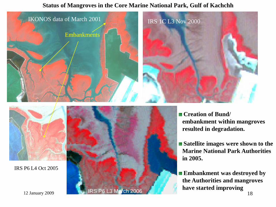
Status of Mangroves in the Core Marine National Park, Gulf of Kachchh
IRS 1C L3 Nov 2000IKONOS data of March 2001
Embankments
IRS P6 L3 March 2006
IRS P6 L4 Oct 2005
Creation of Bund/
embankment within mangroves
resulted in degradation.
Satellite images were shown to the
Marine National Park Authorities
in 2005.
Embankment was destroyed by
the Authorities and mangroves
have started improvingIRS P6 L3 March 2006

12 January 2009 Colloquium, Space Studies, UND 19
IRS 1C LISS III 1999
Clearing of mangroves
IRS P6 LISS III 2007
Aquaculture development
Degradation of Mangroves due to Reclamation for
Aquaculture Development
Coringa Mangroves Reserve Forest, Andhra Pradesh
Mangroves
Landsat MSS 1977
Mangroves beyond the Sanctuary boundary (in yellow) have been removed and
land reclaimed for aquaculture. The sequential images show mangroves in the
region, their clearing and subsequent aquaculture development.

12 January 2009 Colloquium, Space Studies, UND 20
Bhitarkanika
Porlob Jig, A&N Lothian, W.B
Jindra, GUK
Chorao, Goa

Marine Applications
OPERATIONAL
Fishery forecast (colour & SST)
Modelling of primary productivity (colour)
Spatial and temporal variability of chlorophyll
and SST AS (NOAA AVHRR & OCM)

12 January 2009 Colloquium, Space Studies, UND 22
Mean = 124 kg / hr
mean + SD = 84
Track DOF DOP Catch
No. (kg)
1 21 Oct 20 Oct 237(H)
2 21 Oct 20 Oct 236(H)
3 22 Oct 20 Oct 116
Track DOF Chlorophyll
No (mg/m3)
18 Oct 20 Oct
1 21 Oct 0.46 0.52
2 21 Oct 1.7 1.9
3 22 Oct 0.53 0.67
October 16, 2000 October 18, 2000
October 20, 2000 October 22, 2000
1
2
3
(Source : FSI)
FEED BACK PHASE I
(1999-2000)
FEED BACK PHASE III
(2000-2001)
Fishery Forecast
www.incois.gov

Snow and Glaciers
• Glacier inventory
• Mass balance (accumulation vs. ablation)
• Snow melt run-off (sites for power
generation)
• Moraine dammed –lakes
(inventory and associated hazard)
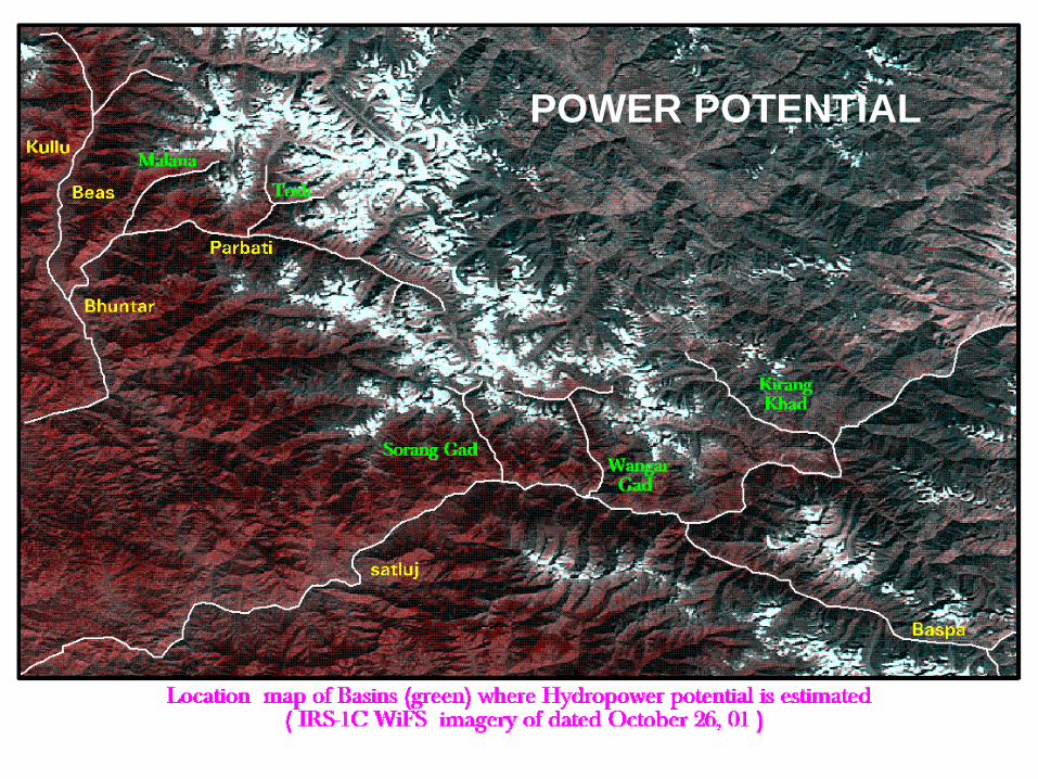
12 January 2009 Colloquium, Space Studies, UND 24
POWER POTENTIAL

12 January 2009 Colloquium, Space Studies, UND 25
Full view of Gangotri Glacier
IRS LISS-III SEP 2006
RETREAT OF GANGOTRI GLACIER
Snout
Shift in snout during 1962-2006
Gangotri Glacier
IRS LISS-III SEP 1999

12 January 2009 Colloquium, Space Studies, UND 26
Management
of
Disasters

12 January 2009 Colloquium, Space Studies, UND 27
LAND:
1. PRECURSORS TO EARTHQUAKE:
2. EXTREME RAINFALL EVENTS <FLASH FLOODS>
3. Forest Fire
4. FLOODS/ DROUGHT
5. Urban Environment: Carrying Capacity
OCEAN/ LAND INTERFACE:
5. CYCLONE TRACKING AND LAND FALL
6. COASTAL EROSION

12 January 2009 Colloquium, Space Studies, UND 28
Resolving R& D ISSUES
• Scientific knowledge available globally
but not adopted
• Knowledge upgradation and adoption
(new sensor evaluation, newer
concepts and modelling approaches)
12 January 2009 Colloquium, Space Studies, UND 29
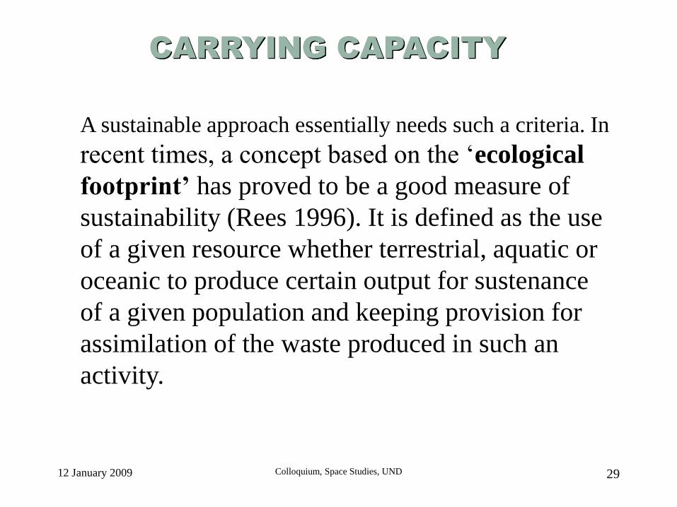
CARRYING CAPACITY
A sustainable approach essentially needs such a criteria. In
recent times, a concept based on the ‘ecological
footprint’ has proved to be a good measure of
sustainability (Rees 1996). It is defined as the use
of a given resource whether terrestrial, aquatic or
oceanic to produce certain output for sustenance
of a given population and keeping provision for
assimilation of the waste produced in such an
activity.

12 January 2009 Colloquium, Space Studies, UND 30

12 January 2009 Colloquium, Space Studies, UND 31
1967
1998
Loss of Carrying
Capacity:
*loss of open land
*choked drainage
A part of
Hyderabad city

12 January 2009 Colloquium, Space Studies, UND 32
OCEAN/ LAND (interface)
12 January 2009 Colloquium, Space Studies, UND 33
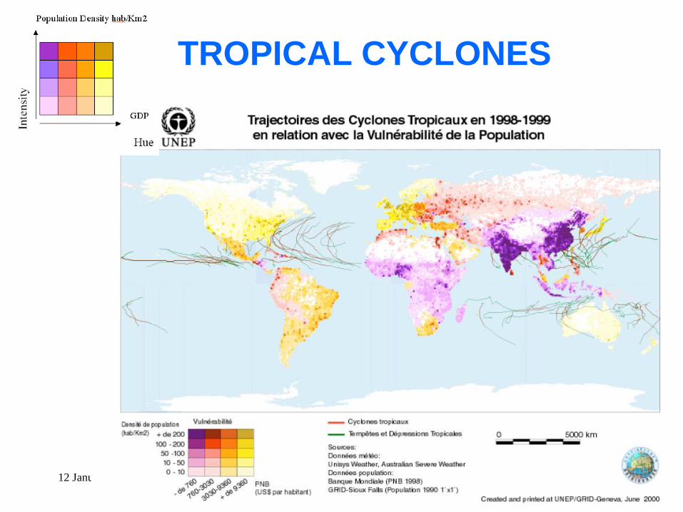
TROPICAL CYCLONES

12 January 2009 Colloquium, Space Studies, UND 34
Correct Geolocation
Correct Intensity Estimation
Correct Intensity Change Detection
Correct Track Change Detection
Key Issues in Tropical Cyclone Monitoring & Prediction
Courtesy: Dr CM Kishtwal, SAC, ISRO

12 January 2009 Colloquium, Space Studies, UND 35
Tracks of Winter Cyclones During Past 30 years

12 January 2009 Colloquium, Space Studies, UND 36
Tracks of Summer Cyclones During Past 30 years

12 January 2009 Colloquium, Space Studies, UND 37
Visible/IR Images
• 24-h Track prediction
using past positions of
TC
• Diurnal Variation of
TC intensity
Wind Scatterometer
• Method developed for
TC Center determination
with accuracy of aprox.
20 km.
Microwave Radiometer
• Method developed
automatic TC intensity
estimation with accuracy
of ~ 11 kt.
• Method developed for TC
intensity change in next
24 hours with accuracy of
~ 7 kt.
Tropical Cyclones


