Chapter 3Remote Sensing, Target Identification and Testing for Submerged Prehistoric Sites in Florida: Process and Protocol in Underwater CRM Projects
Michael K. Faught
M. K. Faught ()Panamerican Consultants, Inc., 703 Truett Dr.,32303 Tallahassee, Florida, USAe-mail: [email protected]
Introduction
At the time this chapter was written, only 3 states out of 22 in the USA with coast-lines, Maine, Maryland, and Florida, required background research, predictive mod-eling, and remote sensing surveys pertinent to locating and protecting submerged prehistoric sites1. The goal here is to provide examples from the state of Florida that demonstrate how these methods work, and to encourage administrators, resource managers, and other researchers to incorporate these protocols in future underwater work in order to protect submerged prehistoric sites.
Why focus on Cultural Resource Management (CRM) as a venue for practicing submerged prehistoric geoarchaeology? Because more and more of these kinds of projects are being required and more are going to be required in the future, because they are adequately funded, and because they demand appropriate technologies like side-scan sonar, sub-bottom seismic profiling, swath bathymetry remote sensing, and sometimes sediment sampling by various coring devices (Faught and Flemming 2008). It can be argued, in addition, that large industrial strength hydraulic dredging and sand resource mining equipment, which normally are considered destructive to archaeological resources, can be adapted to conduct controlled underwater expo-sures, by increasing the size, or depth of the potential sample areas, or both, thereby enabling development, managing resources, and learning more about the past.
As Senior Maritime Archaeologist at Panamerican Consultants, Inc., the author has been involved in several maritime CRM projects in Florida with foci on historic
1 The states with coastal margins include thirteen states and Florida along the eastern seaboard, four and Florida in the Gulf of Mexico, and four with Pacific Ocean coastlines. Pacific states rarely require any submerged resource evaluations, shipwreck or prehistoric, itself a cause for concern, but coastal states along the Atlantic seaboard and around the Gulf of Mexico do require remote sensing surveys for historic shipwrecks with some regularity.
and prehistoric resources, including both survey and testing phases. These projects, discussed and cited in the following sections, include private sector pipeline trench exposures, dredging for berthing facilities in Tampa Bay, and navigation widen-ing projects conducted for the US Army Corps of Engineers (USACE). These US-ACE projects have been in Tampa Bay, the St. Johns and Indian rivers, Naples and Sarasota bays, and in two offshore locations on the east and west coasts of the state. These projects have served as examples for revising and refining methods of searching for prehistoric sites. While the results are not spectacular, the projects have produced data used in developing protocols for identifying and testing sub-merged prehistoric “targets” that may be useful to others.
The Floridian peninsula—and its now-submerged continental shelf—has been occupied for as long as people have been in North America and it has produced more recorded submerged prehistoric sites, artifacts, and burials than any other state in the USA (Faught 1988, 2004; Flemming 1983; Clausen et al. 1975, 1979; Dunbar 1991; Goodyear and Warren 1972; Ruppe 1980; Stright 1990, 1995). Florida has also been at the forefront of legislation and management of submerged cultural re-sources for decades, first with shipwrecks, and now with requirements for research and protection specific to submerged prehistoric sites.
There are three primary aspects of the projects that demonstrate how concern for prehistoric sites can be incorporated in CRM projects. These are: (1) modeling for sites by the identification of relevant antecedent landforms, culture groups and sea-level history; (2) remote sensing using different kinds of underwater acoustic devices and identification target genres; and (3) coring, or dredging, and (4) geo-logic analysis of sediments to test for the presence or absence of evidence for hu-man activities.
Modeling for Sites: Cultural Histories, Local Geologic Details, Sea-Level Rise History
An excellent example of the method of compiling and synthesizing details of cul-ture history, geology, and sea-level rise in order to identify potential zones for prehistoric sites is Coastal Environment’s (1977) “Cultural Resources Evaluation of the Northern Gulf of Mexico Continental Shelf, Volume I: Prehistoric Cultural Resource Potential”2 (CEI 1977). This work showed that predictive models for pre-historic sites can be developed by summarizing local upland Pleistocene-Holocene archaeological data, local geologic information, and local sea-level rise history to reconstruct when and where different paleolandscapes would have been dry, and what local culture groups would have been in the project area at that time. This al-lows the researcher to model site locations, types of sites, and kinds of artifacts to be expected. This approach is qualitative, but statistical modeling is also possible where Geographic Information System (GIS) layers are available, such as archaeo-
2 See Pearson et al. this volume for more on this project.
393 Remote Sensing, Target Identification and Testing for Submerged …
logical site distributions, reconstructed drainage patterns, paleovegetation and pa-leofaunal distributions, and paleolandscape extents.
Other data sets also can be useful, such as geo-referenced historic maps (dis-cussed below) or the distributions of previously remotely sensed features of inter-est. Knowing the distributions of archaeological sites is best accomplished with regulatory agency-based data compilations such as state site file data in the USA. The Florida Master Site File (FMSF) has sophisticated GIS layered data, available to professionals and vetted researchers with more than 31,000 sites statewide that have been recorded and digitized. In Florida, these data include cultural affiliation, site type information (including multiple categories for submerged sites), and cita-tions to reports.
Georeferencing Historic Charts to Understand Past Coastline and Channel Configurations
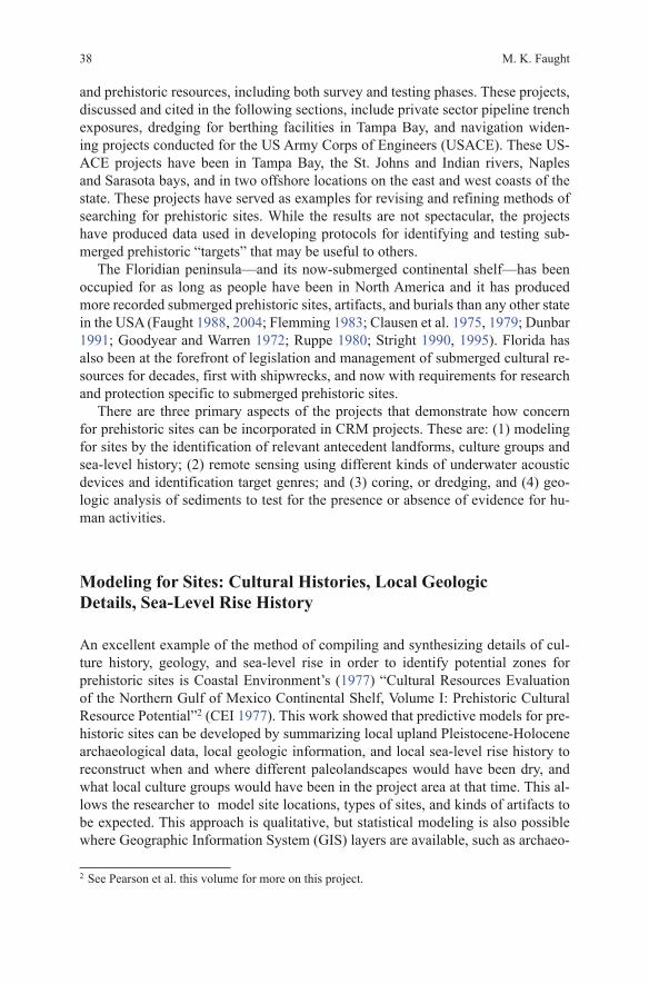
Georeferenced historic navigation charts are useful tools to reconstruct coastal and channel configurations that existed before modern impacts to bays and inlets. Many charts made in the nineteenth and early twentieth centuries can be georeferenced and used with precision in GIS analysis and in combination with remote sensing information. Two examples are presented here. Fig. 3.1 shows significant made-land cloaking the original bay bottom where dredging for new berths was planned in Hillsborough Bay (the northeast arm of Tampa Bay). The modern fill concealed a near-channel paleolandscape, likely the channel of the Paleo-Hillsborough River, which had the potential for prehistoric sites. The channel was identified with sub-bottom profiler and plotted on the historic map of the GIS project. Because of di-verse modern impacts to the bay and the restricted area of dredging, monitoring of dredge spoil was recommended in order to record any cultural materials dredged up from the original Bay bottom (Faught and James 2007). Based on chert artifacts, cut-marked bone, and a diagnostic Middle Archaic projectile point recovered dur-ing monitoring (Faught and Ambrosino 2007), the location was designated as a new “site” (8 HI 393, Port Sutton Dredge Site) in the Florida Master Site File (FMSF).
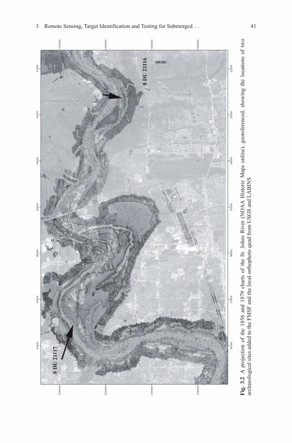
Figure 3.2 was made by georeferencing charts made from 1859 to 1879 and over-laying them on a modern orthophoto quad with Florida Master Site File (FMSF) sites indicated. The figure illustrates the complex morphology of the St. Johns River bottom, and revealed meander-like channel segments that had not been previously recognized by local geologists. Some of the paleochannel segments were confirmed with seismic remote sensing revealing diverse preserved strata (Faught and James 2011). The chronology of this record remains to be worked out.
Use of these maps is important because Middle and Late Archaic—that is, mid-dle and late Holocene prehistoric sites—are the most frequent kinds of submerged prehistoric sites identified in the USA, and they are found in shallower water situ-ations (less than 30 ft (10 m)), such as in bay and inlet settings as found in most coastal states (e.g., Blanton 1996). Submerged prehistoric sites known elsewhere in
M. K. Faught40
the world are dominated by similar middle and later Holocene examples in similar shallower water settings (Benjamin et al. 2011; Masters and Flemming 1983). Some submerged prehistoric sites could have been relatively recently submerged depend-ing on the local geology. In Louisiana, for instance, 2000-year-old Woodland period sites have been completely or partially drowned due to sediment loading and recent subsidence (Charles Pearson personal communication, Richard Weinstein personal communication).
Geoarchaeological Uses of Acoustic Data—Target Identification
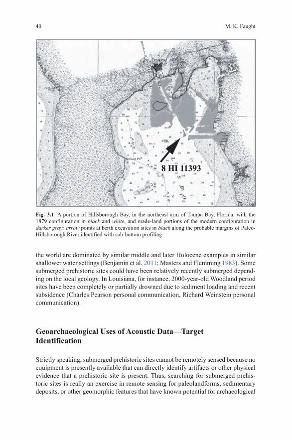
Strictly speaking, submerged prehistoric sites cannot be remotely sensed because no equipment is presently available that can directly identify artifacts or other physical evidence that a prehistoric site is present. Thus, searching for submerged prehis-toric sites is really an exercise in remote sensing for paleolandforms, sedimentary deposits, or other geomorphic features that have known potential for archaeological
Fig. 3.1 A portion of Hillsborough Bay, in the northeast arm of Tampa Bay, Florida, with the 1879 configuration in black and white, and made-land portions of the modern configuration in darker gray; arrow points at berth excavation sites in black along the probable margins of Paleo-Hillsborough River identified with sub-bottom profiling
3 Remote Sensing, Target Identification and Testing for Submerged … 41
Fig.
3.2
A p
roje
ctio
n of
the
185
6 an
d 18
79 c
harts
of
the
St. J
ohns
Riv
er (
NO
AA
His
toric
Map
s on
line)
, geo
refe
renc
ed, s
how
ing
the
loca
tions
of
two
arch
aeol
ogic
al si
tes a
dded
to th
e FM
SF a
nd th
e lo
cal o
rthop
hoto
qua
d fr
om U
SGS
and
LAB
INS
M. K. Faught42
site presence and preservation. The key to success is using local terrestrial archaeol-ogy to predict the location of submerged sites locally.
There are more and more examples of models using terrestrial analogs and re-constructions of bottom morphology and seismic data to identify site potentials (Benjamin 2010; Benjamin et al. 2011; Coleman and McBride 2008; O’Shea and Meadows 2009). Likewise, models of the presence and preservation of submerged coastal archaeological sites impacted by the sea-level transgression have been dis-cussed in several previous publications (Blanton 1996; Gagliano et al. 1982; Hoyt et al. 1990; Kraft 1986; Kraft and Chacko 1978; Kraft et al. 1983; Lewis 2000; Waters 1992).
Where paleolandscape areas are exposed or shallowly buried, side-scan sonar and multibeam bathymetry are useful tools to make what are known as “sound un-derwater images,” or acoustic images, for understanding antecedent landscape con-figurations, like paleochannel patterns, or exposed shell middens or rock outcrops, features that should produce high backscatter arrays (Faught 2002–2004; Fish and Carr 1991; Gusick and Faught 2011). However, most of the sea floor is covered by silt, mud, and sand sediments and only seismic remote sensing can penetrate these beds. Seismic remote sensing with sub-bottom profilers is most useful for identify-ing marine sediment cover, paleodrainage patterns, and buried features, like shell middens (Gusick and Faught 2011; Leach and Belknap 2007).
Seismic remote sensing is not a panacea, however. Seismic data are reflection coefficients, basically dark and light (higher and lower amplitude) reflections, due to changes of sediment characteristics. These characteristics can be due to beds of differential hardness, as well as to constituents like organic or fine-grained deposits that create highly reflective (dark) returns (Plets et al. 2007; Stevenson et al. 2002)3. Thus, the analytical challenge is distinguishing reflectors that have archaeologi-cal significance, i.e., subsurface layers that may contain archaeological material or indicate proximity to such. Because some littoral processes generate organic rich deposits, they can be identified in sediment profiles with sub-bottom profilers, and allow estimation of past coastline presence, and human behaviors nearby.
Inset terraces (horizontal surfaces) near paleochannel features and shell midden accumulations, especially those attaining substantial positive relief, are common target items or features in the predictive models in Florida presented here. Other terrestrial analogs also can be used, especially locally unique features (such as sink-holes, or tool-stone rock outcrops), but horizontal surfaces near drainages and shell midden deposits are the most easily identifiable features in Florida using remote sensing.
This “channel adjacency” model of prehistoric land use proved useful in the St. Johns River (Fig. 3.2) where a flat terrace-like surface adjacent to a vestige of a paleochannel feature at a depth of 10 m (30 ft, Fig. 3.3) was recommended for avoidance and later tested during diving operations with 4 in. air lift excavation
3 One caveat of remote sensing with subbottom profilers is that lower frequency devices are need-ed in sandy/shelly environments, whereas higher frequency devices can be used with finer grained and higher organic content deposits.
3 Remote Sensing, Target Identification and Testing for Submerged … 43
sampling. Point count analysis of the samples, described in more detail in the fol-lowing section, produced fossil bone, small debitage flakes, and a radiocarbon age on charcoal of 6010 ± 40 BP (Beta 285863). Sea-level reconstructions demonstrate the feature would have been exposed as dry land at that time. The find has been designated as a new site in the Florida Master Site File (8 DU 21117).
Shell middens may be the most likely, most frequent, and most accessible target in inundated settings in many places. Fig. 3.4 is a schematic of a midden in the process of being submerged (Gagliano et al. 1982, p. 4). Pioneer plants, shrubs, and eventually trees can grow on the raised feature after abandonment. These plant assemblages can also be the potential for identifying manuported plant species that may have grown on the feature after being brought in by humans. The theoretical benefit of these processes is that the hardness of the shells, and their interlocked
Fig. 3.4 Conceptual image of how a shell midden can become submerged as the sea levels rise (after Gagliano et al. 1982, p. 4). Root systems and the interlacing of disarticulated shells will tend to hold the archaeological deposits in place
Fig. 3.3 Left: bathymetric mesh reconstruction of the bottom morphology of the St. Johns River; right: a sub-bottom profile in the St. Johns River, horizontal lines at 10 ft intervals. Arrows point at Paleochannel margin where artifacts were located with radiocarbon age consistent with the depth
M. K. Faught44
matrix, and the root systems involved will hold the feature in place, and keep it relatively cohesive during transgression. Shell middens can have potential for large size, differential density, thickness, and relief for identification by remote sensing (Twitchell et al. 2010; Leach and Belknap 2007).
At 8 DU 21118 in the St. Johns River (Fig. 3.2), several “positive relief ” features were identified from the seismic data, one of which was confirmed as a probable midden feature after testing on the basis of dominant frequency and disarticulated character of the oyster shells ( Crassostrea), the presence of avian bone, and recon-struction of pre-inland waterway dredging configurations (Faught and James 2011). Leach and Belknap (2007) published on their comparison of a known culturally ac-cumulated shell midden and cores and seismic data taken from natural submerged bioherms and a possible submerged midden feature in another set of seismic data from Maine. However, not all positive relief features have turned out to be cultural, or even possibly cultural. In the St. Johns River, two positive relief features were domed outcrops of limestone bedrock (Faught and James 2011) and in Tampa Bay, one positive relief reflector proposed as a midden feature turned out to be a bed of fossil marine shell of probable Sangamon age (e.g., the last interglacial high stand of the sea level).
Fishing weirs, causeways, dugouts, or other prehistoric features are also poten-tial targets of interest but they are difficult to predict or identify with remote sens-ing. Connaway (2007) demonstrates that fish weirs are usually built in particular (predicable) settings in drainage ways that may be identified through predictive modeling. Other features can be locally specific targets. For example, several mid-Holocene cemeteries have been found in peat beds in ponds, and may also be pres-ent offshore Doran 2002.
Testing: Coring, Dredging, and Sediment Analysis
It is arguable that more work has gone into creating models for determining sub-merged archaeological site’s potential occurrence and preservation potentials than on actual in-field testing of submerged landforms by diving, coring, or dredging. On the other hand, the logistics and conditions for working underwater are significant, but not insurmountable, obstacles for advancement.
Coring has been used effectively to sample the sea floor bottom, because it probes sediments efficiently and effectively from the water surface, from boats, or underwater by divers (Gifford 1983; Leach and Belknap 2007; Pearson et al. 1986). In 1982 and 1986, archaeologists at Coastal Environments Inc., demonstrated the benefits of close order seismic remote sensing, followed by robust coring probes to sample targets identified as high probability landforms for the occurrence and preservation of prehistoric features. This research resulted in the identification of a probable shell midden of 8,000 BP age (Pearson et al. (this volume)). Another example of coring, conducted for offshore wind farm construction permits, in mas-sachusetts identified preserved soil horizons that could have been potential areas for
3 Remote Sensing, Target Identification and Testing for Submerged … 45
human occupation sites, but no direct evidence was acquired that indicated evidence for a site (Robinson and Brett 2006). Vibracores were used in Tampa Bay to inves-tigate sediment beds on the paleomargins of Pleistocene-aged Lake Edgar that were within a pipeline corridor. The northern paleo-lake margin was identified as highly probable for human occupation, and the pipeline trench was recommended for diver post excavation monitoring, described below.
Of benefit to the CRM consultant is the fact that many industrial projects in underwater settings use cores for engineering data about the substrate (texture, con-solidation, etc.), potentially amortizing the cost for samples with good planning. However, the submerged prehistoric geoarchaeologist will, more than likely, need more cores and control on their placement than are typically collected for engineer-ing purposes. Data descriptions collected for engineering, including data on con-tacts, color, texture, and hardness, are useful for the geoarchaeologist, assuming ad-ditional data are gathered to determine environments of deposition and chronology.
Cores, however, cannot be used in every situation, such as rocky substrates (Faught 2002–2004), and sites discovered by coring may need additional study or mitigation. Sampling strategies using various dredging options increase the amount of sediment that can be excavated and sampled, increasing the likelihood of site discovery.
Panamerican Consultants, Inc., a US-based archaeology consulting firm, has conducted several “testing phase” operations using different sampling strategies—some in lieu of coring—that were organized to probe and sample submerged prehis-toric “targets.” These projects include diver-controlled induction dredge and airlift excavations in Tampa Bay (Faught and James 2010), the St. Johns River (Faught and James 2011), and the Indian River (James et al. 2010).
Diver-controlled hydraulic and airlift dredges can be very effective in mov-ing sediments underwater. In general, hydraulic dredges (i.e., induction or water dredges) are effective in shallow water (less than 20 ft), but airlift dredges less so (Faught 2002–2004; Latvis and Quitmeyer 2006). Both kinds of dredges work in deeper water, but the airlift can be more powerful and easier to manipulate at deeper depths. Dredge sizes range from 7.62 to 15.24 cm (3–6 in.) diameter hoses, with 10.16 cm (4 in.) dredges being the most common; anything larger is difficult for a diver to handle safely4.
Both kinds of dredges have the potential to expose and screen large amounts of sediment in relatively quick time once on site. Diver-assisted dredge excavations can be analogous to shovel test probe, test pit, or trenching approaches on land. Loose deposits, particularly sand beds, limit the size and depth of any exposure, because the sides tend to slump faster than can be removed after sitting open for a period of time, such as overnight. In those cases, coffer structures are necessary for deeper excavations.
4 Industry diving is regulated by the Occupational Safety and Health Administration (OSHA), and the US Army Corps of Engineers (USACE) diving is particularly stringent. For the Academic or agency diver, AAUS is adequate standard. Appropriate regulations must be followed in each case.
M. K. Faught46
In addition to diver-controlled dredging in CRM projects, Panamerican has rec-ommended and conducted two projects that monitored industrial scale exposures into Tampa Bay. The first project monitored the effluent from an 18 in. swinging ladder dredge for the construction of additional berthing area in Tampa Bay (Faught and Ambrosino 2007). The 18 in. “swinging ladder” dredge operations were con-ducted by sampling at the effluent site “boil” (the location of the dredge area is shown in Fig. 3.1). Provenience was controlled by DGPS location and depth of the dredge head kept in digital logs by the dredgers plus the estimated time in the dredge pipe. Time of discovery was recorded for items of interest, and dredge head location could thus be calculated. Monitoring included backhoe scoops of spoil and inspection of residual after work stoppages. This particular experience was some-what effective; a diagnostic Middle Archaic (middle Holocene age) projectile point, other chipped stone, and bone indicated a site (designated in the FMSF as 8 HI 11393), but construction of a sluice or other, more controlled screening apparatus was recommended for similar projects in the future.
The second project included inspecting a trench for a gas pipeline dug by clam bucket dredge devices. Archaeological divers inspected a trench dug by clam bucket over a particular 500 m, high probability portion of Tampa Bay that was 15 ft wide, 6 ft deep, as well as the associated spoil piles from the bucket drops. The trench was excavated into fine sandy sediments that slumped to their angle of repose after exposure, concealing stratigraphic details. Divers swam the exposure seeking strati-graphic information, and possible exposed sites in situ, with limited effectiveness. Archaeological excavation of high probability sections of trenches for Industry was recommended for similar projects in the future.
Site Preservation Potentials and Signatures: How to Know That You Have a Site After You Have Been Digging Around and Have Seemingly Meaningless Samples?
In the Big Bend of Florida, artifact arrays representing submerged prehistoric sites remain cohesive but reworked after the sea-level rise and submergence (Faught 2002–2004). This was also noted at the Cato and Douglas Beach sites on the west coast of Florida (Bullen et al. 1968; Murphy 1990). In fact, virtually all known examples of submerged prehistoric sites are partially or wholly reworked by the process of the sea-level transgression and sediment reworking in ways analogous to terrestrial site deflation and matrix replacement (Masters and Flemming 1983; Fischer 1995; Benjamin et al. 2011). Submerged site “deflation” results from flu-idization and removal of sediment matrix at times of inundation, leaving “lags” of larger clasts (particles), such as chipped stone artifacts or shell.
Even though sites can remain cohesive, and discovery of artifact arrays certainly indicate places where people used to be, culturally derived deposits are not always apparent from core samples, or to the diver, or at first glance of the collected sam-ples after screening and bagging dredged deposits in the field. Artifacts are certainly
3 Remote Sensing, Target Identification and Testing for Submerged … 47
important, but artifacts are rarely encountered when sampling some sites, as Ga-gliano et al. determined systematically (1982, p. 2). They noted then:
In instances where submerged landforms likely to contain evidence of human occupation have been identified, some surveys have included … small-diameter gravity cores. The retrieved core samples have been studied in the laboratory by archaeologists to determine if any indications of human activity are present. This has proved to be a challenging and, with few exceptions, an unrewarding exercise, primarily because there is presently little framework of reference with which to compare the core data.
This remains true even today. Little research has been done to identify the sedimen-tary signatures of the deposits that make up submerged archaeological sites (“an-thropomorphic” sediments or soils). Gagliano et al.’s (1982) “Sedimentary Stud-ies of Prehistoric Archaeological Sites: Criteria for the identification of submerged archaeological Sites of the Northern Gulf of Mexico Continental Shelf” is a rare exception and of high value, but it has limited distribution for those investigating submerged prehistoric sites.
Gagliano et al. chose 15 terrestrial sites in Louisiana and Texas that occur on eight identifiable and mapable landforms to study in detail. Their landforms in-cluded a major natural levee, a minor natural levee, chenier and accretion ridges, a barrier Island, salt dome margins, estuarine margins, Pleistocene terrace on a chan-nel margin, and sites by lake margins. They sampled sediments by test excavations at known sites and box core sampling of sediment profiles; recording color, bed-ding, and contact descriptions. Analytically, they sorted the sediments to particle size; they conducted point counts5 and grain size analysis, multiple geochemical analyses, and radiocarbon dating. They demonstrated that sites were recognized by increased diversity of constituents, including high frequencies of bone, charred wood, and shell. Some micro fragments of ceramic and lithic artifacts were identi-fied, but they were rare.
Shell midden deposits in Florida are notorious for having very few artifacts. Therefore characteristics of shell midden sites that might act as criteria for “declara-tion” of a site are needed, and these include such evidence as disarticulated speci-mens of mollusk species that dominate the collection of (most often Crassostrea in Florida, but also Donax, and Mercenaria) faunal bone, specifically shark and alligator teeth in the Indian River project area, charcoal, and manuports (i.e., nonar-tifactual items out of place) (Faught and James 2011).
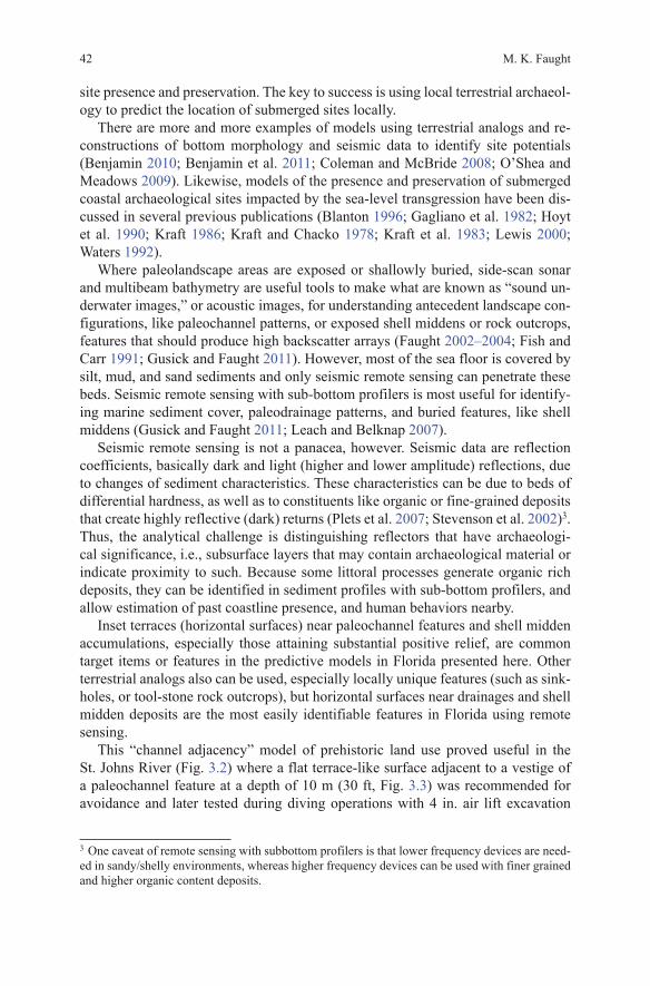
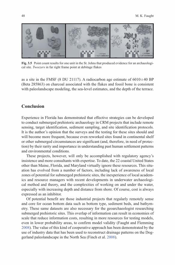
By close examination of sediment samples, known as “point counting,” first sorting size categories and then sorting out and identifying the particle types in each size category (Fig. 3.5), Panamerican has declared two remotely sensed tar-gets as archaeological sites, and has cleared other targets as not being sites. In the example described earlier, in the St. Johns River (Figs. 3.2 and 3.3) a 30 ft deep terrace feature adjacent to a paleochannel vestige produced evidence for a probable occupation area in the form of small chert flakes, fossil bone, and diversity of other particle types (Fig. 3.5; Faught and James 2011). The feature has been designated
5 “Point counting” is the sorting of sediment matrices into particles of constituent groups, and recording and graphing frequency distributions of them for comparison and description.
M. K. Faught48
as a site in the FMSF (8 DU 21117). A radiocarbon age estimate of 6010 ± 40 BP (Beta 285863) on charcoal associated with the flakes and fossil bone is consistent with paleolandscape modeling, the sea-level estimates, and the depth of the terrace.
Conclusion
Experience in Florida has demonstrated that effective strategies can be developed to conduct submerged prehistoric archaeology in CRM projects that include remote sensing, target identification, sediment sampling, and site identification protocols. It is the author’s opinion that the surveys and the testing for these sites should and will become more frequent, because even reworked sites found in continental shelf or other submerged circumstances are significant (and, therefore, in need of protec-tion) by their rarity and importance in understanding past human settlement patterns and environmental conditions.
These projects, however, will only be accomplished with regulatory agency’s insistence and more consultants with expertise. To date, the 22 coastal United States other than Maine, Florida, and Maryland virtually ignore these resources. This situ-ation has evolved from a number of factors, including lack of awareness of local zones of potential for submerged prehistoric sites, the inexperience of local academ-ics and resource managers with recent developments in underwater archaeologi-cal method and theory, and the complexities of working on and under the water, especially with increasing depth and distance from shore. Of course, cost is always expressed as an inhibitor.
Of potential benefit are those industrial projects that regularly remotely sense and core for ocean bottom data such as bottom type, sediment beds, and bathym-etry. These same datasets are also necessary for the geoarchaeologist researching submerged prehistoric sites. This overlap of information can result in economies of scale that reduce information costs, resulting in more resources for testing models, even in lower probability areas, to confirm model validity (Faught and Flemming 2008). The value of this kind of cooperative approach has been demonstrated by the use of industry data that has been used to reconstruct drainage patterns on the Dog-gerland paleolandscape in the North Sea (Finch et al. 2008).
Fig. 3.5 Point count results for one unit in the St. Johns that produced evidence for an archaeologi-cal site. Tweezers in far right frame point at debitage flakes
3 Remote Sensing, Target Identification and Testing for Submerged … 49
In fact, identification of high probability landforms is the easy part of submerged prehistoric sites’ archaeology; sampling is the hard part. There is a real need to ex-cavate, rather than just avoid high probability places in order to test the accuracy of the models. Coring is a useful strategy, especially with intensive pattern and with geoarchaeological analyses, but controlled dredging allows for much more sedi-ment sampling with a goal to approximate sampling coverage as if the project were terrestrial.
It is argued here that dredge monitoring with effluent screening is a viable meth-od of resource management, given the difficulties of this kind of archaeology and the restricted impacts of many projects. To go even further, it is suggested that today’s industrial strength dredges are eminently adaptable to underwater archaeo-logical excavations because of modern and precise DGPS positioning and dredge digging head depth control. Coupled with screening facilities of appropriate nesting sizes for local conditions, trenching or sediment removal projects become geoar-chaeological sampling units, analogous to trenching with backhoes in terrestrial archaeological projects. Whether this kind of sampling happens in CRM projects, or a funded research operation, remains to be seen, but it is not outrageous to suggest that continued discoveries will result from CRM-based projects because, as noted in the introduction, those projects are required and funded.
References
Benjamin, J. (2010). Submerged prehistoric landscapes and underwater site discovery: Reevaluat-ing the ‘Danish Model’ for international practice. Journal of Island and Coastal Archaeology, 5(2), 253–270.
Benjamin, J., Bonsall, C., Pickard, C., & Fischer, A. (Eds.). (2011). Submerged prehistory in the Americas. Submerged prehistory. Oxford: Oxbow.
Blanton, D. (1996). Accounting for submerged mid-holocene archaeological sites in the southeast: A case study for the Chesapeake Bay Estuary, Virginia. In K. E. Sassaman & D. G. Ander-son (Eds.), Archaeology of the Mid-Holocene Southeast (pp. 200–217). Gainsville: University Press of Florida.
Bullen, R. P., Bullen, A. K., & Clausen, C. J. (1968). The Cato Site near Sebastian Inlet, Florida. The Florida Anthropologist, 21(1), 14–16.
Coastal Environments Inc. (1977). Cultural resources evaluation of the northern Gulf of Mexico Continental shelf, Volume I: Prehistoric cultural resource potential, Volume II: Historical cul-tural resources, and Volume III: Maps. A final report for the U.S. Department of the Interior, National Park Service, Office of Archeology and Historic Preservation. NTIS No. PB276773/AS. Contract No. 08550-MU5-40.
Clausen, C. J., Brooks, H. K., & Wesolowsky, A. B. (1975). The early man site at warm Mineral Springs, Florida. Journal of Field Archaeology, 2(3), 191–213.
Clausen, C. J., Cohen, A. D., Emiliani, C., Holman, J. A., & Stipp, J. J. (1979). Little salt spring, Florida: A unique underwater site. Science, 203(4381), 609–614.
Coleman, D. F., & McBride, K. (2008). Underwater prehistoric archaeological potential on the southern New England continental shelf off block island 200. In R. D. Ballard (Ed.), Archaeo-logical oceanography (pp. 200–223). Princeton: Princeton University Press.
Connaway, J. M. (2007). Fish weirs: A world perspective with emphasis on the fish weirs of Mis-sissippi. Jackson: Mississippi Department of Archives and History Archaeological Report No. 33, Jackson.
M. K. Faught50
Doran, H. G. (2002). Windover: Multidisciplinary investigations of an early archaic florida cem-etery. University Press of Florida, Gainesville.
Dunbar, J. S. (1991). Resource orientation of Clovis and Suwannee Age paleoindian sites in Flori-da. In R. Bonnichsen & K. L. Turnmire (Eds.), Clovis: Origins and adaptations (pp. 185–214). College Station: Centre for the Study of the First Americans.
Faught, M. K. (1988). Inundated sites in the Apalachee Bay area of the eastern Gulf of Mexico. Florida Anthropologist, 41(1), 185–190.
Faught, M. K. (2002–2004). Submerged Paleoindian and archaic sites of the Big Bend, Florida. Journal of Field Archaeology, 29(3–4), 273–290.
Faught, M. K. (2004). The underwater archaeology of paleolandscapes, Apalachee Bay, Florida. American Antiquity, 69(2), 235–249.
Faught, M. K., & Ambrosino, J. N. (2007). Archaeological monitoring for Berth 218 Dredging, Port Sutton, Hillsborough County, Florida. Prepared for the Tampa Bay Port Authority, FMSF Survey # 14748.
Faught, M. K., & Flemming, N. (2008). Submerged prehistoric sites: ‘Needles in Haystacks’ for CRMs and industry. Sea Technology, 49(10), 37–38, 40–42.
Faught, M. K., & James, S. R. (2007). Intensive remote sensing survey for a proposed Berth Dredging project at Port Sutton, Tampa Bay, Hillsborough County, Florida. For CH2MHILL, Tampa, Florida, FMSF Survey # 13688.
Faught, M. K., & James, S. R. (2011). Diver identification and archaeological testing: Adden-dum to cultural resources remote sensing survey of Jacksonville Harbor project GRR2, Duvall County, Florida. Prepared for US Army Corps of Engineers, Jacksonville District, by Pana-merican Consultants, FMSF Survey # 18474.
Faught, M. K., & James, S. R., Jr. (2010). Diver identification and archaeological testing of ten geomorphic targets in cuts A and B in Tampa Bay and data collection from four Vibracores from Tampa Bay, Hillsborough County, Florida. Prepared for the US Army Corps of Engineers, Jacksonville District and under contract to G.E.C., Inc., Baton Rouge, Louisiana by Panameri-can Consultants, Inc., Memphis, Tennessee.
Faught, M. K., & James, S. R., Jr. (2011). Diver identification and archaeological testing: Ad-dendum to cultural resources remote sensing survey of Jacksonville Harbor project GRR2, Duvall County, Florida. Prepared for the US Army Corps of Engineers, Jacksonville District and under contract to G.E.C., Inc., Baton Rouge, Louisiana by Panamerican Consultants, Inc., Memphis, Tennessee.
Finch, S., Gaffney, V., & Thomson, K. (2008). Mapping Doggerland: The Mesolithic landscapes of the southern North Sea. Archaeopress.
Fischer, A. (1995). Man and sea in the Mesolithic: Coastal settlement above and below present sea level. Oxford: Oxbow.
Fish, J. P., & Carr, H. A. (1991). Sound underwater images: A guide to the generation and inter-pretation of side scan sonar data. Orleans: Lower Cape Publishing Company.
Flemming, N. C. (1983). Survival of submerged Lithic and Bronze Age artifact sites: A review of case histories. In P. M. Masters & N. C. Flemming (Eds.), Quaternary coastlines (pp. 135–173). New York: Academic Press.
Gagliano, S. M., Pearson, C. E., Weinstein, R. A., Wiseman, D. E., & McClendon, C. M. (1982). Sedimentary studies of prehistoric archaeological sites: Criteria for the identification of sub-merged archaeological sites of the northern Gulf of Mexico continental shelf. Prepared for the U.S. Department of the Interior National Park Service, Division of State Plans and Grants, Contract No. C35003(79).
Gifford, J. (1983). Core sampling of a holocene marine sedimentary sequence and underlying neolithic cultural material off Franchthi Cave, Greece. In P. M. Masters and N. C. Flemming (Eds.), Quaternary coastlines and marine archaeology, (pp. 269–281). New York: Academic Press.
Goodyear, A. C., & Warren, L. O. (1972). Further observations on the submarine oyster shell de-posits of Tampa Bay. Florida Anthropologist, 25(2.1), 52–66.
3 Remote Sensing, Target Identification and Testing for Submerged … 51
Gusick, A. E., & Faught, M. K. (2011). Prehistoric archaeology underwater: A nascent subdisci-pline critical to understanding early coastal occupations and migration routes. In N. Bicho, J. Haws, & J. Davis (Eds.), Trekking the shore: Changing coastlines and the antiquity of coastal settlement, interdisciplinary contributions to archaeology (pp. 27–50). New York: Springer.
Hoyt, W. H., Kraft, J. C., & Chrzastowski, M. J. (1990). Prospecting for submerged archaeological sites on the continental shelf; Southern Mid-Atlantic Bight of North America. In N. P. Lasca & J. Donahue (Eds.), Archaeological geology of North America (pp. 147–160). Boulder: Geo-logical Society of America.
James, S. R., Jr., Faught, M. K., & Ambrosino, J. (2010). Historic assessment, remote sensing sur-vey, and diver identification of five potentially significant magnetic and six geomorphic targets of the intracoastal waterway, Indian River County, Florida. Prepared for the U.S. Army Corps of Engineers, Jacksonville District and under contract to G.E.C., Inc., Baton Rouge, Louisiana by Panamerican Consultants, Inc., Memphis, Tennessee. FMSF Survey # 17297.
Kraft, J. C. (1986). Marine environments: Paleogeographic reconstructions in the littoral region. In J. Stein & W. Farrand (Eds.), Archaeological sediments in context (pp. 111–125). Orono: Center for the Study of Early Man.
Kraft, J. C., & Chacko, J. J. (1978). Paleogeographic analysis of coastal archaeological settings in Delaware. Archaeology of Eastern North America, 6, 41–60.
Kraft, J. C., Belknap, D. F., & Kayan, I. (1983). Potential of the discovery of human occupation sties on the continental shelves and nearshore coastal zone. In P. M. Master & N. C. Flemming (Eds.), Quaternary coastlines and marine archaeology (pp. 87–120). New York: Academic Press.
Latvis, J. M., & Quitmyer, I. C. (2006). Underwater excavation methods. In D. S. Webb (Ed.), First floiridians and last mastodons: The Page-Ladson site in the Aucilla River (pp. 1–30). New York: Springer.
Lewis, R. B. (2000). Sea-level rise and subsidence effects on gulf coast archaeological site distri-butions. American Antiquity, 65(3), 525–541.
Leach, P. A., & Belknap, D. F. (2007). Marine geophysics and vibracoring applied to refining the search for submerged prehistory in Damariscotta River, Maine, USA. In L. Wilson, P. Dick-enson, & J. Jeandron (Eds.), Reconstructing human-landscape interactions: Proceedings of the developing international geoarchaeology conference, St. John, New Brunswick, Canada, October 2005 (pp. 21–23). Newcastle: Cambridge Scholar’s Press.
Masters, P. M., & Flemming, N. (1983). Quaternary coastlines. New York: Academic Press.Murphy, L. E. (1990). 8SL17: Natural site formation processes of a multiple component underwa-
ter site in Florida. Santa Fe: Submerged Cultural Resources Unit.O’Shea, J. M., & Meadows, G. A. (2009). Evidence for early hunters beneath the Great Lakes.
Proceedings of the National Academy of Sciences, 106(25), 10120–10123.Pearson, C. E., Kelley, D. B., Weinstein, R. A., & Gagliano, S. M. (1986). Archaeological inves-
tigations on the outer continental shelf: A study within the Sabine River Valley, Offshore Loui-siana and Texas. Prepared for the U.S. Department of the Interior, Minerals Management Ser-vice, Reston, Va. (Contract # 14-12-0001-30072). Coastal Environments, Inc., Baton Rouge, LA.
Plets, R., Dix, J., Bastos, A., & Best, A. (2007). Characterization of buried inundated peat on seismic (Chirp) data, inferred from core information. Archaeological Prospection, 14(4), 1–12.
Robinson, D., & Brett, W. (2006). Phase IA/B cultural resources survey keyspan energy offshore wind farm to Sterling Substation Transmission Cable Project. Report Submitted by PAL, Paw-tucket, Rhode Island for EEA, Inc.
Ruppe, R. J. (1980). The archaeology of drowned terrestrial sites: A preliminary report. Talahasee: Bureau of Historic Sites and Properties.
Stevenson, I. R., McCann, C., & Runciman, P. B. (2002). An attenuation-based sediment classifi-cation technique using chirp sub-bottom profiler data and laboratory acoustic analysis. Marine Geophysical Research, 23(4), 277–298.
Stright, M. J. (1990). Archaeological sites on the North American continental shelf. Geological Society of America Centennial Special, 4, 439–465.
M. K. Faught52
Stright, M. J. (1995). Archaic period sites on the continental shelf of North America: The effects of relative sea-level changes on archaeological site locations and preservation. In E. A. III Bettis (Ed.), Archaeological Geology of the Archaic Period in North America: Geological Society of America. (pp. 131–147). Boulder: Geological Society of America.
Twichell, D., Edmiston, L., Andrews, B., Stevenson, W., Donoghue, J., Poore, R., & Osterman, L. (2010). Geologic controls on the recent evolution of oyster reefs in Apalachicola Bay and St. George Sound, Florida. Estuarine, Coastal and Shelf Science, 88(3), 385–394.
Waters, M. R. (1992). Principles of geoarchaeology. Tucson: University of Arizona Press.