35
REPORT CAMBRIDGE WEST LANDS CITY OF CAMBRIDGE
| Date post: | 15-Apr-2018 |
| Category: |
Documents |
| Upload: | vuongquynh |
| View: | 216 times |
| Download: | 1 times |

REPORT
CAMBRIDGE WEST LANDS CITY OF CAMBRIDGE

2
Cambridge West Collector Road EA – Preliminary Evaluation Report October, 2015
1.0 INTRODUCTION ........................................................................................................................................................................................... 4
1.1 Purpose of the Project ...................................................................................................................................................................... 4
1.2 Background and Context ................................................................................................................................................................ 4
1.3 Problem and Opportunity Statement ..................................................................................................................................... 6
1.4 Purpose of this Preliminary Assessment Report................................................................................................................ 6
2.0 STUDY APPROACH .................................................................................................................................................................................... 8
2.1 Class Environmental Assessment Integrated Approach .............................................................................................. 8
2.1.1 Project Classification ........................................................................................................................................................................... 9
3.0 ASSESSMENT OF ALIGNMENT ALTERNATIVES ...................................................................................................................... 15
3.1 Study Area ............................................................................................................................................................................................. 15
3.2 Collector Road Alignment Alternatives ............................................................................................................................... 15
3.3 The “Do Nothing” Alternative .................................................................................................................................................... 16
3.4 Evaluation Criteria and Related Scoring Methodology ............................................................................................. 17
3.5 Collector Road Evaluation............................................................................................................................................................ 22
3.5.1 Blenheim Road Alignments ......................................................................................................................................................... 23
3.5.2 Bismark Road Alignments ............................................................................................................................................................. 25
3.5.3 Newman Drive Alignments ......................................................................................................................................................... 26
3.6 Devils Creek Crossing Design Alternatives Evaluation ............................................................................................... 28
4.0 CONCLUSIONS .......................................................................................................................................................................................... 31

3
Cambridge West Collector Road EA – Preliminary Evaluation Report October, 2015
List of Tables
Table 1.0 Cambridge West Master Environmental Servicing Plan Projects
Table 2.0 Alignment Alternatives Evaluation Criteria
Table 3.0 Evaluation Score for Each Collector Road Alternative
Table 4.0 Evaluation Score for Each Devils Creek Crossing Design Option
List of Figures
Figure 1 Cambridge West Master Environmental Servicing Plan (Figure 12 of MESP)
Figure 2 Environmental Assessment Integrated Approach
Figure 3 Municipal Class Environmental Assessment Process
Figure 4 Study Area
Figure 5 Road Alignment Options
Figure 6 Preliminary Preferred Collector Road Alternatives
Appendices
Appendix A Evaluation Criteria Matrix - Cambridge West Collector Road Alignment Alternatives
Appendix B Evaluation Criteria Matrix - Devil’s Creek Crossing Alternatives
Appendix C Technical Memos for Factor Category 1: Natural Environment
Appendix D Technical Memos for Factor Category 2: Socio-Cultural Environment
Appendix E Technical Memos for Factor Category 3: Transportation/Municipal Services and
Utilities
Appendix F Technical Memos for Factor Category 4: Financial
Appendix G Technical Memos for Factor Category 5: Technical
Appendix H Additional Technical Memos related to Devil’s creek Crossing Design Alternatives
4
Cambridge West Collector Road EA – Preliminary Evaluation Report October, 2015
1.0 INTRODUCTION
1.1 Purpose of the Project
Municipal road projects in Ontario are subject to Ontario’s Environmental Assessment Act (EA
Act). The Municipal Engineers Association’s Municipal Class Environmental Assessment (Municipal
Class EA) process for planning, design and construction of municipal infrastructure was
developed in accordance with the EA Act and is described in more detail in Section 2.1 of this
document. The purpose of this study is to determine the preferred precise alignment of the
collector roads and the associated infrastructure within the Cambridge West lands through an
integrated Planning Act and Municipal Class EA process. The need for the collector roads was
previously established through the Cambridge West Master Servicing Plan (MESP) which was
carried out through a separate EA process. In addition to establishing the need for the collector
road system, the MESP recommended the re-alignment of Blenheim Road to improve current
conditions, including the safety at the CPR crossing.
1.2 Background and Context
The Cambridge West Master Environmental Servicing Plan (MESP) was approved by the City of
Cambridge in March 2014. The purpose of the MESP is to guide the development of the
remaining designated greenfield lands on the west side of the City of Cambridge. The Cambridge
West MESP integrates environmental, servicing, transportation and land use planning
components and is based on technical studies that include a natural heritage study; a
hydrogeological study; a transportation network study; and servicing studies (stormwater, sanitary
sewer, and water). The MESP provides a basis for and direction to a Community Plan for the area
and future development applications (such as draft plans of subdivision). The MESP was also
carried out in conformity with the Class Environmental Assessment (EA) process and satisfies
Phase 1 and Phase 2 requirements of the EA process. In April 2014, three Part II Order requests
were received by the Ministry of Environment and Climate Change asking that individual
5
Cambridge West Collector Road EA – Preliminary Evaluation Report October, 2015
assessments be required for three of the approved projects. On October 2, the Minister’s decision
was released which stated that individual assessments were not required.
As part of the MESP, a preferred collector road network was determined and is shown
conceptually on Figure 1 (Figure 12 of the MESP). The collector road network shown in the MESP
is based on the findings of the Transportation Network Assessment Constraints and Opportunities
study completed as part of the MESP as well as consideration of the Natural Heritage Study and
other MESP components.
The Transportation Network Assessment concluded that the estimated traffic volumes that would
originate from future residential development of the lands would require a minimum of three
connections to the existing road network. Seven potential connection points were identified and
examined. A comprehensive set of evaluation criteria were developed to evaluate the collector
road options. These criteria support and follow the requirements of the Municipal Class
Environmental Assessment Process. The evaluation of the options is summarized in the MESP
document. The MESP concluded that the best connection points to the existing road network are
at Newman Drive, Bismark Drive and Blenheim Road. The MESP also recommended the re-
alignment of Blenheim Road in order to improve traffic distribution in the study area, improve
safety at the CPR crossing and provide the opportunity to improve the ecological linkage at the
crossing of Devil’s Creek and where Blenheim Road crosses between Barrie’s Lake and the
wetland complex to the north.
The MESP identified that precise alignment of the collector roads is to be determined through the
completion of the Class Environmental Assessment (EA) process. The conclusion of the
Environmental Assessment and the determination of the preferred precise alignment of the
collector roads within Cambridge West lands will occur through the approval of an Official Plan
Amendment as well as completion of phases 3 to 5 of the EA. Final road design at the level of
detail for construction (i.e. Phase 5) would be completed as part of the draft plan of subdivision.

6
Cambridge West Collector Road EA – Preliminary Evaluation Report October, 2015
Devils Creek Crossing
The MESP recommended that a new crossing structure of Devil’s Creek be developed as part of
the realignment of Blenheim Road. The Natural Environment Study, that was completed as part of
the MESP, recommended improvement to the environmental linkages along the Devil’s Creek
corridor could be improved through a redesigned crossing structure that would include provision
for a wildlife movement, including large mammals. The design and implementation of the
crossing structure is not subject to the Environmental Assessment Act. However, the evaluation of
the design alternatives has been completed as part of this project. The alternatives have been
assessed using the same methodology and similar criteria to the collector road evaluation. The
preliminary preferred crossing structure is included in the recommendations of this report.
1.3 Problem and Opportunity Statement
Based on the conclusions and recommendations of the Cambridge West MESP the following
Problem and Opportunity Statement was developed for the completion of the Cambridge West
Collector Road Environmental Assessment:
• To determine the precise alignment of the collector roads and associated infrastructure
within the Cambridge West lands including the extension of Newman Drive from its
current terminus to the extension of Bismark Drive, the extension of Bismark Drive from its
current terminus to the re-aligned Blenheim Road and the precise realignment of
Blenheim Road within the Blenheim Road study area;
• To determine the preferred intersection design(s);
• To determine the preferred type of crossing at Devil’s Creek;
• To determine any recommended mitigative measures.
1.4 Purpose of this Preliminary Assessment Report
This report documents the planning process conducted in accordance with the Municipal Class
EA and Planning Act for the Cambridge West Collector Roads Alignment hereafter referred to as
the “project”. The purpose of the report is to describe the collector road alignment alternatives

CAMBRIDGE WEST
MASTER ENVIRONMENTAL
SERVICING PLAN
K:\0800A-CAMBRIDGE WEST COMMUNITY\RPT\SEPTEMBER30 2013 FIGURES\CONCEPTUAL SERVICING PLAN.DWG
Scale 1:7,500
0
metres
100 35020050
Figure 12
Sources:
Air Photo - City of Cambridge, 2012
Study Area - City of Cambridge
Legend
Proposed Collector Road
Open Space
Wetland
Development Study Area
Stormwater Management
Proposed Sanitary Trunk Sewer
Proposed Storm Sewer
Existing Sanitary Trunk Sewer
Existing Water Main
Proposed Water Main
Existing Storm Sewer

7
Cambridge West Collector Road EA – Preliminary Evaluation Report October, 2015
and Devil’s Creek crossing design options, the evaluation method and the preliminary preferred
alternatives for the collector roads and the Devils Creek crossing. The information in this report is
to be made available to the community for review and comment. The information from the
public review will then be considered in the determination of a recommended final collector road
alignment.

8
Cambridge West Collector Road EA – Preliminary Evaluation Report October, 2015
2.0 STUDY APPROACH
2.1 Class Environmental Assessment Integrated Approach
This study is being conducted in accordance with the Municipal Engineers Association Municipal
Class Environmental Assessment (October 2000, as amended in 2007 and 2011) (Municipal Class
EA). The Municipal Class EA process was developed in accordance with the EA Act for a “class” of
projects, including municipal road, water, wastewater and transit projects, that are recurring,
similar in nature, limited in scale, responsive to mitigation measures, and have a predictable range
of environmental effects. The purpose of the Municipal Class EA is to provide for the protection,
conservation, and wise management of the “environment”, which includes the natural, social,
cultural, built and economic environment.
The Municipal Class EA recognizes the desirability of coordinating or integrating the planning
processes and approvals under the EA Act and the Planning Act as long as the intent and
requirements of both Acts are met. An “Integrated” Planning Act/Class EA has specific process
requirements:
• Must fulfill the requirements outlined in the Municipal Class EA Document section A.2.9
• Allows Schedule B and C projects to be Schedule A projects (i.e. infrastructure projects are
considered approved if planned in conjunction with the application or study which
subsequently is approved under the Planning Act).
• Required notification of the infrastructure project(s) as per Municipal Class EA
requirements. The process must still involve conducting an environmental inventory,
considering alternatives, assessing environmental effects, consulting with the public and
review agencies and preparing a file or report for public and agency review and comment.
• Both the Planning Act application and the infrastructure Municipal Class EA are being
planned jointly and processed concurrently.

9
Cambridge West Collector Road EA – Preliminary Evaluation Report October, 2015
2.1.1 Project Classification
The Municipal Class EA process recognizes that potential environmental impacts may vary,
depending on the nature of the project, and classifies projects into four “schedules”, as follows:
• Schedule ‘A’ - municipal maintenance, operational and emergency activities. These
projects are pre-approved and, therefore, allow the municipality to proceed without
further approval under the EA Act.
• Schedule ‘A+’ - the environmental effects are usually minimal. However, the public is to
be advised prior to implementation. These projects are also pre-approved.
• Schedule ‘B’ - projects that may have minimal environmental effects on the environment.
These projects are approved subject to a screening process, including consultation with
directly affected public and agencies.
• Schedule ‘C’ - projects that may have significant environmental effects on the
environment and must proceed under the full planning and documentation procedures
outlined in the Municipal Class EA Document.
The projects that are part of the Cambridge West Master Environmental Servicing Plan that each
have an applicable schedule under the Municipal Class EA are shown in Table 1.0. The A+
projects are pre-approved and only require notification of the public prior to implementation. The
Schedule B projects are required to undertake Phases 1 and 2 of the Municipal Class EA process.
Phases 1 and 2 were completed as part of the MESP process and notice of completion was issued
for the Schedule B projects following approval of the MESP in March 2014. Schedule C projects
are required to undertake the full planning and documentation process of the Municipal Class EA.
Phases 1 and 2 were completed as part of the MESP. Phases 3 and 4 are the subject of this report
and to be completed as part of this project. Successful completion of Phase 4 of the Class EA
process will permit the City of Cambridge to complete Phase 5 of the process through
consideration of approval of plans of subdivision. Figure 2.0 illustrates this integrated approach.

10
Cambridge West Collector Road EA – Preliminary Evaluation Report October, 2015
Table 1.0 : Cambridge West Master Environmental Servicing Plan Projects
Project Schedule
Extension of new sanitary services to service development lands and connect to existing outlet
B
Enlarge existing sanitary sewer between George Street and Grand River
A+
Extend water distribution system to service development lands and connect to existing system
B
Establish new stormwater management facilities including outfall
B
Retrofit of existing Newman Creek stormwater management facility
B
Establish a new storm sewer to connect development lands to the existing Princess Street storm sewer
B
Construction of new collector road network C
Re-alignment of Blenheim Road and associated water servicing infrastructure
C
Retirement of existing Blenheim Road and associated water servicing infrastructure
A+

11
Cambridge West Collector Road EA – Preliminary Evaluation Report October, 2015
Figure 2.0 : Environmental Assessment Integrated Approach
Phases 1 through 4 of the Municipal Class EA process as summarized as follows:
Phase 1 Identification of the problem or opportunity
Phase 2 Identify alternative solutions to address the problem or opportunity by taking
into consideration the existing environment, and establish the preferred solution
taking into account public and review agency input. At this point, determine the
appropriate Schedule for the undertaking and document decisions in a Project
File for Schedule B projects, or proceed through the following Phases for
Schedule C projects.
Phase 3 Examine alternative methods of implementing the preferred solution, based
upon the existing environment, public and review agency input, anticipated

12
Cambridge West Collector Road EA – Preliminary Evaluation Report October, 2015
environmental effects and methods of minimizing negative effects and
maximizing positive effects.
Phase 4 Document, in an Environmental Study Report a summary of the rationale, and
the planning, design and consultation process of the project as established
through the above Phases, and make such documentation available for scrutiny
by review agencies and the public.
Phase 5 Complete contract drawings and documents, and proceed to construction and
operation; monitor construction for adherence to environmental provisions and
commitments. Where special conditions dictate, also monitor the operation of
the completed facilities.
The Municipal Class EA process is illustrated in Figure 3.0.
2.2 Consultation Process to Date
Considerable consultation has occurred both through and in addition to the requirements of the
EA process. The following is a brief summary of the consultation process to date:
2.2.1 MESP Process
The Cambridge West Master Environmental Servicing Plan (MESP) was approved by Cambridge
City Council on March 17, 2014, with the Notice of Completion subsequently issued on March 21,
2014. The MESP was formally initiated with Council approval of the Terms of Reference and
Technical Workplan in April 2011. Throughout the MESP process, three Public Information
Centres (PICs) were held to inform the community about the study and provide opportunity for
community members to provide input to the Project Team and the Technical Steering
Committee. Public Information Centres were held May 11, 2011, June 18, 2013 and October 8,
2013. The formal public and agency notice and consultation was consistent with and satisfied the
process requirements for Phase 1 and Phase 2 of the EA process. Notice of completion was

13
Cambridge West Collector Road EA – Preliminary Evaluation Report October, 2015
issued on March 21, 2014. Three requests for Part II order were received. The Ministry of
Environment and Climate Change has reviewed the requests and on October 2, 2015 The
Ministry’s decision was released, which stated that The Minister was satisfied and the request for
individual assessment was not required.
2.2.2 Public Information Centre (PIC) #1
The first PIC for the Collector Road Network EA was held on October 2, 2014. The purpose of this
PIC was to: identify the Problem Statement; identify preliminary collector road alignment
alternatives; and to present the proposed evaluation criteria for assessing the various alignment
alternatives. A number of comments were received during the first PIC, including requests to
consider the following additional collector road alignments:
1. For Newman Drive, an option that extends along the north/east side of the central
wetland and intersects with Bismark Drive;
2. For Blenheim Road, a realignment option that follows the existing road alignment then
curves directly north to an intersection with Bismarck Drive.
Following PIC #1, the road alignment options were updated to include the above noted options,
which are identified as Newman Option 7 and Blenheim Road Option 4 respectively. These
alignments were subsequently evaluated, along with the other options, using the proposed
evaluation criteria.
2.2.3 West Galt Neighbourhood Protection Association (NPA)
The West Galt Neighbourhood Protection Association (NPA) was formed in 2014 by a group of
area residents who had concerns about the planned Cambridge West development. As part of
the approval of the MESP, Cambridge Council directed the NPA be involved in subsequent phases
and completion of the EA and planning process. To date, the NPA has provided input on the
Terms of Reference for the traffic study and input into the consultation process.

14
Cambridge West Collector Road EA – Preliminary Evaluation Report October, 2015
Figure 3.0 - Municipal Class Environmental Assessment Process

15
Cambridge West Collector Road EA – Preliminary Evaluation Report October, 2015
3.0 ASSESSMENT OF ALIGNMENT ALTERNATIVES
3.1 Study Area
The overall Study Area for this project is within the Cambridge West lands as defined by the
Cambridge West Master Environmental Servicing Plan. The Study Area for each of the collector
road alignment alternatives and the Devils Creek crossing alternatives is shown in Figure 4.0.
3.2 Collector Road Alignment Alternatives
The principle purpose of this study is to determine the preferred alignment of collector roads and
associated infrastructure within the Cambridge West lands. Phases 1 and 2 of the EA (which were
completed as part of the Cambridge West MESP) identified that three collector road connections
were required:
• An extension of Newman Drive;
• An extension of Bismark Drive;
• A re-alignment of Blenheim Road – including a new crossing of the railway line
Based on the conclusions of the MESP potential alignments for each of the collector roads were
developed and presented for public review and comment at the Public Information Centre on
October 2, 2014. As a result of community input additional alternatives were added (Newman

16
Cambridge West Collector Road EA – Preliminary Evaluation Report October, 2015
Drive #7, Bismark Drive #4 and Blenheim Road #4). The collector road alignment alternatives are
shown in Figure 5.0 of this report.
3.3 The “Do Nothing” Alternative
As part of the MESP process the ‘do nothing alternative’ was considered. The Cambridge West
lands are currently used for agriculture; however the lands are already designated for urban
residential development. The lands are located within the designated Urban Area boundary and
designated for low/medium density residential development in the Cambridge Official Plan. The
‘do nothing alternative’ would mean the lands continue to be used for agricultural and no urban
development would occur.
Given the current land use designations, the Cambridge West lands are considered as part of the
Region’s and City’s long term land supply and provides some of the lands needed to
accommodate the Region’s forecast growth to 2031. The lands were considered in the Region’s
Land Budget which was a basis for the new Regional Official Plan and the City’s Official Plan. From
this policy perspective, the “do nothing alternative” for these lands has already been considered
and rejected.
The purpose of the Cambridge West MESP was to determine the best way for development to
occur on the lands. The major components of the MESP (natural heritage system, transportation
network, stormwater management strategy, and sanitary and water servicing strategy) are
required to be implemented successfully in order for urban development to be permitted on the
lands. The “do nothing alternative” would be appropriate if one or more of these components
could not be implemented. The technical work undertaken for the MESP concludes that each of
these components can be implemented and therefore, the “do nothing alternative” was not
recommended.
The rejection of the “do nothing alternative” contained in the MESP also applies to the alignment
of Blenheim Road. The MESP evaluated two options for the connection of a re-aligned Blenheim

CAMBRIDGE WEST
COLLECTOR ROAD
ENVIRONMENTAL
ASSESSMENT
Scale
Legend
Community Plan Boundary
Natural Heritage Features
north
STUDY AREA
Blenheim Road Study Area
Bismark Drive Study Area
Newman Drive Study Area
Devil's Creek Crossing Study Area

CAMBRIDGE WEST
COLLECTOR ROAD
ENVIRONMENTAL
ASSESSMENT
Scale
Sources:
Air Photo - City of Cambridge, 2012
Study Area - City of Cambridge
Legend
Community Plan Boundary
Natural Open Space
north
ROAD ALIGNMENT OPTIONS
Road Alignment Options
Property Ownership
Bismark Drive/Blenheim Road
Newman 1
Newman 2
Newman 3
Newman 4
Newman 5
Newman 6
Newman 7
Wetland
Dripline
New Wildlife Corridors
Figure 5

17
Cambridge West Collector Road EA – Preliminary Evaluation Report October, 2015
road to the point where it would connect to the current alignment on the east side of Devil’s
Creek. One option maintained the current alignment of the road as it crosses the railway line and
Devil’s Creek and one option re-aligned the road so that it would cross the railway line at a 90
degree angle. The MESP recommended the second option which would re-align the road so that
it forms a new 90 degree crossing of the railway line. The primary reasons were because it would
improve safety at the rail crossing and would allow for improved ecological linkages along the
Devil’s Creek corridor. Given that Cambridge Council, Regional Council and the GRCA approved
the MESP in its entirety, the conclusions of the MESP are the starting point for the phases of the
EA process that are the subject of this project. However, a version of the “do nothing alternative”
has been retained through the addition of Blenheim Road Option 4 to the list of road alignment
options. This alignment was added as an option following comments received during PIC #1,
which related to concerns of increased traffic speeds as a result of the Blenheim realignment
options.
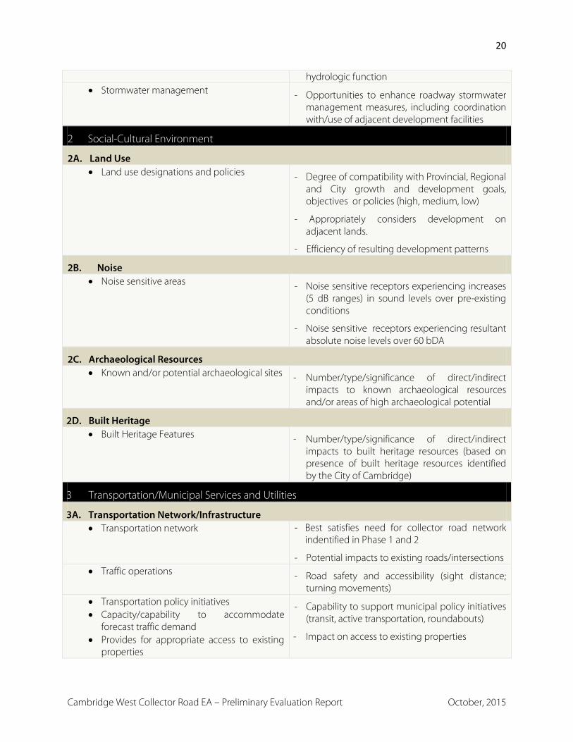
3.4 Evaluation Criteria and Related Scoring Methodology
Comprehensive evaluation criteria were developed and are based on the identified Study Area.
The evaluation criteria support and follow the requirements of the Muncipal Class Environmental
Assessment process and take into account relevant planning considerations. Draft evaluation
criteria/factors were prepared and submitted as part of the Official Plan Amendment application.
The draft evaluation criteria/factors were then presented at the Public Information Centre held on
October 2, 2014 and circulated to review agencies and departments for comment/input. Table
2.0 of this report includes the final evaluation Criteria/Factors which have been grouped into five
factor categories including: natural environment; socio-economic environment; cultural
environment; transportation, municipal services and utilities; and financial/technical. Within each
category, there are various factor groups.
These factor categories have been derived from the Municipal Class Environmental Assessment
document, prepared by the Municipal Engineers Association (October 2000, amended 2011). Part
A, Section A.1.1 of the Municipal Class EA document provides key principles of successful

18
Cambridge West Collector Road EA – Preliminary Evaluation Report October, 2015
environmental assessment planning under the EA Act including: identification and consideration
of the effects of each alternative on all aspects of the environment, i.e., the impact on the natural,
social cultural, technical and economic/financial environment.
The Numerical Evaluation approach was selected as the preferred scoring methodology. This
methodology requires a “must score” approach. For each criteria/factor the least preferred
alternative received a score of 1 and the most preferred alternative received a score of 10. All
other alternatives were scored between these values with ties permitted.
It was recognized that different factor categories and factor groups do not have the same number
of Criteria and as a result certain factor categories and factor groups should be weighted. To
address this issue, a normalized scoring approach was adopted wherein the total score for each
factor group was averaged in order to calculate an average category score. The average category
scores were then added together to determine the total normalized score for each alternative.
The alternative with the highest total normalized score emerged as the overall preferred
alignment and the alternative with the lowest total normalized score was determined to be the
least preferred alignment.
Table 2.0 - Alignment Alternatives Evaluation Criteria
Cambridge West Collector Road Alignments Factor Category Indicator/Measure
1 Natural Environment
1A. Terrestrial Ecosystems • Vegetation communities and flora - Impact on feature and function of vegetation
communities and flora, considering ecological significance (type, size, composition, species of conservation concern) and sensitivity/ susceptibility (e.g., mortality, stress, composition change)
• Wetlands - Impact on feature and function of wetlands (e.g., area, classification and quality, relative extent, function in broader wetland complex ecosystem)

19
Cambridge West Collector Road EA – Preliminary Evaluation Report October, 2015
• Wildlife habitat - Impact on feature and function of wildlife habitat, considering significance (e.g., size, presence of specialized habitat elements, species of conservation concern) and sensitivity (e.g., noise, light).
- Effects on wildlife movement corridors (e.g., habitat removal, fragmentation, potential increases in animal-vehicle conflicts)
1B. Aquatic Ecosystems • Aquatic habitat - Number of water bodies and watercourse
crossings
- Sensitivity of fish/fish habitat and thermal regime (warm, cool or cold water)
- Extent (area) and function of riparian habitat removed
- Extent and type of fish habitat (in-stream) altered/displaced in watercourse, including importance to aquatic ecosystem (e.g. spawning, nursery areas, habitat for species of conservation concern or less tolerant species)
1C. Surface Water • Water quality and thermal regime - Impact on water quality of surface water features
- Impact in the thermal regime of surface water features
• Quantity (flows) - Effects on surface drainage/floodplain
contributions to surface water features
1D. Groundwater Resources • Groundwater recharge areas - Encroachment on significant groundwater
recharge areas (Regional Recharge Area) (removal/disruption of function – area; depth)
• Groundwater quality - Potential for impacts to vulnerable areas (Area) • Shallow groundwater
movement/contributions - Potential for interference with existing flow
patterns (baseflow) relative to proximity to surface water and significant groundwater discharge areas
1E. Surface Drainage • Flood plain function - Impacts to Regulatory Floodplain of Devil’s
Creek
- Changes (+/-) to Devil’s Creek floodplain
20
Cambridge West Collector Road EA – Preliminary Evaluation Report October, 2015
hydrologic function • Stormwater management - Opportunities to enhance roadway stormwater
management measures, including coordination with/use of adjacent development facilities
2 Social-Cultural Environment
2A. Land Use • Land use designations and policies - Degree of compatibility with Provincial, Regional
and City growth and development goals, objectives or policies (high, medium, low)
- Appropriately considers development on adjacent lands.
- Efficiency of resulting development patterns
2B. Noise • Noise sensitive areas - Noise sensitive receptors experiencing increases
(5 dB ranges) in sound levels over pre-existing conditions
- Noise sensitive receptors experiencing resultant absolute noise levels over 60 bDA
2C. Archaeological Resources • Known and/or potential archaeological sites - Number/type/significance of direct/indirect
impacts to known archaeological resources and/or areas of high archaeological potential
2D. Built Heritage • Built Heritage Features - Number/type/significance of direct/indirect
impacts to built heritage resources (based on presence of built heritage resources identified by the City of Cambridge)
3 Transportation/Municipal Services and Utilities
3A. Transportation Network/Infrastructure • Transportation network - Best satisfies need for collector road network
indentified in Phase 1 and 2
- Potential impacts to existing roads/intersections • Traffic operations - Road safety and accessibility (sight distance;
turning movements) • Transportation policy initiatives • Capacity/capability to accommodate
forecast traffic demand • Provides for appropriate access to existing
properties
- Capability to support municipal policy initiatives (transit, active transportation, roundabouts)
- Impact on access to existing properties

21
Cambridge West Collector Road EA – Preliminary Evaluation Report October, 2015
3B. Municipal Services and Utilities • Municipal services - Opportunities for connections to or logical
extension of existing services
- Provision of standard cross-section locations for services
• Utilities - Degree of exposure of utilities and/or utility conflicts with road design
4 Financial • Cost - Estimated capital cost
- Road length
- Property requirements (number, area) and ease of acquisition
- Extraordinary operations and maintenance requirements/costs (e.g., differences in the number of valves and water treatment requirements; collector road maintenance)
- Species at Risk mitigation/overall benefit
- Cultural heritage mitigation measures
5 Technical • Roadway geometric design requirements - Conformance to TAC and City of
Cambridge/RMOW standards • Structural/foundation/pavement design
requirements - Conformance to TAC and City of Cambridge
standards
- Requirements for pavement depth and/or foundation footprint, based on soil conditions
- Structural requirements relative to capital cost and long term maintenance requirements
• Topographic; extent of cut/fill - Potential for excessive borrow quantity or excessive off-site disposal of earth material (volume)
- Requirements for excessive (steep) grades (length)
- Ability to maintain positive drainage, in combination with number of suitable drainage outlets and establish strategy for flow distribution to Devil’s Creek
• Constructability - Physical constructability (adequate access to corridor)

22
Cambridge West Collector Road EA – Preliminary Evaluation Report October, 2015
- Potential conflicts with existing infrastructure (other than utilities)
- Provision of standard horizontal and vertical clearance requirements
- Current staging of development for full implementation of the road network
• Railway – vertical alignment of crossing - Disruption to rail service - Ability to meet design standards - Flexibility to retrofit in the future - Ability of the City to implement - Cost
3.5 Collector Road Evaluation
Alignment alternatives were systematically assessed relative to all criteria/factors in accordance
with the selected methodology (see Appendix A). The scoring for each alternative for each
collector road is shown in Table 3.0. Based on the evaluation the recommended preliminary
preferred collector road alignments are shown on Figure 6.0 of this report.
Technical Memos on each evaluation factor/criteria are included in Appendices C-G of this
document.
Table 3.0 - Evaluation Score for Each Collector Road Alternative
Collector Road Alignment Evaluation Score Evaluation Ranking
Blenheim Road Alignment Alternatives
Blenheim Road Alignment 1 46 1
Blenheim Road Alignment 2 42 2
Blenheim Road Alignment 3 17 3
Blenheim Road Alignment 4 19 4
Bismark Drive Alignment Alternatives
Bismark Drive Alignment 1 40 2
Bismark Drive Alignment 2 49 1
Bismark Drive Alignment 3 40 2
Bismark Drive Alignment 4 23 4

Scale
Sources:
Air Photo - City of Cambridge, 2012
Study Area - City of Cambridge
Community Plan Boundary
Natural Open Space
north
PRELIMINARY PREFERRED
COLLECTOR ROAD ALTERNATIVES
Preferred Road Alignment Options
Property Ownership
Wetland
Dripline
New Wildlife Corridors
CAMBRIDGE WEST
COLLECTOR ROAD
ENVIRONMENTAL
ASSESSMENT
Legend
Figure 6

23
Cambridge West Collector Road EA – Preliminary Evaluation Report October, 2015
Collector Road Alignment Evaluation Score Evaluation Ranking
Newman Drive Alignment Alternatives
Newman Drive Alignment 1 41 3
Newman Drive Alignment 2 39 4
Newman Drive Alignment 3 47 1
Newman Drive Alignment 4 45 2
Newman Drive Alignment 5 28 6
Newman Drive Alignment 6 27 7
Newman Drive Alignment 7 37 5
The following is a summary of the advantages and disadvantages of the Preliminary Preferred
Collector Road Alternatives. Commentary has also been provided on why some of the alternatives
were ultimately not selected as the preferred.
3.5.1 Blenheim Road Alignments
Four Alignments were considered for Blenheim Road with Alignment 1 ultimately being selected
as the preliminary Alignment. The following is a summary of the advantages and disadvantages of
the Preliminary Preferred Collector Road Alternative. A brief summary of why some of the other
alternatives were discounted is also included.
Alignment 1 scored highest under Categories 2 (Socio-Cultural Environment), 3
(Transportation/Municipal Services and Utilities), and 5 (Technical). It scored second highest in
the remaining categories (Category 1 Natural Environment and Category 4 Financial).
In terms of the natural environment, Alignment 1 has the least amount of impact on the water
quality of surface water feature and in the thermal regime of surface water features. This
Alignment also has the least amount of effect on surface drainage contributes to surface water
features. Alignment 1 is unlikely to negatively impact groundwater quality since it has the
furthest travel time to the aquifer. Of the Alignments, Alignment 1 is located the furthest from

24
Cambridge West Collector Road EA – Preliminary Evaluation Report October, 2015
shallow groundwater resulting in less potential for interference with existing flow patterns relative
to proximity to surface water and significant groundwater discharge areas. In terms of
stormwater management, Alignment 1 meets the SWM strategy and objectives as set forth in the
MESP. Alignment 1 also has the greatest opportunities for enhancing roadway stormwater
management measures.
When evaluating socio-cultural environment factors, Alignment 1 is the most compatible with
Provincial, Regional and City growth and development goals, objectives and policies as it results
in a more efficient development pattern than the other Alignments due to the fact it is more
centrally located within the development area and would result in more efficient local road
patterns and transit routes. This Alignment has the least amount of noise impact on 200 Blenheim
Road. Alignment 1 has no impact to any known archaeological resources and/or areas of high
archaeological potential, and has the least impact to built heritage resources (i.e. 200 Blenheim
Road).
When considering Transportation and Municipal Services and Utilities criteria, Alignment 1
provides the best transportation design options for the Cambridge West community. It is the
safest Alignment in terms of road safety and accessibility (i.e. sight distance, turning movements)
and provides the best transportation policy initiatives based on having more centrally located
transit. Alignment 1 ranked high for municipal services as this Alignment provides the shortest
route for the sanitary sewer, and allows for utilities to be installed during construction of the
roadway.
When considering technical criteria, Alignment 1 provides the most stable road alignment and
requires less cut/fill when compared to other Alignments. Alignment 1 scored high for
constructability mainly because there are no land acquisition costs as the road will be constructed
almost entirely in cultivated lands. Finally, Alignment 1 offers the best tangent to the railway
resulting in less disruption to rail service and a greater ability to meet design standards.

25
Cambridge West Collector Road EA – Preliminary Evaluation Report October, 2015
Alignment 2 ranked second overall. The main factors which resulted in Alignment 2 ranking less
than the preferred were the Socio-Cultural Environment criteria. Alignment 2 would result in a
less efficient development pattern and has a greater impact on 200 Blenheim Road.
Alignments 3 and 4 were ranked 4th and 3rd respectively and overall were ranked significantly
behind Alignment 1. Alignment 3 had the greatest impact on 200 Blenheim Road as it bisects the
property and may require removal of the house. Since archeological screening has not been
completed for 200 Blenheim Road, this alignment could be impacted by any future
archaeological screening that would be required should this Alignment be selected. Alignment
3 also presents elevation concerns for servicing and vertical alignment challenges impacting
roadway design. Alignment 3 requires land acquisitions, due to necessary widening, and would
require extensive cut/fill.
Alignment 4 is located close to the wetlands and natural features associated with the Devil’s
Creek Swamp and Forest ESPA. This Alignment is the least likely to meet SWM strategy and
objectives outlined in the MESP, since it would result in increased surface drainage directed
towards Devil’s Creek, potentially impacting water quality. Alignment 4 has the shortest travel
time to the aquifer resulting in increased potential for impacts on groundwater quality.
Alignment 4 results in the least efficient development pattern and will create additional traffic
adjacent 200 Blenheim Road. Alignment 4 ranked low for municipal services and utilities as it has
the longest route for the sanitary sewer and would have the greatest degree of utility conflicts.
Alignment 4 would have the highest reconstruction costs. Finally, Alignment 4 has site distance
and intersection concerns resulting in a lower ranking for some of the technical factors.
3.5.2 Bismark Drive Alignments
Four Alignments were considered for Bismark Drive with Alignment 2 ultimately being selected as
the preliminary preferred Alignment. The following is a summary of the advantages and
disadvantages of the Preliminary Preferred Collector Road Alternative for Bismark Road. A brief
discussion on why other alternatives were ultimately not selected is also included.

26
Cambridge West Collector Road EA – Preliminary Evaluation Report October, 2015
Alignment 2 is furthest from natural features and wetlands, giving it a high ranking in the natural
environment category. It is also the most efficient option in terms of the resulting development
pattern since it is most centrally located.
Alternative 2 provides the best sight distances at the intersection with Blenheim Road, giving it
the highest ranking for road safety. Given the more centralized location of Alternative 2, it also
results in a more efficient transportation network minimizing travel distance for cars, transit and
pedestrians.
Alternative 2 ranked first for factor 3.B (Municipal Services and Utilities) as it results in the shortest
distance for watermains and sewers.
Of the other alternatives considered, Alternative 4 ranked the lowest. Its closer proximity to Devils
Creek means a greater amount of stormwater would be directed to Devil’s Creek. It has the
shortest travel time to the aquifer; and results in the least efficient development pattern.
Alternative 4 also requires considerable cut due to steep slopes at Blenheim Road.
3.5.3 Newman Drive Alignments
Seven alignments were considered for Newman Drive with Alignment 3 ultimately being ranked
as the preliminary preferred Alignment. The following is a summary of the advantages and
disadvantages of the Preliminary Preferred Collector Road Alternative for Newman Drive. A brief
discussion on why other alternatives were ranked lower is also included.
Alignment 3 was provides for an efficient land use and lotting pattern while making provisions for
future development. Alignment 3 is the most centrally located which results in the highest
ranking when considering the transportation network. It has the best sight distances based on
the straighter alignment of this alternative. Alternative 3 is also located further from the wetland
resulting in better soils and less need for fill.

27
Cambridge West Collector Road EA – Preliminary Evaluation Report October, 2015
The other alternatives considered for Newman Drive were scored lower for a number of reasons:
Alignments 1 and 2 were located too close to environmental features; Alignment 7 was the
closest to vulnerable groundwater areas and Alignments 5 and 6 are not as centrally located and
are located outside of the urban area requiring a more complex stormwater management
strategy; Alignment 1 has a less efficient lotting pattern and both Alignments 1 and 2 have
tighter curves at Newman Drive resulting in potential conflicts with driveways and sightlines.
Alignments 1 and 2 would also require more Block consolidation.
3.6 Intersection Alternatives
The Cambridge West MESP which contemplated the three collector road connections has been
designed to ensure that safe and appropriate intersections can generally be achieved, subject to
detailed engineering design. Controlled intersections are warranted at the intersections of
Blenheim Road/ Bismark Road and Newman Drive / Bismark Road. Based on the anticipated
traffic volumes for the intersection of Blenheim and Bismark Road, there are two intersection
alternatives that have been considered: a traffic signal; or a roundabout. The Newman Drive/
Bismark Road intersection will have lower volumes of traffic, as such three intersection alternatives
have been considered: a traffic circle; an all-way stop; or a signalized intersection.
The evaluation criteria considered all of the possible intersection options and the impact of each
alternative. For the Blenheim alignments it was found that in general, the most westerly
intersection with Bismark Drive to provide for the highest possible design standard and
appropriate intersection geometry. For Bismark Drive and Newman Drive it was found that, in
general, as the intersection location moved farther south and away from the central part of the
neighbourhood, its ability to provide for the highest possible design standard and appropriate
intersection geometry was negatively affected. At each intersection, the preliminary preferred
collector road alternatives would allow for any of the intersection controls. Selection of the
intersection control (i.e. roundabout or signals) will be determined through detail design.

28
Cambridge West Collector Road EA – Preliminary Evaluation Report October, 2015
3.7 Devils Creek Crossing Design Alternatives Evaluation
The Devils Creek Crossing Design alternatives were also systematically assessed relative to the
evaluation criteria and method used for the evaluation of the collector road alternatives (see
Appendix B). The MESP recommended that a new crossing design include provisions that would
enhance ecological linkages and, in particular, provide for wildlife movement including large
mammals. During the public process associated with the MESP, members of the community
asked that a new crossing also consider the ability to provide a for a multi-use trail within the
crossing structure such that it would allow for the extension of the Devil’s Creek Trail south of
Blenheim Road. Based on these considerations, and others, several design variables were
considered and used to develop seven design alternatives. A number of the Technical Memos in
Appendices C-G address the Devil’s Creek Design Alternatives, additional Technical Memos
related to Devil’s Creek are included in Appendix H.
1. Open Bottom or Closed Bottom Structure
An open bottom structure and a closed bottom structure were both considered as
alternatives (see Appendix H for details). The closed bottom structure was screened out
as an option in the preliminary evaluation stage and was not carried forward for any of the
design alternatives. The closed bottom structure was discarded as an option because of
the impact on Devil’s Creek and impacts on groundwater flows.
2. Width of the Structure
Two structure widths were considered for evaluation: a 6.1 metre structure width and a 9.4
metre structure width. A sketch of each are included in Appendix H. The 6.1 metre width
provides sufficient width to accommodate the creek and would accommodate sufficient
space for wildlife movement on both sides of the creek. The 9.4 metre structure width
provides sufficient width to also accommodate a multi-use trail on one side.
Smaller widths (i.e a 4.5 metre structure width) were considered but screened out in the
preliminary evaluation. The widths smaller than 6.1 metres were not carried forward

29
Cambridge West Collector Road EA – Preliminary Evaluation Report October, 2015
because they would not provide sufficient width for the creek, particularly at times of high
water levels, and would not provide for wildlife movement.
3. Length of the Structure
Three structure lengths were considered for evaluation. Conceptual designs for each are
shown in Appendix H.
o 31 metre length – results in shorter tunnel and reduced embankments but results
in a narrower boulevard width for Blenheim Road;
o 40 metre length – results in a typical cross section width for Blenheim Road with
some embankments and reduced headwalls
o 48 metre length – longest tunnel length and has no headwalls but has the most
significant embankments
4. Height of the Structure
Two heights for the structure were evaluated: a 2.2 metre height and 3.0 metre height (see
Appendix H for a sketch and more detail). The difference in height is directly related to
how the sanitary sewer is accommodated. The options for the sanitary sewer are to place
it at a great depth so that it crosses below Devil’s Creek or at a shallow depth whereby it
crosses over the creek between the road bed of Blenheim Road and the top of the
crossing structure. Routing the sanitary sewer below the creek allows for the higher
height structure of 3.0 metres.
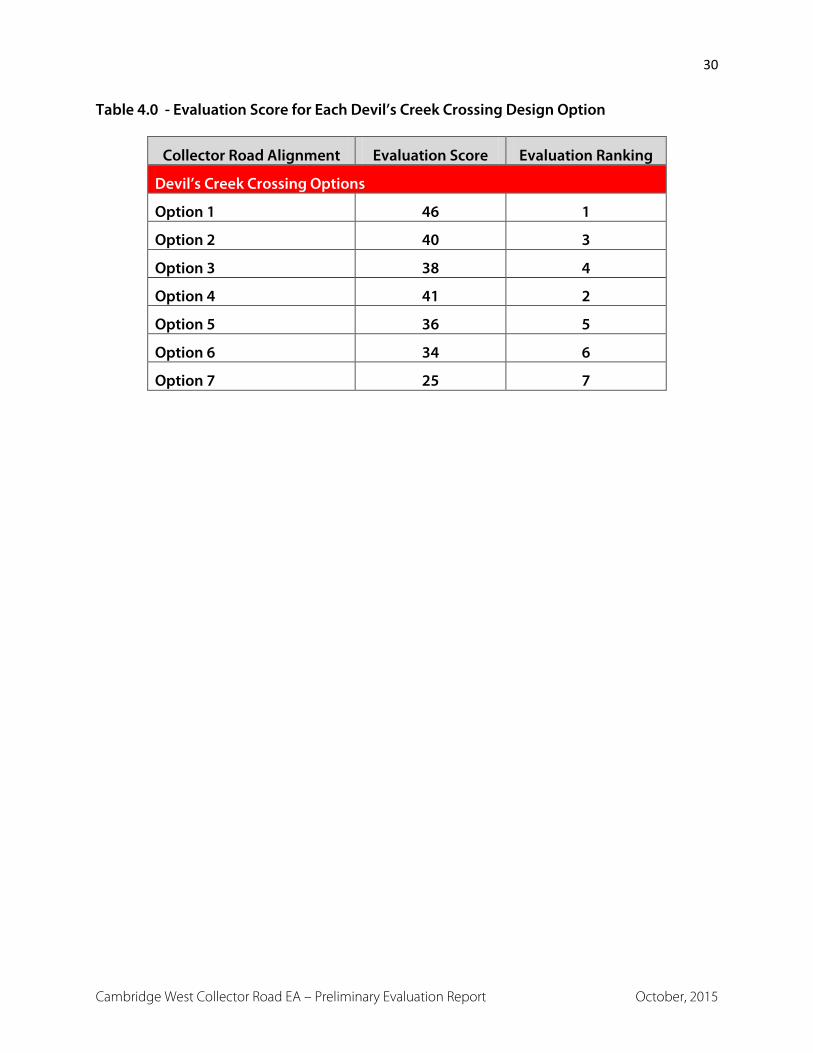
Seven design alternatives were developed and evaluated. The detailed evaluation is shown in the
table in Appendix B. A summary of the scoring for each design alternative is shown in Table 4.0.
Based on the evaluation Alignment 1 is recommended as the preliminary preferred crossing
structure.
30
Cambridge West Collector Road EA – Preliminary Evaluation Report October, 2015
Table 4.0 - Evaluation Score for Each Devil’s Creek Crossing Design Option
Collector Road Alignment Evaluation Score Evaluation Ranking
Devil’s Creek Crossing Options
Option 1 46 1
Option 2 40 3
Option 3 38 4
Option 4 41 2
Option 5 36 5
Option 6 34 6
Option 7 25 7
31
Cambridge West Collector Road EA – Preliminary Evaluation Report October, 2015
4.0 CONCLUSIONS The purpose of the report is to describe the collector road alignment alternatives and Devil’s
Creek crossing design options, the evaluation method and the preliminary preferred alternatives
for the collector roads and the Devils Creek crossing. The information in this report is to be made
available to the community for review and comment. The information from the public review will
then be considered in the determination of a recommended final collector road alignment. A
preliminary preferred collector road network is shown on Figure 6.
Input from the public will be considered in finalizing recommended preferred alternatives for the
collector road network and the recommended preferred Devil’s Creek crossing alternative. The
process will be documented, in an Environmental Study Report, which will include a summary of
the rationale, and the planning, design and consultation process of the project as established
through the phases of the Municipal Class EA process and the documentation will be available for
scrutiny by review agencies and the public.


