1. 2. SHEET: 1 OF 1 MACHINE: 30t Excavator CONTRACTOR: LOGGED: RF CHECKED: DB GAP gINT FN. F27 RL1 CLIENT: PROJECT: LOCATION: JOB NO: DATE: 25/8/14 DATE: 23/9/14 This report of test pit photographs must be read in conjunction with accompanying notes and abbreviations. It has been prepared for geotechnical purposes only, without attempt to assess possible contamination. Any references to potential contamination are for information only and do not necessarily indicate the presence or absence of soil or groundwater contamination. REPORT OF TEST PIT PHOTOGRAPHS: TP10 SITA Australia Allawuna Farm Landfill Allawuna Farm 147645033 COORDS: 462642 m E 6469116 m N MGA94 50 SURFACE RL: DATUM: AHD PIT DEPTH: 4.00 m BUCKET TYPE: 900 mm toothed GAP 8_08.06 LIB.GLB GrfcTbl GAP TEST PIT PHOTO 2 PER PAGE 147645033 - 25-27 GEOTECH INVESTIGATION (TEST PITS).GPJ <<DrawingFile>> 27/02/2015 16:34 8.30.004 Datgel Tools
Transcript
1.
2.
SHEET: 1 OF 1
MACHINE: 30t Excavator
CONTRACTOR:
LOGGED: RF
CHECKED: DB
GAP gINT FN. F27RL1
CLIENT:
PROJECT:
LOCATION:
JOB NO:
DATE: 25/8/14
DATE: 23/9/14
This report of test pit photographs must be read in conjunction with accompanying notes and abbreviations. It has been preparedfor geotechnical purposes only, without attempt to assess possible contamination. Any references to potential contamination are
for information only and do not necessarily indicate the presence or absence of soil or groundwater contamination.
REPORT OF TEST PIT PHOTOGRAPHS: TP10
SITA Australia
Allawuna Farm Landfill
Allawuna Farm
147645033
COORDS: 462642 m E 6469116 m N MGA94 50
SURFACE RL: DATUM: AHD
PIT DEPTH: 4.00 m
BUCKET TYPE: 900 mm toothed
GA
P 8
_08.
06 L
IB.G
LB G
rfcT
bl G
AP
TE
ST
PIT
PH
OT
O 2
PE
R P
AG
E 1
4764
503
3 -
25-2
7 G
EO
TE
CH
INV
ES
TIG
AT
ION
(T
ES
T P
ITS
).G
PJ
<<
Dra
win
gFile
>>
27/
02/2
015
16:3
4 8
.30.
004
Dat
gel T
ools
L-M
R
TOPSOIL
Clayey GRAVELfine to medium grained gravel, rounded to sub-rounded particles,pale brown, with low plasticity fines, with some roots and rootlets.
Clayey SANDfine to coarse grained, orange and white with red staining,medium plasticity fines, with some angular gravel.
REFUSAL ON BEDROCK.GROUNDWATER ACCUMULATED IN BASE OF TEST PIT.BACKFILLED.TEST PIT DISCONTINUED @ 1.80 m
GC
SC
0.30
1.40
1.80
EX
W
M -W
L -MD
D
Density inferred from observations
SHEET: 1 OF 1
Field Material DescriptionSamplingExcavation
EX
CA
VA
TIO
NR
ES
IST
AN
CE
SOIL/ROCK MATERIAL DESCRIPTION
US
CS
SY
MB
OL
RE
CO
VE
RE
D
WA
TE
R
RLDEPTH
DE
PT
H(m
etre
s)
ME
TH
OD
GR
AP
HIC
LOG
SAMPLE ORFIELD TEST
MACHINE: 30t Excavator
CONTRACTOR:
LOGGED: RF
CHECKED: DB
GAP gINT FN. F01eRL3
CLIENT:
PROJECT:
LOCATION:
JOB NO:
DATE: 26/8/14
DATE: 23/9/14
This report of test pit must be read in conjunction with accompanying notes and abbreviations. It has been prepared forgeotechnical purposes only, without attempt to assess possible contamination. Any references to potential contamination are for
information only and do not necessarily indicate the presence or absence of soil or groundwater contamination.
REPORT OF TEST PIT: TP11
SITA Australia
Allawuna Farm Landfill
Allawuna Farm
147645033
COORDS: 462810 m E 6469077 m N MGA94 50
SURFACE RL: DATUM: AHD
PIT DEPTH: 1.80 m
BUCKET TYPE: 900 mm toothed
GA
P 8
_08.
06 L
IB.G
LB L
og G
AP
NO
N-C
OR
ED
FU
LL P
AG
E 1
4764
503
3 -
25-2
7 G
EO
TE
CH
INV
ES
TIG
AT
ION
(T
ES
T P
ITS
).G
PJ
<<
Dra
win
gFile
>>
27/
02/2
015
16:3
4 8
.30.
004
Dat
gel T
ools
MO
IST
UR
EC
ON
DIT
ION
CO
NS
IST
EN
CY
DE
NS
ITY
STRUCTURE ANDADDITIONAL
OBSERVATIONS
0.0
0.5
1.0
1.5
2.0
2.5
3.0
3.5
4.0
4.5
5.0
1.
2.
SHEET: 1 OF 1
MACHINE: 30t Excavator
CONTRACTOR:
LOGGED: RF
CHECKED: DB
GAP gINT FN. F27RL1
CLIENT:
PROJECT:
LOCATION:
JOB NO:
DATE: 26/8/14
DATE: 23/9/14
This report of test pit photographs must be read in conjunction with accompanying notes and abbreviations. It has been preparedfor geotechnical purposes only, without attempt to assess possible contamination. Any references to potential contamination are
for information only and do not necessarily indicate the presence or absence of soil or groundwater contamination.
REPORT OF TEST PIT PHOTOGRAPHS: TP11
SITA Australia
Allawuna Farm Landfill
Allawuna Farm
147645033
COORDS: 462810 m E 6469077 m N MGA94 50
SURFACE RL: DATUM: AHD
PIT DEPTH: 1.80 m
BUCKET TYPE: 900 mm toothed
GA
P 8
_08.
06 L
IB.G
LB G
rfcT
bl G
AP
TE
ST
PIT
PH
OT
O 2
PE
R P
AG
E 1
4764
503
3 -
25-2
7 G
EO
TE
CH
INV
ES
TIG
AT
ION
(T
ES
T P
ITS
).G
PJ
<<
Dra
win
gFile
>>
27/
02/2
015
16:3
4 8
.30.
004
Dat
gel T
ools
L-M
R
TOPSOIL
Clayey GRAVELfine to medium grained gravel, rounded to sub-rounded particles,pale brown, with low plasticity fines, with some roots and rootlets.
Clayey SANDfine to coarse grained, orange and white with red staining,medium plasticity fines, with some angular gravel.
REFUSAL ON BEDROCK.GROUNDWATER ACCUMULATED IN BASE OF TEST PIT.BACKFILLED.TEST PIT DISCONTINUED @ 1.40 m
GC
SC
0.30
1.00
1.40
EX W
L
D
Density inferred from observations
SHEET: 1 OF 1
Field Material DescriptionSamplingExcavation
EX
CA
VA
TIO
NR
ES
IST
AN
CE
SOIL/ROCK MATERIAL DESCRIPTION
US
CS
SY
MB
OL
RE
CO
VE
RE
D
WA
TE
R
RLDEPTH
DE
PT
H(m
etre
s)
ME
TH
OD
GR
AP
HIC
LOG
SAMPLE ORFIELD TEST
MACHINE: 30t Excavator
CONTRACTOR:
LOGGED: RF
CHECKED: DB
GAP gINT FN. F01eRL3
CLIENT:
PROJECT:
LOCATION:
JOB NO:
DATE: 26/8/14
DATE: 23/9/14
This report of test pit must be read in conjunction with accompanying notes and abbreviations. It has been prepared forgeotechnical purposes only, without attempt to assess possible contamination. Any references to potential contamination are for
information only and do not necessarily indicate the presence or absence of soil or groundwater contamination.
REPORT OF TEST PIT: TP12
SITA Australia
Allawuna Farm Landfill
Allawuna Farm
147645033
COORDS: 462889 m E 6469114 m N MGA94 50
SURFACE RL: DATUM: AHD
PIT DEPTH: 1.40 m
BUCKET TYPE: 900 mm toothed
GA
P 8
_08.
06 L
IB.G
LB L
og G
AP
NO
N-C
OR
ED
FU
LL P
AG
E 1
4764
503
3 -
25-2
7 G
EO
TE
CH
INV
ES
TIG
AT
ION
(T
ES
T P
ITS
).G
PJ
<<
Dra
win
gFile
>>
27/
02/2
015
16:3
4 8
.30.
004
Dat
gel T
ools
MO
IST
UR
EC
ON
DIT
ION
CO
NS
IST
EN
CY
DE
NS
ITY
STRUCTURE ANDADDITIONAL
OBSERVATIONS
0.0
0.5
1.0
1.5
2.0
2.5
3.0
3.5
4.0
4.5
5.0
1.
SHEET: 1 OF 1
MACHINE: 30t Excavator
CONTRACTOR:
LOGGED: RF
CHECKED: DB
GAP gINT FN. F27RL1
CLIENT:
PROJECT:
LOCATION:
JOB NO:
DATE: 26/8/14
DATE: 23/9/14
This report of test pit photographs must be read in conjunction with accompanying notes and abbreviations. It has been preparedfor geotechnical purposes only, without attempt to assess possible contamination. Any references to potential contamination are
for information only and do not necessarily indicate the presence or absence of soil or groundwater contamination.
REPORT OF TEST PIT PHOTOGRAPHS: TP12
SITA Australia
Allawuna Farm Landfill
Allawuna Farm
147645033
COORDS: 462889 m E 6469114 m N MGA94 50
SURFACE RL: DATUM: AHD
PIT DEPTH: 1.40 m
BUCKET TYPE: 900 mm toothed
GA
P 8
_08.
06 L
IB.G
LB G
rfcT
bl G
AP
TE
ST
PIT
PH
OT
O 2
PE
R P
AG
E 1
4764
503
3 -
25-2
7 G
EO
TE
CH
INV
ES
TIG
AT
ION
(T
ES
T P
ITS
).G
PJ
<<
Dra
win
gFile
>>
27/
02/2
015
16:3
4 8
.30.
004
Dat
gel T
ools
L-M
R
TOPSOIL
Clayey GRAVELfine to medium grained gravel, rounded to sub-rounded particles,pale brown, with low plasticity fines, with some roots and rootlets.
Clayey SANDfine to coarse grained, orange and white with red staining,medium plasticity fines, with some angular gravel.
REFUSAL ON BEDROCK.GROUNDWATER ACCUMULATED IN BASE OF TEST PIT.BACKFILLED.TEST PIT DISCONTINUED @ 1.50 m
GC
SC
0.30
0.90
1.50
EX W
L
D
Density inferred from observations
SHEET: 1 OF 1
Field Material DescriptionSamplingExcavation
EX
CA
VA
TIO
NR
ES
IST
AN
CE
SOIL/ROCK MATERIAL DESCRIPTION
US
CS
SY
MB
OL
RE
CO
VE
RE
D
WA
TE
R
RLDEPTH
DE
PT
H(m
etre
s)
ME
TH
OD
GR
AP
HIC
LOG
SAMPLE ORFIELD TEST
MACHINE: 30t Excavator
CONTRACTOR:
LOGGED: RF
CHECKED: DB
GAP gINT FN. F01eRL3
CLIENT:
PROJECT:
LOCATION:
JOB NO:
DATE: 26/8/14
DATE: 23/9/14
This report of test pit must be read in conjunction with accompanying notes and abbreviations. It has been prepared forgeotechnical purposes only, without attempt to assess possible contamination. Any references to potential contamination are for
information only and do not necessarily indicate the presence or absence of soil or groundwater contamination.
REPORT OF TEST PIT: TP13
SITA Australia
Allawuna Farm Landfill
Allawuna Farm
147645033
COORDS: 463095 m E 6469206 m N MGA94 50
SURFACE RL: DATUM: AHD
PIT DEPTH: 1.50 m
BUCKET TYPE: 900 mm toothed
GA
P 8
_08.
06 L
IB.G
LB L
og G
AP
NO
N-C
OR
ED
FU
LL P
AG
E 1
4764
503
3 -
25-2
7 G
EO
TE
CH
INV
ES
TIG
AT
ION
(T
ES
T P
ITS
).G
PJ
<<
Dra
win
gFile
>>
27/
02/2
015
16:3
4 8
.30.
004
Dat
gel T
ools
MO
IST
UR
EC
ON
DIT
ION
CO
NS
IST
EN
CY
DE
NS
ITY
STRUCTURE ANDADDITIONAL
OBSERVATIONS
0.0
0.5
1.0
1.5
2.0
2.5
3.0
3.5
4.0
4.5
5.0
1.
2.
SHEET: 1 OF 1
MACHINE: 30t Excavator
CONTRACTOR:
LOGGED: RF
CHECKED: DB
GAP gINT FN. F27RL1
CLIENT:
PROJECT:
LOCATION:
JOB NO:
DATE: 26/8/14
DATE: 23/9/14
This report of test pit photographs must be read in conjunction with accompanying notes and abbreviations. It has been preparedfor geotechnical purposes only, without attempt to assess possible contamination. Any references to potential contamination are
for information only and do not necessarily indicate the presence or absence of soil or groundwater contamination.
REPORT OF TEST PIT PHOTOGRAPHS: TP13
SITA Australia
Allawuna Farm Landfill
Allawuna Farm
147645033
COORDS: 463095 m E 6469206 m N MGA94 50
SURFACE RL: DATUM: AHD
PIT DEPTH: 1.50 m
BUCKET TYPE: 900 mm toothed
GA
P 8
_08.
06 L
IB.G
LB G
rfcT
bl G
AP
TE
ST
PIT
PH
OT
O 2
PE
R P
AG
E 1
4764
503
3 -
25-2
7 G
EO
TE
CH
INV
ES
TIG
AT
ION
(T
ES
T P
ITS
).G
PJ
<<
Dra
win
gFile
>>
27/
02/2
015
16:3
4 8
.30.
004
Dat
gel T
ools
L
M-H
M-H
R
TOPSOIL
Clayey GRAVELfine to medium grained gravel, rounded to sub-rounded particles,pale brown, with low plasticity fines, with some roots and rootlets.
Clayey SAND to Sandy CLAYfine to coarse grained, orange and white, weakly to moderatelyiron cemented with pisolitic gravel embedded.
Clayey SILThigh plasticity clay to high plasticity silt, orange and white with redstaining, between about 30% to 50% fine to coarse grained sand
REFUSAL ON BEDROCK.GROUNDWATER NOT ENCOUNTERED.BACKFILLED.TEST PIT DISCONTINUED @ 2.80 m
GC
SC / CI
MH
0.20
0.70
1.30
2.80
EX
BDS 2.00-2.50 mRec = 500/500 mm3 bags
M
D - M
L
St -VSt
Density inferred from observations
SHEET: 1 OF 1
Field Material DescriptionSamplingExcavation
EX
CA
VA
TIO
NR
ES
IST
AN
CE
SOIL/ROCK MATERIAL DESCRIPTION
US
CS
SY
MB
OL
RE
CO
VE
RE
D
WA
TE
R
RLDEPTH
DE
PT
H(m
etre
s)
ME
TH
OD
GR
AP
HIC
LOG
SAMPLE ORFIELD TEST
MACHINE: 30t Excavator
CONTRACTOR:
LOGGED: RF
CHECKED: DB
GAP gINT FN. F01eRL3
CLIENT:
PROJECT:
LOCATION:
JOB NO:
DATE: 27/8/14
DATE: 23/9/14
This report of test pit must be read in conjunction with accompanying notes and abbreviations. It has been prepared forgeotechnical purposes only, without attempt to assess possible contamination. Any references to potential contamination are for
information only and do not necessarily indicate the presence or absence of soil or groundwater contamination.
REPORT OF TEST PIT: TP14
SITA Australia
Allawuna Farm Landfill
Allawuna Farm
147645033
COORDS: 462532 m E 6468982 m N MGA94 50
SURFACE RL: DATUM: AHD
PIT DEPTH: 2.80 m
BUCKET TYPE: 900 mm toothed
GA
P 8
_08.
06 L
IB.G
LB L
og G
AP
NO
N-C
OR
ED
FU
LL P
AG
E 1
4764
503
3 -
25-2
7 G
EO
TE
CH
INV
ES
TIG
AT
ION
(T
ES
T P
ITS
).G
PJ
<<
Dra
win
gFile
>>
27/
02/2
015
16:3
4 8
.30.
004
Dat
gel T
ools
MO
IST
UR
EC
ON
DIT
ION
CO
NS
IST
EN
CY
DE
NS
ITY
STRUCTURE ANDADDITIONAL
OBSERVATIONS
0.0
0.5
1.0
1.5
2.0
2.5
3.0
3.5
4.0
4.5
5.0
1.
2.
SHEET: 1 OF 1
MACHINE: 30t Excavator
CONTRACTOR:
LOGGED: RF
CHECKED: DB
GAP gINT FN. F27RL1
CLIENT:
PROJECT:
LOCATION:
JOB NO:
DATE: 27/8/14
DATE: 23/9/14
This report of test pit photographs must be read in conjunction with accompanying notes and abbreviations. It has been preparedfor geotechnical purposes only, without attempt to assess possible contamination. Any references to potential contamination are
for information only and do not necessarily indicate the presence or absence of soil or groundwater contamination.
REPORT OF TEST PIT PHOTOGRAPHS: TP14
SITA Australia
Allawuna Farm Landfill
Allawuna Farm
147645033
COORDS: 462532 m E 6468982 m N MGA94 50
SURFACE RL: DATUM: AHD
PIT DEPTH: 2.80 m
BUCKET TYPE: 900 mm toothed
GA
P 8
_08.
06 L
IB.G
LB G
rfcT
bl G
AP
TE
ST
PIT
PH
OT
O 2
PE
R P
AG
E 1
4764
503
3 -
25-2
7 G
EO
TE
CH
INV
ES
TIG
AT
ION
(T
ES
T P
ITS
).G
PJ
<<
Dra
win
gFile
>>
27/
02/2
015
16:3
4 8
.30.
004
Dat
gel T
ools
L
M-H
TOPSOIL
Clayey GRAVELfine to medium grained gravel, rounded to sub-rounded particles,pale brown, with low plasticity fines, with some roots and rootlets.
Clayey SANDfine to coarse grained, pale brown with white and red staining, lowto intermediate plasticity fines, with some roots and rootlets.
Silty Clayey SAND to Sandy Silty CLAYfine to coarse grained, orange and white with red stainingreducing at depth, medium plasticity fines, with some roots androotlets.
TARGET DEPTH ACHIEVED.GROUNDWATER ENCOUNTERED.BACKFILLED.TEST PIT DISCONTINUED @ 4.00 m
GC
SC
SC / CI
0.30
0.60
1.00
4.00
EX
W
M -W
L
St -VSt
Density inferred from observations
SHEET: 1 OF 1
Field Material DescriptionSamplingExcavation
EX
CA
VA
TIO
NR
ES
IST
AN
CE
SOIL/ROCK MATERIAL DESCRIPTION
US
CS
SY
MB
OL
RE
CO
VE
RE
D
WA
TE
R
RLDEPTH
DE
PT
H(m
etre
s)
ME
TH
OD
GR
AP
HIC
LOG
SAMPLE ORFIELD TEST
MACHINE: 30t Excavator
CONTRACTOR:
LOGGED: RF
CHECKED: DB
GAP gINT FN. F01eRL3
CLIENT:
PROJECT:
LOCATION:
JOB NO:
DATE: 26/8/14
DATE: 23/9/14
This report of test pit must be read in conjunction with accompanying notes and abbreviations. It has been prepared forgeotechnical purposes only, without attempt to assess possible contamination. Any references to potential contamination are for
information only and do not necessarily indicate the presence or absence of soil or groundwater contamination.
REPORT OF TEST PIT: TP15
SITA Australia
Allawuna Farm Landfill
Allawuna Farm
147645033
COORDS: 462742 m E 6468960 m N MGA94 50
SURFACE RL: DATUM: AHD
PIT DEPTH: 4.00 m
BUCKET TYPE: 900 mm toothed
GA
P 8
_08.
06 L
IB.G
LB L
og G
AP
NO
N-C
OR
ED
FU
LL P
AG
E 1
4764
503
3 -
25-2
7 G
EO
TE
CH
INV
ES
TIG
AT
ION
(T
ES
T P
ITS
).G
PJ
<<
Dra
win
gFile
>>
27/
02/2
015
16:3
4 8
.30.
004
Dat
gel T
ools
MO
IST
UR
EC
ON
DIT
ION
CO
NS
IST
EN
CY
DE
NS
ITY
STRUCTURE ANDADDITIONAL
OBSERVATIONS
0.0
0.5
1.0
1.5
2.0
2.5
3.0
3.5
4.0
4.5
5.0
1.
2.
SHEET: 1 OF 1
MACHINE: 30t Excavator
CONTRACTOR:
LOGGED: RF
CHECKED: DB
GAP gINT FN. F27RL1
CLIENT:
PROJECT:
LOCATION:
JOB NO:
DATE: 26/8/14
DATE: 23/9/14
This report of test pit photographs must be read in conjunction with accompanying notes and abbreviations. It has been preparedfor geotechnical purposes only, without attempt to assess possible contamination. Any references to potential contamination are
for information only and do not necessarily indicate the presence or absence of soil or groundwater contamination.
REPORT OF TEST PIT PHOTOGRAPHS: TP15
SITA Australia
Allawuna Farm Landfill
Allawuna Farm
147645033
COORDS: 462742 m E 6468960 m N MGA94 50
SURFACE RL: DATUM: AHD
PIT DEPTH: 4.00 m
BUCKET TYPE: 900 mm toothed
GA
P 8
_08.
06 L
IB.G
LB G
rfcT
bl G
AP
TE
ST
PIT
PH
OT
O 2
PE
R P
AG
E 1
4764
503
3 -
25-2
7 G
EO
TE
CH
INV
ES
TIG
AT
ION
(T
ES
T P
ITS
).G
PJ
<<
Dra
win
gFile
>>
27/
02/2
015
16:3
4 8
.30.
004
Dat
gel T
ools
L
M-H
TOPSOIL
Clayey GRAVELfine to medium grained gravel, rounded to sub-rounded particles,pale brown, with low plasticity fines, with some roots and rootlets.
Clayey SANDfine to coarse grained, yellow with white and red staining, with15% to 30% intermediate plasticity fines, with some roots androotlets.
Silty Clayey SAND to Sandy Silty CLAYfine to coarse grained, orange and white with red stainingreducing at depth, medium plasticity fines, with some roots androotlets.
TARGET DEPTH ACHIEVED.GROUNDWATER ENCOUNTERED.BACKFILLED.TEST PIT DISCONTINUED @ 4.00 m
GC
SC
SC / CI
0.20
0.60
0.90
4.00
EX
W
M -W
L
St -VSt
Density inferred from observations
SHEET: 1 OF 1
Field Material DescriptionSamplingExcavation
EX
CA
VA
TIO
NR
ES
IST
AN
CE
SOIL/ROCK MATERIAL DESCRIPTION
US
CS
SY
MB
OL
RE
CO
VE
RE
D
WA
TE
R
RLDEPTH
DE
PT
H(m
etre
s)
ME
TH
OD
GR
AP
HIC
LOG
SAMPLE ORFIELD TEST
MACHINE: 30t Excavator
CONTRACTOR:
LOGGED: RF
CHECKED: DB
GAP gINT FN. F01eRL3
CLIENT:
PROJECT:
LOCATION:
JOB NO:
DATE: 27/8/14
DATE: 23/9/14
This report of test pit must be read in conjunction with accompanying notes and abbreviations. It has been prepared forgeotechnical purposes only, without attempt to assess possible contamination. Any references to potential contamination are for
information only and do not necessarily indicate the presence or absence of soil or groundwater contamination.
REPORT OF TEST PIT: TP16
SITA Australia
Allawuna Farm Landfill
Allawuna Farm
147645033
COORDS: 462599 m E 6468918 m N MGA94 50
SURFACE RL: DATUM: AHD
PIT DEPTH: 4.00 m
BUCKET TYPE: 900 mm toothed
GA
P 8
_08.
06 L
IB.G
LB L
og G
AP
NO
N-C
OR
ED
FU
LL P
AG
E 1
4764
503
3 -
25-2
7 G
EO
TE
CH
INV
ES
TIG
AT
ION
(T
ES
T P
ITS
).G
PJ
<<
Dra
win
gFile
>>
27/
02/2
015
16:3
4 8
.30.
004
Dat
gel T
ools
MO
IST
UR
EC
ON
DIT
ION
CO
NS
IST
EN
CY
DE
NS
ITY
STRUCTURE ANDADDITIONAL
OBSERVATIONS
0.0
0.5
1.0
1.5
2.0
2.5
3.0
3.5
4.0
4.5
5.0
1.
2.
SHEET: 1 OF 1
MACHINE: 30t Excavator
CONTRACTOR:
LOGGED: RF
CHECKED: DB
GAP gINT FN. F27RL1
CLIENT:
PROJECT:
LOCATION:
JOB NO:
DATE: 27/8/14
DATE: 23/9/14
This report of test pit photographs must be read in conjunction with accompanying notes and abbreviations. It has been preparedfor geotechnical purposes only, without attempt to assess possible contamination. Any references to potential contamination are
for information only and do not necessarily indicate the presence or absence of soil or groundwater contamination.
REPORT OF TEST PIT PHOTOGRAPHS: TP16
SITA Australia
Allawuna Farm Landfill
Allawuna Farm
147645033
COORDS: 462599 m E 6468918 m N MGA94 50
SURFACE RL: DATUM: AHD
PIT DEPTH: 4.00 m
BUCKET TYPE: 900 mm toothed
GA
P 8
_08.
06 L
IB.G
LB G
rfcT
bl G
AP
TE
ST
PIT
PH
OT
O 2
PE
R P
AG
E 1
4764
503
3 -
25-2
7 G
EO
TE
CH
INV
ES
TIG
AT
ION
(T
ES
T P
ITS
).G
PJ
<<
Dra
win
gFile
>>
27/
02/2
015
16:3
4 8
.30.
004
Dat
gel T
ools
L
M-H
R
TOPSOIL
Clayey SANDfine to coarse grained, yellow with white and red staining, low tomedium plasticity fines, with some rounded to subrounded gravel,with some roots and rootlets.
Silty Clayey SAND to Sandy Silty CLAYfine to coarse grained, orange and white with red stainingreducing at depth, medium plasticity fines, with some roots androotlets.
REFUSAL ON BEDROCK.GROUNDWATER NOT ENCOUNTERED.BACKFILLED.TEST PIT DISCONTINUED @ 3.80 m
SC
SC / CI
0.20
0.90
3.80
EX
M
D - M
L
St -VSt
Density inferred from observations
SHEET: 1 OF 1
Field Material DescriptionSamplingExcavation
EX
CA
VA
TIO
NR
ES
IST
AN
CE
SOIL/ROCK MATERIAL DESCRIPTION
US
CS
SY
MB
OL
RE
CO
VE
RE
D
WA
TE
R
RLDEPTH
DE
PT
H(m
etre
s)
ME
TH
OD
GR
AP
HIC
LOG
SAMPLE ORFIELD TEST
MACHINE: 30t Excavator
CONTRACTOR:
LOGGED: RF
CHECKED: DB
GAP gINT FN. F01eRL3
CLIENT:
PROJECT:
LOCATION:
JOB NO:
DATE: 27/8/14
DATE: 23/9/14
This report of test pit must be read in conjunction with accompanying notes and abbreviations. It has been prepared forgeotechnical purposes only, without attempt to assess possible contamination. Any references to potential contamination are for
information only and do not necessarily indicate the presence or absence of soil or groundwater contamination.
REPORT OF TEST PIT: TP17
SITA Australia
Allawuna Farm Landfill
Allawuna Farm
147645033
COORDS: 462461 m E 6468894 m N MGA94 50
SURFACE RL: DATUM: AHD
PIT DEPTH: 3.80 m
BUCKET TYPE: 900 mm toothed
GA
P 8
_08.
06 L
IB.G
LB L
og G
AP
NO
N-C
OR
ED
FU
LL P
AG
E 1
4764
503
3 -
25-2
7 G
EO
TE
CH
INV
ES
TIG
AT
ION
(T
ES
T P
ITS
).G
PJ
<<
Dra
win
gFile
>>
27/
02/2
015
16:3
4 8
.30.
004
Dat
gel T
ools
MO
IST
UR
EC
ON
DIT
ION
CO
NS
IST
EN
CY
DE
NS
ITY
STRUCTURE ANDADDITIONAL
OBSERVATIONS
0.0
0.5
1.0
1.5
2.0
2.5
3.0
3.5
4.0
4.5
5.0
1.
2.
SHEET: 1 OF 1
MACHINE: 30t Excavator
CONTRACTOR:
LOGGED: RF
CHECKED: DB
GAP gINT FN. F27RL1
CLIENT:
PROJECT:
LOCATION:
JOB NO:
DATE: 27/8/14
DATE: 23/9/14
This report of test pit photographs must be read in conjunction with accompanying notes and abbreviations. It has been preparedfor geotechnical purposes only, without attempt to assess possible contamination. Any references to potential contamination are
for information only and do not necessarily indicate the presence or absence of soil or groundwater contamination.
REPORT OF TEST PIT PHOTOGRAPHS: TP17
SITA Australia
Allawuna Farm Landfill
Allawuna Farm
147645033
COORDS: 462461 m E 6468894 m N MGA94 50
SURFACE RL: DATUM: AHD
PIT DEPTH: 3.80 m
BUCKET TYPE: 900 mm toothed
GA
P 8
_08.
06 L
IB.G
LB G
rfcT
bl G
AP
TE
ST
PIT
PH
OT
O 2
PE
R P
AG
E 1
4764
503
3 -
25-2
7 G
EO
TE
CH
INV
ES
TIG
AT
ION
(T
ES
T P
ITS
).G
PJ
<<
Dra
win
gFile
>>
27/
02/2
015
16:3
4 8
.30.
004
Dat
gel T
ools
L
M-H
R
TOPSOIL
Clayey SANDfine to coarse grained, pale brown with white and red staining, lowto medium plasticity fines, with some rounded to subroundedgravel, with some roots and rootlets.
Silty Clayey SAND to Sandy Silty CLAYfine to coarse grained, orange and white with red stainingreducing at depth, medium plasticity fines, with some roots androotlets.
REFUSAL ON BEDROCK.GROUNDWATER NOT ENCOUNTERED.BACKFILLED.TEST PIT DISCONTINUED @ 2.90 m
SC
SC / CI
0.30
0.50
2.90
EX
M
D - M
L
St -VSt
Density inferred from observations
SHEET: 1 OF 1
Field Material DescriptionSamplingExcavation
EX
CA
VA
TIO
NR
ES
IST
AN
CE
SOIL/ROCK MATERIAL DESCRIPTION
US
CS
SY
MB
OL
RE
CO
VE
RE
D
WA
TE
R
RLDEPTH
DE
PT
H(m
etre
s)
ME
TH
OD
GR
AP
HIC
LOG
SAMPLE ORFIELD TEST
MACHINE: 30t Excavator
CONTRACTOR:
LOGGED: RF
CHECKED: DB
GAP gINT FN. F01eRL3
CLIENT:
PROJECT:
LOCATION:
JOB NO:
DATE: 25/8/14
DATE: 23/9/14
This report of test pit must be read in conjunction with accompanying notes and abbreviations. It has been prepared forgeotechnical purposes only, without attempt to assess possible contamination. Any references to potential contamination are for
information only and do not necessarily indicate the presence or absence of soil or groundwater contamination.
REPORT OF TEST PIT: TP18
SITA Australia
Allawuna Farm Landfill
Allawuna Farm
147645033
COORDS: 462344 m E 6468807 m N MGA94 50
SURFACE RL: DATUM: AHD
PIT DEPTH: 2.90 m
BUCKET TYPE: 900 mm toothed
GA
P 8
_08.
06 L
IB.G
LB L
og G
AP
NO
N-C
OR
ED
FU
LL P
AG
E 1
4764
503
3 -
25-2
7 G
EO
TE
CH
INV
ES
TIG
AT
ION
(T
ES
T P
ITS
).G
PJ
<<
Dra
win
gFile
>>
27/
02/2
015
16:3
4 8
.30.
004
Dat
gel T
ools
MO
IST
UR
EC
ON
DIT
ION
CO
NS
IST
EN
CY
DE
NS
ITY
STRUCTURE ANDADDITIONAL
OBSERVATIONS
0.0
0.5
1.0
1.5
2.0
2.5
3.0
3.5
4.0
4.5
5.0
1.
2.
SHEET: 1 OF 1
MACHINE: 30t Excavator
CONTRACTOR:
LOGGED: RF
CHECKED: DB
GAP gINT FN. F27RL1
CLIENT:
PROJECT:
LOCATION:
JOB NO:
DATE: 25/8/14
DATE: 23/9/14
This report of test pit photographs must be read in conjunction with accompanying notes and abbreviations. It has been preparedfor geotechnical purposes only, without attempt to assess possible contamination. Any references to potential contamination are
for information only and do not necessarily indicate the presence or absence of soil or groundwater contamination.
REPORT OF TEST PIT PHOTOGRAPHS: TP18
SITA Australia
Allawuna Farm Landfill
Allawuna Farm
147645033
COORDS: 462344 m E 6468807 m N MGA94 50
SURFACE RL: DATUM: AHD
PIT DEPTH: 2.90 m
BUCKET TYPE: 900 mm toothed
GA
P 8
_08.
06 L
IB.G
LB G
rfcT
bl G
AP
TE
ST
PIT
PH
OT
O 2
PE
R P
AG
E 1
4764
503
3 -
25-2
7 G
EO
TE
CH
INV
ES
TIG
AT
ION
(T
ES
T P
ITS
).G
PJ
<<
Dra
win
gFile
>>
27/
02/2
015
16:3
4 8
.30.
004
Dat
gel T
ools
L
M-H
TOPSOIL
Clayey SANDfine to coarse grained, pale brown with white and red staining, lowto medium plasticity fines, with some rounded to subroundedgravel, with some roots and rootlets.
Silty Clayey SAND to Sandy Silty CLAYfine to coarse grained, orange and white with red stainingreducing at depth, medium plasticity fines, with some roots androotlets.
TARGET DEPTH ACHIEVED.GROUNDWATER ENCOUNTERED.BACKFILLED.TEST PIT DISCONTINUED @ 4.00 m
SC
SC / CI
0.20
0.90
4.00
EX
W
M -W
L
St -VSt
Density inferred from observations
SHEET: 1 OF 1
Field Material DescriptionSamplingExcavation
EX
CA
VA
TIO
NR
ES
IST
AN
CE
SOIL/ROCK MATERIAL DESCRIPTION
US
CS
SY
MB
OL
RE
CO
VE
RE
D
WA
TE
R
RLDEPTH
DE
PT
H(m
etre
s)
ME
TH
OD
GR
AP
HIC
LOG
SAMPLE ORFIELD TEST
MACHINE: 30t Excavator
CONTRACTOR:
LOGGED: RF
CHECKED: DB
GAP gINT FN. F01eRL3
CLIENT:
PROJECT:
LOCATION:
JOB NO:
DATE: 27/8/14
DATE: 23/9/14
This report of test pit must be read in conjunction with accompanying notes and abbreviations. It has been prepared forgeotechnical purposes only, without attempt to assess possible contamination. Any references to potential contamination are for
information only and do not necessarily indicate the presence or absence of soil or groundwater contamination.
REPORT OF TEST PIT: TP19
SITA Australia
Allawuna Farm Landfill
Allawuna Farm
147645033
COORDS: 462541 m E 6468844 m N MGA94 50
SURFACE RL: DATUM: AHD
PIT DEPTH: 4.00 m
BUCKET TYPE: 900 mm toothed
GA
P 8
_08.
06 L
IB.G
LB L
og G
AP
NO
N-C
OR
ED
FU
LL P
AG
E 1
4764
503
3 -
25-2
7 G
EO
TE
CH
INV
ES
TIG
AT
ION
(T
ES
T P
ITS
).G
PJ
<<
Dra
win
gFile
>>
27/
02/2
015
16:3
4 8
.30.
004
Dat
gel T
ools
MO
IST
UR
EC
ON
DIT
ION
CO
NS
IST
EN
CY
DE
NS
ITY
STRUCTURE ANDADDITIONAL
OBSERVATIONS
0.0
0.5
1.0
1.5
2.0
2.5
3.0
3.5
4.0
4.5
5.0
1.
2.
SHEET: 1 OF 1
MACHINE: 30t Excavator
CONTRACTOR:
LOGGED: RF
CHECKED: DB
GAP gINT FN. F27RL1
CLIENT:
PROJECT:
LOCATION:
JOB NO:
DATE: 27/8/14
DATE: 23/9/14
This report of test pit photographs must be read in conjunction with accompanying notes and abbreviations. It has been preparedfor geotechnical purposes only, without attempt to assess possible contamination. Any references to potential contamination are
for information only and do not necessarily indicate the presence or absence of soil or groundwater contamination.
REPORT OF TEST PIT PHOTOGRAPHS: TP19
SITA Australia
Allawuna Farm Landfill
Allawuna Farm
147645033
COORDS: 462541 m E 6468844 m N MGA94 50
SURFACE RL: DATUM: AHD
PIT DEPTH: 4.00 m
BUCKET TYPE: 900 mm toothed
GA
P 8
_08.
06 L
IB.G
LB G
rfcT
bl G
AP
TE
ST
PIT
PH
OT
O 2
PE
R P
AG
E 1
4764
503
3 -
25-2
7 G
EO
TE
CH
INV
ES
TIG
AT
ION
(T
ES
T P
ITS
).G
PJ
<<
Dra
win
gFile
>>
27/
02/2
015
16:3
4 8
.30.
004
Dat
gel T
ools
L
M-H
TOPSOIL
Clayey GRAVELfine to medium grained gravel, rounded to sub-rounded particles,pale brown, with low plasticity fines, with some roots and rootlets.
Clayey SANDfine to coarse grained, white with red staining, medium plasticityfines, with some roots and rootlets.
TARGET DEPTH ACHIEVED.GROUNDWATER NOT ENCOUNTERED BUT TOP LAYERWAS OBSERVED TO BE MOIST.BACKFILLED.TEST PIT DISCONTINUED @ 3.80 m
GC
SC
0.20
1.00
3.80
EX
BDS 2.00-2.50 mRec = 500/500 mm1 bag
M
D - M
L
D
Density inferred from observations
SHEET: 1 OF 1
Field Material DescriptionSamplingExcavation
EX
CA
VA
TIO
NR
ES
IST
AN
CE
SOIL/ROCK MATERIAL DESCRIPTION
US
CS
SY
MB
OL
RE
CO
VE
RE
D
WA
TE
R
RLDEPTH
DE
PT
H(m
etre
s)
ME
TH
OD
GR
AP
HIC
LOG
SAMPLE ORFIELD TEST
MACHINE: 30t Excavator
CONTRACTOR:
LOGGED: RF
CHECKED: DB
GAP gINT FN. F01eRL3
CLIENT:
PROJECT:
LOCATION:
JOB NO:
DATE: 26/8/14
DATE: 23/9/14
This report of test pit must be read in conjunction with accompanying notes and abbreviations. It has been prepared forgeotechnical purposes only, without attempt to assess possible contamination. Any references to potential contamination are for
information only and do not necessarily indicate the presence or absence of soil or groundwater contamination.
REPORT OF TEST PIT: TP20
SITA Australia
Allawuna Farm Landfill
Allawuna Farm
147645033
COORDS: 462725 m E 6468874 m N MGA94 50
SURFACE RL: DATUM: AHD
PIT DEPTH: 3.80 m
BUCKET TYPE: 900 mm toothed
GA
P 8
_08.
06 L
IB.G
LB L
og G
AP
NO
N-C
OR
ED
FU
LL P
AG
E 1
4764
503
3 -
25-2
7 G
EO
TE
CH
INV
ES
TIG
AT
ION
(T
ES
T P
ITS
).G
PJ
<<
Dra
win
gFile
>>
27/
02/2
015
16:3
4 8
.30.
004
Dat
gel T
ools
MO
IST
UR
EC
ON
DIT
ION
CO
NS
IST
EN
CY
DE
NS
ITY
STRUCTURE ANDADDITIONAL
OBSERVATIONS
0.0
0.5
1.0
1.5
2.0
2.5
3.0
3.5
4.0
4.5
5.0
1.
2.
SHEET: 1 OF 1
MACHINE: 30t Excavator
CONTRACTOR:
LOGGED: RF
CHECKED: DB
GAP gINT FN. F27RL1
CLIENT:
PROJECT:
LOCATION:
JOB NO:
DATE: 26/8/14
DATE: 23/9/14
This report of test pit photographs must be read in conjunction with accompanying notes and abbreviations. It has been preparedfor geotechnical purposes only, without attempt to assess possible contamination. Any references to potential contamination are
for information only and do not necessarily indicate the presence or absence of soil or groundwater contamination.
REPORT OF TEST PIT PHOTOGRAPHS: TP20
SITA Australia
Allawuna Farm Landfill
Allawuna Farm
147645033
COORDS: 462725 m E 6468874 m N MGA94 50
SURFACE RL: DATUM: AHD
PIT DEPTH: 3.80 m
BUCKET TYPE: 900 mm toothed
GA
P 8
_08.
06 L
IB.G
LB G
rfcT
bl G
AP
TE
ST
PIT
PH
OT
O 2
PE
R P
AG
E 1
4764
503
3 -
25-2
7 G
EO
TE
CH
INV
ES
TIG
AT
ION
(T
ES
T P
ITS
).G
PJ
<<
Dra
win
gFile
>>
27/
02/2
015
16:3
4 8
.30.
004
Dat
gel T
ools
L
M-H
R
TOPSOIL
Clayey SANDfine to coarse grained, pale brown with white and red staining, lowto medium plasticity fines, with some rounded to subroundedgravel, with some roots and rootlets.
Silty Clayey SAND to Sandy Silty CLAYfine to coarse grained, orange and white with red stainingreducing at depth, medium plasticity fines, with some roots androotlets.
REFUSAL ON BEDROCK.GROUNDWATER ACCUMULATED IN BASE OF TEST PIT.BACKFILLED.TEST PIT DISCONTINUED @ 3.20 m
SC
SC / CI
0.20
0.40
3.20
EX
W
M -W
L
St -VSt
Density inferred from observations
SHEET: 1 OF 1
Field Material DescriptionSamplingExcavation
EX
CA
VA
TIO
NR
ES
IST
AN
CE
SOIL/ROCK MATERIAL DESCRIPTION
US
CS
SY
MB
OL
RE
CO
VE
RE
D
WA
TE
R
RLDEPTH
DE
PT
H(m
etre
s)
ME
TH
OD
GR
AP
HIC
LOG
SAMPLE ORFIELD TEST
MACHINE: 30t Excavator
CONTRACTOR:
LOGGED: RF
CHECKED: DB
GAP gINT FN. F01eRL3
CLIENT:
PROJECT:
LOCATION:
JOB NO:
DATE: 26/8/14
DATE: 23/9/14
This report of test pit must be read in conjunction with accompanying notes and abbreviations. It has been prepared forgeotechnical purposes only, without attempt to assess possible contamination. Any references to potential contamination are for
information only and do not necessarily indicate the presence or absence of soil or groundwater contamination.
REPORT OF TEST PIT: TP21
SITA Australia
Allawuna Farm Landfill
Allawuna Farm
147645033
COORDS: 462881 m E 6468940 m N MGA94 50
SURFACE RL: DATUM: AHD
PIT DEPTH: 3.20 m
BUCKET TYPE: 900 mm toothed
GA
P 8
_08.
06 L
IB.G
LB L
og G
AP
NO
N-C
OR
ED
FU
LL P
AG
E 1
4764
503
3 -
25-2
7 G
EO
TE
CH
INV
ES
TIG
AT
ION
(T
ES
T P
ITS
).G
PJ
<<
Dra
win
gFile
>>
27/
02/2
015
16:3
4 8
.30.
004
Dat
gel T
ools
MO
IST
UR
EC
ON
DIT
ION
CO
NS
IST
EN
CY
DE
NS
ITY
STRUCTURE ANDADDITIONAL
OBSERVATIONS
0.0
0.5
1.0
1.5
2.0
2.5
3.0
3.5
4.0
4.5
5.0
1.
2.
SHEET: 1 OF 1
MACHINE: 30t Excavator
CONTRACTOR:
LOGGED: RF
CHECKED: DB
GAP gINT FN. F27RL1
CLIENT:
PROJECT:
LOCATION:
JOB NO:
DATE: 26/8/14
DATE: 23/9/14
This report of test pit photographs must be read in conjunction with accompanying notes and abbreviations. It has been preparedfor geotechnical purposes only, without attempt to assess possible contamination. Any references to potential contamination are
for information only and do not necessarily indicate the presence or absence of soil or groundwater contamination.
REPORT OF TEST PIT PHOTOGRAPHS: TP21
SITA Australia
Allawuna Farm Landfill
Allawuna Farm
147645033
COORDS: 462881 m E 6468940 m N MGA94 50
SURFACE RL: DATUM: AHD
PIT DEPTH: 3.20 m
BUCKET TYPE: 900 mm toothed
GA
P 8
_08.
06 L
IB.G
LB G
rfcT
bl G
AP
TE
ST
PIT
PH
OT
O 2
PE
R P
AG
E 1
4764
503
3 -
25-2
7 G
EO
TE
CH
INV
ES
TIG
AT
ION
(T
ES
T P
ITS
).G
PJ
<<
Dra
win
gFile
>>
27/
02/2
015
16:3
4 8
.30.
004
Dat
gel T
ools
L
M-H
R
TOPSOIL
Clayey SANDfine to coarse grained, brown with white and red staining, low tomedium plasticity fines, with gravel, with some roots and rootlets.
Clayey SANDfine to coarse grained, orange and white with red staining,medium plasticity fines, with some roots and rootlets.
REFUSAL ON BEDROCK.GROUNDWATER NOT ENCOUNTERED.BACKFILLED.TEST PIT DISCONTINUED @ 1.90 m
SC
SC
0.15
0.90
1.90
EX
1.00-1.50 mRec = 500/500 mm1 bag
D
L
D
Density inferred from observations
SHEET: 1 OF 1
Field Material DescriptionSamplingExcavation
EX
CA
VA
TIO
NR
ES
IST
AN
CE
SOIL/ROCK MATERIAL DESCRIPTION
US
CS
SY
MB
OL
RE
CO
VE
RE
D
WA
TE
R
RLDEPTH
DE
PT
H(m
etre
s)
ME
TH
OD
GR
AP
HIC
LOG
SAMPLE ORFIELD TEST
MACHINE: 30t Excavator
CONTRACTOR:
LOGGED: RF
CHECKED: DB
GAP gINT FN. F01eRL3
CLIENT:
PROJECT:
LOCATION:
JOB NO:
DATE: 26/8/14
DATE: 23/9/14
This report of test pit must be read in conjunction with accompanying notes and abbreviations. It has been prepared forgeotechnical purposes only, without attempt to assess possible contamination. Any references to potential contamination are for
information only and do not necessarily indicate the presence or absence of soil or groundwater contamination.
REPORT OF TEST PIT: TP22
SITA Australia
Allawuna Farm Landfill
Allawuna Farm
147645033
COORDS: 463230 m E 6468999 m N MGA94 50
SURFACE RL: DATUM: AHD
PIT DEPTH: 1.90 m
BUCKET TYPE: 900 mm toothed
GA
P 8
_08.
06 L
IB.G
LB L
og G
AP
NO
N-C
OR
ED
FU
LL P
AG
E 1
4764
503
3 -
25-2
7 G
EO
TE
CH
INV
ES
TIG
AT
ION
(T
ES
T P
ITS
).G
PJ
<<
Dra
win
gFile
>>
27/
02/2
015
16:3
4 8
.30.
004
Dat
gel T
ools
MO
IST
UR
EC
ON
DIT
ION
CO
NS
IST
EN
CY
DE
NS
ITY
STRUCTURE ANDADDITIONAL
OBSERVATIONS
0.0
0.5
1.0
1.5
2.0
2.5
3.0
3.5
4.0
4.5
5.0
1.
2.
SHEET: 1 OF 1
MACHINE: 30t Excavator
CONTRACTOR:
LOGGED: RF
CHECKED: DB
GAP gINT FN. F27RL1
CLIENT:
PROJECT:
LOCATION:
JOB NO:
DATE: 26/8/14
DATE: 23/9/14
This report of test pit photographs must be read in conjunction with accompanying notes and abbreviations. It has been preparedfor geotechnical purposes only, without attempt to assess possible contamination. Any references to potential contamination are
for information only and do not necessarily indicate the presence or absence of soil or groundwater contamination.
REPORT OF TEST PIT PHOTOGRAPHS: TP22
SITA Australia
Allawuna Farm Landfill
Allawuna Farm
147645033
COORDS: 463230 m E 6468999 m N MGA94 50
SURFACE RL: DATUM: AHD
PIT DEPTH: 1.90 m
BUCKET TYPE: 900 mm toothed
GA
P 8
_08.
06 L
IB.G
LB G
rfcT
bl G
AP
TE
ST
PIT
PH
OT
O 2
PE
R P
AG
E 1
4764
503
3 -
25-2
7 G
EO
TE
CH
INV
ES
TIG
AT
ION
(T
ES
T P
ITS
).G
PJ
<<
Dra
win
gFile
>>
27/
02/2
015
16:3
4 8
.30.
004
Dat
gel T
ools
L
H
R
TOPSOIL
Clayey GRAVELfine to medium grained gravel, angular to sub-angular particles,white with red staining, with medium plasticity fines, presence ofunweathered bedrock, with some roots and rootlets.
REFUSAL ON BEDROCK.GROUNDWATER ENCOUNTERED.BACKFILLED.TEST PIT DISCONTINUED @ 0.80 m
SC0.40
0.80
EX W
L
D
Density inferred from observations
SHEET: 1 OF 1
Field Material DescriptionSamplingExcavation
EX
CA
VA
TIO
NR
ES
IST
AN
CE
SOIL/ROCK MATERIAL DESCRIPTION
US
CS
SY
MB
OL
RE
CO
VE
RE
D
WA
TE
R
RLDEPTH
DE
PT
H(m
etre
s)
ME
TH
OD
GR
AP
HIC
LOG
SAMPLE ORFIELD TEST
MACHINE: 30t Excavator
CONTRACTOR:
LOGGED: RF
CHECKED: DB
GAP gINT FN. F01eRL3
CLIENT:
PROJECT:
LOCATION:
JOB NO:
DATE: 26/8/14
DATE: 23/9/14
This report of test pit must be read in conjunction with accompanying notes and abbreviations. It has been prepared forgeotechnical purposes only, without attempt to assess possible contamination. Any references to potential contamination are for
information only and do not necessarily indicate the presence or absence of soil or groundwater contamination.
REPORT OF TEST PIT: TP23
SITA Australia
Allawuna Farm Landfill
Allawuna Farm
147645033
COORDS: 463180 m E 6468909 m N MGA94 50
SURFACE RL: DATUM: AHD
PIT DEPTH: 0.80 m
BUCKET TYPE: 900 mm toothed
GA
P 8
_08.
06 L
IB.G
LB L
og G
AP
NO
N-C
OR
ED
FU
LL P
AG
E 1
4764
503
3 -
25-2
7 G
EO
TE
CH
INV
ES
TIG
AT
ION
(T
ES
T P
ITS
).G
PJ
<<
Dra
win
gFile
>>
27/
02/2
015
16:3
5 8
.30.
004
Dat
gel T
ools
MO
IST
UR
EC
ON
DIT
ION
CO
NS
IST
EN
CY
DE
NS
ITY
STRUCTURE ANDADDITIONAL
OBSERVATIONS
0.0
0.5
1.0
1.5
2.0
2.5
3.0
3.5
4.0
4.5
5.0
1.
2.
SHEET: 1 OF 1
MACHINE: 30t Excavator
CONTRACTOR:
LOGGED: RF
CHECKED: DB
GAP gINT FN. F27RL1
CLIENT:
PROJECT:
LOCATION:
JOB NO:
DATE: 26/8/14
DATE: 23/9/14
This report of test pit photographs must be read in conjunction with accompanying notes and abbreviations. It has been preparedfor geotechnical purposes only, without attempt to assess possible contamination. Any references to potential contamination are
for information only and do not necessarily indicate the presence or absence of soil or groundwater contamination.
REPORT OF TEST PIT PHOTOGRAPHS: TP23
SITA Australia
Allawuna Farm Landfill
Allawuna Farm
147645033
COORDS: 463180 m E 6468909 m N MGA94 50
SURFACE RL: DATUM: AHD
PIT DEPTH: 0.80 m
BUCKET TYPE: 900 mm toothed
GA
P 8
_08.
06 L
IB.G
LB G
rfcT
bl G
AP
TE
ST
PIT
PH
OT
O 2
PE
R P
AG
E 1
4764
503
3 -
25-2
7 G
EO
TE
CH
INV
ES
TIG
AT
ION
(T
ES
T P
ITS
).G
PJ
<<
Dra
win
gFile
>>
27/
02/2
015
16:3
5 8
.30.
004
Dat
gel T
ools
L
M-H
R
TOPSOIL
Clayey SANDfine to coarse grained, brown with white and red staining, low tomedium plasticity fines, with gravel, with some roots and rootlets.
Clayey SANDfine to coarse grained, orange and white with red staining,medium plasticity fines, with some roots and rootlets.
Silty Clayey SAND to Sandy Silty CLAYfine to coarse grained, orange and white with red stainingreducing at depth, medium plasticity fines, with some roots androotlets.
REFUSAL ON BEDROCK.GROUNDWATER NOT ENCOUNTERED.BACKFILLED.TEST PIT DISCONTINUED @ 2.90 m
SC
SC
SC / CI
0.20
0.80
1.20
2.90
EX
M
D - M
L
St -VSt
Density inferred from observations
SHEET: 1 OF 1
Field Material DescriptionSamplingExcavation
EX
CA
VA
TIO
NR
ES
IST
AN
CE
SOIL/ROCK MATERIAL DESCRIPTION
US
CS
SY
MB
OL
RE
CO
VE
RE
D
WA
TE
R
RLDEPTH
DE
PT
H(m
etre
s)
ME
TH
OD
GR
AP
HIC
LOG
SAMPLE ORFIELD TEST
MACHINE: 30t Excavator
CONTRACTOR:
LOGGED: RF
CHECKED: DB
GAP gINT FN. F01eRL3
CLIENT:
PROJECT:
LOCATION:
JOB NO:
DATE: 26/8/14
DATE: 23/9/14
This report of test pit must be read in conjunction with accompanying notes and abbreviations. It has been prepared forgeotechnical purposes only, without attempt to assess possible contamination. Any references to potential contamination are for
information only and do not necessarily indicate the presence or absence of soil or groundwater contamination.
REPORT OF TEST PIT: TP24
SITA Australia
Allawuna Farm Landfill
Allawuna Farm
147645033
COORDS: 463044 m E 6468802 m N MGA94 50
SURFACE RL: DATUM: AHD
PIT DEPTH: 2.90 m
BUCKET TYPE: 900 mm toothed
GA
P 8
_08.
06 L
IB.G
LB L
og G
AP
NO
N-C
OR
ED
FU
LL P
AG
E 1
4764
503
3 -
25-2
7 G
EO
TE
CH
INV
ES
TIG
AT
ION
(T
ES
T P
ITS
).G
PJ
<<
Dra
win
gFile
>>
27/
02/2
015
16:3
5 8
.30.
004
Dat
gel T
ools
MO
IST
UR
EC
ON
DIT
ION
CO
NS
IST
EN
CY
DE
NS
ITY
STRUCTURE ANDADDITIONAL
OBSERVATIONS
0.0
0.5
1.0
1.5
2.0
2.5
3.0
3.5
4.0
4.5
5.0
1.
2.
SHEET: 1 OF 1
MACHINE: 30t Excavator
CONTRACTOR:
LOGGED: RF
CHECKED: DB
GAP gINT FN. F27RL1
CLIENT:
PROJECT:
LOCATION:
JOB NO:
DATE: 26/8/14
DATE: 23/9/14
This report of test pit photographs must be read in conjunction with accompanying notes and abbreviations. It has been preparedfor geotechnical purposes only, without attempt to assess possible contamination. Any references to potential contamination are
for information only and do not necessarily indicate the presence or absence of soil or groundwater contamination.
REPORT OF TEST PIT PHOTOGRAPHS: TP24
SITA Australia
Allawuna Farm Landfill
Allawuna Farm
147645033
COORDS: 463044 m E 6468802 m N MGA94 50
SURFACE RL: DATUM: AHD
PIT DEPTH: 2.90 m
BUCKET TYPE: 900 mm toothed
GA
P 8
_08.
06 L
IB.G
LB G
rfcT
bl G
AP
TE
ST
PIT
PH
OT
O 2
PE
R P
AG
E 1
4764
503
3 -
25-2
7 G
EO
TE
CH
INV
ES
TIG
AT
ION
(T
ES
T P
ITS
).G
PJ
<<
Dra
win
gFile
>>
27/
02/2
015
16:3
5 8
.30.
004
Dat
gel T
ools
L
M
M-H
R
TOPSOIL
Clayey GRAVELfine to medium grained gravel, rounded to sub-rounded particles,pale brown, with low plasticity fines, with some roots and rootlets.
Clayey SANDfine to coarse grained, yellow and white and red staining, mediumplasticity fines, with some roots and rootlets.
Silty Clayey SAND to Sandy Silty CLAYfine to coarse grained, orange and white with red stainingreducing at depth, medium plasticity fines, with some roots androotlets.
REFUSAL ON BEDROCK.GROUNDWATER NOT ENCOUNTERED.BACKFILLED.TEST PIT DISCONTINUED @ 3.60 m
GC
SC
SC / CI
0.30
0.60
1.40
3.60
EX
M
D - M
L
D
St -VSt
Density inferred from observations
SHEET: 1 OF 1
Field Material DescriptionSamplingExcavation
EX
CA
VA
TIO
NR
ES
IST
AN
CE
SOIL/ROCK MATERIAL DESCRIPTION
US
CS
SY
MB
OL
RE
CO
VE
RE
D
WA
TE
R
RLDEPTH
DE
PT
H(m
etre
s)
ME
TH
OD
GR
AP
HIC
LOG
SAMPLE ORFIELD TEST
MACHINE: 30t Excavator
CONTRACTOR:
LOGGED: RF
CHECKED: DB
GAP gINT FN. F01eRL3
CLIENT:
PROJECT:
LOCATION:
JOB NO:
DATE: 26/8/14
DATE: 23/9/14
This report of test pit must be read in conjunction with accompanying notes and abbreviations. It has been prepared forgeotechnical purposes only, without attempt to assess possible contamination. Any references to potential contamination are for
information only and do not necessarily indicate the presence or absence of soil or groundwater contamination.
REPORT OF TEST PIT: TP25
SITA Australia
Allawuna Farm Landfill
Allawuna Farm
147645033
COORDS: 462755 m E 6468785 m N MGA94 50
SURFACE RL: DATUM: AHD
PIT DEPTH: 3.60 m
BUCKET TYPE: 900 mm toothed
GA
P 8
_08.
06 L
IB.G
LB L
og G
AP
NO
N-C
OR
ED
FU
LL P
AG
E 1
4764
503
3 -
25-2
7 G
EO
TE
CH
INV
ES
TIG
AT
ION
(T
ES
T P
ITS
).G
PJ
<<
Dra
win
gFile
>>
27/
02/2
015
16:3
5 8
.30.
004
Dat
gel T
ools
MO
IST
UR
EC
ON
DIT
ION
CO
NS
IST
EN
CY
DE
NS
ITY
STRUCTURE ANDADDITIONAL
OBSERVATIONS
0.0
0.5
1.0
1.5
2.0
2.5
3.0
3.5
4.0
4.5
5.0
1.
2.
SHEET: 1 OF 1
MACHINE: 30t Excavator
CONTRACTOR:
LOGGED: RF
CHECKED: DB
GAP gINT FN. F27RL1
CLIENT:
PROJECT:
LOCATION:
JOB NO:
DATE: 26/8/14
DATE: 23/9/14
This report of test pit photographs must be read in conjunction with accompanying notes and abbreviations. It has been preparedfor geotechnical purposes only, without attempt to assess possible contamination. Any references to potential contamination are
for information only and do not necessarily indicate the presence or absence of soil or groundwater contamination.
REPORT OF TEST PIT PHOTOGRAPHS: TP25
SITA Australia
Allawuna Farm Landfill
Allawuna Farm
147645033
COORDS: 462755 m E 6468785 m N MGA94 50
SURFACE RL: DATUM: AHD
PIT DEPTH: 3.60 m
BUCKET TYPE: 900 mm toothed
GA
P 8
_08.
06 L
IB.G
LB G
rfcT
bl G
AP
TE
ST
PIT
PH
OT
O 2
PE
R P
AG
E 1
4764
503
3 -
25-2
7 G
EO
TE
CH
INV
ES
TIG
AT
ION
(T
ES
T P
ITS
).G
PJ
<<
Dra
win
gFile
>>
27/
02/2
015
16:3
5 8
.30.
004
Dat
gel T
ools
L
M-H
R
TOPSOIL
Clayey SANDfine to coarse grained, pale brown with white and red staining, lowto medium plasticity fines, with some rounded to subroundedgravel, with some roots and rootlets.
Silty Clayey SAND to Sandy Silty CLAYfine to coarse grained, orange and white with red stainingreducing at depth, medium plasticity fines, with some roots androotlets.
REFUSAL ON BEDROCK.GROUNDWATER ACCUMULATED IN BASE OF TEST PIT.BACKFILLED.TEST PIT DISCONTINUED @ 1.80 m
SC
SC / CI
0.20
0.50
1.80
EX
W
M -W
L
St -VSt
Density inferred from observations
SHEET: 1 OF 1
Field Material DescriptionSamplingExcavation
EX
CA
VA
TIO
NR
ES
IST
AN
CE
SOIL/ROCK MATERIAL DESCRIPTION
US
CS
SY
MB
OL
RE
CO
VE
RE
D
WA
TE
R
RLDEPTH
DE
PT
H(m
etre
s)
ME
TH
OD
GR
AP
HIC
LOG
SAMPLE ORFIELD TEST
MACHINE: 30t Excavator
CONTRACTOR:
LOGGED: RF
CHECKED: DB
GAP gINT FN. F01eRL3
CLIENT:
PROJECT:
LOCATION:
JOB NO:
DATE: 25/8/14
DATE: 23/9/14
This report of test pit must be read in conjunction with accompanying notes and abbreviations. It has been prepared forgeotechnical purposes only, without attempt to assess possible contamination. Any references to potential contamination are for
information only and do not necessarily indicate the presence or absence of soil or groundwater contamination.
REPORT OF TEST PIT: TP26
SITA Australia
Allawuna Farm Landfill
Allawuna Farm
147645033
COORDS: 462431 m E 6468685 m N MGA94 50
SURFACE RL: DATUM: AHD
PIT DEPTH: 1.80 m
BUCKET TYPE: 900 mm toothed
GA
P 8
_08.
06 L
IB.G
LB L
og G
AP
NO
N-C
OR
ED
FU
LL P
AG
E 1
4764
503
3 -
25-2
7 G
EO
TE
CH
INV
ES
TIG
AT
ION
(T
ES
T P
ITS
).G
PJ
<<
Dra
win
gFile
>>
27/
02/2
015
16:3
5 8
.30.
004
Dat
gel T
ools
MO
IST
UR
EC
ON
DIT
ION
CO
NS
IST
EN
CY
DE
NS
ITY
STRUCTURE ANDADDITIONAL
OBSERVATIONS
0.0
0.5
1.0
1.5
2.0
2.5
3.0
3.5
4.0
4.5
5.0
1.
2.
SHEET: 1 OF 2
MACHINE: 30t Excavator
CONTRACTOR:
LOGGED: RF
CHECKED: DB
GAP gINT FN. F27RL1
CLIENT:
PROJECT:
LOCATION:
JOB NO:
DATE: 25/8/14
DATE: 23/9/14
This report of test pit photographs must be read in conjunction with accompanying notes and abbreviations. It has been preparedfor geotechnical purposes only, without attempt to assess possible contamination. Any references to potential contamination are
for information only and do not necessarily indicate the presence or absence of soil or groundwater contamination.
REPORT OF TEST PIT PHOTOGRAPHS: TP26
SITA Australia
Allawuna Farm Landfill
Allawuna Farm
147645033
COORDS: 462431 m E 6468685 m N MGA94 50
SURFACE RL: DATUM: AHD
PIT DEPTH: 1.80 m
BUCKET TYPE: 900 mm toothed
GA
P 8
_08.
06 L
IB.G
LB G
rfcT
bl G
AP
TE
ST
PIT
PH
OT
O 2
PE
R P
AG
E 1
4764
503
3 -
25-2
7 G
EO
TE
CH
INV
ES
TIG
AT
ION
(T
ES
T P
ITS
).G
PJ
<<
Dra
win
gFile
>>
27/
02/2
015
16:3
5 8
.30.
004
Dat
gel T
ools
3.
SHEET: 2 OF 2
MACHINE: 30t Excavator
CONTRACTOR:
LOGGED: RF
CHECKED: DB
GAP gINT FN. F27RL1
CLIENT:
PROJECT:
LOCATION:
JOB NO:
DATE: 25/8/14
DATE: 23/9/14
This report of test pit photographs must be read in conjunction with accompanying notes and abbreviations. It has been preparedfor geotechnical purposes only, without attempt to assess possible contamination. Any references to potential contamination are
for information only and do not necessarily indicate the presence or absence of soil or groundwater contamination.
REPORT OF TEST PIT PHOTOGRAPHS: TP26
SITA Australia
Allawuna Farm Landfill
Allawuna Farm
147645033
COORDS: 462431 m E 6468685 m N MGA94 50
SURFACE RL: DATUM: AHD
PIT DEPTH: 1.80 m
BUCKET TYPE: 900 mm toothed
GA
P 8
_08.
06 L
IB.G
LB G
rfcT
bl G
AP
TE
ST
PIT
PH
OT
O 2
PE
R P
AG
E 1
4764
503
3 -
25-2
7 G
EO
TE
CH
INV
ES
TIG
AT
ION
(T
ES
T P
ITS
).G
PJ
<<
Dra
win
gFile
>>
27/
02/2
015
16:3
5 8
.30.
004
Dat
gel T
ools
L
M-H
R
TOPSOIL
Clayey SANDfine to coarse grained, pale brown with white and red staining, lowto medium plasticity fines, with some rounded to subroundedgravel, with some roots and rootlets.
Silty Clayey SAND to Sandy Silty CLAYfine to coarse grained, orange and white with red stainingreducing at depth, medium plasticity fines, with some roots androotlets.
REFUSAL ON BEDROCK.GROUNDWATER NOT ENCOUNTERED.BACKFILLED.TEST PIT DISCONTINUED @ 2.40 m
SC
SC / CI
0.30
0.80
2.40
EX
M
D - M
L
St -VSt
Density inferred from observations
SHEET: 1 OF 1
Field Material DescriptionSamplingExcavation
EX
CA
VA
TIO
NR
ES
IST
AN
CE
SOIL/ROCK MATERIAL DESCRIPTION
US
CS
SY
MB
OL
RE
CO
VE
RE
D
WA
TE
R
RLDEPTH
DE
PT
H(m
etre
s)
ME
TH
OD
GR
AP
HIC
LOG
SAMPLE ORFIELD TEST
MACHINE: 30t Excavator
CONTRACTOR:
LOGGED: RF
CHECKED: DB
GAP gINT FN. F01eRL3
CLIENT:
PROJECT:
LOCATION:
JOB NO:
DATE: 25/8/14
DATE: 23/9/14
This report of test pit must be read in conjunction with accompanying notes and abbreviations. It has been prepared forgeotechnical purposes only, without attempt to assess possible contamination. Any references to potential contamination are for
information only and do not necessarily indicate the presence or absence of soil or groundwater contamination.
REPORT OF TEST PIT: TP27
SITA Australia
Allawuna Farm Landfill
Allawuna Farm
147645033
COORDS: 462470 m E 6468591 m N MGA94 50
SURFACE RL: DATUM: AHD
PIT DEPTH: 2.40 m
BUCKET TYPE: 900 mm toothed
GA
P 8
_08.
06 L
IB.G
LB L
og G
AP
NO
N-C
OR
ED
FU
LL P
AG
E 1
4764
503
3 -
25-2
7 G
EO
TE
CH
INV
ES
TIG
AT
ION
(T
ES
T P
ITS
).G
PJ
<<
Dra
win
gFile
>>
27/
02/2
015
16:3
5 8
.30.
004
Dat
gel T
ools
MO
IST
UR
EC
ON
DIT
ION
CO
NS
IST
EN
CY
DE
NS
ITY
STRUCTURE ANDADDITIONAL
OBSERVATIONS
0.0
0.5
1.0
1.5
2.0
2.5
3.0
3.5
4.0
4.5
5.0
1.
2.
SHEET: 1 OF 1
MACHINE: 30t Excavator
CONTRACTOR:
LOGGED: RF
CHECKED: DB
GAP gINT FN. F27RL1
CLIENT:
PROJECT:
LOCATION:
JOB NO:
DATE: 25/8/14
DATE: 23/9/14
This report of test pit photographs must be read in conjunction with accompanying notes and abbreviations. It has been preparedfor geotechnical purposes only, without attempt to assess possible contamination. Any references to potential contamination are
for information only and do not necessarily indicate the presence or absence of soil or groundwater contamination.
REPORT OF TEST PIT PHOTOGRAPHS: TP27
SITA Australia
Allawuna Farm Landfill
Allawuna Farm
147645033
COORDS: 462470 m E 6468591 m N MGA94 50
SURFACE RL: DATUM: AHD
PIT DEPTH: 2.40 m
BUCKET TYPE: 900 mm toothed
GA
P 8
_08.
06 L
IB.G
LB G
rfcT
bl G
AP
TE
ST
PIT
PH
OT
O 2
PE
R P
AG
E 1
4764
503
3 -
25-2
7 G
EO
TE
CH
INV
ES
TIG
AT
ION
(T
ES
T P
ITS
).G
PJ
<<
Dra
win
gFile
>>
27/
02/2
015
16:3
5 8
.30.
004
Dat
gel T
ools
L
H
R
TOPSOIL
Clayey SANDfine to coarse grained, pale brown with white and red staining, lowto medium plasticity fines, with some rounded to subroundedgravel, with some roots and rootlets.
Clayey SANDfine to coarse grained, white with red staining, medium plasticityfines, with angular gravel, with some roots and rootlets.
REFUSAL ON BEDROCK.GROUNDWATER NOT ENCOUNTERED.BACKFILLED.TEST PIT DISCONTINUED @ 0.70 m
SC
SC
0.20
0.50
0.70
EX M
L
D
Density inferred from observations
SHEET: 1 OF 1
Field Material DescriptionSamplingExcavation
EX
CA
VA
TIO
NR
ES
IST
AN
CE
SOIL/ROCK MATERIAL DESCRIPTION
US
CS
SY
MB
OL
RE
CO
VE
RE
D
WA
TE
R
RLDEPTH
DE
PT
H(m
etre
s)
ME
TH
OD
GR
AP
HIC
LOG
SAMPLE ORFIELD TEST
MACHINE: 25t Excavator
CONTRACTOR:
LOGGED: RF
CHECKED: DB
GAP gINT FN. F01eRL3
CLIENT:
PROJECT:
LOCATION:
JOB NO:
DATE: 9/9/14
DATE: 23/9/14
This report of test pit must be read in conjunction with accompanying notes and abbreviations. It has been prepared forgeotechnical purposes only, without attempt to assess possible contamination. Any references to potential contamination are for
information only and do not necessarily indicate the presence or absence of soil or groundwater contamination.
REPORT OF TEST PIT: TP28
SITA Australia
Allawuna Farm Landfill
Allawuna Farm
147645033
COORDS: 462350 m E 6469090 m N MGA94 50
SURFACE RL: DATUM: AHD
PIT DEPTH: 0.70 m
BUCKET TYPE: 900 mm toothed
GA
P 8
_08.
06 L
IB.G
LB L
og G
AP
NO
N-C
OR
ED
FU
LL P
AG
E 1
4764
503
3 -
25-2
7 G
EO
TE
CH
INV
ES
TIG
AT
ION
(T
ES
T P
ITS
).G
PJ
<<
Dra
win
gFile
>>
27/
02/2
015
16:3
5 8
.30.
004
Dat
gel T
ools
MO
IST
UR
EC
ON
DIT
ION
CO
NS
IST
EN
CY
DE
NS
ITY
STRUCTURE ANDADDITIONAL
OBSERVATIONS
0.0
0.5
1.0
1.5
2.0
2.5
3.0
3.5
4.0
4.5
5.0
1.
SHEET: 1 OF 1
MACHINE: 25t Excavator
CONTRACTOR:
LOGGED: RF
CHECKED: DB
GAP gINT FN. F27RL1
CLIENT:
PROJECT:
LOCATION:
JOB NO:
DATE: 9/9/14
DATE: 23/9/14
This report of test pit photographs must be read in conjunction with accompanying notes and abbreviations. It has been preparedfor geotechnical purposes only, without attempt to assess possible contamination. Any references to potential contamination are
for information only and do not necessarily indicate the presence or absence of soil or groundwater contamination.
REPORT OF TEST PIT PHOTOGRAPHS: TP28
SITA Australia
Allawuna Farm Landfill
Allawuna Farm
147645033
COORDS: 462350 m E 6469090 m N MGA94 50
SURFACE RL: DATUM: AHD
PIT DEPTH: 0.70 m
BUCKET TYPE: 900 mm toothed
GA
P 8
_08.
06 L
IB.G
LB G
rfcT
bl G
AP
TE
ST
PIT
PH
OT
O 2
PE
R P
AG
E 1
4764
503
3 -
25-2
7 G
EO
TE
CH
INV
ES
TIG
AT
ION
(T
ES
T P
ITS
).G
PJ
<<
Dra
win
gFile
>>
27/
02/2
015
16:3
5 8
.30.
004
Dat
gel T
ools
L
M-H
R
TOPSOIL
Clayey SANDfine to coarse grained, pale brown with white and red staining, lowto medium plasticity fines, with some rounded to subroundedgravel, with some roots and rootlets.
Clayey SANDfine to coarse grained, white with red staining, medium plasticityfines, with angular gravel, with some roots and rootlets.
REFUSAL ON BEDROCK.GROUNDWATER ACCUMULATED IN BASE OF TEST PIT.BACKFILLED.TEST PIT DISCONTINUED @ 1.30 m
SC
SC
0.20
0.60
1.30
EX M -
W
L
D
Density inferred from observations
SHEET: 1 OF 1
Field Material DescriptionSamplingExcavation
EX
CA
VA
TIO
NR
ES
IST
AN
CE
SOIL/ROCK MATERIAL DESCRIPTION
US
CS
SY
MB
OL
RE
CO
VE
RE
D
WA
TE
R
RLDEPTH
DE
PT
H(m
etre
s)
ME
TH
OD
GR
AP
HIC
LOG
SAMPLE ORFIELD TEST
MACHINE: 25t Excavator
CONTRACTOR:
LOGGED: RF
CHECKED: DB
GAP gINT FN. F01eRL3
CLIENT:
PROJECT:
LOCATION:
JOB NO:
DATE: 9/9/14
DATE: 23/9/14
This report of test pit must be read in conjunction with accompanying notes and abbreviations. It has been prepared forgeotechnical purposes only, without attempt to assess possible contamination. Any references to potential contamination are for
information only and do not necessarily indicate the presence or absence of soil or groundwater contamination.
REPORT OF TEST PIT: TP29
SITA Australia
Allawuna Farm Landfill
Allawuna Farm
147645033
COORDS: 462764 m E 6469075 m N MGA94 50
SURFACE RL: DATUM: AHD
PIT DEPTH: 1.30 m
BUCKET TYPE: 900 mm toothed
GA
P 8
_08.
06 L
IB.G
LB L
og G
AP
NO
N-C
OR
ED
FU
LL P
AG
E 1
4764
503
3 -
25-2
7 G
EO
TE
CH
INV
ES
TIG
AT
ION
(T
ES
T P
ITS
).G
PJ
<<
Dra
win
gFile
>>
27/
02/2
015
16:3
5 8
.30.
004
Dat
gel T
ools
MO
IST
UR
EC
ON
DIT
ION
CO
NS
IST
EN
CY
DE
NS
ITY
STRUCTURE ANDADDITIONAL
OBSERVATIONS
0.0
0.5
1.0
1.5
2.0
2.5
3.0
3.5
4.0
4.5
5.0
1.
SHEET: 1 OF 1
MACHINE: 25t Excavator
CONTRACTOR:
LOGGED: RF
CHECKED: DB
GAP gINT FN. F27RL1
CLIENT:
PROJECT:
LOCATION:
JOB NO:
DATE: 9/9/14
DATE: 23/9/14
This report of test pit photographs must be read in conjunction with accompanying notes and abbreviations. It has been preparedfor geotechnical purposes only, without attempt to assess possible contamination. Any references to potential contamination are
for information only and do not necessarily indicate the presence or absence of soil or groundwater contamination.
REPORT OF TEST PIT PHOTOGRAPHS: TP29
SITA Australia
Allawuna Farm Landfill
Allawuna Farm
147645033
COORDS: 462764 m E 6469075 m N MGA94 50
SURFACE RL: DATUM: AHD
PIT DEPTH: 1.30 m
BUCKET TYPE: 900 mm toothed
GA
P 8
_08.
06 L
IB.G
LB G
rfcT
bl G
AP
TE
ST
PIT
PH
OT
O 2
PE
R P
AG
E 1
4764
503
3 -
25-2
7 G
EO
TE
CH
INV
ES
TIG
AT
ION
(T
ES
T P
ITS
).G
PJ
<<
Dra
win
gFile
>>
27/
02/2
015
16:3
5 8
.30.
004
Dat
gel T
ools
L-M
M-H
TOPSOIL
Clayey SANDfine to coarse grained, pale brown with white and red staining, lowto medium plasticity fines, with some rounded to subroundedgravel, with some roots and rootlets.
Clayey SANDfine to coarse grained, yellow with white and red staining, withapproximately 15% to 30% medium plasticity fines, with someroots and rootlets.
Silty Clayey SAND to Sandy Silty CLAYfine to coarse grained, orange and white with red stainingreducing at depth, medium plasticity fines, with some roots androotlets.
TARGET DEPTH ACHIEVED.GROUNDWATER ACCUMULATED IN BASE OF TEST PIT.BACKFILLED.TEST PIT DISCONTINUED @ 4.00 m
SC
SC
SC / CI
0.20
0.60
1.90
4.00
EX
W
M -W
L - S
St -VSt
Density inferred from observations
SHEET: 1 OF 1
Field Material DescriptionSamplingExcavation
EX
CA
VA
TIO
NR
ES
IST
AN
CE
SOIL/ROCK MATERIAL DESCRIPTION
US
CS
SY
MB
OL
RE
CO
VE
RE
D
WA
TE
R
RLDEPTH
DE
PT
H(m
etre
s)
ME
TH
OD
GR
AP
HIC
LOG
SAMPLE ORFIELD TEST
MACHINE: 25t Excavator
CONTRACTOR:
LOGGED: RF
CHECKED: DB
GAP gINT FN. F01eRL3
CLIENT:
PROJECT:
LOCATION:
JOB NO:
DATE: 9/9/14
DATE: 23/9/14
This report of test pit must be read in conjunction with accompanying notes and abbreviations. It has been prepared forgeotechnical purposes only, without attempt to assess possible contamination. Any references to potential contamination are for
information only and do not necessarily indicate the presence or absence of soil or groundwater contamination.
REPORT OF TEST PIT: TP30
SITA Australia
Allawuna Farm Landfill
Allawuna Farm
147645033
COORDS: 462631 m E 6468894 m N MGA94 50
SURFACE RL: DATUM: AHD
PIT DEPTH: 4.00 m
BUCKET TYPE: 900 mm toothed
GA
P 8
_08.
06 L
IB.G
LB L
og G
AP
NO
N-C
OR
ED
FU
LL P
AG
E 1
4764
503
3 -
25-2
7 G
EO
TE
CH
INV
ES
TIG
AT
ION
(T
ES
T P
ITS
).G
PJ
<<
Dra
win
gFile
>>
27/
02/2
015
16:3
5 8
.30.
004
Dat
gel T
ools
MO
IST
UR
EC
ON
DIT
ION
CO
NS
IST
EN
CY
DE
NS
ITY
STRUCTURE ANDADDITIONAL
OBSERVATIONS
0.0
0.5
1.0
1.5
2.0
2.5
3.0
3.5
4.0
4.5
5.0
1.
2.
SHEET: 1 OF 1
MACHINE: 25t Excavator
CONTRACTOR:
LOGGED: RF
CHECKED: DB
GAP gINT FN. F27RL1
CLIENT:
PROJECT:
LOCATION:
JOB NO:
DATE: 9/9/14
DATE: 23/9/14
This report of test pit photographs must be read in conjunction with accompanying notes and abbreviations. It has been preparedfor geotechnical purposes only, without attempt to assess possible contamination. Any references to potential contamination are
for information only and do not necessarily indicate the presence or absence of soil or groundwater contamination.
REPORT OF TEST PIT PHOTOGRAPHS: TP30
SITA Australia
Allawuna Farm Landfill
Allawuna Farm
147645033
COORDS: 462631 m E 6468894 m N MGA94 50
SURFACE RL: DATUM: AHD
PIT DEPTH: 4.00 m
BUCKET TYPE: 900 mm toothed
GA
P 8
_08.
06 L
IB.G
LB G
rfcT
bl G
AP
TE
ST
PIT
PH
OT
O 2
PE
R P
AG
E 1
4764
503
3 -
25-2
7 G
EO
TE
CH
INV
ES
TIG
AT
ION
(T
ES
T P
ITS
).G
PJ
<<
Dra
win
gFile
>>
27/
02/2
015
16:3
5 8
.30.
004
Dat
gel T
ools
L
M-H
R
TOPSOIL
Clayey SANDfine to coarse grained, pale brown with white and red staining, lowto medium plasticity fines, with some rounded to subroundedgravel, with some roots and rootlets.
Clayey SANDfine to coarse grained, orange and white with red staining,medium plasticity fines, with angular gravel, with some roots androotlets.
REFUSAL ON BEDROCK.GROUNDWATER ACCUMULATED IN BASE OF TEST PIT.BACKFILLED.TEST PIT DISCONTINUED @ 1.60 m
SC
SC
0.20
0.70
1.60
EX M -
W
L
D
Density inferred from observations
SHEET: 1 OF 1
Field Material DescriptionSamplingExcavation
EX
CA
VA
TIO
NR
ES
IST
AN
CE
SOIL/ROCK MATERIAL DESCRIPTION
US
CS
SY
MB
OL
RE
CO
VE
RE
D
WA
TE
R
RLDEPTH
DE
PT
H(m
etre
s)
ME
TH
OD
GR
AP
HIC
LOG
SAMPLE ORFIELD TEST
MACHINE: 25t Excavator
CONTRACTOR:
LOGGED: RF
CHECKED: DB
GAP gINT FN. F01eRL3
CLIENT:
PROJECT:
LOCATION:
JOB NO:
DATE: 9/9/14
DATE: 23/9/14
This report of test pit must be read in conjunction with accompanying notes and abbreviations. It has been prepared forgeotechnical purposes only, without attempt to assess possible contamination. Any references to potential contamination are for
information only and do not necessarily indicate the presence or absence of soil or groundwater contamination.
REPORT OF TEST PIT: TP31
SITA Australia
Allawuna Farm Landfill
Allawuna Farm
147645033
COORDS: 462963 m E 6469073 m N MGA94 50
SURFACE RL: DATUM: AHD
PIT DEPTH: 1.60 m
BUCKET TYPE: 900 mm toothed
GA
P 8
_08.
06 L
IB.G
LB L
og G
AP
NO
N-C
OR
ED
FU
LL P
AG
E 1
4764
503
3 -
25-2
7 G
EO
TE
CH
INV
ES
TIG
AT
ION
(T
ES
T P
ITS
).G
PJ
<<
Dra
win
gFile
>>
27/
02/2
015
16:3
5 8
.30.
004
Dat
gel T
ools
MO
IST
UR
EC
ON
DIT
ION
CO
NS
IST
EN
CY
DE
NS
ITY
STRUCTURE ANDADDITIONAL
OBSERVATIONS
0.0
0.5
1.0
1.5
2.0
2.5
3.0
3.5
4.0
4.5
5.0
1.
2.
SHEET: 1 OF 1
MACHINE: 25t Excavator
CONTRACTOR:
LOGGED: RF
CHECKED: DB
GAP gINT FN. F27RL1
CLIENT:
PROJECT:
LOCATION:
JOB NO:
DATE: 9/9/14
DATE: 23/9/14
This report of test pit photographs must be read in conjunction with accompanying notes and abbreviations. It has been preparedfor geotechnical purposes only, without attempt to assess possible contamination. Any references to potential contamination are
for information only and do not necessarily indicate the presence or absence of soil or groundwater contamination.
REPORT OF TEST PIT PHOTOGRAPHS: TP31
SITA Australia
Allawuna Farm Landfill
Allawuna Farm
147645033
COORDS: 462963 m E 6469073 m N MGA94 50
SURFACE RL: DATUM: AHD
PIT DEPTH: 1.60 m
BUCKET TYPE: 900 mm toothed
GA
P 8
_08.
06 L
IB.G
LB G
rfcT
bl G
AP
TE
ST
PIT
PH
OT
O 2
PE
R P
AG
E 1
4764
503
3 -
25-2
7 G
EO
TE
CH
INV
ES
TIG
AT
ION
(T
ES
T P
ITS
).G
PJ
<<
Dra
win
gFile
>>
27/
02/2
015
16:3
6 8
.30.
004
Dat
gel T
ools
L
M-H
R
TOPSOIL
Clayey SANDfine to coarse grained, pale brown with white and red staining, lowto medium plasticity fines, with some rounded to subroundedgravel, with some roots and rootlets.
Clayey SANDfine to coarse grained, orange and white with red staining,medium plasticity fines, with angular gravel, with some roots androotlets.
REFUSAL ON BEDROCK.GROUNDWATER ACCUMULATED IN BASE OF TEST PIT.BACKFILLED.TEST PIT DISCONTINUED @ 2.00 m
SC
SC
0.20
0.90
2.00
EX
W
M -W
L
D
Density inferred from observations
SHEET: 1 OF 1
Field Material DescriptionSamplingExcavation
EX
CA
VA
TIO
NR
ES
IST
AN
CE
SOIL/ROCK MATERIAL DESCRIPTION
US
CS
SY
MB
OL
RE
CO
VE
RE
D
WA
TE
R
RLDEPTH
DE
PT
H(m
etre
s)
ME
TH
OD
GR
AP
HIC
LOG
SAMPLE ORFIELD TEST
MACHINE: 25t Excavator
CONTRACTOR:
LOGGED: RF
CHECKED: DB
GAP gINT FN. F01eRL3
CLIENT:
PROJECT:
LOCATION:
JOB NO:
DATE: 9/9/14
DATE: 23/9/14
This report of test pit must be read in conjunction with accompanying notes and abbreviations. It has been prepared forgeotechnical purposes only, without attempt to assess possible contamination. Any references to potential contamination are for
information only and do not necessarily indicate the presence or absence of soil or groundwater contamination.
REPORT OF TEST PIT: TP32
SITA Australia
Allawuna Farm Landfill
Allawuna Farm
147645033
COORDS: 462987 m E 6469267 m N MGA94 50
SURFACE RL: DATUM: AHD
PIT DEPTH: 2.00 m
BUCKET TYPE: 900 mm toothed
GA
P 8
_08.
06 L
IB.G
LB L
og G
AP
NO
N-C
OR
ED
FU
LL P
AG
E 1
4764
503
3 -
25-2
7 G
EO
TE
CH
INV
ES
TIG
AT
ION
(T
ES
T P
ITS
).G
PJ
<<
Dra
win
gFile
>>
27/
02/2
015
16:3
6 8
.30.
004
Dat
gel T
ools
MO
IST
UR
EC
ON
DIT
ION
CO
NS
IST
EN
CY
DE
NS
ITY
STRUCTURE ANDADDITIONAL
OBSERVATIONS
0.0
0.5
1.0
1.5
2.0
2.5
3.0
3.5
4.0
4.5
5.0
1.
SHEET: 1 OF 1
MACHINE: 25t Excavator
CONTRACTOR:
LOGGED: RF
CHECKED: DB
GAP gINT FN. F27RL1
CLIENT:
PROJECT:
LOCATION:
JOB NO:
DATE: 9/9/14
DATE: 23/9/14
This report of test pit photographs must be read in conjunction with accompanying notes and abbreviations. It has been preparedfor geotechnical purposes only, without attempt to assess possible contamination. Any references to potential contamination are
for information only and do not necessarily indicate the presence or absence of soil or groundwater contamination.
REPORT OF TEST PIT PHOTOGRAPHS: TP32
SITA Australia
Allawuna Farm Landfill
Allawuna Farm
147645033
COORDS: 462987 m E 6469267 m N MGA94 50
SURFACE RL: DATUM: AHD
PIT DEPTH: 2.00 m
BUCKET TYPE: 900 mm toothed
GA
P 8
_08.
06 L
IB.G
LB G
rfcT
bl G
AP
TE
ST
PIT
PH
OT
O 2
PE
R P
AG
E 1
4764
503
3 -
25-2
7 G
EO
TE
CH
INV
ES
TIG
AT
ION
(T
ES
T P
ITS
).G
PJ
<<
Dra
win
gFile
>>
27/
02/2
015
16:3
6 8
.30.
004
Dat
gel T
ools
APPENDIX E Test Pits Logging
Test Pit Investigation November 2014
March 2015 Reference No. 147645033-008-R-Rev0
L
M
TOPSOIL
Clayey GRAVELfine to medium grained gravel (laterite), rounded to sub-roundedparticles, pale orange to pale brown, with some fine to mediumsand, low plasticity fines.
Clayey SANDfine to medium grained, orange, with red-brown (oxidised)cemented pea gravel, medium plasticity fines.
Sandy Silty CLAY to Silty Clayey SANDwhite with orange and red, medium plasticity fines, with someroots and rootlets. Fine to coarse grained sand, pockets ofpredominantly sand and gravel angular to subangular, poorlysorted quartz - from weathered granite
TARGET DEPTH ACHIEVED.GROUNDWATER NOT ENCOUNTERED.BACKFILLED.TEST PIT DISCONTINUED @ 5.10 m
GC
SC
SC / CI
0.20
1.30
2.50
5.10
EX
BDS 0.70-1.00 mRec = 300/300 mm3/4 bag
BDS 1.70-2.00 mRec = 300/300 mm3/4 bag
BDS 4.20-4.50 mRec = 300/300 mm3/4 bag
D
M
L
D
St -VSt
Density inferred from observations
SHEET: 1 OF 1
Field Material DescriptionSamplingExcavation
EX
CA
VA
TIO
NR
ES
IST
AN
CE
SOIL/ROCK MATERIAL DESCRIPTION
US
CS
SY
MB
OL
RE
CO
VE
RE
D
WA
TE
R
RLDEPTH
DE
PT
H(m
etre
s)
ME
TH
OD
GR
AP
HIC
LOG
SAMPLE ORFIELD TEST
MACHINE: 25t Excavator
CONTRACTOR:
LOGGED: AW
CHECKED: RF
GAP gINT FN. F01eRL3
CLIENT:
PROJECT:
LOCATION:
JOB NO:
DATE: 18/11/14
DATE: 19/2/15
This report of test pit must be read in conjunction with accompanying notes and abbreviations. It has been prepared forgeotechnical purposes only, without attempt to assess possible contamination. Any references to potential contamination are for
information only and do not necessarily indicate the presence or absence of soil or groundwater contamination.
REPORT OF TEST PIT: TP83
SITA Australia
Allawuna Farm Landfill
Allawuna Farm
147645033
COORDS: 462424 m E 6469384 m N MGA94 50
SURFACE RL: DATUM: AHD
PIT DEPTH: 5.10 m
BUCKET TYPE: 900 mm toothed
GA
P 8
_08.
06 L
IB.G
LB L
og G
AP
NO
N-C
OR
ED
FU
LL P
AG
E 1
4764
503
3 -
GE
OT
EC
H IN
VE
ST
IGA
TIO
N 2
(T
ES
T P
ITS
)-N
OV
14.G
PJ
<<
Dra
win
gFile
>>
27/
02/2
015
16:4
6 8
.30.
004
Dat
gel T
ools
MO
IST
UR
EC
ON
DIT
ION
CO
NS
IST
EN
CY
DE
NS
ITY
STRUCTURE ANDADDITIONAL
OBSERVATIONS
0
1
2
3
4
5
6
1.
SHEET: 1 OF 1
MACHINE: 25t Excavator
CONTRACTOR:
LOGGED: AW
CHECKED: RF
GAP gINT FN. F29RL1
CLIENT:
PROJECT:
LOCATION:
JOB NO:
DATE: 18/11/14
DATE: 19/2/15
This report of test pit photographs must be read in conjunction with accompanying notes and abbreviations. It has been preparedfor geotechnical purposes only, without attempt to assess possible contamination. Any references to potential contamination are
for information only and do not necessarily indicate the presence or absence of soil or groundwater contamination.
REPORT OF TEST PIT PHOTOGRAPHS: TP83
SITA Australia
Allawuna Farm Landfill
Allawuna Farm
147645033
COORDS: 462424 m E 6469384 m N MGA94 50
SURFACE RL: DATUM: AHD
PIT DEPTH: 5.10 m
BUCKET TYPE: 900 mm toothed
GA
P 8
_08.
06 L
IB.G
LB G
rfcT
bl G
AP
TE
ST
PIT
PH
OT
O 1
PE
R P
AG
E 1
4764
503
3 -
GE
OT
EC
H IN
VE
ST
IGA
TIO
N 2
(T
ES
T P
ITS
)-N
OV
14.G
PJ
<<
Dra
win
gFile
>>
27/
02/2
015
16:4
6 8
.30.
004
Dat
gel T
ools
L
TOPSOIL
Clayey GRAVELfine to medium grained gravel (laterite), rounded to sub-roundedparticles, pale orange to pale brown, with some fine to mediumsand, low plasticity fines.
Clayey SANDfine to medium grained, orange and yellow, with red-brown(oxidised) cemented pea gravel, medium plasticity fines, withsome roots and rootlets.
Sandy Silty CLAY to Silty Clayey SANDfine to coarse grained sand, white with red staining, mediumplasticity fines, with some roots and rootlets. Pockets ofpredominantly sand and gravel (angular to subangular, poorlysorted quartz - from weathered granite
TARGET DEPTH ACHIEVED.GROUNDWATER NOT ENCOUNTERED.BACKFILLED.TEST PIT DISCONTINUED @ 5.20 m
GC
SC
SC / CI
0.20
1.00
5.00
5.20
EX
BDS 0.50-0.80 mRec = 300/300 mm3/4 Bag
BDS 3.00-3.30 mRec = 300/300 mm3/4 Bag
5.00-5.20 mRec = 200/200 mm3/4 Bag
D
D - M
M
L
D
St -VSt
Density inferred from observations
SHEET: 1 OF 1
Field Material DescriptionSamplingExcavation
EX
CA
VA
TIO
NR
ES
IST
AN
CE
SOIL/ROCK MATERIAL DESCRIPTION
US
CS
SY
MB
OL
RE
CO
VE
RE
D
WA
TE
R
RLDEPTH
DE
PT
H(m
etre
s)
ME
TH
OD
GR
AP
HIC
LOG
SAMPLE ORFIELD TEST
MACHINE: 25t Excavator
CONTRACTOR:
LOGGED: AW
CHECKED: RF
GAP gINT FN. F01eRL3
CLIENT:
PROJECT:
LOCATION:
JOB NO:
DATE: 18/11/14
DATE: 19/2/15
This report of test pit must be read in conjunction with accompanying notes and abbreviations. It has been prepared forgeotechnical purposes only, without attempt to assess possible contamination. Any references to potential contamination are for
information only and do not necessarily indicate the presence or absence of soil or groundwater contamination.
REPORT OF TEST PIT: TP84
SITA Australia
Allawuna Farm Landfill
Allawuna Farm
147645033
COORDS: 462548 m E 6469464 m N MGA94 50
SURFACE RL: DATUM: AHD
PIT DEPTH: 5.20 m
BUCKET TYPE: 900 mm toothed
GA
P 8
_08.
06 L
IB.G
LB L
og G
AP
NO
N-C
OR
ED
FU
LL P
AG
E 1
4764
503
3 -
GE
OT
EC
H IN
VE
ST
IGA
TIO
N 2
(T
ES
T P
ITS
)-N
OV
14.G
PJ
<<
Dra
win
gFile
>>
27/
02/2
015
16:4
6 8
.30.
004
Dat
gel T
ools
MO
IST
UR
EC
ON
DIT
ION
CO
NS
IST
EN
CY
DE
NS
ITY
STRUCTURE ANDADDITIONAL
OBSERVATIONS
0
1
2
3
4
5
6
1.
SHEET: 1 OF 1
MACHINE: 25t Excavator
CONTRACTOR:
LOGGED: AW
CHECKED: RF
GAP gINT FN. F29RL1
CLIENT:
PROJECT:
LOCATION:
JOB NO:
DATE: 18/11/14
DATE: 19/2/15
This report of test pit photographs must be read in conjunction with accompanying notes and abbreviations. It has been preparedfor geotechnical purposes only, without attempt to assess possible contamination. Any references to potential contamination are
for information only and do not necessarily indicate the presence or absence of soil or groundwater contamination.
REPORT OF TEST PIT PHOTOGRAPHS: TP84
SITA Australia
Allawuna Farm Landfill
Allawuna Farm
147645033
COORDS: 462548 m E 6469464 m N MGA94 50
SURFACE RL: DATUM: AHD
PIT DEPTH: 5.20 m
BUCKET TYPE: 900 mm toothed
GA
P 8
_08.
06 L
IB.G
LB G
rfcT
bl G
AP
TE
ST
PIT
PH
OT
O 1
PE
R P
AG
E 1
4764
503
3 -
GE
OT
EC
H IN
VE
ST
IGA
TIO
N 2
(T
ES
T P
ITS
)-N
OV
14.G
PJ
<<
Dra
win
gFile
>>
27/
02/2
015
16:4
6 8
.30.
004
Dat
gel T
ools
L
M
TOPSOIL
Clayey GRAVELfine to medium grained gravel (laterite), rounded to sub-roundedparticles, pale orange to pale brown, with some minor fine tomedium sand, low plasticity fines, with some roots and rootlets.
Clayey SANDfine to medium grained, orange and yellow, with red-brown(oxidised) cemented pea gravel, with pockets of silt. Mediumplasticity fines, with some roots and rootlets.
Sandy Silty CLAY to Silty Clayey SANDfine to coarse grained sand, white with red staining, mediumplasticity fines, with some roots and rootlets. Zones ofpredominantly sand and gravel (angular to subangular, poorlysorted quartz - from weathered granite.
TARGET DEPTH ACHIEVED.GROUNDWATER NOT ENCOUNTERED.BACKFILLED.TEST PIT DISCONTINUED @ 4.90 m
GC
SC
SC / CI
0.30
1.20
2.90
4.90
EX
BDS 0.50-1.00 mRec = 500/500 mm2 bags
BDS 2.00-2.50 mRec = 500/500 mm2 bags
BDS 3.50-4.00 mRec = 500/500 mm2 bags
D
M
L
D
St -VSt
Density inferred from observations
SHEET: 1 OF 1
Field Material DescriptionSamplingExcavation
EX
CA
VA
TIO
NR
ES
IST
AN
CE
SOIL/ROCK MATERIAL DESCRIPTION
US
CS
SY
MB
OL
RE
CO
VE
RE
D
WA
TE
R
RLDEPTH
DE
PT
H(m
etre
s)
ME
TH
OD
GR
AP
HIC
LOG
SAMPLE ORFIELD TEST
MACHINE: 25t Excavator
CONTRACTOR:
LOGGED: AW
CHECKED: RF
GAP gINT FN. F01eRL3
CLIENT:
PROJECT:
LOCATION:
JOB NO:
DATE: 18/11/14
DATE: 19/2/15
This report of test pit must be read in conjunction with accompanying notes and abbreviations. It has been prepared forgeotechnical purposes only, without attempt to assess possible contamination. Any references to potential contamination are for
information only and do not necessarily indicate the presence or absence of soil or groundwater contamination.
REPORT OF TEST PIT: TP85
SITA Australia
Allawuna Farm Landfill
Allawuna Farm
147645033
COORDS: 462664 m E 6469559 m N MGA94 50
SURFACE RL: DATUM: AHD
PIT DEPTH: 4.90 m
BUCKET TYPE: 900 mm toothed
GA
P 8
_08.
06 L
IB.G
LB L
og G
AP
NO
N-C
OR
ED
FU
LL P
AG
E 1
4764
503
3 -
GE
OT
EC
H IN
VE
ST
IGA
TIO
N 2
(T
ES
T P
ITS
)-N
OV
14.G
PJ
<<
Dra
win
gFile
>>
27/
02/2
015
16:4
6 8
.30.
004
Dat
gel T
ools
MO
IST
UR
EC
ON
DIT
ION
CO
NS
IST
EN
CY
DE
NS
ITY
STRUCTURE ANDADDITIONAL
OBSERVATIONS
0
1
2
3
4
5
6
1.
SHEET: 1 OF 1
MACHINE: 25t Excavator
CONTRACTOR:
LOGGED: AW
CHECKED: RF
GAP gINT FN. F29RL1
CLIENT:
PROJECT:
LOCATION:
JOB NO:
DATE: 18/11/14
DATE: 19/2/15
This report of test pit photographs must be read in conjunction with accompanying notes and abbreviations. It has been preparedfor geotechnical purposes only, without attempt to assess possible contamination. Any references to potential contamination are
for information only and do not necessarily indicate the presence or absence of soil or groundwater contamination.
REPORT OF TEST PIT PHOTOGRAPHS: TP85
SITA Australia
Allawuna Farm Landfill
Allawuna Farm
147645033
COORDS: 462664 m E 6469559 m N MGA94 50
SURFACE RL: DATUM: AHD
PIT DEPTH: 4.90 m
BUCKET TYPE: 900 mm toothed
GA
P 8
_08.
06 L
IB.G
LB G
rfcT
bl G
AP
TE
ST
PIT
PH
OT
O 1
PE
R P
AG
E 1
4764
503
3 -
GE
OT
EC
H IN
VE
ST
IGA
TIO
N 2
(T
ES
T P
ITS
)-N
OV
14.G
PJ
<<
Dra
win
gFile
>>
27/
02/2
015
16:4
6 8
.30.
004
Dat
gel T
ools
L
M
TOPSOIL
Clayey GRAVELfine to medium grained gravel (laterite), rounded to sub-roundedparticles, pale orange to pale brown, with low plasticity fines, withsome roots and rootlets.
Durricrustmedium to coarse cemented gravels, with clay matrix, orangewith red stains
Clayey SANDfine to medium grained, orange, with red-brown (oxidised)cemented pea gravel, medium plasticity fines, with some rootsand rootlets.
Sandy Silty CLAY to Silty Clayey SANDfine to coarse grained sand, white with red staining, mediumplasticity fines, with some roots and rootlets. Zones ofpredominantly sand and gravel (angular to subangular, poorlysorted quartz - from weathered granite).
TARGET DEPTH ACHIEVED.GROUNDWATER NOT ENCOUNTERED.BACKFILLED.TEST PIT DISCONTINUED @ 6.00 m
GC
GC
SC
SC / CI
0.30
0.90
1.10
2.00
6.00
EX
BDS 0.40-0.80 mRec = 400/400 mm2 bags
BDS 1.30-1.80 mRec = 500/500 mm2 bags
BDS 4.00-4.50 mRec = 500/500 mm2 bags
D - M
M -M
L
VD
D
St -VSt
Density inferred from observations
SHEET: 1 OF 1
Field Material DescriptionSamplingExcavation
EX
CA
VA
TIO
NR
ES
IST
AN
CE
SOIL/ROCK MATERIAL DESCRIPTION
US
CS
SY
MB
OL
RE
CO
VE
RE
D
WA
TE
R
RLDEPTH
DE
PT
H(m
etre
s)
ME
TH
OD
GR
AP
HIC
LOG
SAMPLE ORFIELD TEST
MACHINE: 25t Excavator
CONTRACTOR:
LOGGED: AW
CHECKED: RF
GAP gINT FN. F01eRL3
CLIENT:
PROJECT:
LOCATION:
JOB NO:
DATE: 18/11/14
DATE: 19/2/15
This report of test pit must be read in conjunction with accompanying notes and abbreviations. It has been prepared forgeotechnical purposes only, without attempt to assess possible contamination. Any references to potential contamination are for
information only and do not necessarily indicate the presence or absence of soil or groundwater contamination.
REPORT OF TEST PIT: TP86
SITA Australia
Allawuna Farm Landfill
Allawuna Farm
147645033
COORDS: 462790 m E 6469647 m N MGA94 50
SURFACE RL: DATUM: AHD
PIT DEPTH: 6.00 m
BUCKET TYPE: 900 mm toothed
GA
P 8
_08.
06 L
IB.G
LB L
og G
AP
NO
N-C
OR
ED
FU
LL P
AG
E 1
4764
503
3 -
GE
OT
EC
H IN
VE
ST
IGA
TIO
N 2
(T
ES
T P
ITS
)-N
OV
14.G
PJ
<<
Dra
win
gFile
>>
27/
02/2
015
16:4
6 8
.30.
004
Dat
gel T
ools
MO
IST
UR
EC
ON
DIT
ION
CO
NS
IST
EN
CY
DE
NS
ITY
STRUCTURE ANDADDITIONAL
OBSERVATIONS
0
1
2
3
4
5
6
1.
SHEET: 1 OF 1
MACHINE: 25t Excavator
CONTRACTOR:
LOGGED: AW
CHECKED: RF
GAP gINT FN. F29RL1
CLIENT:
PROJECT:
LOCATION:
JOB NO:
DATE: 18/11/14
DATE: 19/2/15
This report of test pit photographs must be read in conjunction with accompanying notes and abbreviations. It has been preparedfor geotechnical purposes only, without attempt to assess possible contamination. Any references to potential contamination are
for information only and do not necessarily indicate the presence or absence of soil or groundwater contamination.
REPORT OF TEST PIT PHOTOGRAPHS: TP86
SITA Australia
Allawuna Farm Landfill
Allawuna Farm
147645033
COORDS: 462790 m E 6469647 m N MGA94 50
SURFACE RL: DATUM: AHD
PIT DEPTH: 6.00 m
BUCKET TYPE: 900 mm toothed
GA
P 8
_08.
06 L
IB.G
LB G
rfcT
bl G
AP
TE
ST
PIT
PH
OT
O 1
PE
R P
AG
E 1
4764
503
3 -
GE
OT
EC
H IN
VE
ST
IGA
TIO
N 2
(T
ES
T P
ITS
)-N
OV
14.G
PJ
<<
Dra
win
gFile
>>
27/
02/2
015
16:4
6 8
.30.
004
Dat
gel T
ools
L
M
TOPSOIL
Clayey GRAVELfine to coarse grained gravel (laterite), rounded to sub-roundedparticles, orange to pale brown, with low plasticity fines, withsome roots and rootlets.
Clayey SANDfine to coarse grained, orange, weakly to moderately ironcemented with pisolitic gravel embedded. Medium plasticity fines,with some angular quartz (medium to coarse).
Silty Clayey SAND to Sandy Silty CLAYwhite with orange and red (mottled), medium plasticity fines. Fineto coarse grained sand, pockets of predominantly sand andgravel (angular to subangular, poorly sorted quartz - fromweathered granite).
TARGET DEPTH ACHIEVEDGROUNDWATER NOT ENCOUNTERED.BACKFILLED.TEST PIT DISCONTINUED @ 4.20 m
GC
SC
SC / CI
0.20
0.90
2.40
4.20
EX
BDS 1.50-1.80 mRec = 300/300 mm3/4 Bag
BDS 3.50-3.80 mRec = 300/300 mm3/4 Bag
D
D - M
M
L
D
St -VSt
Density inferred from observations
SHEET: 1 OF 1
Field Material DescriptionSamplingExcavation
EX
CA
VA
TIO
NR
ES
IST
AN
CE
SOIL/ROCK MATERIAL DESCRIPTION
US
CS
SY
MB
OL
RE
CO
VE
RE
D
WA
TE
R
RLDEPTH
DE
PT
H(m
etre
s)
ME
TH
OD
GR
AP
HIC
LOG
SAMPLE ORFIELD TEST
MACHINE: 25t Excavator
CONTRACTOR:
LOGGED: AW
CHECKED: RF
GAP gINT FN. F01eRL3
CLIENT:
PROJECT:
LOCATION:
JOB NO:
DATE: 19/11/14
DATE: 19/2/15
This report of test pit must be read in conjunction with accompanying notes and abbreviations. It has been prepared forgeotechnical purposes only, without attempt to assess possible contamination. Any references to potential contamination are for
information only and do not necessarily indicate the presence or absence of soil or groundwater contamination.
REPORT OF TEST PIT: TP87
SITA Australia
Allawuna Farm Landfill
Allawuna Farm
147645033
COORDS: 462932 m E 6469645 m N MGA94 50
SURFACE RL: DATUM: AHD
PIT DEPTH: 4.20 m
BUCKET TYPE: 900 mm toothed
GA
P 8
_08.
06 L
IB.G
LB L
og G
AP
NO
N-C
OR
ED
FU
LL P
AG
E 1
4764
503
3 -
GE
OT
EC
H IN
VE
ST
IGA
TIO
N 2
(T
ES
T P
ITS
)-N
OV
14.G
PJ
<<
Dra
win
gFile
>>
27/
02/2
015
16:4
6 8
.30.
004
Dat
gel T
ools
MO
IST
UR
EC
ON
DIT
ION
CO
NS
IST
EN
CY
DE
NS
ITY
STRUCTURE ANDADDITIONAL
OBSERVATIONS
0.0
0.5
1.0
1.5
2.0
2.5
3.0
3.5
4.0
4.5
5.0
1.
SHEET: 1 OF 1
MACHINE: 25t Excavator
CONTRACTOR:
LOGGED: AW
CHECKED: RF
GAP gINT FN. F29RL1
CLIENT:
PROJECT:
LOCATION:
JOB NO:
DATE: 19/11/14
DATE: 19/2/15
This report of test pit photographs must be read in conjunction with accompanying notes and abbreviations. It has been preparedfor geotechnical purposes only, without attempt to assess possible contamination. Any references to potential contamination are
for information only and do not necessarily indicate the presence or absence of soil or groundwater contamination.
REPORT OF TEST PIT PHOTOGRAPHS: TP87
SITA Australia
Allawuna Farm Landfill
Allawuna Farm
147645033
COORDS: 462932 m E 6469645 m N MGA94 50
SURFACE RL: DATUM: AHD
PIT DEPTH: 4.20 m
BUCKET TYPE: 900 mm toothed
GA
P 8
_08.
06 L
IB.G
LB G
rfcT
bl G
AP
TE
ST
PIT
PH
OT
O 1
PE
R P
AG
E 1
4764
503
3 -
GE
OT
EC
H IN
VE
ST
IGA
TIO
N 2
(T
ES
T P
ITS
)-N
OV
14.G
PJ
<<
Dra
win
gFile
>>
27/
02/2
015
16:4
6 8
.30.
004
Dat
gel T
ools
L
M
TOPSOIL
Clayey GRAVELfine to coarse grained gravel (laterite), rounded to sub-roundedparticles, orange to pale brown, with low plasticity fines, withsome roots and rootlets.
Clayey SANDfine to coarse grained, yellow to orange, weakly to moderatelyiron cemented with pisolitic gravel embedded. Medium plasticityfines, pockets of angular to subangular quartz particles.
Silty Clayey SAND to Sandy Silty CLAYwhite with orange and red, medium plasticity fines. Fine to coarsegrained sand, pockets of predominantly sand and gravel(angular to subangular, poorly sorted quartz - from weatheredgranite). Pockets of predominantly clay, with some talcy texture(smooth clay- stiff and friable).
TARGET DEPTH ACHIEVEDGROUNDWATER NOT ENCOUNTERED.BACKFILLED.TEST PIT DISCONTINUED @ 4.20 m
GC
SC
SC / CI
0.20
0.90
2.40
4.20
EX
BDS 1.50-1.80 mRec = 300/300 mm3/4 Bag
BDS 3.00-3.30 mRec = 300/300 mm3/4 Bag
D
M
L
D
St -VSt
Density inferred from observations
SHEET: 1 OF 1
Field Material DescriptionSamplingExcavation
EX
CA
VA
TIO
NR
ES
IST
AN
CE
SOIL/ROCK MATERIAL DESCRIPTION
US
CS
SY
MB
OL
RE
CO
VE
RE
D
WA
TE
R
RLDEPTH
DE
PT
H(m
etre
s)
ME
TH
OD
GR
AP
HIC
LOG
SAMPLE ORFIELD TEST
MACHINE: 25t Excavator
CONTRACTOR:
LOGGED: AW
CHECKED: RF
GAP gINT FN. F01eRL3
CLIENT:
PROJECT:
LOCATION:
JOB NO:
DATE: 19/11/14
DATE: 19/2/15
This report of test pit must be read in conjunction with accompanying notes and abbreviations. It has been prepared forgeotechnical purposes only, without attempt to assess possible contamination. Any references to potential contamination are for
information only and do not necessarily indicate the presence or absence of soil or groundwater contamination.
REPORT OF TEST PIT: TP88
SITA Australia
Allawuna Farm Landfill
Allawuna Farm
147645033
COORDS: 463017 m E 6469535 m N MGA94 50
SURFACE RL: DATUM: AHD
PIT DEPTH: 4.20 m
BUCKET TYPE: 900 mm toothed
GA
P 8
_08.
06 L
IB.G
LB L
og G
AP
NO
N-C
OR
ED
FU
LL P
AG
E 1
4764
503
3 -
GE
OT
EC
H IN
VE
ST
IGA
TIO
N 2
(T
ES
T P
ITS
)-N
OV
14.G
PJ
<<
Dra
win
gFile
>>
27/
02/2
015
16:4
6 8
.30.
004
Dat
gel T
ools
MO
IST
UR
EC
ON
DIT
ION
CO
NS
IST
EN
CY
DE
NS
ITY
STRUCTURE ANDADDITIONAL
OBSERVATIONS
0.0
0.5
1.0
1.5
2.0
2.5
3.0
3.5
4.0
4.5
5.0
1.
SHEET: 1 OF 1
MACHINE: 25t Excavator
CONTRACTOR:
LOGGED: AW
CHECKED: RF
GAP gINT FN. F29RL1
CLIENT:
PROJECT:
LOCATION:
JOB NO:
DATE: 19/11/14
DATE: 19/2/15
This report of test pit photographs must be read in conjunction with accompanying notes and abbreviations. It has been preparedfor geotechnical purposes only, without attempt to assess possible contamination. Any references to potential contamination are
for information only and do not necessarily indicate the presence or absence of soil or groundwater contamination.
REPORT OF TEST PIT PHOTOGRAPHS: TP88
SITA Australia
Allawuna Farm Landfill
Allawuna Farm
147645033
COORDS: 463017 m E 6469535 m N MGA94 50
SURFACE RL: DATUM: AHD
PIT DEPTH: 4.20 m
BUCKET TYPE: 900 mm toothed
GA
P 8
_08.
06 L
IB.G
LB G
rfcT
bl G
AP
TE
ST
PIT
PH
OT
O 1
PE
R P
AG
E 1
4764
503
3 -
GE
OT
EC
H IN
VE
ST
IGA
TIO
N 2
(T
ES
T P
ITS
)-N
OV
14.G
PJ
<<
Dra
win
gFile
>>
27/
02/2
015
16:4
7 8
.30.
004
Dat
gel T
ools
L
L
M-H
R
TOPSOIL
Clayey GRAVELfine to medium grained gravel, rounded to sub-rounded particles,orange pale brown, with low plasticity fines
Clayey SANDfine to medium grained, orange and dark yellow, weakly tomoderately iron cemented with pisolitic gravel embedded.Medium plasticity fines thoughout.
Silty Clayey SAND to Sandy Silty CLAYwhite with orange and red, medium plasticity fines. Fine to coarsegrained sand, zones of predominantly sand and gravel (angularto subangular, poorly sorted quartz - from weathered granite)
REFUSAL @ 2.6mGROUNDWATER NOT ENCOUNTERED.BACKFILLED.TEST PIT DISCONTINUED @ 2.60 m
GC
SC
SC / CI
0.20
0.90
2.30
2.60
EX
BDS 0.50-0.80 mRec = 300/300 mm3/4 bag
BDS 1.70-2.00 mRec = 300/300 mm3/4 bag
BDS 2.30-2.60 mRec = 300/300 mm3/4 bag
D
M
L
D
St -VSt
SHEET: 1 OF 1
Field Material DescriptionSamplingExcavation
EX
CA
VA
TIO
NR
ES
IST
AN
CE
SOIL/ROCK MATERIAL DESCRIPTION
US
CS
SY
MB
OL
RE
CO
VE
RE
D
WA
TE
R
RLDEPTH
DE
PT
H(m
etre
s)
ME
TH
OD
GR
AP
HIC
LOG
SAMPLE ORFIELD TEST
MACHINE: 25t Excavator
CONTRACTOR:
LOGGED: AW
CHECKED: RF
GAP gINT FN. F01eRL3
CLIENT:
PROJECT:
LOCATION:
JOB NO:
DATE: 18/11/14
DATE: 19/2/15
This report of test pit must be read in conjunction with accompanying notes and abbreviations. It has been prepared forgeotechnical purposes only, without attempt to assess possible contamination. Any references to potential contamination are for
information only and do not necessarily indicate the presence or absence of soil or groundwater contamination.
REPORT OF TEST PIT: TP89
SITA Australia
Allawuna Farm Landfill
Allawuna Farm
147645033
COORDS: 462920 m E 6469466 m N MGA94 50
SURFACE RL: DATUM: AHD
PIT DEPTH: 2.60 m
BUCKET TYPE: 900 mm toothed
GA
P 8
_08.
06 L
IB.G
LB L
og G
AP
NO
N-C
OR
ED
FU
LL P
AG
E 1
4764
503
3 -
GE
OT
EC
H IN
VE
ST
IGA
TIO
N 2
(T
ES
T P
ITS
)-N
OV
14.G
PJ
<<
Dra
win
gFile
>>
27/
02/2
015
16:4
7 8
.30.
004
Dat
gel T
ools
MO
IST
UR
EC
ON
DIT
ION
CO
NS
IST
EN
CY
DE
NS
ITY
STRUCTURE ANDADDITIONAL
OBSERVATIONS
0.0
0.5
1.0
1.5
2.0
2.5
3.0
1.
SHEET: 1 OF 1
MACHINE: 25t Excavator
CONTRACTOR:
LOGGED: AW
CHECKED: RF
GAP gINT FN. F29RL1
CLIENT:
PROJECT:
LOCATION:
JOB NO:
DATE: 18/11/14
DATE: 19/2/15
This report of test pit photographs must be read in conjunction with accompanying notes and abbreviations. It has been preparedfor geotechnical purposes only, without attempt to assess possible contamination. Any references to potential contamination are
for information only and do not necessarily indicate the presence or absence of soil or groundwater contamination.
REPORT OF TEST PIT PHOTOGRAPHS: TP89
SITA Australia
Allawuna Farm Landfill
Allawuna Farm
147645033
COORDS: 462920 m E 6469466 m N MGA94 50
SURFACE RL: DATUM: AHD
PIT DEPTH: 2.60 m
BUCKET TYPE: 900 mm toothed
GA
P 8
_08.
06 L
IB.G
LB G
rfcT
bl G
AP
TE
ST
PIT
PH
OT
O 1
PE
R P
AG
E 1
4764
503
3 -
GE
OT
EC
H IN
VE
ST
IGA
TIO
N 2
(T
ES
T P
ITS
)-N
OV
14.G
PJ
<<
Dra
win
gFile
>>
27/
02/2
015
16:4
7 8
.30.
004
Dat
gel T
ools
L
M
TOPSOIL
SAND and GRAVELfine to medium sand, fine to medium grained gravel (laterite),rounded to sub-rounded particles, orange to pale brown (laterite).
Silty Clayey SANDfine to medium grained, orange, some weakly to moderately ironcemented with pisolitic gravel embedded. Medium plasticity fines,roots (up to 1cm) and rootlets throughout.
Silty Clayey SAND to Sandy Silty CLAYwhite with orange and red, medium plasticity fines, with roots androotlets. Fine to coarse grained sand, pockets of predominantlysand and gravel (angular to subangular, poorly sorted quartz -from weathered granite)
TARGET DEPTH ACHIEVED.GROUNDWATER NOT ENCOUNTERED.BACKFILLED.TEST PIT DISCONTINUED @ 5.60 m
SP / GM
SC
SC / CI
0.20
1.00
2.60
5.60
EX
BDS 0.70-1.00 mRec = 300/300 mm3/4 Bag
BDS 2.00-2.30 mRec = 300/300 mm3/4 Bag
BDS 4.50-4.80 mRec = 300/300 mm3/4 Bag
D
M
L
D
St -VSt
Density inferred from observations
SHEET: 1 OF 1
Field Material DescriptionSamplingExcavation
EX
CA
VA
TIO
NR
ES
IST
AN
CE
SOIL/ROCK MATERIAL DESCRIPTION
US
CS
SY
MB
OL
RE
CO
VE
RE
D
WA
TE
R
RLDEPTH
DE
PT
H(m
etre
s)
ME
TH
OD
GR
AP
HIC
LOG
SAMPLE ORFIELD TEST
MACHINE: 25t Excavator
CONTRACTOR:
LOGGED: AW
CHECKED: RF
GAP gINT FN. F01eRL3
CLIENT:
PROJECT:
LOCATION:
JOB NO:
DATE: 18/11/14
DATE: 19/2/15
This report of test pit must be read in conjunction with accompanying notes and abbreviations. It has been prepared forgeotechnical purposes only, without attempt to assess possible contamination. Any references to potential contamination are for
information only and do not necessarily indicate the presence or absence of soil or groundwater contamination.
REPORT OF TEST PIT: TP90
SITA Australia
Allawuna Farm Landfill
Allawuna Farm
147645033
COORDS: 462778 m E 6469528 m N MGA94 50
SURFACE RL: DATUM: AHD
PIT DEPTH: 5.60 m
BUCKET TYPE: 900 mm toothed
GA
P 8
_08.
06 L
IB.G
LB L
og G
AP
NO
N-C
OR
ED
FU
LL P
AG
E 1
4764
503
3 -
GE
OT
EC
H IN
VE
ST
IGA
TIO
N 2
(T
ES
T P
ITS
)-N
OV
14.G
PJ
<<
Dra
win
gFile
>>
27/
02/2
015
16:4
7 8
.30.
004
Dat
gel T
ools
MO
IST
UR
EC
ON
DIT
ION
CO
NS
IST
EN
CY
DE
NS
ITY
STRUCTURE ANDADDITIONAL
OBSERVATIONS
0
1
2
3
4
5
6
1.
SHEET: 1 OF 1
MACHINE: 25t Excavator
CONTRACTOR:
LOGGED: AW
CHECKED: RF
GAP gINT FN. F29RL1
CLIENT:
PROJECT:
LOCATION:
JOB NO:
DATE: 18/11/14
DATE: 19/2/15
This report of test pit photographs must be read in conjunction with accompanying notes and abbreviations. It has been preparedfor geotechnical purposes only, without attempt to assess possible contamination. Any references to potential contamination are
for information only and do not necessarily indicate the presence or absence of soil or groundwater contamination.
REPORT OF TEST PIT PHOTOGRAPHS: TP90
SITA Australia
Allawuna Farm Landfill
Allawuna Farm
147645033
COORDS: 462778 m E 6469528 m N MGA94 50
SURFACE RL: DATUM: AHD
PIT DEPTH: 5.60 m
BUCKET TYPE: 900 mm toothed
GA
P 8
_08.
06 L
IB.G
LB G
rfcT
bl G
AP
TE
ST
PIT
PH
OT
O 1
PE
R P
AG
E 1
4764
503
3 -
GE
OT
EC
H IN
VE
ST
IGA
TIO
N 2
(T
ES
T P
ITS
)-N
OV
14.G
PJ
<<
Dra
win
gFile
>>
27/
02/2
015
16:4
7 8
.30.
004
Dat
gel T
ools
L
M
H
TOPSOIL
Clayey GRAVELfine to medium grained gravel, rounded to sub-rounded particles,pale brown, with low plasticity fines, with some roots and rootlets.
Silty Clayey SANDfine to coarse grained, orange and white, weakly to moderatelyiron cemented with pisolitic gravel embedded.
Silty Clayey SAND to Sandy Silty CLAYfine to coarse grained, orange and white, medium plasticity fines,weakly to moderately iron cemented with pisolitic gravelembedded, with some roots and rootlets
Silty Clayey SAND to Sandy Silty CLAYwhite with orange and red, imedium plasticity fines, with roots androotlets (up to 1cm thick). Fine to coarse grained sand, pocketsof predominantly sand and gravel (angular to subangular, poorlysorted quartz - from weathered granite)
TARGET DEPTH ACHIEVED.GROUNDWATER NOT ENCOUNTERED.BACKFILLED.TEST PIT DISCONTINUED @ 4.20 m
GC
SC
SC / CI
SC / CI
0.30
0.60
1.00
1.80
4.20
EX
BDS 0.30-0.60 mRec = 300/300 mm3/4 bag
BDS 0.60-0.90 mRec = 300/300 mm3/4 bag
BDS 1.50-1.80 mRec = 300/300 mm3/4 bag
BDS 3.00-3.30 mRec = 300/300 mm3/4 bag
D
M
L -MD
St
St -VSt
SHEET: 1 OF 1
Field Material DescriptionSamplingExcavation
EX
CA
VA
TIO
NR
ES
IST
AN
CE
SOIL/ROCK MATERIAL DESCRIPTION
US
CS
SY
MB
OL
RE
CO
VE
RE
D
WA
TE
R
RLDEPTH
DE
PT
H(m
etre
s)
ME
TH
OD
GR
AP
HIC
LOG
SAMPLE ORFIELD TEST
MACHINE: 25t Excavator
CONTRACTOR:
LOGGED: AW
CHECKED: RF
GAP gINT FN. F01eRL3
CLIENT:
PROJECT:
LOCATION:
JOB NO:
DATE: 18/11/14
DATE: 19/2/15
This report of test pit must be read in conjunction with accompanying notes and abbreviations. It has been prepared forgeotechnical purposes only, without attempt to assess possible contamination. Any references to potential contamination are for
information only and do not necessarily indicate the presence or absence of soil or groundwater contamination.
REPORT OF TEST PIT: TP91
SITA Australia
Allawuna Farm Landfill
Allawuna Farm
147645033
COORDS: 462649 m E 6469452 m N MGA94 50
SURFACE RL: DATUM: AHD
PIT DEPTH: 4.20 m
BUCKET TYPE: 900 mm toothed
GA
P 8
_08.
06 L
IB.G
LB L
og G
AP
NO
N-C
OR
ED
FU
LL P
AG
E 1
4764
503
3 -
GE
OT
EC
H IN
VE
ST
IGA
TIO
N 2
(T
ES
T P
ITS
)-N
OV
14.G
PJ
<<
Dra
win
gFile
>>
27/
02/2
015
16:4
7 8
.30.
004
Dat
gel T
ools
MO
IST
UR
EC
ON
DIT
ION
CO
NS
IST
EN
CY
DE
NS
ITY
STRUCTURE ANDADDITIONAL
OBSERVATIONS
0.0
0.5
1.0
1.5
2.0
2.5
3.0
3.5
4.0
4.5
5.0
1.
SHEET: 1 OF 1
MACHINE: 25t Excavator
CONTRACTOR:
LOGGED: AW
CHECKED: RF
GAP gINT FN. F29RL1
CLIENT:
PROJECT:
LOCATION:
JOB NO:
DATE: 18/11/14
DATE: 19/2/15
This report of test pit photographs must be read in conjunction with accompanying notes and abbreviations. It has been preparedfor geotechnical purposes only, without attempt to assess possible contamination. Any references to potential contamination are
for information only and do not necessarily indicate the presence or absence of soil or groundwater contamination.
REPORT OF TEST PIT PHOTOGRAPHS: TP91
SITA Australia
Allawuna Farm Landfill
Allawuna Farm
147645033
COORDS: 462649 m E 6469452 m N MGA94 50
SURFACE RL: DATUM: AHD
PIT DEPTH: 4.20 m
BUCKET TYPE: 900 mm toothed
GA
P 8
_08.
06 L
IB.G
LB G
rfcT
bl G
AP
TE
ST
PIT
PH
OT
O 1
PE
R P
AG
E 1
4764
503
3 -
GE
OT
EC
H IN
VE
ST
IGA
TIO
N 2
(T
ES
T P
ITS
)-N
OV
14.G
PJ
<<
Dra
win
gFile
>>
27/
02/2
015
16:4
7 8
.30.
004
Dat
gel T
ools
L
M
TOPSOIL
Clayey GRAVELfine to medium grained gravel (laterite), rounded to sub-roundedparticles, orange pale brown, with low plasticity fines.
Clayey SANDfine to medium grained, orange, weakly to moderately ironcemented with pisolitic gravel embedded. With some coarse sandand gravel (angular to subangular). Medium plasticity fines.
Silty Clayey SAND to Sandy Silty CLAYwhite with orange and red (mottled), progressing from more redto white at depth, medium plasticity fines. Fine to coarse grainedsand, pockets of predominantly sand and gravel (angular tosubangular, poorly sorted quartz - from weathered granite)
TARGET DEPTH ACHIEVEDGROUNDWATER NOT ENCOUNTERED.BACKFILLED.TEST PIT DISCONTINUED @ 4.40 m
GC
SC
SC / CI
0.20
0.50
1.40
4.40
EX
BDS 0.20-0.50 mRec = 300/300 mm3/4 BAG
BDS 1.00-1.30 mRec = 300/300 mm3/4 BAG
D
M
L
D
St -VSt
Density inferred from observations
SHEET: 1 OF 1
Field Material DescriptionSamplingExcavation
EX
CA
VA
TIO
NR
ES
IST
AN
CE
SOIL/ROCK MATERIAL DESCRIPTION
US
CS
SY
MB
OL
RE
CO
VE
RE
D
WA
TE
R
RLDEPTH
DE
PT
H(m
etre
s)
ME
TH
OD
GR
AP
HIC
LOG
SAMPLE ORFIELD TEST
MACHINE: 25t Excavator
CONTRACTOR:
LOGGED: AW
CHECKED: RF
GAP gINT FN. F01eRL3
CLIENT:
PROJECT:
LOCATION:
JOB NO:
DATE: 19/11/14
DATE: 19/2/15
This report of test pit must be read in conjunction with accompanying notes and abbreviations. It has been prepared forgeotechnical purposes only, without attempt to assess possible contamination. Any references to potential contamination are for
information only and do not necessarily indicate the presence or absence of soil or groundwater contamination.
REPORT OF TEST PIT: TP92
SITA Australia
Allawuna Farm Landfill
Allawuna Farm
147645033
COORDS: 462813 m E 6469390 m N MGA94 50
SURFACE RL: DATUM: AHD
PIT DEPTH: 4.40 m
BUCKET TYPE: 900 mm toothed
GA
P 8
_08.
06 L
IB.G
LB L
og G
AP
NO
N-C
OR
ED
FU
LL P
AG
E 1
4764
503
3 -
GE
OT
EC
H IN
VE
ST
IGA
TIO
N 2
(T
ES
T P
ITS
)-N
OV
14.G
PJ
<<
Dra
win
gFile
>>
27/
02/2
015
16:4
7 8
.30.
004
Dat
gel T
ools
MO
IST
UR
EC
ON
DIT
ION
CO
NS
IST
EN
CY
DE
NS
ITY
STRUCTURE ANDADDITIONAL
OBSERVATIONS
0.0
0.5
1.0
1.5
2.0
2.5
3.0
3.5
4.0
4.5
5.0
1.
SHEET: 1 OF 1
MACHINE: 25t Excavator
CONTRACTOR:
LOGGED: AW
CHECKED: RF
GAP gINT FN. F29RL1
CLIENT:
PROJECT:
LOCATION:
JOB NO:
DATE: 19/11/14
DATE: 19/2/15
This report of test pit photographs must be read in conjunction with accompanying notes and abbreviations. It has been preparedfor geotechnical purposes only, without attempt to assess possible contamination. Any references to potential contamination are
for information only and do not necessarily indicate the presence or absence of soil or groundwater contamination.
REPORT OF TEST PIT PHOTOGRAPHS: TP92
SITA Australia
Allawuna Farm Landfill
Allawuna Farm
147645033
COORDS: 462813 m E 6469390 m N MGA94 50
SURFACE RL: DATUM: AHD
PIT DEPTH: 4.40 m
BUCKET TYPE: 900 mm toothed
GA
P 8
_08.
06 L
IB.G
LB G
rfcT
bl G
AP
TE
ST
PIT
PH
OT
O 1
PE
R P
AG
E 1
4764
503
3 -
GE
OT
EC
H IN
VE
ST
IGA
TIO
N 2
(T
ES
T P
ITS
)-N
OV
14.G
PJ
<<
Dra
win
gFile
>>
27/
02/2
015
16:4
7 8
.30.
004
Dat
gel T
ools
L
M
TOPSOIL
Clayey GRAVELfine to medium grained gravel (laterite), rounded to sub-roundedparticles, orange to pale brown, with low plasticity fines, withsome roots and rootlets.
Clayey SANDfine to medium grained, yellow to orange, weakly to moderatelyiron cemented with pisolitic gravel embedded. Medium plasticityfines.
Silty Clayey SAND to Sandy Silty CLAYwhite with orange and red (mottled), imedium plasticity fines, withroots and rootlets (up to 1cm thick). Fine to coarse grained sand,pockets of predominantly sand and gravel (angular tosubangular, poorly sorted quartz -from weathered granite).Pockets of predominantly clay.
TARGET DEPTH ACHIEVEDGROUNDWATER NOT ENCOUNTERED.BACKFILLED.TEST PIT DISCONTINUED @ 4.20 m
GC
SC
SC / CI
0.20
0.60
2.50
4.20
EX
BDS 0.30-0.60 mRec = 300/300 mm3/4 Bag
BDS 1.70-2.00 mRec = 300/300 mm3/4 Bag
BDS 3.00-3.30 mRec = 300/300 mm3/4 bag
D
M
L
D
St -VSt
Density inferred from observations
SHEET: 1 OF 1
Field Material DescriptionSamplingExcavation
EX
CA
VA
TIO
NR
ES
IST
AN
CE
SOIL/ROCK MATERIAL DESCRIPTION
US
CS
SY
MB
OL
RE
CO
VE
RE
D
WA
TE
R
RLDEPTH
DE
PT
H(m
etre
s)
ME
TH
OD
GR
AP
HIC
LOG
SAMPLE ORFIELD TEST
MACHINE: 25t Excavator
CONTRACTOR:
LOGGED: AW
CHECKED: RF
GAP gINT FN. F01eRL3
CLIENT:
PROJECT:
LOCATION:
JOB NO:
DATE: 19/11/14
DATE: 19/2/15
This report of test pit must be read in conjunction with accompanying notes and abbreviations. It has been prepared forgeotechnical purposes only, without attempt to assess possible contamination. Any references to potential contamination are for
information only and do not necessarily indicate the presence or absence of soil or groundwater contamination.
REPORT OF TEST PIT: TP93
SITA Australia
Allawuna Farm Landfill
Allawuna Farm
147645033
COORDS: 462674 m E 6469343 m N MGA94 50
SURFACE RL: DATUM: AHD
PIT DEPTH: 4.20 m
BUCKET TYPE: 900 mm toothed
GA
P 8
_08.
06 L
IB.G
LB L
og G
AP
NO
N-C
OR
ED
FU
LL P
AG
E 1
4764
503
3 -
GE
OT
EC
H IN
VE
ST
IGA
TIO
N 2
(T
ES
T P
ITS
)-N
OV
14.G
PJ
<<
Dra
win
gFile
>>
27/
02/2
015
16:4
7 8
.30.
004
Dat
gel T
ools
MO
IST
UR
EC
ON
DIT
ION
CO
NS
IST
EN
CY
DE
NS
ITY
STRUCTURE ANDADDITIONAL
OBSERVATIONS
0.0
0.5
1.0
1.5
2.0
2.5
3.0
3.5
4.0
4.5
5.0
1.
SHEET: 1 OF 1
MACHINE: 25t Excavator
CONTRACTOR:
LOGGED: AW
CHECKED: RF
GAP gINT FN. F29RL1
CLIENT:
PROJECT:
LOCATION:
JOB NO:
DATE: 19/11/14
DATE: 19/2/15
This report of test pit photographs must be read in conjunction with accompanying notes and abbreviations. It has been preparedfor geotechnical purposes only, without attempt to assess possible contamination. Any references to potential contamination are
for information only and do not necessarily indicate the presence or absence of soil or groundwater contamination.
REPORT OF TEST PIT PHOTOGRAPHS: TP93
SITA Australia
Allawuna Farm Landfill
Allawuna Farm
147645033
COORDS: 462674 m E 6469343 m N MGA94 50
SURFACE RL: DATUM: AHD
PIT DEPTH: 4.20 m
BUCKET TYPE: 900 mm toothed
GA
P 8
_08.
06 L
IB.G
LB G
rfcT
bl G
AP
TE
ST
PIT
PH
OT
O 1
PE
R P
AG
E 1
4764
503
3 -
GE
OT
EC
H IN
VE
ST
IGA
TIO
N 2
(T
ES
T P
ITS
)-N
OV
14.G
PJ
<<
Dra
win
gFile
>>
27/
02/2
015
16:4
8 8
.30.
004
Dat
gel T
ools
L
TOPSOIL
SANDfine to medium, pale yellow to grey, poorly graded, angluar tosubrounded, loose.
SANDfine to medium, orange, poorly graded, angular to subrounded,loose, with trace of silt and clay,
TARGET DEPTH ACHIEVEDGROUNDWATER NOT ENCOUNTERED.BACKFILLED.TEST PIT DISCONTINUED @ 4.20 m
SP
SP
0.20
1.80
4.20
EX
BDS 1.00-1.30 mRec = 300/300 mm3/4 Bag
BDS 3.00-3.30 mRec = 300/300 mm3/4 Bag
L
L -MD
Density inferred from observations
SHEET: 1 OF 1
Field Material DescriptionSamplingExcavation
EX
CA
VA
TIO
NR
ES
IST
AN
CE
SOIL/ROCK MATERIAL DESCRIPTION
US
CS
SY
MB
OL
RE
CO
VE
RE
D
WA
TE
R
RLDEPTH
DE
PT
H(m
etre
s)
ME
TH
OD
GR
AP
HIC
LOG
SAMPLE ORFIELD TEST
MACHINE: 25t Excavator
CONTRACTOR:
LOGGED: AW
CHECKED: RF
GAP gINT FN. F01eRL3
CLIENT:
PROJECT:
LOCATION:
JOB NO:
DATE: 19/11/14
DATE: 19/2/15
This report of test pit must be read in conjunction with accompanying notes and abbreviations. It has been prepared forgeotechnical purposes only, without attempt to assess possible contamination. Any references to potential contamination are for
information only and do not necessarily indicate the presence or absence of soil or groundwater contamination.
REPORT OF TEST PIT: TP94
SITA Australia
Allawuna Farm Landfill
Allawuna Farm
147645033
COORDS: 462514 m E 6469262 m N MGA94 50
SURFACE RL: DATUM: AHD
PIT DEPTH: 4.20 m
BUCKET TYPE: 900 mm toothed
GA
P 8
_08.
06 L
IB.G
LB L
og G
AP
NO
N-C
OR
ED
FU
LL P
AG
E 1
4764
503
3 -
GE
OT
EC
H IN
VE
ST
IGA
TIO
N 2
(T
ES
T P
ITS
)-N
OV
14.G
PJ
<<
Dra
win
gFile
>>
27/
02/2
015
16:4
8 8
.30.
004
Dat
gel T
ools
MO
IST
UR
EC
ON
DIT
ION
CO
NS
IST
EN
CY
DE
NS
ITY
STRUCTURE ANDADDITIONAL
OBSERVATIONS
0.0
0.5
1.0
1.5
2.0
2.5
3.0
3.5
4.0
4.5
5.0
1.
SHEET: 1 OF 1
MACHINE: 25t Excavator
CONTRACTOR:
LOGGED: AW
CHECKED: RF
GAP gINT FN. F29RL1
CLIENT:
PROJECT:
LOCATION:
JOB NO:
DATE: 19/11/14
DATE: 19/2/15
This report of test pit photographs must be read in conjunction with accompanying notes and abbreviations. It has been preparedfor geotechnical purposes only, without attempt to assess possible contamination. Any references to potential contamination are
for information only and do not necessarily indicate the presence or absence of soil or groundwater contamination.
REPORT OF TEST PIT PHOTOGRAPHS: TP94
SITA Australia
Allawuna Farm Landfill
Allawuna Farm
147645033
COORDS: 462514 m E 6469262 m N MGA94 50
SURFACE RL: DATUM: AHD
PIT DEPTH: 4.20 m
BUCKET TYPE: 900 mm toothed
GA
P 8
_08.
06 L
IB.G
LB G
rfcT
bl G
AP
TE
ST
PIT
PH
OT
O 1
PE
R P
AG
E 1
4764
503
3 -
GE
OT
EC
H IN
VE
ST
IGA
TIO
N 2
(T
ES
T P
ITS
)-N
OV
14.G
PJ
<<
Dra
win
gFile
>>
27/
02/2
015
16:4
8 8
.30.
004
Dat
gel T
ools
L
M
TOPSOIL
Clayey GRAVELfine to coarse grained gravel, some larger cobbles (laterite),rounded to sub-rounded particles, orange to pale brown, with lowplasticity fines, with some roots and rootlets.
Clayey SANDfine to coarse grained, yellow to orange, weakly to moderatelyiron cemented with pisolitic gravel embedded. Medium plasticityfines.
Silty Clayey SAND to Sandy Silty CLAYwhite with orange and red, medium plasticity fines, with roots androotlets (up to 1cm thick). Fine to coarse grained sand, pocketsof predominantly sand and gravel (angular to subangular, poorlysorted quartz - from weathered granite). Pockets ofpredominantly clay.
TARGET DEPTH ACHIEVEDGROUNDWATER NOT ENCOUNTERED.BACKFILLED.TEST PIT DISCONTINUED @ 4.20 m
GC
SC
SC / CI
0.20
1.00
2.80
4.20
EX
BDS 0.50-0.80 mRec = 300/300 mm3/4 Bag
BDS 2.00-2.30 mRec = 300/300 mm3/4 Bag
BDS 3.50-3.80 mRec = 300/300 mm3/4 Bag
D
M
L
D
St -VSt
Density inferred from observations
SHEET: 1 OF 1
Field Material DescriptionSamplingExcavation
EX
CA
VA
TIO
NR
ES
IST
AN
CE
SOIL/ROCK MATERIAL DESCRIPTION
US
CS
SY
MB
OL
RE
CO
VE
RE
D
WA
TE
R
RLDEPTH
DE
PT
H(m
etre
s)
ME
TH
OD
GR
AP
HIC
LOG
SAMPLE ORFIELD TEST
MACHINE: 25t Excavator
CONTRACTOR:
LOGGED: AW
CHECKED: RF
GAP gINT FN. F01eRL3
CLIENT:
PROJECT:
LOCATION:
JOB NO:
DATE: 19/11/14
DATE: 19/2/15
This report of test pit must be read in conjunction with accompanying notes and abbreviations. It has been prepared forgeotechnical purposes only, without attempt to assess possible contamination. Any references to potential contamination are for
information only and do not necessarily indicate the presence or absence of soil or groundwater contamination.
REPORT OF TEST PIT: TP95
SITA Australia
Allawuna Farm Landfill
Allawuna Farm
147645033
COORDS: 462376 m E 6469194 m N MGA94 50
SURFACE RL: DATUM: AHD
PIT DEPTH: 4.20 m
BUCKET TYPE: 900 mm toothed
GA
P 8
_08.
06 L
IB.G
LB L
og G
AP
NO
N-C
OR
ED
FU
LL P
AG
E 1
4764
503
3 -
GE
OT
EC
H IN
VE
ST
IGA
TIO
N 2
(T
ES
T P
ITS
)-N
OV
14.G
PJ
<<
Dra
win
gFile
>>
27/
02/2
015
16:4
8 8
.30.
004
Dat
gel T
ools
MO
IST
UR
EC
ON
DIT
ION
CO
NS
IST
EN
CY
DE
NS
ITY
STRUCTURE ANDADDITIONAL
OBSERVATIONS
0.0
0.5
1.0
1.5
2.0
2.5
3.0
3.5
4.0
4.5
5.0
1.
SHEET: 1 OF 1
MACHINE: 25t Excavator
CONTRACTOR:
LOGGED: AW
CHECKED: RF
GAP gINT FN. F29RL1
CLIENT:
PROJECT:
LOCATION:
JOB NO:
DATE: 19/11/14
DATE: 19/2/15
This report of test pit photographs must be read in conjunction with accompanying notes and abbreviations. It has been preparedfor geotechnical purposes only, without attempt to assess possible contamination. Any references to potential contamination are
for information only and do not necessarily indicate the presence or absence of soil or groundwater contamination.
REPORT OF TEST PIT PHOTOGRAPHS: TP95
SITA Australia
Allawuna Farm Landfill
Allawuna Farm
147645033
COORDS: 462376 m E 6469194 m N MGA94 50
SURFACE RL: DATUM: AHD
PIT DEPTH: 4.20 m
BUCKET TYPE: 900 mm toothed
GA
P 8
_08.
06 L
IB.G
LB G
rfcT
bl G
AP
TE
ST
PIT
PH
OT
O 1
PE
R P
AG
E 1
4764
503
3 -
GE
OT
EC
H IN
VE
ST
IGA
TIO
N 2
(T
ES
T P
ITS
)-N
OV
14.G
PJ
<<
Dra
win
gFile
>>
27/
02/2
015
16:4
8 8
.30.
004
Dat
gel T
ools
L
M-H
R
TOPSOIL
Clayey SAND and GRAVELfine to medium, dark grey grading to light grey with depth,predominantly gravel (laterite), rounded to sub-rounded particles,orange to pale brown. Low plasticity fines, with some roots androotlets.
Clayey SANDfine to coarse grained, orange to yellow, weakly to moderatelyiron cemented with pisolitic gravel embedded. Medium plasticityfines.
Silty Clayey SAND to Sandy Silty CLAYwhite/grey with red/pink (mottled), medium plasticity fines. Fine tocoarse grained sand, pockets of predominantly sand and gravel(angular to subangular, poorly sorted quartz - from weatheredgranite). Pockets of predominantly clay.
REFUSAL @ 2.2mGROUNDWATER NOT ENCOUNTERED.BACKFILLED.TEST PIT DISCONTINUED @ 2.20 m
SC / GC
SC
SC / CI
0.15
0.70
1.10
2.20
EX
BDS 0.80-1.10 mRec = 300/300 mm3/4 Bag
BDS 1.50-1.80 mRec = 300/300 mm3/4 Bag
D
D - M
M
L
D
St -VSt
Density inferred from observations
SHEET: 1 OF 1
Field Material DescriptionSamplingExcavation
EX
CA
VA
TIO
NR
ES
IST
AN
CE
SOIL/ROCK MATERIAL DESCRIPTION
US
CS
SY
MB
OL
RE
CO
VE
RE
D
WA
TE
R
RLDEPTH
DE
PT
H(m
etre
s)
ME
TH
OD
GR
AP
HIC
LOG
SAMPLE ORFIELD TEST
MACHINE: 25t Excavator
CONTRACTOR:
LOGGED: AW
CHECKED: RF
GAP gINT FN. F01eRL3
CLIENT:
PROJECT:
LOCATION:
JOB NO:
DATE: 21/11/14
DATE: 19/2/15
This report of test pit must be read in conjunction with accompanying notes and abbreviations. It has been prepared forgeotechnical purposes only, without attempt to assess possible contamination. Any references to potential contamination are for
information only and do not necessarily indicate the presence or absence of soil or groundwater contamination.
REPORT OF TEST PIT: TP96
SITA Australia
Allawuna Farm Landfill
Allawuna Farm
147645033
COORDS: 462261 m E 6469071 m N MGA94 50
SURFACE RL: DATUM: AHD
PIT DEPTH: 2.20 m
BUCKET TYPE: 900 mm toothed
GA
P 8
_08.
06 L
IB.G
LB L
og G
AP
NO
N-C
OR
ED
FU
LL P
AG
E 1
4764
503
3 -
GE
OT
EC
H IN
VE
ST
IGA
TIO
N 2
(T
ES
T P
ITS
)-N
OV
14.G
PJ
<<
Dra
win
gFile
>>
27/
02/2
015
16:4
8 8
.30.
004
Dat
gel T
ools
MO
IST
UR
EC
ON
DIT
ION
CO
NS
IST
EN
CY
DE
NS
ITY
STRUCTURE ANDADDITIONAL
OBSERVATIONS
0.0
0.5
1.0
1.5
2.0
2.5
3.0
1.
SHEET: 1 OF 1
MACHINE: 25t Excavator
CONTRACTOR:
LOGGED: AW
CHECKED: RF
GAP gINT FN. F29RL1
CLIENT:
PROJECT:
LOCATION:
JOB NO:
DATE: 21/11/14
DATE: 19/2/15
This report of test pit photographs must be read in conjunction with accompanying notes and abbreviations. It has been preparedfor geotechnical purposes only, without attempt to assess possible contamination. Any references to potential contamination are
for information only and do not necessarily indicate the presence or absence of soil or groundwater contamination.
REPORT OF TEST PIT PHOTOGRAPHS: TP96
SITA Australia
Allawuna Farm Landfill
Allawuna Farm
147645033
COORDS: 462261 m E 6469071 m N MGA94 50
SURFACE RL: DATUM: AHD
PIT DEPTH: 2.20 m
BUCKET TYPE: 900 mm toothed
GA
P 8
_08.
06 L
IB.G
LB G
rfcT
bl G
AP
TE
ST
PIT
PH
OT
O 1
PE
R P
AG
E 1
4764
503
3 -
GE
OT
EC
H IN
VE
ST
IGA
TIO
N 2
(T
ES
T P
ITS
)-N
OV
14.G
PJ
<<
Dra
win
gFile
>>
27/
02/2
015
16:4
8 8
.30.
004
Dat
gel T
ools
L
M
TOPSOIL
Clayey SAND and GRAVELfine to medium, dark grey grading to light grey with depth,predominantly gravel (laterite), rounded to sub-rounded particles,orange to pale brown. Low plasticity fines, with some roots androotlets.
Clayey SANDfine to coarse grained, orange to red, weakly to moderately ironcemented with pisolitic gravel embedded. Medium plasticity fines.
Silty Clayey SAND to Sandy Silty CLAYwhite/grey with red/pink (mottled), medium plasticity fines. Fine tocoarse grained sand, pockets of predominantly sand and gravel(angular to subangular, poorly sorted quartz - from weatheredgranite). Pockets of predominantly clay.
TARGET DEPTH ACHIEVEDGROUNDWATER NOT ENCOUNTERED.BACKFILLED.TEST PIT DISCONTINUED @ 4.30 m
SC / GC
SC
SC / CI
0.15
0.60
1.30
4.30
EX
BDS 0.80-1.10 mRec = 300/300 mm3/4 Bag
BDS 3.00-3.30 mRec = 300/300 mm3/4 Bag
D
D - M
M
L
D
St -VSt
Density inferred from observations
SHEET: 1 OF 1
Field Material DescriptionSamplingExcavation
EX
CA
VA
TIO
NR
ES
IST
AN
CE
SOIL/ROCK MATERIAL DESCRIPTION
US
CS
SY
MB
OL
RE
CO
VE
RE
D
WA
TE
R
RLDEPTH
DE
PT
H(m
etre
s)
ME
TH
OD
GR
AP
HIC
LOG
SAMPLE ORFIELD TEST
MACHINE: 25t Excavator
CONTRACTOR:
LOGGED: AW
CHECKED: RF
GAP gINT FN. F01eRL3
CLIENT:
PROJECT:
LOCATION:
JOB NO:
DATE: 21/11/14
DATE: 19/2/15
This report of test pit must be read in conjunction with accompanying notes and abbreviations. It has been prepared forgeotechnical purposes only, without attempt to assess possible contamination. Any references to potential contamination are for
information only and do not necessarily indicate the presence or absence of soil or groundwater contamination.
REPORT OF TEST PIT: TP97
SITA Australia
Allawuna Farm Landfill
Allawuna Farm
147645033
COORDS: 462348 m E 6468950 m N MGA94 50
SURFACE RL: DATUM: AHD
PIT DEPTH: 4.30 m
BUCKET TYPE: 900 mm toothed
GA
P 8
_08.
06 L
IB.G
LB L
og G
AP
NO
N-C
OR
ED
FU
LL P
AG
E 1
4764
503
3 -
GE
OT
EC
H IN
VE
ST
IGA
TIO
N 2
(T
ES
T P
ITS
)-N
OV
14.G
PJ
<<
Dra
win
gFile
>>
27/
02/2
015
16:4
8 8
.30.
004
Dat
gel T
ools
MO
IST
UR
EC
ON
DIT
ION
CO
NS
IST
EN
CY
DE
NS
ITY
STRUCTURE ANDADDITIONAL
OBSERVATIONS
0.0
0.5
1.0
1.5
2.0
2.5
3.0
3.5
4.0
4.5
5.0
1.
SHEET: 1 OF 1
MACHINE: 25t Excavator
CONTRACTOR:
LOGGED: AW
CHECKED: RF
GAP gINT FN. F29RL1
CLIENT:
PROJECT:
LOCATION:
JOB NO:
DATE: 21/11/14
DATE: 19/2/15
This report of test pit photographs must be read in conjunction with accompanying notes and abbreviations. It has been preparedfor geotechnical purposes only, without attempt to assess possible contamination. Any references to potential contamination are
for information only and do not necessarily indicate the presence or absence of soil or groundwater contamination.
REPORT OF TEST PIT PHOTOGRAPHS: TP97
SITA Australia
Allawuna Farm Landfill
Allawuna Farm
147645033
COORDS: 462348 m E 6468950 m N MGA94 50
SURFACE RL: DATUM: AHD
PIT DEPTH: 4.30 m
BUCKET TYPE: 900 mm toothed
GA
P 8
_08.
06 L
IB.G
LB G
rfcT
bl G
AP
TE
ST
PIT
PH
OT
O 1
PE
R P
AG
E 1
4764
503
3 -
GE
OT
EC
H IN
VE
ST
IGA
TIO
N 2
(T
ES
T P
ITS
)-N
OV
14.G
PJ
<<
Dra
win
gFile
>>
27/
02/2
015
16:4
8 8
.30.
004
Dat
gel T
ools
L
M
TOPSOIL
Clayey GRAVEL and SANDfine to medium sand grading to fine to coarse grained gravel atdepth, rounded to sub-rounded particles, orange to pale brown,with low plasticity fines, with some roots and rootlets.
Clayey SANDfine to coarse grained, yellow to orange, weakly to moderatelyiron cemented with pisolitic gravel embedded. Medium plasticityfines.
Silty Clayey SAND to Sandy Silty CLAYwhite with orange and red (mottled), grading to mostly white atbase, medium plasticity fines, with roots and rootlets . Fine tocoarse grained sand, pockets of predominantly sand and gravel(angular to subangular, poorly sorted quartz - from weatheredgranite). Pockets of predominantly clay.
TARGET DEPTH ACHIEVEDGROUNDWATER NOT ENCOUNTERED.BACKFILLED.TEST PIT DISCONTINUED @ 4.10 m
GC
SC
SC / CI
0.20
0.90
2.00
4.10
EX
BDS 0.60-0.90 mRec = 300/300 mm3/4 Bag
BDS 1.50-1.80 mRec = 300/300 mm3/4 Bag
BDS 3.00-3.30 mRec = 300/300 mm3/4 Bag
D
D - M
M
L
D
St -VSt
Density inferred from observations
SHEET: 1 OF 1
Field Material DescriptionSamplingExcavation
EX
CA
VA
TIO
NR
ES
IST
AN
CE
SOIL/ROCK MATERIAL DESCRIPTION
US
CS
SY
MB
OL
RE
CO
VE
RE
D
WA
TE
R
RLDEPTH
DE
PT
H(m
etre
s)
ME
TH
OD
GR
AP
HIC
LOG
SAMPLE ORFIELD TEST
MACHINE: 25t Excavator
CONTRACTOR:
LOGGED: AW
CHECKED: RF
GAP gINT FN. F01eRL3
CLIENT:
PROJECT:
LOCATION:
JOB NO:
DATE: 19/11/14
DATE: 19/2/15
This report of test pit must be read in conjunction with accompanying notes and abbreviations. It has been prepared forgeotechnical purposes only, without attempt to assess possible contamination. Any references to potential contamination are for
information only and do not necessarily indicate the presence or absence of soil or groundwater contamination.
REPORT OF TEST PIT: TP98
SITA Australia
Allawuna Farm Landfill
Allawuna Farm
147645033
COORDS: 462482 m E 6469051 m N MGA94 50
SURFACE RL: DATUM: AHD
PIT DEPTH: 4.10 m
BUCKET TYPE: 900 mm toothed
GA
P 8
_08.
06 L
IB.G
LB L
og G
AP
NO
N-C
OR
ED
FU
LL P
AG
E 1
4764
503
3 -
GE
OT
EC
H IN
VE
ST
IGA
TIO
N 2
(T
ES
T P
ITS
)-N
OV
14.G
PJ
<<
Dra
win
gFile
>>
27/
02/2
015
16:4
9 8
.30.
004
Dat
gel T
ools
MO
IST
UR
EC
ON
DIT
ION
CO
NS
IST
EN
CY
DE
NS
ITY
STRUCTURE ANDADDITIONAL
OBSERVATIONS
0.0
0.5
1.0
1.5
2.0
2.5
3.0
3.5
4.0
4.5
5.0
1.
SHEET: 1 OF 1
MACHINE: 25t Excavator
CONTRACTOR:
LOGGED: AW
CHECKED: RF
GAP gINT FN. F29RL1
CLIENT:
PROJECT:
LOCATION:
JOB NO:
DATE: 19/11/14
DATE: 19/2/15
This report of test pit photographs must be read in conjunction with accompanying notes and abbreviations. It has been preparedfor geotechnical purposes only, without attempt to assess possible contamination. Any references to potential contamination are
for information only and do not necessarily indicate the presence or absence of soil or groundwater contamination.
REPORT OF TEST PIT PHOTOGRAPHS: TP98
SITA Australia
Allawuna Farm Landfill
Allawuna Farm
147645033
COORDS: 462482 m E 6469051 m N MGA94 50
SURFACE RL: DATUM: AHD
PIT DEPTH: 4.10 m
BUCKET TYPE: 900 mm toothed
GA
P 8
_08.
06 L
IB.G
LB G
rfcT
bl G
AP
TE
ST
PIT
PH
OT
O 1
PE
R P
AG
E 1
4764
503
3 -
GE
OT
EC
H IN
VE
ST
IGA
TIO
N 2
(T
ES
T P
ITS
)-N
OV
14.G
PJ
<<
Dra
win
gFile
>>
27/
02/2
015
16:4
9 8
.30.
004
Dat
gel T
ools
L
M
TOPSOIL
SANDfine to medium, pale yellow to grey, moderately to well graded,subangluar to rounded, loose.
Clayey SANDfine to medium, orange, moderately to well graded, subangluar torounded, loose, minor pea gravels, with some silt and clay, lowplasticity fines.
Silty Clayey SAND to Sandy Silty CLAYwhite with orange and red, medium plasticity fines, with roots androotlets (up to 1cm thick). Fine to coarse grained sand, pocketsof predominantly sand and gravel (angular to subangular, poorlysorted quartz - from weathered granite). Pockets ofpredominantly clay.
TARGET DEPTH ACHIEVEDGROUNDWATER NOT ENCOUNTERED.BACKFILLED.TEST PIT DISCONTINUED @ 4.90 m
SW
SC
SC / CI
0.20
2.10
4.50
4.90
EX
BDS 1.00-1.30 mRec = 300/300 mm3/4 Bag
BDS 3.00-3.30 mRec = 300/300 mm3/4 Bag
BDS 4.60-4.90 mRec = 300/300 mm3/4 Bag
D
M
M -W
L
D
St -VSt
Density inferred from observations
SHEET: 1 OF 1
Field Material DescriptionSamplingExcavation
EX
CA
VA
TIO
NR
ES
IST
AN
CE
SOIL/ROCK MATERIAL DESCRIPTION
US
CS
SY
MB
OL
RE
CO
VE
RE
D
WA
TE
R
RLDEPTH
DE
PT
H(m
etre
s)
ME
TH
OD
GR
AP
HIC
LOG
SAMPLE ORFIELD TEST
MACHINE: 25t Excavator
CONTRACTOR:
LOGGED: AW
CHECKED: RF
GAP gINT FN. F01eRL3
CLIENT:
PROJECT:
LOCATION:
JOB NO:
DATE: 19/11/14
DATE: 19/2/15
This report of test pit must be read in conjunction with accompanying notes and abbreviations. It has been prepared forgeotechnical purposes only, without attempt to assess possible contamination. Any references to potential contamination are for
information only and do not necessarily indicate the presence or absence of soil or groundwater contamination.
REPORT OF TEST PIT: TP99
SITA Australia
Allawuna Farm Landfill
Allawuna Farm
147645033
COORDS: 462610 m E 6469196 m N MGA94 50
SURFACE RL: DATUM: AHD
PIT DEPTH: 4.90 m
BUCKET TYPE: 900 mm toothed
GA
P 8
_08.
06 L
IB.G
LB L
og G
AP
NO
N-C
OR
ED
FU
LL P
AG
E 1
4764
503
3 -
GE
OT
EC
H IN
VE
ST
IGA
TIO
N 2
(T
ES
T P
ITS
)-N
OV
14.G
PJ
<<
Dra
win
gFile
>>
27/
02/2
015
16:4
9 8
.30.
004
Dat
gel T
ools
MO
IST
UR
EC
ON
DIT
ION
CO
NS
IST
EN
CY
DE
NS
ITY
STRUCTURE ANDADDITIONAL
OBSERVATIONS
0.0
0.5
1.0
1.5
2.0
2.5
3.0
3.5
4.0
4.5
5.0
5.5
1.
SHEET: 1 OF 1
MACHINE: 25t Excavator
CONTRACTOR:
LOGGED: AW
CHECKED: RF
GAP gINT FN. F29RL1
CLIENT:
PROJECT:
LOCATION:
JOB NO:
DATE: 19/11/14
DATE: 19/2/15
This report of test pit photographs must be read in conjunction with accompanying notes and abbreviations. It has been preparedfor geotechnical purposes only, without attempt to assess possible contamination. Any references to potential contamination are
for information only and do not necessarily indicate the presence or absence of soil or groundwater contamination.
REPORT OF TEST PIT PHOTOGRAPHS: TP99
SITA Australia
Allawuna Farm Landfill
Allawuna Farm
147645033
COORDS: 462610 m E 6469196 m N MGA94 50
SURFACE RL: DATUM: AHD
PIT DEPTH: 4.90 m
BUCKET TYPE: 900 mm toothed
GA
P 8
_08.
06 L
IB.G
LB G
rfcT
bl G
AP
TE
ST
PIT
PH
OT
O 1
PE
R P
AG
E 1
4764
503
3 -
GE
OT
EC
H IN
VE
ST
IGA
TIO
N 2
(T
ES
T P
ITS
)-N
OV
14.G
PJ
<<
Dra
win
gFile
>>
27/
02/2
015
16:4
9 8
.30.
004
Dat
gel T
ools
L
M-H
R
TOPSOIL
Clayey GRAVELfine to coarse grained gravel (laterite), rounded to sub-roundedparticles, orange to pale brown, with low plasticity fines, withsome roots and rootlets.
Clayey SANDfine to coarse grained, orange, weakly to moderately ironcemented with pisolitic gravel embedded. Medium plasticity fines.
Silty Clayey SAND to Sandy Silty CLAYwhite with orange and red mottled, medium plasticity fines. Fine tocoarse grained sand, pockets of predominantly sand and gravel(angular to subangular, poorly sorted quartz - from weatheredgranite). Pockets of predominantly clay.
REFUSAL @ 2.5mGROUNDWATER NOT ENCOUNTERED.BACKFILLED.TEST PIT DISCONTINUED @ 2.50 m
GC
SC
SC / CI
0.20
0.70
1.30
2.50
EX
BDS 1.00-1.30 mRec = 300/300 mm3/4 Bag
BDS 1.80-2.10 mRec = 300/300 mm3/4 Bag
D
D - M
M
L
D
St -VSt
Density inferred from observations
SHEET: 1 OF 1
Field Material DescriptionSamplingExcavation
EX
CA
VA
TIO
NR
ES
IST
AN
CE
SOIL/ROCK MATERIAL DESCRIPTION
US
CS
SY
MB
OL
RE
CO
VE
RE
D
WA
TE
R
RLDEPTH
DE
PT
H(m
etre
s)
ME
TH
OD
GR
AP
HIC
LOG
SAMPLE ORFIELD TEST
MACHINE: 25t Excavator
CONTRACTOR:
LOGGED: AW
CHECKED: RF
GAP gINT FN. F01eRL3
CLIENT:
PROJECT:
LOCATION:
JOB NO:
DATE: 19/11/14
DATE: 19/2/15
This report of test pit must be read in conjunction with accompanying notes and abbreviations. It has been prepared forgeotechnical purposes only, without attempt to assess possible contamination. Any references to potential contamination are for
information only and do not necessarily indicate the presence or absence of soil or groundwater contamination.
REPORT OF TEST PIT: TP100
SITA Australia
Allawuna Farm Landfill
Allawuna Farm
147645033
COORDS: 462879 m E 6469339 m N MGA94 50
SURFACE RL: DATUM: AHD
PIT DEPTH: 2.50 m
BUCKET TYPE: 900 mm toothed
GA
P 8
_08.
06 L
IB.G
LB L
og G
AP
NO
N-C
OR
ED
FU
LL P
AG
E 1
4764
503
3 -
GE
OT
EC
H IN
VE
ST
IGA
TIO
N 2
(T
ES
T P
ITS
)-N
OV
14.G
PJ
<<
Dra
win
gFile
>>
05/
03/2
015
13:3
2 8
.30.
004
Dat
gel T
ools
MO
IST
UR
EC
ON
DIT
ION
CO
NS
IST
EN
CY
DE
NS
ITY
STRUCTURE ANDADDITIONAL
OBSERVATIONS
0.0
0.5
1.0
1.5
2.0
2.5
3.0
1.
SHEET: 1 OF 1
MACHINE: 25t Excavator
CONTRACTOR:
LOGGED: AW
CHECKED: RF
GAP gINT FN. F29RL1
CLIENT:
PROJECT:
LOCATION:
JOB NO:
DATE: 19/11/14
DATE: 19/2/15
This report of test pit photographs must be read in conjunction with accompanying notes and abbreviations. It has been preparedfor geotechnical purposes only, without attempt to assess possible contamination. Any references to potential contamination are
for information only and do not necessarily indicate the presence or absence of soil or groundwater contamination.
REPORT OF TEST PIT PHOTOGRAPHS: TP100
SITA Australia
Allawuna Farm Landfill
Allawuna Farm
147645033
COORDS: 462879 m E 6469339 m N MGA94 50
SURFACE RL: DATUM: AHD
PIT DEPTH: 2.50 m
BUCKET TYPE: 900 mm toothed
GA
P 8
_08.
06 L
IB.G
LB G
rfcT
bl G
AP
TE
ST
PIT
PH
OT
O 1
PE
R P
AG
E 1
4764
503
3 -
GE
OT
EC
H IN
VE
ST
IGA
TIO
N 2
(T
ES
T P
ITS
)-N
OV
14.G
PJ
<<
Dra
win
gFile
>>
05/
03/2
015
13:3
3 8
.30.
004
Dat
gel T
ools
L
M-H
R
TOPSOIL
Clayey SAND and GRAVELfine to medium grained gravel, rounded to sub-rounded particles,pale brown, with low plasticity fines, with some roots and rootlets.
Silty Clayey SANDfine to medium grained, orange and white, weakly to moderatelyiron cemented with pisolitic gravel embedded, medium plasticityfines.
Silty Clayey SAND to Sandy Silty CLAYFine to coarse grained sand, white with orange and red clay,medium plasticity fines. Pockets of predominantly sand andgravel (angular to subangular, poorly sorted quartz - fromweathered granite)
REFUSAL AT 4.2mGROUNDWATER ENCOUNTERED @ 3.6m - minor seepageinflows.BACKFILLED.TEST PIT DISCONTINUED @ 4.20 m
SC / GC
SC
SC / CI
0.20
1.80
3.20
4.20
EX
BDS 0.80-1.30 mRec = 500/500 mm2 Bags
BDS 2.20-2.70 mRec = 500/500 mm2 Bags
BDS 3.30-3.80 mRec = 500/500 mm2 Bags
Wat
er s
eepa
ge
inflo
w @
3.6
m
D
M
M -W
L
D
St -VSt
Density inferred from observations
SHEET: 1 OF 1
Field Material DescriptionSamplingExcavation
EX
CA
VA
TIO
NR
ES
IST
AN
CE
SOIL/ROCK MATERIAL DESCRIPTION
US
CS
SY
MB
OL
RE
CO
VE
RE
D
WA
TE
R
RLDEPTH
DE
PT
H(m
etre
s)
ME
TH
OD
GR
AP
HIC
LOG
SAMPLE ORFIELD TEST
MACHINE: 25t Excavator
CONTRACTOR:
LOGGED: AW
CHECKED: RF
GAP gINT FN. F01eRL3
CLIENT:
PROJECT:
LOCATION:
JOB NO:
DATE: 20/11/14
DATE: 19/2/15
This report of test pit must be read in conjunction with accompanying notes and abbreviations. It has been prepared forgeotechnical purposes only, without attempt to assess possible contamination. Any references to potential contamination are for
information only and do not necessarily indicate the presence or absence of soil or groundwater contamination.
REPORT OF TEST PIT: TP101
SITA Australia
Allawuna Farm Landfill
Allawuna Farm
147645033
COORDS: 463107 m E 6469414 m N MGA94 50
SURFACE RL: DATUM: AHD
PIT DEPTH: 4.20 m
BUCKET TYPE: 900 mm toothed
GA
P 8
_08.
06 L
IB.G
LB L
og G
AP
NO
N-C
OR
ED
FU
LL P
AG
E 1
4764
503
3 -
GE
OT
EC
H IN
VE
ST
IGA
TIO
N 2
(T
ES
T P
ITS
)-N
OV
14.G
PJ
<<
Dra
win
gFile
>>
05/
03/2
015
13:3
3 8
.30.
004
Dat
gel T
ools
MO
IST
UR
EC
ON
DIT
ION
CO
NS
IST
EN
CY
DE
NS
ITY
STRUCTURE ANDADDITIONAL
OBSERVATIONS
0.0
0.5
1.0
1.5
2.0
2.5
3.0
3.5
4.0
4.5
5.0
1.
SHEET: 1 OF 1
MACHINE: 25t Excavator
CONTRACTOR:
LOGGED: AW
CHECKED: RF
GAP gINT FN. F29RL1
CLIENT:
PROJECT:
LOCATION:
JOB NO:
DATE: 20/11/14
DATE: 19/2/15
This report of test pit photographs must be read in conjunction with accompanying notes and abbreviations. It has been preparedfor geotechnical purposes only, without attempt to assess possible contamination. Any references to potential contamination are
for information only and do not necessarily indicate the presence or absence of soil or groundwater contamination.
REPORT OF TEST PIT PHOTOGRAPHS: TP101
SITA Australia
Allawuna Farm Landfill
Allawuna Farm
147645033
COORDS: 463107 m E 6469414 m N MGA94 50
SURFACE RL: DATUM: AHD
PIT DEPTH: 4.20 m
BUCKET TYPE: 900 mm toothed
GA
P 8
_08.
06 L
IB.G
LB G
rfcT
bl G
AP
TE
ST
PIT
PH
OT
O 1
PE
R P
AG
E 1
4764
503
3 -
GE
OT
EC
H IN
VE
ST
IGA
TIO
N 2
(T
ES
T P
ITS
)-N
OV
14.G
PJ
<<
Dra
win
gFile
>>
05/
03/2
015
13:3
3 8
.30.
004
Dat
gel T
ools
L
M-H
R
TOPSOIL
Clayey GRAVELfine to coarse grained gravel, some larger cobbles (laterite),rounded to sub-rounded particles, orange to pale brown, with lowplasticity fines, with some roots and rootlets.
Silty CLAYwhite to grey, with red mottled zones, some weakly to moderatelyiron cemented with pisolitic gravel embedded. Silty at the topgrading to more clayey with depth. Medium plasticity fines.
Silty Clayey SAND to Sandy Silty CLAYmostly white with orange and red, laminated in part, mediumplasticity fines, with roots and rootlets (some up to 1cm). Fine tocoarse grained sand, pockets of predominantly sand and gravel(angular to subangular, poorly sorted quartz - from weatheredgranite). Pockets of predominantly clay.
This report of test pit must be read in conjunction with accompanying notes and abbreviations. It has been prepared forgeotechnical purposes only, without attempt to assess possible contamination. Any references to potential contamination are for
information only and do not necessarily indicate the presence or absence of soil or groundwater contamination.
REPORT OF TEST PIT: TP102
SITA Australia
Allawuna Farm Landfill
Allawuna Farm
147645033
COORDS: 463096 m E 6469307 m N MGA94 50
SURFACE RL: DATUM: AHD
PIT DEPTH: 2.80 m
BUCKET TYPE: 900 mm toothed
GA
P 8
_08.
06 L
IB.G
LB L
og G
AP
NO
N-C
OR
ED
FU
LL P
AG
E 1
4764
503
3 -
GE
OT
EC
H IN
VE
ST
IGA
TIO
N 2
(T
ES
T P
ITS
)-N
OV
14.G
PJ
<<
Dra
win
gFile
>>
05/
03/2
015
13:3
3 8
.30.
004
Dat
gel T
ools
MO
IST
UR
EC
ON
DIT
ION
CO
NS
IST
EN
CY
DE
NS
ITY
STRUCTURE ANDADDITIONAL
OBSERVATIONS
0.0
0.5
1.0
1.5
2.0
2.5
3.0
3.5
1.
SHEET: 1 OF 1
MACHINE: 25t Excavator
CONTRACTOR:
LOGGED: AW
CHECKED: RF
GAP gINT FN. F29RL1
CLIENT:
PROJECT:
LOCATION:
JOB NO:
DATE: 20/11/14
DATE: 19/2/15
This report of test pit photographs must be read in conjunction with accompanying notes and abbreviations. It has been preparedfor geotechnical purposes only, without attempt to assess possible contamination. Any references to potential contamination are
for information only and do not necessarily indicate the presence or absence of soil or groundwater contamination.
REPORT OF TEST PIT PHOTOGRAPHS: TP102
SITA Australia
Allawuna Farm Landfill
Allawuna Farm
147645033
COORDS: 463096 m E 6469307 m N MGA94 50
SURFACE RL: DATUM: AHD
PIT DEPTH: 2.80 m
BUCKET TYPE: 900 mm toothed
GA
P 8
_08.
06 L
IB.G
LB G
rfcT
bl G
AP
TE
ST
PIT
PH
OT
O 1
PE
R P
AG
E 1
4764
503
3 -
GE
OT
EC
H IN
VE
ST
IGA
TIO
N 2
(T
ES
T P
ITS
)-N
OV
14.G
PJ
<<
Dra
win
gFile
>>
05/
03/2
015
13:3
3 8
.30.
004
Dat
gel T
ools
L
H
R
TOPSOIL some weathered dolerite cobbles at surface
CLAYGreen to dark grey CLAY, medium plasticity, with sand and gravelrock fragments, and weathered blocks increasing with depth -weathered Dolerite
This report of test pit must be read in conjunction with accompanying notes and abbreviations. It has been prepared forgeotechnical purposes only, without attempt to assess possible contamination. Any references to potential contamination are for
information only and do not necessarily indicate the presence or absence of soil or groundwater contamination.


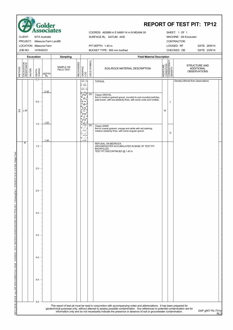


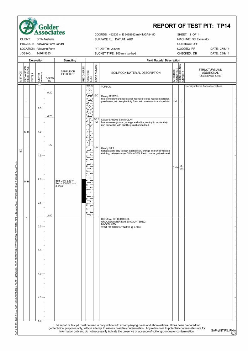


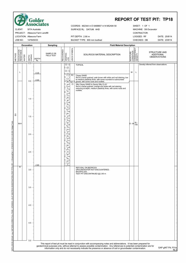


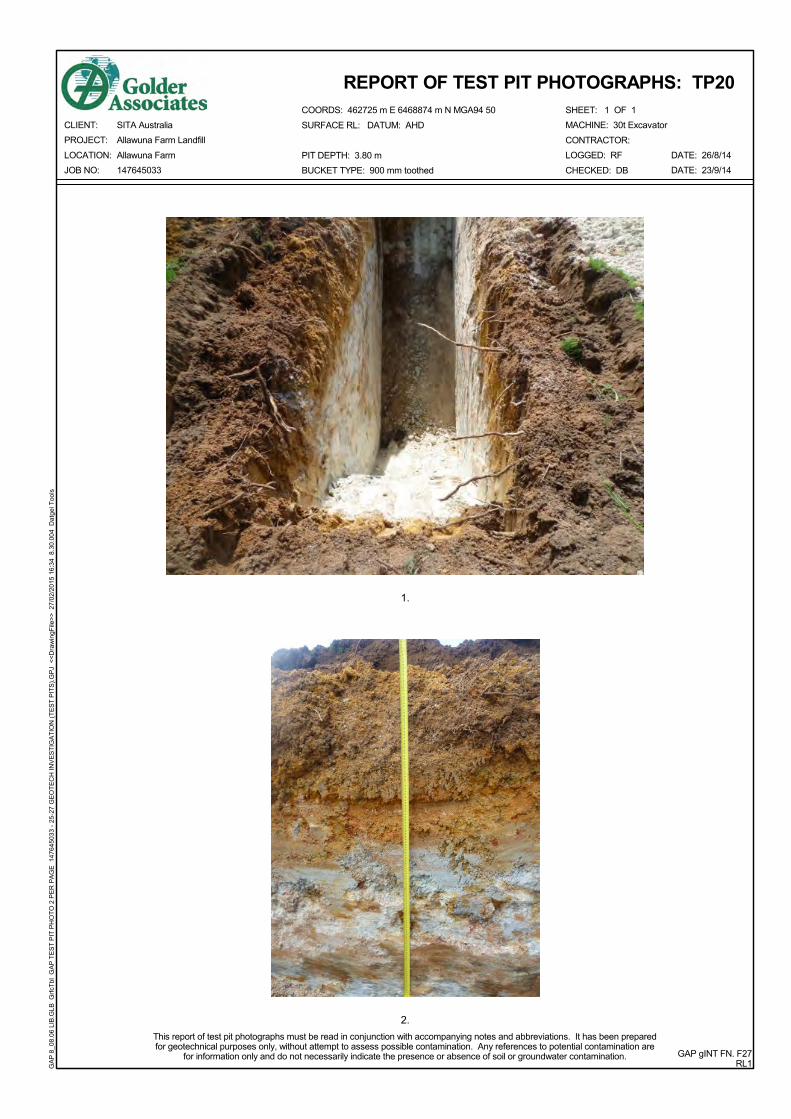


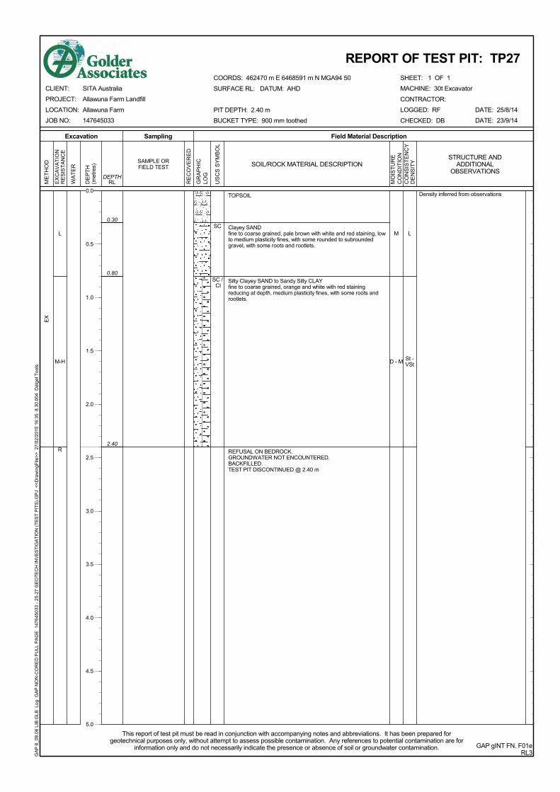


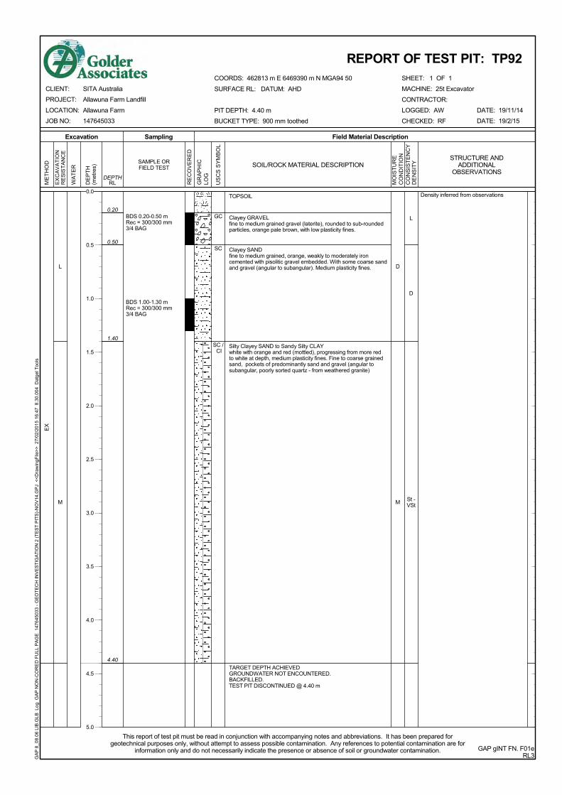


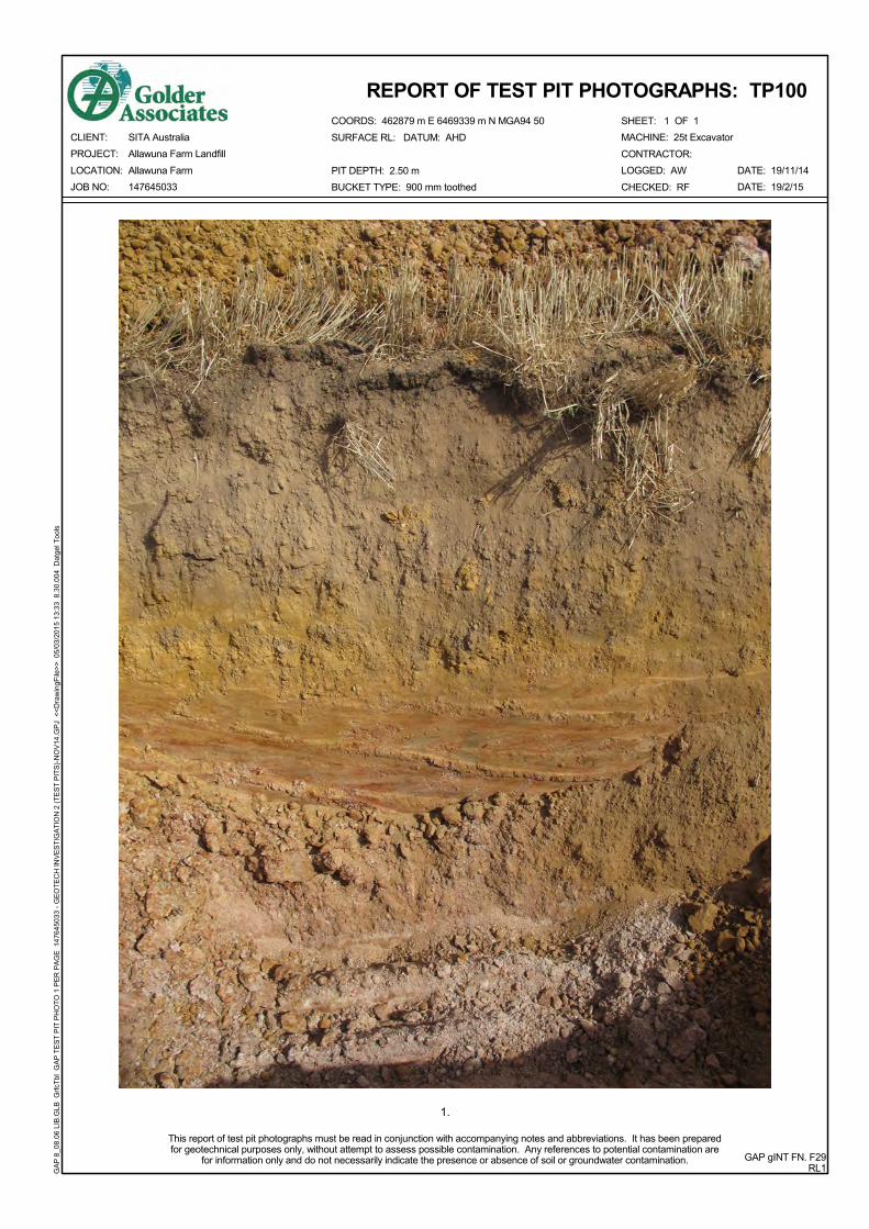


![Railroad Corridor & Barrow Pit/Wetland - nps.gov chapter3-8_BPW... · Railroad Corridor & Barrow Pit/Wetland [Existing conditions inventory maps and photographs follow this section]](https://static.documents.pub/doc/80x56/5c8b3f2709d3f2d5658d2b13/railroad-corridor-barrow-pitwetland-npsgov-chapter3-8bpw-railroad.jpg)


