100TH CONGRESS 1 I REPT. 100-1053 2d Session HOUSE OF REPRESENTATIVES Part 1 AMENDING THE WILD AND SCENIC RIVERS ACT, AND FOR OTHER PURPOSES OCTOBER 4, 1988.-Ordered to be printed Mr. UDALL, from the Committee on Interior and Insular Affairs, submitted the following REPORT together with ADDITIONAL VIEWS (To accompany H.R. 4164] [Including cost estimate of the Congressional Budget Office] The Committee on Interior and Insular Affairs, to whom was re- ferred the bill (H.R. 4164) to amend the Wild and Scenic Rivers Act, and for other purposes, having considered the same, report fa- vorably thereon with an amendment and recommend that the bill as amended do pass. The amendment is as follows: Page 1, line 3, strike all after the enacting clause and insert in lieu thereof: SECTION 1. SHORT TITLE. This Act may be referred to as the "Mark 0. Hatfield Oregon Wild and Scenic Rivers Act of 1988" SEC. 2. AMENDMENTS TO THE WILD AND SCENIC RIVERS ACT. Section 3(a) of the Wild and Scenic Rivers Act (16 U.S.C. 1274) is amended by adding the following new paragraphs at the end thereof: "(66) BIG MARSH, OREGON.-The 15-mile segment from the northeast quarter of section 15, township 26 south, range 6 east, to its confluence with Crescent Creek in the northeast quarter of section 20, township 24 south, range 7 east; to be adminis- tered by the Secretary of Agriculture as a recreational river. Notwithstanding any other provision of this Act, the Secretary of Agriculture may undertake construc- tion activities to enhance and restore wetland resources associated with Big Marsh Creek. "(67) CHETCO, OREGON.-The 44.5-mile segment from its headwaters to the Sis- kiyou National Forest boundary; to be administered by the Secretary of Agriculture as follows: 29-006
Transcript
100TH CONGRESS 1 I REPT. 100-10532d Session HOUSE OF REPRESENTATIVES Part 1
AMENDING THE WILD AND SCENIC RIVERS ACT, ANDFOR OTHER PURPOSES
OCTOBER 4, 1988.-Ordered to be printed
Mr. UDALL, from the Committee on Interior and Insular Affairs,submitted the following
REPORT
together with
ADDITIONAL VIEWS
(To accompany H.R. 4164]
[Including cost estimate of the Congressional Budget Office]
The Committee on Interior and Insular Affairs, to whom was re-ferred the bill (H.R. 4164) to amend the Wild and Scenic RiversAct, and for other purposes, having considered the same, report fa-vorably thereon with an amendment and recommend that the billas amended do pass.
The amendment is as follows:Page 1, line 3, strike all after the enacting clause and insert in
lieu thereof:SECTION 1. SHORT TITLE.
This Act may be referred to as the "Mark 0. Hatfield Oregon Wild and ScenicRivers Act of 1988"SEC. 2. AMENDMENTS TO THE WILD AND SCENIC RIVERS ACT.
Section 3(a) of the Wild and Scenic Rivers Act (16 U.S.C. 1274) is amended byadding the following new paragraphs at the end thereof:
"(66) BIG MARSH, OREGON.-The 15-mile segment from the northeast quarter of
section 15, township 26 south, range 6 east, to its confluence with Crescent Creek in
the northeast quarter of section 20, township 24 south, range 7 east; to be adminis-
tered by the Secretary of Agriculture as a recreational river. Notwithstanding any
other provision of this Act, the Secretary of Agriculture may undertake construc-tion activities to enhance and restore wetland resources associated with Big Marsh
Creek."(67) CHETCO, OREGON.-The 44.5-mile segment from its headwaters to the Sis-
kiyou National Forest boundary; to be administered by the Secretary of Agricultureas follows:
29-006
"(A) The 25.5-mile segment from its headwaters to Boulder Creek at the Kal-miopsis Wilderness boundary as a wild river.
"(B) The eight-mile segment from Boulder Creek to Steel Bridge as a scenicriver.
"(C) The 11-mile segment from Steel Bridge to the Siskiyou National Forestboundary, one mile below Wilson Creek, as a recreational river.
"(68) CLACKAMAS, OREGON.-The 47-mile segment from Big Springs to Big Cliff; tobe administered by the Secretary of Agriculture as follows:
"(A) The 4-mile segment from Big Springs to the Forest Service Road 4690bridge, as a scenic river.
"(B) The 3.5-mile segment from the Forest Service Road 4690 bridge to thejunction with Oregon State Highway 224, as a recreational river.
"(C) The 10.5-mile segment from Oregon State Highway 224 to the JuneCreek Bridge, as a scenic river.
"(D) The 9-mile segment from the June Creek Bridge to Tar Creek, as a recre-ational river.
"(E) The 5.5-mile segment from Tar Creek to just south of Indian HenryCampground, as a scenic river.
"(F) The 14.5-mile segment just south of Indian Henry Campground to BigCliff, as a recreational river.
"(69) CRESCENT CREEK, OREGON.-The 10-mile segment from the southwest quarterof section 11, township 24 south, range 6 east, to the west section line of section 13,township 24 south, range 7 east; to be administered by the Secretary of Agriculture,as a recreational river.
.(70) CROOKED, OREGON.-The 17.3-mile segment from the National Grasslandboundary to Dry Creek; to be administered by the Secretary of the Interior as fol-lows:
"(A) The 9.3-mile segment from the National Grassland boundary to LakeBilly Chinook, one mile west of Highway 97, as a recreational river.
"(B) The 8-mile segment from Bowman Dam to Dry Creek as a recreationalriver.
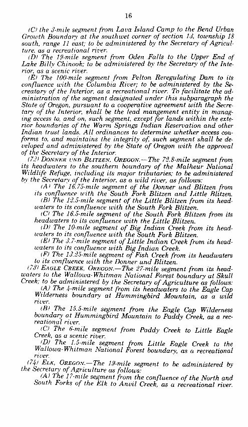
"(71) DESCHUTES, OREGON.-(A) The 40.4-mile segment from Wickiup Dam tonorthern boundary of Sunriver at the southwest quarter of section 20, township 19south, range 11 east; to be administered by the Secretary of Agriculture, as arecreational river.
"(B) The 11-mile segment from the northern boundary of Sunriver at thesouthwest quarter of section 20, township 19 south, range 11 east, to Lava IslandCamp; to be administered by the Secretary of agriculture as a scenic river.
"(C) The 3-mile segment from Lava Island Camp to the Bend Urban GrowthBoundary at the southwest corner of section 13, township 18 south, range 11 east;to be administered by the Secretary of Agriculture, as a recreational river.
"(D) The 19-mile segment from Oden Falls to the Upper End of Lake Billy Chi-nook; to be administered by the Secretary of the Interior, as a scenic river.
"(E) The 100-mile segment from the Pelton Reregulating Dam to its confluencewith the Columbia River; to be administered by the Secretary of the Interior, as arecreational river. To facilitate the administration of the segment designated underthis subparagraph the State of Oregon, pursuant to a cooperative agreement withthe Secretary of the Interior, shall be the lead management entity in managingaccess to, and on, such segment, except for lands within the exterior boundaries ofthe Warm Springs Indian Reservation and other Indian trust lands. All ordinancesto determine whether access conforms to, and maintains the integrity of, such seg-ment shall be developed and administered by the State of Oregon with the approvalof the Secretary of the Interior.
"(72) DONNER UND BUTZEN, OREGON.-The 72.8-mile segment from its headwatersto the southern boundary of the Malheur National Wildlife Refuge, including itsmajor tributaries; to be administered by the Secretary of the Interior, as a wildriver, as follows:
"(A) The 16.75-mile segment of the Donner und Blitzen from its confluencewith the South Fork Blitzen and Little Blitzen.
"(B) The 12.5-mile segment of the Little Blitzen from its headwaters to itsconfluence with the South Fork Blitzen.
"(C) The 16.5-mile segment of the South Fork Blitzen from its headwaters toits confluence with the Little Blitzen.
"(D) The 10-mile segment of Big Indian Creek from its headwaters to its con-fluence with the South Fork Blitzen."(E) The 3 7-mile segment of Little Indian Creek from its headwaters to its
confluence with Big Indian Creek.
3"(F) The 13 .2 5-mile segment of Fish Creek from its headwaters to its conflu-
ence with the Donner und Blitzen."(73) EAGLE CREEK, OREGON.-The 27-mile segment from its headwaters to the
Wallowa-Whitman National Forest boundary at Skull Creek; to be administered bythe Secretary of Agriculture as follows:
"(A) The 4-mile segment from its headwaters to the Eagle Cap Wildernessboundary at Hummingbird Mountain, as a wild river.
"(B) The 15.5-mile segment from the Eagle Cap Wilderness boundary at Hum-mingbird Mountain to Paddy Creek, as a recreational river.
"(C) The 6-mile segment from Paddy Creek to Little Eagle Creek, as a scenicriver.
"(D) The 1.5-mile segment from Little Eagle Creek to the Wallowa-WhitmanNational Forest boundary, as a recreational river.
"(74) ELK, OREGON.-The 19-mile segment to be administered by the Secretary ofAgriculture as follows:
"(A) The 17-mile segment from the confluence of the North and South Forksof the Elk to Anvil Creek, as a recreational river.
"(B) The 2-mile segment of the North Fork Elk from the falls to its confluencewith the South Fork, as a wild river.
"(75) GRANDE RONDE, OREGON.-The 43.8-mile segment from its confluence withthe Wallowa River to the Oregon-Washington State line; to be administered as fol-lows:
"(A) The 1.5-mile segment from its confluence with the Wallowa River to theUmatilla National Forest boundary in section 11, township 3 north, range 40east to be administered by the Secretary of Agriculture, as a recreational river.
"(B) The 17.4-mile segment from the Umatilla National Forest boundary insection 11, township 3 north, range 40 east, to the Wallowa-Whitman NationalForest boundary approximately one-half mile east of Grossman Creek; to be ad-ministered by the Secretary of Agriculture, as a wild river.
"(C) The 9-mile segment from the Wallowa-Whitman National Forest bounda-ry approximately one-half mile east of Grossman Creek to Wildcat Creek; to beadministered by the Secretary of the Interior, as a wild river.
"(D) The 15.9-mile segment from Wildcat Creek to the Oregon-WashingtonState line; to be administered by the Secretary of the Interior, as a recreationalriver.
"(76) IMNAHA, OREGON.-The 68-mile segment from its confluence with the Northand South Forks of the Imnaha River to its mouth; to be administered by the Secre-tary of Agriculture as follows:
"(A) The 6-mile segment from its confluence with the North and South Forksof the Imnaha River to Indian Crossing, as a wild river.
"(B) The 58-mile segment from Indian Crossing to Cow Creek, as a recreation-al river.
"(C) The 4-mile segment from Cow Creek to its mouth, as a scenic river"(77) JOHN DAY, OREGON.-The 147.5-mile segment from Service Creek to Tum-
water; to be administered by the Secretary of the Interior as a recreational river."(78) JOSEPH CREEK, OREGON.-The 8.6-mile segment from Joseph Creek Ranch,
one mile downstream from Cougar Creek, to the Wallowa-Whitman National Forestboundary; to be administered by the Secretary of Agriculture, as a wild river.
"(79) LITTLE DESCHUTES, OREGON.-The 12-mile segment from its source in thenortheast quarter of section 15, township 26 south, range 6.5 east, to the north sec-tion line of section 12, township 26 south, range 7 east; to be administered by theSecretary of Agriculture, as a recreational river.
"(80) LoSTINE, OREGON.-The 16-mile segment from its headwaters to theWallowa-Whitman National Forest boundary; to be administered by the Secretaryof Agriculture as follows:
"(A) The 5-mile segment from its headwaters to the Eagle Cap Wildernessboundary, as a wild river.
"(B) The 11-mile segment from the Eagle Cap Wilderness boundary to theWallowa-Whitman National Forest boundary at Silver Creek, as a recreationalriver.
"(81) MALHEUR, OREGON.-The 5.5-mile segment from Malheur Ford south to theMalheur National Forest boundary at the west section line of section 15, township18 south, range 35 east; to be administered by the Secretary of Agriculture, as awild river.
"(82) MCKENZIE, OREGON.-The 13.3-mile segment from Clear Lake to Scott Creek;to be administered by the Secretary of Agriculture, as a recreational river as fol-lows:
"(A) The 4.5-mile segment from Clear Lake to Tamolitch Falls."(B) The 2.2-mile segment from Tamolitch Falls to the maximum pool at Trail
Bridge Reservoir."(C) The 6.6-mile segment from the base of the developments at Trail Bridge
Reservoir to Scott Creek."(83) METOuIUS, OREGON.-The 28.6-mile segment from the south Deschutes Na-
tional Forest boundary to Lake Billy Chinook, to be administered as follows:"(A) The 11.5-mile segment from the south Deschutes National Forest bounda-
ry (approximately 2,055.5 feet from Metolius Springs) to Bridge 99; to be admin-istered by the Secretary of Agriculture as a recreational river.
"(B) The 17.1-mile segment from Bridge 99 to Lake Billy Chinook; to be ad-ministered as a scenic river under a cooperative management agreement be-tween the Secretary of the Interior and Agriculture, respectively, and the Con-federated Tribes of the Warm Springs Reservation.
"(84) MINAM, OREGON.-The 39-mile segment from its headwaters at the southend of Minam Lake to the Eagle Cap Wilderness boundary, one-half mile down-stream from Cougar Creek; to be administered by the Secretary of Agriculture, as awild river.
"(85) NORTH FORK CROOKED, OREGON.-The 32.3-mile segment from its source atWilliams Prairie to one mile from its confluence with the Crooked River; to be ad-ministered as follows:
"(A) The 3-mile segment from its source at Williams Prairie to the Upper Endof Big Summit Prairie; to be administered by the Secretary of Agriculture as arecreational river.
"(B) The 3.7-mile segment from the Lower End of Big Summit Prairie to thebridge across from the Deep Creek Campground; to be administered by the Sec-retary of Agriculture as a recreational river.
"(C) The 8-mile segment from the bridge across from the Deep Creek Camp-ground to the Ochoco National Forest boundary, one-half mile from Lame DogCreek; to be administered by the Secretary of Agriculture as a scenic river.
"(D) The 1.5-mile segment from the Ochoco National Forest boundary toUpper Falls; to be administered by the Secretary of the Interior as a scenicriver.
-(E) The 11.1-mile segment from Upper Falls to Committee Creek; to be ad-ministered by the Secretary of Agriculture as a wild river.
"(F) the 5-mile segment from Committee Creek to one mile from its conflu-ence with the Crooked River; to be administered by the Secretary of the Interi-or as a recreational river.
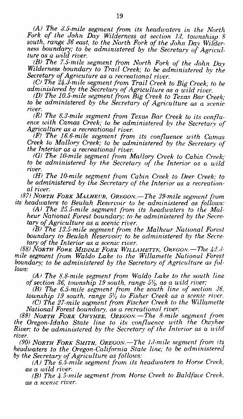
"(86) NORTH FORK JOHN DAY, OREGON.-The 90.7-mile segment from its headwa-ters in the North Fork of the John Day Wilderness Area at section 13, township 8south, range 36 east, to its confluence with the John Day River to be administeredas follows:
"(A) The 3.5-mile segment from its headwaters in the North Fork of the JohnDay Wilderness at section 13, township 8 south, range 36 east, to the NorthFork of the John Day Wilderness boundary; to be administered by the Secretaryof Agriculture as a wild river.
"(B) The 7.5-mile segment from the North Fork of the John Day Wildernessboundary to Trail Creek; to be administered by the Secretary of Agriculture asa recreational river.
"(C) The 24.3-mile segment from Trail Creek to Big Creek; to be administeredby the Secretary of Agriculture as a wild river.
"(D) The 10.5-mile segment from Big Creek to Texas Bar Creek; to be adminis-tered by the Secretary of Agriculture as a scenic river.
"(E) The 8.3-mile segment from Texas Bar Creek to its confluence with CamasCreek; to be administered by the Secretary of Agriculture as a recreationalriver.
"(F) The 16.6-mile segment from its confluence with Camas Creek to MalloryCreek; to be administered by the Secretary of the Interior as a recreationalriver.
"(G) The 10-mile segment from Mallory Creek to Cabin Creek; to be adminis-tered by the Secretary of the Interior as a wild river.
"(H) The 10-mile segment from Cabin Creek to Deer Creek; to be adminis-tered by the Secretary of the Interior as a recreational river.
"(87) NORTH FORK MALHEUR, OREGON.-The 39-mile segment from its headwatersto Beulah Reservoir to be administered as follows:
"(A) The 25.5-mile segment from its headwaters to the Malheur NationalForest boundary; to be administered by the Secretary of Agriculture as a scenicriver.
"(B) The 13.5-mile segment from the Malheur National Forest boundary toBeulah Reservoir; to be administered by the Secretary of the Interior as ascenic river.
"(88) NORTH FORK MIDDLE FORK WILLAMETTE, OREGON.-The 4 2 .3-mile segmentfrom Waldo Lake to the Willamette National Forest boundary; to be administeredby the Secretary of Agriculture as follows:
"(A) The 8.8-mile segment from Waldo Lake to the south line of section 36,township 19 south, range 51/2, as a wild river;
"(B) The 6.5-mile segment from the south line of section 36, township 19south, range 51/2 to Fisher Creek as a scenic river.
"(C) The 2 7-mile segment from Fischer Creek to the Willamette NationalForest boundary, as a recreational river."(89) NORTH FORK OWYHEE, OREGON.-The 8-mile segment from the Oregon-Idaho
State line to its confluence with the Owyhee River; to be administered by the Secre-tary of the Interior as a wild river.
"(90) NORTH FORK SMITH, OREGON.-The 13 -mile segment from its headwaters tothe Oregon-California State line; to be administered by the Secretary of Agricultureas follows:
"(A) The 6.5-mile segment from its headwaters to Horse Creek, as a wildriver.
"(B) The 4.5-mile segment from Horse Creek to Baldface Creek, as a scenicriver.
"(C) The 2-mile segment from Baldface Creek to the Oregon-California Stateline, as a wild river.
"(91) NORTH FORK SPRAGUE, OREGON.-The 15-mile segment from the head ofRiver Spring in the southwest quarter of section 15, township 35 south, range 16east, to the northwest quarter of the southwest quarter of section 11, township 35south, range 15 east; to be administered by the Secretary of Agriculture as a scenicriver.
"(92) NORTH POWDER, OREGON.-The 6-mile segment from its headwaters to theWallowa-Whitman National Forest boundary at River Mile 21; to be administeredby the Secretary of Agriculture as a scenic river.
"(93) NORTH UMPQUA, OREGON.-The 33.8-mile segment from the Soda SpringsPowerhouse to Rock Creek to be administered as follows:
"(A) The 2 5.4-mile segment from the Soda Springs Powerhouse to theUmpqua National Forest boundary; to be administered by the Secretary of Agri-culture as a recreational river.
"(B) The 8.4 mile segment from the Umpqua National Forest boundary to itsconfluence with Rock Creek; to be administered by the Secretary of the Interioras a recreational river.
"(94) POWDER, OREGON.-The 11.7 mile segment from Thief Valley Dam to theHighway 213 bridge; to be administered by the Secretary of the Interior as a scenicriver.
"(95) QUARTZVILLE CREEK, OREGON.-The 12-mile segment from the WillametteNational Forest boundary to Slack Water in Green Peter Reservoir; to be adminis-tered by the Secretary of the Interior as a recreational river.
"(96) ROARING, OREGON.-The 13.7-mile segment from its headwaters to its conflu-ence with the Clackamas River; to be administered by the Secretary of Agricultureas follows:
"(A) The 13.5 mile segment from its headwaters to one-quarter mile upstreamof the mouth, as a wild river.
"(B) The 0.2 mile segment from one-quarter mile upstream of the mouth to itsconfluence with the Clackamas River, as a recreational river.
"(97) SALMON, OREGON.-The 33.5-mile segment from its headwaters to its conflu-ence with the Sandy River to be administered as follows:
"(A) The half-mile segment from its headwaters to one-half mile downstream;to be administered by the Secretary of Agriculture as a recreational river. Inestablishing detailed boundaries under subsection (b) of this section, the Secre-tary shall exclude from such boundaries the Timberline Lodge Winter SportsArea.
"(B) The 6.25-mile segment from one-half mile from the headwaters to thesouth boundary line at section 6; to be administered by the Secretary of Agricul-ture as a scenic river.
"(C) The 15-mile segment from the boundary line at section 6 to the junctionwith the south fork of the Salmon River; to be administered by the Secretary ofAgriculture as a wild river.
"(D) The 3.5-mile segment from the junction with the south fork of theSalmon River to the Mt. Hood National Forest boundary; to be administered bythe Secretary of Agriculture as a recreational river.
"(E) The 3.2-mile segment from the Mt. Hood National Forest boundary toLymp Creek; to be administered by the Secretary of the Interior as a recreation-al river.
"(F) The 4.8-mile segment from Lymp Creek to its confluence with the SandyRiver; to be administered by the Secretary of the Interior as a scenic river.
"(98) SANDY, OREGON.-The 24.9 miles in 2 segments from its headwaters to thewest line of the east half of the northeast quarter of section 6, township 1 south,range 4 east at Dabney State Park to be administered by the Secretary of Agricul-ture as follows:
"(A) The 4.5-mile segment from its headwaters to the section line between sec-tions 15 and 22, township 2 south, range 8 east, as a wild river.
"(B) The 7.9-mile segment from the section line between sections 15 and 22,township 2 south, range 8 east to the Mt. Hood National Forest boundary, as arecreational river.
"(C) The 12.5-mile segment from the east boundary of sections 25 and 36,township 1 south, range 4 east in Clackamas County near Dodge Park, down-stream to the west line of the east half of the northeast quarter of section 6,township 1 south, range 4 east, in Multnomah County at Dabney State Park,the upper 3.8 miles as a scenic river and the lower 8.7 miles, as a recreationalriver. The Secretary of Agriculture shall administer the segment designatedunder this subparagraph through a cooperative management agreement withthe Governor of Oregon and the counties of Multnomah and Clackamas in ac-cordance with section 10(e) of this Act.
"(99) SOUTH FORK IMNAHA, OREGON.-The 9-mile segment from its headwaters tothe confluence with the Imnaha River; to be administered by the Secretary of Agri-culture as a wild river.
"(100) SOUTH FORK JOHN DAY, OREGON.-The 48-mile segment from the MalheurNational Forest to its confluence with the John Day River; to be administered bythe Secretary of the Interior as a recreational river.
"(101) SQUAW CREEK, OREGON.-The 15.4-mile segment from its source to the hy-drologic gaging station 800 feet upstream from the intake to the McAllister ditch tobe administered by the Secretary of Agriculture as follows:"(A) The 6.6-mile segment from the source to the Three Sisters Wilderness
boundary, as a wild river."(B) The Soap Fork Squaw Creek from its source to its confluence with Squaw
Creek, as a wild river."(C) The North Fork from its headwaters to Squaw Creek, as a wild river."(D) The South Fork from its headwaters to Squaw Creek, as a wild river."(E) The Park Creek Fork from its headwaters to Squaw Creek, as a wild
river."(F) The 8.8-mile segment from the boundary of the Three Sisters Wilderness
Area to the hydrologic gaging station 800 feet upstream from the intake of theMcAllister ditch, as a scenic river.
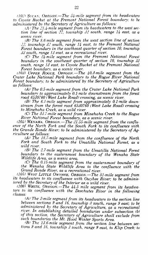
"(102) SYCAN, OREGON.-The 54-mile segment from its headwaters to CoyoteBucket at the Fremont National Forest boundary; to be administered by the Secre-tary of Agriculture as follows:
"(A) The 21.4-mile segment from its headwaters to the west section line of sec-tion 22, township 32 south, range 14 east, as a scenic river.
"(B) The 8.6-mile segment from the west section line of section 22, township32 south, range 14 east, to the Fremont National Forest boundary in the south-east quarter of section 10, township 33 south, range 13 east, as a recreationalriver.
"(C) The 24-mile segment from the Fremont National Forest boundary in thesoutheast quarter of section 10, township 33 south, range 13 east, to CoyoteBucket at the Fremont National Forest boundary, as a scenic river.
"(103) UPPER ROGUE, OREGON.-The 40.3-mile segment from the Crater Lake Na-tional Park boundary to the Rogue River National Forest boundary; to be adminis-tered by the Secretary of Agriculture as follows:
"(A) The 0.5-mile segment from the Crater Lake National Park boundary toapproximately 0.1-mile downstream from the forest road 6530760 (West LakeRoad) crossing, as a scenic river.
"(B) The 6.1-mile segment from approximately 0.1-mile downstream from theforest road 6530760 (West Lake Road) crossing to Minehaha Creek, as a wildriver.
"(C) The 3 3.7-mile segment from Minehaha Creek to the Rogue River Nation-al Forest boundary, as a scenic river.
"(104) WENAHA, OREGON.-The 21.55-mile segment from the confluence of theNorth Fork and the South Fork to its confluence with the Grande Ronde River; tobe administered by the Secretary of Agriculture as follows:
"(A) The 18.7-mile segment from the confluence of the North Fork and SouthFork to the Umatilla National Forest, as a wild river.
"(B) The 2.7-mile segment from the Umatilla National Forest boundary to theeasternmost boundary of the Wenaha State Wildlife Area, as a scenic area.
"(C) The 0.15-mile segment from the easternmost boundary of the WenahaState Wildlife Area to the confluence with the Grand Ronde River, as a recre-ational river.
"(105) WEST LITTLE OWYHEE, OREGON.-The 51-mile segment from its headwatersto its confluence with Owyhee River; to be administered by the Secretary of the In-terior as a wild river.
"(106) WHITE, OREGON.-The 44.5 mile segment from its headwaters to its conflu-ence with the Deschutes River in the following classes:
"(A) The 2-mile segment from its headwaters to the section line between sec-tions 9 and 16, township 3 south, range 9 east; to be administered by the Secre-tary of Agriculture, as a recreational river. In establishing detailed boundariesunder subsection (b) of this section, the Secretary of Agriculture shall excludefrom such boundaries the Mt. Hood Winter Sports Area.
"(B) The 13.6-mile segment from the section line between sections 9 and 16,township 3 south, range 9 east, to Klip Creek; to be administered by the Secre-tary of Agriculture as a recreational river.
"(C) The 6.5-mile segment from Klip Creek to the Mt. Hood National Forestboundary; to be administered by the Secretary of Agriculture as a wild river.
"(D) The 19.2-mile segment from the Mt. Hood National Forest boundary tothe Highway 197 bridge to be administered by the Secretary of the Interior as awild river.
"(E) The 3.6 mile segment from the Highway 197 bridge to River Mile 2.2; tobe administered by the Secretary of the Interior as a recreational river.
"(F) The 1.6 mile segment from River Mile 1.6 to its confluence with the Des-chutes River; to be administered by the Secretary of the Interior as a recre-ational area."
SEC. 3. WILD AND SCENIC RIVER STUDIES.
Section 5(a) of the Wild and Scenic Rivers Act (16 U.S.C. 1276), is amended byadding the following new paragraphs at the end thereof:
"(100) BLUE, OREGON.-The segment from its headwaters to the Blue River Reser-voir.
"(101) CHEWAUCAN, OREGON.-The segment from its headwaters to the PaisleyUrban Growth boundary to be studied in cooperation with the basin planning proc-ess currently underway.
"(102) PINE CREEK, OREGON.-All its tributaries and mainstem, including from itsheadwaters to the bridge over Pine Creek at Carson and the segment from the head-waters of North Pine Creek to its confluence with Pine Creek and from the conflu-ence with Pine Creek to its mouth.
"(103) SOUTH FORK McKENZIE, OREGON.-The segments from its headwaters to theupper end of Cougar Reservoir and from the lower end of Cougar Reservoir to itsconfluence with the McKenzie River.
"(104) STEAMBOAT CREEK, OREGON.-The entire creek."(105) UPPER KLAMATH, OREGON.-The segment from immediately below John
Boyle Dam to the Oregon-California State line."(106) WALLOWA, OREGON.-The segment from its confluence with the Minam
River to its confluence with the Grande Ronde River."(107) JOHN DAY, OREGON.-(A) The segment of the North Fork John Day from
Deer Creek approximately one mile upstream from Monument to its confluenice
with the mainstem of the John Day River at Kimberly."(B) The segment of the South Fork John Day from Smokey Creek to the mouth.
"(C) The 9-mile segment from its headwaters at section 28, township 15 south,
range 35 east to Blue Mountains Hot Springs."(D) The segment of the mainstem John Day from Blue Mountains Hot Springs to
Cottonwood Creek.
"(E) The 5.7-mile segment from Cottonwood Creek to Goose Rock."(F) The segment of the mainstem John Day from Goose Rock to Service Creek."(108) JOSEPH CREEK, OREGON.-The segment from the Crow Creek Bridge to
Joseph Creek Ranch, one mile downstream from Cougar Creek."(109) WILLIAMSON, OREGON.-The segment from the west Winema National
Forest boundary to its mouth."
SEC. I. INDIAN TREATY LANDS.
Where Indian treaty lands exist in association with lands included in the Nation-al Wild and Scenic Rivers System under this Act, the Secretaries of the Interior andAgriculture, as appropriate, shall fully consult and enter into written cooperativemanagement agreements with the affected Indian tribe for planning, administra-tion, and management of such areas.
SEC. 5. ADMINISTRATIVE PROVISIONS.
Nothing in this Act shall affect any of the following:1) The jurisdiction of responsibilities of an Indian tribe with respect to fish,
wildlife, land, and water management.(2) Any right, privilege, or immunity of any Indian or Indian tribe afforded
under Federal treaty, agreement, or statute.(3) The water and land claims, present or future, of an Indian tribe.(4) Any amendment to the license for the Pelton Hydroelectric Project (FERC
Project No. 2030), or any relicensing of such project, which does not have adirect and adverse effect on any river segment designated under this Act as acomponent of the national wild and scenic rivers system.
(5) The rights or jurisdiction of Indian tribes over waters or any river orstream within the affected river area or stream, or over any ground water re-sources.
(6) The beneficial ownership interest of land held in trust, now or hereafter,by the United States for Indian tribes or individual Indians.
SE(. 6. CITY OF PORTLAND.
Nothing in this Act shall preclude or impair the licensing, development, oper-ation, or maintenance of city of Portland, Oregon, water resources facilities on thoseportions of the Bull Run or Little Sandy Rivers that are outside the boundary of thewild and scenic river area as designated in this Act. Nothing in this Act is intendedor shall be construed to affect any rights, obligations, privileges, or benefits grantedto the city of Portland, Oregon, under any prior authority of law or under anyagreement or administrative ruling entered into or made effective before the effec-tive date of this Act.
PURPOSE
The purpose of H.R. 4164 1 is to amend the National Wild andScenic Rivers Act to designate certain river segments as wild andscenic and to provide for the study of other river segments for pos-sible wild and scenic designation within the State of Oregon.
BACKGROUND
There are over 35,000 miles of rivers and streams within theState of Oregon. The 1982 Nationwide Rivers Inventory and forestmanagement plans prepared by the U.S. Forest Service have identi-fied many river segments within the state as containing significantscenic, recreational, cultural, geological and fisheries resources.Currently, segments of four Oregon rivers (Snake, Lower Rogue,Lower Illinois and Owyhee) totaling 317 miles have been designat-ed national wild and scenic rivers. Segments of three rivers (NorthUmpqua, Snake, and Lower John Day) totaling 185 miles have
H R 4164 was introduced by Representative DeFazio for himself and Mr. AuCoin and Mr.Wyden on March 16, 1988. A similar bill H.R 4259 was introduced by Representative DennySmith on March 25, 1988.
been formally designated for study as potential components of thenational wild and scenic rivers system.
The State of Oregon administers a Scenic Waterways program,established in 1970. The program protects segments of 11 rivers to-taling 656 miles, which includes portions of 3 national wild andscenic rivers.
The U.S. Forest Service and the Bureau of Land Managementhave been studying rivers within the state as part of their landmanagement planning processes, in fulfillment of the provisions ofSec. 5(d) of the Wild and Scenic Rivers Act which has formed abasis for a statewide wild and scenic rivers bill.
SECTION-BY-SECTION ANALYSIS
Section 1. Provides that this Act may be referred to as the "Mark0. Hatfield Oregon Wild and Scenic Rivers Act of 1988"
Section 2. Amends Section 3(a) of the Wild and Scenic Rivers Act(16 U.S.C. 1274) to add segments of 41 rivers in the State of Oregonas components of the national wild and scenic rivers system. TheCommittee has found these river segments to have the outstanding-ly remarkable qualities required by the Act for designation. In ad-dition 10 segments are designated for study as possible wild andscenic river additions.
The Committee has provided for management of these river seg-ments pursuant to the policies and practices set forth in the Wildand Scenic Rivers Act. The Committee recognizes that a variety ofuses including, but not limited to, such activities as grazing, timberharvest, mining, agriculture, utility, transportation and residentialuses will continue to take place on private and public lands withinthe wild and scenic river corridors. It is the Committee's intentionthat all such activities be allowed to continue, insofar as they donot conflict with the policies and purposes of the Wild and ScenicRivers Act.
The Committee has been concerned with some of the informationthat has been disseminated regarding management of lands andwater within and around a designated river corridor. The Commit-tee would strongly note that the Forest Service in testimony beforethe Committee stated that:
To the extent authorized by law, the Forest Service hasbeen protecting the outstanding remarkable features ofeach eligible river so as to not jeopardize eventual designa-tion. Special standards guide decisions related to timbermanagement, dam construction, hydroelectric develop-ment, mining, road construction, recreation development,and other activities. These same standards would guide thedevelopment of a specific plan for any river that is eventu-ally designated. As a result, designation would have littleeffect on day-to-day management of the river corridor.
These standards do not preclude timber harvest outsidethe corridor of potential wild rivers providing it is done ina visually sensitive manner. Timber management is alsoallowed within the corridor of potential scenic or recre-ational rivers if designed to protect the outstanding valuesassociated with the river. These same standards have been
in effect since the rivers were placed on the NationwideRivers Inventory, and they would be the basis for develop-ment of a management plan for any river that is designat-ed. Therefore, designation would have very little effect ontimber harvest.
Furthermore, the Committee notes that with regard to condem-nation of private lands and interests under authority of the Wildand Scenic Rivers Act, the Forest Service testified that it had neverused its authority to condemn private lands in Oregon and hadrarely used it elsewhere in the country. The Forest Service statedit had used its condemnation authority to acquire scenic easementsin Oregon, but even that was of a very limited nature. The Com-mittee recognizes that condemnation should only be used after allother attempts to resolve the problem have failed.
The Committee would further note that designation of a wild andscenic river segment, by itself, will not automatically result in ad-ditional restrictions on activities adjacent to a designated segment.The administering federal agencies already have land managementpolicies that take into account wild and scenic river designations inthe management of adjacent lands.
The Committee understands that the U.S. Forest Service, theBureau of Land Management and the State of Oregon have enteredinto Memorandums of Understanding to assist compliance with theState's water quality standards. The Committee notes that Mem-bers of the Oregon delegation recently consulted with the State onthe impact of this policy both on and upstream of designated wildand scenic rivers. Copies of the correspondence have been madepart of the hearing record. The Committee concurs in the existingpolicy of cooperation between federal and state agencies to protectthe water quality values of rivers and streams within the State andcommends the State for its leadership on this matter.
On the 100 mile segment of the Deschutes River described in sub-paragraph (71)(E), it is the Committee's intent that the Secretaryshall fully consult and enter into cooperative management agree-ments, pursuant to Section 10(e) of the Wild and Scenic Rivers Act,with the State of Oregon and the Confederated Tribes of WarmSprings. The Committee notes that the State of Oregon designatedthis segment as a component of the State Scenic Waterways Pro-gram in 1970. Except for lands within the boundaries of the WarmSprings Indian Reservation, the legislation provides that the Stateof Oregon shall be the lead management entity on this segment ofthe Deschutes River. As amended, H.R. 4164 provides that the Con-federated Tribes of Warm Springs shall, similarly, be the lead man-agement entity on all lands within the boundaries of the WarmSprings Reservation that border upon this segment.
It is the Committee's intent and expection that with regard tothe segments of the Elk River designated by paragraph (74) of thisAct the Secretary shall employ management practices upstream ofthe designated segments that protect the fish habitat and waterquality values of the designated segments.
The Committee notes that the segment of the John Day Riverdesignated by paragraph (77) of this Act is a State Scenic Water-way. It is the intent of the Committee that the Secretary consult
and enter into a cooperative agreement, pursuant to Section 10(e)of the Wild and Scenic Rivers Act, with the State for this section ofthe John Day.
For the 13.3 mile segment of the McKenzie River designated byparagraph (82) the Committee expects the Secretary in establishingdetailed boundaries under Section 3(b) of the Wild and ScenicRivers Act to exclude from the designated segments any develop-ments that are unsuitable for inclusion in the national wild andscenic rivers system.
On the Metolius River designated under paragraph (83) the billexempted the approximately 157 acres of land from the MetoliusSprings to the National Forest boundary from designation. Exclu-sion of this private property from federal designation is an ac-knowledgement of the unique public/private partnership that hasbeen developed to manage this extremely fragile and vulnerableenvironment.
In establishing detailed boundaries under section 3(b) of the Wildand Scenic Rivers Act for those segments of the Salmon and WhiteRivers designated by paragraphs (97) and (106) H.R. 4164, asamended, provides that the Secretary shall exclude the TimberlineLodge and Mt. Hood Winter Sports Areas. The general area aroundthe Upper Salmon and White Rivers incorporates much of the Tim-berline Lodge/Mt. Hood Meadows Winter Recreation Area. Thisarea is a longtime winter recreation area for hundreds of thou-sands of visitors annually. Among other considerations, the area iscurrently being promoted as a possible site for the 1998 WinterOlympic Games. Wild and scenic designation for this river is ex-pected to complement, and not interfer with, that effort. The Com-mittee understands that designation and classification does notnecessarily preclude the Secretary from exercising discretion to ap-prove construction, operation, and maintenance of ski lifts, skiruns, and associated facilities for the land comprising the Timber-line Lodge/Mt. Hood Meadows Winter Recreation Area outside thedesignated river corridor boundaries insofar as such constructiondoes not involve water resource projects and is consistent with pro-tecting the values for which these river segments are designated.
For the 15.4 mile segment of Squaw Creek designated by para-graph (101) the Secretary may undertake activities, consistent withthe provisions of the Wild and Scenic Rivers Act, to provide protec-tion for the town of Sisters from a rapid discharge of Carver Lake.
Section 3. This Section amends Section 5(a) of the Wild andScenic Rivers Act to provide for studies of 10 river segments in theState of Oregon for possible inclusion in the national wild andscenic rivers system.
While many of these study rivers are thought to possess the nec-essary outstandingly remarkable qualities, there is a lack of infor-mation about them that makes further study advisable. Such stud-ies shall be carried out as provided in Section 4(a) of the Wild andScenic Rivers Act. The studies will provide the Congress and thepublic with a comprehensive assessment of resource values, land-ownership and uses, and management options. The Committeewould note that such studies in no way deprive private landownersof the beneficial use of their lands during the period of study.
In the Act adding the Illinois and Owyhee Rivers to the Wild andScenic Rivers System in 1984, the Secretary of Agriculture was di-rected to "preserve, protect, and enhance" the anadromous fish re-source in Steamboat Creek. Since 1984, the Umpqua NationalForest has made a strong effort to meet that management guid-ance.
However, it should be noted that, despite these efforts, summer-time water temperature in Steamboat Creek commonly reaches 75degrees Fahrenheit, which is approximately 17 degrees higher thanfisheries biologists recommend for sound anadromous fisheries.Therefore, Steamboat Creek has been designated a study river todetermine whether wild and scenic status would offer managementtools to better protect this important value. The Committee intendsthat the Forest Service shall continue its efforts to enhance thefisheries in Steamboat Creek, with an emphasis on protecting andenhancing temperature and turbidity levels in Steamboat Creek.
In addition, the Committee expects the Forest Service and theBureau of Land Management to protect and enhance the fisheriesand water quality of the tributaries of Steamboat Creek, includingCanton Creek, to optimize fish production. Those efforts should in-clude, where necessary, increased law enforcement activities.
As amended, H.R. 4164 provides for a study of the Upper Klam-ath River, rather than designation as was originally proposed. TheCommittee believes this is a reasonable compromise to the contro-versies that have surrounded the river's possible designation. Asprovided in Section 4(a) of the Wild and Scenic Rivers Act, thestudy will provide the Congress with a comprehensive assessmentof the river and its nearby environs.
The Committee would note that nothing in the Wild and ScenicRivers Act prohibits or prevents a federal agency from carryingforth any studies or proceedings short of licensure. The Committeebelieves that no irrevocable decisions should be made before theCongress has the opportunity to pass judgement on the advisabilityor inadvisability of Wild and Scenic designation for this river.
Section 4. This section provides that for those river segmentsthat contain Indian treaty lands, the appropriate Secretary willconsult and enter into cooperative management agreement withthe affected Indian tribe for planning, administration, and manage-ment of such areas.
The Committee encourages Indian participation and leadershipin river management on Indian lands. The Committee does notwish to usurp tribal authority, but rather has provided a tool fortribes to protect and use the significant river resources foundwithin their lands.
Section 5. This section contains administrative provisions protect-ing the legitimate legal rights of an Indian tribe to land or waterswithin a designated river corridor.
The Committee does not wish to impinge on tribal rights. TheCommittee expects wild and scenic designation to compliment atribe's legal management and use of land and waters within a des-ignated area.
Section 6. Provides that nothing in this Act shall preclude orimpair the licensing, development or maintenance of water re-source facilities of the City of Portland on these portions of the
kethomas
Highlight
Bull Run or Little Sandy Rivers outside the wild and scenic riverboundaries. The section further provides that the Act is not intend-ed to affect whatever legal rights, obligations, privileges or benefitsthe City of Portland may have had previous to the date of enact-ment of this Act.
The Committee understands the State of Oregon has the powerand responsibility to maintain reasonable minimum stream flowsand water quality standards on the segments referenced in this sec-tion. The Committee is also aware that a 12.5 mile segment of theSandy River designated by this Act is part of the State's scenic wa-terway system. The State has withdrawn the waters of the twotributaries named in this section from appropriation by anyoneexcept the City of Portland. The Oregon Supreme Court has recent-ly ruled, in Diack v. City of Portland, 306 Or. 287 (1988), that wherethe state has the power, it must restrict diversions from the tribu-taries to protect the recreation, fish, and wildlife use of the scenicwaterway. The case makes clear that the State has the power torestrict diversions on these tributaries. The Committee is confidentthat the public trust doctrine reserves to the State sufficient powerto restrict any diversion that threatens those portions of the SandyRiver designated by this Act.
LEGISLATIVE HISTORY AND COMMITTEE RECOMMENDATION
A hearing was held by the Subcommittee on National Parks andPublic Lands on H.R. 4164 on September 13, 1988. The Subcommit-tee was discharged from further consideration and the bill was con-sidered by the Committee on Interior and Insular Affairs on Sep-tember 22, 1988. The Committee considered an amendment in thenature of a substitute offered by Mr. Vento and adopted threeamendments to the substitute offered by Mr. Denny Smith. TheCommittee adopted the amendment and ordered H.R. 4164, asamended, favorably reported to the House on September 22, 1988by voice vote.
INFLATIONARY IMPACT STATEMENT AND BUDGET ACT COMPLIANCE
Taken in the context of the overall budget, the funding involvedis insignificant and the Committee believes no inflationary impactwill result from the enactment of this legislation. The analysis ofthe Congressional Budget Office, which the Committee adopts as itsown, follows:
U.S. CONGRESS,
CONGRESSIONAL BUDGET OFFICE,
Washington, DC, September 30. 1988.Hon. MORRIS K. UDALL,Chairman, Committee on Interior and Insular Affairs,House of Representatives, Washington, DC.
DEAR MR. CHAIRMAN: The Congressional Budget Office has re-viewed H.R. 4164, the Mark 0. Hatfield Oregon Wild and ScenicRivers Act of 1988, as ordered reported by the House Committee on
Interior and Insular Affairs on September 22, 1988. We estimatethat enactment of this bill would result in additional costs to the
federal government totaling approximately $11 million over thenext five years, assuming appropriation of the necessary amounts.
H.R. 4164 would add over 1,400 miles of river in Oregon to thewild and scenic river system. The bill would also add 10 river seg-ments in Oregon to the list of rivers to be studied for inclusion inthe wild and scenic river system. Finally, H.R. 4164 would protectcertain rights of Indian tribes and the city of Portland.
Based on information provided by the Department of the Interiorand the Department of Agriculture, CBO estimates that enactmentof this bill would result in additional costs to the federal govern-ment totaling approximately $3 million for river studies and about$8 million for other management, planning, acquisition, and devel-opment activities over the next five years. Of these amounts, about$2 million would be spent in fiscal year 1989, $5 million in 1990,and the remainder over the 1991-1993 period.
Enactment of this bill would not affect the budgets of state orlocal governments.
If you wish further details on this estimate, we will be pleased toprovide them. The CBO staff contact is Theresa Gullo, who can bereached at 226-2860.
Sincerely,JAMES L. BLUM,
Acting Director.
OVERSIGHT STATEMENT
The Committee intends to carefully monitor the implementationof this legislation to assure compliance with the intent of the Act.No recommendations were submitted to the Committee pursuant toRule X, clause 2(b)(2).
DEPARTMENTAL REPORT
The Committee requested reports from the Departments of theInterior and Agriculture on May 24, 1988. No reports were receivedfrom the departments.
CHANGES IN EXISTING LAW MADE BY THE BILL, As REPORTED
In compliance with clause 3 of rule XIII of the Rules of theHouse of Representatives, changes in existing law made by the bill,as reported, are shown as follows (existing law proposed to be omit-ted is enclosed in black brackets, new matter is printed in italic,existing law in which no change is proposed is shown in roman):
WILD AND SCENIC RIVERS ACT** * * * * *
SEC. 3. (a) The following rivers and the land adjacent thereto arehereby designated as components of the national wild and scenicrivers system:
(1) * * ** * * * * * *
(66) BIG MARSH, OREGON.-The 15-mile segment from the north-east quarter of section 15, township 26 south, range 6 east, to its
confluence with Crescent Creek in the northeast quarter of section20, township 24 south, range 7 east; to be administered by the Secre-tary of Agriculture as a recreational river. Notwithstanding anyother provision of this Act, the Secretary of Agriculture may under-take construction activities to enhance and restore wetland resourcesassociated with Big Marsh Creek.
(67) CHETCO, OREGON.-The 44.5-mile segment from its headwa-ters to the Siskiyou National Forest boundary to be administered bythe Secretary of Agriculture as follows:
(A) the 25.5-mile segment from its headwaters to BoulderCreek at the Kalmiopsis Wilderness boundary as a wild river.
(B) The eight-mile segment from Boulder Creek to SteelBridge as a scenic river.
(C) the 11-mile segment from Steel Bridge to the Siskivou Na-tional Forest boundary, one mile below Wilson Creek, as a recre-ational river.
(68) CLACKAMAS, OREGON.-The 47-mile segment from Big Springsto Big Cliff, to be administered by the Secretary of Agriculture asfollows:
(A) The 4-mile segment from Big Springs to the Forest ServiceRoad 4690 bridge, as a scenic river.
(B) The 3.5-mile segment from the Forest Service Road 4690bridge to the junction with Oregon State Highway 224, as a rec-reational river.
(C) The 10.5-mile segment from Oregon State Highway 224 tothe June Creek Bridge, as a scenic river.
(D) The 9-mile segment from the June Creek Bridge to TarCreek, as a recreational river.
(E) The 5.5-mile segment from Tar Creek to just south ofIndian Henry Campground, as a scenic river.
(F) The 14.5-mile segment from just south of Indian HenryCampground to Big Cliff, as a recreational river.
(69) CRESCENT CREEK, OREGON.-The 10-mile segment from thesouthwest quarter of section 11, township 24 south, range 6 east, tothe west section line of section 13, township 24 south, range 7 east;to be administered by the Secretary of Agriculture, as a recreationalriver.
(70) CROOKED, OREGON.-The 17.3-mile segment from the NationalGrassland boundary to Dry Creek; to be administered by the Secre-tary of the Interior as follows:
(A) The 9.3-mile segment from the National Grassland bound-ary to Lake Billy Chinook, one mile west of Highway 97, as arecreational river.
(B) The 8-mile segment from Bowman Dam to Dry Creek as arecreational river.
(71) DESCHUTES, OREGON.-(A) The 40.4-mile segment from Wicki-up Dam to northern boundary of Sunriver at the southwest quarterof section 20, township 19 south, range 11 east; to be administeredby the Secretary of Agriculture, as a recreational river.
(B) The 11-mile segment from the northern boundary of Sunriverat the southwest quarter of section 20, township 19 south, range 11east, to Lava Island Camp; to be administered by the Secretary ofAgriculture as a scenic river.
(C) the i-mile segment from Lava Island Camp to the Bend UrbanGrowth Boundary at the southwet corner of section 13, township 18south, range 11 east; to be administered by the Secretary of Agricul-ture, as a recreational river.
(D) The 19-mile segment from Oden Falls to the Upper End ofLake Billy Chinook; to be administered by the Secretary of the Inte-rior, as a scenic river.
(E) The 100-mile segment from Pelton Reregulating Dam to itsconfluence with the Columbia River; to be administered by the Se-creatary of the Interior, as a recreational river. To facilitate the ad-ministration of the segment designated under this subparagraph theState of Oregon, pursuant to a cooperative agreement with the Secre-tary of the Interior, shall be the lead mangement entity in manag-ing access to, and on, such segment, except for lands within the exte-rior boundaries of the Warm Springs Indian Reservation and otherIndian trust lands. All ordinances to determine whether access con-forms to, and maintains the integrity of, such segment shall be de-veloped and administered by the State of Oregon with the approvalof the Secretary of the Interior.
(72) DONNER UND BLITZEN OREGON.-The 72.8-mile segment fromits headwaters to the southern boundary of the Malheur NationalWildlife Refuge, including its major tributaries; to be administeredby the Secretary of the Interior, as a wild river, as follows:
(A) The 16.75-mile segment of the Donner und Blitzen fromits confluence with the South Fork Blitzen and Little Blitzen.
(B) The 12.5-mile segment of the Little Blitzen from its head-waters to its confluence with the South Fork Blitzen.
(C) The 16.5-mile segment of the South Fork Blitzen from itsheadwaters to its confluence with the Little Blitzen.
(D) The 10-mile segment of Big Indian Creek from its head-waters to its confluence with the South Fork Blitzen.
(E) The 3. 7-mile segment of Little Indian Creek from its head-waters to its confluence with Big Indian Creek.
(F) The 13.25-mile segment of Fish Creek from its headwatersto its confluence with the Donner und Blitzen.
(73) EAGLE CREEK, OREGON.-The 27-mile segment from its head-waters to the Wallowa-Whitman National Forest boundary at SkullCreek; to be administered by the Secretary of Agriculture as follows:
(A) The 4-mile segment from its headwaters to the Eagle CapWilderness boundary at Hummingbird Mountain, as a wildriver.
(B) The 15.5-mile segment from the Eagle Cap Wildernessboundary at Hummingbird Mountain to Paddy Creek, as a rec-reational river.
(C) The 6-mile segment from Paddy Creek to Little EagleCreek, as a scenic river.
(D) The 1.5-mile segment from Little Eagle Creek to theWallowa-Whitman National Forest boundary, as a recreationalriver.
(74) ELK, OREGON.-The 19-mile segment to be administered bythe Secretary of Agriculture as follows:
(A) The 17-mile segment from the confluence of the North andSouth Forks of the Elk to Anvil Creek, as a recreational river.
(B) The 2-mile segment of the North Fork Elk from the fallsto its confluence with the South Fork, as a wild river.
(75) GRANDE RONDE, OREGON.-The 43.8-mile segment from itsconfluence with the Wallowa River to the Oregon-Washington Stateline; to be administered as follows:
(A) The 1.5-mile segment from its confluence with theWallowa River to the Umatilla National Forest boundary insection 11, township 3 north, range 40 east to be administeredby the Secretary of Agriculture, as a recreational river.
(B) The 17.4-mile segment from the Umatilla National Forestboundary in section 11, township 3 north, range 40 east, to theWallowa-Whitman National Forest boundary approximatelyone-half mile east of Grossman Creek; to be administered by theSecretary of Agriculture, as a wild river.
(C) The 9-mile segment from the Wallowa-Whitman NationalForest boundary approximately one-half mile east of GrossmanCreek to Wildcat Creek; to be administered by the Secretary ofthe Interior, as a wild river.
(D) The 15.9-mile segment from Wildcat Creek to the Oregon-Washington State line; to be administered by the Secretary ofthe Interior, as a recreational river.
(76) IMNAHA, OREGON.-The 68-mile segment from its confluencewith the North and South Forks of the Imnaha River to its mouth;to be administered by the Secretary of Agriculture as follows:
(A) The 6-mile segment from its confluence with the Northand South Forks of the Imnaha River to Indian Crossing, as awild river.
(B) The 58-mile segment from Indian Crossing to Cow Creek,as a recreational river.
(C) The 4-mile segment from Cow Creek to its mouth, as ascenic river.
(77) JOHN DAY, OREGON.-The 147.5-mile segment from ServiceCreek to Tumwater; to be administered by the Secretary of the Inte-rior as a recreational river.
(78) JOSEPH CREEK, OREGON.-The 8.6-mile segment from JosephCreek Ranch, one mile downstream from Cougar Creek, to theWallowa-Whitman National Forest boundary; to be administered bythe Secretary of Agriculture, as a wild river.
(79) LITTLE DESCHUTES, OREGON.-The 12-mile segment from its
source in the northwest quarter of section 15, township 26 south,range 6.5 east, to the north section line of section 12, township 26south, range 7 east; to be administered by the Secretary of Agricul-ture, as a recreational river.
(80) LOSTINE, OREGON.-The 16-mile segment from its headwatersto the Wallowa-Whitman National Forest boundary; to be adminis-tered by the Secretary of Agriculture as follows:
(A) The 5-mile segment from its headwaters to the Eagle CapWilderness boundary, as a wild river.
(B) The 11-mile segment from the Eagle Cap Wildernessboundary to the Wallowa- Whitman National Forest boundaryat Silver Creek, as a recreational river.
(81) MALHEUR, OREGON.-The 5.5-mile segment from MalheurFord south to the Malheur National Forest boundary at the west
section line of section 15, township 18 south, range 35 east; to be ad-ministered by the Secretary of Agriculture, as a wild river.
(82) MCKENZIE, OREGON.-The 13.3-mile segment from Clear Laketo Scott Creek; to be administered by the Secretary of Agriculture, asa recreational river as follows:
(A) The 4.5-mile segment from Clear Lake to Tamolitch Falls.(B) The 2.2-mile segment from Tamolitch Falls to the maxi-
mum pool at Trail Bridge Reservoir.(C) The 6.8 mile segment from the base of the developments at
Trail Bridge Reservoir to Scott Creek.(83) METOLIUS, OREGON.-The 28.6-mile segment from the south
Deschutes National Forest boundary to Lake Billy Chinook, to beadministered as follows:
(A) The 11.5-mile segment from south Deschutes NationalForesty boundary (approximately 2,055.5 feet from MetoliusSprings) to Bridge 99; to be administered by the Secretary of Ag-riculture as a recreational river.
(B) The 17.1-mile segment from Bridge 99 to Lake Billy Chi-nook; to be administered as a scenic river under a cooperativemanagement agreement between the Secretary of the Interiorand Agriculture, respectively, and the Confederated Tribes ofthe Warm Springs Reservation.
(84) MINAM, OREGON.-The 39-mile segment from its headwatersat the south end of Minam Lake to the Eagle Cap Wildernessboundary, one-half mile downstream from Cougar Creek; to be ad-ministered by the Secretary of Agriculture, as a wild river.
(85) NORTH FORK CROOKED, OREGON.-The 32.3-mile segmentfrom its source at Williams Prairie to one mile from its confluencewith the Crooked River; to be administered as follows:
(A) The 3-mile segment from its source at Williams Prairie tothe Upper End of Big Summit Prairie; to be administered bythe Secretary of Agriculture as a recreational river.
(B) The 3.7-mile segment from the Lower End of Big SummitPrairie to the bridge across from the Deep Creek Campground;to be administered by the Secretary of Agriculture as a recre-ational river.
(C) The 8-mile segment from the bridge across from the DeepCreek Campground to the Ochoco National Forest boundary,one-half mile from Lame Dog Creek; to be administered by theSecretary of Agriculture as a scenic river.
(D) The 1.5-mile segment from the Ochoco National Forestboundary to Upper Falls; to be administered by the Secretary ofthe Interior as a scenic river.
(E) The 11.1-mile segment from Upper Falls to CommitteeCreek; to be administered by the Secretary of Agriculture as awild river.
(F) The 5-mile segment from Committee Creek to one milefrom its confluence with the Crooked River; to be administeredby the Secretary of the Interior as a recreational river.
(86) NORTH FORK JOHN DAY, OREGON.-The 90.7-mile segmentfrom its headwaters in the North Fork of the John Day WildernessArea at section 13, township 8 south, range 36 east, to its confluencewith the John Day River to be administered as follows:
(A) The 3.5-mile segment from its headwaters in the NorthFork of the John Day Wilderness at section 13, townshisp 8south, range 36 east, to the North Fork of the John Day Wilder-ness boundary; to be administered by the Secretary of Agricul-ture as a wild river.
(B) The 7.5-mile segment from North Fork of the John DayWilderness boundary to Trail Creek; to be administered by theSecretary of Agricuture as a recreational river.
(C) The 24.3-mile segment from Trail Creek to Big Creek; to beadministered by the Secretary of Agriculture as a wild river.
(D) The 10.5-mile segment from Big Creek to Texas Bar Creek;to be administered by the Secretary of Agriculture as a scenicriver.
(E) The 8.3-mile segment from Texas Bar Creek to its conflu-ence with Camas Creek; to be administered by the Secretary ofAgriculture as a recreational river.
(F) The 16.6-mile segment from its confluence with CamasCreek to Mallory Creek; to be administered by the Secretary ofthe Interior as a recreational river.
(G) The 10-mile segment from Mallory Creek to Cabin Creek;to be administered by the Secretary of the Interior as a wildriver.
(H) The 10-mile segment from Cabin Creek to Deer Creek; tobe administered by the Secretary of the Interior as a recreation-al river.
(87) NORTH FORK MALHEUR, OREGON.-The 39-mile segment fromits headwaters to Beulah Reservoir to be administered as follows:
(A) The 25.5-mile segment from its headwaters to the Mal-heur National Forest boundary; to be administered by the Secre-tary of Agriculture as a scenic river.
(B) The 13.5-mile segment from the Malheur National Forestboundary to Beulah Reservoir; to be administered by the Secre-tary of the Interior as a scenic river.
(88) NORTH FORK MIDDLE FORK WILLAMETTE, OREGON. -The 42.3-mile segment from Waldo Lake to the Willamette National Forestboundary; to be administered by the Secretary of Agriculture as fol-lows:
(A) The 8.8-mile segment from Waldo Lake to the south lineof section 36, township 19 south, range 51/2, as a wild river;
(B) The 6.5-mile segment from the south line of section 36,township 19 south, range 5V1 to Fisher Creek as a scenic river.
(C) The 27-mile segment from Fischer Creek to the WillametteNational Forest boundary, as a recreational river.
(89) NORTH FORK OWYHEE, OREGON.-The 8-mile segment fromthe Oregon-Idaho State line to its confluence with the OwyheeRiver; to be administered by the Secretary of the Interior as a wildriver.
(90) NORTH FORK SMITH, OREGON.-The 13-mile segment from itsheadwaters to the Oregon-California State line; to be administeredby the Secretary of Agriculture as follows:
(A) The 6.5-mile segment from its headwaters to Horse Creek,as a wild river.
(B) The 4.5-mile segment from Horse Creek to Baldface Creek,as a scenic river.
(C) The 2-mile segment from Baldface Creek to the Oregon-California State line, as a wild river.
(91) NORTH FORK SPRAGUE, OREGON.-The 15-mile segment fromthe head of River Spring in the southwest quarter of section 15,township 35 south, range 16 east, to the northwest quarter of thesouthwest quarter of section 11, township 35 south, range 15 east; tobe administered by the Secretary of Agriculture as a scenic river.
(92) NORTH POWDER, OREGON.-The 6-mile segment from its head-waters to the Wallowa-Whitman National Forest boundary at RiverMile 20; to be administered by the Secretary of Agriculture as ascenic river.
(93) NORTH UMPQUA, OREGON.-The 33.8-mile segment from theSoda Springs Powerhouse to Rock Creek to be administered as fol-lows:
(A) The 25.4-mile segment from the Soda Springs Powerhouseto the Umpqua National Forest boundary; to be administered bythe Secretary of Agriculture as a recreational river.
(B) The 8.4 mile segment from the Umpqua National Forestboundary to its confluence with Rock Creek; to be administeredby the Secretary of the Interior as a recreational river.
(94) POWDER, OREGON.-The 11.7 mile segment from Thief ValleyDam to the Highway 203 bridge; to be administered by the Secretaryof the Interior as a scenic river.
(95) QUARTZVILLE CREEK, OREGON.-The 12-mile segment from theWillamette National Forest boundary to Slack Water in Green PeterReservoir; to be administered by the Secretary of the Interior as arecreational river.
(96) ROARING, OREGON.-The 13.7-mile segment from its headwa-ters to its confluence with the Clackamas River; to be administeredby the Secretary of Agriculture as follows:
(A) The 13.5 mile segment from its headwaters to one-quartermile upstream of the mouth, as a wild river.
(B) The 0.2 mile segment from one-quarter mile upstream ofthe mouth to its confluence with the Clackamas River, as a rec-reational river.
(97) SALMON, OREGON.-The 33.5-mile segment from its headwa-ters to its confluence with the Sandy River to be administered asfollows:
(A) The half-mile segment from its headwaters to one-halfmile downstream; to be administered by the Secretary of Agri-culture as a recreational river. In establishing detailed bound-aries under subsection (b) of this section, the Secretary shall ex-clude from such boundaries the Timberline Lodge WinterSports Area.
(B) The 6.25-mile segment from one-half mile from the head-waters to the south boundary line at section 6; to be adminis-tered by the Secretary of Agriculture as a scenic river.
(C) The 15-mile segment from the boundary line at section 6to the junction with the south fork of the Salmon River; to beadministered by the Secretary of Agriculture as a wild river.
(D) The 3.5-mile segment from the junction with the southfork of the Salmon River to the Mt. Hood National Forestboundary; to be administered by the Secretary of Agriculture asa recreational river.
(E) The 3.2-mile segment from the Mt. Hood National Forestboundary to Lymp Creek; to be administered by the Secretary ofthe Interior as a recreational river.
(F) The 4.8-mile segment from the Lymp Creek to its conflu-ence with the Sandy River; to be administered by the Secretaryof the Interior as a scenic river.
(98) SANDY, OREGON.-The 24.9 miles in 2 segments from its head-waters to the west line of the east half of the northeast quarter ofsection 6, township 1 south, range 4 east at Dabney State Park to beadministered by the Secretary of Agriculture as follows:
(A) The 4.5-mile segment from its headwaters to the sectionline between sections 15 and 22, township 2 south, range 8 east,as a wild river.
(B) The 7.9-mile segment from the section line between sec-tions 15 and 22, township 2 south, range 8 east to the Mt. HoodNational Forest boundary, as a recreational river.
(C) The 12.5-mile segment from the east boundary of sections5 and 36, township 1 south, range 4 east in Clackamas Countynear Dodge Park, downstream to the west line of the east halfof the northeast quarter of section 6, township 1 south, range 4east, in Multnomah County at Dabney State Park, the upper ,1.8miles as a scenic river and the lower 8.7 miles, as a recreationalriver. The Secretary of Agriculture shall administer the segmentdesignated under this subparagraph through a cooperativemanagement agreement with the Governor of Oregon and thecounties of Multnomah and Clackamas in accordance with sec-tion 10(e) of this Act.
(99) SOUTH FORK IMNAHA, OREGON.-The 9-mile segment from itsheadwaters to the confluence with the Imnaha River; to be adminis-tered by the Secretary of Agriculture as a wild river.
(100) SOUTH FORK JOHN DAY, OREGON.-The 48-mile segmentfrom the Malheur National Forest to its confluence with the JohnDay River; to be administered by the Secretary of the Interior as arecreational river.
(101) SQUAW CREEK, OREGON.-The 15.4-mile segment from itssource to the hydrologic gaging station 800 feet upstream from theintake to the McAllister ditch to be administered by the Secretary ofAgriculture as follows:
(A) The 6.6-mile segment from the source to the Three SistersWilderness boundary, as a wild river.
(B) The Soap Fork Squaw Creek from its source to its conflu-ence with Squaw Creek, as a wild river.
(C) The North Fork from its headwaters to Squaw Creek, as awild river.
(D) The South Fork from its headwaters to Squaw Creek, as awild river.
(E) The Park Creek Fork from its headwaters to Squaw Creek,as a wild river.
(F) The 8.8-mile segment from the boundary of the Three Sis-ters Wilderness Area to the hydrologic gaging station 800 feetupstream from the intake of the McAllister ditch, as a scenicriver.
(102) SYcA.'. OREGON.-The 54-mile segment from its headwatersto Coyote Bucket at the Fremont National Forest boundary, to beadministered by the Secretary of Agriculture as follows.
(A) The 21.4-mile segment from its headwaters to the west sec-tion line of section 22, township 32 south, range 14 east, as ascenic river.
(B) The 8.6-mile segment from the west section line of section22, township 32 south, range 14 east, to the Fremont NationalForest boundary in the southeast quarter of section 10, township33 south, range 13 east, as a recreational river.
(C) The 24-mile segment from the Fremont National Forestboundary in the southeast quarter of section 10, township 33south, range 13 east, to Coyote Bucket at the Fremont NationalForest boundary, as a scenic river.
(103) UPPER ROGUE, OREGON.-The 40.3-mile segment from theCrater Lake National Park boundary to the Rogue River NationalForest boundary, to be administered by the Secretary of Agricultureas follows.
(A) The 0.5-mile segment from the Crater Lake National Parkboundary to approximately 0.1-mile downstream from the forestroad 6530760 (West Lake Road) crossing, as scenic river.
(B) The 6.1-mile segment from approximately 0.1-mile down-stream from the forest road 6530760 (West Lake Road) crossingto Minehaha Creek, as a wild river.
(C) The 33.7-mile segment from Minehaha Creek to the RogueRiver National Forest boundary, as a scenic river.
(104) WENAHA, OREGON.-The 21.55-mile segment from the conflu-ence of the North Fork and the South Fork to its confluence withthe Grande Ronde River; to be administered by the Secretary of Ag-riculture as follows:
(A) The 18.7-mile segment from the confluence of the NorthFork and South Fork to the Umatilla National Forest, as awild river.
(B) The 2.7-mile segment from the Umatilla National Forestboundary to the easternmost boundary of the Wenaha StateWildlife Area, as a scenic area.
(C) The 0.15-mile segment from the easternmost boundary ofthe Wenaha State Wildlife Area to the confluence with theGrand Ronde River, as a recreational river.
(105) WEST LITTLE OWYHEE, OREGON.-The 51-mile segment fromits headwaters to its confluence with Owyhee River; to be adminis-tered by the Secretary of the Interior as a wild river.
(106) WHITE, OREGON.-The 44.5 mile segment from its headwa-ters to its confluence with the Deschutes River in the followingclasses:
(A) The 2-mile segment from its headwaters to the section linebetween sections 9 and 16, township 3 south, range 9 east; to beadministered by the Secretary of Agriculture, as a recreationalriver. In establishing detailed boundaries under subsection (b)of this section, the Secretary of Agriculture shall exclude fromsuch boundaries the Mt. Hood Winter Sports Area.
(B) The 13.6-mile segment from the section line between sec-tions ,9 and 16, township 3 south, range 9 east, to Klip Creek; to
be administered by the Secretary of Agriculture as a recreation-al river.
(C) The 6.5-mile segment from the Klip Creek to the Mt. HoodNational Forest boundary; to be administered by the Secretaryof Agriculture as a wild river.
(D) The 19.2-mile segment from the Mt. Hood National Forestboundary to the Highway 197 bridge to be administered by theSecretary of the Interior as a wild river.
(E) The 3.6 mile segment from the Highway 197 bridge toRiver Mile 2.2; to be administered by the Secretary of the Interi-or as a recreatonal river.
(F) The 1.6 mile segment from River Mile 1.6 to its confluencewith the Deschutes River; to be administered by the Secretary ofthe Interior as a recreational area.
SEC. 5. (a) The following rivers are hereby designated for poten-tial addition to the national wild and scenic rivers system:(1) * * *
(100) BLUE, OREGON.-The segment from its headwaters to theBlue River Reservoir.
(101) CHEWAUCAN, OREGON.-The segment from its headwaters tothe Paisley Urban Growth boundary to be studied in cooperationwith the basin planning process currently underway.
(102) PINE CREEK, OREGON.-All its tributaries and mainstem, in-cluding from its headwaters to the bridge over Pine Creek at Carsonand the segment from the headwaters of North Pine Creek to itsconfluence with Pine Creek and from the confluence with PineCreek to its mouth.
(103) SoUTH FORK MCKENZIE, OREGON.-The segments from itsheadwaters to the upper end of Cougar Reservoir and from thelower end of Cougar Reservoir to its confluence with the McKenzieRiver.
(104) STEAMBOAT CREEK, OREGON.-The entire creek.(105) UPPER KLAMATH, OREGON.-The segment from immediately
below John Boyle Dam to the Oregon-Calfornia State line.(106) WALLOWA, OREGON.-The segment from its confluence with
the Minam River to its confluence with the Grande Ronde River.(107) JOHN DAY, OREGON.-(A) The segment of the North Fork
John Day from Deer Creek approximately one mile upstream fromMonument to its confluence with the mainstem of the John DayRiver at Kimberly.
(B) The segment of the South Fork John Day from Smokey Creekto the mouth.
(C) The 9-mile segment from its headwaters at section 28, town-ship 15 south, range 35 east to Blue Mountains Hot Springs.
(D) The segment of the mainstem John Day from Blue MountainsHot Springs to Cottonwood Creek.
(E) The 5.7-mile segment from Cottonwood Creek to Goose Rock.(F) The segment of the mainstem John Day from Goose Rock to
Service Creek.
24
t108) JOSEPH CREEK, OREGON.-The segment from the Crow CreekBridge to Joseph Creek Ranch, one mile downstream from CougarCreek.
(109) WILLIAMSON, OREGON.-The segment from the west WinemaNational Forest boundary to its mouth.
ADDITIONAL VIEWS
I appreciate the attention given by the Committee report to cer-tain issues of great concern to many Oregonians. However, theimpact of the State of Oregon's water quality standards, includingthe state's antidegradation policy, on designated wild and scenicriver segments in this bill needs further clarification. The Commit-tee report refers to an exchange of letters between Members of theOregon congressional delegation and the State of Oregon designedto clarify this impact. This Member believes that these lettersshould be part of the report, in addition to being part of the hear-ing record.
I would, therefore, like to quote from the letter sent by Membersof the Oregon delegation to Fred Hansen, Director of the State ofOregon's Department of Environmental Quality, on September 14,1988, which stated,
As you may know, we are working on legislation to des-ignate over 40 Oregon rivers and streams for protectionunder the National Wild and Scenic Rivers Act. It is im-portant that we provide these outstanding national re-source waters the recognition and protection they deserve.At the same time, it is imperative that we do so in a fash-ion that minimizes any adverse effects on Oregon's econo-my and does not result in any unintended impacts on up-stream activities.
We are, therefore, writing to you to make sure that wehave an accurate understanding of the applicability of Or-egon's water quality standards, including the state's anti-degradation policy, to the control of activities that havethe potential to generate nonpoint source pollution inareas upstream from designated national wild and scenicriver segments. This is a concern raised in testimony byforest landowners, including the USDA Forest Service.
Under existing federal Environmental ProtectionAgency policy, affirmed most recently in an August 19,1987, EPA policy memorandum, EPA has stated in rele-vant part, that:
EPA's water quality standards regulation (40CFR 131) provides that State adopted water qual-ity standards shall include designated beneficialuses and water quality criteria to protect those usesas well as include an antidegradation policy. It isintended that proper installation of State ap-proved BM's [best management practices] willachieve water quality standards. Therefore, waterquality standards are to be used to measure theeffectiveness of BMPs. In the review and revision
of water quality standards as provided for in theCWA [Clean Water Act], the State should ensurethat water quality standards are achievable andthat water quality criteria reflect what is neededto assure protection of beneficial uses. As providedfor in EPA's National Nonpoint Source PolicyStatement, there should be "flexibility in waterquality standards to address the impact of timeand space components of NPS as well as naturallyoccurring events. " This involves the considerationof the variability of natural conditions, magnitudeand frequency of impact, and level of acceptablerisk.
For proposed management actions, BMPs de-signed and implemented in accordance with aState approved process will normally constitutecompliance with the CWA. The CWA does notitself directly establish a mechanism for enforcingWQSs directly against NPS. BMPs developedunder a State approved process may be used asperformance standards for proposed actions. Ap-plicable water quality standards along with waterquality monitoring should be used to measure theeffectiveness of BMPs.
Once BMPs have been approved by the State, theBMPs become the primary mechanism for meetingwater quality standards. Proper installation, oper-ation and maintenance of State approved BMPsare presumed to meet a landowner's or manager'sobligation for compliance with applicable waterquality standards. (Emphasis added).
Oregon's water quality standards, promulgated by the EPA prop-erly reflect this direction. At OAR 340-41-026(1)(b)(7) the rules re-quire that "logging and forest management activities shall be con-ducted in accordance with the Oregon Forest Practices Act so as tominimize adverse effects on water quality." It is our understandingthat, consistent with existing federal EPA policy, the state's forestpractice rules are the state-approved BMPs and, therefore, "arepresumed to meet a landowner's or manager's obligation for com-pliance with applicable water quality standards," including thestate's antidegradation policy at OAR 340-41-026(1)(a).
The situtation on federal lands administered by the USDAForest Service and the Bureau of Land Management is similar. Theaforementioned EPA policy memorandum suggests that:
States and operators, managers and/or owners of largetracts of private or public land containing areas of highquality water, where changes in the use or management ofthe land could pose a threat of degradation, may find it ad-vantageous to negotiate and establish comprehensive plan-ning and operating procedures for the NPS managementof such tracts or major portions thereof, consistent withthis guidance. Such agreements would include, among
other things, understanding regarding monitoring respon-sibilities, BMP implementation and plan enforcement.
Such procedures could be incorporated into memorandaof understandings (MOUs) between the parties, whichshould be reviewed and reexecuted periodically to allowfor changes in conditions and/or policy.
It is our understanding that both the USDA Forest Service andthe Bureau of Land Management have entered into such memoran-da of understandings with the DEQ, and that the requirements andpractices contained in Forest Service and BLM timber sales con-tracts are deemed to be equivalent to those in the state forest prac-tices rules. It is our further understanding with respect to theForest Service, that the state is reviewing each draft plan preparedunder the provisions of the National Forest Management Act of1976 with the expressed purpose of assuring, among other things,that any new land allocations, standards, or guidelines containedin the draft plans would not contribute to a violation of the state'swater quality standards.
Based upon the provisions of the preferred alternatives in thedraft plans, the Forest Service has informed us in testimony thatthe designation of wild and scenic river segments as contemplatedin our bill should not, by itself, result in any additional restrictionof forest management activities in areas upstream from the desig-nated stream segments as a consequence of the provisions of OAR340-41-026. The Forest Service is confident that existing mecha-nisms for working with the DEQ are adequate to assure compliancewith the state's water quality standards program without signifi-cant timber harvest impacts as the NFMA plans are put into finalform.
Would you please confirm whether our understanding of thesematters is accurate, and whether the state concurs with the ForestService's assessment of the extent of any upstream impacts fromthe proposed legislation. It is our intention to include your re-sponse in the legislation history of the final bill so that there willbe no confusion over the applicability or impact of Oregon's waterquality standards on streams above a segment designated in thelegislation.
We may move to mark-up this bill as early as next week. Thankyou for a prompt response to this inquiry.
I would also like to cite extensively from Director Hansen's re-sponse, dated September 22, 1988, which read,
I am pleased to respond to your letter of September 14,1988 and confirm our discussion with your staff that oc-curred prior to September 22, 1988 regarding the applica-bility of Oregon's water quality standards, including theantidegradation policy, to the control of forest manage-ment activities or other activities that have the potentialto general nonpoint source pollution in areas upstreamfrom designated national wild and scenic river segments.
Your letter accurately reflects our understanding ofEPA policy direction regarding state water quality stand-ards, the required antidegradation policy, and control ofnonpoint sources of pollution. Your letter also accurately
reflects Oregon's current adopted standards and programfor control of forest management related nonpoint sourcesof pollution. Finally, we generally agree with the assess-ment of the U.S. Forest Service relative to the extent ofany upstream impacts from the proposed legislation.
Establishment of a wild and scenic river segment, byitself, will not automatically result in additional restric-tions on activities upstream from a designated segment.Under existing laws and rules, such activities would haveto be conducted in a manner which assures that best man-agement practices are applied, that existing water qualitystandards are not violated, and that beneficial uses of thewaterway downstream from the activity are not adverselyaffected by changes in water quality.
Perhaps the most significant issue is whether the antide-gradation policy contained in Oregon's Water QualityStandards would be interpreted to mean "no scientificallymeasurable change" in any physical, chemical or biologicalproperties of the water when applied to a wild and scenicriver segment. Water quality varies naturally. Some varia-tion or change in water quality can occur without adverse-ly affecting beneficial uses of a stream. We understandthat designation of a wild and scenic river segment wouldnot arbitrarily preclude activities upstream by reinterpret-ing the existing antidegradation policy as a "no measura-ble water quality change" policy. In order to protect bene-ficial uses and the special values associated with a desig-nated wild and scenic river segment, however, it is appro-priate to make sure that water quality changes resultingfrom activities upstream are minimized to the maximumextent practicable by use of best management practices.
The Department of Environmental Quality and Environ-mental Quality Commission are currently in the process ofreviewing it's non-point source pollution control program.This review process is expected to result in greater empha-sis on monitoring and evaluating the effectiveness of bestmanagement practices in meeting water quality standards.Improved monitoring may identify the need in some in-stances to modify current best management practices toassure that water quality standards are met. In addition,the federal Clean Water Act requires states to review andupdate water quality standards on a three year cycle asappropriate. In conjunction with this process, and pursu-ant to Environmental Quality Commission policy direction,the current antidegradation policy is being reviewed. Anyclarifications of existing rules resulting from these process-es would be generally applicable on a statewide basis.
However, if through ongoing review processes, currentbest management practices are determined to be insuffi-cient to protect the beneficial uses and values in wild andscenic river segments, and perhaps other segments, im-proved or additional best management practices may berequired, or it may be necessary to control more strictly orlimit specific activities in portions of the upstream area.
29
As cited above, correspondence between the Members of theOregon congressional delegation and the State of Oregon revealedthat designation of additional wild and scenic river segments inOregon would not, by itself, prohibit forest management activitiesso long as they are consistent with state-approved best manage-ment practices in areas upstream from designated segments.