REPORT ON A HELICOPTER-BORNE MAGNETIC SURVEY LAKE: 010 Lundmark-Akow Lakes North Caribou Lake Area, Patricia Mining Division, Northwestern Ontario for Romios Gold Resources Inc. 147 Oakwood Ave. Toronto, Ont., M6E 2T7 Tel: (416) 653-1162 Fax: (416) 653-1176 Project 9607 March, 1996 O R E: c E';'VE D D I. 6 5 9 5"
Transcript
REPORT ON A HELICOPTER-BORNE MAGNETIC SURVEY
LAKE:
010
Lundmark-Akow LakesNorth Caribou Lake Area, Patricia Mining Division,
4. AIRCRAFT AND EQUIPMENT 54. l Aircraft 54.2 Magnetometer 54.3 Ancillary Systems 5
5. PERSONNEL 5
6. DELIVERABLES 5
7. DATA PROCESSING AND PRESENTATION 67. l Base Map 67.2 Flight Path Map 77.3 Magnetic Data 7
8. CONCLUSIONS 7
Figures
Figures l: Location map
Appendices
REPORT ON HELICOPTER-BORNE MAGNETIC SURVEYSNORTH CARIBOU LAKE AREA, NORTHWESTERN ONTARIO
l. INTRODUCTION
This report describes a helicopter-bo me geophysical survey carried out on behalf of Romios Gold Resources Inc., by Aero Surveys Inc., under an agreement dated February 7, 1996. The principal geophysical sensor consisted of a high sensitivity cesium vapour magnetometer. Ancillary equipment included a GPS navigation system with GPS base station, radar altimeter, and a base station magnetometer.
One block, referred to as Lundmark and Akow Lakes, was surveyed. The survey area is located in the North Caribou Lake area of the Patricia Mining Division, Northwestern Ontario. The areal extent of the block is 60 km2 . The total line kilometres (combined) flown (including tie lines) was 1315.0 km (1245.0 km traverse lines plus 70.0 km tie line).
This logistical report describes the survey, the data processing, and the presentation.
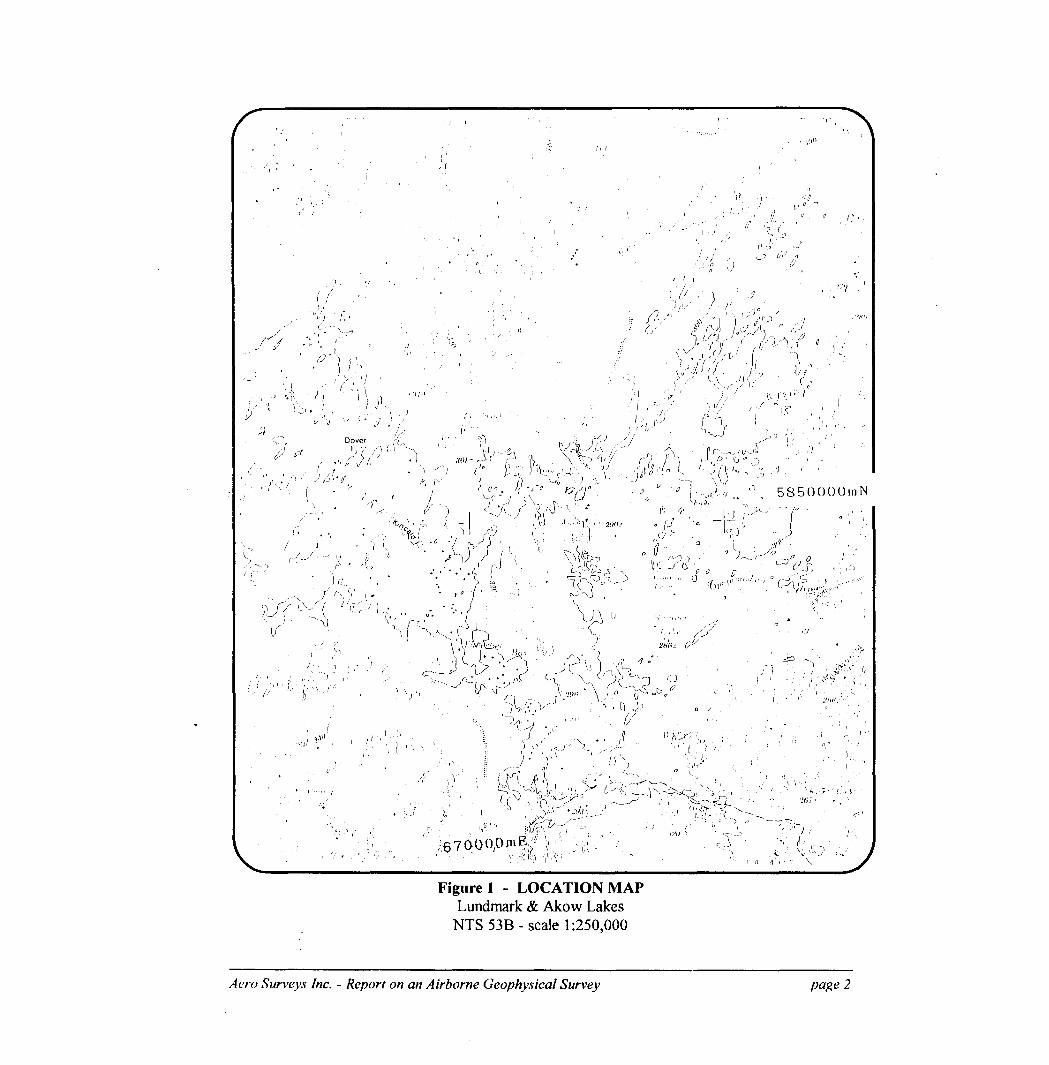
2. SURVEY AREAS
The survey area is shown in figure l. The block may be found on NTS sheets 53B/15 and 53B/16. The corner co-ordinates of the block in UTM (NAD27-Zone 15) easting and northing are as follows:
Topographic relief is low and the land is poorly drained. The area is dissected by numerous ponds and streams. Large swamps are ubiquitous. Pickle Lake, the principal town in the area for facilities, is found at latitude Sl^S'N and longitude 900 10'W. The Lundmark & Akow Lakes area lies just east of North Caribou Lake and about 145 km north-northwest of Pickle Lake.
Aero Surveys Inc. - Report on an Airborne Geophysical Survey
Figure l - LOCATION MAPLandmark Si Akow Lakes
NTS 53B-scale 1:250,000
Aero Surveys Inc. - Report on an Airborne Geophysical Survey page 2
MAPS
The results of the survey are presented in a series of black line and colour maps at a scale of l: 10,000. Due to the size of the area, each of the two map types had to be divided into three sheets. An index map may be found on each sheet.
The blackline maps contains skeletal topographic features derived from local 1:50,000 scale topographic maps.
Map products are as follows:
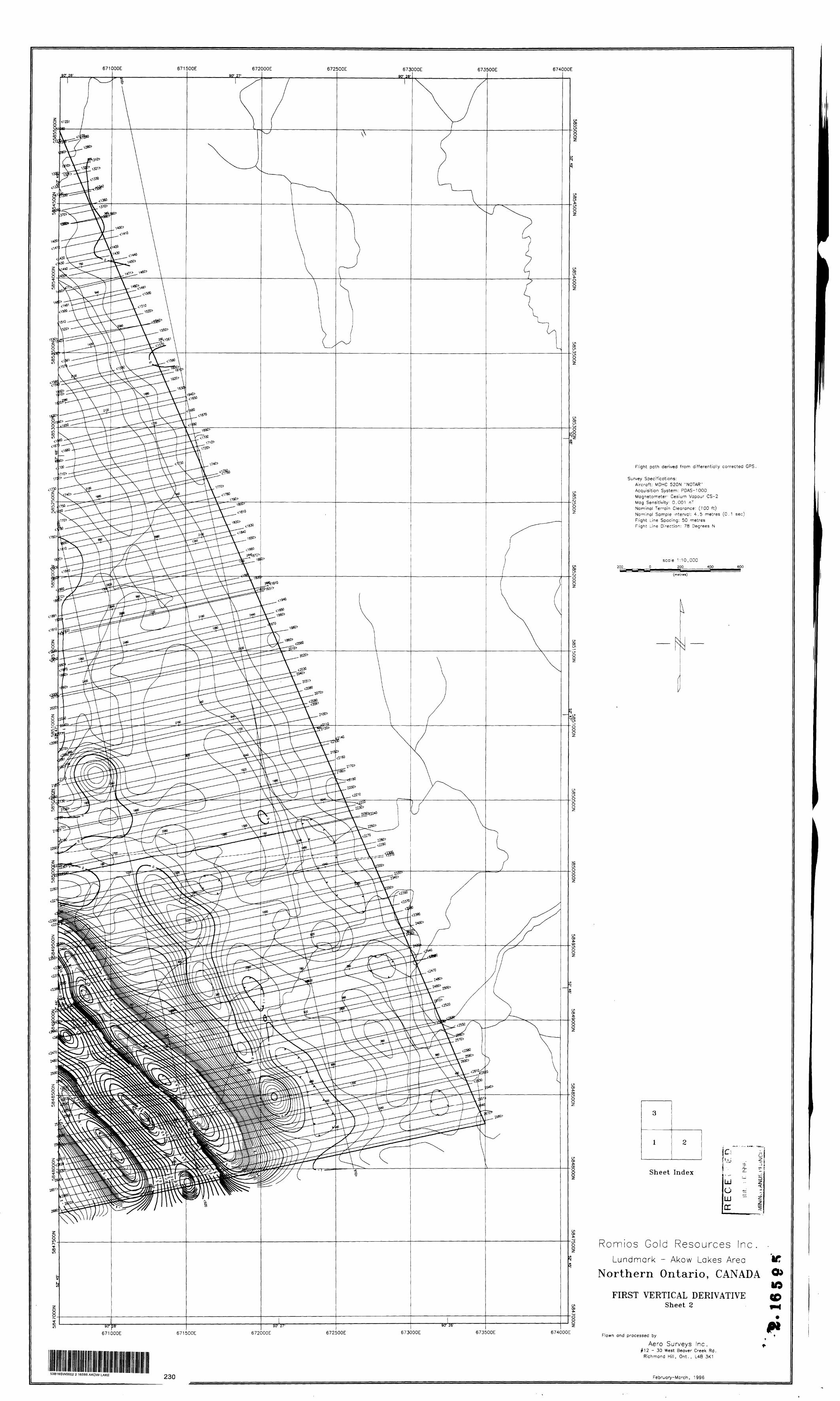
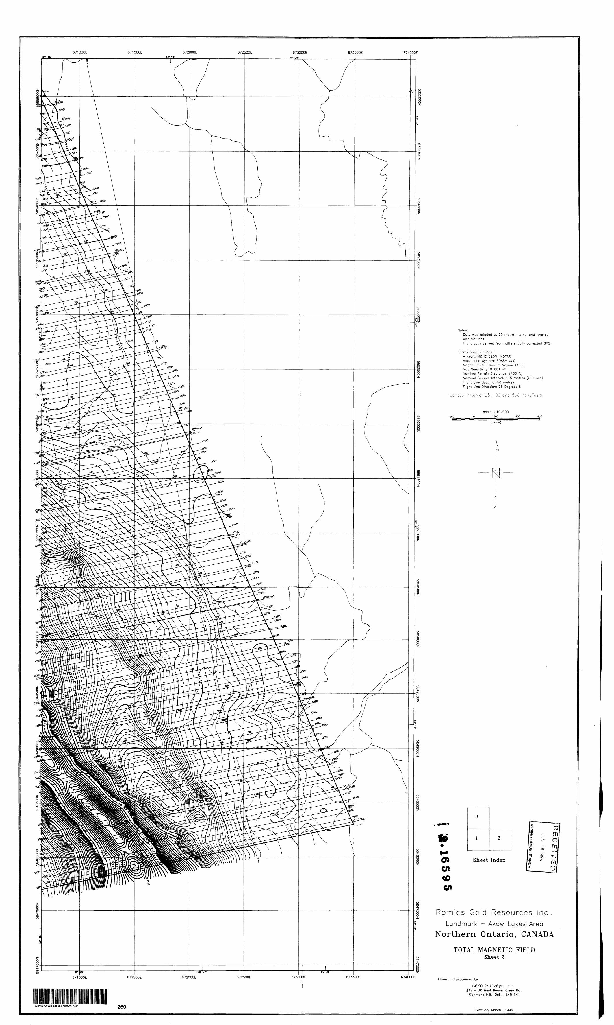
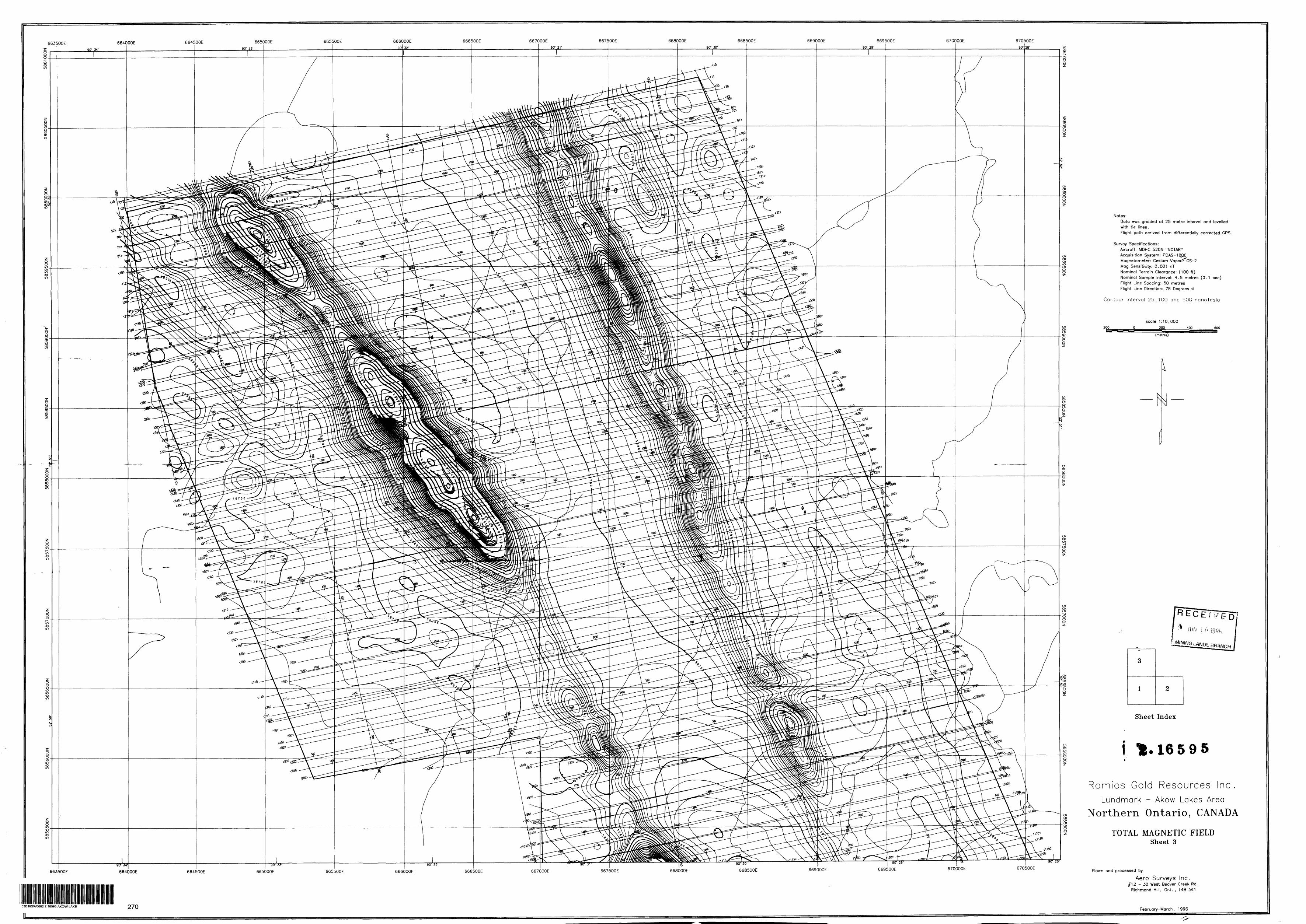
- Plate l. Total Magnetic Field Contours (colour version) on paper- Plate l b. Total Magnetic Field Contours (blackline version) on polyester film- Plate 2. Vertical Magnetic Gradient Contours (colour version) on paper- Plate 2b. Vertical Magnetic Gradient Contours (blackline version) on polyester film
All the maps show the flight path. Colour contour maps show colour fill plus superimposed line contours.
3. SURVEY SPECIFICATIONS AND PROCEDURES
The survey specifications are summarised in the following table:
AREA NAME
Lundmark Lake
LINE SURVEY AREA SPACING LINE T1ELINES FLIGHT DATES FLOWN (km 2 ) (m) (km) (km) DIRECTION (1996)
60.0 50.0 1245.0 70.0 078-258 Feb 19,21-29
Nominal Mag sensor terrain clearance was 100 ft. (bird height above ground, i.e. helicopter is maintained 175 ft above ground). Nominal survey speed was 120 knots/hr. Scan rates for data acquisition was 0.1 second for the magnetometer and l .0 second for OPS location and altimeter. This translates to a geophysical reading about every 4.5 metres along flight track.
Navigation was assisted by a OPS receiver and data acquisition system which reports OPS co-ordinates as WGS-84 latitude/longitude and directs the pilot over a pre-programmed survey grid. The x-y-z position of the aircraft, as reported by the GPS, is recorded along with terrain clearance, as reported by the radar altimeter, at one second intervals.
A combination magnetometer and GPS base station was set up at the base camp in Pickle Lake. The base station was used to monitor and record the diurnal magnetic variation. In the event of a magnetic storm the survey crew was forewarned and flying postponed until conditions improved. The GPS base station records static GPS positions for later differential correction of the airborne record.
The operator maintained a detailed flight log during the survey noting the times of the flight as well as any unusual geophysical or topographic feature.
On return of the aircrew to the base camp the survey data was transferred to a portable hard drive (PCMCIA) and downloaded to the data processing work station. In-field processing included differential correction of the GPS. The geophysical data and the corrected flight path were sent, via internet, to the main processing centre at the Aero Surveys office in Richmond Hill. Survey lines which showed excessive deviation after differential correction were reflown.
Aero Surveys Inc. - Report on an Airborne Geophysical Survey page 3
4. AIRCRAFT AND EQUIPMENT
4.1 Aircraft
A McDonnell Douglas 520N "Notar" helicopter - registration C-FPRX - owned and operated by Heli-Max Limited was used for the survey. Installation of the geophysical and ancillary equipment was carried out by Aero Surveys at the airport in Pickle Lake, Ont. The survey aircraft was flown at a nominal terrain clearance of 175 ft.
4.2 Magnetometer
The magnetometer employed a Scintrex CS-2 cesium vapour, optically pumped magnetometer sensor mounted in dedicated bird towed 75 ft below the helicopter. The sensitivity of the magnetometer is 0.001 nanoTesla at a 0.2 second sampling rate.
4.3 Ancillary Systems
Magnetometer and GPS Base Station
An integrated GPS and magnetometer base station was set up at the base of operations to record diurnal variations of the earth's magnetic field. GPS antenna and magnetometer sensor were linked to a laptop computer with a docking station and appropriate processor cards.
The magnetometer sensor was a Scintrex CS-2 mounted on a tripod away from potential noise sources. The clock of the base station was synchronised with GPS time in order to allow correlation with the airborne data. Digital recording resolution was 0.1 nT. The sample rate was once per second. A continuously updated profile plot of the base station values was presented on the base station screen.
The GPS base station employed a Novatel GPS card with external antenna. The static location of the antenna was recorded at one second intervals.
Radar Altimeter
A Terra TRA 3500/TR1 30 radar altimeter was used to record terrain clearance. The antenna was mounted beneath the bubble of the helicopter cockpit.
GPS Navigation System
The navigation system consisted of a Picodas PNAV navigation system comprising a PC based acquisition system, navigate0 software, a deviation indicator in front of the aircraft pilot to direct the flight, a full screen display with controls in front of the operator, a Novatel GPS receiver card mounted in the PNAV data acquisition console, and a Novatel GPS antenna mounted on the helicopter tail assembly.
Aero Surveys Inc. - Report on an Airborne Geophysical Survey page 4
Survey co-ordinates are set-up prior to survey and the information is fed into the airborne navigation system. The co-ordinate system employed in the survey design and digital recording is WGS-84 latitude and longitude. The OPS positional data is recorded at one second intervals and used with the base station data to calculate differentially corrected locations.
Digital Acquisition System
A PDAS 1000 data acquisition system collected and recorded the digital survey data on an internal hard disk drive. Data is displayed on an LCD screen as traces to allow the operator to monitor the integrity of the system. Contents and update rates were as follows:
DATA TYPE
Magnetometer
Position
Radar Altimeter
OPS Clock Time
System C lock Time
SAMPLING
0.1 sec
1.0 sec
0.1 sec
0.1 sec
0.1 sec
RESOLUTION
0.001 nT
0.1 m
1 ft
5. PERSONNEL
The following Aero Surveys personnel were involved in the project
FieldParty Chief/Data Processor: Keith Hall Operator: Barry Levy
OfficeData Processing: Andrei Bagrianski, Alessandro Colla Reporting: Neil Fiset
The survey pilot, Francois Pinard, was employed directly by the helicopter operator - Heli-Max Limited. Overall management of the survey was carried out from the Toronto offices of Aero Surveys by Tim Bodger, President.
6. DELIVERABLES
The survey is described in a report which is provided in two copies. Folded paper copies of the colour maps are bound with the report. The maps on film base are rolled.
The maps were produced at a scale of l: 10,000. The blackline contours (plates l b Si. 2b) were plotted on polyester film; the colour versions (plates l St, 2 ) were plotted on paper only.
Aero Surveys Inc. - Report on an Airborne Geophysical Survey page 5
The maps show a skeletal topographic base digitised from a scanned l :50,000 National Topographic Series (NTS) map. The basic coordinate/projection system used is Universal Transverse Mercator. For reference the NAD27 latitude and longitude are also noted on the maps. All the maps show the flight path trace with time reference fiducials marked at an appropriate interval.
The following table describes the map products accompanying the report:
In addition to the plan maps attached to the report is a bound booklet containing the geophysical data in pseudo-analogue chart form on a line by line basis. The fields and nominal scales are described below:
CHART FI ELD VERTICAL SCALE
Total Field Magnetics - fine l cm = 200 nT
Total Field Magnetics - coarse_____l cm = 2 000 nT^^^
Altimeter___________________l cm ^ 100ft__^
The corrected digital data is archived on floppy diskette(s) in Geosoft XYZ format. In addition the gridded data and the magnetometer base station data is provided digitally. A description of the file formats is delivered with the digital data.
7. DATA PROCESSING AND PRESENTATION
7.1 Base Map
The skeletal base seen in Plate l is derived from scanning a 1:50,000 topographic sheet and then vectorising the main hydrological features (rivers, lakes) using CAD overlay under AutoCAD. The map is then output as a DXF file and in turn made compatible with Geosoft by converting to a PLT format.
The basic geographic projection/coordinate system used to create all the maps is the Universal Transverse Mercator system (UTM). All the blocks fall within UTM Zone 15.
Aero Surveys Inc. - Report on an Airborne Geophysical Survey page 6
7.2 Flight Path Map
The raw flight path, as WGS 84 latitude/longitude, is differentially corrected using the base station OPS record and the University of Calgary's C3NAV IM software. The corrected flight path is then translated into the local UTM co-ordinate system.
The flight path is drawn using linear interpolation between x,y positions from the navigation system. Positions are updated every second and expressed as UTM eastings (x) and UTM northings (y).
The time reference fiducials are drawn on the map at appropriate intervals and are used to reference the pseudo-analogue charts to the plan map.
7.3 M agnetic Data
The aeromagnetic data were corrected for diurnal variations by adjustment using the intersections of the tie lines. No corrections for the regional reference field (1GRF) were applied. The corrected profile data were interpolated on to a 25 m grid using a bicubic spline technique. The grid provided the basis for threading the presented contours. The minimum contour interval is l O or 20 nT depending on the local magnetic activity.
The vertical gradient of the magnetic field was calculated using Geosoft's MAGMAP programme. Basically the algorithm takes the Fourier transform of the spatial domain Total Field Magnetic grid and then applies a special filter and gradient operator. The frequency domain data is then returned back to the spatial domain and plotted as a colour image. It may also be contoured.
8. CONCLUSIONS
A high resolution helicopter-borne aeromagnetic survey has been completed over a claim block in the North Caribou Lake area, Patricia Mining Division, Northwestern Ontario. Total areal coverage amounts to 60 km2 . Total survey line coverage is 1315.0 line kilometres (l245.0 km traverse lines plus 70.0 km tie lines). Results have been presented as colour and black line maps at a scale of 1:10,000.
Respectfully submitted,
Neil Fiset, B.Se. Aero Surveys Inc.
March 28, 1996
Aero Surveys Inc. - Report on an Airborne Geophysical Survey page 7
AppendixJ
Aero Surveys Inc. - Report on an Airborne Geophysical Survey page 8
53B16SW0002 2 1 6595 AKOW LAKE 020ROMl US KSTA7HB LTD.
:l 47 Da k woo d Avenue oronto, Ontario M6E 2V7
LUNUMARK LAKE - AKOW LAKE GULD PROSPECT NORTH CARIBOU LAKE GREENSTONE BELT
Table of Contents
S3B16SW0002 2 16595 AKOW LAKE
i rt t roducti on
Property Description and Location
Recess, Climate, Local Resources
Geol ogy
Mineral Exploration History
Mineral Occurrences and their State o-f Development
l o n c:: 11.1 s i o n a n d R e c o m m e n d a t i c :? n s
Ke f erences
l R r t i -f- i r: i? t e o f A u thor
List of Figures
i. - I.. D c a i" T on
Mi n i nq i ;1 ai ms
;.. H p ri r o c k P e o l o q y
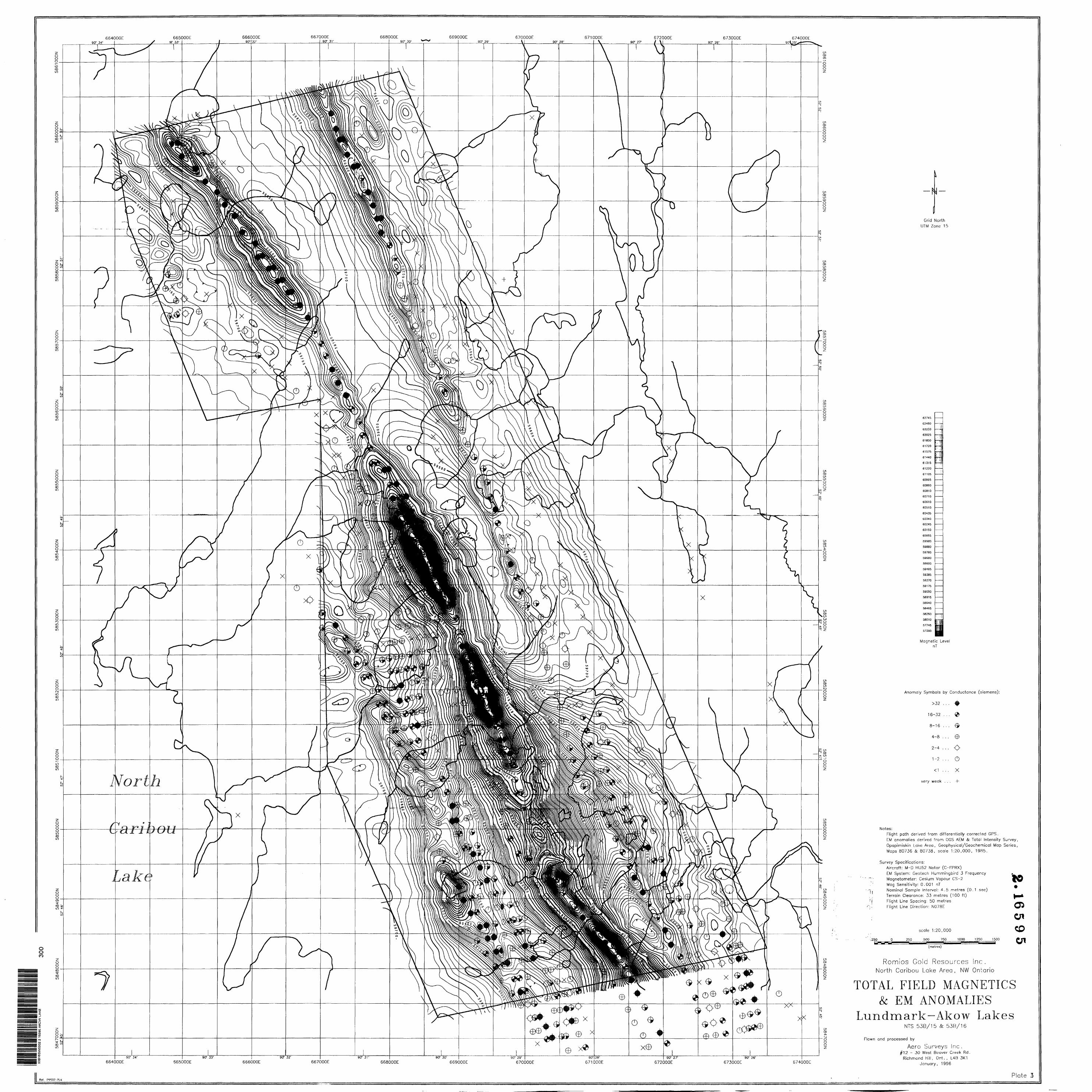
4 r Airborne Electromaqneti c and Total Intensity Magnetic Surveys
5. Assays, Mineralization, and Recommended Exploration
020C
SUMMARY
Ihe L.undmark Lake-Akow Lake property contains a significantvolume:- o-f the northern extension o-f the iron -formation that, h o e t. 5 l:, h f? lv! t." B is e l whi t e gold deposits now under development at('f iarn nil skan Lake, 24 km south of Lund mar 'k Lake. To date onlypart, c t-f" the favourable geology of the property has receivedr-r el i mi nary f? x p l or at i on .
A t wo ph a Ke exploration program is recommended to t e s t t h e potential for gold hosted by sulphide mineralization in 23 km shrike length of tabular and folded iron formations and shear z tines in a s s o c i a t. e ci mafic volcanic rocks. The g e o c h e m i c a l l y anomalous gold content and the structural complexity of the iron formation have been identified over most, of the property. Additional prospecting and geophysical surveys are needed to refine the identification of diamond drilling targets.
Phase I of the proposed exploration is a program of prospecting, magnetometer, electromagnetometer, and induced polarization surveys. Its objective is to refine the identification of targets for the diamond drilling program of Phase .LI.
INTRODUCTION
Romi os Lstat.es Ltd. staked 23 mining claims in the Landmark Lake- Pikow l. a h: e area of the North Caribou Lake? greenstone belt in the spring and summer of 1994. The property was staked because of i t s a n p a r' e n i. stratigraphic a n d s t. r u c t u r a l a s s o c i a t i o n w i t h the l a r g e M u s s e l w 11 i t e g o l d d e p o B i t. s a t O p a. p i ut i s k. a n Lake, 2 4 k. m sou t h of Lundmark Lake. (Fig. 1)
l he Musselwhite project, a joint venture of Placer Dome Inc. (6U7.) and IVX Bold Inc. (32X), has known ore reserves (June 1994) of 4.2 million tonnes grading 9.6 grams gold/tonne (4.6 million tons (a O, 28 o:-:, gold/ton) in the East Eiay Zone and 2.9 million tonnes grading 5.9 grams gold/tonne (3.2 million tons S O.17 02. gold/ton) in the West Anticline Zone.
The author was contracted to review the geology and mineral ex-p l or at i on history of the Landmark Lake-Akow Lake property from published sources and the open-file mineral exploration assessment r export, s and maps of the Ontario Ministry of NorthernDevelopment and Mines, to recommend further exploration, if warranted, and to prepare this summary report.
As detailed in this report, the property has not been explored complete l y a rid war- r a. n t s a d d i t i o n a J. f o l .1 o w -11. f:) and p r j m a r y exploration to test adequate?! y its potential to contain mineable q o l d mi net-a l i z at i on .
PROPERTY DESCRIPTION AND LOCATION
The Lundmark I.. a k e-Akow Lake property is in the centra o-f the Morth Caribou Lake greenstone belt. Tt is 24 km north ot the |-1 LI s -- o l w h i t e q o l d d e p o s i ts, (F i q . l )
l" h f? property consists o-f 23 c on t. i. qi .10 M R unpatent p d mining claim 1?, total Mnq 312 units (4992 hectares or 12,460 acres) in the Patricia Mining Division (Fi q. 2). The claim numbers (all series inclusive) are: PA.12O8544, PA. l 2O8557--PA. 12O8565 , PA.12O8569, PA.12O9S73-PA,12O8575, PA.12OB991-PA.120894, PA.12O9235-PA.12O9237, -md PA, l 20925.1-PA. 1209252.
l he property mineral rights are wholly owned by Romios Estates Ltd.
ACCESS, CLIMATE, AND LOCAL RESOURCES
Access to the area is tay float or ski aircraft from the town of Pickle Lake, 160 km south of LLindmark. Lake. Landmark Lake is also 24 km north of Opapimiskan Lake, the terminus of a winter road from Highway 808.
The climate of the area is polar continental, notable for prolonged winter conditions of sub-freer inq temperatures and moderate to heavy snow cover. The temperate season of usually moderate rainfall is from May through October.
l he property is in the Northern Coniferous Section of the Boreal Forest. The land is approximately 807. forested; tree species vary with drainage and the extent of past wildfires, and are an even distribution of mixed forest and concentrations of deciduous and coniferous trees. The main conifers are spruce, tamarack, and jackpine; the deciduous trees are aspen, birch, and alder. Mi i skeg rovers the remainder of the property. The remoteness of H-ip area and the generally non-commercial quality of its timber have precluded logging.
'lopographic relief rarely exceeds ten meters.
GEOLOGY
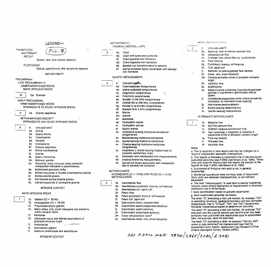
The Landmark Lake-Akow Lake property is within the Sachigo Subprovinee of the Superior Province of the Precambrian Shield. The claims straddle the clastic metasedimentary core and flanking Morth Rim and South R im mafic metavolcanic rocks of the Early Precambrian Worth Caribou Lake greenstone belt. The area is in the southeast striking, central part of the synformal greenstone belt (F-"ig, 3). Within the metavolcanic rocks, near and subparallel to their contact with the metasedimentary rocks, are segments of the Eyapamikama-Akow lakes and Hatch Lake iron formations. (Breaks, 1986; Thurston, 1991)
The met.avolcan i .c rocks are mafic flows, flow breccias,
ri'iiph i bol i .f es , and schists of chl or i te-act i nol i t.e to hornblende pi. aqi oc l ^se composition. The clastic metasedi ments are mainly a v.-u-jety of fine grained sandstones and mudstones; some units locally contain biotite, garnet, or staurolite porphyroblasts.
The? iron formations are mapped primarily on their strong magnetic signature.. The western (Eyapami kama Akow lakes) iron formation is relatively well exposed from east of Landmark Lake to Akow lake; a small outcrop area also occurs in the northwest corner of t hfa property. It is subvertical, 10 m to 35 m thick, and varies from chert-magnetite to c: her t.-q r Liner i t.e in composition. Sulphides, pyrite and pyrrhotite, are common as gossans in the grunerite 2ones and as lenses in small shear zones, boudinaged necks in chert layers, and in the axial planar cleavage of folds where grunerite has replaced magnetite.
"l" l T e F? as tern (Hatch Lake) iron formation is exposed only in a few small outcrops on the property but it is clearly identifiable by its aerial magnetic signature. (Fig. 4; Breaks, .1.986; (Jl^S, J98fV)
("he iron formations AK-R part of the same stratigraphic unit, that \ i r i r-11-, the Musselwhit.e gold deposits at Opapi mi skan Lake (Fig. J.)
MINERAL EXPLORATION HISTORY
Significant assay results and mineralisation discoveries are plotted on Figure 5. Additional mineralisation is noted onFi gure 3,
in 1962, Inco Ltd. drilled a 422 Ft. hole in mafic volcanics near the sedimentary contact in the southeast corner of the property. The hole intersected minor pyrite and pyrrhotite in brecciated quartz and quartz-mica-garnet schist. (Inco Ltd., 1962)
.Inco Ltd. also drilled five shallow packsack drill holes in the northwest part of the claims, north of Lu.ndmark Lake, in 196.2 1963. Only two of the holes reached bedrock and the northern drill hole intersected 74 ft. of cher t magnet, i te iron formation. No assays were reported. (Inco Ltd., 1963)
in 1 9B.'.:-1 , Lominco Ltd. '"onducted an overburden drilling program. i l ring a southeast .linear- traverse that included 6.f.:i km on theP o m i o s property, from the ea^t sirtpj of Lundmmark Lake to ther~.nut h hnundar y of the claims (Cominco Ltd. , 19R'?). 'f hey samp l eel t i l l t-or gold, copper, 1. r*ari , and 7inr in :V. of the fi'\ holesri r-i i. ;| FT! (1 4-t,-3o ft. hole depths 5 75 t:i ft. total -footageriri l l ^d ) - I'hp* hi qheeit gold ^^-^ays wf-'re from v4 pph to H6 ppb
i h F---' t \f\ r- R r -| Akow Lake and M t i m Lake, end s o u -t- h w e s f c* f the s o u t hi hay r i-t- f-H:TH-j l ake.i. l he base metal assays ranged from '~i to 6O
in 1. 9H -'., Fldcir Resources l td. drilled two diamond drill holes in t-tu-.i northwest corner of the property, one through the iron formation and the other in mafic met. avol cam. cs. The drilling
i n l l owed ground magnetic and electromagnetic surveys of a large
ri i-p f* northwest of t. h t? property. The holes intersectedd i. ssem i nated pyrrhotite, pyrite, and chalcopyrite; and pyrrhotiteand pyrite, respectively. Mo significant gold assays werer r? p or ter! .
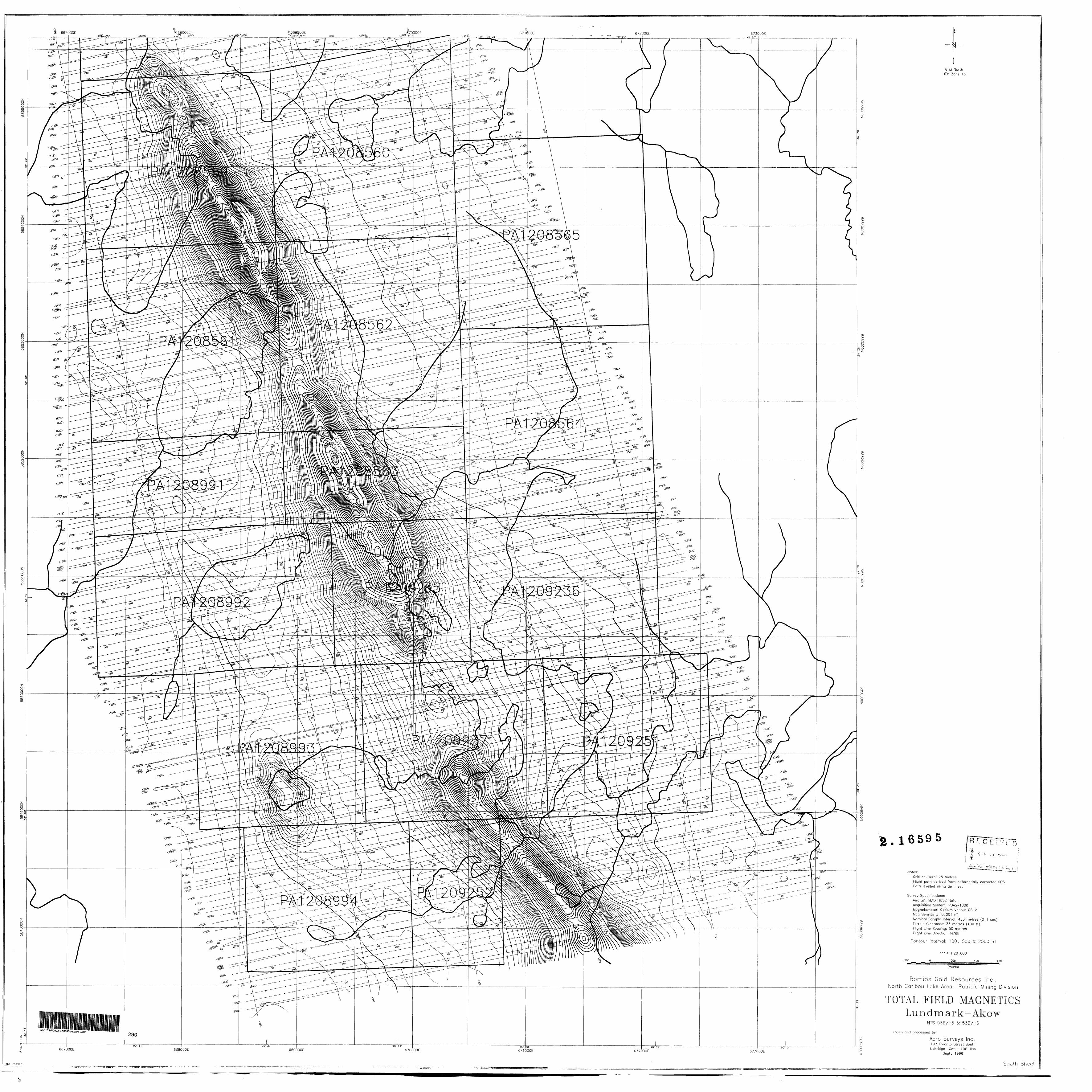
i ri 1.98!::-, Ae r od a t Limited -flew a helicopter' ma q net i c. and e l ec t r omagnot i c survey o-f the North Car i hou I.. ake greenstone belt, l he survey covered the property (Fin, 4^ r.'MnS, 198^), Both iron
-f- or mat i oris anri a segment o-f a possible third (north o-f At i m Lake) r-irp outlined clearly, together with continuous coincident rones rv f- varying conductive intensity. Megascopic houdinage o-f the iron -f or mat. j. on into segments from one to three kilometers l onq , separated by ri arrow areas one half kilometer l onq, also are well rip-fined. Additional, significant features are the probable expression o-f isoclinal folding within the iron -formation: east and west of the north part of Akow Lake, north of Atim Lake, and past of L u ri d ir* a r k. Lake.
The southeast, extremity of the? property, south of the north half of Akow Lake, was explored in 1985 by Geocanex Ltd. for Moss Resources Ltd. and 635479 Ontario Ltd. (Geocanex Ltd., 1985; 1986). Geocanex Ltd. did geological mapping, prospecting, trenching, and ground magnetic and el ect.r omagnet i c surveys.
Assay results were up to 445 ppb gold from a quartz vein in mafic volcanics and 60 ppb gold in iron formation near the north end of the surveyed area. The geophysical surveys identified five closely spaced linear conductors that parallel 5OOO ft. stratigraphic width in the southeast corner of the property. Their convergence suggests the presence of more extensive isoclinal -folding than indicated by the Gl-iS airborne survey (Figs. 4 fe 5) .
Jn 19B7, Geocanex Ltd. did ground magnetic and electromagnetic surveys, geological mapping, prospecting and trenching for Fxp l. ora-F i ve and Power Fxplorations Inc. on the west-central part c,f th ra F'omio^- property, primarily the outcrop area from the northeast side of l. un d mar k Lake to the west side of the north hail- o-*- Akow Lake (Fig. t:.; Beocanex Ltd., .I9fc)7a S* 1987b). The ground geophysical surveys confirmed the airborne survey rini-f i ni t i on of the iron formation and the distribution of ft induct i ve 7 on e s within and concordant to it. The latter may represent graphite, sulphides in metavol can i cs or metased i merits , or rehear 7-ones. In addition, two west to northwest fault/shear 7 on t? displacements were detected.
Hedrock sampling yielded numerous gold assays of up to: 790 ppb in gossans of sulphide bearing grunerite and magnetite iron formation; 190 ppb in mafic: metavol c an i c s; lOO ppb in rnetasedi merits (wacke); 235 ppb in a quartz vein; and 170 ppb in a shear zone in metavolcaics (basalt).
MINERAL OCCURRENCES and their STATE of DEVELOPMENT
'l here? i '~ n o h i s t o i- y of astern p t. 1? to develop any of the mineralt T r \ .ir-r F^ri c P* s noted on the Romi os Estates Ltd. property, beyond ther^X f* t or~ .-i l" i fin r- i i~ i^ri aHo'1./^ n
CONCH IS T ON and RECOMMENDATIONS
l -'r-ri^ppr- 1 -i nq on h^|f of -l- h e outcrop area o f t. h f? p r "per ̂ y a n d nn l y p, -i r f i ,-.i i j y lAjit-hi n one poor l. y exposed iron formation has resulted in the di. srovery of numer ous or r i trrences of anomalous qoldf on t en t in r--p'Vf-?r fi l rock type?r- and shear rc:)ne r̂ ., in addition toqo!l d within iron formation.
In total, less than half of the property has received primary qeoloqiral and geophysical exploration. That work forms the base tor advanced exploration and identifies the remaining, unexplored r-reas of the property.
l he Landmark Lake-Akow Lake claims contain 23 km strike length of iron formations that are spatially, composi t i onal l y , and structurally analogous to the gold hosting geology of the Mussel whi te deposits. The iron formation on the property has been tested by only one deep and one shallow drill hole (El dor Resources Ltd., 1 983; Irico Ltd., 1963).
There are at least thirteen areas that should be drilled to test for gold associated with sulphides in the iron formations. They are qeophysi cal l y well defined attenuation (boudinage) and isoclinal, fold nones of the iron formations; conductive rones coincident, w^th areas of decreased magnetic susceptibility in the :i ron formations; and conductive zones with, possible n("'l d bear i nq (:: M l phi dec. in shear zones subparallel to the iron formations.
Prerise drilling t-^rqets should be selected after an induced polarisation survey of the southwest part of tne property, to t-o'l. l. ow--! ip the primary qround geophysical surveys of l.-jeocanex Ltd.
t i c and electromagnetic surveys of the remainder of i he airborne* identified iron formations in the northwest and southwest parts of the property, outside? the? area surveyed by (.-Seocanex Ltd., also should be conducted and followed by induced p o l. a r i r- -- 1 i o n s u r" v e y s o f selected areas.
^iu.rfacE? prospecting and mapping of most of the property iron formation outcrop areas has been done; however primary prospecting is warranted in the northwest corner and in the area east of the projected Hatch Lake iron formation north of Akow Lake (Fig. 5). This work could be done concurrently with the ground geophysical surveys.
REFERENCES
H r P a k s , F, W, pt. al. , 1986: Precambrian qeoloqy of theDoubtful-Akow Lakes Area. Ontario Geological Survey Preliminary Map P.2965, scale 1:31,680.
Conn nc:o I.. t. d., 1982: Akow property. Overburden drilling. MNDM File 53EVO9WW OO18 2.4877.
Eidor Resources Ltd., 1983: North Caribou project. Magnetometer, EM surveys, diamond drilling. MNDM File 53B/15SE 0018 2.8872.
OGS , 1985: Airborne electromagnetic and total intensity magnetic survey, Opapimiskan Lake area; by Aerodat Limited for Ontario Geological Survey, Maps 80736 - 80739, scale 1:20,000.
Thurston, P.C. et al . , 1991: Sachigo Subprovirtce greenstone belts. North Caribou greenstone belt. p.83-87 in Northwestern Superior Province: review and terrane analysis; in Geology of Ontario, Ontario Geological Survey, Special Volume 4, Part l, p.81-142.
CERTIFICATE OF THE AUTHOR
I, EDWARD D. F R hi Y, hereby certify that:
1. I am an independent consulting geologist. , residing in l-Javja, Ontario (P.O. Box 1536, Wawa, Ontario POS 1KO) .
2. I received a Bachelor of Arts degree (-four year program, geology major) -from Au.gustana College (Illinois) in 1966.
I continued my -formal geological education as a graduate student and teaching assistant at Pennsylvania State University (1966-1969) and the University o-f Waterloo (1972-1975).
I have been practicing my profession continuously in Ontario since 1969, through private and public sector, and self employment.
I am an elected (1974) Fellow of the Geological Association of Canada.
3. I hsve not personally examined the Lundmark Lake - AkowLake property of Romios Estates Ltd. in the North Caribou Lake greenstone belt, Patricia Mining Division, northwestern Ontario, described in my attached report.
4. The information contained in the attached report is based on the references cited: published maps and reports of the Ontario Geological Survey, open-file r?;; f i or at i on assessment maps e.nd reports obtained from
. rhe Sioux Lookout and Toronto Resident Geologist offices of The Ontario Ministry of Northern Development and h'! i res, and public company annual reports and press r 6? i ^? ̂ s e s i
b. I have not received, nor cio I expect to receive, directly or indirectly, any interest in the mining claims of Romios Lst?tes Ltd. or of any affiliate of the company.
6. l hereby consent to the use of my attached report in a prospectus or other statement related to the raising of funds for mineral exploration.
respectfully submitted,
Edward D. Frey I'O September 1994
Ph: 705-856-1355
LEGEND"-"
PHANEROZOIC QUATERNARY
RECENTStream, lake, and swamp deposits
PLEISTOCENEGlacial, glaciofluvial, and lacustrine deposits
UNCONFORMITY
PRECAMBRIANLATE PRECAMBRIAN (?)
UNMETAMORPHOSED ROCKS MAFIC INTRUSIVE ROCKS
10a Diabase
EARLY PRECAMBRIAN UNMETAMORPHOSED ROCKS
INTERMEDIATE TO FELSIC INTRUSIVE ROCKS
9a Granite pegmatite
METAMORPHOSED ROCKSc ' dINTERMEDIATE AND FELSIC INTRUSIVE ROCKS
i 6a Chert6b Chert with pyrite and pyrrhotite 6c Chert-grunerite iron formation 6d Chert-magrietite iron formation 6e Banded iron formation tectonic breccia 6f Gamet-actinolite layers associated with banded
conglomerate 4y Amphibole biotite-bearing foliated rock of
probable sedimentary origin4z Ultramafic rock interbedded with metasediments4B Andalusite-bearing metasediments4D Garnet-rich layers associated with metapelites
and or banded iron formation
M ETA VOLCANICSINTERMEDIATE (CI = 10-35) AND FELSIC (CI = 0-10) METAVOLCANICS
serpentine schist of probable volcanic origin1e Flow top brecciaif Pillowed flow1h Variolitic flow
Notesa. This is basically a field legend and may be changed as a result of subsequent laboratory investigations, b. This legend is intended to compliment that of the previously published adjoining Map P.2965 (see Breaks e tai 1 986). Those units and subunits missing from this legend are present in the legend for Map P.2965 ( see Breaks ef ai 1986). c. Succession of intrusive rock units is not, in general, established.d. Numerical succession does not imply order of deposition; many units are repeated stratigraphically, or are laterally equivalente. The term "volcaniclastic" is used here to denote fragmental volcanic rocks whose mechanism of fragmentation is uncertain, commonly due to deformation, f. Rock identification based on airborne observation, g. Rock subdivision presently not known. The letter "G" preceding a rock unit number, for example "G2"; or preceding structural, geological boundary and iron formation designations, that is "G Fault", 'GIC' and "GIF" respectively, indicates interpretation based on geophysical data only. The letter 'C" preceding a rock unit number, for example "C4*, indicates that the outcrop position and identification has been compiled from published and unpublished data or assessment files; the outcrops were not examined. The letter "D" preceding a code, for example "D2a (py, po)'. refers to data compiled from diamond-drill logs filed for assessment work credits. Assessment Files Research Office, Ontario Geological Survey, Toronto (AFRO).
SYMBOLSExploration trenching; width indicated, where knoijm . ' .
iShear zone; (dip unkiiown, Inclined. yertbal); arrows indicate direction of shear, where known
Jeformation zone observed and Integrated from geophysics
Sma) bedrock outoop
Are* of bedrock outoop
Bedding: (Inclined, vertical)
Bedding; (Inclined, vertical, overturned); top Indicated by arrow
Bedding; (inclined, vertical, overturned); top (arrow) from grain gradation
Lava flow, top (arrow) from pillow chape and packing
S, foliation; (dip unknown, inclined, vertical)
S; foliation: (dip unknown, inclined, vertical)
Parallel bedding and foliation; (dip unknown. Inclined, vertical)
Gneissosity: (inclined, vertical)
Joints: (inclined, vertical)
lineation with plunge; generation uncertain
Mineral and stretch lineations with plunge: (L,. L2)
Intersection lineations with plunge (So-S,, S,-Sj)
l Iron formation; (interpreted from aeromagnetic*, drillhole data); width exaggerated in some areas
l Mesoscopic folds, geometry known (observed fold profile): with or without (old axial trace or axial plane symbol and/or ' plunge symbol attached
Fold axial trace: axial plane where dip known
Dikes; width exaggerated on map; (vertical. Inclined, dip unknown)
Drillhole: (inclined); intersected lithology and mineralization indicated
Magnetic attraction
Extent of survey
Location of Property
Gold showing
Mineral occurrence at the surface
Location of assay samples
Fold axis, with plunge: geometry (observed) of fou shown; fold generation Indicated: (Fi.Fj.Fj)
Fold axis, with plunge: geometry (observed) of tow shown: (generation not known)
Axial trace of macroscopic folds: (antiform, synform)
Quartz veins, width exaggerated on map; width, where known. Is Indicated In parentheses: (vertical. Inclined dip unknown); veins of other composition specified
PROPERTIES- JUNE 1994ROMIOS ESTATES LTD.
PLACER DOME INCX-TVX GOLD LTD.
PANGEA GOLDFDZLDS INC.
PLACER DOBIE INC.
PLACER DOME INO- WISCAN RESOURCES INC.
H REGISTRY RESOURCES INC- PANGEA GOLDFIELDS INC.
GENERAL GEOLOGY ft GOLD OCCURRENCESNORTH CARIBOU-OPAPIMISKAN-NEAWAGANK LAKES AREA
LUNDMARK-AKOW LAKE CLAIMSNORTH CARIBOU LAKE GREENSTONE BELT
PICKLE LAKE AREA, ONTARIO
Report prepared for:
Report prepared by:
ROMIOS GOLD RESOURCES INC.
FRANK GLASSGeologist/Geophysicist
January 31, 1996Toronto, Ontario
January 30, 1996
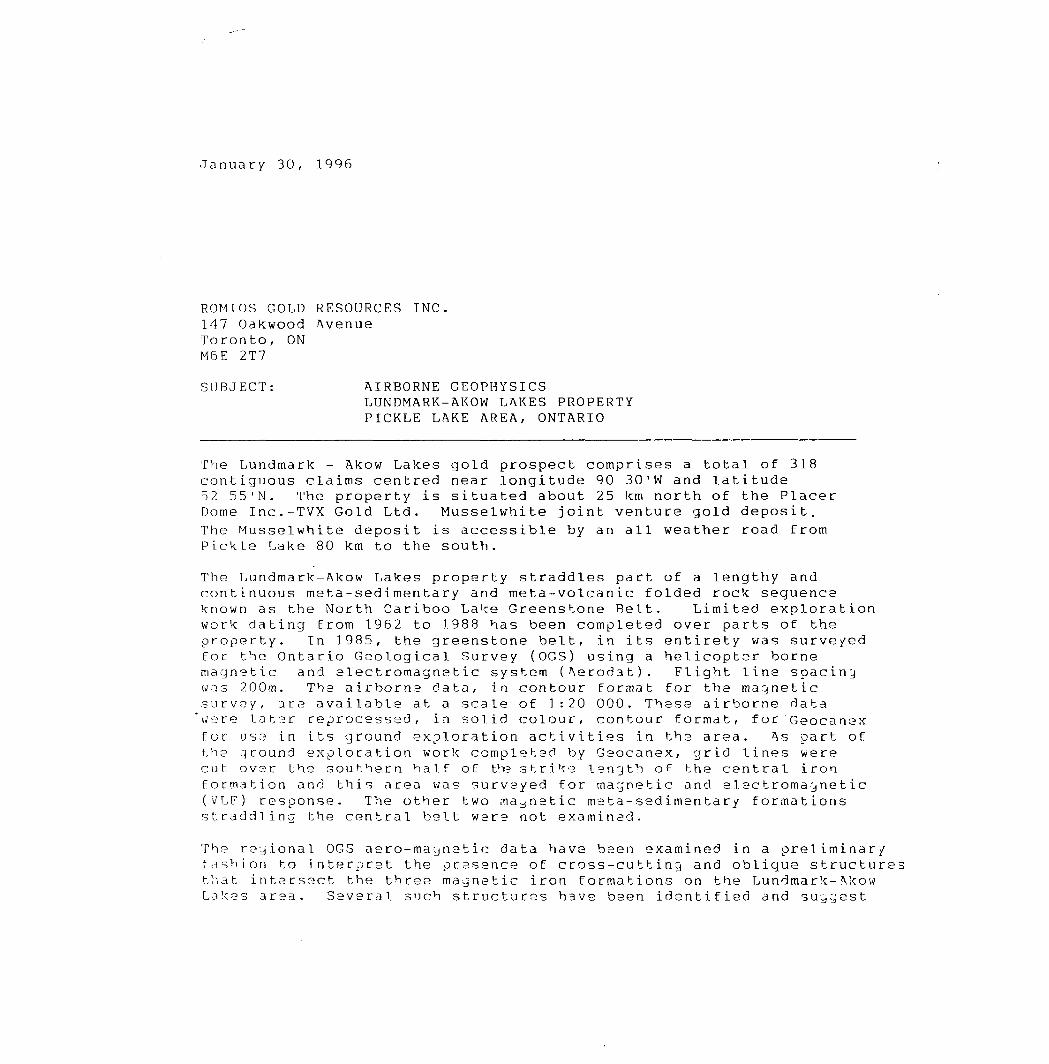
ROMIOS GOLD RESOURCES INC. 147 Oakwood Avenue Toronto, ON M6E 2T7
SUBJECT: AIRBORNE GEOPHYSICSLUNDMARK-AKOW LAKES PROPERTY PICKLE LAKE AREA, ONTARIO
The Lundmark - Akow Lakes gold prospect comprises a total of 318 contiguous claims centred near longitude 90 30'W and latitude 52 55'N. The property is situated about 25 km north of the Placer Dome Inc.-TVX Gold Ltd. Musselwhite joint venture gold deposit. The Musselwhite deposit is accessible by an all weather road from Pickle Lake 80 km to the south.
The Lundmark-Akow Lakes property straddles part of a lengthy and continuous meta-sedimentary and meta-volcanic folded rock sequence known as the North Cariboo Lake Greenstone Relt. Limited exploration work dating from 1962 to 1.988 has been completed over parts of the property. In 1985, the greenstone belt, in its entirety was surveyed for the Ontario Geological Survey (OGS) using a helicopter-borne magnetic and electromagnetic system (Aerodat). Flight line spacing was 200m. The airborns data, in contour format for the magnetic survey, are available at a scale of 1:20 000. These airborne data 'were later reprocessed, in solid colour, contour format, for Geocanax for use in its ground exploration activities in the area. As part of the ground exploration work completed by Geocanex, grid lines were cut over the southern half of the strike length of the central iron formation and this area was surveyed for magnetic and electromagnetic (VLF) response. The other two magnetic meta-sedimentary formations straddling the central belt were not examined.
The regional OGS aero-magnetic data have been examined in a preliminary fashion to interpret the presence of cross-cutting and oblique structures that intersect the three magnetic iron formations on the Lundmark-Akow Lakes area. Several such structures have been identified and suggest
Page 2."January 30, 1996
presence of favourable alteration zonas.
The cost of preparing and surveying only five blocks varying from 1,5 km x 1,2 km in siza would approach about |20,000.00. This would still laava a significant portion of the property unmapped at high resolution.
Currant practice in the exploration of complex folded structural corridors, and particularly where magnetic iron formation is present, is to use high resolution surveys where the line spacing approaches 50 m or better. Several major exploration companies now use this approach in airborne surveys to obtain complete and detailed mapping of their new areas of interest. Real time flight-line navigation and rapid instrument measurement ensure that airborne surveys produce very high resolution data bases that are essential for the detailed recognition of important small-scale fold structures.
The Lundmark-^kow Lakes property could be outlined within a rectangular block of about 50km x 1 2km. If this block were to be examined by an aero-magnetic survey, with a line spacing of 50 m, the total line coverage would approach 1200 line-kilometers. The data base acquired could then be used, with increased reliability, to identify the structurally complex zones that could have greater potential for hydrothermal alteration and also enhanced gold mineralisation.
Ground follow-up of the target areas would involve minimal grids on which potential drill targets could then be identified.
. lass Geologist/GeophysicistUPGGQ)Toronto, ON
Northern Developmentant M ines
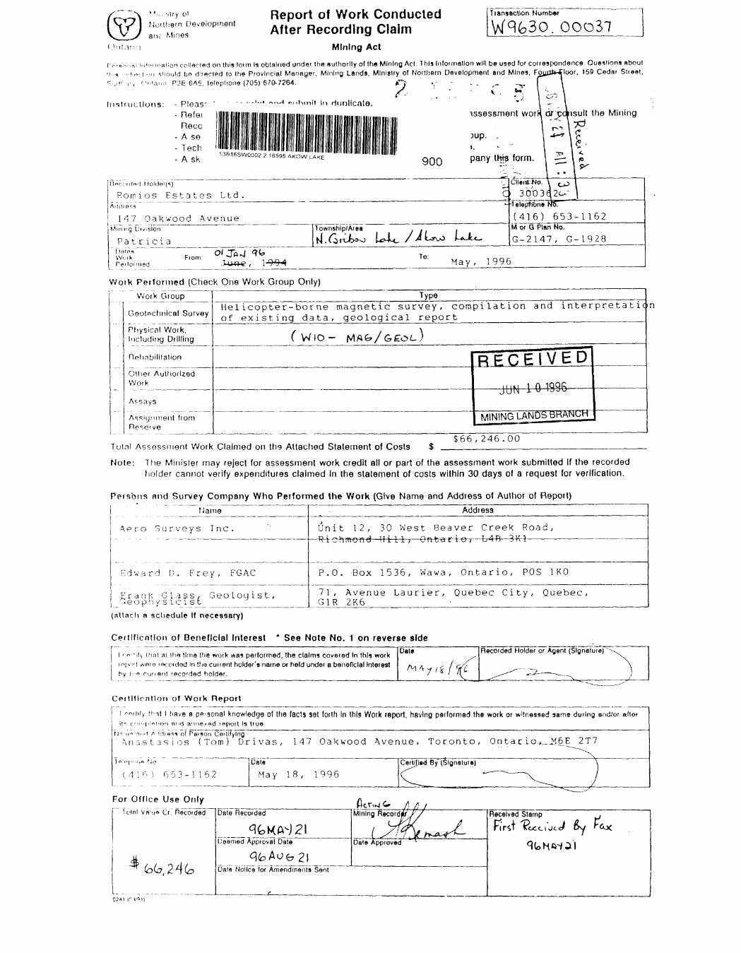
Report of Work Conducted After Recording Claim
Mining Act
Transaction Number
. 00037
rv..c^.. n ! infornintion collected on this loim la obtHlned under Ihe authority of the Mining Act. This Information will be used for correspondence. Questions about •i :, ,MO, i r,,, should bo directed lo Ihe Provincial Manager, Mining Lands, Ministry of Northern Development and Mines, FoyaJWt'oor, 159 Cedar Street.
f'ntnno. P3E CA5, telephone (705) 670-7264.
Irish uctlons: - Pleas- Refei
Recc- A se
t " U I l - - --- ---' --'- • •"•i. i n mtini • lin ||||| |||||
-Ask 5 3B16 SW0002 2 16595 AKOW LAKE
in Hunllcate.
900
)up. .i.pan y t W? form.
assessment worK or sojisult the Mining rv
nci.'utod Holden-;)
Romios Estates Ltd.
147 O a k w o od AvenueMining (ju.slon
Patricial intos W o i K PAI Id mod
From:
C
I Township/Area i l i l
Client-No. \ ^ 1
3 O t) 3 q 2 c- " |Teleption* NoT
(416) 653-M or Q Plan No.
G-2147, G-
1162
1928
To: May, 1996
Work Performed (Check One Work Group Only)
Rehabilitation
Work
Assays
oup
cal Survey
Vork. Drilling
ion
lorlzed
H from
Helicopter-borne magnetic of existing data, geologi
( W lO - MAfe/G
Type
GE&L-
RECEIVED
JUN i O 1996
MINING LANDS BHAIMUH
|66,246.00Totnl Assessment Work Claimed on th9 Attached Statement of Costs
Note: The Minister may reject for assessment work credit all or part of the assessment work submitted If the recorded holder cannot verify expenditures claimed In the stalement of costs within 30 days of a request for verification.
Persons and Survey Company Who Performed the Work (Give Name and Address of Author of Report)
Aero Surveys Inc.
i p n y
ame
Inc.
^y, FGAC
Geologist,
Address
Uni — R4e
P.O
71 , G1R
t 12,
. Box
30-H^r
15
Avenue 2K6
West Be a-HTT — Q^nfcQ r
36 , Wawa ,
Laurier,
ver Creek 4-e-, — L4B 3-
Ontario,
Quebec Ci
Road , ^^ —————————————————
POS 1KO
ty , Quebec ,
(atlncli a acliedule If n ecessary)
Certlflcntlon of Beneficial I nterest * See Note No. 1 on reverse side
l rn-'iiy Dial al ihs lime the work was performed, Ihe claims covered In this work mjvvi wnroi rocptdod In tha current holder's name or held under a beneficial Interesthy r-n cuneni recorded holder.
Dale Recorded Holder or Agent (Signature)
Cetllflcntlon of Work Report
l rn,iiiy tint l have B ppisonai knowledge of the fads set loith In this Work report, having performed the work or witnessed same during and/or allotit-, c^i'.p'otion nnd anne^pd report Is true.
N" n" HPI.I A Idioi^ of Pe'Son CertifyingAri3Sta.SLOS (Tom) Drivas, 147 Oakwood Avenue, Toronto, On tar io-,^.Jrl6 E 2T7
M I ^ l 653-1162Date May 18, 1996
CertlJIed By (Signature)
For Office U se OnlyTelnl Vn'uo Cr." Recorded Date Recorded
^Ceenied Approval Date
^Dale Notice for Amendments Sent
Mining Record'/! /j i
Date ApprovedL-i.
Received Stamp i
r O
3 3
LOL v"
—'•- J .
c*0v..',
G
r~'
L' \ --i
-
•ooL/, -v"C/1
^
rTCo t k
^
^:n *-'i0(1
0
''J
S
-
i^j,O-0
'
6"
Vjo
Qj)
-
NSsJ
rS~
_L'j
O
w
^
tL;
O DO
^
6^
2.
Coo
O^
6"
1
QJ,
0
LA*
ex?
•~* f -^
QJO onCT-
^—)
*
y S
g j
O03
i
-
' 5
iOoCA
'
-
Q
CAcr
-
z??^ISS3| Zc D ~* ^
— OS wo 3Z 2S?m 3
cO l2 S" 0^3
CK O *
II'> ~
~a iP
l viV
r-j
r.C;
r, r,
'o
r,
o
L/ J
r, r-
CAJUJ cv O /~ i
oC^ D
8
r
S s
CAJ LA*LAJ CAJ
8
^
8
8
Q
8
CA1
8
-CcD
8
-O
S
Br o
CA) CV
0c^
X C 0
s
LA' lA'
(A)
B
-C
8 8
CT-
C6
N8 B
CAJ
CAI
C/J
g?
0r; C
"S
"9
X81 co Ci
CAJ
lAJ
o0
Jl
8 8
LAJ
CAJ
O6
-C
8*8
Value of Assessment Work Done on this Claim
pp3 t, o a
II10
-n N r
LAJLAJ
Lv
CAJ
r^,
CAJcA
r, 0
VBQ.
j
1
(V•n^i.
-{bJ L
INING
CE
N 1 i
LANC
IV
3 199!
SBR/
ED
5
NOH
^
5 J-
01
SITS 35 3 *" ao^ 3 l
S
Credits vou a te c laiming In this report may be cut back. In order to minimize the adverse effects of such deletions, please Indicate from which claims you wish lo priorize the deletion of credits. Please mark {^) one of the following:
1 \ ?3 C redits are to be cut back starting with the claim listed last, working backwards.
2 L J Credits are lo be cut back equally over all claims contained In this report of work.
3 i .J Credits are to be cut back as priorized on the attached appendix.
In ihe event that you have not specified your choice of priority, option one will be implemented.
Note 1: Examples of beneficial Interest are unrecorded transfers, option agreements, memorandum of agreements, etc., with respect to the mining claims.
Note 2: If work has been performed on patented or leased land, please complete the following:
l certify thai Ihe recorded holder had a beneficial interest in the patented \ or leased land at ihe time the work wes performed.
Signature \ Dale
o
o 2— o
5 c 3 3
frCO
n,-i)r
SO
•x
O
-O
O
-^
1-Q
*V
C09
^2
G^
0 cX)(-A
-
'
O •X)^A
-0
?
^:-|
^s|
- 0SsI g
Ifo g
co ?2 ft 2.3 53 {f
D<o i
l 2X B,
i 5
i/i
l
C-O
(s*
UJ
S
^o
8
.TL/J (sj
S
3 5?^55 S Bw ^ (J E"9o|oe 2 D 3*2
~ O
lift
u r.
w
c?
(,
fc
c^
C'.
oO
CAJ
O-
r.O
s-f?c q 7* w -i 3 ft.
do I'ts you aie claiming In lh!s report may be cut back In order to minimize the adverse effects ol such deletions, please Indicate from Allied claims you wish lo ptiorize the deletion ol credits. Please mark (^) one of (he following:
1 i,K Credits aie to be cut back starting with the claim listed last, working backwards.2 l J Credits are to be cul back equally over all claims contained In this report ol work.3. l J Credits are to be cut back as prlorlzed on the attached appendix.
In Die event that you have not specified your choice of priority, option one will be Implemented.
Nole 1 : Examples of benellclal Interest are unrecorded transfers, option agreements, memorandum of agreements, etc., with respect to the mining claims.
Note "i: I f work has been performed on patented or leased land, please complete the following:
l ccrtily Uiat ihe (ecofded holder had a benellclal Interest In the patented or loosed land at the lime Ihe work wtfs performed.
.Signature Dale
i•.On M'
"JL-'tliern Development ?nd Mines
Ministere du Peveloppemenl du Nord e' des mines
Statement of Costs for Assessment Credit
Etat des couts aux fins du credit devaluation
Mining Act/Loi sur les mines
[Transaction No./N" de transaction W9630.00037
Personal information collected on this 'orm is obtained under the authority o' 'he Mining Act This information will be used to maintain a record and onaping s'alus of the mining claim(s). Questions about this collection should hp (lirpirtpfl to Ihe Provincial Manager, Minings Lands, Ministry ot Northern D'Hr-lopmc.'"! and Mines, 4th Floor, 159 Cedar Street, Sudbury, Ontario P3E 6A5, telephone (705) 670-7264.
SEP 3 O 1996Les renseignemenls personnels contenus dans la pteserv recueillis en vertu de des concessions renseignements au
; (ormule sont our un registre
collece de ces ministere du
-chef provincial des terrains mirllSfS
Developpement du Nord et des Mines, 159, rue Cedar, 4 e etage, Sudbury (Onlario) P3E 6A5. telephone (705) 670-7264.
1. Direct Costs/Gouts directs
Type
Wages Salaires
Contractor's bo l and Consultant's Fees InterpDrolls deGe 9 1C l'enlrepren?ii Cc et de l'experf|X E conseil Geolc
Supplies U&ad Fournitures rf C utillsees '
Equipment Rental Location de materiel
Description
Labour Main-d'oeuvreField Supervision Supervision sur le terrain
TypeHel icopterne mag survey, ^ -'-r-^-ta-t-i on— of —— qical, Geophy- 1 B, M ineral *loration Data gical Reports'Typea Acquisition Pnw^r )
T.'pe
Amount Montant
N/A
i6085.5(
^47-9-^-(
11200. 0(
481 . S(
1
1
Total Direct Cost*^ Total des couts directs
Totals Total global
NIL
)
)
$fiS7fi4
)
481 .51
SIL:
6,246.1
5
)
)0
2. Indirect Costs, Couts indirectsNote: When claiming Rehabilitation work Indirect costs are not
allowable as assessment work.Pour le remboursement des travaux de rehabilitation, les couts indirects ne sont pas admissibles en tant que travaux devaluation.
Type
Transportation Transport
Food and Lodging Nourriture et hebergementMobilization and Demobilization Mobilisation et demobilisation
Description
Type
N/A
Amount Montan!
Sub Total of Indirect Costs Total partlel des couts Indirects
Amount Allowable (not greater than 20W of Direct Costs) Montan! admissible (n'excedent pas 20 H des couts directs)
Total Value of Assessment Credit Valeur totale du credit ^ Total of Direct and Allowable devaluation -P Indirect costs) (Total des coOts directs
(t Indirects admissibles
Totals Total global
N/A
66, 246. 00
Note: The recorded holder will be required to verify expenditures claimed in this statement of costs within 30 days of a request for verification. If verification is not made, the Minister may reject for assessment work all or part of the assessment work submitted.
Note : Le titulaire enregistre sera tenu de verifier les depenses demandees dans le present etat des couts dans les 30 jours suivant une demande a cet effet. Si la verification n'est pas effectuee, le ministre peut rejeter tout ou une partie des travaux devaluation presentes.
Filing Discounts Remises pour depot
1. Work filed within two years of completion is claimed at 10007o of Ihe above Total Value of Assessment Credit.
1. Les travaux deposes dans les deux ans suivant leur achievement sont rembourses a 100 Vo de la valeur lotale susmentionnee du credit devaluation.
2. Work filed three, four or five years after completion is claimed at 50 0.'o of the above Total Value of Assessment Credit. See calculations below.
Toial Value of Assessment Credit Total Assessment Claimed
x O 50 =
2. Les travaux deposes trois, quatre ou cinq ans apres leur achievement sont rembourse's a 50 07o de la valeur totale du credit devaluation susmentionne. Voir les calculs ci-dessous.
Valeur totale du credit devaluation
x 0,50 =
Evaluation totala demandee
Certification Verifying Statement of Costs Attestation de I'etat des couts
l hereby certify:that 'he amounts shown are as accurate as possible and these costs were incurred white conducting assessment work on the lands shown on the accompanying Report of Work form.
(Recorded Holder, Agent, Position m Company)(Romios Estates Ltd.)
to make this certification
J'atteste par la presente :que les montants indiqu^s sont le plus exact possible et que ces defenses ont 6t6 engagees pour effectuer les travaux devaluation sur les terrains indiques dans la formule de rapport de travail ci-joint.
that as TOM DRIVAS - PRESIDENT | am authorized Et qu'a titre de je suis autorise(titulaire enregistre, representant, poste occup6 dans la compagnie)
a faire cette attestation.
Signature DateSept.27, 1996
Nota : Dans cette formule, lorsqu'il designe des personnes, le masculin est utilisd au sens neuire.
Ministry ofNorthern Developmentand Mines
December 5, 1996
Sharon Kemash Mining Recorder Queen and Fourth P.O. Box 3000 Sioux Lookout, ON P8T 1C6
Ministere du Developpement du Nord et des Mines Ontario
After reviewing the Work Report(s) we have prepared this letter and the attached summary, which lists the results of our review. Requirements of the Assessment Work Regulation may not have been fully met. Please examine the summary to determine the next course of action concerning the identified Work Report(s).
NOTE: The 90 day deemed approval provision, subsection 6(7) of the Assessment Work Regulation, is no longer in effect for this submission.
PLEASE NOTE ANY REQUESTED REVISIONS MUST BE SUBMITTED IN DUPLICATE.
If the anniversary dates for the mining claims affected by this correspondence have not passed, a number of options are available. Please contact the Mining Recorder to discuss these options.
If you have any questions regarding this correspondence, please contact Steve Beneteau at (705)670-5855.
Yours sincerely,
ORIGINAL SIGNED BYRon C. GashinskiSenior Manager, Mining Lands SectionMines and Minerals Division
Correspondence ID: 10413
Copy for: Assessment Library
Work Report Assessment Results
Submission Number: 2 .16595
Date Correspondence Sent: December 05, 1996 Assessor: Steve Beneteau
Transaction First ClaimNumber Number Township(s) l A rea(s) Status Approval Date
W9630.00037 1208561 AKOW LAKE, NORTH CARIBOU LAKE Approval After Notice December 02, 1996(NORTH-EAST)
Section:
15 Airborne Geophy AMAG
Assessment credit has been approved as outlined on the attached Credit Distribution form.
Correspondence to: Recorded Holder(s) and/or Agent(s):
Mining Recorder ROMIOS ESTATES LTD. Sioux Lookout, ON TORONTO, ONTARIO
Resident Geologist Sioux Lookout, ON
Assessment Files Library Sudbury, ON
Page: l
Correspondence ID: 10413
Distribution of Assessment Work Credit
The following credit distribution reflects the value of assessment work performed on the mining land(s). Please contact the Mining Recorder to determine if this affects the status of your claims.
THE INFORMATION THAT APPEARS ON THIS MAP HAS BEEN COMPILED FROM VARIOUS SOURCES, AND ACCURACY IS NOT GUARANTEED. THOSE WISHING TO STAKE MIN ING CLAIMS SHOULD CON SULT WITH THE MINING RECORDER, MINISTRY OF NORTHERN DEVELOP MENT AND MINES, FOR AD DITIONAL INFORMATION ON THE STATUS OF THE LANDS SHOWN HEREON.
52 0 4!' "
PA.
1208562
1209237
—r—^944679 JB44678J. ' ' — -.r ^i Pa l Po i PO h KO ,
NOTE: MINING RIGHTS IN PARCELS PATENTED PRiOH TO MAY 6. 1913. VESTED IN ORIGINAL PATENTEE BY THE PUBLIC LANDS ACT. R.S.O. 1970, CHAP. 380. SEC 63. SUBSEC 1
REFERENCESAREAS WITHDRAWN FROM DISPOSITION
M.R O. - MINING RIGHTS ONLY
S.R.O. - SURFACE RIGHTS ONLY
M.+ S. - MINING AND SURFACE RIGHTS
Dneription Order No. D*te Diipotition Fil*
AREA IN WINDIGO TRIBAL COUNCIL PLANNING BOARD r OR DETAILS CALL 737-1585
2.16595AREA IN SHIBOGAMA INTERIM PLANNING 30ARD
CALL FOR DETAILS 737-2662
SCALE. 1 INCH = 40 CHAINS
FEf Tloon 2000 4000 6OOO 8OOO
o ?ooMETRES . ,/
i ooo(l K.MI
2000 (2 KM ,
AREA
AKOW LAKEM.N.R. ADMINISTRATIVE DISTRICT
SIOUX LOOKOUTMINING DIVISION
PATRICIALAND TITLES/ REGISTRY DIVISION
KENORA ( PATRICIA PORTION)
•w,
Ministryof LandNatural Management
Resources BranchOntario
Dit * FEBRUARY, 1984. Member
G-1928
53B16SW0002 2.16595 AKOW LAKE 200 o 1996
90945' 90
52052*30^-1
930'
30, K&O e.
MAY 31/94 REG
52'
QO o
\
52 e45-
—52052'30"
90045'44' 43
42' 41' 40' 39' 38'
6-
37' 36'35
34' 33' 32'
X
THE INFORMATION THAT APPEARS ON THIS MAP HAS BEEN COMPILED FROM VARIOUS SOURCES, AND ACCURACY IS NOT GUARANTEED. THOSE WISHING TO STAKE MIN ING CLAIMS SHOULD CON SULT WITH THE MINING RECORDER, MINISTRY OF NORTHERN DEVELOP WENT AND MINES, FOR AD DITIONAL INFORMATION ON THE STATUS OF THE LANDS SHOWN HEREON
LJ—52045'
31 90030'
53B16SW0002 2.16595 AKOW LAKE 210
LEGEND
HIGHWAY AND ROUTE No.
OTHER ROADS
TRAILS
SURVEYED LINES:TOWNSHIPS, BASE LINES. ETC.LOTS. MINING CLAIMS, PARCELS. ETC.
Romios Gold Resources Inc. North Caribou Lake Area, Patricia Mining Division
TOTAL FIELD MAGNETICS Lundmark-Akow
NTS 53B/15 Se 53B/16
Flown and processed by
Aero Surveys Inc .107 Toronto Street SouthUxbridge, Ont. , L9P 1H4
Sept, 1996
South Sheet
664000E
O O CO
665000ES 9(T 33
666000E90' 32 1
667000E90' 3V
668000E 669000E 670000E \
671000EA,
672000E 673000E 674000E90\.25L,
90' 34'
664000E 565000E90' 33'
666000E 667000E90' 31'
668000E90' 30'
669000E90- 29'
670000E90' 28'
671000E90' 27'
672000E 673QOQE 674000E
N-
Grid North UTM Zone 15
62745
62480
62230
62025
61850
61720
61575
61440
61315
61220
61105
60995
60890
60810
60710
60610
60510
60435
6034Q
60245
60150
60055
59980
59880
59780
59680
59600
59495
59385
59270
59175
59050
58915
58640
5B4B5
582W
58010
57745
57280
Magnetic Level nT
Anomaly Symbols by Conductance (siemens):
16-32 . . .
8-16 . . .
4-8 . . .
2-4 . . .
1-2 . ..
O . ..
very weak . .
O
X
-\-
Notes:Flight path derived from differentially corrected GPS. EM anomalies derived from OGS AEM &C. Total Intensity Survey, Opapimiskin Lake Area, Geophysical/Geocherhical Map Series, Maps 80736 k 80738, scale 1:20,000, 1985.