REPORT ON INSPECTION OF PONY HILLS EAST QUARRY EXTENSION, FAIRVIEW GAS FIELD. Compiled by BOOBOOK for SANTOS BOOBOOK 113 Euthulla Road PO Box 924 Roma QLD 4455 Ph. (07) 46222646 Fax (07) 46221325 [email protected]ABN: 94 617 952 309 www.boobook.biz DOCUMENT CONTROL REV DATE DETAILS AUTHOR VERIFIER APPROVED 0 26/12/2011 DRAFT V.1 RA CE ME 1 26/12/2011 FINAL RA CE CE
Transcript
REPORT ON INSPECTION OF PONY HILLS EAST QUARRY EXTENSION, FAIRVIEW GAS FIELD.
EXECUTIVE SUMMARY This report provides a summary of the results of a field inspection undertaken by Boobook on 29 and 30 September 2011 at the proposed Pony Hills East quarry extension within the Fairview Gas Field. The site was inspected to determine the presence or absence of sensitive habitats and significant species, as well as to provide an overview of the terrestrial ecology of the site. Descriptions of habitat were made at six sites within the proposed extension area. Data from nine sites recorded during a previous survey (Boobook 2010) is incorporated within this report. The proposed quarry extension is mapped by DERM as non-remnant vegetation, however, the field survey demonstrated that the entire quarry extension is comprised of remnant vegetation dominated by White Cypress Pine woodland which equates to a least concern regional ecosystem type, this being RE 11.10.9. No endangered or of concern regional ecosystems scheduled under the Vegetation Management Act 1999 or threatened ecological communities listed under the Environment Protection and Biodiversity Conservation Act 1999 are present within the quarry extension. No species of fauna scheduled as endangered, vulnerable or near threatened (EVNT) under the Nature Conservation Act 1992 and/or the Environment Protection and Biodiversity Conservation Act 1999 were detected during the field survey. Habitat within the proposed quarry extension is suitable for at least four species of EVNT fauna, these being Little Pied Bat, Squatter Pigeon, Brigalow Scaly-foot and Golden-tailed Gecko. Significant fauna habitat features, such as log piles and rock outcrops, occur throughout the proposed quarry footprint. One species of EVNT flora was detected at the site, this being Cliff Bluebell Wahlenbergia islensis which is scheduled as Near Threatened under the Nature Conservation Act 1992. No significant weeds are present. One weed scheduled as a Class 2 pest under the Land Protection (Pest and Stock Route Management) Act 2002 was recorded, this being Velvety Tree Pear Opuntia tomentosa. Given that intact vegetation to the north of the existing quarry contains populations of at least one species of EVNT flora, is likely to contain populations of at least four species of EVNT fauna, is known to contain populations of regionally significant fauna and contains locally significant fauna habitat features (i.e. rock walls and outcrops), it is recommended that the proposed quarry expansion avoids the area which contains the greatest concentration of these values, which is approximately the area above the 425m contour.
Conclusions drawn in this report are based on available information at the time of writing. Any additional information may
alter such conclusions and the author reserves the right to do so if such information becomes available. This report has
been made as at the date of the report and is not to be used after six (6) months and not if there are any material changes
meanwhile. In either event it should be referred back for review. To the extent permitted by law BOOBOOK does not
accept liability for any loss or damage which any person may suffer arising from any negligence or breach of contract on its
part. This report was prepared for the benefit of the party to whom it is directed only and for the purpose identified within.
BOOBOOK does not accept responsibility to any other person for the contents of the report.
TABLE OF CONTENTS 1. BACKGROUND ................................................................................................................................... 1
2. SITE CONTEXT ................................................................................................................................... 1
Figure Two. Logs such as HL16 had loose bark and small hollows ................................................................... 15
Figure Three. Woodland dominated by White Cypress Pine Callitris glaucophylla at Q3 ................................ 15
Figure Four. A dense midlayer dominated beneath an open canopy seen at Q5 was typical in the rockier
areas ........................................................................................................................................................................... 15
Figure Five. Fauna habitat represented by rock outcrops at site HF3 ................................................................ 15
Figure Six. Crevices frequent the extensive rock shelf which follows the 425m contour ................................ 15
Figure Seven. Location of field sites at the proposed Pony Hills East quarry extension (over Google Earth
At the request of Santos, BOOBOOK was engaged to investigate terrestrial ecological values and fauna/flora management issues associated with the proposed Pony Hills East quarry extension within the Fairview gas field. The site was inspected on 29 and 30 September 2011 by Rosamund Aisthorpe (Graduate Botanist, BOOBOOK), Olivia Warner (Field Assistant, BOOBOOK) and Stephen Gear (Fauna Spotter, BOOBOOK). This follows a previous inspection and ecological assessment by BOOBOOK (2010).
2. SITE CONTEXT
The Pony Hills East quarry extension is located within Hallet State Forest approximately 44 kilometres east-northeast of Injune, south central Queensland. The site lies within Province 24 (Carnarvon Ranges) of the Brigalow Belt South bioregion. It is located within a large tract of predominantly intact vegetation dominated by White Cypress Pine woodland on undulating terrain.
3. TENEMENT
The Pony Hills East quarry extension is located within PL 100.
4. METHODOLOGY
Habitat and vegetation values were assessed during a walking traverse of the study area. Detailed descriptions of vegetation were compiled at six representative sites located within and immediately adjoining the quarry. Data from nine sites recorded during a previous survey (Boobook 2010) is incorporated within this report. These sites were consistent with the quaternary level of assessment as per Neldner et. al. (2005). Quaternary sites are those where all location, environmental (landform, substrate) and overall vegetation structure and species composition was recorded. Abundance of all dominant species in each layer was recorded. A list of additional species present at each site was also obtained (i.e. species that were not dominant were also recorded as being present but their abundance was not rated). Further detail is provided below. At each quaternary site the following was recorded:
1. Height (median and maximum/minimum) of each stratum of vegetation (i.e. ground, shrub, tree and emergent layers);
2. dominant flora in each stratum of vegetation; 3. structural formation type (Specht 1970 or Walker and Hopkins 1990): codes as per
Table 29 in Neldner et. al. (2005) 4. regional ecosystem type observed; 5. regional ecosystem type mapped; 6. broad geology type; 7. landform type; 8. broad soil type; 9. connectivity/patch characteristics (i.e. whether the isolated or degree of connectivity
to surrounding vegetation); 10. presence and abundance of weeds (declared and non-declared species) as well as
estimated % coverage of the site;
2
11. presence of endangered, vulnerable or near threatened flora; 12. presence of suitable habitat for endangered, vulnerable or near threatened flora; 13. disturbance types (e.g. clearing, grazing, fire history, pest animal diggings):
categories as per Neldner et. al. (2005) with some minor modification to suit local variables.
The location of each survey site was determined using a handheld GPS (Garmin GPSmap 76CSx). Tree heights in each stratum were estimated using a clinometer and tree girths were measured (where necessary) using a DBH tape. A ground-truthed regional ecosystem map was produced based on these results and interpretation of aerial and satellite imagery (e.g. Fairview Quickbird and Google Earth). Fauna habitat features were identified which included noting the presence or absence of rocks and boulders, logs, trees with hollows, trees with loose bark, termite mounds and mistletoe. Active fauna searches were conducted for approximately 5 hours on 30 September 2011 which involved scanning logs with binoculars, rolling rocks and logs, peeling loose bark lifting fallen bark sheets off the ground and raking leaf litter. This was targeting EVNT species including terrestrial (e.g. Common Death Adder Acanthophis antarcticus, Brigalow Scaly-foot Paradelma orientalis, Yakka Skink Egernia rugosa, Dunmall’s Snake Furina dunmalli and Collared Delma Delma torquata) and arboreal reptiles (e.g. Golden-tailed Gecko Strophurus taenicauda). Incidental records of fauna seen or heard during the field survey were recorded. This included trace records such as tracks, scats, feeding signs and bones. The site descriptions provide a snapshot of the species present during the inspection, but do not represent a complete inventory of the native flora, fauna and weeds present at the site. Subsequent visits would be necessary over a range of seasons to compile a more detailed inventory of species present. Despite these limitations, sufficient information was collected to assess the status, condition and composition of vegetation communities within the study area, such that site-specific recommendations could be developed. Desktop assessments were conducted, including searches of relevant databases, on-line mapping and Google Earth imagery.
5. DESKTOP SEARCHES
An inventory of significant regional ecosystems and vegetation communities mapped and likely to occur in the project area was compiled from the following sources:
EPBC Protected Matters Search Tool. Detailed descriptions of each regional ecosystem were derived from the Regional Ecosystem Description Database (REDD) in order to field check ecosystem mapping. The extent and condition of regional ecosystems was assessed prior to the field survey using Google Earth on-line satellite imagery. An inventory of EVNT (endangered, vulnerable, rare or near threatened) flora and fauna known from or likely to occur in the project areas was compiled by obtaining collection and observation records from the following sources:
Queensland Herbarium database (Herbrecs);
Queensland Department of Environment and Resource Management (DERM) database (Wildnet);
EPBC Protected Matters Search Tool;
3
DERM Referable Wetlands database;
DERM Environmentally Sensitive Areas (ESAs).
A Wildnet search was completed within a five kilometre radius around the approximate centre point of the proposed quarry extension, this being 25.78331°S, 149.00327°E.
6. THREATENED ECOLOGICAL COMMUNITIES (TECs)
The EPBC Protected Matters Search tool listed the following threatened ecological communities (TECs) as potentially occurring within a five kilometre radius of the approximate centre-point of the project study area:
Coolibah – Black Box Woodlands of the Darling Riverine Plains and the Brigalow Belt South Bioregions;
Weeping Myall Woodlands.
In addition, two other TECs are known to occur in the broader study area, these being “Brigalow (Acacia harpophylla dominant and co-dominant) woodland” and “Semi-evergreen vine thickets of the Brigalow Belt (North and South) and Nandewar Bioregions”. None of these TECs occur within the Pony Hills East quarry extension.
7. REGIONAL ECOSYSTEMS
Descriptions of regional ecosystems mapped within a five kilometre radius of the Pony Hills East quarry extension are listed in Table One. Table One. Descriptions of regional ecosystems mapped within the study area.
Key: E = endangered; LC = least concern; NOC = no concern at present; OC = of concern.
11.3.25 Queensland Blue Gum Eucalyptus tereticornis or River Red Gum E. camaldulensis woodland fringing drainage lines
LC OC
11.10.1 Narrow-leaved Ironbark Eucalyptus crebra and/or Spotted Gum Corymbia citriodora var. variegata open forest on coarse-grained sedimentary rocks
LC NOC
11.10.9 White Cypress Pine Callitris glaucophylla woodland on coarse-grained sedimentary rocks
LC NOC
11.10.11 Poplar Box Eucalyptus populnea, Silver-leaved Ironbark E. melanophloia +/- White Cypress Pine Callitris glaucophylla woodland on coarse-grained sedimentary rocks
LC NOC
The proposed Pony Hills East quarry extension is currently mapped as non-remnant vegetation except for the southeastern corner which is part of a large polygon surrounding the site. The mapped remnant polygon is RE 11.10.9 “White Cypress Pine Callitris glaucophylla woodland on coarse-grained sedimentary rocks”. Further discussion regarding regional ecosystems at the site is provided in section 9.3.
4
8. FAUNA VALUES
8.1 EVNT FAUNA
No endangered, vulnerable or near threatened (EVNT) fauna was observed during the site inspection at the Pony Hills East quarry extension. Database searches and previous surveys in the project area have identified 21 EVNT fauna recorded from or likely to occur in the search area (Table Two). Of these species, four are likely to occur in remnant vegetation within the Pony Hills East quarry extension, based on the presence of suitable vegetation and/or microhabitat types. These species are Squatter Pigeon, Little Pied Bat, Brigalow Scaly-foot and Golden-tailed Gecko. At least nine other species could possibly occur at the site. Further targeted searches in accordance with DEWHA (2010) and DWEPAC (2011) would be necessary to confirm the presence of these species. Table Two. Summary of likelihood of occurrence of EVNT fauna within the study area.
KEY: EPBC Act = Environment Protection and Biodiversity Conservation Act 1999; NC Act = Nature Conservation Act 1992. Record Source: 1 = EPBC search; 2 = Wildlife on-line (DERM database); 3 = Boobook unpublished fauna data for Fairview gas field; 4 = species predicted to occur in broader study area. Status: E =
endangered; V = vulnerable; NT = near threatened; LC = least concern.
CLASS/ FAMILY
SPECIES NAME
COMMON NAME
EPBC ACT
STATUS
NC ACT STATUS
RECORD SOURCE
LIKELIHOOD OF PRESENCE
Insects Lycaenidae
Jalmenus eubulus
Pale Imperial Hairstreak
not listed V 4 Unlikely: suitable
habitat absent
Amphibians Hylidae
Cyclorana verrucosa
Rough Collared Frog
not listed NT 2 Possible: recorded
within 5km of site
Reptiles Chelidae Rheodytes leukops
Fitzroy River Turtle
V V 1 Unlikely: suitable
habitat absent
Reptiles Elapidae Acanthophis antarcticus
Common Death Adder
not listed NT 4 Possible: suitable
habitat present
Reptiles Elapidae Furina dunmalli Dunmall’s snake V V 1, 3 Possible: suitable
habitat present
Reptiles Elapidae Denisonia maculata
Ornamental Snake
V V 1 Unlikely: suitable
habitat absent
Reptiles Gekkonidae
Strophurus taenicauda
Golden-tailed Gecko
not listed NT 2, 3 Likely: suitable
habitat present & recorded within 5km of site
Reptiles Pygopodidae
Delma torquata Collared Delma V V 4 Possible: suitable
habitat present
Reptiles Pygopodidae
Paradelma orientalis
Brigalow Scaly-foot
V V 1, 4 Likely: suitable
habitat present
Reptiles Scincidae
Egernia rugosa Yakka Skink V V 1, 4 Possible: suitable
habitat present
Birds Accipitridae Erythrotriorchis radiata
Red Goshawk V E 1 Possible: suitable
habitat present (may overfly site but resident population unlikely)
5
CLASS/ FAMILY
SPECIES NAME
COMMON NAME
EPBC ACT
STATUS
NC ACT STATUS
RECORD SOURCE
LIKELIHOOD OF PRESENCE
Birds Accipitridae Lophoictinia isura
Square-tailed Kite
not listed NT 4 Possible: suitable
habitat present (may overfly site but resident population unlikely)
Birds Cacatuidae Calyptorhynchus lathami
Glossy black-Cockatoo
not listed V 4 Unlikely: suitable
habitat absent but may overfly site
Birds Columbidae Geophaps scripta scripta
Squatter Pigeon V V 1, 3 Likely: suitable
habitat present & recorded within 5km of site
Birds Estrillidae Neochmia ruficauda ruficauda
Star Finch E E 1 Unlikely: suitable
habitat absent and outside of extant range
Birds Meliphagidae
Grantiella picta Painted Honeyeater
not listed V 4 Unlikely: suitable
habitat absent
Birds Rostratulidae
Rostratula australis
Australian Painted Snipe
V V 1 Unlikely: suitable
habitat absent
Mammals Dasyuridae
Dasyurus hallucatus
Northern Quoll E LC 1 Possible: suitable
habitat present
Mammals Vespertilionidae
Chalinolobus dwyeri
Large-eared Pied Bat
V V 1, 3, 4 Possible: roost
sites unlikley but may overfly site
Mammals Vespertilionidae
Nyctophilus corbeni (as N. timoriensis)
South-eastern Long-eared Bat
V V 1, 4 Possible: suitable
habitat present
Mammals Vespertilionidae
Chalinolobus picatus
Little Pied Bat not listed NT 4 Likely: suitable
habitat present
8.2 NON-EVNT FAUNA OF SIGNIFICANCE
Non-EVNT priority fauna are those species which are not scheduled as near threatened, vulnerable or endangered under state or commonwealth legislation, but are recognised as being of conservation significance in the Brigalow Belt bioregion due to regional declines, restricted or disjunct distributions or associations with habitat that may be under particular threat. Such species include declining woodland birds, some arboreal and terrestrial mammals and several reptiles. These species have been identified as being significant for the bioregion by an expert panel as part of the Brigalow Belt Biodiversity Planning Assessment (EPA 2008a). Evidence of one non-EVNT priority fauna was recorded during this survey, this being Common Brushtail Possum Trichosurus vulpecula at site HL24. Scats attributable to this species were found on a log. A bandicoot was also sighted at site HL20 but could not be positively identified. Of the two species of bandicoot that occur in the study area, Long-nosed Bandicoot Perameles nasuta and Northern Brown Bandicoot Isoodon macroura, the former is of bioregional significance (EPA 2008a). The Northern Brown Bandicoot is also locally rare, hence, the bandicoot record is significant regardless of the species identity. Speckled Warbler Chthonicola sagittata has been previously recorded within the quarry extension area (Boobook 2010) while Bush Stone-curlew Burhinus grallarius could also potentially occur.
6
8.3 MIGRATORY SPECIES
One species of fauna scheduled as a migratory species under the EPBC Act 1999 was recorded at the Pony Hills East quarry, this being Rainbow Bee-eater. Several other migratory species are likely to regularly overfly the site, these being White-throated Needletail and Fork-tailed Swift. No suitable habitat exists for migratory water birds.
8.4 FAUNA HABITAT VALUES
Fauna habitat features observed within the existing quarry footprint included habitat trees and habitat logs. For the purposes of this report, habitat trees are defined as those that contain hollows or are otherwise of value from a fauna habitat perspective (e.g. they may be a potential food source for a threatened species). Descriptions of these trees are contained within Table Three and their locations are shown in Figure 10. Table Three. Descriptions of trees with habitat values at the proposed Pony Hills East
quarry extension.
KEY: * = within 100m of quarry extension boundary
HABITAT TREE CODE
EASTING/ NORTHING
(55J)
SPECIES DEAD/ALIVE
APPROX. HEIGHT
HABITAT FEATURES
HT1 700937 7146604
Eucalyptus sp. dead 12m medium hollows present
HT2 700920 7146617
Eucalyptus sp. dead 10m small, medium and large hollows present; large amount of termite damage
HT3 700931 7146760
Angophora leiocarpa
dead 20m large hollow present in base of tree
HT4* 701027 7146834
Eucalyptus melanophloia
dead 6m medium and large hollows present
HT5 700893 7146997
Corymbia sp. dead 10m small hollows present; loose bark on trunk
HT6* 700887 7147068
Eucalyptus sp. dead 15m small hollows present; trunk burnt
HT7 700885 7147008
Eucalyptus sp. dead 12m small and medium sized hollows present
HT8 700699 7146790
Eucalyptus sp. dead 7m
HT9 700700 7146857
Eucalyptus sp. dead 5m large hollow present; tree burnt at base
HT10 700692
7146929
Eucalyptus melanophloia
dead 12m small and medium sized hollows present; tree burnt; large amount of loose bark on tree and on ground
HT11 700712 7146942
Eucalyptus melanophloia
dead 10m small hollow present; tree burnt
HT12 700780 7146953
Eucalyptus melanophloia
dead 6m medium hollow present; tree burnt
HT13 700793 7146946
Eucalyptus sp. dead 12m small, medium and large hollows present; charred at base
HT14 700795 7146855
Eucalyptus melanophloia
dead 8m medium hollow present; burnt at base
HT15 700785 7146832
Eucalyptus sp. dead 14m small and large hollows present; burnt at base
HT16 700764 7146826
Eucalyptus sp. dead 10m small and large hollows present; burnt at base
7
HABITAT TREE CODE
EASTING/ NORTHING
(55J)
SPECIES DEAD/ALIVE
APPROX. HEIGHT
HABITAT FEATURES
HT17 700753 7146924
Eucalyptus melanophloia
dead 18m hollows absent; large sheets of loose bark on tree trunk; tree burnt at base
HT18 700762 7146927
Eucalyptus melanophloia
alive 20m sheets of loose bark present on tree trunk; tree burnt at base
HT19 700851 7146993
Eucalyptus melanophloia
dead 17m small hollows present; tree burnt
HT20 700749 7146819
Eucalyptus melanophloia
dead 18m small and medium hollows present; tree ringbarked; tree burnt at base
HT21 700744 7146802
Eucalyptus sp. dead 12m small hollows present
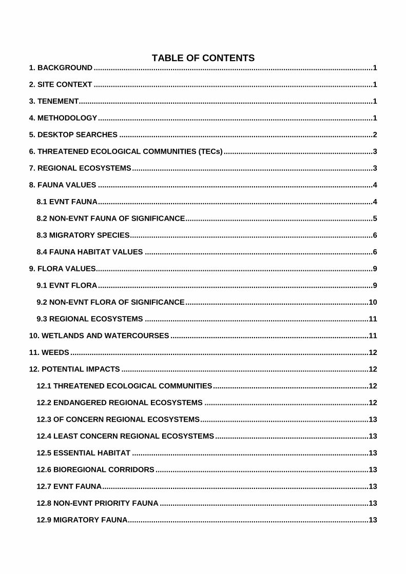
There are numerous small dead trees (likely to have succumbed to prolonged drought prior to the survey) and cut stumps (from logging) which have an abundance of loose bark. These are highly likely to provide shelter sites for at least one significant reptile, this being Golden-tailed Gecko. Piles of logs and debris resulting from past clearing operations are scattered along the margin of the quarry within the existing cleared footprint. Over 30 habitat logs were recorded within the quarry expansion footprint (Table Four). Their locations are shown in Figure 11. For the purposes of this report, habitat logs are defined as those that contain hollows or are otherwise of value from a fauna habitat perspective (e.g. they may offer a potential basking site for reptiles). Small logs are scattered throughout the remnant vegetation, however, large logs (particularly those with hollows) are rare.
Table Four. Descriptions of logs with habitat values at the proposed Pony Hills East
quarry extension.
KEY: * = within 100m of quarry extension boundary
HABITAT LOG CODE
EASTING/ NORTHING
(55J)
SPECIES APPROX. LENGTH
HABITAT FEATURES
HL1 700964 7146666
Eucalyptus sp. 14m medium hollow present; log mostly solid apart from base; burnt
HL2 700989 7146781
Eucalyptus sp. 15m medium hollow present; mostly solid except base
HL3 700889 7146975
Eucalyptus sp. 8m medium hollow present; burnt at base
HL4 700887 7146981
Eucalyptus sp. 9m small and medium hollows present; burnt at base
HL5 700877 7147034
Eucalyptus sp. 3m medium hollow present; burnt at ends
HL6* 700854 7147039
Eucalyptus sp. 12m small and medium hollows present; burnt at base
HL7 700927 7146961
Eucalyptus sp. 14m medium hollow present; log shattered and partially collapsed
HL8 700845 7146879
Eucalyptus sp. 3m medium hollow present; burnt at ends
HL9 700867 7146882
Eucalyptus sp. 11m small hollows present; burnt at base
HL10 700862 7146869
Eucalyptus sp. 11m small and medium hollows present; burnt at base
8
HABITAT LOG CODE
EASTING/ NORTHING
(55J)
SPECIES APPROX. LENGTH
HABITAT FEATURES
HL11 700878 7146873
Eucalyptus sp. 14m small and medium hollows present; burnt at base
HL12 700891 7146878
Eucalyptus sp. 3m medium hollow present; most of outside burnt
HL13 700898 7146872
Eucalyptus sp. 9m small and medium hollows present; burnt around base
HL14* 700669 7146782
Eucalyptus sp. 8m small hollows present; fractured in middle of log
HL15 700728 7146945
Eucalyptus sp. 8m small and medium hollows present; burnt at base
HL16 700762 7146939
Eucalyptus melanophloia
10m small hollows present; burnt at base
HL17 700772 7146941
Eucalyptus sp. 9m medium hollows present; burnt at base
HL18 700793 7146894
Eucalyptus sp. 12m small and large hollows present; burnt around outside of log
HL19 700801 7146875
Eucalyptus sp. 6m small hollows; burnt at base
HL20 700797 7146869
Eucalyptus sp. 4m small hollows present; burnt at base
HL21 700799 7146864
Eucalyptus sp. 8m medium hollow present
HL22 700790 7146835
Eucalyptus sp. 6m small and medium hollows present
HL23 700799 7146826
Eucalyptus sp. 8m small hollows present; burnt at ends
HL24 700813 7146800
Eucalyptus sp. 7m small and large hollows present; log burnt
HL25 700816 7146789
Eucalyptus sp. 8m small hollows present
HL26 700821 7146798
Eucalyptus sp. 4m small and medium hollows present; various small hollow logs next to main log
HL27 700769 7146863
Eucalyptus sp. 7m medium and large hollows present; log burnt
HL28 700798 7146961
Eucalyptus sp. 7m small and medium hollows present; log burnt
HL29 700805 7146973
Eucalyptus sp. 2.5m small and medium hollows present; smaller piece with hollows separated from main log
HL30 700853 7146959
Eucalyptus sp. 4m large hollows present; log burnt
HL31 700853 7146916
Eucalyptus sp. 4m medium hollows present; log badly burnt
HL32 700812 7146848
Eucalyptus sp. 4m medium hollows present
HL33 700744 7146883
Eucalyptus sp. 9m small and medium hollows present; log badly burnt
HL34 700831 7146810
Eucalyptus sp. 5m small and medium hollows; log burnt
HL35 700855 7146840
Eucalyptus sp. 2m large hollows present; log badly burnt
In addition to habitat trees and logs, fauna habitat features identified within the intact vegetation to the north of the existing quarry include rock benches and walls (Table Five and Figure 12).
9
Associated with these rock benches and walls (approximately at the 425m contour) are piles of loose rock, cavities and ledges which provide shelter sites for small terrestrial fauna, particularly reptiles, potentially including significant species such as Brigalow Scaly-foot and Collared Delma. Table Five. Descriptions of habitat features observed at the proposed Pony Hills East
quarry extension.
KEY: * = within 100m of quarry extension boundary
HABITAT FEATURE CODE
EASTING/ NORTHING
(55J)
FEATURE HABITAT VALUES
HF1 * 701050 7146820
Small log pile Habitat for EVNT reptiles e.g. Golden-tailed Gecko, Dunmall’s Snake
HF2 700967
7146844
Outcrop with embedded and loose rock
Habitat for EVNT reptiles e.g. Brigalow Scaly-foot, Collared Delma
HF3 700956 7146942
Rock shelf with crevices and loose rock
Habitat for EVNT reptiles e.g. Brigalow Scaly-foot, Collared Delma
HF4 700680 7146782
Rock shelf with crevices, loose rock and boulders
Habitat for EVNT reptiles e.g. Brigalow Scaly-foot, Collared Delma
HF5 700857 7147005
Outcrop with crevices, embedded and loose rock
Habitat for EVNT reptiles e.g. Brigalow Scaly-foot, Collared Delma
In addition to the fauna habitat identified inside the proposed quarry extension there were two habitat trees (HT4 and HT6); two logs (HL6 and HL14) and a log pile (HF1) recorded within a 100m buffer surrounding the proposed quarry expansion footprint. This demonstrates that similar kinds of fauna habitat extend into the surrounding Hallet State Forest.
9. FLORA VALUES
9.1 EVNT FLORA
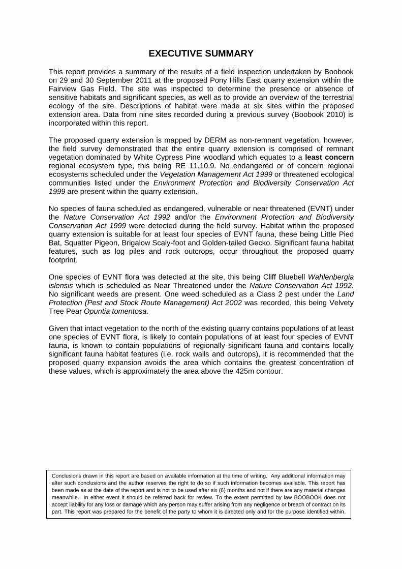
A search of the EPBC Act 1999 Protected Matters Search Tool database returned records of three species of EVNT flora (Cadellia pentastylis, Commersonia argentea, Tylophora linearis) which could potentially occur in the study area. None of these occur at the site. Previous surveys by Boobook in the Fairview gas field have detected populations of an additional eight species of EVNT flora (Table Six). One of these species was detected at the Pony Hills East quarry extension, this being Cliff Bluebell Wahlenbergia islensis which is scheduled as Near Threatened under the Nature Conservation Act 1992. W. islensis was identified from site HF4 along the western side of the proposed quarry expansion footprint. This population comprised approximately 30 individuals and extended along the base of a rock wall for at least 30 metres.
10
Table Six. Summary of likelihood of occurrence of EVNT flora within the study area.
KEY: EPBC Act = Environment Protection and Biodiversity Conservation Act 1999; NC Act = Nature Conservation Act 1992. Record Source: 1 = EPBC search; 2 = Boobook unpublished flora data for Fairview gas
field; note no EVNT flora records were returned for the Wildlife on-line (DERM database) 5km search area Status: E = endangered; V = vulnerable; NT = near threatened; LC = least concern.
CLASS/ FAMILY
SPECIES NAME
COMMON NAME
EPBC ACT
STATUS
NC ACT STATUS
RECORD SOURCE
LIKELIHOOD OF PRESENCE
Acanthaceae Xerothamnella herbacea
Herbaceous Xerothamnella
E E 2 Absent: suitable
habitat is not present
Apocynaceae Tylophora linearis
Slender Tylophora
E E 1 Absent: suitable
habitat is not present
Byttneriaceae Commersonia argentea
A shrub V LC 1 Absent: suitable
habitat is not present
Campanulaceae Wahlenbergia islensis
Cliff Bluebell not listed NT 2 Confirmed: patchy
suitable habitat is present
Celastraceae Apatophyllum teretifolium
Sandstone Prickle-bush
not listed NT 2 Absent: suitable
habitat is not present
Ericaceae Leucopogon grandiflorus
Whorl-leaved Heath
not listed NT 2 Absent: suitable
habitat is not present
Haloragaceae Gonocarpus urceolatus
Rock Raspwort not listed NT 2 Absent: suitable
habitat is not present
Mimosaceae Acacia calantha Cracow Wattle not listed NT 2 Absent: suitable
habitat is not present
Myrtaceae Melaleuca irbyana
Swamp Paperbark
not listed E 2 Absent: suitable
habitat is not present
Myrtaceae Sannantha brachypoda
A Heath-myrtle not listed NT 2 Absent: suitable
habitat is not present
Surianaceae Cadellia pentastylis
Ooline V V 1 Absent: suitable
habitat is not present
Zamiaceae Macrozamia fearnsidei
Curly-leaved Zamia
V LC 2 Absent: suitable
habitat is not present
9.2 NON-EVNT FLORA OF SIGNIFICANCE
No non-EVNT priority flora as per EPA 2008 were detected. These are species which are not scheduled as near threatened, vulnerable or endangered under state or commonwealth legislation, but are recognised as being of regional conservation significance. One species of local significance was recorded this being Thyme Honey-myrtle Melaleuca thymifolia. A single plant was observed at site Q6. This species is represented in the Queensland Herbarium by less than 10 collections from the Leichhardt pastoral district, and is a rare and highly localised species within the Fairview Gas Field.
11
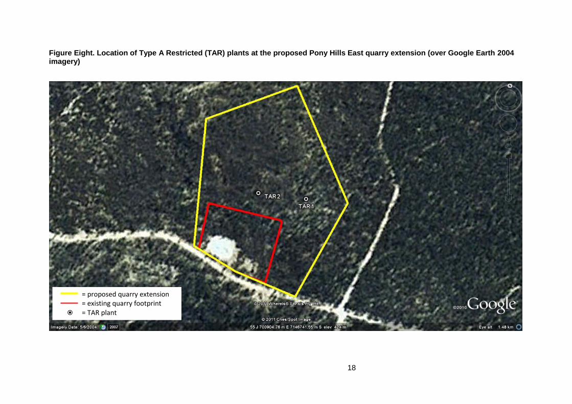
One species of Type A Restricted (TAR) plant was observed at the study are, this being Kurrajong Brachychiton populneus. Descriptions are given in Table Seven and mapped locations are shown in Figure Eight for the plants recorded during the field inspection. Table Seven. Descriptions of Type A Restricted (TAR) plants observed within the
proposed Pony Hills East quarry extension.
KEY: * = within 100m buffer
CODE EASTING/ NORTHING
(55J)
SPECIES COMMENTS
TAR1 700954 7146766
Brachychiton populneus sapling c. 1.5m high
TAR2 700831 7146768
Brachychiton populneus two mature trees side by side av. 12m high
9.3 REGIONAL ECOSYSTEMS
Current regional ecosystem mapping describes the site as non-remnant, however, ground-truthing indicates the whole area within the proposed extension is dominated by White Cypress Pine Callitris glaucophylla and Silver-leaved Ironbark Eucalyptus melanophloia woodland which equates to remnant RE 11.10.9 (see Table Eight). Refer to quaternary site descriptions in Appendix Four (sites Q1, Q2, Q3, Q4, Q5 and Q6) and Figure Nine for further detail. Table Eight. Regional ecosystems observed within the study area.
Key: E = endangered; LC = least concern; NOC = no concern at present; OC = of concern.
RE RE DESCRIPTION VMA 1999
status DERM
(biodiversity status)
11.10.9 White Cypress Pine Callitris glaucophylla woodland on coarse-grained sedimentary rocks
LC NOC
Parts of the proposed quarry extension appear to have been severely affected by past wildfire and/or drought. In these areas, living canopy trees are sparse and the understory is characterised by a very dense midlayer of even-aged Acacia longispicata. No endangered or of concern regional ecosystem types were observed within the proposed quarry extension. The existing disturbed footprint of the Pony Hills East quarry comprises a clearing with a pit, gravel piles and steep banks resulting from previous excavations. No mature trees are present within the existing quarry footprint.
10. WETLANDS AND WATERCOURSES
No watercourses or wetlands of national, regional or local significance occur within the project area. The nearest watercourse (stream order 1) lies approximately 500m to the southeast of the site.
12
11. WEEDS
Eleven species of non-native flora were recorded at the Pony Hills East quarry (Table Nine). One species scheduled as a Class 2 pest under the Land Protection (Pest and Stock Route Management) Act 2002 was recorded, this being Velvety Tree Pear Opuntia tomentosa. This species is in low abundance and is subject to biological control. No other weeds are of management concern. Table Nine. Weeds observed at the Pony Hills East quarry extension.
KEY: *Status as per Land Protection (Pest and Stock Route Management) Act 2002; Abundance: Rare = <10
plants observed; Uncommon = 11 – 50 plants observed; common = >50 plants observed; ND = not declared; # = March 2010 survey record.
FAMILY SCIENTIFIC NAME COMMON NAME STATUS* ABUNDANCE
Verbenaceae Verbena aristigera Mayne's Pest ND common
12. POTENTIAL IMPACTS
12.1 THREATENED ECOLOGICAL COMMUNITIES
The project will not impact upon any Threatened Ecological Communities listed under the EPBC Act 1999.
12.2 ENDANGERED REGIONAL ECOSYSTEMS
The project will not impact upon any regional ecosystems scheduled as endangered under the Vegetation Management Act 1999 or with a DERM biodiversity status of endangered.
13
12.3 OF CONCERN REGIONAL ECOSYSTEMS
The project will not impact upon any regional ecosystems scheduled as of concern under the Vegetation Management Act 1999 or with a DERM biodiversity status of of concern.
12.4 LEAST CONCERN REGIONAL ECOSYSTEMS
The project could potentially impact upon approximately 11.5ha of a least concern regional ecosystem type (RE 11.10.9). Note this entire area is currently unmapped by DERM.
12.5 ESSENTIAL HABITAT
The site is not within 1km of any mapped Essential Habitat for any scheduled EVNT fauna or flora.
12.6 BIOREGIONAL CORRIDORS
The project will potentially contribute to further disturbance to a large vegetated remnant which is within a Category C Environmentally Sensitive Area.
12.7 EVNT FAUNA
Further expansion of the quarry is likely to have most impact on threatened reptiles which may occur at the site. These potentially include Brigalow Scaly-foot, Yakka Skink, Golden-tailed Gecko, Dunmall’s Snake and Collared Delma which inhabit microhabitat features present at the quarry including logs, fallen bark, loose bark or rock outcrops. The project is also likely to impact upon several species of bat includeing Little Pied Bat, Large-eared Pied Bat and South-eastern Long-eared Bat which may roost or forage within habaitat present at the proposed quarry extension. Should the quarry be expanded northwards, especially above approximately the 425m contour, there is a high likelihood of destruction of habitat likely to be occupied by these species. The presence of microhabitat features known to support these species has been demonstrated during the field inspection.
12.8 NON-EVNT PRIORITY FAUNA
The project could potentially result in the loss of habitat for several non-EVNT priority fauna that are known to occupy the site, including Speckled Warbler, Common Brush-tailed Possum and a species of bandicoot (identity unconfirmed).
12.9 MIGRATORY FAUNA
Although several birds listed as a migratory species under the EPBC Act 1999 are known from the general area (e.g. Fork-tailed Swift, White-throated Needletail, Rainbow Bee-eater), and are likely to overfly the site, these are widespread and common species which are unlikely to be negatively impacted by the proposed quarry expansion.
12.10 EVNT FLORA
One species of EVNT flora is likely to be negatively impacted by the project should clearing extend beyond approximately the 425m contour, this being Cliff Bluebell Wahlenbergia islensis. The population of this species within the project area is highly localised and could be completely destroyed by the proposed quarry expansion.
14
12.11 NON-EVNT FLORA
At least one locally significant species of flora could be negatively impacted by the proposed quarry extension, this being Thyme Honey-myrtle Melaleuca thymifolia. The population within the proposed quarry extension is represented by a single plant. Three individuals of TAR plants could potentially be impacted by the proposed quarry extension
12.12 WETLANDS AND WATERCOURSES
No wetlands or watercourses will be negatively impacted by the project.
13. RECOMMENDATIONS
1. Due to the presence of habitat features highly likely to support significant fauna (especially EVNT species such as Golden-tailed Gecko, Brigalow Scaly-foot, Collared Delma, Yakka Skink, Little Pied Bat, Large-eared Pied Bat, Eastern Long-eared Bat and Squatter Pigeon) within remnant vegetation at and above approximately the 425m contour, no expansion of the quarry is recommended above this area. A practical buffer to avoid the rock walls, rock piles and population of Cliff Bluebell Wahlenbergia islensis should be determined in the field with Santos staff prior to the commencement of any clearing at the site. Any proposed clearing including and beyond the 425 m contour would require further pre-clearance surveys for EVNT fauna, especially Golden-tailed Gecko, Brigalow Scaly-foot, Collared Delma, Yakka Skink, Little Pied Bat, Large-eared Pied Bat and Eastern Long-eared Bat. Such surveys would need to be in accordance with federal guidelines (i.e. DEWHA 2010, DSEWPAC 2011) for EPBC listed species. 2. Due to the potential presence of EVNT reptiles associated with log and debris piles surrounding the existing quarry, it is recommended that a fauna spotter be present to implement fauna management measures during any proposed clearing operations likely to interfere with these piles. A fauna spotter should be present throughout any other clearing operations at the site. 3. Avoid disturbance to TAR plants where possible. If disturbance is unavoidable, TAR plants should be translocated, where practical, in accordance with internal procedures. 4. Weed hygiene practices should be implemented for all vehicles and equipment entering the site to minimise the potential introduction of additional weeds to the site. 5. Slow vehicle speeds (maximum 40m/h) should be maintained within 100 metres of the site to reduce the chance of collisions with Squatter Pigeons which are likely to utilise the site.
14. REFERENCES
Boobook (2010). Report on Inspection of Pony Hills Central Quarry, Fairview Gas Field. Unpublished consultancy report to Santos. Department of the Environment, Water, Heritage and the Arts (2010). Survey Guidelines for Australia’s Threatened Bats. DSEWPAC, Canberra. Department of Sustainability, Environment, Water, Population and Communities (2011). Survey Guidelines for Australia’s Threatened Reptiles. DSEWPAC, Canberra.
15
Environmental Protection Agency (EPA) (2008a). ‘Brigalow Belt South Fauna Expert Panel Report.’ Environmental Protection Agency, Brisbane. August 2002. Revised and updated June 2008. Environmental Protection Agency (EPA) (2008b). ‘Brigalow Belt South Flora Expert Panel Report.’ Environmental Protection Agency, Brisbane. August 2002. Revised and updated June 2008. Neldner, V.J., Wilson, B. A., Thompson, E.J. and Dillewaard, H.A. (2005) Methodology for Survey and Mapping of Regional Ecosystems and Vegetation Communities in Queensland. Version 3.1. Updated September 2003. Queensland Herbarium, Environmental Protection Agency, Brisbane.
16
SITE PHOTOS
Figure One (left). Cliff Bluebell Wahlenbergia islensis at site HF4. Figure Two (right). Logs are scattered throughout the proposed quarry extension such as HL16 which had loose bark and small hollows.
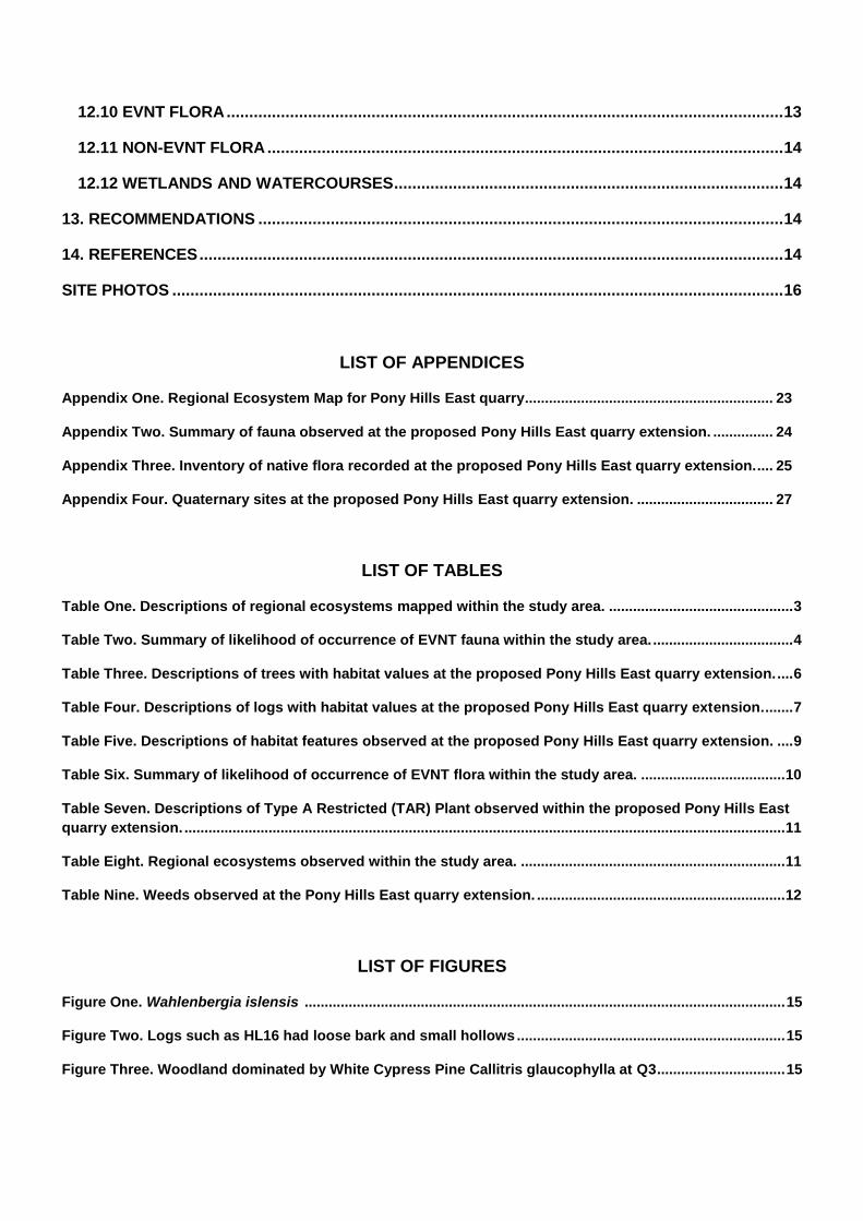
Figure Three (left). Woodland dominated by White Cypress Pine Callitris glaucophylla within the Pony Hills East quarry extension at Q3. Figure Four (right). A dense midlayer dominated by Slender-flowered Wattle Acacia longispicata beneath an open canopy of White Cypress Pine and Silver-leaved Ironbark Eucalyptus melanophloia seen at Q5 which was typical of communities in the rockier areas.
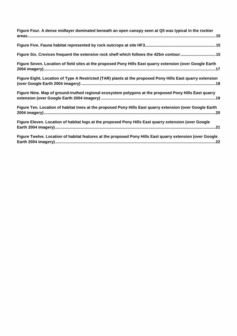
Figure Five (left). Fauna habitat represented by rock outcrops surrounded by White Cypress Pine woodland at site HF3. Figure Six (right). Crevices are present in the extensive rock shelf which approximately follows the 425m contour.
17
Figure Seven. Location of field sites at the proposed Pony Hills East quarry extension (over Google Earth 2004 imagery)