Source: Esri, DigitalGlobe, GeoEye, Earthstar Geographics, CNES/Airbus DS, USDA, USGS, AEX, Getmapping,Aerogrid, IGN, IGP, swisstopo, and the GIS User Community
Source: Esri, DigitalGlobe, GeoEye, Earthstar Geographics, CNES/Airbus DS, USDA,USGS, AEX, Getmapping, Aerogrid, IGN, IGP, swisstopo and the GIS User Community.
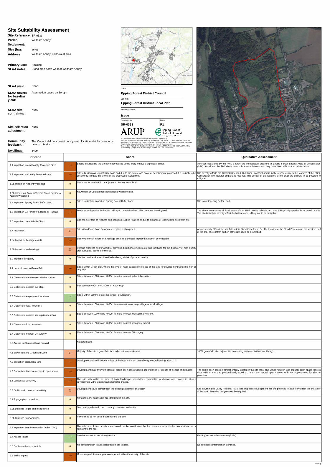
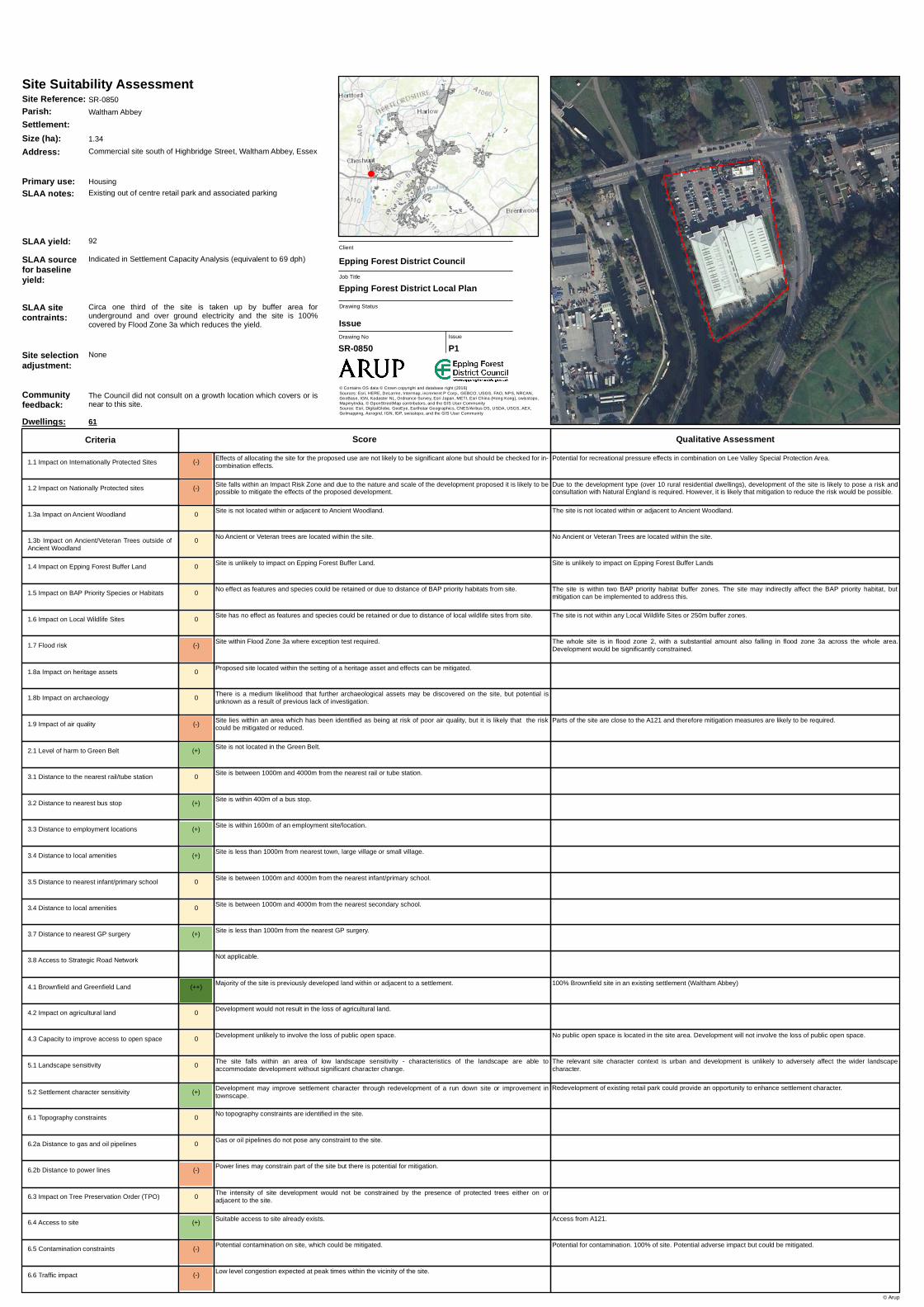
Residential Sites for Stage 2 Assessment inWaltham Abbey
0 Effects of a lloca ting the site for the proposed use do not underm ine conserva tion ob jectives (a lone or incom b ina tion with other sites).
0 Ba sed on the Im pa ct Risk Z ones there is no requirem ent to consult Na tura l Engla nd b eca use the proposeddevelopm ent is unlikely to pose a risk to S S S I's.
S ite is not loca ted within or a dja cent to Ancient W oodla nd.
0 S ite is unlikely to im pa ct on Epping Forest Buffer La nd.
(-) Fea tures a nd species in the site m a y not b e reta ined in their entirety b ut effects ca n b e m itiga ted.
(-) Fea tures a nd species in the site m a y not b e reta ined in their entirety b ut effects ca n b e m itiga ted.
0 No Ancient or Vetera n trees a re loca ted within the site.
Pick Hill/Pa ternoster Hill.
S ite is identified a s a potentia l regenera tion a rea . It is on the edge of the existing settlem ent. However, very low densitydevelopm ent is not likely to a ffect the predom ina ntly rura l cha ra cter of the a rea .
S om e 46% of the site is in Flood Z one 2, within which 29% a nd 11% of a re in Flood Z ones 3a a nd 3b . T he higher riskFlood Z ones run through the m iddle of the site b ut the im pa ct ca n b e m itiga ted through site la yout.
90% greenfield site, a dja cent to a n existing settlem ent (W a ltha m Ab b ey).
Although som e woodla nd a nd sem i-na tura l pub lic open spa ce a re loca ted within the site, opportunities for re-configura tion m a y ena b le the proposa ls to b e delivered without loss of pub lic open spa ce.
S ite sha res cha ra cteristics with the a dja cent zone of m odera te sensitivity. T he form a nd extent of a ny developm entwould ha ve to b e sensitive to the loca tion to a void potentia l a dverse im pa ct on a dja cent la ndsca pe cha ra cter a rea .
No potentia l conta m ina tion identified.
Very sm a ll pa rts of the site a re within 2000m of either Epping Forest S pecia l Area of Conserva tion or Lee Va lleyS pecia l Protection Area . Im pa cts likely to b e a voida b le.
T he site proposes a developm ent type tha t is not considered a risk to S S S I fea tures.
A very sm a ll pa rt of the site is a dja cent to the Buffer La nd. Developm ent likely to b e possib le without com prom isingBuffer La nd to the south-ea st.
T he site is pa rtia lly within the m a jority of a Deciduous W oodla nd ha b ita t, a nd within the releva nt b uffer zone. T he site islikely to directly a ffect the ha b ita t, b ut m itiga tion ca n b e im plem ented to a ddress this.
T he site encom pa sses a sm a ll portion of Cob b in’s Brook LW S . T he site m a y directly a ffect som e of the fea tures a ndspecies of the LW S . T hese fea tures a nd species m a y not b e reta ined entirely, b ut effects ca n b e m itiga ted.
T he intensity of site developm ent would not b e constra ined b y the presence of protected trees either on ora dja cent to the site.
S uita b le a ccess to site a lrea dy exists.
Developm ent is unlikely to ha ve a n effect on settlem ent cha ra cter.
Topogra phica l constra ints exist in the site b ut potentia l for m itiga tion.
Ga s or oil pipelines do not pose a ny constra int to the site.
Power lines do not pose a constra int to the site.
S ite within Flood Z one 3a where exception test required.
No effect likely on historic a ssets due to dista nce from site.
Existing evidence a nd/or a la ck of previous disturb a nce indica tes a high likelihood for the discovery of high qua litya rcha eologica l a ssets on the site.
S ite lies outside of a rea s identified a s b eing a t risk of poor a ir qua lity.
S ite is within Green Belt, where the level of ha rm ca used b y relea se of the la nd for developm ent would b e verylow, low or m edium .
S ite is m ore tha n 4000m from the nea rest ra il or tub e sta tion.
S ite is within 400m of a b us stop.
S ite is within 1600m of a n em ploym ent site/loca tion.
S ite is b etween 1000m a nd 4000m from nea rest town, la rge villa ge or sm a ll villa ge.
S ite is b etween 1000m a nd 4000m from the nea rest infa nt/prim a ry school.
S ite is b etween 1000m a nd 4000m from the nea rest seconda ry school.
S ite is b etween 1000m a nd 4000m from the nea rest GP surgery.
Not a pplica b le.
Ma jority of the site is greenfield la nd a dja cent to a settlem ent.
Developm ent would involve the loss of the b est a nd m ost versa tile a gricultura l la nd (gra des 1-3).
Developm ent unlikely to involve the loss of pub lic open spa ce.
T he site fa lls within a n a rea of m edium la ndsca pe sensitivity - cha ra cteristics of the la ndsca pe a re resilient tocha nge a nd a b le to a b sorb developm ent without significa nt cha ra cter cha nge.
No conta m ina tion issues identified on site to da te.
Area a round the site expected to b e uncongested a t pea k tim e, or site b elow the site size threshold where it wouldb e expected to a ffect congestion.
1.8a Im pa ct on herita ge a ssets
6.3 Im pa ct on T ree Preserva tion Order (T PO)
6.4 Access to site
5.2 S ettlem ent cha ra cter sensitivity
6.1 Topogra phy constra ints
6.2a Dista nce to ga s a nd oil pipelines
6.2b Dista nce to power lines
1.7 Flood risk
3.1 Dista nce to the nea rest ra il/tub e sta tion
3.2 Dista nce to nea rest b us stop
3.3 Dista nce to em ploym ent loca tions
3.4 Dista nce to loca l a m enities
3.5 Dista nce to nea rest infa nt/prim a ry school
3.7 Dista nce to nea rest GP surgery
3.8 Access to S tra tegic Roa d Network
4.1 Brownfield a nd Greenfield La nd
4.2 Im pa ct on a gricultura l la nd
4.3 Ca pa city to im prove a ccess to open spa ce
5.1 La ndsca pe sensitivity
6.5 Conta m ina tion constra ints
6.6 Tra ffic im pa ct
1.1 Im pa ct on Interna tiona lly Protected S ites
1.2 Im pa ct on Na tiona lly Protected sites
1.3a Im pa ct on Ancient W oodla nd
1.4 Im pa ct on Epping Forest Buffer La nd
1.5 Im pa ct on BAP Priority S pecies or Ha b ita ts
1.6 Im pa ct on Loca l W ildlife S ites
1.3b Im pa ct on Ancient/Vetera n Trees outside ofAncient W oodla nd
3.4 Dista nce to loca l a m enities
0
1.9 Im pa ct of a ir qua lity
1.8b Im pa ct on a rcha eology
2.1 Level of ha rm to Green Belt
Site Reference: S R-0020
Primary use: Housing
Communityfeedback:
Feedb a ck wa s received on W AL-E which is within or nea r to thissite. Refer to Appendix B1.4 for further deta ils.
Dwellings: 260
T wo Gla sshouses, derelict nurseries to rea r of Pick Hill(m a sterpla nned a rea ) a nd a gricultura l/gra zing la nd
SLAA notes:
SLAA sourcefor baselineyield:
Indica ted in Ca ll for S ites (equiva lent to 31 dph)
SLAA sitecontraints:
Flood risk will restrict potentia l developm ent to circa ha lfunconstra ined ca pa city for housing.
(-) Effects of allocating the site for the proposed use are not likely to be significant alone but should be checked for in-combination effects.
0 Based on the Impact Risk Zones there is no requirement to consult Natural England because the proposeddevelopment is unlikely to pose a risk to SSSI's.
Site is not located within or adjacent to Ancient Woodland.
0 Site is unlikely to impact on Epping Forest Buffer Land.
0 No effect as features and species could be retained or due to distance of BAP priority habitats from site.
0 Site has no effect as features and species could be retained or due to distance of local wildlife sites from site.
0 No Ancient or Veteran trees are located within the site.
Access would need to be achieved either from adjacent development (Mason Close) or from Mason Way which mayrequire culverting.
Site is identified as a potential regeneration area. Low density development is proposed which reflects the character ofthe area. Therefore, development is not likely to have an impact on the character of the area.
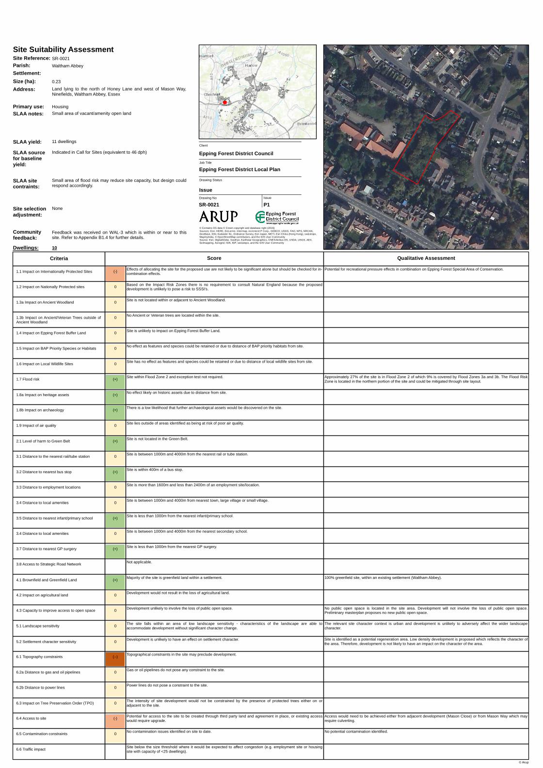
Approximately 27% of the site is in Flood Zone 2 of which 9% is covered by Flood Zones 3a and 3b. The Flood RiskZone is located in the northern portion of the site and could be mitigated through site layout.
100% greenfield site, within an existing settlement (Waltham Abbey).
No public open space is located in the site area. Development will not involve the loss of public open space.Preliminary masterplan proposes no new public open space.
The relevant site character context is urban and development is unlikely to adversely affect the wider landscapecharacter.
No potential contamination identified.
Potential for recreational pressure effects in combination on Epping Forest Special Area of Conservation.
The intensity of site development would not be constrained by the presence of protected trees either on oradjacent to the site.
Potential for access to the site to be created through third party land and agreement in place, or existing accesswould require upgrade.
Development is unlikely to have an effect on settlement character.
Topographical constraints in the site may preclude development.
Gas or oil pipelines do not pose any constraint to the site.
Power lines do not pose a constraint to the site.
Site within Flood Zone 2 and exception test not required.
No effect likely on historic assets due to distance from site.
There is a low likelihood that further archaeological assets would be discovered on the site.
Site lies outside of areas identified as being at risk of poor air quality.
Site is not located in the Green Belt.
Site is between 1000m and 4000m from the nearest rail or tube station.
Site is within 400m of a bus stop.
Site is more than 1600m and less than 2400m of an employment site/location.
Site is between 1000m and 4000m from nearest town, large village or small village.
Site is less than 1000m from the nearest infant/primary school.
Site is between 1000m and 4000m from the nearest secondary school.
Site is less than 1000m from the nearest GP surgery.
Not applicable.
Majority of the site is greenfield land within a settlement.
Development would not result in the loss of agricultural land.
Development unlikely to involve the loss of public open space.
The site falls within an area of low landscape sensitivity - characteristics of the landscape are able toaccommodate development without significant character change.
No contamination issues identified on site to date.
Site below the size threshold where it would be expected to affect congestion (e.g. employment site or housingsite with capacity of <25 dwellings).
1.8a Impact on heritage assets
6.3 Impact on Tree Preservation Order (TPO)
6.4 Access to site
5.2 Settlement character sensitivity
6.1 Topography constraints
6.2a Distance to gas and oil pipelines
6.2b Distance to power lines
1.7 Flood risk
3.1 Distance to the nearest rail/tube station
3.2 Distance to nearest bus stop
3.3 Distance to employment locations
3.4 Distance to local amenities
3.5 Distance to nearest infant/primary school
3.7 Distance to nearest GP surgery
3.8 Access to Strategic Road Network
4.1 Brownfield and Greenfield Land
4.2 Impact on agricultural land
4.3 Capacity to improve access to open space
5.1 Landscape sensitivity
6.5 Contamination constraints
6.6 Traffic impact
1.1 Impact on Internationally Protected Sites
1.2 Impact on Nationally Protected sites
1.3a Impact on Ancient Woodland
1.4 Impact on Epping Forest Buffer Land
1.5 Impact on BAP Priority Species or Habitats
1.6 Impact on Local Wildlife Sites
1.3b Impact on Ancient/Veteran Trees outside ofAncient Woodland
3.4 Distance to local amenities
0
1.9 Impact of air quality
1.8b Impact on archaeology
2.1 Level of harm to Green Belt
Site Reference: SR-0021
Primary use: Housing
Communityfeedback:
Feedback was received on WAL-3 which is within or near to thissite. Refer to Appendix B1.4 for further details.
Dwellings: 10
Small area of vacant/amenity open landSLAA notes:
SLAA sourcefor baselineyield:
Indicated in Call for Sites (equivalent to 46 dph)
SLAA sitecontraints:
Small area of flood risk may reduce site capacity, but design couldrespond accordingly.
(--) Effects of allocating the site for the proposed use is likely to have a significant effect.
0 Based on the Impact Risk Zones there is no requirement to consult Natural England because the proposeddevelopment is unlikely to pose a risk to SSSI's.
Site is not located within or adjacent to Ancient Woodland.
0 Site is unlikely to impact on Epping Forest Buffer Land.
(-) Features and species in the site may not be retained in their entirety but effects can be mitigated.
0 Site has no effect as features and species could be retained or due to distance of local wildlife sites from site.
(-) Site contains Ancient and/or Veteran trees but at a sufficiently low density across the site that removal could belargely avoided or possible impacts could be mitigated.
Potential for access points off Old Shire Lane/Paternoster Hill.
Site is identified as a potential regeneration area, on the edge of existing settlement and number of houses is at ahigher density than neighbouring developments. Therefore, development is likely to affect the predominantly ruralcharacter of the area.
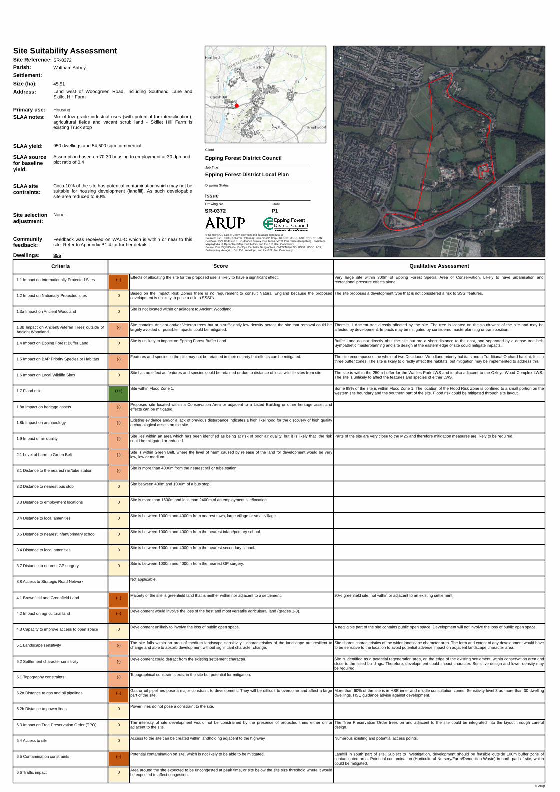
Majority of the site is in the HSE inner and middle consultation zones. Sensitivity level 3 as more than 30 dwellingdwellings. HSE guidance is advise against development.
Approximately 30% of the site is in Flood Zone 2 of which 13% is also within Flood Zones 3a and 3b. The higher FloodRisk Zones are located inside the south-western boundary and through the centre of the site, which can be mitigatedthrough site layout.
Parts of the site are very close to the M25 and therefore mitigation measures are likely to be required.
100% greenfield site, adjacent to an existing settlement (Waltham Abbey).
No public open space is located in the site area. Development will not involve the loss of public open space. Existingmasterplan proposes no new public open space.
No potential contamination identified.
Very large housing site within 500m of Epping Forest Special Area of Conservation. Likely to have urbanisation andrecreational pressure impacts alone.
Site is not touching Buffer Land.
The site is partially within around half of a BAP priority habitat, and within three buffer zones. It is adjacent to a BAPpriority species. The site is likely to directly affect the BAP priority habitat but mitigation can address this.
The site is within the 250m buffer for the Warlies Park LWS. The site is unlikely to affect the features and species ofeither LWS.
There are 2 Ancient trees directly affected by the site. The trees are in the south west of the of the site. Impacts to theAncient trees may be mitigated due to the low density and by considered masterplanning or transposition.
The intensity of site development would not be constrained by the presence of protected trees either on oradjacent to the site.
Access to the site can be created within landholding adjacent to the highway.
Development could detract from the existing settlement character.
Topographical constraints exist in the site but potential for mitigation.
Gas or oil pipelines pose a major constraint to development. They will be difficult to overcome and affect a largepart of the site.
Power lines do not pose a constraint to the site.
Site within Flood Zone 3a where exception test required.
No effect likely on historic assets due to distance from site.
Existing evidence and/or a lack of previous disturbance indicates a high likelihood for the discovery of high qualityarchaeological assets on the site.
Site lies within an area which has been identified as being at risk of poor air quality, but it is likely that the riskcould be mitigated or reduced.
Site is within Green Belt, where the level of harm caused by release of the land for development would be verylow, low or medium.
Site is more than 4000m from the nearest rail or tube station.
Site between 400m and 1000m of a bus stop.
Site is more than 1600m and less than 2400m of an employment site/location.
Site is between 1000m and 4000m from nearest town, large village or small village.
Site is between 1000m and 4000m from the nearest infant/primary school.
Site is between 1000m and 4000m from the nearest secondary school.
Site is between 1000m and 4000m from the nearest GP surgery.
Not applicable.
Majority of the site is greenfield land adjacent to a settlement.
Development would involve the loss of the best and most versatile agricultural land (grades 1-3).
Development unlikely to involve the loss of public open space.
The site falls within an area of high landscape sensitivity - vulnerable to change and unable to absorbdevelopment without significant character change.
No contamination issues identified on site to date.
Area around the site expected to be uncongested at peak time, or site below the site size threshold where it wouldbe expected to affect congestion.
1.8a Impact on heritage assets
6.3 Impact on Tree Preservation Order (TPO)
6.4 Access to site
5.2 Settlement character sensitivity
6.1 Topography constraints
6.2a Distance to gas and oil pipelines
6.2b Distance to power lines
1.7 Flood risk
3.1 Distance to the nearest rail/tube station
3.2 Distance to nearest bus stop
3.3 Distance to employment locations
3.4 Distance to local amenities
3.5 Distance to nearest infant/primary school
3.7 Distance to nearest GP surgery
3.8 Access to Strategic Road Network
4.1 Brownfield and Greenfield Land
4.2 Impact on agricultural land
4.3 Capacity to improve access to open space
5.1 Landscape sensitivity
6.5 Contamination constraints
6.6 Traffic impact
1.1 Impact on Internationally Protected Sites
1.2 Impact on Nationally Protected sites
1.3a Impact on Ancient Woodland
1.4 Impact on Epping Forest Buffer Land
1.5 Impact on BAP Priority Species or Habitats
1.6 Impact on Local Wildlife Sites
1.3b Impact on Ancient/Veteran Trees outside ofAncient Woodland
3.4 Distance to local amenities
0
1.9 Impact of air quality
1.8b Impact on archaeology
2.1 Level of harm to Green Belt
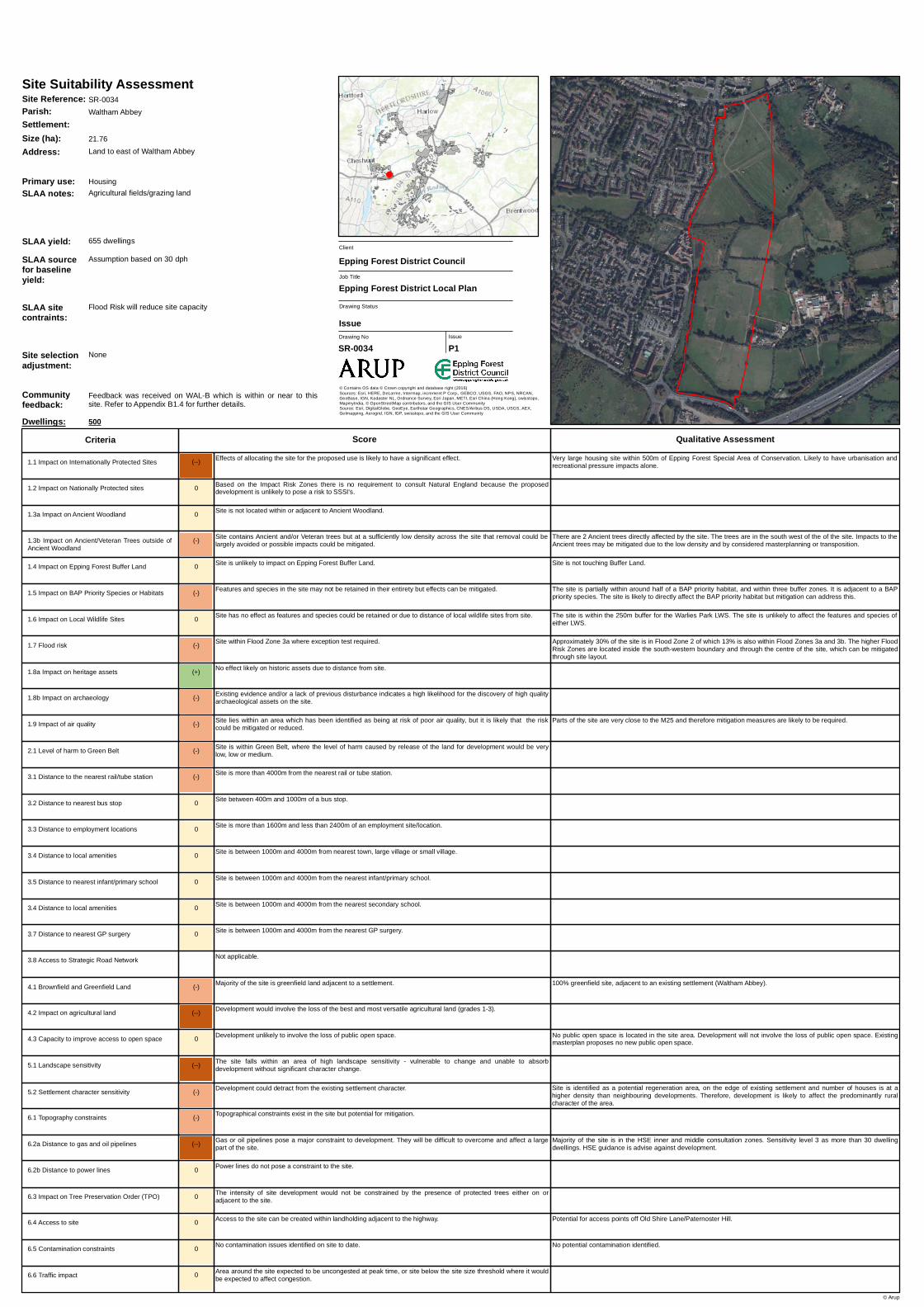
Site Reference: SR-0034
Primary use: Housing
Communityfeedback:
Feedback was received on WAL-B which is within or near to thissite. Refer to Appendix B1.4 for further details.
(-) Effects of allocating the site for the proposed use are not likely to be significant alone but should be checked for in-combination effects.
0 Based on the Impact Risk Zones there is no requirement to consult Natural England because the proposeddevelopment is unlikely to pose a risk to SSSI's.
Site is adjacent to or contains Ancient Woodland. The proposals would likely result in direct loss or harm toAncient Woodland or cannot be mitigated.
(-) The effects of the site on Epping Forest Buffer Land can be mitigated.
0 No effect as features and species could be retained or due to distance of BAP priority habitats from site.
0 Site has no effect as features and species could be retained or due to distance of local wildlife sites from site.
0 No Ancient or Veteran trees are located within the site.
Access from Mott Street.
Low density development is proposed which reflects the rural character of the area. Therefore, development is notlikely to have an impact on the character of the area.
Small portion in northern part of the site is in HSE inner zone and some 50% is in the middle zone. Sensitivity level 2.HSE guidance don't advise against development
90% greenfield site, 500m from existing settlements (High Beech and Sewardstone).
No public open space is located in the site area. Development will not involve the loss of public open space. Existingmasterplan proposes no new public open space.
Key characteristics of the adjacent landscape sensitivity zone assessed as highly sensitive extend to the whole of thissite. Development would be likely to adversely affect the wider landscape character.
Potential contamination (Stables). Potential impact that could be mitigated.
Potential for recreational pressure effects in combination with other housing sites within 2km of Epping Forest SpecialArea of Conservation.
The site is partly within the 250m buffer for Aldergrove Wood Ancient Woodland. The site may directly affect a portionof the buffer land. The site is likely to cause direct loss which cannot be mitigated within the site.
The site directly abuts Epping Forest Buffer Land to the north-west. The proposed development is sufficiently lowdensity that, with sympathetic site design and landscaping, impacts at fringes could be mitigated through boundarytreatment.
The site is partially within a Deciduous Woodland buffer zone. The site may indirectly affect the habitat, but mitigationcan be implemented to address this.
The site is within the 250m buffer for Carroll's Farm Complex LWS, Aldergrove Wood LWS, Lippitts Hill Scrub LWS andOak Farm Grassland LWS. The site is unlikely to affect the features and species of these LWS.
The intensity of site development would not be constrained by the presence of protected trees either on oradjacent to the site.
Suitable access to site already exists.
Development is unlikely to have an effect on settlement character.
Topographical constraints in the site may preclude development.
Gas or oil pipelines may constrain part of the site but there is potential for mitigation.
Power lines do not pose a constraint to the site.
Site within Flood Zone 1.
No effect likely on historic assets due to distance from site.
Existing evidence and/or a lack of previous disturbance indicates a high likelihood for the discovery of high qualityarchaeological assets on the site.
Site lies outside of areas identified as being at risk of poor air quality.
Site is within Green Belt, where the level of harm caused by release of the land for development would be verylow, low or medium.
Site is more than 4000m from the nearest rail or tube station.
Site more than a 1000m from a bus stop.
Site is more than 2400m from an employment site/location.
Site is between 1000m and 4000m from nearest town, large village or small village.
Site is less than 1000m from the nearest infant/primary school.
Site is more than 4000m from the nearest secondary school.
Site is between 1000m and 4000m from the nearest GP surgery.
Not applicable.
Majority of the site is greenfield land that is neither within nor adjacent to a settlement.
Development would involve the loss of the best and most versatile agricultural land (grades 1-3).
Development unlikely to involve the loss of public open space.
The site falls within an area of high landscape sensitivity - vulnerable to change and unable to absorbdevelopment without significant character change.
Potential contamination on site, which could be mitigated.
Site below the size threshold where it would be expected to affect congestion (e.g. employment site or housingsite with capacity of <25 dwellings).
1.8a Impact on heritage assets
6.3 Impact on Tree Preservation Order (TPO)
6.4 Access to site
5.2 Settlement character sensitivity
6.1 Topography constraints
6.2a Distance to gas and oil pipelines
6.2b Distance to power lines
1.7 Flood risk
3.1 Distance to the nearest rail/tube station
3.2 Distance to nearest bus stop
3.3 Distance to employment locations
3.4 Distance to local amenities
3.5 Distance to nearest infant/primary school
3.7 Distance to nearest GP surgery
3.8 Access to Strategic Road Network
4.1 Brownfield and Greenfield Land
4.2 Impact on agricultural land
4.3 Capacity to improve access to open space
5.1 Landscape sensitivity
6.5 Contamination constraints
6.6 Traffic impact
1.1 Impact on Internationally Protected Sites
1.2 Impact on Nationally Protected sites
1.3a Impact on Ancient Woodland
1.4 Impact on Epping Forest Buffer Land
1.5 Impact on BAP Priority Species or Habitats
1.6 Impact on Local Wildlife Sites
1.3b Impact on Ancient/Veteran Trees outside ofAncient Woodland
3.4 Distance to local amenities
(--)
1.9 Impact of air quality
1.8b Impact on archaeology
2.1 Level of harm to Green Belt
Site Reference: SR-0044i
Primary use: Housing
Communityfeedback:
The Council did not consult on a growth location which covers or isnear to this site.
Dwellings: 13
Paddock land/livery businessSLAA notes:
SLAA sourcefor baselineyield:
Indicated in Call for Sites (previous outline application) equivalentto 7 dph. Could accommodate up to 105 dwellings at 30 dph andemployment use assumed at plot ratio of 0.4 on remainder of site.
SLAA sitecontraints:
None
Drawn from Baseline, 24 dwellings split proportionallySite selectionadjustment:
(--) Effects of allocating the site for the proposed use is likely to have a significant effect.
(-) Site falls within an Impact Risk Zone and due to the nature and scale of the development proposed it is likely to bepossible to mitigate the effects of the proposed development.
Site is not located within or adjacent to Ancient Woodland.
0 Site is unlikely to impact on Epping Forest Buffer Land.
0 No effect as features and species could be retained or due to distance of BAP priority habitats from site.
0 Site has no effect as features and species could be retained or due to distance of local wildlife sites from site.
0 No Ancient or Veteran trees are located within the site.
The protected trees on or adjacent to the site could be incorporated into the development proposed, subject to care inthe layout, but would be likely to have a significant adverse impact on the suitability of the site for development
Access from Mott Street.
Low density development is proposed which reflects the rural character of the area. Therefore, development is notlikely to have an impact on the character of the area.
Small portion in the western corner is in the HSE outer consultation zone. Likely impact is considered negligible anddoes not pose a constraint to development. HSE guidance don't advise against development.
100% greenfield site, 200m from an existing settlement (High Beech).
No public open space is located in the site area. Development will not involve the loss of public open space. Existingmasterplan proposes no new public open space.
The form and extent of any development would have to be sensitive to the location to avoid potential adverse impacton the wider landscape character.
No potential contamination identified.
Site located within 400m of Epping Forest Special Area of Conservation. Risk of urbanisation (fly tipping, fires, invasivespecies).
Due to the development type (all planning applications, except householder), development of the site is likely to pose arisk and consultation with Natural England is required. However, it is likely that mitigation to reduce the risk would bepossible.
Site is not touching Buffer Land.
The site is adjacent to a Wood Pasture and Parkland habitat, and within three buffer zones. The site may indirectlyaffect the habitats, but mitigation can be implemented to address this.
The intensity of site development would be constrained by the presence of protected trees either on or adjacent tothe site.
Suitable access to site already exists.
Development is unlikely to have an effect on settlement character.
Topographical constraints in the site may preclude development.
Gas or oil pipelines do not pose any constraint to the site.
Power lines do not pose a constraint to the site.
Site within Flood Zone 1.
No effect likely on historic assets due to distance from site.
Existing evidence and/or a lack of previous disturbance indicates a high likelihood for the discovery of high qualityarchaeological assets on the site.
Site lies outside of areas identified as being at risk of poor air quality.
Site is within Green Belt, where the level of harm caused by release of the land for development would be verylow, low or medium.
Site is between 1000m and 4000m from the nearest rail or tube station.
Site more than a 1000m from a bus stop.
Site is more than 2400m from an employment site/location.
Site is between 1000m and 4000m from nearest town, large village or small village.
Site is less than 1000m from the nearest infant/primary school.
Site is between 1000m and 4000m from the nearest secondary school.
Site is between 1000m and 4000m from the nearest GP surgery.
Not applicable.
Majority of the site is greenfield land that is neither within nor adjacent to a settlement.
Development would result in the loss of poorer quality agricultural land (grade 4-5).
Development unlikely to involve the loss of public open space.
The site falls within an area of medium landscape sensitivity - characteristics of the landscape are resilient tochange and able to absorb development without significant character change.
No contamination issues identified on site to date.
Site below the size threshold where it would be expected to affect congestion (e.g. employment site or housingsite with capacity of <25 dwellings).
1.8a Impact on heritage assets
6.3 Impact on Tree Preservation Order (TPO)
6.4 Access to site
5.2 Settlement character sensitivity
6.1 Topography constraints
6.2a Distance to gas and oil pipelines
6.2b Distance to power lines
1.7 Flood risk
3.1 Distance to the nearest rail/tube station
3.2 Distance to nearest bus stop
3.3 Distance to employment locations
3.4 Distance to local amenities
3.5 Distance to nearest infant/primary school
3.7 Distance to nearest GP surgery
3.8 Access to Strategic Road Network
4.1 Brownfield and Greenfield Land
4.2 Impact on agricultural land
4.3 Capacity to improve access to open space
5.1 Landscape sensitivity
6.5 Contamination constraints
6.6 Traffic impact
1.1 Impact on Internationally Protected Sites
1.2 Impact on Nationally Protected sites
1.3a Impact on Ancient Woodland
1.4 Impact on Epping Forest Buffer Land
1.5 Impact on BAP Priority Species or Habitats
1.6 Impact on Local Wildlife Sites
1.3b Impact on Ancient/Veteran Trees outside ofAncient Woodland
3.4 Distance to local amenities
0
1.9 Impact of air quality
1.8b Impact on archaeology
2.1 Level of harm to Green Belt
Site Reference: SR-0044ii
Primary use: Housing
Communityfeedback:
The Council did not consult on a growth location which covers or isnear to this site.
Dwellings: 3
Paddock land/livery businessSLAA notes:
SLAA sourcefor baselineyield:
Indicated in Call for Sites (previous outline application) equivalentto 7 dph. Could accommodate up to 105 dwellings at 30 dph andemployment use assumed at plot ratio of 0.4 on remainder of site.
0 Effects of a lloca ting the site for the proposed use do not undermine conserva tion objectives (a lone or incombina tion with other sites).
0 Ba sed on the Impa ct R isk Z ones there is no requirement to consult Na tura l Engla nd beca use the proposeddevelopment is unlikely to pose a risk to S S S I's.
S ite is not loca ted within or a dja cent to Ancient W oodla nd.
0 S ite is unlikely to impa ct on Epping Forest Buffer La nd.
0 No effect a s fea tures a nd species could be reta ined or due to dista nce of BAP priority ha bita ts from site.
0 S ite ha s no effect a s fea tures a nd species could be reta ined or due to dista nce of loca l wildlife sites from site.
0 No Ancient or Vetera n trees a re loca ted within the site.
Existing a ccess off Ga lley Hill R oa d a lthough Ga lley Hill R oa d ma y need upgra ding (currently single la ne in pla ces).
S ite is identified a s a potentia l regenera tion a rea . Low density development is proposed which reflects the cha ra cter ofthe a rea . T herefore, development is not likely to ha ve a n impa ct on the cha ra cter of the a rea .
90% greenfield site, 600m from existing settlement (W a ltha m Abbey).
Potentia l conta mina tion (Nursery / W orks / S cra pya rd). Potentia l a dverse impa ct tha t could be mitiga ted.
A very sma ll pa rt of the site a re within 2km of Lee Va lley S pecia l Protection Area . Impa cts likely to be a voida ble.
T he site is pa rtia lly within the buffer zone for Deciduous W oodla nd. T he site ma y indirectly a ffect the ha bita t, butmitiga tion ca n be implemented to a ddress this.
T he site is within the 250m buffer for the Cobbin’s Brook LW S . T he site is unlikely to a ffect the fea tures a nd species ofthe LW S .
T he intensity of site development would not be constra ined by the presence of protected trees either on ora dja cent to the site.
Potentia l for a ccess to the site to be crea ted through third pa rty la nd a nd a greement in pla ce, or existing a ccesswould require upgra de.
Development is unlikely to ha ve a n effect on settlement cha ra cter.
Topogra phica l constra ints exist in the site but potentia l for mitiga tion.
Ga s or oil pipelines do not pose a ny constra int to the site.
Power lines do not pose a constra int to the site.
S ite within Flood Z one 1.
No effect likely on historic a ssets due to dista nce from site.
Existing evidence a nd/or a la ck of previous disturba nce indica tes a high likelihood for the discovery of high qua litya rcha eologica l a ssets on the site.
S ite lies outside of a rea s identified a s being a t risk of poor a ir qua lity.
S ite is within Green Belt, where the level of ha rm ca used by relea se of the la nd for development would be verylow, low or medium.
S ite is between 1000m a nd 4000m from the nea rest ra il or tube sta tion.
S ite between 400m and 1000m of a bus stop.
S ite is within 1600m of a n employment site/loca tion.
S ite is between 1000m a nd 4000m from nea rest town, la rge villa ge or sma ll villa ge.
S ite is between 1000m a nd 4000m from the nea rest infa nt/prima ry school.
S ite is between 1000m a nd 4000m from the nea rest seconda ry school.
S ite is between 1000m a nd 4000m from the nea rest GP surgery.
Not a pplica ble.
Ma jority of the site is greenfield la nd tha t is neither within nor a dja cent to a settlement.
Development would involve the loss of the best a nd most versa tile a gricultura l la nd (gra des 1-3).
Development unlikely to involve the loss of public open spa ce.
T he site fa lls within a n a rea of medium la ndsca pe sensitivity - cha ra cteristics of the la ndsca pe a re resilient tocha nge a nd a ble to a bsorb development without significa nt cha ra cter cha nge.
Potentia l conta mina tion on site, which could be mitiga ted.
Area a round the site expected to be uncongested a t pea k time, or site below the site size threshold where it wouldbe expected to a ffect congestion.
1.8a Impa ct on herita ge a ssets
6.3 Impa ct on T ree Preserva tion Order (T PO)
6.4 Access to site
5.2 S ettlement cha ra cter sensitivity
6.1 Topogra phy constra ints
6.2a Dista nce to ga s a nd oil pipelines
6.2b Dista nce to power lines
1.7 Flood risk
3.1 Dista nce to the nea rest ra il/tube sta tion
3.2 Dista nce to nea rest bus stop
3.3 Dista nce to employment loca tions
3.4 Dista nce to loca l a menities
3.5 Dista nce to nea rest infa nt/prima ry school
3.7 Dista nce to nea rest GP surgery
3.8 Access to S tra tegic R oa d Network
4.1 Brownfield a nd Greenfield La nd
4.2 Impa ct on a gricultura l la nd
4.3 Ca pa city to improve a ccess to open spa ce
5.1 La ndsca pe sensitivity
6.5 Conta mina tion constra ints
6.6 Tra ffic impa ct
1.1 Impa ct on Interna tiona lly Protected S ites
1.2 Impa ct on Na tiona lly Protected sites
1.3a Impa ct on Ancient W oodla nd
1.4 Impa ct on Epping Forest Buffer La nd
1.5 Impa ct on BAP Priority S pecies or Ha bita ts
1.6 Impa ct on Loca l W ildlife S ites
1.3b Impa ct on Ancient/Vetera n Trees outside ofAncient W oodla nd
3.4 Dista nce to loca l a menities
0
1.9 Impa ct of a ir qua lity
1.8b Impa ct on a rcha eology
2.1 Level of ha rm to Green Belt
Site Reference: S R -0060
Primary use: Housing
Communityfeedback:
Feedba ck wa s received on W AL-E which is within or nea r to thissite. R efer to Appendix B1.4 for further deta ils.
Dwellings: 34
R esidentia l & Commercia l premises a nd ga rden/pa ddocksSLAA notes:
(--) Effects of allocating the site for the proposed use is likely to have a significant effect.
0 Based on the Impact Risk Zones there is no requirement to consult Natural England because the proposeddevelopment is unlikely to pose a risk to SSSI's.
Site is not located within or adjacent to Ancient Woodland.
0 Site is unlikely to impact on Epping Forest Buffer Land.
0 No effect as features and species could be retained or due to distance of BAP priority habitats from site.
0 Site has no effect as features and species could be retained or due to distance of local wildlife sites from site.
0 No Ancient or Veteran trees are located within the site.
Access from A121 and Sewardstone Road.
Proposed plan reflects the character of the area. Therefore, development is not likely to have an impact on thecharacter of the area.
Only 4% of the site is in the middle zone. Due to the location/size of the affected area this results in negligible impactand is not considered a constraint to development. HSE guidance could be advise against development for the smallaffected area.
Some 99% of the site is located within Flood Zone 1. Higher Flood Risk Zones 2 and 3a, located on the southernboundary of the site, affect less than 1% of the site and can be avoided through site layout.
Parts of the site are very close to the M25 and therefore mitigation measures are likely to be required.
100% greenfield site, adjacent to an existing settlement (Waltham Abbey).
No public open space is located in the site area. Development will not involve the loss of public open space. Anexisting site masterplan identifies opportunities to provide new public open spaces in the development proposal.
The form and extent of any development would have to be sensitive to the location to avoid potential adverse impacton the wider landscape character.
Potential contamination (Farm / Infilled Pond). Potential adverse impact that could be mitigated.
Very large site circa 1km from Epping Forest Special Area of Conservation. Could have recreational pressure effectalone which may require bespoke mitigation.
The site proposes a development type that is not considered a risk to SSSI features.
The site is partially within the buffer zones for Deciduous Woodland and Wood Pasture and Parkland. The site mayindirectly affect the habitats, but mitigation can be implemented to address this.
The site is within the 250m buffer for the Gunpowder Park LWS. The site is unlikely to affect the features and speciesof the LWS.
The intensity of site development would not be constrained by the presence of protected trees either on oradjacent to the site.
Suitable access to site already exists.
Development is unlikely to have an effect on settlement character.
Topographical constraints exist in the site but potential for mitigation.
Gas or oil pipelines do not pose any constraint to the site.
Power lines do not pose a constraint to the site.
Site within Flood Zone 1.
No effect likely on historic assets due to distance from site.
Existing evidence and/or a lack of previous disturbance indicates a high likelihood for the discovery of high qualityarchaeological assets on the site.
Site lies within an area which has been identified as being at risk of poor air quality, but it is likely that the riskcould be mitigated or reduced.
Site is within Green Belt, where the level of harm caused by release of the land for development would be verylow, low or medium.
Site is more than 4000m from the nearest rail or tube station.
Site between 400m and 1000m of a bus stop.
Site is within 1600m of an employment site/location.
Site is between 1000m and 4000m from nearest town, large village or small village.
Site is between 1000m and 4000m from the nearest infant/primary school.
Site is between 1000m and 4000m from the nearest secondary school.
Site is between 1000m and 4000m from the nearest GP surgery.
Not applicable.
Majority of the site is greenfield land adjacent to a settlement.
Development would involve the loss of the best and most versatile agricultural land (grades 1-3).
Development could provide an opportdwellingy to improve links to adjacent existing public open space or provideaccess to open space which is currently private.
The site falls within an area of low landscape sensitivity - characteristics of the landscape are able toaccommodate development without significant character change.
Potential contamination on site, which could be mitigated.
Low level congestion expected at peak times within the vicinity of the site.
1.8a Impact on heritage assets
6.3 Impact on Tree Preservation Order (TPO)
6.4 Access to site
5.2 Settlement character sensitivity
6.1 Topography constraints
6.2a Distance to gas and oil pipelines
6.2b Distance to power lines
1.7 Flood risk
3.1 Distance to the nearest rail/tube station
3.2 Distance to nearest bus stop
3.3 Distance to employment locations
3.4 Distance to local amenities
3.5 Distance to nearest infant/primary school
3.7 Distance to nearest GP surgery
3.8 Access to Strategic Road Network
4.1 Brownfield and Greenfield Land
4.2 Impact on agricultural land
4.3 Capacity to improve access to open space
5.1 Landscape sensitivity
6.5 Contamination constraints
6.6 Traffic impact
1.1 Impact on Internationally Protected Sites
1.2 Impact on Nationally Protected sites
1.3a Impact on Ancient Woodland
1.4 Impact on Epping Forest Buffer Land
1.5 Impact on BAP Priority Species or Habitats
1.6 Impact on Local Wildlife Sites
1.3b Impact on Ancient/Veteran Trees outside ofAncient Woodland
3.4 Distance to local amenities
0
1.9 Impact of air quality
1.8b Impact on archaeology
2.1 Level of harm to Green Belt
Site Reference: SR-0061B
Primary use: Housing
Communityfeedback:
Feedback was received on WAL-G which is within or near to thissite. Refer to Appendix B1.4 for further details.
Dwellings: 329
Land around Dowding Way (A121). Currently agricultural landSLAA notes:
SLAA sourcefor baselineyield:
Assumption based on circa 50:50 housing to employment land. 30dph housing and 0.4 plot ratio for employment.
SLAA sitecontraints:
None
Multi-parcel site, which has been split out. Yield based on baselineand proportionally split between sites based on site size.
0 Effects of allocating the site for the proposed use do not undermine conservation objectives (alone or incombination with other sites).
(-) Site falls within an Impact Risk Zone and due to the nature and scale of the development proposed it is likely to bepossible to mitigate the effects of the proposed development.
Site is not located within or adjacent to Ancient Woodland.
0 Site is unlikely to impact on Epping Forest Buffer Land.
0 No effect as features and species could be retained or due to distance of BAP priority habitats from site.
0 Site has no effect as features and species could be retained or due to distance of local wildlife sites from site.
0 No Ancient or Veteran trees are located within the site.
Existing access off Sewardstone Road.
Site is within a very low density settlement and the proposed number of houses is at a higher density than theneighbouring developments. Therefore, development is likely to affect the semi-rural character of the area.
A very small portion of the north-eastern corner of the site is in HSE inner consultation zone. Majority of site is inmiddle and outer zones. Level 3 sensitivity as more than 30 dwelling dwellings. HSE guidance advise againstdevelopment.
Parts of the site are close to the A1112 and therefore mitigation measures are likely to be required.
70% greenfield site, 2000m from existing settlement (Waltham Abbey).
No public open space is located in the site area. Development will not involve the loss of public open space.Preliminary masterplan proposes no new public open space.
Potential contamination (Farmyard / Industrial / infilled ground). Potential adverse impact that could be mitigated.
Due to the development type (over 50 rural dwellings), development of the site is likely to pose a risk and consultationwith Natural England is required. However, it is likely that mitigation to reduce the risk would be possible.
The site is partially within three buffer zones. The site may indirectly affect the BAP priority habitats, but mitigation canbe implemented to address this.
The site is within the 250m buffer for the Sewardstone/Osier Marshes LWS. The site is unlikely to affect the featuresand species of the LWS.
The intensity of site development would not be constrained by the presence of protected trees either on oradjacent to the site.
Suitable access to site already exists.
Development could detract from the existing settlement character.
No topography constraints are identified in the site.
Gas or oil pipelines pose a major constraint to development. They will be difficult to overcome and affect a largepart of the site.
Power lines do not pose a constraint to the site.
Site within Flood Zone 1.
Opportunity to enhance significance of the historical asset/ further reveal its significance / enhance the setting.
Existing evidence and/or a lack of previous disturbance indicates a high likelihood for the discovery of high qualityarchaeological assets on the site.
Site lies within an area which has been identified as being at risk of poor air quality, but it is likely that the riskcould be mitigated or reduced.
Site is within Green Belt, where the level of harm caused by release of the land for development would be high orvery high.
Site is more than 4000m from the nearest rail or tube station.
Site is within 400m of a bus stop.
Site is more than 1600m and less than 2400m of an employment site/location.
Site is between 1000m and 4000m from nearest town, large village or small village.
Site is between 1000m and 4000m from the nearest infant/primary school.
Site is between 1000m and 4000m from the nearest secondary school.
Site is between 1000m and 4000m from the nearest GP surgery.
Not applicable.
Majority of the site is greenfield land that is neither within nor adjacent to a settlement.
Development would involve the loss of the best and most versatile agricultural land (grades 1-3).
Development could provide an opportdwellingy to improve links to adjacent existing public open space or provideaccess to open space which is currently private.
The site falls within an area of low landscape sensitivity - characteristics of the landscape are able toaccommodate development without significant character change.
Potential contamination on site, which could be mitigated.
Area around the site expected to be uncongested at peak time, or site below the site size threshold where it wouldbe expected to affect congestion.
1.8a Impact on heritage assets
6.3 Impact on Tree Preservation Order (TPO)
6.4 Access to site
5.2 Settlement character sensitivity
6.1 Topography constraints
6.2a Distance to gas and oil pipelines
6.2b Distance to power lines
1.7 Flood risk
3.1 Distance to the nearest rail/tube station
3.2 Distance to nearest bus stop
3.3 Distance to employment locations
3.4 Distance to local amenities
3.5 Distance to nearest infant/primary school
3.7 Distance to nearest GP surgery
3.8 Access to Strategic Road Network
4.1 Brownfield and Greenfield Land
4.2 Impact on agricultural land
4.3 Capacity to improve access to open space
5.1 Landscape sensitivity
6.5 Contamination constraints
6.6 Traffic impact
1.1 Impact on Internationally Protected Sites
1.2 Impact on Nationally Protected sites
1.3a Impact on Ancient Woodland
1.4 Impact on Epping Forest Buffer Land
1.5 Impact on BAP Priority Species or Habitats
1.6 Impact on Local Wildlife Sites
1.3b Impact on Ancient/Veteran Trees outside ofAncient Woodland
3.4 Distance to local amenities
0
1.9 Impact of air quality
1.8b Impact on archaeology
2.1 Level of harm to Green Belt
Site Reference: SR-0063
Primary use: Housing
Communityfeedback:
The Council did not consult on a growth location which covers or isnear to this site.
Dwellings: 150
Residential, Open and Closed Storage (Former Haulage Yard),Parking and adjacent field
SLAA notes:
SLAA sourcefor baselineyield:
Indicated in Call for Sites (equivalent to 41 dph)
(--) Effects of allocating the site for the proposed use is likely to have a significant effect.
0 Based on the Impact Risk Zones there is no requirement to consult Natural England because the proposeddevelopment is unlikely to pose a risk to SSSI's.
Site is not located within or adjacent to Ancient Woodland.
0 Site is unlikely to impact on Epping Forest Buffer Land.
(--) Features and species in the site unlikely to be retained and effects cannot be mitigated.
0 Site has no effect as features and species could be retained or due to distance of local wildlife sites from site.
(--) Site contains a higher density of Ancient and/or Veteran trees, or are configured in such a way that direct loss orharm is likely.
The protected trees on or adjacent to the site could be incorporated into the development proposed, subject to care inthe layout, but would be likely to have a significant adverse impact on the suitability of the site for development
Access off Honey Lane.
Site is identified as a potential regeneration area. It is on the edge of the existing settlement. However, very low densitydevelopment is proposed which is not likely to affect the predominantly rural character of the area.
Less than 1% of the site is in the HSE middle consultation zone. The affected area is on the site boundary whichresults in negligible sites and is not considered a constraint to development. HSE guidance is likely to be don't adviseagainst development.
Parts of the site are very close to the M25 and therefore mitigation measures are likely to be required.
100% greenfield site, adjacent to an existing settlement (Waltham Abbey).
No public open space is located in the site area. Development will not involve the loss of public open space.
Potential contamination on several parts of the site (Farm/infilled ponds/former sewage works). Potential adverseimpact that could be mitigated.
Very large site circa 1km from Epping Forest Special Area of Conservation. Could have recreational pressure effectalone which may require bespoke mitigation.
The site encompasses the whole of a Deciduous Woodland habitat and Wood Pasture and Parkland habitat. The siteis likely to directly affect the priority habitats, and these effects may not be mitigable.
There are 11 Ancient trees directly affected by the site. The trees are dispersed throughout the site, and developmentmay directly affect all of the trees. The position of the dispersed trees is such that direct harm is likely.
The intensity of site development would be constrained by the presence of protected trees either on or adjacent tothe site.
Suitable access to site already exists.
Development is unlikely to have an effect on settlement character.
Topographical constraints exist in the site but potential for mitigation.
Gas or oil pipelines do not pose any constraint to the site.
Power lines do not pose a constraint to the site.
Site within Flood Zone 1.
No effect likely on historic assets due to distance from site.
Existing evidence and/or a lack of previous disturbance indicates a high likelihood for the discovery of high qualityarchaeological assets on the site.
Site lies within an area which has been identified as being at risk of poor air quality, but it is likely that the riskcould be mitigated or reduced.
Site is within Green Belt, where the level of harm caused by release of the land for development would be verylow, low or medium.
Site is between 1000m and 4000m from the nearest rail or tube station.
Site between 400m and 1000m of a bus stop.
Site is more than 1600m and less than 2400m of an employment site/location.
Site is between 1000m and 4000m from nearest town, large village or small village.
Site is less than 1000m from the nearest infant/primary school.
Site is between 1000m and 4000m from the nearest secondary school.
Site is less than 1000m from the nearest GP surgery.
Not applicable.
Majority of the site is greenfield land adjacent to a settlement.
Development would involve the loss of the best and most versatile agricultural land (grades 1-3).
Development unlikely to involve the loss of public open space.
The site falls within an area of low landscape sensitivity - characteristics of the landscape are able toaccommodate development without significant character change.
Potential contamination on site, which could be mitigated.
Area around the site expected to be uncongested at peak time, or site below the site size threshold where it wouldbe expected to affect congestion.
1.8a Impact on heritage assets
6.3 Impact on Tree Preservation Order (TPO)
6.4 Access to site
5.2 Settlement character sensitivity
6.1 Topography constraints
6.2a Distance to gas and oil pipelines
6.2b Distance to power lines
1.7 Flood risk
3.1 Distance to the nearest rail/tube station
3.2 Distance to nearest bus stop
3.3 Distance to employment locations
3.4 Distance to local amenities
3.5 Distance to nearest infant/primary school
3.7 Distance to nearest GP surgery
3.8 Access to Strategic Road Network
4.1 Brownfield and Greenfield Land
4.2 Impact on agricultural land
4.3 Capacity to improve access to open space
5.1 Landscape sensitivity
6.5 Contamination constraints
6.6 Traffic impact
1.1 Impact on Internationally Protected Sites
1.2 Impact on Nationally Protected sites
1.3a Impact on Ancient Woodland
1.4 Impact on Epping Forest Buffer Land
1.5 Impact on BAP Priority Species or Habitats
1.6 Impact on Local Wildlife Sites
1.3b Impact on Ancient/Veteran Trees outside ofAncient Woodland
3.4 Distance to local amenities
0
1.9 Impact of air quality
1.8b Impact on archaeology
2.1 Level of harm to Green Belt
Site Reference: SR-0065
Primary use: Housing
Communityfeedback:
Feedback was received on WAL-A which is within or near to thissite. Refer to Appendix B1.4 for further details.
Dwellings: 685
Residential dwellings, primary school, open space (playing fields)and scrub/grassland
SLAA notes:
SLAA sourcefor baselineyield:
Indicated in Call for Sites (equivalent to 18-30 dph)
Address: Pendowe a nd Gra nge Hill Nursery, S ewa rdstone Roa d Da inesNursery, S ewa rdstone Nursery, Pritcha rd's Nursery, Mott S treetNursery, Ceda r Lodge, Mott S treet, London E4
(-) Effects of a lloca ting the site for the proposed use a re not likely to b e significa nt a lone b ut should b e checked for in-com b ina tion effects.
(-) S ite fa lls within a n Im pa ct Risk Z one a nd due to the na ture a nd sca le of the developm ent proposed it is likely to b epossib le to m itiga te the effects of the proposed developm ent.
S ite is a dja cent to or conta ins Ancient W oodla nd b ut possib le effects ca n b e m itiga ted.
0 S ite is unlikely to im pa ct on Epping Forest Buffer La nd.
(-) Fea tures a nd species in the site m a y not b e reta ined in their entirety b ut effects ca n b e m itiga ted.
0 S ite ha s no effect a s fea tures a nd species could b e reta ined or due to dista nce of loca l wildlife sites from site.
0 No Ancient or Vetera n trees a re loca ted within the site.
Existing a ccess off Mott S t.
S ite is within a very low density settlem ent a nd the proposed num b er of houses is a t a higher density tha n theneighb ouring developm ents. T herefore, developm ent is likely to a ffect the sem i-rura l cha ra cter of the a rea .
HP ga s line runs through the northern portion of the site a nd a pproxim a tely 50% of the site is in the HS E innerconsulta tion zone. S ensitivity level 3 a s m ore tha n 30 dwellings. HS E guida nce a dvise a ga inst developm ent.
100% greenfield site not within or a dja cent to a n existing settlem ent.
No pub lic open spa ce is loca ted in the site a rea . Developm ent will not involve the loss of pub lic open spa ce.
T he form a nd extent of a ny developm ent would ha ve to b e sensitive to the loca tion to a void potentia l a dverse im pa cton the a dja cent highly sensitive la ndsca pe cha ra cter a rea .
Potentia l conta m ina tion (Horticultura l Nursery). Potentia l a dverse im pa ct tha t could b e m itiga ted.
Potentia l for recrea tiona l pressure effects in com b ina tion with other housing sites within 2km of Epping Forest S pecia lArea of Conserva tion.
Due to the developm ent type (over 100 rura l dwellings), developm ent of the site is likely to pose a risk a nd consulta tionwith Na tura l Engla nd is required. However, it is likely tha t m itiga tion to reduce the risk would b e possib le.
T he site is pa rtly within the 250m b uffer for T hom pson W ood Ancient W oodla nd. T he site m a y directly a ffect a sm a lla rea of the b uffer la nd, b ut im pa cts m a y b e m itiga ted a ga inst through considered m a sterpla nning.
S ite is not touching Buffer La nd.
T he site encom pa sses a Tra ditiona l Orcha rd ha b ita t, a nd is within two b uffer zones. T he site m a y directly im pa ct onthe ha b ita t, b ut m itiga tion ca n b e im plem ented to a ddress this.
T he site is within the 250m b uffer for the T hom pson’s W ood LW S . T he site is unlikely to a ffect the fea tures a nd speciesof either LW S .
T he intensity of site developm ent would not b e constra ined b y the presence of protected trees either on ora dja cent to the site.
S uita b le a ccess to site a lrea dy exists.
Developm ent could detra ct from the existing settlem ent cha ra cter.
Topogra phica l constra ints exist in the site b ut potentia l for m itiga tion.
Ga s or oil pipelines pose a m a jor constra int to developm ent. T hey will b e difficult to overcom e a nd a ffect a la rgepa rt of the site.
Power lines do not pose a constra int to the site.
S ite within Flood Z one 1.
No effect likely on historic a ssets due to dista nce from site.
Existing evidence a nd/or a la ck of previous disturb a nce indica tes a high likelihood for the discovery of high qua litya rcha eologica l a ssets on the site.
S ite lies outside of a rea s identified a s b eing a t risk of poor a ir qua lity.
S ite is within Green Belt, where the level of ha rm ca used b y relea se of the la nd for developm ent would b e high orvery high.
S ite is m ore tha n 4000m from the nea rest ra il or tub e sta tion.
S ite b etween 400m a nd 1000m of a b us stop.
S ite is m ore tha n 2400m from a n em ploym ent site/loca tion.
S ite is b etween 1000m a nd 4000m from nea rest town, la rge villa ge or sm a ll villa ge.
S ite is b etween 1000m a nd 4000m from the nea rest infa nt/prim a ry school.
S ite is b etween 1000m a nd 4000m from the nea rest seconda ry school.
S ite is b etween 1000m a nd 4000m from the nea rest GP surgery.
Not a pplica b le.
Ma jority of the site is greenfield la nd tha t is neither within nor a dja cent to a settlem ent.
Developm ent would involve the loss of the b est a nd m ost versa tile a gricultura l la nd (gra des 1-3).
Developm ent unlikely to involve the loss of pub lic open spa ce.
T he site fa lls within a n a rea of m edium la ndsca pe sensitivity - cha ra cteristics of the la ndsca pe a re resilient tocha nge a nd a b le to a b sorb developm ent without significa nt cha ra cter cha nge.
Potentia l conta m ina tion on site, which could b e m itiga ted.
Area a round the site expected to b e uncongested a t pea k tim e, or site b elow the site size threshold where it wouldb e expected to a ffect congestion.
1.8a Im pa ct on herita ge a ssets
6.3 Im pa ct on T ree Preserva tion Order (T PO)
6.4 Access to site
5.2 S ettlem ent cha ra cter sensitivity
6.1 Topogra phy constra ints
6.2a Dista nce to ga s a nd oil pipelines
6.2b Dista nce to power lines
1.7 Flood risk
3.1 Dista nce to the nea rest ra il/tub e sta tion
3.2 Dista nce to nea rest b us stop
3.3 Dista nce to em ploym ent loca tions
3.4 Dista nce to loca l a m enities
3.5 Dista nce to nea rest infa nt/prim a ry school
3.7 Dista nce to nea rest GP surgery
3.8 Access to S tra tegic Roa d Network
4.1 Brownfield a nd Greenfield La nd
4.2 Im pa ct on a gricultura l la nd
4.3 Ca pa city to im prove a ccess to open spa ce
5.1 La ndsca pe sensitivity
6.5 Conta m ina tion constra ints
6.6 Tra ffic im pa ct
1.1 Im pa ct on Interna tiona lly Protected S ites
1.2 Im pa ct on Na tiona lly Protected sites
1.3a Im pa ct on Ancient W oodla nd
1.4 Im pa ct on Epping Forest Buffer La nd
1.5 Im pa ct on BAP Priority S pecies or Ha b ita ts
1.6 Im pa ct on Loca l W ildlife S ites
1.3b Im pa ct on Ancient/Vetera n Trees outside ofAncient W oodla nd
3.4 Dista nce to loca l a m enities
(-)
1.9 Im pa ct of a ir qua lity
1.8b Im pa ct on a rcha eology
2.1 Level of ha rm to Green Belt
Site Reference: S R-0084
Primary use: Housing
Communityfeedback:
T he Council did not consult on a growth loca tion which covers or isnea r to this site.
(--) Effects of allocating the site for the proposed use is likely to have a significant effect.
(--) Site falls within an Impact Risk Zone and due to the nature and scale of development proposed it is unlikely to bepossible to mitigate the effects of the proposed development.
Site is not located within or adjacent to Ancient Woodland.
(+) Site may assist in extending the Epping Forest Buffer Land.
(--) Features and species in the site unlikely to be retained and effects cannot be mitigated.
(-) Features and species in the site may not be retained in their entirety but effects can be mitigated.
0 No Ancient or Veteran trees are located within the site.
Existing access off Beaulieu Drive and Fishers Green Lane.
Site part of Waltham Abbey Royal Gunpowder Factory. It also overlaps with the Conservation Area. Therefore,development could significantly alter the character of the settlement around this site.
Only 1% of the site is affected by the BPA oil pipeline. The affected area is in the northern corner of the site. This isresults is a negligible site and is not considered a constraint to development.
Approximately 70% of the site is in Flood Zone 3a, within which circa 9% is in Flood Zone 3b. The higher Flood Zonecovers the western side of the site. The eastern portion of the site could be developed although it is partially located inflood zone 2.
Majority of the site is far enough away from motorway to not have a significant impact.
80% greenfield site, adjacent to an existing settlement (Waltham Abbey).
A negligible part of the site contains public open space. Development will not likely involve any loss. Site adjacent toexisting public open space which could provide opportunities for improved access to woodland and semi natural publicopen space.
Potential / known contamination (Explosives & Chemical Manufacture, Testing & Research) Potential adverse impactthat could be mitigated.
Although separated by the river, a large site immediately adjacent to Epping Forest Special Area of Conservation(SPA) on a side of the SPA where there is little such development may have direct effects from urbanisation.
The site directly affects the Waltham Abbey SSSI and is likely to pose a risk to the features of the SSSI. Consultationwith Natural England is required. Furthermore, the effects on the features of the SSSI are unlikely to be possible tomitigate.
The proposed development includes substantial areas of parkland which could provide opportunity to extend the BufferLand.
The site encompasses the whole of two Semi Improved Grassland, multiple Deciduous Woodland, and multipleLowland Fens priority habitats. The site is likely to directly affect the habitats, and this may not be mitigable.
The site is adjacent to the Former Royal Gunpowder Factory Site LWS. The site may indirectly affect the features andspecies of the LWS. These features and species may not be retained in their entirety, but effects can be mitigated.
The intensity of site development would not be constrained by the presence of protected trees either on oradjacent to the site.
Suitable access to site already exists.
Development is likely to substantially harm the existing settlement character.
No topography constraints are identified in the site.
Gas or oil pipelines do not pose any constraint to the site.
Power lines do not pose a constraint to the site.
Site within Flood Zone 3a where exception test required.
Site would result in loss of a heritage asset or significant impact that cannot be mitigated.
Existing evidence and/or a lack of previous disturbance indicates a high likelihood for the discovery of high qualityarchaeological assets on the site.
Site lies outside of areas identified as being at risk of poor air quality.
Site is within Green Belt, where the level of harm caused by release of the land for development would be high orvery high.
Site is between 1000m and 4000m from the nearest rail or tube station.
Site more than a 1000m from a bus stop.
Site is more than 1600m and less than 2400m of an employment site/location.
Site is between 1000m and 4000m from nearest town, large village or small village.
Site is between 1000m and 4000m from the nearest infant/primary school.
Site is between 1000m and 4000m from the nearest secondary school.
Site is between 1000m and 4000m from the nearest GP surgery.
Not applicable.
Majority of the site is greenfield land adjacent to a settlement.
Development would involve the loss of the best and most versatile agricultural land (grades 1-3).
Development could provide an opportunity to improve links to adjacent existing public open space or provideaccess to open space which is currently private.
The site falls within an area of high landscape sensitivity - vulnerable to change and unable to absorbdevelopment without significant character change.
Potential contamination on site, which could be mitigated.
Moderate peak time congestion expected within the vicinity of the site.
1.8a Impact on heritage assets
6.3 Impact on Tree Preservation Order (TPO)
6.4 Access to site
5.2 Settlement character sensitivity
6.1 Topography constraints
6.2a Distance to gas and oil pipelines
6.2b Distance to power lines
1.7 Flood risk
3.1 Distance to the nearest rail/tube station
3.2 Distance to nearest bus stop
3.3 Distance to employment locations
3.4 Distance to local amenities
3.5 Distance to nearest infant/primary school
3.7 Distance to nearest GP surgery
3.8 Access to Strategic Road Network
4.1 Brownfield and Greenfield Land
4.2 Impact on agricultural land
4.3 Capacity to improve access to open space
5.1 Landscape sensitivity
6.5 Contamination constraints
6.6 Traffic impact
1.1 Impact on Internationally Protected Sites
1.2 Impact on Nationally Protected sites
1.3a Impact on Ancient Woodland
1.4 Impact on Epping Forest Buffer Land
1.5 Impact on BAP Priority Species or Habitats
1.6 Impact on Local Wildlife Sites
1.3b Impact on Ancient/Veteran Trees outside ofAncient Woodland
3.4 Distance to local amenities
0
1.9 Impact of air quality
1.8b Impact on archaeology
2.1 Level of harm to Green Belt
Site Reference: SR-0085
Primary use: Housing
Communityfeedback:
The Council did not consult on a growth location which covers or isnear to this site.
(-) Effects of allocating the site for the proposed use are not likely to be significant alone but should be checked for in-combination effects.
(-) Site falls within an Impact Risk Zone and due to the nature and scale of the development proposed it is likely to bepossible to mitigate the effects of the proposed development.
Site is not located within or adjacent to Ancient Woodland.
0 Site is unlikely to impact on Epping Forest Buffer Land.
0 No effect as features and species could be retained or due to distance of BAP priority habitats from site.
0 Site has no effect as features and species could be retained or due to distance of local wildlife sites from site.
0 No Ancient or Veteran trees are located within the site.
Existing access off Galley Hill Road although Galley Hill Road may need upgrading (currently single lane in places).
Site is identified as a potential regeneration area. It is far away from existing settlements with scattered developmentsaround it. Therefore, development is likely to affect the predominantly rural character of the area.
100% greenfield site, 600m from an existing settlement (Waltham Abbey).
Site shares characteristics with the adjacent zone of moderate sensitivity. The form and extent of any developmentwould have to be sensitive to the location to avoid potential adverse impact on adjacent landscape character area.
No potential contamination identified.
Potential for recreational pressure effects in combination on Lea Valley Special Protection Area.
Due to the development type (over 50 rural residential dwellings), development of the site is likely to pose a risk andconsultation with Natural England is required. However, it is likely that mitigation to reduce the risk would be possible.
The intensity of site development would not be constrained by the presence of protected trees either on oradjacent to the site.
Potential for access to the site to be created through third party land and agreement in place, or existing accesswould require upgrade.
Development could detract from the existing settlement character.
Topographical constraints exist in the site but potential for mitigation.
Gas or oil pipelines do not pose any constraint to the site.
Power lines do not pose a constraint to the site.
Site within Flood Zone 1.
No effect likely on historic assets due to distance from site.
Existing evidence and/or a lack of previous disturbance indicates a high likelihood for the discovery of high qualityarchaeological assets on the site.
Site lies outside of areas identified as being at risk of poor air quality.
Site is within Green Belt, where the level of harm caused by release of the land for development would be verylow, low or medium.
Site is more than 4000m from the nearest rail or tube station.
Site between 400m and 1000m of a bus stop.
Site is within 1600m of an employment site/location.
Site is between 1000m and 4000m from nearest town, large village or small village.
Site is between 1000m and 4000m from the nearest infant/primary school.
Site is between 1000m and 4000m from the nearest secondary school.
Site is between 1000m and 4000m from the nearest GP surgery.
Not applicable.
Majority of the site is greenfield land that is neither within nor adjacent to a settlement.
Development would involve the loss of the best and most versatile agricultural land (grades 1-3).
Development unlikely to involve the loss of public open space.
The site falls within an area of medium landscape sensitivity - characteristics of the landscape are resilient tochange and able to absorb development without significant character change.
No contamination issues identified on site to date.
Area around the site expected to be uncongested at peak time, or site below the site size threshold where it wouldbe expected to affect congestion.
1.8a Impact on heritage assets
6.3 Impact on Tree Preservation Order (TPO)
6.4 Access to site
5.2 Settlement character sensitivity
6.1 Topography constraints
6.2a Distance to gas and oil pipelines
6.2b Distance to power lines
1.7 Flood risk
3.1 Distance to the nearest rail/tube station
3.2 Distance to nearest bus stop
3.3 Distance to employment locations
3.4 Distance to local amenities
3.5 Distance to nearest infant/primary school
3.7 Distance to nearest GP surgery
3.8 Access to Strategic Road Network
4.1 Brownfield and Greenfield Land
4.2 Impact on agricultural land
4.3 Capacity to improve access to open space
5.1 Landscape sensitivity
6.5 Contamination constraints
6.6 Traffic impact
1.1 Impact on Internationally Protected Sites
1.2 Impact on Nationally Protected sites
1.3a Impact on Ancient Woodland
1.4 Impact on Epping Forest Buffer Land
1.5 Impact on BAP Priority Species or Habitats
1.6 Impact on Local Wildlife Sites
1.3b Impact on Ancient/Veteran Trees outside ofAncient Woodland
3.4 Distance to local amenities
0
1.9 Impact of air quality
1.8b Impact on archaeology
2.1 Level of harm to Green Belt
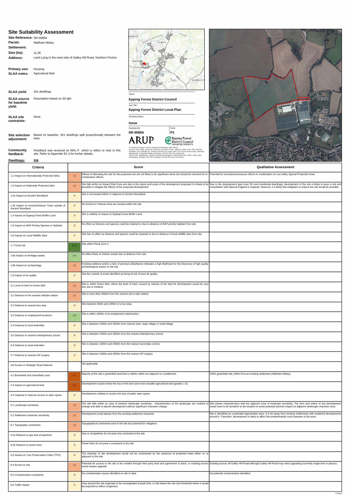
Site Reference: SR-0089A
Primary use: Housing
Communityfeedback:
Feedback was received on WAL-F which is within or near to thissite. Refer to Appendix B1.4 for further details.
Dwellings: 206
Agricultural fieldSLAA notes:
SLAA sourcefor baselineyield:
Assumption based on 30 dph
SLAA sitecontraints:
None
Based on baseline, 341 dwellings split proportionally between thesites.
(-) Effects of allocating the site for the proposed use are not likely to be significant alone but should be checked for in-combination effects.
(-) Site falls within an Impact Risk Zone and due to the nature and scale of the development proposed it is likely to bepossible to mitigate the effects of the proposed development.
Site is not located within or adjacent to Ancient Woodland.
0 Site is unlikely to impact on Epping Forest Buffer Land.
0 No effect as features and species could be retained or due to distance of BAP priority habitats from site.
0 Site has no effect as features and species could be retained or due to distance of local wildlife sites from site.
0 No Ancient or Veteran trees are located within the site.
Existing access off of Crooked Mile.
Site is identified as a potential regeneration area. It is on the edge of the existing settlement. However, very low densitydevelopment is not likely to affect the predominantly rural character of the area.
100% greenfield site, adjacent to an existing settlement (Waltham Abbey).
The key characteristics of the wider landscape character zone extend across the whole site. The form and extent ofany development would have to be sensitive to the location to avoid potential adverse impact on adjacent landscapecharacter area.
Potential contamination (Horticultural Nursery, Scrapyard, Shooting Ground). Potential adverse impact that could bemitigated.
Potential for recreational pressure effects in combination on Lea Valley Special Protection Area.
Due to the development type (over 50 rural residential dwellings), development of the site is likely to pose a risk andconsultation with Natural England is required. However, it is likely that mitigation to reduce the risk would be possible.
The site is within two buffer zones. The site may indirectly affect the habitats, but mitigation can be implemented toaddress this.
The intensity of site development would not be constrained by the presence of protected trees either on oradjacent to the site.
Suitable access to site already exists.
Development is unlikely to have an effect on settlement character.
No topography constraints are identified in the site.
Gas or oil pipelines do not pose any constraint to the site.
Power lines do not pose a constraint to the site.
Site within Flood Zone 1.
No effect likely on historic assets due to distance from site.
Existing evidence and/or a lack of previous disturbance indicates a high likelihood for the discovery of high qualityarchaeological assets on the site.
Site lies outside of areas identified as being at risk of poor air quality.
Site is within Green Belt, where the level of harm caused by release of the land for development would be verylow, low or medium.
Site is more than 4000m from the nearest rail or tube station.
Site is within 400m of a bus stop.
Site is within 1600m of an employment site/location.
Site is between 1000m and 4000m from nearest town, large village or small village.
Site is between 1000m and 4000m from the nearest infant/primary school.
Site is between 1000m and 4000m from the nearest secondary school.
Site is between 1000m and 4000m from the nearest GP surgery.
Not applicable.
Majority of the site is greenfield land adjacent to a settlement.
Development would involve the loss of the best and most versatile agricultural land (grades 1-3).
Development unlikely to involve the loss of public open space.
The site falls within an area of medium landscape sensitivity - characteristics of the landscape are resilient tochange and able to absorb development without significant character change.
Potential contamination on site, which could be mitigated.
Area around the site expected to be uncongested at peak time, or site below the site size threshold where it wouldbe expected to affect congestion.
1.8a Impact on heritage assets
6.3 Impact on Tree Preservation Order (TPO)
6.4 Access to site
5.2 Settlement character sensitivity
6.1 Topography constraints
6.2a Distance to gas and oil pipelines
6.2b Distance to power lines
1.7 Flood risk
3.1 Distance to the nearest rail/tube station
3.2 Distance to nearest bus stop
3.3 Distance to employment locations
3.4 Distance to local amenities
3.5 Distance to nearest infant/primary school
3.7 Distance to nearest GP surgery
3.8 Access to Strategic Road Network
4.1 Brownfield and Greenfield Land
4.2 Impact on agricultural land
4.3 Capacity to improve access to open space
5.1 Landscape sensitivity
6.5 Contamination constraints
6.6 Traffic impact
1.1 Impact on Internationally Protected Sites
1.2 Impact on Nationally Protected sites
1.3a Impact on Ancient Woodland
1.4 Impact on Epping Forest Buffer Land
1.5 Impact on BAP Priority Species or Habitats
1.6 Impact on Local Wildlife Sites
1.3b Impact on Ancient/Veteran Trees outside ofAncient Woodland
3.4 Distance to local amenities
0
1.9 Impact of air quality
1.8b Impact on archaeology
2.1 Level of harm to Green Belt
Site Reference: SR-0099
Primary use: Housing
Communityfeedback:
Feedback was received on WAL-F which is within or near to thissite. Refer to Appendix B1.4 for further details.
Dwellings: 100
Derelict agricultural nursery/garden centre with a few smallwarehouses on site and an area of open storage hardstanding
SLAA notes:
SLAA sourcefor baselineyield:
Assumption based on previous planning brief/applications
(-) Effects of allocating the site for the proposed use are not likely to be significant alone but should be checked for in-combination effects.
(-) Site falls within an Impact Risk Zone and due to the nature and scale of the development proposed it is likely to bepossible to mitigate the effects of the proposed development.
Site is not located within or adjacent to Ancient Woodland.
0 Site is unlikely to impact on Epping Forest Buffer Land.
0 No effect as features and species could be retained or due to distance of BAP priority habitats from site.
0 Site has no effect as features and species could be retained or due to distance of local wildlife sites from site.
0 No Ancient or Veteran trees are located within the site.
Access could be gained from Parklands.
Site is identified as a potential regeneration area. Low density development is proposed which reflects the character ofthe area. Therefore, development is not likely to have an impact on the character of the area.
100% greenfield site, adjacent to an existing settlement (Waltham Abbey).
No potential contamination identified.
Potential for recreational pressure effects in combination on Lea Valley Special Protection Area.
Due to the development type (over 50 rural residential dwellings), development of the site is likely to pose a risk andconsultation with Natural England is required. However, it is likely that mitigation to reduce the risk would be possible.
The intensity of site development would not be constrained by the presence of protected trees either on oradjacent to the site.
Potential for access to the site to be created through third party land and agreement in place, or existing accesswould require upgrade.
Development is unlikely to have an effect on settlement character.
No topography constraints are identified in the site.
Gas or oil pipelines do not pose any constraint to the site.
Power lines do not pose a constraint to the site.
Site within Flood Zone 1.
No effect likely on historic assets due to distance from site.
Existing evidence and/or a lack of previous disturbance indicates a high likelihood for the discovery of high qualityarchaeological assets on the site.
Site lies outside of areas identified as being at risk of poor air quality.
Site is within Green Belt, where the level of harm caused by release of the land for development would be verylow, low or medium.
Site is more than 4000m from the nearest rail or tube station.
Site is within 400m of a bus stop.
Site is within 1600m of an employment site/location.
Site is between 1000m and 4000m from nearest town, large village or small village.
Site is between 1000m and 4000m from the nearest infant/primary school.
Site is between 1000m and 4000m from the nearest secondary school.
Site is between 1000m and 4000m from the nearest GP surgery.
Not applicable.
Majority of the site is greenfield land adjacent to a settlement.
Development would involve the loss of the best and most versatile agricultural land (grades 1-3).
Development unlikely to involve the loss of public open space.
The site falls within an area of medium landscape sensitivity - characteristics of the landscape are resilient tochange and able to absorb development without significant character change.
No contamination issues identified on site to date.
Area around the site expected to be uncongested at peak time, or site below the site size threshold where it wouldbe expected to affect congestion.
1.8a Impact on heritage assets
6.3 Impact on Tree Preservation Order (TPO)
6.4 Access to site
5.2 Settlement character sensitivity
6.1 Topography constraints
6.2a Distance to gas and oil pipelines
6.2b Distance to power lines
1.7 Flood risk
3.1 Distance to the nearest rail/tube station
3.2 Distance to nearest bus stop
3.3 Distance to employment locations
3.4 Distance to local amenities
3.5 Distance to nearest infant/primary school
3.7 Distance to nearest GP surgery
3.8 Access to Strategic Road Network
4.1 Brownfield and Greenfield Land
4.2 Impact on agricultural land
4.3 Capacity to improve access to open space
5.1 Landscape sensitivity
6.5 Contamination constraints
6.6 Traffic impact
1.1 Impact on Internationally Protected Sites
1.2 Impact on Nationally Protected sites
1.3a Impact on Ancient Woodland
1.4 Impact on Epping Forest Buffer Land
1.5 Impact on BAP Priority Species or Habitats
1.6 Impact on Local Wildlife Sites
1.3b Impact on Ancient/Veteran Trees outside ofAncient Woodland
3.4 Distance to local amenities
0
1.9 Impact of air quality
1.8b Impact on archaeology
2.1 Level of harm to Green Belt
Site Reference: SR-0104
Primary use: Housing
Communityfeedback:
Feedback was received on WAL-F which is within or near to thissite. Refer to Appendix B1.4 for further details.
Dwellings: 150
Agricultural fieldSLAA notes:
SLAA sourcefor baselineyield:
Indicated in Call for Sites
SLAA sitecontraints:
None
NoneSite selectionadjustment:
SLAA yield: 150 dwellings comprising 50 market homes and 100 affordable
(-) Effects of allocating the site for the proposed use are not likely to be significant alone but should be checked for in-combination effects.
(-) Site falls within an Impact Risk Zone and due to the nature and scale of the development proposed it is likely to bepossible to mitigate the effects of the proposed development.
Site is not located within or adjacent to Ancient Woodland.
0 Site is unlikely to impact on Epping Forest Buffer Land.
(-) Features and species in the site may not be retained in their entirety but effects can be mitigated.
(-) Features and species in the site may not be retained in their entirety but effects can be mitigated.
0 No Ancient or Veteran trees are located within the site.
Existing access off Sewardstone Road.
Site is on the edge of the existing settlement and the proposals are for higher density development than theneighbouring developments. Therefore, development is likely to affect the predominantly semi-rural character of thearea.
Small area of the site is in the HSE middle consultation zone located in the north-western corner of the site. Can bemitigated through layout design. Level 3 sensitivity (30+ dwellings). HSE guidance advise against development forsmall affected portion.
Parts of the site are close to the A1112 and therefore mitigation measures are likely to be required.
100% greenfield site, 3,100m from an existing settlement (Waltham Abbey).
No public open space is located in the site and will not involve the loss. Site adjacent to existing public open spacewhich could provide opportunities for improved access, beneficial in an area of identified managed open spacedeficiency.
Potential contamination (Horticultural Nursery). Potential adverse impact that could be mitigated.
Potential for recreational pressure effects in combination with other housing sites within 2km of Epping Forest SpecialArea of Conservation.
Due to the development type (any net gain of dwellings), development of the site is likely to pose a risk andconsultation with Natural England is required. However, it is likely that mitigation to reduce the risk would be possible.
The site encompasses a BAP priority habitat with no main features. The site is likely to directly impact the habitat, butmitigation can be implemented to address this.
The site is adjacent to the Northfield Marsh LWS. These features and species may not be retained in their entirety, buteffects can be mitigated. The site is within the 250m buffer for the Sewardstone/Osier Marshes LWS but is unlikely toaffect the LWS.
The intensity of site development would not be constrained by the presence of protected trees either on oradjacent to the site.
Suitable access to site already exists.
Development could detract from the existing settlement character.
No topography constraints are identified in the site.
Gas or oil pipelines may constrain part of the site but there is potential for mitigation.
Power lines do not pose a constraint to the site.
Site within Flood Zone 2 and exception test not required.
Proposed site located within the setting of a heritage asset and effects can be mitigated.
There is a low likelihood that further archaeological assets would be discovered on the site.
Site lies within an area which has been identified as being at risk of poor air quality, but it is likely that the riskcould be mitigated or reduced.
Site is within Green Belt, where the level of harm caused by release of the land for development would be high orvery high.
Site is between 1000m and 4000m from the nearest rail or tube station.
Site between 400m and 1000m of a bus stop.
Site is more than 2400m from an employment site/location.
Site is between 1000m and 4000m from nearest town, large village or small village.
Site is between 1000m and 4000m from the nearest infant/primary school.
Site is more than 4000m from the nearest secondary school.
Site is between 1000m and 4000m from the nearest GP surgery.
Not applicable.
Majority of the site is greenfield land that is neither within nor adjacent to a settlement.
Development would involve the loss of the best and most versatile agricultural land (grades 1-3).
Development could provide an opportunity to improve links to adjacent existing public open space or provideaccess to open space which is currently private.
The site falls within an area of low landscape sensitivity - characteristics of the landscape are able toaccommodate development without significant character change.
Potential contamination on site, which could be mitigated.
Area around the site expected to be uncongested at peak time, or site below the site size threshold where it wouldbe expected to affect congestion.
1.8a Impact on heritage assets
6.3 Impact on Tree Preservation Order (TPO)
6.4 Access to site
5.2 Settlement character sensitivity
6.1 Topography constraints
6.2a Distance to gas and oil pipelines
6.2b Distance to power lines
1.7 Flood risk
3.1 Distance to the nearest rail/tube station
3.2 Distance to nearest bus stop
3.3 Distance to employment locations
3.4 Distance to local amenities
3.5 Distance to nearest infant/primary school
3.7 Distance to nearest GP surgery
3.8 Access to Strategic Road Network
4.1 Brownfield and Greenfield Land
4.2 Impact on agricultural land
4.3 Capacity to improve access to open space
5.1 Landscape sensitivity
6.5 Contamination constraints
6.6 Traffic impact
1.1 Impact on Internationally Protected Sites
1.2 Impact on Nationally Protected sites
1.3a Impact on Ancient Woodland
1.4 Impact on Epping Forest Buffer Land
1.5 Impact on BAP Priority Species or Habitats
1.6 Impact on Local Wildlife Sites
1.3b Impact on Ancient/Veteran Trees outside ofAncient Woodland
3.4 Distance to local amenities
0
1.9 Impact of air quality
1.8b Impact on archaeology
2.1 Level of harm to Green Belt
Site Reference: SR-0138
Primary use: Housing
Communityfeedback:
The Council did not consult on a growth location which covers or isnear to this site.
(-) Effects of allocating the site for the proposed use are not likely to be significant alone but should be checked for in-combination effects.
(-) Site falls within an Impact Risk Zone and due to the nature and scale of the development proposed it is likely to bepossible to mitigate the effects of the proposed development.
Site is not located within or adjacent to Ancient Woodland.
(-) The effects of the site on Epping Forest Buffer Land can be mitigated.
0 No effect as features and species could be retained or due to distance of BAP priority habitats from site.
(-) Features and species in the site may not be retained in their entirety but effects can be mitigated.
0 No Ancient or Veteran trees are located within the site.
Access can be achieved off of Crooked Mile.
Site is identified as a potential regeneration area on edge of existing settlement and the proposed quantum is at ahigher density than the neighbouring developments. Therefore, development is likely to affect the predominantly ruralcharacter of the are
100% greenfield site, 900m from an existing settlement (Waltham Abbey).
A negligible part of the site contains public open space. Development will not involve the loss of public open space.
Potential contamination (Within 250m of Landfill Site). Potential adverse impact that could be mitigated.
Potential for recreational pressure effects in combination on Lea Valley Special Protection Area.
Due to the development type (over 50 rural residential dwellings), development of the site is likely to pose a risk andconsultation with Natural England is required. However, it is likely that mitigation to reduce the risk would be possible.
Development on this site may have an impact on the Buffer Land, particularly the wooded northern edge of the site,however appropriate design and layout could mitigate impacts.
The site is adjacent to a Deciduous Woodland habitat and a BAP priority habitat with no main features, and is withinfour buffer zones. The site may indirectly affect the habitats, but mitigation can be implemented to address this.
The site is adjacent to Galleyhill Wood Complex LWS. The site may indirectly affect a small part of the LWS. Thesefeatures and species may not be retained in their entirety, but effects can be mitigated.
The intensity of site development would not be constrained by the presence of protected trees either on oradjacent to the site.
Access to the site can be created within landholding adjacent to the highway.
Development could detract from the existing settlement character.
Topographical constraints in the site may preclude development.
Gas or oil pipelines do not pose any constraint to the site.
Power lines do not pose a constraint to the site.
Site within Flood Zone 1.
No effect likely on historic assets due to distance from site.
Existing evidence and/or a lack of previous disturbance indicates a high likelihood for the discovery of high qualityarchaeological assets on the site.
Site lies outside of areas identified as being at risk of poor air quality.
Site is within Green Belt, where the level of harm caused by release of the land for development would be verylow, low or medium.
Site is more than 4000m from the nearest rail or tube station.
Site between 400m and 1000m of a bus stop.
Site is more than 1600m and less than 2400m of an employment site/location.
Site is between 1000m and 4000m from nearest town, large village or small village.
Site is between 1000m and 4000m from the nearest infant/primary school.
Site is between 1000m and 4000m from the nearest secondary school.
Site is between 1000m and 4000m from the nearest GP surgery.
Not applicable.
Majority of the site is greenfield land that is neither within nor adjacent to a settlement.
Development would involve the loss of the best and most versatile agricultural land (grades 1-3).
Development unlikely to involve the loss of public open space.
The site falls within an area of medium landscape sensitivity - characteristics of the landscape are resilient tochange and able to absorb development without significant character change.
Potential contamination on site, which could be mitigated.
Area around the site expected to be uncongested at peak time, or site below the site size threshold where it wouldbe expected to affect congestion.
1.8a Impact on heritage assets
6.3 Impact on Tree Preservation Order (TPO)
6.4 Access to site
5.2 Settlement character sensitivity
6.1 Topography constraints
6.2a Distance to gas and oil pipelines
6.2b Distance to power lines
1.7 Flood risk
3.1 Distance to the nearest rail/tube station
3.2 Distance to nearest bus stop
3.3 Distance to employment locations
3.4 Distance to local amenities
3.5 Distance to nearest infant/primary school
3.7 Distance to nearest GP surgery
3.8 Access to Strategic Road Network
4.1 Brownfield and Greenfield Land
4.2 Impact on agricultural land
4.3 Capacity to improve access to open space
5.1 Landscape sensitivity
6.5 Contamination constraints
6.6 Traffic impact
1.1 Impact on Internationally Protected Sites
1.2 Impact on Nationally Protected sites
1.3a Impact on Ancient Woodland
1.4 Impact on Epping Forest Buffer Land
1.5 Impact on BAP Priority Species or Habitats
1.6 Impact on Local Wildlife Sites
1.3b Impact on Ancient/Veteran Trees outside ofAncient Woodland
3.4 Distance to local amenities
0
1.9 Impact of air quality
1.8b Impact on archaeology
2.1 Level of harm to Green Belt
Site Reference: SR-0162
Primary use: Housing
Communityfeedback:
Feedback was received on WAL-F which is within or near to thissite. Refer to Appendix B1.4 for further details.
(-) Effects of allocating the site for the proposed use are not likely to be significant alone but should be checked for in-combination effects.
0 Based on the Impact Risk Zones there is no requirement to consult Natural England because the proposeddevelopment is unlikely to pose a risk to SSSI's.
Site is not located within or adjacent to Ancient Woodland.
0 Site is unlikely to impact on Epping Forest Buffer Land.
0 No effect as features and species could be retained or due to distance of BAP priority habitats from site.
0 Site has no effect as features and species could be retained or due to distance of local wildlife sites from site.
0 No Ancient or Veteran trees are located within the site.
Existing access.
Site is a car park and identified as a potential regeneration area. Redevelopment could enhance the character of thearea.
90% brownfield site, within an existing settlement (Waltham Abbey).
The relevant site character context is urban and development is unlikely to adversely affect the wider landscapecharacter.
Potential contamination (Electricity Substation, 3 x 1000 gallon underground fuel tanks, above ground oil tank andwithin 250m of landfill site). Potential adverse impact that could be mitigated.
Potential for recreational pressure effects in combination on Lea Valley Special Protection Area.
The intensity of site development would not be constrained by the presence of protected trees either on oradjacent to the site.
Suitable access to site already exists.
Development may improve settlement character through redevelopment of a run down site or improvement intownscape.
Topographical constraints exist in the site but potential for mitigation.
Gas or oil pipelines do not pose any constraint to the site.
Power lines do not pose a constraint to the site.
Site within Flood Zone 1.
No effect likely on historic assets due to distance from site.
There is a low likelihood that further archaeological assets would be discovered on the site.
Site lies outside of areas identified as being at risk of poor air quality.
Site is not located in the Green Belt.
Site is between 1000m and 4000m from the nearest rail or tube station.
Site is within 400m of a bus stop.
Site is within 1600m of an employment site/location.
Site is less than 1000m from nearest town, large village or small village.
Site is between 1000m and 4000m from the nearest infant/primary school.
Site is between 1000m and 4000m from the nearest secondary school.
Site is less than 1000m from the nearest GP surgery.
Not applicable.
Majority of the site is previously developed land within or adjacent to a settlement.
Development would not result in the loss of agricultural land.
Development unlikely to involve the loss of public open space.
The site falls within an area of low landscape sensitivity - characteristics of the landscape are able toaccommodate development without significant character change.
Potential contamination on site, which could be mitigated.
Site below the size threshold where it would be expected to affect congestion (e.g. employment site or housingsite with capacity of <25 dwellings).
1.8a Impact on heritage assets
6.3 Impact on Tree Preservation Order (TPO)
6.4 Access to site
5.2 Settlement character sensitivity
6.1 Topography constraints
6.2a Distance to gas and oil pipelines
6.2b Distance to power lines
1.7 Flood risk
3.1 Distance to the nearest rail/tube station
3.2 Distance to nearest bus stop
3.3 Distance to employment locations
3.4 Distance to local amenities
3.5 Distance to nearest infant/primary school
3.7 Distance to nearest GP surgery
3.8 Access to Strategic Road Network
4.1 Brownfield and Greenfield Land
4.2 Impact on agricultural land
4.3 Capacity to improve access to open space
5.1 Landscape sensitivity
6.5 Contamination constraints
6.6 Traffic impact
1.1 Impact on Internationally Protected Sites
1.2 Impact on Nationally Protected sites
1.3a Impact on Ancient Woodland
1.4 Impact on Epping Forest Buffer Land
1.5 Impact on BAP Priority Species or Habitats
1.6 Impact on Local Wildlife Sites
1.3b Impact on Ancient/Veteran Trees outside ofAncient Woodland
3.4 Distance to local amenities
0
1.9 Impact of air quality
1.8b Impact on archaeology
2.1 Level of harm to Green Belt
Site Reference: SR-0219
Primary use: Housing
Communityfeedback:
The Council did not consult on a growth location which covers or isnear to this site.
Dwellings: 16
NoneSLAA notes:
SLAA sourcefor baselineyield:
Assumption based on 50 dph on only Fire Station part of site
(--) Effects of allocating the site for the proposed use is likely to have a significant effect.
(-) Site falls within an Impact Risk Zone and due to the nature and scale of the development proposed it is likely to bepossible to mitigate the effects of the proposed development.
Site is adjacent to or contains Ancient Woodland but possible effects can be mitigated.
0 Site is unlikely to impact on Epping Forest Buffer Land.
0 No effect as features and species could be retained or due to distance of BAP priority habitats from site.
0 Site has no effect as features and species could be retained or due to distance of local wildlife sites from site.
0 No Ancient or Veteran trees are located within the site.
Tops on boundary trees would not be likely to significantly restrict site capacity, subject to care in detailed layout.
Existing access off Lippitts Hill.
Low density development is proposed which reflects the semi-rural character of the area. Therefore, development isnot likely to have an impact on the rural character of the area subject to sensitive design reflecting the adjacent listedbuildings.
100% greenfield site, 3,000m from an existing settlement (Loughton).
No public open space is located in the site area. Development will not involve the loss of public open space.
The form and extent of any development would have to be sensitive to the location to avoid potential adverse impacton the wider landscape character.
No potential contamination identified.
Residential development within very close proximity to Epping Forest Special Area of Conservation, which could resultin urbanisation effects (e.g. from fly tipping, fires etc.).
Due to the development type (all planning applications, except householder), development of the site is likely to pose arisk and consultation with Natural England is required. However, it is likely that mitigation to reduce the risk would bepossible.
The site is partly within the 250m buffer for Epping-Ambresbury Banks Ancient Woodland. The site may directly affecta small area of the buffer land, but impacts may be mitigated against through considered masterplanning.
Site is not touching Buffer Land.
The site is partially within Deciduous Woodland, BAP priority habitat with no main features and Wood Pasture andParkland buffer zones. The site may indirectly affect the habitats, but mitigation can be implemented to address this.
The intensity of site development would not be constrained by the presence of protected trees either on oradjacent to the site.
Suitable access to site already exists.
Development is unlikely to have an effect on settlement character.
Topographical constraints in the site may preclude development.
Gas or oil pipelines do not pose any constraint to the site.
Power lines do not pose a constraint to the site.
Site within Flood Zone 1.
Proposed site located within a Conservation Area or adjacent to a Listed Building or other heritage asset andeffects can be mitigated.
Existing evidence and/or a lack of previous disturbance indicates a high likelihood for the discovery of high qualityarchaeological assets on the site.
Site lies outside of areas identified as being at risk of poor air quality.
Site is within Green Belt, where the level of harm caused by release of the land for development would be verylow, low or medium.
Site is more than 4000m from the nearest rail or tube station.
Site more than a 1000m from a bus stop.
Site is more than 2400m from an employment site/location.
Site is more than 4000m from the nearest town, large village or small village.
Site is between 1000m and 4000m from the nearest infant/primary school.
Site is more than 4000m from the nearest secondary school.
Site is more than 4000m from the nearest GP surgery.
Not applicable.
Majority of the site is greenfield land that is neither within nor adjacent to a settlement.
Development would result in the loss of poorer quality agricultural land (grade 4-5).
Development unlikely to involve the loss of public open space.
The site falls within an area of medium landscape sensitivity - characteristics of the landscape are resilient tochange and able to absorb development without significant character change.
No contamination issues identified on site to date.
Area around the site expected to be uncongested at peak time, or site below the site size threshold where it wouldbe expected to affect congestion.
1.8a Impact on heritage assets
6.3 Impact on Tree Preservation Order (TPO)
6.4 Access to site
5.2 Settlement character sensitivity
6.1 Topography constraints
6.2a Distance to gas and oil pipelines
6.2b Distance to power lines
1.7 Flood risk
3.1 Distance to the nearest rail/tube station
3.2 Distance to nearest bus stop
3.3 Distance to employment locations
3.4 Distance to local amenities
3.5 Distance to nearest infant/primary school
3.7 Distance to nearest GP surgery
3.8 Access to Strategic Road Network
4.1 Brownfield and Greenfield Land
4.2 Impact on agricultural land
4.3 Capacity to improve access to open space
5.1 Landscape sensitivity
6.5 Contamination constraints
6.6 Traffic impact
1.1 Impact on Internationally Protected Sites
1.2 Impact on Nationally Protected sites
1.3a Impact on Ancient Woodland
1.4 Impact on Epping Forest Buffer Land
1.5 Impact on BAP Priority Species or Habitats
1.6 Impact on Local Wildlife Sites
1.3b Impact on Ancient/Veteran Trees outside ofAncient Woodland
3.4 Distance to local amenities
(-)
1.9 Impact of air quality
1.8b Impact on archaeology
2.1 Level of harm to Green Belt
Site Reference: SR-0231
Primary use: Housing
Communityfeedback:
The Council did not consult on a growth location which covers or isnear to this site.
(-) Effects of allocating the site for the proposed use are not likely to be significant alone but should be checked for in-combination effects.
(-) Site falls within an Impact Risk Zone and due to the nature and scale of the development proposed it is likely to bepossible to mitigate the effects of the proposed development.
Site is not located within or adjacent to Ancient Woodland.
0 Site is unlikely to impact on Epping Forest Buffer Land.
0 No effect as features and species could be retained or due to distance of BAP priority habitats from site.
0 Site has no effect as features and species could be retained or due to distance of local wildlife sites from site.
0 No Ancient or Veteran trees are located within the site.
Existing access off Mott Street.
Site is within a very low density settlement and the proposed number of houses is at a higher density than theneighbouring developments. Therefore, development is likely to affect the predominantly semi-rural character of thearea.
Northern portion of the site is in the HSE middle and outer consultation zones. Due to the location of the affected areamitigation could be possible. Sensitivity level 3 as more than 30 dwellings. HSE guidance advise against developmentfor affected area
Parts of the site are close to the A1112 and therefore mitigation measures are likely to be required.
90% greenfield site, 2500m from an existing settlement (Waltham Abbey).
Key characteristics of the adjacent landscape sensitivity zone assessed as highly sensitive extend to the whole of thissite. Development would be likely to adversely affect the wider landscape character.
Potential contamination (Horticultural Nursery). Potential adverse impact that could be mitigated.
Potential for recreational pressure effects in combination with other housing sites within 2km of Epping Forest SpecialArea of Conservation.
Due to the development type (over 50 rural dwellings), development of the site is likely to pose a risk and consultationwith Natural England is required. However, it is likely that mitigation to reduce the risk would be possible.
Site is not touching Buffer Land.
The site is partially within a Deciduous Woodland habitat buffer zone. The site may indirectly affect the habitat, butmitigation can be implemented to address this.
The intensity of site development would not be constrained by the presence of protected trees either on oradjacent to the site.
Suitable access to site already exists.
Development could detract from the existing settlement character.
No topography constraints are identified in the site.
Gas or oil pipelines may constrain part of the site but there is potential for mitigation.
Power lines do not pose a constraint to the site.
Site within Flood Zone 1.
No effect likely on historic assets due to distance from site.
Existing evidence and/or a lack of previous disturbance indicates a high likelihood for the discovery of high qualityarchaeological assets on the site.
Site lies within an area which has been identified as being at risk of poor air quality, but it is likely that the riskcould be mitigated or reduced.
Site is within Green Belt, where the level of harm caused by release of the land for development would be high orvery high.
Site is more than 4000m from the nearest rail or tube station.
Site is within 400m of a bus stop.
Site is more than 1600m and less than 2400m of an employment site/location.
Site is between 1000m and 4000m from nearest town, large village or small village.
Site is between 1000m and 4000m from the nearest infant/primary school.
Site is between 1000m and 4000m from the nearest secondary school.
Site is between 1000m and 4000m from the nearest GP surgery.
Not applicable.
Majority of the site is greenfield land that is neither within nor adjacent to a settlement.
Development would involve the loss of the best and most versatile agricultural land (grades 1-3).
Development unlikely to involve the loss of public open space.
The site falls within an area of high landscape sensitivity - vulnerable to change and unable to absorbdevelopment without significant character change.
Potential contamination on site, which could be mitigated.
Area around the site expected to be uncongested at peak time, or site below the site size threshold where it wouldbe expected to affect congestion.
1.8a Impact on heritage assets
6.3 Impact on Tree Preservation Order (TPO)
6.4 Access to site
5.2 Settlement character sensitivity
6.1 Topography constraints
6.2a Distance to gas and oil pipelines
6.2b Distance to power lines
1.7 Flood risk
3.1 Distance to the nearest rail/tube station
3.2 Distance to nearest bus stop
3.3 Distance to employment locations
3.4 Distance to local amenities
3.5 Distance to nearest infant/primary school
3.7 Distance to nearest GP surgery
3.8 Access to Strategic Road Network
4.1 Brownfield and Greenfield Land
4.2 Impact on agricultural land
4.3 Capacity to improve access to open space
5.1 Landscape sensitivity
6.5 Contamination constraints
6.6 Traffic impact
1.1 Impact on Internationally Protected Sites
1.2 Impact on Nationally Protected sites
1.3a Impact on Ancient Woodland
1.4 Impact on Epping Forest Buffer Land
1.5 Impact on BAP Priority Species or Habitats
1.6 Impact on Local Wildlife Sites
1.3b Impact on Ancient/Veteran Trees outside ofAncient Woodland
3.4 Distance to local amenities
0
1.9 Impact of air quality
1.8b Impact on archaeology
2.1 Level of harm to Green Belt
Site Reference: SR-0236
Primary use: Housing
Communityfeedback:
The Council did not consult on a growth location which covers or isnear to this site.
(-) Effects of allocating the site for the proposed use are not likely to be significant alone but should be checked for in-combination effects.
0 Based on the Impact Risk Zones there is no requirement to consult Natural England because the proposeddevelopment is unlikely to pose a risk to SSSI's.
Site is not located within or adjacent to Ancient Woodland.
0 Site is unlikely to impact on Epping Forest Buffer Land.
0 No effect as features and species could be retained or due to distance of BAP priority habitats from site.
0 Site has no effect as features and species could be retained or due to distance of local wildlife sites from site.
0 No Ancient or Veteran trees are located within the site.
Existing access off Honey Pot Lane.
Site identified as a potential regeneration area. Low density development is proposed reflecting semi-rural character ofthe area. Development is not likely to impact character of the area, subject to sensitive design reflecting ConservationArea.
100% greenfield site not within or adjacent to an existing settlement.
Potential contamination (within 250m of landfill site). Potential adverse impact that could be mitigated.
Potential for recreational pressure effects in combination on Epping Forest Special Area of Conservation.
Site is not touching Buffer Land.
The site is within a BAP priority habitat buffer zone. The site may indirectly affect the BAP priority habitats, butmitigation can be implemented to address this.
The site is adjacent to the Oxleys Wood Complex LWS. The site is unlikely to affect the features and species of theLWS.
The intensity of site development would not be constrained by the presence of protected trees either on oradjacent to the site.
Suitable access to site already exists.
Development is unlikely to have an effect on settlement character.
Topographical constraints in the site may preclude development.
Gas or oil pipelines do not pose any constraint to the site.
Power lines do not pose a constraint to the site.
Site within Flood Zone 1.
Proposed site located within a Conservation Area or adjacent to a Listed Building or other heritage asset andeffects can be mitigated.
Existing evidence and/or a lack of previous disturbance indicates a high likelihood for the discovery of high qualityarchaeological assets on the site.
Site lies outside of areas identified as being at risk of poor air quality.
Site is within Green Belt, where the level of harm caused by release of the land for development would be verylow, low or medium.
Site is more than 4000m from the nearest rail or tube station.
Site between 400m and 1000m of a bus stop.
Site is within 1600m of an employment site/location.
Site is between 1000m and 4000m from nearest town, large village or small village.
Site is less than 1000m from the nearest infant/primary school.
Site is between 1000m and 4000m from the nearest secondary school.
Site is between 1000m and 4000m from the nearest GP surgery.
Not applicable.
Majority of the site is greenfield land that is neither within nor adjacent to a settlement.
Development would involve the loss of the best and most versatile agricultural land (grades 1-3).
Development unlikely to involve the loss of public open space.
The site falls within an area of high landscape sensitivity - vulnerable to change and unable to absorbdevelopment without significant character change.
Potential contamination on site, which could be mitigated.
Site below the size threshold where it would be expected to affect congestion (e.g. employment site or housingsite with capacity of <25 dwellings).
1.8a Impact on heritage assets
6.3 Impact on Tree Preservation Order (TPO)
6.4 Access to site
5.2 Settlement character sensitivity
6.1 Topography constraints
6.2a Distance to gas and oil pipelines
6.2b Distance to power lines
1.7 Flood risk
3.1 Distance to the nearest rail/tube station
3.2 Distance to nearest bus stop
3.3 Distance to employment locations
3.4 Distance to local amenities
3.5 Distance to nearest infant/primary school
3.7 Distance to nearest GP surgery
3.8 Access to Strategic Road Network
4.1 Brownfield and Greenfield Land
4.2 Impact on agricultural land
4.3 Capacity to improve access to open space
5.1 Landscape sensitivity
6.5 Contamination constraints
6.6 Traffic impact
1.1 Impact on Internationally Protected Sites
1.2 Impact on Nationally Protected sites
1.3a Impact on Ancient Woodland
1.4 Impact on Epping Forest Buffer Land
1.5 Impact on BAP Priority Species or Habitats
1.6 Impact on Local Wildlife Sites
1.3b Impact on Ancient/Veteran Trees outside ofAncient Woodland
3.4 Distance to local amenities
0
1.9 Impact of air quality
1.8b Impact on archaeology
2.1 Level of harm to Green Belt
Site Reference: SR-0253
Primary use: Housing
Communityfeedback:
Feedback was received on WAL-C which is within or near to thissite. Refer to Appendix B1.4 for further details.
(-) Effects of allocating the site for the proposed use are not likely to be significant alone but should be checked for in-combination effects.
(-) Site falls within an Impact Risk Zone and due to the nature and scale of the development proposed it is likely to bepossible to mitigate the effects of the proposed development.
Site is not located within or adjacent to Ancient Woodland.
0 Site is unlikely to impact on Epping Forest Buffer Land.
0 No effect as features and species could be retained or due to distance of BAP priority habitats from site.
0 Site has no effect as features and species could be retained or due to distance of local wildlife sites from site.
0 No Ancient or Veteran trees are located within the site.
Existing access off Sewardstone Road.
Low density development is proposed which reflects the semi-rural character of the area. Therefore, development isnot likely to have an impact on the rural character of the area.
Site is not located in any HSE consultation zone.
Parts of the site are close to the A1112 and therefore mitigation measures are likely to be required.
90% greenfield site, 2,100m from an existing settlement (Waltham Abbey).
Potential contamination (Horticultural Nursery / ironworks / stables and landfill within 250m). Potential adverse impactthat could be mitigated.
Potential for recreational pressure effects in combination with other housing sites within 2km of Epping Forest SpecialArea of Conservation.
Due to the development type (over 50 rural dwellings), development of the site is likely to pose a risk and consultationwith Natural England is required. However, it is likely that mitigation to reduce the risk would be possible.
The site is partially within three buffer zones. The site may indirectly affect the BAP priority habitats, but mitigation canbe implemented to address this.
The site is within the 250m buffer for the Northfield Marsh LWS. The site is unlikely to affect the features and speciesof the LWS.
The intensity of site development would not be constrained by the presence of protected trees either on oradjacent to the site.
Suitable access to site already exists.
Development is unlikely to have an effect on settlement character.
No topography constraints are identified in the site.
Gas or oil pipelines do not pose any constraint to the site.
Power lines do not pose a constraint to the site.
Site within Flood Zone 1.
No effect likely on historic assets due to distance from site.
There is a low likelihood that further archaeological assets would be discovered on the site.
Site lies within an area which has been identified as being at risk of poor air quality, but it is likely that the riskcould be mitigated or reduced.
Site is within Green Belt, where the level of harm caused by release of the land for development would be high orvery high.
Site is more than 4000m from the nearest rail or tube station.
Site is within 400m of a bus stop.
Site is more than 2400m from an employment site/location.
Site is between 1000m and 4000m from nearest town, large village or small village.
Site is between 1000m and 4000m from the nearest infant/primary school.
Site is between 1000m and 4000m from the nearest secondary school.
Site is between 1000m and 4000m from the nearest GP surgery.
Not applicable.
Majority of the site is greenfield land that is neither within nor adjacent to a settlement.
Development would involve the loss of the best and most versatile agricultural land (grades 1-3).
Development unlikely to involve the loss of public open space.
The site falls within an area of low landscape sensitivity - characteristics of the landscape are able toaccommodate development without significant character change.
Potential contamination on site, which could be mitigated.
Low level congestion expected at peak times within the vicinity of the site.
1.8a Impact on heritage assets
6.3 Impact on Tree Preservation Order (TPO)
6.4 Access to site
5.2 Settlement character sensitivity
6.1 Topography constraints
6.2a Distance to gas and oil pipelines
6.2b Distance to power lines
1.7 Flood risk
3.1 Distance to the nearest rail/tube station
3.2 Distance to nearest bus stop
3.3 Distance to employment locations
3.4 Distance to local amenities
3.5 Distance to nearest infant/primary school
3.7 Distance to nearest GP surgery
3.8 Access to Strategic Road Network
4.1 Brownfield and Greenfield Land
4.2 Impact on agricultural land
4.3 Capacity to improve access to open space
5.1 Landscape sensitivity
6.5 Contamination constraints
6.6 Traffic impact
1.1 Impact on Internationally Protected Sites
1.2 Impact on Nationally Protected sites
1.3a Impact on Ancient Woodland
1.4 Impact on Epping Forest Buffer Land
1.5 Impact on BAP Priority Species or Habitats
1.6 Impact on Local Wildlife Sites
1.3b Impact on Ancient/Veteran Trees outside ofAncient Woodland
3.4 Distance to local amenities
0
1.9 Impact of air quality
1.8b Impact on archaeology
2.1 Level of harm to Green Belt
Site Reference: SR-0291
Primary use: Housing
Communityfeedback:
The Council did not consult on a growth location which covers or isnear to this site.
(-) Effects of allocating the site for the proposed use are not likely to be significant alone but should be checked for in-combination effects.
(-) Site falls within an Impact Risk Zone and due to the nature and scale of the development proposed it is likely to bepossible to mitigate the effects of the proposed development.
Site is not located within or adjacent to Ancient Woodland.
0 Site is unlikely to impact on Epping Forest Buffer Land.
(--) Features and species in the site unlikely to be retained and effects cannot be mitigated.
0 Site has no effect as features and species could be retained or due to distance of local wildlife sites from site.
0 No Ancient or Veteran trees are located within the site.
The protected trees on or adjacent to the site could be incorporated into the development proposed, subject to care inthe layout, but would be likely to have a significant adverse impact on the suitability of the site for development
Existing access off Sewardstone Road.
Low density development is proposed which reflects the character of the area. Therefore, development is not likely tohave an impact on the character of the area.
100% greenfield site, 3,200m from an existing settlement (Waltham Abbey).
Potential contamination (Horticultural Nursery). Potential adverse impact that could be mitigated.
Potential for recreational pressure effects in combination with other housing sites within 2km of Epping Forest SpecialArea of Conservation.
Due to the development type (any net gain of dwellings), development of the site is likely to pose a risk andconsultation with Natural England is required. However, it is likely that mitigation to reduce the risk would be possible.
The site encompasses the majority of a Deciduous Woodland habitat and a portion of a Wood Pasture and Parklandhabitat. The site is likely to directly affect the habitats, and this impact may not be mitigable.
The site is within the 250m buffer for the Northfield Marsh LWS. The site is unlikely to affect the features and speciesof either LWS.
The intensity of site development would be constrained by the presence of protected trees either on or adjacent tothe site.
Suitable access to site already exists.
Development is unlikely to have an effect on settlement character.
No topography constraints are identified in the site.
Gas or oil pipelines do not pose any constraint to the site.
Power lines do not pose a constraint to the site.
Site within Flood Zone 2 and exception test not required.
Proposed site located within the setting of a heritage asset and effects can be mitigated.
Existing evidence and/or a lack of previous disturbance indicates a high likelihood for the discovery of high qualityarchaeological assets on the site.
Site lies outside of areas identified as being at risk of poor air quality.
Site is within Green Belt, where the level of harm caused by release of the land for development would be high orvery high.
Site is between 1000m and 4000m from the nearest rail or tube station.
Site is within 400m of a bus stop.
Site is more than 2400m from an employment site/location.
Site is between 1000m and 4000m from nearest town, large village or small village.
Site is between 1000m and 4000m from the nearest infant/primary school.
Site is more than 4000m from the nearest secondary school.
Site is between 1000m and 4000m from the nearest GP surgery.
Not applicable.
Majority of the site is greenfield land that is neither within nor adjacent to a settlement.
Development would involve the loss of the best and most versatile agricultural land (grades 1-3).
Development unlikely to involve the loss of public open space.
The site falls within an area of low landscape sensitivity - characteristics of the landscape are able toaccommodate development without significant character change.
Potential contamination on site, which could be mitigated.
Area around the site expected to be uncongested at peak time, or site below the site size threshold where it wouldbe expected to affect congestion.
1.8a Impact on heritage assets
6.3 Impact on Tree Preservation Order (TPO)
6.4 Access to site
5.2 Settlement character sensitivity
6.1 Topography constraints
6.2a Distance to gas and oil pipelines
6.2b Distance to power lines
1.7 Flood risk
3.1 Distance to the nearest rail/tube station
3.2 Distance to nearest bus stop
3.3 Distance to employment locations
3.4 Distance to local amenities
3.5 Distance to nearest infant/primary school
3.7 Distance to nearest GP surgery
3.8 Access to Strategic Road Network
4.1 Brownfield and Greenfield Land
4.2 Impact on agricultural land
4.3 Capacity to improve access to open space
5.1 Landscape sensitivity
6.5 Contamination constraints
6.6 Traffic impact
1.1 Impact on Internationally Protected Sites
1.2 Impact on Nationally Protected sites
1.3a Impact on Ancient Woodland
1.4 Impact on Epping Forest Buffer Land
1.5 Impact on BAP Priority Species or Habitats
1.6 Impact on Local Wildlife Sites
1.3b Impact on Ancient/Veteran Trees outside ofAncient Woodland
3.4 Distance to local amenities
0
1.9 Impact of air quality
1.8b Impact on archaeology
2.1 Level of harm to Green Belt
Site Reference: SR-0292
Primary use: Housing
Communityfeedback:
The Council did not consult on a growth location which covers or isnear to this site.
Dwellings: 66
NoneSLAA notes:
SLAA sourcefor baselineyield:
Assumption based on 30 dph
SLAA sitecontraints:
TPO's cover circa half of site and flood risk would reduce capacityby circa 1/4
(--) Effects of allocating the site for the proposed use is likely to have a significant effect.
(--) Site falls within an Impact Risk Zone and due to the nature and scale of development proposed it is unlikely to bepossible to mitigate the effects of the proposed development.
Site is not located within or adjacent to Ancient Woodland.
0 Site is unlikely to impact on Epping Forest Buffer Land.
(--) Features and species in the site unlikely to be retained and effects cannot be mitigated.
0 Site has no effect as features and species could be retained or due to distance of local wildlife sites from site.
0 No Ancient or Veteran trees are located within the site.
Existing access off Abbeyview (B194).
Site is within Lee Valley Regional Park. The proposed development has the potential to adversely affect the characterof the park. Sensitive design would be required.
Approximately 50% of the site falls within Flood Zone 2 and 3a. The location of the Flood Zone covers the western halfof the site. The eastern portion of the site could be developed.
100% greenfield site, adjacent to an existing settlement (Waltham Abbey).
The public open space is almost entirely located in the site area. This would result in loss of public open space (coverscirca 98% of the site, predominantly woodland and semi natural open space), with few opportunities for site re-provision.
No potential contamination identified.
Although separated by the river, a large site immediately adjacent to Epping Forest Special Area of Conservation(SPA) on a side of the SPA where there is little such development may have direct effects from urbanisation.
Site directly affects the Cornmill Stream & Old River Lea SSSI and is likely to pose a risk to the features of the SSSI.Consultation with Natural England is required. The effects on the features of the SSSI are unlikely to be possible tomitigate.
Site is not touching Buffer Land.
The site encompasses all local areas of four BAP priority habitats, and one BAP priority species is recorded on site.The site is likely to directly affect the habitats and is likely not to be mitigable.
The intensity of site development would not be constrained by the presence of protected trees either on oradjacent to the site.
Suitable access to site already exists.
Development could detract from the existing settlement character.
No topography constraints are identified in the site.
Gas or oil pipelines do not pose any constraint to the site.
Power lines do not pose a constraint to the site.
Site within Flood Zone 3a where exception test required.
Site would result in loss of a heritage asset or significant impact that cannot be mitigated.
Existing evidence and/or a lack of previous disturbance indicates a high likelihood for the discovery of high qualityarchaeological assets on the site.
Site lies outside of areas identified as being at risk of poor air quality.
Site is within Green Belt, where the level of harm caused by release of the land for development would be high orvery high.
Site is between 1000m and 4000m from the nearest rail or tube station.
Site between 400m and 1000m of a bus stop.
Site is within 1600m of an employment site/location.
Site is between 1000m and 4000m from nearest town, large village or small village.
Site is between 1000m and 4000m from the nearest infant/primary school.
Site is between 1000m and 4000m from the nearest secondary school.
Site is between 1000m and 4000m from the nearest GP surgery.
Not applicable.
Majority of the site is greenfield land adjacent to a settlement.
Development would involve the loss of the best and most versatile agricultural land (grades 1-3).
Development may involve the loss of public open space with no opportunities for on-site off-setting or mitigation.
The site falls within an area of high landscape sensitivity - vulnerable to change and unable to absorbdevelopment without significant character change.
No contamination issues identified on site to date.
Moderate peak time congestion expected within the vicinity of the site.
1.8a Impact on heritage assets
6.3 Impact on Tree Preservation Order (TPO)
6.4 Access to site
5.2 Settlement character sensitivity
6.1 Topography constraints
6.2a Distance to gas and oil pipelines
6.2b Distance to power lines
1.7 Flood risk
3.1 Distance to the nearest rail/tube station
3.2 Distance to nearest bus stop
3.3 Distance to employment locations
3.4 Distance to local amenities
3.5 Distance to nearest infant/primary school
3.7 Distance to nearest GP surgery
3.8 Access to Strategic Road Network
4.1 Brownfield and Greenfield Land
4.2 Impact on agricultural land
4.3 Capacity to improve access to open space
5.1 Landscape sensitivity
6.5 Contamination constraints
6.6 Traffic impact
1.1 Impact on Internationally Protected Sites
1.2 Impact on Nationally Protected sites
1.3a Impact on Ancient Woodland
1.4 Impact on Epping Forest Buffer Land
1.5 Impact on BAP Priority Species or Habitats
1.6 Impact on Local Wildlife Sites
1.3b Impact on Ancient/Veteran Trees outside ofAncient Woodland
3.4 Distance to local amenities
0
1.9 Impact of air quality
1.8b Impact on archaeology
2.1 Level of harm to Green Belt
Site Reference: SR-0331
Primary use: Housing
Communityfeedback:
The Council did not consult on a growth location which covers or isnear to this site.
(-) Effects of a lloca ting the site for the proposed use a re not likely to b e significa nt a lone b ut should b e checked for in-com b ina tion effects.
0 Ba sed on the Im pa ct Risk Z ones there is no requirem ent to consult Na tura l Engla nd b eca use the proposeddevelopm ent is unlikely to pose a risk to S S S I's.
S ite is not loca ted within or a dja cent to Ancient W oodla nd.
(-) T he effects of the site on Epping Forest Buffer La nd ca n b e m itiga ted.
(-) Fea tures a nd species in the site m a y not b e reta ined in their entirety b ut effects ca n b e m itiga ted.
(-) Fea tures a nd species in the site m a y not b e reta ined in their entirety b ut effects ca n b e m itiga ted.
0 No Ancient or Vetera n trees a re loca ted within the site.
Existing a ccess Pick Hill/Am esb ury Junction. Pick Hill would need to b e upgra ded, b ut would provide m a in esta te roa dfor urb a n extension.
S ite is identified a s a potentia l regenera tion a rea . Cob b ins Brook Loca l W ildlife S ite covers sm a ll a rea of north of site.T herefore, sensitive design could b e required a dja cent to Cob b ins Brook Loca l W ildlife S ite.
Northern portion of the site, tota lling som e 11%, is a ffected b y the BPA oil pipeline. Due to the loca tion of the a ffecteda rea m itiga tion through site la yout will b e possib le.
S om e 35% of the site is in Flood Z one 2 of which 23% is in Flood Z one 3a . T he higher Flood Risk Z one is loca ted inthe northern portion of the site a nd ca n b e a voided through site la yout.
90% greenfield site, a dja cent to a n existing settlem ent (W a ltha m Ab b ey).
A negligib le pa rt of the site conta ins pub lic open spa ce. Developm ent will not involve the loss of pub lic open spa ce.
No potentia l conta m ina tion identified.
Very la rge site over 1.5km from Epping Forest S pecia l Area of Conserva tion. Potentia l for recrea tiona l pressure effectsin com b ina tion with other housing sites within 2km of Epping Forest S pecia l Area of Conserva tion.
T he site a b uts Buffer La nd to the west. It is of a sim ila r cha ra cter/typology a nd currently provides linka ge to the widercountryside. T here is potentia l for m itiga tion through m a sterpla nning a nd strengthening of existing dense pla nting onea stern edge.T he site encom pa sses two T ra ditiona l Orcha rds, a BAP priority ha b ita t with no m a in fea tures, the m a jority of aDeciduous W oodla nd a nd is a dja cent to two other ha b ita ts. T he site is likely to directly a ffect the ha b ita ts a nd m a y notb e m itiga b le.T he site encom pa sses a sm a ll portion of Cob b in’s Brook LW S . T he site m a y directly a ffect som e of this LW S , b uteffects ca n b e m itiga ted. T he site is a dja cent to the W a rlies Pa rk LW S however is unlikely to a ffect the fea tures a ndspecies of this LW S .
T he intensity of site developm ent would not b e constra ined b y the presence of protected trees either on ora dja cent to the site.
Potentia l for a ccess to the site to b e crea ted through third pa rty la nd a nd a greem ent in pla ce, or existing a ccesswould require upgra de.
Developm ent could detra ct from the existing settlem ent cha ra cter.
Topogra phica l constra ints exist in the site b ut potentia l for m itiga tion.
Ga s or oil pipelines m a y constra in pa rt of the site b ut there is potentia l for m itiga tion.
Power lines do not pose a constra int to the site.
S ite within Flood Z one 3a where exception test required.
Proposed site loca ted within the setting of a herita ge a sset a nd effects ca n b e m itiga ted.
Existing evidence a nd/or a la ck of previous disturb a nce indica tes a high likelihood for the discovery of high qua litya rcha eologica l a ssets on the site.
S ite lies outside of a rea s identified a s b eing a t risk of poor a ir qua lity.
S ite is within Green Belt, where the level of ha rm ca used b y relea se of the la nd for developm ent would b e verylow, low or m edium .
S ite is m ore tha n 4000m from the nea rest ra il or tub e sta tion.
S ite b etween 400m a nd 1000m of a b us stop.
S ite is within 1600m of a n em ploym ent site/loca tion.
S ite is b etween 1000m a nd 4000m from nea rest town, la rge villa ge or sm a ll villa ge.
S ite is b etween 1000m a nd 4000m from the nea rest infa nt/prim a ry school.
S ite is b etween 1000m a nd 4000m from the nea rest seconda ry school.
S ite is b etween 1000m a nd 4000m from the nea rest GP surgery.
Not a pplica b le.
Ma jority of the site is greenfield la nd a dja cent to a settlem ent.
Developm ent would involve the loss of the b est a nd m ost versa tile a gricultura l la nd (gra des 1-3).
Developm ent unlikely to involve the loss of pub lic open spa ce.
T he site fa lls within a n a rea of high la ndsca pe sensitivity - vulnera b le to cha nge a nd una b le to a b sorbdevelopm ent without significa nt cha ra cter cha nge.
No conta m ina tion issues identified on site to da te.
Area a round the site expected to b e uncongested a t pea k tim e, or site b elow the site size threshold where it wouldb e expected to a ffect congestion.
1.8a Im pa ct on herita ge a ssets
6.3 Im pa ct on T ree Preserva tion Order (T PO)
6.4 Access to site
5.2 S ettlem ent cha ra cter sensitivity
6.1 Topogra phy constra ints
6.2a Dista nce to ga s a nd oil pipelines
6.2b Dista nce to power lines
1.7 Flood risk
3.1 Dista nce to the nea rest ra il/tub e sta tion
3.2 Dista nce to nea rest b us stop
3.3 Dista nce to em ploym ent loca tions
3.4 Dista nce to loca l a m enities
3.5 Dista nce to nea rest infa nt/prim a ry school
3.7 Dista nce to nea rest GP surgery
3.8 Access to S tra tegic Roa d Network
4.1 Brownfield a nd Greenfield La nd
4.2 Im pa ct on a gricultura l la nd
4.3 Ca pa city to im prove a ccess to open spa ce
5.1 La ndsca pe sensitivity
6.5 Conta m ina tion constra ints
6.6 Tra ffic im pa ct
1.1 Im pa ct on Interna tiona lly Protected S ites
1.2 Im pa ct on Na tiona lly Protected sites
1.3a Im pa ct on Ancient W oodla nd
1.4 Im pa ct on Epping Forest Buffer La nd
1.5 Im pa ct on BAP Priority S pecies or Ha b ita ts
1.6 Im pa ct on Loca l W ildlife S ites
1.3b Im pa ct on Ancient/Vetera n Trees outside ofAncient W oodla nd
3.4 Dista nce to loca l a m enities
0
1.9 Im pa ct of a ir qua lity
1.8b Im pa ct on a rcha eology
2.1 Level of ha rm to Green Belt
Site Reference: S R-0332
Primary use: Housing
Communityfeedback:
Feedb a ck wa s received on W AL-D which is within or nea r to thissite. Refer to Appendix B1.4 for further deta ils.
Dwellings: 846
Mix of existing gla sshouse nurseries a nd a gricultura l/va ca nt openla nd including Pick Hill Nursery, Monkwood Nursery, S pringfieldNursery, U pshire Nursery a nd K nolly Nursery
SLAA notes:
SLAA sourcefor baselineyield:
Assum ption b a sed on 30 dph
SLAA sitecontraints:
Reduction in developm ent ca pa city b y circa 1/4 due to flood risk
(-) Effects of allocating the site for the proposed use are not likely to be significant alone but should be checked for in-combination effects.
(-) Site falls within an Impact Risk Zone and due to the nature and scale of the development proposed it is likely to bepossible to mitigate the effects of the proposed development.
Site is not located within or adjacent to Ancient Woodland.
0 Site is unlikely to impact on Epping Forest Buffer Land.
(-) Features and species in the site may not be retained in their entirety but effects can be mitigated.
0 Site has no effect as features and species could be retained or due to distance of local wildlife sites from site.
0 No Ancient or Veteran trees are located within the site.
Existing access off Sewardstone Road.
Low density development is proposed which reflects the semi-rural character of the area. Therefore, development isnot likely to have an impact on the character of the area.
More than 50% of the site is in the HSE inner and middle consultation zones. Sensitivity level 3 as more than 30dwelling dwellings. HSE guidance advise against development.
Parts of the site are close to the A1112 and therefore mitigation measures are likely to be required.
100% greenfield site, 3,000m from an existing settlement (Waltham Abbey).
No public open space is located in the site area, and development will not involve any loss. Site adjacent to existingpublic open space which could provide opportunities for improved access to woodland and semi-natural public openspace.
Potential contamination (Horticultural Nursery and Landfill within 250m). Potential adverse impact that could bemitigated.
Potential for recreational pressure effects in combination with other housing sites within 2km of Epping Forest SpecialArea of Conservation.
Due to the development type (over 10 rural dwellings), development of the site is likely to pose a risk and consultationwith Natural England is required. However, it is likely that mitigation to reduce the risk would be possible.
The site is within four buffer zones. The site may indirectly affect the habitats, but mitigation can be implemented toaddress this.
The site is within the 250m buffer for the Sewardstone/Osier Marshes LWS and is adjacent to the Northfield MarshLWS. The site is unlikely to affect the features and species of either LWS.
The intensity of site development would not be constrained by the presence of protected trees either on oradjacent to the site.
Suitable access to site already exists.
Development is unlikely to have an effect on settlement character.
No topography constraints are identified in the site.
Gas or oil pipelines pose a major constraint to development. They will be difficult to overcome and affect a largepart of the site.
Power lines do not pose a constraint to the site.
Site within Flood Zone 2 and exception test not required.
No effect likely on historic assets due to distance from site.
There is a low likelihood that further archaeological assets would be discovered on the site.
Site lies within an area which has been identified as being at risk of poor air quality, but it is likely that the riskcould be mitigated or reduced.
Site is within Green Belt, where the level of harm caused by release of the land for development would be high orvery high.
Site is between 1000m and 4000m from the nearest rail or tube station.
Site is within 400m of a bus stop.
Site is more than 2400m from an employment site/location.
Site is between 1000m and 4000m from nearest town, large village or small village.
Site is between 1000m and 4000m from the nearest infant/primary school.
Site is more than 4000m from the nearest secondary school.
Site is between 1000m and 4000m from the nearest GP surgery.
Not applicable.
Majority of the site is greenfield land that is neither within nor adjacent to a settlement.
Development would involve the loss of the best and most versatile agricultural land (grades 1-3).
Development could provide an opportunity to improve links to adjacent existing public open space or provideaccess to open space which is currently private.
The site falls within an area of low landscape sensitivity - characteristics of the landscape are able toaccommodate development without significant character change.
Potential contamination on site, which could be mitigated.
Area around the site expected to be uncongested at peak time, or site below the site size threshold where it wouldbe expected to affect congestion.
1.8a Impact on heritage assets
6.3 Impact on Tree Preservation Order (TPO)
6.4 Access to site
5.2 Settlement character sensitivity
6.1 Topography constraints
6.2a Distance to gas and oil pipelines
6.2b Distance to power lines
1.7 Flood risk
3.1 Distance to the nearest rail/tube station
3.2 Distance to nearest bus stop
3.3 Distance to employment locations
3.4 Distance to local amenities
3.5 Distance to nearest infant/primary school
3.7 Distance to nearest GP surgery
3.8 Access to Strategic Road Network
4.1 Brownfield and Greenfield Land
4.2 Impact on agricultural land
4.3 Capacity to improve access to open space
5.1 Landscape sensitivity
6.5 Contamination constraints
6.6 Traffic impact
1.1 Impact on Internationally Protected Sites
1.2 Impact on Nationally Protected sites
1.3a Impact on Ancient Woodland
1.4 Impact on Epping Forest Buffer Land
1.5 Impact on BAP Priority Species or Habitats
1.6 Impact on Local Wildlife Sites
1.3b Impact on Ancient/Veteran Trees outside ofAncient Woodland
3.4 Distance to local amenities
0
1.9 Impact of air quality
1.8b Impact on archaeology
2.1 Level of harm to Green Belt
Site Reference: SR-0337
Primary use: Housing
Communityfeedback:
The Council did not consult on a growth location which covers or isnear to this site.
(-) Effects of allocating the site for the proposed use are not likely to be significant alone but should be checked for in-combination effects.
(-) Site falls within an Impact Risk Zone and due to the nature and scale of the development proposed it is likely to bepossible to mitigate the effects of the proposed development.
Site is not located within or adjacent to Ancient Woodland.
0 Site is unlikely to impact on Epping Forest Buffer Land.
0 No effect as features and species could be retained or due to distance of BAP priority habitats from site.
0 Site has no effect as features and species could be retained or due to distance of local wildlife sites from site.
0 No Ancient or Veteran trees are located within the site.
Existing access off Sewardstone Road.
Low density development is proposed which reflects the semi-rural character of the area. Therefore, development isnot likely to have an impact on the character of the area.
Less than 1% of the site is in the HSE outer consultation zone. Impact is considered negligible and does not pose aconstraint to development. HSE guidance don't advise against development.
Parts of the site are close to the A1112 and therefore mitigation measures are likely to be required.
100% greenfield site, 2,100m from an existing settlement (Waltham Abbey).
Key characteristics of the adjacent landscape sensitivity zone assessed as highly sensitive extend to the whole of thissite. Development would be likely to adversely affect the wider landscape character.
Potential contamination (Horticultural Nursery). Potential adverse impact that could be mitigated.
Potential for recreational pressure effects in combination with other housing sites within 2km of Epping Forest SpecialArea of Conservation.
Due to the development type (over 50 rural dwellings), development of the site is likely to pose a risk and consultationwith Natural England is required. However, it is likely that mitigation to reduce the risk would be possible.
Site is not touching Buffer Land.
The site is adjacent to a Deciduous Woodland habitat, and in the relevant buffer zone. The site may indirectly affect thehabitat, but mitigation can be implemented to address this.
The intensity of site development would not be constrained by the presence of protected trees either on oradjacent to the site.
Suitable access to site already exists.
Development is unlikely to have an effect on settlement character.
No topography constraints are identified in the site.
Gas or oil pipelines do not pose any constraint to the site.
Power lines do not pose a constraint to the site.
Site within Flood Zone 1.
No effect likely on historic assets due to distance from site.
Existing evidence and/or a lack of previous disturbance indicates a high likelihood for the discovery of high qualityarchaeological assets on the site.
Site lies within an area which has been identified as being at risk of poor air quality, but it is likely that the riskcould be mitigated or reduced.
Site is within Green Belt, where the level of harm caused by release of the land for development would be high orvery high.
Site is more than 4000m from the nearest rail or tube station.
Site is within 400m of a bus stop.
Site is more than 2400m from an employment site/location.
Site is between 1000m and 4000m from nearest town, large village or small village.
Site is between 1000m and 4000m from the nearest infant/primary school.
Site is between 1000m and 4000m from the nearest secondary school.
Site is between 1000m and 4000m from the nearest GP surgery.
Not applicable.
Majority of the site is greenfield land that is neither within nor adjacent to a settlement.
Development would involve the loss of the best and most versatile agricultural land (grades 1-3).
Development unlikely to involve the loss of public open space.
The site falls within an area of high landscape sensitivity - vulnerable to change and unable to absorbdevelopment without significant character change.
Potential contamination on site, which could be mitigated.
Area around the site expected to be uncongested at peak time, or site below the site size threshold where it wouldbe expected to affect congestion.
1.8a Impact on heritage assets
6.3 Impact on Tree Preservation Order (TPO)
6.4 Access to site
5.2 Settlement character sensitivity
6.1 Topography constraints
6.2a Distance to gas and oil pipelines
6.2b Distance to power lines
1.7 Flood risk
3.1 Distance to the nearest rail/tube station
3.2 Distance to nearest bus stop
3.3 Distance to employment locations
3.4 Distance to local amenities
3.5 Distance to nearest infant/primary school
3.7 Distance to nearest GP surgery
3.8 Access to Strategic Road Network
4.1 Brownfield and Greenfield Land
4.2 Impact on agricultural land
4.3 Capacity to improve access to open space
5.1 Landscape sensitivity
6.5 Contamination constraints
6.6 Traffic impact
1.1 Impact on Internationally Protected Sites
1.2 Impact on Nationally Protected sites
1.3a Impact on Ancient Woodland
1.4 Impact on Epping Forest Buffer Land
1.5 Impact on BAP Priority Species or Habitats
1.6 Impact on Local Wildlife Sites
1.3b Impact on Ancient/Veteran Trees outside ofAncient Woodland
3.4 Distance to local amenities
0
1.9 Impact of air quality
1.8b Impact on archaeology
2.1 Level of harm to Green Belt
Site Reference: SR-0338
Primary use: Housing
Communityfeedback:
The Council did not consult on a growth location which covers or isnear to this site.
(-) Effects of allocating the site for the proposed use are not likely to be significant alone but should be checked for in-combination effects.
(-) Site falls within an Impact Risk Zone and due to the nature and scale of the development proposed it is likely to bepossible to mitigate the effects of the proposed development.
Site is not located within or adjacent to Ancient Woodland.
0 Site is unlikely to impact on Epping Forest Buffer Land.
0 No effect as features and species could be retained or due to distance of BAP priority habitats from site.
0 Site has no effect as features and species could be retained or due to distance of local wildlife sites from site.
0 No Ancient or Veteran trees are located within the site.
Existing access off Mott Street.
Low density development is proposed which reflects the semi-rural character of the area. Therefore, development isnot likely to have an impact on the housing character of the area.
Small portion of the site is in the HSE inner consultation zone, with the remainder in the middle and outer zones.Sensitivity level 3 as more than 30 dwellings. HSE guidance advise against development.
100% greenfield site, 2,000m from an existing settlement (Waltham Abbey).
Site shares characteristics with the wider adjacent character area. The form and extent of any development wouldhave to be sensitive to the location to avoid potential adverse impact on adjacent landscape character area.
Potential contamination (Horticultural Nursery). Potential adverse impact that could be mitigated.
Potential for recreational pressure effects in combination on Epping Forest Special Area of Conservation.
Due to the development type (over 100 rural dwellings), development of the site is likely to pose a risk and consultationwith Natural England is required. However, it is likely that mitigation to reduce the risk would be possible.
Site is not touching Buffer Land.
The site is within the buffer zones for Deciduous Woodland and Traditional Orchard habitats. The site may indirectlyaffect the BAP priority habitats, but mitigation can be implemented to address this.
The intensity of site development would not be constrained by the presence of protected trees either on oradjacent to the site.
Suitable access to site already exists.
Development is unlikely to have an effect on settlement character.
No topography constraints are identified in the site.
Gas or oil pipelines pose a major constraint to development. They will be difficult to overcome and affect a largepart of the site.
Power lines do not pose a constraint to the site.
Site within Flood Zone 1.
No effect likely on historic assets due to distance from site.
Existing evidence and/or a lack of previous disturbance indicates a high likelihood for the discovery of high qualityarchaeological assets on the site.
Site lies outside of areas identified as being at risk of poor air quality.
Site is within Green Belt, where the level of harm caused by release of the land for development would be high orvery high.
Site is more than 4000m from the nearest rail or tube station.
Site is within 400m of a bus stop.
Site is more than 1600m and less than 2400m of an employment site/location.
Site is between 1000m and 4000m from nearest town, large village or small village.
Site is between 1000m and 4000m from the nearest infant/primary school.
Site is between 1000m and 4000m from the nearest secondary school.
Site is between 1000m and 4000m from the nearest GP surgery.
Not applicable.
Majority of the site is greenfield land that is neither within nor adjacent to a settlement.
Development would involve the loss of the best and most versatile agricultural land (grades 1-3).
Development unlikely to involve the loss of public open space.
The site falls within an area of medium landscape sensitivity - characteristics of the landscape are resilient tochange and able to absorb development without significant character change.
Potential contamination on site, which could be mitigated.
Area around the site expected to be uncongested at peak time, or site below the site size threshold where it wouldbe expected to affect congestion.
1.8a Impact on heritage assets
6.3 Impact on Tree Preservation Order (TPO)
6.4 Access to site
5.2 Settlement character sensitivity
6.1 Topography constraints
6.2a Distance to gas and oil pipelines
6.2b Distance to power lines
1.7 Flood risk
3.1 Distance to the nearest rail/tube station
3.2 Distance to nearest bus stop
3.3 Distance to employment locations
3.4 Distance to local amenities
3.5 Distance to nearest infant/primary school
3.7 Distance to nearest GP surgery
3.8 Access to Strategic Road Network
4.1 Brownfield and Greenfield Land
4.2 Impact on agricultural land
4.3 Capacity to improve access to open space
5.1 Landscape sensitivity
6.5 Contamination constraints
6.6 Traffic impact
1.1 Impact on Internationally Protected Sites
1.2 Impact on Nationally Protected sites
1.3a Impact on Ancient Woodland
1.4 Impact on Epping Forest Buffer Land
1.5 Impact on BAP Priority Species or Habitats
1.6 Impact on Local Wildlife Sites
1.3b Impact on Ancient/Veteran Trees outside ofAncient Woodland
3.4 Distance to local amenities
0
1.9 Impact of air quality
1.8b Impact on archaeology
2.1 Level of harm to Green Belt
Site Reference: SR-0339
Primary use: Housing
Communityfeedback:
The Council did not consult on a growth location which covers or isnear to this site.
(-) Effects of allocating the site for the proposed use are not likely to be significant alone but should be checked for in-combination effects.
0 Based on the Impact Risk Zones there is no requirement to consult Natural England because the proposeddevelopment is unlikely to pose a risk to SSSI's.
Site is not located within or adjacent to Ancient Woodland.
0 Site is unlikely to impact on Epping Forest Buffer Land.
0 No effect as features and species could be retained or due to distance of BAP priority habitats from site.
0 Site has no effect as features and species could be retained or due to distance of local wildlife sites from site.
0 No Ancient or Veteran trees are located within the site.
Potential access point off of Lodge Lane.
Site is identified as a potential regeneration area. Low density development is proposed which reflects the character ofthe area. Therefore, development is not likely to have an impact on the character of the area.
Parts of the site are very close to the M25 and therefore mitigation measures are likely to be required.
100% greenfield site, adjacent to an existing settlement (Waltham Abbey).
The relevant site landscape character sensitivity context is the wider open countryside. Development is unlikely toadversely affect the wider landscape character.
Former sewage works / landfill in the northern half of SR-0370. Potential adverse impact that could be mitigated.
Potential for recreational pressure effects in combination with other housing sites within 2km of Epping Forest SpecialArea of Conservation.
The site is partially within the buffer zones for Deciduous Woodland and Wood Pasture and Parkland. The site mayindirectly affect the habitats, but mitigation can be implemented to address this.
The intensity of site development would not be constrained by the presence of protected trees either on oradjacent to the site.
Access to the site can be created within landholding adjacent to the highway.
Development is unlikely to have an effect on settlement character.
Topographical constraints exist in the site but potential for mitigation.
Gas or oil pipelines do not pose any constraint to the site.
Power lines do not pose a constraint to the site.
Site within Flood Zone 1.
No effect likely on historic assets due to distance from site.
Existing evidence and/or a lack of previous disturbance indicates a high likelihood for the discovery of high qualityarchaeological assets on the site.
Site lies within an area which has been identified as being at risk of poor air quality, but it is likely that the riskcould be mitigated or reduced.
Site is within Green Belt, where the level of harm caused by release of the land for development would be verylow, low or medium.
Site is between 1000m and 4000m from the nearest rail or tube station.
Site between 400m and 1000m of a bus stop.
Site is within 1600m of an employment site/location.
Site is between 1000m and 4000m from nearest town, large village or small village.
Site is between 1000m and 4000m from the nearest infant/primary school.
Site is between 1000m and 4000m from the nearest secondary school.
Site is between 1000m and 4000m from the nearest GP surgery.
Not applicable.
Majority of the site is greenfield land adjacent to a settlement.
Development would involve the loss of the best and most versatile agricultural land (grades 1-3).
Development unlikely to involve the loss of public open space.
The site falls within an area of low landscape sensitivity - characteristics of the landscape are able toaccommodate development without significant character change.
Potential contamination on site, which could be mitigated.
Area around the site expected to be uncongested at peak time, or site below the site size threshold where it wouldbe expected to affect congestion.
1.8a Impact on heritage assets
6.3 Impact on Tree Preservation Order (TPO)
6.4 Access to site
5.2 Settlement character sensitivity
6.1 Topography constraints
6.2a Distance to gas and oil pipelines
6.2b Distance to power lines
1.7 Flood risk
3.1 Distance to the nearest rail/tube station
3.2 Distance to nearest bus stop
3.3 Distance to employment locations
3.4 Distance to local amenities
3.5 Distance to nearest infant/primary school
3.7 Distance to nearest GP surgery
3.8 Access to Strategic Road Network
4.1 Brownfield and Greenfield Land
4.2 Impact on agricultural land
4.3 Capacity to improve access to open space
5.1 Landscape sensitivity
6.5 Contamination constraints
6.6 Traffic impact
1.1 Impact on Internationally Protected Sites
1.2 Impact on Nationally Protected sites
1.3a Impact on Ancient Woodland
1.4 Impact on Epping Forest Buffer Land
1.5 Impact on BAP Priority Species or Habitats
1.6 Impact on Local Wildlife Sites
1.3b Impact on Ancient/Veteran Trees outside ofAncient Woodland
3.4 Distance to local amenities
0
1.9 Impact of air quality
1.8b Impact on archaeology
2.1 Level of harm to Green Belt
Site Reference: SR-0370
Primary use: Housing
Communityfeedback:
Feedback was received on WAL-G which is within or near to thissite. Refer to Appendix B1.4 for further details.
Dwellings: 97
Agricultural land and small copseSLAA notes:
SLAA sourcefor baselineyield:
Assumption based on 70:30 housing to employment at 30 dph andplot ratio of 0.4
(--) Effects of allocating the site for the proposed use is likely to have a significant effect.
0 Based on the Impact Risk Zones there is no requirement to consult Natural England because the proposeddevelopment is unlikely to pose a risk to SSSI's.
Site is not located within or adjacent to Ancient Woodland.
0 Site is unlikely to impact on Epping Forest Buffer Land.
(-) Features and species in the site may not be retained in their entirety but effects can be mitigated.
0 Site has no effect as features and species could be retained or due to distance of local wildlife sites from site.
(-) Site contains Ancient and/or Veteran trees but at a sufficiently low density across the site that removal could belargely avoided or possible impacts could be mitigated.
The Tree Preservation Order trees on and adjacent to the site could be integrated into the layout through carefuldesign.
Numerous existing and potential access points.
Site is identified as a potential regeneration area, on the edge of the existing settlement, within conservation area andclose to the listed buildings. Therefore, development could impact character. Sensitive design and lower density maybe required.
More than 60% of the site is in HSE inner and middle consultation zones. Sensitivity level 3 as more than 30 dwellingdwellings. HSE guidance advise against development.
Some 98% of the site is within Flood Zone 1. The location of the Flood Risk Zone is confined to a small portion on thewestern site boundary and the southern part of the site. Flood risk could be mitigated through site layout.
Parts of the site are very close to the M25 and therefore mitigation measures are likely to be required.
90% greenfield site, not within or adjacent to an existing settlement.
A negligible part of the site contains public open space. Development will not involve the loss of public open space.
Site shares characteristics of the wider landscape character area. The form and extent of any development would haveto be sensitive to the location to avoid potential adverse impact on adjacent landscape character area.
Landfill in south part of site. Subject to investigation, development should be feasible outside 100m buffer zone ofcontaminated area. Potential contamination (Horticultural Nursery/Farm/Demolition Waste) in north part of site, whichcould be mitigated.
Very large site within 300m of Epping Forest Special Area of Conservation. Likely to have urbanisation andrecreational pressure effects alone.
The site proposes a development type that is not considered a risk to SSSI features.
Buffer Land do not directly abut the site but are a short distance to the east, and separated by a dense tree belt.Sympathetic masterplanning and site design at the eastern edge of site could mitigate impacts.
The site encompasses the whole of two Deciduous Woodland priority habitats and a Traditional Orchard habitat. It is inthree buffer zones. The site is likely to directly affect the habitats, but mitigation may be implemented to address this
The site is within the 250m buffer for the Warlies Park LWS and is also adjacent to the Oxleys Wood Complex LWS.The site is unlikely to affect the features and species of either LWS.
There is 1 Ancient tree directly affected by the site. The tree is located on the south-west of the site and may beaffected by development. Impacts may be mitigated by considered masterplanning or transposition.
The intensity of site development would not be constrained by the presence of protected trees either on oradjacent to the site.
Access to the site can be created within landholding adjacent to the highway.
Development could detract from the existing settlement character.
Topographical constraints exist in the site but potential for mitigation.
Gas or oil pipelines pose a major constraint to development. They will be difficult to overcome and affect a largepart of the site.
Power lines do not pose a constraint to the site.
Site within Flood Zone 1.
Proposed site located within a Conservation Area or adjacent to a Listed Building or other heritage asset andeffects can be mitigated.
Existing evidence and/or a lack of previous disturbance indicates a high likelihood for the discovery of high qualityarchaeological assets on the site.
Site lies within an area which has been identified as being at risk of poor air quality, but it is likely that the riskcould be mitigated or reduced.
Site is within Green Belt, where the level of harm caused by release of the land for development would be verylow, low or medium.
Site is more than 4000m from the nearest rail or tube station.
Site between 400m and 1000m of a bus stop.
Site is more than 1600m and less than 2400m of an employment site/location.
Site is between 1000m and 4000m from nearest town, large village or small village.
Site is between 1000m and 4000m from the nearest infant/primary school.
Site is between 1000m and 4000m from the nearest secondary school.
Site is between 1000m and 4000m from the nearest GP surgery.
Not applicable.
Majority of the site is greenfield land that is neither within nor adjacent to a settlement.
Development would involve the loss of the best and most versatile agricultural land (grades 1-3).
Development unlikely to involve the loss of public open space.
The site falls within an area of medium landscape sensitivity - characteristics of the landscape are resilient tochange and able to absorb development without significant character change.
Potential contamination on site, which is not likely to be able to be mitigated.
Area around the site expected to be uncongested at peak time, or site below the site size threshold where it wouldbe expected to affect congestion.
1.8a Impact on heritage assets
6.3 Impact on Tree Preservation Order (TPO)
6.4 Access to site
5.2 Settlement character sensitivity
6.1 Topography constraints
6.2a Distance to gas and oil pipelines
6.2b Distance to power lines
1.7 Flood risk
3.1 Distance to the nearest rail/tube station
3.2 Distance to nearest bus stop
3.3 Distance to employment locations
3.4 Distance to local amenities
3.5 Distance to nearest infant/primary school
3.7 Distance to nearest GP surgery
3.8 Access to Strategic Road Network
4.1 Brownfield and Greenfield Land
4.2 Impact on agricultural land
4.3 Capacity to improve access to open space
5.1 Landscape sensitivity
6.5 Contamination constraints
6.6 Traffic impact
1.1 Impact on Internationally Protected Sites
1.2 Impact on Nationally Protected sites
1.3a Impact on Ancient Woodland
1.4 Impact on Epping Forest Buffer Land
1.5 Impact on BAP Priority Species or Habitats
1.6 Impact on Local Wildlife Sites
1.3b Impact on Ancient/Veteran Trees outside ofAncient Woodland
3.4 Distance to local amenities
0
1.9 Impact of air quality
1.8b Impact on archaeology
2.1 Level of harm to Green Belt
Site Reference: SR-0372
Primary use: Housing
Communityfeedback:
Feedback was received on WAL-C which is within or near to thissite. Refer to Appendix B1.4 for further details.
Dwellings: 855
Mix of low grade industrial uses (with potential for intensification),agricultural fields and vacant scrub land - Skillet Hill Farm isexisting Truck stop
SLAA notes:
SLAA sourcefor baselineyield:
Assumption based on 70:30 housing to employment at 30 dph andplot ratio of 0.4
SLAA sitecontraints:
Circa 10% of the site has potential contamination which may not besuitable for housing development (landfill). As such developablesite area reduced to 90%.
NoneSite selectionadjustment:
SLAA yield: 950 dwellings and 54,500 sqm commercial
(-) Effects of allocating the site for the proposed use are not likely to be significant alone but should be checked for in-combination effects.
0 Based on the Impact Risk Zones there is no requirement to consult Natural England because the proposeddevelopment is unlikely to pose a risk to SSSI's.
Site is not located within or adjacent to Ancient Woodland.
0 Site is unlikely to impact on Epping Forest Buffer Land.
0 No effect as features and species could be retained or due to distance of BAP priority habitats from site.
0 Site has no effect as features and species could be retained or due to distance of local wildlife sites from site.
0 No Ancient or Veteran trees are located within the site.
Existing access off Paternoster Hill.
Site is identified as a potential regeneration area, on the edge of existing settlement and number of houses is at ahigher density than neighbouring developments. Therefore, development is likely to affect the semi-rural character ofthe area.
Approximately 50% of the site is in the middle consultation zone. No part of the site is in the inner zone. Potential formitigation. Sensitivity level 3 as more than 30 dwelling dwellings. HSE guidance advise against development
80% greenfield site, adjacent to an existing settlement (Waltham Abbey).
Although some of Epping Forest Buffer Land is located within the site, opportunities for re-configuration may enablethe proposals to be delivered without loss of public open space.
Site shares characteristics of the wider adjacent landscape character area. The form and extent of any developmentwould have to be sensitive to the location to avoid potential adverse impact on adjacent landscape character area.
No potential contamination identified.
Potential for recreational pressure effects in combination with other housing sites within 2km of Epping Forest SpecialArea of Conservation.
Site provides little linkage to the wider countryside and the Buffer Land are physically separated to the north. Theproposed development is sufficiently small scale that impacts are unlikely.
The site is wholly within the buffer zones for Deciduous Woodland and Wood Pasture and Parkland. The site mayindirectly affect the habitats, but mitigation can be implemented to address this.
The site is adjacent to the Warlies Park LWS. The site is unlikely to affect the features and species of the LWS.
The intensity of site development would not be constrained by the presence of protected trees either on oradjacent to the site.
Suitable access to site already exists.
Development could detract from the existing settlement character.
Topographical constraints in the site may preclude development.
Gas or oil pipelines may constrain part of the site but there is potential for mitigation.
Power lines do not pose a constraint to the site.
Site within Flood Zone 1.
Proposed site located within the setting of a heritage asset and effects can be mitigated.
Existing evidence and/or a lack of previous disturbance indicates a high likelihood for the discovery of high qualityarchaeological assets on the site.
Site lies outside of areas identified as being at risk of poor air quality.
Site is within Green Belt, where the level of harm caused by release of the land for development would be verylow, low or medium.
Site is more than 4000m from the nearest rail or tube station.
Site between 400m and 1000m of a bus stop.
Site is within 1600m of an employment site/location.
Site is between 1000m and 4000m from nearest town, large village or small village.
Site is less than 1000m from the nearest infant/primary school.
Site is between 1000m and 4000m from the nearest secondary school.
Site is between 1000m and 4000m from the nearest GP surgery.
Not applicable.
Majority of the site is greenfield land adjacent to a settlement.
Development would involve the loss of the best and most versatile agricultural land (grades 1-3).
Development may involve the loss of public open space but there are opportdwellingies for on-site off-setting ormitigation.
The site falls within an area of medium landscape sensitivity - characteristics of the landscape are resilient tochange and able to absorb development without significant character change.
No contamination issues identified on site to date.
Moderate peak time congestion expected within the vicinity of the site.
1.8a Impact on heritage assets
6.3 Impact on Tree Preservation Order (TPO)
6.4 Access to site
5.2 Settlement character sensitivity
6.1 Topography constraints
6.2a Distance to gas and oil pipelines
6.2b Distance to power lines
1.7 Flood risk
3.1 Distance to the nearest rail/tube station
3.2 Distance to nearest bus stop
3.3 Distance to employment locations
3.4 Distance to local amenities
3.5 Distance to nearest infant/primary school
3.7 Distance to nearest GP surgery
3.8 Access to Strategic Road Network
4.1 Brownfield and Greenfield Land
4.2 Impact on agricultural land
4.3 Capacity to improve access to open space
5.1 Landscape sensitivity
6.5 Contamination constraints
6.6 Traffic impact
1.1 Impact on Internationally Protected Sites
1.2 Impact on Nationally Protected sites
1.3a Impact on Ancient Woodland
1.4 Impact on Epping Forest Buffer Land
1.5 Impact on BAP Priority Species or Habitats
1.6 Impact on Local Wildlife Sites
1.3b Impact on Ancient/Veteran Trees outside ofAncient Woodland
3.4 Distance to local amenities
0
1.9 Impact of air quality
1.8b Impact on archaeology
2.1 Level of harm to Green Belt
Site Reference: SR-0373
Primary use: Housing
Communityfeedback:
The Council did not consult on a growth location which covers or isnear to this site.
Dwellings: 84
Existing use as a Primary School and Playing FieldSLAA notes:
(-) Effects of allocating the site for the proposed use are not likely to be significant alone but should be checked for in-combination effects.
0 Based on the Impact Risk Zones there is no requirement to consult Natural England because the proposeddevelopment is unlikely to pose a risk to SSSI's.
Site is not located within or adjacent to Ancient Woodland.
0 Site is unlikely to impact on Epping Forest Buffer Land.
0 No effect as features and species could be retained or due to distance of BAP priority habitats from site.
0 Site has no effect as features and species could be retained or due to distance of local wildlife sites from site.
0 No Ancient or Veteran trees are located within the site.
Existing access off Newteswell Drive (through existing car park areas).
Site is amenity open space identified as a potential regeneration area. The proposals are for higher densitydevelopment than the neighbouring developments. Therefore, development may impact upon the character of thearea.
90% greenfield site, within an existing settlement (Waltham Abbey).
Site shares characteristics with the adjacent landscape character area. The form and extent of any development wouldhave to be sensitive to the location to avoid potential adverse impact on adjacent landscape character area.
Potential contamination over small parts of site (Horticultural Nursery / Electric Substation). Potential adverse impactthat could be mitigated.
Potential for recreational pressure effects in combination on Lea Valley Special Protection Area.
The intensity of site development would not be constrained by the presence of protected trees either on oradjacent to the site.
Suitable access to site already exists.
Development could detract from the existing settlement character.
No topography constraints are identified in the site.
Gas or oil pipelines do not pose any constraint to the site.
Power lines do not pose a constraint to the site.
Site within Flood Zone 1.
No effect likely on historic assets due to distance from site.
There is a low likelihood that further archaeological assets would be discovered on the site.
Site lies outside of areas identified as being at risk of poor air quality.
Site is not located in the Green Belt.
Site is between 1000m and 4000m from the nearest rail or tube station.
Site is within 400m of a bus stop.
Site is within 1600m of an employment site/location.
Site is between 1000m and 4000m from nearest town, large village or small village.
Site is between 1000m and 4000m from the nearest infant/primary school.
Site is between 1000m and 4000m from the nearest secondary school.
Site is between 1000m and 4000m from the nearest GP surgery.
Not applicable.
Majority of the site is greenfield land within a settlement.
Development would involve the loss of the best and most versatile agricultural land (grades 1-3).
Development unlikely to involve the loss of public open space.
The site falls within an area of medium landscape sensitivity - characteristics of the landscape are resilient tochange and able to absorb development without significant character change.
Potential contamination on site, which could be mitigated.
Area around the site expected to be uncongested at peak time, or site below the site size threshold where it wouldbe expected to affect congestion.
1.8a Impact on heritage assets
6.3 Impact on Tree Preservation Order (TPO)
6.4 Access to site
5.2 Settlement character sensitivity
6.1 Topography constraints
6.2a Distance to gas and oil pipelines
6.2b Distance to power lines
1.7 Flood risk
3.1 Distance to the nearest rail/tube station
3.2 Distance to nearest bus stop
3.3 Distance to employment locations
3.4 Distance to local amenities
3.5 Distance to nearest infant/primary school
3.7 Distance to nearest GP surgery
3.8 Access to Strategic Road Network
4.1 Brownfield and Greenfield Land
4.2 Impact on agricultural land
4.3 Capacity to improve access to open space
5.1 Landscape sensitivity
6.5 Contamination constraints
6.6 Traffic impact
1.1 Impact on Internationally Protected Sites
1.2 Impact on Nationally Protected sites
1.3a Impact on Ancient Woodland
1.4 Impact on Epping Forest Buffer Land
1.5 Impact on BAP Priority Species or Habitats
1.6 Impact on Local Wildlife Sites
1.3b Impact on Ancient/Veteran Trees outside ofAncient Woodland
3.4 Distance to local amenities
0
1.9 Impact of air quality
1.8b Impact on archaeology
2.1 Level of harm to Green Belt
Site Reference: SR-0377
Primary use: Housing
Communityfeedback:
The Council did not consult on a growth location which covers or isnear to this site.
(-) Effects of allocating the site for the proposed use are not likely to be significant alone but should be checked for in-combination effects.
(-) Site falls within an Impact Risk Zone and due to the nature and scale of the development proposed it is likely to bepossible to mitigate the effects of the proposed development.
Site is not located within or adjacent to Ancient Woodland.
0 Site is unlikely to impact on Epping Forest Buffer Land.
0 No effect as features and species could be retained or due to distance of BAP priority habitats from site.
0 Site has no effect as features and species could be retained or due to distance of local wildlife sites from site.
0 No Ancient or Veteran trees are located within the site.
Access off Crooked Mile.
Site is identified as a potential regeneration area. It is far away from existing settlements with scattered developmentsaround it. Therefore, development is likely to affect the predominantly rural character of the area.
100% greenfield site, 600m from an existing settlement (Waltham Abbey).
Although allotments are located with the site, opportunities for re-configuration or re-provision within the site mayenable the proposals to be delivered without loss of public open space.
No potential contamination identified.
Potential for recreational pressure effects in combination on Lea Valley Special Protection Area.
Due to the development type (over 50 rural residential dwellings), development of the site is likely to pose a risk andconsultation with Natural England is required. However, it is likely that mitigation to reduce the risk would be possible.
Site is not touching Buffer Land.
The site is within three buffer zones. The site may indirectly affect the habitats, but mitigation can be implemented toaddress this.
The site is within the 250m buffer for the Galleyhill Wood Complex LWS. The site is unlikely to affect the features andspecies of the LWS.
The intensity of site development would not be constrained by the presence of protected trees either on oradjacent to the site.
Suitable access to site already exists.
Development could detract from the existing settlement character.
Topographical constraints exist in the site but potential for mitigation.
Gas or oil pipelines do not pose any constraint to the site.
Power lines do not pose a constraint to the site.
Site within Flood Zone 1.
No effect likely on historic assets due to distance from site.
Existing evidence and/or a lack of previous disturbance indicates a high likelihood for the discovery of high qualityarchaeological assets on the site.
Site lies outside of areas identified as being at risk of poor air quality.
Site is within Green Belt, where the level of harm caused by release of the land for development would be verylow, low or medium.
Site is more than 4000m from the nearest rail or tube station.
Site between 400m and 1000m of a bus stop.
Site is more than 1600m and less than 2400m of an employment site/location.
Site is between 1000m and 4000m from nearest town, large village or small village.
Site is between 1000m and 4000m from the nearest infant/primary school.
Site is between 1000m and 4000m from the nearest secondary school.
Site is between 1000m and 4000m from the nearest GP surgery.
Not applicable.
Majority of the site is greenfield land that is neither within nor adjacent to a settlement.
Development would involve the loss of the best and most versatile agricultural land (grades 1-3).
Development may involve the loss of public open space but there are opportdwellingies for on-site off-setting ormitigation.
The site falls within an area of medium landscape sensitivity - characteristics of the landscape are resilient tochange and able to absorb development without significant character change.
No contamination issues identified on site to date.
Area around the site expected to be uncongested at peak time, or site below the site size threshold where it wouldbe expected to affect congestion.
1.8a Impact on heritage assets
6.3 Impact on Tree Preservation Order (TPO)
6.4 Access to site
5.2 Settlement character sensitivity
6.1 Topography constraints
6.2a Distance to gas and oil pipelines
6.2b Distance to power lines
1.7 Flood risk
3.1 Distance to the nearest rail/tube station
3.2 Distance to nearest bus stop
3.3 Distance to employment locations
3.4 Distance to local amenities
3.5 Distance to nearest infant/primary school
3.7 Distance to nearest GP surgery
3.8 Access to Strategic Road Network
4.1 Brownfield and Greenfield Land
4.2 Impact on agricultural land
4.3 Capacity to improve access to open space
5.1 Landscape sensitivity
6.5 Contamination constraints
6.6 Traffic impact
1.1 Impact on Internationally Protected Sites
1.2 Impact on Nationally Protected sites
1.3a Impact on Ancient Woodland
1.4 Impact on Epping Forest Buffer Land
1.5 Impact on BAP Priority Species or Habitats
1.6 Impact on Local Wildlife Sites
1.3b Impact on Ancient/Veteran Trees outside ofAncient Woodland
3.4 Distance to local amenities
0
1.9 Impact of air quality
1.8b Impact on archaeology
2.1 Level of harm to Green Belt
Site Reference: SR-0378
Primary use: Housing
Communityfeedback:
Feedback was received on WAL-F which is within or near to thissite. Refer to Appendix B1.4 for further details.
Dwellings: 734
Agricultural field, grazing land and allotmentsSLAA notes:
(-) Effects of allocating the site for the proposed use are not likely to be significant alone but should be checked for in-combination effects.
0 Based on the Impact Risk Zones there is no requirement to consult Natural England because the proposeddevelopment is unlikely to pose a risk to SSSI's.
Site is not located within or adjacent to Ancient Woodland.
0 Site is unlikely to impact on Epping Forest Buffer Land.
0 No effect as features and species could be retained or due to distance of BAP priority habitats from site.
0 Site has no effect as features and species could be retained or due to distance of local wildlife sites from site.
0 No Ancient or Veteran trees are located within the site.
Existing access is between two buildings and not very wide. May limit development capacity or alternative accessincorporating an adjacent property may be necessary.
Site is identified as a potential regeneration area. It is located within the settlement area and provides an opportunityfor intensification. Therefore redevelopment could enhance the character of the area.
95% greenfield site, within an existing settlement (Waltham Abbey).
The relevant site character context is urban and development is unlikely to adversely affect the wider landscapecharacter.
Potential contamination (Yard). Potential adverse impact that could be mitigated.
Potential for recreational pressure effects in combination on Lea Valley Special Protection Area.
The site is wholly within the buffer zone for BAP priority habitats with no main features. The site may indirectly affectthe habitat, but mitigation can be implemented to address this.
The intensity of site development would not be constrained by the presence of protected trees either on oradjacent to the site.
Potential for access to the site to be created through third party land and agreement in place, or existing accesswould require upgrade.
Development may improve settlement character through redevelopment of a run down site or improvement intownscape.
No topography constraints are identified in the site.
Gas or oil pipelines do not pose any constraint to the site.
Power lines do not pose a constraint to the site.
Site within Flood Zone 1.
No effect likely on historic assets due to distance from site.
There is a low likelihood that further archaeological assets would be discovered on the site.
Site lies outside of areas identified as being at risk of poor air quality.
Site is not located in the Green Belt.
Site is between 1000m and 4000m from the nearest rail or tube station.
Site is within 400m of a bus stop.
Site is within 1600m of an employment site/location.
Site is less than 1000m from nearest town, large village or small village.
Site is between 1000m and 4000m from the nearest infant/primary school.
Site is between 1000m and 4000m from the nearest secondary school.
Site is less than 1000m from the nearest GP surgery.
Not applicable.
Majority of the site is greenfield land within a settlement.
Development would not result in the loss of agricultural land.
Development unlikely to involve the loss of public open space.
The site falls within an area of low landscape sensitivity - characteristics of the landscape are able toaccommodate development without significant character change.
Potential contamination on site, which could be mitigated.
Site below the size threshold where it would be expected to affect congestion (e.g. employment site or housingsite with capacity of <25 dwellings).
1.8a Impact on heritage assets
6.3 Impact on Tree Preservation Order (TPO)
6.4 Access to site
5.2 Settlement character sensitivity
6.1 Topography constraints
6.2a Distance to gas and oil pipelines
6.2b Distance to power lines
1.7 Flood risk
3.1 Distance to the nearest rail/tube station
3.2 Distance to nearest bus stop
3.3 Distance to employment locations
3.4 Distance to local amenities
3.5 Distance to nearest infant/primary school
3.7 Distance to nearest GP surgery
3.8 Access to Strategic Road Network
4.1 Brownfield and Greenfield Land
4.2 Impact on agricultural land
4.3 Capacity to improve access to open space
5.1 Landscape sensitivity
6.5 Contamination constraints
6.6 Traffic impact
1.1 Impact on Internationally Protected Sites
1.2 Impact on Nationally Protected sites
1.3a Impact on Ancient Woodland
1.4 Impact on Epping Forest Buffer Land
1.5 Impact on BAP Priority Species or Habitats
1.6 Impact on Local Wildlife Sites
1.3b Impact on Ancient/Veteran Trees outside ofAncient Woodland
3.4 Distance to local amenities
0
1.9 Impact of air quality
1.8b Impact on archaeology
2.1 Level of harm to Green Belt
Site Reference: SR-0379
Primary use: Housing
Communityfeedback:
The Council did not consult on a growth location which covers or isnear to this site.
(-) Effects of allocating the site for the proposed use are not likely to be significant alone but should be checked for in-combination effects.
0 Based on the Impact Risk Zones there is no requirement to consult Natural England because the proposeddevelopment is unlikely to pose a risk to SSSI's.
Site is not located within or adjacent to Ancient Woodland.
0 Site is unlikely to impact on Epping Forest Buffer Land.
0 No effect as features and species could be retained or due to distance of BAP priority habitats from site.
0 Site has no effect as features and species could be retained or due to distance of local wildlife sites from site.
0 No Ancient or Veteran trees are located within the site.
Existing access off Greenyard.
Site is identified as a potential regeneration area. It is a existing car park within the settlement area and provides anopportunity for intensification. Therefore, redevelopment could enhance the character of the area.
Some 96% of the site is in Flood Zone 2. Within this 57% overlaps with Flood Zone 3a and 4% with Flood Zone 3b.Flood Zones 3a and 3b are located in the western portion of the site and mitigation could be achieved through sitelayout.
100% brownfield site, adjacent to an existing settlement (Waltham Abbey).
The relevant site character context is urban and development is unlikely to adversely affect the wider landscapecharacter.
Potential contamination (Gunpowder Works). Potential adverse impact that could be mitigated.
Potential for recreational pressure effects in combination on Lea Valley Special Protection Area.
The site is adjacent to a Deciduous Woodland habitat, and wholly within three buffer zones. The site may indirectlyaffect the habitats, but mitigation can be implemented to address this.
The intensity of site development would not be constrained by the presence of protected trees either on oradjacent to the site.
Suitable access to site already exists.
Development may improve settlement character through redevelopment of a run down site or improvement intownscape.
No topography constraints are identified in the site.
Gas or oil pipelines do not pose any constraint to the site.
Power lines do not pose a constraint to the site.
Site within Flood Zone 3a where exception test required.
Proposed site located within a Conservation Area or adjacent to a Listed Building or other heritage asset andeffects can be mitigated.
Existing evidence and/or a lack of previous disturbance indicates a high likelihood for the discovery of high qualityarchaeological assets on the site.
Site lies outside of areas identified as being at risk of poor air quality.
Site is within Green Belt, but the level of harm caused by release of the land for development would be none.
Site is between 1000m and 4000m from the nearest rail or tube station.
Site is within 400m of a bus stop.
Site is within 1600m of an employment site/location.
Site is less than 1000m from nearest town, large village or small village.
Site is between 1000m and 4000m from the nearest infant/primary school.
Site is between 1000m and 4000m from the nearest secondary school.
Site is less than 1000m from the nearest GP surgery.
Not applicable.
Majority of the site is previously developed land within or adjacent to a settlement.
Development would not result in the loss of agricultural land.
Development unlikely to involve the loss of public open space.
The site falls within an area of low landscape sensitivity - characteristics of the landscape are able toaccommodate development without significant character change.
Potential contamination on site, which could be mitigated.
Moderate peak time congestion expected within the vicinity of the site.
1.8a Impact on heritage assets
6.3 Impact on Tree Preservation Order (TPO)
6.4 Access to site
5.2 Settlement character sensitivity
6.1 Topography constraints
6.2a Distance to gas and oil pipelines
6.2b Distance to power lines
1.7 Flood risk
3.1 Distance to the nearest rail/tube station
3.2 Distance to nearest bus stop
3.3 Distance to employment locations
3.4 Distance to local amenities
3.5 Distance to nearest infant/primary school
3.7 Distance to nearest GP surgery
3.8 Access to Strategic Road Network
4.1 Brownfield and Greenfield Land
4.2 Impact on agricultural land
4.3 Capacity to improve access to open space
5.1 Landscape sensitivity
6.5 Contamination constraints
6.6 Traffic impact
1.1 Impact on Internationally Protected Sites
1.2 Impact on Nationally Protected sites
1.3a Impact on Ancient Woodland
1.4 Impact on Epping Forest Buffer Land
1.5 Impact on BAP Priority Species or Habitats
1.6 Impact on Local Wildlife Sites
1.3b Impact on Ancient/Veteran Trees outside ofAncient Woodland
3.4 Distance to local amenities
0
1.9 Impact of air quality
1.8b Impact on archaeology
2.1 Level of harm to Green Belt
Site Reference: SR-0380
Primary use: Housing
Communityfeedback:
The Council did not consult on a growth location which covers or isnear to this site.
Dwellings: 41
Pay and Display Car parkSLAA notes:
SLAA sourcefor baselineyield:
Assumption based on 80 dph and ground floor retail
SLAA sitecontraints:
None
NoneSite selectionadjustment:
SLAA yield: 41 dwellings and 3,000 sqm town centre
(-) Effects of allocating the site for the proposed use are not likely to be significant alone but should be checked for in-combination effects.
0 Based on the Impact Risk Zones there is no requirement to consult Natural England because the proposeddevelopment is unlikely to pose a risk to SSSI's.
Site is not located within or adjacent to Ancient Woodland.
0 Site is unlikely to impact on Epping Forest Buffer Land.
0 No effect as features and species could be retained or due to distance of BAP priority habitats from site.
0 Site has no effect as features and species could be retained or due to distance of local wildlife sites from site.
0 No Ancient or Veteran trees are located within the site.
Existing access off Darby Drive.
Part of the site (car park) is identified as a potential regeneration area. Site is adjacent to the Abbey and Lea ValleyRegional Park and has the potential to adversely affect the character of the area. Sensitive design would be required.
40% brownfield site, within an existing settlement (Waltham Abbey).
The part of the site identified for development (car park) would not lead to the loss of public open space.
The relevant site character context is urban and development is unlikely to adversely affect the wider landscapecharacter.
Potential contamination (Graveyard / Abattoir / Works / Smithy). Potential adverse impact that could be mitigated.
Potential for recreational pressure effects in combination on Lea Valley Special Protection Area.
Below IRZ consultation threshold
The part of site identified for development does not cover the BAP priority habitat, therefore no impact likely.
The intensity of site development would not be constrained by the presence of protected trees either on oradjacent to the site.
Suitable access to site already exists.
Development could detract from the existing settlement character.
No topography constraints are identified in the site.
Gas or oil pipelines do not pose any constraint to the site.
Power lines do not pose a constraint to the site.
Site within Flood Zone 1.
Site would result in loss of a heritage asset or significant impact that cannot be mitigated.
Existing evidence and/or a lack of previous disturbance indicates a high likelihood for the discovery of high qualityarchaeological assets on the site.
Site lies outside of areas identified as being at risk of poor air quality.
Site is not located in the Green Belt.
Site is between 1000m and 4000m from the nearest rail or tube station.
Site is within 400m of a bus stop.
Site is within 1600m of an employment site/location.
Site is less than 1000m from nearest town, large village or small village.
Site is less than 1000m from the nearest infant/primary school.
Site is between 1000m and 4000m from the nearest secondary school.
Site is less than 1000m from the nearest GP surgery.
Not applicable.
Majority of the site is greenfield land within a settlement.
Development would not result in the loss of agricultural land.
Development unlikely to involve the loss of public open space.
The site falls within an area of low landscape sensitivity - characteristics of the landscape are able toaccommodate development without significant character change.
Potential contamination on site, which could be mitigated.
Site below the size threshold where it would be expected to affect congestion (e.g. employment site or housingsite with capacity of <25 dwellings).
1.8a Impact on heritage assets
6.3 Impact on Tree Preservation Order (TPO)
6.4 Access to site
5.2 Settlement character sensitivity
6.1 Topography constraints
6.2a Distance to gas and oil pipelines
6.2b Distance to power lines
1.7 Flood risk
3.1 Distance to the nearest rail/tube station
3.2 Distance to nearest bus stop
3.3 Distance to employment locations
3.4 Distance to local amenities
3.5 Distance to nearest infant/primary school
3.7 Distance to nearest GP surgery
3.8 Access to Strategic Road Network
4.1 Brownfield and Greenfield Land
4.2 Impact on agricultural land
4.3 Capacity to improve access to open space
5.1 Landscape sensitivity
6.5 Contamination constraints
6.6 Traffic impact
1.1 Impact on Internationally Protected Sites
1.2 Impact on Nationally Protected sites
1.3a Impact on Ancient Woodland
1.4 Impact on Epping Forest Buffer Land
1.5 Impact on BAP Priority Species or Habitats
1.6 Impact on Local Wildlife Sites
1.3b Impact on Ancient/Veteran Trees outside ofAncient Woodland
3.4 Distance to local amenities
0
1.9 Impact of air quality
1.8b Impact on archaeology
2.1 Level of harm to Green Belt
Site Reference: SR-0381
Primary use: Housing
Communityfeedback:
None
Dwellings: 15
Pay and Display Car parkSLAA notes:
SLAA sourcefor baselineyield:
Assumption based on 80 dph and ground floor retail
SLAA sitecontraints:
Capacity significantly reduced due to only 0.17ha of site beingdevelopable
NoneSite selectionadjustment:
SLAA yield: 15 dwellings and 1,700m town centre (retail/ commercial)
(-) Effects of allocating the site for the proposed use are not likely to be significant alone but should be checked for in-combination effects.
(-) Site falls within an Impact Risk Zone and due to the nature and scale of the development proposed it is likely to bepossible to mitigate the effects of the proposed development.
Site is not located within or adjacent to Ancient Woodland.
0 Site is unlikely to impact on Epping Forest Buffer Land.
0 No effect as features and species could be retained or due to distance of BAP priority habitats from site.
0 Site has no effect as features and species could be retained or due to distance of local wildlife sites from site.
0 No Ancient or Veteran trees are located within the site.
Existing access off Broomstick Hall Road.
Site is identified as a potential regeneration area. However, part of it is school playing fields and open space.Therefore, redevelopment is likely to adversely affect the character of the area.
Some 30% of the site is in Flood Zone 2 of which 9% is in Flood Zone 3a. Flood Zone 3a is located along the easternand northern site boundary and can be avoided through site layout.
60% greenfield site, within an existing settlement (Waltham Abbey).
The relevant site character context is urban and development is unlikely to adversely affect the wider landscapecharacter.
No potential contamination identified.
Potential for recreational pressure effects in combination with other housing sites within 2km of Epping Forest SpecialArea of Conservation.
Due to the development type (over 50 residential dwellings), development of the site is likely to pose a risk andconsultation with Natural England is required. However, it is likely that mitigation to reduce the risk would be possible.
The site is not within any BAP priority habitat buffer zones. There is a habitat species recorded within site, which maybe directly affected. Additionally, Giant hogweed has been recorded approx. 20m to the west of site.
The intensity of site development would not be constrained by the presence of protected trees either on oradjacent to the site.
Suitable access to site already exists.
Development could detract from the existing settlement character.
Topographical constraints exist in the site but potential for mitigation.
Gas or oil pipelines do not pose any constraint to the site.
Power lines do not pose a constraint to the site.
Site within Flood Zone 2 and exception test not required.
No effect likely on historic assets due to distance from site.
There is a low likelihood that further archaeological assets would be discovered on the site.
Site lies outside of areas identified as being at risk of poor air quality.
Site is not located in the Green Belt.
Site is between 1000m and 4000m from the nearest rail or tube station.
Site is within 400m of a bus stop.
Site is within 1600m of an employment site/location.
Site is between 1000m and 4000m from nearest town, large village or small village.
Site is less than 1000m from the nearest infant/primary school.
Site is less than 1000m from the nearest secondary school.
Site is less than 1000m from the nearest GP surgery.
Not applicable.
Majority of the site is greenfield land within a settlement.
Development would not result in the loss of agricultural land.
Development unlikely to involve the loss of public open space.
The site falls within an area of low landscape sensitivity - characteristics of the landscape are able toaccommodate development without significant character change.
No contamination issues identified on site to date.
Area around the site expected to be uncongested at peak time, or site below the site size threshold where it wouldbe expected to affect congestion.
1.8a Impact on heritage assets
6.3 Impact on Tree Preservation Order (TPO)
6.4 Access to site
5.2 Settlement character sensitivity
6.1 Topography constraints
6.2a Distance to gas and oil pipelines
6.2b Distance to power lines
1.7 Flood risk
3.1 Distance to the nearest rail/tube station
3.2 Distance to nearest bus stop
3.3 Distance to employment locations
3.4 Distance to local amenities
3.5 Distance to nearest infant/primary school
3.7 Distance to nearest GP surgery
3.8 Access to Strategic Road Network
4.1 Brownfield and Greenfield Land
4.2 Impact on agricultural land
4.3 Capacity to improve access to open space
5.1 Landscape sensitivity
6.5 Contamination constraints
6.6 Traffic impact
1.1 Impact on Internationally Protected Sites
1.2 Impact on Nationally Protected sites
1.3a Impact on Ancient Woodland
1.4 Impact on Epping Forest Buffer Land
1.5 Impact on BAP Priority Species or Habitats
1.6 Impact on Local Wildlife Sites
1.3b Impact on Ancient/Veteran Trees outside ofAncient Woodland
3.4 Distance to local amenities
0
1.9 Impact of air quality
1.8b Impact on archaeology
2.1 Level of harm to Green Belt
Site Reference: SR-0384
Primary use: Housing
Communityfeedback:
Feedback was received on WAL-4 which is within or near to thissite. Refer to Appendix B1.4 for further details.
Dwellings: 220
Existing School and Playing FieldsSLAA notes:
SLAA sourcefor baselineyield:
Assumption based on 40 dph
SLAA sitecontraints:
Flood Risk reducing developable area by circa 1/5. Also circa 10%of the site is covered by SR-0482 (21 dwellings) and as such theyield is reduced.
Capacity reinstated for site selection assessment (21 dwellings) toaccount for overlapping site.
(-) Effects of allocating the site for the proposed use are not likely to be significant alone but should be checked for in-combination effects.
0 Based on the Impact Risk Zones there is no requirement to consult Natural England because the proposeddevelopment is unlikely to pose a risk to SSSI's.
Site is not located within or adjacent to Ancient Woodland.
0 Site is unlikely to impact on Epping Forest Buffer Land.
(-) Features and species in the site may not be retained in their entirety but effects can be mitigated.
0 Site has no effect as features and species could be retained or due to distance of local wildlife sites from site.
0 No Ancient or Veteran trees are located within the site.
Numerous existing and potential access points.
Site is identified as a potential regeneration area. However, parts of the site are existing playing fields, allotments andopen space. Therefore, redevelopment has the potential to adversely affect the character of the area.
Some 70% of the site is within Flood Zone 2, of which 26% is within Flood Zone 3a and 19% in Flood Zone 3b. FloodZones 3a and 3b are located along the southern site boundary and flood risk can be mitigated through site layout.
90% greenfield site, within an existing settlement (Waltham Abbey).
35% of open land is within the development site. Given the narrow shape of the site, there may be few opportunities toreconfigure the development and re-provide the public open space elsewhere.
The relevant site character context is urban and development is unlikely to adversely affect the wider landscapecharacter.
Potential contamination (Horticultural Nurseries / Electricity Sub Station). Potential adverse impact that could bemitigated.
Potential for recreational pressure effects in combination with other housing sites within 2km of Epping Forest SpecialArea of Conservation.
The site is partially within around half of a BAP priority habitat with no main features, and within the related bufferzone. The site is likely to directly affect the BAP priority habitat but mitigation can address this.
The intensity of site development would not be constrained by the presence of protected trees either on oradjacent to the site.
Access to the site can be created within landholding adjacent to the highway.
Development could detract from the existing settlement character.
No topography constraints are identified in the site.
Gas or oil pipelines do not pose any constraint to the site.
Power lines do not pose a constraint to the site.
Site within Flood Zone 3a where exception test required.
No effect likely on historic assets due to distance from site.
There is a low likelihood that further archaeological assets would be discovered on the site.
Site lies outside of areas identified as being at risk of poor air quality.
Site is not located in the Green Belt.
Site is between 1000m and 4000m from the nearest rail or tube station.
Site is within 400m of a bus stop.
Site is within 1600m of an employment site/location.
Site is between 1000m and 4000m from nearest town, large village or small village.
Site is less than 1000m from the nearest infant/primary school.
Site is between 1000m and 4000m from the nearest secondary school.
Site is between 1000m and 4000m from the nearest GP surgery.
Not applicable.
Majority of the site is greenfield land within a settlement.
Development would not result in the loss of agricultural land.
Development may involve the loss of public open space with no opportdwellingies for on-site off-setting ormitigation.
The site falls within an area of low landscape sensitivity - characteristics of the landscape are able toaccommodate development without significant character change.
Potential contamination on site, which could be mitigated.
Area around the site expected to be uncongested at peak time, or site below the site size threshold where it wouldbe expected to affect congestion.
1.8a Impact on heritage assets
6.3 Impact on Tree Preservation Order (TPO)
6.4 Access to site
5.2 Settlement character sensitivity
6.1 Topography constraints
6.2a Distance to gas and oil pipelines
6.2b Distance to power lines
1.7 Flood risk
3.1 Distance to the nearest rail/tube station
3.2 Distance to nearest bus stop
3.3 Distance to employment locations
3.4 Distance to local amenities
3.5 Distance to nearest infant/primary school
3.7 Distance to nearest GP surgery
3.8 Access to Strategic Road Network
4.1 Brownfield and Greenfield Land
4.2 Impact on agricultural land
4.3 Capacity to improve access to open space
5.1 Landscape sensitivity
6.5 Contamination constraints
6.6 Traffic impact
1.1 Impact on Internationally Protected Sites
1.2 Impact on Nationally Protected sites
1.3a Impact on Ancient Woodland
1.4 Impact on Epping Forest Buffer Land
1.5 Impact on BAP Priority Species or Habitats
1.6 Impact on Local Wildlife Sites
1.3b Impact on Ancient/Veteran Trees outside ofAncient Woodland
3.4 Distance to local amenities
0
1.9 Impact of air quality
1.8b Impact on archaeology
2.1 Level of harm to Green Belt
Site Reference: SR-0385
Primary use: Housing
Communityfeedback:
The Council did not consult on a growth location which covers or isnear to this site.
Dwellings: 378
Existing playing fields and amenity open space.SLAA notes:
SLAA sourcefor baselineyield:
Assumption based on 40 dph
SLAA sitecontraints:
Circa 40% of the site is covered by SR-0481 (88 dwellings) and assuch the yield is reduced.
Capacity reinstated for site selection assessment (88 dwellings) toaccount for overlapping site.
(--) Effects of allocating the site for the proposed use is likely to have a significant effect.
(-) Site falls within an Impact Risk Zone and due to the nature and scale of the development proposed it is likely to bepossible to mitigate the effects of the proposed development.
Site is not located within or adjacent to Ancient Woodland.
0 Site is unlikely to impact on Epping Forest Buffer Land.
0 No effect as features and species could be retained or due to distance of BAP priority habitats from site.
0 Site has no effect as features and species could be retained or due to distance of local wildlife sites from site.
0 No Ancient or Veteran trees are located within the site.
The protected trees on or adjacent to the site could be incorporated into the development proposed, subject to care inthe layout, but would be likely to have a significant adverse impact on the suitability of the site for development
Access from Sewardstone Road and Davis Hill.
Site is far away from existing settlements with scattered housing around it. Therefore, development is likely to affectthe predominantly rural character of the area.
Parts of the site are close to the A1112 and therefore mitigation measures are likely to be required.
90% greenfield site not within or adjacent to an existing settlement.
No public open space is located in the site area and development will not involve any loss. Site adjacent to existingpublic open space which could provide opportunities for improved access, beneficial in an area of identified publicopen space deficiency
Potential contamination (Farm). Potential adverse impact, but could be mitigated.
Residential development within very close proximity to Epping Forest Special Area of Conservation, which could resultin urbanisation effects (e.g. from fly tipping, fires etc.).
Due to the development type (all planning applications, except householder), development of the site is likely to pose arisk and consultation with Natural England is required. However, it is likely that mitigation to reduce the risk would bepossible.
The site is adjacent to Deciduous Woodland and Semi Improved Grassland habitats. It is within four buffer zones. Thesite may indirectly affect the habitats, but mitigation can be implemented to address this.
The site is adjacent to Gilwell Park South LWS and within the 250m buffer for Woodlands Farm Meadow LWS. The siteis unlikely to affect the features and species of these LWS.
The intensity of site development would be constrained by the presence of protected trees either on or adjacent tothe site.
Suitable access to site already exists.
Development could detract from the existing settlement character.
Topographical constraints in the site may preclude development.
Gas or oil pipelines do not pose any constraint to the site.
Power lines do not pose a constraint to the site.
Site within Flood Zone 1.
No effect likely on historic assets due to distance from site.
Existing evidence and/or a lack of previous disturbance indicates a high likelihood for the discovery of high qualityarchaeological assets on the site.
Site lies within an area which has been identified as being at risk of poor air quality, but it is likely that the riskcould be mitigated or reduced.
Site is within Green Belt, where the level of harm caused by release of the land for development would be high orvery high.
Site is between 1000m and 4000m from the nearest rail or tube station.
Site between 400m and 1000m of a bus stop.
Site is more than 2400m from an employment site/location.
Site is more than 4000m from the nearest town, large village or small village.
Site is between 1000m and 4000m from the nearest infant/primary school.
Site is more than 4000m from the nearest secondary school.
Site is more than 4000m from the nearest GP surgery.
Not applicable.
Majority of the site is greenfield land that is neither within nor adjacent to a settlement.
Development would involve the loss of the best and most versatile agricultural land (grades 1-3).
Development could provide an opportunity to improve links to adjacent existing public open space or provideaccess to open space which is currently private.
The site falls within an area of high landscape sensitivity - vulnerable to change and unable to absorbdevelopment without significant character change.
Potential contamination on site, which could be mitigated.
Area around the site expected to be uncongested at peak time, or site below the site size threshold where it wouldbe expected to affect congestion.
1.8a Impact on heritage assets
6.3 Impact on Tree Preservation Order (TPO)
6.4 Access to site
5.2 Settlement character sensitivity
6.1 Topography constraints
6.2a Distance to gas and oil pipelines
6.2b Distance to power lines
1.7 Flood risk
3.1 Distance to the nearest rail/tube station
3.2 Distance to nearest bus stop
3.3 Distance to employment locations
3.4 Distance to local amenities
3.5 Distance to nearest infant/primary school
3.7 Distance to nearest GP surgery
3.8 Access to Strategic Road Network
4.1 Brownfield and Greenfield Land
4.2 Impact on agricultural land
4.3 Capacity to improve access to open space
5.1 Landscape sensitivity
6.5 Contamination constraints
6.6 Traffic impact
1.1 Impact on Internationally Protected Sites
1.2 Impact on Nationally Protected sites
1.3a Impact on Ancient Woodland
1.4 Impact on Epping Forest Buffer Land
1.5 Impact on BAP Priority Species or Habitats
1.6 Impact on Local Wildlife Sites
1.3b Impact on Ancient/Veteran Trees outside ofAncient Woodland
3.4 Distance to local amenities
0
1.9 Impact of air quality
1.8b Impact on archaeology
2.1 Level of harm to Green Belt
Site Reference: SR-0439
Primary use: Housing
Communityfeedback:
The Council did not consult on a growth location which covers or isnear to this site.
Dwellings: 125
Agricultural grazing land including fishing lakes, associated farmand outbuildings, holiday chalets and equestrian uses.
SLAA notes:
SLAA sourcefor baselineyield:
Indicated in Call for Sites (equivalent to 10 dph).
0 Effects of a lloca ting the site for the proposed use do not underm ine conserva tion ob jectives (a lone or incom b ina tion with other sites).
0 Ba sed on the Im pa ct Risk Z ones there is no requirem ent to consult Na tura l Engla nd b eca use the proposeddevelopm ent is unlikely to pose a risk to S S S I's.
S ite is not loca ted within or a dja cent to Ancient W oodla nd.
0 S ite is unlikely to im pa ct on Epping Forest Buffer La nd.
0 No effect a s fea tures a nd species could b e reta ined or due to dista nce of BAP priority ha b ita ts from site.
0 S ite ha s no effect a s fea tures a nd species could b e reta ined or due to dista nce of loca l wildlife sites from site.
0 No Ancient or Vetera n trees a re loca ted within the site.
Off Ga lley Hill Roa d.
S ite is fa r a wa y from existing settlem ents with sca ttered housing a round it. T herefore, developm ent is likely to a ffectthe predom ina ntly rura l cha ra cter of the a rea .
100% greenfield, 800m from a n existing settlem ent (W a ltha m Ab b ey).
No potentia l conta m ina tion identified.
T he site is within the 250m b uffer for the Cob b in’s Brook LW S . T he site is unlikely to a ffect the fea tures a nd species ofthe LW S .
T he intensity of site developm ent would not b e constra ined b y the presence of protected trees either on ora dja cent to the site.
S uita b le a ccess to site a lrea dy exists.
Developm ent could detra ct from the existing settlem ent cha ra cter.
Topogra phica l constra ints in the site m a y preclude developm ent.
Ga s or oil pipelines do not pose a ny constra int to the site.
Power lines do not pose a constra int to the site.
S ite within Flood Z one 1.
No effect likely on historic a ssets due to dista nce from site.
Existing evidence a nd/or a la ck of previous disturb a nce indica tes a high likelihood for the discovery of high qua litya rcha eologica l a ssets on the site.
S ite lies outside of a rea s identified a s b eing a t risk of poor a ir qua lity.
S ite is within Green Belt, where the level of ha rm ca used b y relea se of the la nd for developm ent would b e verylow, low or m edium .
S ite is m ore tha n 4000m from the nea rest ra il or tub e sta tion.
S ite b etween 400m a nd 1000m of a b us stop.
S ite is m ore tha n 1600m a nd less tha n 2400m of a n em ploym ent site/loca tion.
S ite is b etween 1000m a nd 4000m from nea rest town, la rge villa ge or sm a ll villa ge.
S ite is b etween 1000m a nd 4000m from the nea rest infa nt/prim a ry school.
S ite is b etween 1000m a nd 4000m from the nea rest seconda ry school.
S ite is b etween 1000m a nd 4000m from the nea rest GP surgery.
Not a pplica b le.
Ma jority of the site is greenfield la nd tha t is neither within nor a dja cent to a settlem ent.
Developm ent would involve the loss of the b est a nd m ost versa tile a gricultura l la nd (gra des 1-3).
Developm ent unlikely to involve the loss of pub lic open spa ce.
T he site fa lls within a n a rea of m edium la ndsca pe sensitivity - cha ra cteristics of the la ndsca pe a re resilient tocha nge a nd a b le to a b sorb developm ent without significa nt cha ra cter cha nge.
No conta m ina tion issues identified on site to da te.
Area a round the site expected to b e uncongested a t pea k tim e, or site b elow the site size threshold where it wouldb e expected to a ffect congestion.
1.8a Im pa ct on herita ge a ssets
6.3 Im pa ct on T ree Preserva tion Order (T PO)
6.4 Access to site
5.2 S ettlem ent cha ra cter sensitivity
6.1 Topogra phy constra ints
6.2a Dista nce to ga s a nd oil pipelines
6.2b Dista nce to power lines
1.7 Flood risk
3.1 Dista nce to the nea rest ra il/tub e sta tion
3.2 Dista nce to nea rest b us stop
3.3 Dista nce to em ploym ent loca tions
3.4 Dista nce to loca l a m enities
3.5 Dista nce to nea rest infa nt/prim a ry school
3.7 Dista nce to nea rest GP surgery
3.8 Access to S tra tegic Roa d Network
4.1 Brownfield a nd Greenfield La nd
4.2 Im pa ct on a gricultura l la nd
4.3 Ca pa city to im prove a ccess to open spa ce
5.1 La ndsca pe sensitivity
6.5 Conta m ina tion constra ints
6.6 Tra ffic im pa ct
1.1 Im pa ct on Interna tiona lly Protected S ites
1.2 Im pa ct on Na tiona lly Protected sites
1.3a Im pa ct on Ancient W oodla nd
1.4 Im pa ct on Epping Forest Buffer La nd
1.5 Im pa ct on BAP Priority S pecies or Ha b ita ts
1.6 Im pa ct on Loca l W ildlife S ites
1.3b Im pa ct on Ancient/Vetera n Trees outside ofAncient W oodla nd
3.4 Dista nce to loca l a m enities
0
1.9 Im pa ct of a ir qua lity
1.8b Im pa ct on a rcha eology
2.1 Level of ha rm to Green Belt
Site Reference: S R-0453
Primary use: Housing
Communityfeedback:
T he Council did not consult on a growth loca tion which covers or isnea r to this site.
(-) Effects of allocating the site for the proposed use are not likely to be significant alone but should be checked for in-combination effects.
0 Based on the Impact Risk Zones there is no requirement to consult Natural England because the proposeddevelopment is unlikely to pose a risk to SSSI's.
Site is not located within or adjacent to Ancient Woodland.
0 Site is unlikely to impact on Epping Forest Buffer Land.
(-) Features and species in the site may not be retained in their entirety but effects can be mitigated.
0 Site has no effect as features and species could be retained or due to distance of local wildlife sites from site.
0 No Ancient or Veteran trees are located within the site.
Off Hill House.
Part of the site is a public open space. Therefore, redevelopment is likely to adversely affect the character of the area.
Some 84% of the site is within Flood Zone 2 of which 43% is also within Flood Zones 3a (the majority) and 3b. FloodZones 3a and 3b run along the middle of the site and careful site layout will be required to mitigate flood risk.
100% greenfield site, within an existing settlement (Waltham Abbey).
60% of open land is within the development site. Given the narrow shape of the site, there may be few opportunities toreconfigure the development and re-provide the public open space elsewhere.
The relevant site character context is urban and development is unlikely to adversely affect the wider landscapecharacter.
No potential contamination identified.
Potential for recreational pressure effects in combination on Epping Forest Special Area of Conservation.
The site is partially within around half of a BAP priority habitat with no main features, and within the related bufferzone. The site is likely to directly affect the BAP priority habitat but mitigation can address this.
The intensity of site development would not be constrained by the presence of protected trees either on oradjacent to the site.
Suitable access to site already exists.
Development could detract from the existing settlement character.
No topography constraints are identified in the site.
Gas or oil pipelines do not pose any constraint to the site.
Power lines do not pose a constraint to the site.
Site within Flood Zone 3a where exception test required.
No effect likely on historic assets due to distance from site.
There is a low likelihood that further archaeological assets would be discovered on the site.
Site lies outside of areas identified as being at risk of poor air quality.
Site is not located in the Green Belt.
Site is more than 4000m from the nearest rail or tube station.
Site is within 400m of a bus stop.
Site is more than 1600m and less than 2400m of an employment site/location.
Site is between 1000m and 4000m from nearest town, large village or small village.
Site is less than 1000m from the nearest infant/primary school.
Site is between 1000m and 4000m from the nearest secondary school.
Site is between 1000m and 4000m from the nearest GP surgery.
Not applicable.
Majority of the site is greenfield land within a settlement.
Development would not result in the loss of agricultural land.
Development may involve the loss of public open space with no opportdwellingies for on-site off-setting ormitigation.
The site falls within an area of low landscape sensitivity - characteristics of the landscape are able toaccommodate development without significant character change.
No contamination issues identified on site to date.
Area around the site expected to be uncongested at peak time, or site below the site size threshold where it wouldbe expected to affect congestion.
1.8a Impact on heritage assets
6.3 Impact on Tree Preservation Order (TPO)
6.4 Access to site
5.2 Settlement character sensitivity
6.1 Topography constraints
6.2a Distance to gas and oil pipelines
6.2b Distance to power lines
1.7 Flood risk
3.1 Distance to the nearest rail/tube station
3.2 Distance to nearest bus stop
3.3 Distance to employment locations
3.4 Distance to local amenities
3.5 Distance to nearest infant/primary school
3.7 Distance to nearest GP surgery
3.8 Access to Strategic Road Network
4.1 Brownfield and Greenfield Land
4.2 Impact on agricultural land
4.3 Capacity to improve access to open space
5.1 Landscape sensitivity
6.5 Contamination constraints
6.6 Traffic impact
1.1 Impact on Internationally Protected Sites
1.2 Impact on Nationally Protected sites
1.3a Impact on Ancient Woodland
1.4 Impact on Epping Forest Buffer Land
1.5 Impact on BAP Priority Species or Habitats
1.6 Impact on Local Wildlife Sites
1.3b Impact on Ancient/Veteran Trees outside ofAncient Woodland
3.4 Distance to local amenities
0
1.9 Impact of air quality
1.8b Impact on archaeology
2.1 Level of harm to Green Belt
Site Reference: SR-0481
Primary use: Housing
Communityfeedback:
The Council did not consult on a growth location which covers or isnear to this site.
Dwellings: 88
Half overgrown scrub land and half open space with children's playarea.
SLAA notes:
SLAA sourcefor baselineyield:
Assumption based on 30 dph
SLAA sitecontraints:
Circa 10% reduction in capacity which lies in Flood Zone 3a.
(-) Effects of allocating the site for the proposed use are not likely to be significant alone but should be checked for in-combination effects.
0 Based on the Impact Risk Zones there is no requirement to consult Natural England because the proposeddevelopment is unlikely to pose a risk to SSSI's.
Site is not located within or adjacent to Ancient Woodland.
0 Site is unlikely to impact on Epping Forest Buffer Land.
0 No effect as features and species could be retained or due to distance of BAP priority habitats from site.
0 Site has no effect as features and species could be retained or due to distance of local wildlife sites from site.
0 No Ancient or Veteran trees are located within the site.
Off Mason Way.
Site is located within the settlement area and provides an opportunity for intensification. Therefore, redevelopmentcould enhance the character of the area.
100% greenfield site, within an existing settlement (Waltham Abbey).
The relevant site character context is urban and development is unlikely to adversely affect the wider landscapecharacter.
No potential contamination identified.
Potential for recreational pressure effects in combination on Epping Forest Special Area of Conservation.
The intensity of site development would not be constrained by the presence of protected trees either on oradjacent to the site.
Suitable access to site already exists.
Development may improve settlement character through redevelopment of a run down site or improvement intownscape.
No topography constraints are identified in the site.
Gas or oil pipelines do not pose any constraint to the site.
Power lines do not pose a constraint to the site.
Site within Flood Zone 1.
No effect likely on historic assets due to distance from site.
There is a low likelihood that further archaeological assets would be discovered on the site.
Site lies outside of areas identified as being at risk of poor air quality.
Site is not located in the Green Belt.
Site is between 1000m and 4000m from the nearest rail or tube station.
Site between 400m and 1000m of a bus stop.
Site is more than 1600m and less than 2400m of an employment site/location.
Site is between 1000m and 4000m from nearest town, large village or small village.
Site is less than 1000m from the nearest infant/primary school.
Site is between 1000m and 4000m from the nearest secondary school.
Site is less than 1000m from the nearest GP surgery.
Not applicable.
Majority of the site is greenfield land within a settlement.
Development would not result in the loss of agricultural land.
Development unlikely to involve the loss of public open space.
The site falls within an area of low landscape sensitivity - characteristics of the landscape are able toaccommodate development without significant character change.
No contamination issues identified on site to date.
Site below the size threshold where it would be expected to affect congestion (e.g. employment site or housingsite with capacity of <25 dwellings).
1.8a Impact on heritage assets
6.3 Impact on Tree Preservation Order (TPO)
6.4 Access to site
5.2 Settlement character sensitivity
6.1 Topography constraints
6.2a Distance to gas and oil pipelines
6.2b Distance to power lines
1.7 Flood risk
3.1 Distance to the nearest rail/tube station
3.2 Distance to nearest bus stop
3.3 Distance to employment locations
3.4 Distance to local amenities
3.5 Distance to nearest infant/primary school
3.7 Distance to nearest GP surgery
3.8 Access to Strategic Road Network
4.1 Brownfield and Greenfield Land
4.2 Impact on agricultural land
4.3 Capacity to improve access to open space
5.1 Landscape sensitivity
6.5 Contamination constraints
6.6 Traffic impact
1.1 Impact on Internationally Protected Sites
1.2 Impact on Nationally Protected sites
1.3a Impact on Ancient Woodland
1.4 Impact on Epping Forest Buffer Land
1.5 Impact on BAP Priority Species or Habitats
1.6 Impact on Local Wildlife Sites
1.3b Impact on Ancient/Veteran Trees outside ofAncient Woodland
3.4 Distance to local amenities
0
1.9 Impact of air quality
1.8b Impact on archaeology
2.1 Level of harm to Green Belt
Site Reference: SR-0482
Primary use: Housing
Communityfeedback:
Feedback was received on WAL-4 which is within or near to thissite. Refer to Appendix B1.4 for further details.
(-) Effects of allocating the site for the proposed use are not likely to be significant alone but should be checked for in-combination effects.
0 Based on the Impact Risk Zones there is no requirement to consult Natural England because the proposeddevelopment is unlikely to pose a risk to SSSI's.
Site is not located within or adjacent to Ancient Woodland.
0 Site is unlikely to impact on Epping Forest Buffer Land.
0 No effect as features and species could be retained or due to distance of BAP priority habitats from site.
0 Site has no effect as features and species could be retained or due to distance of local wildlife sites from site.
0 No Ancient or Veteran trees are located within the site.
Off Crooked Mile.
Site is located within the settlement area and provides an opportunity for intensification. Therefore, redevelopmentcould enhance the character of the area.
Split site (50% greenfield and brownfield). Site is within an existing settlement (Waltham Abbey).
The relevant site character context is urban and development is unlikely to adversely affect the wider landscapecharacter.
No potential contamination identified.
Potential for recreational pressure effects in combination on Lea Valley Special Protection Area.
The site is wholly within the buffer zones for Deciduous Woodland and BAP priority habitats with no main features. Thesite may indirectly affect the habitats, but mitigation can be implemented to address this.
The intensity of site development would not be constrained by the presence of protected trees either on oradjacent to the site.
Suitable access to site already exists.
Development may improve settlement character through redevelopment of a run down site or improvement intownscape.
No topography constraints are identified in the site.
Gas or oil pipelines do not pose any constraint to the site.
Power lines do not pose a constraint to the site.
Site within Flood Zone 1.
Proposed site located within the setting of a heritage asset and effects can be mitigated.
There is a low likelihood that further archaeological assets would be discovered on the site.
Site lies outside of areas identified as being at risk of poor air quality.
Site is not located in the Green Belt.
Site is between 1000m and 4000m from the nearest rail or tube station.
Site is within 400m of a bus stop.
Site is within 1600m of an employment site/location.
Site is less than 1000m from nearest town, large village or small village.
Site is between 1000m and 4000m from the nearest infant/primary school.
Site is between 1000m and 4000m from the nearest secondary school.
Site is less than 1000m from the nearest GP surgery.
Not applicable.
Majority of the site is greenfield land within a settlement.
Development would not result in the loss of agricultural land.
Development unlikely to involve the loss of public open space.
The site falls within an area of low landscape sensitivity - characteristics of the landscape are able toaccommodate development without significant character change.
No contamination issues identified on site to date.
Site below the size threshold where it would be expected to affect congestion (e.g. employment site or housingsite with capacity of <25 dwellings).
1.8a Impact on heritage assets
6.3 Impact on Tree Preservation Order (TPO)
6.4 Access to site
5.2 Settlement character sensitivity
6.1 Topography constraints
6.2a Distance to gas and oil pipelines
6.2b Distance to power lines
1.7 Flood risk
3.1 Distance to the nearest rail/tube station
3.2 Distance to nearest bus stop
3.3 Distance to employment locations
3.4 Distance to local amenities
3.5 Distance to nearest infant/primary school
3.7 Distance to nearest GP surgery
3.8 Access to Strategic Road Network
4.1 Brownfield and Greenfield Land
4.2 Impact on agricultural land
4.3 Capacity to improve access to open space
5.1 Landscape sensitivity
6.5 Contamination constraints
6.6 Traffic impact
1.1 Impact on Internationally Protected Sites
1.2 Impact on Nationally Protected sites
1.3a Impact on Ancient Woodland
1.4 Impact on Epping Forest Buffer Land
1.5 Impact on BAP Priority Species or Habitats
1.6 Impact on Local Wildlife Sites
1.3b Impact on Ancient/Veteran Trees outside ofAncient Woodland
3.4 Distance to local amenities
0
1.9 Impact of air quality
1.8b Impact on archaeology
2.1 Level of harm to Green Belt
Site Reference: SR-0541
Primary use: Housing
Communityfeedback:
The Council did not consult on a growth location which covers or isnear to this site.
Dwellings: 12
Single storey school building with substantial open space.SLAA notes:
(-) Effects of allocating the site for the proposed use are not likely to be significant alone but should be checked for in-combination effects.
0 Based on the Impact Risk Zones there is no requirement to consult Natural England because the proposeddevelopment is unlikely to pose a risk to SSSI's.
Site is not located within or adjacent to Ancient Woodland.
0 Site is unlikely to impact on Epping Forest Buffer Land.
0 No effect as features and species could be retained or due to distance of BAP priority habitats from site.
0 Site has no effect as features and species could be retained or due to distance of local wildlife sites from site.
0 No Ancient or Veteran trees are located within the site.
Site is located within the settlement area and provides an opportunity for intensification. Therefore, redevelopmentcould enhance the character of the area.
Some 99% of the site is in Flood Zone 1. Less than 1% of the site is in Flood Zones 2 and 3a. The development couldbe configured to avoid this area.
100% brownfield site, within an existing settlement (Waltham Abbey).
The relevant site character context is urban and development is unlikely to adversely affect the wider landscapecharacter.
No potential contamination identified.
Potential for recreational pressure effects in combination on Lea Valley Special Protection Area.
The site is wholly within the buffer zone for BAP priority habitats with no main features. The site may indirectly affectthe habitat, but mitigation can be implemented to address this.
The intensity of site development would not be constrained by the presence of protected trees either on oradjacent to the site.
Suitable access to site already exists.
Development may improve settlement character through redevelopment of a run down site or improvement intownscape.
No topography constraints are identified in the site.
Gas or oil pipelines do not pose any constraint to the site.
Power lines do not pose a constraint to the site.
Site within Flood Zone 1.
No effect likely on historic assets due to distance from site.
Existing evidence and/or a lack of previous disturbance indicates a high likelihood for the discovery of high qualityarchaeological assets on the site.
Site lies outside of areas identified as being at risk of poor air quality.
Site is not located in the Green Belt.
Site is between 1000m and 4000m from the nearest rail or tube station.
Site is within 400m of a bus stop.
Site is within 1600m of an employment site/location.
Site is less than 1000m from nearest town, large village or small village.
Site is between 1000m and 4000m from the nearest infant/primary school.
Site is between 1000m and 4000m from the nearest secondary school.
Site is less than 1000m from the nearest GP surgery.
Not applicable.
Majority of the site is previously developed land within or adjacent to a settlement.
Development would not result in the loss of agricultural land.
Development unlikely to involve the loss of public open space.
The site falls within an area of low landscape sensitivity - characteristics of the landscape are able toaccommodate development without significant character change.
No contamination issues identified on site to date.
Site below the size threshold where it would be expected to affect congestion (e.g. employment site or housingsite with capacity of <25 dwellings).
1.8a Impact on heritage assets
6.3 Impact on Tree Preservation Order (TPO)
6.4 Access to site
5.2 Settlement character sensitivity
6.1 Topography constraints
6.2a Distance to gas and oil pipelines
6.2b Distance to power lines
1.7 Flood risk
3.1 Distance to the nearest rail/tube station
3.2 Distance to nearest bus stop
3.3 Distance to employment locations
3.4 Distance to local amenities
3.5 Distance to nearest infant/primary school
3.7 Distance to nearest GP surgery
3.8 Access to Strategic Road Network
4.1 Brownfield and Greenfield Land
4.2 Impact on agricultural land
4.3 Capacity to improve access to open space
5.1 Landscape sensitivity
6.5 Contamination constraints
6.6 Traffic impact
1.1 Impact on Internationally Protected Sites
1.2 Impact on Nationally Protected sites
1.3a Impact on Ancient Woodland
1.4 Impact on Epping Forest Buffer Land
1.5 Impact on BAP Priority Species or Habitats
1.6 Impact on Local Wildlife Sites
1.3b Impact on Ancient/Veteran Trees outside ofAncient Woodland
3.4 Distance to local amenities
0
1.9 Impact of air quality
1.8b Impact on archaeology
2.1 Level of harm to Green Belt
Site Reference: SR-0566
Primary use: Housing
Communityfeedback:
The Council did not consult on a growth location which covers or isnear to this site.
Dwellings: 10
A corner plot on an existing housing estate comprising two storeybuildings (flats) on three sides.
SLAA notes:
SLAA sourcefor baselineyield:
Assumption based on 30 dph
SLAA sitecontraints:
Circa 50% of the site is covered by SR-0699 (initial site) and assuch the yield is reduced to avoid double counting. Theredevelopment of the site would not likely increase the currentquantity of residential dwellings.
For the purposes of assessment, it is assumed that this site canaccommodate net additional dwellings at 30 dph on a site size of0.32 ha.
(-) Effects of allocating the site for the proposed use are not likely to be significant alone but should be checked for in-combination effects.
0 Based on the Impact Risk Zones there is no requirement to consult Natural England because the proposeddevelopment is unlikely to pose a risk to SSSI's.
Site is not located within or adjacent to Ancient Woodland.
0 Site is unlikely to impact on Epping Forest Buffer Land.
0 No effect as features and species could be retained or due to distance of BAP priority habitats from site.
0 Site has no effect as features and species could be retained or due to distance of local wildlife sites from site.
0 No Ancient or Veteran trees are located within the site.
Low density development is proposed which reflects the character of the area. Therefore, development is not likely tohave an impact on the character of the area.
100% brownfield site, within an existing settlement (Waltham Abbey).
No public open space is located in the site area. Development will not involve the loss of public open space.Preliminary masterplan proposes no new public open space.
The relevant site character context is urban and development is unlikely to adversely affect the wider landscapecharacter.
Potential contamination (Horticultural Nursery). Potential adverse impact that could be mitigated.
Potential for recreational pressure effects in combination on Epping Forest Special Area of Conservation.
The intensity of site development would not be constrained by the presence of protected trees either on oradjacent to the site.
Suitable access to site already exists.
Development is unlikely to have an effect on settlement character.
Topographical constraints in the site may preclude development.
Gas or oil pipelines do not pose any constraint to the site.
Power lines do not pose a constraint to the site.
Site within Flood Zone 1.
No effect likely on historic assets due to distance from site.
There is a low likelihood that further archaeological assets would be discovered on the site.
Site lies outside of areas identified as being at risk of poor air quality.
Site is not located in the Green Belt.
Site is between 1000m and 4000m from the nearest rail or tube station.
Site is within 400m of a bus stop.
Site is more than 1600m and less than 2400m of an employment site/location.
Site is between 1000m and 4000m from nearest town, large village or small village.
Site is less than 1000m from the nearest infant/primary school.
Site is between 1000m and 4000m from the nearest secondary school.
Site is less than 1000m from the nearest GP surgery.
Not applicable.
Majority of the site is previously developed land within or adjacent to a settlement.
Development would not result in the loss of agricultural land.
Development unlikely to involve the loss of public open space.
The site falls within an area of low landscape sensitivity - characteristics of the landscape are able toaccommodate development without significant character change.
Potential contamination on site, which could be mitigated.
Site below the size threshold where it would be expected to affect congestion (e.g. employment site or housingsite with capacity of <25 dwellings).
1.8a Impact on heritage assets
6.3 Impact on Tree Preservation Order (TPO)
6.4 Access to site
5.2 Settlement character sensitivity
6.1 Topography constraints
6.2a Distance to gas and oil pipelines
6.2b Distance to power lines
1.7 Flood risk
3.1 Distance to the nearest rail/tube station
3.2 Distance to nearest bus stop
3.3 Distance to employment locations
3.4 Distance to local amenities
3.5 Distance to nearest infant/primary school
3.7 Distance to nearest GP surgery
3.8 Access to Strategic Road Network
4.1 Brownfield and Greenfield Land
4.2 Impact on agricultural land
4.3 Capacity to improve access to open space
5.1 Landscape sensitivity
6.5 Contamination constraints
6.6 Traffic impact
1.1 Impact on Internationally Protected Sites
1.2 Impact on Nationally Protected sites
1.3a Impact on Ancient Woodland
1.4 Impact on Epping Forest Buffer Land
1.5 Impact on BAP Priority Species or Habitats
1.6 Impact on Local Wildlife Sites
1.3b Impact on Ancient/Veteran Trees outside ofAncient Woodland
3.4 Distance to local amenities
0
1.9 Impact of air quality
1.8b Impact on archaeology
2.1 Level of harm to Green Belt
Site Reference: SR-0578A
Primary use: Housing
Communityfeedback:
The Council did not consult on a growth location which covers or isnear to this site.
Dwellings: 6
Hostel, including parking.SLAA notes:
SLAA sourcefor baselineyield:
Assumption based on 40 dph due to the more urban location
(-) Effects of allocating the site for the proposed use are not likely to be significant alone but should be checked for in-combination effects.
0 Based on the Impact Risk Zones there is no requirement to consult Natural England because the proposeddevelopment is unlikely to pose a risk to SSSI's.
Site is not located within or adjacent to Ancient Woodland.
0 Site is unlikely to impact on Epping Forest Buffer Land.
0 No effect as features and species could be retained or due to distance of BAP priority habitats from site.
0 Site has no effect as features and species could be retained or due to distance of local wildlife sites from site.
0 No Ancient or Veteran trees are located within the site.
Site is within a very low density settlement and the number of houses is at a higher density than the neighbouringdevelopments. Therefore, development is likely to affect the semi-rural character of the area.
More than 70% of the site is in the HSE middle consultation zone. Sensitivity level 3 as more than 30 dwellings at adensity in excess of 40dph. HSE guidance advise against development.
90% greenfield site, within an existing settlement (Sewardstone).
Potential contamination (Tank / Horticultural Nursery / Farm). Potential adverse impact that could be mitigated.
Potential for recreational pressure effects in combination with other housing sites within 2km of Epping Forest SpecialArea of Conservation.
Site is not touching Buffer Land.
The site is within Traditional Orchard and Deciduous Woodland buffer zones. The site may indirectly affect thehabitats, but mitigation can be implemented to address this.
The intensity of site development would not be constrained by the presence of protected trees either on oradjacent to the site.
Suitable access to site already exists.
Development could detract from the existing settlement character.
No topography constraints are identified in the site.
Gas or oil pipelines pose a major constraint to development. They will be difficult to overcome and affect a largepart of the site.
Power lines do not pose a constraint to the site.
Site within Flood Zone 1.
No effect likely on historic assets due to distance from site.
Existing evidence and/or a lack of previous disturbance indicates a high likelihood for the discovery of high qualityarchaeological assets on the site.
Site lies outside of areas identified as being at risk of poor air quality.
Site is within Green Belt, where the level of harm caused by release of the land for development would be high orvery high.
Site is more than 4000m from the nearest rail or tube station.
Site is within 400m of a bus stop.
Site is more than 1600m and less than 2400m of an employment site/location.
Site is between 1000m and 4000m from nearest town, large village or small village.
Site is between 1000m and 4000m from the nearest infant/primary school.
Site is between 1000m and 4000m from the nearest secondary school.
Site is between 1000m and 4000m from the nearest GP surgery.
Not applicable.
Majority of the site is greenfield land within a settlement.
Development would involve the loss of the best and most versatile agricultural land (grades 1-3).
Development unlikely to involve the loss of public open space.
The site falls within an area of medium landscape sensitivity - characteristics of the landscape are resilient tochange and able to absorb development without significant character change.
Potential contamination on site, which could be mitigated.
Area around the site expected to be uncongested at peak time, or site below the site size threshold where it wouldbe expected to affect congestion.
1.8a Impact on heritage assets
6.3 Impact on Tree Preservation Order (TPO)
6.4 Access to site
5.2 Settlement character sensitivity
6.1 Topography constraints
6.2a Distance to gas and oil pipelines
6.2b Distance to power lines
1.7 Flood risk
3.1 Distance to the nearest rail/tube station
3.2 Distance to nearest bus stop
3.3 Distance to employment locations
3.4 Distance to local amenities
3.5 Distance to nearest infant/primary school
3.7 Distance to nearest GP surgery
3.8 Access to Strategic Road Network
4.1 Brownfield and Greenfield Land
4.2 Impact on agricultural land
4.3 Capacity to improve access to open space
5.1 Landscape sensitivity
6.5 Contamination constraints
6.6 Traffic impact
1.1 Impact on Internationally Protected Sites
1.2 Impact on Nationally Protected sites
1.3a Impact on Ancient Woodland
1.4 Impact on Epping Forest Buffer Land
1.5 Impact on BAP Priority Species or Habitats
1.6 Impact on Local Wildlife Sites
1.3b Impact on Ancient/Veteran Trees outside ofAncient Woodland
3.4 Distance to local amenities
0
1.9 Impact of air quality
1.8b Impact on archaeology
2.1 Level of harm to Green Belt
Site Reference: SR-0589
Primary use: Housing
Communityfeedback:
The Council did not consult on a growth location which covers or isnear to this site.
Dwellings: 46
A parade of local shops with residential flats above and associatedparking and access. Access also used for adjacent block of flats.
SLAA notes:
SLAA sourcefor baselineyield:
Indicated in Settlement Capacity Analysis (equivalent to 152 dph)
(-) Effects of allocating the site for the proposed use are not likely to be significant alone but should be checked for in-combination effects.
0 Based on the Impact Risk Zones there is no requirement to consult Natural England because the proposeddevelopment is unlikely to pose a risk to SSSI's.
Site is not located within or adjacent to Ancient Woodland.
0 Site is unlikely to impact on Epping Forest Buffer Land.
0 No effect as features and species could be retained or due to distance of BAP priority habitats from site.
0 Site has no effect as features and species could be retained or due to distance of local wildlife sites from site.
0 No Ancient or Veteran trees are located within the site.
Existing access via farm gate.
Site is on the edge of the existing settlement and the proposals are for higher density development than theneighbouring developments. Therefore, development is likely to affect the predominantly rural character of the area.
Total site area is in the HSE inner and outer consultation zones. Sensitivity level 3 as more than 30 dwelling dwellings.HSE guidance advise against development.
100% greenfield site, 250m from an existing settlement (Waltham Abbey).
Potential contamination (Horticultural Nursery). Potential adverse impact that could be mitigated.
Potential for recreational pressure effects in combination on Epping Forest Special Area of Conservation.
Site is not touching Buffer Land.
The site encompasses a portion of Deciduous Woodland habitat. It is within the relevant buffer zone and partiallywithin the buffer for Wood Pasture and Parkland. The site may directly affect the BAP priority habitat, but mitigationcan address this.
The site is within the 250m buffer of Warlies Park LWS and Oxleys Wood Complex LWS. The site is unlikely to affectthe features and species of these LWS.
The intensity of site development would not be constrained by the presence of protected trees either on oradjacent to the site.
Suitable access to site already exists.
Development could detract from the existing settlement character.
No topography constraints are identified in the site.
Gas or oil pipelines pose a major constraint to development. They will be difficult to overcome and affect a largepart of the site.
Power lines do not pose a constraint to the site.
Site within Flood Zone 1.
Proposed site located within the setting of a heritage asset and effects can be mitigated.
Existing evidence and/or a lack of previous disturbance indicates a high likelihood for the discovery of high qualityarchaeological assets on the site.
Site lies outside of areas identified as being at risk of poor air quality.
Site is within Green Belt, where the level of harm caused by release of the land for development would be verylow, low or medium.
Site is more than 4000m from the nearest rail or tube station.
Site between 400m and 1000m of a bus stop.
Site is within 1600m of an employment site/location.
Site is between 1000m and 4000m from nearest town, large village or small village.
Site is less than 1000m from the nearest infant/primary school.
Site is between 1000m and 4000m from the nearest secondary school.
Site is between 1000m and 4000m from the nearest GP surgery.
Not applicable.
Majority of the site is greenfield land that is neither within nor adjacent to a settlement.
Development would involve the loss of the best and most versatile agricultural land (grades 1-3).
Development unlikely to involve the loss of public open space.
The site falls within an area of high landscape sensitivity - vulnerable to change and unable to absorbdevelopment without significant character change.
Potential contamination on site, which could be mitigated.
Area around the site expected to be uncongested at peak time, or site below the site size threshold where it wouldbe expected to affect congestion.
1.8a Impact on heritage assets
6.3 Impact on Tree Preservation Order (TPO)
6.4 Access to site
5.2 Settlement character sensitivity
6.1 Topography constraints
6.2a Distance to gas and oil pipelines
6.2b Distance to power lines
1.7 Flood risk
3.1 Distance to the nearest rail/tube station
3.2 Distance to nearest bus stop
3.3 Distance to employment locations
3.4 Distance to local amenities
3.5 Distance to nearest infant/primary school
3.7 Distance to nearest GP surgery
3.8 Access to Strategic Road Network
4.1 Brownfield and Greenfield Land
4.2 Impact on agricultural land
4.3 Capacity to improve access to open space
5.1 Landscape sensitivity
6.5 Contamination constraints
6.6 Traffic impact
1.1 Impact on Internationally Protected Sites
1.2 Impact on Nationally Protected sites
1.3a Impact on Ancient Woodland
1.4 Impact on Epping Forest Buffer Land
1.5 Impact on BAP Priority Species or Habitats
1.6 Impact on Local Wildlife Sites
1.3b Impact on Ancient/Veteran Trees outside ofAncient Woodland
3.4 Distance to local amenities
0
1.9 Impact of air quality
1.8b Impact on archaeology
2.1 Level of harm to Green Belt
Site Reference: SR-0594
Primary use: Housing
Communityfeedback:
Feedback was received on WAL-C which is within or near to thissite. Refer to Appendix B1.4 for further details.
Dwellings: 111
Open amenity space to the rear of Boleyn Court, including a pondand tennis courts. Site has quite a dense tree boundary.
SLAA notes:
SLAA sourcefor baselineyield:
Indicated in Settlement Capacity Analysis (equivalent to 69 dph)
(-) Effects of allocating the site for the proposed use are not likely to be significant alone but should be checked for in-combination effects.
0 Based on the Impact Risk Zones there is no requirement to consult Natural England because the proposeddevelopment is unlikely to pose a risk to SSSI's.
Site is not located within or adjacent to Ancient Woodland.
0 Site is unlikely to impact on Epping Forest Buffer Land.
0 No effect as features and species could be retained or due to distance of BAP priority habitats from site.
0 Site has no effect as features and species could be retained or due to distance of local wildlife sites from site.
0 No Ancient or Veteran trees are located within the site.
Low density development is proposed which reflects the semi-rural character of the area. Therefore, development isnot likely to have an impact on the character of the area.
Small portion in the northern corner of the site is within the HSE Outer Consultation zone. This is considered negligibleand is not a constraint to development. HSE guidance don't advise against development
Parts of the site are close to the A1112 and therefore mitigation measures are likely to be required.
80% brownfield site, within an existing settlement (Sewardstone).
The form and extent of any development would have to be sensitive to the location to avoid potential adverse impacton the adjacent landscape character area.
Potential contamination (Tank / Horticultural Nursery). Potential adverse impact that could be mitigated.
Potential for recreational pressure effects in combination on Epping Forest Special Area of Conservation.
Site is not touching Buffer Land.
The site is partially within a Deciduous Woodland buffer zone. The site may indirectly affect the BAP priority habitat,but mitigation can be implemented to address this.
The intensity of site development would not be constrained by the presence of protected trees either on oradjacent to the site.
Suitable access to site already exists.
Development is unlikely to have an effect on settlement character.
No topography constraints are identified in the site.
Gas or oil pipelines do not pose any constraint to the site.
Power lines do not pose a constraint to the site.
Site within Flood Zone 1.
No effect likely on historic assets due to distance from site.
Existing evidence and/or a lack of previous disturbance indicates a high likelihood for the discovery of high qualityarchaeological assets on the site.
Site lies within an area which has been identified as being at risk of poor air quality, but it is likely that the riskcould be mitigated or reduced.
Site is within Green Belt, where the level of harm caused by release of the land for development would be high orvery high.
Site is more than 4000m from the nearest rail or tube station.
Site is within 400m of a bus stop.
Site is more than 1600m and less than 2400m of an employment site/location.
Site is between 1000m and 4000m from nearest town, large village or small village.
Site is between 1000m and 4000m from the nearest infant/primary school.
Site is between 1000m and 4000m from the nearest secondary school.
Site is between 1000m and 4000m from the nearest GP surgery.
Not applicable.
Majority of the site is previously developed land within or adjacent to a settlement.
Development would involve the loss of the best and most versatile agricultural land (grades 1-3).
Development unlikely to involve the loss of public open space.
The site falls within an area of medium landscape sensitivity - characteristics of the landscape are resilient tochange and able to absorb development without significant character change.
Potential contamination on site, which could be mitigated.
Low level congestion expected at peak times within the vicinity of the site.
1.8a Impact on heritage assets
6.3 Impact on Tree Preservation Order (TPO)
6.4 Access to site
5.2 Settlement character sensitivity
6.1 Topography constraints
6.2a Distance to gas and oil pipelines
6.2b Distance to power lines
1.7 Flood risk
3.1 Distance to the nearest rail/tube station
3.2 Distance to nearest bus stop
3.3 Distance to employment locations
3.4 Distance to local amenities
3.5 Distance to nearest infant/primary school
3.7 Distance to nearest GP surgery
3.8 Access to Strategic Road Network
4.1 Brownfield and Greenfield Land
4.2 Impact on agricultural land
4.3 Capacity to improve access to open space
5.1 Landscape sensitivity
6.5 Contamination constraints
6.6 Traffic impact
1.1 Impact on Internationally Protected Sites
1.2 Impact on Nationally Protected sites
1.3a Impact on Ancient Woodland
1.4 Impact on Epping Forest Buffer Land
1.5 Impact on BAP Priority Species or Habitats
1.6 Impact on Local Wildlife Sites
1.3b Impact on Ancient/Veteran Trees outside ofAncient Woodland
3.4 Distance to local amenities
0
1.9 Impact of air quality
1.8b Impact on archaeology
2.1 Level of harm to Green Belt
Site Reference: SR-0598
Primary use: Housing
Communityfeedback:
The Council did not consult on a growth location which covers or isnear to this site.
Dwellings: 30
Open amenity space, with pedestrian walkway over part of the site.Western side of the site is thin, with a large amount of treecoverage.
SLAA notes:
SLAA sourcefor baselineyield:
Indicated in Settlement Capacity Analysis (equivalent to 153 dph)
(-) Effects of allocating the site for the proposed use are not likely to be significant alone but should be checked for in-combination effects.
0 Based on the Impact Risk Zones there is no requirement to consult Natural England because the proposeddevelopment is unlikely to pose a risk to SSSI's.
Site is not located within or adjacent to Ancient Woodland.
0 Site is unlikely to impact on Epping Forest Buffer Land.
0 No effect as features and species could be retained or due to distance of BAP priority habitats from site.
0 Site has no effect as features and species could be retained or due to distance of local wildlife sites from site.
0 No Ancient or Veteran trees are located within the site.
Access via existing house on site.
Site is within a very low density settlement and the number of houses is at a higher density than the neighbouringdevelopments. Therefore, development is likely to affect the semi-rural character of the area.
Approximately 98% of the site is in the HSE middle consultation zone. Sensitivity level 3 as density of more than 40dph. HSE guidance advise against development.
95% greenfield site, 100m from an existing settlement (Waltham Abbey).
No potential contamination identified.
Potential for recreational pressure effects in combination on Epping Forest Special Area of Conservation.
Site is not touching Buffer Land.
The site is wholly within the buffer zones for Deciduous Woodland and Wood Pasture and Parkland. The site mayindirectly affect the habitats, but mitigation can be implemented to address this.
The site is within the 250m buffer of Warlies Park LWS. The site is unlikely to affect the features and species of thisLWS.
The intensity of site development would not be constrained by the presence of protected trees either on oradjacent to the site.
Potential for access to the site to be created through third party land and agreement in place, or existing accesswould require upgrade.
Development could detract from the existing settlement character.
No topography constraints are identified in the site.
Gas or oil pipelines pose a major constraint to development. They will be difficult to overcome and affect a largepart of the site.
Power lines do not pose a constraint to the site.
Site within Flood Zone 1.
Proposed site located within the setting of a heritage asset and effects can be mitigated.
Existing evidence and/or a lack of previous disturbance indicates a high likelihood for the discovery of high qualityarchaeological assets on the site.
Site lies outside of areas identified as being at risk of poor air quality.
Site is within Green Belt, where the level of harm caused by release of the land for development would be verylow, low or medium.
Site is more than 4000m from the nearest rail or tube station.
Site between 400m and 1000m of a bus stop.
Site is within 1600m of an employment site/location.
Site is between 1000m and 4000m from nearest town, large village or small village.
Site is less than 1000m from the nearest infant/primary school.
Site is between 1000m and 4000m from the nearest secondary school.
Site is between 1000m and 4000m from the nearest GP surgery.
Not applicable.
Majority of the site is greenfield land that is neither within nor adjacent to a settlement.
Development would involve the loss of the best and most versatile agricultural land (grades 1-3).
Development unlikely to involve the loss of public open space.
The site falls within an area of high landscape sensitivity - vulnerable to change and unable to absorbdevelopment without significant character change.
No contamination issues identified on site to date.
Site below the size threshold where it would be expected to affect congestion (e.g. employment site or housingsite with capacity of <25 dwellings).
1.8a Impact on heritage assets
6.3 Impact on Tree Preservation Order (TPO)
6.4 Access to site
5.2 Settlement character sensitivity
6.1 Topography constraints
6.2a Distance to gas and oil pipelines
6.2b Distance to power lines
1.7 Flood risk
3.1 Distance to the nearest rail/tube station
3.2 Distance to nearest bus stop
3.3 Distance to employment locations
3.4 Distance to local amenities
3.5 Distance to nearest infant/primary school
3.7 Distance to nearest GP surgery
3.8 Access to Strategic Road Network
4.1 Brownfield and Greenfield Land
4.2 Impact on agricultural land
4.3 Capacity to improve access to open space
5.1 Landscape sensitivity
6.5 Contamination constraints
6.6 Traffic impact
1.1 Impact on Internationally Protected Sites
1.2 Impact on Nationally Protected sites
1.3a Impact on Ancient Woodland
1.4 Impact on Epping Forest Buffer Land
1.5 Impact on BAP Priority Species or Habitats
1.6 Impact on Local Wildlife Sites
1.3b Impact on Ancient/Veteran Trees outside ofAncient Woodland
3.4 Distance to local amenities
0
1.9 Impact of air quality
1.8b Impact on archaeology
2.1 Level of harm to Green Belt
Site Reference: SR-0600
Primary use: Housing
Communityfeedback:
Feedback was received on WAL-C which is within or near to thissite. Refer to Appendix B1.4 for further details.
Dwellings: 24
Existing car dealership which is in use.SLAA notes:
SLAA sourcefor baselineyield:
Indicated in Settlement Capacity Analysis (equivalent to 153 dph)
SLAA sitecontraints:
The density could potentially be achieved through sensitive designdue to its corner plot in an urban area.
(-) Effects of allocating the site for the proposed use are not likely to be significant alone but should be checked for in-combination effects.
0 Based on the Impact Risk Zones there is no requirement to consult Natural England because the proposeddevelopment is unlikely to pose a risk to SSSI's.
Site is not located within or adjacent to Ancient Woodland.
0 Site is unlikely to impact on Epping Forest Buffer Land.
0 No effect as features and species could be retained or due to distance of BAP priority habitats from site.
0 Site has no effect as features and species could be retained or due to distance of local wildlife sites from site.
0 No Ancient or Veteran trees are located within the site.
Off Gant Court.
Site is identified as a potential regeneration area and is existing garages which provides an opportunity forintensification. Therefore, redevelopment could enhance the character of the area.
100% brownfield site, within an existing settlement (Waltham Abbey).
The relevant site character context is urban and development is unlikely to adversely affect the wider landscapecharacter.
Potential contamination (Horticultural Nursery). Potential adverse impact that could be mitigated.
Small site within 2km of Epping Forest Special Area of Conservation. Potential for in combination recreational effectswith other developments.
The site is within two BAP priority habitat buffer zones. The site may indirectly affect the BAP priority habitats, butmitigation can be implemented to address this.
The intensity of site development would not be constrained by the presence of protected trees either on oradjacent to the site.
Suitable access to site already exists.
Development may improve settlement character through redevelopment of a run down site or improvement intownscape.
Topographical constraints exist in the site but potential for mitigation.
Gas or oil pipelines do not pose any constraint to the site.
Power lines do not pose a constraint to the site.
Site within Flood Zone 1.
No effect likely on historic assets due to distance from site.
There is a low likelihood that further archaeological assets would be discovered on the site.
Site lies outside of areas identified as being at risk of poor air quality.
Site is not located in the Green Belt.
Site is between 1000m and 4000m from the nearest rail or tube station.
Site is within 400m of a bus stop.
Site is more than 1600m and less than 2400m of an employment site/location.
Site is between 1000m and 4000m from nearest town, large village or small village.
Site is less than 1000m from the nearest infant/primary school.
Site is between 1000m and 4000m from the nearest secondary school.
Site is less than 1000m from the nearest GP surgery.
Not applicable.
Majority of the site is previously developed land within or adjacent to a settlement.
Development would not result in the loss of agricultural land.
Development unlikely to involve the loss of public open space.
The site falls within an area of low landscape sensitivity - characteristics of the landscape are able toaccommodate development without significant character change.
Potential contamination on site, which could be mitigated.
Site below the size threshold where it would be expected to affect congestion (e.g. employment site or housingsite with capacity of <25 dwellings).
1.8a Impact on heritage assets
6.3 Impact on Tree Preservation Order (TPO)
6.4 Access to site
5.2 Settlement character sensitivity
6.1 Topography constraints
6.2a Distance to gas and oil pipelines
6.2b Distance to power lines
1.7 Flood risk
3.1 Distance to the nearest rail/tube station
3.2 Distance to nearest bus stop
3.3 Distance to employment locations
3.4 Distance to local amenities
3.5 Distance to nearest infant/primary school
3.7 Distance to nearest GP surgery
3.8 Access to Strategic Road Network
4.1 Brownfield and Greenfield Land
4.2 Impact on agricultural land
4.3 Capacity to improve access to open space
5.1 Landscape sensitivity
6.5 Contamination constraints
6.6 Traffic impact
1.1 Impact on Internationally Protected Sites
1.2 Impact on Nationally Protected sites
1.3a Impact on Ancient Woodland
1.4 Impact on Epping Forest Buffer Land
1.5 Impact on BAP Priority Species or Habitats
1.6 Impact on Local Wildlife Sites
1.3b Impact on Ancient/Veteran Trees outside ofAncient Woodland
3.4 Distance to local amenities
0
1.9 Impact of air quality
1.8b Impact on archaeology
2.1 Level of harm to Green Belt
Site Reference: SR-0688
Primary use: Housing
Communityfeedback:
The Council did not consult on a growth location which covers or isnear to this site.
Dwellings: 11
Council owned garages with associated parking and turning area.SLAA notes:
SLAA sourcefor baselineyield:
Assumption based on 30 dph
SLAA sitecontraints:
Could accommodate terraced properties as seen elsewhere on theestate, including the conversion of five garages underneath existingflats.
(-) Effects of allocating the site for the proposed use are not likely to be significant alone but should be checked for in-combination effects.
0 Based on the Impact Risk Zones there is no requirement to consult Natural England because the proposeddevelopment is unlikely to pose a risk to SSSI's.
Site is not located within or adjacent to Ancient Woodland.
0 Site is unlikely to impact on Epping Forest Buffer Land.
0 No effect as features and species could be retained or due to distance of BAP priority habitats from site.
0 Site has no effect as features and species could be retained or due to distance of local wildlife sites from site.
0 No Ancient or Veteran trees are located within the site.
Off Mallion Court.
Site is identified as a potential regeneration area and is existing garages which provides an opportunity forintensification. Therefore, redevelopment could enhance the character of the area.
100% brownfield site, within an existing settlement (Waltham Abbey).
The relevant site character context is urban and development is unlikely to adversely affect the wider landscapecharacter.
No potential contamination identified.
Small site within 2km of Epping Forest Special Area of Conservation. Potential for in combination recreational effectswith other developments.
The intensity of site development would not be constrained by the presence of protected trees either on oradjacent to the site.
Suitable access to site already exists.
Development may improve settlement character through redevelopment of a run down site or improvement intownscape.
Topographical constraints exist in the site but potential for mitigation.
Gas or oil pipelines do not pose any constraint to the site.
Power lines do not pose a constraint to the site.
Site within Flood Zone 1.
No effect likely on historic assets due to distance from site.
There is a low likelihood that further archaeological assets would be discovered on the site.
Site lies outside of areas identified as being at risk of poor air quality.
Site is not located in the Green Belt.
Site is between 1000m and 4000m from the nearest rail or tube station.
Site is within 400m of a bus stop.
Site is within 1600m of an employment site/location.
Site is between 1000m and 4000m from nearest town, large village or small village.
Site is less than 1000m from the nearest infant/primary school.
Site is less than 1000m from the nearest secondary school.
Site is between 1000m and 4000m from the nearest GP surgery.
Not applicable.
Majority of the site is previously developed land within or adjacent to a settlement.
Development would not result in the loss of agricultural land.
Development unlikely to involve the loss of public open space.
The site falls within an area of low landscape sensitivity - characteristics of the landscape are able toaccommodate development without significant character change.
No contamination issues identified on site to date.
Site below the size threshold where it would be expected to affect congestion (e.g. employment site or housingsite with capacity of <25 dwellings).
1.8a Impact on heritage assets
6.3 Impact on Tree Preservation Order (TPO)
6.4 Access to site
5.2 Settlement character sensitivity
6.1 Topography constraints
6.2a Distance to gas and oil pipelines
6.2b Distance to power lines
1.7 Flood risk
3.1 Distance to the nearest rail/tube station
3.2 Distance to nearest bus stop
3.3 Distance to employment locations
3.4 Distance to local amenities
3.5 Distance to nearest infant/primary school
3.7 Distance to nearest GP surgery
3.8 Access to Strategic Road Network
4.1 Brownfield and Greenfield Land
4.2 Impact on agricultural land
4.3 Capacity to improve access to open space
5.1 Landscape sensitivity
6.5 Contamination constraints
6.6 Traffic impact
1.1 Impact on Internationally Protected Sites
1.2 Impact on Nationally Protected sites
1.3a Impact on Ancient Woodland
1.4 Impact on Epping Forest Buffer Land
1.5 Impact on BAP Priority Species or Habitats
1.6 Impact on Local Wildlife Sites
1.3b Impact on Ancient/Veteran Trees outside ofAncient Woodland
3.4 Distance to local amenities
0
1.9 Impact of air quality
1.8b Impact on archaeology
2.1 Level of harm to Green Belt
Site Reference: SR-0690
Primary use: Housing
Communityfeedback:
The Council did not consult on a growth location which covers or isnear to this site.
Dwellings: 12
Council owned garages with associated parking and turning area.SLAA notes:
SLAA sourcefor baselineyield:
Assumption based on 30 dph
SLAA sitecontraints:
Could accommodate terraced properties as seen elsewhere onestate at higher density, including the conversion of four garagesunderneath existing flats.
(-) Effects of allocating the site for the proposed use are not likely to be significant alone but should be checked for in-combination effects.
(-) Site falls within an Impact Risk Zone and due to the nature and scale of the development proposed it is likely to bepossible to mitigate the effects of the proposed development.
Site is not located within or adjacent to Ancient Woodland.
0 Site is unlikely to impact on Epping Forest Buffer Land.
0 No effect as features and species could be retained or due to distance of BAP priority habitats from site.
0 Site has no effect as features and species could be retained or due to distance of local wildlife sites from site.
0 No Ancient or Veteran trees are located within the site.
Access from A121.
Redevelopment of existing retail park could provide an opportunity to enhance settlement character.
The whole site is in flood zone 2, with a substantial amount also falling in flood zone 3a across the whole area.Development would be significantly constrained.
Parts of the site are close to the A121 and therefore mitigation measures are likely to be required.
100% Brownfield site in an existing settlement (Waltham Abbey)
No public open space is located in the site area. Development will not involve the loss of public open space.
The relevant site character context is urban and development is unlikely to adversely affect the wider landscapecharacter.
Potential for contamination. 100% of site. Potential adverse impact but could be mitigated.
Potential for recreational pressure effects in combination on Lee Valley Special Protection Area.
Due to the development type (over 10 rural residential dwellings), development of the site is likely to pose a risk andconsultation with Natural England is required. However, it is likely that mitigation to reduce the risk would be possible.
The site is not located within or adjacent to Ancient Woodland.
Site is unlikely to impact on Epping Forest Buffer Lands
The site is within two BAP priority habitat buffer zones. The site may indirectly affect the BAP priority habitat, butmitigation can be implemented to address this.
The site is not within any Local Wildlife Sites or 250m buffer zones.
No Ancient or Veteran Trees are located within the site.
The intensity of site development would not be constrained by the presence of protected trees either on oradjacent to the site.
Suitable access to site already exists.
Development may improve settlement character through redevelopment of a run down site or improvement intownscape.
No topography constraints are identified in the site.
Gas or oil pipelines do not pose any constraint to the site.
Power lines may constrain part of the site but there is potential for mitigation.
Site within Flood Zone 3a where exception test required.
Proposed site located within the setting of a heritage asset and effects can be mitigated.
There is a medium likelihood that further archaeological assets may be discovered on the site, but potential isunknown as a result of previous lack of investigation.
Site lies within an area which has been identified as being at risk of poor air quality, but it is likely that the riskcould be mitigated or reduced.
Site is not located in the Green Belt.
Site is between 1000m and 4000m from the nearest rail or tube station.
Site is within 400m of a bus stop.
Site is within 1600m of an employment site/location.
Site is less than 1000m from nearest town, large village or small village.
Site is between 1000m and 4000m from the nearest infant/primary school.
Site is between 1000m and 4000m from the nearest secondary school.
Site is less than 1000m from the nearest GP surgery.
Not applicable.
Majority of the site is previously developed land within or adjacent to a settlement.
Development would not result in the loss of agricultural land.
Development unlikely to involve the loss of public open space.
The site falls within an area of low landscape sensitivity - characteristics of the landscape are able toaccommodate development without significant character change.
Potential contamination on site, which could be mitigated.
Low level congestion expected at peak times within the vicinity of the site.
1.8a Impact on heritage assets
6.3 Impact on Tree Preservation Order (TPO)
6.4 Access to site
5.2 Settlement character sensitivity
6.1 Topography constraints
6.2a Distance to gas and oil pipelines
6.2b Distance to power lines
1.7 Flood risk
3.1 Distance to the nearest rail/tube station
3.2 Distance to nearest bus stop
3.3 Distance to employment locations
3.4 Distance to local amenities
3.5 Distance to nearest infant/primary school
3.7 Distance to nearest GP surgery
3.8 Access to Strategic Road Network
4.1 Brownfield and Greenfield Land
4.2 Impact on agricultural land
4.3 Capacity to improve access to open space
5.1 Landscape sensitivity
6.5 Contamination constraints
6.6 Traffic impact
1.1 Impact on Internationally Protected Sites
1.2 Impact on Nationally Protected sites
1.3a Impact on Ancient Woodland
1.4 Impact on Epping Forest Buffer Land
1.5 Impact on BAP Priority Species or Habitats
1.6 Impact on Local Wildlife Sites
1.3b Impact on Ancient/Veteran Trees outside ofAncient Woodland
3.4 Distance to local amenities
0
1.9 Impact of air quality
1.8b Impact on archaeology
2.1 Level of harm to Green Belt
Site Reference: SR-0850
Primary use: Housing
Communityfeedback:
The Council did not consult on a growth location which covers or isnear to this site.
Dwellings: 61
Existing out of centre retail park and associated parkingSLAA notes:
SLAA sourcefor baselineyield:
Indicated in Settlement Capacity Analysis (equivalent to 69 dph)
SLAA sitecontraints:
Circa one third of the site is taken up by buffer area forunderground and over ground electricity and the site is 100%covered by Flood Zone 3a which reduces the yield.
(-) Effects of allocating the site for the proposed use are not likely to be significant alone but should be checked for in-combination effects.
0 Based on the Impact Risk Zones there is no requirement to consult Natural England because the proposeddevelopment is unlikely to pose a risk to SSSI's.
Site is not located within or adjacent to Ancient Woodland.
0 Site is unlikely to impact on Epping Forest Buffer Land.
0 No effect as features and species could be retained or due to distance of BAP priority habitats from site.
0 Site has no effect as features and species could be retained or due to distance of local wildlife sites from site.
0 No Ancient or Veteran trees are located within the site.
Part of site is an existing car park within the settlement area and provides an opportunity for intensification. Therefore,redevelopment could enhance the character of the area, subject to sensitive design reflecting the sites location in aconservat
100% brownfield site, within an existing settlement (Waltham Abbey).
The relevant site character context is urban and development is unlikely to adversely affect the wider landscapecharacter.
Potential contamination (car park / Made Ground / Within 250m of Landfill / Unknown Victorian Development).Potential adverse impact that could be mitigated.
Potential for recreational pressure effects in combination on Lea Valley Special Protection Area.
The site is wholly within three buffer zones. The site may indirectly affect the habitats, but mitigation can beimplemented to address this.
The intensity of site development would not be constrained by the presence of protected trees either on oradjacent to the site.
Suitable access to site already exists.
Development may improve settlement character through redevelopment of a run down site or improvement intownscape.
No topography constraints are identified in the site.
Gas or oil pipelines do not pose any constraint to the site.
Power lines do not pose a constraint to the site.
Site within Flood Zone 2 and exception test not required.
Proposed site located within a Conservation Area or adjacent to a Listed Building or other heritage asset andeffects can be mitigated.
Existing evidence and/or a lack of previous disturbance indicates a high likelihood for the discovery of high qualityarchaeological assets on the site.
Site lies outside of areas identified as being at risk of poor air quality.
Site is not located in the Green Belt.
Site is between 1000m and 4000m from the nearest rail or tube station.
Site is within 400m of a bus stop.
Site is within 1600m of an employment site/location.
Site is less than 1000m from nearest town, large village or small village.
Site is between 1000m and 4000m from the nearest infant/primary school.
Site is between 1000m and 4000m from the nearest secondary school.
Site is less than 1000m from the nearest GP surgery.
Not applicable.
Majority of the site is previously developed land within or adjacent to a settlement.
Development would not result in the loss of agricultural land.
Development unlikely to involve the loss of public open space.
The site falls within an area of low landscape sensitivity - characteristics of the landscape are able toaccommodate development without significant character change.
Potential contamination on site, which could be mitigated.
Moderate peak time congestion expected within the vicinity of the site.
1.8a Impact on heritage assets
6.3 Impact on Tree Preservation Order (TPO)
6.4 Access to site
5.2 Settlement character sensitivity
6.1 Topography constraints
6.2a Distance to gas and oil pipelines
6.2b Distance to power lines
1.7 Flood risk
3.1 Distance to the nearest rail/tube station
3.2 Distance to nearest bus stop
3.3 Distance to employment locations
3.4 Distance to local amenities
3.5 Distance to nearest infant/primary school
3.7 Distance to nearest GP surgery
3.8 Access to Strategic Road Network
4.1 Brownfield and Greenfield Land
4.2 Impact on agricultural land
4.3 Capacity to improve access to open space
5.1 Landscape sensitivity
6.5 Contamination constraints
6.6 Traffic impact
1.1 Impact on Internationally Protected Sites
1.2 Impact on Nationally Protected sites
1.3a Impact on Ancient Woodland
1.4 Impact on Epping Forest Buffer Land
1.5 Impact on BAP Priority Species or Habitats
1.6 Impact on Local Wildlife Sites
1.3b Impact on Ancient/Veteran Trees outside ofAncient Woodland
3.4 Distance to local amenities
0
1.9 Impact of air quality
1.8b Impact on archaeology
2.1 Level of harm to Green Belt
Site Reference: SR-0851
Primary use: Housing
Communityfeedback:
The Council did not consult on a growth location which covers or isnear to this site.
Dwellings: 30
Public car park (pay and display)SLAA notes:
SLAA sourcefor baselineyield:
Indicated in Settlement Capacity Analysis (equivalent to 150 dph)
SLAA sitecontraints:
Site is 100% covered by a combination of SR-380 and SR-0578.As such the yield is omitted for this site to avoid double counting.
Full capacity reinstated for site selection assessment (overlappingsite).
(-) Effects of allocating the site for the proposed use are not likely to be significant alone but should be checked for in-combination effects.
(-) Site falls within an Impact Risk Zone and due to the nature and scale of the development proposed it is likely to bepossible to mitigate the effects of the proposed development.
Site is not located within or adjacent to Ancient Woodland.
0 Site is unlikely to impact on Epping Forest Buffer Land.
0 No effect as features and species could be retained or due to distance of BAP priority habitats from site.
0 Site has no effect as features and species could be retained or due to distance of local wildlife sites from site.
0 No Ancient or Veteran trees are located within the site.
Existing access via school. No access from Tudor Way on western edge of site.
Site is identified as potential regeneration area. It has existing playing fields and open space. Therefore,redevelopment has the potential to adversely affect the character of the area.
95% greenfield site, within an existing settlement (Waltham Abbey).
The relevant site character context is urban and development is unlikely to adversely affect the wider landscapecharacter.
Potential contamination (Horticultural Nursery). Potential adverse impact that could be mitigated.
Potential for recreational pressure effects in combination on Lea Valley Special Protection Area.
Due to the development type (over 50 residential dwellings), development of the site is likely to pose a risk andconsultation with Natural England is required. However, it is likely that mitigation to reduce the risk would be possible.
The site is partially within the buffer zone for BAP priority habitats with no main features. The site may indirectly affectthe habitat, but mitigation can be implemented to address this.
The intensity of site development would not be constrained by the presence of protected trees either on oradjacent to the site.
Potential for access to the site to be created through third party land and agreement in place, or existing accesswould require upgrade.
Development could detract from the existing settlement character.
No topography constraints are identified in the site.
Gas or oil pipelines do not pose any constraint to the site.
Power lines do not pose a constraint to the site.
Site within Flood Zone 1.
No effect likely on historic assets due to distance from site.
There is a low likelihood that further archaeological assets would be discovered on the site.
Site lies outside of areas identified as being at risk of poor air quality.
Site is not located in the Green Belt.
Site is between 1000m and 4000m from the nearest rail or tube station.
Site between 400m and 1000m of a bus stop.
Site is within 1600m of an employment site/location.
Site is less than 1000m from nearest town, large village or small village.
Site is less than 1000m from the nearest infant/primary school.
Site is between 1000m and 4000m from the nearest secondary school.
Site is less than 1000m from the nearest GP surgery.
Not applicable.
Majority of the site is greenfield land within a settlement.
Development would not result in the loss of agricultural land.
Development unlikely to involve the loss of public open space.
The site falls within an area of low landscape sensitivity - characteristics of the landscape are able toaccommodate development without significant character change.
Potential contamination on site, which could be mitigated.
Area around the site expected to be uncongested at peak time, or site below the site size threshold where it wouldbe expected to affect congestion.
1.8a Impact on heritage assets
6.3 Impact on Tree Preservation Order (TPO)
6.4 Access to site
5.2 Settlement character sensitivity
6.1 Topography constraints
6.2a Distance to gas and oil pipelines
6.2b Distance to power lines
1.7 Flood risk
3.1 Distance to the nearest rail/tube station
3.2 Distance to nearest bus stop
3.3 Distance to employment locations
3.4 Distance to local amenities
3.5 Distance to nearest infant/primary school
3.7 Distance to nearest GP surgery
3.8 Access to Strategic Road Network
4.1 Brownfield and Greenfield Land
4.2 Impact on agricultural land
4.3 Capacity to improve access to open space
5.1 Landscape sensitivity
6.5 Contamination constraints
6.6 Traffic impact
1.1 Impact on Internationally Protected Sites
1.2 Impact on Nationally Protected sites
1.3a Impact on Ancient Woodland
1.4 Impact on Epping Forest Buffer Land
1.5 Impact on BAP Priority Species or Habitats
1.6 Impact on Local Wildlife Sites
1.3b Impact on Ancient/Veteran Trees outside ofAncient Woodland
3.4 Distance to local amenities
0
1.9 Impact of air quality
1.8b Impact on archaeology
2.1 Level of harm to Green Belt
Site Reference: SR-0853
Primary use: Housing
Communityfeedback:
The Council did not consult on a growth location which covers or isnear to this site.
Dwellings: 72
Playing fields at Waltham Holy Cross Primary SchoolSLAA notes:
SLAA sourcefor baselineyield:
Indicated in Settlement Capacity Analysis (equivalent to 69 dph)
(-) Effects of allocating the site for the proposed use are not likely to be significant alone but should be checked for in-combination effects.
0 Based on the Impact Risk Zones there is no requirement to consult Natural England because the proposeddevelopment is unlikely to pose a risk to SSSI's.
Site is not located within or adjacent to Ancient Woodland.
0 Site is unlikely to impact on Epping Forest Buffer Land.
0 No effect as features and species could be retained or due to distance of BAP priority habitats from site.
0 Site has no effect as features and species could be retained or due to distance of local wildlife sites from site.
0 No Ancient or Veteran trees are located within the site.
Pedestrian access via footpath. No existing vehicular access. This could potentially be overcome as the samelandowner owns the school next door and could provide more land for access (EFDC input from KT email April 19,2016 10:17 ).
Site is identified as a potential regeneration area. It is located within the settlement area and provides an opportunityfor intensification. Therefore, redevelopment could enhance the character of the area.
80% greenfield site within an existing settlement.
The relevant site character context is urban and development is unlikely to adversely affect the wider landscapecharacter.
Potential contamination (Infilled Pond). Potential adverse impact that could be mitigated.
Potential for recreational pressure effects in combination on Epping Forest Special Area of Conservation.
The site is adjacent to a Deciduous Woodland habitat, and within the relevant and Wood pasture and Parkland bufferzones. The site may indirectly affect the BAP priority habitats, but mitigation can be implemented to address this.
The intensity of site development would not be constrained by the presence of protected trees either on oradjacent to the site.
Potential for access to the site to be created through third party land and agreement in place, or existing accesswould require upgrade.
Development may improve settlement character through redevelopment of a run down site or improvement intownscape.
No topography constraints are identified in the site.
Gas or oil pipelines do not pose any constraint to the site.
Power lines do not pose a constraint to the site.
Site within Flood Zone 1.
No effect likely on historic assets due to distance from site.
There is a low likelihood that further archaeological assets would be discovered on the site.
Site lies outside of areas identified as being at risk of poor air quality.
Site is not located in the Green Belt.
Site is between 1000m and 4000m from the nearest rail or tube station.
Site is within 400m of a bus stop.
Site is more than 1600m and less than 2400m of an employment site/location.
Site is between 1000m and 4000m from nearest town, large village or small village.
Site is less than 1000m from the nearest infant/primary school.
Site is between 1000m and 4000m from the nearest secondary school.
Site is less than 1000m from the nearest GP surgery.
Not applicable.
Majority of the site is greenfield land within a settlement.
Development would involve the loss of the best and most versatile agricultural land (grades 1-3).
Development unlikely to involve the loss of public open space.
The site falls within an area of low landscape sensitivity - characteristics of the landscape are able toaccommodate development without significant character change.
Potential contamination on site, which could be mitigated.
Low level congestion expected at peak times within the vicinity of the site.
1.8a Impact on heritage assets
6.3 Impact on Tree Preservation Order (TPO)
6.4 Access to site
5.2 Settlement character sensitivity
6.1 Topography constraints
6.2a Distance to gas and oil pipelines
6.2b Distance to power lines
1.7 Flood risk
3.1 Distance to the nearest rail/tube station
3.2 Distance to nearest bus stop
3.3 Distance to employment locations
3.4 Distance to local amenities
3.5 Distance to nearest infant/primary school
3.7 Distance to nearest GP surgery
3.8 Access to Strategic Road Network
4.1 Brownfield and Greenfield Land
4.2 Impact on agricultural land
4.3 Capacity to improve access to open space
5.1 Landscape sensitivity
6.5 Contamination constraints
6.6 Traffic impact
1.1 Impact on Internationally Protected Sites
1.2 Impact on Nationally Protected sites
1.3a Impact on Ancient Woodland
1.4 Impact on Epping Forest Buffer Land
1.5 Impact on BAP Priority Species or Habitats
1.6 Impact on Local Wildlife Sites
1.3b Impact on Ancient/Veteran Trees outside ofAncient Woodland
3.4 Distance to local amenities
0
1.9 Impact of air quality
1.8b Impact on archaeology
2.1 Level of harm to Green Belt
Site Reference: SR-0854
Primary use: Housing
Communityfeedback:
Feedback was received on WAL-A which is within or near to thissite. Refer to Appendix B1.4 for further details.
Dwellings: 39
Scrublands (overgrown open space) with fencing at boundaries. Noexisting public access.
SLAA notes:
SLAA sourcefor baselineyield:
Indicated in Settlement Capacity Analysis (equivalent to 31 dph)
SLAA sitecontraints:
Site is 100% covered by a SR-0065. As such the yield is omittedfor this site to avoid double counting.
Capacity reinstated from overlapping site.Site selectionadjustment:
SLAA yield: 20+19 (from SR-0854 and SR-0855) equates to a total of 39
(-) Effects of allocating the site for the proposed use are not likely to be significant alone but should be checked for in-combination effects.
(-) Site falls within an Impact Risk Zone and due to the nature and scale of the development proposed it is likely to bepossible to mitigate the effects of the proposed development.
Site is not located within or adjacent to Ancient Woodland.
0 Site is unlikely to impact on Epping Forest Buffer Land.
0 No effect as features and species could be retained or due to distance of BAP priority habitats from site.
0 Site has no effect as features and species could be retained or due to distance of local wildlife sites from site.
0 No Ancient or Veteran trees are located within the site.
Existing access off B194 Crooked Mile.
Small site in existing use. Proposed amount of development is not likely to impact settlement character.
90% greenfield, 10% brownfield adjacent to Waltham Abbey
Horticultural Nursery.
Residential development between 400m and 2km from Lee Valley Ramsar. In-combination effects from recreationalpressure likely.
Due to the development type (over 10 rural dwellings), development of the site is likely to pose a risk and consultationwith Natural England is required. However, it is likely that mitigation to reduce the risk would be possible.
The site is adjacent to a BAP priority habitat with no main features, and wholly within three buffer zones. The site mayindirectly affect the habitats, but mitigation can be implemented to address this.
The intensity of site development would not be constrained by the presence of protected trees either on oradjacent to the site.
Suitable access to site already exists.
Development is unlikely to have an effect on settlement character.
No topography constraints are identified in the site.
Gas or oil pipelines do not pose any constraint to the site.
Power lines do not pose a constraint to the site.
Site within Flood Zone 1.
Proposed site located within the setting of a heritage asset and effects can be mitigated.
Existing evidence and/or a lack of previous disturbance indicates a high likelihood for the discovery of high qualityarchaeological assets on the site.
Site lies outside of areas identified as being at risk of poor air quality.
Site is within Green Belt, where the level of harm caused by release of the land for development would be high orvery high.
Site is between 1000m and 4000m from the nearest rail or tube station.
Site is within 400m of a bus stop.
Site is within 1600m of an employment site/location.
Site is between 1000m and 4000m from nearest town, large village or small village.
Site is between 1000m and 4000m from the nearest infant/primary school.
Site is between 1000m and 4000m from the nearest secondary school.
Site is between 1000m and 4000m from the nearest GP surgery.
Not applicable.
Majority of the site is greenfield land adjacent to a settlement.
Development would involve the loss of the best and most versatile agricultural land (grades 1-3).
Development unlikely to involve the loss of public open space.
The site falls within an area of low landscape sensitivity - characteristics of the landscape are able toaccommodate development without significant character change.
Potential contamination on site, which could be mitigated.
Low level congestion expected at peak times within the vicinity of the site.
1.8a Impact on heritage assets
6.3 Impact on Tree Preservation Order (TPO)
6.4 Access to site
5.2 Settlement character sensitivity
6.1 Topography constraints
6.2a Distance to gas and oil pipelines
6.2b Distance to power lines
1.7 Flood risk
3.1 Distance to the nearest rail/tube station
3.2 Distance to nearest bus stop
3.3 Distance to employment locations
3.4 Distance to local amenities
3.5 Distance to nearest infant/primary school
3.7 Distance to nearest GP surgery
3.8 Access to Strategic Road Network
4.1 Brownfield and Greenfield Land
4.2 Impact on agricultural land
4.3 Capacity to improve access to open space
5.1 Landscape sensitivity
6.5 Contamination constraints
6.6 Traffic impact
1.1 Impact on Internationally Protected Sites
1.2 Impact on Nationally Protected sites
1.3a Impact on Ancient Woodland
1.4 Impact on Epping Forest Buffer Land
1.5 Impact on BAP Priority Species or Habitats
1.6 Impact on Local Wildlife Sites
1.3b Impact on Ancient/Veteran Trees outside ofAncient Woodland
3.4 Distance to local amenities
0
1.9 Impact of air quality
1.8b Impact on archaeology
2.1 Level of harm to Green Belt
Site Reference: SR-0901
Primary use: Housing
Communityfeedback:
The Council did not consult on a growth location which covers or isnear to this site.
Dwellings: 35
Existing use as glasshouse and market gardening.SLAA notes:
SLAA sourcefor baselineyield:
Assumption based on 30 dph.
SLAA sitecontraints:
None
NoneSite selectionadjustment:
SLAA yield: Capacity not indicated by promoter, and has been estimated.
(-) Effects of allocating the site for the proposed use are not likely to be significant alone but should be checked for in-combination effects.
(-) Site falls within an Impact Risk Zone and due to the nature and scale of the development proposed it is likely to bepossible to mitigate the effects of the proposed development.
Site is not located within or adjacent to Ancient Woodland.
0 Site is unlikely to impact on Epping Forest Buffer Land.
0 No effect as features and species could be retained or due to distance of BAP priority habitats from site.
0 Site has no effect as features and species could be retained or due to distance of local wildlife sites from site.
0 No Ancient or Veteran trees are located within the site.
Existing access off B194 Crooked Mile.
Site is in use as glasshouse. Proposed amount of development is not likely to impact settlement character.
100% brownfield, adjacent to Waltham Abbey)
Horticultural Nursery and Works.
Residential development between 400m and 2km from Lee Valley Ramsar. In-combination effects from recreationalpressure likely.
Due to the development type (over 10 rural dwellings), development of the site is likely to pose a risk and consultationwith Natural England is required. However, it is likely that mitigation to reduce the risk would be possible.
The site is adjacent to a BAP priority habitat with no main features, and wholly within three buffer zones. The site mayindirectly affect the habitats, but mitigation can be implemented to address this.
The intensity of site development would not be constrained by the presence of protected trees either on oradjacent to the site.
Suitable access to site already exists.
Development is unlikely to have an effect on settlement character.
No topography constraints are identified in the site.
Gas or oil pipelines do not pose any constraint to the site.
Power lines do not pose a constraint to the site.
Site within Flood Zone 1.
Proposed site located within the setting of a heritage asset and effects can be mitigated.
Existing evidence and/or a lack of previous disturbance indicates a high likelihood for the discovery of high qualityarchaeological assets on the site.
Site lies outside of areas identified as being at risk of poor air quality.
Site is within Green Belt, where the level of harm caused by release of the land for development would be high orvery high.
Site is between 1000m and 4000m from the nearest rail or tube station.
Site is within 400m of a bus stop.
Site is within 1600m of an employment site/location.
Site is between 1000m and 4000m from nearest town, large village or small village.
Site is between 1000m and 4000m from the nearest infant/primary school.
Site is between 1000m and 4000m from the nearest secondary school.
Site is between 1000m and 4000m from the nearest GP surgery.
Not applicable.
Majority of the site is greenfield land adjacent to a settlement.
Development would involve the loss of the best and most versatile agricultural land (grades 1-3).
Development unlikely to involve the loss of public open space.
The site falls within an area of low landscape sensitivity - characteristics of the landscape are able toaccommodate development without significant character change.
Potential contamination on site, which could be mitigated.
Site below the size threshold where it would be expected to affect congestion (e.g. employment site or housingsite with capacity of <25 dwellings).
1.8a Impact on heritage assets
6.3 Impact on Tree Preservation Order (TPO)
6.4 Access to site
5.2 Settlement character sensitivity
6.1 Topography constraints
6.2a Distance to gas and oil pipelines
6.2b Distance to power lines
1.7 Flood risk
3.1 Distance to the nearest rail/tube station
3.2 Distance to nearest bus stop
3.3 Distance to employment locations
3.4 Distance to local amenities
3.5 Distance to nearest infant/primary school
3.7 Distance to nearest GP surgery
3.8 Access to Strategic Road Network
4.1 Brownfield and Greenfield Land
4.2 Impact on agricultural land
4.3 Capacity to improve access to open space
5.1 Landscape sensitivity
6.5 Contamination constraints
6.6 Traffic impact
1.1 Impact on Internationally Protected Sites
1.2 Impact on Nationally Protected sites
1.3a Impact on Ancient Woodland
1.4 Impact on Epping Forest Buffer Land
1.5 Impact on BAP Priority Species or Habitats
1.6 Impact on Local Wildlife Sites
1.3b Impact on Ancient/Veteran Trees outside ofAncient Woodland
3.4 Distance to local amenities
0
1.9 Impact of air quality
1.8b Impact on archaeology
2.1 Level of harm to Green Belt
Site Reference: SR-0902
Primary use: Housing
Communityfeedback:
The Council did not consult on a growth location which covers or isnear to this site.
Dwellings: 14
In existing use as nursery, and mostly hard standing.SLAA notes:
SLAA sourcefor baselineyield:
Assumption based on 30 dph.
SLAA sitecontraints:
None
NoneSite selectionadjustment:
SLAA yield: Capacity not indicated by promoter, and has been estimated.
0 Effects of allocating the site for the proposed use do not undermine conservation objectives (alone or incombination with other sites).
(-) Site falls within an Impact Risk Zone and due to the nature and scale of the development proposed it is likely to bepossible to mitigate the effects of the proposed development.
Site is not located within or adjacent to Ancient Woodland.
0 Site is unlikely to impact on Epping Forest Buffer Land.
0 No effect as features and species could be retained or due to distance of BAP priority habitats from site.
0 Site has no effect as features and species could be retained or due to distance of local wildlife sites from site.
0 No Ancient or Veteran trees are located within the site.
Access from Roundhills.
Low density development on swimming pool site not likely to impact existing suburban character.
Parts of the site are close to the M25 and therefore mitigation measures are likely to be required.
75% Brownfield site adjacent to an existing settlement (Waltham Abbey)
No public open space is located in the site area. Development will not involve the loss of public open space.
The relevant site character context is urban and development is unlikely to adversely affect the wider landscapecharacter.
Records indicate that the sites are located on a former historic landfill. Mitigation possible, but developer should berequired to show evidence of viability for site remediation in order to redevelop.
Site on very edge of 2km zone for Lee Valley Special Protection Area. Impacts likely to be avoidable.
Due to the development type (over 50 residential dwellings), development of the site is likely to pose a risk andconsultation with Natural England is required. However, it is likely that mitigation to reduce the risk would be possible.
The site is not located within or adjacent to Ancient Woodland.
Site is unlikely to impact on Epping Forest Buffer Lands
The site is not within any BAP priority habitats or buffer zones.
The site is not within any Local Wildlife Sites or 250m buffer zones.
No Ancient or Veteran Trees are located within the site.
The intensity of site development would not be constrained by the presence of protected trees either on oradjacent to the site.
Suitable access to site already exists.
Development is unlikely to have an effect on settlement character.
No topography constraints are identified in the site.
Gas or oil pipelines do not pose any constraint to the site.
Power lines do not pose a constraint to the site.
Site within Flood Zone 1.
No effect likely on historic assets due to distance from site.
There is a medium likelihood that further archaeological assets may be discovered on the site, but potential isunknown as a result of previous lack of investigation.
Site lies within an area which has been identified as being at risk of poor air quality, but it is likely that the riskcould be mitigated or reduced.
Site is within Green Belt, where the level of harm caused by release of the land for development would be verylow, low or medium.
Site is between 1000m and 4000m from the nearest rail or tube station.
Site is within 400m of a bus stop.
Site is within 1600m of an employment site/location.
Site is between 1000m and 4000m from nearest town, large village or small village.
Site is between 1000m and 4000m from the nearest infant/primary school.
Site is more than 4000m from the nearest secondary school.
Site is between 1000m and 4000m from the nearest GP surgery.
Not applicable.
Majority of the site is previously developed land within or adjacent to a settlement.
Development would involve the loss of the best and most versatile agricultural land (grades 1-3).
Development unlikely to involve the loss of public open space.
The site falls within an area of low landscape sensitivity - characteristics of the landscape are able toaccommodate development without significant character change.
Potential contamination on site, which could be mitigated.
Low level congestion expected at peak times within the vicinity of the site.
1.8a Impact on heritage assets
6.3 Impact on Tree Preservation Order (TPO)
6.4 Access to site
5.2 Settlement character sensitivity
6.1 Topography constraints
6.2a Distance to gas and oil pipelines
6.2b Distance to power lines
1.7 Flood risk
3.1 Distance to the nearest rail/tube station
3.2 Distance to nearest bus stop
3.3 Distance to employment locations
3.4 Distance to local amenities
3.5 Distance to nearest infant/primary school
3.7 Distance to nearest GP surgery
3.8 Access to Strategic Road Network
4.1 Brownfield and Greenfield Land
4.2 Impact on agricultural land
4.3 Capacity to improve access to open space
5.1 Landscape sensitivity
6.5 Contamination constraints
6.6 Traffic impact
1.1 Impact on Internationally Protected Sites
1.2 Impact on Nationally Protected sites
1.3a Impact on Ancient Woodland
1.4 Impact on Epping Forest Buffer Land
1.5 Impact on BAP Priority Species or Habitats
1.6 Impact on Local Wildlife Sites
1.3b Impact on Ancient/Veteran Trees outside ofAncient Woodland
3.4 Distance to local amenities
0
1.9 Impact of air quality
1.8b Impact on archaeology
2.1 Level of harm to Green Belt
Site Reference: SR-0903
Primary use: Housing
Communityfeedback:
The Council did not consult on a growth location which covers or isnear to this site.