HMWB - Ecological Potential Classification and Measures - FINAL 25-11-‘08 Report on the Interim Classification of Ecological Potential and identification of measures for Ireland’s Heavily Modified Water Bodies FINAL REPORT Towards the draft River Basin Management Plan, December 2008 Surface water Status Group, November 2008
Transcript
HMWB - Ecological Potential Classification and Measures - FINAL 25-11-‘08
Report on the Interim Classification of Ecological Potential
and
identification of measures for Ireland’s
Heavily Modified Water Bodies
FINAL REPORT
Towards the draft River Basin Management Plan, December 2008
Surface water Status Group,
November 2008
HMWB - Ecological Potential Classification and Measures - FINAL 25-11-‘08
Table of Contents
1.0 Introduction
2.0 HMWBs for inclusion in the Draft River Basin Management Plans, 2008.
3.0 Results of application of UK TAG Approach
4.0 Summary of outcome – proposed Ecological Potential Classification
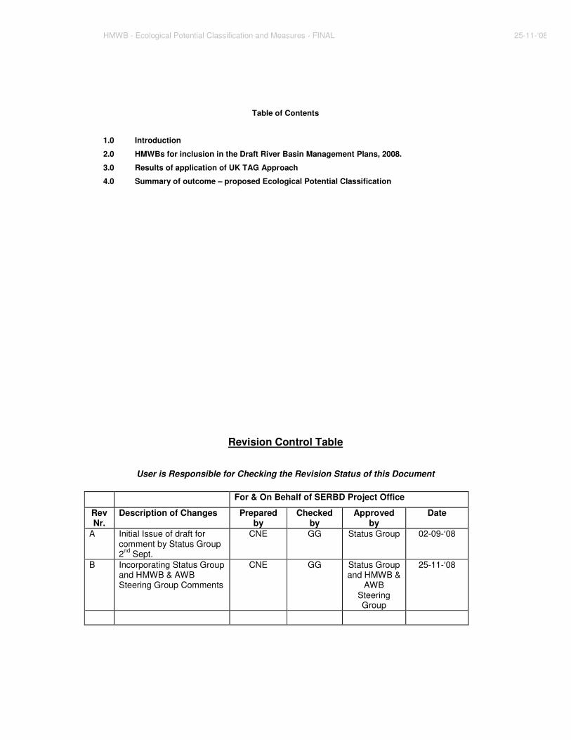
Revision Control Table
User is Responsible for Checking the Revision Status of this Document
For & On Behalf of SERBD Project Office
Rev Nr.
Description of Changes Prepared by
Checked by
Approved by
Date
A Initial Issue of draft for comment by Status Group 2nd Sept.
CNE GG Status Group 02-09-‘08
B Incorporating Status Group and HMWB & AWB Steering Group Comments
CNE GG Status Group and HMWB &
AWB Steering Group
25-11-‘08
HMWB - Ecological Potential Classification and Measures - FINAL 25-11-‘08
Acronyms
ABBREVIATIONS
AWB Artificial Water Body
CIS Common Implementation Strategy
EPA Environmental Protection Agency
GEP Good Ecological Potential
GES Good Ecological Status
HEP Hydro Electric Power
HMWB Heavily Modified Water Body
PCG POMS Co-ordination Group
pHMWB provisional Heavily Modified Water Body
pNHA proposed Natural Heritage Area
POM Programme of Measures
POMS Programme of Measures and Standards
RBMP River Basin Management Plan
RBD River Basin District
SAC Special Area of Conservation
SERBD South Eastern River Basin District
SPA Special Protection Area
WB water body
WFD Water Framework Directive
UK TAG United Kingdom Technical Advisory Group
1
1.0 Introduction 1.1 Definition The Water Framework Directive(WFD) and the relevant Common Implementation Strategy(CIS) Guidance define Heavily Modified Water Bodies (HMWBs) as bodies of water which, as a result of physical alterations by human activity, are substantially changed in character and cannot, therefore, meet “good ecological status” (GES). HMWBs are distinct from Artificial Water Bodies (AWBs) in that they are changed or altered from their natural character. AWBs have been created by human activity where no water body previously existed. Instead of “good ecological status” the environmental objective for HMWB and AWB is good ecological potential (GEP), which has to be achieved by 2015. 1.2 Interpretation CIS Guidance makes the following important points regarding interpretation of the designation:
- HMWB designation is not mandatory. If an altered water body can achieve GES, it may be treated as a natural water body within its appropriate category i.e. not designated.
- HMWB designation is intended to apply to major infrastructural projects associated with specified uses listed in the Directive.
- The predicted failure by HMWBs to achieve GES is due to hydromorphological change, not diffuse /point pollution or other impacts. Good Chemical Status must still be achieved.
- The HMWB designation is not an exemption; an ‘extension of deadline’ or ‘less stringent objective’ exemption can be sought for a HMWB as it can for a natural river, lake, transitional or coastal water body.
- In future planning cycles existing HMWB may be ‘de-designated’ and new HMWB designated.
1.3 Identification of HMWB candidates in Ireland – Article 5 Characterisation (2005) HMWB have been physically altered; their hydromorphological condition has been changed such that the achievement of GES is precluded. Screening for the identification of provisional Heavily Modified Water Bodies (pHMWB) used two nationally applied risk assessments:
Water bodies identified as 1a: At Risk by either or both risk assessments (490 water bodies) were collated for expert review. Figure 1.1 Initial Characterisation Risk Classes
2b Not at risk 2a Probably not at risk
1b Probably at risk
1a At Risk
Following expert review and taking account of CIS Guidance a final list of 37 provisional HMWBs were agreed and reported in Ireland’s Article 5 characterisation report. Scenarios represented are summarised in Table 1.1. Table 1.1 Summary of pHMWBs Reported (according to specified use)
Specified Use No. of WBs Ports 10 Drinking Water Supply 9 Power Generation 7 Flood Protection 5 Power Generation & drinking water supply 4 Other (Railway causeway & artificial bed) 2
2
1.4 Further Characterisation – Post Article 5 Following the identification of pHMWBs in the Initial (Article 5) Characterisation Report, it was required that each pHMWB identified be subjected to two designation tests to confirm that the criteria for designation in the River Basin Management Plans (RBMP) were met. The designation tests are based on the text of the Directive and are set out in CIS guidance. They are referred to as:
- the ‘Restoration Measures test’ and - the ‘Alternative Means test’.
The task of applying these tests to pHMWBs was undertaken as a dedicated national study reporting to the National Programme of Measures and Standards (POMS) Co-Ordination Group (PCG). The study was undertaken by the South Western River Basin District (SWRBD) project team on a National basis. The study is now complete and 34 HMWBs are proposed for designation in the draft River Basin Management Plan (December 2008). The list is included in section 2.0 of this report. A protocol for the examination of potential additions to the list of HMWBs for the final plan in 2009, and/or future RBMP cycles has been circulated by the study to the River Basin District (RBD) Projects. 1.5 Classification of Ecological Potential in Ireland The United Kingdom Technical Advisory Group (UK TAG) published its Guidance on the Classification of Ecological Potential for HMWBs & Artificial Water Bodies in draft for consultation on February 14th 2008. The approach involves an assessment of mitigation measures as an alternative approach for hydromorphological classification. This measures-based hydromorphological class is combined with the physico-chemical and biological class for the water body to determine the final Ecological Potential class for the HMWB. For measures, in short, where it is discovered that all practicable measures compatible with the use being made of the water body are already in place and effective, a ‘Good Ecological Potential or Better’ class is assigned. Where opportunities for the implementation of additional measures are identified, ‘Moderate Ecological Potential or Worse’ is assigned. To undertake the measures assessment, the UK TAG approach provides spreadsheet templates listing a checklist of generic measures for each type of modification. It is required that a spreadsheet be completed for each HMWB. To trial the approach, pilot cases already selected during the HMWB and AWB POMS Study were examined within the UK TAG spreadsheet templates. Results of the trial were presented to the EPA-led Surface Water Status Working Group. The approach was judged to be a useful method for both the classification of Ecological Potential and the identification of measures for inclusion in the draft RBMP for each water body. It was therefore agreed that the approach should be extended to all HMWBs approved for designation by the HMWB & AWB POMS Steering Group i.e. the 34 HMWBs proposed for designation. Results are provided in section 3.0 of this report. In the execution of the exercise, consultation with the following bodies was undertaken and input and comments received:
- Electricity Supply Board - Office of Public Works - Central Fisheries Board - Shannon Regional Fisheries Board - Eastern Regional Fisheries Board - Southern Regional Fisheries Board - South Western Regional Fisheries Board - Northern Regional Fisheries Board - Dublin City Council - Fingal County Council - Donegal County Council - Cork County Council
3
- Clare County Council - Department of Communications, Energy and Natural Resources - Dublin Port Company - Port of Waterford - Rosslare Europort - New Ross Port - Shannon Foynes Port Company - Department of Agriculture – Killybegs Harbour - National Parks and Wildlife Service - Environmental Protection Agency Marine Biologists - Environmental Protection Agency Freshwater Biologists
Interim status (based on biology and physico-chemical data) as prepared by the EPA and the Surface Water Status Working Group was collated and is presented beside measures-based hydromorphology class. Indication of whether interim status was based on monitoring data or extrapolated is provided. Overall Ecological Potential classification is determined in accordance with the UK TAG Matrix shown in Table 1.2. Note that where a ‘moderate’ class originates in biological or physico-chemical data and the measures-based result is ‘good’, no specific HMWB measures are assigned but other measures may be assigned to HMWBs in the draft and final RBMPs via other Programmes of Measures. Such measures from other POMs have not been itemised or described in this report. In some instances, measures were recommended as necessary for preventing the deterioration of status in water bodies downstream of a HMWB which has not been designated itself as HMWB. These measures are listed on a case by case basis in section 3.0 (summarised in Appendix A) and will be implemented within other Programmes of Measures (abstraction and morphology). The completed UK TAG measures spreadsheets for all HMWBs are provided as Appendix B to this report (separately in .xls format).
EPA Interim Status Measures-based Classification Classification using (Phy-chem & biological elements) (UK TAG approach)
4
2.0 HMWBs for inclusion in the Draft River Basin Management Plans, 2008.
RBD Category Water body name Name of associated modification
Impoundments (HEP = hydro electric power)
1 EA Lake Pollaphuca Reservoir Pollaphuca dam HEP station
2 EA Lake Golden Falls Golden Falls dam – HEP station
3 EA Lake Leixlip Leixlip dam – HEP station
4 EA Lake Lough Nahanagan Turlough Hill Pumped Storage HEP station
5 NW Lake Assaroe Lake Cathleen’s Fall dam - HEP station
6 NW River Erne d/s of Cathleen's Fall Cathleen’s Fall dam - HEP station
7 NW River River Erne from Belleek to the dam Cliff dam – HEP station
8 NW Lake Lough Nacung (Upper) Gweedore Dam/Weir for Clady HEP
9 NW Lake Lough Dunlewy Weir / dam for Clady HEP Station
10 SW Lake Carrigdrohid Reservoir Carrigadrohid Dam – HEP station
11 SW Lake Inniscarra Reservoir Inniscarra Dam
12 SH Lake Lough Derg (Lower) Parteen weir/dam for Ardnacrusha HEP
13 EA Lake Vartry Reservoir lwr Vartry Reservoir Lwr
14 EA Lake Vartry Reservoir upr Vartry Reservoir Upr
15 EA River EA_Vartry170_Vartry3 Vartry Reservoir
16 EA Lake Glenasmole Reservoir lwr Dam for Glenasmole Reservoir Lwr
17 EA Lake Glenasmole Reservoirs upr Glenasmole Reservoir Upr (Dodder)
18 SH Lake Doo Lough West Clare water supply
19 NW Lake Lough Salt Letterkenny
Flood protection
20 SH River SH_Fergus_FergusMAIN_1Lower Fergus Tidal Barrage
21 SH River SH_Fergus_Spancelhill_1 Fergus Tidal Barrage
22 EA River EA_Santry166_Santry1 Santry river channel modification
Ports
23 EA Transitional Liffey Estuary Lower Dublin Port
24 SE Coastal Rosslare Harbour Rosslare Harbour
25 NW Coastal North Western Atlantic Ocean (Killybegs Harbour) Killybegs Port
26 SE Transitional Lower Suir Estuary (Little Island - Cheekpoint) Port of Waterford
27 SE Transitional New Ross Port New Ross Port
28 SW Transitional Lee (Cork) Estuary Lower Port of Cork
29 SW Transitional Lough Mahon Port of Cork
30 SW Coastal Cork Harbour Port of Cork / Ringaskiddy
31 SH Transitional Limerick Dock Limerick Port
32 SH Transitional Foynes Harbour Foynes Port
Other
33 SE River SE_NoreMain_Breagagh_Lower Modified bed following contamination by
34 EA Transitional Broadmeadow Water Dublin-Belfast railway line
5
3.0 Results of application of UK TAG Approach to HMWBs
Collation of measures-based classification and interim status (biological and physiochemical-based status assessment) towards the determination of overall ecological classification is documented below. Where the process and consultations have prescribed measures to water bodies, these are documented also. Note: full water body names are not used. 3.1 Pollaphuca Reservoir (EA_09_71)
• Measures-based classification: Good Ecological Potential or Better • Interim Status classification: Moderate (monitored) • Overall Classification: Moderate Ecological Potential • Protected areas: Pollaphuca is a Special Protection Area (SPA) (4063) and a proposed
Natural Heritage Area (pNHA) (731)
Pollaphuca Reservoir is proposed for designation in the draft River Basin Management Plan as it is an impoundment of the River Liffey. It was created by the construction of a dam for the generation of hydroelectric power, also creating a water supply reservoir and a mechanism for the control of flood passage in the Liffey catchment. Please refer to section 3.2.5 of the HMWB & AWB National Application Report for further details on this case. (Available on http://www.nsshare.com/pomstracker/ or from the SWRBD) HMWB Measures & Actions No measures are recommended for Pollaphuca Reservoir For the prevention of status deterioration in the downstream river water body: Measures described under Golden Falls, below, apply to both Pollaphuca and Golden Falls. 3.2 Golden Falls Reservoir (EA_09_53)
• Measures-based classification: Good Ecological Potential or Better • Interim Status classification: Moderate (monitored) • Overall Classification: Moderate Ecological Potential • Protected areas: None
Golden Falls Reservoir is proposed for designation in the draft River Basin Management Plan as it is an impoundment of the River Liffey. It was created by the construction of a dam for the generation of hydroelectric power, with a role also in overall flow control within the catchment for the purposes of securing the supply of water water supply and the control of flood passage. Please refer to section 3.2.5 of the HMWB & AWB National Application Report for further details on this case. (Available on http://www.nsshare.com/pomstracker/ or from the SWRBD) HMWB Measures & Actions No measures are recommended for Golden Falls Reservoir. For the prevention of status deterioration in the river water body downstream of Golden Falls & Pollaphuca:
- Abstraction POM: re-examine the current required discharge to the river Liffey downstream of the dam from an ecological perspective.
- Morphology POM: Implement a programme of gravel loosening or gravel transportation from behind the dam to the river water body d/s in consultation with the Regional Fisheries Board and National Parks and Wildlife Service, as appropriate.
Leixlip Reservoir is proposed for designation in the draft River Basin Management Plan as it is an impoundment of the River Liffey. It was created by the construction of a dam for the generation of hydroelectric power, also creating a water supply reservoir and a mechanism for the control of flood passage in the Liffey catchment. Please refer to section 3.2.5 of the HMWB & AWB National Application Report for further details on this case. (Available on http://www.nsshare.com/pomstracker/ or from the SWRBD) HMWB Measures & Actions
- Ecological Potential study: in the first cycle (by 2012), an Ecological Potential study should be conducted to identify the impacts of the dam at Leixlip on ecology and hydromorphology. Based on the findings of the study, recommendations should be made, where required, for specific measures to be implemented in the second and/or subsequent cycles. The compatibility of measures with all roles of the impoundment should be assessed, particularly power generation, dam safety and safe passage of floods.
3.4 Lough Nahanagan (EA_10_27)
• Measures-based classification: Good Ecological Potential or Better • Interim Status classification: Good (extrapolated) • Overall Classification: Good Ecological Potential • Protected areas: None
Lough Nahanagan is proposed for designation in the draft River Basin Management Plan as it is used as the source lake for Ireland’s only large pumped storage hydroelectric power generation station at Turlough Hill in the Wicklow Mountains. Please refer to section 3.2.6 of the HMWB & AWB National Application Report for further details on this case. (Available from the SWRBD or on http://www.nsshare.com/pomstracker/ ) HMWB Measures & Actions No measures are recommended for Lough Nahanagan. 3.5 Assaroe Lake (NW_36_717)
• Measures-based classification: Moderate Ecological Potential or worse • Interim Status classification: Good (Extrapolated) • Overall Classification: Moderate Ecological Potential
(Moderate overall because interim status is extrapolated and did not take into account hydromorphological effects other than designated abstractions.)
• Protected areas: None Assaroe Lake is proposed for designation in the draft River Basin Management Plan as it is impounded by the dam at Cathleen’s fall Hydropower station, Ballyshannon, Co. Donegal. Please refer to section 3.2.4 of the HMWB & AWB National Application Report for further details on this case. (Available on http://www.nsshare.com/pomstracker/ or from the SWRBD) HMWB Measures & Actions
- Ecological Potential study: in the first cycle (by 2012), an Ecological Potential study should be conducted to identify the impacts of the dam at Cathleen’s Fall (& Cliff dam, upstream) on ecology and hydromorphology. Based on the findings of the study, recommendations should be made, where required, for specific measures to be implemented in the second and/or subsequent cycles. The compatibility of measures with all roles of the impoundment should be assessed, particularly power generation, dam safety and safe passage of floods.
7
3.6 Erne d/s of Cathleen’s Fall (NWRBD - XB_36_West_8) • Measures-based classification: Moderate Ecological Potential or worse • Interim Status classification: Good (based on NI class) • Overall Classification: Moderate Ecological Potential • Protected areas: None
The Erne downstream of Cathleen’s fall is proposed for designation in the draft River Basin Management Plan as the hydromorphological impacts of the dam at Cathleen’s fall Hydropower station are judged to preclude the achievement of good ecological status in the water body. Please refer to section 3.2.4 of the HMWB & AWB National Application Report for further details on this case. (Available on http://www.nsshare.com/pomstracker/ or from the SWRBD) HMWB Measures & Actions
- Ecological Potential study: Include this HMWB in the scope of the study described for Assaroe Lake, above.
3.7 River Erne from Belleek to Cliff Hydro Power Station (NWRBD - XB_36_West_9)
• Measures-based classification: Moderate Ecological Potential or worse • Interim Status classification: Good (based on NI class) • Overall Classification: Moderate Ecological Potential. • Protected areas: None
The Erne from Belleek to Cliff hydro power station is proposed for designation in the draft River Basin Management Plan as it is impounded by the dam. Please refer to section 3.2.4 of the HMWB & AWB National Application Report for further details on this case. (Available on http://www.nsshare.com/pomstracker/ or from the SWRBD) HMWB Measures & Actions
- Ecological Potential study: Included within scope of study recommendation described for Cathleen’s Fall above.
3.8 Lough Nacung (upper) (NW_38_26)
• Measures-based classification: Moderate Ecological Potential or worse • Interim Status classification: High (monitored) • Overall Classification: Moderate Ecological Potential
(Moderate overall because interim status, although monitored, did not take into account hydromorphological effects. )
• Protected areas: Lough Nacung falls entirely within the boundary of the Fawnboy Bog/Lough Nacung pNHA and Special Area of Conservation (000140).
Lough Nacung is proposed for designation in the draft River Basin Management Plan as it is impounded by the regulating weir at Gweedore, part of the Clady hydroelectric scheme. Please refer to section 3.2.2 of the HMWB & AWB National Application Report for further details on this case. (Available on http://www.nsshare.com/pomstracker/ or from the SWRBD) HMWB Measures & Actions
- Ecological Potential study: in the first cycle (by 2012), an Ecological Potential study should be conducted to identify the impacts of Gweedore regulating weir on ecology and hydromorphology. Based on the findings of the study, recommendations should be made, where required, for specific measures to be implemented in the second and/or subsequent cycles. The compatibility of measures with all roles of the impoundment should be assessed, particularly power generation, dam safety and safe passage of floods.
8
For the prevention of status deterioration in the downstream river water body: - Abstraction POM: re-examine the current required discharge to the river Clady
downstream of the dam from an ecological perspective. The river d/s of the hydro power scheme also lies within the Fawnboy Bog / Lough Nacung SAC.
3.9 Lough Dunlewy – NWRBD – NW_38_683
• Measures-based classification: Moderate Ecological Potential or worse • Interim Status classification: Good (monitored) • Overall Classification: Good Ecological Potential
(EPA lake expert override- Good overall because monitoring in this case included fish. ) • Protected areas: Lough Dunlewy falls entirely within the boundary of the Fawnboy
Bog/Lough Nacung pNHA and SAC (000140) Lough Dunlewy is proposed for designation in the draft River Basin Management Plan as it is impounded as part of the Clady hydroelectric scheme. Please refer to section 3.2.2 of the HMWB & AWB National Application Report for further details on this case. (Available on http://www.nsshare.com/pomstracker/ or from the SWRBD) HMWB Measures & Actions
- Ecological Potential study: Include Lough Dunlewy within scope of study recommendation described for Lough Nacung, above.
3.10 Carrigadrohid Reservoir (SW_19_139)
• Measures-based classification: Moderate Ecological Potential or worse. • Interim Status classification: Moderate (Extrapolated) • Overall Classification: Moderate Ecological Potential • Protected areas: the westernmost portion of the reservoir, west of the N22 bridge falls
within the Gearagh pNHA and SAC (000108). A lesser portion in the most westerly area of the lake coincides with the Gearagh SAP (004109)
Carrigadrohid Reservoir is proposed for designation in the draft River Basin Management Plan as it is an impoundment of the River Lee. It was created by the construction of a dam for the generation of hydroelectric power, also controlling flow in the catchment to secure a water supply. The dam also provides a mechanism for the control of flood passage in the Lee catchment. Please refer to section 3.2.3 of the HMWB & AWB National Application Report for further details on this case. (Available on http://www.nsshare.com/pomstracker/ or from the SWRBD) HMWB Measures & Actions
- Ecological Potential study: in the first cycle (by 2012), an Ecological Potential study should be conducted to identify the impacts of the dam at Carrigadrohid (and Inniscarra, below) on ecology and hydromorphology. Based on the findings of the study, recommendations should be made, where required, for specific measures to be implemented in the second and/or subsequent cycles. The compatibility of measures with all roles of the dams and reservoirs, particularly water supply, dam safety and safe passage of floods should be assessed.
Inniscarra Reservoir is proposed for designation in the draft River Basin Management Plan as it is an impoundment of the River Lee. It was created by the construction of a dam for the generation of hydroelectric power, also securing a water supply reservoir and providing a mechanism for the control of flood passage in the Lee catchment. Please refer to section 3.2.3 of the HMWB & AWB
9
National Application Report for further details on this case. (Available from the SWRBD or on http://www.nsshare.com/pomstracker/) HMWB Measures & Actions
- Ecological Potential study: Include Inniscarra within scope of study recommendation described for Carrigadrohid, above.
For the prevention of status deterioration in the downstream river water body:
- Abstraction POM: re-examine the current required discharge to the river Lee downstream of the dam from an ecological perspective.
3.12 Lough Derg Lower (Ardnacrusha) (SH_25_191_b)
• Measures-based classification: Moderate Ecological Potential or worse • Interim Status classification: Moderate (Extrapolated) • Overall Classification: Moderate Ecological Potential • Protected areas: HMWB lies within the upstream section of the extensive Lower River
Shannon SAC (002165). Lough Derg Lower is proposed for designation in the draft River Basin Management Plan as it is an impoundment of the River Shannon. It is impounded by behind Parteen Weir, part of the infrastructure in place for the Ardnacrusha hydropower scheme. Please refer to Appendix A of the HMWB & AWB National Application Report for further details on this case. (Available from the SWRBD or on http://www.nsshare.com/pomstracker/ ) HMWB Measures & Actions
- Ecological Potential study: in the first cycle (by 2012), an Ecological Potential study should be conducted to identify the impacts of Parteen regulating weir on ecology and hydromorphology. Based on the findings of the study, recommendations should be made, where required, for specific measures to be implemented in the second and/or subsequent cycles. The compatibility of measures with all roles of Parteen weir should be assessed, particularly embankment safety and safe passage of floods.
For the prevention of status deterioration in the downstream river water body:
- Abstraction POM: re-examine the current required discharge to the river Shannon downstream of Parteen weir from an ecological perspective.
- Morphology POM: a programme gravel transportation from behind the dams is recommended
3.13 Vartry Reservoir lwr (EA_10_10)
• Measures-based classification: Good Ecological Potential or better • Interim Status classification: Good (extrapolated) • Overall Classification: Good Ecological Potential • Protected areas: Vartry Reservoir pNHA (001771)
Vartry Reservoir lower is proposed for designation in the draft River Basin Management Plan as it is an impoundment of the Vartry River for the purposes of water supply from the catchment. Please refer to Appendix A to the HMWB & AWB National Application Report for further details on this case. (Available on http://www.nsshare.com/pomstracker/ or from the SWRBD.) HMWB Measures & Actions No measures are recommended for Vartry Reservoir lower. For the prevention of status deterioration in the downstream river water body:
- Abstraction POM: A compensation flow needs to be set for the d/s river water body and this should be examined from an ecological perspective. This can only be implemented without negative impacts on the water supply if an alternative supply found for the greater Dublin area also reduces dependency on the Vartry supply.
10
3.14 Vartry Reservoir upr (EA_10_11) • Measures-based classification: Good Ecological Potential or better • Interim Status classification: Good (extrapolated) • Overall Classification: Good Ecological Potential • Protected areas: Vartry Reservoir pNHA (001771)
Vartry Reservoir upper is proposed for designation in the draft River Basin Management Plan as it is an impoundment of the Vartry River for the purposes of water supply from the catchment. Please refer to Appendix A to the HMWB & AWB National Application Report for further details on this case. (Available on http://www.nsshare.com/pomstracker/ or from the SWRBD.) HMWB Measures & Actions No measures are recommended for Vartry Reservoir upper. 3.15 Vartry River water body (EA_10_1334) (between the reservoirs)
• Measures-based classification: Good Ecological Potential or better • Interim Status classification: Good (extrapolated) • Overall Classification: Good Ecological Potential • Protected areas: Vartry Reservoir pNHA (001771)
The Vartry River between the two impoundments is proposed for designation in the draft River Basin Management Plan due to the impacts of the upper Vartry dam. Please refer to Appendix A to the HMWB & AWB National Application Report for further details on this case. (Available on http://www.nsshare.com/pomstracker/ or from the SWRBD. ) HMWB Measures & Actions No measures are recommended for Vartry river water body between the reservoirs but any measures identified through the recommended Abstraction POM investigation into compensation flow may affect this water body. 3.16 Glenasmole Reservoir lwr (EA_09_68)
• Measures-based classification: Good Ecological Potential or better • Interim Status classification: Good (monitored) • Overall Classification: Good Ecological Potential • Protected areas : Reservoir lies within the Glenasmole Valley pNHA and SAC (001209)
Glenasmole Reservoir lower is proposed for designation in the draft River Basin Management Plan as it is an impoundment of the Dodder River. The impoundment was originally constructed to serve several mills further downstream in the catchment, but this has now been superseded by the role of the dam in the control of flood passage. Please refer to section 3.4.3 of the HMWB & AWB National Application Report for further details on this case. (Available from the SWRBD or on http://www.nsshare.com/pomstracker/ ) HMWB Measures & Actions No measures are proposed for the Glenasmole Reservoir lower HMWB for the first cycle. For the prevention of status deterioration in the downstream river water body:
- Abstraction POM: no compensation flow is currently set for the d/s river water body. It is recommended that a compensation flow be set with requirements examined from an ecological perspective. Regard should be paid to the role of the impoundments in controlling the safe passage of floods in the Dodder catchment. A set compensation flow can only be implemented without negative impacts on the water supply if an alternative supply found for the greater Dublin area also reduces dependency on the Dodder supply.
- Morphology POM: in the first river basin planning cycle, obsolete structures such as weirs, in the downstream river water body should be investigated to determine their impacts on ecology and hydromorphology. This investigation should make recommendations for measures to be implemented in the second and/or subsequent cycles.
11
3.17 Glenasmole Reservoir upr (EA_09_70)
• Measures-based classification: Good Ecological Potential or better • Interim Status classification: Good (monitored) • Overall Classification: Good Ecological Potential • Protected areas: Reservoir lies within the Glenasmole Valley pNHA and SAC (001209)
Glenasmole Reservoir upper is proposed for designation in the draft River Basin Management Plan as it is an impoundment of the Dodder River the purposes of water supply from the catchment. Please refer to section 3.4.3 of the HMWB & AWB National Application Report for further details on this case. (Available on http://www.nsshare.com/pomstracker/ or from the SWRBD. ) HMWB Measures & Actions No measures are proposed for the Glenasmole Reservoir upper HMWB for the first cycle. For the prevention of status deterioration in the downstream river water body:
- Abstraction POM: Glenasmole Reservoir upper should be included in scope of the measure described for Glenasmole Reservoir lower, above, referring to compensation flows.
Doo Lough is proposed for designation in the draft River Basin Management Plan as it is an impoundment to serve as a water supply reservoir for west Co. Clare. Please refer to section 3.4.2 of the HMWB & AWB National Application Report for further details on this case. Available on http://www.nsshare.com/pomstracker/ or from the SWRBD. ) HMWB Measures & Actions
- Ecological Potential study: in the first cycle (by 2012), an Ecological Potential study should be conducted to identify the impacts of the impoundment on ecology and hydromorphology. Based on the findings of the study, recommendations should be made, where required, for specific measures to be implemented in the second and/or subsequent cycles.
3.19 Lough Salt (NW_38_649)
• Measures-based classification: Good Ecological Potential • Interim Status classification: Good (Monitored) • Overall Classification: Good Ecological Potential • Protected areas: None.
Lough Salt is proposed for designation in the draft River Basin Management Plan due to the impacts on the lake of its use as a water supply for the town of Letterkenny and its surrounding area. Please refer to Appendix A to the HMWB & AWB National Application Report for further details on this case. (Available on http://www.nsshare.com/pomstracker/ or from the SWRBD. ) HMWB Measures & Actions
- Ecological Potential study: The impacts of the use of Lough Salt as a water supply reservoir on ecological potential should be investigated in the first cycle. This investigation should make specific recommendations for measures, if required, to be implemented in the second and/or subsequent cycles.
12
3.20 River Fergus main (SH_27_1122_1) • Measures-based classification: Moderate Ecological Potential or worse • Interim Status classification: Poor (Monitored) • Overall Classification: Poor Ecological Potential • Protected areas: Lower River Shannon SAC (002165)
The River Fergus (main) is proposed for designation in the draft River Basin Management Plan due to the impacts of the Fergus tidal barrage on the water body. Please refer to Appendix A to the HMWB & AWB National Application Report for further details on this case. (Available from the SWRBD or on http://www.nsshare.com/pomstracker/ ) HMWB Measures & Actions
- Ecological Potential study: in the first cycle (by 2012), an Ecological Potential study should be conducted to identify the impacts of the impoundment on ecology and hydromorphology. Based on the findings of the study, recommendations should be made, where required, for specific measures to be implemented in the second and/or subsequent cycles.
The river Fergus Spancelhill water body is proposed for designation in the draft River Basin Management Plan due to the impacts of the Fergus tidal barrage on the water body. Please refer to Appendix A to the HMWB & AWB National Application Report for further information on this case. (Available from the SWRBD or on http://www.nsshare.com/pomstracker/ ) HMWB Measures & Actions
- Include in the Fergus study as described under Fergus Main, above. 3.22 Santry River (EA_09_ 1507)
• Measures-based classification: Moderate Ecological Potential or worse • Interim Status classification: Poor (Monitored) • Overall Classification: Poor Ecological Potential • Protected areas: the upstream reaches of the HMWB river coincide with Santry Demesne
pNHA (000178). The HMWB flows into Bull Island SPA but does not overlap with its boundary.
The Santry River water body is proposed for designation in the draft River Basin Management Plan due to bed and channel modifications which have taken place over the course of development in surrounding and immediately adjacent urban and suburban areas and flood alleviation works undertaken by the local authority. Please refer to section 3.3.2 of the HMWB & AWB National Application Report for further details on this case. (Available on http://www.nsshare.com/pomstracker/ or from the SWRBD. ) HMWB Measures & Actions Opportunities for riparian zone and aquatic habitat measures are limited due to the confined channel. The following measures are proposed for implementation:
- Riparian zone: include in the area development plan that any new developments or redevelopment along the river bank should employ soft engineering of banks where possible and should protect, enhance or restore aquatic and riparian habitats in consultation with the fisheries board.
- Floodplain connectivity: Include in the area development plan that developments in the contributing catchment should aim to improve flood-plain connectivity and avoid further confinement of the channel.
13
- Catchment characteristics affecting hydrology: Include in the area development plan that any new developments or redevelopment in the contributing catchment should aim to maximise green areas and tree planting and minimise hard surfaces, favouring sustainable drainage approaches.
- In-stream structures: existing weirs and sluices to be examined in order to determine impacts on fish passage. Opportunities for installation of fish passes where necessary, or improvement in design or operation should be identified in the first cycle. Any measures identified should be implemented in subsequent cycles.
- Obsolete structures: any obsolete bank-side or in-stream structures should be identified, their impact on ecological potential examined and their removal considered if technically feasible.
3.23 Dublin Port (Liffey estuary Lower)(EA_090_0300)
• Measures-based classification: Good Ecological Potential or Better • Interim Status classification: Moderate (Monitored) • Overall Classification: Good Ecological Potential
Liffey estuary Lower is proposed for designation in the draft River Basin Management Plan due to the impacts on the water body of Dublin Port and its related activities such as dredging and shipping traffic. Please refer to section 3.1.2 of the HMWB & AWB National Application Report for further information on this case. (Available on http://www.nsshare.com/pomstracker/ or from the SWRBD. ) HMWB Measures & Actions No Measures are recommended for Liffey Estuary Lower, containing Dublin Port. 3.24 Rosslare Harbour (SE_045_0000)
Rosslare Harbour is proposed for designation in the draft River Basin Management Plan due to the impacts on the water body of the port and its related activities such as dredging and shipping traffic. Please refer to section 3.1.7 of the HMWB & AWB National Application Report for further details on this case. (Available on http://www.nsshare.com/pomstracker/ or from the SWRBD. ) HMWB Measures & Actions
- Dredging: Within the first river basin planning cycle, investigate impacts of dredging activities on Ecological Potential and identify any opportunities for mitigation measures to be implemented in the second and subsequent cycles to mitigate impacts. Best practice should be used and all possible mitigation measures should be employed to minimise impacts.
14
3.25 Killybegs Harbour (North Western Atlantic Ocean)(NW_080_0000) • Measures-based classification: Moderate Ecological Potential or worse • Interim Status classification: Moderate (Monitored) • Overall Classification: Moderate Ecological Potential • Protected areas: None
Killybegs Harbour is proposed for designation in the draft River Basin Management Plan due to the impacts on the water body of the port and its related activities such as dredging and shipping traffic. Please refer to section 3.1.8 of the HMWB & AWB National Application Report for further information on this case. (Available on http://www.nsshare.com/pomstracker/ or from the SWRBD. ) HMWB Measures & Actions
- Dredging plan: Killybegs currently does not have a dredging/spoil disposal strategy. It is recommended that a strategy be prepared.
- Dredging: Dredging/ spoil disposal does not take place on a regular basis. In the past it has only been carried out when construction within the Harbour has taken place. If in the future maintenance dredging is carried out advice should be sought on the technology to be employed and the appropriate timing in order to minimise any potential impacts on fisheries or habitats. Best practice should be used and all possible mitigation measures should be employed to minimise impacts.
3.26 Port of Waterford (Lower Suir Estuary [Little Island – Cheekpoint])(SE_100_0500)
• Measures-based classification: Moderate Ecological Potential or Worse • Interim Status classification: Good (Monitored) • Overall Classification: Moderate Ecological Potential • Protected areas: the port is located within the Lower River Suir SAC (002137) identified
for the presence of the priority habitat on Annex I of the Habitats Directive. The Lower Suir Estuary transitional water body is proposed for designation in the draft River Basin Management Plan due to the impacts on the water body of the port at Belview and its related activities such as dredging and shipping traffic. Please refer to section 3.1.3 of the HMWB & AWB National Application Report for further details on this case. (Available from the SWRBD or on http://www.nsshare.com/pomstracker/ ) HMWB Measures & Actions
- Structures: Within the first river basin planning cycle (by 2012) the groynes constructed near the bars at Cheekpoint should be investigated to ascertain if there are any negative impacts on hydromorphology. If negative impacts are ascertained, opportunities for specific measures for implementation the second or subsequent cycles should be identified.
3.27 New Ross Port (SE_100_0200)
• Measures-based classification: Moderate Ecological Potential or worse • Interim Status classification: Good (Monitored) • Overall Classification: Moderate Ecological Potential • Protected areas: the HMWB coincides with part of the Barrow River Estuary NHA (00698)
and the River Barrow and River Nore SAC (002162). The New Ross Port transitional water body is proposed for designation in the draft River Basin Management Plan due to the impacts of the port at New Ross and its related activities such as dredging and shipping traffic. Please refer to section 3.1.4 of the HMWB & AWB National Application Report for further information on this case. (Available from the SWRBD or on http://www.nsshare.com/pomstracker/ ) HMWB Measures & Actions
- Dredging plan: Maintenance dredging is only undertaken in New Ross when it is absolutely necessary to restore either the channel or berths to their advertised depths of -
15
2.5m and -4.5m respectively. Maintenance dredging in the channel was last undertaken in 2004 when 41,290 tonnes of spoil was removed. New Ross Port does not have a dredging/spoil disposal strategy in place, currently. If further dredging takes place in the future it is recommended that a strategy be prepared.
- Dredging: If further dredging takes place in the future, best practice should be used and all possible mitigation measures should be employed to minimise impacts. If it is identified that habitat deterioration will occur due to dredging even with best practice in place, opportunities for indirect or offsite mitigation measures such as habitat creation should be identified for implementation in the second or subsequent cycles to offset same.
- Obsolete structures: A number of small quays on the river banks south of the main port area are no longer in use. Investigate the hydromorphological impacts of any obsolete structures and remove where impacts are identified and removal is feasible.
- Structures: In regards some of the legacy issues New Ross Port should investigate if the breakwaters in place are having negative hydromorphological impacts which could be addressed. Opportunities for measures to address any impacts ascertained should be identified for the second or subsequent cycles.
3.28 Lee Cork Estuary (SW_060_0900)
• Measures-based classification: Moderate Ecological Potential or worse • Interim Status classification: Moderate (monitored) • Overall Classification: Moderate Ecological Potential • Protected Areas: A very small area at the downstream end of the HMWB overlaps with
the Douglas River pNHA (0001046) and the Cork Harbour SPA (004030). Lee (Cork) Estuary is proposed for designation in the draft River Basin Management Plan due to the impacts of the port at the City Quays and Tivoli Dock and port related activities in the water body such as dredging and shipping traffic. Please refer to Appendix A of the HMWB & AWB National Application Report. (Available on http://www.nsshare.com/pomstracker/ or from the SWRBD. ) HMWB Measures & Actions
- Bed scouring: Investigate the impacts of bed scouring by vessels at Tivoli Dock on ecological potential. If impacts are identified, explore technical feasibility of deepening channel / turning basin at Tivoli Dock to minimise or eliminate same. Implement if feasible.
- Dredging: investigate the impacts of current dredging techniques on ecological potential. Ensure technically feasible techniques to minimise silt suspension are used towards protection of ecological resources.
- Obsolete structures: Investigate the hydromorphological impacts of any obsolete structures and remove where impacts are identified and removal is feasible.
3.29 Lough Mahon (SW_060_0750)
• Measures-based classification: Moderate Ecological Potential or worse • Interim Status classification: Good (Monitored) • Overall Classification: Moderate Ecological Potential • Protected Areas: the upstream end of this water body is coincident with the Douglas
River pNHA (0001046) and the Cork Harbour SPA (004030) on the western side and the Great Island Channel pNHA and SAC (0001058) on the eastern side.
Lough Mahon is proposed for designation in the draft River Basin Management Plan due to the impacts of port related activities in the water body such as dredging and shipping traffic. Please refer to Appendix A of the HMWB & AWB National Application Report for further details on this case. (Available on http://www.nsshare.com/pomstracker/ or from the SWRBD. ) HMWB Measures & Actions
16
- Dredging: investigate the impacts of current dredging techniques on ecological potential. Ensure technically feasible techniques to minimise silt suspension are used towards protection of ecological resources.
- Obsolete structures: Investigate the hydromorphological impacts of any obsolete structures and remove where impacts are identified and removal is feasible.
3.30 Cork Harbour (SW_060_0000)
• Measures-based classification: Moderate Ecological Potential or worse • Interim Status classification: Moderate (monitored) • Overall Classification: Moderate Ecological Potential • Protected Areas: the HMWB includes a number of areas designated for conservation
purposes: Monkstown Creek pNHA (001979); Lough Beg pNHA (001066), Owenboy River pNHA (001990), Rostellan Lough, Aghada Shore and Poulnabibe Inlet (001076), Whitegate Bay (001084) and Cork Harbour SPA (004030).
The Cork Harbour coastal water body is proposed for designation in the draft River Basin Management Plan due to the impacts of Ringaskiddy port and Cobh cruise terminal and related activities in the water body such as dredging and shipping traffic. Please refer to Appendix A of the HMWB & AWB National Application Report for further information on this case. (Available from the SWRBD or on http://www.nsshare.com/pomstracker/ ) HMWB Measures & Actions
- Bed scouring: Investigate the impacts of bed scouring by vessels at Ringaskiddy on ecological potential. If impacts are identified, explore technical feasibility of deepening channel / turning basin at Ringaskiddy to minimise or eliminate same. Implement if feasible.
- Dredging: investigate the impacts of current dredging techniques on ecological potential. Ensure technically feasible techniques to minimise silt suspension are used towards protection of ecological resources.
- Obsolete structures: Investigate the hydromorphological impacts of any obsolete structures and remove where impacts are identified and removal is feasible.
3.31 Limerick Dock (SH_060_0900)
• Measures-based classification: Good Ecological Potential or Better • Interim Status classification: Moderate (Monitored) • Overall Classification: Good Ecological Potential
(EPA marine expert override) • Protected areas: the HMWB coincides with a portion of the River Shannon and Fergus
Estuaries SPA (004077) identified due to coastal wetland habitats supporting internationally important bird populations.
Limerick Dock transitional water body is proposed for designation in the draft River Basin Management Plan due to the impacts of the port and its related activities in the water body such as dredging and shipping traffic. Please refer to section 3.1.5 of the HMWB & AWB National Application Report for further details on this case. (Available from the SWRBD or on http://www.nsshare.com/pomstracker/ ) HMWB Measures & Actions No measures are recommended for Limerick Dock. 3.32 Foynes Harbour (SH_060_0350)
• Measures-based classification: Good Ecological Potential or Better • Interim Status classification: Moderate (Monitored) • Overall Classification: Good Ecological Potential
(EPA marine expert override)
17
• Protected areas: the HMWB coincides with a portion of the River Shannon and Fergus Estuaries SPA (004077) identified due to coastal wetland habitats supporting internationally important bird populations. The HMWB is also includes part of the Inner Shannon Estuary – South Shore NHA. (000435).
Foynes Harbour is proposed for designation in the draft River Basin Management Plan due to the impacts of Foynes port and its related activities in the water body such as dredging and shipping traffic. Please refer to section 3.1.6 of the HMWB & AWB National Application Report for further information on this case. (Available on http://www.nsshare.com/pomstracker/ or from the SWRBD) HMWB Measures & Actions No measures are recommended for Foynes Harbour. 3.33 River Breagagh (SE_15_1269)
The river Breagagh in Kilkenny is proposed for designation in the draft River Basin Management Plan due to the modified nature of the channel; both the river bed and banks have been significantly changed from their natural state by urban/industrial confinement and instream works to manage sediment contaminated by a PCB spillage. Please refer to section 3.5.2 of the HMWB & AWB National Application Report for further information on this case. (Available on http://www.nsshare.com/pomstracker/ or from the SWRBD. ) HMWB Measures & Actions
- Ecological Potential study: in the first cycle (by 2012), an Ecological Potential study should be conducted to identify the impacts of the modifications in the river Breagagh on ecology and hydromorphology. Based on the findings of the study, recommendations should be made, where required, for specific measures to be implemented in the second and/or subsequent cycles. The SRFB proposes the introduction of gravels in consultation with the EPA to fill in spaces in the gabions and mesh bed and create a more natural bed structure & material. The implementation of this measure will depend on the findings of the Ecological Potential study.
3.34 Broadmeadow Water (EA_060_0100)
• Measures-based classification: Good Ecological Potential or Better • Interim Status classification: Moderate(Monitored) • Overall Classification: Good Ecological Potential
(EPA marine expert override) • Protected areas: the HMWB coincides with the Malahide Estuary pNHA and SAC
(000205) and the Broadmeadow / Swords Estuary SPA (004025). The Broadmeadow Water transitional water body is proposed for designation in the draft River Basin Management Plan as it is partially impounded by a major railway causeway / viaduct. Please refer to Appendix A of the HMWB & AWB National Application Report for further details on this case. (Available on http://www.nsshare.com/pomstracker/ or from the SWRBD. ) HMWB Measures & Actions None of the UK TAG spreadsheets provided an appropriate assessment for the modifications in this water body. Following consultation with EPA marine experts, no measures are recommended for the Broadmeadow Water.
18
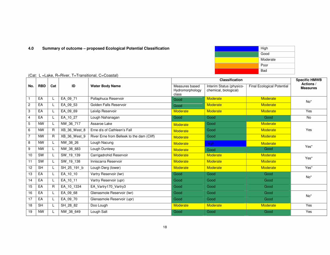
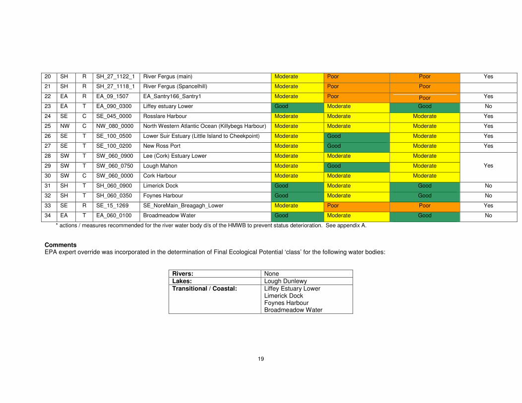
4.0 Summary of outcome – proposed Ecological Potential Classification (Cat: L =Lake, R=River, T=Transitional, C=Coastal)
Classification
No. RBD Cat ID Water Body Name Measures based Hydromorphology class
Interim Status (physico-chemical, biological)
Final Ecological Potential
Specific HMWB Actions / Measures
1 EA L EA_09_71 Pollaphuca Reservoir Good Moderate Moderate
2 EA L EA_09_53 Golden Falls Reservoir Good Moderate Moderate No*
3 EA L EA_09_69 Leixlip Reservoir Moderate Moderate Moderate Yes
4 EA L EA_10_27 Lough Nahanagan Good Good Good No
5 NW L NW_36_717 Assaroe Lake Moderate Good Moderate
6 NW R XB_36_West_8 Erne d/s of Cathleen’s Fall Moderate Good Moderate
7 NW R XB_36_West_9 River Erne from Belleek to the dam (Cliff) Moderate Good Moderate
Yes
8 NW L NW_38_26 Lough Nacung Moderate High Moderate 9 NW L NW_38_683 Lough Dunlewy Moderate Good Good
Yes*
10 SW L SW_19_139 Carrigadrohid Reservoir Moderate Moderate Moderate
11 SW L SW_19_138 Inniscarra Reservoir Moderate Moderate Moderate Yes*
12 SH L SH_25_191_b Lough Derg (lower) Moderate Moderate Moderate Yes*
13 EA L EA_10_10 Vartry Reservoir (lwr) Good Good Good
14 EA L EA_10_11 Vartry Reservoir (upr) Good Good Good No*
15 EA R EA_10_1334 EA_Vartry170_Vartry3 Good Good Good
16 EA L EA_09_68 Glenasmole Reservoir (lwr) Good Good Good
17 EA L EA_09_70 Glenasmole Reservoir (upr) Good Good Good No*
18 SH L SH_28_82 Doo Lough Moderate Moderate Moderate Yes
19 NW L NW_38_649 Lough Salt Good Good Good Yes
High
Good
Moderate
Poor Bad
19
20 SH R SH_27_1122_1 River Fergus (main) Moderate Poor Poor Yes
21 SH R SH_27_1118_1 River Fergus (Spancelhill) Moderate Poor Poor
22 EA R EA_09_1507 EA_Santry166_Santry1 Moderate Poor Poor Yes
23 EA T EA_090_0300 Liffey estuary Lower Good Moderate Good No
24 SE C SE_045_0000 Rosslare Harbour Moderate Moderate Moderate Yes
25 NW C NW_080_0000 North Western Atlantic Ocean (Killybegs Harbour) Moderate Moderate Moderate Yes
26 SE T SE_100_0500 Lower Suir Estuary (Little Island to Cheekpoint) Moderate Good Moderate Yes
27 SE T SE_100_0200 New Ross Port Moderate Good Moderate Yes
28 SW T SW_060_0900 Lee (Cork) Estuary Lower Moderate Moderate Moderate
29 SW T SW_060_0750 Lough Mahon Moderate Good Moderate
30 SW C SW_060_0000 Cork Harbour Moderate Moderate Moderate
Yes
31 SH T SH_060_0900 Limerick Dock Good Moderate Good No
32 SH T SH_060_0350 Foynes Harbour Good Moderate Good No
33 SE R SE_15_1269 SE_NoreMain_Breagagh_Lower Moderate Poor Poor Yes
34 EA T EA_060_0100 Broadmeadow Water Good Moderate Good No
* actions / measures recommended for the river water body d/s of the HMWB to prevent status deterioration. See appendix A. Comments EPA expert override was incorporated in the determination of Final Ecological Potential ‘class’ for the following water bodies:
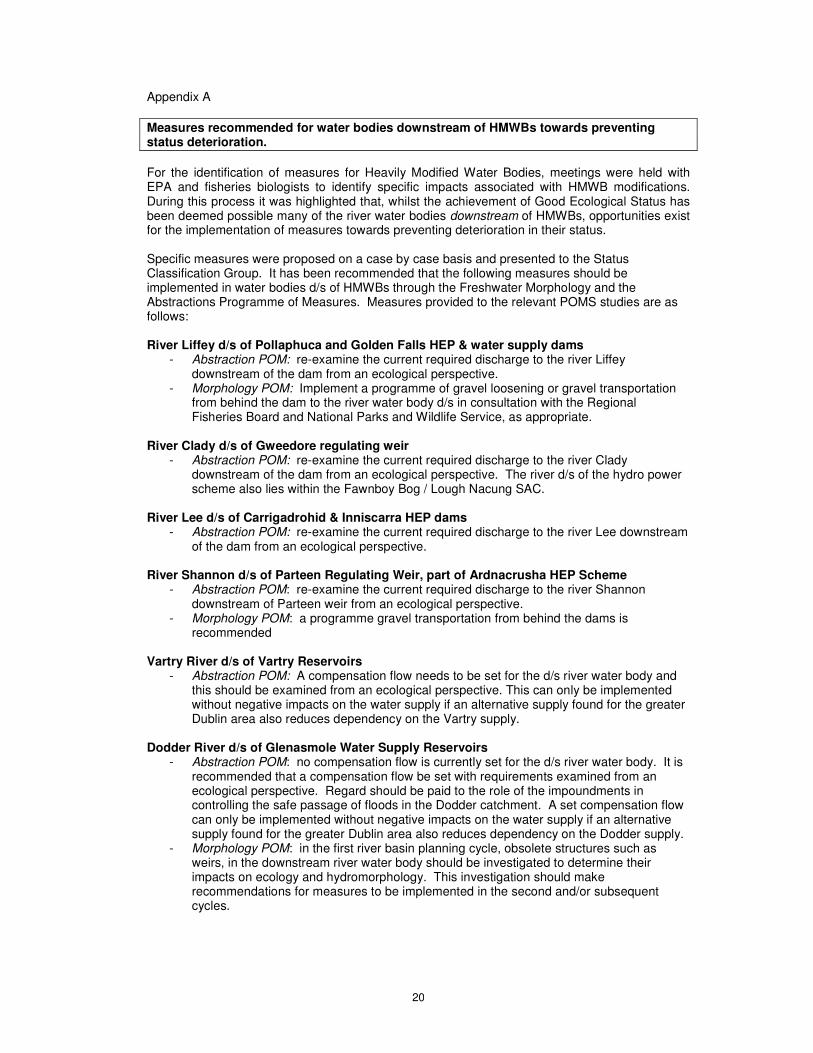
Appendix A Measures recommended for water bodies downstream of HMWBs towards preventing status deterioration. For the identification of measures for Heavily Modified Water Bodies, meetings were held with EPA and fisheries biologists to identify specific impacts associated with HMWB modifications. During this process it was highlighted that, whilst the achievement of Good Ecological Status has been deemed possible many of the river water bodies downstream of HMWBs, opportunities exist for the implementation of measures towards preventing deterioration in their status. Specific measures were proposed on a case by case basis and presented to the Status Classification Group. It has been recommended that the following measures should be implemented in water bodies d/s of HMWBs through the Freshwater Morphology and the Abstractions Programme of Measures. Measures provided to the relevant POMS studies are as follows: River Liffey d/s of Pollaphuca and Golden Falls HEP & water supply dams
- Abstraction POM: re-examine the current required discharge to the river Liffey downstream of the dam from an ecological perspective.
- Morphology POM: Implement a programme of gravel loosening or gravel transportation from behind the dam to the river water body d/s in consultation with the Regional Fisheries Board and National Parks and Wildlife Service, as appropriate.
River Clady d/s of Gweedore regulating weir
- Abstraction POM: re-examine the current required discharge to the river Clady downstream of the dam from an ecological perspective. The river d/s of the hydro power scheme also lies within the Fawnboy Bog / Lough Nacung SAC.
River Lee d/s of Carrigadrohid & Inniscarra HEP dams
- Abstraction POM: re-examine the current required discharge to the river Lee downstream of the dam from an ecological perspective.
River Shannon d/s of Parteen Regulating Weir, part of Ardnacrusha HEP Scheme
- Abstraction POM: re-examine the current required discharge to the river Shannon downstream of Parteen weir from an ecological perspective.
- Morphology POM: a programme gravel transportation from behind the dams is recommended
Vartry River d/s of Vartry Reservoirs
- Abstraction POM: A compensation flow needs to be set for the d/s river water body and this should be examined from an ecological perspective. This can only be implemented without negative impacts on the water supply if an alternative supply found for the greater Dublin area also reduces dependency on the Vartry supply.
Dodder River d/s of Glenasmole Water Supply Reservoirs
- Abstraction POM: no compensation flow is currently set for the d/s river water body. It is recommended that a compensation flow be set with requirements examined from an ecological perspective. Regard should be paid to the role of the impoundments in controlling the safe passage of floods in the Dodder catchment. A set compensation flow can only be implemented without negative impacts on the water supply if an alternative supply found for the greater Dublin area also reduces dependency on the Dodder supply.
- Morphology POM: in the first river basin planning cycle, obsolete structures such as weirs, in the downstream river water body should be investigated to determine their impacts on ecology and hydromorphology. This investigation should make recommendations for measures to be implemented in the second and/or subsequent cycles.
21
Appendix B Excel Spreadsheets completed for each HMWB case. (Provided separately)