35
Report to: Port of Hastings Development Authority/AECOM+GHD JV Port of Hastings Development Project Seagrass Desktop Review and Study Design AGH-CEP0-EV-REP19 December 2014
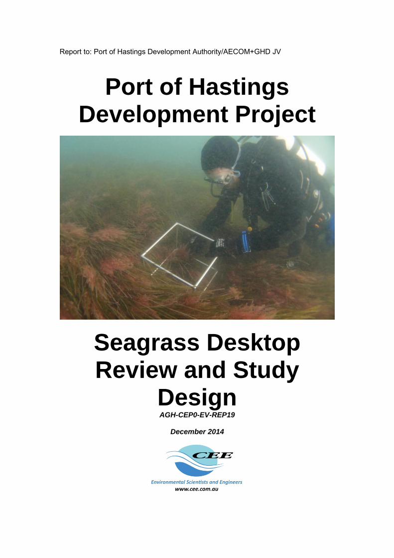
Report to: Port of Hastings Development Authority/AECOM+GHD JV
Port of Hastings Development Project
Seagrass Desktop Review and Study
Design AGH-CEP0-EV-REP19
December 2014

In May 2016 the Special Minister of State asked Infrastructure Victoria to provide advice on the future capacity of Victoria’s commercial ports. Specifically, the Minister has asked for advice on when the need for a second container port is likely to arise and which variables may alter this timeline. The Minister has also asked for advice on where a second container port would ideally be located and under what conditions, including the suitability of, and barriers to investing in, sites at the Port of Hastings and the Bay West location.
In undertaking this task, Infrastructure Victoria reviewed work that was completed as part of the Port of Hastings development project before it was cancelled in 2014. This document forms part of the initial work undertaken for the proposed port development at Hastings. Infrastructure Victoria considers that much of the previous Hastings work, although preliminary in nature, is relevant and suitable for informing a strategic assessment. Therefore, Infrastructure Victoria has made the reports previously commissioned for the development project part of the evidence base on which Infrastructure Victoria will use in providing the Minister with advice.
The opinions, conclusions and any recommendations in this document are based on conditions encountered and information reviewed at the date of preparation of the document and for the purposes of the Port of Hastings Development Project.
Infrastructure Victoria and its consultants have used the information contained in these reports as an input but have not wholly relied on all the information presented in these reports.
Port of Hastings: Key Questions for Seagrass Studies (DRAFT) i
Port of Hastings Development Project Seagrass Desktop Review and Study Design
December 2014
Table of Contents
1 Introduction 1
1.1 Environmental and social studies 1
1.2 Purpose and Scope 2
1.3 Limitations 3
1.4 Seagrasses in Western Port 4
2 Key Questions 6
3 Information requirements 7
4 Proposed Study Methods 11
4.1 Extent of seagrass beds in Western Port 12 4.1.1 Use of information 12 4.1.2 Coordination 12 4.1.3 Spatial coverage 12 4.1.4 Timing 13 4.1.5 Methods 13 4.1.6 Outputs 13
4.2 Seagrass present condition and spatial and temporal variation in Western Port 14 4.2.1 Purpose 14 4.2.2 Coordination 14 4.2.3 Spatial coverage 14 4.2.4 Timing 16 4.2.5 Seagrass indicators 17 4.2.6 Methods 17 4.2.7 Outputs 17
5 Critical review of available information on Seagrass – A3 table 19
6 References cited in text 29
Appendix ‐ Crawfish Rock Special Management Area 31
Purpose 31
Coordination 31
Spatial coverage 31
Timing 31
Methods 31
Outputs 31

Port of Hastings: Key Questions for Seagrass Studies (DRAFT) ii
Table of Figures Figure 1 Framework for environmental and social studies 2 Figure 2 Extent of seagrass and macroalgae in 1999 (Blake and Ball, 2001) 4 Figure 3 Map of Western Port showing proposed study sites 15 Figure 4 Conceptual model of possible natural variation in a seagrass condition indicator 16 Figure 5 Schedule for monitoring surveys (green denotes survey month) 16
Table of Tables Table 1 Existing and required information for answering key questions 7 Table 2 Suggested sites for seagrass monitoring 15 Table 3 Summary of seagrass indicators, utility, practicality, economics 18
Report to: PoHDA and AECOM+GHD JV Report by:
Scott Chidgey, Peter Crockett and Percival Ho (CEE) Specialist advisers/reviewers:
Paul Boon (Dodo Environmental) Kathryn McMahon (Edith Cowan University)

Port of Hastings Development Proposal: Key Questions for
Seagrass Studies DRAFT
1 INTRODUCTION The Victorian Government has identified the Port of Hastings as a key area for port expansion. An expanded Port of Hastings will increase capacity and competition in the container ports sector servicing Melbourne and Victoria helping to manage the expected growth in container trade. The Port of Hastings Development Authority (the Authority) and its board were established in January 2012 under the Transport Integration Act 2010. The primary objectives of the Authority are to:
manage and operate the Port of Hastings. facilitate the development of the Port of Hastings as a viable alternative to the Port of
Melbourne as a container port to increase capacity and competition in the container ports sector to accommodate future growth in trade, consistent with the vision statement and the transport system objectives.
Over the next three to four years, the Authority will be working to develop a business case for an expanded Port of Hastings and undertake comprehensive environmental assessment. This business case will include:
preferred project design/scope (including transport connections). necessary environmental approvals (including impact assessment). preferred governance and delivery strategy.
In May 2014, the Port of Hastings Development Project was declared a 'Major Transport Project' under the Major Transport Project Facilitation Act 2009 (MTPF Act). In July 2014, the then Minister for Ports, Mr David Hodgett, formally appointed the Authority as the Project Proponent under the MTPF Act.
1.1 Environmental and social studies The overall design methodology for the Project involves an iterative design process which has commenced and will continue for around two years. The design process will cycle and re-cycle the evolving design through an evaluation process that allows design options to be tested and evaluated against economic, environmental, social and other objectives and associated criteria. Performance requirements will be developed as an integral part of the design process to clearly define the environmental and social outcomes that the Project must achieve in its implementation phases. The preliminary design will demonstrate the way in which the Authority considers the Project could be developed so as to achieve the performance requirements. Environmental and social studies are required for the Project to inform the design development process and to assess the Project in accordance with the Approvals Strategy previously adopted by the Authority. An overview of the framework for the environmental and social studies and their relationship with the design process is shown in Figure 1.

Port of Hastings: Key Questions for Seagrass Studies (DRAFT) 2
Figure 1 Framework for environmental and social studies
As shown in Figure 1, a stepwise approach is being employed to implement the environmental and social studies for the Project. This reflects both the iterative relationship between the studies and the design development process and their ultimate purpose of informing assessment under the Major Transport Projects Facilitation Act 2009 (MTPF Act) and the Environment Protection and Biodiversity Conservation Act 1999 (EPBC Act). The key steps in the implementation of the environmental and social studies are:
Undertake an initial assessment of need using an issues screening process to identify priorities for studies.
Initiate environmental and social investigations required to support the design development process.
Undertake desktop reviews to complete the assessment of the adequacy of existing information and confirm methodology for any further existing conditions investigations, including field work (where required).
At the relevant stage of project definition and taking into account emerging performance requirements, undertake field and other investigations to characterise existing conditions.
Following the issue of the preliminary design, undertake risk and impact assessments to support preparation of the Comprehensive Impact Statement (CIS).
1.2 Purpose and Scope The purpose of this report is to present a desktop review of the adequacy of existing information and confirm methodology for any further investigations including field work (where required) on the existing condition of seagrass.
Project concept
Iterative design process
Initial preliminary design
Final preliminary design
Preliminary risk report
Desktop studies
Initial data collection & fieldwork
Detailed investigations & assessment
CIS assessment
Draft environmental objectives
Initial performance requirements
Refined performance requirements
Final performance requirements
Project objectives, key assumptions, and assets, values and uses
Design Development Environmental and Social Studies Performance Requirements

Port of Hastings: Key Questions for Seagrass Studies (DRAFT) 3
The scope of this report includes:
Identifying the key questions to be addressed by a seagrass baseline study to support investigations being completed for the Project.
Review of existing background information and historical data to identify its suitability to define existing seagrass conditions in support of design decision making, impact assessment, identification of relevant management and mitigation measures and development of performance requirements, and approvals requirements.
Identifying gaps in existing data or information which should be addressed to adequately inform design decisions, impact assessment, performance requirements and approvals.
Defining seagrass study methods to address any identified information requirements. 1.3 Limitations The contents of this document reflect CEE’s current position on the subject matter of this document. It is provided for discussion or information purposes and is intended to be a guide only. The contents of this document should not be relied upon as representing CEE’s final position on the subject matter, except where stated otherwise. Any views expressed by CEE in this document may change as a consequence of CEE finalising formal technical studies or specifications, or legislative, or procedure and regulatory developments. Any figures provided are indicative only, are subject to change and are dependent upon a number of factors.

Port of Hastings: Key Questions for Seagrass Studies (DRAFT) 4
1.4 Seagrasses in Western Port Seagrasses are found in all parts of Western Port. Substantial beds of seagrass are distributed within and close to the proposed marine and landside port development in the lower North Arm of Western Port. Seagrasses are identified as a key component of the marine environment of Western Port (Shapiro, 1975, EPA 2001, Melbourne Water 2011). Four species are present, Zostera nigricaulis, Z. muelleri, Halophila australis and Amphibolis antarctica, of which the most abundant is Z. nigricaulis. Western Port lacks significant areas of reef, so seagrasses and other biogenic habitats provide the only complex habitat to support other species, such as fish and invertebrates. Seagrasses are understood to be the most extensive of these biogenic habitats, covering almost 25% of Western Port (Blake and Ball, 2001). The Ramsar listing of Western Port identifies its value as “a natural wetland marine embayment with extensive intertidal flats, mangroves, saltmarsh, seagrass beds within the South East Coastal Plain”. Seagrass meadows are a critical ecosystem component of the ecological character description in the Ramsar listing.
Figure 2 Extent of seagrass and macroalgae in 1999 (Blake and Ball, 2001)
They are a fundamentally important component of the Western Port marine ecosystem today despite enormous losses of intertidal seagrasses in the late 1970s and early 1980s (Blake and Ball, 2001). The extent and density of seagrass changed dramatically at this time, but some recovery has occurred. The macroalga Caulerpa cactoides also forms large beds of habitat in mainly eastern areas of Western Port that have a similar habitat function to seagrass (Jenkins, 2013).

Port of Hastings: Key Questions for Seagrass Studies (DRAFT) 5
Seagrasses can be the key primary producer in bays. Seagrass carbon production per unit area is typically five times greater than phytoplankton alone (Mateo et al 2006). It was considered based on the “area covered by seagrasses and benthic algae (in the late 1970s) that Westernport Bay ranked amongst the most productive estuarine ecosystems in Australia” (Clough and Attiwill1980). Seagrasses on mudflats, sandspits and on the banks of channels provide a habitat for marine biota in an area that would otherwise offer little refuge for small fish and invertebrates, or permanent attachment for small marine algae, invertebrates and microscopic plants. Few animals feed directly on seagrasses in Western Port, except for swans, some fish (garfish) and some invertebrates (Watson et al 1984). However, the organic debris produced by seagrass provides an important source of nutrients and carbon for microbiota (bacteria and fungi), which in turn are food for a range of invertebrate detritovores which ingest seagrass material to digest the attached microbiota (Watson et al 1984). Microscopic plants and animals are attached to the living leaves of seagrasses. These microscopic plants such as diatoms are grazed by small animals including snails and crustaceans (Daly 1979, Howard 1976), which become food for larger animals living among the leaves. Hence, the seagrasses in Western Port create complex habitat for a wide variety of epibiota such as the algae and invertebrates that live on or among their leaves and infauna that live within the sediments bound by the roots of the seagrasses (Watson et al 1984, Edgar and Shaw 1995b). These invertebrates are food for small fish species and the juveniles of larger fish, which are the prey of a range of larger fish (Robertson 1984, Edgar and Shaw 1995a, c, Hindell et al 2000a, b, Smith 2009). Seagrasses can protect sediments below their leaves from the actions of waves and tidal currents, resulting in accumulation of fine sediments beneath the canopy of seagrass leaves (Marsden et al 1979). Other mechanisms of fine sediment accumulation in seagrass beds include filtering of particulates by the microbiota on the seagrass leaves and adherence of material directly on the leaves (Marba et al 2006). On the other hand, some seagrasses can mechanically brush the seabed below the canopy resulting in only coarse sediments remaining (Koch et al 2006). The loss of intertidal seagrasses from parts of the upper North Arm of Western Port in the early 1980s was observed to result in the exposure of surface sediments to wave action, resuspension of fine sediments and increase in turbidity of water over the mudflats and in the tidal channels draining the mudflats (Bulthuis et al 1984). The condition of Western Port seagrass is vital to Western Port’s international status as a wetland and its national and local recognition as a unique and important marine ecosystem.

Port of Hastings: Key Questions for Seagrass Studies (DRAFT) 6
2 KEY QUESTIONS A number of key questions need to be addressed to gauge the potential impacts of the Project on seagrass in Western Port. Those that are particularly important to this early stage of the development are listed below. How much seagrass is in Western Port? Information on the amount of seagrass in Western Port overall is required to understand the relative importance of seagrass that may be impacted by the Project.
Area (including past changes leading to present area)? Species (including Caulerpa cactoides)? How does it compare with other bays, inlets in southern Australia? Environmental requirements?
How much do they vary naturally?
How much does their area vary over time? How does their condition (various measures of abundance and health) vary between
seasons and years? What environmental factors influence natural variation?
Where and how much seagrass would be lost due to port development?
Removed due to infrastructure? Lost due to light reduction, sedimentation, smothering, erosion? Temporary and permanent loss (in context of previous losses and recovery)? Intertidal versus subtidal losses?
Flow on effects of seagrass loss? How would other species (fish, birds, invertebrates) be affected? How would water quality (resuspension) be affected? For how long?
What is the recovery potential for seagrass?
Lessons from historical loss and recovery of seagrass in Western Port and elsewhere How long would it take?
To answer these questions requires an integrated multidisciplinary program linking biological information and biological process understanding with information on the physical processes that may be affected by the development. Integration of biological and physical process models will be required to provide clear but sophisticated answers to the questions with a prescribed level of certainty. Available information on seagrass in Western Port and relevant information on seagrasses elsewhere is reviewed and summarised below, information gaps are identified and studies proposed to provide information to answer these questions. These studies will be prioritised and addressed in an iterative process, as shown in Figure 1, in parallel with development of the preliminary design and development of performance requirements.

Port of Hastings: Key Questions for Seagrass Studies (DRAFT) 7
3 INFORMATION REQUIREMENTS Table 1 Existing and required information for answering key questions
Key Question Existing Information Information Requirements
How much seagrass is in Western Port?
There is a large volume of information on the extent of seagrass species in Western Port compiled up to 1999. There is information on the extent of seagrass in other Victorian embayments from the late 1990s and early 2000s. The extent of intertidal and shallow subtidal seagrass in Western Port was last mapped in 1999 from aerial photographs and ground-truthing.
It is 15 years since the last estimates of the extent of seagrass in Western Port were made in 1999. The area of seagrass showed large variations over the 20 years prior to the last comprehensive survey. Hence, the present extent and condition of Western Port seagrass species is unknown. The present distribution boundaries, abundance and health of intertidal and subtidal seagrass needs to be mapped and the condition established. Mapping is fundamental to assessing the significance of loss of seagrass as a proportion of the total area in Western Port. This will form a key piece of information to set the limit of acceptable change in accordance with the ecological character description.
How much natural variation in seagrass extent and condition is there?
There are a limited number of studies that have examined seasonal variability in Zostera seagrasses in Western Port – mostly conducted in the 1980s (Bulthuis & Woelkerling, 1983b) with some in the early 2000s (Campbell & Miller, 2002). There has been some long term monitoring of changes in Zostera seagrass extent at a small number of sites in Western Port (Ball et al, 2010, Ball et al, 2010) – though no sites have been monitored in the area directly affected by the Project (North Arm).
There is uncertainty about seagrass seasonal dynamics, seagrass environmental requirements (light, seabed type, hydrodynamics, nutrients) and seagrass productivity. Existing information on natural variability in seagrasses can provide guidance for structuring monitoring and investigations specific to Project impact assessment. Monitoring of natural variation in extent and condition indicators of seagrass health/condition is required to determine their environmental requirements with regards to light, hydrodynamics, seabed type and sedimentation. Understanding the degree of natural variation (cyclic seasonal, random short-term, interannual, long term) would define the baseline from which predicted impacts must be assessed. This will also inform the ecological character description.
Port of Hastings: Key Questions for Seagrass Studies (DRAFT) 8
Key Question Existing Information Information Requirements How could seagrasses be lost due to port development?
The processes that can lead to seagrass loss due to port development include permanent removal of seagrass habitat, temporary impacts on water quality leading to reduced light availability and permanent changes to hydrodynamics and water quality that make previously suitable seagrass habitats unsuitable for their persistence. Vast areas of intertidal seagrass were lost from the North Arm of Western Port in the late 1970s and early 1980s. Identification of the cause of the loss in Western Port has been inconclusive. The subsequent partial recovery of seagrass in parts of North Arm indicates that conditions may now be suitable for seagrasses compared to previous conditions. However, the rate of recovery has not been documented since 1999. Few studies have attempted to define seagrass requirements for Western Port Zostera seagrass (e.g. Holland et al, 2013, Bulthuis 1983). The results are informative at a general level but are not sufficiently project specific to enable assessment of likely impacts from the Project. Impacts from port development processes can be divided into direct (removal of seagrass habitat) and indirect (changes to water quality and hydrodynamics) impacts.
Direct impacts can be readily predicted from the Project ‘footprint’ (when known) and the extent of seagrasses in Western Port (when known). Prediction of other pathways of impact requires an understanding of seagrass habitat requirements (light, hydrodynamics, sedimentation), project specifications (dredge volumes, duration of program) and hydrodynamic and particle transport modelling of dredge plumes. Project specific investigations and monitoring programs are required to define the habitat requirements for the four Western Port seagrass species, in particular Z. nigricaulis – the species likely to be subject to the greatest impacts. Information on seagrasses is required in a form that would be directly linked with predictive hydrodynamic and water quality models to predict indirect impacts on seagrass, refine predictions and inform dredge planning. Models would require accurate data on seagrass habitat requirements and water quality, in particular data on the tolerance of seagrasses to sub-optimal habitat conditions (ie. how long Western Port seagrasses can survive under reduced irradiance), and how this tolerance may change from season to season.
Port of Hastings: Key Questions for Seagrass Studies (DRAFT) 9
Key Question Existing Information Information Requirements Where and how much seagrass would be lost?
The area over which seagrasses are directly impacted by port development depends on the ‘footprint’ of the port and how much seagrass habitat it covers. Other pathways of direct impact depend on their exposure to temporary dredge plumes and the magnitude of permanent changes to water quality and hydrodynamics. Permanent changes to water quality and hydrodynamics are likely to affect a larger area than temporary changes to water quality. How much seagrass is lost ultimately depends on how much habitat becomes unsuitable for seagrass due to port construction activities. Intertidal and subtidal seagrasses occupy distinctly different habitats and are subject to different degrees of variation in light and temperature – habitat requirements of intertidal versus subtidal seagrasses appear to be distinct, but are as yet undefined.
The present area and distribution of seagrass condition is needed as a baseline for any future assessment of extent of effect of the project. Estimates of the magnitude of direct losses can only be made when design details of port development options are available. Estimates of the magnitude and significance of seagrass losses would require the following information:
The current extent of seagrasses and their environmental requirements in Western Port
Quantification of the tolerances of seagrasses to reductions in water quality (particularly light) at spatial and temporal scales relevant to the Project activities, activity schedules and spatial process scales.
Modelling of turbid plumes and changes to hydrodynamics Integration of seagrass tolerances and turbid plume
predictive models.
Mitigation options and monitoring strategies would require the following information:
The tolerance and resilience of seagrasses to reductions in water quality (light and sedimentation) including seasonally variable tolerance
Details of dredge volumes, material characteristics and dredging and disposal options.
Any predictions of both seagrass loss and recovery would need to be cognisant of factors unrelated to the project that may also affect seagrass in Western Port, i.e. temperature.

Port of Hastings: Key Questions for Seagrass Studies (DRAFT) 10
Key Question Existing Information Information Requirements What are the flow-on effects of seagrass loss?
Information from Western Port, the Australian region and globally shows that a wide range of flora and fauna are associated with or dependent on seagrass habitats, and that seagrass habitats support a complex food web of multiple trophic levels and temporal variability in productivity and habitat use. Losses of seagrass habitat could lead to a series of indirect impacts to other ecological values through impacts on water quality and sediment stability (primarily through mobilisation of sediments and nutrients), primary productivity (of seagrasses and associated micro and macroalgae), habitat loss (algae, invertebrates, fish) and carbon emissions (sequestered carbon would be released as beds degrade).
Flow-on effects of seagrass loss are likely to be complex due to the large number of trophic levels and feedbacks involved. General flow-on effects of seagrass loss are likely to be expressed in terms of impacts on primary productivity and area of habitat character affected. The subsequent effects on dependent ecosystem components may have to be assessed in terms of (1) key species and (2) percentage reduction in ecological community groups. Understanding the degree of natural variation in seagrass habitat (cyclic seasonal, random short-term, interannual, long term) would define the baseline from which predicted impacts must be assessed.
Would seagrass recover?
Historically there has been loss and partial recovery of seagrasses in Western Port. Vast areas of intertidal seagrass were lost from the North Arm in the late 1970s and early 1980s. Efforts to identify the cause of this loss have been inconclusive. The subsequent partial recovery indicates that conditions may now be suitable for seagrasses compared to previous conditions. However, the rate of recovery has not been documented since 1999. The ability of seagrass to recover from deleterious impacts depends on the nature of seagrass loss, the future suitability of habitat, the health of remaining populations (plants or seed bank) and the availability of recruits from outside the impacted area.
Habitat suitability would determine the likelihood of recovery
The type of seagrass ‘loss’ is important – if loss is only partial (e.g. loss of stems and leaves only may allow recovery from rhizomes and roots below ground) or total (above and below ground material lost).
The supply of propagules (seeds, seedlings and vegetative propagules) from adjacent areas would influence the speed of recovery.
Assessment and documentation of seagrass condition along existing water quality gradients would be required into areas that previously provided habitat for seagrass but are now bare. This observational information would be used to develop a correlation matrix of seagrass condition and environmental condition. Correlations (positive and negative) would be used to inform the potential for a predictive model and the scope of investigations to develop a recovery model. Any predictions of both seagrass loss and recovery would need to be cognisant of factors unrelated to the project that may also affect seagrass in Western Port. Predicting recovery of seagrass beds requires a thorough understanding of post-dredging hydrodynamics and water quality, the scale and pattern of seagrass loss and the reproductive capacity of remaining populations
Port of Hastings: Key Questions for Seagrass Studies (DRAFT) 11
4 PROPOSED STUDY METHODS The review has identified the key uncertainties with regard to the present extent and condition of Western Port seagrass habitat, and further uncertainties that affect the ability to predict likely impacts of dredging and/or seagrass recovery. Seagrass monitoring and targeted trials should be used to understand inherent spatial and temporal variability in seagrasses and link these to variations with natural factors (i.e. light) and particularly those that may also be affected by the development processes (light, suspended solids concentrations, hydrodynamics). This would support development of integrated predictive models of effects of the Project on seagrasses and dependent ecosystem components. Methods and indicators should be selected from well-established and proven techniques, with appropriateness for studying seagrasses in the Western Port environment to be assessed at an early stage. The approach to the studies therefore would be staged and iterative. The list of main studies required to answer the main questions identified in the beginning of this report are:
1. Seagrass present spatial extent and variation o Intertidal areas to be mapped and remapped over time o Subtidal areas to be mapped and remapped over time
2. Seagrass present condition including spatial and temporal variation o Comparison of seagrass metrics and indicators for ongoing monitoring and
investigations o Relationship with natural environmental factors in Western Port
Light, suspended solids, sediment loads, temperature o Monitor physico chemical conditions
Monitor ambient light and temperature at depths and locations in Western Port
Monitor suspended solids concentrations Monitor turbidity Monitor sedimentation rates
o Monitor productivity o Predictive model development
3. Seagrass tolerance o Light requirement o Smothering (sedimentation of leaves) o Burial (sedimentation burying plant parts) o Predictive model development
4. Seagrass recovery o Recovery pathways (clonal growth vs. recruitment from seed or fragments) o Predictive model development o Mitigation opportunities
5. Ecosystem dependencies 6. Integrated predictive models
o Hydrodynamic, water quality, seagrass response, ecosystem dependency A staged approach would be taken to carrying out the studies to enable information to be progressively collected and used to refine the scope and focus of subsequent studies. The first two studies on the list should be commenced as soon as possible as they would inform the scope and design of the subsequent studies. These observational studies are the basis for developing predictive model frameworks and informing design, procedures and expected outcomes for all subsequent studies and assessments related to seagrass.

Port of Hastings: Key Questions for Seagrass Studies (DRAFT) 12
4.1 Extent of seagrass beds in Western Port Establishing the current extent and condition of seagrasses in Western Port is required to answer the following key questions:
How important is seagrass to Western Port? o by establishing its current extent and condition
How much seagrass will be lost due to port development? o by identifying how much seagrass is present within affected areas
Where in Western Port will seagrass be lost or temporarily affected? o by identifying where seagrass is present within affected areas
Mapping the existing extent of seagrass in Western Port is fundamental to assessing Project impacts on seagrass as it is a critical ecosystem component of Ramsar wetlands. This information is critical to understanding and defining the limits of acceptable change. The area of seagrass can then be compared with other communities in the region (Port Phillip, Corner Inlet) to provide international and statewide context for the assessment of impacts on seagrass as a habitat. 4.1.1 Use of information
Information from this investigation would also be essential to understanding the relationships between seagrass distribution and environmental variables (light availability, hydrodynamics) and as inputs to environmental modelling (hydrodynamics, water quality, ecology). 4.1.2 Coordination
Mapping exercises should be undertaken by suitably experienced personnel and take account of the range of habitat forming seagrass (Zostera nigricaulis, Z. muelleri, Halophila australis, Amphibolis antarctica) and algae species (Caulerpa cactoides). Other habitat boundaries (mangroves, saltmarsh) or visible features (sediment colour, texture) should also be mapped and or explained. The mapping exercise would require coordination between areas of experience including: Remote sensing Groundtruthing Ecology GIS. 4.1.3 Spatial coverage
Mapping of seagrass should cover the whole of Western Port. Mapping of seagrass boundaries (presence/absence) should be undertaken at the same or higher spatial resolution as previous studies to enable comparison (Blake and Ball (2001) used 1:10,000 scale remote imagery). Mapping should aim to achieve ± 1 m resolution for particular areas of interest, such as specific monitoring locations. This would require ground level mapping. Documentation of the condition (abundance and health) of seagrasses at different monitoring locations within the mapped areas and depths is required to describe the potential range of seagrass community characteristics in North Arm (see Section 4.2). This may include higher resolution Assessment of impacts to seagrass will be required to predict the significance of impacts to the ecological character of the Ramsar site. The characteristics of seagrasses in North Arm will need to be compared with other locations in Western Port that are less likely to be affected by the Development during assessment of impacts, to provide reference conditions for impact management during construction and provide information for proof of concept of predictive models on completion of construction stages.

Port of Hastings: Key Questions for Seagrass Studies (DRAFT) 13
4.1.4 Timing
Repeat mapping surveys would be required to establish natural variation in the extent of seagrass over time including short term cyclic variations (seasons), random short term variations (‘noise’), interannual variations and long term trends. Past aerial images would be examined to show the trajectory to the present condition. This would contribute to understanding historic factors resulting in the present ‘baseline’ conditions and understanding the possible uncertainties in the natural stability of the baseline. . 4.1.5 Methods
There are well established methods for mapping of intertidal seagrasses using remote imagery, assisted by ground truthing (i.e. Blake and Ball, 2001). Personnel experienced in these methods are currently available in Victoria. Recent observations of intertidal habitats shows that an extensive ground truthing of habitats would be required to distinguish the species within remotely identified ‘beds’, which could comprise a range of vegetation types. 4.1.6 Outputs
GIS mapping of seagrass extent and condition.

Port of Hastings: Key Questions for Seagrass Studies (DRAFT) 14
4.2 Seagrass present condition and spatial and temporal variation in Western Port
Defining baseline spatial and temporal variation in seagrass biomass, condition and other key indicators is an essential part of defining their tolerance to changed environmental conditions and predicting the impact of changed environmental conditions. 4.2.1 Purpose
Investigations of seagrass condition are required to answer the following key questions: Will seagrass be lost due to port development, if so how much and how would
seagrass be lost? Would seagrasses recover and how?
Documentation of seagrass condition along existing water quality gradients into areas that previously provided habitat for seagrass but are now bare would be used to develop a correlation matrix of seagrass condition and environmental condition. Correlations (positive and negative) would be used to inform the potential and scope for a predictive model and the scope of investigations to develop a recovery model. 4.2.2 Coordination
This task should be coordinated with:
Mapping Other ecological studies Seagrass response models Hydrodynamic studies Water quality studies The design process Integrated modelling 4.2.3 Spatial coverage
These investigations require monitoring at a range of sites and times representative of Western Port seagrass distributions and temporal dynamics. A range of seagrass condition indicators and environmental variables would be monitored. This phase of investigations would establish relationships between indicators and environmental variables and identify parameters with the best cost:benefit ratio for use in further investigations. Some monitoring sites were established in mid-2014. Further monitoring sites will be established for the ongoing monitoring program such that all major Western Port seagrass habitats are monitored. Suggested sites are shown in Table 2. These sites have been proposed on the basis of preliminary discussions with team members in other disciplines, but will be finalised during an integrated workshop when the study proposals have been approved.

Port of Hastings: Key Questions for Seagrass Studies (DRAFT) 15
Table 2 Recommended sites for seagrass monitoring
Location Depth Position data
WGS 84/MGA 94Zone 55H
SegmentDominant Seagrass
Type
Suggested monitoring sites
Inside Channel Intertidal* 357358 5761020 UNA Zostera Project
Subtidal* 357287 5760874 UNA Zostera Project
Yaringa Intertidal* 346389 5763611 NA Zostera Project
Shallow subtidal 346869 5763454 NA Zostera Project
Subtidal 347078 5763397 NA Zostera Project
The Bluff Intertidal 345215 5761883 NA Zostera Project
The Bluff Shallow subtidal 345454 5761802 NA Zostera Project
The Bluff Subtidal 345716 5761745 NA Zostera Project
Stony Pt Intertidal 344553 5752358 LNA Zostera Project
Shallow subtidal 344627 5752356 LNA Zostera Project
Tea Tree Pt Shallow subtidal 348649 5749473 LNA Zostera Project
Corinella Intertidal 362126 5748195 C Zostera Ref
Corinella Shallow subtidal 361845 5748602 C Zostera Ref
Mosquito Creek Subtidal 360117 5750307 C Zostera Ref
Rhyll Shallow subtidal 352433 5742253 EA Zostera Ref
Balnarring Subtidal 336974 5748646 WE Amphibolis Ref
Tortoise Head Subtidal 349628 5746323 CZ Amphibolis Ref Sites in bold were originally established in mid-2014.
*Denotes previously established site that has been repositioned in a more appropriate location Shallow subtidal sites: 1.5 m below MSL to 2.5 m below MSL, Subtidal sites: >2.5 m below MSL
Figure 3 Map of Western Port showing proposed study sites

Port of Hastings: Key Questions for Seagrass Studies (DRAFT) 16
4.2.4 Timing
The timing of surveys need to be planned according to the known or likely scales of variability in the seagrass characteristics being measured and the relevance of the natural variations to the prediction of potential project impacts. Previous work by Bulthuis & Woelkerling (1983b) and Campbell & Miller (2002) will provide guidance on timing surveys.
Figure 4 Conceptual model of possible natural variation in a seagrass condition indicator
Initially, surveys would be conducted 5 times per year at sites within North Arm segments (Figure 5, Table 2), and twice per year (at times of max and minimum biomass) at other sites.
Figure 5 Schedule for monitoring surveys (green denotes survey month)
A minimum of two years of comprehensive baseline data is required to document the strength of seasonal and spatial variability, with a longer period desirable to determine the range of interannual variability. Interannual variability may be determined from a reduced number of monitoring sites.
Port of Hastings: Key Questions for Seagrass Studies (DRAFT) 17
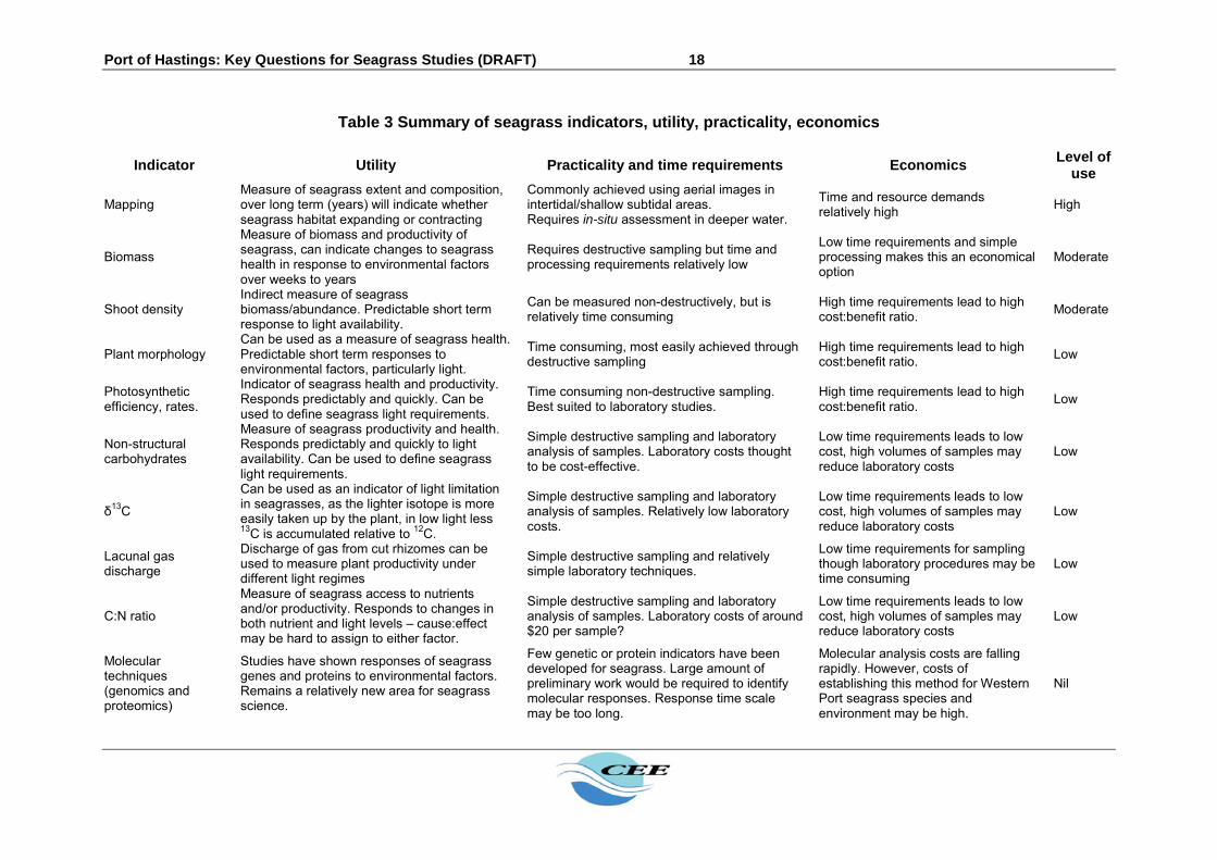
4.2.5 Seagrass indicators
Seagrass condition can change in response to short and long term environmental changes. Some indicators provide an ‘early warning’ of change in seagrass condition, while other indicators provide information on longer term changes in seagrass (McMahon et al, 2013). Relevant indicators of both types will be investigated as part of the monitoring program. Review of available literature on indicators of seagrass condition that are likely to respond to predicted impacts (light, sedimentation) have been selected based on their utility, cost and practicality for use with Western Port seagrasses (Table 3). These indicators are:
Above ground biomass; Dimensions of seagrass stems and leaves (e.g. stem length, leaf length, leaves per
shoot, leaf clusters); Non-structural carbohydrates in above and below ground seagrass tissues; Carbon stable isotopes (δ13C) in seagrass leaves; Productivity: this may be assessed using conventional benthic chambers, or via
lacunal gas discharge, fluorometry, oxygen evolution or acoustic methods. Sedimentation: determining background sediment accretion rates and levels of
adherence to seagrass leaves will be important to predicting impacts of sedimentation resulting from dredging activities.
The list of indicators would be refined based on the results of early monitoring surveys – with a view to continuing to monitor only those indicators that provide good quality information at a reasonable cost. 4.2.6 Methods
Methods of monitoring these indicators are presented and assessed in Table 3. The methods would be developed via an iterative process. Results would be continually assessed for suitability, efficiency and application in predictive modelling or impact assessment.
4.2.7 Outputs
The first six months of results would inform development of predictive impact assessment models and tools, and provide the basis for design of trails to quantify impact response. The results of the first year or two would provide the basis of detailed description of existing conditions with respect to seagrass biology relevant to impact assessment for the Project.
Port of Hastings: Key Questions for Seagrass Studies (DRAFT) 18
Table 3 Summary of seagrass indicators, utility, practicality, economics
Indicator Utility Practicality and time requirements Economics Level of
use
Mapping Measure of seagrass extent and composition, over long term (years) will indicate whether seagrass habitat expanding or contracting
Commonly achieved using aerial images in intertidal/shallow subtidal areas. Requires in-situ assessment in deeper water.
Time and resource demands relatively high
High
Biomass
Measure of biomass and productivity of seagrass, can indicate changes to seagrass health in response to environmental factors over weeks to years
Requires destructive sampling but time and processing requirements relatively low
Low time requirements and simple processing makes this an economical option
Moderate
Shoot density Indirect measure of seagrass biomass/abundance. Predictable short term response to light availability.
Can be measured non-destructively, but is relatively time consuming
High time requirements lead to high cost:benefit ratio.
Moderate
Plant morphology Can be used as a measure of seagrass health. Predictable short term responses to environmental factors, particularly light.
Time consuming, most easily achieved through destructive sampling
High time requirements lead to high cost:benefit ratio.
Low
Photosynthetic efficiency, rates.
Indicator of seagrass health and productivity. Responds predictably and quickly. Can be used to define seagrass light requirements.
Time consuming non-destructive sampling. Best suited to laboratory studies.
High time requirements lead to high cost:benefit ratio.
Low
Non-structural carbohydrates
Measure of seagrass productivity and health. Responds predictably and quickly to light availability. Can be used to define seagrass light requirements.
Simple destructive sampling and laboratory analysis of samples. Laboratory costs thought to be cost-effective.
Low time requirements leads to low cost, high volumes of samples may reduce laboratory costs
Low
δ13C
Can be used as an indicator of light limitation in seagrasses, as the lighter isotope is more easily taken up by the plant, in low light less 13C is accumulated relative to 12C.
Simple destructive sampling and laboratory analysis of samples. Relatively low laboratory costs.
Low time requirements leads to low cost, high volumes of samples may reduce laboratory costs
Low
Lacunal gas discharge
Discharge of gas from cut rhizomes can be used to measure plant productivity under different light regimes
Simple destructive sampling and relatively simple laboratory techniques.
Low time requirements for sampling though laboratory procedures may be time consuming
Low
C:N ratio
Measure of seagrass access to nutrients and/or productivity. Responds to changes in both nutrient and light levels – cause:effect may be hard to assign to either factor.
Simple destructive sampling and laboratory analysis of samples. Laboratory costs of around $20 per sample?
Low time requirements leads to low cost, high volumes of samples may reduce laboratory costs
Low
Molecular techniques (genomics and proteomics)
Studies have shown responses of seagrass genes and proteins to environmental factors. Remains a relatively new area for seagrass science.
Few genetic or protein indicators have been developed for seagrass. Large amount of preliminary work would be required to identify molecular responses. Response time scale may be too long.
Molecular analysis costs are falling rapidly. However, costs of establishing this method for Western Port seagrass species and environment may be high.
Nil

Port of Hastings: Key Questions for Seagrass Studies (DRAFT) 19
5 CRITICAL REVIEW OF AVAILABLE INFORMATION ON SEAGRASS – A3 TABLE
Category Bibliographic details Summary Relevance Limitations Related key
question
General Shapiro, M.A (1975) A Preliminary Report on the Western Port Bay Study, Ministry of Conservation, Melbourne.
Presents findings of a two year multidisciplinary study into the Western Port environment. Established existing conditions such as distribution of key ecological features (mangroves, seagrass, mudflats, feeding areas for birds), water quality, hydrodynamics, estimates of productivity. Provided advice on management strategies for the ecosystem
High Information is now outdated
How much seagrass is in Western Port?
Distribution
Stephens, A. (1995). The distribution of seagrass in Western Port, Victoria. Australia. Environment Protection Authority, No. 490. Victoria, Australia.
Zostera/Heterozostera distribution in Western Port was mapped aerially. Total seagrass area in 1994 was 93 km2 (excluding Western Entrance segment). The largest area of seagrass was in the Upper North Arm (43 km2), followed by Lower North Arm (24 km2) and the Rhyll segment (11 km2). The least amount of seagrass was at Corinella segment (5 km2). Comparisons with past surveys indicated that seagrass in 1994 increased by 26 km2 from 1983/84 (lowest at 67 km2) but was still well below that in 1973/74 (highest at 197 km2).
High – seagrass distribution data specific to Western Port
Information is now outdated
How much seagrass is in Western Port?
Distribution
Roob, R. and D. Ball (1997). Gippsland Lakes Seagrass Mapping. Victorian Marine Habitat Database. Queenscliff. Marine and Freshwater Resources Institute.
Seagrass distribution in Gippsland Lakes and Lake Tylers was mapped aerially Total seagrass area was 43 km2. Zostera/Heterozostera was the dominant seagrass (43 km2) while Ruppia spiralis was a very minor component (0.6 km2). The depth distribution of seagrass within the Lakes system was generally 0-2 m. Comparisons with past surveys indicated seagrass here somewhat followed that at Western Port, with high cover prior in the 1960s, lowest cover in the mid 1980s and peaking again in 1997.
Moderate – demonstrates seagrass abundance in other Victorian habitats
Information is now outdated
How much seagrass is in Western Port?
Distribution
Roob, R., P. Morris, et al. (1998). Corner Inlet and Nooramunga Seagrass Mapping. Victorian Marine Habitat Database. Queenscliff, Marine and Freshwater Resources Institute.
Seagrass distribution in Corner Inlet and Nooramunga was mapped aerially Total seagrass area was 149 km2. Zostera/Heterozostera was the dominant seagrass (110 km2). Posidonia australis is prevalent but is found in lesser amounts (32 km2). Halophila was only a minor component of the seagrasses (0.2 km2). The depth distribution of seagrass within Corner Inlet and Nooramunga was generally between 0-4 m. Comparisons with past surveys indicated that like Western Port, seagrass distribution fluctuated markedly through time; but was lowest in the early 1970s, and highest in late 1970s and 1998.
Moderate – demonstrates seagrass abundance in other Victorian habitats
Information is now outdated
How much seagrass is in Western Port?
Distribution
Blake, S., Roob, R., et al. (2000). Seagrass Mapping of Victoria's Minor Inlets. Queenscliff, Marine and Freshwater Resources Institute.
Seagrass distribution in the 6 minor inlets of Victoria was mapped aerially. Total seagrass area was 21 km2. The dominant seagrass was Zostera/Heterozostera (14 km2), while Ruppia sp. was a minor component (2 km2). Comparisons with past surveys across 4 inlets indicated that seagrass distribution varied at broad scales through time even though the inlets were independent of each other. Lowest seagrass densities were generally observed in the 1970s, while densities were highest in the 1990s.
Moderate – demonstrates seagrass abundance in other Victorian habitats
Information is now outdated
How much seagrass is in Western Port?
Distribution
Blake, S. and D. Ball (2001). Victorian Marine Habitat Database: Seagrass Mapping of Port Philip Bay. Queenscliff, Marine and Freshwater Resources Institute.
Seagrass distribution in Port Philip Bay was mapped aerially. Total seagrass area was 68 km2, making up 40% of the vegetated area in the bay. Zostera/Heterozostera was the dominant seagrass (59 km2), followed by Amphibolis (2 km2) and Halophila (1.4 km2). Amphibolis was dominant in the Heads where wave energy was high and sediments were coarse. The depth distribution of Zostera/Heterozostera was between 0-5 m. Comparisons with past surveys indicated that unlike Western Port, seagrass distribution in the Port Philip Bay had remained relatively constant from 1957 to 2000, although there were significant fluctuations over time at the scale of sites.
Moderate – demonstrates seagrass abundance in other Victorian habitats
Information is now outdated
How much seagrass is in Western Port?
Distribution
Blake, S. and D. Ball (2001). Victorian Marine Habitat Database: Seagrass Mapping of Western Port. Queenscliff, Marine and Freshwater Resources Institute.
Aerially mapped distribution of seagrass. Found that in 1999 84% of total vegetated area was seagrass or seagrass with macroalgae. Dense Zostera/Heterozostera with algae was dominant category. Amphibolis dominant in Western Entrance and present in Eastern Entrance. Zostera/Heterozostera begins at entrance of North Arm (as Amphibolis declines) and becomes dominant from the lower North Arm. Zostera/Heterozostera decreases in upper North Arm. Starts appearing after east of French Island and becomes dense from Bass River to San Remo.
High – seagrass distribution data specific to Western Port
Information is now outdated
How much do they vary naturally? How much do they vary naturally?
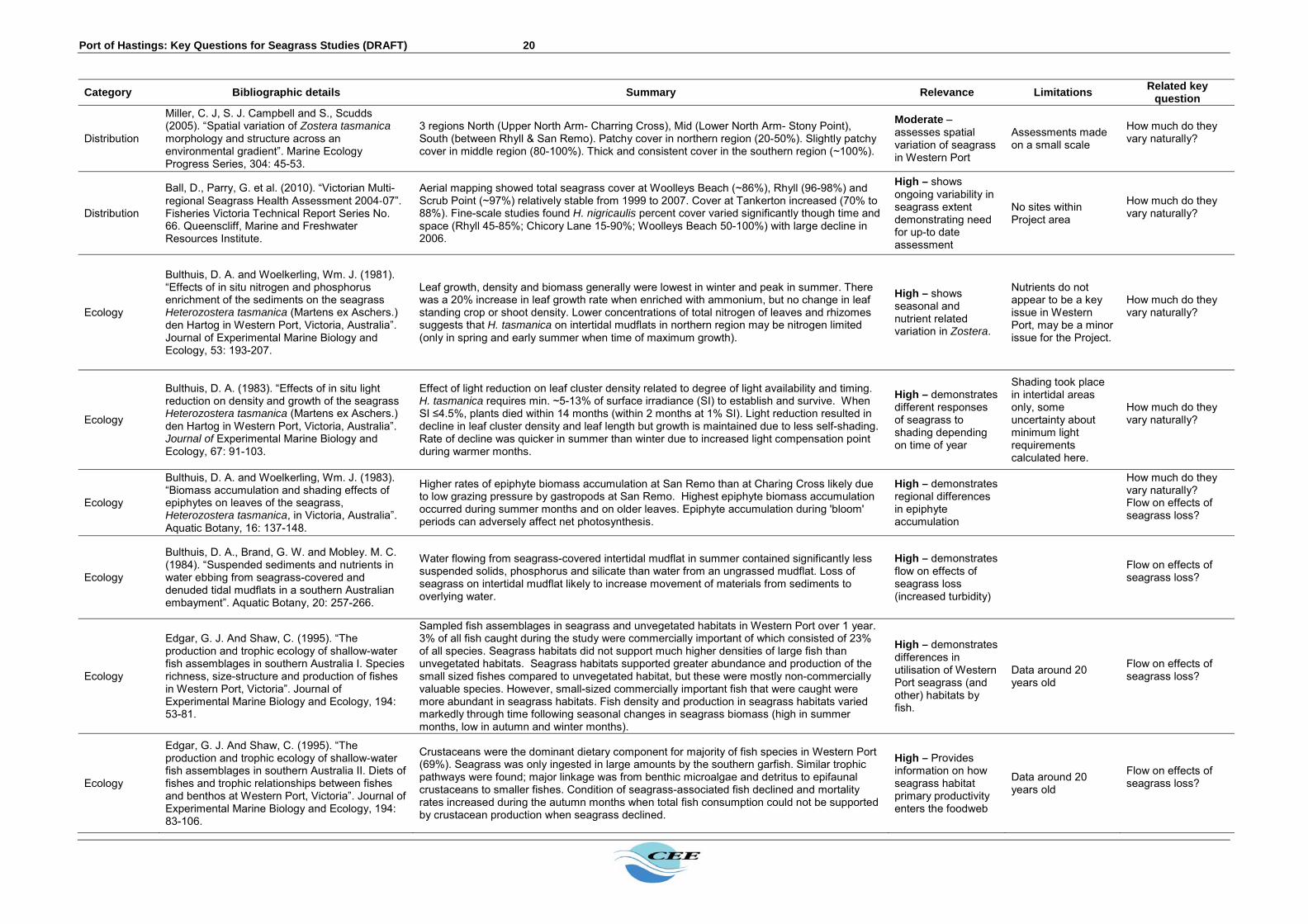
Port of Hastings: Key Questions for Seagrass Studies (DRAFT) 20
Category Bibliographic details Summary Relevance Limitations Related key
question
Distribution
Miller, C. J, S. J. Campbell and S., Scudds (2005). “Spatial variation of Zostera tasmanica morphology and structure across an environmental gradient”. Marine Ecology Progress Series, 304: 45-53.
3 regions North (Upper North Arm- Charring Cross), Mid (Lower North Arm- Stony Point), South (between Rhyll & San Remo). Patchy cover in northern region (20-50%). Slightly patchy cover in middle region (80-100%). Thick and consistent cover in the southern region (~100%).
Moderate – assesses spatial variation of seagrass in Western Port
Assessments made on a small scale
How much do they vary naturally?
Distribution
Ball, D., Parry, G. et al. (2010). “Victorian Multi-regional Seagrass Health Assessment 2004‐07”. Fisheries Victoria Technical Report Series No. 66. Queenscliff, Marine and Freshwater Resources Institute.
Aerial mapping showed total seagrass cover at Woolleys Beach (~86%), Rhyll (96-98%) and Scrub Point (~97%) relatively stable from 1999 to 2007. Cover at Tankerton increased (70% to 88%). Fine-scale studies found H. nigricaulis percent cover varied significantly though time and space (Rhyll 45-85%; Chicory Lane 15-90%; Woolleys Beach 50-100%) with large decline in 2006.
High – shows ongoing variability in seagrass extent demonstrating need for up-to date assessment
No sites within Project area
How much do they vary naturally?
Ecology
Bulthuis, D. A. and Woelkerling, Wm. J. (1981). “Effects of in situ nitrogen and phosphorus enrichment of the sediments on the seagrass Heterozostera tasmanica (Martens ex Aschers.) den Hartog in Western Port, Victoria, Australia”. Journal of Experimental Marine Biology and Ecology, 53: 193-207.
Leaf growth, density and biomass generally were lowest in winter and peak in summer. There was a 20% increase in leaf growth rate when enriched with ammonium, but no change in leaf standing crop or shoot density. Lower concentrations of total nitrogen of leaves and rhizomes suggests that H. tasmanica on intertidal mudflats in northern region may be nitrogen limited (only in spring and early summer when time of maximum growth).
High – shows seasonal and nutrient related variation in Zostera.
Nutrients do not appear to be a key issue in Western Port, may be a minor issue for the Project.
How much do they vary naturally?
Ecology
Bulthuis, D. A. (1983). “Effects of in situ light reduction on density and growth of the seagrass Heterozostera tasmanica (Martens ex Aschers.) den Hartog in Western Port, Victoria, Australia”. Journal of Experimental Marine Biology and Ecology, 67: 91-103.
Effect of light reduction on leaf cluster density related to degree of light availability and timing. H. tasmanica requires min. ~5-13% of surface irradiance (SI) to establish and survive. When SI ≤4.5%, plants died within 14 months (within 2 months at 1% SI). Light reduction resulted in decline in leaf cluster density and leaf length but growth is maintained due to less self-shading. Rate of decline was quicker in summer than winter due to increased light compensation point during warmer months.
High – demonstrates different responses of seagrass to shading depending on time of year
Shading took place in intertidal areas only, some uncertainty about minimum light requirements calculated here.
How much do they vary naturally?
Ecology
Bulthuis, D. A. and Woelkerling, Wm. J. (1983). “Biomass accumulation and shading effects of epiphytes on leaves of the seagrass, Heterozostera tasmanica, in Victoria, Australia”. Aquatic Botany, 16: 137-148.
Higher rates of epiphyte biomass accumulation at San Remo than at Charing Cross likely due to low grazing pressure by gastropods at San Remo. Highest epiphyte biomass accumulation occurred during summer months and on older leaves. Epiphyte accumulation during 'bloom' periods can adversely affect net photosynthesis.
High – demonstrates regional differences in epiphyte accumulation
How much do they vary naturally? Flow on effects of seagrass loss?
Ecology
Bulthuis, D. A., Brand, G. W. and Mobley. M. C. (1984). “Suspended sediments and nutrients in water ebbing from seagrass-covered and denuded tidal mudflats in a southern Australian embayment”. Aquatic Botany, 20: 257-266.
Water flowing from seagrass-covered intertidal mudflat in summer contained significantly less suspended solids, phosphorus and silicate than water from an ungrassed mudflat. Loss of seagrass on intertidal mudflat likely to increase movement of materials from sediments to overlying water.
High – demonstrates flow on effects of seagrass loss (increased turbidity)
Flow on effects of seagrass loss?
Ecology
Edgar, G. J. And Shaw, C. (1995). “The production and trophic ecology of shallow-water fish assemblages in southern Australia I. Species richness, size-structure and production of fishes in Western Port, Victoria”. Journal of Experimental Marine Biology and Ecology, 194: 53-81.
Sampled fish assemblages in seagrass and unvegetated habitats in Western Port over 1 year. 3% of all fish caught during the study were commercially important of which consisted of 23% of all species. Seagrass habitats did not support much higher densities of large fish than unvegetated habitats. Seagrass habitats supported greater abundance and production of the small sized fishes compared to unvegetated habitat, but these were mostly non-commercially valuable species. However, small-sized commercially important fish that were caught were more abundant in seagrass habitats. Fish density and production in seagrass habitats varied markedly through time following seasonal changes in seagrass biomass (high in summer months, low in autumn and winter months).
High – demonstrates differences in utilisation of Western Port seagrass (and other) habitats by fish.
Data around 20 years old
Flow on effects of seagrass loss?
Ecology
Edgar, G. J. And Shaw, C. (1995). “The production and trophic ecology of shallow-water fish assemblages in southern Australia II. Diets of fishes and trophic relationships between fishes and benthos at Western Port, Victoria”. Journal of Experimental Marine Biology and Ecology, 194: 83-106.
Crustaceans were the dominant dietary component for majority of fish species in Western Port (69%). Seagrass was only ingested in large amounts by the southern garfish. Similar trophic pathways were found; major linkage was from benthic microalgae and detritus to epifaunal crustaceans to smaller fishes. Condition of seagrass-associated fish declined and mortality rates increased during the autumn months when total fish consumption could not be supported by crustacean production when seagrass declined.
High – Provides information on how seagrass habitat primary productivity enters the foodweb
Data around 20 years old
Flow on effects of seagrass loss?

Port of Hastings: Key Questions for Seagrass Studies (DRAFT) 21
Category Bibliographic details Summary Relevance Limitations Related key
question
Ecology
Edgar, G. J. And Shaw, C. (1995). “The production and trophic ecology of shallow-water fish assemblages in southern Australia III. General relationships between sediments, seagrasses, invertebrates and fishes”. Journal of Experimental Marine Biology and Ecology, 194: 107-131.
Conducted over large geographic scale from WA, TAS, VIC to NSW. Multiple regression showed that fish production was highly correlated with crustacean production and seagrass biomass, and was negatively correlated with wave exposure. The estimated crustacean production was highly correlated with the biomass of seagrass material and also proportion of particle <63um.
Low – general ecological study with low relevance to Project
Flow on effects of seagrass loss?
Ecology
Miller, C. J, Campbell, S. J. and Scudds, S. (2005). “Spatial variation of Zostera tasmanica morphology and structure across an environmental gradient”. Marine Ecology Progress Series, 304: 45-53.
Environmental gradient in water quality shapes seagrass form and meadow structure. Northern regions characterised by low leaf numbers, low shoot weights, low shoot densities and few internodes. Mid to southern regions have more and longer leaves, more nodes and longer internode lengths as well as having higher shoot densities and greater seagrass cover.
High – provides information on existing conditions in seagrass beds
Small number of sites and did not provide information on subtidal Zostera
How much do they vary naturally?
Ecology
Morris, L., Jenkins, G., Hatton, D. And Smith, T. (2007). “Effects of nutrient additions on intertidal seagrass (Zostera muelleri) habitat in Western Port, Victoria, Australia”. Marine and Freshwater Research, 58: 666-674.
Nutrient addition to Z. muelleri in Western Port increased leaf dry weight and loose algae at 2 out of 3 sites, but did not affect number of seagrass leaves, epiphyte biomass.
Low – study primarily concerned with nutrients, results equivocal.
Does not demonstrate light responses
How much do they vary naturally?
Ecology
Hutchinson, N., Jenkins, G. P., Brown, A. and Smith, T. M. (2013). “Variation with Depth in Temperate Seagrass-Associated Fish Assemblages in Southern Victoria, Australia”. Estuaries and Coasts, 37: 801-814.
Sampling fish in shallow (<1 m) and deep (2-8 m) Z. nigricaulis meadows in Port Philip Bay over 3 years. Species richness was higher in shallow beds than deep beds. There was a positive relationship between seagrass biomass/length and total abundance/species richness. Total abundance of fish was generally significantly higher in shallow beds than in deep beds. Both seagrass habitats had distinctive assemblage structure between the two depths, with small schooling fish dominating shallow beds.
Moderate – demonstrates depth related differences in fish associated with seagrass.
Not assessed in Western Port
How much do they vary naturally?
Bioindicators Atkinson, M. J. (1983). "C:N:P ratios of benthic marine plants." Limnology and Oceanography 28(3): 568-574.
Establishes C:N:P ratio for benthic marine macroalgae and seagrasses as 550:30:1. benthic marine plants require lower amount of nutrients to support a particular level of net production than phytoplankton. Benthic plants growing with highly elevated N levels approach Redfield C:N:P - this suggested as a limit rather than central tendency of their ratio.
Moderate
Bioindicators Dennison, W. C. (1987). "Effects of light on seagrass photosynthesis, growth and depth distribution." Aquatic Botany 27: 15-26.
Studies effects of light on Z. marina photosynthesis, growth and depth distribution. Gross photosynthesis peaked in late-summer but net photosynthesis peaked in spring due to high respiration at summer temperatures. Depth limit related to depth distribution of compensation irradiance and minimum annual average compensation irradiance of 12.3 h/d found. Even though longest days are at summer solstice, Hcomp and Hsat were longest in northern spring (April) - temperature affects Hcomp and Hsat as they are based on net photosynthesis.
Moderate – establishes general light requirements and measures of ‘light dose’ for seagrass, establishes interactive effect of light and temperature on photosynthesis.
How much do they vary naturally?
Bioindicators Duarte, C. M. (1990). "Seagrass nutrient content." Marine Ecology Progress Series 67: 201-207.
Examine nutrient content of 27 seagrass species from 30 locations (literature based). Suggested stable C:N and C:P ratios of 12 and 200 (somewhat higher than redfield ratio). Median values of N and P content were 1.8 and 0.2 percent DW - values below this might indicate nutrient limitation. Structural carbon in seagrass contributes to higher C:N:P ratios compared with phytoplankton. Did not examine effects of light.
Moderate – Establishes generalised C:N:P ratios for seagrasses
General relevance only: species studied not found in Western Port.
Bioindicators
Abal, E. G., N. Loneragan, et al. (1994). "Physiological and morphological responses of the seagrass Zostera capricorni Aschers to light intensity." Journal of Experimental Marine Biology and Ecology 178(1): 113-129.
Study response of Z. capricorni to changes in light intensity. High light led to smaller shoots, higher biomass and productivity, less negative 13C values, lower leaf N content, less chlorophyll and more photoprotection than low light plants.
Moderate – demonstrates response of related Zostera species to light availability
General relevance only: species studied not found in Western Port.
Where and how much seagrass would be lost due to port development?

Port of Hastings: Key Questions for Seagrass Studies (DRAFT) 22
Category Bibliographic details Summary Relevance Limitations Related key
question
Bioindicators
Kraemer, G. P. and R. S. Alberte (1995). "Impact of daily photosynthetic period on protein synthesis and carbohydrate stores in Zostera marina L. (eelgrass) roots: implications for survival in light-limited environments." Journal of Experimental Marine Biology and Ecology 185(2): 191-202.
Examines effect of reduction in Hsat period on rhizome metabolism. Found protein synthesis in rhizomes could continue anaerobically given sufficient C stores. Plants quickly switch to anaerobic metabolism in rhizomes when photosynthesis ceases. Z. marina rhizomes could withstand 10-14 day anoxic periods (2 hr Hsat period). Seagrass more resilient to reduced Hsat if they had good C stores to begin with.
Moderate – demonstrates effects of light availability on carbohydrates and proteins in Zostera
General relevance only: species studied not found in Western Port.
Where and how much seagrass would be lost due to port development?
Bioindicators
Burke, M. K., W. C. Dennison, et al. (1996). "Non-structural carbohydrate reserves of eelgrass Zostera marina." Marine Ecology Progress Series 137(1-3): 195-201.
Studies NSC dynamics in Z. marina. Found seasonal variation in sugar, but not starch. Most NSC stores in rhizomes, most starch in roots. Shading reduced NSC reserve storage, spring an important time for both growth and NSC accumulation. NSC reserves depleted throughout remainder of year.
Moderate – demonstrates effects of light availability on carbohydrates stores in Zostera.
General relevance only: species studied not found in Western Port.
Where and how much seagrass would be lost due to port development?
Bioindicators
Grice, A., N. Loneragan, et al. (1996). "Light intensity and the interactions between physiology, morphology and stable isotope ratios in five species of seagrass." Journal of Experimental Marine Biology and Ecology 195(1): 91-110.
Examined effects of light on stable isotope ratios, physiology, morphology on five species of seagrass. Less negative delta 13C values, higher productivities, higher C:N ratio under full sun. Seagrass productivity positively correlated with delta 13 C. Discuss increased root biomass at higher productivity - perhaps used to acquire more N from sediments to boost depleted N stores. Seagrasses discriminate less against 13C at higher irradiances.
Moderate – demonstrates effects of light availability on Zostera bioindicators
General relevance only: species studied not found in Western Port.
Where and how much seagrass would be lost due to port development?
Bioindicators
Fourqurean, J. W., T. O. Moore, et al. (1997). "Spatial and temporal variation in C:N:P ratios, S15N and S13C of eelgrass Zostera marina as indicators of ecosystem processes, Tomales Bay, California, USA " Marine Ecology Progress Series 157: 147-157.
Examine C:N:P and stable isotopes in Z. marina in response to temporal and spatial variation in nutrient availability. Strong positive relationship between C:N ratio and distance from nutrient source (seasonal upwelling).
Moderate – demonstrates effects of light availability on Zostera bioindicators
General relevance only: species studied not found in Western Port.
Bioindicators
Longstaff, B. J. and W. C. Dennison (1999). "Seagrass survival during pulsed turbidity events: the effects of light deprivation on the seagrasses Halodule pinifolia and Halophila ovalis." Aquatic Botany 65(1-4): 105-121.
Examined responses of natural light gradients and experimental light starvation in two seagrass species. Showed 38-78 day tolerance of H. pinnifolia to light deprivation, death at 90-100 days. H. ovalis dead after 38 days darkness. Increase in amino acid content of H. pinnifolia due light deprivation. Early indicators of light stress in H. pinnifolia were increased amino acid content, decrease in Chl-a/b ratio, decrease in 13C values.
Moderate – demonstrates effects of light availability on seagrass bioindicators
General relevance only: species studied not found in Western Port.
Where and how much seagrass would be lost due to port development?
Bioindicators
Longstaff, B. J., N. R. Loneragan, et al. (1999). "Effects of light deprivation on the survival and recovery of the seagrass Halophila ovalis (RBr) Hook." Journal of Experimental Marine Biology and Ecology 234(1): 1-27.
Used light deprivation experiments to examine mortality of Halophila ovalis. Biomass declined after 3-6 days of darkness, death after 30d. Sugar concentrations declined rapidly for first 2 days of deprivation, stabilised, then rapidly increased in recovery period. Starch concentrations did not change during light deprivation (inhibition of utilisation due anaerobiosis). Also examined photosynthesis, C isotope, pigments.
Moderate – demonstrates effects of light availability on seagrass bioindicators
General relevance only: species studied not found in Western Port.
Where and how much seagrass would be lost due to port development?
Bioindicators
Cabello-Pasini, A., C. Lara-Turrent, et al. (2002). "Effect of storms on photosynthesis, carbohydrate content and survival of eelgrass populations from a coastal lagoon and the adjacent open ocean." Aquatic Botany 74(2): 149-164.
Examined response of Z. marina to reduced light levels associated with storms. Storms reduced light availability to nearly zero for nearly three weeks on open coast. 85% decline in leaf sugar and starch content after three weeks, and shoots died off. Seedlings re-appeared after storm season ended and light availability increased.
Moderate – demonstrates effects of light availability on seagrass bioindicators
General relevance only: species studied not found in Western Port.
Where and how much seagrass would be lost due to port development? What is the recovery potential for seagrass?
Bioindicators
Peralta, G., J. Perez-Llorens, et al. (2004). "Effects of light availability on growth, architecture and nutrient content of the seagrass Zostera noltii Hornem." Journal of Experimental Marine Biology and Ecology 269(1): 9-26.
Examine response of Z. noltii to shading over 14 days. Find that growth parameters, C:N, NSC are negatively affected by light reduction.
Moderate – demonstrates effects of light availability on seagrass bioindicators
General relevance only: species studied not found in Western Port.
Where and how much seagrass would be lost due to port development?
Bioindicators
Brun, F. G., I. Hernandez, et al. (2003). "Growth, carbon allocation and proteolytic activity in the seagrass Zostera noltii shaded by Ulva canopies." Functional Plant Biology 30(5): 551-560.
Tested effect of shading on Z. noltiicarbon allocation and proteolytic activity. Shaded plants had negative net growth and starch mobilised in above and below ground tissue. Sucrose declined in below ground parts, accumulated in above ground parts. Severe shading led to low activity of enzymes associated with sucrose formation, but increased C 'sink strength' indicated by high activity of sucrose synthase.
Moderate – demonstrates effects of light availability on seagrass bioindicators
General relevance only: species studied not found in Western Port.
Where and how much seagrass would be lost due to port development?

Port of Hastings: Key Questions for Seagrass Studies (DRAFT) 23
Category Bibliographic details Summary Relevance Limitations Related key
question
Bioindicators
Baird, M. E. and J. H. Middleton (2004). "On relating physical limits to the carbon:nitrogen ratio of unicellular algae and benthic plants." Journal of Marine Systems 49: 169-175.
Examine physical reasons for higher C:N:P ratios in benthic algae and seagrasses compared with phytoplankton. Find that potential light absorption is higher for benthic plants than phytoplankton, which may explain why they require around 4 times as much light per unit N compared to unicellular algae. This may explain higher C:N:P ratios and nitrogen limitation in benthic plants.
Low - Provides general information only on algae versus seagrass C:N:P
Provides general information only on
Bioindicators
Hackney, J. W. and M. J. Durako (2004). "Size-frequency patterns in morphometric characteristics of the seagrass Thalassia testudinum reflect environmental variability." Ecological Indicators 4: 55-71.
Examined variability in structural characteristics of Thalassia testudinum in Florida Bay, USA. Shoot morphometrics showed significant inter-annual differences in size-frequency distributions, but only leaf number per shoot showed difference in mean. There were larger differences between basins within Florida Bay than between years.
Low – demonstrates regional differences in seagrass shoot dimensions related to water quality/habitat.
General relevance only: species studied not found in Western Port.
Bioindicators
Ibarra-Obando, S., K. Heck, et al. (2004). "Effects of simultaneous changes in light, nutrients, and herbivory levels, on the structure and function of a subtropical turtlegrass meadow." Journal of Experimental Marine Biology and Ecology 301(2): 193-224.
Studied effects of nutrient addition, herbivory and light on seagrass response variables. All variables negatively responded to light reduction except below-ground biomass, shoot density and leaf length.
Low – demonstrates effects of light availability on seagrass bioindicators
General relevance only: species studied not found in Western Port.
Bioindicators
Ransbotyn, V. and T. B. G. Reusch (2006). "Housekeeping gene selection for quantitative real-time PCR assays in the seagrass Zostera marina subjected to heat stress." Limnology and Oceanography: Methods 4: 367-373.
Study where authors attempted to identify Z. marina 'house keeping genes' whose expression (or degree of expression) could be used to study response to heat stress. Authors found only a small number of 'stable' house keeping genes (3). Their response (in terms of expression) of these genes to changes in temperature were not investigated.
Low – demonstrates effects of heat on seagrass genetics
Study shows current utility of genetic/molecular techniques limited
Bioindicators
Hoffmann, A. A. and P. J. Daborn (2007). "Towards genetic markers in animal populations as biomonitors for human-induced environmental change." Ecology Letters 10: 63-76.
Propose genetic 'markers' as potentially sensitive indicators of changes in environmental conditions. Review documented genetic changes in animal (mostly small arthropods) genetics in response to toxins and temperature. Such changes in genetics ('evolution') in response to contemporary changes in environment are happening in species with short generation times (multiple times per year) - which is not the case for seagrasses.
Low – shows genetic response to environment
Uses examples of animals with very short generation times
Bioindicators
McKenzie, L. J., J. Mellors, et al. (2007). Great Barrier Reef Water Quality Protection Plan - Marine Monitoring Program: Intertidal Seagrass. Great Barrier Reef Water Quality Protection Plan - Marine Monitoring Program. Townsville, Great Barrier Reef Marine Park Authority.
Large scale monitoring program. Included monitoring of C:N and C:P ratios in 2005/2006 - both were able to differentiate between coastal and reef habitat types, inferring a distinction between low light, and comparatively higher light environments (C:N and C:P ratios are lower in low light, high nutrient environments).
Moderate – shows utility of C:N and C:P monitoring for assessing seagrass condition
Unable to distinguish between nutrient and light availability effects
Where and how much seagrass would be lost due to port development?
Bioindicators
Procaccini, G., J. L. Olsen, et al. (2007). "Contribution of genetics and genomics to seagrass biology and conservation." Journal of Experimental Marine Biology and Ecology 350(1-2): 234-259.
Outlines applications for different types of molecular analyses in seagrasses, including 'genetic' monitoring. Applications discussed appear to be mostly applicable to impacts on the scale of years to decades. Does not provide information on whether monitoring 'gene expression' is currently feasible in seagrasses.
Low – shows genetic response to environment
Uses examples of changes over scale of years to decades
Bioindicators
Schwartz, M. K., G. Luikart, et al. (2007). "Genetic monitoring as a promising tool for conservation and management." Trends in Ecology and Evolution 22(1): 9.
Examine uses of genetic monitoring for tracking changes in population size, connectivity, gene flow, genetic diversity.
Low – shows genetic response to environment
Uses examples of changes over scale of years to decades

Port of Hastings: Key Questions for Seagrass Studies (DRAFT) 24
Category Bibliographic details Summary Relevance Limitations Related key
question
Bioindicators
Touchette, B. W. and J. M. Burkholder (2007). "Carbon and nitrogen metabolism in the seagrass, Zostera marina L.: Environmental control of enzymes involved in carbon allocation and nitrogen assimilation." Journal of Experimental Marine Biology and Ecology 350(1/2): 216-233.
Carbon and Nitrogen metabolism in Z. marina strongly influence by prevailing environmental conditions, especially temperature, salinity and environmental nutrient levels. Z. marina characterised as adapted to N limitation, and able to maximise nitrate uptake during infrequent nitrate pulses (by re-allocating carbohydrates to reducing nitrate and forming amino acids). Low carbohydrate reserves generally lead to low nitrate reductase activity, but NR activity usually up regulated when Nitrate available, may cause internal carbon limitation. Glutamine synthetase activity closely linked to inorganic N levels (up-regulated at increase N levels) and temperature (up-regulated at optimum temperature)
Low – study primarily concerned with nutrients
Does not demonstrate light responses
Bioindicators
Vichkovitten, T., M. Holmer, et al. (2007). "Spatial and temporal changes in non-structural carbohydrate reserves in eelgrass (Zostera marina L.) in Danish coastal waters." Botanica Marina 50(2): 75-87.
Examine spatial and seasonal changes of non-structural carbohydrates in Z. marina. Rhizomes major storage organ, sucrose major storage, starch <15% total reserves. Plants with lower light had more reserves, nutrient availability did not affect reserves. More starch was accumulated over winter.
Moderate – demonstrates carbohydrate dynamics in Zostera
General relevance only: species studied not found in Western Port.
Where and how much seagrass would be lost due to port development?
Bioindicators
Collier, C., P. S. Lavery, et al. (2008). "Physiological characteristics of the seagrass Posidonia sinuosa along a depth-related gradient of light availability." Marine Ecology Progress Series 353: 65-79.
Examined physiology of P. sinuosa along a depth-related gradient of light availability. RLC, pigments, nutrient and carbohydrate concentrations showed few differences among depths but some adjustment between seasons. C:N ratio was lower in winter (low light) than summer.
Moderate – demonstrates light related dynamics in Posidonia bioindicators
General relevance only: species studied not found in Western Port.
Where and how much seagrass would be lost due to port development?
Bioindicators
Collier, C. J., P. S. Lavery, et al. (2009). "Shade-induced response and recovery of the seagrass Posidonia sinuosa." Journal of Experimental Marine Biology and Ecology 370(1–2): 89-103.
Document changes in shoot density, rhizome sugars, leaf morphology, S13C, photosynthesis, %N in response to light reduction.
Moderate – demonstrates light related dynamics in Posidonia bioindicators
General relevance only: species studied not found in Western Port.
Where and how much seagrass would be lost due to port development?
Bioindicators McKenzie, L. J. and R. L. Yoshida (2009). Coastal Canaries. Seagrass-Watch. Cairns, Seagrass Watch.
Decreasing C:N and C:P ratios in seagrass leaves at GBR sites indicated reduced light availability (or nutrient enrichment?). Shift from N-limited to P-limited conditions, 2005-2006.
Moderate – demonstrates light and nutrient related dynamics in seagrass bioindicators
General relevance only: species studied not found in Western Port.
Where and how much seagrass would be lost due to port development?
Bioindicators
Collier, C. J., P. Prado, et al. (2010). "Carbon and nitrogen translocation in response to shading of the seagrass Posidonia sinuosa." Aquatic Botany 93(1): 47-54.
Examined translocation of C and N in P. sinuosa in response to shading (ambient vs below limiting light, 10 days). Found mature leaves could translocate N to growing leaves under shade conditions, enhancing light harvesting efficiency.
Moderate – demonstrates light related dynamics in Posidonia bioindicators
General relevance only: species studied not found in Western Port.
Where and how much seagrass would be lost due to port development?
Bioindicators
Niedringhaus, T. P., D. Milanova, et al. (2011). "Landscape of Next-Generation Sequencing Technologies." Analytical Chemistry 83(12): 4327-4341.
Examines applicability of next-generation molecular techniques (genetics) Low
Bioindicators Cabacao, S. and R. Santos (2012). "Ecological Indicators." Seagrass reproductive effort as an ecological indicator of disturbance 23: 116-122.
Review changes in seagrass reproductive effort in response to disturbances and seagrass traits. RE increased with disturbance in 72% cases, 25% decreased. Seagrass RE increased 4-fold with disturbance. Mechanical and sedimentary/hydrodynamics disturbances caused greatest RE increase. Responses to decreased light availability equivocal, but generally RE falls when light drops.
Moderate – demonstrates effects of disturbance on seagrass reproductive effort
General relevance only: species studied not found in Western Port.
What is the recovery potential for seagrass?
Bioindicators
Durako, M. J. (2012). "Using PAM fluorometry for landscape-level assessment of Thalassia testudinum: Can diurnal variation in photochemical efficiency be used as an ecoindicator of seagrass health?" Ecological Indicators 18: 243-251.
Used diurnal (rather than once per day) PAM measurement of effective quantum yield (deltaF/Fm' as an indicator of seagrass response to interannual variability in light availability. Regressions of effective quantum yield versus PAR showed strong linear relationships in each year. Comparison of slopes between years showed strong statistically significant differences - related to light availability/water clarity).
Low – demonstrates light related dynamics in Thallasia photophysiology
General relevance only: species studied not found in Western Port.
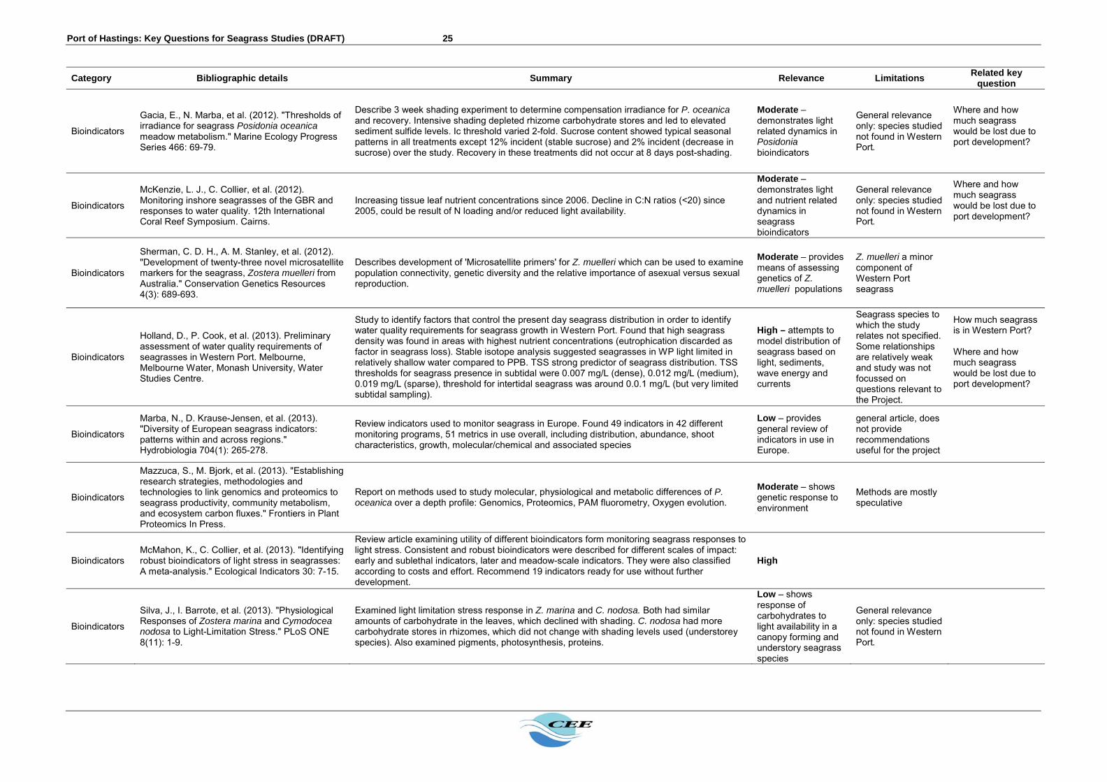
Port of Hastings: Key Questions for Seagrass Studies (DRAFT) 25
Category Bibliographic details Summary Relevance Limitations Related key
question
Bioindicators
Gacia, E., N. Marba, et al. (2012). "Thresholds of irradiance for seagrass Posidonia oceanica meadow metabolism." Marine Ecology Progress Series 466: 69-79.
Describe 3 week shading experiment to determine compensation irradiance for P. oceanica and recovery. Intensive shading depleted rhizome carbohydrate stores and led to elevated sediment sulfide levels. Ic threshold varied 2-fold. Sucrose content showed typical seasonal patterns in all treatments except 12% incident (stable sucrose) and 2% incident (decrease in sucrose) over the study. Recovery in these treatments did not occur at 8 days post-shading.
Moderate – demonstrates light related dynamics in Posidonia bioindicators
General relevance only: species studied not found in Western Port.
Where and how much seagrass would be lost due to port development?
Bioindicators
McKenzie, L. J., C. Collier, et al. (2012). Monitoring inshore seagrasses of the GBR and responses to water quality. 12th International Coral Reef Symposium. Cairns.
Increasing tissue leaf nutrient concentrations since 2006. Decline in C:N ratios (<20) since 2005, could be result of N loading and/or reduced light availability.
Moderate – demonstrates light and nutrient related dynamics in seagrass bioindicators
General relevance only: species studied not found in Western Port.
Where and how much seagrass would be lost due to port development?
Bioindicators
Sherman, C. D. H., A. M. Stanley, et al. (2012). "Development of twenty-three novel microsatellite markers for the seagrass, Zostera muelleri from Australia." Conservation Genetics Resources 4(3): 689-693.
Describes development of 'Microsatellite primers' for Z. muelleri which can be used to examine population connectivity, genetic diversity and the relative importance of asexual versus sexual reproduction.
Moderate – provides means of assessing genetics of Z. muelleri populations
Z. muelleri a minor component of Western Port seagrass
Bioindicators
Holland, D., P. Cook, et al. (2013). Preliminary assessment of water quality requirements of seagrasses in Western Port. Melbourne, Melbourne Water, Monash University, Water Studies Centre.
Study to identify factors that control the present day seagrass distribution in order to identify water quality requirements for seagrass growth in Western Port. Found that high seagrass density was found in areas with highest nutrient concentrations (eutrophication discarded as factor in seagrass loss). Stable isotope analysis suggested seagrasses in WP light limited in relatively shallow water compared to PPB. TSS strong predictor of seagrass distribution. TSS thresholds for seagrass presence in subtidal were 0.007 mg/L (dense), 0.012 mg/L (medium), 0.019 mg/L (sparse), threshold for intertidal seagrass was around 0.0.1 mg/L (but very limited subtidal sampling).
High – attempts to model distribution of seagrass based on light, sediments, wave energy and currents
Seagrass species to which the study relates not specified. Some relationships are relatively weak and study was not focussed on questions relevant to the Project.
How much seagrass is in Western Port? Where and how much seagrass would be lost due to port development?
Bioindicators
Marba, N., D. Krause-Jensen, et al. (2013). "Diversity of European seagrass indicators: patterns within and across regions." Hydrobiologia 704(1): 265-278.
Review indicators used to monitor seagrass in Europe. Found 49 indicators in 42 different monitoring programs, 51 metrics in use overall, including distribution, abundance, shoot characteristics, growth, molecular/chemical and associated species
Low – provides general review of indicators in use in Europe.
general article, does not provide recommendations useful for the project
Bioindicators
Mazzuca, S., M. Bjork, et al. (2013). "Establishing research strategies, methodologies and technologies to link genomics and proteomics to seagrass productivity, community metabolism, and ecosystem carbon fluxes." Frontiers in Plant Proteomics In Press.
Report on methods used to study molecular, physiological and metabolic differences of P. oceanica over a depth profile: Genomics, Proteomics, PAM fluorometry, Oxygen evolution.
Moderate – shows genetic response to environment
Methods are mostly speculative
Bioindicators McMahon, K., C. Collier, et al. (2013). "Identifying robust bioindicators of light stress in seagrasses: A meta-analysis." Ecological Indicators 30: 7-15.
Review article examining utility of different bioindicators form monitoring seagrass responses to light stress. Consistent and robust bioindicators were described for different scales of impact: early and sublethal indicators, later and meadow-scale indicators. They were also classified according to costs and effort. Recommend 19 indicators ready for use without further development.
High
Bioindicators
Silva, J., I. Barrote, et al. (2013). "Physiological Responses of Zostera marina and Cymodocea nodosa to Light-Limitation Stress." PLoS ONE 8(11): 1-9.
Examined light limitation stress response in Z. marina and C. nodosa. Both had similar amounts of carbohydrate in the leaves, which declined with shading. C. nodosa had more carbohydrate stores in rhizomes, which did not change with shading levels used (understorey species). Also examined pigments, photosynthesis, proteins.
Low – shows response of carbohydrates to light availability in a canopy forming and understory seagrass species
General relevance only: species studied not found in Western Port.

Port of Hastings: Key Questions for Seagrass Studies (DRAFT) 26
Category Bibliographic details Summary Relevance Limitations Related key
question
Bioindicators
Smith, T. M., P. H. York, et al. (2013). "Microsatellite primer development for the seagrass Zostera nigricaulis (Zosteraceae)." Conservation Genetics Resources 5: 607-610.
Describes development of 'Microsatellite primers' for Z. nigricaulis which can be used to examine population connectivity, genetic diversity and the relative importance of asexual versus sexual reproduction.
High – provides means of assessing genetics of Z. nigricaulis populations
Costs and relevance of methods for Project unclear
Bioindicators
Warry, F. Y., P. Reich, et al. (2013). Using leaf chemistry to better understand the ecology of seagrass in the Gippsland Lakes. D. o. S. a. Environment. Heidelberg, Victoria, Arthur Rylah Institute for Environmental Research.
Study on Ruppia and Zostera leaf chemistry in Gippsland lakes (and other parameters). For Zostera found % N range (min-max) of 2.09-5.21, % P range of 0.15-0.35, % C range of 39-44, C:N of 7.5-20, N:P of 7-19.
Low
General relevance only – study not conducted in Western port
Bioindicators
Zhijian, J., H. Xiaoping, et al. (2013). "Dynamics of nonstructural carbohydrates in seagrass Thalassia hemprichii and its response to shading." Acta oceanologica Sinica 32(8): 61-67.
Examine dynamics of NSC in Thalassia hemprichii and response to shading. Found more carbohydrate stores in below ground parts, mostly soluble sugars as storage, starch minor component but measurably higher in low intertidal compared to high intertidal areas.
Moderate – demonstrates light related dynamics in seagrass carbohydrate stores
General relevance only: species studied not found in Western Port.
Where and how much seagrass would be lost due to port development?
Bioindicators
Dattolo, E., M. Ruocco, et al. (2014). "Response of the seagrass Posidonia oceanica to different light environments: Insights from a combined molecular and photo-physiological study." Marine Environmental Research In Press.
Investigated gene-expression response to seasonal and depth related light availability differences. Demonstrated up-regulation of a number of genes, and down regulation of others in response to 'high' light. High light plants showed narrow range of gene expression (genes for photoprotection and regeneration of membrane proteins switched on), while low light plants had more variable gene expression.
Moderate – shows genetic response to environment
Time scale for genetic response unclear (spatial study, not temporal)
Bioindicators
Falkenberg, L. J. and C. A. Styan (2014). "Too much data is never enough: A review of the mismatch between scales of water quality data collection and reporting from recent marine dredging programmes." Ecological Indicators 45: 529-537.
Cautions against data kleptomania in water quality monitoring. Low
Bioindicators
Govers, L. L., W. Suykeruyk, et al. (2014). "Rhizome starch as indicator for temperate seagrass winter survival." Ecological Indicators 49: 53-60.
Study of Zostera noltii transplant survival. Low autumn rhizome starch concentrations usually resulted in unsuccessful transplants. Removing seagrass leaves (clipping) over winter did not affect rhizome starch concentration or seagrass biomass in June (Summer). Autumn rhizome starch concentrations were found to be a good indicator of next year's growth success. Shoot density and winter leaves were bad indicators of growth success. Suggest timing of disturbance at start of growing season (late spring) as at this time seagrasses are not completely reliant on their carbohydrate reserves.
Low
Provides some information on re-establishment strategies for seagrass.
What is the recovery potential for seagrass?
Bioindicators
Kilminster, K., V. Forbes, et al. (2014). "Development of 'sediment-stress' functional level indicator for the seagrass Halophila ovalis." Ecological Indicators 36: 280-289.
Study relating seagrass productivity with sediment sulfur dynamics. Primarily considers impacts of eutrophication on sulfur in sediments.
Low Considers nutrients rather than light impacts
Bioindicators
Macreadie, P. I., M. T. Schliep, et al. (2014). "Molecular indicators of chronic seagrass stress: A new era in the management of seagrass ecosystems?" Ecological Indicators 38: 279-281.
Review article examining molecular (genetic) techniques for examining seagrass responses to chronic stressors. Monitoring 'gene expression' or specific protein production may have application for dredging related impacts. Suggests such techniques may become feasible coming years. Unclear how much work and cost involved in developing gene expression methods for monitoring responses to acute stressors, such as dredging.
High
Methods discussed are unproven and likely costly at this point
Bioindicators
Roca, G., J. Romero, et al. (2014). "Detecting the impacts of harbour construction on a seagrass habitat and its subsequent recovery." Ecological Indicators 45: 9-17.
Harbour construction caused increase in sediment organic matter, sediment (fine sand) deposition and decreased light availability over 5-15 months. Shoot density showed response, light reduction caused decline in carbohydrate content. No response seen in N or P content, morphological (shoot biomass) and community (epiphytes) indicators. Heavy metal and carbohydrate content were much better in detecting recovery over short term. "Shoot density and indicators directly related to light availability (starch, sucrose, total carbohydrates) and metal pollution responded most to disturbance".
High – Directly assessed the impact of a dredging project on seagrass bioindicators
General relevance only: species studied not found in Western Port.
Where and how much seagrass would be lost due to port development?

Port of Hastings: Key Questions for Seagrass Studies (DRAFT) 27
Category Bibliographic details Summary Relevance Limitations Related key
question
Bioindicators
Ruocco, M., E. Dattolo, et al. (2014). Daily variation of gene-expression along a depth-related gradient of light availability in Posidonia oceanica. Seagrasses in Europe: Threats, Responses and Management. Olhao, Portugal.
Reports on results of P. oceanica study of Mazzuca et al, 2013. Find different gene expression between shallow (5 m) and deep (20 m) plants.
Moderate – shows genetic response to environment
Time scale for genetic response unclear (spatial study, not temporal)
Reproduction
Marbà, N. and Walker, D., I. (1999). “Growth, flowering, and population dynamics of temperate Western Australian seagrasses”. Marine Ecology Progress Series, 184: 105-118.
Studied reproduction characteristics of 8 seagrass species in Western Australia. Growth patterns varied markedly between seagrass species but clonal growth (via rhizome elongation) was main mechanism for providing shoots for all species. Large differences in flowering capacity indicate that sexual production may be important for population maintenance for some species. H. tasmanica meadow was maintained mainly by fast recruitment rates of shoots via rhizome growth.
Moderate
General relevance only – study not conducted in Western port
What is the recovery potential for seagrass?
Reproduction
Parry, G. D., Heislers, S., Chan, K., Cleaver, J., Werner, G. F. (2005). Seasonality of flowering and fruiting of the seagrass Zostera muelleri and Zostera (formerly Heterozostera) tasmanica. Industries Research Victoria: Marine and Freshwater Systems. Report No. 5.
Sampled 7 sites in Western Port. Seasonal patterns of flowering and seed development were consistent at all sites. Number of male flowers from Z. muelleri peaked in November and developing seeds were found between November and March. Immature seeds were found from November to March, but were most abundant between early December and mid-January. Mean density of Z. muelleri seeds on plants was 540-840/m2 and 280/m2 in sediments. The fruiting and flowering season of Z. tasmanica occurred between September and January with peak production of male flowers occurring earlier than November. Developing seeds were abundant between November and mid January. No spadices were found during February or March. Z. tasmanica mean density on plants was 490/m2 and 88-890/m2 in sediments.
High – shows seasonality of Zostera nigricaulis and Z. muelleri in Western Port.
Unclear how important seeds are to seagrass growth/colonisation
What is the recovery potential for seagrass?
Reproduction
Parry, G. D. (2007). Feasibility of restoration of seagrass beds using seeds. Primary Industries Research Victoria: Marine and Freshwater Systems. Report No. 21.
Review of restoration projects using rhizome and seeds in the USA. Highlighted the complexities involved in establishment of new seagrass beds (such as seeding techniques, dormancy and germination triggers, planting density). Focus on Western Port was on distribution dynamics.
Moderate – demonstrates difficulties involved with seagrass restoration efforts
What is the recovery potential for seagrass?
Reproduction
Cabacao, S. and Santos, R. (2012). “Seagrass reproductive effort as an ecological indicator of disturbance”. Ecological Indicators, 23: 116-122.
Meta-analysis of reproductive effort of several seagrass species worldwide in response to disturbances. Seagrasses show a general trend of increase reproductive effort with disturbance. This response was significantly correlated with rhizome diameter, suggesting that species with higher storage capacity have greater capacity of investing in flowering in unfavourable conditions.
Moderate – demonstrates effects of disturbance on seagrass reproductive effort
General relevance only: species studied not found in Western Port.
What is the recovery potential for seagrass?
Reproduction
Thompson, A. C. G., York, P. H., Smith, T., Sherman, C. D. H., Booth, D. J., Keough, M. J., Ross, D. J., Macreadie, P. I. (2014). “Seagrass Viviparous Propagules as a Potential Long-Distance Dispersal Mechanism. Estuaries and Coasts”. (In press)
Field and lab-based study on vivaparous shoots of Z. nigricaulis meadows in Port Philip Bay. Vivaparous shoot density was higher at sites with high wind and water currents than sheltered sites. There is potential for vivaparous shoots to act as long-distance dispersal vector as they are able to remain buoyant and healthy for >85 days. However, successful establishment and/or survivorship is rare and will depend on many factors (e.g. location of establishment, seasonal and sediment conditions).
High – demonstrates modes of reproduction and establishment of new Zostera beds in Victoria
What is the recovery potential for seagrass?
Reproduction
Macreadie, P. I., York, P. H., Sherman, C. D. H. (2014). “Resilience of Zostera muelleri seagrass to small-scale disturbances: the relative importance of asexual versus sexual recovery”. Ecology and Evolution, 4: 450-461.
Studied recovery of Z. muelleri in NSW. At small scales (cms), recovery was driven mainly via asexual rhizome growth. Recovery took 35 weeks via shoot regrowth and 65 weeks via asexual rhizome regrowth. Seed propagules did not contribute to recovery. Genotypic diversity did not appear to influence recovery.
High – demonstrates modes of reproduction and establishment of new Zostera beds in SE Australia
What is the recovery potential for seagrass?
Dredging monitoring
Westera, M. and R. Babcock (2007). Post-dredging recovery of seagrasses in the Geraldton region, year 3 report. Floreat Park, CSIRO.
Post-dredging monitoring of seagrass impact and reference sites in the Geraldton region. Impacts were greatest closest to source of turbid plumes. Recover was seen in most areas, except in areas nearest the channel and marina where dredging occurred. Impacts were consistent with extent of dredge plumes. Recommend future programs start by mapping benthic primary producer habitats to identify sites for more intensive monitoring, and use of
High – direct assessment of actual dredging project impacts on seagrass, provides
What is the recovery potential for seagrass? Where and how much seagrass

Port of Hastings: Key Questions for Seagrass Studies (DRAFT) 28
Category Bibliographic details Summary Relevance Limitations Related key
question appropriate bioindicators. recommendations for
future projects would be lost due to port development?
Dredging monitoring
Mulligan (2009). 'Applying the learning': The Geraldton Port dredging project 2002-03. Paper to the Freight and Logistics Council of WA and Ports WA.
Examines 'lessons learnt' from the Geraldton Port dredging project 2002-03. Found that baseline monitoring (seagrass and water quality) was insufficient and was inadequate to inform hydrodynamic modelling. Impact predictions from research on 'unknowns' could not be made accurately prior to the project - studies after the fact identified early indicators of stress.
High – direct assessment of actual dredging project impacts on seagrass, provides recommendations for future projects
Where and how much seagrass would be lost due to port development?
Dredging monitoring
Chartrand, K. M., P. J. Ralph, et al. (2012). Development of a Light-Based Seagrass Management Approach for the Gladstone Western Basin Dredging Program. DAFF Publication. Cairns, Fisheries Queensland.
Used shading study, PAR monitoring and laboratory studies to derived light-based triggers for management of dredge plume impacts on seagrasses. Monitored PAR, temperature, seagrass cover and biomass, shoot densities, below ground carbohydrates. Found Z. capricorni required between 4.5 and 12 mol quanta m-2 d-1 for minimum period of two weeks in the growing season to maintain or increase cover/biomass. Light reductions in the senescent season had no effect on biomass or cover. Intertidal seagrasses were stressed when emmersed and net photosynthesis declined. Carbohydrate stores declined through the senescent season, in the growing season they remained stable (low-med shading) or decreased (high shading) and increased in all treatments when shades were removed. Interestingly control plots did not increase stores for first 4 weeks. Found lower light requirement in laboratory studies (3.5 mol quanta m-2 d-1)
High – derives trigger values for regulating water quality around seagrass beds
Only considered intertidal seagrasses. Unclear exactly how trigger values were derived
Where and how much seagrass would be lost due to port development?
Dredging monitoring
CQG Consulting (2013). Port of Gladstone Western Basin Dredging and Disposal Project, Queensland: Annual Environmental Performance Report. Report to Gladstone Ports Corporation. Gladstone, CQG Consulting.
Annual review of monitoring. Found that seagrass and water quality not adversely affected by dredging overall.
Low Routine monitoring report only
Dredging monitoring
McCormack, C., M. A. Rasheed, et al. (2013). Long Term Seagrass Monitoring in the Port Curtis Western Basin: Quarterly Seagrass Assessments & Permanent Transect Monitoring Progress Report November 2009 to November 2012. Townsville, TropWater/JCU.
Used 'Seagrass Watch' methods to monitor seagrasses for Gladstone dredging project 2009-2012. Monitored multiple parameters (cover, biomass, C:N:P, flowering, seeds, shoot density, leaf and rhizome growth, productivity) - the most informative of which appear to have been cover and biomass (showing clear seasonal and longer-term trends). Growth and productivity estimates showed seasonal patterns but not longer term patterns. Used literature values to estimate light requirements for seagrasses in mol m-2 d-1 (not minimum light requirements). Found relationship between seagrass cover and biomass with light availability 2 weeks and 3 months before sampling.
High – derives trigger values for regulating water quality around seagrass beds
Only considered intertidal seagrasses. Unclear exactly how trigger values were derived
Where and how much seagrass would be lost due to port development?
Dredging monitoring
Environment, V. (2013). Western Basin Duplication and Dredging: Water Quality Monitoring (Final Project Report). Report to Gladstone Ports. Gladstone, Vision Environment.
Reports on results of Gladstone water quality monitoring 2009-2013: Turbidity, nutrients, Chl-a, Metals, PAR. Mean monthly PAR consistently above trigger value (6 mol photons m-2 d-1) at all sites - occasional instances where close to or less than 6 at one site (TC1). PAR sensors were telemetered, and moored on seabed 1.5-2 m below LAT.
Low Routine monitoring report only
Dredging monitoring
York, P. H. and T. Smith (2013). Research, monitoring and management of seagrass ecosystems adjacent to port developments in central Queensland: Literature Review and Gap analysis. Waurn Ponds, Deakin University.
Reviews research on managing dredging impacts on seagrass. Find that none of the physiological parameters measured PAM fluorometry, CO2 flux or pigments showed sub-lethal effects any faster than morphological measures (leaf size, density). Work on gene expression still underway by Rasheed. Stress that new genetic techniques may be used to detect chronic stress impacts on seagrass genetic diversity.
High – Assesses effectiveness of seagrass monitoring and management strategies during Gladstone project
Still unclear how trigger values for Gladstone project derived.
Where and how much seagrass would be lost due to port development?

Port of Hastings: Key Questions for Seagrass Studies (DRAFT) 29
6 REFERENCES CITED IN TEXT Ball, D., G. Parry, et al. (2010). Victorian Multi-regional Seagrass Health Assessment 2004‐
07. Fisheries Victoria Technical Report Series No. 66. Queenscliff, Fisheries Victoria. Blake, S. and D. Ball (2001). Seagrass Mapping of Western Port. Victorian Marine Habitat
Database. Queenscliff, Marine and Freshwater Resources Institute. Bulthuis, D. A. and W. J. Woelkerling (1983). "Seasonal variation in standing crop, density
and leaf growth rate of the seagrass, Heterozostera tasmanica, in western Port and Port Phillip Bay, Victoria, Australia." Aquatic Botany 16: 111-136.
Bulthuis, D. A., G. W. Brand, et al. (1984). "Suspended sediments and nutrients in water ebbing from seagrass-covered and denuded tidal mudflats in a southern Australian embayment." Aquatic Botany 20(3–4): 257-266.
Campbell, S. J. and C. J. Miller (2002). "Shoot and abundance characteristics of the seagrass Heterozostera tasmanica in Westernport estuary (south-eastern Australia)." Aquatic Botany 73(1): 33-46.
Clough, B. F. and P. M. Attiwill (1980). "Primary productivity of Zostera muelleri Irmisch ex Aschers. in Westernport Bay (Victoria, Australia). ." Aquatic Botany 9: 1-13.
Edgar, G. J. and C. Shaw (1995). "The production and trophic ecology of shallow-water fish assemblages in southern Australia II. Diets of fishes and trophic relationships between fishes and benthos at Western Port, Victoria." Journal of Experimental Marine Biology and Ecology 194(1): 83-106.
Hindell, J. S., G. Jenkins, et al. (2000). "Evaluating the impact of predation by fish on the assemblage structure of fishes associated with seagrass (Heterozostera tasmanica (Martens ex Ascherson) den Hartog), and unvegetated sand habitats." Journal of Experimental Marine Biology and Ecology 255: 153-174.
Holland, D., P. Cook, et al. (2013). Preliminary assessment of water quality requirements of seagrasses in Western Port. Melbourne, Melbourne Water, Monash University, Water Studies Centre.
Howard, R. K. (1984). "The trophic ecology of Caridean shrimps in an eelgrass community." Aquatic Botany 18(1-2): 155-174.
Jenkins, G. (2013). Fish and habitats. Western Port Research Seminar. Pakenham, Melbourne Water. Available from: http://www.melbournewater.com.au/whatwedo/protectrivers/Documents/Fish%20Habitat%20-%20Greg%20Jenkins.pdf accessed Nov. 2014
Koch, E. W., J. D. Ackerman, et al. (2006). Fluid Dynamics in Seagrass Ecology - from Molecules to Ecosystems. Ch 8 in Seagrasses: Biology, Ecology and Conservation. P. S. Lavery, R. J. Orth and C. M. Duarte. Netherlands, Springer.
Marba, N., M. Holmer, et al. (2006). Seagrass Beds and Coastal Biogeochemistry. Seagrasses: Biology, Ecology and Conservation. A. W. D. Larkum, R. J. Orth and C. M. Duarte. Netherlands, Springer.
Marsden, M. A. H., C. W. Mallet, et al. (1979). "Geological and Physical Setting, Sediments and Environments, Western Port, Victoria." Marine Geology 30: 11-46.
Mateo, M-A., J. Cebrian, et al. (2006). Carbon Flux in Seagrass Ecosystems. Ch. 7 in ‘Seagrasses: Biology, Ecology and Conservation’. A. W. D. Larkum, R. J. Orth and C. M. Duarte. The Netherlands, Springer.
McMahon, K., C. Collier, et al. (2013). "Identifying robust bioindicators of light stress in seagrasses: A meta-analysis." Ecological Indicators 30: 7-15.
Melbourne Water (2011). Understanding the Western Port Environment: A summary of current knowledge and priorities for future research. East Melbourne, Melbourne Water.
Robertson, A. I. (1984). "Trophic interactions between the fish fauna and macrobenthos of an eelgrass community in Western Port, Victoria." Aquatic Botany 18(1-2): 135-153.
Shapiro, M. A. (1975). Western Port Environmental Study, Ministry for Conservation Victoria, Melbourne.

Port of Hastings: Key Questions for Seagrass Studies (DRAFT) 30
Shepherd, S. A., J. E. Watson, et al. (2009). "Long-term changes in macroalgal assemblages after increased sedimentation and turbidity in Western Port, Victoria, Australia." Botanica Marina 52(3): 195-206.
Smith, T. M. (2009). The importance of edge effects in determining fish distributions in patchy seagrass habitats. Department of Zoology. Melbourne, University of Melbourne. PhD.
Watson, G. F., A. I. Robertson, et al. (1984). "Invertebrate macrobenthos of the seagrass communities in Western Port, Victoria." Aquatic Botany 18(1-2): 175-197.

Port of Hastings: Key Questions for Seagrass Studies (DRAFT) 31
APPENDIX - CRAWFISH ROCK SPECIAL MANAGEMENT AREA Crawfish Rock is an isolated rocky outcrop in the north of North Arm. It is the major natural hard seabed habitat in the north of Western Port, is regarded by many marine scientists as a significant location and is a Special Management Area. The flora and fauna of Crawfish Rock has shown detectable change that is likely due to changes in water quality over the past 30 years (Shepherd et al 2009). Purpose There is potential for the Project to further affect the flora and fauna characteristics at Crawfish Rock. Hence low effort monitoring of the existing conditions at Crawfish Rock is recommended to document medium term variation and inform prediction of impacts of the development on the ecological community. Coordination This task would require coordination with: Mapping Hydrodynamic studies Water quality studies The design process
Spatial coverage Crawfish Rock marine community would be monitored along two vertical transects at positions that are accessible and sheltered from tidal currents.
Timing Crawfish Rock flora and fauna should initially be monitored twice per year for the first two years. Methods The diversity and abundance of the marine community would be monitored at depth/sites along two vertical transects using quantitative photographic techniques.
Outputs The results will inform development of predictive impact assessment models. The results of the first year or two will provide the basis of detailed description of existing conditions with respect to seagrass biology relevant to impact assessment for the Project.


