65
Attorney-General's Department Report for Cocos (Keeling) Islands Quarantine Station Outline Development Plan May 2010

AttorneyGeneral'sDepartment
Report for Cocos (Keeling)Islands Quarantine Station
Outline Development Plan
May 2010
61/24776/94456 Cocos (Keeling) Islands Quarantine StationOutline Development Plan
Contents
1. Introduction 1
1.1 Background 1
1.2 Study Area 3
2. Land Constraints & Opportunities Analysis 5
2.1 Planning Context 5
2.2 Strategic Location & Physical Description 5
2.3 Existing Buildings 7
2.4 Utilities Infrastructure 9
2.5 Environment 11
2.6 Buffer Restrictions 16
3. Development Scenarios 18
3.1 Option A 18
3.2 Option B 18
3.3 Option C 19
4. Community & Stakeholder Consultation 24
4.1 Research Institutions 24
4.2 Community Outcomes 26
5. Outline Development Plan 28
5.1 ODP Philosophy 28
5.2 Land Use Distribution & Built Form 28
5.3 Vehicular & Pedestrian Connectivity 33
5.4 Groundwater Protection 34
5.5 Services 35
5.6 Quarantine & Export Considerations 36
6. Implementation 37
6.1 Pathway 37
6.2 Land Development Conditions 37
7. References 39

61/24776/94456 Cocos (Keeling) Islands Quarantine StationOutline Development Plan
Figure IndexFigure 1: QStation Site 4Figure 2: Local Planning Scheme Zoning 6Figure 3: Erosion at the North West corner of the site 19872003 14Figure 4: Possible Beach Realignment and Bay Shape 15Figure 5: Sea level rise predictions (IPCC 2007) 16Figure 6: Development Option A 21Figure 7: Development Option B 22Figure 8: Development Option C 23Figure 9: Integrated Food System 25Figure 10: MultiUser Accommodation Precinct 29Figure 11: Indicative Built Form 29Figure 12: Proposed Settlement Residential Expansion Area 30Figure 13: Food Production Precinct 32
AppendicesA Previous ODPB Constraints and Opportunities MappingC Consultation OutcomesD North Queensland ‘AgriFood Tourism Destination’ ProjectE ODP Site PlanF Ministerial Policy Guideline No. 8
161/24776/94456 Cocos (Keeling) Islands Quarantine StationOutline Development Plan
1. Introduction
1.1 BackgroundThe previous Minister for Home Affairs agreed to the transfer of the management of the QuarantineStation (QStation) from the Department of Agriculture, Fisheries and Forestry to the AttorneyGeneral’sDepartment (AGD) on 18 June 2008. This facility is now no longer in use for quarantine purposes. TheMinister also agreed that a plan of management would be required for the QStation. As of 22nd
December 2008, AGD has the responsibility for the QStation and is now looking to undertake a plan ofmanagement.
GHD has been engaged to prepare an Outline Development Plan (ODP) for the QStation site that willprovide a land use planning framework to guide the future subdivision and development of the site. Inpreparing this ODP, there are two key documents that have been taken into consideration: a previousODP prepared for the site in 2001 and the recently completed Crown Land Management Plan (CLMP).
1.1.1 Previous ODP
An ODP for the QStation was prepared by the then Department for Planning and Infrastructure (DPI) inDecember 2001. The purpose of the ODP was to facilitate the future disposal, subdivision anddevelopment of the former animal quarantine station on Lot 327 Sydney Highway on West Island.
An enquirybydesign (EBD) workshop was held onisland and three different options were produced forthe future use of the Qstation. Option A consisted of a mixture of land uses including residential, localcommerce, office spaces, public market, cultural centre, light industry, and tourist accommodationincluding a camping ground.
Option B was similar to Option A, however it provided an alternative arrangement for the residentialportions of the site and a different mix of light industrial and commercial space.
Option C was focussed around an educational institution with a small complement of residential lots andsome commercial/light industrial land. It also proposed tropical agricultural research lots, woodlots andnative tree nursery.
The final preferred direction for the ODP from the report can be found at Appendix A to this report. It hasa focus on residential development, with some short stay accommodation and commercial/light industrialuses along Sydney Highway.
The long term conversion of the Qstation land to solely residential uses is not likely to represent themost suitable use for the land. On such a small island where the provision of infrastructure is difficult andland development costs are increased, residential uses should first be consolidated around the existinginfrastructure rich settlement (GHD, 2009). A mixture of land uses is best suited to the site and theoptions discussed in the ODP for industrial, education and tropical plant research utilising the existingbuildings and open space are considered the most suitable use of the Qstation land (GHD, 2009).
1.1.2 Crown Land Management Plan
GHD prepared the Crown Land Management Plan for the Indian Ocean Territories – Cocos (Keeling)Islands in September 2009. The main objective of the project was to assess Crown land in the Indian

261/24776/94456 Cocos (Keeling) Islands Quarantine StationOutline Development Plan
Ocean Territories (IOT) and enable informed decisions to be made on its most suitable future uses whichwill lead to the overall better management of Crown land.
The project consisted of an initial assessment of Crown land in the IOT which was undertaken bydrawing on readily available information, mostly from resources provided by AGD and DPI. The analysisprovided the basis for a plan of management, which included recommendations on the appropriate futureuses of land and land development priorities (i.e. short term, medium term, long term).
A visual assessment of the QStation site by GHD revealed the following (GHD, 2009):
» The existing building stock is structurally in good condition, requiring only general internalmaintenance;
» The majority of the land is exempt from storm surge effects, except for a small portion of the southwestern corner and land in proximity to the station’s electrical switch board; and
» Apart from a small proportion of buildings, immediate reuse opportunities are limited for the site andsignificant adaptive work would be required for any uses other than storage.
The most suitable land uses identified in the CLMP for the QStation site included budget tourist or visitoraccommodation, residential uses in part, light industrial uses and education and tropical plant/animalresearch that could utilise existing infrastructure and large cleared areas on the site. It was also identifiedthat the site would not be suitable for a highend tourist resort due to a lack of seclusion from traffic andthe existing settlement, no convenient access to a swimming beach, proximity to the island’s only majorroad link and a degraded surrounding environment.
It was identified in the CLMP that an ODP should be prepared for the orderly redevelopment of the QStation that should identify opportunities that include (but not be limited to):
» A public road access to the ‘Surf Shack’;
» Short term light industrial use until a long term industrial area near Rumah Baru is created;
» Residential use in part to support other onsite uses;
» Safe pedestrian connection to the town site;
» Reuse of existing structures;
» Marine and agricultural research;
» Waste water reuse from nearby waste water treatment plant; and
» Alternative energy production.
The CLMP concluded by making a series of recommendations for the future use and management ofCrown land on the Islands. The most relevant to the future use of the QStation are:
» AGD should ensure that a future Local Planning Strategy acknowledges the need to reduce theIsland’s dependency on imported food and building materials by encouraging rural development,including agriculture, horticulture and aquaculture;
» AGD consider residential land use on the Qstation site as part of, and to support, a broader mixeduse framework taking into account the reuse of key existing building assets;
» AGD consider approaching relevant public and private national and international institutions with aninterest in tropical food production to consider the establishment of onisland research with a focuson the Qstation opportunity; and

361/24776/94456 Cocos (Keeling) Islands Quarantine StationOutline Development Plan
» AGD should formulate an ODP for the Qstation that supports temporary light industrial use and thelong term establishment of a mixed use precinct.
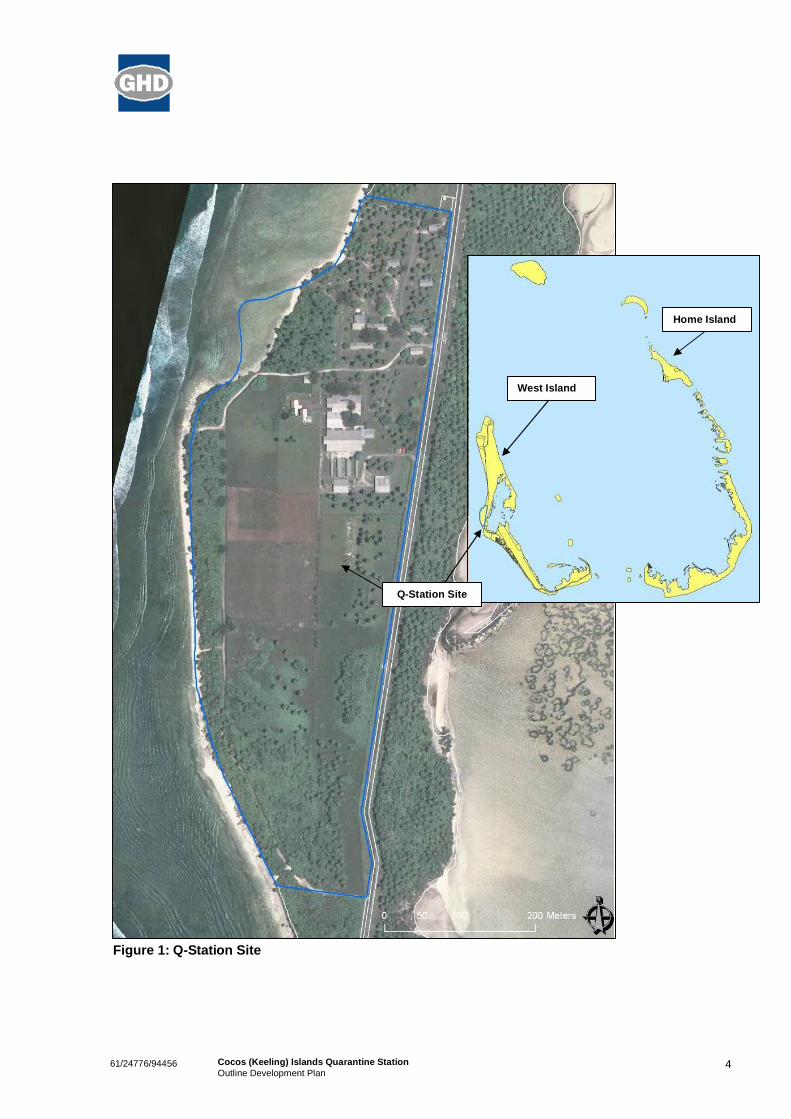
1.2 Study AreaThe subject land is comprised of Lot 327, Sydney Highway on West Island. The site is approximately 21ha in size and is located on Sydney Highway at the midpoint of the Island (see Figure 1). It isapproximately 800m to the north of the main settlement and 1500m from the access to the new RumahBaru jetty and off loading facility.
The quarantine facilities were constructed in the late 1970s and the site was used as a postentry animalquarantine station until 1996. The site housed up to 250 head of imported cattle, sheep and goats in flyand rodent proof buildings. Small numbers of animals from the Australian mainland were also housed atthe station as disease sentinels (DPI, 2001).
Quarantine activities have since ceased and the land and buildings have not been actively used for anyother purpose until recently. In 2009, the accommodation quarters were refurbished to house theconstruction work force building the new jetty and off loading facilities at Rumah Baru.
There is also a popular surfing spot on the western coast adjacent to the QStation site. The localcommunity has built a small shelter for storage and observation, called the ‘Surf Shack’. Currently thisarea does not have a public access and the access route to the Surf Shack is along a track that skirts thesouthern and western boundary of the site.
461/24776/94456 Cocos (Keeling) Islands Quarantine StationOutline Development Plan
Figure 1: QStation Site
Home Island
West Island
QStation Site

561/24776/94456 Cocos (Keeling) Islands Quarantine StationOutline Development Plan
2. Land Constraints & Opportunities Analysis
Constraints and Opportunities mapping can be found at Appendix B.
2.1 Planning ContextThe subject land is a former Quarantine Station site also known as Site 1 – Location 205(V) West Island.
The site is zoned as ‘Special Use’ in the Shire of Cocos (Keeling) Islands Local Planning Scheme No. 1(LPS). The zoning is illustrated in Figure 2.
Schedule 2 of the LPS outlines the permitted uses of the subject land, which are tourist facilities,residential, industrylight/service, office and warehouse. Schedule 2 also stipulates the requirement forthe preparation of an Outline Development Plan (ODP) prior to the subdivision and/or development ofthis land and Special Conditions are to be addressed as follows:
a) Subdivision layout (if proposed);
b) Heritage assessment to determine the retention or disposal of existing infrastructure and building(s);
c) Groundwater protection;
d) Public access to foreshore;
e) Servicing requirements;
f) General size, scale, bulk and design of proposed buildings and structures;
g) Road access;
h) Conservation of the Nature Conservation and Foreshore Protection reserve; and
i) Any other matters deemed necessary by the Council.
The Shire intends to review the current LPS in the 20102011 financial year. During this process, thepermitted land uses for the ODP can be amended if necessary to include any proposed land uses thatare not seen to comply with the current list.
2.2 Strategic Location & Physical DescriptionThe QStation site is located strategically midway along Sydney Highway, the main road running thelength of West Island, as it is in close proximity to the exiting settlement and airport (1km) and theirassociated services and amenities. It is also approximately 3 km south of the current jetty on the northerntip of West Island and only 1.5 km to the south of the entry to the new Rumah Baru jetty and offloadingfacilities and a proposed Light Industrial Area. The waste water treatment plant (WWTP) is also only250m to the north.
The site is relatively flat and lowlying at an average of 12m above sea level. There is a low point on thesouth western corner of the site that is subject to inundation from the ocean on occasion. The site is 21ha in size and is sparsely vegetated. There are existing buildings in the northern portion of the site andthe majority of the southern portion is cleared with some vegetation regrowth occurring. Vegetation isdenser in the northern portion of the site surrounding the accommodation buildings.

661/24776/94456 Cocos (Keeling) Islands Quarantine StationOutline Development Plan
Cleared land with quarantine buildings Existing houses in the northern portion of the site
Figure 2: Local Planning Scheme Zoning

761/24776/94456 Cocos (Keeling) Islands Quarantine StationOutline Development Plan
2.3 Existing BuildingsThe existing building stock remains from the site’s role as a quarantine station. The existing buildings aredivided into two main uses: accommodation/living and the animal and associated quarantine facilities.The accommodation area consists of 4 three bedroom detached houses, two dormitory type buildingsknown as singles quarters and a kitchen and mess area.
Dormitory buildings (above) and existing kitchen building (below)
Detached housing (below)

861/24776/94456 Cocos (Keeling) Islands Quarantine StationOutline Development Plan
The quarantine buildings consist of offices, a laboratory, covered and uncovered animal pens and twocovered storage buildings.
Office space and laboratory (above)
Main building and open animal pens (with storage shed) (above) and covered animals pens (below)

961/24776/94456 Cocos (Keeling) Islands Quarantine StationOutline Development Plan
The accommodation buildings have recently been refurbished to use by the construction workforceassociated with the Rumah Baru project, which is due for completion in May 2010. There is also thepossibility of the construction workforce associated with the proposed runway extension using thesebuildings.
The Shire of Cocos (Keeling) Islands are currently utilising the two storage buildings.
The existing building stock is structurally in good condition and would require only general internal refitand maintenance to enable them to be used again. In an environment where the provision ofinfrastructure is difficult and land development costs are increased, the reuse of these buildings wherepossible should be a priority. The proposed ODP needs to take into account the reuse of thesebuildings.
The existing buildings are not recognised as having any significant heritage value.
2.4 Utilities Infrastructure
2.4.1 Power
An 11kV network, operated by the Water Corporation, distributes power from the Power House to aseries of ring main units on West Island. Some of the network was upgraded in late 2001 with theinstallation of new 6.35\11kV high voltage cables alongside the eastern edge of the Sydney Highwayroad reserve adjacent to the site. Substation 3 is located near the northern end of the site across theroad from the Quarantine Station and steps down voltage to the main switchboards at the QuarantineStation and the Compass Locator site. The substation has a 315kVA 11/0.433kV transformer which wasinstalled at the time of the upgrade in 2001.
The Quarantine Station main switchboard is a free standing installation located within the QuarantineStation and houses the supply authority metering cabinet. Within the lot, low voltage power is reticulatedfrom the main switchboard to the Emergency Power House Switchboard (this is descriptive title; theequipment is also referred to as the Quarantine Station Substation Switchboard in the as constructeddrawings). From here, the Emergency Power House Switchboard distributes power to local distributionboards which are located at the main buildings on site.
Much of the electrical infrastructure at the station was installed when the station was constructedapproximately 30 years ago. The Emergency Power House was also installed at the time, with a 150kVAgenerator set, in order to provide back up power to the site and also supply power back to the grid. Thegenerator set has since been decommissioned and removed from site however some of the EmergencyPower House Switchboard still remains in use.
There has been little activity at the station in the past 510 years which suggests that some of theelectrical infrastructure may not be in operational condition. Personnel on site have indicated that there isa significant problem with rats at the Quarantine Station. Rats have been known to eat through the outersheath of laid cable and dead rats are commonly found within switchboard cavities.
2.4.2 Water
Water to the QStation site is supplied from a gallery at Rumah Baru approx 2.2kms away via a 100mmasbestos pipe. It is pumped into two 200,000 litre storage tanks and chlorine is introduced manually.From the tanks it is then distributed via an adjacent pump house comprising two centrifugal fire service
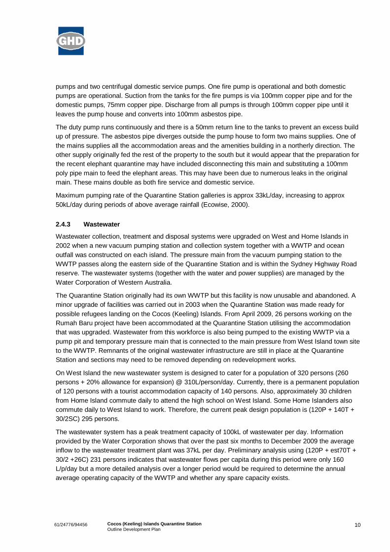
1061/24776/94456 Cocos (Keeling) Islands Quarantine StationOutline Development Plan
pumps and two centrifugal domestic service pumps. One fire pump is operational and both domesticpumps are operational. Suction from the tanks for the fire pumps is via 100mm copper pipe and for thedomestic pumps, 75mm copper pipe. Discharge from all pumps is through 100mm copper pipe until itleaves the pump house and converts into 100mm asbestos pipe.
The duty pump runs continuously and there is a 50mm return line to the tanks to prevent an excess buildup of pressure. The asbestos pipe diverges outside the pump house to form two mains supplies. One ofthe mains supplies all the accommodation areas and the amenities building in a northerly direction. Theother supply originally fed the rest of the property to the south but it would appear that the preparation forthe recent elephant quarantine may have included disconnecting this main and substituting a 100mmpoly pipe main to feed the elephant areas. This may have been due to numerous leaks in the originalmain. These mains double as both fire service and domestic service.
Maximum pumping rate of the Quarantine Station galleries is approx 33kL/day, increasing to approx50kL/day during periods of above average rainfall (Ecowise, 2000).
2.4.3 Wastewater
Wastewater collection, treatment and disposal systems were upgraded on West and Home Islands in2002 when a new vacuum pumping station and collection system together with a WWTP and oceanoutfall was constructed on each island. The pressure main from the vacuum pumping station to theWWTP passes along the eastern side of the Quarantine Station and is within the Sydney Highway Roadreserve. The wastewater systems (together with the water and power supplies) are managed by theWater Corporation of Western Australia.
The Quarantine Station originally had its own WWTP but this facility is now unusable and abandoned. Aminor upgrade of facilities was carried out in 2003 when the Quarantine Station was made ready forpossible refugees landing on the Cocos (Keeling) Islands. From April 2009, 26 persons working on theRumah Baru project have been accommodated at the Quarantine Station utilising the accommodationthat was upgraded. Wastewater from this workforce is also being pumped to the existing WWTP via apump pit and temporary pressure main that is connected to the main pressure from West Island town siteto the WWTP. Remnants of the original wastewater infrastructure are still in place at the QuarantineStation and sections may need to be removed depending on redevelopment works.
On West Island the new wastewater system is designed to cater for a population of 320 persons (260persons + 20% allowance for expansion) @ 310L/person/day. Currently, there is a permanent populationof 120 persons with a tourist accommodation capacity of 140 persons. Also, approximately 30 childrenfrom Home Island commute daily to attend the high school on West Island. Some Home Islanders alsocommute daily to West Island to work. Therefore, the current peak design population is (120P + 140T +30/2SC) 295 persons.
The wastewater system has a peak treatment capacity of 100kL of wastewater per day. Informationprovided by the Water Corporation shows that over the past six months to December 2009 the averageinflow to the wastewater treatment plant was 37kL per day. Preliminary analysis using (120P + est70T +30/2 +26C) 231 persons indicates that wastewater flows per capita during this period were only 160L/p/day but a more detailed analysis over a longer period would be required to determine the annualaverage operating capacity of the WWTP and whether any spare capacity exists.

1161/24776/94456 Cocos (Keeling) Islands Quarantine StationOutline Development Plan
The current wastewater system (collection, treatment and ocean outfall) does not include any allowancefor flows from the Quarantine Station, however the wastewater treatment plant site was designed to allowfor a duplication of treatment capacity in the future if required.
The existing houses are currently provided with a reticulated gravity collection system that flows to asmall pumping station (PS1). This pumping station pumps to another main pumping station (PS2) whichin turn pumps to the existing WWTP as described previously. There are a number of the administrationand storage facility buildings that are also provided with a reticulated gravity collection system that flow topumping station PS2. The condition of the existing sewers and access chambers would have to beassessed if they were to be considered for long term use as they were part of the original infrastructure.
2.5 Environment
2.5.1 Vegetation
Protected Plants or Vegetation Types
A search of the Environmental Protection and Biodiversity Conservation Act (1999) protected matterswas undertaken (http://www.environment.gov.au/erin/ert/epbc/index.html). The resultant report indicatedthat there are no protected plant species or vegetation communities on the Cocos Islands, although thereare a number of bird species which are protected. Some of these bird species may use vegetation on thequarantine site.
Existing Vegetation
A report on the vegetation of the site was produced by the Western Australian Department of Planningand Infrastructure in 2001. This indicated:
‘While the northern half of the quarantine station land has been cleared for grazing, most of the southernpart is heavily overgrown with coconut palms, cabbage bush, a variety of grasses and other understorey, aswell as invasive weeds.
Parks Australia North has advised that individual native trees and/or small stands of trees (particularlyIronwoods) may exist on the southern portion of the site. The future developers of this land will be requiredto undertake a vegetation survey to identify trees worthy of protection prior to any clearing, site works ordevelopment of the vegetated southern portion of the property.
Parks Australia North has also identified a stand of replanted native trees situated near the centre of thesite. These trees should be conserved in the future development of the site, either within public open spaceor within road reserves and/or individual lots.’
The vegetation at the site was photographed and briefly considered during a site visit in February 2010.
The native overstorey vegetation was reported to consist primarily of Cocos nucifera (Coconut) trees(including young trees and seedlings) with groups of Morinda citrifolia (Cheese Tree), scattered plants ofGuettarda speciosa (Beach Gardenia) in the southern part of the site and occasional plants of Terminaliacatappa (Beach Almond). There were dense shrublands of Cabbage plant (Scaevola taccada) with themajority of this occurring in patches along the coastal strip, seaward of the fenced site. Some smallpatches of Cabbage plant were present in the southern part of the site and adjacent to buildings. Thegroundcover consists of grass weeds and herbs including Euphorbia cyathophora (Painted Spurge),Phyla nodiflora (Lippia), Chloris sp. (windmill grass), Cenchrus sp. (buffel grass) and nettle.

1261/24776/94456 Cocos (Keeling) Islands Quarantine StationOutline Development Plan
It is also likely that the significant weed, Siam Weed (Chromolaena odorata) is present in much of theunderstorey. Plants which were similar to this species were identified in photographs but as none wereflowering, formal identification was difficult. This plant is currently only found in localised parts ofQueensland on the Australian mainland but is considered a significant threat to other tropical andsubtropical areas of the country. Control of the weed within the current site is not considered feasible dueto its likely extent, but the removal and disposal of any soil or vegetation from the site should be carefullyconsidered. Similarly, vehicles and equipment being returned to the Australian mainland will requirethorough cleaning and, potentially, quarantine measures.
Morinda citrifolia (Cheese Tree) and Cocos nucifera (coconut)
in shrubland in the southern part of the site
Dense stands of Scaevola taccada (Cabbagetree bush)
Some shrubby trees of Ironwood (Cordia subcordata) are present along a northsouth central fence lineon the site and appear to have been planted (see Plate 3). A number of exotic trees have been plantedover the site and these include Casuarina equisetifolia (Sheoak), Frangipani and Delonix regia(Poinciana).
Cordia subcordata (Ironwood) in the central
southern portion of the site (possibly planted)

1361/24776/94456 Cocos (Keeling) Islands Quarantine StationOutline Development Plan
There was no evidence of particular use of the plants by birds. No nests were seen, nor were any areasrecorded as being roost areas (e.g. by the presence of bird droppings or other evidence). However, it islikely that the coastal vegetation particularly would be used by some seabirds. The Ironwood is also animportant seabird nesting tree (pamphlet by the Director of National Parks, undated).
2.5.2 Groundwater Lens
Water supply for the Islands is via a series of underground fresh water lenses, perched above saltierwater, that are recharged through rainfall that permeates from the surface into these lenses. The freshwater is accessed through a series of water galleries that pump water from these lenses.
There is currently some concern over the pressure on ground water lenses and their ability to providesuitable quality potable water to the Islands. The previous ODP report for the Qstation identified that theminimum width of a coral island to sustain a fresh water supply is 400m. The coastline of West Island isforever changing and is subject to the effects of storm surges and climate change. The Climate ChangeAssessment for the IOT indicated that the Cocos (Keeling) Islands are at a medium to high risk ofincreased sediment movement and reduction of narrow beaches. In addition to this, the capacity of thelenses varies from place to place and also fluctuates daily according to rainfall, tides and the extent ofextraction (DPI, 2001).
Although the exact extent of the lenses is not known, it is believed that the southern tip of the ‘NorthernFreshwater Lens’ may extend under the QStation site. The previous ODP report outlines that the lens islocated an average of about 2m below the ground surface and the depth to the base of the water lens islikely to vary from 79m (DPI, 2001).
Until an alternative water source is developed for West Island (e.g. desalinisation), the protection of thisground water source is a high priority. Any future development on the QStation site will need to becompatible with the protection of this water source, and appropriate drainage development standards willneed to be implemented.
2.5.3 Coastal Erosion
To determine the coastal setback required at the Quarantine Station on Cocos Islands, past rates oferosion were measured using the line of coastal vegetation from two, georeferenced aerial photos. Theonly aerial photos available are from 1987 and 2003.
The distance between the 1987 and 2003 vegetation line was measured to determine the rate of erosionor accretion in the relevant time frame. However, for this to be accurate over the 16 year time spanprovided, a higher density of photographs would be required. In the large time period between the aerialphotos, cycles of erosion and accretion of sediments may have occurred resulting in a possible underestimation of rates of erosion.
The greatest rates of erosion measured at Quarantine Station, on the NE/SW orientated beach proposedfor sacrificial land use was 3 m per year with an average of about 2 m per year in this eroded section(refer to Figure 2). On the North/South oriented beach rates of erosion were much less at around 0.25mper year on average. Accretion of sediment has been noted in areas just to the south of the erosive area.
From the aerial photographs it appears that the beach is realigning with the coastline to the north whichhas a North/South orientation. The soft section of the beach has moved on average 30m between 1987and 2003, with one area receding just under 50m as shown in Figure 3. A hard point just south of the

1461/24776/94456 Cocos (Keeling) Islands Quarantine StationOutline Development Plan
eroded section, as indicated in Figure 4, has not shown erosion between 1987 and 2003 and maytherefore form a headland to the bay. The soft point will likely continue to recede untill a more stable bayshape is formed, refer to line A in Figure 4. This estimated shoreline, in the absence of detailed data andcalculations, aligns with the predominant wave direction.
Figure 3: Erosion at the North West corner of the site 19872003
If in the next 50 years sea level rises 0.43m, according to the Brunn Rule the shore line could move 43mlandward. This is shown in Figure 4 by the blue line which falls in between the probable beachrealignment and the worst case realignment. Line A shows the probable bay shape and line B the worstcase scenario alignment. The blue line ‘X’ shows the predicted vegetation line in 50 years time due onlyto sea level rise.
As no wave, sediment transport or geotechnical information is known for the site, it can not be assumedthat rates of erosion will continue to be the same as the beach recedes. If the sediment changes frombeing unconsolidated to lithified, rates of erosion should reduce as sand is prone to much higher rates oferosion than rock. It has been assumed that the soft point is composed of sand but if rock is found in thearea it may alter the predicted bay shape.

1561/24776/94456 Cocos (Keeling) Islands Quarantine StationOutline Development Plan
Figure 4: Possible Beach Realignment and Bay Shape
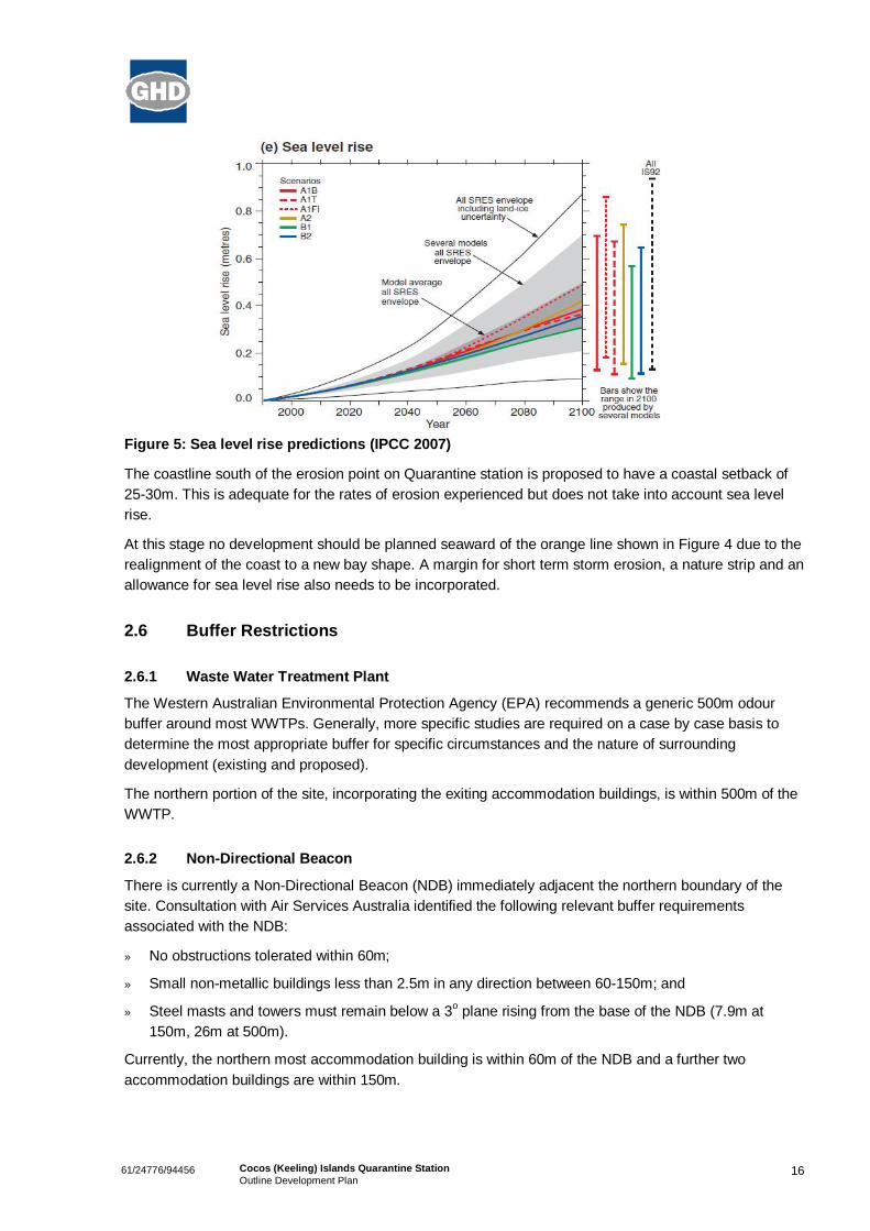
A component of erosion due to sea level rise as a result of global warming should also be incorporatedinto coastal setback for planning purposes. The Intergovernmental Panel on Climate Change (IPCC) inthe 4th Annual Report on climate change in 2007 predicted a 0.43 m rise in sea level in the next 50 years(see Figure 5). Hence, as mentioned above, when the x100 multiplier according to the Brunn Rule isapplied, a 43m foreshore retreat is possible.
It is advised that a survey of the Quarantine Station be conducted to determine if more hard sites existnear the coast. Running a Mike 21 SW model is needed to determine the wave directions which willinfluence the alignment of the beach in the future. This information would then be combined to calculatea stable bay shape. A model of beach erosion during storms will be run using SBEACH (StorminducedBEAch CHange).
1661/24776/94456 Cocos (Keeling) Islands Quarantine StationOutline Development Plan
Figure 5: Sea level rise predictions (IPCC 2007)
The coastline south of the erosion point on Quarantine station is proposed to have a coastal setback of2530m. This is adequate for the rates of erosion experienced but does not take into account sea levelrise.
At this stage no development should be planned seaward of the orange line shown in Figure 4 due to therealignment of the coast to a new bay shape. A margin for short term storm erosion, a nature strip and anallowance for sea level rise also needs to be incorporated.
2.6 Buffer Restrictions
2.6.1 Waste Water Treatment Plant
The Western Australian Environmental Protection Agency (EPA) recommends a generic 500m odourbuffer around most WWTPs. Generally, more specific studies are required on a case by case basis todetermine the most appropriate buffer for specific circumstances and the nature of surroundingdevelopment (existing and proposed).
The northern portion of the site, incorporating the exiting accommodation buildings, is within 500m of theWWTP.
2.6.2 NonDirectional Beacon
There is currently a NonDirectional Beacon (NDB) immediately adjacent the northern boundary of thesite. Consultation with Air Services Australia identified the following relevant buffer requirementsassociated with the NDB:
» No obstructions tolerated within 60m;
» Small nonmetallic buildings less than 2.5m in any direction between 60150m; and
» Steel masts and towers must remain below a 3o plane rising from the base of the NDB (7.9m at150m, 26m at 500m).
Currently, the northern most accommodation building is within 60m of the NDB and a further twoaccommodation buildings are within 150m.

1761/24776/94456 Cocos (Keeling) Islands Quarantine StationOutline Development Plan
2.6.3 Waste Transfer Station
The EPA also has guidelines for buffer distances from waste transfer stations. According to GuidanceStatement 3 – Separation Distances between Industrial and Sensitive Land Uses, a 200m buffer isrequired between sensitive land uses and ‘waste depots’. A ‘waste depot’ is defined as ‘premises onwhich waste is stored or sorted, pending final disposal or reuse’ (EPA, 2005).
No portion of the QStation site is currently within the 200m buffer area surrounding the current wastetransfer station on West Island, however it is important to note the proximity of the transfer station whilstinvestigating future uses for the southern portion of the QStation site.

1861/24776/94456 Cocos (Keeling) Islands Quarantine StationOutline Development Plan
3. Development Scenarios
The following preliminary land use scenarios were developed based on the outcomes of the Crown LandManagement Plan, the previous ODP prepared for the site and the outcomes of the land capability andsuitability analysis.
A description of each option is below and the options themselves can be seen in Figures 6,7 and 8.
3.1 Option AOption A consists of a mixture of land uses including residential, tourist/visitors accommodation, publicopen space, light industrial, research facilities in the existing buildings and extensive area forhorticulture/aquaculture type research activities. Building reuse is maximised where possible forresearch and accommodation purposes.
The residential uses along the coast take advantage of the ocean views, with a staggered lotarrangement to allow the rear lots visual access to the ocean also. The concentration of residential lots inthe south ensures the closest possible proximity to the existing settlement and associated services andfacilities. The southern tip of the site is reserved for recreation due to the inundation activity that occursfrom the ocean in the area. There are also residential lots in the northern area of the site on the highway,utilising existing accommodation buildings. The proposed lots are sympathetic to the existing residentialcadastral pattern on the Island in terms of size and shape.
Light industrial lots are proposed along Sydney Highway to ensure maximum access from the highway,as well as the rest of the site. Access to the highway is considered essential as the new jetty and offloading facility at Rumah Baru is nearby. There may be possible synergies with any research possibilitiesthat occur, relating to storage or fabrication of materials.
Intensive research uses are proposed for the main complex of existing old quarantine buildings on thesite. This area links with the extensive research areas proposed for the remainder of the south half of thesite for horticulture/aquaculture or other research activities.
The tourist accommodation is located to the north of the site, utilising the remainder of the existingaccommodation facilities.
There is a coastal setback of 2040m along the western edge of the site for use as a coastal foreshorereserve that takes into account coastal erosion and possible sea level rise. This will allow for a dual usepath along the site and public access to the ‘Surf Shack’.
This option has five access points to Sydney Highway, as well as the possibility of extending the roadnetwork to the north of the site in the future if required.
3.2 Option BOption B is similar to Option A with respect to proposed land uses, however has an alternative land useand road network arrangement.
In Option B, all residential uses are in the northern portion of the site, utilising the existingaccommodation buildings and facilities. The tourist accommodation is in a coastal location in this optionand the light industrial lots remain along Sydney Highway. Research activities remain in the existing

1961/24776/94456 Cocos (Keeling) Islands Quarantine StationOutline Development Plan
facilities and the southern portion of the site; however their proportion of the site is greater. This optionalso maintains a coastal foreshore reserve and recreation area.
This option has only two access points to Sydney Highway, complemented by a network of internalservice corridors within the extensive research area. The possibility to extend the road network to thenorth of the site remains.
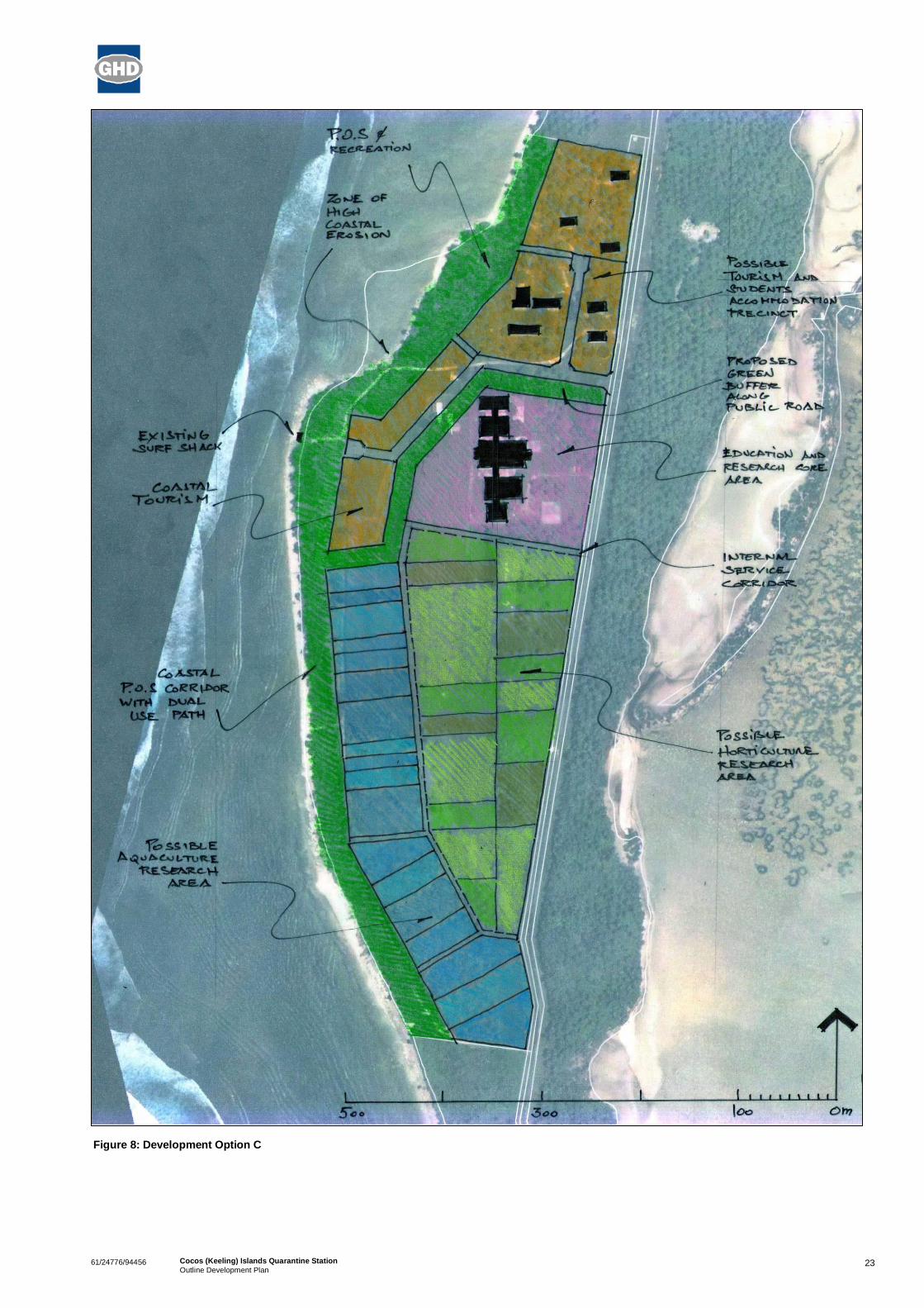
3.3 Option CFrom a land use distribution perspective Option C has a research and short stay accommodation focus,with no provision for individual residential or light industrial lots. This focus is consistent with the DraftCrown Land Management Plan that recommends future permanent residential development be restrictedto an extension of the existing settlement. Future industrial lots are best located in close proximity to theRumah Baru jetty.
The tourist/visitor accommodation land use in Option C is concentrated to the north of the site with amodest portion extending southwards along the coast. This approach would facilitate the reutilisation ofall existing accommodation buildings and related infrastructure within that northern area of the site withthe advantage of proximity to the coastal shore and easy access to and from the Sydney Highway.
Option C offers greater land use efficiency in comparison to options A and B by minimising the publicroad system and by creating relatively large accommodation blocks designed to generate discreteclusters of buildings by different parties. Public vehicle access is restricted to only the tourist area andexisting ‘Surf Shack’ by way of a single entry point from Sydney Highway. The direct public vehicularaccess to the ‘Surf Shack’ from the Sydney highway acts as a buffer between the tourist accommodationarea and the research facilities to the south. The need to provide a coastal public open space andrecreation corridor is further recognised.
Reuse of the former quarantine buildings is proposed with a focus on intensive research as per the otheroptions. However, the entire southern half of the site has been identified as a precinct for extensiveresearch and food production activities.
This research and production precinct enables marine aquaculture activities to capitalise on the closeproximity to the ocean along what is otherwise an unsuitable section of the coast for swimming.Depending on future environmental assessment findings, the southern portion is well located to haveocean water connections with both the lagoon to the east side as well as the high sea on the west side.
An internal network of access corridors is provided to ensure easy access to essential services as wellas potential fluid interaction between horticulture and fresh water aquaculture if required. Intenseaquaponic activities would be best located immediately to the south of the education and research areaoccupying the Quarantine buildings and immediate surrounds in order to capitalise on the serviceinfrastructure already available in that location.
Through an extensive process of public and stakeholder consultation, option C has emerged as thepreferred option. The public consultation also identified the urgent need to improve the current shortageof accommodation required for many workers that currently frustrates the long term economicdevelopment of the Islands.
As a result of this demand for affordable medium term accommodation, a detailed MultiUserAccommodation Village Concept Plan (see Section 5) has been developed to illustrate the potentialpractical solutions that could apply to the northern portion of the site.

2061/24776/94456 Cocos (Keeling) Islands Quarantine StationOutline Development Plan
The plan illustrates the possible relationship between:
» existing and future buildings;
» the proposed road and parking layout;
» the definition of the common areas;
» the pedestrian network and the relationship to the ocean frontage; and
» the type of accommodation suitable in each section of the village.
Depending on the architectural design an estimated 80 to 120 rooms of a single and double storeyconfiguration could be accommodated without significantly impacting on the existing environmentalqualities of the site.

2161/24776/94456 Cocos (Keeling) Islands Quarantine StationOutline Development Plan
Figure 6: Development Option A

2261/24776/94456 Cocos (Keeling) Islands Quarantine StationOutline Development Plan
Figure 7: Development Option B
2361/24776/94456 Cocos (Keeling) Islands Quarantine StationOutline Development Plan
Figure 8: Development Option C

2461/24776/94456 Cocos (Keeling) Islands Quarantine StationOutline Development Plan
4. Community & Stakeholder Consultation
Both offIsland and onIsland consultations were conducted with various stakeholders and thecommunities of Home and West Islands during the formulation of the ODP. The three options outlined inSection 3 were presented together with the key components and broad development aims in eachoption. The purpose was to ascertain those aspects of the three options what were acceptable to thestakeholders and communities and those that were not supported in order to combine the mostappropriate components of each into the final ODP.
The full list of consultation outcomes can be found at Appendix C.
4.1 Research InstitutionsA variety of research institutions were approached to gauge the level of interest in the utilisation of theQStation site for research purposes. These institutions included the University of Western Australia(UWA), Curtin University of Technology (Curtin), Murdoch University (Murdoch), the CommonwealthScientific and Industrial Research Organisation (CSIRO) and the Australian Institute of Marine Science(AIMS).
The focus of the consultations was based on the opportunities for the reuse of the site and the existingbuildings, local food production, the generation of employment for the local community, and training andcapacity building opportunities.
The key outcomes of this consultation revealed that there may be several possibilities for the reuse ofthe Qstation site and buildings for research and/or food production. This is based around the possibilitythat the Cocos (Keeling) Islands may offer a disease free environment for land and water based foodsystems, providing a significant commercial advantage for any export product from the Islands.
Murdoch identified the site as having potential for the development and utilisation of pulse legumes toassist in basic agriculture food production on the Islands. Legumes are a class of plants that do notrequire nitrogenous fertilisers. Instead, legumes form a symbiosis with soil bacteria called rhizobiumthrough which nitrogen is absorbed from air and transformed into proteins that legumes can absorb. Theprocess is called nitrogen fixation and has benefit in that expenditure on nitrogen fertilizers is notrequired.
Tropical legumes can provide dietary protein for human consumption, byproducts for animal feed,enhanced soil fertility for subsequent cereal crops and possibly byproducts for aquaponics systems (asa feed base). Sustainable legume crops (e.g. soy, pigeon pea, chick pea) could be considered as they donot require nitrogenous fertilisers and therefore have a lower risk of groundwater contamination.
Based on comparisons with other experiments on research stations by Murdoch, yields on the QStationsite of pulse legumes could be expected to be in the vicinity of 26 tonnes/ha (depending on specieschoice, cultivar choice, agronomy, seasonal conditions and number of crops per season). This suggestsa minimum of 30 tonnes of legumes could be produced per year, with up to 90 tonnes being a possibility(if two crops per year is achieved). Assuming a population of 1,000 people on the Islands, this wouldproduce 1.5 kg per week per capita which would be well above the weekly intake of this kind of food,even in areas of established legume produced. This would be sufficient for the Island’s requirements aswell as exporting to Christmas Island and/or the mainland.
2561/24776/94456 Cocos (Keeling) Islands Quarantine StationOutline Development Plan
Consultations with CSIRO identified that the Food Futures Flagship (FFF) program may be helpful indeveloping food production operations on the Islands. The FFF program is focused on genetics, nutrientsand environmental management in relation to sustainable aquaculture. CSIRO has experience in marineaquaculture in Vietnam, East Timor and Papua New Guinea and have had good results with tigerprawns, abalone and salmon.
CSIRO has a particular focus on research and production achievements with Tiger Prawns and throughtheir work, have identified that domesticated Tiger prawns can yield up to 12t per ha per harvest, with thepossibility of two harvests per year. A commercial farm can use 3050 ha and CSIRO identified that landbased ponds can be used and that access to ocean water is essential. These ponds can be elevated tosuit the QStation topography and to ensure protection of the fresh water lens.
Australia is relatively disease free and CSIRO believe that the Cocos (Keeling) Islands could be ideal tobreed stock for export to large aquaculture operations in South East Asia. The relative isolation of theIslands and the potential for a disease free environment increases the chance of the production of highquality stock. Initial indications of the viability of such an enterprise reveal that start up and ongoing costlimitations are likely to be a deciding factor in determining business viability.
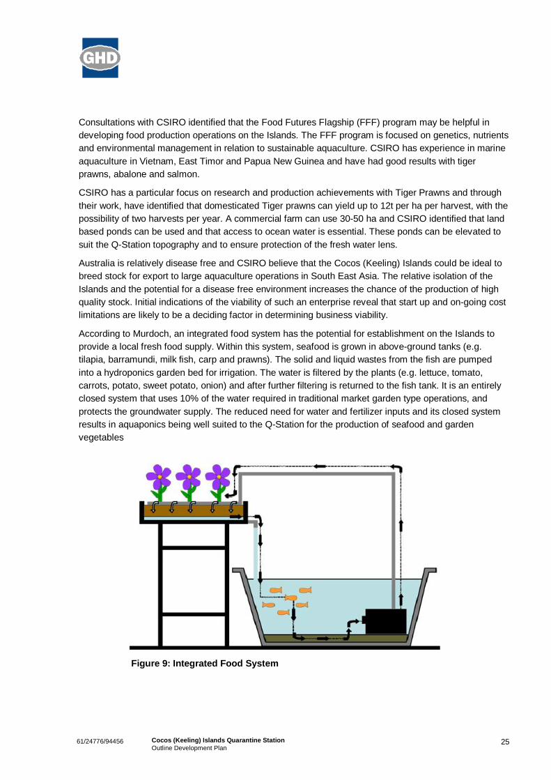
According to Murdoch, an integrated food system has the potential for establishment on the Islands toprovide a local fresh food supply. Within this system, seafood is grown in aboveground tanks (e.g.tilapia, barramundi, milk fish, carp and prawns). The solid and liquid wastes from the fish are pumpedinto a hydroponics garden bed for irrigation. The water is filtered by the plants (e.g. lettuce, tomato,carrots, potato, sweet potato, onion) and after further filtering is returned to the fish tank. It is an entirelyclosed system that uses 10% of the water required in traditional market garden type operations, andprotects the groundwater supply. The reduced need for water and fertilizer inputs and its closed systemresults in aquaponics being well suited to the QStation for the production of seafood and gardenvegetables
Figure 9: Integrated Food System
2661/24776/94456 Cocos (Keeling) Islands Quarantine StationOutline Development Plan
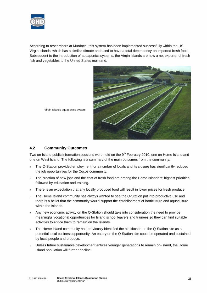
According to researchers at Murdoch, this system has been implemented successfully within the USVirgin Islands, which has a similar climate and used to have a total dependency on imported fresh food.Subsequent to the introduction of aquaponics systems, the Virgin Islands are now a net exporter of freshfish and vegetables to the United States mainland.
Virgin Islands aquaponics system
4.2 Community OutcomesTwo onIsland public information sessions were held on the 9th February 2010, one on Home Island andone on West Island. The following is a summary of the main outcomes from the community:
» The QStation provided employment for a number of locals and its closure has significantly reducedthe job opportunities for the Cocos community.
» The creation of new jobs and the cost of fresh food are among the Home Islanders’ highest prioritiesfollowed by education and training.
» There is an expectation that any locally produced food will result in lower prices for fresh produce.
» The Home Island community has always wanted to see the QStation put into productive use andthere is a belief that the community would support the establishment of horticulture and aquaculturewithin the Islands.
» Any new economic activity on the QStation should take into consideration the need to providemeaningful vocational opportunities for Island school leavers and trainees so they can find suitableactivities to entice them to remain on the Islands.
» The Home Island community had previously identified the old kitchen on the QStation site as apotential local business opportunity. An eatery on the QStation site could be operated and sustainedby local people and produce.
» Unless future sustainable development entices younger generations to remain onIsland, the HomeIsland population will further decline.

2761/24776/94456 Cocos (Keeling) Islands Quarantine StationOutline Development Plan
» Some residents in Beacon Heights find the aircraft noise unbearable at times due to their closeproximity to the parking apron of the airport. As a result, residential uses on the QStation may be agood way of combating this conflict.
» Additional housing must be associated with any local job creation or establishment of skilled tradesservices currently lacking on the Cocos (Keeling) Islands.
» There is a need for accommodation for short term (3 months) skilled labour for local businesses (e.g.hairdressers and waitresses).
» Additional accommodation should not be solely provided to large contractors, but should alsoincorporate the requirements of local small businesses.
» There is a need for ensuring that low cost accommodation is available on West Island in particular fortradespeople.
» The ODP must provide flexibility in land arrangements.
» The houses on the QStation site should be considered for use by the local community.

2861/24776/94456 Cocos (Keeling) Islands Quarantine StationOutline Development Plan
5. Outline Development Plan
5.1 ODP PhilosophyThe QStation site is of strategic importance to the Islands due to its location, size, existing building stockand topography. These attributes mean that the site can support a variety of land uses. This ODP placesa heavy emphasis on the need for the site to contribute significantly to the economic development of theCocos (Keeling) Islands.
Current economic activity is limited to tourism, government services, local business enterprises and asmall export aquaculture operation. The diversification of the Island’s economy is essential to the localcommunity’s self sufficiency and to any future population growth. Part of this entails reducing the currentreliance on imported fresh food from the mainland. The local knowledge associated with the historicaluse of the Oceania House Gardens in supplying fresh fruit to the community provides a favourable socioeconomic context to reintroduce the production of fresh food on the Islands.
The intent of this ODP is to position the QStation site to contribute to the production of local fresh food,to create new export opportunities and to enhance the local employment opportunities of both Home andWest Islanders. This process will contribute to building the social capital of the community whilst alsoproviding additional short term accommodation facilities for the Islands and facilitating the coastalreserve as part of the planned completion of the BiCentennial Trail.
The site could also help in positioning the Islands as an ‘AgriFood Tourism Destination’, similar tocurrent efforts in North Queensland (see Appendix D). The intent of that particular project is to build analternative tourism theme for the region, based on tropical agrifood experiences. Collaboration withChristmas Island could assist in developing a similar theme for the Indian Ocean Territories.
This ODP has been developed as a result of the stakeholder and community consultations and feedbackon the three options outlined in Section 3. The ODP proposes a mixture of land uses whilst maintainingflexibility in land arrangements. The ODP proposes three different precincts within the QStation site – aMulti User Accommodation Village in the northern section, a Food Production Precinct centred aroundthe existing quarantine buildings, and the Southern Precinct which may be subject to environmentalconditions before being able to be utilised. The full ODP site plan can be found at Appendix E.
5.2 Land Use Distribution & Built Form
5.2.1 Multi User Accommodation Village
The northern portion of the site is proposed to become a Multi User Accommodation Village thatincorporates the existing accommodation and kitchen buildings. Whilst the precise accommodation typesfor this area would be subject to a more detailed Housing and Tourism Needs Analysis, it is envisagedthat this area would be utilised for short to medium stay accommodation instead of permanent single lotresidential development. The existing kitchen building would be utilised and transformed into a smallcafé/restaurant business to serve the precinct.

2961/24776/94456 Cocos (Keeling) Islands Quarantine StationOutline Development Plan
Figure 10: MultiUser Accommodation Precinct
Figure 11: Indicative Built Form

3061/24776/94456 Cocos (Keeling) Islands Quarantine StationOutline Development Plan
Whilst this northern area is within the 500m odour buffer of the WWTP, the prevailing winds on theIslands are from the south east and according to the Shire, there is no known issue of odour from theWTTP on the QStation site. The proposed superlots are intended to be created as leasehold lots, andthe proposed accommodation will be transient in nature, reducing any land use conflict with this buffer.
The northern area is also within the prescribed buffer distances from the NDB (60m and 150m). Aspreviously stated, these buffer areas already contain residential dwellings that have been occupied in thepast and are also currently occupied. The future detailed planning of the affected superlots will need totake these buffer requirements into account and proponents will need to consult with Air ServicesAustralia.
As outlined in the CLMP, given the increased costs of developing and servicing land on the Islands,future residential uses should remain in close proximity to the existing settlement and associatedamenities, facilities and service infrastructure. The extension of Buffet Close and Beacon Heights Roadnorthwards is seen as the most suitable area for the expansion of permanent single lot residentialexpansion. This area has been mined for sand in the past and as a result can easily be adjusted for thecreation of residential lots in a coastal setting that reflect the current subdivision character.
Figure 12: Proposed Settlement Residential Expansion Area
The accommodation proposed for the QStation is intended to be short stay accommodation that will besuitable for contract workers and tradespeople, students and researchers as well as tourists. Thisaccommodation will contribute towards addressing the current lack of short stay and touristaccommodation within the Islands. The accommodation should be available for both short and long termstays with affordability a key focus (especially for tourists).
The existing accommodation buildings are proposed to remain and should be incorporated into any newhousing infrastructure. This can be achieved by creating large lots within this precinct for individualoperators to construct small residential complexes within the precinct. The precinct, if existingaccommodation styles on the islands were utilised, could yield approximately 63 additional rooms insingle storey buildings. If 25% of the buildings were two storeys, this configuration could yield up to 78rooms.
CLMP UrbanExpansion Area

3161/24776/94456 Cocos (Keeling) Islands Quarantine StationOutline Development Plan
Views of the ocean can be maintained if these complexes are designed with appropriate visual corridorsand innovative built form arrangements are utilised. A combination of one and two storey development invarious locations and styles should be used that respond to the local environment and environmentalconditions as well as complimenting existing development styles on the islands. Buildings should becyclone resistant and adaptable to climate change effects.
Examples of appropriate existing accommodation styles on the islands
The existing kitchen building is in sound condition and is currently being used by contractors. Thisbuilding could be refurbished into a café/restaurant to serve the accommodation precinct and othersusing the site. This would provide a local business opportunity as well as an opportunity to utilise locallygrown fresh produce if available. It could also provide an outlet for any food produced on the site as partof the food production precinct.
The formalisation of the foreshore reserve is proposed that will allow an adequate coastal setback (up to70m in the peak erosion zone) that allows for erosion and climate change effects as well as theaccommodation of the proposed BiCentennial Trail along the west coast of West Island. Within thisreserve is an opportunity for an open space area for active recreation, as well as a small light weightstructure that could be associated with the proposed café/restaurant for outdoor coastal dining.
The current water supply has been allocated a separate lot and would continue operating in the shortterm. In future if the QStation is connected to the main settlement water supply, then this parcel of landwould become available for additional accommodation uses. Approximately 10 additional rooms could bemade available on this site on one level and 12 rooms if 25% of the buildings were two storeys.
5.2.2 Food Production Precinct
The area immediately to the south of the Multi User Accommodation Village surrounding the existingquarantine buildings is proposed to be developed as a Food Production Precinct. This precinct will beseparated from the northern precinct by a public access road to the Surf Shack. The intention of thisprecinct is to facilitate the reuse of the existing buildings, as well as the surrounding land, to introducefood production and associated research activities to the site.
As outlined in Section 4.1, an integrated food system is seen as having potential to provide a local freshfood supply for the Islands. Aquaponics systems large enough to provide for the Islands do not requirelarge amounts of space and can be easily accommodated within this precinct. According to MurdochUniversity, based on the Virgin Islands aquaponics setup, three systems of 500m2 each could potentiallyprovide up to 30,000kg of fresh seafood and vegetables.

3261/24776/94456 Cocos (Keeling) Islands Quarantine StationOutline Development Plan
Figure 13: Food Production Precinct
This area could also be used for prawn farming ventures to produce potentially diseasefree prawnlarvae for export. The area has access to ocean water and above ground ponds would ensure protectionof the freshwater lens under the site.
The Western Australian Department of Fisheries (DoF) manages commercial, recreational andaquaculture activities on the Islands, in addition to providing fish health diagnostic services, pathologyservices and licensing services under a Service Delivery Agreement with AGD. The CommonwealthMinister currently holds responsibility for these excepted waters under the Fish Resources ManagementAct 1994 (WA) (CI/CKI).
Any aquaculture activity in the IOT will need an Aquaculture License from DoF. The application andconsultation procedures are set out in Ministerial Policy Guideline No. 8 'Assessment for Authorisationsfor Aquaculture and Pearling in Coastal Waters of Western Australia' (See Appendix E). The quality ofthe preapplication investigations and procedures will assist in the consideration of an application, whichcan take 8 10 months for processing. Detailed environmental investigations and communityconsultation are as important as the economic and technical aspects of a business plan and projectbudgeting should allow for these aspects. Applications will also need to have reference to the soon to befinalised Draft Aquaculture Development Plan for the Indian Ocean Territories, being developed by DoFand AGD.
The area to the south of the two storage sheds would be suitable for certain agronomy activities such asa soil improvement research area, possibly utilising tropical pulse legumes. As mentioned in Section 4,tropical legumes can provide various benefits, including enhanced soil fertility for subsequent cerealcrops and possibly byproducts for aquaponics systems. Sustainable legume crops (e.g. soy, pigeonpea, chick pea) could be considered as they do not require nitrogen and therefore have a lower risk ofgroundwater contamination.

3361/24776/94456 Cocos (Keeling) Islands Quarantine StationOutline Development Plan
If a legume nitrogen fixation project was established on the site, it would provide a valuable researchopportunity in response to the numerous environmental constraints encountered by previous agriculturalendeavours on the Islands. The benefits of this activity would be two fold. Firstly the project has thepotential to improve the soil on the QStation site which could allow for the land to be used to growproduce. Secondly, the research outcomes could be applied in other areas within the Islands, providingan opportunity for the Islands to successfully grow fresh produce on a larger scale.
The two storage sheds and the surrounding fenced area has been indicated as the Shire licence area.The Shire is currently using this area as a works depot and their license expires in May 2011. Dependingon whether this use is relocated, this land may be available for any required expansion of the foodproduction precinct. Alternatively, as the sheds are a significant infrastructure asset, their reuse forstorage or repair workshops is more suitable.
The coastal foreshore reserve is maintained, continuing from the northern precinct. The width isapproximately 45m in this precinct due to the increased stability of this area of the coastline andmaintains the protection of the coastal vegetation. There is the potential for this vegetation to be used bysea birds as nesting sites and its protection is essential for this function to continue.
Existing Ironbark trees within the precinct also need to be protected as they are also potential nestingsites for seabirds. These trees occur in the middle of the precinct along a fence line/track on a northsouth alignment. Incorporating the trees into an access track or service corridor will provide protectionfrom future clearing.
5.2.3 Southern Precinct
The Southern Precinct comprises the remainder of the site to the south of the Food Production Precinct.This area is more heavily vegetated than the northern portion of the site and may be subject toenvironmental clearances before being utilised. Any development within this precinct would need to bepreceded by a detailed flora and fauna study to establish the need for any vegetation protection.
Subject to any vegetation protection measures, this area could be made available to address anyadditional land needs from agribusinesses in the Food Production Precinct. Any successful businessventures that establish themselves in the northern precincts could be expanded or the production of foodcould be introduced into this area if required.
5.3 Vehicular & Pedestrian ConnectivityThe proposed main vehicular access to the site is from Sydney Highway, approximately 50m to the southof the current main entry to the site. This public access will provide access to the Surf Shack as well asthe Multi User Accommodation Village in the northern portion of the site. The informal driveway/access tothe existing four houses should be formalised into a public road to serve the individual development‘cells’.
Car parking for the accommodation precinct will need to be provided within each development cell byindividual developers as per current/future Shire requirements. A formalised public car park is proposedat the Surf Shack to cater for the current users and any potential increases. A formal car park will alsohelp to protect the coastal vegetation by ensuring that vehicles are not parking amongst the vegetation,as currently occurs.
3461/24776/94456 Cocos (Keeling) Islands Quarantine StationOutline Development Plan
The ODP has allowed for any potential expansion of accommodation/residential uses to the north of theQStation site. A second vehicular access onto Sydney Highway can be accommodated on the northernboundary of the site should any expansion occur. This second access is not considered necessary in theshort term.
The two storage sheds currently being utilised as a Shire works depot under licence have direct accessfrom Sydney Highway. If these sheds remain under licence to the Shire or their storage/workshopfunction maintained by another user, then this access arrangement should continue. This will maintainconvenient access off the highway as well as reducing the number of vehicles (especially large vehicles)entering the site adjacent to the accommodation area.
Other internal circulation/access roads may be required to service the lower portion of the site and anypotential food production/research areas. These roads are not proposed to be public roads and would bedesigned to serve the needs of the particular uses that eventually locate on the site. It is not proposedthat any of these roads would have direct access from Sydney Highway.
Pedestrian connectivity is proposed to be concentrated in the northern portion of the site and the coastalforeshore reserve. The Shire’s proposed BiCentennial Trail will traverse the length of the site within thecoastal reserve, providing a dual use path along the west coast of West Island. This trail could alsoincorporate the recreation area proposed as part of the Multi User Accommodation Village as well as anycafé/restaurant business utilising the existing kitchen building.
Dual use paths should also be provided alongside the public roads servicing the accommodationbuildings and connecting them to Sydney Highway and the BiCentennial Trail. Internal pedestrianconnections between each of the accommodation developments should also be encouraged to ensurethat they are not developed in isolation to each other and that pedestrian movements between them areencouraged.
5.4 Groundwater ProtectionAs the site is potentially above a fresh water lens and is in close proximity to the lagoon, all futuredevelopment should be connected to a properly designed and maintained reticulated sewerage system.Septic tanks or other forms of onsite effluent disposal should be avoided.
The design and layout of the sewerage system should have regard to the proximity of the water lens.Main sewers and vacuum collection points should preferably run along outside of the lens and if possiblemains should not cross the central part of the lens
Whilst this should be the standard approach to development within the Multi User AccommodationPrecinct, activities within the Food Production Precinct may require a different and more innovativeapproach. The proposed activities in these areas will not have large impacts on groundwater as part oftheir operation as they are generally closed systems. Any prawn tanks would be above ground, as wouldthe aquaponics systems. The tanks and other infrastructure would have to be in appropriately bunded orsealed areas in case of spillage or leakage.
No discharge of contaminated or nutrient rich water from these systems should be allowed into theground to protect the water lens. Investigations and appropriate measures would have to be developedfor the discharge or recycling of this waste water if disposal is required.
The role of the legumes is to enrich the soil without the use of nitrogen fertilisers and therefore will havea minimal impact on groundwater. Appropriate investigations would have to be carried out however to

3561/24776/94456 Cocos (Keeling) Islands Quarantine StationOutline Development Plan
identify any risks associated with groundwater contamination from the legumes and their naturalprocesses.
Liaison with the Water Corporation and the Shire of Cocos (Keeling) Islands will be required in relation torequirements of any future investigations.
5.5 ServicesPower, water and wastewater services on the Islands are provided by AGD and managed by the WaterCorporation under contract.
5.5.1 Power
The site currently has significant electrical supply infrastructure within and adjacent to the site. The futuredeveloper(s) of the site will be required to extend new, and possible upgrade existing, electrical servicesto new developments and should liaise with the electricity supply authority (Indian Ocean TerritoriesPower Authority) in this regard.
Alternatively, if future developers wish to use existing electrical equipment on site, the equipment mustfirst be tested in accordance with relevant Australian Standards to ensure its safety and integrity.Developers should also liaise with AGD, through the Water Corporation in this regard.
5.5.2 Water
As outlined in Section 2.4, the current available water supply to the QStation can range between33kL/day and 50kL/day, depending on rainfall conditions. The ODP proposed approximately 90additional accommodation rooms on the site. Assuming 2 people per room, water demand may peak atapproximately 32kL/day (based on the typical consumption rate of 180L/p/day for this type ofaccommodation). This demand is within the practicable range of the current water supply system.
Future developers of the site will be required to extend new and possibly upgrade existing waterdistribution infrastructure within the site to service new developments. Developers should also liaise withAGD, through the Water Corporation in this regard.
Whilst no formal position has been adopted by AGD, the connection of the site to the main settlementwater supply remains an option for the future. This would be subject to a feasibility study that addressesthe capacity of the current infrastructure, cost of required new infrastructure and the future demand onthe site.
5.5.3 Wastewater
The West Island WWTP is designed to cater for a population of 320 people @ 320L/person/day and apeak treatment capacity of 100kL of wastewater per day. Preliminary analysis in Section 2.4 revealedthat current flows to the WWTP are 160L/person/day. Given this low amount that the fact that thepermanent West Island population is 120 people, this suggests that there is capacity in the WWTPsystem for additional flows from the 90 (approximately) rooms on the QStation site.
If there was sufficient capacity at the existing WWTP, wastewater could be pumped directly from apumping station at the Quarantine Station and either connect into the existing pressure main (as ittemporarily does now for the Rumah Baru workforce) or a separate pressure main could be constructedto the WWTP.
3661/24776/94456 Cocos (Keeling) Islands Quarantine StationOutline Development Plan
The entrance of the Quarantine station is approximately 1800 metres from the existing vacuum pumpingstation. It is not considered viable to extend and upgrade the existing vacuum system to service theQuarantine Station. The alternative would be to install a separate wastewater treatment facility at theQuarantine Station, construct a new pressure main and connect it to the ocean outfall pipelinedownstream of the existing WWTP.
The use of any spare capacity at the existing WWTP by the Quarantine Station redevelopment wouldneed to be considered by the Shire and AGD, through the Water Corporation. Wastewater head workscharges may apply for use of any existing infrastructure.
5.6 Quarantine & Export ConsiderationsThere is currently a twoway quarantine barrier between the Cocos (Keeling) Islands and (a) Australia,(b) Christmas Island and (c) international destinations. The Commonwealth Quarantine Act 1908 applieson Cocos (Keeling) Islands; however the Islands have their own proclamation which means the regime ofwhat is permitted and what is restricted is different to that of mainland Australia. The risks posed by andto local commodities and the local environment is not fully understood at present. This could result inmore onerous requirements to satisfy AQIS that there is no risk in the specified activity. The presence ofSiam Weed provides a precedent for unwanted species making their way onto the Islands and this couldprove a serious impediment to some imports and exports from the Islands.
Under Section 4A of the Export Control Act 1982, the Cocos (Keeling) Islands are not included within thisAct. This means exporting internationally from the Islands would require a regulation to be made toextend relevant provisions of the Export Control Act 1982 to the Cocos (Keeling) Islands.
Appropriate negotiations with Commonwealth departments will need to take place to fully understand thebarriers to importing any new animal or plant species, as well as exporting any resultant produce.Solutions will be required to address any issues surrounding these activities.

3761/24776/94456 Cocos (Keeling) Islands Quarantine StationOutline Development Plan
6. Implementation
6.1 PathwayIn order for the ODP to be implemented to facilitate the subdivision and development of the QStation,the following pathway will need to be implemented:
1. Endorsement of the ODP by the Shire of Cocos (Keeling) Islands as per Local Planning Schemerequirements (including any required adjustments).
2. Preparation of a detailed subdivision plan and associated report to create the public roads, coastalreserve and super blocks based on the endorsed ODP.
3. Submission of the subdivision plan (and associated report) to the Western Australian PlanningCommission (WAPC) for determination.
4. Upon conditional approval by WAPC, any required works can be commenced on the site to clear anyrelevant conditions (e.g. servicing of super blocks).
5. The site is surveyed in order for a Deposited Plan to be lodged with the WAPC in order to createCertificates of Title for the super blocks and to have the public road gazetted.
6. Once Certificates of Title are issued and the public road is gazetted, AGD can tender for theconstruction of the public road.
7. AGD to negotiate the reuse of the of the QStation buildings and grounds with relevant organisations(e.g. CSIRO, Murdoch, TAFE, private companies) through an RFP process.
8. AGD to negotiate the reuse of the kitchen and existing accommodation buildings through an RFPprocess, in consultation with the Shire.
9. AGD to prepare an RFP and associated development conditions/guidelines for the design,construction and management of the super blocks for short to medium stay accommodationpurposes.
10. Successful RFP respondents to seek planning approval and building licence from the Shire.
It should be noted that the subdivision process can be undertaken as a Crown subdivision through theWestern Australian Department of Regional Development and Lands. This process would not involve theWAPC and would reduce the time required for the creation of Certificates of Title and road gazettal.
6.2 Land Development Conditions1. The Council’s final adoption of the ODP has the effect equivalent to zoning the land for the various
land uses indicated. Any future subdivision, development or use of the site shall be generally inaccordance with the adopted ODP.
2. The provisions of the ODP apply to the land as if they were incorporated into the LPS and arebinding and enforceable in the same way as Scheme provisions. Where any inconsistency arisesbetween the ODP and the LPS, the ODP will prevail.
3. The Council may agree to minor changes or variations to the adopted ODP if, in the Council’sopinions, the change or departure does not alter the intent of the ODP.

3861/24776/94456 Cocos (Keeling) Islands Quarantine StationOutline Development Plan
4. All new development and lots created through subdivision will be required to connect to utilityservices including reticulated sewerage, reticulated potable water, power and communicationsservices.
5. Applications for the development of aquaponics, aquacultural or agricultural activities will be requiredto be accompanied by detailed investigations into the possible effects on the groundwater lens aswell as specific management and protection measures to the satisfaction of the Council, ParksAustralia North and the Water Corporation.
6. The detailed planning of superlots affected by buffers associated with the NDB will need to takethese buffer requirements into account and proponents will need to consult with Air ServicesAustralia to establish exact development parameters.
7. Prior to any development of the southern potion of the site, a detailed flora and fauna survey will berequired, to the satisfaction of Parks Australia North, to identify any natural vegetation attributes thatmay require protection.
8. A condition should accompany any sale or lease of all or part of the QStation that addresses thefollowing fundamental socioeconomic drivers:
– Ensure the creation of jobs accessible to the local community;
– Ensure the training and upskilling of the local community;
– Provide produce that is relevant to local needs;
– Consider participation and ventures by local established businesses; and
– Support, and where possible satisfy, the objectives, targets and measures outlined in anystrategic economic development documents.

3961/24776/94456 Cocos (Keeling) Islands Quarantine StationOutline Development Plan
7. References
Department for Planning and Infrastructure, 2001. Draft Outline Development Plan Quarantine Station,West Island, Cocos (Keeling) Islands, December 2001.
Ecowise Environmental, 2000. Cocos (Keeling) Islands Water Monitoring Annual Report, 1999. February2000.
Environmental Protection Authority, 2005. Guidance for the Assessment of Environmental Factors –Separation Distances between Industrial and Sensitive Land Uses – No. 3. Perth, Western Australia.
GHD. 2009. Crown Land Management Plan for the Indian Ocean Territories: Cocos (Keeling) Islands,29th September 2009.
Intergovernmental Panel on Climate Change, 2007. Fourth Assessment Report of the IntergovernmentalPanel on Climate Change, Geneva, Switzerland.
Western Australian Planning Commission. 2007, Shire of Cocos (Keeling) Islands Local PlanningScheme No. 1, gazetted 30th July 2007.

61/24776/94456 Cocos (Keeling) Islands Quarantine StationOutline Development Plan
Appendix A
Previous ODP


61/24776/94456 Cocos (Keeling) Islands Quarantine StationOutline Development Plan
Appendix B
Constraints and Opportunities Mapping

nmnmnm
nmnmnmnmnmnmnmnmnmnmnm
#
262,400
262,400
262,600
262,600
262,800
262,800
263,000
263,000
263,200
263,200
8,652
,600
8,652
,600
8,652
,800
8,652
,800
8,653
,000
8,653
,000
8,653
,200
8,653
,200
8,653
,400
8,653
,400
8,653
,600
8,653
,600
Opportunities & Constraints
0 40 80 120 16020
Meters
Map Projection: Transverse MercatorHorizontal Datum: World Geodetic System 1984Grid: Universal Transverse Mercator, Zone 47S
T F E W
o© 2010. While GHD has taken care to ensure the accuracy of this product, GHD (LEGAL ENTITY) and Geoscience Australia make no representations or warranties about its accuracy, completeness or suitability for any particular purpose. GHD and Geoscience Australia cannot accept liabilityof any kind (whether in contract, tort or otherwise) for any expenses, losses, damages and/or costs (including indirect or consequential damage) which are or may be incurred as a result of the product being inaccurate, incomplete or unsuitable in any way and for any reason.
AttorneyGeneral's DepartmentQuarantine Station Outline Development Plan
Opportunities & ConstraintsAppendix B
Job NumberRevision A
61/24776
21 June 2010Date
Data sources: Geoscience Australia, Cadastre, August 2007. GHD, remaining datasets, AprilMay 2010. Created by: SJ
239 Adelaide Terrace Perth WA 6004 Australia 61 8 6222 8222 61 8 6222 8555 [email protected] www.ghd.com.au
1:3,500 at A3
Rumah Baru 2kms
Existing Settlement 1.5kms
LEGEND
Existing BuildingsSite Area
nm Cordia subcordata (Ironwood)
Coastal Vegetation
Vegetation Investigation Areas
Possible Water Lens Extent
Waste Transfer Station Buffer
Predicted Vegetation Line 'Surf Shack'#Projected Coastal Erosion Extent
Operating Water/Power Infrastructure
Decommissioned Quarantine Buildings
Operating Kitchen/Mess
Operating Residential
Operating Storage Sheds
WWTP 500m Buffer
SYD
NEY
HIG
HW
AY
Existing Cemetery
Airport NonDirectional Beacon (NDB)
60 m
15 0m
NDB Beacon & Buffers

61/24776/94456 Cocos (Keeling) Islands Quarantine StationOutline Development Plan
Appendix C
Consultation Outcomes

161/24776/95475 Quarantine Station ODPSummary of Stakeholder Consultations
Quarantine Station ODP
Summary of OffIsland Consultations – December 2009 – March2010
Department of Regional Development & Lands Henty Farrar – 8/12/2009» The final development would need to be staged, with industry and research occurring first. If this
established itself, the residential expansion would follow with permanent residential demand beingcreated.
» TAFE has experience in aquaculture through a dedicated aquaculture department.
» Did not believe that residential is a suitable use for the site. It is more suited closer to the existingsettlement and existing services.
» The final ODP can be implemented without involvement from the WAPC.
» Under the Land Administration Act, as Crown land, the site can be subdivided (individual lots, roadsetc) if kept under Crown ownership. The new lots could then be leased with conditions to ensuredevelopment within a certain timeframe. Lots could then be sold freehold once these conditions aremet.
» Crown land developments have ‘blanket’ easements over them in the Territories, to ensure thatservices can be provided in the long term on private properties.
» Business cases will need to be conducted by proponents who are interested in utilising the site.
University of Western Australia Alistar Robertson (Pro Vice Chancellor ResearchInitiatives) – 9/12/2009» UWA is currently involved in the $10m ‘Seeds of Life’ program in Timor, with the objective to
increase food production and also create opportunities for additional cash crops. The programincludes field plot tests with plants from all over the world to establish the best crops to grow and alsothe most appropriate methods. UWA have 45 full time people involved in the project
» UWA also has involvement in the Australian Centre for International Agricultural Research (ACIAR).This operates out of the Federal Foreign Affairs Department and funding is only available tointernational projects.
» UWA is involved in a consortium with CSIRO and the Australian Institute of Marine Science (AIMS)to develop a marine facility on campus.
» Believes that for any research initiatives to work on the Islands, it will require the involvement of morethan one organisation as each organisation is a slightly different business with different focuses. Forexample, Murdoch and Curtin have better connections with TAFE than UWA, however UWA has astrong research focus.
» Local interest is needed in the research initiatives for success, which will lead to embedding thelocals directly into the research and education process.

261/24776/95475 Quarantine Station ODPSummary of Stakeholder Consultations
» Social research is therefore required to gather information on the local community and their level ofinterest in actively participating in any research on the Island. Third and fourth year human geographystudents currently travel to Borneo for field research.
» This would require some support from AGD for researchers to spend time with the community.
» Questioned the current training (facilities) capabilities on the Island, as the key to leaving a legacybehind is having locals educated in relevant disciplines.
» Possibilities for the site from UWA’s perspective include the marine science area (fish populations),horticulture, human geography (social research) and soils.
» UWA’s focus would be on research as well as undergraduate and postgraduate student visits.
» Interested in attending a workshop and sending 45 specialist people in different areas for a moredetailed discussion.
Department of Planning – Phil Woodward (Director Northern Regions) & Ken Dawson(Team Leader Pilbara Region) – 10/12/2009» A demand for the outputs of the research (e.g. agriculture/aquaculture) would need to be established
to ensure viability.
» DoP don’t see any major land use conflicts in the options presented.
Murdoch University – Jim Reynoldson (Deputy Vice Chancellor – Research) –14/12/2009*See letter also*
» Murdoch is currently involved in the WA Tropical Research Initiative.
» Murdoch has extensive tropical expertise in areas such as Cambodia and Indonesia focussing oncrops, plantations, legumes and animal disease.
» Murdoch would be interested and see many opportunities for involvement.
» Agree that a multiinstitution approach is required to the utilisation of the site for research.
» Had questions over how their involvement would operate (e.g. lease of buildings etc).
» Murdoch doesn’t have a focus on aquaculture, however currently have studies ongoing in theKimberley in the marine science area that could be adapted to the Islands.
» Interested in attending a workshop and sending 45 specialist people in different areas for a moredetailed discussion.
Murdoch University – John Howieson (Director, Crop & Plant Research Institute) &Ron Yates (Department of Agriculture and Food) 23/12/09» John is involved in subSahara Africa and Mauritius in legume research (improving the condition of
soils is also a key aspect of this).
» Believes that the Cocos Islands would be a good fit for their research areas.
» Retaining phosphate reserves within Australia should be a priority.

361/24776/95475 Quarantine Station ODPSummary of Stakeholder Consultations
» Would require 200T of phosphate on Cocos Island to guarantee food supply for 100 years.
» Bacteria ‘Rhizobium’ growing on peas can replace the need to use urea additives to boost yield ofother crops.
» Legume research generally can help reduce dependence on fertilisers.
» Socioeconomical models developed by CaPRI in Africa could apply to Cocos Malays.
» CaPRI’s priority has been recently refocused on servicing Australia’s needs.
» Cocos Islands is geographically suitable for CaPRI activities and Mauritius experience can apply to QStation environment.
» Murdoch Sustainability Unit (official name?) could assist with local social aspect.
CSIRO Bruce Lee (CSIRO Director Food Futures Flagship) – 23/12/2009» Flagship programs started in 2004 (Water, Transforming Industry, Value added Food). Half of the
organisations resources are dedicated to these flagships.
» Personally involved in Trans Genetic Corn production in USA.
» Focus on genetics, nutrients and environmental management in relation to sustainable aquaculture.
» Experience in marine aquaculture in Vietnam, East Timor and Papua New Guinea/
» Good results with tiger prawns, abalone and salmon.
» Domesticated tiger prawns can yield annually up to 12t per ha per harvest, with the possibility of twoharvest per year (24t per ha per year).
» Land based ponds can be used and easy access to ocean water is essential. Ponds can be elevatedto suite the QStation local conditions (fresh water lens protection).
» A commercial farm can use 30 to 50 ha.
» Saudi Arabia has recently established a $300M prawn farm covering 4000 ha and employing aworkforce of 3000.
» Australia is relatively disease free and Cocos Island could be ideal to breed disease free prawn larvaefor export to large aquaculture operations in SE Asia.
» Sterile larvae would be used for export as this allows:
– no breeding outside of Australia (so keep coming back); and
– using only female larvae to accomplish this would increase yields as females grow faster andcould boost the overall yield by 1/3.
» Food Futures has 4 main areas of research:
– Grain;
– Breed Engineering;
– Design Food & Biomaterials; and
– Biosensor (linked to Biophysics).
» There is a $4b (after accounting for risk) portfolio across these four themes.

461/24776/95475 Quarantine Station ODPSummary of Stakeholder Consultations
» A Collaboration Fund has been established for $3.5m that is given to CSIRO for distribution to otherorganisations. This could apply to joint initiatives with other institutions.
Department of Fisheries – Fiona Vom Berg (Principal Management Officer Aquaculture) – 22/03/2010
Fiona suggested that TAFE has the track record in aquaculture to provide suitable advice on theestablishment and operations of aquaculture/aquaponics on the Islands (especially their facilities inFremantle and Broome). These three centres would represent the peak aquaculture knowledge in WA.
» The contacts are:
o Fremantle: Greg Jenkins;
o Geraldton: Robert Power;
o Broome: Anthony Harris
» Fisheries has a Service Delivery Agreement with AGD that covers the management and monitoringof all commercial, recreational & aquaculture activities including licensing services in the IOT. Anynew aquaculture operation in the IOT is expected to apply for a licence with the Department.
» The required licensing procedure is defined in the Ministerial Policy Guideline No. 8 – Preapplicationprocedures requiring conscientious environmental investigations and community consultation are asimportant as the technical and commercial aspects when assisting in processing an application whichin itself is an 8 to 10 month process.
» Fiona identified that the two lease areas depicted in the cadastre in the lagoon no longer exist.
» The main statutory mechanisms controlling aquaculture activities are the BioSecurity and AgricultureManagement Act and the Fish Resources Management Act.
» Fisheries intend to complete the Draft Aquaculture Plan for the IOT soon; however it is not currentlyavailable for viewing.
» There is a choice to be made in relation to the kind of aquaculture operations that may occur on theIslands, regarding whether they are high value/low volume or low value/high volume. It was agreedthat the Cocos Island context lends itself to high valuelow volume rather than high volumelow valueaquaculture operations.
» A key aspect in considering aquaculture on Cocos Island is to respond to local diet aspirations andtarget species that are currently being depleted in the wild thus creating an alternative catchment.This could raise the need to consider a marine site as opposed to solely focusing on a land site.
» Fiona suggested that TAFE, like CSIRO, could also be considered to hold an aquaculture licence onthe Q Station site. GHD noted the suggestion and pointed out that CSIRO may be best equipped tosecure approvals from AQIS. It was agreed that, in the long term, the objective is to have Islanders aslicence holders.
» There are licensed producers of Artemia in WA.
» The coral aquarium trade is booming globally and commercial opportunities in that business area willcontinue to be sustained.
» At some point in the future Hadji Adams, who has had dealings with the ‘Indian Ocean Training’group, may be a good contact in securing funding for training.

561/24776/95475 Quarantine Station ODPSummary of Stakeholder Consultations
Summary of OnIsland Consultation – 8th to 12th February 2010
Hajji Adams (Home Island), HC, SJ, SE – 9/2/2010» The QStation provided employment for a number of locals and its closure has significantly reduced
the job opportunities for the Cocos community.
» The creation of new jobs and the cost of fresh food are among the Home Islanders’ highest prioritiesfollowed by education and training.
» There is an expectation that any locally produced food will result in lower prices for fresh produce.
» The Home Island community has always wanted to see the QStation put into productive use and assuch Hajji believes that the community would support the establishment of horticulture andaquaculture within the Islands.
» Any new economic activity on the QStation should take into consideration the need to providemeaningful vocational opportunities for Island school leavers and trainees so they can find suitableactivities to entice them to remain on the Islands.
» The Home Island community had previously identified the old kitchen on the QStation site as apotential local business opportunity. An eatery on the QStation site could be operated and sustainedby local people and produce.
» Unless future sustainable development entices younger generations to remain onIsland, the HomeIsland population will further decline.
Cocos (Keeling) Island Coop – Ron Grant, Neck Neng, James (SGS), Paul, SJ, HC,SE – 9/2/2010» Economic self sufficiency has disappeared from the Islands post 1970.
» In 1950, the Islands had 2000 self sufficiency residents. By 1952 the population had dropped to 300.
» By the end of the 1950s, the population had reached 450.
» Many children left the Islands for the mainland most trainees never returned.
» In earlier years, horticulture was widely practiced on Hornsborough and Home Islands.
» When turtle consumption was stopped in 1978, the Home Islanders’ diet shifted to red meat andother processed food from the mainland with damaging health consequences.
» Unless sustainable development is introduced to entice the younger generation to remain, the HomeIsland population will collapse.
Home Island Public Information Session – SJ, HC, SE, SM, James, Paul 9/2/2010» Three Home Islander’s, including Neck Neng and Osman, attended the session.
» Hydroponics was introduced by Osman to Home Island on land provided by the Shire.
» The produce (e.g. bok choy) was not purchased by local traders for various reasons (cultural, role ofthe Coop), even at highly reduced prices and the profitability of the operation collapsed.

661/24776/95475 Quarantine Station ODPSummary of Stakeholder Consultations
» Osman would be very interested in the introduction of food production activities on the QStation siteif the opportunity arises.
West Island Public Information Session – SJ, HC, SE (AGD), SM (AGD), Leslie (AGD),Kier (AGD) James, Paul, Brian (Administrator), Mick Simms (Shire CEO) 9/2/2010» Approximately 15 residents attended the session.
» Some residents in Beacon Heights find the aircraft noise unbearable at times due to their closeproximity to the parking apron of the airport.
» As a result, residential uses on the QStation may be a good way of combating this conflict.
» Additional housing must be associated with any local job creation or establishment of skilled tradesservices currently lacking on the Cocos (Keeling) Islands.
» There is a need for accommodation for short term (3 months) skilled labour for local businesses (e.ghairdressers and waitresses).
» Additional accommodation should not be solely provided to large contractors, but should alsoincorporate the requirements of local small businesses.
» There is a need for ensuring that low cost accommodation is available on West Island in particular fortradespeople.
» The ODP must provide flexibility in land arrangements.
» The diversity in land uses shown in the options is supported.
» There is a perception that young people are leaving the Islands not because of a lack of employmentopportunities, but because of a lack of housing.
» The houses on the QStation site should be considered for use by the local community.
» Future development on the Islands, including the Qstation, would be hindered by the lack ofhousing.
Water Corporation – Hisham, Brendan, SJ, HC, SE – 10/2/2010» Water Corp maintain and operate the town water supply under a service agreement with AGD.
» Water Corp are responsible for sampling the QStation supply bores for salinity measurements only.
» Internal treatment, reticulation and maintenance of the water supply to the accommodation andkitchen buildings is contracted to Cocos Plumbing & Gas (Greg Cahill).
» The reticulation to the southern portion of the site (quarantine buildings) is not in operation atpresent.
» Effluent from the accommodation and kitchen buildings is currently pumped to the existing nearbywaste water treatment plant.
» Connection of the QStation site to the main town water supply would be subject to a feasibility studythat addresses the capacity of the current infrastructure and the future demand on the site.
» Potential use of the site would be subject to the protection of the water lens and application to theDepartment of Water with referral to the Water Corporation.

761/24776/95475 Quarantine Station ODPSummary of Stakeholder Consultations
» If the site was redeveloped, consideration should be given to the replacement of all existingunderground reticulation services (water, wastewater).
» Enquiries towards Water Corporation licensing responsibilities should be directed to Megan Lally inthe Karratha office.
» The current peak demand for electricity on West Island is 500600Kw.
» The power station is equipped with 2x315Kw gensets and 2x450Kw gensets.
Economic Development Consultative Group – HC, SJ, SE (AGD), Simon Millcock(AGD), Brian Lacy (Administrator IOT), Mick Simms (Shire CEO), Melinda Lymon(Shire DCS), Pam Jones (Dory’s Café), Neck Neng, Haji Adams – 10/2/10» A presentation was made to the EDCG by GHD/CPD and a copy was given to the CKI Shire.
» Considerations for the Home Island community should apply to the whole Cocos (Keeling) Islandscommunity.
» Future accommodation needs to be designed for the Cocos (Keeling) Islands conditions and climate.
» The Local Planning Scheme should provide statutory guidance in relation to sustainabledevelopment guidelines.
CKI Tourism Association – SJ, HC, Mardi Bertram (CKITA)» Briefing on the status of the ODP and in particular the current preference for Option C.
» Mardi has agreed to take enquiries from CSIRO regarding onIsland logistics, accommodation andother socioeconomic issues if required.
Shire of Cocos (Keeling) Islands – SJ, HC, SE (AGD), Mick Simms (Shire CEO) –11/2/10» There is a need to determine the buffer requirements for the Air Services beacon immediately north
of the QStation site (John Focs – Air Services Australia).
» The Shire has a yearly renewable ‘licence to enter and use’ two storage sheds on the QStation (exelephant enclosures) that expires in May 2010.
» Should these buildings be required for appropriate economic development purposes, the Shire willreadily relocate their depot operations to the southern portion of the old farm.
» Mick to email plans of the farm to GHD.
» The two transportables adjacent to the apron are utilised by RAAF. It is their intention to removethese and replace them with a purpose built permanent structure. The long term land requirementsand allocation is unknown.
» The Shire receives noise complaints from Beacon Heights residents about the power station.
» The previous onIsland Water Corporation representative was of the opinion that the QStation siteshould be connected to the main town water supply.
» The Shire would like to see the tourism area extended further north to incorporate both Lot 223 &224 in the CLMP, whilst recognising the restrictions imposed by the fuel tank buffer.
861/24776/95475 Quarantine Station ODPSummary of Stakeholder Consultations
» It is Mick’s intention to have the Council agree to a review of the Local Planning Scheme in the firsthalf of 2010, which is likely to incorporate the findings of the CLMP.
» It is the Shire’s intention to maintain the temporary boat ramp to the north of Rumah Baru onceconstruction is completed to link with a tourist trail east of Sydney Highway.
» The Shire will liaise with AGD regarding the opportunity to provide formal comment on the CKICLMP.
Cocos Plumbing & Gas – SJ, HC, Greg Cahill – 11/2/10» Meeting occurred onsite at the QStation
» The bore which is used to supply water to the QStation is ranked 4th out of 5 bores drawing from thenorthern water lens on West Island (see diagram).
» The pipe from the bore to the QStation water tanks is 2.2km
» Based on his experience on the Islands, Greg believes that any leaching from the southern portion ofthe QStation is likely to affect the eastern lagoon before the water lens itself.
» The fire hydrants in the accommodation area are all operational and suppled with fresh water.
» Greg has agreed to take enquiries from CSIRO regarding water infrastructure on the site if required.
» Peter Falkner (Water Corp contractor) has been testing and sampling bores on the Islands for 1015years and would be the best source of information in regards to water lens issues.
Air Services Australia – SJ, HC, John Focs (ASA) – 11/2/10» Meeting occurred on site to discuss the potential expansion of the accommodation area from the
northern end of the QStation into Shire land.
» The current distance from the beacon to the northern most house should be used as an appropriatebuffer for future housing development in proximity to the beacon.
» The possibility of establishing a new road parallel to Sydney Highway and west of the bacon wasraised.
» The intention of the ODP is to not compromise the operation of the beacon.
» John to provide a survey plan of the beacon location.
61/24776/94456 Cocos (Keeling) Islands Quarantine StationOutline Development Plan
Appendix D
North Queensland ‘AgriFood TourismDestination’ Project

Advance Cairns application for TQUAL AusIndustry Funding
Development and Positioning
Tropical North Queensland as an Emerging
Agri-Food Tourism Destination
Project Description:-
The project will build an alternative tourism theme for the region, based on tropical
agri-food experiences, long term strategic approach, with a clearly targeted action plan
to assist existing businesses to adapt, and new enterprises to emerge.
This project will provide the framework for a complimentary product and experience
cluster to establish over time, preparing the region for the anticipated impact of climate
change on the reef and dispersing visitation into the broader region.
Funding will be used for research, developing action plans to implement the food
strategy; building capacity; developing and delivering a regional food brand and
marketing strategy.
There are four main areas of activities of the Project:-
1. Development of Agri-Tourism Industry by Southern Cross University
a. Workshops focusing on two streams of food tourism - Strengthening the
professionalism of the existing food tourism sites and building skills, knowledge
and support of potential agri-food tourism businesses.
b. Other Education –small business management skills & tourism customer skills
such as Aussie Host
c. Paddock to Plate working with growers, restaurants and retailers to continue
on from the DEEDI funding project.
d. Accreditation implementation – for growers, food processors and
restaurateurs (to link to branding) with consideration for a branding council to
sustainably monitor the criteria and hold brand integrity.
2. Regional Food Branding
Development and positioning of a regional food brand that links in with the state
and regional tourism marketing strategies, in collaboration with whole of
industry stakeholder to identify the core values and a clear and unified definition
of what the regions’ food represents. A brand consultant will be engaged to
deliver a brand strategy ready for marketing application.

3. Marketing
a. Develop a Market Strategy to drive the activities that will create awareness of
the regional branding.
b. Promotional Materials – Brand application to marketing materials for
advertising and promotion of the food region as defined by project committee.
c. Website: To reflect the branding and the regional agri-food food industry with
linkages to the TTNQ website.
d. TTNQ Membership –silver member of TTNQ
e. Packaging the Product – Packaged of food trails with other sectors (nature
base) for a holistic and more inviting combination for tourists.
f. GPS/GIS – As technology moves at a fast rate the mapping of food trails will look
at new technologies related to GPS/GIS and telephone applications. Link with
Food atlas being produced by HEMA . Possible future opportunities through
competitive funding for a new Drive Tourism Strategy.
g. Media – working with TTNQ, TQ and local & national media to maximise
coverage of the project and the finished branded product.
h. Industry Contributions – build a group of drivers and consider an association
to extend the life of the branding and regional development after the project
finishes.
4. Food Events
Major Food & Wine event – proposed in the budget but will require
sponsorship funding and possible Queensland Events funding to create a
significant event that will have longevity. The event would have a main
Masterclass event with ancillary events throughout a week and throughout the
region. It would also encompass art, music, children and socially diverse
cultures. Celebrity Chefs would draw the tourism crowd and our local chefs
would be featured.
Other events to consider:-
a. Tourism events – ATEC, ATE, G’Day Australia and other tourism events will be
considered for recognition in the tourism markets.
b. Food/Lifestyle events – Good Food & Wine Show, Tasting Australia, Fine Food
Queensland & Fine Food Australia will also be considered to get the message out.
c. TQ & TTNQ Celebrity Chef and Visiting Journalist Program – Budgeted and
in-kind funding is available to support these activities and can be linked to the
food & wine event as well as throughout the year.
.
For more information: contact Nola Craig T 0409 593 958

61/24776/94456 Cocos (Keeling) Islands Quarantine StationOutline Development Plan
Appendix E
ODP Site Plan
Land Use PlanProposed Subdivision (Aerial Photo)
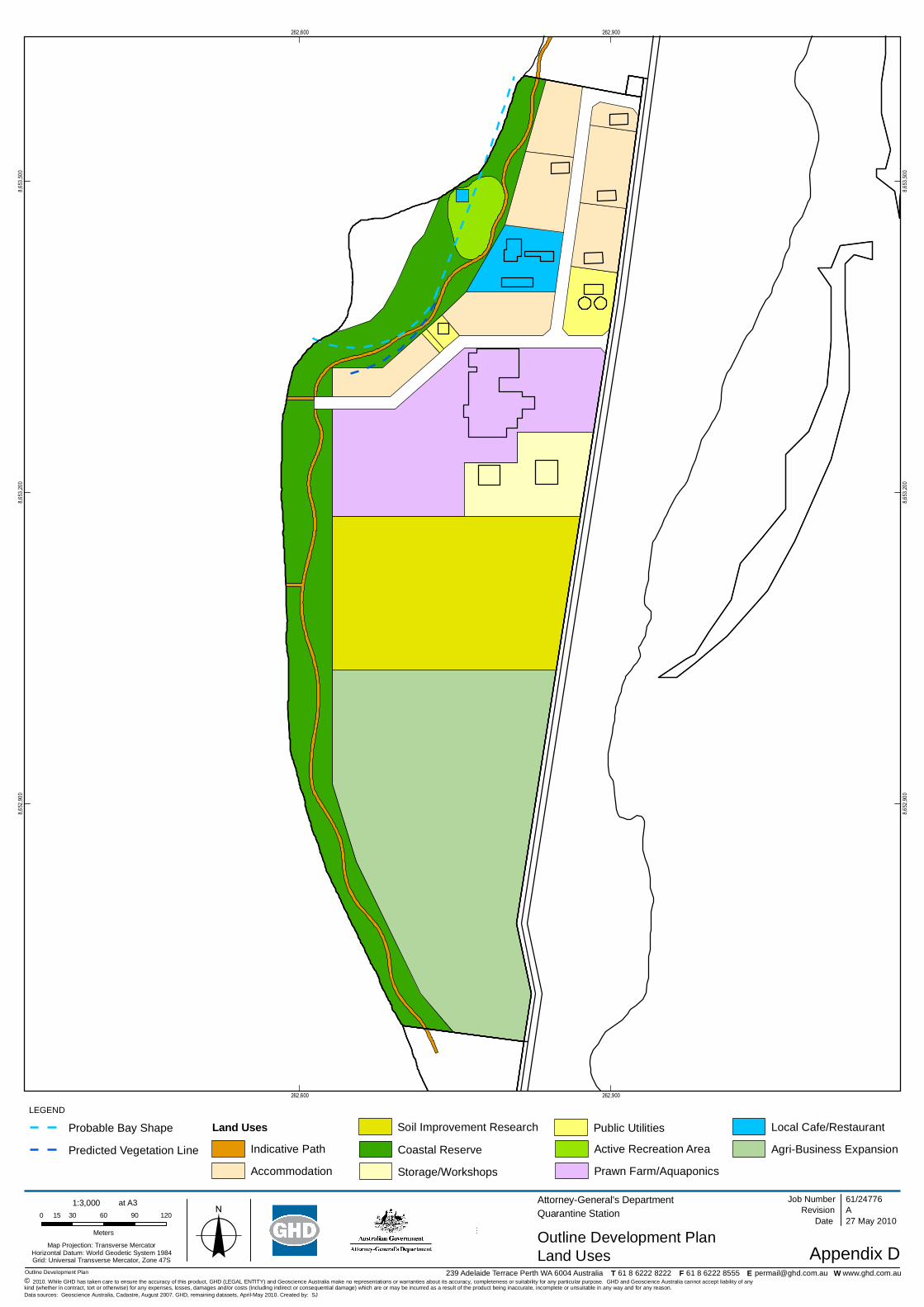
262,600
262,600
262,900
262,900
8,652
,900
8,652
,900
8,653
,200
8,653
,200
8,653
,500
8,653
,500
Outline Development Plan
LEGEND
0 30 60 90 12015
Meters
Map Projection: Transverse MercatorHorizontal Datum: World Geodetic System 1984Grid: Universal Transverse Mercator, Zone 47S
T F E W
o© 2010. While GHD has taken care to ensure the accuracy of this product, GHD (LEGAL ENTITY) and Geoscience Australia make no representations or warranties about its accuracy, completeness or suitability for any particular purpose. GHD and Geoscience Australia cannot accept liability of anykind (whether in contract, tort or otherwise) for any expenses, losses, damages and/or costs (including indirect or consequential damage) which are or may be incurred as a result of the product being inaccurate, incomplete or unsuitable in any way and for any reason.
AttorneyGeneral's DepartmentQuarantine Station
Outline Development PlanAppendix D
Job NumberRevision A
61/24776
27 May 2010
Land Uses
Date
Data sources: Geoscience Australia, Cadastre, August 2007. GHD, remaining datasets, AprilMay 2010. Created by: SJ
239 Adelaide Terrace Perth WA 6004 Australia 61 8 6222 8222 61 8 6222 8555 [email protected] www.ghd.com.au
FINAL
1:3,000 at A3
Land Uses
Coastal Reserve
Storage/Workshops
Probable Bay Shape
Predicted Vegetation Line
Accommodation
Indicative Path
Soil Improvement Research
Prawn Farm/Aquaponics
Active Recreation Area
Local Cafe/Restaurant
AgriBusiness Expansion
Public Utilities
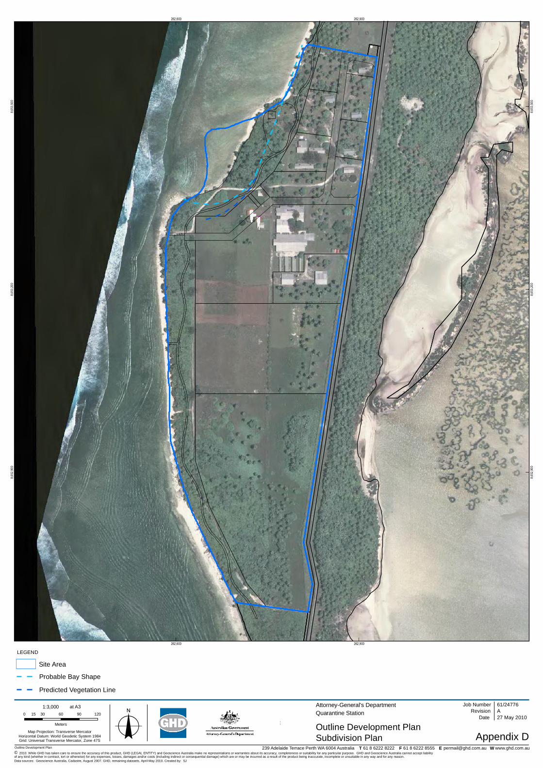
262,600
262,600
262,900
262,900
8,652
,900
8,652
,900
8,653
,200
8,653
,200
8,653
,500
8,653
,500
Outline Development Plan
LEGEND
0 30 60 90 12015
Meters
Map Projection: Transverse MercatorHorizontal Datum: World Geodetic System 1984Grid: Universal Transverse Mercator, Zone 47S
T F E W
o© 2010. While GHD has taken care to ensure the accuracy of this product, GHD (LEGAL ENTITY) and Geoscience Australia make no representations or warranties about its accuracy, completeness or suitability for any particular purpose. GHD and Geoscience Australia cannot accept liabilityof any kind (whether in contract, tort or otherwise) for any expenses, losses, damages and/or costs (including indirect or consequential damage) which are or may be incurred as a result of the product being inaccurate, incomplete or unsuitable in any way and for any reason.
AttorneyGeneral's DepartmentQuarantine Station
Outline Development PlanAppendix D
Job NumberRevision A
61/24776
27 May 2010
Subdivision Plan
Date
Data sources: Geoscience Australia, Cadastre, August 2007. GHD, remaining datasets, AprilMay 2010. Created by: SJ
239 Adelaide Terrace Perth WA 6004 Australia 61 8 6222 8222 61 8 6222 8555 [email protected] www.ghd.com.au
1:3,000 at A3
Probable Bay Shape
Predicted Vegetation Line
Site Area

61/24776/94456 Cocos (Keeling) Islands Quarantine StationOutline Development Plan
Appendix F
Ministerial Policy Guideline No. 8

Fisheries Ministerial Policy GuidelinesAssessment of applications forauthorisations for Aquaculture andPearling in coastal watersof Western AustraliaIssued Pursuant to Section 246of the Fish Resources Management Act 1994and Section 24 of the Pearling Act 1990As amended December 1998Ministerial Policy Guidelines No. 8
l) Determination of Applications Principles and Important MattersWhen all advice is to hand including approvals from relevant decision makingauthorities, the Executive Director will determine the application having regard tothose aspects of submissions which bear upon matters of substance, and matters whichare relevant to the portfolio or legislative charter of respondents and the followingmatters:
• the provisions of the Fish Resources Management Act 1994 or the PearlingAct 1990, as applicable;
• the provisions of other relevant legislation including Native Title legislation and• the Land Administration Act 1997;• any other Ministerial Guidelines;• submissions received and any further consultations under (j) above;• whether the proposal involves a limitation on access to the proposed waters;• any reports and advice from professional and technical officers of Fisheries• Western Australia;• any advice sought and received by the Executive Director;• the possible impact on navigation;• the possible impact on recreational fishing;• the possible impact on commercial fishing and other commercial activities• including tourism;• the possible impact on other pearlers or aquaculturists;• native title claims and the possible impact on native title rights and interests;• the possible impact on the environment or CALM Estate;• the possible impact on visual amenity and potential noise pollution;• The value to industry and the community from increased aquaculture or• pearling production or activity from the proposed site;• The economic benefit to local communities from the presence of aquaculture• and pearl companies and farms in their region; and• any other advice or information the Executive Director considers relevant.
The processes used for assessment of applications within Fisheries Western Australia,and the methods used to arrive at a decision or recommendation, are matters for theExecutive Director’s discretion. For example, in the case of aquaculture proposals, theExecutive Director may use the Inter Departmental Committee on Aquaculture toassist the consultation and decision making process.
c) Consultation with Representative Community and Industry GroupsThe Executive Director will consult with peak community and industry representative
groups which may have expertise in, or be directly affected by or have an interest in,the activities to be conducted under the authorisation. These include, but are notlimited to:
• Western Australian Fishing Industry Council (WAFIC);• Aquaculture Council of Western Australia (ACWA);• Pearl Producers Association (PPA);• Recreational Fishing Advisory Committee and relevant Regional Recreational• Fishing Advisory Committee;• RECFISHWEST;• Holders of pearling and aquaculture authorisations within 5 nautical miles of• the proposed site;• Native Title Holders and Claimants (if any) or their legal representative;• Relevant Aboriginal Land Council or relevant representative Aboriginal body;• Aboriginal Legal Service;• Conservation Council of Western Australia (Inc.); and• Australian Petroleum Production and Exploration Association Ltd.
The above peak representative bodies will be requested to ensure that appropriateregional associations or representative bodies/members are notified of proposals andadvised that they can convey their comments direct to the Executive Director.

61/24776/94456 Cocos (Keeling) Islands Quarantine StationOutline Development Plan
GHD
GHD House, 239 Adelaide Tce. Perth, WA 6004P.O. Box 3106, Perth WA 6832T: 61 8 6222 8222 F: 61 8 6222 8555 E: [email protected]
© GHD 2010
This document is and shall remain the property of GHD. The document may only be used for the purposefor which it was commissioned and in accordance with the Terms of Engagement for the commission.Unauthorised use of this document in any form whatsoever is prohibited.
Document Status
Reviewer Approved for IssueRevNo. Author
Name Signature Name Signature Date
0 SJ Scott Jeffrey Jim Singleton 25/05/2010
1 SJ Scott Jeffrey Jim Singleton 26/05/2010
2 SJ Scott Jeffrey Jim Singleton 04/06/2010


