30
A Simulation Using WRF-ARW Model A Internship Report Presentation Presented by - Devanil Choudhury Intern at – India Meteorological Department
| Date post: | 06-Aug-2015 |
| Category: |
Documents |
| Upload: | devanil-choudhury |
| View: | 75 times |
| Download: | 0 times |

A Simulation Using WRF-ARW Model
A Internship Report Presentation
Presented by - Devanil ChoudhuryIntern at – India Meteorological Department

Content Introduction Learning Objectives Evaluation of the Internship Project topic Scientific Background State of ArtAbout Data WRF-ARW Model
The experimental configuration The case event The Results Future works Conclusion References Thanks Giving

Introduction
The Internship was carried out at NWP Division, India Meteorological Department – New Delhi
Under the guidance of Dr. Someswar Das (Sc-G/ Project Director)
First phase was all about on learning Installation and simulation using WRF-ARW model
It was a very useful experience working with several scientists and engineers at IMD

Learning Objectives
To learn UNIX and AIX (Advanced Interactive eXecutive) operating system
To learn shell scripting (bash/c-shell) and vi editor To learn the WRF-ARW installation on the server To know briefly about WRF-ARW model for using and
running To learn NCL (NCAR Coded Language) and GrADS for
visualizing the output

Evaluation of InternshipUnix envioronment WRF installed on Laptop
Test experiment visualization with GrADS
WRF installation on RMC Delhi's Server for real experiment
Remotely acessed through telnet service
Working with IBM-AIX OS Chose the case for experiment (HudHud)
Learnt the entire domain settings and initial configuration for the model run
Transferred GFS data for the initial condition Ran the model for three days forecast
Graphical analysis with NCAR Coded Language (NCL)
Made the Animation

Project Topic
Simulation of Tropical Cyclone and impact of Doppler Weather Radar (DWR) data assimilation on the skill of track and intensity forecasting based on the WRF-ARW model
Project consists two part of works
1) Simulation of some tropical cyclone using various scheme of WRF-ARW without data assimilation
2) Simulation of some tropical cyclone with DWR data
assimilation

Scientific Background
The ARW has a good overall capability to predict TCs over the NIO basin (Osuri et al.) but
still there is huge scope for further reduction in track forecast error including 1)further improvement in initial condition 2) assimilation of more data (DWR) etc. (Mohapatra et al.)
Synoptic studeies shown that assimilation of DWR can improve NWP models (Liu et al. 2013)
DWR data may improve weather analysis and forecasts because of their high temporal and spatial resolution (Maielno et al.)

State of Art
The work was carried out using WRF-ARW model at NWP division of IMD-Delhi
The High Performance Computing System (HPCS) with 16
processors, 1 node and IBM-AIX parallel computing environment was used to carry out the works
The telnet service, ftp (file transfer protocol) service, internal LAN
connection etc assisted this work
WRF with ARW core model version 3.3.1 was used for the simulation

About Data
The initial and lateral boundary condition for the WRF-ARW model are obtained from analysis and forecast field of the NCEP-GFS model.
The lateral boundary condition are updated in 6-h interval with a fixed sea-surface temperature throughout the model integration, with no regional data assimilation used in this study.
The land surface boundary condition are taken from the U.S. Geological
survey data with a horizontal grid spacing of 10 min. To simulate the full genesis of the experimental event five day
(7-10-2014 to 11-10-2014 ) 72 hrs GFS (Global Forecasting System) analysis data at 00 UTC are taken for the initial condition of the model

WRF-ARW Model
Weather Research and Forecasting (WRF) – Advanced Research WRF (ARW) model was developed by NCAR and UCAR and is a community effort to develop a next generation mesoscale model and data assimilation system.
This mesoscale model suitable for use in
1) Idealized simulations
2) Parameterization research
3) Data assimilation research
4) Forecast research
5) Real-time NWP
6) Hurricane research ....

Flowchart of WRF-ARW
Source : http://www.mmm.ucar.edu

WRF Components
1. WRF Preprocessing System (WPS)
2. ARW Dynamics Solver
3. WRF-DA (Data Assimilation)
4. Graphics (NCL)
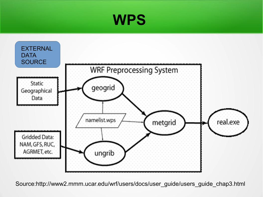
WPS
Source:http://www2.mmm.ucar.edu/wrf/users/docs/user_guide/users_guide_chap3.html
EXTERNAL DATA SOURCE

ARW Dynamics Solver
Source:http://www.meted.ucar.edu
Primitive Equation
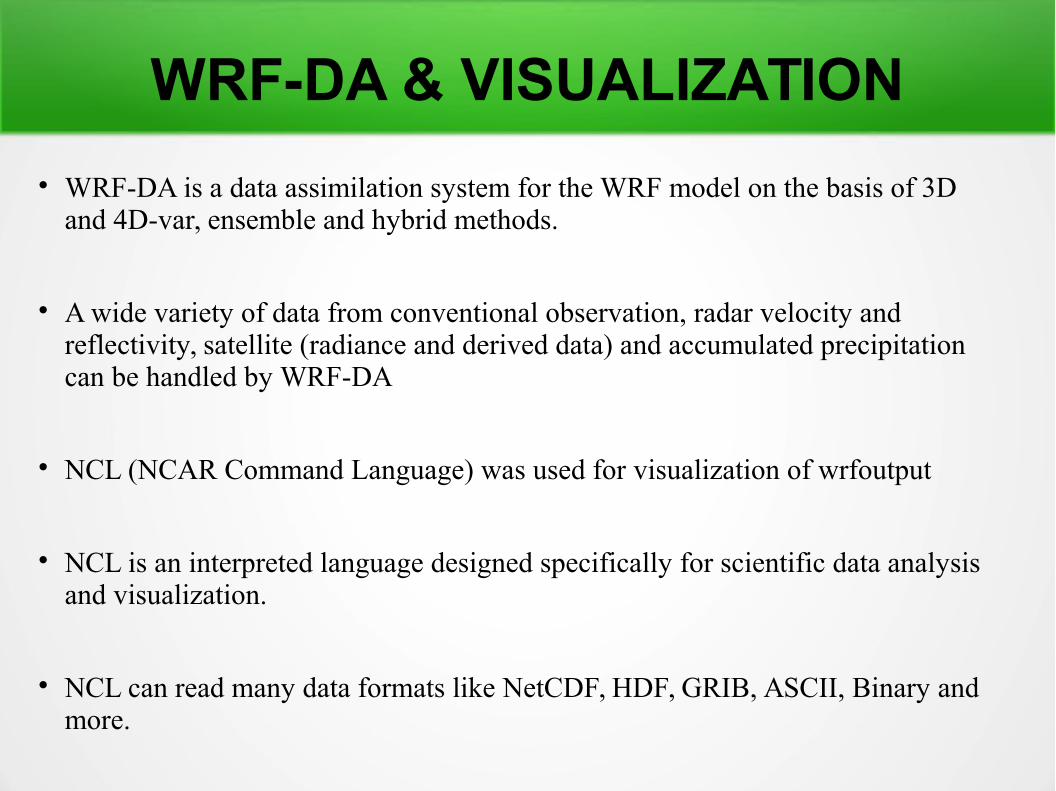
WRF-DA & VISUALIZATION
WRF-DA is a data assimilation system for the WRF model on the basis of 3D and 4D-var, ensemble and hybrid methods.
A wide variety of data from conventional observation, radar velocity and reflectivity, satellite (radiance and derived data) and accumulated precipitation can be handled by WRF-DA
NCL (NCAR Command Language) was used for visualization of wrfoutput
NCL is an interpreted language designed specifically for scientific data analysis and visualization.
NCL can read many data formats like NetCDF, HDF, GRIB, ASCII, Binary and more.

MODEL SUMMARY Fully compressible Euler non-hydrostatic equations with hydrostatic option ;
scaler-conserving flux form for prognostic variables ;
complete coriolis and curvature terms ;
nesting : one way , two way with multiple nests and moving nests ;
mass based terrain folloing co-ordinate ; vertical grid spacing can vary with height ;
mapping to sphere : 3 map projections are supported for real data simulations (coriolis term
included) : polar stereographic , lambert conformal , mervator ;
Arakawa C-grid staggering ;
Runge-Kutta 2 nd and 3 rd order time step options ;
2 nd to 6 th order advection options (horizontal and vertical );
time-split small step for acoustic and gravity-wave modes;
lateral boundary conditions:
Idealized cases: periodic, symmetric, and open radiative;
Real cases: specified with relaxation zone;
full physics options for land-surface, PBL, radiation, microphysics and cumulus
Parameterization. (Source – Research & Forecasting Model WRF by Laura Bianco)

The Experimental ConfigurationFor the first simulation of the VSCS
HudHud :
WRF-ARW nesting was taken as shown in figure
Horizontal resolution – 27 km and 9 km
Vertical level – 28
Time step for integration – 90 sec Run days – 3
Cumulus parameterization – Betts-Miller-Janjic scheme
Initial data – GFS gridded data

The Case Event
Track of HudHud (07-14 october)Source: Joint Research Centre of the European Commission (JRC)
HudHud VSCS taken as the case event

The Salient Features of HudHud HudHud is the first cyclone that crossed Visakhapattanam coast in
the month of October after 1985 and it made landfall on the same day as VSCS Phailin did in 2013.
At the time of landfall on 12 th October, the estimated maximum sustained surface wind speed in association with the cyclone was about 100 kts.
The estimated central pressure was 950 hpa with a pressure drop of 54 hpa at the centre compared to surroundings.
It caused very heavy to extremely heavy rainfall over North Andhra Pradesh and South Odisha and strong gale winds leading to large scale structural damage
Maximum 24 hour cumulative rainfall of 38 cm ending at 0830 hrs IST of 13 th october was reported from Gantyada (Vizianagaram) in AndhraPradesh. Source : IMD Report
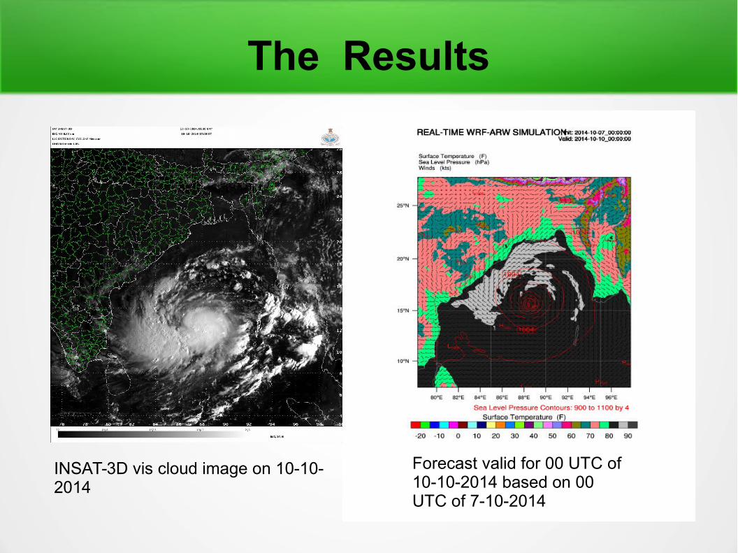
The Results
INSAT-3D vis cloud image on 10-10-2014
Forecast valid for 00 UTC of 10-10-2014 based on 00 UTC of 7-10-2014

The Results
INSAT-3D vis cloud image on 11-10-2014
Forecast valid for 00 UTC of 11-10-2014 based on 00 UTC of 8-10-2014

The Results
INSAT-3D vis cloud image on 12-10-2014
Forecast valid for 00 UTC of 12-10-2014 based on 00 UTC of 9-10-2014

The Results
INSAT-3D vis cloud image on 13-10-2014
Forecast valid for 00 UTC of 13-10-2014 based on 00 UTC of 10-10-2014
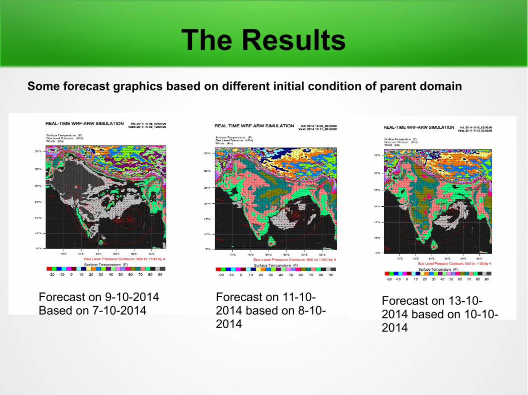
The Results
Forecast on 9-10-2014Based on 7-10-2014
Forecast on 11-10-2014 based on 8-10-2014
Forecast on 13-10-2014 based on 10-10-2014
Some forecast graphics based on different initial condition of parent domain

The ResultsThe Animation of parent and nested domain based forecast
Parent domain animation from 7-9th Oct. Model run based on 7th oct.
Nested domain animation from 10-12th oct. Model run based on 10th oct.
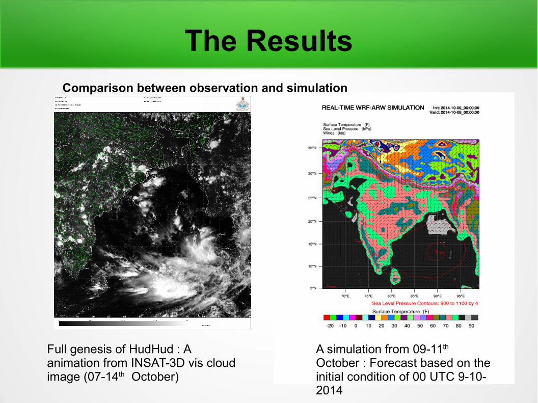
The Results
Full genesis of HudHud : A animation from INSAT-3D vis cloud image (07-14th October)
A simulation from 09-11th
October : Forecast based on the initial condition of 00 UTC 9-10-2014
Comparison between observation and simulation

Future Works
The study of skill of WRF by taking more tropical cyclones
The last possible work is to learn DWR data assimilation technique and assimilate on the skill of track and intensity forecast based on the WRF-ARW model

Conclusion
The deatail investigation and many more experiment are needed for better forecasting
Based on the initial configuration WRF-ARW predicted HudHud closely compared to the observation
This internship was very useful experience for me by gaining new knoledges, skills
Got the opprotunity to observe the operational forecasting and professional practice at IMD
Helped me to define what skills and knowledge I have
to improve i the ensuing time. Lastly It opened for me a new path to reach the higher research
in development of NWP models.

References
Liu et al. , A study on WRF radar data assimilation for hydrological rainfall predictions; 2013: HESS
Maielno et al., Impact of radar data assimilation for the simulation of a heavy rainfall case in central Italy using WRF-3D var; 2014: AMT
Mohapatra et al. Evaluation of official tropical cyclone track forecast over north Indian ocean issued by IMD, 2013; JESS
Osuri et al. Real-time track prediction of tropical cyclone over north Indian ocean using ARW, 2013:JAM
VSCS, HUDHUD over BOB (07-14 October 2014) : A Report
by IMD

Thanks Giving
I would like to thank Dr. Someshwar Das (Sc-G/Project Director) for giving this opportunity;
Mr. A. K. Das (Sc-D) and Mr. V. R. Durai (Sc-D)
for their enomormous support at IMD
&
THANK YOU ALL for your PATIENCES