Journal of Engineering Science and Technology Review 7 (2) (2014) 39 – 46
Research Article
Analysis of Double Meridian Distance for a Closed Traverse Area towards
Developing a Contour Map and Land Title
T. U. Ganiron Jr
Road Engineering Association of Asia and Australasia, New Zealand
Received 1 February 2014; Accepted 10 July 2014 ___________________________________________________________________________________________ Abstract This research aimed to analyze double meridian distance for a closed traverse area in developing a land title for a propose gymnasium in Qassim University. Theodolite, leveling rod and steel tape plays an important role in measuring elevations, bearings and distances of the boundaries of a lot. Contour map is necessary to determine the traces of level surfaces of successive elevation. This will enable to identify the type of contour map and type of contour lines necessary for this project. Corel draw software is used to draw contour map and guide to interpret the significance of the variables. It is essential to check the error of closure for interior angles and for both latitude and departure before applying the Double Meridian Distance (DMD) method to obtain the total area of the lot. Technical descriptions of the land such as distance, bearing, boundaries and area are necessary to visualize the shape & exact location of the land. Developing a land title will be obtained using the technical descriptions of the lot in preparation for the type of gymnasium necessary for Qassim University. Keywords: Contour map, corel draw, double meridian distance, engineer survey, land title, levelling __________________________________________________________________________________________
1. Introduction As in many professions, land surveyors have seen many changes through time. History has always demonstrated that the skills of the land surveyor have always been an important part of civilization. People have shared, owned, sold, development, fought over, given away, coveted, told stories of, imagined, photographed, fenced, studied, mapped, described and been thankful for that which remains constant for all of us, namely our land.
According to [1], land surveying is the technique and science of accurately determining the terrestrial or three-dimensional position of points and the distances and angles between them. These points are usually on the surface of the earth and they are often used to establish land maps and boundaries for ownership or governmental purposes.
To accomplish their objective, surveyors use elements of geometry, engineering, trigonometry, mathematics, physics and law. .An alternative definition, per the American Congress on Surveying and Mapping (ACSM), is the science and art of making all essential measurements to determine the relative position of points and/or physical and cultural details above, on, or beneath the surface of the Earth, and to depict them in a usable form, or to establish the position of points and/or details.
Furthermore, as alluded to above, a particular type of surveying known as "land surveying" (also per ACSM) is the detailed study or inspection, as by gathering information
through observations, measurements in the field, questionnaires, or research of legal instruments, and data analysis in the support of planning, designing, and establishing of property boundaries [2]. It involves the re-establishment of cadastral surveys and land boundaries based on documents of record and historical evidence, as well as certifying surveys (as required by statute or local ordinance) of subdivision plats/maps, registered land surveys, judicial surveys, and space delineation. Land surveying can include associated services such as mapping and related data accumulation, construction layout surveys, precision measurements of length, angle, elevation, area, and volume, as well as horizontal and vertical control surveys, and the analysis and utilization of land survey data [3].
Accuracy is one of the most important factors of land surveys. The purpose of a land survey is to accurately map and designate land boundaries. Any inaccuracies can lead to potential legal issues down the track. Some types of land surveys require even more accuracy than others as they are used to help establish where to construct buildings by taking into account topographic and hydrological features such as sewage systems and trees. Any inaccuracies could cause difficulties in the building process.
The accuracy of land surveys is particularly important when they are used for map making as the wider community relies on the accuracy of maps and assumes that they are precise documents.
The 2005 version of ALTA specifications, “ALTA” stands for American Land Title Association, states a Positional Accuracy of 0.07 feet or 20mm in new money, plus 50 parts per million. Many of the modern instruments
Jestr JOURNAL OF Engineering Science and Technology Review
T. U. Ganiron Jr/Journal of Engineering Science and Technology Review 7 (2) (2014) 39 –46
40
used by a Land Surveyor have an accuracy of distance measurements to within 2mm +/- 2 ppm but that alone does not assure compliance with the ALTA standards [4]. The ALTA Standards require that these conditions are taken into account:
The Relative Positional Accuracy may be tested by either: comparing the relative location of points in a survey as measured by an independent survey of higher accuracy or; In other words the survey would require being a traverse ending at its point of origin, beginning and ending on two different points of higher order [4,5]. These higher orders can be monuments can be NGS monuments, or monuments established on an older survey where the location was determined in accordance with condition 2 as here or the results of a minimally constrained correctly weighted least square adjustment of the survey.
The surveyor needs to apply a squares adjustment program. Therefore the surveyor needs to know the accuracy standards of their equipment and surveying techniques. This means they must know the distance and angular measurement specifications of their instrument and an estimate of such things as centering tolerance.
One of the most important elements that affects the accuracy of land surveys are the tools that the land surveyors use.
According to [6,7], the following findings were gathered: obesity levels rose by 70% in adults between 2003 and 2009, About one third of the men in the KSA are predicted to be obese by 2011, About 22% of girls under 15 and 19% of boys under 15 will be obese by 2011and about 9,000 deaths a year are caused by obesity in the KSA. Most of their projections have come true. It's safe to say though, that these numbers have only become worse since then.
The researcher proposed a gymnasium in Qassim University that will helps the students to control weight, reduces blood pressure in the body, raises HDL (good cholesterol levels) in the body, reduces the risk of diabetes, cancer and other diseases and to gives one more confidence, and also builds one's self esteem through proper exercises.
Moreover, the researcher made this study to, draw the contour map using corel draw software and identify the type of contour map and type of contour line necessary for this project, analyze the computation of double meridian distance, enumerate the technical description of the proposed land, and develop a Torrens title for Gymnasium in Qassim University.
In order to resolve the deficiencies of the common law and deeds registration system, Robert Torrens introduced the new title system in 1858, after a boom in land speculation and a haphazard grant system resulted in the loss of over 75% of the 40,000 land grants issued in the colony (now state) of South Australia [8]. He established a system based around a central registry of all the land in the jurisdiction of South Australia, embodied in the Real Property Act 1886 (SA). All transfers of land are recorded in the register [8,9]. Most importantly, the owner of the land is established by virtue of his name being recorded in the government's register. The Torrens title also records easements and the creation and discharge of mortgages.
The Torrens title system operates on the principle of “title by registration" (i.e. the indefeasibility of a registered interest) rather than "registration of title” [10]. The system does away with the need for a chain of title (i.e. tracing title
through a series of documents). The State guarantees title and is usually supported by a compensation scheme for those who lose their title due to the State's operation. There are other parcels of land which are still unregistered.
The Certificate of Title shows: the present owners, easements such as underground pipes that may require access for storm water or sewage, and 'right of carriageway' for neighbors get access to their property, covenants such as building restrictions, caveats such as a requirement for someone's approval before transfer of ownership and mortgages [11].
The measure of land is its area. But area itself is not measured. It is calculated. The calculation of the area of a piece of land is easy enough when it has a regular shape. A regularly shaped piece of land, of course, has many practical advantages. Towns, cities, counties and large portions of this country are laid out in a grid, not merely for aesthetic reasons or for ease of laying them out, but because a grid allows for an eminently efficient use of the land. But for surveyors and assessors, the advantage of the regular shape, especially of small lots, is that it makes area calculations a matter of simple multiplication.
Unfortunately, parcels of land are seldom regular in shape. Often, especially in colonial days, they were occupied long before they were surveyed. Inhabitation followed the terrain, an invariable feature of which is its irregularity. The resulting pieces of ground usually had straight lines between corners, but indeterminate shapes.
Calculating the area of such a form has been known since Euclid [12]. The trick is to break up the irregular shape into manageable components, and then perform the appropriate multiplications and sums. By colonial times, the mathematics involved was greatly facilitated by the invention of logarithms and trigonometric function tables. Given these, and reasonably accurate field measurements, any colonial surveyor could calculate its area with a pencil – “more or less” [13].
The colonial surveyors were using a standardized method called "DMD", the abbreviation for double mean distance or double meridian distance.
Once transits were used, the first step in the DMD method was to balance the angles. They could be interior or exterior. The field check was to add up the number of sides to the figure, either less by two (interior) or more by two (exterior), times 180 degrees [14,20]. That sum could be compared to the sum of the angles turned for an initial check. The angles were not always adjusted for balance, but if they were, the error was most likely distributed proportionately among all the angles.
The second step was to calculate the latitudes and longitudes. This required looking up the cosines and sines for the directions of the property lines with respect to north and south. (This is the rationale for quadrants in the first place). These functions were generally carried to eight places after the decimal point, and then multiplied by the lengths of the lines. The results were arranged in columns: N, S, E, and W. North and East were positive, and South and West were negative.
The third step was to balance these columns. Theoretically, the sum of the latitudes and the sums of the departures must equal zero, for the figure to close. Since measurements are inherently imprecise, they never really equaled zero, and were mildly suspect when they did. From
T. U. Ganiron Jr/Journal of Engineering Science and Technology Review 7 (2) (2014) 39 –46
41
the difference in the starting and ending latitudes and departures, the direction and length of the closing line were calculated. The error of closure was most easily eliminated by placing it in the line(s) whose direction most nearly mimicked the closing line. The error could also be distributed in other ways. The most methodical way was to distribute the error proportionately, the correction in each line being determined by the closing line multiplied by the ratio of a line length to the total perimeter length. However the error was reapportioned, the latitudes and departures would then be recalculated.
The next step was to calculate a series of areas, one corresponding to each of the parcel lines. A longitudinal line was drawn, at least hypothetically, through the westerly-most corner of the parcel plat, and latitudinal lines drawn from the corners to that line. The result was a series of areas, the first and last of which were triangular and the rest trapezoidal in shape. At this point, the procedure was to add the two departures of each area and multiply the sum by the longitudinal divergence of the line. The result was not an absolute number for each area, but a number with a positive or negative sign, derived from the signs ascribed in step two.
The last step was to add all these areas and divide the sum by two. By simply adding the two sides of each trapezoidal area, a rectangular area double the size of the trapezoid was calculated, thus requiring the division by two.
There are several ways of indicating elevation and relief on maps. The most common way is by contour lines. A contour line is a line representing an imaginary line on the ground along which all points are at the same elevation. Contour lines indicate a vertical distance above or below a datum plane. Starting at sea level, normally the zero contours, and each contour line represents an elevation above sea level. The vertical distance between adjacent contour lines is known as the contour interval. The amount of the contour interval is given in the marginal information. On most maps, the contour lines are printed in brown. Starting at zero elevation, every fifth contour line is drawn with a heavier line. These are known as index contours. Someplace along each index contour, the line is broken and its elevation is given. The contour lines falling between index contours are called intermediate contours [16]. They are drawn with a finer line than the index contours and, usually, do not have their elevations given. Corel draw software is used to draw contour maps in 2D.
Qassim University is a public university in the Al-Qassim Province of Saudi Arabia. It was established in 2004 jointly between King Saud University and Imam Muhammad ibn Saud Islamic University, each of which used it as its Qassim campus. Subsequently, its constituent colleges became a part of Qassim University. The main campus of Qassim University covers about eight square kilometers and is situated between Buraidah and Unaizah in the heart of the region. There are campuses in different cities in Al-Qassim Province. During 2008, enrollment at Qassim University was 40,000 students. Faculty and staff totaled 3,500 [17].
Colleges at Qassim University include Sharia College; the College of Arabic Language and Social Sciences; the College of Agricultural and Veterinary Sciences; a College of Economics; a College of Science; a College of Medicine; a College of Engineering; a College of Computer Science; a
College of Applied Medical Sciences; a College of Dentistry and a College of Pharmacy.
There is also a Science College in Zelfy, community colleges and women's colleges.
In the KSA it is estimated that 70% of the student population can be classed as physically inactive. Moreover, 60% of students do not participate in the recommended level of physical activity & 25% are not active at all [18]. In Qatar, 33% of the population are said to be so inactive that they gain no health benefits at all & the risk to the community from their physical inactivity, and therefore lack of fitness, is great [19]. Physical activity and the level of fitness have been linked to good health. Due to the advance of science in this day & age this link can be proven, with overwhelming evidence those students who lead active lifestyles are less likely to die early or to experience major illnesses such as heart disease, diabetes & colon cancer. Fitness is therefore a major, if not the major, factor in the type of health. This leads to construct a new gymnasium in Qassim University.
Open gyms are an integral part of the ability to compete with teams that may have more tradition or more talent or more size. Open gyms allow teaching students how to play in semi-chaotic situations like basketball, tennis and badminton.
This study will encourage civil engineering students and students of other fields to focus the significance of such variables such as distance, bearing, latitude, departure and double meridian distance for technical description of the lot. Moreover, students will enable to use critical thinking and creativity in developing a land title, constructing contour map and choose a type of gymnasium appropriate in Qassim University.
The University will be aware the level of fitness of students that have been linked to good health through the construction of propose gymnasium.
The home builders will be provided with knowledge and information about technical description of the lot.
The owners of the lot will solve the problems of uncertainty, complexity and cost associated with old-system title, which depended on proof of an unbroken chain of title back to a good root of title.
2. Research Methodology The study focuses on the computational analysis of double meridian distance for area of propose gymnasium lot of Qassim University. Technical descriptions such as distance, bearing, latitude, departure and elevation are variables essentials in developing a contour map and land title of the lot. The research concentrates on the type of contour map and contour lines based on the technical descriptions of land title. It will also cover the type of gymnasium that is applicable in this study. In addition, the study is delimited to double prime distance, trapezoidal rule, simson’s one third rule and coordinates. 2.1 Research Paradigm
One way of presenting a research paradigm is by the use of Input-Output-Process (IPO) model. The input is the
T. U. Ganiron Jr/Journal of Engineering Science and Technology Review 7 (2) (2014) 39 –46
42
information, ideas and resources used, the process is the actions taken upon/using input or stored material and output is the results of the processing that then exit the system. The two components of a traverse line are latitude and departure. According to [20] latitude is the vertical component of a traverse line wherein the distance is multiplied by the cosine of the bearing angle of the line whereas the departure is the horizontal component of a traverse line wherein the distance is multiplied by the sine of the bearing angle of the line. Moreover, the technical descriptions of a land contain distance, bearing, boundaries and area. This will measured by theodolite and a steel tape to determine the distance, horizontal & vertical angles. The azimuth will be converted to bearing whereas; distance should be measured in meter. It is important to check the interior angles and the components of a traverse line if there are adjustments in the data. The area of the land is computed by means of double meridian distance (DMD) .This is done by setting the first line equal to the departure of line itself. The DMD of the succeeding line is equal to the DMD of preceding line plus the departure of the line itself, the DMD of the last line is equal to the departure of the line but opposite in sign and multiply the DMD of the line by its latitude and add algebraically all the product and divide it by two to get the area. The use of corel draw software will be used to plot the successive elevations. Through the use of this process shown in figure 1, developing a contour map, land title and type of gymnasium will be the output of the study.
Fig. 1. Research paradigm 3. Results and Discussion 3.1 Characteristics of the Elevation
Table 1 shows the technical descriptions of the lot with the use of theodolite, leveling rod and steel tape. The highest elevation is 21.5 m along line 4-5 with a distance of 257.50 m , bearing of N 21 deg. 45’W and 5-6 with a distance of 665.20 m, bearing of N 31 deg. 15’E. However, the lowest elevation is 2.3 m, bearing S 05 deg. 17’W. This means that the elevations show a uniform, steep slope will be evenly closed to each other
Table 1. Technical description
3.2 Linear Error of Closure for Interior angles , latitude and departure Table 2 shows the computed latitude and departure by applying the trigonometry functions of an angle. This also shows that there is no error in interior angles. However, latitudes in the north direction have a sum of 998.63 meters. Latitudes in the south direction have a sum of 1090.30 meters. This means that the error in latitude is 91.67 meters .Departures in the east direction has a sum of 1095.41meters . Departures in the west direction have a sum of 1058.39 meters. This means that the error in departure is 37.02 meters
Table 2. Computed latitude and departure
3.3 Technical Descriptions Table 3 shows the adjusted technical descriptions of a lot. The sum of latitude for both north and south is zero. Moreover, the sum of the departure for both east and west direction is zero. This means that the traverse is closed. Beginning at a point marked “1” S 43deg. 15’ W ;49.70 m. , thence S 58 deg.53’ W, 291.00 m to point 2; thence N 80 deg. 10’ W, 499.00 m to point 3; thence N 21 deg. 45’ W, 257.50 m to point 4; thence N 31deg. 15 ‘E, 665.20
T. U. Ganiron Jr/Journal of Engineering Science and Technology Review 7 (2) (2014) 39 –46
43
m; thence 50 deg. 31’ E, 665.20 m to point 5, thence N 50 deg. 31’ E , 166.00 m to point 6; thence S 85 deg. 02’E , 249.50 m to point 7; thence S 5 deg. 17’ W, 557.00 m to point 8; thence S 50 deg. 25’E, 149.70 m to point 9 , thence S 71 deg. 28’ E, 272.70m to point 10 containing an area of 592, 849.45 square meter.
Table 3. Adjusted latitude and departure
3.4 Contour map Figure 2 shows a profile of elevations using contour map. Core Draw is used to plot the elevations. This topographic
contour map shows the horizontal and vertical positions of the terrain .The intermediate contour line was used to represents a line of equal elevation.
T. U. Ganiron Jr/Journal of Engineering Science and Technology Review 7 (2) (2014) 29 –38
Fig. 2. Contour map 4. Gymnasium Plan It’s important to visualize this urban mix of student’s players, player-observers, observers and passersby, and to appreciate the richness of the resulting social experience, because this is the conceptual model for a new generation of gymnasiums in the multi-sport recreation centers and clubs of the coming decade.
This model shown in figure 4 applies to any member-supported facility that’s sustained by a sense of community among users or members. In some respects, this gymnasium can be viewed as the town square of these communities where people come to participate and large dedicated spectator seating areas are not needed.
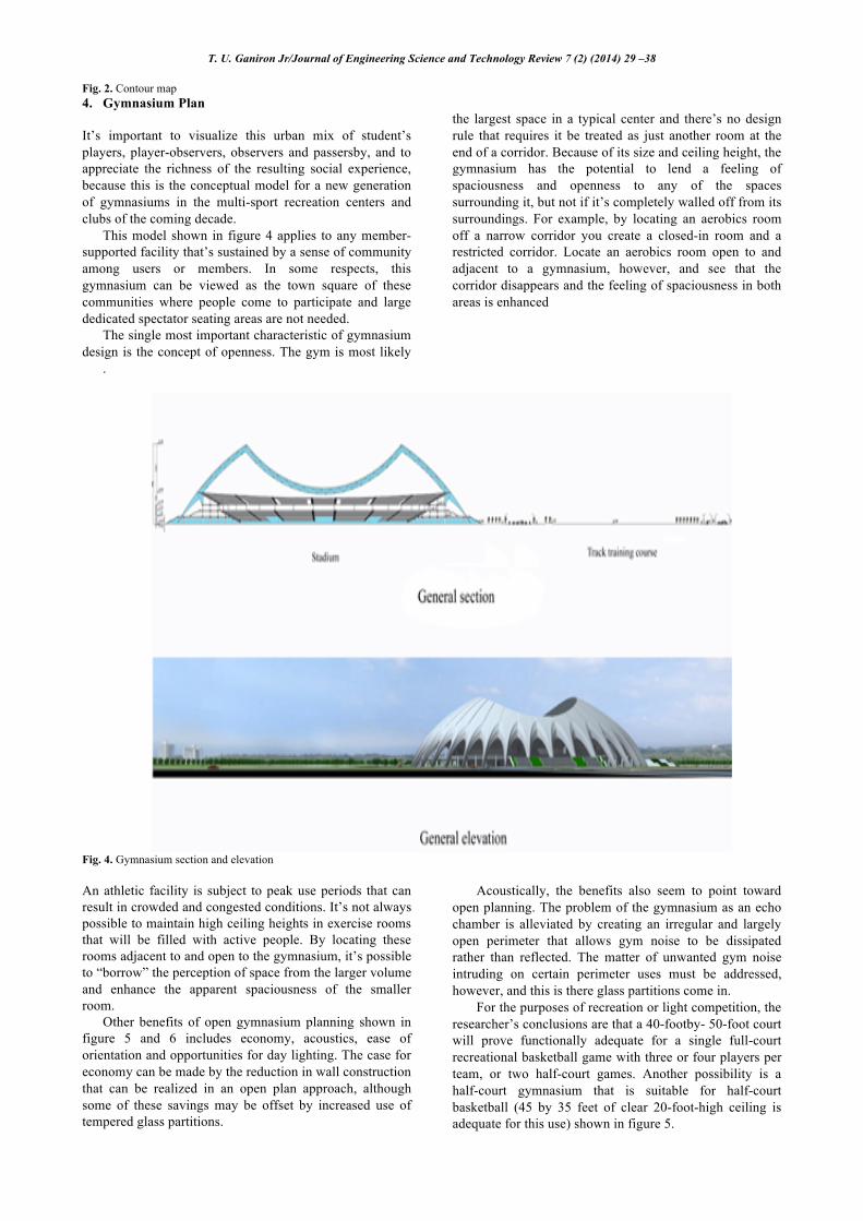
The single most important characteristic of gymnasium design is the concept of openness. The gym is most likely
the largest space in a typical center and there’s no design rule that requires it be treated as just another room at the end of a corridor. Because of its size and ceiling height, the gymnasium has the potential to lend a feeling of spaciousness and openness to any of the spaces surrounding it, but not if it’s completely walled off from its surroundings. For example, by locating an aerobics room off a narrow corridor you create a closed-in room and a restricted corridor. Locate an aerobics room open to and adjacent to a gymnasium, however, and see that the corridor disappears and the feeling of spaciousness in both areas is enhanced
.
Fig. 4. Gymnasium section and elevation An athletic facility is subject to peak use periods that can result in crowded and congested conditions. It’s not always possible to maintain high ceiling heights in exercise rooms that will be filled with active people. By locating these rooms adjacent to and open to the gymnasium, it’s possible to “borrow” the perception of space from the larger volume and enhance the apparent spaciousness of the smaller room.
Other benefits of open gymnasium planning shown in figure 5 and 6 includes economy, acoustics, ease of orientation and opportunities for day lighting. The case for economy can be made by the reduction in wall construction that can be realized in an open plan approach, although some of these savings may be offset by increased use of tempered glass partitions.
Acoustically, the benefits also seem to point toward open planning. The problem of the gymnasium as an echo chamber is alleviated by creating an irregular and largely open perimeter that allows gym noise to be dissipated rather than reflected. The matter of unwanted gym noise intruding on certain perimeter uses must be addressed, however, and this is there glass partitions come in.
For the purposes of recreation or light competition, the researcher’s conclusions are that a 40-footby- 50-foot court will prove functionally adequate for a single full-court recreational basketball game with three or four players per team, or two half-court games. Another possibility is a half-court gymnasium that is suitable for half-court basketball (45 by 35 feet of clear 20-foot-high ceiling is adequate for this use) shown in figure 5.
T. U. Ganiron Jr/Journal of Engineering Science and Technology Review 7 (2) (2014) 39 –46
44
Creating a gymnasium with suitable dimensions for
volleyball can be a bid asset for a small club facility with limited opportunities for recreational programming. Adhering to regulation dimensions is more important for volleyball than it is for basketball, although a compromise of 2 or 3 feet in curt length is possible without jeopardizing the enjoyment of the game.
However, it may be better to preserve the regulation volleyball court dimensions (29 feet, 6 inches by 59 feet) and eliminate the buffer/safety zone normally provided outside the court boundaries and provide instead a completely cushioned wall just outside the end lines.
With respect to ceiling heights, 18 feet is a practical minimum clear height in which to enjoy recreational basketball or volleyball.
At this dimension, all lights must be fully recessed. It must be emphasized that while these off-size mini-gyms are less than ideal, the owners and operators of such facilities report a high level of member satisfaction with the unexpected opportunity for basketball play in what would otherwise be a small, fitness-only facility 5. Conclusion
The computed total interior angle of the land is 1440 degrees whereas the allowable interior angle for 10 sides is 1440 degrees. This means that there is no error in the interior angles. Latitude in the north direction has a sum of 998.63 meters. Latitude in the south direction has a sum of 1090.30 meters. This means that the error in latitude is 91.67 meters. A departure in the east direction has a sum of 1095.41meters. A departure in the west direction has a sum of 1058.39 meters. This means that the error in departure is 37.02 meters. The adjustment necessary to close the components of a traverse line is use the transit rule. Topographic contour map is necessary to shows the horizontal and vertical positions of the terrain. Moreover, intermediate contour line is used to represents a line of equal elevation. The land title contains the land description surveyed by Geodetic Engineer including the lot plan, rights of ownership and attest by concern authorities. The single most important characteristic of gymnasium design is the concept of openness. The gym is most likely the largest space in a typical center and there’s no design rule that requires it be treated as just another room at the end of a corridor. Because of its size and ceiling height, the gymnasium has the potential to lend a feeling of spaciousness and openness to any of the spaces surrounding it, but not if it’s completely walled off from its surroundings
.
Fig. 5. Gymnasium flooring plan
T. U. Ganiron Jr/Journal of Engineering Science and Technology Review 7 (2) (2014) 39 –46
45
Fig. 6. Landscape planning analysis and drawing 6. Appendix
Fig. 7. Land title
T. U. Ganiron Jr/Journal of Engineering Science and Technology Review 7 (2) (2014) 39 –46
46
Fig. 8. Lot plan
______________________________ References
1. M. Fajardo, Elements of Roads and Highways, National Bookstore, Manila, 2009.
2. T. U. Ganiron Jr, S. Al-Alyahya and A. Eltoumi, Handouts in Project Management, Qassim University, Buraidah City, 2010.
3. B. Kavanagh, Surveying with Computer Applications, Pearson Education, 2010.
4. J. La Putt, Higher Surveying, National Bookstore, Quezon City, 2007.
5. F. Moffitt, Surveying, Harper & Row Publishers, New York, 2007.
6. Architectural Design Publication Magazine of the Architectural Engineering Planner, Washington DC, 2004.
7. ASEP Engineering Surveying Manuals, Washington DC, 2008
8. P. Dimaunahan, Student’s Fieldwork Manual in Elementary Surveying, University of the East, Manila, 1999.
9. R. Estanero, Field Manual in Higher Surveying, Dela Salle University, Manila, 1988.
10. T. Ganiron Jr, Handouts in CE 112, Qassim University, Buraidah City, 2010.
11. J. Hipolito, A Review Manual Surveying, Rex Bookstore, Manila, 1989.
12. Y. Kebbieh, Handouts in Basic Survey, Qassim University, Buraidah City, 2009.
13. T. U. Ganiron Jr, “A Practicum Report in Metro Manila Skyway Projects (Stage 1-Buendia to Bicutan), Master’s Project, Civil Engineering Department, De La Salle University, Manila, 1997.
14. T. U. Ganiron Jr, M. I. Laman, A. Climacosa, R. Ayeng and R. Mariano, “Efficiency of Sosrobahu Mechanism for the Construction of Elevated Roadways with Single
15. T. U. Ganiron Jr, V. Flores, R. Uaje, M. Lucenada, J. Boboyo and R. Dizon, “A Study on the Developmental Impact of the Proposed Interchange to Minimize the Worsening Congestion along the Zapote- Aguinaldo Highway Intersection”, BS Thesis, Civil Engineering Department, FEATI University, Manila,1999.
16. A. Balaan, C. Abaya, R. Dayrit, R. Vergara and J. Condeza, “Formulation of Precast High Strength Concrete as a Solution to Fast Track Projects”, BS Thesis, Civil Engineering Department, FEATI University, Manila, 1998.
17. T. U. Ganiron Jr, J. Aparato, M. Abayon, M. Baybay and R. Sison, “A Study on the Development of Skyway Systems (Phase 2: Nichols Toll Plaza to Bicutan): Its Trends and Impact to the Commuters”, BS Thesis, Civil Engineering Department, FEATI University, Manila, 2000.
18. F. Sol Jr, S. Banzuela, J. Ave, F. Seville and R. Joson, “An Assessment in Construction of Underground Railways along Edsa corner Ayala Avenue to Pasay Road”, BS Thesis, Civil Engineering Department, FEATI University, Manila,2000.
19. T. U. Ganiron Jr, M. Velante, J. Sam and K. Yuipco, “A Study on Accessibility of a Road Network Development of BF Home Paranaque and Along Sucat Road”, BS Thesis, Civil Engineering Department, FEATI University, Manila, 2000.
20. F. Sol Jr, G. Torres, N. Cortes, F. Samson and E. Torres, “A Study of Inefficient Traffic System along Taft Avenue from Vito Cruz to Libertad Street”, BS Thesis, Civil Engineering Department, FEATI University, Manila, 2000.