BABEŞ-BOLYAI UNIVERSITY OF CLUJ-NAPOCA FACULTY OF ENVIRONMENTAL SCIENCES RESEARCH ON THE ENVIRONMENTAL IMPACT OF SOME GOLD MINES CLOSURE IN ROŞIA MONTANĂ METALLOGENETIC FIELD PhD THESIS SUMMARY Scientific Coordinator Prof. PhD Şerban-Nicolae VLAD PhD Student Lucrina ŞTEFĂNESCU Cluj-Napoca 2010
Transcript
BABEŞ-BOLYAI UNIVERSITY OF CLUJ-NAPOCA FACULTY OF ENVIRONMENTAL SCIENCES
RESEARCH ON THE ENVIRONMENTAL IMPACT OF SOME GOLD MINES CLOSURE IN ROŞIA MONTANĂ
METALLOGENETIC FIELD
PhD THESIS SUMMARY
Scientific Coordinator Prof. PhD Şerban-Nicolae VLAD
PhD Student Lucrina ŞTEFĂNESCU
Cluj-Napoca 2010
i
TABLE OF CONTENTS (the page numbering is identical with that in the PhD thesis)
Introduction 1I The environmental impact of metalliferous resources mining 5 1.1. General aspects 5 1.1.1. Air pollution 9 1.1.2. Water pollution 10 1.1.3. Soil pollution 14 1.1.4. Noise pollution 16 1.1.5. Landscape damage 16 1.2. Major mining accidents 18 1.3. Initiative in the mining industry 24 1.3.1 The “Awareness and Preparedness for Emergencies at Local Level”
Programme for Mining Industry 25
1.3.2. International Cyanide Management Code 27 1.3.3. Global Mining Initiative 28 1.3.4. International Council on Mining and Metals 28 1.4. Present state of the Romanian mining industry 29 1.4.1. Mining industry – facts and figures 29 1.4.2. Legislative framework regarding mineral resource extraction and
environmental protection 33
1.4.3. Economic issues regarding the Romanian mining industry 35 1.5. Conclusions 37II Mine closure and the environmental issues 38 2.1. Introductory aspects 38 2.1.1. Concepts and terminology 40 2.1.2. Objectives of mine closure 43 2.1.3. Types of mine closure 44 2.1.4. Stages of mine closure 46 2.2. International policies regarding mine closure 48 2.2.1. North America 50 2.2.2. South America 52 2.2.3. Africa 54 2.2.4. Asia 55 2.2.5. Australia 56 2.2.6. Europe 57 2.3. Mine closure in Romania 61 2.3.1. The legislative Romanian framework regarding mine closure 61 2.3.2. The strategy of the Romanian state regarding mine closure 62 2.4. Social-economic aspects of mine closure 64 2.4.1. The social impact of the mine closure process 64 2.4.2. Financial liability regarding mine closure 65 2.4.3. Socio-economic regeneration programs and ecological rehabilitation of
the mining sites in Romania 66
2.5. Conclusions 69III The exploitation of metalliferous resources in the Roşia Montană
metallogenetic field and its associated environmental impact 70
3.1. The geographical and geological context of the research 70 3.1.1. Geographical location and the relief 70 3.1.2. The regional and local geological and metallogenetic context 73
ii
3.1.3. Hydrography 86 3.1.4. Climate 89 3.1.5. Soils 90 3.1.6. Vegetation and fauna 92 3.1.7. Protected areas 94 3.2. Presentation of the operational context of the mining exploitation 94 3.2.1. Short history of mining activity in Roşia Montană 95 3.2.2. Description of the Roşia Montană mining site 100 3.2.3. Description of the gold extraction technology used in Roşia Montană 104 3.3. The impact on the environmental components in the Roşia Montană
metallogenetic field 105
3.3.1. Impact on waters 106 3.3.2. Impact on soils 127 3.3.3. Impact on air 133 3.4. Integrated assessment of the environmental pollution impact and risk 136 3.4.1. Description of the method 136 3.4.2. Calculation of the pollution impact and risk 141 3.4.3. Results analysis 143 3.5. Conclusions 146IV Environmental impact of the mine closure at Roşia Montană mining site 148 4.1. Impact upon the physical component 149 4.1.1. Impact on waters 149 4.1.2. Impact on air 150 4.1.3. Impact on soil 150 4.1.4. Impact on landscape 150 4.2. Impact on the biotic component 156 4.2.1. Impact on vegetation 156 4.2.2. Impact on fauna 163 4.3. Impact on the antropic component 164 4.3.1. Impact on the health of the population 165 4.3.2. Impact on the demographic evolution 166 4.3.3. Impact on the standard of living 168 4.4. Matrix assessment of the mine closure impact upon the environmental
components in the Roşia Montană mining site 171
4.4.1. Description of the method 172 4.4.2. Completion of the matrix 174 4.4.3. Results and discussions 176 4.5. Conclusions 177V Risks associated to mine closure 178 5.1. Risk and hazard – general aspects 178 5.2. Identification of the hazardous areas 179 5.2.1. The open pits 180 5.2.2. Gura Roşiei processing plant 183 5.2.3. Waste heaps 183 5.2.4. Tailing dams 184 5.3. Risks associated to mine closure 186 5.3.1. Natural hazards and risks 186 5.3.2. Technological hazards and risks 202 5.3.3. Natural disasters triggered technological accidents (Na-Techs) 206 5.4. Matrix assessment of the environmental risks associated to the Roşia
Montană 208
5.4.1. The methodology of elaborating the risk assessment matrix 209
iii
5.4.2. Risk analysis 210 5.4.3. Results and discussions 211 5.5. Closure Risk Factor calculation model for the Roşia Montană mining site 213 5.5.1. The Closure Risk Factor 213 5.5.2. Methodology 213 5.5.3. Results and discussions 216 5.6. Conclusions 221VI Roşia Montană mine closure conceptual model 223 6.1. Argumentation of the conceptual model 223 6.2. The basic principles for the elaboration of the conceptual model 225 6.3. The methodology for the elaboration of the conceptual model 225 6.4. The outline of the Roşia Montană conceptual mine closure model 227 6.4.1. The ecological rehabilitation component 230 6.4.2. The remining component 238 6.5. The costs associated to the model 240 6.6. The model’s SWOT analysis 243 6.7. The assessment of the impact generated by the mine closure model 244 6.8. Significance of the model for the decision-making process 246 6.9. Conclusions 247 CONCLUSIONS 248 Bibliography 252 Appendixes 271 Appendix 1. International legislation regarding the mining industry and the
environment 271
Appendix 2. National legislation regarding the mining industry and the environment
274
Appendix 3. Acronym list 284 List of published papers 286
The valuation of subsoil resources represents a very profitable activity from the economic point of view and provides raw matters for many industrial sectors “downstream”. The paper treats the environmental impact of these activities, focusing on the closure stage of the mining exploitation. Essential aspects of the complex mine closure process are approached and necessary activities for the self-sustaining of the system are described.
The topic of mine closure presents a special significance for all the stakeholders: - for the mining companies, from the perspective of environmental, social and safety risk
reduction in the area, as well as from the perspective of necessary funds of area rehabilitation;
- for authorities and government, from the point of view of environmental issue solution, and the social and economic restoration of vast regions;
- for communities in view of avoiding the economic and social collapse. The pollution and irreversible damage of the environmental factors quality as a result of the
mining activities represent solid arguments for the application of correct standards and policies of ecological restoration.
The proposed objectives of the study are the following: - presentation of the concepts, international policies, perspectives, and efficient solutions
regarding the challenges of the mine closure process, - performance of an analysis of a time evolution of environmental quality, respectively the
determination of damage or improvement level, - environmental impact assessment due to metalliferous resources exploitation in the study
area for the determination of a knowledge data base for the subsequent approach of the closure aspects,
- identification and classification of mine closure associated impacts within Roşia Montană metallogenetic field,
- mine closure impact assessment for the outline of a clear image upon the Roşia Montană present state,
- establishing ecological reconstruction priorities, by the identification, analysis and evaluation of existing risks within the study perimeter,
- approach of risks and hazards from the study area from the perspective of natural and antropic risks, as well as from a more complex perspective of their interaction – NATECH (Natural Disasters Trigger Technological Disasters),
- identification, classification and assessment of risks associated to mine closure in the Roşia Montană metallogenetic field,
- elaboration of a conceptual mine closure model, based on the risks and impacts previously identified and assessed.
II. MINE CLOSURE AND THE ENVIRONMENTAL ISSUES
Mine closure represents an important stage of the life cycle of a mine, and it is by far the most difficult aspect challenging the mining industry. Mining is just a temporary and relatively short use of lands, and the importance of the closure stage emerges from the necessity to return damaged systems to a stat of stability which enables their future use.
The manner in which mine closure is planned and designed defines the vision of the owner on the final result and includes the premises of the implementation of this vision. The mine closure plan should represent an integrant part of the life cycle of a mining project and should be elaborated to achieve the following goals (Sassoon, 2000):
• long-term population safety and health; • avoidance of physical and chemical damage of the environmental resources; • efficient and sustainable long-term use of the site;
2
• mitigation of adverse socio-economic impacts; • maximum amplification of the socio-economic benefits.
In other words, mine closure should be performed according to the principles of sustainable development. Sustainable development represents a set of integrated principles which involve the environmental ecosystems, economic growth, social equity, policy integration and the idea that efficient solution may be achieved only by an interdisciplinary approach of the problems. This implies also taking into consideration the future repercussions of present decisions – not all of them favorable. Sustainable development in the case of mine closure provides opportunities and challenges, but, most important, it should provide viable solutions (Roosa, 2008).
Recently, the accent of mine closure environmental issues management was placed on the idea of mining for closure (Peck, 2005). Mine closure represents a series of activities that starts with pre-planning and ends with acquiring long-term stability and self-sustaining ecosystems.
Mine closure stipulated in the restructuring programs for many old mines in Romania needs the appropriate approach of the environmental issues resulting from the mining activities, including the use of chemical substances. In this regard, a good management and long-term responsibility, supported by a coherent legislation are necessary (Ştefănescu et. al., 2009).
III. THE EXPLOITATION OF METALLIFEROUS RESOURCES IN THE ROŞIA MONTANĂ METALLOGENETIC FIELD AND ITS ASSOCIATED ENVIRONMENTAL IMPACT 3.1. THE GEOGRAPHICAL AND GEOLOGICAL CONTEXT OF THE RESEARCH
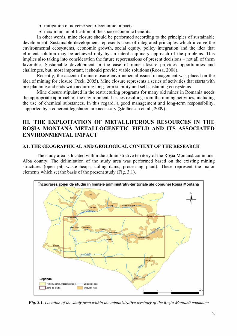
The study area is located within the administrative territory of the Roşia Montană commune, Alba county. The delimitation of the study area was performed based on the existing mining structures (open pit, waste heaps, tailing dams, processing plant). These represent the major elements which set the basis of the present study (Fig. 3.1).
Fig. 3.1. Location of the study area within the administrative territory of the Roşia Montană commune
3
3.1.2. The regional and local geological and metallogenetic context
The geologic and metallogenetic framework of Roşia Montană represents the key factor of
actual natural and antropic processes. By explaining and understanding the genesis and type of the deposit, one could achieve a better image on the contamination sources, on the contaminants’ migration pathways and of the way in which these affect the end receptors, facilitating the environmental impact assessment.
The alpine magmatism in Romania is the result of the geotectonic evolution of the Carpathian – Pannonian region, thus delimitating the following events associated to a complete Wilson cycle (Vlad, 1998):
- Jurassic – Lower Cretacic, characterized by the presence of a tholeiitic series, of a calc-alkaline series and of a spilitic complex, located in the Southern Apuseni Mts.;
- Upper Cretacic, representing a polistadial calc-alkalin magmatism (laramic or banatitic magmatism), developed in the Apuseni Mts. and in the Meridional Carpathians;
- Upper Terţiary, which has lead to the formation of some volcano-plutonic complexes, especially andesitic, which occur in the Oriental Carpathians and in Southern Apuseni Mts.
After the closure of the Transylvanian - Thetyan ocean and of the Tisia-Dacia block collision, the architecture of the Southern Apuseni Mts. was marked starting with the Tertiary by the tectonic phenomena with an extensional character. The north-eastern movement of the Pannonian region during the Oligocene-Miocene, combined with the clockwise rotation movement of the Tisia-Dacia block and the “roll-back” movement of the foundation of the flish basin have lead to the installation of a tectonic extensional framework with Neogene magmatism and associated metalogenesis (Balintoni and Vlad, 1996).
Reactivated NE-SW Laramian fractures during the Neogene times across early Alpine magmatic lineations controlled the occurrence of molasses basins. They form triangular grabens with increased extension north-westward and pull – apart trend, due to NW-SE transverse fracturing. The molasses grabens represent the preferential site for Tertiary volcano-plutonic edifices with prevalent Badenian rhyodacite-rhyolites and especially Sarmatian-Pannonian andesitic volcanic piles at their upper part. This calc-alkaline magmatism with slightly sub-alkaline tendency was generated by melting of thinned-metasomatised PreApulian Continental margin (Tisia-Dacia Block) (Vlad and Orlandea, 2004).
Tămaş (2007) treats the systematic of the Neogene volcanic activity in the Apuseni Mts. according to Har:
calc-alkalin volcanism – represented by a start period (Eggenburgian – lower Miocene) with acid character (rhyolites, rhyodacites, dacites and associated piroclastites), followed by a calc-alkaline phase with an intermediary character, predominantly andesitic (middle Miocene – Pliocene).
alkaline volcanisms – the final stage of the magmatic/volcanic manifestations, with predominantly basic products – alkaline basalts, shoshonites (upper Sarmatian – Quaternary).
Thus, the calc-alkaline Badenian – Quaternary magmatism in the Apuseni Mts. Starts with an acid stage (rhyolites, rhyodacites ignimbrites, of the Faţa Băii, Băiţa type) and it ends with alkaline volcanism (shoshonites), well-known by the neck from Măgura Uroi (lava, lava with elements of volcanic breccia or clastolava). The Neogene calc-alkaline magmatismul in the Apuseni Mts. took place in a transtensional regime by the reactivation of the Upper Cretacic – Palaeogene magmatism into graben structures (Balintoni and Vlad, 1996).
The complex geologic structure of the Carpathians explains the large diversity of the metalliferous genetic / paragenetic types resulting during a long evolution, from Precambrian to Quaternary. The inheritance and metallogenetic evolution in association with the events of some orogenic Wilson cycles represent the fundamental concepts which enable a close correlation
4
between the geologic features controlling the pulsatile deposition of the ores, during the mechanical cycles and the inherent geochemical behavior of the base metals (Vlad and Borcoş, 1994).
The gold-silver deposit from Roşia Montană is composed of veins structures and stockworks, respectively bodies of breccia, cemented with metallic minerals and gangue (Tămaş, 2001).
Figure 3.2 presents the image of the study area geology, according to the geologic map scaled 1:50.000, Abrud sheet (Bordea et al., 1979).
Thus, the geologic structure of the study area includes: a) cretaceous sedimentary deposits, b) neogene sedimentary deposits (Badenian and Sarmatian), c) neogene volcanic rocks – dacites and andesites, and their pyroclastic products.
Fig. 3.2. The geology of the study area From metallogenetic point of view, Roşia Montană - Bucium district belongs to the Province
of the concentrations associated to the tertiary volcanism, Sub-province of the concentrations associated to the tertiary volcanism of the Southern Apuseni. This region includes most of the structures favorable to the gold-silver metallogenetic processes, belonging to the Golden Quadrilateral (Orlandea, 2003).
Studies performed on the alpine metallogenesis in Romania have highlighted several epithermal models within the metalogeny associated to the Neogene volcanism, among which the Roşia Montană model (Vlad and Borcoş, 1997). The magmatism and metalogenesis in this limited area was pulsatorily manifested, which was explained by the in depth activity of a hot spot, the neogene volcanism ad associated metalogenesis can be explained not by a subduction process sensu strictu, but as reactivation products of the hot spot (Vlad, 1983).
In conclusion, the structural-evolutionary complications in the Romanian Carpathians have created favorable conditions to the genesis of the precious metals, and thus making the Roşia Montană deposit, the most important gold concentration in our country and in Europe, in the category of over 1000 t Au ores (Vlad, 2005).
5
3.2.2. Description of the Roşia Montană mining site The chosen study area includes 21.45 km2, and it partially overlaps Roşia Valley drainage
basin and its confluence with the Abrud River. It incorporates all the mining objectives presenting interest from the environmental safety and protection point of view. It belongs to the administrative territory of the Roşia Montană commune and it includes the following mining structures (Fig. 3.3):
- Gura Roşiei processing plant - Aprăbuş precinct - Gura Roşiei and Valea Săliştei tailing dams - Cetate and Cârnic open pits - 17 waste heaps
Fig. 3.3. Location of the mining objectives within the study area Gura Roşiei processing plant is located at the junction of Roşia and Abrud rivers, occupying
40 m2. It was built in 1852 and was continuously improved in order to recover the precious metals through the amalgamation process. Nowadays, the structures and facilities within the plant are abandoned, leading to unfavorable conditions for all the environmental media
The Aprăbuş precinct is located on the left side of the Roşia rivulet, west of Cetate open pit and occupies a total surface of 1.3 ha. The ore was transported here after the extraction from the open pit and it was crushed.
The two tailings dams are located in the west part of the study area on the left side of the Abrud river (Gura Roşiei tailing dam) and respectively on the valley of Sălişte rivulet (Valea Săliştei tailing dam). Together they cover a surface of 40 ha and store a volume of 3.4 mil. m3
tailings. The two open pits are located south of the centre of the Roşia Montană commune, on the
hills with the same names. The Cetate open pit is the largest, with a 22 ha surface and an average diameter of 400 m at the upper part. The exploitation started in 1971. That time, the Cetate hill, was 1,040 m high. Nowadays, the exploitation elevation of the open pit is 873 m.
6
The Cârnic open pit is located east of the Cetate pit. This is the smallest pit and the level of the exploitation bench is +966 m.
There are 17 waste heaps on the studies site. Among these, Valea Verde and Hop were the last to be closed, in 2006.
3.3. THE IMPACT ON THE ENVIRONMENTAL COMPONENTS IN THE ROŞIA
MONTANĂ METALLOGENETIC FIELD The surface of the Roşia Montană exploitation is located in the hydrographical basins of the
Corna and Roşia rivulets, as well as to the interfluves between these water bodies. This fact favours the migration of pollutants by the means of these rivers. The Roşia rivulet is considered as one of the most heavily polluted in the entire Arieş catchments area (Luca et al., 2006), representing the main source of pollution of the Abrud and then of the Arieş river.
As a result of the regional inventory of accident risk sites in the Tisa river basin, the International Commission for the Protection of the Danube River (ICPDR) has published a report in the year 2000, in which these risks were divided into two categories: major and minor risks (ICPDR, 2000). Among these objectives, the most of the industrial units belonged to the mining industry. Roşia Montană was among the main risk area, by the Valea Săliştei tailing dam, characterized by heavy metals and high acidity pollution risk (Ştefănescu et al., 2007).
The pollution problems do not disappear once the mining activity has ceased. The abandoned mining sites include large amounts of wastes with a high content of mobile metals and particulate matters, which, through their drainage by the rivers or rainfall waters, are carried away and introduced into the aquatic circuit. That is the reason the abandoned mining sites represent large scale environmental pollution sources, especially of the hydrographical networks.
The scientific literature mentions the acid mining drainage as the main source of pollution in the hydrographical basin of the Arieş River, as well as in the sub-basins of its tributaries (Forray, 2002). To this there is to be added the natural potential to generate acid drainage. The rocks with the highest potential to generate acid waters in the area are the volcanic breccia. The pH values decrease below 2, thus driving a massive mobility of heavy metals in the rock (Baciu, 2007).
By the lixiviation of the rainfall waters through the tailing dams these charge with pollutants, especially heavy metals. The waters discharged from the Valea Săliştei tailing dam are at present exceeding the admissible limits for the indicators Pb and Mn, presenting a moderate acidity. Gura Roşiei tailing dam was less monitored from the physical-chemical point of view as this is under preservation since 1986. The 2008 analyses made available by the courtesy of RoşiaMin mining exploitation, performed on tailing dam discharged waters illustrate extreme values of Pb and Mn, as well as an acid character. Mine waters and tailing dams discharged waters present high contents of pollutants, which contribute to the pollution of water courses.
Based on the analyses performed in the autumn of 2006 – spring of 2007 together with the team of the Research Institute for Analytical Instrumentation, Cluj-Napoca, the heavy metals concentrations in the waters of Arieş and Abrud rivers are presented, downstream of the Roşia Montană mining exploitation. The analysis of the environmental samples was performed at the Laboratory of Environmental Analyses, Cluj-Napoca, certified according to SR EN ISO 17025:2005 standard, by the Romanian Certification Association, RENAR.
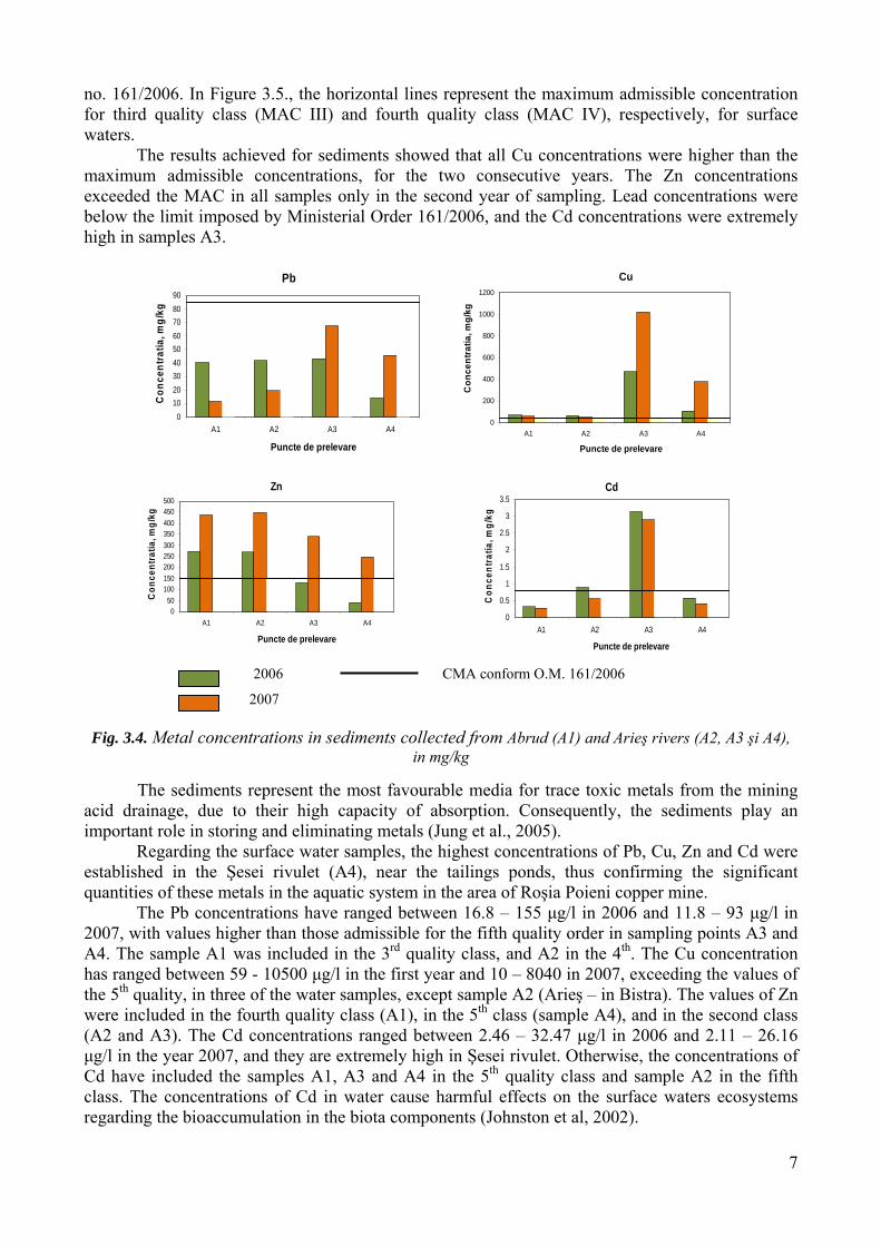
The predominant heavy metal sources in Aries River are the acid mine waters drained from tailings and from deposed sediments rich in metals which in certain conditions are easily mobilized. While the cooper and zinc are known as unwanted substances, lead and cadmium are characterized as toxic pollutants (Hambidge, 2000).The metals concentrations in sediment samples are shown in Figure 3.4, and in surface waters in Figure 3.5.
Metal concentrations in water and sediment samples are assessed against those in Romanian Order no. 161/2006 (Ministry of Waters, Forests and Environmental Protection), required for surface waters and sediments, as comparison. In Figure 3.4, the horizontal line represents the maximum admissible concentration for heavy metals in sediments, according to Romanian Order
7
no. 161/2006. In Figure 3.5., the horizontal lines represent the maximum admissible concentration for third quality class (MAC III) and fourth quality class (MAC IV), respectively, for surface waters.
The results achieved for sediments showed that all Cu concentrations were higher than the maximum admissible concentrations, for the two consecutive years. The Zn concentrations exceeded the MAC in all samples only in the second year of sampling. Lead concentrations were below the limit imposed by Ministerial Order 161/2006, and the Cd concentrations were extremely high in samples A3.
Pb
0102030405060708090
A1 A2 A3 A4
Puncte de prelevare
Con
cent
ratia
, mg/
kg
Cu
0
200
400
600
800
1000
1200
A1 A2 A3 A4
Puncte de prelevare
Con
cent
ratia
, mg/
kg
Zn
050
100150200250300350400450500
A1 A2 A3 A4
Puncte de prelevare
Con
cent
ratia
, mg/
kg
Cd
0
0.5
1
1.5
2
2.5
3
3.5
A1 A2 A3 A4
Puncte de prelevare
Con
cent
ratia
, mg/
kg
Fig. 3.4. Metal concentrations in sediments collected from Abrud (A1) and Arieş rivers (A2, A3 şi A4), in mg/kg
The sediments represent the most favourable media for trace toxic metals from the mining
acid drainage, due to their high capacity of absorption. Consequently, the sediments play an important role in storing and eliminating metals (Jung et al., 2005).
Regarding the surface water samples, the highest concentrations of Pb, Cu, Zn and Cd were established in the Şesei rivulet (A4), near the tailings ponds, thus confirming the significant quantities of these metals in the aquatic system in the area of Roşia Poieni copper mine.
The Pb concentrations have ranged between 16.8 – 155 µg/l in 2006 and 11.8 – 93 µg/l in 2007, with values higher than those admissible for the fifth quality order in sampling points A3 and A4. The sample A1 was included in the 3rd quality class, and A2 in the 4th. The Cu concentration has ranged between 59 - 10500 µg/l in the first year and 10 – 8040 in 2007, exceeding the values of the 5th quality, in three of the water samples, except sample A2 (Arieş – in Bistra). The values of Zn were included in the fourth quality class (A1), in the 5th class (sample A4), and in the second class (A2 and A3). The Cd concentrations ranged between 2.46 – 32.47 µg/l in 2006 and 2.11 – 26.16 µg/l in the year 2007, and they are extremely high in Şesei rivulet. Otherwise, the concentrations of Cd have included the samples A1, A3 and A4 in the 5th quality class and sample A2 in the fifth class. The concentrations of Cd in water cause harmful effects on the surface waters ecosystems regarding the bioaccumulation in the biota components (Johnston et al, 2002).
2006 CMA conform O.M. 161/2006
2007
8
Pb
0
20
40
60
80
100
120
140
160
180
A1 A2 A3 A4
Puncte de prelevare
Conc
entra
tia, u
g/l
Cu
0
2000
4000
6000
8000
10000
12000
A1 A2 A3 A4
Puncte de prelevare
Con
cent
ratia
, ug/
l
Zn
0500
100015002000250030003500400045005000
A1 A2 A3 A4
Puncte de prelevare
Con
cent
ratia
, ug/
l
Cd
0
5
10
15
20
25
30
35
A1 A2 A3 A4
Puncte de prelevare Co
ncen
tratia
, ug/
l
2006 CMA III 2007 CMA IV
Fig. 3.5. Metal concentrations in surface waters, in µg/l (MAC-maximum admissible concentration)
In accordance to the surface water classification, the sample collected from the study area, respectively A1, was included in the following quality classes: class III for Pb, class IV for Zn şi class V for Cu and Cd. The values of the pH ranged within the limit values (6.5 – 8.5), except sample A4, indicating the high acidity of the Şesei rivulet, increasing the solubility and mobility of metals, raising the risk of metal contamination in the nearest water courses, groundwater and agricultural fields (Ozunu et al., 2009). The normal values of the pH in sample A1 (Abrud), may be explained by the dilution of waters in the Roşia Montană rivulet by the junction with Abrud.
In the following figures there is presented the level of pollution in sediments and surface waters, based on the heavy metals concentrations. Water quality is represented by colored circles, according to the pollution values determined as a result of the analyses performed.
9
Fig. 3.6. Water pollution in the Aries Middle Basin based on heavy metals concentration in sediments
Fig. 3.7. Water pollution in the Aries Middle Basin based on heavy metals concentration in surface waters
This study has indicated that the mining activity in the studied perimeter has affected metal
concentrations in the surface waters. High levels of some metals (Pb, Cu, Cd, Zn) concentrations in Arieş water and its tributaries
and the low pH values due to the significant metallic sulphures content of tailings and sediments
10
suggest that, even when closed, the mines and tailings dams from the area represent continuous pollution sources of natural waters, even when the exploitation has ceased (Ozunu et al., 2009).
There is very clear the idea that maintaining the present situation (“No Action”) will lead to the continuation of the unconformities and to the further damage of the environmental media and human settlements. The mine water discharge into the Roşia rivulet and of the discharge waters from the tailings dams into the Sălişte rivulet and Abrud River, without a previous treatment will further damage the natural receptors.
Taking into consideration the long history of the gold and silver mining in the area, one can speak of the high degree of soil pollution. This phenomenon has been greatly amplified during the last 4-5 decades due to the low technological level and to the inadequate exploitation/processing methods, as well as to the intense pace of exploitation. The pollution was considerably enhanced by the storage of tailings on unprotected terrains, under the circumstances of high levels of heavy metals and toxic substances used in the processing of metals. The affected areas were extended along the time by their subjection to the natural processes (precipitations, frost/defrost, wind, water seepage). The close connection between the environmental media water and soil has lead to the situation that the water pollution sources mentioned above constitute also soil pollution sources. 3.4. INTEGRATED ASSESSMENT OF THE ENVIRONMENTAL POLLUTION IMPACT
AND RISK An efficient approach strategy of preoccupations regarding the environmental factors and
the identification of local, regional, and national priorities is to assess the impact and risk. The assessment of the ecological impact is essential for the remediation process, thus representing the basis of management practices. The ecological assessments range between the inventory of the local biota, determinations of contaminants in the environment and organisms, environmental impact assessments to ecological risk assessments for a certain substance or any other disturbing factor.
The contaminated sites often suffer damages of the physical and biological components, but also chemical contamination. Cleaning and remediation of contaminated sites is one of the major environmental problems of this century, one of the first steps towards the assessment of ecological resources (receptors, including human beings), structure and function of ecosystems, as well as the levels and effects of contamination (Burger, 2008).
Risk assessment is a gradual process, towards the comparison of relative risks induced by decontamination actions (Swanson, 2007). Risk assessments may be performed at various levels, from the large scale investigations which compare various sites, to site specific detailed analyses. This approach is useful where there are no resources for the ecological rehabilitation of the area and where the identification of priority actions is necessary for assuring human health and environmental protection (Semenzin et al., 2007). 3.4.1. Description of the method
The integrated qualitative impact and risk assessment method is used. This is a new trend, to
combine the two procedures of environmental risk assessment and environmental impact assessment. The integrated method takes into account the environmental issues (impact and risk), the cause – effect relationship, as well as the environmental impact generating sources and their consequences, especially if they are characterized by a high occurrence probability (Robu, 2005).
By the use of this method one reduced the subjectivity degree specific to other methods (i.e. method of the global pollution index). The method used in this study quantifies automatically and simultaneously both the environmental impact and the risk associated to the former, starting with the determined concentrations. The environmental assessor cannot influence or intervene in the final results.
11
The integrated environmental impact and risk assessment method presents the following advantages:
• this is first of all, easy to use and it follows a clear, simple and well defined procedure; • it does not depend especially on the experience of the assessor; • the environmental impacts and risks are calculated starting from the pollutants
concentrations, determined in the environment at a certain time or estimated by pspecial programs, which reflect the reality in an objective manner;
• the integrated method of impact – risk assessment is not a subjective method; the subjectivity of the method, generated by the assessor’s experience is diminished following the mathematic steps;
• the assessor’s experience does not influence the final results, which facilitates the project’s monitoring, pollution prevention, or closure decision making process.
In order to reduce the degree of subjectivity in calculating the importance units, the calculation matrix method will be used, first obtaining weights and then importance units for each environmental media (Table 3.1).
There are several procedures for assigning the weights. The method used in the present study is similar to the one used in the Battelle environmental valuation system. Through this method, the relative weights of the individual issues are expressed in importance units of the parameters. The total of 1000 importance units is used as an estimation of the weight (Ferreira et al., 2008).
Table 3.1. Calculation of the weight of each environmental component
Solving the line matrix the “importance units” are obtained Component Weights Importance units Discharge waters 0.16 155.84 Surface waters 0.19 194.81 Air 0.26 259.74 Soil 0.39 389.61 Total (verification) 1,000 1,000
W – Weights for awarded importance IU – Importance units (subsequently used in quantifying the impact) IU = W x 1000
The quality of the assessed environmental component is then determined as the ratio
between the maximum admissible concentration, according to the present legislation and the concentration of a certain quality indicator, specific to the assessed environmental component. The impact induced upon the assessed environmental component is the result of the ratio between the importance units of the environmental component and its quality.
To each calculated environmental impact, an environmental risk is assigned. This risk can be calculated either for each impact induced to the environment and subsequently as an average of the achieved values, or directly, considering the average value of the impact induced on the respective environmental component.
After quantifying the environmental impact and risk, their classification is in order (Table 3.2).
12
Table 3.2. Classification of the environmental impact and risk Environmental impact
Description Environmental risk
Description
<100 Environment not affected by the human activity / natural quality
<100
Negligible / unsignificant risks
100-350 Environment subjected to the effects of human activities below admissible limits
100-200 Minor risks, but these needs to be monitored
350-500 Environment subjected to the effects of human activities, causing discomfort
200-350 Medium risks at acceptable level, they should be monitored
500-700 Environment subjected to the effects of human activities, causing the disturbance of life forms
350-700 Medium risks at unacceptable level, there are necessary measures of prevention and control
700-1000 Environment seriously affected by human activities
700-1000 Major risks Riscuri majore, sunt necesare măsuri de prevenire, control şi remediere
>1000 Damaged environment, improper to life forms
>1000 Catastrophic risks, all activities should be ceased
(Source: Robu, 2005)
Based on the formulas presented in the methodology, the environmental impact and risk was calculated, thus achieving the following results:
Fig. 3.8. The impact and risk on environmental media in the Roşia Montană mining perimeter
The highest impact and respectively risk is induced upon the waters, represented especially by the mine waters, followed at great distance by the soil and air factors. The value difference between the mine water and tailings dam discharge waters and the other evaluated components is graphically illustrated in Fig. 3.8.
The results achieved for each analyzed environmental component is included in the following impact and environmental classes:
Mine waters and tailings dams discharge waters:
- Impact: damaged environment, improper to life forms, - Risk: catastrophic risks, all activities should be ceased,
Surface waters: - Impact: environment subjected to mining activities, causing the disturbance of
life forms,
13
- Risk: medium risks at inacceptable level; prevention and control measures are necessary,
Soil: - Impact: environment subjected to the effects of human activities, causing the
disturbance of life forms - Risk: medium risks at unacceptable level, prevention and control measures are
necessary, Air:
- Impact: environment subjected to the effects of human activities below admissible limits,
- Risk: Negligible / insignificant risks 4.4. MATRIX ASSESSMENT OF THE MINE CLOSURE IMPACT UPON THE ENVIRONMENTAL COMPONENTS IN THE ROŞIA MONTANĂ MINING SITE
In order to emphasize which of the environmental components will be most strongly affected by the mine closure in Roşia Montană, the rapid impact assessment matrix was applied. This method involves the elaboration of a matrix in which, on one of the coordinates there are specified the assessed activities and on the other coordinate there are presented the potentially affected environmental factors. At the intersection of the activities with the environmental factors the intensity and significance of the impact are quantified.
The use of this method enables the analysis of all possible relationships, which makes the overall assessment be more objective. One has to mention the fact that this method enables the assessment of both the direct impact and the indirect impact. Usually, in the impact assessment matrixes there are used the scale and weights for the differentiation of the various roles of the activity types and ecological factors, which confers a complex character to the method.
Among the advantages of the method there are: the possibility to compare various types of impacts based on mutual rationales; transparency; flexibility; easy to use and economical. The main advantages of the method are: its subjectivity, as it involves the judgment of the assessor or of a team of assessment and the fact that the assessment is qualitative, but it also involves quantitative grades (Muntean, 2004).
4.4.1. Description of the method
The RIAM method (Rapid Impact Assessment Matrix) is based on a standard definition of the significant assessment criteria and of the means by which one can deduct quasi-quantitative values for each of these criteria (represented by a specific, independent weight). The impact of the activities to be developed is assessed based on the environmental issues; each of these issues receives a weight (environmental weight). The potential impact is measured for each environmental aspect considered (Macoveanu, 2006).
The steps of RIAM method: 1. The establishment of criteria and assessment steps 2. Definition of considered environmental aspects and the class grouping 3. Calculation of the environmental weights for each environmental issue 4. Conversion of environmental individual weights on categories of impact 5. Determination of the impact category for each class of environmental aspects 6. Graphical or numerical representation of the environmental weight achieved for each
environmental aspects and environmental categories. The calculus procedure of RIAM implies the following equations:
A1 x A2 = At (eq. 4.1.)
B1 + B2 + B3 = Bt (eq. 4.2.) At x Bt = ES (eq.4.3.)
14
Where: A1, A2, B1, B2, B3 – criteria of assessment for the RIAM method At, Bt – weights achieved by the multiplication, respectively the sum of values assigned to the
evaluation criteria EW – environmental weight for the analyzed factor
The standard assessment criteria established are classified into two major types: A – criteria that, individually, may change the obtained environmental weight B – criteria that, individually, cannot change the environmental weight.
Tabel 4.1. Assessment criteria and steps by the RIAM method
Criteria Scale Description
A1 Significance of the
environmental change (effect)
4 3 2 1 0
Significant for the national/international interests Significant for regional/national interests Significant also for the areas in the immediate vicinity of the site area Significant only for local conditions No significance
A2 Magnitude of the
environmental change
+ 3 + 2 + 1 0
- 1 - 2 - 3
Significant major benefit Significant improvement of the present state Improvement of the present state The maintenance of the present state Negative change of the present state Disadvantages or significant negative changes Disadvantages or major negative changes
B1 Permanence
1 2 3
No changes Temporary Permanent
B2 Reversibility
1 2 3
No changes Reversible Irreversible
B3 Cumulativity
1 2 3
No changes Non-cumulative / unique Cumulative / synergetic
After the environmental weights have been achieved, these were transformed into impact
categories (IC), based on the conversion scale below. Table 4.2. Conversion of environmental weights into impact categories The environmental weight
(EW) Categories
(Code) Description of the category
+ 72 → + 108 + E Major positive impact + 36 → + 71 + D Significant positive impact + 19 → + 35 + C Moderate positive impact + 10 → + 18 + B Positive impact
+ 1 → + 9 + A Slightly positive impact 0 N Lack of change / of the status-quo / Not applicable
- 1 → - 9 - A Slightly negative impact - 10 → - 18 - B Negative impact - 19 → - 35 - C Moderate negative impact - 36 → - 71 - D Significant negative impact
- 72 → - 108 - E Major negative impact
The method has been applied by considering the environmental peculiarities in the study area and of the analyses of the samples presented previously in the thesis.
The matrix was completed by the assignment of a value from the weight scale, according to the impact mine closure will have upon them.
15
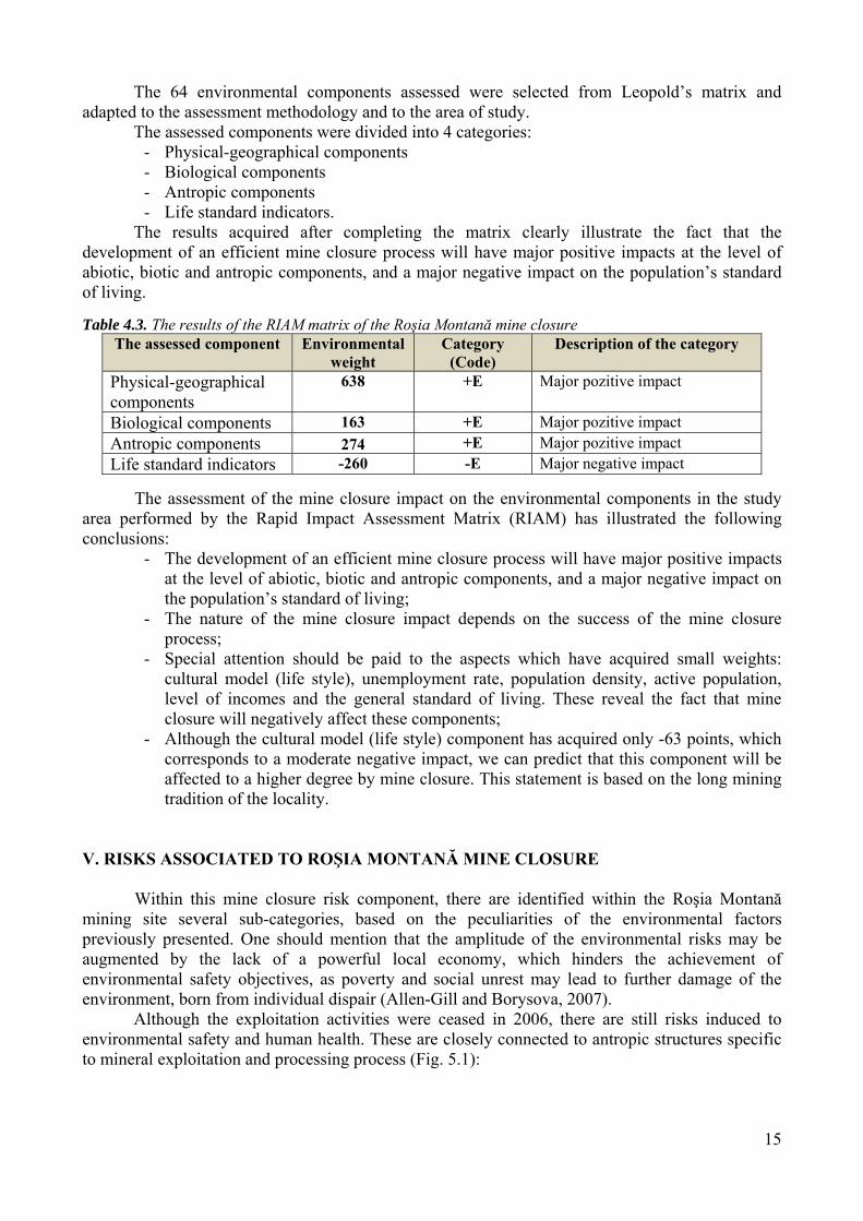
The 64 environmental components assessed were selected from Leopold’s matrix and adapted to the assessment methodology and to the area of study.
The assessed components were divided into 4 categories: - Physical-geographical components - Biological components - Antropic components - Life standard indicators.
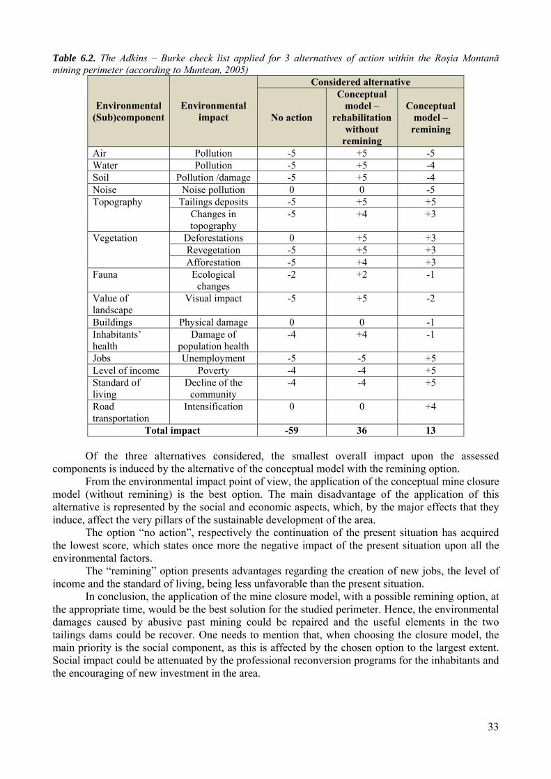
The results acquired after completing the matrix clearly illustrate the fact that the development of an efficient mine closure process will have major positive impacts at the level of abiotic, biotic and antropic components, and a major negative impact on the population’s standard of living. Table 4.3. The results of the RIAM matrix of the Roşia Montană mine closure
The assessed component Environmental weight
Category (Code)
Description of the category
Physical-geographical components
638 +E Major pozitive impact
Biological components 163 +E Major pozitive impact Antropic components 274 +E Major pozitive impact Life standard indicators -260 -E Major negative impact
The assessment of the mine closure impact on the environmental components in the study
area performed by the Rapid Impact Assessment Matrix (RIAM) has illustrated the following conclusions:
- The development of an efficient mine closure process will have major positive impacts at the level of abiotic, biotic and antropic components, and a major negative impact on the population’s standard of living;
- The nature of the mine closure impact depends on the success of the mine closure process;
- Special attention should be paid to the aspects which have acquired small weights: cultural model (life style), unemployment rate, population density, active population, level of incomes and the general standard of living. These reveal the fact that mine closure will negatively affect these components;
- Although the cultural model (life style) component has acquired only -63 points, which corresponds to a moderate negative impact, we can predict that this component will be affected to a higher degree by mine closure. This statement is based on the long mining tradition of the locality.
V. RISKS ASSOCIATED TO ROŞIA MONTANĂ MINE CLOSURE
Within this mine closure risk component, there are identified within the Roşia Montană
mining site several sub-categories, based on the peculiarities of the environmental factors previously presented. One should mention that the amplitude of the environmental risks may be augmented by the lack of a powerful local economy, which hinders the achievement of environmental safety objectives, as poverty and social unrest may lead to further damage of the environment, born from individual dispair (Allen-Gill and Borysova, 2007).
Although the exploitation activities were ceased in 2006, there are still risks induced to environmental safety and human health. These are closely connected to antropic structures specific to mineral exploitation and processing process (Fig. 5.1):
16
Fig. 5.1. Potentially hazardous areas (ArcScene representation)
5.3.1. Natural hazards and risks
Landslides During the mining works, the relief suffered multiple transformations which have
determined its fragility and the possibility to cause geomorphologic processes such as: falls, landslides, etc.
The lack of the stabilizing vegetation cover, excessive grazing, and change of land uses or mining activities are just a few of the causes of landslides activation or reactivation, in the North and East of Roşia Montană and within the upper course of the Corna River, representing sources of risk. The presence of the artificial lakes “tauri” in the areas represents another source of landslide risk, amplified by the potential of suffosion occurrence.
For the assessment of landslides occurrence risk there was elaborated the landslide risk map. The methodology used in the elaboration of landslides susceptibility map is that included in the Guide of landslide risks maps for the assurance of building stability – Indicative GT – 019-98 (Institute of Studies and Projects for Territorial Planning, 1998).
When elaborating the risk map regarding the landslide occurrence potential there were taken into consideration several criteria established based on some factors which act singularly or interdependently, influencing the stability of slopes, based on the three degrees of potential with the appropriate probability of landslides occurrence.
Table 5.1. The classes of landslide occurrence potential (Institute of Studies and Projects for Territorial Planning, 1998)
Low Medium High
Probability of landslide occurrence (P) and the appropriate risk coefficient (K) Practically
zero Low Medium Medium -
High High Extremely
high 0 < 0.10 0.10-0.30 0.31-0.50 0.51-0.80 >0.80
17
The calculus formula used for the elaboration of landslide susceptibility map is the following:
(ec. 5.1.)
Where: Km – potential of landslides occurrence Ka – the litological criterion Kb – the geomorphologic criterion Kc –hydrologic and climatic criterion Kd –seismic criterion Ke –sylvic criterion Kf –antropic criterion
Results and discussions One can notice from the analysis of the slope map that the slopes ranging between 6° and
12° are predominant. The quasi-horizontal surfaces (0-3° slope) occupies the areas including the interfluves, bed of the rivers and the terraces of the rivers, the terraces of waste heaps and of the tailings dams.
The area of the open pit is dominated by slopes ranging between 15-35°. The basin of the Cetate pit has marginal slopes ranging between 25-32° in the SE and 32-45° in NE. The high declivity (over 35°) is fairly small.
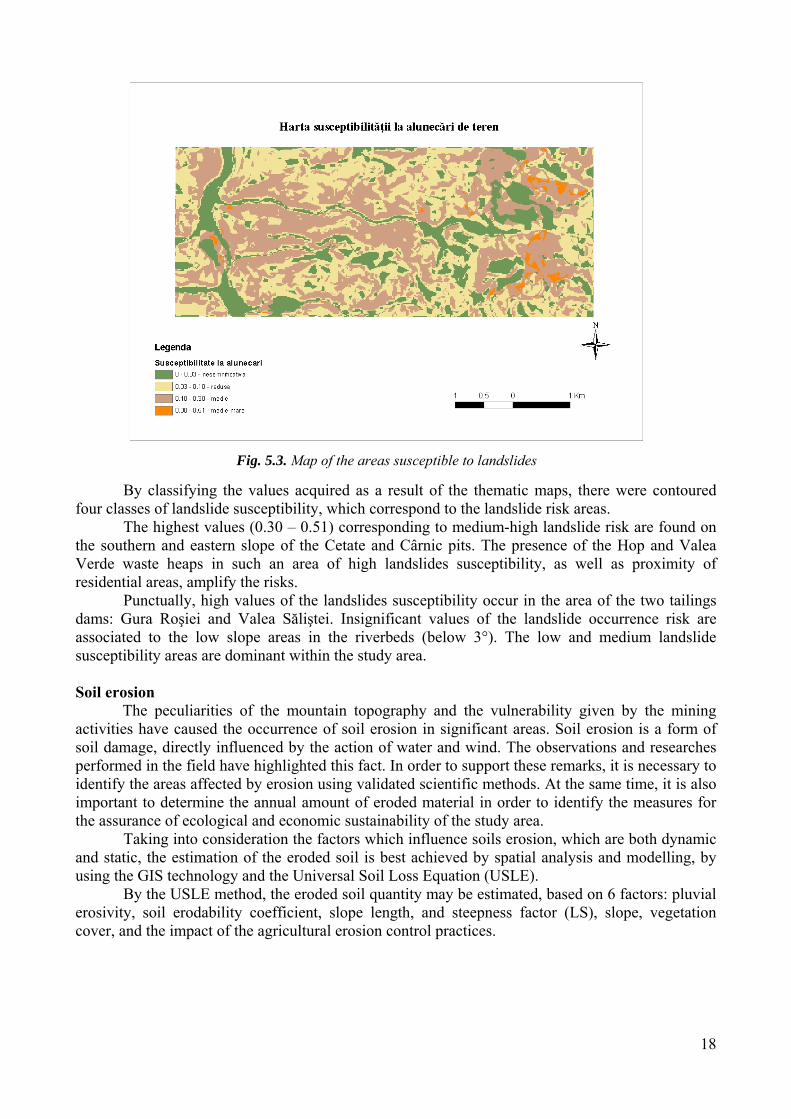
By overlaying the previously elaborated maps (geology, slope, climatic, land use, forestry, antropic) there resulted the map of landslides susceptibility which indicates the landslide risk areas (Fig. 5.3.). Identification of these areas is of utmost importance in mine closure planning, as it indicates very clearly the revegetation priorities, in view of ensuring land stability.
18
Fig. 5.3. Map of the areas susceptible to landslides
By classifying the values acquired as a result of the thematic maps, there were contoured
four classes of landslide susceptibility, which correspond to the landslide risk areas. The highest values (0.30 – 0.51) corresponding to medium-high landslide risk are found on
the southern and eastern slope of the Cetate and Cârnic pits. The presence of the Hop and Valea Verde waste heaps in such an area of high landslides susceptibility, as well as proximity of residential areas, amplify the risks.
Punctually, high values of the landslides susceptibility occur in the area of the two tailings dams: Gura Roşiei and Valea Săliştei. Insignificant values of the landslide occurrence risk are associated to the low slope areas in the riverbeds (below 3°). The low and medium landslide susceptibility areas are dominant within the study area.
Soil erosion
The peculiarities of the mountain topography and the vulnerability given by the mining activities have caused the occurrence of soil erosion in significant areas. Soil erosion is a form of soil damage, directly influenced by the action of water and wind. The observations and researches performed in the field have highlighted this fact. In order to support these remarks, it is necessary to identify the areas affected by erosion using validated scientific methods. At the same time, it is also important to determine the annual amount of eroded material in order to identify the measures for the assurance of ecological and economic sustainability of the study area.
Taking into consideration the factors which influence soils erosion, which are both dynamic and static, the estimation of the eroded soil is best achieved by spatial analysis and modelling, by using the GIS technology and the Universal Soil Loss Equation (USLE).
By the USLE method, the eroded soil quantity may be estimated, based on 6 factors: pluvial erosivity, soil erodability coefficient, slope length, and steepness factor (LS), slope, vegetation cover, and the impact of the agricultural erosion control practices.
19
Fig. 5.4. Digital Elevation Model of the study area Fig. 5.5. The LS factor determined for the study area
Fig. 5.6. Map of slopes in the study area Fig. 5.7. Land use categories in the study area
20
The USLE method used to estimate the eroded soil quantity is based on the following equation:
E=K*LS*S*C*Cs (eq. 5.3.) Where:
E – quantity of eroded soil (t/(ha/year)), K – climatic aggressiveness coefficient, LS –topographic index, calculated based on the slope length and steepness, S – soil erodability coefficient, C – coefficient regarding the land use, Cs – impact of agricultural erosion control practices.
Results and discussions Analyzing the map of soil erosion susceptibility in the study area (Fig. 5.8), one can notice
that the largest amounts of eroded soil are found in the mining exploitation area and on the high slope surfaces.
The correspondence between the quantity of eroded soil and the susceptibility to erosion was established according to the ICPA methodology, elaborated in 1986, as follows:
One can notice that areas with extremely high erosion are located on the south-eastern slopes of the Cetate and Cârnic hills, respectively the area of the Valea Verde, Hop, Cârnicel, Napoleon and Piatra Corbului waste heaps. The area is affected, beside erosion, by landslides, as it can be seen in Figure 5.3.
The western slope of the Cetate open pit is included in the “high erosion” susceptibility category. Within the entire area of the open pit and the surrounding area, the stabilizing vegetation cover is missing, and washing of soil under the influence of wind and water amplifies the erosion process.
Fig. 5.8. Map of the areas susceptible to erosion
21
5.3.2. Technological hazards and risks Risks associated to mining wastes storage facilities
Major risks related to mining wastes deposits have a double character: - Risks related to the generation of the acid mine drainage and the elimination of heavy
metals caused by the changes in relationships between minerals, surface waters, underground waters and atmospheric conditions (especially metallic minerals). Such risks could correspond to continuous long-term pollution which will not stop until total oxidation of wastes exposed to atmospheric conditions. The risk is the combination between the potential source of pollution with a transfer pathway and the existence of the receptors (including humans).
- Risks related to physical stability of the tailing dams and the waste heaps which could cause catastrophic accidents.
The combination between the two types of risks could cause serious problems to the quality of environment and human health. Studies have highlighted that environmental disequilibrium is mainly generated by the physical-chemical changes related to the extraction of minerals, than the chemical substances added in the process (BRGM, 2001). Physical and geochemical properties will affect the resultant risk. The instable or active waste deposits will present a much higher resultant risks, due to the higher potential to eliminate toxic substances. In the present case, none of the tailing dams is active, and the higher instability was observed at the Valea Săliştei tailing dam. 5.3.3. Natural disasters trigger technological accidents (Na-Techs)
Potential hazard existing on site are represented by: - existence of the waste disposal structures (waste heaps and tailing dams), - instability of the waste heaps, - lack of stabilizing vegetation, - generation of acid mine drainage. These hazard may be included in the following categories:
Hazards due to the intrinsic properties and characteristics: physical collapse, slope damage; subsidence, collapse of underground galleries.
Hazards due to exogenous factors and dislocation forces: erosion by the surface seepage with rich flows, forming torrents and rivulets; submination by a water course (leading to collapse); action of frost and accumulation of ice during the winter period; erosion by fine airborne particles.
This factors and forces are often modified or driven by biological factors, such as the presence or absence of the vegetation, and animal activity.
The contemporary knowledge recognizes that many hazards are hybrid, with natural and antropic components. Hybrid hazards or the so-called NATECH incidents (Natural Disasters Trigger Technological Disasters) have a natural component (earthquakes, floods, massive landslides, volcanic eruptions) and a technological one (any types of damage on an industrial site: pipes ruptures, tank ruptures, explosions, etc.). The risks are higher as these disasters have a higher possibility to exceed the national borders and affect the neighboring regions and countries (Şerban and Bălteanu, 2005).
We mention as NATECH type hazards in the study area, we mention: - Failure of tailings dams caused by natural factors: earthquakes, floods, landslides, with
catastrophic consequences for the local community. - Poor system of mine waters drainage in waste heaps and tailings dams, as well as the
inadequate manner of land use and stabilization of mining waste structures damage the environment and enhance the consequences in case of earthquake. The mining communities are subjected to technological risks, driven by natural hazard (earthquake).
22
- Foundation failure – exceed of the portent capacity of the natural land by the rapid overload, activation of landslides phenomena in the bottom layers, defective circuit of infiltration waters, alteration degree of the rocks, etc.
- Risk of exceeding the evacuation capacity of the waste heaps waters; - The breakage of the waste heap material due to some efforts occurring in exceptional
cases (earthquakes, pressures, etc.). - Landslide of waste heaps – natural disasters (earthquakes, heavy rainfalls followed by
floods, etc.) can cause landslides, thus amplifying the destructive effects. 5.5. CLOSURE RISK FACTOR CALCULATION MODEL FOR THE ROŞIA MONTANĂ MINING SITE 5.5.1. The Closure Risk Factor
In this chapter, the Australian model for the calculation of the Closure Risk Factor is applied in the case of Roşia Montană mining site in order to enable the outline of an overall image upon the risks that the closure of this site would induce. The model consists in the dividing the Closure Risk into several risks and quantifying these risks (Laurence, 2005). The decomposition of the Closure Risk Factor into several individual components enables and enhances the quality of the decision making process, as these are very friendly tools for the decision makers.
From the risk management point of view, the closure stage should be approached as strict as the other stages in the life of a mine. During all these stages, the major risks should be approached so as to reduce to a minimum or even to eliminate the threats to the normal development of the operations.
It is well known that there is no risk 0, which is why the goal is to minimize the value of the risk as much as possible, so as to be acceptable for the environment and the population. 5.5.2. Methodology
The Closure Risk Factor CRF is a qualitative and quantitative measure which includes all the
significant risk components of the mine closure (Laurence, 2006). The advantage of this calculation model is that it represents a simple analysis which enables the decision makers to simplify the complex mine closure model into numerous subcomponents. This systematic approach hinders the overlook of the critical factors in the closure process and facilitates the outline of the significant aspects.
The model can also be used to generate quantitative estimations of risk by designating weights to specific aspects in order to achieve the Closure Risk Factor (CRF). The model is useful for the performance of some comparative analyses between the closure risk factors from several mining sites of the same company, in order to facilitate the assignment of adequate resources to the sites with the highest risks.
The model is also useful for the governmental departments responsible with the regulation of the mining sector, as well as for the industry and authorities in order to achieve the best results in the mining industry. The value of this management tool consists in analyzing all aspects which influence or are influenced by the mine closure process and the assignment of weight coefficients to the relative importance.
The first step in estimating the Closure Risk Factor is to classify the major closure risks and divide them into smaller sub-categories, which enable a more detailed image of risks.
The classification of the risks associated to mine closure which is presented below pursues the classification model elaborated by professor David Laurence (2006), adapted to the situation of Roşia Montană, without pretending to be comprehensive. We start from the risk concept,
23
respectively from identifying the mine closure typology, in order to reach a decision making regarding the optimum closure model. Although this activity is subjective, we want to keep the balance between the two sides of risk approach: the alarmist one, which amplifies the risk and the optimistic one, which underestimates it.
In order to simplify the calculations, the presumption was made that a 1.0 factor is to be assigned to those primary aspects with small importance which present minor risks, and the value of 2.0 is to be assigned to extreme risks.
The next step consists in assigning importance coefficients to primary risks and then to specific aspects (secondary risks).
Table 5.2. Assigning weights to primary risks
Primary risks Weight (W) Environmental risks RE 1.9
Social risks RSoc 1.7 Safety and health risks RSH 1.6
Final land use risks RLU 1.5 Legal and financial risks RLF 1.2
Technical risks RTech 1.0
During the next stage, weights are assigned to secondary aspects within each of the primary risk. For example, if we consider the environmental component, waters represent the most important secondary element, followed by terrestrial systems, wastes and air. Thus, the weights will be assigned as follows:
Table 5.3. Assigning weights to secondary components of the Environmental Risk Secondary component Weight (w)
Water – RE water 1.9 Wastes - RE wastes 1.7
Terrestrial systems RE ter. sys. 1.6 Air RE air 1.1
The final step consists in identification and notation of specific risks or aspects of each
secondary component. These specific aspects will be weighted on a scale from 1 to 10. For example, for the secondary aspect water, the acid mine drainage potential will be weighted with the maximum value, while the heavy metal pollution potential will be 9. It is important to mention that there can be also assigned negative numbers to those specific issues which may have a positive impact in the mine closure process (i.e. an efficient program of monitoring the water quality, measures to stabilize the tailings dams and the waste heaps, etc.). These aspects will lead to a mitigation of the Total Closure Risk Factor.
The risk factor for the environmental component is obtained by the following equation: CRE = WRE x [wwater x (SRwater 1 + SRwater 2 + SRwater 3 + …) + wair x (SRair 1 + SRair 2 + SRair
3 + …) + wter.sys. x (SRter.sys. 1 + SRter.sys. 2 + SRter.sys. 3 + …) + wwastes x (SRwastes 1 + SRwastes 2 + S
Rwastes 3 + …)] Each major closure risk is calculated in this manner. The value of the Closure Risk Factor is
achieved by the sum of these values, expressed by a simple equation:
After achieving the Closure Risk Factor, this is compared to the risk classes in the following table:
24
Table 5.4. Correlation between the Closure Risk Factor and the complexity of mine closure
Value of CRF Description of risk Characteristics
> 2000 Extreme - environmentally and socially sensitive locations; subjected to past, extensive environmental abuse
1500-2000 Very high - proximity to extremely sensitive areas (world heritage); - long established mining towns; - sensitive commodities such as uranium, asbestos.
1000-1500 High
- vast surface mines in proximity to settled areas; - mines in developing countries; - gold or other mines with acid mine drainage potential; - any mines where mine is only employer in local community.
500-1000 Moderate - underground coal mines with pillar extraction; - hard rock mines using caving methods; - gold mines in remote, semi-arid regions
<500 Minor
- alluvial strip mines using chemical-free gravity treatment; - underground coal mines with first workings only; - clay quarry near regional centre – to be used as landfill or other purpose on closure; - small extractive operations.
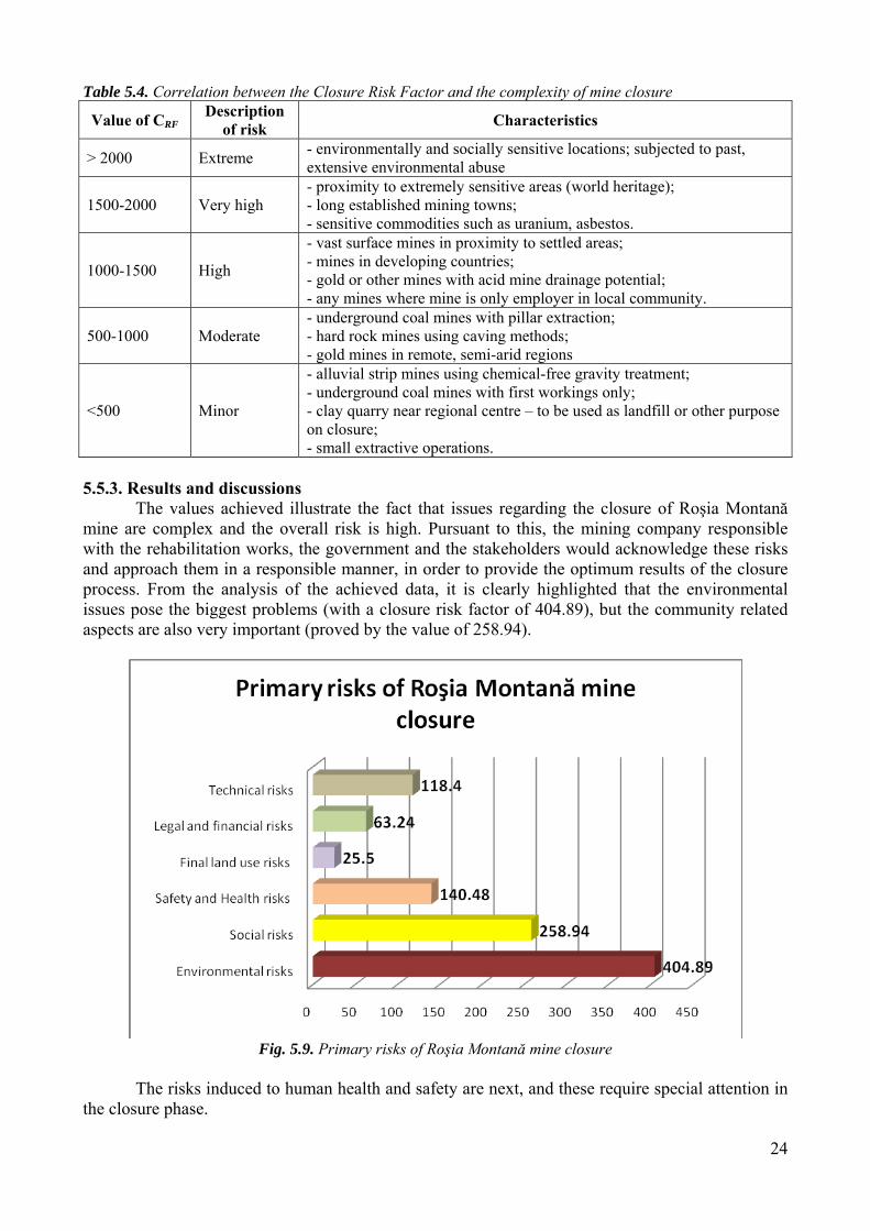
5.5.3. Results and discussions
The values achieved illustrate the fact that issues regarding the closure of Roşia Montană mine are complex and the overall risk is high. Pursuant to this, the mining company responsible with the rehabilitation works, the government and the stakeholders would acknowledge these risks and approach them in a responsible manner, in order to provide the optimum results of the closure process. From the analysis of the achieved data, it is clearly highlighted that the environmental issues pose the biggest problems (with a closure risk factor of 404.89), but the community related aspects are also very important (proved by the value of 258.94).
Fig. 5.9. Primary risks of Roşia Montană mine closure The risks induced to human health and safety are next, and these require special attention in
the closure phase.
25
All these are closely connected to the legal and financial risks, which, due to lack of funds and closure bonds, represent a reason of concern. These influence directly the technical risks, which have a pretty high value. This value shows the lack of coherent mine closure policies, the absence of an updated mine closure plan and a slow progress of the rehabilitation works.
The risks regarding the final land use are small, reflecting the value of the land and the relatively high possibility to use them in a productive manner, after the closure and rehabilitation of the site.
In conclusion, the total closure risk of Roşia Montană mining site is high, which highlights the importance of an efficient and successful closure process.
VI. ROŞIA MONTANĂ MINE CLOSURE CONCEPTUAL MODEL
The elaboration of the mine closure conceptual model intervenes as logical step after the aspects approached in the previous chapters: introduction into the mine closure concept, site description, impact and risk assessment, identification of impacts and risks from the closure point of view.
The present model is decision-making oriented, and it highlights the weaknesses and strengths of the various proposed alternatives. It can be considered by all decision makers in the assessment process of the possible options.
The following factors are considered within the outline of the model: Remediation criteria, Future land use, Decontamination degree of the land, Affected mining community, Reduction of the impact upon local economy. In building the rationale, the above order is observed, starting with the question: which will
the future land use be after its remediation? After making this decision, the degree of decontamination should be established for the future land use of the site.
Many industrial contaminated sites cannot be decontaminated to the desired extent, without significant restrictions regarding the use of land. There are used various categories of land: sensitive (their use as residential, recreational or agricultural areas, protected areas or sanitary areas, as well as the lands intended to such future uses) and less sensitive (all existing industrial and commercial uses, as well as lands intended to such future uses) (OM 756/1997). Sometimes, the complete removal of the polluting substances on a site may be unapproachable, from the technical perspective or of the associated costs. If the decontamination level does not enable the use of the site as a residential area, it can be cleaned in order to fulfill the requirements of the industrial uses, without any risks to the users.
The future use of the land will determine the standards that need to be respected within the remediation process and the associated costs. These costs should be accounted for by the future land use, and they are directly proportional to the level of decontamination.
In the worse case, the value of the land intended for the future use will be lost, and in the worse case, the contamination may extend, which will lead to the long term increase of the rehabilitation costs.
The local community is another important factor in the elaboration of the model and in the decision-making process. The validation of the model may take place only under the circumstances of an agreement from all stakeholders involved regarding the future use of the land. The impact assessment procedure in order to implement a certain project or the initiation of in an activity implies the population consultation by organizing public debates.
Finally, the model should respond to the exigency to avoid contaminants migration on the respective site. In accomplishing this purpose, the financial component has again a crucial role. The international experience in the field of ecological rehabilitation of the industrial contaminated areas
26
has shown that the long-term costs are much higher when the pollutants migrate, thus contaminating larger areas and exposing a large population to health risks (King, 2007).
All the above aspects focus on the recovery of resources such as lands, for agricultural or forestry uses, on the decontamination of the site and on the protection of water resources, with the final purpose of ensuring environmental stability and human health in the region.
The elaboration of the conceptual mine closure model at the Roşia Montană mining site occurs as logical step after:
1. The assessment of present situation, 2. The integrated analysis of the results achieved pursuant to the assessment, 3. The outline of the conceptual model (Fig. 6.1). The proposed conceptual model has two major components:
1. The ecological rehabilitation component 2. The remining component
The ecological rehabilitation implies the establishment of some remediation measures for each aspect, based on the pursued objectives, with the final purpose of achieving a sustainable system.
The remining concept needs to be defined from the beginning. By this concept it is to understand the reprocessing of mining wastes resulted from previous activities, in order to recover the remaining useful minerals. The technological progress in the field of extraction technologies during the last decades make it possible to recover these minerals in a profitable manner, especially in the context of precious metals prices raise.
Fig. 6.1. The diagram of the site ecological rehabilitation process (according to Glenn et al., 2006)
6.4.1. The ecological rehabilitation component
The rehabilitation and planning of the ecological rehabilitation are actions performed for the protection of the area quality by the management of the environment (reconversion, rehabilitation, transformation) and by the segregation of the antropic activities incongruous with the maintenance of it quality (Muntean and Baciu, 2000, cited by Muntean, 2005).
Identification of damaged lands intended to rehabilitation
Conceptual model
Integrated analysis of the assessment results
Present situation
Site planning according to the objectives
Objective of the ecological rehabilitation
Implementing
Monitoring
- description of the site
- impact assessment - risk assessment
27
The main sources of pollution on the site: - uncontrolled mining wastes storage on the transportation routes; - destruction of the vegetation cover; - removal of the soil top from large surfaces of land; - storage of resulting concentrates; - entrainment of dust particles from the waste heaps and tailing dams surfaces; - heavy metal (Cu, Fe, Zn, Mn) acid water flows from rainfalls on the site, in the area of the
waste heaps and tailing dams, with the potential to carry the wastes, - direct discharges of polluted waters into the natural surface water bodies (acid waters
resulted from the meteoric waters washing the surface of the waste heaps); - exfiltrations of polluted waters from the waste heaps into the underground waters; - emissions of suspended particles (carried away by the wind);
Pathways: soil seepage, migration of pollutants, wind, wind erosion, inhalation/ingestion, deposition on soil, deposition on plants, bioaccumulation, food chain.
Receptors: the population of the Roşia Montană commune, ecosystems in the study area, underground and surface waters, soils, properties.
The model is elaborated based on the risks identified on the site. The priorities pursued during the elaboration of the model are:
- high acid waters generation potential, - low stability of the mining wastes (from mine and flotation) storage structures, - soil damage due to the lack of vegetation and geomorphologic processes (landslides,
erosion).
6.4.1.1. Objectives increase of the physical and chemical stability of the tailing dams, improvement of the waste heaps stability by leveling, slope reshaping, terrace
formation, filling of the existing ravines, ensuring the stability against erosion, mitigation of the seepage degree, reduction of the effects generated by the acid mine waters and reduction of the
exfiltration flow, on site water management, application of biological recultivation measures (amelioration and revegetation, grass
Rehabilitation of the site consists in several activities: decommissioning of buildings and facilities on the site of the processing plant, neutralizing the surfaces where there where stored dangerous substances (fuels, acids,
reagents, explosives), stabilizing the embankments of the tailing dams, stabilization of waste heaps, stabilization of slopes, stopping the evolution of ravines, management of torrents, application of biotextile materials on the intensely eroded surfaces, application of the biomembranes for the waterproofing of dangerous wastes, revegetation of surfaces.
6.4.2. The remining component
The prolongation of the life cycle of the mining exploitation by the remining activity offers the possibility for sustainable development of the area. Remining represents a continuation of the mine life, which contributes to the achievement of the purposes of sustainable development and
28
represents a slower transition to the closure stage. It also prepares the community and the local economy, avoiding the social and environmental extreme shocks and may reduce the risks associated to the closure process.
By remining, it is to understand, in this context, the recovery of the precious metals content of left in the two tailing dams. It is thus reduced the pollution caused by the tailing dams seepage and the useful mineral substances are recycled.
The mining wastes in the Gura Roşiei nd Valea Săliştei tailing dams contain elements which could be useful for industry and which are obtained from other sources with environmental consequences and significant energetic consumption. At present, the processing of these useful elements is not profitable with the existing technologies, and the time of the remining initiation depends on several factors, among which:
- economic and environmental costs, - price of metals at that time, - environmental standards and current regulations, - evolution of the product life cycle, - results of the monitoring programs. The change of the price metals has a considerable influence on the increase of production
and of the interest in the processing of the contents of tailings. Figure 6.2 shows the products life cycle which can be prolonged by the reprocessing of
tailings and their reintegration in the raw matter flow.
Fig. 6.2. Prolongation of the mine tailing life cycle by remining
By the possibility of reprocessing the wastes, remining is an alternative applicable in the cae
of several mining exploitations in Romania, with large quantities of wastes stored in tailing dams and waste heaps.
By the time when the recovery of the useful elements in the tailing dams will be possible, it is necessary to ensure an appropriate level of safety at the two tailings dams, even these will be intended to be reprocessed in the near or further future.
The concentration of rehabilitation costs should be approached in a much larger framework, oriented towards development. There should be found and applied creative solutions for the amplification of the value potential of the site by changes at the level of policies and financial incentives. Examples of such economic activities are:
PROFITABILITY OF REMINING
CESSATION OF TAILING STORAGE
MINE CLOSURE PLANNING
29
the use of mining wastes as a resource for a more advanced extraction of the tailings (remining);
the use of the mining wastes as a resource for making alternative products; the conversion of the mining infrastructure for other uses and the conversion of the
specialized mining infrastructure; the periodic and effortless use of the land such as grazing and sylviculture.
Examples of initiatives which also include the social results within the environmental quality criteria are:
the use of the remanent features of the site in order to create new jobs at local level, for a longer period of time. For example: new development initiatives based on the remaining infrastructure and the land of the site such as wells and mounds, as well as the waste arrangement works (use of voids and/or underground works for piciculture or cultivation of mushrooms),
facilitation of the remining activities and the increase of their commercial attractiveness by the reduction of taxes, the change of legislative framework regarding the property right on lands and by the reduction of legal liabilities for new activities;
providing incentives for the remining operations which, in some cases, would be less expensive than the complete rehabilitation costs,
conversion of mining sites to uses of a higher value of land by the governmental implementation of some zoning changes. The rehabilitation costs may be partially recovered from the selling of rehabilitated land. Some lands could be designed to some other uses chosen by the government.
The key aspects of the remining project for the two tailings dams in Roşia Montană include: providing an efficient planning process for the accomplishment of sustainable
development principles, both during the remining activities, and at the time of site closure;
support and promote the rehabilitation activities for the damages inherited from previous extractive activities;
existence of institutional flexibility and of open attitude towards new remining projects.
6.5. THE COSTS ASSOCIATED TO THE MODEL
From the sustainable development point of view, the costs associated to the present model should include the three levels: environment, social and economic.
The prognosis of the rehabilitation costs several years before is an inexact science, as there are a lot of uncertainty sources and, generally speaking, the site conditions differ from those initially assessed (Miller and Phil, 2005).
The recent legislative regulations from several states stipulate that active mining exploitations prepare financial bonds to cover all the costs associated to the closure phase. The provided amount is based on a preliminary estimation of the necessary closure activities, based on detailed studies and analyses.
The establishment of financial closure bonds represents an important aspect, as the financial restraints often lead to the development of inadequate, incomplete or unprofessional closure and rehabilitation activities (Peck and Sinding, 2009).
In the case of the old mining exploitations in Romania, held by state operators, these financial bonds are absent; the issue of funds provision remains the responsibility of the state and the community. Regarding the costs associated to the environmental aspects of the mine closure, these are a little less than 1 million $ each, as compared to hundreds of millions $ for the vast lignite exploitations in Germany. The closure costs may range between 5-15 million $ USD for medium surface and underground exploitations, operational during the last 10-15 years and more than 50 million $ USD in the case of large surface exploitations active for more than 35 years, with large
30
tailing deposits. The presence of the acid rock drainage adds significant costs to the rehabilitation of waste heaps, tailings dams and to water treatment (Sundar Singh et al., 2006).
While the human-economic behavior is easy to measure in monetary terms, capitalization of the natural resources involves high challenges. However, the decision-making processes are based extensively on the cost-benefit analysis, this facilitating the founding of solutions to environmental problems.
The monetary valuation of the environmental impacts has become an essential aspect of any project development. In the case of mining closure process, the monetary valuation translates into the costs associated to the site rehabilitation. Although there are numerous difficulties related to the environmental damage assessment procedures, the monetary valuation techniques gain importance internationally, as they facilitate a better decision-making process.
At present, there are no strict methodologies for the elaboration of a cost-benefit analysis. The most simplified variant is the cash flow. This is approached in a manner that reflects the external effects of the developed activities. Among these effects, the monetary valuation of the environmental damage presents probably the biggest challenge (Damigos, 2006). In the next table, it is presented a simplified adaptation of the cash flow for the Roşia Montană mine closure conceptual model. Table 6.1. Adaptation of the cash flow to the conceptual model
The impact category Conceptual model –
remining
Conceptual model –
rehabilitation without
remining 1. Impact on employees
a. High over the media wages Positive Negative b. Expenses with the preparedness of
employees Positive Negative
2. Profits for the complementary goods Positive Negative 3. Profits for local providers Positive Negative 4. Impact on surrounding areas
a. Impact on the environment Negative Positive b. Impact in infrastructure Negative Positive c. Benefits for community Positive Negative
5. Impact on community a. Payment of taxes Positive Negative b. VAT and other taxes Positive Negative c. Incentives Positive Negative
One cannot speak of closure costs without approaching social costs which include the
material and spiritual damages population is subjected to, as a result of changes, but also as the result of the adverse management of these changes by the authorities, respectively of the financial efforts that the state is making for the limitation of these damages (Bran et al., 2004).
31
Fig. 6.3. The stages of the Roşia Montană mining exploitation life cycle and the potential rehabilitation costs (adapted according to Ontario Ministry of Northern Development and Mines, 1991)
Figure 6.3 illustrates the average potential costs in the rehabilitation period and post-closure
management of the mining site. Time A represents the start of the exploitation works when the first environmental
disturbance occurred. The exploitation phase AB represents the site development period, when the extraction of
minerals and storage of tailings takes place. Cease of mining activities and tailings storage takes place in point B. During the rehabilitation/closure period BC the rehabilitation takes place as preparation of
the site closure which takes place at time C. During the post-closure phase – CD, the monitoring and rehabilitation works continue until
all the requirements of authorities are fulfilled and the terms of the closure plan respected. The
Y2
Y1
Time (years)
A B C
X
Y1
Z1
Dexploitation – 2000 years Closure / rehabilitation Post - closure
Rehabilitation costs Social costs
Cos
ts a
ssoc
iate
d to
the
mod
el
X1
X2 Y2
Y1 Z1
Z2
The rehabilitation costs without reminingng Y2 Z2 Rehabilitation costs with remining
X1 Y1 X2 Y2 Social costs with remining
Social costs without remining
32
maintenance of the tailings dams and the monitoring of their effects on the environment may continue indefinitely. At the beginning of the mining operations there needs to be a rehabilitation liability. If progressive rehabilitation is not performed together with the exploitation works, the rehabilitation costs will considerably increase until point X, when the activity is ceased. The progressive rehabilitation during the operational period would have reduced the rehabilitation costs. At the same time, the non-observance of the norms regarding the pollution mitigation leads to the extension of the contamination, which inevitably leads to the long-term increase of costs associated to environmental factors rehabilitation.
In the case of the remining component, the high closure and rehabilitation costs in point X may be drastically reduced by progressive rehabilitation, while reprocessing the wastes in the tailings dams – costs Y2 < Y1.
There are three levels of potential costs in the case of remining, depending on the amplitude and success of the site rehabilitation.
These are illustrated in the figure as it follows: 1. The rehabilitation, monitoring and maintenance costs will grow, but much slower than the option
without remining. These will be paid by the company which performs the reprocessing of the mining wastes, while in the option without remining, these costs would be paid by the local community.
2. Increasing costs, but smaller will occur if progressive rehabilitation is performed during the reprocessing of tailings.
3. The continuous post-closure costs (monitoring and maintenance) will be reduced if efficient rehabilitation is performed during the mine closure process (Williams, 1997).
Analyzing the social costs, these will be considerably higher during the closure period if the remining option is not applied (X1). These will be much lower by the application of remining as there will be a continuation of the mining activities in the area. This is a preparation phase towards the final closure, and the social impact is much diminished at the level of the life standards. The application of some policies (programs) of social regeneration and reconversion with the pursuance of specific social objectives may avoid a collapse at the social level within the sustainable development of the mining perimeter.
The encouragement of new economic activities in the area by financing programme may lead to the economic increase of the entire area. 6.7. THE ASSESSMENT OF THE IMPACT GENERATED BY THE MINE CLOSURE MODEL
The impact assessment for the mine closure model was performed by adapting the Adkins-Burke check list to the present situation. The impact assessment methodology generated by the model is based on the assessment scale ranging between -5 (major negative impact) and +5 (major positive impact).
The weighting is performed according to the assessment of the model impact and of the effects (present or potential) which derives from its implementation. The major advantage of this method is the application and rapid interpretation by the assessors and decision-makers, and the main disadvantage is that it does not intercept the relationships between impacts (Muntean, 2005).
33
Table 6.2. The Adkins – Burke check list applied for 3 alternatives of action within the Roşia Montană mining perimeter (according to Muntean, 2005)
Buildings Physical damage 0 0 -1 Inhabitants’ health
Damage of population health
-4 +4 -1
Jobs Unemployment -5 -5 +5 Level of income Poverty -4 -4 +5 Standard of living
Decline of the community
-4 -4 +5
Road transportation
Intensification 0 0 +4
Total impact -59 36 13 Of the three alternatives considered, the smallest overall impact upon the assessed
components is induced by the alternative of the conceptual model with the remining option. From the environmental impact point of view, the application of the conceptual mine closure
model (without remining) is the best option. The main disadvantage of the application of this alternative is represented by the social and economic aspects, which, by the major effects that they induce, affect the very pillars of the sustainable development of the area.
The option “no action”, respectively the continuation of the present situation has acquired the lowest score, which states once more the negative impact of the present situation upon all the environmental factors.
The “remining” option presents advantages regarding the creation of new jobs, the level of income and the standard of living, being less unfavorable than the present situation.
In conclusion, the application of the mine closure model, with a possible remining option, at the appropriate time, would be the best solution for the studied perimeter. Hence, the environmental damages caused by abusive past mining could be repaired and the useful elements in the two tailings dams could be recover. One needs to mention that, when choosing the closure model, the main priority is the social component, as this is affected by the chosen option to the largest extent. Social impact could be attenuated by the professional reconversion programs for the inhabitants and the encouraging of new investment in the area.
34
CONCLUSIONS
There is a real need at the national level to elaborate mechanisms which ensures availability on funds to finance mine closure (financial bonds of mine closure) and the adoption of some environmental management principles vital for the efficiency of the closure process;
Taking into account the long history of the exploitation activities in the area, one can speak of a high degree of soil and water pollution, especially;
Often neglected, the social effects of the mine closure are in the worse cases, as serious as the environmental and economic ones. During the last years, countries such as Romania, the number of closed mining sites has exceeded that of the new mining projects, thus leading to massive unemployment among the miners;
Natural and technological risks were assessed after the detailed analysis of the area. These risks were approached from the mine closure point of view. By the outline of the landslides susceptibility classes, by the elaboration of the soil susceptibility to erosion, the performance of the semi-quantitative analysis of the risks, valuable results were achieved regarding the rehabilitation and closure priorities in the mining perimeter of Roşia Montană;
The Total Closure Risk quantified for the Roşia Montană mining exploitation present high values, with high risks. The environmental risks are the most significant, followed by the social, health, safety, and technical risks. The results acquired as a result of the application of the calculation model draw the attention upon these aspects, as well as the financial ones, which set the bases of an efficient mine closure process;
By the correlation between the Closure Risk Factor and the complexity of the mine closure, the value acquired for Roşia Montană is characteristic to the following exploitations:
vast mining exploitations in the vicinity of residential areas; mines in developing countries; gold mines or other mines with acid mining drainage potential; exploitations where mining is the only branch of activity in the local
community. The priorities of the mine closure process (considered also during the elaboration of the
model) should include: - the high potential of acid waters generation; - low stability of the mining waste disposal structures (mine and flotation
wastes); - soil damage due to the lack of vegetation and geomorphologic process
(landslides, erosion); - reduction of rehabilitation and closure costs; - attenuation of the closure impact on the social component.
The future use of land establishes the standards that need to be observed within the rehabilitation process, as well as the costs associated to the rehabilitation process. These costs need to be justified by the future class of land use on the site, directly proportional to the level of decontamination;
The elaborated model contributes to the improvement of the knowledge basis necessary to the decision-making process regarding the Roşia Montană mining site;
The results acquired after this study reflects the environmental issues specific to the mining perimeter and the specific mine closure issues that need to be considered in the future. Mine closure is an inevitable stage in the life cycle of a mine and early planning contributes to its final success.
35
ORIGINAL CONTRIBUTIONS After the researches performed within this PhD thesis, the following original contributions
could be highlighted:
the detailed presentation of the mine closure and planning for closure concepts, the way they are used in the experienced countries with good results in the field of mine closure and rehabilitation;
the pollution impact and risk assessment in the studied mining perimeter by the use of the integrated impact and risk assessment method, which is one of the most objective assessment methods;
matrix assessment of the mine closure impact upon the environmental components in the Roşia Montană mining perimeter by the rapid impact assessment matrix (RIAM);
identification of risks and hazards associated to the closure of the Roşia Montană mining exploitation;
elaboration of original studies regarding the environmental risks in the study area and their semi-quantitative assessment; by the application of a calculation model elaborated by Prof. David Laurence from School of Mining Engineering, University of New South Wales, Sydney, Australia which has previously been applied on several mining exploitations in Australia;
the performance of a comparative study between the value of the Closure Risk Factor acquired by the application of the model at Roşia Montană and those achieved in other mining exploitations where this model has been applied;
the outline of a priorities list regarding the primary risks of mine closure and of the specific aspects which will influence or be influenced by the closure of the mine;
the elaboration of a conceptual mine closure model for the Roşia Montană mining site with two major elements;
the assessment of the environmental impact in the case of the conceptual mine closure model and of the remining option by the Adkins-Burke check list method.
SELECTIVE BIBLIOGRAPHY
1. Allen-Gill, S., Borysova, O., (2007), Environmental security in transition countries: knowledge gaps, hurdles and effective strategies addresss them, In: strategies to Enhance Environmental Security in Transition Countries, Ruth N., Hull, Constantin-Horia Barbu, Nadezhda Goncharova (Eds.), NATO Security through Science Series – C: Environmental Security, Springer, p. 417-423. 2. Baciu, C., (2007), Impactul asupra mediului generat de drenajul acid al rocilor, Environment & Progress, D. Ciorba, Al. Ozunu, C. Cosma (Eds.), vol. 11/2007, Editura EFES, Cluj-Napoca, p. 19-24. 3. Balintoni, I., Vlad, Ş., (1996), Tertiary magmatism in the Apuseni Mountains and related tectonic setting, Studia Univ. Babeş-Bolyai, Geologia, XLI/1,Cluj-Napoca , p. 115-126. 4. Bordea, S., Ştefan, A., Borcoş, M., (1979), Harta geologică a României, scara 1:50.000, foaia Abrud, Inst. Geol. Geofiz., Bucureşti. 5. Bran, P., Bran, F., Roşca, I.Gh., Creţu, R.F., Manea, Gh., (2004), Dimensiunea economică a impactului de mediu. Studiu de caz Roşia Montană, Editura ASE, Bucureşti. 6. Burger, J., (2008), Environmental management: Integrating ecological evaluation, remediation, restoration, natural resource damage assessment and long-term stewardship on contaminated lands, Science of the Total Environment, Elsevier, 400: 6-19. 7. Damigos, D., (2006), An overview of environmental valuation methods for the mining industry, Journal of Cleaner Production 14: 234-247.
36
8. Ferreira, A.P., Cunha, C.L.N., Kling, A.S.M., (2008), Environmental Evaluation Model for Water Resource Planning. Study Case: Piabanha Hydrographic Basin, Rio de Janeiro, Brazil, Revista Eletrônica do Prodema - UFC, vol. 2, p. 7-18. 9. Forray, F., (2002), Environmental Pollution in the Arieş River Catchment Basin. Case Study: Roşia Montană Mining Exploitation, Studia Universitatis Babeş-Bolyai, Geologia, Special Issue 1:189-198. 10. Glenn, E.P., Waugh, J., Pepper, I.L., (2006), Ecosystem Restoration and Land Reclamation. In: Environmental and Pollution Science, 2nd Edition, Elsevier Science/Academic Press, San Diego, CA., p. 334–348. 11. Hambidge, H., (2000), Human Zinc Deficiency, J. Nutr., 130, 1344-1349. 12. Johnston P., Bakker N., Brigden K., Santillo D., (2002), Evaluation of Trace Metal Contamination from the Baia Sprie Mine Tailings Impoundment, Romania, Greenpeace Research Laboratories, Technical Note 05. 13. Jung, H.B., Yun, S. T., Mayer, B., Kim, S.O., Park, S.S., Lee, P.K., (2005), Transport and sediment–water partitioning of trace metals in acid mine drainage: an example from the abandoned Kwangyang Au–Ag mine area, South Korea, Environ Geol 48: 437–449. 14. King, W. C., (2007), Concepts in Environmental Security in Central and Eastern Europe—the Legacy of War, in: Environmental Security and Public Safety - Problems and Needs in Conversion Policy and Research after 15 Years of Conversion in Central and Eastern Europe, Spyra, W. and Katzsch, M. (Eds.), NATO Environmental Security Series, Springer, p. 161-169. 15. Laurence, D.C., (2005), Classification of Risk Factors Associated with Mine Closure, International Development Research Centre (IDRC), Mining Policy Research Initiative (MPRI), disponibil pe: http://www.idrc.ca/en/ev-84079-201-1-DO_TOPIC.html (accesat in septembrie 2006). 16. Laurence, D.C., (2006), Optimization of the Mine Closure Process, Journal of Cleaner Production 14, p. 285 – 298. 17. Luca, E., Roman, C., Chintoanu, M., Luca, L., Puscaş, A., Hoban, A., (2006), Identificarea principalelor surse de poluare din bazinul Arieşului, Agricultura – Ştiinţă şi practică, nr. 3–4: 59-60. 18. Macoveanu, M., (2006), Metode şi tehnici de evaluare a impactului ecologic, Ediţia a II-a, Editura Ecozone, Iaşi. 19. Miller, C.G., Phil, D., (2005), Financial Assurance for Mine Closure and Reclamation, International Council on Mining and Metals Report, Ottawa, Canada. 20. Muntean O. L., (2005), Evaluarea impactului antropic asupra mediului, Casa Cărţii de Ştiinţă, Cluj-Napoca. 21. Muntean, O.L., (2004), Impactul antropic asupra mediului înconjurător in culoarul Târnavei Mari (sectorul Vânători - Micăsasa), Ed. Casa Cărţii de Ştiinţă, Cluj-Napoca. 22. Orlandea, E., (2003), Metalogeneza asociată vulcanitelor terţiare din Patrulaterul Aurifer, Apusenii de Sud, România, Teză de doctorat, Universitatea Babeş-Bolyai, Facultatea de Geologie, Cluj-Napoca. 23. Ozunu, Al., Ştefănescu, L., Costan, C., Miclean, M., Modoi, C., Vlad, Ş. N., (2009), Surface Water Pollution Generated by Mining Activities. Case Study: Arieş River Middle Catchment Basin, Romania, Environmental Engineering and Management Journal, Iaşi, vol. Vol.8, No.4, July/August 2009, p. 809-815. 24. Peck, P., (2005), Mining for closure, policies, practices and guidelines for sustainable mining and closure of mines, United Nations Environment Programme (UNEP). 25. Peck, P., Sinding, K., (2009), Financial assurance and mine closure: Stakeholder expectations and effects on operating decisions, Resources Policy 4: 227-233. 26. Robu, B., (2005), Evaluarea impactului şi a riscului induse asupra mediului de activităţi industriale, Editura Ecozone, Iaşi. 27. Roosa, S.A., (2008), Sustainable Development Handbook, The Fairmont Press, 468 p. 28. Sasoon, M., (2000), Efective Environmental Impact Assessment, In Warhurst, A., and Noronha, L., (Eds.), Environmental Policy in Mining. Corporate Strategy and Planning for Closure, Lewis Publishers. 29. Semenzin, E., Critto, A., Marcomini, A., Rutgers, M., (2007), DSS-ERAMANIA: A Decision Support Site-Specific Ecological Risk Assessment of Contaminated Sites, In: Strategies to Enhance Environmental Security in Transition Countries, Ruth N., Hull, Constantin-Horia Barbu, Nadezhda Goncharova (Eds.), NATO Security through Science Series – C: Environmental Security, Springer, p. 201-214.