31
EARTH SCIENCES CENTRE GÖTEBORG UNIVERSITY B228 2000 RESHAPING AND RETREAT OF THE NATAL DRAKENSBERG ESCARPMENT, S AFRICA Peter Svensson Department of Physical Geography GÖTEBORG 2000
| Date post: | 16-Jan-2017 |
| Category: |
Documents |
| Upload: | doannguyet |
| View: | 218 times |
| Download: | 1 times |

EARTH SCIENCES CENTREGÖTEBORG UNIVERSITYB228 2000
RESHAPING AND RETREAT OF THE NATALDRAKENSBERG ESCARPMENT, S AFRICA
Peter Svensson
Department of Physical GeographyGÖTEBORG 2000


GÖTEBORGS UNIVERSITETInstitutionen för geovetenskaperNaturgeografiGeovetarcentrum
RESHAPING AND RETREAT OF THE NATALDRAKENSBERG ESCARPMENT, S AFRICA
Peter Svensson
ISSN 1400-3821 B228 Projketarabete
Göteborg 2000
Postadress Besöksadress Telefo Telfax Earth Sciences CentreGeovetarcentrum Geovetarcentrum 031-773 19 51 031-773 19 86 Göteborg UniversityS-405 30 Göteborg Guldhedsgatan 5A S-405 30 Göteborg
SWEDEN


ABSTRACTThe formation of the Natal Drakensberg has always fascinated people and it has been givennames as Quathlamba (Barrier of spears) in Zulu and Drakensberg (The dragons mountain) inAfrikaans. The reason for both of the names is easy to understand when you see the mountainformation rise into the sky. The kind of mountain formation that the Drakensberg is belongs topassive margins, with its origin in the break-up of Pangea. There is normally an escarpment atthese passive margins which follows the rift. On top of the escarpment there is a paleoplain.The paleoplain is a high plateau with a gentle slope in the opposite direction of theescarpment. The topography in the Natal Drakensberg is one of the most spectacular atpassive margins with a relative relief of 1000 m at places. This makes a difference comparedto the paleoplain with a relief amplitude of 300 m. This study concerns the escarpment and thepaleoplain nearby. The large scale development of passive margins is only described in theintroduction. The drainage patterns are used to understand the former geomorphology with, for passivemargins, typical drainage divide and river catchment. Field studies were made in threedifferent areas which were chosen with the help of topographic maps. These areas was airphoto interpreted and together with field mapping made out the base for the geomorphologicalmaps. The field studies developed a great interest in what role weathering plays. The fast weatheredbasalt has a greater chance to weather in the lower warmer and more humid areas. This causesundermining of the escarpment and increases opportunities for mass movments in the upperparts. The following features were observed in the field study at the escarpment; deepweathered ridges, deep weathering in roadcuts, tor formations, falls, slides, talus andsolifluction. A different environment was observed up on the top of the paleoplain with valleyasymmetry and valley side tors. Falls and slides were also observed in this area but not to theextent same as in the escarpment.

2

3
SAMMANFATTNING Drakensbergen i Sydafrika har alltid fascinerat människan och dess spektakulärageomorfologi har gjort att den givits namn så som Quathlamba (Barrier of spears) på Zulu ochDrakensberg som kommer från Afrikaans. Betydelsen av namnet Drakensberg förstår vi ävenpå svenska, när man ser denna drakryggsliknande bergskedja resa sig upp mot skyn. Drakensbergen hör till den typ av bergsformationer som tillhör passiva kontinentkanter medsitt ursprung i uppbrytandet av Pangea. Dessa bildar oftast ett escarpment som ligger längsmed uppbrytningsriften. Ovanför escarpmentet ligger en upphöjd denudationsyta som utgör enhögplatå som sluttar svagt åt motsatt håll. Topografin i Natal Drakensbergen hör till en av demer spektakulära bland escarpmenten med en höjdskillnad på upp mot 1000 m på sina håll.Detta står som en tydlig kontrast till högplatån där den relativa höjdskillnaden sällanöverstiger 300 m. Detta arbete avser att studera själva escarpmentet och paleoytan i dess närhet. Uppkomstenav Passive margins behandlas enbart i inledande text. Dräneringsmönstret har används för att förstå tidigare utseende av morfologin med förpassive margins typiska drainage divide och river catchment. Fältarbete utfördes vid tre studie områden som valdes ut med hjälp av topografiska kartor.Dessa områden flygbildstolkades och detta ihop med fältkartering var grunden för degeomorfologiska kartor som gjordes. I denna studie har stor vikt lagts vid vittringens roll i escarpmentet. Den snabbvittradebasalten får en större möjlighet att vittra i de lägre varmare mer humida delarna avescarpmentet. Detta orsakar en underminering av escarpmentet som därmed ger ökadeförutsättningar för massrörelser i de övre delarna. Vid fältstudien i escarpmentet observeradesdjupvittrade bergsryggar, djupvittrade vägskärningar, torbildningar, ras ,skred, talus,solifluktion. Uppe på paleoplanet observerades en annan miljö med dalassymmetri, dalsidestor men även ras och skred men i mindre omfattning.

4
INTRODUCTION ................................................................................................................................................. 5
THE GEOMORPHIC EVOLUTION OF PASSIVE CONTINENTAL MARGINS AND GREAT ESCARPMENTS.......................... 5
OBJECTIVE.......................................................................................................................................................... 6
REGIONAL SETTING OF THE STUDY AREA .............................................................................................. 7
THE GREAT ESCARPMENT AND THE PALEOPLAIN................................................................................................. 7THE NATAL DRAKENSBERG ESCARPMENT........................................................................................................... 8
Geology.......................................................................................................................................................... 8Topography.................................................................................................................................................... 9Climate in the past, and today ..................................................................................................................... 10
METODOLOGY ................................................................................................................................................. 11
RESULTS............................................................................................................................................................. 12
THE PALEOPLAIN NEAR SANI PASS..................................................................................................................... 12Drainage pattern.......................................................................................................................................... 12Mapping in the valley south of Sani pass..................................................................................................... 12
THE ESCARPMENT IN SANI PASS......................................................................................................................... 16Deepweathering in roadcuts ........................................................................................................................ 16
THE FOOTSLOPES OF SANI PASS ......................................................................................................................... 17Salt and Pepper............................................................................................................................................ 17
THE ESCARPMENT.............................................................................................................................................. 19Bannermans pass ......................................................................................................................................... 19
DISCUSSION....................................................................................................................................................... 23
DRAINAGE ......................................................................................................................................................... 23DEEPWEATHERING............................................................................................................................................. 23DEBRIS ORIGIN................................................................................................................................................... 24MASS MOVEMENT.............................................................................................................................................. 24
CONCLUSIONS.................................................................................................................................................. 25
ACKNOWLEDGEMENT .................................................................................................................................. 25
REFERENCES .................................................................................................................................................... 26

5
INTRODUCTION
The geomorphic evolution of passive continental margins and great escarpments There are two types of continental margins, active and passive. At all margins there are twoaspects of interest, the evolution of the landward side and the sedimentation offshore. Activemargins are associated with convergent boundaries (when two plates are moving against eachother) or transform boundaries (when two plates are moving along to each other). Passivemargins on the other hand are associated with divergent boundaries (when two plates aremoving away from each other) and has its origin in a rift (Tarbuck and Lutgens 1993). Passive margins are normally uplifted and tilted areas with their origin in the break-up ofPangea. The break-up of Pangea started about 180 My and many new continental marginswere created. A passive margin was created in southern Africa when it was separated fromAntarctica. Other well known passive margins in the world are Serra do mare in Brazil,Western Ghats in India, Great Escarpment of eastern Australia, the Scandies in Scandinavia(Lidmar-Bergström and Ollier 1996). Passive margins go through two steps of evolution : one rifting step generally characterisedby thinning of the lithosphere and probably associated with uplift of the landward side, andone subsidence step, probably later when the seaward side subside, as a consequence ofcooling and sediment loading, on the new continental edge. This kind of tectonic evolution is of great importance on a continental scale because it leadsto the establishment of new base levels for continental erosion. These kind of margins have amuch lower level of tectonic activity compared to the active (Summerfield 1991). Like most passive margins, southern Africa is edged inland by asymmetric marginal bulges.King calls these rims highlands (Ollier 1991). There are many possible reasons for the formation of marginal swells and for uplift ingeneral. Possible causes are (Ollier 1991):
1. Passage of the continental margin over a zone of anomalous high heat flow.2. Thermal expansion of a mantle plume beneath the continental margin.3. Isostatic response to erosion of the continental margin, especially by escarpment retreat.4. Uplift to compensate for subsidence offshore, caused in turn by loading of depositedsediments. Mechanisms 3 and 4 usually work together.5. Underplating of the continental margin by masses of light rock.6. Intrusion of large amounts of igneous rock.7. Delayed response to erosion of earlier orogenic belts.8. Subsidence of basins on each side of an originally high continental margin.
The uplift, rifting and continental rupture which leads to the formation of passive margins isof great importance for all attempts to understand the geomorphology on a continental scale.Many, but not all of the passive margins, have major escarpments (Ollier 1991). Our knowledge about vertical movements in passive margins refers to a large extent to thesediment at the edge of the margin. This sediment has been checked with seismic stratigraphytogether with borecores. They show a wedge with sediment that becomes thinner the furtheroffshore you get. The sediment is divided in synrift sediment which is deposited during therifting and postrift sediment which is deposited thereafter (Partridge & Maud 1987). The geomorphological evolution of escarpment in connection with passive margin tectonicsis one of the most debated issues in geomorphological theories. The escarpments forming the

6
margins of the rifts are thought to have migrated inland by nearly parallel retreat occuringfrom the late Cretaceous through the Cenozoic. Rates of retreat have been calculated to 1-2km/My (Selby 1993). Erosion by rivers combined with structural control explains a great dealand was postulated by (Rogers 1920). King´s (1962) parallel theory of retreat is of greatimportance for the understanding of the evolution of escarpments. There are four elements inwhat is called a standard slope. The four elements are crest (on top of the slope with noerosion), the scarp (the steep part with fast mass movement), the debris slope and on the endof the slope, the pediment (with slow mass movement). They are all natural products of thedevelopment of the slope. The full development of a standard hillslope depends on localcircumstances, if there is bedrock or/and the right kind of relief. The scarp retreats parallel toit self during the development of the slope. It has been shown, through observations, that thedebris slope are not growing upwards to cover the scarp. This shows that there is a balancebetween onload and removal of debris (Young 1972). It has been shown that cliff gradients and forms may be controlled by mass strength of theirrocks. All available data indicate that strength-equilibrium hillslopes are common onescarpments and in mountains where slope undercutting, talus and soil cover, inherited slopeforms, and structural controls are not dominant. For hillslopes to reach a state of strengthequilibrium they must be able to retreat sufficiently for the effects of any extraneous control,such as faulting and undercutting. Such retreat requires considerable periods of time forknown rock-slope retreat rates are of the order of 20-6000 m/My. Sites where strength-equilidrium slopes have been identified include mountain slopes in Antarctica, slopes on cliffsformed in relatively weak sedimentary rocks in humid areas of northern New Zeeland,inselbergs in the Namib desert, escarpments around the margins of southern Africa, slopes inthe Cape Mountains, and limestone in the Napier Range of northern Australia (Selby 1993). If strength increases or decreases into the outcrop then the hillslope angle will increase ordecrease in conformity as the slope retreats. This theory has, so far, been tested on equilibriumslopes on sandstones, tillites, shales, dolomite, marble, dolerite, gneiss, schist, basalt,pegmatite, and some granites; there was much variety in bedding and joint patterns. Aparticular example of undercutting is spring sapping which work headwards towards thesource of water. This situation has been recognized in many areas of soluble rocks (Selby1993).
OBJECTIVE This study is about passive margins and the Great Escarpment in South Africa. Field studieshas been made in the Natal Drakensberg and on the Lesotho plateau. The purpose of this study is to describe the geomorphology of the Drakensberg in order toexplain what kind of processes that are responsible for the development of the escarpment.The following questions have been tried to be answered by going through literature andlooking at the landscape in areas up on the Lesotho plateau and down in the Escarpment What kind of mechanisms are controlling the escarpment retreat? What role does weathering play and what role does mass movement play?

7
Fig.1 The paleoplain inthe fore ground, behindthat the escarpment, andfurther away thedissected lowland belowthe escarpment.
REGIONAL SETTING OF THE STUDY AREA
The Great Escarpment and the paleoplain The Great Escarpment in South Africa is one of the most extreme escarpments in the worldconnected to passive margins (fig 2). This especially concerns the Natal Drakensberg (fig 3 &4) with a relief exceeding 1000 m in places. An escarpment separates, in a distinct way,different geomorphological environments; paleoplain, escarpment and the highly dissectedtopography below.
In southern Africa the Great Escarpment is a well defined geomorphological feature, usuallyrecognised by that name, but occasionally as the Main Escarpment. Certain parts of theescarpment has local names such as Drakensberg. Nevertheless, many workers haveacknowledged a single major escarpment over extensive areas, suggesting the existents of asingle ´´ Great Escarpment`` in southern Africa. Though not invariably an escarpment in thestrict sense of the term, it always constitutes a sharp rise from the marginal parts of thecountry to the high interior plateau (King 1952). In southern Africa the Great Escarpment approximately parallels the coast all the way fromNamibia around the coast up through Transval. In the Natal area the Escarpment reaches analtitude of 3000 m and is unbroken. The high surface of southern Africa, inland of the Great Escarpment, is a prominentgeomorphological feature and has such names as the highveld or the interior plateau. It is anancient erosion surface, here termed paleoplain. This paleoplain is by no means perfectly flat,but the relief is low compared to that of the Great Escarpment and its footslopes. Thepaleoplain is a somewhat modified landsurface that existed before the break-up ofGondwanaland and corresponds to older surfaces. In comparison with much greater erosionconnected to the escarpment, the paleoplain is relatively stable (Ollier 1991).

8
The Natal Drakensberg escarpment Geology The Drakensberg is built up by sandstone, mudstone and volcanic rock of Mesozoic age.The volcanic rock overlying the sedimentary strata goes under the name Drakensberg Group.The sedimentary rock, beneath, goes under the name Stromberg Group. The Stromberg Groupis composed of three major formations, the Molteno (in the bottom), the Elliot (in the middle)and the Clarens formation (on the top). The Drakensberg Group has got different layers ofbasalts with some Dolerit dikes (Dangle et al. 1983).
SALT ANDPEPPER
0 5 km
BANNERMANS PASS
SANI PASS to PITSANENG PASSAREA
HUDSONSPEAK
Study sitesDrainagepattern
Escarpment
Cities
Fig.4 The region of the NatalDrakensberg were studies weremade and the field study areas(Topographic maps).
Fig.2 The drainage pattern and the Great escarpment of southernAfrica (Ollier 1985).
Fig.3 The drainage pattern, great escarpment, cities and study sites ofLesotho, Natal and Transkei (Southafrican roadmap).

9
This study only concerns the Drakensberg Group and the Clarens Formation. The flat lyingbasalts of the Drakensberg Group extend from the highest peak at the altitude of 3480 m downto approximately 1800 m in the scarp. It was formed in the late Triassic to mid Jurassic. Theunderlying Triassic Clarens Formation is a sandstone of aolian desert origin. The basalts in theDrakensberg Group goes under the name the Stromberg basalts and the sandstone in theClarens formation is formally known as the Cave sandstone because of its characteristic,deeply-pitted weathering surface (Dangle et al. 1983). Structurally, the Drakensberg is one of the most uncomplicated of the world´s mountainranges. There are no younger geological formations upon the basalt mass. It has always beenthe highest ground in Southern Africa (King 1974). The geomorphology of the NatalDrakensberg is structurally controlled with valleys developed in weakened zones and plateausdeveloped on more resistant layers in the bedrock.
Topography The topography in the Natal Drakensberg and the Lesotho plateau is varied. The relativerelief on the paleoplain is approximately 300 m consisting of rolling landscape with broadvalleys and convex mountains. Some of the valley floors are flat and up to 2 km wide. Thevalleys show asymmetry on the Lesotho plateau. Climatically controlled asymmetrical valleysare associated particularly with periglacial areas (Meiklejohn 1992). The altitude difference can be about 1000 m on a 3 km distance from the paleoplain to thebase of the escarpment. The upper part of the Great Escarpment consists of a 100 to 300 m high scarp whichcontinues down into debris slopes and smaller scarps. These slopes continue down to V-shaped valleys or lower lying plates (Topographic maps).
Valleys are sometimes cut into the cliffs and are connected to a drainage from the paleoplain.These valleys normally continue down the escarpment and create broad V-shaped valleysfurther downstream. Hills on the lower parts of the escarpment sometimes form plateaus, where more resistant,rock form caprock. The slopes on the lower part of the escarpment normally consist ofstraight debris covered slopes interrupted by ledges of resistant rock (fig 5).
Fig. 5 Photo of theescarpment with its steepsloopes, terraces (with moreresistant bedrock) andvalleys.

10
0 50 100 150 200 250 300 350 (km)
Altitude(m)
2 800
3 150
3 500
2 450
2 100
1 750
1 400
1 050
700
350
Fig.6 Profile of the passive margin in the area of Natal and Lesotho.
Climate in the past, and today The climate during the Natal Drakensberg history has been varied. Southern Africa had asignificantly warmer climate during the Cretaceous compared to today and compared to theaverage climate since then. This is the fact even since southern Africa had a 14°C lowerlatitude in the Cretaceous. The water temperature was 7° C higher in the southern pacificduring that time. There were high run-off rates with a high content of clay which indicatesenhanced weathering. This is supported by onshore evidence of deep weathering (Partridge1990). The Tertiary was characterised by a pattern of stepward cooling. The climatic gradient wassignificantly less, in the middle of the Tertiary, compared to today. New warmer periodsoccurred in Eocene and again in the beginning and middle of Miocene. There was a globalwarming in the late Pliocene and it was followed by a decline in temperature 2.4 My ago(Partridge 1990). The climate today in southern Africa is dominated by two subtropical anticyclones. TheSouth Atlantic anticyclone fluctuates in position off the east coast; the cell withdraws insummer and advances in winter. This anticyclone controls the general airflow over Natal.Over the subcontinent an anticyclonic circulation is the predominant feature. This weakens insummer and moves south through a few degrees of latitude. The essential features ofcirculation in summer and winter are similar, yet the seasonal variations of climate withrespect to rainfall and temperature are marked (Summer 1995). Today the total rainfall in the Natal escarpment area is 1000 mm to 1500 mm. The summermonth December-February gets approximately 200 mm/month while the rainfall in June andJuly is down to 10 to 20 mm/month. The mean monthly temperature in July varies between –0.5ºC on top of the escarpment (3000 m) and 2ºC down in the escarpment (1800 m). Themean monthly temperature in January varies between 11ºC on top of the escarpment (3000 m)to 15ºC in the escarpment (1800 m) (Summer 1995).

11
METODOLOGY The study started by selecting interesting areas in the Drakensberg. This was done byanalysing topographic maps and it was supervised by Ian Meiklejohn at University of Pretoria.Three areas were selected and are supposed to represent different geomorphological regions,the paleoplain, escarpment and footslope. The topographic maps that were used came fromGovernment printer South Africa, at the scale of 1:50 000. The maps that were used are2929AD Giant´s Castle 1986, 2929AB Champagne Castle 1978, 2929CB Sani Pass 1986,2929CA Sani Pass (West) 1988. One area was selected on top of the escarpment, on theplateau, to represent the paleoplain, south of Sani pass (fig 4). Another area was picked out inthe sandstone layers, Salt and Pepper, beneath the basalt (fig 4). The last area was selected inthe escarpment, Bannermans pass, to study escarpment retreat and slope processes (fig 4). The next step was to do geomorphological field mapping at the study sites. It was doneduring a two weeks period and done with the help of enlarged topographical maps (scale 1:10000), compass and Altimeter (thommen). Field notes were made and the areas were photodocumented. Deep weathered areas, outside the study areas, were also documented by notesand photos. Aerial photos were used after the field study to interpret larger areas and to get theright positions for the formations checked in field. Air photos from the South Africangovernment were used from air survey year 1996 and photos NR 3375 Kwa- Zulu Natal 985G1: 30 000 21W over Bannermans pass and NR 1595 28W, 2594 27W over Hudsons peak andNR 1601 28W over Salt and Pepper. Hand drawn maps were made with air photos as a baseand photos and notes interpreted into the maps. The hand drawn maps were then scanned andedited in Photo Shop. No attempt has been made to calculate optical errors in the air photossince I considered that kind of accuracy irrelevant for this study. An elevation database from USGS has been used to make a profile of the region. This wasmade in the GIS program Idrisi.

12
RESULTS
The paleoplain near Sani PassDrainage pattern Studies of aerial photos in the area between Sani pass and Pitsaneng pass (fig 8) show thatalmost all the drainage on the paleoplain runs directly from the escarpment towards the Oranjeand the Atlantic Ocean. There are three areas with wetlands close to the escarpment whichseem to form the water divide. At two places capture of this old drainage system isdocumented. The drainage pattern shows very little surface drainage towards the escarpment.The drainage pattern beneath the escarpment is denser than the drainage on the paleoplain. The present drainage divide is situated close to the escarpment. Apart from some captures,very little surface water is getting drained from the paleoplain towards the escarpment. Thedense drainage pattern, in the escarpment, could therefore come out of a ground water flow,from the paleoplain towards the escarpment. There are similar wetlands at water divides, atpassive margins, around the world (Ollier 1991).
Mapping in the valley south of Sani pass The mapped area lies within a valley west of Hudson’s peak, on the Lesotho plateau (fig 8 &9). The valley is assymetrical with steep south facing slopes and less steep north facing slopes.The drainage starts at the edge of the escarpment and flows down through the valley towardsthe Oranje river.
The valley is described in six smaller areas (fig 9).1. South facing slope (fig 7).The south facing slope runs straight in a west to east direction. The slope has three differentlevels with valley side tors. The valley tors probably correspond to layers in the basalt whichare more resistant against weathering. The valley side tors are mainly round weathered butsome parts are of sharper angular, which indicates falls. The area in-between the steeper partsare covered with grass slopes.
Fig. 7 South facing slope withvalley side tors and grassslopes in-between.

13
Drainage
Drainage divide
Water fall
Lake
Escarpment
Steep slope
Fig. 8 Map of the Sani pass area. Note how closely the drainage divide follows the escarpment.

14
Swam
p
Esca
rpm
e nt
Stee
p sl
ope
Dra
inag
e
Roc
k
Slid
e
Val
ley
side
tor
Bou
lder
s
Gul
ly
Fig.
9 M
ap o
f Hud
sons
Pea
k wi
th 6
smal
er a
reas
.1
22
34
5
6

15
2. The valley floor. There are two swamps at the bottom of the valley (eastern swamp at the centre of photo fig10). Gully systems have cut down into the swamps. The swamps consist of up to two metersof peat (Marker and Whittington, 1971). The gullies have probably developed because cattlewalk down to the creeks for a drink.
3. The southwestern part of the valley. The lower part of the north facing slope is covered with a thin layer of soil and there arevalley side tor formations on the upper part (fig 10). There is a slide tongue in the western partof this area. The mountain peak has steep outcrops but most is covered by vegetation. Manyterracetts are found all along the lower part of the slope. They are normally less than 0.5 mhigh and 1 m wide and they indicate soilcreep.4. The southeastern part of the valley. This is an area with rock pediment slopes and round weathered formations at the peaks. Aslides tongue starts beneath the peak. There are steep round weathered formations high up onthe slopes. The upper part of the valley are rock pediment slopes. The valley side towards theeastern peak has a large amount of rock pediment areas and terracetts that are less than 0.5 mhigh. There are also many drainage channels in this area. The eastern peak has an uncoveredround weathered rock surface. Beneath the peak weathering has formed an overhang.5. Cattle station area. This is a rock pediment area and there are three cattle stations with huts in the area.6. Flat valley which ends at the escarpment (fig 11). The drainage towards the Oranje river starts at the edge of the escarpment
Fig. 10 The north facingslope with the westernswamp beneath.

16
The bottom of the valley is wide and flat. The north facing slope shows us rock pedimentand mass movement. The south facing slope looks preserved with valley side tor and grassslopes in-between.
The escarpment in Sani passDeepweathering in roadcuts There is only one road going through the Natal Drakensberg to Lesotho, it goes through Sanipass. Several roadcuts occur between 2500 and 2300 m a s l. Most of the road cuts show signsof deep weathering and some of the roadcuts consist entirely of core boulders set in a matrixof decomposed rock (to the left fig 12). One roadcut reveals angular boulders surrounded bysoil. The debris beneath is rounded by weathering. One other roadcut shows a deep weatheredbedrock profile. Further down the road there is one roadcut with well jointed unweatheredbasalt overlying a less resistant basalt which is deepweathered (to the right fig 12).
Fig.12 Two photos of deep weathering. One with typically round weathered formations for the area(leftt) andthe other one with more resistant rock on top of the round weathered beneath(right).
Roadcuts in the Sani pass reveal that some basalt layers in the escarpment is highlyweathered, in some places into a saprolite with rounded core boulders. This zonal weathering
Fig. 11 The east end of thevalley which ends at the Greatescarpment.

17
suggests that some layers are more permeable and hence weathering will proceed at a fasterrate within these zones.
The footslopes of Sani passSalt and Pepper The mapped area is situated in the Clarens formation at an altitude between 1800 to 1300 ma s l at the footslope of the escarpment. The morphology of the area can be divided intoseparat geomorphic units discussed below with reference to figures on the map (fig 13).
1. This area is characterised by a flat sandstone plateau with a thin regolith cover. The barerock is shown in many places and there is a pan on the plateau with a water depth of 0.2-0.3 m(fig 14).
Steep slope
PanBoulders
Bare rockDrainagepattern
2087
2
1
3
3
4
Fig. 13 Map of Salt and Pepper, with four smaller areas.
Alluvial fan
N

18
2. Salt and Pepper (fig 15) are two large sandstone towers. They are 3-4 m in diameter andapproximately 5 m high. They are obviously remnants of a former sandstone plateau whichhave been dissected by erosion. Weathering has created overhangs on the steep walls beneath the peak, south of Salt andPepper (fig 15). There is a large amount of loose boulders indicating undermining, probablyby weathering. Small scale weathering, such as polygonal cracking and differentialweathering, are shown on boulders in the area.
Fig. 15 Salt and pepper (left), boulders and undermined rocks south of Salt and Pepper (right).
3. Gentle inter fluvial slope with sandstone ledges, or terraces, surrounded by debris coveredslopes, characterise the slope beneath the sandstone plateaus. The debris consist of silt. Someof the drainage pattern starts as pipes.4. The lowermost unit consist of large debris covered terraces and one alluvial fan whichcharacterise this area.
The sandstone area at the base of the escarpment consist of a landscape characterised bystructurally controlled sandstone plateaus, which are being slowly dissected by fluvialprocesses. This is evidential by the alluvial deposits found in the lowermost units. Thedissection and degradation of the plateaus are basically dependent on different weathering of
Fig. 14 Plateau formed on top ofmore resistant sandstone.
19
the sandstone. Enhanced basal weathering found on cliffs suggests that groundwater sappingmay be a possible cause of cliff retreat in this area.
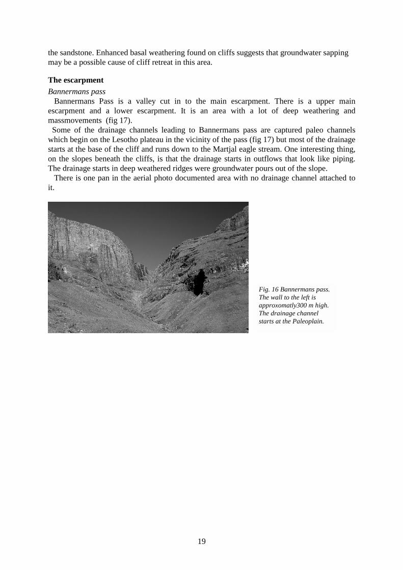
The escarpmentBannermans pass Bannermans Pass is a valley cut in to the main escarpment. There is a upper mainescarpment and a lower escarpment. It is an area with a lot of deep weathering andmassmovements (fig 17). Some of the drainage channels leading to Bannermans pass are captured paleo channelswhich begin on the Lesotho plateau in the vicinity of the pass (fig 17) but most of the drainagestarts at the base of the cliff and runs down to the Martjal eagle stream. One interesting thing,on the slopes beneath the cliffs, is that the drainage starts in outflows that look like piping.The drainage starts in deep weathered ridges were groundwater pours out of the slope. There is one pan in the aerial photo documented area with no drainage channel attached toit.
Fig. 16 Bannermans pass.The wall to the left isapproxomatly300 m high.The drainage channelstarts at the Paleoplain.

20
1
Rid
ge
Fal
l
Cav
e
Esc
arpm
ent
Ste
ep sl
ope
Dra
inag
e di
vide
Dra
inag
e
Slid
e
Bou
lder
s > 0
.5 m
Bou
lder
s < 0
.5 m
Tal
us
Tor
Wat
er fa
ll
Slu
mp
Sol
ifluc
tion
Hut
Pan
Fig.
17
Map
of B
anne
rman
s pas
s with
7 d
iffer
et a
reas
.
1
2
34
5
6
7
7

21
The different geomorphic units will be discussed below with numbers referring to the map(fig 17).1. The unit consists of the main drainage channel from Bannermans pass. The bed of thedrainage channel is originally flat with rounded debris, but smaller drainage channels are cutinto it (fig 18).
2. Waterfalls occur at different levels along a drainage channel which ends up in a ravine.Rock falls have developed a talus below a minor cliff. The talus is formed in between tworidges made up by in situ deep weathered basalt (to the left at fig 19).3. Caves have been formed at the base of a cliff. Most of them are just small hollows but oneis 5 m wide and 4 m high and 3 m deep and can be considered a real cave (fig 19). It lookslike the joints have been subjected to deep weathering, in the back of the caves, parallel to thefront wall.
Caves
4. The only tor formation in the mapped area. They look like fallen boulders from a distancebut are in situ weathered basalt forming a ridge shaped tor (fig 20).
Fig. 18 The main drainagechannel, leading fromBannermans pass, androundweatherd ridges to theright.
Fig. 19 Talus to the left andcaves to the right of the photo.
22
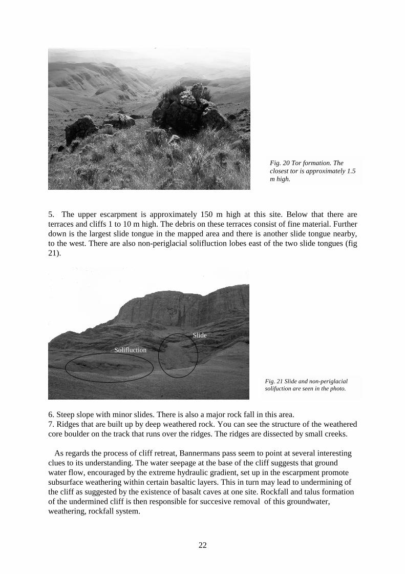
5. The upper escarpment is approximately 150 m high at this site. Below that there areterraces and cliffs 1 to 10 m high. The debris on these terraces consist of fine material. Furtherdown is the largest slide tongue in the mapped area and there is another slide tongue nearby,to the west. There are also non-periglacial solifluction lobes east of the two slide tongues (fig21).
Solifluction
Slide
6. Steep slope with minor slides. There is also a major rock fall in this area.7. Ridges that are built up by deep weathered rock. You can see the structure of the weatheredcore boulder on the track that runs over the ridges. The ridges are dissected by small creeks.
As regards the process of cliff retreat, Bannermans pass seem to point at several interestingclues to its understanding. The water seepage at the base of the cliff suggests that groundwater flow, encouraged by the extreme hydraulic gradient, set up in the escarpment promotesubsurface weathering within certain basaltic layers. This in turn may lead to undermining ofthe cliff as suggested by the existence of basalt caves at one site. Rockfall and talus formationof the undermined cliff is then responsible for succesive removal of this groundwater,weathering, rockfall system.
Fig. 20 Tor formation. Theclosest tor is approximately 1.5m high.
Fig. 21 Slide and non-periglacialsolifuction are seen in the photo.

23
DISCUSSION
Drainage The drainage pattern in the mapped areas are typical for that of a passive margin (Ollier andMarker 1985). This might not be strange since the Drakensberg seems to be one of the greaterexamples for how drainage patterns look at a passive margin. The main drainage dividefollows the escarpment except at a few places (fig 8). This is where the drainage has capturedthe old drainage pattern on the paleoplain. These areas are relatively small which suggests thatfluvial erosion does not play a major role in the escarpment retreat. If fluvial erosion would beof any significant importance much deeper valleys into the paleoplain would be expected.
Deepweathering The deep weathering looks more extensive in the escarpment compared to the paleoplain.The documentation of the roadcuts in Sani pass, shows deep weathering at the altitude of 2500m. There are deep weathered ridges down in the escarpment which you see nothing of at thefield study sight up on the paleoplain. The stripped rock slopes on the paleoplain, especially on the north facing slopes, show thattransportation of material has been faster than the deep weathering processes. This is no proofof inactive deep weathering, but it shows less deep weathering compared to the escarpment. One thing that could be of great importance for the retreat is that much water ougth to godown as ground water and pour out in the escarpment. The altitude difference creates a steephydraulic gradient which leads to effective groundwater flow which in turn may enhance deepweathering and slope processes (fig 22).
Since the escarpment retreat seems to be connected mainly with rock falls and since there arenot that many angular boulders on the slopes beneath, large amount of the rock fall debrisseems to round weather in the slopes. This together with the fact that there are deep weatheredridges in the escarpment make it seem like deep weathering has a lot to do with the possibilityfor material to be removed by creeks as finer material. Therefore the combination of runningwater and deep weathering seems to be the key for the escarpment retreat. The process of deep
Solifluctionand Slides
Ground waterflow Basalt layer
Coreboulders Solifluction
Fig. 22 The ground water accumulates in some basalt layers and increases the weathering. Theaccumulation of water in some layers also generates solifluction.

24
weathering makes it possible for the short distance fast flowing creeks to remove largeamounts of material.
Debris origin The large amounts of fluvial debris in Bannermans pass can also have a connection to deepweathering. The different basalt layers can have different resistance to deep weathering as isshown in the Sani pass road cut (fig 15) and in the whole landscape with resistant rockforming at different levels. Basalt in underlying position weathers due to groundwater flowand is removed while the more resistant basalt falls down due to undermining. This meansthat debris that looks fluvially transported, far from the cliff, can come from a place very closeto were it is now situated. The original position of a basalt boulder might be 200 m abovepresent location but only 100 m up towards the escarpment (fig 23).
Mass movement There is only one talus in the mapped areas, it is situated on the south slope of Bannermanspass. The debris slopes in-between the basalt layers are normally composed of finer material.This may suggest that weathering of the rock fall are faster than production of talus. Mass movements such as slides, falls and non-periglacial solifluction are mapped inBannermans pass. The solifluction in Bannermans pass might be associated with the groundwater being stopped by the basalt layers. The soil on top of the basalt layer gets a large watercontent and solifluction occurs in the escarpment. The same amount of mass movement and weathering are not seen up on the paleoplain. Thelarge scale geomorphology with its flat wide valleys and low altitude difference of thepaleoplain point at low geomorphic activity however valley asymmetry show signs ofperiglacial reshaping (Meiklejohn 1992).
Escarpment
Core boulders
Former position ofthe escarpment
Former position ofcore bolders
Fig. 23 Some of the core boulders in theescarpment might have there origin oldplateaus in the escarpment.

25
CONCLUSIONS The study demonstrates major differences between the landscape on the paleoplain and theescarpment. The paleoplain shows a mixture of very old landforms and younger geomorphologicalfeatures. The grand morphological appearance with low altitude differences and preserveddrainage pattern originate in the Mesozoic era. This has been changed to some extent intovalley asymmetry with rock pediment slopes on the north facing slopes. Not much hashappened since then in a grand morphological sense and only minor slides and falls haveoccurred. The escarpment on the other hand is undergoing rapid and extensive change in time. Thewhole lower part of the escarpment (footslope) is subjected to deep weathering enhanced bysapping of groundwater. The weathering processes makes it possible for running water toremove material from the footslopes. This in turn gives the opportunity for continuing massmovement to occur in the upper parts by undermining of the cliff. The mass movements in theupper parts of the escarpment are falls. Deep weathering occurs both in the bedrock and in thefallen debris. Talus probably does not develop because the supply of debris from falls is slower than theweathering of the debris.
ACKNOWLEDGEMENT I would like to thank my supervisor Mats Olvmo at University of Gothenburg, Departmentof Physical Geography, for the help during this study. I would also like to thank IanMeiklejohn at University of Pretoria, Department of Geography and Environmental science,for the help during field studies and helping me with practical details at University of Pretoria. All photos in this paper was taken by the author in March 1998.

26
REFERENCES
Dangle, R. V. & Siesser, W. G. & Newton, A. R. (1983). Mesozoic and Tertiary Geology ofSouthern Africa. A.A Balkema, Rotterdam. Netherlands.
Dyer, T. G. J. & Marker, M. E. (1979). On some aspects of Lesotho hollows. – Z. Geomorph.23: 256-270.
King, L. C (1974). Aspects of the high Drakensberg. S. Afr. Geog. J., 56, 128-136.
Lidmar-Bregstöm, K. & Ollier, C. D. (1996). The Great Escarpment of south Norway- Reviewand Synthesis. Unpubliched.
Marker, M. E. & Whittington, G. (1971). Observations on some valley forms and deposits inthe Sani pass area, Lesotho. S. Afr. Geog. J., 55.
Meiklejohn, K. I. (1992). Some aspects of valley asymmetry in the high Drakansberg. S. Afr.Geog. J., 74, 49-53.
Moon, B. P. & Selby, M. J. (1983). Rock mass strength and scarp forms in southern Africa. –Geogr. Annaler 65A: 135-45.
Ollier, C. D. (1991) Acient landforms. Belbaven Press, London. England.
Ollier, C. D. & Marker, M. E. (1985). The Great Escarpment of southern Africa. Z.Geomorph. N.F., 54, 37-56.
Partridge, T. C. (1990). Cainozoic environmental changes in Southern Africa. Suid-Afrikaanse Tydskrif vir Wetenskap., 86, 315-317.
Partridge, T. C. & Maud, R. R. (1987). Geomorfhic evolution of southern Africa since theMesozoic. S. Afr. Geog. J., 90, 179-208.
Rogers, A. W. (1920). Geological survey and its aims: and a discussion on the origin of theGreat Escarpment. – Trans. Geol. Soc. S. Africa 23: ( Anniversary Address).
Selby, M. J. (1993). Hillslope Materials and Processes. Oxford university Press Inc, NewYork. USA
Summer, P. D. (1995). Rates and controls of footpath erosion in giant´s castle game reserve,Kwa Zulu, Natal Drakensberg. University of Natal.
Summerfield, M. A. (1991). Global Geomorphology. Longman group Ltd, Essex. England.
Tarbuck, E. J.& Lutgens, F. K. (1993). The earth. Macmillan Publishing Company, NewYork. USA.
Young, A. (1972). Slopes. Oliver and Boyd, Edinburgh. Scotland.

27
Air photos. Chief Director of Survey and Mapping, Private Bag Mowbray. Printed by theGovernment printer, Private bag x 85 Pretoria.
Topographical maps. Published by the Chief Director of Surveys and Mapping, Private BagMowbray. Printed by the Government printer, Private bag x 85 Pretoria.


