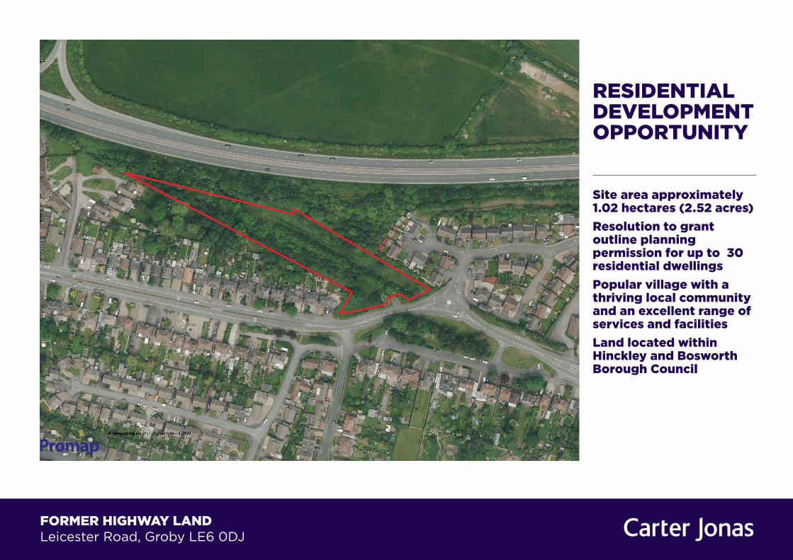
RESIDENTIAL DEVELOPMENT OPPORTUNITY Site area approximately 1.02 hectares (2.52 acres) Resolution to grant outline planning permission for up to 30 residential dwellings Popular village with a thriving local community and an excellent range of services and facilities Land located within Hinckley and Bosworth Borough Council FORMER HIGHWAY LAND Leicester Road, Groby LE6 0DJ
Transcript
RESIDENTIAL DEVELOPMENT OPPORTUNITY
Site area approximately 1.02 hectares (2.52 acres)Resolution to grant outline planning permission for up to 30 residential dwellings Popular village with a thriving local community and an excellent range of services and facilitiesLand located within Hinckley and Bosworth Borough Council
FORMER HIGHWAY LAND Leicester Road, Groby LE6 0DJ
THE OPPORTUNITY
The site is an undeveloped parcel of land with outline planning permission for up to 30 residential dwellings.
The site is being offered by informal tender. Offers for the freehold interest are invited by 12 noon Tuesday 29 August 2017.
LOCATION
Groby is a popular village to the north west of the Leicester with a population of approximately 6,796 inhabitants at the 2011 census, and a thriving local community.
The village enjoys a number of services and facilities comprising three primary schools, high school, a college, community centre, local retail facilities, and an employment area along Fir Tree Lane.
Leicester city centre is only some 3.7 miles (6 kilometres) to the east of Groby, and nearby settlements include, inter alia, Ratby, Glenfield, and Anstey which provide sources of employment, retail and leisure facilities.
PLANNING
The site lies within the jurisdiction of Hinckley and Bosworth Borough Council.
The site is offered for sale with the benefit of a resolution to grant outline planning consent under planning reference 15/00767/OUT for up to 30 residential dwellings.
All matters are reserved within the outline planning permission other than that of access.
THE SITE
The site extends to some 1.02 hectares (2.52 acres), is currently grassed, irregular in shape and constitutes former highway land. The topography of the site undulates and the site contains a number of trees. The existing trees on site are not subject to a tree preservation order.
The site is accessed off Leicester Road which is the main access road into the village of Groby. There is a footpath thorough the site, albeit it is not a public right of way.
The site is bounded by residential housing to the west, south and east. To the north lies the A50 beyond which the land is rural and used for mixed farming.
The Environmental Agency confirms that the site lies within flood zone 1 and therefore the risk of flooding is less than 1 in a 1000 year event.
TENURE
The freehold interest is being sold with vacant possession.
PRICE
Offers in excess of £900,000 (nine hundred thousand pounds) are invited for the freehold interest subject to contract.
The purchaser will be required to pay a 10% non-returnable deposit upon exchange of contracts.
VAT
The site has not been elected for VAT and therefore will not be charged on the sale price.
INFORMATION PACK
A dropbox for additional information has been created and access details are available from the agents.
Informal bids are to be submitted by 12 noon Tuesday 29 August. A copy of the bidding documents is included within the information pack. All bids to be submitted to Leicestershire County Council in an envelope provided by them.
• Informal tender: 29 August 2017
• Interviews: 4 September 2017
• Instruct solicitors: 11 September 2017
• Meeting with solicitors and principles: 25 September 2017
• Exchange contracts: 9 October 2017
• Completion 6 November 2017
Residential Development Opportunity
VEIWINGS
The site is not boarded up and viewing arrangement do not have to be made through the agents. A copy of the marketing particulars should be taken when viewing the site.
FURTHER INFORMATION
Should you require further information please contact either Nick Muncey on 01223 326817 alternatively you can email [email protected], or Richard Combes on 01223 346648 alternatively you can email [email protected].
LEICES
CLO
SE
MAR
STO
ND
RIV
E
BLUEBELL DRIVE
BUTT
ERCU
PCL
OSE
BLU
EBEL
LD
RIV
E
DAISY CLOSE
PRIM
RO
SE
FIELD COURT ROAD
DALB
YDR
IVE
PYMM LEY CLOSE
MLE
YLA
NE
GR
EYLA
ND
PAD
DO
CK
GR
EYC
LOSE
LEICESTER ROAD
PARKSIDE
A 50
79.1m
85.5m
93.7m
78.4m
79.5m
El Sub Sta
SM
88.0m
PRIM
RO
SE
BUTT
ERCU
PCL
OSE
BLUEBELL DRIVE
BLU
EBEL
LD
RIV
E
DAISY CLOSE
LEICES
CLO
SE
DALB
YDR
IVE
MAR
STO
ND
RIV
E
FIELD COURT ROAD
PARKSIDE
PYMM LEY CLOSE
GR
EYLA
ND
PAD
DO
CK
MLE
YLA
NE
GR
EYC
LOSE
LEICESTER ROAD
A 50
ElSubSta
El Sub Sta
SM
85.5m
79.1m
78.4m
79.5m
93.7m
88.0m
LB
PW
178
177
160
170
2
14
12
1
23
0
130
Shelter
150
134
12
1
7
9
4
120126
6
128
3
4
1
8
1
100
34
6
40
110
18
22 10
28
11
16
22
7
62
4
1
Gardens
37
6
10
Pymm Ley
177
52
1
16
11 15
5
7
19
6
2
10
8
3
1
Ppg Sta
5
1
11
3
133
113
125
101
3
69
90
70
1
89
1
65
80
68
65a
77
6
5
4
Shelter
1
17
3
16
Old School
32
PO 44
30
The
Hall
Sub Sta
34
58
57
56
55
10
56b56
a
ElSubSta
LB
PW
178
177
160
170
2
14
12
1
23
0
130
Shelter
150
134
12
1
7
9
4
120126
6
128
3
4
1
8
1
100
34
6
40
110
18
22 10
28
11
16
22
7
62
4
1
Gardens
37
6
10
Pymm Ley
177
52
1
16
11 15
5
7
19
6
2
10
8
3
1
Ppg Sta
5
1
11
3
133
113
125
101
3
69
90
70
1
89
1
65
80
68
65a
77
6
5
4
Shelter
1
17
3
16
Old School
32
PO 44
30
The
Hall
Sub Sta
34
58
57
56
55
10
56b56
a
By Suraj Dave 28 November 2013
Template: F:\GIS\PRINTING\TEMPLATE\2006A4land.wor
Scale 1:2500 @ A4 Landscape(Layer 98)UPRN 2651 Land off Leicester Road
IMPORTANT INFORMATIONOur property particulars do not represent an offer or contract, or part of one. The information given is without responsibility on the part of the agents, seller(s) or lessor(s) and you should not rely on the information as being factually accurate about the property, its condition or its value. Neither Carter Jonas LLP nor anyone in its employment or acting on its behalf has authority to make any representation or warranty in relation to this property. We have not carried out a detailed survey, nor tested the services, appliances or fittings at the property. The images shown may only represent part of the property and are as they appeared at the time of being photographed. The areas, measurements and distances are approximate only. Any reference to alterations or use does not mean that any necessary planning permission, building regulation or other consent has been obtained. The VAT position relating to the property may change without notice.Note: All plans not to scale