Universität Stuttgart ifp 3D Data Management in Urban Areas Results of the EuroSDR Survey: 3D Data Management in European National Mapping and Cadastral Agencies Volker Walter and Dieter Fritsch
Transcript
Un
ivers
ität
Stu
ttg
art
ifp
3D Data Management in Urban Areas
Results of the EuroSDR Survey: 3D Data Management in
European National Mapping and Cadastral Agencies
Volker Walter and Dieter Fritsch
Un
ivers
ität
Stu
ttg
art
ifp Contents
EuroSDR
Motivation
Questionnaire
Participants
(Selected) Questions and Answers
Discussion of the Results
Un
ivers
ität
Stu
ttg
art
ifp EuroSDR
The EuroSDR (European Spatial Data Research Network) is a
non-profit organisation linking national mapping and cadastral
agencies (NMCAs) with research institutes and universities for
the purpose of applied research in spatial data provision,
management and delivery.
Currently about 50 institutions from 17 countries throughout
Europe are represented.
Un
ivers
ität
Stu
ttg
art
ifp Motivation
In the last years, substantial technological progress in managing
3D geospatial data could be observed.
New technologies for the collection of 3D data (in particular airborne
and terrestrial laser scanning) as well as an increasing performance
of CPUs and GPUs allow for 3D data collection and handling on
standard PCs.
However, 3D Geographical Information Systems (GIS) are often
not fully capable to handle the requirements of managing 3D data.
3D data management and 3D analysis are in a state where 2D GIS
was 10 to 15 years ago.
In order to investigate this situation in more detail, we conducted a
survey to identify the state-of-the-art of 3D data management in
Europe.
Un
ivers
ität
Stu
ttg
art
ifp Participants
Our main target group of this survey were NMCAs. However, we
decided to open the survey also to other public and private
institutions in order to get a full overview of the situation.
32 institutions participated in the survey
10 NMCAs
8 Regional Mapping and Cadastral Agencies
7 City Surveying Offices
7 Private Companies
The answers of public institutions (25) were not much different to
the answers of private companies (7)
Significant different answers:
Working Areas (public institutions: data acquisition; private
companies: data processing)
Data Management (public institutions: less complex data models
but more complex software systems; private companies: more
complex data models but less complex software systems).
Un
ivers
ität
Stu
ttg
art
ifp Questionnaire
The questionnaire consisted of two parts:
The first part contained fourteen questions about the market and the
state-of-art of 3D data management.
These questions could be answered by selecting one or more
predefined answers.
Optionally it was possible to add free-text for additional information
or comments.
The second part provided six general questions about 3D data
management.
These questions could be answered with free-text.
…
Un
ivers
ität
Stu
ttg
art
ifp
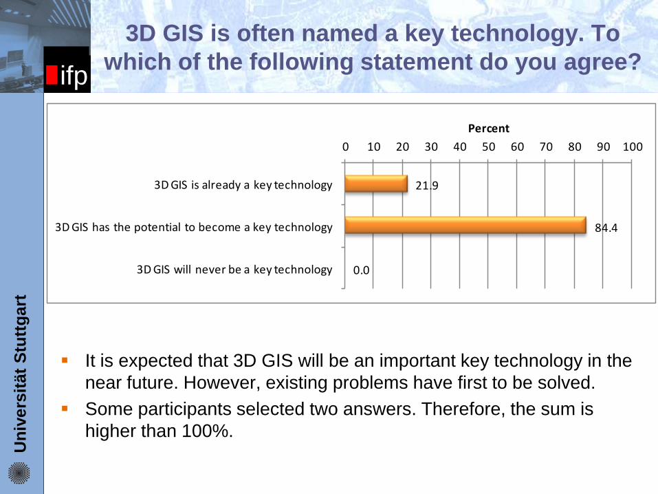
3D GIS is often named a key technology. To
which of the following statement do you agree?
It is expected that 3D GIS will be an important key technology in the
near future. However, existing problems have first to be solved.
Some participants selected two answers. Therefore, the sum is
higher than 100%.
21.9
84.4
0.0
0 10 20 30 40 50 60 70 80 90 100
3D GIS is already a key technology
3D GIS has the potential to become a key technology
3D GIS will never be a key technology
Percent
Un
ivers
ität
Stu
ttg
art
ifp
How will the 3D geospatial market (for hardware,
data, software and services) develop?
3,1
6,3
34,4
31,3
25,0
0 10 20 30 40 50
shrink
stagnate
grow slowly
grow medium
grow fast
Percent
Hardware: The market will ...
0,0
0,0
18,8
46,9
34,4
0 10 20 30 40 50
shrink
stagnate
grow slowly
grow medium
grow fast
Percent
Services: The market will ...
0,0
3,1
15,6
46,9
34,4
0 10 20 30 40 50
shrink
stagnate
grow slowly
grow medium
grow fast
Percent
Data: The market will ...
Un
ivers
ität
Stu
ttg
art
ifp
How will the 3D geospatial market (for hardware,
data, software and services) develop?
All market segments are expected to grow
Hardware is the market segment with the lowest growth expectation
The segments Data and Services are seen as the strongest segments
3,1
6,3
34,4
31,3
25,0
0 10 20 30 40 50
shrink
stagnate
grow slowly
grow medium
grow fast
Percent
Hardware: The market will ...
0,0
0,0
18,8
46,9
34,4
0 10 20 30 40 50
shrink
stagnate
grow slowly
grow medium
grow fast
Percent
Services: The market will ...
0,0
3,1
15,6
46,9
34,4
0 10 20 30 40 50
shrink
stagnate
grow slowly
grow medium
grow fast
Percent
Data: The market will ...
Un
ivers
ität
Stu
ttg
art
ifp
What are your major customers of
3D geospatial data?
The main customers are public institutions. Many public institutions
have a legal mandate to collect, process and provide 3D data.
Private companies represent at the moment only a small market
segment, but it is expected that this segment will grow in the future.
Private persons are at the moment and presumably in the near
future not an important clientele.
34,4
37,5
37,5
6,3
96,9
0 20 40 60 80 100
Small Companies
Medium Companies
Large Companies
Private Persons
Public Institutions
Percent
Un
ivers
ität
Stu
ttg
art
ifp
Are your customers aware
of the potential of 3D data?
The main answer to this question could be: “some are aware and
some are not”.
Some participants selected both “Yes” and “No”. Therefore, the sum
of both answers is higher than 100%.
It is necessary to invest more in marketing processes
53,1
56,3
0 20 40 60 80 100
Yes
No
Percent
Un
ivers
ität
Stu
ttg
art
ifp
Which software systems do you use
for the work with 3D data?
0 5 10 15 20 25
ArcGIS 3D Analyst (ESRI)
Microstation Bentley
LandXplorer
nova FACTORY 3D
Autodesk Map 3D
Global Mapper
GeoMedia Terrain (Intergraph)
inpho Software
Imagine Virtual GIS (Erdas)
SketchUp
SupportGIS 3D (CPA)
TerraExplorerPro (Skyline)
EspaSystem
3D Studio Max
CityGRID
Autodesk
Smallworld GIS
Tridicon 3D
own developments
Trimble DTMaster
Number
0 1 2
Trimble DTMaster
City Grid
QGIS
Geomedia Professional
Geomedia Grid
ACAD
TeklaGIS
VirtualCitySystems
Blender
3D WIN
Terrasolid
BAE Systems SOCET-SET
CityServer 3D
Stereo Analyst
1Spatial Radius Vision
Materialise
Autodesc Revit
Flaeder mouse
MicroDem
Novapoint Virtual Map
Rhinceros/Rhinoterrain
Number
Un
ivers
ität
Stu
ttg
art
ifp
Which software systems do you use
for the work with 3D data?
The 32 participants use 43 different software systems
The 10 NMCAs use 21 different software systems
The software market for processing 3D geospatial data is at the
moment very heterogeneous.
Many different software products are in use and very often one
specific product is only used by one or two institutions.
This leads to problems, because the different systems are often not
interoperable.
Problem: Interoperability
0 5 10 15 20 25
ArcGIS 3D Analyst (ESRI)
Microstation Bentley
LandXplorer
nova FACTORY 3D
Autodesk Map 3D
Global Mapper
GeoMedia Terrain (Intergraph)
inpho Software
Imagine Virtual GIS (Erdas)
SketchUp
SupportGIS 3D (CPA)
TerraExplorerPro (Skyline)
EspaSystem
3D Studio Max
CityGRID
Autodesk
Smallworld GIS
Tridicon 3D
own developments
Trimble DTMaster
Number
0 1 2
Trimble DTMaster
City Grid
QGIS
Geomedia Professional
Geomedia Grid
ACAD
TeklaGIS
VirtualCitySystems
Blender
3D WIN
Terrasolid
BAE Systems SOCET-SET
CityServer 3D
Stereo Analyst
1Spatial Radius Vision
Materialise
Autodesc Revit
Flaeder mouse
MicroDem
Novapoint Virtual Map
Rhinceros/Rhinoterrain
Number
Un
ivers
ität
Stu
ttg
art
ifp
Which 3D data standards do you use for
managing 3D geospatial data in your
organization?
23
22
19
14
10
9
8
8
3
2
1
1
1
1
1
1
1
1
1
1
1
1
1
1
1
1
0 5 10 15 20 25
3D-Shapefile
(3D) DXF
CityGML
KML/KMZ
3D PDF
3DS (3D Studio)
GML3
VRML
DGN
other: ASCII (XYZ)
GeoVRML
X3D
GDB
las
1Spatial GFO
XML
MaagisXL
fbi (Terrasolid)
CityGrid XML
RVT
DWG
OBJ
EsriGrid
ESRI Multipatch
skp
C4D
Number
Un
ivers
ität
Stu
ttg
art
ifp
Which 3D data standards do you use for
managing 3D geospatial data in your
organization?
The 32 participants use 27 different standards
The 10 NMCAs use 13 different standards
Situation similar to Software Systems
3D GIS is a “young” technology
23
22
19
14
10
9
8
8
3
2
1
1
1
1
1
1
1
1
1
1
1
1
1
1
1
1
0 5 10 15 20 25
3D-Shapefile
(3D) DXF
CityGML
KML/KMZ
3D PDF
3DS (3D Studio)
GML3
VRML
DGN
other: ASCII (XYZ)
GeoVRML
X3D
GDB
las
1Spatial GFO
XML
MaagisXL
fbi (Terrasolid)
CityGrid XML
RVT
DWG
OBJ
EsriGrid
ESRI Multipatch
skp
C4D
Number
Un
ivers
ität
Stu
ttg
art
ifp
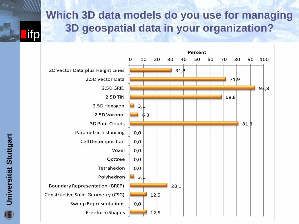
Which 3D data models do you use for managing
3D geospatial data in your organization?
31,3
71,9
93,8
68,8
3,1
6,3
81,3
0,0
0,0
0,0
0,0
0,0
3,1
28,1
12,5
0,0
12,5
0 10 20 30 40 50 60 70 80 90 100
2D Vector Data plus Height Lines
2.5D Vector Data
2.5D GRID
2.5D TIN
2.5D Hexagon
2.5D Voronoi
3D Pont Clouds
Parametric Instancing
Cell Decomposition
Voxel
Octtree
Tetrahedon
Polyhedron
Boundary Representation (BREP)
Constructive Solid Geometry (CSG)
Sweep Representations
Freeform Shapes
Percent
Un
ivers
ität
Stu
ttg
art
ifp
Which 3D data models do you use for managing
3D geospatial data in your organization?
2.5D hexagon
BREP
cell decomposition
CSG
2.5D grid point clouds
voxel
sweep rep.
2.5D TIN
octree
(x, y, z, α)
parametr. inst.
freeform shapes
3D TIN 2D + 1D 2.5D 2.5D Voronoi
Un
ivers
ität
Stu
ttg
art
ifp
Nearly all areas, where 2D geospatial data are used, are also potential
working areas of 3D geospatial data.
The simple reason for that is that our world is three-dimensional and
therefore people want to work with three-dimensional representations.
Word Cloud with 52 possible application areas of 3D data:
Which will be the main application areas of
3D geospatial data?
Un
ivers
ität
Stu
ttg
art
ifp
What are your major problems in the field of
3D data handling?
The most often named problems in the field of 3D data handling are:
Interoperability: Many different software systems are needed which are
often not interoperable.
Standardisation: Missing or inconsistent standards for 3D data.
Software: Existing software solutions are not efficient enough. The tools
and algorithms are not mature enough. The programs are difficult and
can be used only by experts.
Amount of data: The handling of large 3D datasets is difficult.
Integration: The fusion and handling of existing 2D data with new 3D
data is problematic.
Un
ivers
ität
Stu
ttg
art
ifp Discussion
3D data modeling and data handling is much more complex
compared to 2D data
The software market for processing 3D geospatial data is at the
moment very heterogeneous
This leads to problems, because the different systems are often not
interoperable. The same situation holds true for the standardization of
3D geospatial data
It is expected that 3D GIS will be an important key technology in the
near future. However, existing problems have first to be solved.
Un
ivers
ität
Stu
ttg
art
ifp Future Work
Research: there are still problems in the 3D world which are not
fully solved. For example:
2D data and 3D data integration
Integration of different 3D models
Parallelization on GPUs or multi-core CPUs
Handling of very large datasets
…
Development: Software manufacturers have to develop more
powerful software systems:
More functionality
Easier to use
Integrated workflows (Input, Management, Analysis and Presentation)
…
Standardization: Consistent standards and services are needed to
exchange and access 3D data
Un
ivers
ität
Stu
ttg
art
ifp Report
All results will be published in an official EuroSDR report