71
` Page i of 71 Review of Studies on URBAN FLOODS IN GUWAHATI From Flood Knowledge to Urban Action

`
Page i of 71
Review of Studies on
URBAN FLOODS IN GUWAHATI From Flood Knowledge to Urban Action

`
Page ii of 71
July 2014
Assam State Disaster Management Authority

`
Page iii of 71
Title: Review of Studies on Urban Floods in Guwahati from Flood Knowledge to Urban Action
Prepared by All India Disaster Mitigation Institute (AIDMI).
Supported by Assam State Disaster Management Authority (ASDMA).
© Assam State Disaster Management Authority, July 2014

`
Page iv of 71
Contents
Acknowledgements .................................................................................................................... v
Executive Summary ................................................................................................................... vi
Abbreviations ........................................................................................................................... vii
Chapter 1: About Study .............................................................................................................. 8
Chapter 2: Summary Note on Core Studies Related to Guwahati City ................................... 10
Chapter 3: Findings .................................................................................................................. 35
Chapter 4: Recommendations ................................................................................................. 42
Chapter 5: Possible Way Ahead, Risk Reduction Measures .................................................... 49
Chapter 6: Conclusion .............................................................................................................. 53
Annexure: 1 List of Documents Reviewed ............................................................................... 54
Annexure 2: Glossary ............................................................................................................... 56
Annexure 3: Hazard Vulnerability Profile of Various Municipal Wards .................................. 58
References ............................................................................................................................... 71

`
Page v of 71
Acknowledgements
‘The Review of Studies on Urban Floods in Guwahati: From Flood Knowledge to Urban Action’ was conducted for ASDMA (Assam State Disaster Management Authority) by AIDMI (All India Disaster Mitigation Institute) with the objective to carry out a review of various studies on floods that have affected the city of Guwahati. This review seeks to understand the extent of the vulnerability of Guwahati to floods (especially flash floods) and the nature of their varied impacts on the city. This review will cover the disaster related risks in Guwahati and also account for the impacts of climate change on the risk profile of the city. The review will also reflect the list of findings and suggestions in terms of two timeframes – short and long term. The purpose of this review is to turn knowledge into action. Thus, this is not an academic review but an action oriented one. AIDMI would like to thank everyone whose efforts helped us to successfully conduct and finish this review. We sincerely thank Shri Ajay Tiwari, CEO, ASDMA for supporting the study at right time with purpose of turning knowledge into action. We would like to express our gratitude to Ms. Nandita Hazarika, Deputy Secretary and SPO, ASDMA for constant support and guidance to keep the study on track. We are also thankful to ASDMA team for providing useful resources to review under the study. We thank Shri Dayaram Raj Bangshi, ADC (GMC); Mr. Dilip Pathak (Chief Engineer, GMDA); Dr. Sanjay Kumar Sharma (Scientist, Centre for Flood Management Studies); Dr. Arup Kumar Sharma (Head, Dept. Of Civil Engineering, IIT Guwahati); Mr. Anuradha Dutta (SPADE NGO); Mr. Nibaran Barua, Head, Dept. of Design (Water resource department); Mr. Kalyan Das, PhD - Associate Professor (Omeo Kumar Das Institute of Social Change and Development); Mr. Muktaram Deka and Mr. Ranjan Borah (ASDMA); Mr. Kaustav Talukdar (DDMA, Kamrup –Metro; and Dr. Hariprasad Sharma (Head, Dept. of Environmental Science, Guwahati University) for their inputs and support in providing useful resources on Guwahati flood. Sincere thanks to Mr. Mihir R. Bhatt, AIDMI for his guidance and inputs in the study. AIDMI team - Mr. Aditya Jain and Mr. Vishal Pathak conducted the study; Mr. Ennio Picucci and Mr. Gautam Bhut assisted in the identification of different studies to review under this study; Mr. Manish Patel supported in the design of the report.
All India Disaster Mitigation Institute
July 2014

`
Page vi of 71
Executive Summary
A paradigm shift in understanding the human civilization in the context of risk has opened up avenues for getting deeper dives in the ocean of knowledge. When specific issues like that of recurrent flash floods in Guwahati city of Assam are looked at from the perspective of constant change in its nature and magnitude, a debatable range of causes and recommendations can be seen. This ocean of knowledge is huge which different persons, organizations and entities have tried to explore to give their perspectives and opinions for the ultimate solution. It was realized that this knowledge can be of great value and will be more logical than conducting a new study for some newer solutions. The Assam State Disaster Management Authority (ASDMA) having this broader realization assigned the All India Disaster Mitigation Institute (AIDMI), Ahmedabad- the task of reviewing the major studies that had been conducted so far on Guwahati flash floods and to bring the recommendations under one logical umbrella so that unified and inclusive action can be initiated taking into account different sectoral perspectives reflected through each study that had been conducted and completed. The objective of the study was to find out studies on flash floods in Guwahati with specific attention to disaster and climate change risk related issues and to compile their findings and recommendations under one umbrella that exhibits short term and long term actions. However, as mandated this was not meant for academic purposes but rather for simplifying and defining unified and inclusive action points for bringing a solution to this problem. The process for conducting the study started with defining the report structure, finalizing the action plan, visiting Institutions and collecting research reports and documents, finalizing at least 25 documents to be reviewed and studied, preparing draft report based on the review and sharing with ASDMA for comments and finalizing the report. The structure of this report will at the outset orient the reader with background of the study with objective, methodology and process, summary of findings of the studies reviewed, recommendations under short term and long term implications and possible risk reduction measures. It also includes list of the studies reviewed and other references consulted for the study along with a glossary of terms used. The reader after going through the report may be able to synthesize the efforts made and may be able to develop a perspective including more practical, feasible and logical regime of solution. The overarching conclusion of this report is that multiple stakeholders will have to initiate action as recommended and should have to work out an integrated action plan to accomplish the objective. Such a study opens up our thinking to cover broader views cutting across sectoral perspectives and to bring a holistic approach of dealing with larger issues like the floods in Guwahati city. It is expected that this report will help in generating consensus among all the relevant stakeholders to work out holistic solutions to the challenges of floods in the city of Guwahati.

`
Page vii of 71
Abbreviations AIDMI All India Disaster Mitigation Institute ASDMA Assam State Disaster Management Authority ASDMP Assam State Disaster Management Plan AUWSSB Assam Urban Water Supply and Sewerage Department CBUD Capacity Building for Urban Development CDMP City Disaster Management Pan CWC Central Water Commission DDRIC District Disaster Response and Information Centre DEOC District Emergency Operation Centre DM Disaster Management DPR Detailed Project Report DRIC Disaster Response and Information Centre EOC Emergency Operations Centre ESF Emergency Support Functions EWS Early Warning Systems FCD Flood Control Department FLEWS Flood Early Warning Systems FSI Floor Space Index GIS Geographic Information System GMA Guwahati Metropolitan Area GMC Guwahati Municipal Corporation GMDA Guwahati Metropolitan Development Authority HRD Human Resource Development IPCC International Panel on Climate Change ISRO Indian Space Research Organization JNNURM Jawahar lal Nehru National Urban Renewal Mission MoHUPA Ministry of Housing and Urban Poverty Alleviation MoUD Ministry of Urban Development NDMG National Disaster Management Guidelines NESAC North Eastern Space Applications Centre NGOs Non-Governmental Organizations PHE Public Health Engineering PWD Public Works Department SDMG State Disaster Management Guidelines SDRF State Disaster Response Force SOP Standard Operating Procedures TandCP Town and Country Planning ULB Urban Local Body UNDP United Nations Development Programme
`
Page 8 of 71
Chapter 1: About Study 1.1 Background The city of Guwahati is located at the banks of the river Brahmaputra and several of its tributaries pass through the city. Urban growth in the city of Guwahati has been rapid, with uncontrolled development activities. These activities have had a detrimental impact on the ecology and environment of the city. The city is surrounded by wet lands that under threat due to the encroachment and unplanned urban development of the city. The city is prone to floods and landslides and is located on the earthquake prone (zone V) belt. In addition to being vulnerable to these natural hazards, the city of Guwahati and is frequently affected by seasonal flash floods, which are not entirely caused by natural factors alone. There are many sectors which are directly related with the resilience of Guwahati city against floods and their related impacts. Following are the key sectors that should be studied to understand the risk profile of the city for devising suitable strategies for resilience. These include, housing and urban planning; urban infrastructure and services (water supply, sewerage, natural and storm water drainage, solid waste management, electricity, health); informal settlements and slums; poverty and livelihood; ecosystems and land-use; emergency response capacity. Based on the above-mentioned situation (hazards and vulnerabilities), number of agencies (government, humanitarian and development) several experts have conducted studies on or linked with Guwahati and floods. These studies differ in their scope, timeframe and focus on different aspects such as socioeconomic factors, climate change, city development plans, disaster management planning, focus on single or multiple hazards etc. These studies reflect useful and micro level findings that are relevant to Guwahati and the surrounding areas. There are different studies which reflect the same findings with minor changes in the recent development of new vulnerabilities. Instead of conducing new study, it is better to a conduct review of studies that focus on Guwahati and floods. This serves as the rationale behind conducting this study. The exercise is to bring all the flood study works in one place and review the same for arriving at the short term and long term measures for Guwahati for finding a solution to the problem related to risk of floods in the city. 1.2 Objective The objective of the task is to conduct a review of flood studies conducted for Guwahati which coveri disaster risk related issues including the risk related to climate change and different vulnerabilities that triggering the impact of floods. The review will also reflect the list of findings and suggestion in terms of two timeframe – short and long term. The purpose is to turn knowledge into action. This is not an academic review but an action oriented review.

`
Page 9 of 71
1.3 Process
No. Step Outputs Deliverables
1 Outline of the study report
Report structure is reviewed and ready to use
1. List of studied documents
2. Report sharing findings and suggestions with focus on Guwahati and floods.
2 Meeting with ASDMA Plan of action
3 Visit to different institutions in Guwahati
Updates in list of documents
4 List of identified studies/ report to review
Minimum 25 documents identified to review (refer to Annexure 1 for list of documents and list of reference)
5 Draft report for comments
Complete draft report with findings in two time frame – short and long term
6 Meeting with ASDMA Comments from ASDMA
7 Final report Incorporation of comments 1.4 Scope and Limitation This study is focussed on bringing out action oriented findings from the already done planning and research work by various sectors like govt agencies, humanitarian groups, research scholars, academic institutes etc. The field of study was limited to recent documents and research works conducted on floods in Guwahati City, which has now become a common scenario every monsoon season. The city experiences severe impacts of flash floods which are triggered by inadequate civic amenities and negligence of existing natural drain basins. Within a limited time constraint, refining the main findings from several reports and studies was carried out addressing the key sectors which affect the resilience capacity of Guwahati City. The recommendations are given in two time frames of short term and long term measures covering both structural and non structural aspects of intervention.

`
Page 10 of 71
Chapter 2: Summary Note on Core Studies Related to Guwahati City 2.1KeystudiesThe North Eastern region of India is extremely vulnerable to natural hazards like earthquakes, floods, landslides etc. Every year during the monsoon season, the region experiences worst fury of nature in the form of Brahmaputra River flooding and erosion along its banks, devastating large areas of habituated landform and damaging agrarian lands, especially Guwahati city experiences its worst impact in theform of flash floods every year. Several studies had been done on the impacts and effects of floods in the city and its environs. Guwahati being the largest urban centre and a hub of major activities in the region faces most severe impacts of these floods. A compilation of reports addressing important issues and their possible remedial solutions is provided here which can be extremely helpful in planning for long lasting flood mitigation process in Guwahati city. I. FloodHazardZonationbasedonGIS and remote sensingpreparedby
NESAC(NorthEasternSpaceApplicationCentre)Background: Urban flooding is one of the most recurrent hydro-meteorological disasters presently in the world. A sizeable portion of the world’s population suffers from floods every year in major towns and cities. Conveyance of floodwaters in wash corridors and arroyo floodplains that were once predominantly overland sheet flow or flow in rills and gullies, are now obstructed by houses, fences, small buildings, streets, and other obstructions inhibiting their free flow . Guwahati city situated in the north-astern state of Assam is fast becoming one such victim of flash floods that occur due to unplanned growth. Traditional one-dimensional backwater models are inadequate to predict the unconfined flow behaviour in such urban environments like Guwahati and if used, require too many assumptions regarding flow diversions and potential confinement. Two-dimensional flood routing programs can efficiently simulate these complex urban flood environments with accuracy and detail.
Image 5. Guwahati city and its environs, Source: http://nesac.gov.in
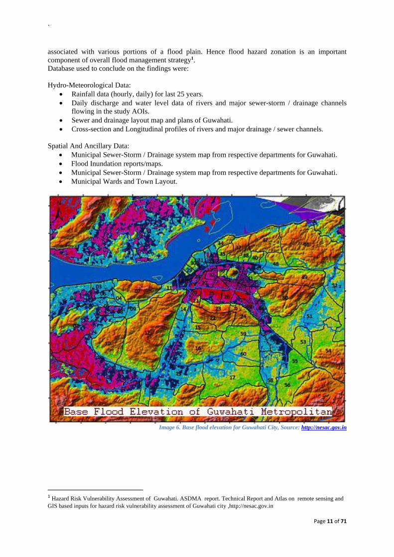
Flood hazard mapping and flood inundation modelling are the vital components in flood mitigation measures and land use planning, and are prerequisites for the flood insurance schemes. As flood itself cannot be prevented but the damages due to floods can be mitigated with proper planning and preparedness at community level. For that it is very important to identify the degree of hazard
`
Page 11 of 71
associated with various portions of a flood plain. Hence flood hazard zonation is an important component of overall flood management strategy1. Database used to conclude on the findings were: Hydro-Meteorological Data:
Rainfall data (hourly, daily) for last 25 years. Daily discharge and water level data of rivers and major sewer-storm / drainage channels
flowing in the study AOIs. Sewer and drainage layout map and plans of Guwahati. Cross-section and Longitudinal profiles of rivers and major drainage / sewer channels.
Spatial And Ancillary Data:
Municipal Sewer-Storm / Drainage system map from respective departments for Guwahati. Flood Inundation reports/maps. Municipal Sewer-Storm / Drainage system map from respective departments for Guwahati. Municipal Wards and Town Layout.
Image 6. Base flood elevation for Guwahati City, Source: http://nesac.gov.in
1 Hazard Risk Vulnerability Assessment of Guwahati. ASDMA report. Technical Report and Atlas on remote sensing and GIS based inputs for hazard risk vulnerability assessment of Guwahati city ,http://nesac.gov.in

`
Page 12 of 71
Image 7. Urban Flood simulation in and around Guwahati metropolitan Area, Source: http://nesac.gov.in
Hydrologic-Hydraulic Analysis and Modelling: The rainfall data analysis showed that there are storms and surges in the annual intensity-duration-frequency (IDF) trend in the last 10 years. Monthly total rainfall peaks ranged between 200 mm and 400 mm in the last 10 years. These rainfall storm events have induced flood inundation and water logging in parcels of Guwahati metropolitan. The analysis of the monthly rainfall data showed that the average annual rainfall is about 2355mm and out of this about 22% of the annual precipitation occurs in April and May and about 65% of the precipitation occurs in the period of June, July, August and September. However, it can be predicted that the rainfall intensity has a direct relation with the induced surface overland flow and drainage discharge capacities (over that it was already conveying prior to the storm event).
Image 8. Flood Hazard Zonation of Guwahati, Source: http://nesac.gov.in

`
Page 13 of 71
All the findings from these geographical assessments have been translated in to following graphical representation using GIS based platform to disseminate the information for easier interpretation.
Image 9. Vulnerability Assessment for flood in Guwahati City, Source: report and atlas on GIS based inputs, NESAC
Image 10. Statistical representation of Flood Hazard Zone, Source: report and atlas on GIS based inputs, NESAC
Least affected
V.High
High
Medium
Low

`
Page 14 of 71
2.ComprehensiveplanformanagementofdrainagecongestionproblemofGuwahati(WaterResourceDepartment)
The drainage system of Guwahati city depends heavily on the existing natural drains. The conditions of these channels are not very convincing as they are constantly covered with garbage, waste material and sewage. The water resource department had prepared a comprehensive plan for the clearing and management of these drain channels, which are like a lifeline of Guwahati City for the purpose of draining out water currently. The city doesn’t have planned drainage system to take care of sewage or waste water which is being generated, so these natural channels become all the more important. The existing drain system of the city consists of:
Bharalu Basin (catchment area=100 sq. km) Silsako Beel Basin (Catchment area = 92 sq. Km) Deepar Beel Basin(Catchment area= 144 sq.km) Kalmoni Basin (Catchment area= 66.5 sq.km) Fore shore Basin
The existing natural drain channels are:
i. Bharalu-Bahini river system ii. Mora Bharalu River
iii. River Basistha iv. Lakhimijan Channel v. Bondajan Channel
vi. Khanajan River vii. Kalmoni River
During monsoon season, the river Brahmaputra flows over the danger level and the low lying areas of Guwahati City face problems of water logging and floods. The feeder drains to the main channels run overflowing, and because of siltation problem of drains, the carrying capacity is also reduced significantly. The water resource department in response to these existing problems took some effective remedial measures like construction of flood walls, installation of high capacity pumps in low lying areas, providing sluice gates on the channels to control flow of water and other significant measures. Some more proposed interventions are under way, which will address the existing flooding problem like re-sectioning of existing channels, construction of storm water drains to carry off excessive flow into the main channels, clearing the existing channels from waste disposal and restricting the drop of sewer in those channels. The remedial recommendations are provided at several levels covering structural and non-structural aspects. The proposed structural measures include: Inter basin transfer of load, so that in case of excessive flow in one channel, the flow can be directed to other river with lesser load. The capacity of existing drain channels need to be increased as the amount of excessive water coming to them will be beyond the handling capacity of these channels currently. Defining the sections of existing channels, so that the problem of encroachment over them and the waste disposal in them can be checked. There are a number of sub projects listed within the entire flood management plan. i) Bahini Bondajan Flood Water Evacuation Project- the main features of this project are-
Construction of RCC drain of length 700 metre from Rukminigaon to VIP road. Re-sectioning of VIP roadside drain to a capacity of 15Cumec discharge upto Silsako Beel
and Re-sectioning of existing channel from Silsako Beel to Bondajan sluice gate Construction of additional sluice gate at Bonda having five shutter opening to arrive at
combined capacity of 80 cumec discharge. Installation of high capacity pumping station at Bondajan to facilitate dewatering when the
sluice gate is closed ii) Providing of Pumping Stations at different locations to relieve drainage congestion
Renovation of Bharalmukh pumping station by installing 6 nos. Of new high discharge pump

`
Page 15 of 71
Installation of high capacity pumps to throw discharge of khanajan during closure of Khanajan sluice.
Procurement and installation of trolley mounted pump sets for dewatering of storm water at water logged areas of Guwahati City.
iii) Defining boundaries of the natural channels
Construction of flood walls on both bank of river Morabharalu. Construction of flood walls on both banks of river Bahini. Construction of flood walls along both banks of river Bharalu. Re-sectioning of Pamohi channel from Mora Bharalu outfall point at N.H. to Deepor Beel.
iv) Improvement of sluice gate over Kalbhog channel with proper pumping facilities including flood
walls along both bank of Kalbhog channel from Kalbhog sluice to its outfall (for augmentation of flood at LGBI Airport and its adjoining areas. Constructon of new channel from backside of new terminal of LGBI Airport to Kalbhog
channel and from Kalbhog channel to existing drainage channel at Dakhala and then Kuldung to end of Dora Beel towards river Kulsi.
Construction of new channel from Batahi bridge near Dekapara towards Padma lake to Kalbhog channel to meet the main drainage channel as mentioned above.
Improvement of existing drainage channel from Dakhala to Dora Beel which has its outflow to the river Kulsi.
Improvement of Kalbhog channel and also the channel coming from Dharapur through new terminal towards Agchia.
Construction of Hume pipe sluice at suitable location to drain the run-off from sub-catchment area of surrounding areas.
v) Some Administrative measures Strict ban on earth cutting in hill areas surrounding the city. Stop encroachments in the hill areas, wetlands and drainage channels of the city. Strict ban on garbage dumping on wetlands and drainage channels. Fixation of road levels Preservation of all existing water bodies/swamps in the city area.
All these measures are bound to bring about a better flood management system for the city. The proposed interventions will help in fighting the problem of water logging and inundation on the low lying areas.

`
Page 16 of 71
3.GuwahatiFloodMitigationProject,ASDMATable No. 3 No.
Description Actions Agencies responsible
Time frame Cost
1. Drains Deposition of silt in primary and secondary drains, clogging due to garbage, open drains a risk
1. De-siltation, cleaning, fencing, lining of all drains
2. Strict penalties for indiscriminate garbage disposal in drains etc.
1. GMC would carry out the de-siltation and cleaning,
2. DC would carry out the Lining and fencing through the line departments
De-siltation, cleaning, and fencing to be over by April’ 2012
20 Crores
2. Waterbodies Encroachment/filling up of 5 major water bodies adversely impacting the water retention capacity of these major Beels. Rules under the Waterbodies preservation act not yet notified.
1. Immediate Eviction, demarcation, excavation, fencing, and
2. Medium to long term activity: beautification
3. Rules to be notified
1. DC would carry out the task through ATDC and GMDA
2. Government to notify rules immediately
Bondajan/Sorsola, Borsola and Silsako to be done taken up in the next two years. In the next 5 years development of Deepor Beel can be taken up.
100 Crores
3. Early warning Public largely caught unawares by floods
Early flood warning systems to be installed
GMC with the help of IMD would take the initiative forward
1 Year 20 Crores
4. Rain water harvesting Large run offs leading to flash floods
No percolation of water Different forms of RWH to be made mandatory in all buildings; technology for increasing absorption by ground to be explored
1. GMC+GMDA to notify it in the bye-laws
2. PWD may look into appropriate technologies for reducing surface run offs
2 months NIL
5. Plastic menace Plastic is becoming a hazard
Restrictions to be imposed in Guwahati city in manufacturing and use of plastic
PCB + GMC will take necessary steps to notify and enforce
3-6 months NIL

`
Page 17 of 71
6. Save the hills Hill cutting and encroachment leads to flow of soil into the drains
1. Hill cutting (prohibition act) may be reviewed and strictly implemented
2. Tree/Vetiver plantation
1. Divisional Commissioner , LAD and DC, Metro
2. DFO may be asked to carry out plantations drives in all hills. An amount of Rs. 1 crore per hill may be placed with DC
3-6 months 15 Crores
7. Pump sets Pump sets insufficient to drain out water from the low lying areas
Procurement of pump sets
WR 3 months 10 Crores
8. Road levels Gradual rise of the road levels leading to flooding in residential areas
Fixation of uniform road levels across Guwahati depending upon the different zones
PWD in consultation with GDD
3 months NIL
9. Storm water drains Absence of storm water drainage network and No channels for excess water to flow out
A storm water drainage network to be put in place, along with GIS mapping of all drains in Guwahati City
GDD 1-2 years Estimation need to be done based on TAHAL DPR
10. DDMA Knee jerk response without departmental coordination
1. State of the art DDMA and UFC to be made active in the DC office
2. Institutional framework to be worked out
3. Standard SOP to be put in place
DC + DMC 3 months 2 Crores
11. Peoples participation People lack awareness
Mock drills, DM audit, Awareness generation, Capacity Building and training, Documentation
Under DC, activities can be organized
Over the next 6 months
2 Crores

`
Page 18 of 71
4.MasterPlanforGuwahatiMetropolitanArea‐2025The recommendations from CDP are translated into action oriented proposals through Master Plan for the Guwahati City. The foremost priority of Master Plan is to regulate the landuse Zoning and keep it revising according to changing requirements. The document presents extensive planning processes regarding all the key areas discussed for long term benefits to the residents. The main goals of the Master Plan are-
To conserve Guwahati’s Sensitive Natural Environment To develop an integrated intra-urban Transport System. To develop Well-Distributed Physical and Social Infrastructure To provide Space for Efficient Functioning of Economic Activites To create special provisions for the state capital requirements To create affordable housing for all and develop a city without slums
Image no. 11 : Map of Guwahati city showing wetlands and forest areas
The economic sector is the main anchor behind the progress and growth of any city region. Guwahati has become one of the major hubs of economic activity in the entire North-East India. The establishment of Guwahati Refinery in 1962 marked the beginning of industrialization in the city. The construction of bridge over River Brahmaputra at Saraighat and the shifting of capital from Shillong to Guwahati in 1972 made tremendous economic impact on the city and turned Guwahati into one of the most important cities in the North-East. The economic development alongside require strengthening of infrastructure and other basic requirements like transportation, drainage, roads, water supply, health, housing etc. The emphasis had been laid on decongesting the core city area and developing satellite towns with high class infrastructure services to them. The main areas of improvement for the city of Guwahati are enlisted with brief description below.
i. Socio-economic scenario of the city- This section looks deep into the economic activities which run the city and their interrelation with people working within those domains. Composition of work force, market areas, major goods of trading, existing trading structure,

`
Page 19 of 71
retail sector, upcoming major business hubs, small scale district and neighbourhood market place and all those aspects which are related to economic growth of Guwahati.
ii. Transport- One very important developmental issue for this city is its existing transport infrastructure. Lot of people from nearby towns and villages come to Guwahati every day, some as daily wagers, some for job, and some to find new prospects in urban living. All these flocking crowd needs to be provided ample transport facilities intercity as well as intra city. The development plan addresses this issue by taking a detailed analysis of current scenario, and having future projections based on it. Traffic volume analysis, household requirements, employment pattern, condition of roads, demand for new transport system have been all studied in detail to come up with viable solutions.
iii. Physical Infrastructure – The infrastructure facilities becomes the most important area of improvement as it directly affects residents of city every day. Water supply, sewerage, drainage, solid waste management, power supply, etc are studied in context of their present situation and the requirements of increasing capacities with increasing population.
iv. Social Infrastructure- The various components of social infrastructure like schools, recreational spaces, hospitals, security services, emergency response, and communication services like post and telecommunication are also analysed to stay up to date with increasing demands. The new satellite townships will be key solutions to the existing problems to the city, as it is planned to ease the stress on major core zones of the city.
v. Housing and Slums- The increasing population demands safe and affordable housing options. The Development Plan is especially concerned for this problem and the expansion of new satellite towns is being undertaken in lieu of this problem. The different sections of society require different housing needs and thus the development model can be devised to cater everyone’s need. Increasing migratory population too require place to cover their heads, and slums can’t be totally removed because of this reason. The slum population have to be considered as an integral part of city and development process is required to address the needs of them too.
Image no. 12: Map of Guwahati city showing slum areas and proposed areas for housing development

`
Page 20 of 71
Image no. 13: Map of Guwahati City shwing proposed development schemes
The proposed landuse zoning addresses all these issues and proposes viable solutions for a sustainable growth of the city. Key highlights of the Master Plan 2025 are presented below:
66 sq km of new area to be added into GMA, making the total area equivalent to 328 sq km. This will involve development of 3 new townships of area 14, 23 and 19 sq km respectively.
Key thrust area is developing transport systems which enable inter and intra region economic development.
Heavy focus on developing a water supply, sewerage and drainage network. Emphasis was also been given on developing the existing characteristics of Guwahati as a
ecological city with development of tourism and recreation spaces. The development process takes long term efforts and extensive planning across all sectors to provide the desirous results. Master plan of Guwahati City presents a holistic approach towards issues related to urban agglomeration. All the above mentioned goals are addressed keeping in mind the projected growth of the city, also making the approach disaster resilient is given due importance in the process. 5. Flood Management Measures and Future Vision in Assam (Water
ResourceDept.,Govt.ofAssam)This document consisted of a presentation by Water Resource Department regarding the current ongoing measures and future visions in association with flood management in Assam and Guwahati city. The geological conditions of Brahmaputra valley creates a unique riverine system that is beneficial for the region and equally devastating in times of monsoon rains, creating havoc especially for the capital city situated on the banks of Bhrahmaputra River. Main reasons for floods and reasons are
Physiographic condition of the valley Narrow elongated U-shaped valley opening towards the Bay of Bengal branch of approaching
Monsoons

`
Page 21 of 71
Average Width Valley : 80 to 90 Km, River : 6 to 10 Km Bed Slope Int. Border to Kobo: 1 in 2390 Kobo to Dhubri: 1 in 6990 Discharge at Pandu Max: 72,794 cumes (1962), Min: 2,300 cumes (Jan/Feb)
Drainage congestion High stages of the Brahmaputra River over prolonged periods obstruct free discharge of
tributaries causing back flow and congestion near outfalls. Restricted waterway of road and railway bridges and culverts obstruct the natural flow of
water. Inadequate countryside drainage through sluices in embankment system particularly during
high floods causes prolonged inundation in the countryside. Encroachment of natural drainages further aggravates the situation.
Geology and Geomorphology Lesser Himalayas comprise of relatively younger rock formations and are in the process of
building up. Friable in nature and easily erodible and prone to landslides. A very young river. Its present configuration took shape only during the Pleistocene and
recent times
Excessive rainfall Excessive rainfall concentrated during the monsoon months from May to October Mean annual rainfall over the catchments area in India is around 2300 mm Mean annual rainfall varies between 2480 mm in the Brahmaputra valley to 6350 mm in
North Eastern Hills.
Seismicity and Landslides Brahmaputra Valley is subjected to frequent tectonic activity. The valley falls under Zone V,
which is highly risk zone. Frequent tectonic activity causes geo morphological changes and landslides. Excessive sediment charge causes rivers ton change course frequently. Carrying capacity is reduced thereby river either spills its banks or erodes. Formation of braided channels and constant shifting of channels and sand shoals.
Encroachment of Riverine Areas Narrowness of the valley and restricted availability of plain areas for habitation. Increase in population and developmental activities leading to encroachment of chars. Density of population in plain areas more than 200 persons per sq km.
Other factors Deforestation and improper land use due to the practice of shifting or Jhum cultivation in the
hill tracts and grazing Laterals southward shift of the river causing migration of bank line through erosion. Fanning out effect at Nodal points causing instability and erosion.
There have been great losses due to floods in past few decades. Total area which is under effect of floods is around 31.60 Lha, and average area affected in a year is about 9.31 Lha. Since 1954 total area eroded by floods is 386,000 Ha. that comes to be 8,000 Ha./Year. Total number of villages washed away were 2534 and expected families affected were 90,700. These numbers give a brief idea about the brutal impacts of floods in Assam. Strategies adopted by Water Resource Dept. For flood Management can be categorised as Immediate and short time measures that are implied on entire Brahmaputra basin and with special provisions for Guwahati city:
Flow Confinement By Embankments

`
Page 22 of 71
Anti Erosion Measures and River Training Works Pro-Siltation Devices Sluices Drainage Development Works
And long Term Measures:
Creation of reservoir in the upper reaches. Task Force constituted by Govt. of India also equivocally opined for implementation of such
multipurpose projects for ensuring flood moderation benefits.
Image no. 14 :Map of Brahmaputra River Basin showing flood embankment projects
The Hon’ble Prime Minister during his visit to Assam on Nov 2004 announced establishing a
cohesive, autonomous, self contained entity called North East Water Resources Authority (NEWRA).
The formation of the NEWRA is in advance stage and active consideration of Govt. of India. This Authority will go a long way in proper utilization and harnessing water resources of the
entire North Eastern region and will help in speedier implementation of the plans and programmes so envisaged.
Hon’ble Prime Minister further reiterated during the conference of Irrigation Ministers’ at New Delhi on Nov 2005 the need for the creation of NEWRA for fostering the developmental process in N. E. Region.
6.CapacityBuildingforUrbanDevelopment(CRISIL)In order to get better output results under JNNURM projects the MoUD (Ministry of Urban Development) and MoHUPA (Ministry of Housing and Urban Poverty Alleviation) introduced a new project for capacity building of Urban Development. The projects basically have three major components:

`
Page 23 of 71
Capacity building for strengthened Urban Management- This component is aligned with the infrastructure and governance sub-mission of JNNURM and will thus support technical assistance across the several urban management topics.
Capacities building for effective urban poverty monitoring and alleviation.- These capacity building initiatives are aligned with the basic services to the urban poor sub-mission. They reflect the need for building information systems, sharing experiences, and designing strategies on urban poverty alleviation
Implementation support- This component will support a national Project Management Unit (PMU) for providing overall technical and managerial support during the implementation of the Programme. The PMU will have a critical role in promoting and support the project.
A rapid baseline assessment was carried out in Guwahati along with 29 other cities to monitor the progress in the cities under CBUD programme. The main objective of carrying out this assessment was to identify the existing status of ULBs participating in the program, and to provide necessary assistance to the ULBs under the identified gaps. The main areas of assessment were:
1. Municipal Financial Management; 2. Municipal Governance; 3. Urban Planning and Land use; and 4. Urban Service Delivery.
Key findings: Municipal financial management
Asset management system needs to be strengthened. Creating an enabling environment for improving property tax collection with political
consensus and bureaucratic will. The new councillors who will join GMC needs to be trained at the onset regarding the crucial link between levy property tax as a source of revenue to initiate more developmental works. This will help reduce high degree of public resistance existing with regards to property tax and help in smoother introduction of Unit Area Method.
Improvement in revenue coverage (70%) and collection performance (50%), both require adequate attention
Expenditures exhibit higher growth rate then revenues indicating revenue deficit in future. Own sources of revenue are only 39% of revenue income, indicating dependency on grants. Collection efficiency in Property tax collection pegged at 40% requires scaling up through
various set of measures. Urban Governance
There is a need for undertaking an assessment of the existing institutional structure for urban governance in Guwahati to assess gaps, overlaps and duplication of function between various organizations.
There is a need for undertaking an institutional development study of GMC to assess the manpower and skill requirement keeping in mind the role that GMC will play in the future when all 12th schedule functions are transferred and handholding support from various agencies (ADB, JNNURM) ends.
Fill all sanctioned posts in GMC with updated job descriptions to ensure that computer literacy is in-built in new recruitment.
GMC also needs to review its office structure and assess the need for an integrated office complex for improving overall management efficiency.

`
Page 24 of 71
Urban Planning Urban planning functions have been partially transferred from GMDA to GMC. However on
a day to day basis GMDA is largely responsible for urban planning including Master Planning.
Division of city area in various ways like – GMC area, GMA area, GMDA area by the different governance institutions create disconnect in cohesive planning of a city as a whole. Projects are conceptualized as per a specific area by the respective agency, which in the long run leads to inequitable development in city pockets. All efforts/projects/plans/funding should be planned for an entire planning area, which covers agglomeration and stretches to semi-urban areas, which will eventually be added to the city with growing urbanization to ensure that an economic hub is created in the form a megacity that can fuel regional development.
Although most of the above reforms have been indicated as achieved but there implementation and enforcement needs to be stepped up. Building permissions are currently given by both GMDA and GMC dually. Such jurisdictional overlaps in delivering urban planning function needs to be streamlined.
Urban Service Delivery
For SWM, in order to make the PPP model sustainable it is crucial that the short-sightedness of the original DPR in terms of household projection is rectified to increase coverage to the actual number of households existing in the city. A proposal has also been submitted by Ramky to GMC in November 2011 to increase the number of households in their purview. GDD has constituted a committee to review the feasibility, however decision has been pending.
Although capital investment needs are currently being met through central government and multilateral agencies, but the state government needs to develop a financial institution which can help access market funding in the future.
Integrated project management is highly required as the city is being upgraded on all fronts. Projects for water supply, sewerage, drainage, roads, and transportation need to converge to reduce public inconvenience. An institutional mechanism needs to be developed which brings all agencies on a common platform such that overlaps, departmental delays, duplication is reduced and faster delivery of projects is ensured with maximum synergy.
Technically competent people from various departments need to be assigned on the projects while ensuring their commitment through the entire life-cycle of the project such that in-house capacities are built in the long run.
The status of all the services provided under various departments were scrutinized to identify gaps in the planning and delivery of services, further recommendations were also provided to improve upon the shortcomings. The assessments done under CBUD helps in revising planning approach under CDP and Master Plan and helps in improving the target goals 7.ClimateProofingGuwahatiCity,TERI,ACCRNBackground: The following study was carried out on an extensive scale under ACCCRN (Asian Cities Climate Change Resilience Network) by TERI (The Energy and Resource Institute) to prepare Climate Resilience Strategy for Guwahati city. TERI carried out risk and vulnerability assessment for the city and prepared a detailed resilience strategy. Analysis of land use imageries for Guwahati city indicates increase in the built-up area and decrease in the dense forest area. The reduction in green cover increases the vulnerability of the city towards hazards like flooding and landslides, and also impacts the ambient micro-climate of an area. The individual consultations revealed that water supply is greatly hampered in the city during the flood event. Besides this, the overall lack of drainage, absence of solid waste management system and pollution of surface water bodies and ground water sources has created a vicious cycle that leads to flooding and water logging in the city every year. Cutting of hills for encroachment, constructing buildings and large scale deforestation in the city has

`
Page 25 of 71
led to blockage of drainage channels, destruction of top soil and high rate of soils erosion on the exposed hill slopes. The functioning of city is heavily dependent on several key sectors, which address different needs and requirements of its residents. Methodology: The focus of this assessment is to facilitate adaptation initiatives and mainstream them into the city development paradigm to make Guwahati city more resilient and prepared towards the risks. This risk assessment largely extracted local information in the form of secondary data along with consultations with the Government Departments and relevant stakeholders. Besides this a climate scenario assessment was also carried out by TERI to understand the future implications of climate change on the city. Review of existing policies and governance framework of the city was an integral part of the assessment to identify channels for integrating adaptation and disaster risk reduction measures in planning and development. Current and future risk profile of the city: The information generated on vulnerable hotspots, communities and urban functions helped in generating the current risk profile of the city. This combined with the future climate projections provided a snapshot of the likely future risk profile of Guwahati. The results of the risk assessment were also shared and consulted with the relevant stakeholders to address any gaps. Identification of adaptation and resilience options to address the risks: The current and future risk profile of the city assisted in recognizing adaptation and resilience options to address these risks. The objective was to have a set of adaptation options which address the vulnerabilities of different sectors and communities and can help in making the city more resilient. Review of existing policies and legislations to identify gaps in addressing to risks: Understanding the current institutional mechanisms to address the risks and disasters faced by the city is an important component of risk assessment. An integral step of the risk assessment was a review of existing policies, legislations and by-laws to address disaster risk reduction. This review helped in identifying the gaps in the existing policy regime to address the current and future risks. Identification of means of integrating and mainstreaming policies for risk reduction in the existing policy framework: The overall analysis helped in identifying means to address the gaps in policy framework and legislations. The results are expected to make the city more resilient towards current and future potential risks. 8.FloodzonemappingofGuwahatiMunicipalCorporationareausingGIStechnology.PlabitaBarmanand²DulalC.GoswamiBackground: GIS is fast becoming an important tool in disaster mitigation process. In a GIS, information of geographic features objects is organized into layers such as drainage, slope, buildings, roads, railways, and so on. The data layers on flood hazards helps in modelling for proper management and land use practices. The research study here presents the use of GIS based information system that can be used to prepare a flood zoning map, so that the decision makers can have a strong base to plan for both structural and non-structural measures for flood mitigation. GIS can integrate spatial data with non-spatial attributes and the data layers of flood zones help in modelling for proper management and land utilization practices and proper designing of storm water discharge system based on topography of the city. The climate of the area is sub tropical humid type with average annual rainfall of 1766 mm and 147 average rainy days. Guwahati is a flood prone area. The Brahmaputra River, at Guwahati station has danger level of 49.68m above m.s.l.

`
Page 26 of 71
Image 15. Flood Zone Map of Guwahati City (ward wise), source: Flood zone mapping of Guwahati Municipal
Corporation area using GIS technology.pdf Methodology:Primary data was collected from field survey using questionnaire specially designed for the study. Data was collected from various Govt. departments and the resultant information was transferrred on to a Guwahati City ward map using GIS platform. The results obtained after analysis of the data are presented in the form of GIS based maps and data tables. Analysis of data from field observations and secondary sources were done keeping in view of the natural drainage systems and their discharge capacities, artificial drainage network for storm water discharge, pattern of rainfall and the slope of the city. Findings: The following zones were quantified during the period of study (See Image No 15) 1. Chronically inundated zone 2. Occasionally inundated zone 3. Rarely inundated zone 4. Inundation free zone The study shows that 52.34 percent of the Guwahati Municipal Area is flood prone. Of this, 16.27 percent belongs to the chronically inundated category, 13.34 percent to the occasionally inundated category and 22.73 percent to the rarely inundated category. The main factors identified for such a high level of flood risks were the undulating topography of city with plain area in the middle of city making it prone to flooding, encroachment on natural drain channels and wetlands, lack of proper drainage system and solid waste disposal in the drains and wetlands. The major roads and areas severely affected from flood inundation problem were identified based on field observation and can be listed as follows:
1) Geetanagar / Hatigaon Chariali upto Narengi 2) G.N.B Road from Guwahati Club to Noonmati ( Except New Guwahati Area ) 3) R.G Baruah Road 4) Maligaon / Durgasarobar 5) Guwahati College approach road 6) Nabagraha Road and its nearby areas 7) Along the Kanwachal road , particularly the southern part 8) Nabin Nagar / Anil Nagar /Ambikagiri Nagar / Tarun Nagar /Lachit Nagar upto Bhangagarh

`
Page 27 of 71
9) Srimantapur 10) Christianbasti area of G.S Road 11) Rukminigaon , Mathura Nagar and some low-lying area in Beltola 12) Some areas on the A.T Road 13) Santipur – Bharalumukh area 14) Fatasil Ambari 15) B.Baruah Road 16) Hedayatpur 17) Lamb Road , Ambari 18) Gandhibasti area 19) B.K Kakoti Road 20) Kachari Garigaon
The study here provides an efficient and cost effective methodology to delineate flood hazard zones in the GMC area. The study has also focused on the identification of factors controlling flood hazard in the study area. Such efforts should be a part of non-structural measures of flood management. The methodology used for this study represents a new prospect for generating inexpensive, easily read, rapidly-accessible charts and maps of inundation and waterlogged prone areas based on the morphological, topographical, drainage basin, demographical related data of the area, that can come very useful and handy for concerned authorities to make the planning process more result oriented. 9. Degradation of Natural Resources and its Impact on Environment: AstudyinGuwahatiCity,LakhimiGogoiBackground: Like the previously discussed research on urban rural migration, this is another perspective towards rapid and unplanned urbanisation. Guwahati city is always having very high vulnerability towards impacts of unplanned urbanisation. The city has been faced lots of problems which impact on the degradation of environment and poses as a threat to the biodiversity. The popping up of multi-storied structures, encroachment on hill sides and wetlands, improper solid waste management had only made the city’s environment worsen. From the earlier study we come to know about the pattern of rural urban migration in context of Guwahati City. Due to rapid growth of population, transport network, trade and commerce and industrial activities, the flow of labour group of people to the city is increasing tremendously. Their homes are not confined only to existing residential areas. They encroach upon areas not suitable for habitation like hill slopes, swamps, wetlands, sides of railway tracks and river edges. Growth of settlement in ecologically sensitive areas leads to loss of vegetation cover, biodiversity, soil los, landslides, floods etc. Findings: Present study revealed that the population in the city has been rapidly increased after the shifting of capital from Shillong to Guwahati. Due to rapid population growth and urbanization, Illegal settlements, industries and excessive growth of invasive species the natural resources has been degrading gradually. As a result hills and wetlands are encroached. Hence, with a depleting green cover on the hill tops and hill slopes, shrinking wetlands and low lying areas due to human interference and encroachment, the environment in the city is witnessing and experiencing unprecedented pollution (Deka et al, 2011).Wetlands and hillocks of Guwahati have taken the maximum battering because of rapid urbanisation. Wetlands recharge ground water and serve as storm water deposits, they also influence a regions micro-climate. Due to waste water and garbage being dumped in these sensitive areas, the quality of water had degraded, and the drainage capacity had also decreased. As all these natural reservoirs of water are being encroached and filled up as a result flood has become a regular phenomenon in the city leading to an unhealthy situation. The natural environment is progressively destroyed for unplanned construction of buildings and roads, release of industrial wastes to the drainage channels, stagnation of filthy water in the intermittently unfilled depressions, which become the breeding place of mosquitoes, etc. have created serious problem of natural resource degradation and environmental pollution, endangering the health of civic life of Guwahati. Guwahati’s maximum progress in last two decades have came up on the on the areas covering up wetlands. Lot of construction have taken place on the wetlands. The large number of

`
Page 28 of 71
wetlands that Guwahati once had is now being reduced to fragmented forms. As the natural reservoirs and wetlands are being encroached upon, as a result floods have become a regular phenomenon in the city. Loss of forest cover is an important contributing factor to the occurrence of land slide in the city in recent years. Flash floods, water logging and dust pollution have aggravated in the area due to the deforestation and earth-cutting in the foothills. Moreover improper disposal of Municipal Solid Waste clog the drains of the city and in rainy season artificial floods are occur. The twin man-made factor creates flash flood in Guwahati city. Recommendations: To protect the natural resources from habitat loss, fragmentation and alteration the following recommendations were given
Regular monitoring of the wetland and hill using various modern techniques, Continuous environmental awareness program among local people. Alternative livelihood options to those depended upon the Beel. Proper enforcement of the policies. Afforestation around the barren area. Minimize the encroachment around the Beel and hill area. Unauthorized encroaches are to be
evicted from vulnerable points for which strict legislative control will be necessary. 10. Present scenario of solidwastewith special reference to plastic andother non‐biodegradable solid waste and its management for thesustainableurbanpoordevelopmentinGuwahaticity,Assam,IndiaBackground: In the context of ongoing study related to occurrence and of floods and reason for its redundancy in Guwahati City, this study analyzes another major factor, i.e. generation of solid waste and its handling in the city. A scientific study was carried out in 12 different localities of Guwahati city covering more than 0.21 million population. The study includes on generation of solid waste and the type of plastic waste consisting of various recyclable and non-recyclable plastics and possible suggestive measure on plastic waste management and sustainable urban poor development are also discussed. In the present scenario only 10% plastic is being collected for recycling where as glass and metal is 50% and 70% respectively with 559 numbers of waste collecting points by 15000 numbers of waste collectors and rag pickers in the studied localities of the city. It was found that among the plastic waste generated from household 60% are of Recyclable Plastic (RP) and 40% are Non Recyclable Plastic (NRP) according to the present scenario. The plastic waste has been playing a major role in clogging of drains and artificial water logging. Methodology: Random samples were collected as per the variation of waste generation. Wet samples were air dried to remove the water content and the samples collected from different sources were averaged out to give a per capita number. Samples were collected from ten wards of the city (51 to 60) . The study recyclable solid waste was conducted at 12 sites and information was collected from rag-pickers with the help of a prepared questionnaire. It is estimated that around 1500 rag-pickers are operating at land fill site at Pachim Boragaon. The small dump houses do cleaning and segregation of waste into different categories like plastics (bottles, carry bags, different pouch packs, CD and electronic waste, large articles like chair and table etc.), glass (broken glass and bottles), metal(tin, iron, aluminium), paper (news paper, cartons, hard board), rubber, etc. This separated material is then sold off to larger recycling industries. Findings: During the study, various solid waste types are collected and differentiated as biodegradable, plastic, glass and metal waste and accordingly compiled the total generation; which is contributing as 57%, 1%, 14% and 28% respectably in the total waste generation scenario Solid Waste management in Guwahati City. In Guwahati, all the plastics, i.e. both recyclable and non recyclable are being dumped together at different places and dumping sites. Among the total plastic type, recyclable plastic is 60% and non recyclable plastic is 40%. Distribution of NRP in drain is 89 % and RP is 11%. It is observed that instead of plastic carry bags (Anonymous, 2008) which are recyclable plastic, non recyclable plastics are the major responsible for clogging of drains and is creating a major problem in Solid Waste Management.

`
Page 29 of 71
The production of the various solid waste types in the study sites.
Image no. 16: Chart showing percentage of solid waste collected from various study sites
Recommendations: Collection and segregation of Recyclable Plastic (RP) and Non-Recyclable Plastic (NRP) shall be done at the source itself, which will make the subsequent process simpler and with higher efficiency. Recycling of only some types of plastic materials is not enough where as recycling of all type of plastic waste is essential for a successful management(Gupta, 2004). By a process of braking down plastics called pyrolysis in heated vaccum chamber, a cleaner fuel substitute can be obtained in a quantity of 750-800 ml. /Kg of plastic waste. In this process there is minimum energy required as the waste gas generated itself is used to power the machinery. As per the study there are around 15,000 people involved in the waste collection and recycling that include the rag-pickers and industries. If all the non-biodegradable solid waste is segregated at source and accordingly collected from source through the organized rag pickers or urban poor and recycling properly there will be a significant growth of industrialization which will lead towards sustainable urban poor development with more than one lakh employment generation in Guwahati itself. Moreover biodegradable solid waste which will residue after the source segregation of recyclable and non-recyclable plastic can also be utilized for employment generation through the production of compost and vermin compost. 11. AGeo‐EnvironmentalAnalysisof theGroundwaterResourcevis‐a‐visSurfaceWaterScenarioinGuwahatiCity,Das.Neelkamal,GoswamiDulalBackground: In India more than 90% of the rural population and nearly 30% of the urban population depend on groundwater for drinking purpose (NRSA, 2008). Groundwater is replenished naturally by surface water from precipitation, streams and rivers. However, unplanned urbanisation coupled with rapid population growth has started exerting tremendous pressure both on the surface and subsurface water resources. Guwahati city is quite unique in terms of its geo-environmental situation with an interface of hills and valleys along with a prominent riverfront. However, the unprecedented growth of city in the past two decades had led to massive alteration in the landscape of the city. Hills and open wetlands have been replaced by hard surfaces affecting the water retention capacity of the ground, and hence affecting the infiltration rate to a great extent. The increasing population require potable water for its daily requirements and it is putting immense pressure on the various sources of water, particularly ground water. The city of Guwahati, in spite of being located on the bank of the mighty Brahmaputra, depends heavily on the groundwater resource for its water requirements. About 69.90% of the households in the city use groundwater, while 27% depend on piped water supply and the rest on surface water obtained mainly from streams (Goswami et al., 2005).

`
Page 30 of 71
Methodology: To carry out the study both primary and secondary data was collected. To collect primary data, a detailed questionnaire was prepared with specific outcome in view and making field measurements on selected geo-hydrological parameters like ground water level in wells, volume of surface water bodies, etc. The secondary data source comprises maps, statistics, published research papers, journals, satellite imagery, etc. These secondary data were mainly collected from various organisations and departments such as Central Groundwater Board (CGWB), Assam Remote Sensing Application Centre (ARSAC), Regional Meteorological Centre, National Institute of Hydrology (NIH), Directorate of Geology and Mining (DGM), etc. Findings: The city of Guwahati is dotted with numerous surface water bodies comprising of wetlands and ponds. These water bodies play a significant role in holding rainwater for considerable period of time and serve as reservoirs. But unprecedented urbanisation and development activities have reduced these water bodies to fragmented forms. At present, the city can boast of only six wetlands, viz., the Deepor Beel, Hahsora Beel, Silsako Beel, Narengi Beel, Borsola and Sarusola Beel. Along with these natural water bodies, the city also boasts of many small ponds and tanks , which make an integral part of water supply. These surface water bodies sustain water flow dynamics between the high land and low land of the city’s landscape, function as storm water reservoir and act as potential sites for natural recharge of the sub surface water. Major portion of rainfall occurs during the months of April to October from the south-west monsoons. The city reciecves around 162 cms. of annual average rainfall. The average number of rainy days per year in the city is about 110 days (See Fig. No. 17).
Image no. 17: Chart showing monthly rainfall Image no.18: Map showing rain water collection potential zones In areas around hills, the water level is deeper compared to the areas having flat alluvial plains and valley zones. Overall depth to water level gradually reduces from elevated eastern and south-eastern areas to the flat lying alluvial plains in the west. Hydro-geological studies revealed the presence of groundwater just under water table conditions in case of shallow aquifers; however, in case of deeper aquifers it is available within the semi-confined to confined conditions. Shallow tube wells constructed in the loose formation down to 30 metres by Public Health Engineering Department yield around 2000 to 3000 litres per hour and the well yield shows consistent behaviour throughout the year. Recommendations: Groundwater development and management is the key for sustainable upliftment of a particular area and proper management practices will ensure effective utilisation of this valuable natural resource. It is imperative that designing of wells should be based on the aquifer characteristics, hydro-geological setup and water requirement. The natural setting of the city can provide space for locating various storage tanks and reservoirs that can serve the city by storing rainwater (See fig. No. 18). Also the concerning agencies should be active in making the public aware about the importance of such recharge zones for increasing the availability of water and safeguarding the environmental quality of the region. These measures will have subsequent impact in mitigating flood emerging hazards as the excess rainwater will be taken care during the entire process of water retention and storage.
`
Page 31 of 71
SupportingReports/Studies1.GuwahatiCityDisasterManagementPlan(KamrupMetroDistrict)Background: The CDMP for Guwahati City had been prepared contextualizing Kamrup Metro district together with the city. The Kamrup Metropolitan District, situated on the western part of Assam has always been at the centre stage of natural calamities like floods, cyclones, earthquake, landslide, epidemics etc. Keeping in mind these very probable calamities in the district that cause major setbacks to lives, livelihoods and property (both movable and immovable), the District Administration. Kamrup Metropolitan District felt the urgency of the need of preparing an emergency response plan. The devastation caused by floods, landslides and cyclones has posed a challenge before the Kamrup Metropolitan District Administration to analyze each and every decision making process to gear up the rescue and restoration during such situations as well as building up the capacity to face further calamities in future. The District Administration has realized the necessity to compile a plan to prevent/minimize the loss and also to facilitate faster recovery during an emergency of this kind. This booklet is more of a guidebook, which can help the administration, remains better prepared for earthquakes, floods and cyclones to safeguard lives, livelihood and property. The objectives behind the preparation of the City Disaster Management Plan are:
• To mitigate the impact of natural and man-made hazards through preparedness at District and Ward level.
• To provide effective support and resources to all the concerned individuals, groups and departments in disaster.
• To assist the line departments, communities in developing compatible skills for disaster preparedness and management.
• To disseminate factual information in a timely, accurate and tactful manner while maintaining necessary confidentiality.
• To develop immediate and lone-term support plans for vulnerable people in/during disasters. • To create awareness among the people about hazards occurrence and increasing their
participation in preparedness, prevention, development, relief, rehabilitation and reconstruction process.
• To have response system in place to face any eventuality. • To affect or elicit the least possible disruption to the normal life process when dealing with
individuals in disaster. • To ensure active participation by the Government Administration, communities, NGOs,
CBOs and volunteers at all levels making optimal utilization of human and material resources during the time of disaster.
The other major function of this elaborate city disaster management plan is to have Response Plan (Emergency Support function (ESF) at city level). There were 14 major ESFs were identified and a complete SOP (standard Operational Procedures) were prepared, so that the teams are prepared and assessed before any emergency situation. Their well preparedness will help to reduce the damage of any disaster/ emergency. To have a proper co-ordination amongst various ESFs, a District and Onsite level operation centre District Emergency Operation Centre (DEOC) needs to be established, which will function directly under the Emergency Operation Centre of the State. The District Emergency Operation Centre under the control of the Deputy Commissioner, Kamrup Metropolitan District will operate round the clock and will be the nerve centre to —
• Monitor • Co-ordinate • Implement the actions/activities for Disaster Management.
In a disaster time, the DEOC will operate under the central authority of the Deputy Commissioner, exercising emergency power to issue directives to all departments to provide emergency response service. He will also co-ordinate with the State Response Machinery like: State Relief Commissioner, Dispur, Assam. The Control Room should be manned round the clock.

`
Page 32 of 71
The DEOC is equipped with • Action Plans • Vulnerability maps • List of key contact persons during emergencies • Database on resources of the district • During disaster provision will be made in the office of the Deputy Commissioner for First aid
and other basic medical relief for the staff. Refer to Annexure 4 for the emergency support function for Kamrup Metropolitan District (the list of participating agencies is suggestive only. Primary agencies may include any of the concerned departments as participating agency as per requirement. City Development Plan: The city Development Plan is comprehensive set of data used to carry out all round development of the entire city. Guwahati CDP was prepared under the JNNURM mission for providing better infrastructure and living conditions to the people and to bring about positive changes according to the aspirations of the residents. The main objectives of the CDP are-
Promote focused, balanced and sustainable economic and infrastructure development that will enable Guwahati to fulfil its role as the Gateway to the North-East (N-E) India and possibly to the South East Asia under the look east policy of the Government of India.
Provide for and build a natural environment that contributes to providing a good quality of life for the residents and visitors.
Provide Basic Services to the Urban Poor through quality delivery of civic amenities and provision of utilities with emphasis on universal access at an affordable price.
Planned development leading to dispersed urbanisation and reduction of congestion. Improving Inter and Intra regional accessibility. Raise adequate funds for meeting investment requirements in the infrastructure sector.
The CDP addresses all the necessary issues related to the city, providing background, current situation and a vision proposal for that particular service. It becomes a handy set of information when the City Administrators are in the process of making Strategies and Action Plans, and looking forward to make the city a better place for its residents. 2.TheRural‐UrbanMigrationPatterninGuwahati’sEnvironment,Dr.JayasreeBorahBackground: Rapid Urbanisation has become a prominent phenomenon in Indian cities today. People from adjacent small towns and villages migrate to cities in search of better jobs, income and lifestyle. Such a migration is usually age and sex selective, thus it not only disturbs the natural balance in Urban Agglomeration, but also affects the socio-economic and demographic structure of the city. Guwahati being the commercial and economic hub of North-East region is facing severe impacts of this rural urban migration. Factors like poverty, unemployment, lack of basic services, floods, crop failure etc. force rural population to flock towards Guwahati city2. Findings: The pattern of migration is largely governed by some particular physical characters of the city like transport services, closeness to markets, availability of space to build their shacks etc. Traders from nearby villages and towns use bus as their primary mode of travelling. The increasing volumes of migrants have put up a lot of pressure on the already overstressed urban amenities. The areas occupied by these migrants’ usually vacant lands including hillocks, wetlands, sides of railway tracks, and riversides. These people are hard to keep track as they keep changing their locations. Moreover, these kinds of encroachments lead to increase in landslides and floods as they hinder the path of flow of flood water, also the hillocks are cut out illegally to make space for construction.
2 Dr. Jayasree Borah, The Rural-Urban Migration Pattern In Guwahati’s Environment, http://www.unil.ch/webdav/site/igu-urban/shared/jayasreeborah.pdf

`
Page 33 of 71
Recommendations: This study gives a different perspective to the problems giving rise to floods and landslides in and around Guwahati city. Urban Planning becomes a major tool in coping up the problem of rapid growth of cities. It can give a holistic approach to solve this problem by integrating the excluded class of city dwellers in main stream planning process. Decentralisation of industrial and other socio-economic activities away from core city area may lead to this. Development of market areas which do not overlap with the sensitive ecological zones, and the planned growth of satellite towns having up to mark infrastructure, so that it can automatically divert the migrating population towards them. These few measures can bring in major changes in the way a city functions. 3.Satellite images forextractionof flooddisaster footprintsandassessing thedisasterimpact:BrahmaputrafloodsofJune–July2012,Assam,India
Background: Satellite images become a vital tool for information on flood disaster footprints, as they provide essential information for assessing the disaster impacts and taking up further planning for flood mitigation. The floods in Brahmaputra basin in June-July 2014 wrecked large parts of Assam. This research article discusses the spatial extent of flood inundation, villages and cities stranded, and population affected by the means of GIS and remote sensing. The study shows that about 4.65 lakh ha area was submerged, 23 of the 27 districts in Assam had more than 5% of the total geographical area submerged, about 3829 villages marooned and 23.08 lakh people were affected(See figure no. ). The information collected from assessment of satellite images will be helpful in prioritizing flood control measures3. Findings: From the analysis of satellite images it was observed that after coming down from the Himalayan ranges the Brahmaputra River deposits massive amounts of sediments along the course of river in the Assam plains. Because of which the main cross section of river is reduced, the channel carrying capacity is also subsequently reduced and it raises the river bed above the flood plain. These result in conditions conducive for bank erosion, channel avulsions and breaching of flood control structures, especially in the upper parts of Assam. The river changes from single channel to a braided channel pattern. Also the width increases from .3 km to as wide as 12 kms due to large amount of sedimentation. In the middle and lower parts of Assam the flow decreases because of low gradient, and it creates large areas of flood inundation. Brahmaputra changes from braided channel pattern to a single channel as it passes through Guwahati and the width of the river narrows down to 1 km from 10 to 15 km upstream. This narrowing down of the channel restricts the free flow of water when the river is in spate and subsequently leads to spilling of flood waters and flooding conditions in the upstream areas located along the river, especially in parts of Guwahati, Kamrup (M), Marigaon and Darrang districts. Recommendations: Solutions to flooding problem require an integrated approach involving structural(river control ) and non-structural (watershed management and strengthening early warning system) methods is required to be taken with the assistance from technological tools like GIS and remote sensing. Satellite images can be one of the most cost-effective ways to capture the flood disaster footprints, identification of areas vulnerable to flooding and understanding the flooding problem in a better way.
3 Bhatt. C.M. et. al, (2013), Satellite images for extraction of flood disaster footprints and assessing the disaster impact Current Science, VOL. 104, NO. 12, 25 http://www.currentscience.ac.in/Volumes/104/12/1692.pdf.

`
Page 34 of 71
Image 19. Maximum spatial extent of flood in 2012, source: Satellite images for extraction of flood disaster footprints
and assessing the disaster impact.pdf 4. Documentation on past disasters, their impact, Measures taken, vulnerable areas in Assam. The entire north east region is prone to natural disasters and especially Assam faces severe consequences of floods every year. A comprehensive report on the documentation of various past natural disasters occurred in Assam, their impacts and the primary reasons for occurrence. The lessons learnt from these past events guide is in taking appropriate decisions in the time of disasters. List of various kinds of natural disasters and their assessment based on the past records. Earthquakes: The entire North East region falls under Seismic zone V, which is very high risk area. The major reason for occurrence of such high intensities is the constant movement of two geological plates, the Himalayan in the north and the Indo-Burman in the east. With complex tectonic and geology set up of the region and intense continental convergence of the northward moving Indian plate at the rate of 20+03mm/year can produce earthquakes of magnitudes 8 and above every few hundred years. Cyclonic Storm Occasional cyclones do occur in the region, particularly in western Assam their severity is more during monsoon. At times these cyclones are devastating bringing colossal loss of human lives and damage to property. Conclusion: At the end a brief summary of actions taken by various govt. Agencies had been provided to have an idea about present status of disaster management in Assam. What are the planning prospects that are being looked into based on other successful such examples of disaster mitigation and management.

`
Page 35 of 71
Chapter 3: Findings From the entire set of studies carried out regarding the impacts of floods on Guwahati city, few key areas of interventions have been identified. These findings have been derived on the basis of shortcomings and gaps mentioned in the studies reviewed. Rapid and unplanned developments have become a major issue in many of the Indian cities. Guwahati is no exception in that sense, but it is situated in an extremely fragile ecosystem and hence the impact of this urbanisation is multifold in comparison to any other such city. From the documents studied, key lessons were identified for the following discussed sectors and simultaneously recommendations are given on its basis to improve the flood resilience of the city. Major natural and induced hazards are increasing due to interlinked factors. Flood Occurrences:
According to the Assam State Disaster Management Policy (2010), landslides and urban floods are the two most prevalent hazards that undermine the urban development of Guwahati. A number of landslides have occurred in Guwahati in recent past causing extensive damage to life and property and have adversely impacted economic development. Continuous rainfall during monsoon aggravates the situation by causing more soil erosion associated with siltation. The poor and socio-economically weaker sections living in marginal and fragile areas are the most affected and vulnerable communities. When the discharge in the rivers along with their tributaries synchronises during monsoon, the city of Guwahati faces flood havoc and the damage caused is colossal. Further, deforestation in upstream and downstream areas of surrounding hill states and Assam respectively has caused excessive siltation, resulting in abnormal rise in the surfaces of major rivers.
Flooding events have become quite common in Guwahati in past few years. Although there is
no data available on such events but during the consultation it was told that Guwahati city has a typical situation of manmade hazard as the city does not experience normal flooding events but is characterized by urban flooding owing to a number of issues like lack of drainage, unmanaged solid waste, reclamation of low lying lands and unchecked/ unplanned urban growth, hill cutting, etc. Another reason is the increased intensity of rainfall occurring in a very short duration. Although there are no recorded statistics on this but it has been observed that frequency of such extreme events has increased.4
According to the city assessment report5, backflow of the water from the River Brahmaputra, due to blockage in the drainage system through Bharalu, Khanajan, causes floods frequently every monsoon. Bharalu basin is the most flood prone area in the region. This is probably because most of the drains fall on the upstream side of River Bharalu. The river is at a higher level than the level of the drains leading to the retarded outlet of the water (Master Plan) Also, there is heavy siltation and dumping of garbage in the Bharalu River. The following map shows the built-up area overlaid with flooded areas in Guwahati. The map shows that the stretches along the Basistha River and the Bharalu River basin are chronically flooded areas while some patches near the Brahmaputra River lie in the occasionally flooded areas. These are also the densely populated areas of the city. The map also shows the location of landslides in the city which shows that some of these are near to the chronically flooded areas.
4 Climate Proofing Guwahati. Assam: City Resilience Strategy and Mainstreaming Plan, Synthesis Report. 5 CEPT 2011. Carrying capacity based Urban Development Regulations, Guwahati Metropolitan Development Authority.

`
Page 36 of 71
Extent of Floods and Landslide Locations
Deforestation Human intervention and depredation in the watersheds region above Guwahati also aggravate the problem. The most serious environmental problem now facing on hilly regions is deforestation. Its effects, if unchecked, are most certain to bring about permanent ecological harm with dramatic increase in flash floods problem in Guwahati city. Deforestation on hill slopes leads to loosening of soil and it creates massive erosions along the hill edges. The excessive rains too add to the woes and it carries this loose soil in to the drain channels and siltation in the city6. Landslide Occurrences: Guwahati city faces severe problem of landslides during monsoons, for which rains is the primary reason, but the triggering cause is excessive cutting along hills and encroachment on them by migrants. Earthquakes too add to the problem as the entire N-E region falls under seismic zone-V. Natural Resources and Ecology:. Guwahati city is sitting in midst of natural wetlands, forests, hillocks, and the river edge of one of the mightiest river in the world. These all constitute as an interlinked ecological system, which is under threat due to rapid and unplanned development. Environmental degradation is fast becoming a major threat to this sensitive arrangement on natural entities and the population which relies on it. Encroachment Encroachment of large number of wetlands that serve as natural reservoirs like Beels, swamps and marshes around the city has also reduced the retention capacity of the drainage system causing flood level to rise. The desire to have a better life and to earn good fortunes lures migrants from villages and towns towards cities. Guwahati is facing a major threat from this problem as a big portion of migrant population illegally occupies hillocks to build their shacks. They exert pressure on already tottering infrastructure of the city and make the flood mitigation process a difficult task.
6 Documentation on past disasters, their impact, Measures taken, vulnerable areas in Assam. http://www.aasc.gov.in/course%20material/Disaster/documentation%20on%20past%20disasters.pdf.

`
Page 37 of 71
Road Building Guwahati city faces the brunt of unplanned road building in sensitive eco zones comprising of hillocks, forests and wetlands. Because of unprecedented growth in population of the city, the construction of roads for transportation had become necessary. Since there had been very least concern for natural environment in the process, the severe effect of this negligence is now showing up in form of frequent flash floods and landslides in and around Guwahati. Migration Migration has been a continuous phenomenon for Guwahati city in the past few decades. Economic opportunities along with many social and political reasons govern migration of people to the city. Better urban services as compared to other rural areas such as education and medical facilities also are factors affecting immigration. In the past few years, with a rapid increase in employment opportunities due to growth of industries and other secondary and tertiary sectors, migration has taken place from different cities and villages. As in most cases there people are poor or from economically backward background and thus they tend to settle in illegal settlements and encroachments on hills or fragile lands. The recent increase in slum areas is an indication of increased migration in Guwahati (CDP, Guwahati).
Findings related to key sectors of city: The current sectoral analysis of these sectors will give an overview of level of preparedness and the kind and extent of interventions needed to strengthen up the resilience capacity of the city7.
i. Housing- The Guwahati CMP-2025 gives the picture of housing sector in the city based on previous census data and future projections. It shows the current population, required no. of dwellings, and the shortage based on these data. In 2001, Guwahati Metropolitan Area contains 183,491 housing units out of which 178,838 units are exclusively residential and 4,753 are put to residence-cum-other uses. Out of the total housing, 48.4% households live in owned residences, 46.4% in rented and 5.2% in other accommodations. The projected housing requirement in GMDA area in 2025 is as under: • Projected additional population for 2025 -1,283,129 • Additional households between 2005 and 2025 @ 4.4 persons per household - 259,163 • Housing shortage in 2005 - 19,802 • Need for additional dwellings between 2006 and 2025 - 278,965 (This is excluding the slum areas.)
Image 20. Total area under Wetland ( in sq.km), Source: Das, Neelkamal, 2013
7 ACCCRN-TERI,Climate Proofing Guwahati, Assam City resilience strategy and Mainstreaming Plan(2013)
http://acccrn.org/sites/default/files/documents/TERI_Guwahati%20Synthesis%20Report.pdf.

`
Page 38 of 71
ii. Urban Planning- The present situation of city is not going to allow further densification of city as the FSI (Floor Space Index) is already higher than other cities8. GMDA plans to develop 3 satellite towns around Guwahati that will help in solving out this problem. Along with the towns other infrastructure services like transport, sanitation, roads need to be effective enough to attract population to reside there.
iii. Ecosystem and Land Use- Guwahati city is located in a valley surrounded by hills on three
sides. The city boundaries also have large area under hillocks and water bodies. These natural elements are under threat by rapid urbanisation, and as they also form part of the natural drain system of the city, their preservation is utmost necessary (See Image no.17). The unplanned expansion of city had led to deforestation and encroachment on hillocks. Such expansions are open invitation to disasters like landslides and floods.
Image 21. Drainage density (in sq. Kms), Source: Das, Neelkamal, 2013
a. Change in topography- External factors such as development near Meghalya border have also led to change in the topography. There are flash floods near agricultural university area. A lot of industries, schools, colleges etc. have been built along the border which not only threat the environment of the city (cutting of hills is a major problem) by aggravating and causing floods, siltation, air pollution; but are also putting pressures on the infrastructure and services of the city as this development is depending on Guwahati city for its requirement.
b. Deforestation and construction on hills- Uncontrolled deforestation and construction on the hills in Guwahati has resulted in more exposed slopes which are more prone to soil erosion as compared to the vegetation covered slopes. Increased soil erosion not only results in loss of soil fertility but also causes problems of water logging and flash flood down the slope. There is a need of regulating cutting of trees and encroachment in forest areas. During consultation exercise with GMDA, it was revealed that the Master Plan of Guwahati clearly demarcates the eco-sensitive zones where development should be restricted. Still, the hill areas and hillocks are being encroached upon.
c. Waste discharge in rivers- One of the important tributaries of the Brahmaputra river, the Bharalu river which flows through the city is an important channel for the drainage of the city. Due to siltation, the bed level of river Bharalu has considerably risen. A major chunk of the waster discharged from the city is directly dumped in this river. Waste water from households, commercial and business establishments, small and medium industries also ends up in Bharal River which gets discharged in the Brahmaputra. Even in upper reaches, the refinery waste water from the Indian Oil Corporation Refinery at Noonmati
8 All India average-2.5-3, Mumbai-1.33, Delhi- 2.5 to 4, Bangalore- 3.25, Guwahati-4

`
Page 39 of 71
flows directly to the river. This has resulted in degradation of the water quality of the river and it has been reduced to a drain. With choking of the natural drainage, the city has become more prone to water logging and urban flooding.
iv. Urban Infrastructure and Services- Urban infrastructure are like the lifeline of a city. The
better condition of these components, the higher are the chances of having a much resilient city. Poor or sub-standard infrastructure services increase the vulnerability of the population to manifolds in case of disasters and climate related extreme events. Guwahati city is lacking a lot on the front of basic infrastructure which are discussed in the following sections.
v. Water Supply- From the current situational analysis it had been found that around 35% of the city is covered by piped water supply. The current demand of water for Guwahati city is 132 MLD, but only 78 MLD is produced as compared to the generation capacity of 98 MLD. The major industries like IOC refinery, Railways, Airport and Defence establishment collect, treat, and supply water on their own capacities.9
vi. Sewerage- The current situation suggests due to unplanned growth, most of the areas in the city are still deprived of proper sewage disposal system. In absence of which the natural drain are turning into sewers and blocking the path of natural flow of storm water. In monsoon period the situation worsens and it leads to flooding and water-clogging in low lying areas. The city does not have a sewerage system at place. The city is dependent on the septic tank system the effluent is released untreated into the nearby drains and low-lying areas. The industrial waste water is also being released in the river and its tributaries untreated. The undulating and bowl shaped topography makes it all the more important to have proper drainage, sewerage and storm water system at place to avoid accumulation of water and associated hazards. The subsoil water table is very high in many areas in the city, leading to non-functional soak pits.
vii. Drainage- The city of Guwahati lacks overall proper drainage system. The drains present along roads are not capable enough to handle excessive flow of water during monsoon season. The entire Guwahati Metropolitan Area is divided into seven drainage basins, through which all the waste water of the city is drained into the river Brahmaputra either directly or through various drainage channels and reservoirs indirectly (See Image no. 18 ). Several projects have been sanctioned under JNNURM scheme to take care of this problem. Since urban flooding has emerged as one of the main risks, addressing drainage both natural and man-made helps in reduction of climate related vulnerability in the city. Except for the 17km drains built by the Town and Country Planning Organisation in 1970s, no other planned drainage system exists within the Guwahati Metropolitan area.
viii. Solid Waste Management- Guwahati Municipal Corporation is the main authority responsible for solid waste management of the city. The city produces waste which is above the norms for a class I city. The waste management system is lacking in organized waste collection and disposal mechanism. The total waste generated can be classified as 57% biodegradable, 28%tin and metal, 14% glass and bottles and 1% plastic (Kashyap et.al,2010). (See Image no.19) Also there is no separate system for collection and disposal for bio-medical waste generated from hospitals.
9 Das. Neelkamal, Goswami Dulal, A geo-Environmental Analysis of the Groundwater Resource vis-a-vis Surface Water Scenario in Guwahati City, Current World Environment, Vol. 8(2), 275- 282 (2013) http://www.cwejournal.org/pdf/vol8no2/8_2_13_p275_282_Neelkamal_Das.pdf

`
Page 40 of 71
Image 22. Solid Waste Collection in Guwahati City, Source: Kashyap et.al, 2010
The solid waste management is highly inadequate at present and needs urgent attention in the city. The master plan predicts that by the year 2025, the city would be generating solid waste in the order of 0.8 kg per capita per day, while the waste generated from hospitals would be of the order of 0.5 kg/capita/day by 2025. Right now there is no separate disposal system for waste from hospitals as per norms.
ix. Electricity/Power Supply- The city is facing severe power shortage, which results in
disrupted supply for several hours. There is a gap of 48 MVA between demand and supply for the city of Guwahati. As the city faces severe flooding issues, continuous power supply is necessary for running pumps which drain out water. Currently diesel gensets are being used for this purpose.
x. Transport- Guwahati is the largest city in the entire NE region, and hence the transport system of city plays a vital role in connecting the other parts of country to NE. The master plan 2025 suggests that the condition of roads and transport system is not up to the mark for a city like this. Most of the roads don’t have footpaths, roadside drains, and they lack street lighting. The overall condition of roads is important for a city to fight flooding like situation as inadequate storm drains, broken patches of road only adds to the problem. The density of vehicles on roads is one of the highest in the entire country.
xi. Health- With respect to healthcare facilities, there are 4 Government hospitals (including the CRPF Hospital) which house about 2430 beds. Apart from this there are 23 non-government/ private hospitals (with 1724 beds) and 24 non-government/ private nursing homes (with 696 beds). Beside these there are several more small medical units functioning in the city. These numbers are fairly good with respect norms laid down by standards. But Guwahati city is highly susceptible to disease outbreaks during floods, and the coordination between hospitals and emergency response mechanism is still not that well.
xii. Urban Poor- Being the commercial hub of North-East, Guwahati is home to a large population of informal residents, who occupy a large area of the city. These people come to city in search of job and livelihood, and are forced to settle down in areas which are highly

`
Page 41 of 71
vulnerable to hazards like, landslide, floods and health risks10. The numbers of slums pockets are on a rise and they lack in basic amenities which make them highly vulnerable to disasters.
The brief summary of findings from the entire identified key sector is given in the following table for easier reference11. Table No. 4 Key Sectors Important findings
i) Housing Guwahati City Master Plan 2025 gives statistical data for current situation and projected numbers for stress building up on housing sector
ii) Urban Planning Already existing high FSI ratio leaves less scope for densification
Need to develop satellite towns identified iii) Ecosystem and Land
Use Threat to natural water bodies from unplanned urbanisation Encroachments on hillocks
iv) Urban Infrastructure and Services
Poor condition of basic services Backbone of city functioning still lacking strength
v) Water Supply Only 35% of the city is covered with piped lines Major industries use their own water treatment System
vi) Sewerage No proper Sewer treatment system in place Natural Drains serving the purpose of sewers as well
vii) Drainage No provision for storm water drainage Need for systematically clear off water logging in low lying
areas viii) Solid Waste
Management The generation of waste in city is much more than its disposal
capacity No separate treatment of bio-medical waste
ix) Electricity/Power Supply
Big gaps in demand and supply of power Metered supply still not effectively covering the city
x) Transport Poor condition of roads and lack of footpaths and street lights Need of effective public transport system
xi) Health Decent medical infrastructure Need of coordination amongst various agencies during times of
emergency xii) Urban Poor Lot of migration from surrounding areas takes place
Inadequate provision for floating and informal population
10 Borah, Jayashree. The rural-urban migration pattern in Guwahati's environment, http://www.unil.ch/webdav/site/igu-urban/shared/jayasreeborah.pdf. 11 Climate Proofing Guwahati, Assam City resilience strategy and Mainstreaming Plan-ACCCRN, http://acccrn.org/sites/default/files/documents/TERI_Guwahati%20Synthesis%20Report.pdf.

`
Page 42 of 71
Chapter 4: Recommendations From the reports and studies reviewed regarding frequent flash flood conditions in Guwahati city, a lot of underlying factors have came to surface. Flash floods are triggered by factors like inadequate infrastructure, population increase, degradation of natural wetlands and forest zones, encroachment on hillocks, clogging of natural drains which used to carry off excess rainwater, and many more. Sustainable long term solutions may include i) Wetland Management System, ii) Prohibition of any construction related activity around ecologically sensitive zones like wetlands and forests, and iii) To strengthen and upgrade physical infrastructure that can meet demands of increasing populations. Wetland degeneration is a big problem in Guwahati, there is shrinking of wetlands by encroachment, natural siltation, earth filing and garbage dumping. This affects decreases in the water retention capacity. Ultimately, the degeneration of wetlands is leading to siltation in wetlands and drains; flash floods; water logging and depletion of the flora and fauna. i) Wetland Management: The wetlands are locally known as Beel and name of the Beel found in the city are Deepar Beel, Hahsora Beel, Narangi Beel, Silasako Beel, Borsola Beel and Sarusola Beel. Among these the Hahsora, Narengi and Silasaku are located in the eastern part of the city while the Sarusola and Borsola in the middle part and Deepar Beel in the western part. Because of increasing pressure on these wetlands, the drainage capacity of these natural water bodies have decreased alarmingly12. The wetland Management System can include the following steps-
1. Identification and demarcation of natural water bodies (Beels). 2. Creating legislative framework to preserve the integrity of these wetlands. 3. It is proposed to develop the adjoining area connecting the National Highway as Capital
Complex and the Beel area to form a nature reserve as extension of the Capital Complex.13 4. To check depletion of wetlands, earth filling in the wet and low lying areas should be stopped. 5. The water quality of Sola Beel is highly polluted mainly because of the dumping of rice bran
and other wastes from the wholesale fish market. This dumping of waste in Sola Beel should be stopped. The area could be used as tourist attraction.
6. The encroachments on natural drainage system, which is the main reason for the blockage (and triggering flash floods in Guwahati), should be stopped.
7. Existing manholes of drain are inadequate; more manholes and inlet are required for the quick disposal of silt and stagnated water.
8. Silt pit of proper size should be constructed in suitable areas and provision of periodical cleaning the silt pit should be done to avoid blockage in the drainage system.
9. Effective garbage collection system (including domestic and other type of garbage) to be in place so that this does not block the drainage channels.
10. A new canal to take excess water may be built from Konna towards west parallel to Kakermara where HFL of the river is lower than the city level.
11. To overcome sewage entering into the Beels, the complete solution would be to provide sewage treatment and solid waste management for all residential and other urban areas.
ii) Prohibition of Hill cutting in the adjacent areas: The construction on the hills in Guwahati has resulted in the removal of vegetation cover in the forest area and exposed surface. The soil loss is 60 times more on the exposed slopes than on the vegetable covered slopes. The problem of soil erosion is significant not only from the view point of loss of soil fertility, but also from the many environmental issues like water logging, flash flood, decrease in ground water table and dusty environment on sunny days. To deal with the given situation, forest areas need to be sanctified and conserved with no further development whatsoever, any cutting of trees and encroachments to be stopped. Similarly massive afforestation programmes are to be undertaken. The overall situation of hills around the city needs to
12 Degradation of Natural Resources and its Impact on Environment : A study in Guwahati City, Lakhimi Gogoi, Department of Geography, Narangi Anchalik Mahavidyalaya, Guwahati, Assam, India http://www.ijsrp.org/research-paper-1213/ijsrp-p2459.pdf 13 Master Plan for Guwahati City-2025

`
Page 43 of 71
be improved in terms of removing encroachments, prohibiting new construction, and enforcing laws to protect further degradation.
iii) Strengthening Physical Infrastructure
1) Housing: a. The increasing population in Guwahati needs safe shelter that can be done with help of
effective planning mechanism. Encroachment on hill slopes result in landslides and loss of valuable assets. The study reveals that there is a need of strict guidelines on landuse planning, structural stability of buildings in hilly areas and for the overall city. Providing low cost accommodation to the people who are living in the slums and hazard prone zones of the city should be on priority (Jayasree Borah). Precautionary and technical details shall be provided for construction of septic tanks and soak-pits along with the houses in the hazard prone zones of the city.
b. No construction should be allowed on slopes greater than 20% (steep slopes). Steep slopes are most unstable and if disturbed are less forgiving of construction errors. It lead to soil erosion, trigger landslides and hampering the development in the valley. While constructing on slopes, certain measures like enforcing proper roads layout; establishing contours and gradients; minimising the amount of cuts and fills; retaining natural vegetation; phased land clearing; proper storm water drainage management plan should be adopted.
c. Basements should not be allowed in any new construction happening in any of the area most prone to flooding. For areas which get occasionally flooded, basements in new construction may be allowed only on conditions as given in Section 46 of the New Revised Buiding Byelaws for GMC 2006.
2) Urban Planning:
a. As the Guwahati city had grown haphazardly, the ecologically sensitive zones have been an easy target for encroachers as well as site for waste disposal. There is an urgent need to identify these zones and demarcate them as no activity area. This target can be achieved through revised land use zoning in the upcoming master plan. Development of satellite townships to ease the pressure of increasing population on core area of city. All these recommendations shall have to be enforced through legal amendments and Master Plan.
b. The last decade has seen a tremendous growth in built-up area in Guwahati and this trend is likely to continue in future. There is a need for proper planning to facilitate further growth in increase in built-up without adversely affecting the ecosystem. The overall land use planning regime needs to incorporate these aspects. One of the examples can be focusing new developments away from the low-lying areas which can help in addressing urban flooding.
c. It is important to protect hill and natural wetland areas and regulate conversion of green fields, especially in case of Guwahati as they also act as buffers for flood management. Planting of high water requirement vegetation in and near the low lying areas has been an effective measure to minimize water logging occurring as an aftermath of floods. The option could be explored after making appropriate analysis of its feasibility in Guwahati case. In Gorakhpur city, under the resilience building activities a project on development of peri urban agriculture has been explored to act as the buffer for urban flooding. Similar interventions could be explored for specific locations within the city of Guwahati.
d. A strong capacity building programme for the population must be organised to create awareness about conservation of natural resources, participation to build protection of natural resources and to encourage micro mitigation / adaptation measures to urban floods in Guwahati.
3) Urban Ecosystem Management and conservation: The city of Guwahati has many wetlands within its boundaries that act as natural drain basin. As there is no proper sewage treatment system currently in the city, the polluted water is

`
Page 44 of 71
directly released either directly in the Brahmaputra River or in these water bodies. This had lead to degradation of these water bodies and the areas around them. The documentation of these important ecological elements, their rejuvenation and their protection shall be added in the proposed development plan. Sewage treatment plant should be built to treat the waste water before releasing in the main water bodies.
4) Water Supply: Brahmaputra River is the prime source of water for drinking and other purposes. Many tube wells have come up in Guwahati which are drawing up ground water on an alarming rate. There is need for regulation on withdrawal of ground water and simultaneously promote rain water harvesting (Neelkamal Das et. al, 2013). The quality of water supplied through municipal pipelines needs to be monitored regularly and more reach to people should be added up.
5) Drainage: a. Currently Guwahati city heavily relies on the natural drainage system, and there is no
proper drainage plan to cater the needs of the city. The existing natural drain channels needs to be cleared from garbage and keep it clean for the movement of storm water during monsoon season. The rivulet channels should be kept clear of any waste disposal, and all the drains falling in them should be relocated. The interconnectivity of these natural drains can be handy in directing out the flood water from the city in quick time; hence the encroachments over the drain channels should be removed. Also a systematic storm water drainage system should be planned along with the other infrastructure services (Lakhmi Gogoi, 2013).
b. The industrial units must be mandated to provide for treatment of the effluent released by them. It should be mandated for the industrial establishments to provide for sewerage and sanitation facilities as well as treatment facilities. Disposal of untreated waste into the river bodies should be banned.
6) Solid Waste Management: The city generates waste which is beyond its handling capacity.
The existing landfill sites are already over flooded. The waste collected need to be segregated as 57% of it is bio-degradable, which can be treated separately (Kashyap et. al. 2010). Also there is need to be have separate collection and disposal mechanism for plastics, metals, glass, bio-degradable and bio-medical waste generated from hospitals, which had been made mandatory by existing norms.
7) Transportation: This one sector is an ever problematic issue with the increase in the number
of vehicles with the population. The bad condition of roads only adds to the already worsen situation. Public transport needs to be promoted and linked directly to the satellite towns and centres, so that the people coming to the city don’t need to rely on private vehicles. The conditions of roads need to be maintained properly and regularly. They play a vital role in evacuation and emergency response time during a disaster situation. Also the problem of water logging with broken roads can be addressed through regular maintenance.
8) Urban Poor: As Guwahati is the commercial and economic hub of entire NE region, the
informal population tends to rise. Important point to consider is to have provision for them in the future planning process. To have strict restrictions about illegal construction on hill slopes. Provide basic services to urban poor like affordable houses, drinking water, medical assistance, and ensure they become part of the city not a burden for it14.
14 The Rural-Urban Migration Pattern In Guwahati’s Environment, Dr. Jayasree Borah Associate Professor Geography Department, Cotton College Guwahati – 781001, Indiahttp://www.unil.ch/webdav/site/igu-urban/shared/jayasreeborah.pdf\.

`
Page 45 of 71
9) For Urban Local Bodies (ULBs) The main stakeholders in the process of flood mitigation for Guwahati City are the ULBs
comprising of Guwahati Municipal Corporation (GMC), Guwahati Metropolitan Development Authority (GMDA) and the Water Resource Department (WRC). GMDA acts as the planning policy maker and GMC along with WRC are the implementing agencies. Planning of new drains, roads, sewer treatment plan, developing wetlands as ecologically sensitive zones and prohibition of any kind of construction in such zones are to be envisioned by GMDA. Forest areas need to be sanctified and conserved with no further development. De-siltation of existing drains, clearing up garbage and managing solid waste, so that the natural environment around wetlands is maintained and no further damage is done to them. All these activities are to be taken care by Municipal Corporation. Maintaining and upgrading the basic civic services will bring about considerable changes in the urban flood scenario. The sectors of intervention are very clearly delineated to strengthen the city’s resilience against floods, it’s just the matter of fact that how well these recommendations are taken into consideration.
Conclusion: Analysis of maps from various time spans indicate that the forest cover had rapidly decreased and built up had increased on an alarming scale (Lakhimi Gogoi, 2013). Recurring flood events hamper the infrastructure of city every year and the expanse of such events is increasing. During floods basic amenities like drinking water, power supply, and medical services all are hampered and it adds to the vulnerability of people. Besides this the overall lack of drainage, absence of solid waste management system, and pollution of surface water bodies and ground water resources has created an interlinked chain of situations that lead to flooding and water logging in the city every year. Flash floods have thus become the major threat to the city and its residents. The natural drain channels and wetlands have been insensibly encroached upon, and their rejuvenation is very much necessary to find long term solution to urban flooding. The entire drainage system of the city is dependent on the existing natural drain channels and because of their deteriorating situation, the city faces urban flash floods in every season. As the catchment area of wetlands is decreasing, the surface runoff simultaneously increases. The garbage disposal in and around Beels is worsening the situation of urban floods. The basic services of the city are the most important aspects of resilience building, thus they are primary areas of recommendations. An integrated approach involving all the agencies and responsible sectors based on the analysis can effectively help in building up the flood resilience of Guwahati City.
Table No. 5 Key Recommendations for strengthening City Resilience Strategy
Sector Recommendation/Strategy Vehicle
Housing Guidelines for construction of buildings on slope Structural stability of buildings in hills and for the entire GMA Soil erosion and sedimentation control for construction in non-hill GMA areas Precautions and technical details for use of Septic tanks and Soak-pits
Section 61 on Special regulations for construction in hilly areas in the Building Bye laws for Guwahati Metropolitan Area need to integrate these guidelines. Intensive micro-zonation studies to be conducted to identify vulnerable areas as per the sub soil conditions of GMA. Norms to be introduced in the Building Bye Laws of GMA 2006. Enforcement of Section 56 of Building Bye laws for GMA 1998 and Revised Building Bye-laws-2006 for GMC which states the necessary provisions and precautions to be

`
Page 46 of 71
Rain water harvesting for storage
followed for septic tank/seepage pits/dispersion trenches. Section 65 (i) (b) in the New Revised Building Bylaws for GMC-2006 provisions for terrace water collection and connected to a recharge point in all group housing schemes/apartment and commercial complexes/institutional buildings. This provision should be mandated for such buildings.
Urban planning Demarcate eco-sensitive areas in the city as low/no build-up areas Planning of 3 new satellite towns to be on the principles of sustainability
Charge in land use zoning and development regulations Use of Urban Development and Plan formulation Guidelines (UDP f1) for norms for optimum densities, land use zoning in hilly areas while Master Plan formulation Use of National Habitat Standards as proposed under the National Mission on Sustainable habitat One of 8 Missions of The Prime Minister’s National Mission On Climate Change.
Urban ecosystem management and conservation
Conservation of green areas/wetlands/beels- Inside the jurisdiction of GMDA
Preparation of Conservation and management plan for wetlands. Preparation of inventory and demarcation of natural bodies and green areas
Water Augmenting the water supply system in the city Regulating withdrawal of ground water and rain water harvesting Water quality monitoring and control
Geo-hydrological studies for new projects Conduct exploratory studies for establishing new withdrawal points Centralised monitoring system through a quality monitor team
Drainage Protecting and managing natural drainage systems of the city Restricting waste disposal in Bharalu and Bashishtha rivulets
Improvement of drainage in the Brahmaputra Valley, including project planning and construction of dams, flood control and bank erosion measures. Identify points of drainage blockage/encroachment in the rivulets
Solid waste Management
Separate out biodegradable waste and use land fill sites justifiably Bio-medical waste collection and handling system
Electricity/Power Promoting energy efficiency urban and land uses
Employ fiscal measures like a progressive and use based tariff structure to promote energy efficiency Enforcement of energy efficient

`
Page 47 of 71
Promoting use of renewable energy sources
building code (ECBC) or GRIHA guidelines for energy in HVAC systems in buildings, particularly under institutional and commercial uses
Health Public health management and surveillance system Emergency medical response
The JD-H is the district level administration officer for public health and the nodal public officer overseeing implementation of government schemes, missions and public health care set-up including PHCs, UHCs, Medical units The office of the JD-H is also the nodal agency for preparing and enforcing the SOP of ESF-4 under the KMD District Disaster Management Plan prepared under the provisions of the Disaster Management Act, 2005
Transportation Develop a strong public transport Network Maintain the existing roads for roper navigation
Urban Poor Make inclusive Development Plans for Urban Poor Provide basic amenities to the dwellers
Institutions and its functions and windows for mitigating floods in Guwahati15 Institutions Functions Window for Climate Proofing Assam State Pollution Control Board
Pollution control, river water quality conservation, industries
Can play a major role in pollution control in water bodies and green areas of the city (including solid waste management infrastructure) which becomes a causal factor for poor drainage and water logging in the city and subsequent health issues.
Guwahati Municipal Corporation
Sanitation and hygiene As the ULB, key role provision of solid waste management, sewerage and storm water drainage for flood control and consequent health issues.
Brahmaputra River Board
Preparation of Master Plan for the control of floods and bank erosion and improvement of drainage in the Brahmaputra Valley, including project planning and construction of dams
Inter-state co-ordination for flood control and management at regional/basin/sub-basin level.
Assam State Disaster Management Authority
Disaster Management, preparedness and response
As the nodal agency for disaster management in the state, can suggest revision of design parameters to include adaptation measures in urban utilities like water supply, storm water drainage and sewerage and can play a key role in mainstreaming ity level climate resilience in urban planning and development reprocess.
Kamrup Metropolitan
Disaster response mechanism, flood risk reduction Guwahati city
As the nodal agency for urban risk reduction in Kamrup Metro including Guwahati city can play a
15 Selected only. From Synthesis report, June 2013. Climate Proofing Guwahati, Assam.

`
Page 48 of 71
District Emergency Operation Centre
key role in management and response mechanism for floods in the city; including suggestion of structural adaptation measures for drainage and flood control. Inter-departmental coordination for disaster risk reduction and response mechanism, including provision of essential services, urban services and public health management.
Office of Jt Director Health-Kamrup Metro
Public health/ Medical response in case of disasters
Medical response has been identified as one of the Emergency Support Functions (ESF 4) and should have a Standard Operational Procedures (SOP) and Plan for response in case of earthquakes. Can suggest and prepare a SOP for flood response.
Department of Environment and Forests, Government of Assam
Manage the Forest, Forest produces and Wildlife of the State of Assam; prevention and abatement of pollution; conservation and protection of biodiversity and climate change issues
Protection and conservation of forest areas and wetlands, and climate proofing agenda for urban areas.
Guwahati Municipal Corporation
Grant of building permissions, provision and maintenance of urban infrastructure and services in Guwahati city
Key role in mainstreaming and implementation of urban flood prevention strategy for provision and maintenance of urban infrastructure and services in Guwahati Municipal area.

`
Page 49 of 71
Chapter 5: Possible Way Ahead, Risk Reduction Measures
5.1GeneralFloodPreventionMeasuresDifferent measures have been adopted to reduce the flood losses and protect the flood plains. Depending upon the nature of works, flood protection and flood management measures may be broadly classified as under:
a. Engineering / Structural Measures b. Non-Structural Measures
a) Engineering /Structural Measures The engineering measures for flood control which bring relief to the flood prone areas by reducing flood flows and thereby the flood levels are:
1. An artificially created reservoir behind a dam across a river 2. A natural depression suitably improved and regulated, if necessary or 3. By diversion of a part of the peak flow to another river or basin, where such diversion would
not cause appreciable damage. 4. By constructing a parallel channel bypassing a particular town/reach of the river prone to
flooding. 5. The engineering methods of flood protection, which do not reduce the flood flow but reduce
spilling are: 6. embankments which artificially raise the effective river bank and thereby prevent spilling and 7. Channel and drainage improvement works, which artificially reduce the flood water level so
as to keep water confined within the river banks and thus prevent spilling. b) Non-structural Measures The non-structural methods endeavour to mitigate the flood damages by:
1. Facilitating timely evacuation of the people and shifting of their movable property to safer grounds by having advance warning of incoming flood i.e. flood forecasting, flood warning in case of threatened inundation
2. Discouraging creation of valuable assets/settlement of the people in the areas subject to frequent flooding i.e. enforcing flood plain zoning regulation16.
3. Planting of high water requirement vegetation in and near the low lying areas has been an effective measure to minimize water logging occurring as an aftermath of floods. The option could be explored after making appropriate analysis of its feasibility in Guwahati case.
5.2 Risk Reduction Measures The annual phenomenon of floods in Assam and particularly the problem of flash floods in Guwahati is only going to aggravate in the near future. It has been reported that as a result of global warming the Himalayan glaciers are receding at the alarming rate of 15 m per year which would result in increasing the volume of water in the channels of rivers like Brahmaputra and hence, intensify the magnitude of floods and resultant damage and destruction. Hence, the problem needs to be considered even more seriously than ever before. There are certain measures which can be taken for mitigating the damage caused by flood annually17. a) Long Term (Structural and Non Structural) Structural
It has been realised that the flood and erosion problem of the state cannot be solved unless the long term measures, as suggested by the National Flood Policy (1954) and recommendations of master plan of Brahmaputra and task force are implemented which are enlisted below.
16 Government of India Planning Commission, Report of Working Group on Flood Management and Region Specific Issues for XII Plan(2011) - http://planningcommission.nic.in/aboutus/committee/wrkgrp12/wr/wg_flood.pdf 17 Government of Assam, Water Resources Department ,Flood Management Measures and Future Vision in Assam(2007) , http://mdoner.gov.in/sites/default/files/11_0.pdf

`
Page 50 of 71
i. Maintenance of embankment, drainage channels and structure and anti-erosion works as per the norms of the embankment manual and Gurnani Committee Report.
ii. Providing 5 (five) nos. of raised platforms near the severely flood affected areas. iii. Extension of Irrigation. iv. Extension of flood plain zone regulations. v. Change of cropping pattern and thrust on pisciculture.
vi. Provision of flood forecasting technology and opening of gauge sites in the sub-basins for flood forecast operation.
vii. Expansion and up-gradation of hydrological network in the sub-basin.
Use of Tubular Sand filled Mattress for Bank Protection Work Tubular Sand Filled Matress is used for bank pitching work at Kamarkuchi area in Nalbari district to prevent erosion of river Pagladia. Similarly, bank protection work with geo-matress at Desang L/B in Sibsagar district is yielding a satisfactory result. Similarly the technology can be used in areas around Guwahati city for river bank protection.
Use of Geo-Tube for Construction of Dyke The soil available for earthen embankment on the northern bank is basically sandy which lacks the required cohesion and stability. Thus, the embankments frequently fail due to flood water pressure causing breaches in the dykes. But, if the same material is used in geo-tubes made up of geo-textile le materials with sufficient tensile strength gives sufficient stability.
Non-structural18
1. Use of Space Technology for Project Planning The Water Resources Department with the technical guidance of the North Eastern Space Application Centre (NESAC) and ARSAC Guwahati has adopted the latest space technology such as the Remote Sensing (RS) and Geographic Information System (GIS) for understanding the flood, erosion and other related problems of various reaches of the Brahmaputra River. The use of modern technology in forecasting and assessment can be extremely helpful in providing accurate data related to flood forecasting.
2. Use of Vetiver Grass for Reducing Soil Loss in Embankment The Vetiver, botanical name Chrysopogon Zizanioides is a grass that grows on any kind of soil- sandy, loamy, clay, alkaline, acidic and saline, soil polluted with heavy metals and tolerates very heavy rainfall as well as can withstand drought. Most importantly, it can survive in total submergence in flood water for as long as five months. Its root system attains a length of about 10 feet and has tensile strength of nylon to effectively arrest bank erosion, prevent landslides, reduce runoff and consequently associates the top soil. However, the vetiver system requires a planned maintenance programme in the first two years of plantation to have a matured plant and the expected result thereof.
3. Annual scientific collection of flood damage data, basin wise preparations of flood risk maps and flood plain zoning in Guwahati;
4. River morphological studies through satellite imageries for study of bank migration to find out probabilities of areas likely come under attack of erosion and take cost effective and timely preventive measures;
5. The existing flood forecasting and flood warning network is to be further augmented, particularly bringing tributaries flowing down from Bhutan and Tibet (China) under the umbrella of this network;
6. Water shed management in selected hilly catchments of Northern tributaries, which have deteriorated in recent times very fast, due to varied reasons, should get priority, so that the functioning of flood management structures have desired results.
7. A strong capacity building programme that focus on awareness and sensitization to build participation of local population especially in flood prone areas of Guwahati is required to encourage risk reduction measures both micro structural level (at house and society level) and also in terms of habitual behaviour that mitigating impact of flash floods.
18 Economic survey,assam,2010-11

`
Page 51 of 71
8. The existing natural drain channels needs to be cleared from garbage and keep it clean for the movement of storm water during monsoon season.
b) Short Term Measures Structural
1. Removal of drainage congestion to bring more areas under protective area; 2. Dredging of selective reaches, particularly in the tributaries and at the outfalls; 3. Anti -erosion works and protection works of valuable fertile lands, protection of vital
important towns and industrial areas; 4. Watershed development and slope stabilization and protection works need to be taken up on a
large scale to prevent secondary disasters such as landslides from occurring. 5. Construction of embankments in a planned scientific manner using the latest engineering
technology at certain selected points only. 6. Putting an end to felling of trees and undertaking afforestation in catchment areas, this will
stop soil erosion at the headstream regions and siltation of river beds in the plains 7. Construction of drainage channels, culverts and sluice gates wherever necessary 8. Construction of raised platforms near the settlements of the flood prone area for taking shelter
during the period of high flood through schemes like SGRY (Special Component) and flattening of hillocks etc. for use as raised platforms
Non-Structural 1. Flood Plain Zoning Regulations should be enacted and enforced by the State Government. 2. Flood Insurance Scheme with higher premium for areas more prone to flooding can be
introduced as an effective measure for providing relief to people 3. Flood prone area development programme as a regional development programme on the
pattern of drought prone area programmme can be introduced for adopting a holistic approach towards development of these areas.
4. There should be a conscious effort to tap the traditional wisdom of the community and promote their indigenous coping mechanisms like construction of raised houses and raised community granaries, having bamboo protected plinths in houses, having raised hand pumps, making banana log boats etc.
5. The study reveals that there is a need of strict guidelines on land use planning, structural stability of buildings in hilly areas and for the overall city. Precautionary and technical details shall be provided for construction of septic tanks and soak-pits along with the houses in the hazard prone zones of the city.
6. No construction should be allowed on slopes greater than 20% (steep slopes). Similarly basement should not be allowed in any construction in flood prone areas of Guwahati.
5.3 Risk Reduction Measures for Guwahati City The district administration together with civic bodies like GMC, GMDA has planned to check the problem of water logging in Guwahati city and have chalked out certain short-term and long term measures for fighting the impacts of floods in Guwahati19. Long-Term Measures
1. Application of modern techniques like GIS for the detailed survey of drainage pattern etc. as a planning tool
2. Creation of new drainage channels along the southern side of the NH bypass 3. Construction of linking channel from the southern part of NH to Deepor Beel 4. Re-sectioning of Khanajan to Khanamukh and providing a multiple sluice-gate at
Khanamukh with pumping facility 5. Diversion of refinery drain directly towards R. Brahmaputra (Work is under progress) 6. Periodic de-siltation of the water bodies like natural drainage channels and Beel.
19 Avantika Gautam (IAS) ,(2004),Disaster Scenario in Assam, A case of Kamrup District, Readings and Case Studies on Disaster Management (Volume : I) http://210.212.83.126/research/cdm/hamradioclub/KAMRUP.pdf
`
Page 52 of 71
7. Imposing a ban on earth cutting in hilly areas. 8. Taking up works for stabilisation of slopes and preservation of wetlands. The following
measures can be taken which support the flood mitigation and effective management wetland in Guwahati city. Existing manholes of drain are inadequate; more manholes and inlet are required for the
quick disposal of silt and stagnated water. The dumping (dumping of rice bran and other wastes from the wholesale fish market) of
waste in Sola Beel should be stopped. Silt pit of proper size should be constructed in suitable areas and provision of periodical
cleaning the silt pit should be done to avoid blockage in the drainage system. Effective garbage collection system to be n place so that this does not block the drainage
channels. A new canal to take excess water may be built from Konna towards west parallel to
Kakermara where HFL of the river is lower than the city level. The Deepar Beel could be a major possible recreational area for the city. To overcome sewage entering into the Beels, the complete solution would be to provide
sewage treatment and solid waste management for all residential and other urban areas.
9. Installing and maintaining silt traps at crucial points within the drainage channels. 10. Installing a dedicated power supply line to the pump sets. 11. To deal with Guwahati floods situation, the overall situation of hills around the city needs to
be improved in terms of removing encroachments, prohibiting new construction, and enforcing laws to protect further degradation and afforestation programmes.
12. Clearing of waterway of the culverts blocked by cables and pipes. 13. Development of satellite townships to ease the pressure of increasing population on core area
of city. All these recommendations shall have to be enforced through legal amendments and Master Plan.
Short-Term and ongoing measures 1. Identification of the worst-affected areas in the city. 2. Clearing of all drains before and during monsoon season. 3. Impose strict penalties for indiscriminate garbage disposal in drains. 4. Maintenance and repair of pump-sets. 5. Employing trolley-mounted pumps for dealing with water-logging due to flash floods. 6. To control flash floods, Rain water harvesting to increase water absorption by ground to be
promoted and made mandatory in certain cases. 7. Restrict the use of hazardous plastic bags, which leads to choking of natural drains. 8. Fixation of uniform road level across the city depending upon various Municipal zones. 9. Storm water drainage network, along with GIS mapping of all drains in Guwahati City. 10. Install early flood warning system in the entire city for faster information dissipation. 11. Soliciting citizen groups participation in identification and monitoring of works. 12. Constitution of teams of magistrates to monitor the implementation of works. 13. Mock drills, DM audit, awareness generation, Capacity building and training, and
documentation of ongoing efforts for future reference.20 14. Maintaining and upgrading the basic civic services will bring about considerable changes in
the urban flood scenario. The sectors of intervention are very clearly delineated to strengthen the city’s resilience against floods.
20 Guwahati flood mitigation project. Presentation from ASDMA

`
Page 53 of 71
Chapter 6: Conclusion
The action points in this report are derived from a literature review that considered evaluations, reviews, reports, lessons papers and existing practices relating to the city of Guwahati and floods. Most of these documents relate to particular issues of Guwahati with different direct or indirect link with urban floods with focus on humanitarian and development aspects, as this is where government and humanitarian actors are most likely to be involved in disaster response and risk reduction. Many factors, such as rapid urban growth and a potentially increased risk of extreme weather events (especially floods), suggest that government and other development actors will increasingly be involved in urban humanitarian response in the city. This will be a steep learning curve: Guwahati urban areas present unique challenges in terms of complexity and scale, and many existing ways of working were originally developed to address these challenges. However, the situation currently appears to be a topic with several unanswered questions, and where many lessons have not been tested in the context of Guwahati . As a result, this report should be seen as an attempt to capture what is known at a specific point in time and based on existing studies. The report based on different studies shows that the existing vulnerabilities are too debilitating for Guwahati and addressing these now, will also help in building resilience in the long run. The last two chapters have listed recommendations and measures for undertaking actions at different levels. There are some efforts that concern departments can incorporate in their response and or ongoing actions. The state and district government could support some of the suggested actions. A mainstreaming plan has been provided by TERI to implement the sectoral strategies in a recent (2013) study for climate resilience in Guwahati. A policy level support from the state government will ensure sustainability of the initiatives and also lead to encouraging implementable actions. The implementation of recommendations would lead to identification of missing points at different levels as Guwahati city (and in general many cities of India) face pressing and unique challenges (unanswered questions) as they navigate through the mire of complexity, unbridled growth and rapid change to achieve sustainable development.

`
Page 54 of 71
Annexure: 1 List of Documents Reviewed A. Core Reports/Studies regarding Guwahati City
1. Hazard Risk Vulnerability Assessment of Guwahati. ASDMA report. Technical Report and
Atlas on remote sensing and GIS based inputs for hazard risk vulnerability assessment of Guwahati city.
2. Comprehensive plan for management of drainage congestion of greater Guwahati (for natural channels), Water Resource Dept.
3. Guwahati flood mitigation project. Presentation from ASDMA
4. Guwahati Master Plan http://www.gmda.co.in/maps/part1.pdf
5. Flood Management Measures and Future Vision in Assam, Government of Assam, Water Resources Department, http://mdoner.gov.in/sites/default/files/11_0.pdf.
6. Storm Water Drainage by Tahal Consulting Engineers Ltd., submitted to GMDA 7. Capacity Building for Urban Development, Rapid Baseline Assessment-Guwahati City
Ministry of Urban Development, Government of India, CRISIL risk and Infrastructure solution Limited http://jnnurm.nic.in/wp-content/uploads/2014/03/11-Guwahati-Draft-Report.pdf.
8. Climate Proofing Guwahati, Assam City resilience strategy and Mainstreaming Plan-ACCCRN, http://acccrn.org/sites/default/files/documents/TERI_Guwahati%20Synthesis%20Report.pdf.
9. Flood zone mapping of Guwahati Municipal Corporation area using GIS technology Plabita Barman and ²Dulal C. Goswami ¹, Rain Forest Research Institute, Sotai, Jorhat-785001 ²Department of Environmental Science Gauhati University, Guwahati, Assam, 781014. http://esriindia.com/Events/UC2009_files/DM4.pdf.
10. Degradation of Natural Resources and its Impact on Environment : A study in Guwahati City, Lakhimi Gogoi, Department of Geography, Narangi Anchalik Mahavidyalaya, Guwahati, Assam, India http://www.ijsrp.org/research-paper-1213/ijsrp-p2459.pdf
11. Present scenario of solid waste with special reference to plastic and other non-biodegradable solid waste and its management for the sustainable urban poor development in Guwahati city, Assam, India, Amarjyoti Kashyap1, Jatin Kalita2, Sarbeswar Kalita3 and Kripaljyoti Mazumdar4 1, 4Environ, Guwahati, Assam, India-781 006 2 Department of Zoology, Gauhati University, Assam, India-781 014 3 Department of Environmental Science, Gauhati University, Assam, India-781 014 4 G. B. Pant Institute of Himalayan Environment and Development, NE Unit,Itanagar-791 113, Arunachal Pradesh, India http://nebio.in/neceer/NEBIO112010_18_26_Kashyap_etal-1.pdf
12. Das. Neelkamal, Goswami Dulal, A geo-Environmental Analysis of the Groundwater Resource vis-a-vis Surface Water Scenario in Guwahati City, Current World Environment, Vol. 8(2), 275- 282 (2013) http://www.cwejournal.org/pdf/vol8no2/8_2_13_p275_282_Neelkamal_Das.pdf

`
Page 55 of 71
B. Supporting Reports/Studies 13. Draft Guwahati City Disaster Management and Response Plan Kamrup Metropolitan District,
http://sdmassam.nic.in/pdf/Guwahati%20Metro.pdf.
14. Land use City Development Plan Guwahati http://jnnurm.nic.in/wp-content/uploads/2010/12/CDP_Guwahati.pdf.
15. National Disaster Management Guidelines Management of Urban flooding
http://www.ndma.gov.in/images/guidelines/management_urban_flooding.pdf. 16. Assam State Disaster Management Plan – Assam State, ASDMA, Government of Assam. http://sdmassam.nic.in/pdf/asdmp.pdf. 17. Sovenir, Assam Water Conference 2013 (Focal Theme: Management of Water Resources in
North East Region with special reference to Flood and Erosion Management.) 18. Souvenir, Assam Water Conference 2014 (Focal Theme: Sustainable Development of Water
Resources in north Wast Region). 19. International Conference on Environmentally Sustainable Urban Ecosystems ABSTRACT
VOLUME Centre of Excellence for Integrated Landuse Planning and Water Resource Management Department of Civil Engineering Indian Institute of Technology Guwahati Guwahati 781039, Assam, India http://www.iitg.ernet.in/coeiitg/ENSURE%20ABSTRACT%20Volume.pdf
20. A Conceptual Guideline, Planning and Design of Drainage in Hilly Area, 2012. Department of Civil Engineering, IIT Guwahati. Published by Centre of Excellence, Integrated Landuse Planning and Water Resources Management (ILPWRM), A Centre Sponsored by Ministry of Urban Development, Government of India.
21. Urban Carrying Capacity, concept and calculation, Department of Civil Engineering, IIT Guwahati, MoUD Sponsored Centre of Excellence for Integrated Land Use Planning and Water Resource Management (ILPWRM). 2011-2012.

`
Page 56 of 71
Annexure 2: Glossary21
Capacity The combination of all the strengths, attributes and resources available within a community, society or organization that can be used to achieve agreed goals.
Climate Change The Inter-governmental Panel on Climate Change (IPCC) defines climate change as: “a change in the state of the climate that can be identified (e.g., by using statistical tests) by changes in the mean and/or the variability of its properties, and that persists for an extended period, typically decades or longer. Climate change may be due to natural internal processes or external forcings, or to persistent anthropogenic changes in the composition of the atmosphere or in land use”. The United Nations Framework Convention on Climate Change (UNFCCC) defines climate change as “a change of climate which is attributed directly or indirectly to human activity that alters the composition of the global atmosphere and which is in addition to natural climate variability observed over comparable time periods”.
Critical facilities / infrastructure
The primary physical structures, technical facilities and systems which are socially, economically or operationally essential to the functioning of a society or community, both in routine circumstances and in the extreme circumstances of an emergency.
Disaster ‘Disaster’ means a catastrophe, mishap, calamity or grave occurrence in an area, arising from natural or man made causes, or by accident or negligence which results in substantial loss of life or human suffering or damage to, and destruction of property, or damage to, or degradation of, environment, and is of such a nature or magnitude as to be beyond the coping capacity of the community of the affected area
Disaster management
‘Disaster management’ means a continuous and integrated process of planning, organizing, coordinating and implementing measures which are necessary or expedient for – Prevention of danger or threat of any disaster, Mitigation or reduction of risk of any disaster or its severity or consequences; Capacity building; Preparedness to deal with any disaster; Prompt response to any threatening disaster situation or disaster; Assessing the severity or magnitude of effects of any disaster; Evacuation, rescue an relief; Rehabilitation and reconstruction
Disaster risk reduction
DRR is the concept and practice of reducing disaster risks through systematic efforts to analyze and manage the causal factors of disasters, including through reduced exposure to hazards, lessened vulnerability of people and property, wise management of land and the environment, and improved preparedness for adverse events.
Early warning system
The set of capacities needed to generate and disseminate timely and meaningful warning information to enable individuals, communities and organizations threatened by a hazard to prepare and to act appropriately and in sufficient time to reduce the possibility of harm or loss.
Exposure People, property, systems, or other elements present in hazard zones that are thereby subject to potential losses.
Hazard A dangerous phenomenon, substance, human activity or condition that may cause loss of life, injury or other health impacts, property damage, loss of livelihoods and services, social and economic disruption, or environmental damage.
Mitigation The lessening or limitation of the adverse impacts of hazards and related disasters.Preparedness The knowledge and capacities developed by governments, professional response 21 State Disaster Management Plan, Assam. Assam State Disaster Management Authority.

`
Page 57 of 71
and recovery organizations, communities and individuals to effectively anticipate, respond to, and recover from, the impacts of likely, imminent or current hazard events or conditions.
Prevention The outright avoidance of adverse impacts of hazards and related disasters. Recovery The restoration, and improvement where appropriate, of facilities, livelihoods and
living conditions of disaster-affected communities, including efforts to reduce disaster risk factors.
Response The provision of emergency services and public assistance during or immediately after a disaster in order to save lives, reduce health impacts, ensure public safety and meet the basic subsistence needs of the people affected.
Risk The combination of the probability of an event and its negative consequences. Risk assessment A methodology to determine the nature and extent of risk by analysing potential
hazards and evaluating existing conditions of vulnerability that together could potentially harm exposed people, property, services, livelihoods and the environment on which they depend.
Structural and non-structural measures
Structural measures: Any physical construction to reduce or avoid possible impacts of hazards, or application of engineering techniques to achieve hazard-resistance and resilience in structures or systems; Non-structural measures: Any measure not involving physical construction that uses knowledge, practice or agreement to reduce risks and impacts, in particular through policies and laws, public awareness raising, training and education.
Vulnerability The characteristics and circumstances of a community, system or asset that make it susceptible to the damaging effects of a hazard.

`
Page 58 of 71
Annexure 3: Hazard Vulnerability Profile of Various Municipal Wards
WARD NO.
WARD / LOCATION WARD AREA (sq.m)
FLOOD HAZARD ZONES (Area in sq.m)
FLOOD HAZARD ZONES (% of ward area)
Very high High Moderate Low Very high High Moderate Low 1A Lankeshwar Kailashpur Satmile
Garigaon, Bezpara 3047125.05 - - - - - - - -
1B Guwahati University, Bidyanagar, Gopinath Bordoloi Nagar
4545183.05 - 11410.99 1138647.16 - - 0.25 25.05 -
1C Jalukbari, Sundarbari, Geetanagar
7392940.90 - 1962858.26
7674.89 - - 26.55 0.10 -
2A Adabari, Pandu New Colony 1205174.55 - - 807952.46 - - - 67.04 - 2B Adabari, Pandu, American
Colony 489682.67 - - 295000.48 - - - 60.24 -
3A Adabari, Kamakhya Nagar 1022391.85 - 1729.55 56541.86 1729.55 - 0.17 5.53 0.17 3B Kamakhya, North Jalukbari,
Adabari 390340.99 - - 185140.89 138779.91 - - 47.43 35.55
4A Kamakhya, Kasopukhuri 2242029.45 - - 32255.79 45449.60 - - 1.44 2.03 4B Maligaon No 1 and 2,
Kamakhya, Kalipur 140395.54 - - 132779.28 333462.94 - - 9.46 23.75
5A Maligaon 788432.00 - 284476.57 52795.20 - - 36.08 6.70 - 5B East Maligaon, West Maligaon 1379779.53 - - 491680.31 368766.89 - - 35.63 26.73 5C Kalipur, Bhutnath 1220472.57 - - 355802.37 126425.42 - - 29.15 10.36 6A Tetelia (portion of 1C, 6A, 6B) 10204861.36 - 6474.00 157778.97 - - 0.06 1.55 - 6B Lokhra, Gorchuk, Ahom Gaon,
Boragaon 8854112.08 - - - - - - - -
6C ISBT, Jyotikuchi 6918785.49 - - - - - - - - 7A Fatashi Hills 3501746.66 - 42011.31 86073.96 223923.83 - 1.20 2.46 6.39 7B Direnpara 4916721.66 - - 6627.83 12228.79 - - 0.13 0.25 7C Devkota Nagar 4620966.01 - - - - - - - - 8A Sanitpur 231198.71 - 56405.52 13507.61 - - 24.40 5.84 -

`
Page 59 of 71
8B Bharalumukh 389084.85 - 167832.88 - - - 43.14 . . 8C Bharalu, Machkhowa 525159.56 - 305266.16 64575.18 128887.12 - 58.13 12.30 24.54 9A Machkhowa 318572.07 - 8737.12 129304.25 139109.22 - 2.74 40.59 43.67 9B Tokobari, Athgaon 312725.96 - 293353.04 - 56.44 - 93.61 - 0.02 9C Athgaon 286753.42 - 246105.05 - 37678.16 - 85.82 - 13.14 10A Fancy Bazar 636695.83 - 9213.52 85488.33 2901156.5
5- 1.45 13.43 45.57
10B Pan Bazar 638903.54 - 2692.15 251120.43 61020.74 - 0.42 39.30 9.55 10C Dighali Pukhuri, Ambari, Paltan
Bazar 922377.11 - 32249.61 167370.21 - - 3.50 18.15 -
11A Barowari, Latasil 1106979.25 - - 183080.12 - - - 16.54 - 11B Sikpukhuri, Chenikuthi, Uzan
Bazar 956536.71 - - 1259.61 - - - 0.13 -
12A Navagraha Hills 613438.83 - - - - - - - - 12B Silpukhuri, Kanwachal,
Navagraha 913232.51 - - - - - - - -
12C Chandmari, Ramchai Hills, Krishnanagar, Milanpur
1559013.31 - - - - - - - -
13A Kasturba Nagar, Gandhi Basti 721273.66 - 148492.81 79593.71 13593.96 - 20.59 11.04 18.54 13B Silpukhuri, Gandhi Basti 621118.50 - 410925.72 - - - 66.16 - - 13C Sarania Hills 708993.84 126789.82 222749.68 382.83 - 17.88 31.42 0.05 - 14A Rehabari 748578.78 - 113762.23 44746.27 298230.24 - 15.20 5.98 39.84 14B Paltan Bazar 477854.80 - 318939.50 104387.12 15255.27 - 66.74 21.84 3.19 15A Fatasil Ambari 457380.54 - 9163.94 - 363570.39 - 2.00 - 79.49 15B Fatasil Ambari, Bishnupur 271409.86 - 123.62 - 245472.96 - 0.05 - 90.44 15C Sankarpur, Sathgaon 556288.77 - - - 68769.30 - - - 12.36 16A Fatasil Ambari 704288.29 - - - - - - - - 16B Barshapara, Dhirenpara 409849.60 - - - - - - - - 16C Barsapara, Ganapati Nagar 1387470.68 - - - - - - - - 17A Kalapahar, Sathgaon 555740.49 - - - - - - - - 17B Bongshar 1998562.37 - - - - - - - - 17C Birubari 1942482.15 - - - - - - - - 18A Udaypur, Jonakpur, Naamghar 999586.18 - 137058.55 - 50.61.79- - 13.71 - 0.51 18B Ulubari 819799.75 145533.75 511558.79 85046.07 - 17.75 62.40 10.37 -

`
Page 60 of 71
18C Bhangagarh, Lachit Nagar, Chilarai Nagar, Srimantapur
1116382.53 331329.70 339457.72 - - 29.68 30.41 - -
19A Kahilipara Jatia (part of 17B, 19A, 26C, 27B)
1766310.18 - - 6157.39 3465.81 - - 0.35 0.20
19B Christian Basti 487731.34 - - 1616.19 54.07 - - 0.33 0.01 19C Bhangagarh, Ananda Nagar,
Sreenagar 1276392.81 13800.26 465685.07 420927.59 278162.75 1.08 36.48 32.98 21.79
20A Bhangagarh, Tarun Nagar, Nabin Nagar
1093250.46 439817.46 423561.29 40743.67 2338.74 40.23 38.74 3.73 0.21
20B Tarun Nagar, Manik Nagar, Sundar Nagar
757364.33 19199.71 521816.08 129721.69 - 2.54 68.90 17.13 -
20C Japorigog, Nayanpur 1613767.15 - 62567.38 109224.38 12001.91 - 3.88 6.77 0.74 21A Bamachal 787312.40 - - - 60177.29 - - - 7.84 21B RBI Colony 1600684.71 - 1 256323.40 4 - 8.16 16.01 29.78 21C Zoo Tiniali 992656.00 0 7 24117.75 18875.36 20.31 17.85 2.43 1.90 22A Ganesh Nagar, Noonmati 1767412.33 1 67034.85 126873.74 - 6.76 3.79 7.18 - 22B Noonmati, Gopal Nagar,
Kharguli Gaon, Bonda Grant No. 2
6284874.95 36505.11 8743.20 79305.72 - 0.58 0.14 1.26 -
22C Noonmati, Narengi Tiniali 5199417.07 - 218.16 12760.96 1218.16 - 0.00 0.25 0.02 23A Railway Colony 405185.63 - - 277677.17 25233.28 - - 68.53 6.23 23B Bamunimaidan 460643.11 - - - 8 - - - 23.57 23C Noonmati, Jyoti Nagar, Jayanta
Nagar 1285999.45 - 20343.42 109301.01 5 - 1.58 8.50 18.58
24A Geetanagar 1061749.13 - - 465326.76 25542.70 - - 43.83 2.41 24B Mathgharaia 2018257.66 - - 42213.28 49178.90 - - 2.04 2.44 24C Satgaon, Birkuchi No. 2,
Kalitakuchi 1744694.10 - - - - - - - -
24D Bonda Gaon 3334435.57 - - - 51471.19 - - - 1.54 25A Hengerabari, Sarumataria,
Mathura Nagar 1512879.55 - - 498132.97 0 - - 32.93 49.01
25B Birkuchi No. 2 2988888.92 - - 1301694.88 0 - - 43.55 26.32 25C Borbari, Krishnanagar, Milan
Nagar, Hengerabari 4397860.12 - - 2545.70 3 - - 0.06 6.21

`
Page 61 of 71
26A Dispur, Swaraj Nagar, Sarumotoria
1413819.86 - 48655.34 2278.47 5 - 3.44 0.16 23.78
26B Rukminigaon 1201287.37 - 9 521510.19 41865.84 - 22.92 43.41 3.49 26C Kahilipara, Jonakpur,
Bhargaduttapur, Janakpur 2923408.54 - - 764516.99 8 - - 26.15 23.20
26D Rani Bagan, Survey 1187692.55 - 692.94 869199.28 4 0.06 73.18 12.88 27A Sawkuchi 2119315.37 - - - - - - - - 27B Lal Ganesh, Odalbakra,
Dakshingaon 3345104.24 - - - - - - - -
27C Lokhra, Nalapara, Sarujai, Beherabari Chariali
4428184.98 - - - - - - -
28A Six Male, Jayanagar, Beltola 2577235.43 - 3 1058747.73 - - 23.69 41.08 - 28B Beltoa, Bongaon, Kundil nagar 1357020.67 - 19343.84 1207.82 - - 1.43 0.09 - 28C Basistha 1374352.22 - - - - - - - - 29A Hatigaon (portion of 19A, 26A,
26B, 26C, 26D, 28A, 29A, 29B) 1263873.44 - - 482750.32 7 - - 38.20 25.20
29B Sijubari, Milan Nagar, Notboma 1727187.82 - - 40649.17 2 - - 2.35 10.27 29C Bikash Nagar, Bhetapara,
Beharabari, Sarboday Nagar 2436787.95 - - - - - - - -
30A Beltola, Saurabh Nagar, Resham Nagar, Krishnapur
1506323.18 - 95701.59 - - - 6.35 - -
30B Pator Kuchi, Uday Nagar 2477877.97 - - - - - - - 30C Bakrapara, Swaragpur, Ganesh
Nagar 2296963.05 - - - - - - - -
31A Six Mile, Bormotoria, Aziz Nagar
4527482.73 - - 494682.49 9 - - 10.93 10.98
31B Bagharbari 1395980.86 - - - - - - - - 31C Batahguli, Bagrora, Lakhi
Nagar, Milan Nagar 5785869.27 - 20.69 - - - 0.00 - -
(NB. Flood hazard zonation area and percentage distribution within each and ward area may not exactly scale with FHZ layers as given in Figs. 2.11a or 2.11b due to averaging out in layer splitting)

`
Page 62 of 71
Table: Localities under different Vulnerability Category
Sl. No.
High Vulnerability Zone Medium Vulnerability Zone Low Vulnerability Zone
1 Kharghuli town, Bamunimaidam 68 (north to west)
Kahilipara (part of 17B, 19A, 25C, 27B)
Paltanbazar (centre)
2 Ulubari town (portion of 10B, 10C, 14A, 14B, 15A, 18A)
Durgasarobar (portion of 4B, 5B, 5C, 7A, 7B)
Madghoria (portion of 22C, 24B, 24C, 24D, 25B, minor part of 24A, 25C)
3 Paltan bazaar (North east corner)
Odalbakragaon (portion of 6C, 16C, 17B, 26C, 27B)
Japorigog (East and central part)
4 Maligaon (part of 1C, 3A, 3B, 4B, 5A, 5B)
Bhogargaon (very less part of 17B, 17C, part of 19A)
Ulubari 25
5 Gatangarh (portion of 1C, 5A, 5B, 6A)
Hengrabari (portion of 19C, 20C, 25A, 25B, 26A, 31A, 31B, sligh portion of 25C)
Bamunimaidam 66 (part of east)
6 Garthpandukumarpara (north to east)
Noonmatigaon (some portion of 22A, 22B, 22C, 23A, 23B, 24A, majority of 23C)
Dispur (portion of 19A, 19B, 19C, 20C, 26A)
7 Fatashil 16 (portion of 7A, 7B, 8A, 8B, 8C, 15A, 15B, 15C)
Dakhin gaon (part of 6C, 18C, 26C, 27A, 29A, 29B majority of 27B)
Bagharbari (portion of 31A, 31B, 31C)
8 Ulubari Town 17 (parts of 8C, 14A, 15B, 15C, major portion of 15A)
Jatikuchi (portion of 6C, 18C, minor portion of 27B)
Shilagrant (Central)
9 Majjalukbari (Noth to Central)
Ulubari (part of 14A, 15A, 15C, 17C, 18B, 18C, complete 18A)
Shilamahekhati (south)
10 Uttarpukhuri, Paschim jalukbari (West and Central South)
Kamakhya (part of 2A, 2B, 3A, 3B, 5C and complete 4A, 4B)
Maidamgaoun (portion of 26B, 26D, 28A, 28C, 29B, 29C, 30A, 30B, 30C, complete 28B)
11 Garal (north) Sadilapur (portion of 1A, 1B, 2A) 12 Mirjapur (North east) Dehangarigaon (portion of 1A, 1B) 13 Mikirparachakardai (west) Dharapur 14 Kahikuchi (North east) Ajara 15 Fatashi 32 (minor part of 6B,
7B, 7C, 15A, 15B, 15C, 16A, 16B, part of 6C)
Paschim boragaon (part of 6A, 6B, 7C)
16 Barsapara (west) Pub borogaon (minor portion of 6A, 6C, part of 5C, 7B)
17 Jatia (portion of 19A, 26C, 26D, 29A) Natbama
Betkuchi (portion of 6B, 6C, 27A, 27C)
18 Hatigaon (portion of 19A, 26A, 26B, 26C, 26D, 28A, 29A, 29B)
Sarusajai (portion of 6B, 6C, majority of 27C)
19 Barsajai (portion of 27A, 27C, majority of 29B, complete 29C)
Barsajai (portion of 27A, 27C, majority of 29B, complete 29C)
20 Bagharbari (portion of 31A, 31B, 31C)
Hatigaon (portion of 19A, 26A, 26B, 26C, 26D, 28A, 29A, 29B)
21 Sarumataria (part of 19A, 25A, 26A, 26B, 26D)
Fatashi 32 (minor part of 6B, 7B, 7C, 15A, 15B, 15C, 16A, 16B part of 6C)

`
Page 63 of 71
22 Japorigog (portion of 13B, 13C, 17C, 18C, 19B, 19C, 20C, 21A, 21B, 21C, 23A, 25C, complete portion of 20A, 20B)
Khanapara (portion of 28A, 28B, 30A, 30B, 31C)
23 Bonda (minor part of 22C, 24D)
Satgaon (part of 24D, 25B, 31A, 31B)
24 Madghoria (portion of 22C, 24B, 24C, 24D, 25B, minor part of 24A, 25C)
Kalitakuchi (portion of 24D, 31B)
25 Birkuchi (major part of 24D) Non cadastral madghoria (part of 22C, 24A, 24D, 25B, majority of 24B, 24C, Complete 25C)
26 Sarania town (maximum portion of 10C, 11A, 11B, 12B, 12C, 13A, 13C, 14B, complete 13B)
Durandha (portion of 25A, 26B, 28A, 31A, 31C)
27 North guwahati (southwest and southern part)
Saukuchi
28 Shilagran (west) Tetelia (portion of 1C, 6A, 6B) 29 Namlijalah (south) Non cadasrtal tetelia (majority of
7B, 7C, part of 1C, 5A, 5B, 6A, 6C, 7A)
30 Amingaon (east and south) Sunsaligrant 31 Rudreswar (centre) Abhoyapurgaon 32 Maidamgaon (portion of
26B, 26D, 28A, 28C, 29B, 29C, 30A, 30B, 30C, complete 28B)
Gauripur
33 Namlijalah 34 Tilingaon 35 North guwahati (Part of south)

`
Page 64 of 71
Table: Localities of different Risk Zones for Flood Hazard
Very High High Medium Low Shilagrant (North west)
Ulubari 25 (part of 13A, 13C, 14A, 18B, 18C)
Hengrabari (portion of 19C, 20C, 25A, 25B, 26A, 31A, 31B, sligh portion of 25C)
Durandha (portion of 25A, 26B, 28A, 31A, 31C)
Japorigog (portion of 13B, 13C, 17C, 18C, 19C, 20C, 21A, 21B, 21C, 23A, 24C, complete portion of 20A, 20B)
Ulubari town (portion of 10B, 10C, 14A, 14B, 15A, 18A)
Satgaon (part of 24D, 25B, 31A, 31B)
Japorigog (North eastern Corner) (portion of 13B, 13C, 17C, 18C, 19B, 19C, 20C, 21A, 21B, 21C, 23A, 25C, complete portion of 20A, 20B)
Japorigog (portion of 13B, 13C, 17C, 18C, 19B, 19C, 20C, 21A, 21B, 21C, 23A, 25C, complete portion of 20A, 20B)
Baramataria (South west) Shilagrant (Centre)
Sarabia town (maximum portion of 10C, 11A, 11B, 12B, 12C, 13A, 13C, 14B, complete 13B)
Maidamgaon (portion of 26B, 26D, 28A, 28C, 29B, 29C, 30A, 30B, 30C, complete 28B)
Maligaon (part of 1C, 3A, 3B, 4B, 5A, 5B)
Bamunimaidam 68 (portion of 12C, 13B, 21A, 21C, 22A, 23A, 23C, 24A, complete 23B)
Hatigaon (portion of 19A, 26A, 26B, 26C, 26D, 28A, 29A, 29B)
Durandha, Maligaon (North East corner)
Noonmatigaon (some portion of 22A, 22B, 22C, 23A, 23B, 24A, majority of 23C)
Jatia (portion of 19A, 26C, 26D, 29A)
Bharalumukh (portion of 4B, 5B, 5C, 7A, 8A)
Kahilipara (part of 17B, 19A, 26C, 27B)
Fatashil 16 (portion of 7A, 7B, 8A, 8B, 8C, 15A, 15B, 15C)
Dispur (portion of 19A, 19B, 19C, 20B, 20C, 26A)
Jatia (portion of 19A, 26C, 26D, 29A)
Japorigog (portion of 13B, 13C, 17C, 18C, 19C, 20C, 21A, 21B, 21C, 23A, 25C, complete portion of 20A, 20B)
Maidamgaon (portion of 26B, 26D, 28A, 28C, 29B, 29C, 30A, 30B, 30C, complete 28B)
Ulubari 25 (North east)
Baramataria (North, east) Bharalumukh (portion of 4B, 5B, 5C, 7A, BA)
Khanapara (portion of 28A, 28B, 30A, 30B, 31C)
Maligaon (part of 1C, 3A, 3B, 4B, 5A, 5B)
Hengrabari (portion of 19C, 20C, 25A, 25B, 26A, 31A, 31B, sligh portion of 25C)
Garthpandukumarpara (South)
Natbama (North east) Fatasil 16 Maligaon (part of 1C, 3A, 3B,
4B, 5A, 5B) Noonmatigaon (some portion of 22A, 22B, 22C, 23A, 23B, 24A, majority of 23C)

`
Page 65 of 71
Non cadastral Tetelia (majority of 7B, 7C, part of 1C, 5A, 5B, 6A, 6C, 7A)
Shilagrant (Centre)
Gatanagarh (portion of 1C, 5A, 5B, 6A)
Amingaon (Small part of South)
Majjalukbari (East) Shilamahekhati (Small part of West)
Uttapukhuri (West, North) Sarumataria (part of 19A, 25A, 26A, 26B, 26D)
Garthpandukumarapara (North, Centre, East)
Rukminigaon (West)
Namlijalah (West) Durandha (portion of 25A, 26B, 28A, 31A, 31C)
Shilagrant (southwest) Hengrabari (portion of 19C, 20C, 25A, 25B, 26A, 31A, 31B, sligh portion of 25C)
North guwahati Rudreswar (central east) Tilingaon (small part of South
west)
Abhoyapurgaon (central east, north east)
Ulubari 25

`
Page 66 of 71
Table: Number of Persons likely to be affected during Flood in different Risk Zones
Localities No. of Persons In Low
Risk
No. of Persons In Medium
Risk
No. of Persons In High
Risk
No. of Persons In Very High
Risk ABHOYAPURGAON 0 226 357 0 AJARA 0 0 0 0 AMINGAON 0 156 270 0 BAGHARBARI (portion of 31A, 31B, 31C) 0 0 0 0 BAGHARBARI NONCADASTRAL (portion of 30A, 30B, 31B, major portion of 31C)
0 0 0 0
BAMUNIMAIDAM (major of 12C, minor of 21A)
0 0 0 0
BAMUNIMAIDAM 68 (portion of 12C, 13B, 21A, 21C, 22A, 23A, 23C, complete 23B)
0 1542 4001 0
BARA MATARIA (portion of 26B, 28A) 0 1358 2902 0 BARJHAR 0 0 0 0 BARSAJAI (portion of 27A, 27C, majority of 29B, complete 29C)
0 0 0 0
BARSAPARA (portion of 6C, 16A, 16B, 16C) 0 143 0 0 BASHISTHA GRANT (portion of 28B, 28C, 29C, 30C)
0 0 0 0
BETKUCHI (portion of 6B, 6C, 27A, 27C) 0 0 0 0 BHARALUMUKH (portion of 4B, 5B, 5C, 7A, 8A)
0 5111 1054 0
BHOGARGAON (very less part of 17B, 17C, part of 19A)
0 0 0 0
BIRKUCHI (major part of 24D) 0 0 0 0 BONDA (minor part of 22C, 24D) 0 0 0 0 BONDA NONCADASTRAL (part of 24D) 0 0 0 0 BRAHMAPUTRA RIVER 2571 22126 7623 0 CHARMAJULIPUM 0 0 0 0 DAKHIN GAON (part of 5C, 16C, 26C, 27A, 29A, 29B, majority of 27B)
0 0 40 0
DEHANGARIGAON (portion of 1A, 1B) 0 7 0 0 DHALBAMA (part of 6B) 0 0 0 0 DHARAPUR 0 0 0 0 DISPUR (portion of 19A, 19B, 19C, 20B, 20C, 26A)
0 9944 774 0
DURANDHA (portion of 25A, 26B, 28A, 31A, 31C)
464 1201 596 0
DURGA SAROBAR (portion of 4B, 5B, 5C, 7A, 7B)
200 1911 0 0
FATASHIL 32 (minor part of 6B, 7B, 7C, 15A, 15B, 15C, 16A, 16B, part of 6C)
0 3096 0 0
FATASIL 16 (portion of 7A, 7B, 8A, 8B, 8C, 15A, 15B, 15C)
43 3547 184 0
GARAL 0 0 0 0 GARHPANDUKUMARPARA (major portion of 2A, 2B, portion of 3A, 3B, 4B)
0 3621 4991 0
GATANAGARH (portion of 1C, 5A, 5B, 6A) 0 0 1224 0 GAURIPUR 0 0 0 0

`
Page 67 of 71
HATIGAON (portion of 19A, 26A, 26B, 26C, 26D, 28A, 29A, 29B)
0 12180 732 0
HENGRABARI (portion of 19C, 20C, 25A, 26B, 26A, 31A, sligh portion of 25C)
19 5516 230 0
JANSIMLU (minor portion of 31B, 31C) 0 0 0 0 JAPORIGOG (portion of 13B, 13C, 17C, 18C, 19B, 19C, 20A, 20B, 20C, 21A, 21B, 21C, 23A, 25C)
562 18585 38935 164
JATIA (portion of 19A, 26C, 26D, 29A) 33 5214 724 0 JATIKUCHI (portion of 6C, 16C, minor portion of 27B)
0 0 0 0
JUGIPARA 0 0 0 0 KACHARIGARIGAON (part of 1A, 1B, mninor part of 1C)
0 0 0 0
KAHIKUCHI 0 0 0 0 KAHILIPARA (part of 17B, 19A, 26C, 27B) 27 885 74 0 KAHILIPARA NONCADASTRAK (portion of 15C, 16A, 16B, 16C, 17A, 17C, 18A, 18C, 19A, 19B, 19C, 27B)
0 0 0 0
KALITA KUCHI (portion of 24D, 31B) 34 0 0 0 KAMAKHYA (portion of 2A, 2B, 3A, 3B, complete 4B)
0 2313 14 0
KHANAPARA (portion of 28A, 28B, 30A, 30B, 31C)
0 0 1287 0
KHARGHULI TOWN (part of 11A, 11B, 12A, 12B, 12C)
0 0 0 0
KHARGULI GAON (portion of 22B) 0 0 0 0 MADGHORIA (portion of 22C, 24B, 24C, 24D, 25B, minor part of 24A, 25C)
0 48 0 0
MAIDAM GAON (portion of 26B, 26D, 28A, 28C, 29B, 29C, 30A, 30C, complete 28B)
0 2377 2300 0
MAJJALUKBARI (part of 1A, 1C, 6A, major part of 1B)
0 2 217 0
MALIGAON (part of 1C, 3A, 3B, 4B, 5A, 5B) 76 4267 2521 0 MIKIRPARA CHAKARDA (minor portion of 1C, 6A)
0 0 0 0
MIRJAPUR 0 0 0 0 NAMLIJALAH 0 39 92 0 NATBAMA (portion of 26C, 27A, 29A, 29B) 0 48 232 0 NON CADASTRAL MODGHORIA (part of 20A, 20C, 21B, 22C, 23A, 24A, 24D, 25B, 26A, majority of 24B, 24C, Complete 25C)
26 5370 86 0
NON CADASTRAL TETELIA (majority of 7B, 7C, part of 1C, 5A, 5B, 6A, 6C, 7A)
0 537 728 0
NOONMATI GAON (some portion of 22A, 22B, 22C, 23A, 23B, 24A, majority of 23C)
0 576 1060 0
NOONMATI GARDEN (portion of 22B, 22C) 0 0 0 0 NORTH GUWAHATI 0 721 2003 0 ODALBAKRA GAON (portion of 6C, 16C, 17B, 26C, 27B)
0 34 0 0
PASCHIM BORAGAON (part of 6A, 6B, 7C) 0 0 0 0 PUB BORAGARON (minor portion of 6A, 6C, part of 6C, 7B)
0 0 0 0

`
Page 68 of 71
RAMSHAHIL (portion of 12A, 12B, 21A, 22A, maximum of 12C)
0 0 0 0
RUDRESWAR 0 21 119 0 RUKMINIGAON (some portion of 25A, part of 26A, 26B, 28A)
41 1502 494 0
SADILAPUR (portion of 1A, 1B, 2A) 0 343 1 0 SARANA TOWN (maximum portion of 10C, 11A, 11B, 12B, 12C, 13A, 13C, 14B, complete 13B)
0 1233 6005 0
SARUMATARIA (part of 19A, 25A, 26A, 26B, 26D)
0 2036 0 0
SARUSAJA (portion of 6B, 6C, majority of 27C) 0 0 0 0 SATGAON (part of 24D, 25B, 31A, 31B) 18 1385 89 0 SAUKUCHI (portion of 6C, 26C, 27B, 27C, 29B, 29C, major portion of 27A)
0 0 0 0
SHILAGRANT 222 302 440 59 SHILAMAHEKHATI 12 62 11 0 SUNSALIGRANT NONCADASTRAL (12C, 22C, 23C, major portion of 22A, 22B)
0 783 261 24
TETELIA (portion of 1C, 6A, 6B) 0 0 0 0 TILIGAON 6 12 11 0 ULUBARI (part of 14A, 15A, 15C, 17C, 18B, 18C, complete 18A)
0 354 2949 10
ULUBARI 25 (part of 13A, 13C, 14A, 14B, 18B, 18C)
106 3602 5940 0
ULUBARI TOWN (portion of 10B, 10C, 14A, 14B, 15A, 18A)
205 1936 5000 0
ULUBARI TOWN 17 (parts of 8C, 14A, 15B, 15C, major portion of 15A)
0 4916 59 0
UTTARAPUKHURI (portion of 1B, 1C, 2A, 3A) 0 648 464 0

`
Page 69 of 71
Annexure 4 for the emergency support function for Kamrup Metropolitan District (the list of participating agencies is suggestive only. Primary agencies may include any of the concerned departments as participating agency as per requirement. Function Primary Agencies Suggestive Participating Agencies
ESF 1 Coordination Deputy Commissioner Sr. S.P.; ADC (Relief and Rehabilitation): ADC (Law and Order): Special Officer. GMC: Special Officer. GMDA: District Fire Officer; Joint Director. Health: ADC (Food and Civil Supply): ADC (Nazarat); DTO: Youth Co-coordinator. NYK; Supdt. Engg, PWD (B); DIPRO. Dist Alland V Officer, Civil Defence. Home Guards and all other relevant departments of Kamrup Metropolitan District desired during the crisis.
ESF 2 Communication S.P Communication Ham Radio Operator Clubs. Existing Wireless Operators (Police, Fire, Revenue). Telecom Dept., Mobile Operators, FM Radio, Signals Regiment-Army, [Ma CWC, Doordarshan, Radio.
ESF3 Evacuation
(Search and Rescue)
Dy. Director, SFSO Magistrate; Municipal Office (GMC); PWD (Roads and Buildings) Fire Service; Police officers cum Dog Handler; Civil Defence; Home Guards; Health: NCC: NYK; NSS; Zilla Sainik Board; Nearest Army Cant.
ESF4 Emergency Medical Response
Joint Director,Health Principal GMC, Suptt GMC and MMC; Blood Bank; Indian Red Cross Society; Nursing Homes; NSS; Rotary Club; Lions Club; Ambulance Services; Medicine Stockiest.
ESF5 Relief
(Food- Shelter)
ADC (Relief) Deputy Director, Supply; Food Corporation of India; Chamber of Commerce; Local Civil Supplies, Red Cross Society
ESF6 Logistics (Traffic- Electricity-Water)
ADC (Nazarat),and ADC, DM, SP, (Traffic); Transport Deptt; IWT: ASEB; Public Health Engineering; Water Resource; PWD (Roads). NH Division.
ESF7 Transport DTO IWT; Railway, IAF, PWD. Municipality, Civil Defence, NCC etc.
ESF8 Damage Assessment Team
ADC, (Revenue) Circle Officers; Municipality; Agriculture Deptt; and other relevant departments of Kamrup Metropolitan District desired during the crisis
ESF9 Volunteers Dy. Director, Civil Defence NCC; Zilla Sainik Board; BloodBank; RedCross; NSS; RotaryC; LionsCl ; NGOs

`
Page 70 of 71
ESF10 Public Works Supert. Engineer. PWD(B) GMC; GMDA; PWD (Road and Building); Electricity Board; Public Health Engineering Dept.; Water Resource.
ESF11 Road Debris Clearance Commissioner, GMC Animal Husbandry Deptt.; Divisional Forest Officer; PWD (Roads); NH Division; ASEB; NCC; Zilla Sainik Board; Nearest Army Cant
ESF12 Public Information and Help Lines
DIPRO District Sport Officer; Inspector of School; Media (Print/ Audio-Visual), NSS, NYK, Scouts and Guides
ESF13 Law and Order ADC (LawandOrder) and SSP SDM; Addl. S.P.; Home Guards; Other Para-military agencies.
ESF14 Cattle Resource Recovery and Care
Dist. Animal Husbandry Officer Animal Husbandry Department, Animal medical stockiest, NG0s; Agriculture Deptt

`
Page 71 of 71
References The following are beyond than the studies that used in preparation of the report (listed in chapter 2). 1. Documentation on past disasters, their impact, Measures taken, vulnerable areas in Assam.
http://www.aasc.gov.in/course%20material/Disaster/documentation%20on%20past%20disasters.pdf.
2. Government of India Planning Commission Report of Working Group on Flood Management and Region Specific Issues for XII Plan -government of India http://planningcommission.nic.in/aboutus/committee/wrkgrp12/wr/wg_flood.pdf.
3. Disaster Scenario in Assam, A case of Kamrup District, Avantika Gautam (IAS) http://210.212.83.126/research/cdm/hamradioclub/KAMRUP.pdf
4. THE RURAL-URBAN MIGRATION PATTERN IN GUWAHATI’S ENVIRONMENT Dr. Jayasree Borah Associate Professor Geography Department, Cotton College Guwahati – 781001, India http://www.unil.ch/webdav/site/igu-urban/shared/jayasreeborah.pdf\.
5. SHARING RESPONSIBILITIES: JOINT DISCUSSIONS ON FLOODS AND FL OOD MANAGEMENT January 11, 2013 –eco systems for life http://www.indiawaterportal.org/sites/indiawaterportal.org/files/concept_note_flo d_meeting.pdf.
6. BEST PRACTICES ON FLOOD PREVENTION, PROTECTION AND MITIGATION- European Centre for River Restoration http://ecrr.org/publication/floodrisk_doc7.pdf.
7. Satellite images for extraction of flood disaster footprints and assessing the disaster impact: Brahmaputra floods of June–July 2012, Assam, India http://www.currentscience.ac.in/Volumes/104/12/1692.pdf.
8. NGO report. Adjusting to floods on Brahmaputra Plains, Assam India, ARANYAK, Guwahati, India.
Newspapers 1. In Assam, the Brahmaputra River Remains Uncontrollable –India Ink
http://jmi.ac.in/upload/menuupload/article_sanjayhazarika_2012july9.pdf. 2. Flood Prevention in the Rivers of Bihar, North Bengal and Assam –The economic weekly
http://www.epw.in/system/files/pdf/1954_6/41/flood_prevention_in_the_rivers_of_bihar_north bengal_and_assam.pdf.
3. Climate change is a depressing reality in Assam- Infochange India http://infochangeindia.org/environment/features/climate-change-is-a-depressing-reality-in-assam.html.
4. Cropping Patterns and Risk Management in the Flood Plains of Assam- Economic and Political Weekly, https://www.google.co.in/url?sa=tandrct=jandq=andesrc=sandsource=webandcd=41andcad=rjaanduact=8andved=0CCYQFjAAOCgandurl=http%3A%2F%2Fwww.researchgate.net%2Fpublication%2F259400050_Cropping_Patterns_and_Risk_Management_in_the_Flood_Plains_of_Assam%2Ffile%2F60b7d52b7b38e167d7.pdfandei=Pct1U9qHJMScugS7moCwBgandusg=AFQjCNHqcZB9Lpj2notSvdzzMNO5fNbebQ. Impact of Flood and River Bank Erosion on Socio economy: A case study of Golaghat Revenue Circle of Golaghat district, Assam- Centre for studies in Geography, Dibrugarh University http://www.cibtech.org/J%20GEOLOGY%20EARTH%20ENVIRONMENT/PUBLICATIONS/2013/Vol_3_No_3/JGEE-20-030-%20ACHARJEE-%20IMPACT-%20ASSAM.pdf.


