64
A community collaborative project Review of the Blackberry Buffer Zone April 2011
| Date post: | 24-Jul-2018 |
| Category: |
Documents |
| Upload: | truongnhan |
| View: | 218 times |
| Download: | 0 times |

A community collaborative project
Review of the Blackberry Buffer ZoneApril 2011

Blackberry locations on Brunswick River Before spraying (left) and post spray (facing page)
Blackberry -a Weed of National Significance
Andrew Reeves Development Officer,
Department of Agriculture and Food Western Australia
Jodie Deeley Project Officer, South West Catchments Council
Joanna Hugues-Dit-Ciles
Executive Officer, Leschenault Catchment Council
Review of the Blackberry Buffer Zone April 2011 <

2
AcronymsCfoC Caring for our Country
DAFWA Department of Agriculture and Food Western Australia
DEC Department of Environment and Conservation
LCC Leschenault Catchment Council
NRM Natural Resource Management
SWCC South West Catchments Council
Weeds CRC Cooperative Research Centre for Weeds
Worsley BHP Billiton Worsley Alumina Pty Ltd
Definition of specialised terms used in this report
> Biodiversity: collective term for all taxa of plants, animals and microorganisms.
> Ecosystem: a community or assemblage of communities of organisms, interacting with one another, and the specific environment in which they live and which they also interact, e.g. lake. Includes all the biological, chemical and physical resources and the interrelationships and dependencies that occur between those resources.
> Extension program: continuing education including methods such as media coverage and broadcasts, videotape, DVDs, brochures, flyers, and other forms of distance learning such group discussion, conferences and seminars.
> Riparian vegetation: vegetation on land that adjoins, directly influences or is influenced by a permanent or seasonal body of water.
> Weeds of National Significance: Under the National Weeds Strategy, 20 introduced plants were identified as Weeds of National Significance (WoNS). These weeds are regarded as the worst weeds in Australia because of their invasiveness, potential for spread, and economic and environmental impacts (DTIRIS 2011).
Definition of terms commonly used in this report
> Blackberry buffer zone: a containment line in south-west Western Australia established to prevent the spread of Rubus laudatus south of the containment line.
> DEC estate: land within the blackberry buffer zone that is managed by the Department of Environment and Conservation.
> Private land: land within the blackberry buffer zone that is under freehold title by a member of the public.
> Public land: land within the blackberry buffer zone that is vested and managed by a state public authority.
> Vacant Crown Land: land within the blackberry buffer zone that is Crown land not vested in any public authority or individual.
> Rubus anglocandicans: commonly referred to as European or late-flowering blackberry (December – February). This species is affected by the blackberry rust fungus (Phragmidium violaceum).
> Rubus laudatus: commonly referred to as American or early flowering blackberry (October – December). This species is not affected by the blackberry rust fungus (Phragmidium violaceum).
> Rubus ulmifolius: commonly referred to as small-leafed blackberry. This species is moderately affected by the blackberry rust fungus (Phragmidium violaceum).
> Worsley estate: land within the blackberry buffer zone that is managed by BHP Billiton Worsley Alumina Pty Ltd.
Definitions>

3
<Acknowledgements
AcknowledgementsThe blackberry buffer zone’s success could not have been achieved without the dedication of key individuals and the support of various government agencies, local government authorities and private landholders within the buffer zone.
In particular, the support of Brett Vukelic (technical officer) and Ken Okamitsu (project officer) was essential to the on-ground liaison with landholders, coordination of contractors, identification of sites suitable for revegetation and blackberry surveillance activities within the buffer zone.
The landowners and managers within the buffer zone have shown their continued support for it by undertaking their own control activities, reporting infestations, tagging areas for treatment and allowing access to their properties. It is a feature of the program that over four years of activity the Department of Agriculture and Food Western Australia (DAFWA) has not had to enforce compliance on any property. Landholders have called in advance to invite officers onto their properties to show them their work and allow access and inspection.
DAFWA officers have provided ongoing assistance by conducting surveillance along river systems and investigating the herbarium’s FloraBase records. This has allowed for the collection of valuable data for this report. I would like to acknowledge Brad Rayner, James Sheehan, Julie Webber, Jason Dearle, David Hill and Ken Noack for their field work and Peter Gardiner for the mapping and GIS support.
Key stakeholders joining the blackberry working group has been an important development for maintaining awareness of the buffer zone and coordinating the control and reporting of individual agencies to achieve a common goal.
Financial support from the Australian Government through the Caring for our Country program, the State Natural Resource Management Office, BHP Billiton Worsley Alumina, the Shire of Collie and Shire of Harvey is acknowledged. The Shire of Collie has also taken the initiative to identify the community’s weed concerns and developed a policy of eradicating Rubus laudatus from the shire – supporting the future of the blackberry buffer zone.
Andrew Reeves
April 2011

4
> Executive Summary
The blackberry buffer zone was established in 2007–08. It was funded by the Defeating the Weed Menace program with in-kind support from the Department of Agriculture and Food Western Australia (DAFWA). The aim was to establish a 100-km-long by 6-km-wide buffer zone that would reduce the southward spread of Rubus laudatus from its current infested area (north of Collie) into the forest regions of Western Australia’s south west and south coast.
Initial funding was for a one-year program aiming to provide first-year control of blackberry infestations through herbicide applications on private land. A blackberry identification workshop run by the CRC for Australian Weed Management and the CSIRO helped local individuals to identify suspect blackberry species. It was anticipated that any follow-up work would be the landholder’s responsibility under an audit and compliance regime conducted by the DAFWA in 2008–09.
The value of the blackberry buffer zone as a national priority was recognised by the Caring for our Country (CfoC) program in 2009–10 when the South West Catchments Council (SWCC) obtained funding under its two-year regional investment program (2009–11). This funding allowed the program to be extended to provide second-year treatment on private land to achieve 95 per cent control of the previously treated infestations. The funding also allowed treatments to start on land administered by the Department of Environment and Conservation (DEC) and encouraged BHP Billiton Worsley Alumina (Worsley) to become actively involved by providing financial support to the program and by mapping and treating blackberry on its own estate. Extension events undertaken by SWCC significantly raised the buffer zone’s profile within the community.
Further funding for the program was gained in 2010–11 by the Leschenault Catchment Council (LCC) via the State Natural Resource Management (NRM) Office, Caring for our Country program and Worsley to employ a dedicated project officer. Further communication and extension materials produced during this period resulted in landholders actively seeking to engage with the project, reporting blackberry and treating infested areas at their own expense.
The program has evolved to create a valuable management asset in the fight against blackberry. As part of the 2010–11 program, SWCC engaged DAFWA to review the blackberry buffer zone and consider two broad aspects:
. : A Evaluate the effectiveness of the blackberry buffer zone
. : B Future investment requirements in the blackberry buffer zone
This report has determined that the blackberry buffer zone has successfully prevented the southward spread of R. laudatus into the forest regions of Western Australia’s south west and south coast. Strong public support and high control rates on private land have underpinned this success. DEC has contributed in-kind support to the blackberry buffer zone and is responsible for managing approximately one-third of the buffer zone’s area (public land). The funding support from Worsley and its program to map and treat blackberry on its estate is of great benefit to the blackberry buffer zone. The Shire of Collie supports the buffer zone with strong policy and has made R. laudatus an eradication target within the shire.
The evaluation has determined that all infestations of R. laudatus south of the buffer zone have been eradicated, or are under active management. Further investment is required to obtain the full support of significant landholders and mining operations within the buffer zone, as well as for surveillance activities to be increased on the public estate. Management of the private land within the buffer zone needs to progress to ensure that previously infested land is protected from blackberry re-infestation (through revegetation activities to create riparian vegetation resistant to future weed invasions).
For effective monitoring of the blackberry buffer zone into the future, the collection and recording of data needs a consistent approach. Development of the blackberry database will allow storage, interrogation and presentation of data: an important development for the buffer zone’s ongoing management.

5
Delimitation of blackberry infestations within the buffer zone
. : Recommendation 1 Surveillance, inspection and mapping activities be undertaken with
the relevant environmental officers to determine the extent and distribution of blackberry on land occupied by coal companies and power generation companies east of the Collie townsite.
> Key activitiesa. NRM project officer time is allocated toward developing a
relationship with the environmental officers at the coal mining and power generation companies east of Collie to raise their awareness of the blackberry buffer zone project.
b. Mining and utility companies in the Collie Shire to develop a management plan for blackberry on their tenements that identifies first-, second- and third-year treatment areas and assigns resources to control activities.
c. NRM project officer time is allocated toward undertaking mine-site induction activities to allow access to the land occupied by coal mining and power generation companies east of Collie.
. : Recommendation 2 Continued engagement with DEC to ensure that surveillance and
treatment of blackberry on the public estate within the buffer zone is undertaken as a priority.
> Key activitiesa. DEC to continue treating blackberry in public land access areas
within the buffer zone to eradicate all blackberries from areas of high human use.
b. DEC to undertake surveillance mapping along natural watercourses at 500 to 1000 m intervals and at road and utility junctions to identify infestations of blackberry, and apply treatments where practical.
c. DEC to monitor public land for blackberry in response to ‘trigger’ events such as large-scale disturbances (e.g. fire) that will make these areas susceptible to blackberry invasion.
Control and containment of treated blackberry within the buffer zone
. : Recommendation 3 DAFWA biosecurity staff apply an inspection and compliance
regime for infested properties within the buffer zone to ensure that blackberry continues to be treated.
> Key activitiesa. DAFWA policy continues to have a high priority in the
blackberry buffer zone as a strategic weed control initiative.
b. DAFWA biosecurity officer time is dedicated to audit and compliance activities each year within the blackberry buffer zone.
c. NRM and DAFWA officers continue to provide extension material to property owners advising that three years of control and monitoring is required to ensure eradication of blackberry is achieved.
Prevention of re-introduction of blackberry to treated properties
. : Recommendation 4 The buffer zone be extended to cover the area of the
Collie townsite and Collie River adjacent to the townsite to support the Shire of Collie’s policy initiatives.
. : Recommendation 5 The blackberry buffer zone be extended to include the Collie River
around the township of Burekup to ensure that natural distribution along the watercourse is prevented.
> Key activitya. On its estate, DEC to treat blackberry along the natural
watercourses that flow into the buffer zone to ensure large seed sources are treated to prevent infestation of downstream areas.
Evaluate the ability of the buffer zone to prevent Rubus laudatus from establishing south of the buffer zone
. : Recommendation 6 NRM and DAFWA officers to undertake targetted surveillance along
the Preston, Capel, Blackwood and Ferguson rivers to ensure that infestations of Rubus laudatus do not exist south of the buffer zone.
> Key activitya. NRM and DAFWA officers to provide media articles to local
papers and formulate extension materials supporting the blackberry buffer zone program to ensure awareness of the program is maintained.
The extent to which all relevant sectors currently support and contribute to the program
. : Recommendation 7 Representatives from the coal mining and power generation
companies be invited to attend meetings of the blackberry working group to engage in planning for work activities.
. : Recommendation 8 NRM officers to engage Shire of Harvey, Shire of Dardanup and
Shire of Donnybrook-Balingup environmental officers to encourage the adoption of local policies to eradicate Rubus laudatus from those shires to support and strengthen the Shire of Collie’s initiatives.
Summary of RecommendationsPART A: Evaluate the effectiveness of
the blackberry buffer zone

6
Introduction ..................................................................................................... 8
Background ............................................................................................................... 9
Funding .................................................................................................................... 10
Funding 2007–08 ............................................................................................... 10
Funding 2008–09 ............................................................................................... 10
Funding 2009–10 ............................................................................................... 11
Funding 2010–11 ............................................................................................... 11
Summary ................................................................................................................ 11
Part A: Evaluate the effectiveness of the blackberry buffer zone .................................................................. 12
1 Delimitation of blackberry infestations within the buffer zone....................................................................... 13
1.1 Private land ................................................................................................. 13
1.2 Private land – BHP Billiton Worsley Alumina Pty Ltd ........ 15
1.3 Private land – coal and power generation companies ...... 16
1.4 Public land – DEC estate .................................................................... 16
1.5 Conclusions ................................................................................................ 20
1.6 Recommendations ................................................................................. 20
2 Control and containment of treated blackberry within the buffer zone........................... 22
2.1 Methods ....................................................................................................... 22
2.2 Results ........................................................................................................... 22
2.3 Discussion .................................................................................................... 23
2.4 Recommendations ................................................................................. 23
3 Prevention of re-introduction of blackberry to treated properties ............................................... 24
3.1 Infestations within the buffer zone – under active management ................................................................ 24
3.2 Infestations within the buffer zone – not under active management ....................................................... 24
3.3 Infestations outside of the buffer zone ....................................... 24
3.4 Conclusions ................................................................................................ 24
3.5 Recommendations ................................................................................. 25
Terms of ReferenceThe review was conducted using records from DAFWA, SWCC and LCC, as well as location records of Rubus laudatus from the Western Australian State Herbarium.
The review was conducted in two parts.
Part A: Evaluate the effectiveness of the blackberry buffer zone
The review was designed to evaluate progress towards eradicating blackberry within the blackberry buffer zone and to recommend the future management objectives for the buffer zone.
Progress towards eradication of blackberry within the buffer zone was measured against five criteria.
1. Delimitation of blackberry infestations within the buffer zone
2. Control and containment of treated blackberry within the buffer zone
3. Prevention of re-introduction of blackberry to treated properties
4. The buffer zone’s ability to prevent Rubus laudatus establishing south of the buffer zone
5. The extent to which all relevant sectors currently support and contribute to the program
Part B: Determine future investment in the blackberry buffer zone
The review was designed to identify areas for future investment, determine the management objectives and look at what records needed to be kept for effective evaluation; that is:
6. Recommend the management objectives
7. Identify any changes to the stakeholders who should be investing in the blackberry buffer zone
8. Recommend how to measure progress towards achieving themanagement objectives
9. Resources required from 2012–15

7
<Contents
4 The buffer zone’s ability to prevent Rubus laudatus establishing south of the buffer zone ......................................... 26
4.1 Media and community awareness ................................................. 26
4.2 FloraBase records ................................................................................... 26
4.3 Information on locations of Rubus laudatus reported by members of the public, DAFWA field inspectors and spray contractors ......................................................................... 29
4.4 Surveillance inspections along key river systems south of the buffer zone .................................................................. 30
4.5 Conclusions ................................................................................................ 30
4.6 Recommendations ................................................................................. 31
5 The extent to which all relevant sectors currently support and contribute to the program ......... 32
5.1 Private landholders ................................................................................ 32
5.2 Private landholders – BHP Billiton Worsley Alumina Pty Ltd ...................................... 32
5.3 Private landholders – coal and power generation companies .................................... 33
5.4 Public landholders – DEC .............................................................................................................. 33
5.5 Collie townsite .......................................................................................... 33
5.6 Conclusions ................................................................................................ 33
5.7 Recommendations ................................................................................. 33
PART B: Future investment in the blackberry buffer zone .................................................................. 34
6 Recommend the management objectives .................................................................... 35
6.1 Long-term management within the blackberry buffer zone ....................................................................... 35
6.2 Conclusions .............................................................................................. 35
7 Identify any changes to the stakeholders who should be investing in the blackberry buffer zone .......... 36
7.1 Government of Western Australia through the State NRM Office and the Australian Government through Caring for our Country funding .................................................... 36
7.2 Department of Agriculture and Food WA ............................. 36
7.3 Department of Environment and Conservation ................ 37
7.4 BHP Billiton Worsley Alumina ........................................................ 37
7.5 Griffin Coal, Wesfarmers Premier Coal, Muja and Collie power stations .................................................... 37
7.6 Shire of Collie .......................................................................................... 37
7.7 Shire of Harvey ...................................................................................... 37
7.8 Shire of Dardanup ................................................................................ 37
7.9 Shire of Donnybrook-Balingup ...................................................... 37
7.10 Private landholders ............................................................................... 37
7.11 Conclusions .............................................................................................. 37
8 Recommend how to measure progress towards achieving the management objectives ................. 38
8.1 Blackberry database of control works ...................................... 38
8.2 Photo monitoring points ................................................................... 38
9 Resources required for 2012–15 ............................................................................................. 42
9.1 Investment to treat blackberry on private land ................... 42
9.2 Investment to conduct surveillance for blackberry on public land ................................................................. 42
9.3 Investment in management of the program .......................... 43
9.4 Investment in rivercare and ecosystem restoration .......... 44
References ............................................................................................................. 45
Introduction
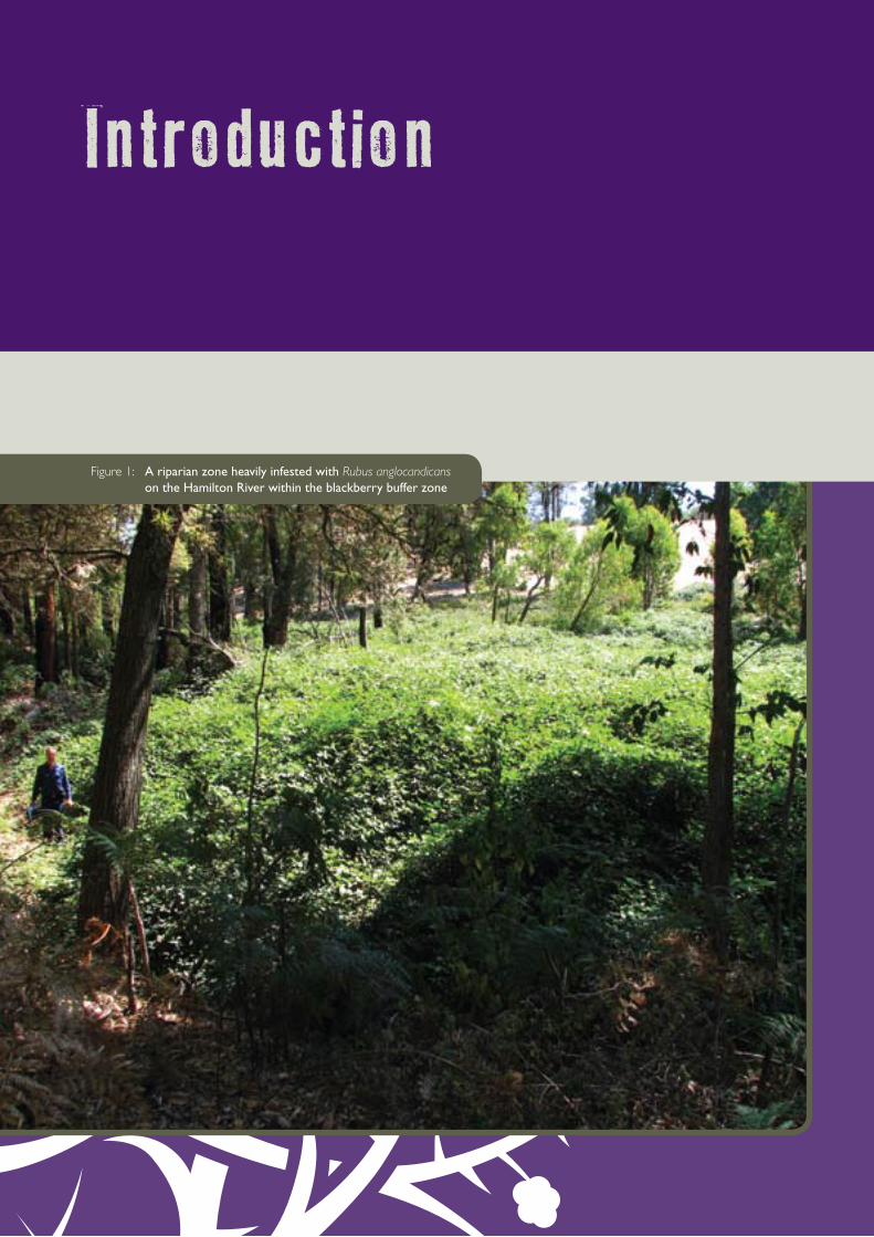
Figure 1: A riparian zone heavily infested with Rubus anglocandicans on the Hamilton River within the blackberry buffer zone

9
Introduction <BackgroundBlackberry (Rubus spp.) is a Weed of National Significance and major environmental weed of Western Australia (Moore & Wheeler 2002). It infests a 600-km-long by 100-km-wide belt from Perth to Albany. One of three main species is R. laudatus from North America, which occurs mainly in the infestation’s northern part (especially around the Perth metropolitan area) and generally only north of Collie. The other two species originate from Europe: R. anglocandicans occurs over most of the infested region and R. ulmifolius is mainly found in scattered populations around the townships of Manjimup and Pemberton, with a few infestations around Albany.
Two strains of the rust (Phragmidium violaceum) have been released, one in 1984 (Moore & Hoskins 1985) and one in 1991 (Dodd & Lloyd 1992). These are now widely distributed but have had little impact (Moore & Wheeler 2002). Eight new strains were released in 2004 to help control this weed (Morin et al. 2005). They have caused significant damage to R. anglocandicans, moderate damage to R. ulmifolius and little damage to the American species, R. laudatus.
It is anticipated that rust damage may result in the American species replacing the European species – with the maximum benefit of the biocontrol program being lost. (A similar situation occurred when other strains of the same rust were released in Victoria in the 1980s.) Thus a strategy was required to maximise the biocontrol program’s effects.
The blackberry buffer zone, also known as the blackberry containment line, was established in 2007. A line from Collie to the west coast essentially separates the relatively pure R. anglocandicans in the south from the mixed infestations in the north [see Figure 2].
The Brunswick and Collie rivers, railway line and road provides access across the rugged Darling Scarp and creates an opportunity to develop a 10-km-wide blackberry-free barrier between these two species, which will reduce the seed-borne spread of blackberry to very low levels (Moore et al. 2007) [see Figure 3].
The blackberry buffer zone was originally developed as a one-year standalone project. It was not anticipated that further funding or support would be available in subsequent years, other than the regulatory support of audit and compliance offered by DAFWA biosecurity staff.
It was recognised that the Defeating the Weed Menace funding would not be sufficient to identify and control all blackberry infestations within the buffer zone; thus the primary activity was to provide first-year control to private landholders within the buffer zone. The work would be conducted ‘tenure blind’ and provide access to herbicide or contractor-supported treatments where requested by the landholder. Follow-up treatments were to be conducted by the landholder at their expense.
Several management decisions were made based on the available funding, which included:
• DEC land would not be treated but the agency would be encouraged to support the investment by private landholders where a private/public interface between properties existed (via its Good Neighbour policy).
• The Collie townsite and Collie River immediately adjacent to the townsite would be excluded from the buffer zone due to the large number of additional landholders this would include and the difficulty to engage and communicate with them for a one-year program.
• The Coalfields Highway would form the buffer zone’s southern portion because it was an asset that allowed ease of movement and a defined line. It was recognised that the natural spread of blackberry was along river systems and that a more appropriate boundary would have been the Collie River from Wellington Dam to its mouth.
• Mining tenement and commercial utilities were excluded from the supply of herbicide or contract support because it was felt they already had access to significant resources that did not require a public-funded investment.
After the blackberry buffer zone was established, it was recognised that strategic weed management for blackberry in Western Australia was a national priority. This resulted in further investment by federal, state and local governments, alongside the continued support of public and commercial interests.
BUNBURY
Busselton
PERTH
Augusta Pemberton
Bridgetown
Manjimup
Nannup
Waroona Boddington
Williams
ALBANY
Mandurah
Northam
Blackberry Buffer Zone
Rubus anglocandicans
Rubus laudatus
Figure 2: Distribution of the main species of blackberry in Western Australia and the blackberry buffer zone

10
BUNBURY
BrunswickJunction
Burekup
Dardanup
Mungalup
Collie
Worsley
Muja
FundingFunding 2007–08
In 2007 DAFWA and the Defeating the Weed Menace program of Natural Heritage Trust (NHT) invested $150,000 for the establishment of the blackberry buffer zone in Western Australia.
Contract spraying $ 55,901.00
Chemical supplied to landholders $ 2,091.00
Chemical analysis $ 7,175.00
DAFWA’s in-kind contribution $ 84,833.00
TOTAL $ 150,000.00
DAFWA’s in-kind contribution included:
• DAFWA officers’ time
• audit inspections and compliance
• national reporting and scientific papers.
Funding 2008–09
No funding was available in 2008–09. DAFWA continued audit and compliance activity for supporting landholders and awareness of the buffer zone. As a result of this:
• 9 landholders contacted DAFWA seeking further herbicide
• 3 landholders used their own spray equipment/herbicide
• 6 landholders sprayed in conjunction with their neighbours
• 10 large landholders undertook their own spray programs.
DAFWA’s in-kind contribution $ 6,412.00
TOTAL $ 6,412.00
DAFWA’s in kind contribution included:
• DAFWA officers’ time (15 days).
• audit inspections and compliance (five days).
Figure 3: Blackberry buffer zone project area

11
Introduction <
Darkan
Funding 2009–10
In 2009–10 SWCC obtained core funding from CfoC to continue work on the blackberry buffer zone. In addition, additional funds were secured from the commercial mining sector (Worsley), local government (Shire of Harvey) and the Water Corporation via the Shire of Collie to treat specific blackberry-infested reserves and farmland within the buffer zone.
SWCC 2010 on ground* $ 52,874.58
LCC (Worsley)** $ 25,000.00
Harvey Shire $ 2,715.90
Water Corporation $ 4,664.23
UCL Brunswick River $ 5,000.00
DAFWA’s in-kind contribution $ 6,412.00
TOTAL $116,412.00
* With CfoC funding, SWCC allocated $52,874.58 to on-ground blackberry control (contractor spraying) as well as allocating project officer time (0.5 FTE)
** Worsley funding was received through the LCC as part of Worsley’s community funding program and was spent on control works on the Brunswick and Wellesley rivers.
DAFWA’s in-kind contribution included:
• DAFWA officers’ time (15 days).
• attendance at community events (five days).
Funding 2010–11
With funds rolled over from the 2009–10 financial year and remaining funds from SWCC’s CfoC allocation to the project, a total of $30,100 was available for work in 2010–11.
The LCC was successful in gaining a CfoC grant of $294,425.94 for blackberry control, as well as a State NRM Office grant of $229,676 to continue work in the blackberry buffer zone and provide for rehabilitation and community awareness projects.
As a result of this funding to LCC, SWCC’s funding of $30,100 was allocated to paying for additional DAFWA services to the project, including the additional audit and surveillance work for this evaluation.
Of these amounts, the following has been allocated to on-ground control of blackberry.
LCC (State NRM Office) $ 58,900.00
LCC (CfoC)* $ 54,500.00
LCC (Worsley) $ 18,600.00
SWCC (CfoC) $ 30,100.00
Shire and other landholder contribution $ 8,000.00
DAFWA in-kind contribution – biosecurity officer** $ 9,000.00
DAFWA in-kind contribution*** $ 9,000.00
TOTAL $188,100.00
* An additional $60,500 is allocated from the LCC CfoC funding to on-ground control of blackberry in 2011–12
** The DAFWA biosecurity officer allocated to this project had 0.1 FTE purchased but spent an additional 0.1 FTE on the project
*** Includes biosecurity officers’ time across the South West Agricultural Region, five officers at five days/person (25 days total).
River rehabilitation on-ground funds for 2010–11:
LCC (State NRM) $ 32,000.00
LCC (CfoC) $ 30,000.00
LCC (Worsley) $ 20,000.00
TOTAL $ 82,000.00
Summary
Total investment in the blackberry buffer zone:
2007–08 $150,000.00
2008–09 $ 6,412.00
2009–10 $116,412.00
2010–11 $270,100.00
TOTAL $542,924.00

Part AEvaluate the effectiveness of the blackberry buffer zone
Progress towards eradication of blackberry within the buffer zone was measured against five criteria:
1. Delimitation of blackberry infestations within the buffer zone for: • private land • private land – BHP Billiton Worsley Alumina Pty Ltd • private land – coal and power generation companies • public land – DEC estate
2. Control and containment of treated blackberry within the buffer zone
3. Prevention of re-introduction of blackberry to treated properties
4. The buffer zone’s ability to prevent Rubus laudatus establishing south of the buffer zone
5. The extent to which all relevant sectors currently support and contribute to the program
BUNBURY
BrunswickJunction
Burekup
Dardanup
Mungalup
Collie
Worsley
Muja
Darkan
Property - Blackberry present (follow up if required)
Property - Sprayed
Property - No response
Properties Blackberry Free
Blackberry Buffer Zone
0 2 4 6 8 10
kilometres
Figure 4: Results of the 2007–08 survey of landholders identifying respondents to the survey and treatment applications

Evaluate the effectiveness of the Blackberry Buffer Zone PART A
Delimitation of blackberry infestations within the buffer zone
13
1
Of the 363 letters that were delivered, 83 respondents (23 per cent) indicated they had blackberry on their properties. Of these, 20 requested they be supplied with chemicals to treat their own infestations and 63 requested a contractor to undertake the work.
One hundred and thirty property owners (36 per cent) said their properties were free of blackberry.
One hundred and fifty property owners (41 per cent) did not respond to the survey. The largest landholders within the buffer zone including DEC, Worsley and the coal mining and power generation companies were unable to respond to the survey because they could not define the extent of the infestation on their land. Of the private landholders that did not respond, most were located east of the Collie townsite where it was anticipated that blackberry had a limited distribution due to land use practices.
The 2007–08 works program concentrated on the 83 respondents who reported the presence of blackberry. They were subsequently supplied with free herbicide to treat infestations themselves or a contractor did the control work at no charge to the landholder. Details of the 2007–08 treatments are provided in Figure 4.
In addition to the treatment program, a blackberry identification workshop attracting 25 participants was conducted by Annette Beer, an education officer with the CRC for Australian Weed Management (Weeds CRC). An Agmemo article and media release was also completed and distributed to local media outlets, followed by a radio interview.
In 2008–09 no funding was secured, although a letter outlining the obligations for controlling declared plants was sent to all landholders in the buffer zone as part of DAFWA’s communication strategy.
Audit and compliance activities were undertaken as part of normal biosecurity practices.
Landholders actively undertook their own treatments and the following activities were reported to DAFWA (Reeves 2010):
• nine landholders contacted DAFWA seeking further herbicide
• three landholders used their own spray equipment/herbicide
• six landholders sprayed in conjunction with their neighbours
• 10 large landholders undertook their own spraying programs.
In addition to DAFWA’s audit and compliance work, the Water Corporation helped nine landholders in the Allanson area of the Collie Shire to do their own spraying.
All landholders inspected by DAFWA were actively managing blackberry on their properties and all treatments were conducted through voluntary work agreements. No work orders needed to be applied under section 50 or section 52 of the Agriculture and Related Resources Protection Act 1976 (WA).
In 2009–10 SWCC sent a further 290 letters to landholders within the blackberry buffer zone after funding was secured from CfoC. The letters outlined the success of the 2007–08 program and informed landholders that the program would continue. The landholder was not asked to give information on the presence or absence of blackberry on their property.
A total of 216.54 ha was treated for the control of blackberry in 2009–10, of which 73.3 ha was farmland and 143.24 ha was on reserves and public lands. Two contractors were engaged to conduct the on-ground treatment at the direction of DAFWA biosecurity officers. Contractor 1 had a cost of $136/ha treated,
Table 1: Survey results from 2007–08 landholder survey
Total number of properties targetted in mailout 384Total letters successfully delivered* 363
Results of properties which responded (363)
Properties > With blackberry > Free of blackberry > No response
83 130 150 > Contractor treated > Owner treated
63 20
* A total of 384 letters were sent out and of these, 21 letters were returned with an incorrect address/contact details.
1:1 Private landIn 2007–08 a mailout to landholders sought to determine blackberry extent and distribution on private land. It informed them about the blackberry buffer zone and one-year control program and requested them to supply information about the presence/absence of blackberry on their properties. Letters were sent to 339 landholders on 384 properties within the buffer zone, including the area east of the Collie townsite.

Delimitation of blackberry infestations within the buffer zone
PART A Evaluate the effectiveness of the Blackberry Buffer Zone
1
14
while contractor 2 had an average cost of $462.45/ha treated. This substantial difference reflects the working environment of the two contractors: contractor 1 worked in open farmland and river reserves while contractor 2 worked in dense bushland and difficult-to-access terrain.
The contractors’ work was audited via a desktop assessment of the forms they both completed. This audit was supported by inspection of all treatment locations by DAFWA biosecurity staff eight weeks after treatment to assess the percentage of control. After all of the sites were inspected, it was found that the contractors’ work had achieved 95 per cent control.
Infestations of < 10 m² were usually eradicated in one treatment due to complete coverage of the infestation with herbicide. Larger infestations (50 m²) generally have a larger crown that requires a second treatment to ensure blackberry death. Infestations larger than 50 m² require an initial treatment to reduce density and provide access to the whole bush before a second- and third-year treatment can be applied to complete control of the infestation (Vukelic 2010, pers. comm.)
Figure 5 provides details of the 2009–10 treatments, which were mostly located along the Brunswick River.
In addition to the treatment program, SWCC arranged a consultation with the local Aboriginal community, organised media releases and workshops (e.g. two at Brunswick attended by local community groups including the Brunswick River Restoration Action Group) and developed an information brochure for
distribution throughout the community. DAFWA provided a follow-up Agmemo article for local agricultural producers.
In 2010–11 further funding was secured from CfoC and the State NRM Office to support the blackberry buffer zone. To coordinate the required activities, LCC, SWCC, DEC and DAFWA formed a blackberry working group with the support of Worsley and the shires of Harvey and Collie.
The blackberry working group sent letters to all properties within the blackberry buffer zone, as well as 50 properties along the Wellesley River (a tributary of the Brunswick). Landholders were not asked to give information on the presence or absence of blackberry on their properties, but they were invited to report blackberry infestations to DAFWA or SWCC.
Through the State NRM Office and Worsley funding, $77,500 was available for on-ground control. This was spent across 24 properties with a total of 71.53 ha treated. The area on each property ranged from 0.2 ha to 8 ha. The CfoC funds of $54,500 treated a total area of 66 ha across 31 properties that ranged from 0.5 ha to 7.9 ha treated. This total included an area of 36.6 ha of high-priority Rubus laudatus south of the blackberry buffer zone. The property treatments south of the buffer zone were conducted over 11 properties in the Preston Valley and 10 properties in the Newlands area. Details of the 2010–11 treatments are provided in Figure 6.
Media and extension activities included installation of a large sign along the Coalfields Highway (the southern boundary of the buffer zone) and an accompanying media release to highlight the project’s significance (Appendix 1, blackberry containment zone road sign).
BUNBURY
BrunswickJunctionAustralind
Boyannup
Allanson
Collie
Donnybrook
Property treated 2009/2010
Property - Intersecting Buffer
Blackberry Buffer Zone
0 5 10 15 20
kilometres
Treatment Point 2009/2010
Figure 5: Results of the 2009–10 blackberry treatments

15
Increased awareness resulting from the letters, sign and local press coverage, and/or peer pressure from neighbours, resulted in 20 landholders contacting DAFWA and SWCC to confirm they would either continue the program on their own properties or would like to join the program.
Landholders were confident the program was achieving its aims and making a difference to the extent of blackberry in the buffer zone. This was reflected in the high level of property access granted to DAFWA biosecurity staff and the LCC project officer. Properties that would have previously restricted access, including some large private landholdings with extractive industries, were now allowing access and actively treating blackberry on their own properties at their own expense.
By being allowed greater property access in 2010–11, biosecurity and project staff were able to identify outlier and hard-to-locate infestations and arrange for their treatment.
Project staff are now confident there are no large undetected or unreported infestations of blackberry on private land within the buffer zone. Importantly, no infestations of Rubus laudatus have been detected within the buffer zone.
1:2 Private land BHP Billiton Worsley Alumina Pty Ltd
BHP Billiton Worsley Alumina (Worsley) land within the blackberry buffer zone represents a considerable area that forms a buffer between private and public land. It is considered separately to other private land within the buffer zone because the area of land is considerable, it is managed by a mining operation and Worsley is a financial contributor to the buffer zone.
Worsley provided $25,000 in community funding to support the blackberry project in 2009–10 and $38,600 in 2010–11 through the LCC.
Worsley has completed mapping of blackberry infestations on its own estate [see Figure 7] and undertakes treatment each year in line with its available budget.
Worsley does not have a specific management plan for the treatment of blackberry on its estate, however areas that have received first-year control have been identified in figures 8 and 9.
BUNBURY
BrunswickJunction
Australind
Boyannup
Allanson
Collie
Donnybrook
Property treated 2010/2011
Property - Intersecting Buffer
Blackberry Buffer Zone
0 5 10 15 20
kilometres
Treatment Point 2010/2011
Figure 6: Results of the 2010–11 blackberry treatments

Delimitation of blackberry infestations within the buffer zone
PART A Evaluate the effectiveness of the Blackberry Buffer Zone
1
16
1:3 Private land Coal and power generation companies
Two mine sites east of the Collie townsite, owned by Griffin Coal and Wesfarmers Premier Coal, occupy significant areas of land for which there is minimal data about the extent of blackberry. The areas around the Muja and Collie power stations also have not been investigated for the extent and distribution of blackberry.
DAFWA records on the presence of blackberry over these lands are minimal and engagement with the relevant environmental officers was not pursued by DAFWA or SWCC before 2010.
LCC investigations in 2011 determined the coal companies and power utilities do control weeds on these lands, including treatment of blackberry. However, blackberry infestations are not specifically mapped and control is not reported to the blackberry working group. For surveillance activities to occur, project officer time would need to be funded so that relationships with the environmental officers at these mine sites could be established. Safety and induction activities may need to be completed and surveillance mapping of blackberry undertaken.
1:4 Public land DEC estate
Blackberry was surveyed on 16 March 2011 along the Hamilton River to gauge the level of blackberry infestation on DEC estate. Two DAFWA officers undertook a one-day survey of the river, walking the river system and using access tracks to inspect the river at 500 to 1000 m intervals along its length. At each surveillance point, 100 m up and downstream was inspected and the presence or absence of blackberry recorded. Key locations such as road intersections and utility crossings were also inspected. Rubus anglocandicans was detected in the survey but R. laudatus was not.
The survey’s aim was to detect large areas of unmanaged blackberry on public land (DEC estate) that might pose a risk for re-infestation downstream and/or those areas with the potential to develop into large infestations that could affect the native vegetation.
The results of the field survey are presented in Table 2 and figures 10 and 11.
!
!!
!!
!!
!
!
!
!!
!!
!!
!!
!!
!
! ! ! !
!!
!
!!!!!!!!!!!!
!!
!!
!
! ! ! ! ! ! ! ! ! ! ! !
! !
!!
!!
!!
!!
!!
!!
!
!!
!!
!!
!!
!!
!!
!
!!
!!
!!
!!
!
!!
!!
!
!!
!
!!
!!
!!
GA
STA
LDO
COALFIELDS
HAMILTO
NV
ICTO
R
WORSLEY BACK
BEELA
MORNINGTON
LIBERAL
WALLIS
LABOUR
WO
RSLE
Y M
ILL
ELLIN
GTON D
AM
BEELA
WORSLEY BACK
WORSLEY BACK
Worsley Land Boundary
Blackberry
RoadsSealed Road
Track
Minor Road
Railways
Transmission Line
0 0.5 1
kilometres
Figure 7: Blackberry locations on BHP Billiton Worsley Alumina land identified as of March 2011

17
Worsley Land Boundary
Blackberry control area
0 0.5 1
kilometres
Figure 8: Blackberry locations on BHP Billiton Worsley Alumina land treated in March 2010
GASTA
LDO
COALFIELDS
HAMILTO
N
VIC
TOR
WORSLEY BACK
BEELA
LIBERAL
MORNINGTON
WALLIS
LABOUR
WO
RSLE
Y M
ILL
WORSLEY BACK
BEELA
Worsley Land Boundary
Blackberry control area
RoadsSealed Road
Track
Minor Road
Railways
Transmission Line
0 1 2
kilometres
Figure 9: Blackberry locations on BHP Billiton Worsley Alumina land treated in March 2011

Delimitation of blackberry infestations within the buffer zone
PART A Evaluate the effectiveness of the Blackberry Buffer Zone
1
The survey intersected the Hamilton River and the Coalfields Highway: sites 1 and 2 were areas of public land with blackberry downstream of a significant private landholder infestation (the area was under first-year management).
The survey extended through the Worsley timber estate and private landholdings (Table 2, points 3 to 7). These points include significant infestations of R. anglocandicans that have already been mapped in Figure 7.
The inspection of public land north of the Worsley estate and private property showed that blackberry is present on the public land as small, isolated infestations (Table 2, points 8 to 19). The native vegetation along the Hamilton River north of the Worsley estate is undisturbed and has very few locations where blackberry has become established. Most of the public land did not have blackberry or had minor infestations; in most cases the bushland was healthy and resilient to invasion by blackberry. Areas where roads and powerlines intersect the public waterways result in additional disturbance where weed invasion can occur (site 10).
Site 12 located an area of blackberry within public land approximately 50 m x 100 m (0.5 ha) in size. This infestation was significant as it was starting to compete with the native vegetation and, over time, could provide a significant seed source. As the blackberry density increases at this site it could alter the native vegetation’s composition and serve as a significant food source for native and feral animals, further increasing the chance of spread. Control is feasible by using a 200 m retractable hose reel and vehicle-mounted spray tank parked on the adjacent roadway.
The limited areas where blackberry has established include sites where roads, powerlines and walking tracks cross the Hamilton River and are subject to additional/altered water flow and other disturbance. Control of small infestations is technically feasible using backpack sprayers and targetted applications, yet these small, isolated infestations represent a minimal risk of spread.
Eleven river systems were identified (see Part A, Section 3) as requiring investigation for the presence of blackberry along riparian areas within the buffer zone. Resource requirements for investigation of these river systems are discussed in Part B, Section 8.
Table 2: Survey of the Hamilton River to map infestations of blackberry on public lands
Location South East Landowner Area infested
1 33° 19’ 37.1” 116° 02’ 44.0” DEC estate < 0.1 ha
Notes: Juvenile R. anglocandicans to 20 cm high.
2 33° 19’ 37.4” 116° 02’ 47.5” DEC estate 0.25 ha
Notes: Tennis-court-size area of R. anglocandicans.
3 No GPS point No GPS point Worsley estate n/a
Notes: Small tributary to Hamilton River with R. anglocandicans.
4 33° 19’ 10.2” 116° 02’ 41.4” Worsley estate > 0.5 ha
Notes: Solid R. anglocandicans across Hamilton River. Outer areas treated.
5 33° 18’ 54.3” 116° 02’ 41.2” Worsley estate > 0.5 ha
Notes: Large R. anglocandicans bushes in Hamilton River. Large area of R. anglocandicans.
6 33° 18’ 42.6” 116° 02’ 36.4” Worsley estate > 0.5 ha
Notes: Tributary flowing from farmland into Hamilton River. Large area of R. anglocandicans.
7 No GPS point No GPS point Worsley estate > 1.0 ha
Notes: Interface between farmland and creekline. Large area of R. anglocandicans.
8 33° 18’ 21.2” 116° 03’ 05.9” DEC estate > 0.1 ha
Notes: Isolated large plants of R. anglocandicans in Hamilton Creek adjacent to farmland.
9 33° 18’ 05.6” 116° 03’ 06.9” DEC estate
Notes: No blackberry.
10 33° 17’ 53.0” 116° 03’ 09.5” < 0.1 ha
Notes: Power lines over Hamilton River, 3 to 4 R. anglocandicans plants.
11 33° 17’ 40.3” 116° 03” 07.1” DEC estate
Notes: No blackberry Wallis Road to Donnybrook.
12 33° 17’ 31.7” 116° 03’ 02.8” DEC estate 0.5 ha
Notes: Disused bridge, isolated R. anglocandicans around bridge. Note on map the large infestation downstream (several tennis courts in size).
13 33° 17’ 09.8” 116° 03’ 01.1” DEC estate n/a
Notes: No blackberry
14 33° 16’ 56.7” 116° 02’ 54.6” DEC estate n/a
Notes: No blackberry
15 33° 16’ 44.2” 116° 02’ 48.2” n/a
Notes: No blackberry
16 33° 16’ 34.3” 116° 02’ 48.2” DEC estate n/a
Notes: No blackberry Hamilton River and Liberal Road.
17 33° 16’ 20.0” 116° 03’ 40.2” DEC estate n/a
Notes: No blackberry Hamilton River alignment not evident.
18 33° 16’ 17.4” 116° 03’ 57.6” DEC estate n/a
Notes: No blackberry Hamilton River and Mornington Road.
19 33° 16’ 06.6” 116° 04’ 17.9” DEC estate n/a
Notes: No blackberry open woodland, river alignment not evident.

19
Worsley BackRoad
Wallis RD
Coalfields Hwy
Wellington Dam4
on t
410500
410500
411000
411000
411500
411500
412000
412000
412500
412500
6311500 6311500
6312000 6312000
6312500 6312500
6313000 6313000
6313500 6313500
6314000 6314000
6314500 6314500
6315000 6315000
6315500 6315500
1
7
4
6
5
8
1110
No Blackberry
Blackberry Present
Blackberry Present
Road
Track
River, waterway, water body
Department of Environment & Conservation
Worsley Alumina
0 100 200 300 400 500
metres
Figure 10: Inspections for blackberry on public land along the lower Hamilton River, March 2011

Delimitation of blackberry infestations within the buffer zone
PART A Evaluate the effectiveness of the Blackberry Buffer Zone
1
20
1:5 ConclusionsSmall infestations of Rubus anglocandicans continue to exist within the buffer zone in hard-to-access areas. Control has been achieved for an estimated 95 per cent of all treated blackberry infestations, with no large untreated infestations being detected during extensive on-ground property inspections conducted by DAFWA biosecurity officers and SWCC and LCC project staff from 2007–08 to 2010–11.
Delimiting of blackberry on Worsley land has been completed and some areas are heavily infested with Rubus anglocandicans. These will require additional investment from Worsley to ensure the area is treated to kill the blackberry. The infestation’s extent has been identified and mapped and treatments are being applied each year. Project staff are confident no large, undetected infestations of blackberry exist on Worsley land. No infestations of R. laudatus are known to occur on Worsley land within the buffer zone.
The extent and distribution of blackberry on the large mine sites of Griffin Coal and Wesfarmers Premier Coal and the Muja and Collie power stations have not been mapped or included in the existing records of blackberry buffer zone project staff. Weed control activities are known to occur at the coal mining sites but no distinction is made between blackberry and other weed species (Hugues-Dit-Ciles 2011, pers. comm). Additional investment for raising awareness of the blackberry project at these operations is required, as is surveillance mapping of blackberry infestations on this land.
Public land within the blackberry buffer zone is mostly DEC estate. A one-day inspection of the Hamilton River has established that limited blackberry infestations occur along public waterways administered by DEC. Small areas of R. anglocandicans are present at sites such as roadways and walk trails. On occasion those areas have the potential to significantly affect downstream areas or serve as a food source for native and feral animals. Treatment of these infestations on the Hamilton River is technically achievable and should be undertaken.
In 2010–11, control work on public land has focused on areas that are easy to access and treat such as community camping and day-trip locations visible to the public. Weed control in these locations needs to be completed. Additional resources need to be allocated to the mapping of creek lines within DEC estate to detect and treat blackberry infestations before they become established.
1:6 Recommendations . : RECOMMENDATION 1
Surveillance, inspection and mapping activities be undertaken with the relevant environmental officers to determine the extent and distribution of blackberry on land occupied by coal companies and power generation companies east of the Collie townsite.
Key activities
a. NRM project officer time is allocated toward developing a relationship with the environmental officers at the coal mining and power generation companies east of Collie to raise their awareness of the blackberry buffer zone project.
b. Mining and utility companies in the Collie Shire to develop a management plan for blackberry on their tenements that identifies first-, second- and third-year treatment areas and assigns resources to control activities.
c. NRM project officer time is allocated toward undertaking mine-site induction activities to allow access to the land occupied by coal mining and power generation companies east of Collie.
. : RECOMMENDATION 2
Continued engagement with DEC is required to ensure that surveillance and treatment of blackberry on the public estate within the buffer zone is undertaken as a priority.
Key activities
a. DEC to continue treating blackberry in public land access areas within the buffer zone to eradicate all blackberries from areas of high human use.
b. DEC to undertake surveillance mapping along natural watercourses at 500 to 1000 m intervals and at road and utility junctions to identify infestations of blackberry, and apply treatments where practical.
c. DEC to monitor public land for blackberry in response to ‘trigger’ events such as large-scale disturbances (e.g. fire) that will make these areas susceptible to blackberry invasion.

Evaluate the effectiveness of the Blackberry Buffer Zone PART A
Delimitation of blackberry infestations within the buffer zone 1
21
Wallis RD
Hamilton River
n
Morni gton Road
Hamilton Road
LIBERAL RD
16
15
14
12
411000
411000
411500
411500
412000
412000
412500
412500
413000
413000
413500
413500
6316000 6316000
6316500 6316500
6317000 6317000
6317500 6317500
6318000 6318000
6318500 6318500
6319000 6319000
6319500 6319500
No Blackberry
Blackberry Present
Blackberry Present
Road
Track
River, waterway, water body
Department of Environment & Conservation
0 100 200 300 400 500
metres
Figure 11: Inspections for blackberry on public land along the upper Hamilton River, March 2011

PART A Evaluate the effectiveness of the Blackberry Buffer Zone
22
Control and containment of treated blackberry within the buffer zone2
The blackberry buffer zone’s effectiveness can be assessed by determining the extent of the control and containment treatments.
The Best practice management guide for blackberry has identified that effective control involves repeated treatment and inspection to ensure the crown of the plant has been killed.
Once an area has been treated it will be necessary to monitor the area for many years and destroy new plants. Effective monitoring is important to help measure the progress of the management and rehabilitation program. Whilst you may think the program is progressing well, the analysis of simple records could indicate ways to improve it. The most important records to keep are the efficacy and cost-effectiveness of the various treatment techniques (Bruzzese et al. 2000).
Field assessments and auditing of the contractors’ works have determined that treatment efficacy has resulted in > 95 per cent control of blackberry in the first year of treatment of any infestation. Site conditions and the extent of infestation in the first year of treatment determine if the location requires a second herbicide application the year after. Biosecurity staff have identified that for large infestations where it is difficult to treat the entire sward in one application, it is better to allow the treated plants to break down in the second year and thus allow access and expose any surviving canes to follow-up treatment in the third year. This also allows any surviving blackberry to establish a cane that is far more easily detected in the third year than locating small shoots in the year after the first treatment. The regenerated cane has a larger surface area for herbicide absorption compared with any small shoots that may appear in the year after treatment.
Where small infestations can be treated by walking around the infested area and accessing all sides of the blackberry, > 97 per cent control is achieved. However in the small number of cases where a cane survives, treatment the following year results in 100 per cent control.
2:1 MethodsTo assess the effectiveness of the treatments, an audit of the locations that had received two years’ control was undertaken. The review concentrated on those properties where blackberry was reported as being present during the 2007–08 survey.
In 2010–11, funding secured by the LCC enabled the appointment of a project officer – who helped DAFWA biosecurity staff conduct the following audit within the blackberry buffer zone.
The audit identified four main types of properties from the 2007–08 survey that needed to be inspected:
> Category 1: Properties that landholders reported as having blackberry, where contractors carried out treatment
> Category 2: Properties that landholders reported as having blackberry, where they treated the infestation themselves
> Category 3: Properties that landholders reported as having no blackberry
> Category 4: Properties for which there was no response to the survey
2:2 Results> Category 1
Of the properties where blackberry was reported as present and where a contract weed sprayer treated the infestation, a total of 17 per cent were randomly audited (11 out of 63). Two properties (18 per cent) achieved blackberry eradication and at the nine properties that continued to have blackberry, all reported a high rate of initial kill followed by regeneration in small areas from root and seed. The properties in this category generally had larger infestations in difficult-to-access areas, or the landowners did not have suitable equipment to treat the blackberry.
> Category 2
Of the properties where owners reported the presence of blackberry and chose to treat the infestation themselves (with herbicide supplied by the program), 30 per cent were audited (six out of 20). Four out of six properties (66.6%) no longer have blackberry after initial and follow-up treatments by the landholder. Of the four properties that have achieved eradication, three required one treatment only (all blackberry was killed) and one property required a further treatment the following year.
At two properties that continue to have blackberry, the initial treatments were successful; however, small amounts still exist in the difficult-to-access locations, such as a quarry and river reserve.
The properties in this category generally had small infestations that were readily accessible to the property owner, who also had suitable equipment to treat the blackberry.

23
> Category 3
Nine per cent of properties (12 out of 130) with landowners reporting the absence of blackberry were audited. Nine out of the 12 audited properties (75 per cent) did not have blackberry, while three properties (25 per cent) had become infested since the initial survey was conducted in 2007–08.
Of the three properties reported to have become infested with blackberry since the buffer zone began in 2007–08, two were reported to be newly infested (2009–10) from neighbouring properties, with an area of less than 5 m². Another area of blackberry (10 m²) was reported in grape vines, which the landholder did not want treated by the con tractor, the landholder spot sprayed the infestation themselves.
> Category 4
One hundred and fifty properties did not respond to the 2007–08 survey. Four per cent (six out of 150) were audited and of these, none had blackberry. The sample size of the properties in this category is too small to draw any conclusions and further sampling is required to achieve at least a 10 per cent audit of properties.
2:3 DiscussionFirst-year control treatments have resulted in a large reduction in the area of blackberry on individual properties, with > 95 per cent control of treated infestations in the first year. Control and containment have been very effective on these properties, with the larger infestations that previously existed on private land now being reduced to less than 10 m². Small infestations that continue to exist
are usually confined to areas that are difficult to access.
Some large infestations remain on private property where treatment of the entire infestation was not possible in one year, due to access constraints. On these properties additional investment is required to complete the primary treatment across the entire infestation before a secondary treatment can be applied.
Second- and third-year treatments are still required on some properties to move from control and containment to property-based eradication of blackberry on private land within the buffer zone.
2:4 Recommendations. : RECOMMENDATION 3
DAFWA biosecurity staff apply an inspection and compliance regime for infested properties within the buffer zone to ensure that blackberry continues to be treated.
Key activities
a. DAFWA policy continues to have a high priority in the blackberry buffer zone as a strategic weed control initiative.
b. DAFWA biosecurity officer time is dedicated to audit and compliance activities each year within the blackberry buffer zone.
c. NRM and DAFWA officers continue to provide extension material to property owners advising that three years of control and monitoring is required to ensure eradication of blackberry is achieved.
Blackberry along Brunswick River after treatment.

PART A Evaluate the effectiveness of the Blackberry Buffer Zone
24
3 Prevention of re-introduction of blackberry to treated properties
Blackberry infestations are found to the buffer zone’s north and south, with varying levels of active management. Infestations within the buffer zone are subject to ongoing management and are being controlled, with the long-term aim of property-based eradication. Incursions of blackberry into the buffer zone will occur, however for the buffer zone to remain effective, this must be kept to a minimum.
Re-infestation of blackberry will come from two sources:
• infestations within the buffer zone from existing sources
- infestations under active management
- infestations not under active management
• infestations outside of the buffer zone spreading along movement pathways.
3:1 Infestations within the buffer zone – under active management
The delimiting survey on private property, as well as land managed by Worsley, has established that treatment of known infestations over at least three years is required for successful eradication of blackberry. Active management of land within the buffer zone is contributing to an ongoing reduction of blackberry infestations. Treatment is a risk-reduction measure to ensure re-infestation does not occur.
3:2 Infestations within the buffer zone – not under active management
The delimiting survey on public and private land associated with the DEC estate, coal mining and power generation companies has not adequately determined the extent of blackberry infestations. Infestations within these areas pose an increased potential for re-infestation because they are not under active management and treatments are not currently being applied.
3:3 Infestations outside of the buffer zone
The width of the buffer zone (6 km) was designed to be large enough to prevent the spread of blackberry seeds via natural movement along waterways. Animal vectors such as birds, foxes, emus and feral pigs would also be likely to excrete any seeds without traversing the entire width of the buffer zone.
It is likely the buffer zone will be subject to re-invasion from blackberry outside the treatment area, resulting in ‘edge effects’ as new infestations establish on distribution pathways leading into the buffer zone.
These pathways are likely to be along natural watercourses and tributaries where water can be a vector for movement. Riparian vegetation provides cover for animals such as birds and foxes as they move within the buffer zone: therefore spread via animal movement is likely to occur in association with waterways. Waterways on private land have multiple access points and blackberry associated with these river systems can be routinely inspected, treated and monitored by landholders and DAFWA officers. Waterways on public land and DEC estate have few public access points, are often difficult to access and require greater investments in resources to inspect, monitor and treat.
The following river systems are potential pathways of spread into the blackberry buffer zone:
• Wellesley River • Brunswick River
• Harris River • Bingham River
• Hillman River • Darken River
• Chamberlain Creek • Chicken Creek
• Collie River • Collie River South
• Henty Brook.
See Figure 12 for the river systems that flow into and out of the blackberry buffer zone.
After the blackberry buffer zone was identified as a national priority, it became possible to review the initial restrictions that prevented the buffer zone from capturing the natural pathways of spread for blackberry. The two principal areas are the Collie townsite and Collie River adjacent to the townsite and the Collie River from Wellington Dam to its mouth.
These natural boundaries are more appropriate than the Coalfields Highway, given the natural movement pathway of blackberry is along river systems. Having undertaken extensive work on the private landholdings, it is now possible to direct resources to these movement pathways and conduct the required surveillance and mapping activities to treat infestations along these river systems.
3:4 ConclusionsProperties where the extent of blackberry infestations has not been defined and no active management is occurring pose an increased risk of re-infestation to properties free of blackberry. Ongoing work to map infestations along river systems on DEC-managed land, as well as land managed by the coal and power companies, is essential to determine the extent of blackberry and provide for management.
The rate of blackberry spread from outside the buffer zone onto properties within it is likely to be a low risk, however the movement pathways need to be monitored and infestations

25
targetted for treatment to reduce the potential for re-establishment.
The survey of the Hamilton River has determined that blackberry infestations are likely to be small and commonly associated with areas where other disturbances such as road intersections and utility lines cross the river system. However, these have the potential to become larger, unmanaged infestations that may alter the native vegetation.
Originally the buffer zone was created with the Collie townsite and Collie River south of the Coalfields Highway specifically excluded. The original funding in 2007–08 was not sufficient to enable consultation with the large number of landholders along the Collie River and within the town and treatment of this area would have been time-consuming and expensive.
Multiple infestations of blackberry are known to exist along the Collie River and these have the potential to provide a source of seed for downstream areas.
3.5 Recommendations. : RECOMMENDATION 4
The buffer zone be extended to cover the area of the Collie townsite and Collie River adjacent to the townsite to support the Shire of Collie’s policy initiatives.
. : RECOMMENDATION 5
The blackberry buffer zone be extended to include the Collie River around the township of Burekup to ensure that natural distribution along the watercourse is prevented.
Key activity
a. On its estate, DEC to treat blackberry along the natural water-courses that flow into the buffer zone to ensure large seed sources are treated to prevent infestation of downstream areas.
BUNBURY
BrunswickJunction
Burekup
Dardanup
Mungalup
Collie
Worsley
Muja
Darkan
0 5 10 15 20
kilometres
Tributaries flowing into & out of buffer areaWaterway with Buffer AreaWaterwayBlackberry Buffer Zone
Figure 12: Waterways as pathways of movement into and out of the blackberry buffer zone

PART A Evaluate the effectiveness of the Blackberry Buffer Zone
26
The buffer zone’s ability to prevent establishing south of the buffer zone4
4:1 Media and community awarenessTo raise awareness of the program among landholders, the media was engaged and community-based activities organised both within and outside the buffer zone. The reporting of suspected R. laudatus was encouraged, particularly in areas south of the buffer zone.
4:2 FloraBase recordsFloraBase http://florabase.dec.wa.gov.au/ is the authoritative source for information about Western Australian flora. It integrates data from a number of fundamental datasets including the census of Western Australian plants, specimen database of 700,000 vouchered plant collections, and descriptive data and interactive keys for the families, genera and species of vascular plants in Western Australia. These datasets are regularly maintained and updated.
FloraBase has records of eight R. laudatus samples from six shires south of the blackberry buffer zone [see Figure 13], but has no records on the extent of active management at these locations. The known locations were inspected by DAFWA biosecurity staff during the 2010–11 flowering period and the information recorded in Appendix 2.
DAFWA biosecurity officers have inspected all eight locations (the inspection data is summarised in Table 3). More details of each site, including maps, can be found in Appendix 2.
MANJIMUP
DENMARK
BRIDGETOWNGREENBUSHES
DONNYBROOKBALINGUP
DARDANUP
AUGUSTAMARGARET
RIVER
BUNBURY
PERTHKALGOORLIE
ESPERANCE
0 100 200 300
kilometres
Map OneMap Two
BUNBURY
Collie
Donnybrook
Busselton
Margaret River
Augusta Manjimup
Denmark
Albany
Bridgetown
31753404108450
4278321
1769340
333081
3175340 3175340
3175340
3175340
3331040
3331199
4223209
ESPERANCE
0 25 50
kilometres
GIBSON
CONDINGUP5498929
0
Shire with Rubus laudatus
25 50
kilometres
Local Govt Area/Shire
Blackberry Buffer Zone
Rubus laudatus Points
FloraBase ID123
MAP 1 MAP 2
Figure 13: Shire locations of R. laudatus south of the buffer zone from FloraBase information
The aim of the buffer zone is to create an area free of all blackberry and prevent the southward movement of Rubus laudatus beyond the Coalfields Highway and into the forest regions of the state’s south west and south coast.
The extent of R. laudatus south of the buffer zone has been assessed using the following sources:
• feedback from the media and community awareness campaign about the buffer zone targetted at reporting of early-flowering blackberry in October and November
• information from FloraBase that has recorded samples of R. laudatus south of the buffer zone
• information on locations of R. laudatus reported by members of the public, DAFWA field inspectors and spray contractors
• surveillance inspections and treatment of isolated infestations were conducted along two river systems south of the buffer zone; that is:
> Blackwood River > Preston River.

27
Table 3: Inspection outcome of all known FloraBase records for Rubus laudatus south of the blackberry buffer zone
FloraBase information Inspection outcome
PERTH 05498929Rubus laudatus A.Berger
Heidi McCrea from the Esperance NRM Office has informed DAFWA that three blackberry infestations are recorded in the Esperance Shire and all are under active management with the intent to eradicate blackberry from the shire.
Funding is being supplied by CfoC and active management is being undertaken.Phone (08) 9079 6008 [email protected]
Confirmation received by DAFWA 14/10/2010.
PERTH 04223209Rubus laudatus A.Berger
As above
PERTH 04108450Rubus laudatus A.Berger
Inspected by Lee Fontanini from the Manjimup Weed Action Group and Paul Merks, DAFWA. All plants have been eradicated.
Confirmation received by DAFWA 14/09/2010.
No R. laudatus detected at location.
PERTH 04278321Rubus laudatus A.Berger
Inspected by Jason Dearle from DAFWA. All plants have been eradicated.
Confirmation received by DAFWA 06/12/2010.
No R. laudatus detected at location, however R. anglocandicans was widespread and established.
PERTH 1769340Rubus laudatus A.Berger
Inspected by Lee Fontanini from the Manjimup Weed Action Group and Paul Merks, DAFWA. All plants have been eradicated.
Confirmation received by DAFWA 14/09/2010 from Sandy Lloyd.
No R. laudatus detected at location, however R. anglocandicans was widespread and established.
PERTH 03331040Rubus laudatus A.Berger
Inspected by Bradley Rayner, DAFWA (Vasse Research Station).
No R. laudatus detected at location.
PERTH 03331199Rubus laudatus A.Berger
Location identified as 2.5 km out into Hamlin Bay
PERTH 03330818Rubus laudatus A.Berger
Inspected by Julie Webber, DAFWA (Manjimup).
Confirmation received by DAFWA 05/11/2010.
No R. laudatus detected at location.
PERTH 03175340Rubus laudatus A.Berger
Inspected by Jason Dearle from DAFWA (Manjimup).
Confirmation received by DAFWA 05/11/2010.
FloraBase also records locations for R. ulmifolius (small-leafed blackberry) within the Harvey townsite (Figure 14) and adjacent to the buffer zone. R. ulmifolius is only moderately affected by the rust fungus Phragmidium violaceum (Moore et al. 2007). This report was treated as a high priority for investigation.
The site was inspected by a DAFWA biosecurity officer in February 2011 and no plants were detected.

PART A Evaluate the effectiveness of the Blackberry Buffer Zone
28
The buffer zone’s ability to prevent establishing south of the buffer zone4
Table 4: Rubus laudatus south of the blackberry containment line reported to DAFWA
Additional Locations found and treated for eradication
Appendix 3Figure 1
Plant description: Suspect R. laudatusLocality: Dardanup on the corner of Moore and Busher roadsDescription: A small infestation treated by James Sheehan Individual: James Sheehan Treatment date: 25/10/2010Lat 33.38400 Long 115.71340
Treated by: James Sheehan from DAFWA 28/10/2010Inspected: 06/04/2011 and plant had been eradicated.
Appendix 3Figure 2
Plant description: Suspect R. laudatusLocality: Donnybrook Shire along the Preston RiverDescription: Follow-up work from CRIS property 1297120 identified small infestations of R. laudatus along the Preston RiverIndividual: James Sheehan and Brad Rayner Treatment date: 28/10/2010CRIS property ID: 1297120
Treated by: Banks Pest and Weed Control, December 2010
Appendix 3Figure 3
Plant description: Suspect R. laudatusLocality: Tassone Road and South West HighwayDescription: An infestation growing along a creekline adjacent to the roadsideIndividual: James Sheehan and Andrew Reeves Treatment date: 28/08/2010Lat 33.38400 Long 115.71340
Treated by: Banks Pest and Weed Control, December 2010
Appendix 3Figure 4
Plant description: Suspect R. laudatus Locality: Trigwell Street, DonnybrookDescription: An infestation growing along a creekline adjacent to the roadsideIndividual: James Sheehan Treatment date: 08/12/2009Lat 33.58400 Long 115.82345 CRIS property ID: 3199451
Treated by: Banks Pest and Weed Control, 2010
Appendix 3Figure 5
Plant description: Suspect R. laudatus Locality: CollieDescription: An infestation growing along a creekline adjacent to the roadsideIndividual: James Sheehan Treatment date: 08/12/2010Lat 33.58400 Long 115.82345 CRIS property ID: 3199451
To be treated: 2011–12
Appendix 3Figure 6
Plant description: Suspect R. laudatus Locality: Newlands, Donnybrook Shire Description: Paddock infestations across several properties in the Newlands District, DonnybrookIndividual: James Sheehan DAFWA Treatment date: 2010–11CRIS property id(s): 1586740, 1290950, 1288410
Treated: 2010–11 by Banks Pest and Weed Control for LCC

29
HARVEY
RoadsSealed Road
Track
Minor Road
Railways
Transmission Line
Blackberry Inspection Point 2009/2010
0 2 4 6
kilometres0 5 10 15 20
kilometres
Figure 14: Rubus ulmifolius adjacent to the Harvey Oval
Analysis of the data shows the Esperance locations are being actively managed by the Esperance NRM Office (which has funding to treat all known infestations).
Inspections of all the other south-west locations have revealed R. laudatus is not present. Note that location PERTH 03331199 is 2.5 km out into Hamlin Bay.
4:3 Information on locations of Rubus laudatus reported by members of the public, DAFWA field inspectors and spray contractors
FloraBase is not the only source of information on occurrences of R. laudatus. The program’s extension work has resulted in increased reporting of early-flowering blackberry by members of the public. The weed-control activities of local contractors have also resulted in a significant increase in the detection of early-flowering blackberry. See Appendix 3 for further details.
Table 4 lists the locations that have come to DAFWA’s attention and the outcome of subsequent inspections.

PART A Evaluate the effectiveness of the Blackberry Buffer Zone
30
The buffer zone’s ability to prevent establishing south of the buffer zone4
4:4 Surveillance inspections along key river systems south of the buffer zone
DAFWA officers conducted surveillance inspections and treated isolated infestations along the Blackwood and Preston rivers. They stopped every 500 or 1000 m along the river system and inspected 100 m either side of the surveillance point.
R. anglocandicans but no R. laudatus was detected along the Blackwood River (Figure 15).
R. laudatus was detected along the Preston River as small isolated infestations (Figure 16) and in conjunction with R. anglocandicans. Where R. laudatus occurred with R. anglocandicans, both species were treated for eradication. Continued surveillance of the Preston River is a priority in 2011–12.
4:5 ConclusionsThe program’s extension and communication activities have been sufficient to raise awareness of the need to report suspect early-flowering blackberry, Rubus laudatus. Infestations are being reported by property owners, shire officers and private weed contractors that have been involved in the program.
FloraBase records of R. laudatus have all been investigated by DAFWA staff and no active infestations have been detected.
Surveillance activities along the Preston River in the Donnybrook Shire detected R. laudatus growing in association with R. anglocandicans. These infestations have been treated to achieve property eradication. Continued surveillance of the Preston River is a priority in 2011–12.
0 1 2 3 4 5
kilometres
Blackberry not present
Blackberry present
Figure 15: Surveillance inspection for Rubus laudatus along the Blackwood River system 2010-11; only Rubus anglocandicans identified

31
0 1 2 3 4 5
kilometres
American Rubus laudatus
American & European
Blackberry Species
European Rubus anglocandicans
0 0.5 1 1.5 2
kilometres
Figure 16: Surveillance inspection for Rubus laudatus along the Preston River system 2010–11; R. laudatus identified growing alongside R. anglocandicans
4:6 Recommendations. : RECOMMENDATION 6
NRM and DAFWA officers to undertake targetted surveillance along the Preston, Capel, Blackwood and Ferguson rivers to ensure that infestations of Rubus laudatus do not exist south of the buffer zone.
Key activity
a. NRM and DAFWA officers to provide media articles to local papers and formulate extension materials supporting the blackberry buffer zone program to ensure awareness of the program is maintained.

32
the amount of blackberry has been significantly reduced. Some large infestations remain on private property where treatment of the entire infestation was not possible in one year.
On one of these properties, additional investment is required to complete the primary treatment across the entire infestation before a secondary treatment can be applied.
Landholder support can be measured by the extent to which people respond to the letters and mailouts, attendance at information evenings, reporting of suspect blackberry, and whether the landholders themselves continue working on the infestations after the initial treatment.
All of these areas have been positive and indicate strong private landholder support and understanding of the program’s objectives.
5:2 Private landholders BHP Billiton Worsley Alumina Pty Ltd
Worsley has been a strong supporter of the program, contributing financially to annual control outside its estate and also undertaking mapping and control work on its land tenement within the buffer zone.
Worsley is a significant landholder within the buffer zone and is also strategically placed given its land adjoins many of the private landholders on the buffer zone’s eastern side (where most of the control work has been done).
Control in many areas of Worsley’s timber country will be difficult because of access issues. Complete control of blackberry on this land will require a minimum of five to six years to treat the larger infestations and a further three to four years for property eradication treatments and surveillance.
5:1 Private landholdersThe blackberry buffer zone has received positive support from the private landholders (who have been the main beneficiaries of funding to date).
Landholders have often cited the cost of the initial treatment and lack of suitable equipment as barriers to controlling blackberry on their land. Thus the offer of treatment services by contract weed sprayers or the provision of herbicide has removed any issues related to cost and those relating to the necessary equipment.
The federal and state government investment in these key areas has enabled the program’s success to date and provided the opportunity to ‘break the back’ of blackberry across private land within the buffer zone. Most of the private properties have applied primary and secondary (follow up) treatment and in these cases
SWCC has established a blackberry working group that aims to bring the relevant land managers together to exchange ideas and plan work activities within or adjacent to the buffer zone. This working group includes representatives from DAFWA, SWCC, LCC, DEC, Worsley and the shires of Collie and Harvey.
Other community groups are regularly updated on the program’s achievements including the Friends of Worsley, Shire of Collie Weed and Waterways Advisory Group, Brunswick River Restoration Action Group and the Upper Preston River Restoration Action Group.
PART A Evaluate the effectiveness of the Blackberry Buffer Zone
The extent to which all relevant sectors currently support and contribute to the program5

33
5:3 Private landholders Coal and power generation companies
Thus far minimal engagement with representatives from Griffin Coal and Wesfarmers Premier Coal has occurred. Both of these companies have mine sites east of the Collie townsite and minimal data is available about blackberry extent on these lands. Issues relating to access and mine site safety have led to limited surveillance.
The land around the Muja and Collie power stations has also not been investigated for the same reasons.
5:4 Public landholders DEC
The state government, by way of DEC, is the biggest landholder in the buffer zone, managing approximately one third of the land within it. Much of the area is inaccessible, with few forest tracks. The Hamilton River investigation identified small areas of blackberry along the tributary rivers that flow into the Collie River and Wellington Dam; however, the DEC estate is largely intact with native vegetation that appears to be able to withstand blackberry invasion.
Areas where human disturbance has occurred (e.g. road intersections with river systems; powerline and water pipeline easements) are the key areas for surveillance and early treatment.
The point where DEC land adjoins private land is another key area for surveillance and early treatment to support the work of private landholders in conjunction with weed control contractors.
5:5 Collie townsiteThe Collie townsite was originally excluded from the buffer zone because there was not enough funding to treat townsite areas or engage the area’s large number of landholders.
As awareness of the buffer zone has increased, support for it has grown stronger. For example, in 2009–10 and 2010–11 the Water Corporation contributed to the treatment of blackberry around the Collie townsite. This was supplemented by the Vacant Crown Land (VCL) fund through DAFWA.
The Shire of Collie identified Rubus laudatus as a high-priority weed after a community meeting in March 2010 and resolved to eradicate all infestations on shire land. Details are available on its website: <http://www.collie.wa.gov.au/services/environmental-management/weeds/> (Van Delft 2010).
5:6 ConclusionsActivities within the buffer zone have focused on private landholdings, resulting in a highly successful blackberry treatment regime. Landholders in the immediate area, such as Worsley and DEC, have been highly supportive of the control work.
The program now needs to engage the environmental officers responsible for land managed by the coal and power generation companies within the Shire of Collie.
The support of the shire has provided the necessary platform to continue eradication of R. laudatus from shire land. It has funded control work along the Collie River (at the townsite) even though the area is not officially within the buffer zone.
5:7 Recommendations. : RECOMMENDATION 7
Representatives from the coal mining and power generation companies be invited to attend meetings of the blackberry working group to engage in planning for work activities.
. : RECOMMENDATION 8
NRM officers to engage Shire of Harvey, Shire of Dardanup and Shire of Donnybrook-Balingup environmental officers to encourage the adoption of local policies to eradicate Rubus laudatus from those shires to support and strengthen the Shire of Collie’s initiative.

Part BFuture Investment in the Blackberry Buffer Zone
European Blackberry (left) and American Blackberry (right)
The review was designed to identify areas for future investment, determine the management objectives and look at what records needed to be kept for effective evaluation; that is:
6. Recommend the management objectives
• Eradicate any infestations of Rubus laudatus that are detected south of the buffer zone
• Surveillance and early reporting of R. laudatus south of the buffer zone
• Contain and control infestations of R. anglocandicans within the buffer zone and work towards property-based eradication
• Replanting of areas in which control and eradication have occurred to build resilient riparian vegetation
7. Identify any changes to the stakeholders who should be investing in the blackberry buffer zone
• Government of Western Australia through the State NRM Office and Australian Government through Caring for our Country funding
• DAFWA• DEC
• BHP Billiton Worsley Alumina• Griffin Coal, Wesfarmers Premier Coal, Muja and
Collie power stations• Shire of Collie• Shire of Harvey• Shire of Dardanup• Shire of Donnybrook-Balingup• Private landholders
8. Recommend how to measure progress towards achieving the management objectives
• Stakeholders to support the blackberry database and standard recording templates and contribute data each year to ensure future management decisions are made using the best-available data.
9. Resources required from 2012–15
• Investment to treat blackberry on public land• Investment to conduct surveillance for blackberry
on public land• Investment in management of the program• Investment in rivercare and ecosystem restoration
35
Future Investment in the Blackberry Buffer Zone PART B
Recommend the management objectives 6
6:1 Long-term management within the blackberry buffer zone
The buffer zone’s riparian areas will only be able to resist incursions by weed species as long as the environment is not suitable for weed establishment. This is best achieved by re-planting native vegetation and protecting the area with fencing and initial weed management.
The long-term benefit of a complete approach to weed management is that the waterways and river systems have the resilience to resist weed establishment – prevention is better than cure.
The long-term management of blackberry-infested areas within the buffer zone must be to:
• replant suitable areas with native vegetation following eradication of infestations
• fence the areas to prevent access and influences that may degrade them
• maintain two years’ weed control to allow the native species to establish and form a canopy that is resilient to weed invasions
• undertake infill planting during the first two to three years in the case of seedling death, drought or other factors that may affect the survival of seedlings.
6:2 ConclusionsThe blackberry buffer zone’s management objectives have developed over time as further funding and increased community support for the program has been obtained. The initial one-year control program has become a strategic containment line supported by the Australian Government, state government agencies, community groups, and land managers and property owners within and south of the buffer zone.
The development of specific targets within and south of the buffer zone is necessary to provide clear direction on the program’s future objectives.
Replanting of native species is required in areas where blackberry control has been achieved in the following circumstances:
• after two years of control
• where the blackberry is reduced to small, isolated infestations that can be controlled by targetted, direct application
• where property-based eradication has been successful.
In 2007–08 the intent of the buffer zone was to treat all blackberries on agricultural land within it and to keep these areas free of blackberry by surveillance and compliance activities. As the program has developed, its scope has expanded to include private land operated by mining companies. Control operations on DEC land and around the Collie townsite are the next target.
The audit of private landholders and the on-ground control works have established that no Rubus laudatus exists within the buffer zone. However, ongoing treatment of R. anglocandicans is required on all land tenure, with treated areas requiring additional inspection and treatment to ensure that regeneration from the crown and seedlings does not occur.
The buffer zone’s objectives are:• to eradicate any infestations of R. laudatus
detected south of the buffer zone • surveillance and early reporting of R. laudatus
south of the buffer zone• to contain and control infestations of R.
anglocandicans within the buffer zone and work towards property-based eradication
• replanting of areas in which control and eradication have occurred to build resilient riparian vegetation.
Inspection and surveillance activities for R. laudatus must continue to be supported south of the buffer zone and in the Esperance Shire. The infestation at Esperance is a high priority for treatment. The NRM Office in this region should be supported to ensure the shire becomes free of all blackberry infestations.
The locations of R. laudatus on FloraBase have been inspected and found to be inactive infestations. Continued investment in communication and awareness materials is required in these regions. Infestations of R. laudatus detected as a result of contractor and public reporting have been eradicated and ongoing investment in surveillance should continue.
The river systems and tributaries immediately south of the buffer zone also require continued investment in surveillance and treatment. Along the Preston River in the Shire of Donnybrook-Balingup additional surveillance and treatment to eradicate identified locations is required to ensure R. laudatus does not become established along this river system.
Random surveillance and inspection along six river systems should be done to ensure no R. laudatus is present. These include Capel River, Blackwood River, Preston River, Ferguson River, Thompson brook and Balingup brook.

36
PART B Future Investment in the Blackberry Buffer Zone
Continued federal and state government investment is required in the following areas:
• control and containment of blackberry infestations in the first- and second-year treatment
• targetted surveillance of Rubus laudatus south of the buffer zone
• communication and extension activities
• engagement and planning activities with stakeholders
• monitoring and evaluation of the program
• restoration of treated areas on river foreshores and in bushland, as well as areas at risk from blackberry infestation – to build resilient native vegetation.
7:2 Department of Agriculture and Food WA
DAFWA provides audit and compliance services for private land within the buffer zone to ensure the investment in reducing blackberry to small, isolated infestations is maintained and that progress towards control is extended to property-based eradication where possible.
DAFWA also has a role south of the buffer zone to ensure targetted eradication of R. laudatus and needs to maintain input into the technical working group and act as a first point of contact for the public and landholders.
7:1 Government of Western Australia through the State NRM Office and the Australian Government through Caring for our Country funding
Funding through Caring for Our Country and the State NRM Office has allowed large areas of blackberry to be treated during the 2009–10 and 2010–11 spray seasons. On private land the infestations have been reduced to a level enabling landholders to continue work to treat the last small infestations and progress towards property eradication.
Continued investment and funding support is required to community based, regional organisations so they are able to coordinate the initial level of control before community and agencies can progress to a maintenance regime.
Existing investors/stakeholders should continue to have a role in the blackberry buffer zone program. More work needs to be done to engage the coal mining and power generation companies given they are significant landholders within the buffer zone.
Identify any changes to the stakeholders who should be investing in the blackberry buffer zone7

37
7:3 Department of Environment and Conservation
DEC has few financial resources to direct toward blackberry control on its estate within the buffer zone. Where feasible, control and monitoring activities should be conducted around areas where utilities and roads intersect natural waterways and at the private/public property boundary to ensure the blackberry is contained and treated on DEC-managed land as much as possible.
Where funding allows, surveillance of river systems on DEC estate should be conducted to identify any areas of blackberry that may degrade natural ecosystems and serve to re-infest other downstream areas.
7:4 BHP Billiton Worsley AluminaWorsley has contributed financial support to the buffer zone program each year (2009–2011), as well as having its own active control program for blackberry. Worsley’s continued investment also supports the investment made on adjacent landholdings. To ensure the treatment of blackberry is an ongoing priority, a management plan for its own tenements should be completed with the view to achieving control and containment. The plan should show the annual investment in control and areas to receive first-, second- and third-year treatments.
7:5 Griffin Coal, Wesfarmers Premier Coal, Muja and Collie power stations
These mining and utility operations have significant land areas east of the Collie townsite. They need to engage in the program to ensure all blackberry infestations are identified within the buffer zone.
Where infestations are identified, a management plan to achieve control and containment should be completed. As discussed in the previous section, the plan should show the annual investment in control and areas to receive first-, second- and third-year treatments.
7:6 Shire of CollieThe Shire of Collie’s policy decision identifying R. laudatus as an eradication target on shire lands is a strong statement in support of the buffer zone program. The buffer zone’s extension to include the Collie townsite is a practical outcome of this. The shire will need to invest in maintaining its land to treat blackberry and encourage other landholders to enact this policy decision.
7:7 Shire of HarveyThe blackberry buffer zone extends across the Shire of Harvey: its support for the treatment of R. laudatus on shire land, as well as by property owners within the shire, would complement the Shire of Collie’s policy decisions and further strengthen the buffer zone.
7:8 Shire of DardanupThe blackberry buffer zone joins the Shire of Dardanup: its support for the treatment of R. laudatus on shire land, as well as by property owners within the shire, would complement the Shire of Collie’s policy decisions and further strengthen the buffer zone.
7:9 Shire of Donnybrook-BalingupInfestations of R. laudatus have been treated in the Shire of Donnybrook-Balingup along the Preston River and in the locality of Newlands. Shire support for the treatment of R. laudatus on shire land, as well as by property owners within it, would complement the Shire of Collie’s policy decisions and further strengthen the buffer zone.
7:10 Private landholdersPrivate landholders continue to support the blackberry buffer zone. As infestations are controlled through first- and second-year treatments, landholders are required to continue the program to maintain their properties free of blackberry.
7:11 ConclusionsThe ongoing success of the blackberry buffer zone depends on the continued support of existing stakeholder groups and the engagement of other significant landholders within it. Significant support has been achieved from existing stakeholders, with the Shire of Collie’s policy support being a particularly important outcome. Further engaging the mining and power companies on the aims and objectives of the program will increase the strength of the buffer zone.
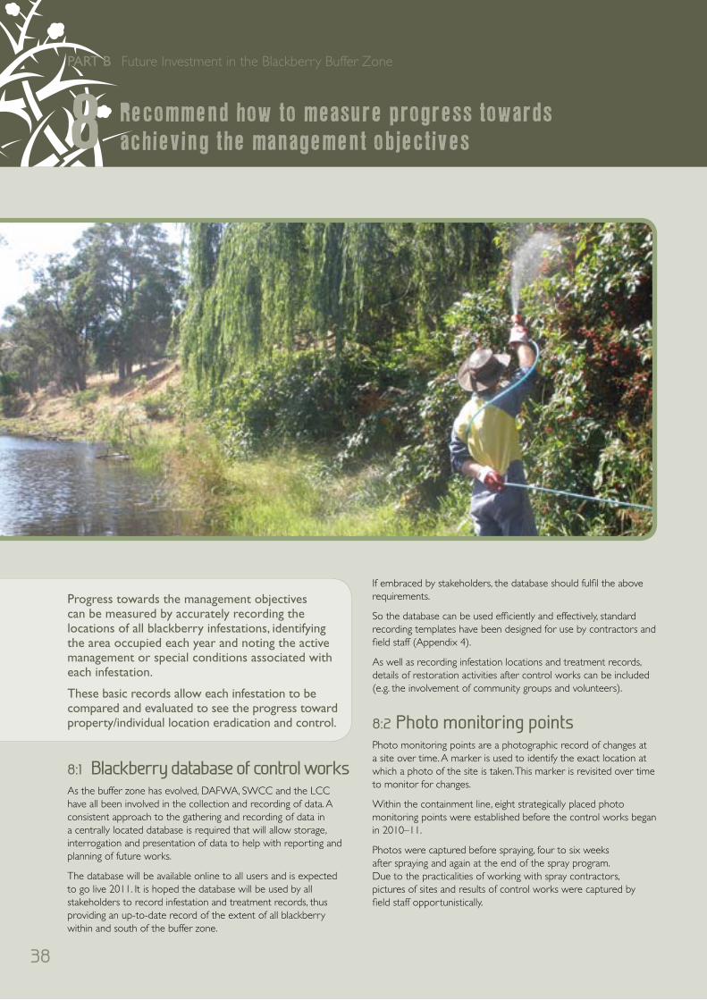
38
PART B Future Investment in the Blackberry Buffer Zone
If embraced by stakeholders, the database should fulfil the above requirements.
So the database can be used efficiently and effectively, standard recording templates have been designed for use by contractors and field staff (Appendix 4).
As well as recording infestation locations and treatment records, details of restoration activities after control works can be included (e.g. the involvement of community groups and volunteers).
8:2 Photo monitoring pointsPhoto monitoring points are a photographic record of changes at a site over time. A marker is used to identify the exact location at which a photo of the site is taken. This marker is revisited over time to monitor for changes.
Within the containment line, eight strategically placed photo monitoring points were established before the control works began in 2010–11.
Photos were captured before spraying, four to six weeks after spraying and again at the end of the spray program. Due to the practicalities of working with spray contractors, pictures of sites and results of control works were captured by field staff opportunistically.
8:1 Blackberry database of control worksAs the buffer zone has evolved, DAFWA, SWCC and the LCC have all been involved in the collection and recording of data. A consistent approach to the gathering and recording of data in a centrally located database is required that will allow storage, interrogation and presentation of data to help with reporting and planning of future works.
The database will be available online to all users and is expected to go live 2011. It is hoped the database will be used by all stakeholders to record infestation and treatment records, thus providing an up-to-date record of the extent of all blackberry within and south of the buffer zone.
Progress towards the management objectives can be measured by accurately recording the locations of all blackberry infestations, identifying the area occupied each year and noting the active management or special conditions associated with each infestation.
These basic records allow each infestation to be compared and evaluated to see the progress toward property/individual location eradication and control.
Recommend how to measure progress towards achieving the management objectives8

39
Photo monitoring site 1Paris Road, Australind (381991.9 E, 6317559.1 N)
AFTER eight weeksBEFORE
Photo monitoring site 2Meadow Landing (383971.8 E, 6315525.8 N)
AFTER four weeksBEFORE
Photo monitoring site 3Treendale Road, Treendale (387558.2 E, 6315201.6 N)
AFTER six weeksBEFORE
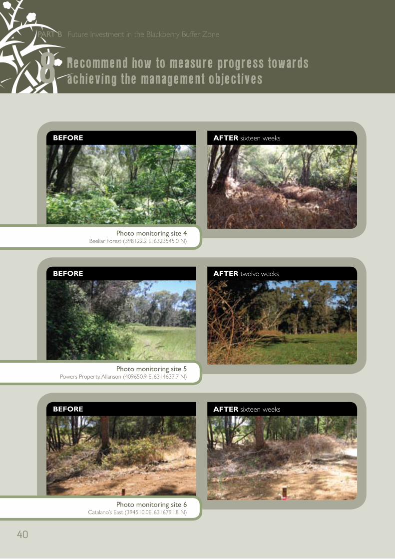
40
PART B Future Investment in the Blackberry Buffer Zone
Photo monitoring site 4Beeliar Forest (398122.2 E, 6323545.0 N)
AFTER sixteen weeksBEFORE
Photo monitoring site 5Powers Property, Allanson (409650.9 E, 6314637.7 N)
AFTER twelve weeksBEFORE
Photo monitoring site 6Catalano’s East (394510.0E, 6316791.8 N)
AFTER sixteen weeksBEFORE
Recommend how to measure progress towards achieving the management objectives8

41
Photo monitoring site 7Catalano’s North (394510.0E, 6316791.8 N)
AFTER five weeksBEFORE
Photo monitoring site 8DEC Reserve, Kemerton (318669E, 6324025N)
AFTER eight weeksBEFORE

42
PART B Future Investment in the Blackberry Buffer Zone
9:1 Investment to treat blackberry on private land
The treatments applied to private land within the blackberry buffer zone from 2007–08 to 2010–11 have resulted in almost all infestations receiving a first control treatment. Some large infestations require a second and third treatment to complete eradication of blackberry on this land.
The areas that still require primary treatment include properties in the Collie hills immediately adjacent to the Darling Scarp along the Coalfields Highway and some isolated infestations in the Brunswick and Allanson area.
Table 5: Estimated costs to complete blackberry treatment within the buffer zone 2011–15
2011–12 2012–13 2013–14 2014–15
First-year treatment $40,000 $20,000 n/a n/a
Second-year treatment $15,000 $10,000 $5,000 n/a
Third-year treatment $6,000 $5,000 $5,000 $5,000
$61,000* $35,000** $10,000 $5,000
* funding already made available via CfoC** an application for funding has been submitted with the outcome pending
The proposed extension of the buffer zone to treat the Collie River around the Collie townsite as well as the Burekup area will require additional resources for control. An estimated 30 properties will require treatment at an average cost of $2,500/property. For operational reasons it may not be practical to treat all areas in one year and some properties may require primary, first-year treatment in 2012–13.
Table 6: Estimated costs for blackberry treatment for the Collie townsite and Collie River near Burekup extension of the blackberry buffer zone
2011–12 2012–13 2013–14 2014–15
First-year
treatment $50,000 $25,000 n/a n/a
Second-year
treatment n/a $10,000 $10,000 n/a
Third-year
treatment n/a n/a $5,000 $5,000
$50,000 $35,000 $15,000 $5,000
9:2 Investment to conduct surveillance for blackberry on public land
The 11 river systems within the blackberry buffer zone should be investigated to determine the extent of blackberry along them and identify any areas where blackberry may transform the area from a native ecosystem to a large blackberry infestation.
The costs associated with the surveillance should be spread across the project timeframe from 2012–15. This will ensure that officers are not focused solely on one task and each season allow media opportunities to be targetted toward landholders within each local area.
This will require two officers for two days to walk each riparian system and a further one day to write the report. A digital camera and GPS will be required. This represents five days for each system and for 11 river systems this will require 110 days to complete.
Resources required for 2012–159
43
Table 7: Officer time required to conduct surveillance on river systems within the blackberry buffer zone
Officers River systems* Days Total Estimated cost**
2 11 5 110 days $38,500
* Wellesley River, Brunswick River, Harris River, Bingham River, Hillman River, Darken River, Chamberlain Creek, Chicken Creek, Collie River, Collie River South and Henty Brook
** $350/day per officer
DAFWA’s surveillance of the Hamilton River has determined that areas of blackberry are likely to exist along these river systems, mostly in areas where disturbance has occurred along powerlines, roadways and walking tracks.
It is estimated that each river system may have 2 ha of blackberry requiring treatment. Given the access difficulties, the costs of treatment are likely to be $1,500/ha.
Table 8: Estimated costs of treatment of blackberry along river systems within the blackberry buffer zone
River systems Ha treatment Cost/ha Estimated cost
11 2 1,500 $33,000
Surveillance of river systems south of the buffer zone will be required to locate and eradicate isolated infestations of Rubus laudatus.
Table 9: Officer time required to conduct surveillance on river systems south of the blackberry buffer zone
Officers River systems* Days Total Estimated cost**
2 6 5 60 days $21,000
* Preston River, Ferguson River, Capel River, Blackwood River, Thompson Brook, Balingup Brook
** $350/day per officer
South of the buffer zone no treatments need to be applied for R. anglocandicans so much of the work will involve mapping. Treatment requirements should be limited.
Table 10: Estimated costs of treatment should R. laudatus be detected along river systems south of the buffer zone
River systems Ha treatment Cost/ha Estimated cost
6 1 1,500 $9,000
9:3 Investment in management of the program
Investing in management of the program will ensure it continues to operate in a coordinated manner and enable activities such as media extension, management of the database, blackberry working group, and liaison with stakeholders such as mining and utility companies and government agencies.
As the on-ground blackberry control work within the buffer zone is reduced as treatments are applied, it will be essential to ensure other weed species do not become established. This will be achieved by building a resilient river ecosystem through replacing weeds with native vegetation.
The project officer will then have work to conduct summer weed control and winter re-planting and fencing activities. This work requires a considerable investment to ensure both activities are completed and the public are informed and supported.
Table 11: Estimated cost of management for blackberry treatment and rivercare work from 2011–12 to 2015
2011–12 2012–13 2013–14 2014–15
Blackberry project time $30,000 $30,000 $30,000 $30,000
River restoration project time* $30,000 $30,000 $30,000 $30,000
Extension and communication** $10,000 $10,000 $10,000 $10,000
Database data collection and entry $10,000 $10,000 $10,000 $10,000
$80,000 $80,000 $80,000 $80,000
* 3–5 ha of river restoration per year : first-year site preparation, second-year planting, third-year maintenance.
** two workshops/field days per year, four media articles, chair blackberry working group, liaison with stakeholders

44
PART B Future Investment in the Blackberry Buffer Zone
9:4 Investment in rivercare and ecosystem restoration
The investment in rivercare and ecosystem restoration will require at least 3 to 5 ha of river systems to be revegetated and protected with fencing per year from 2011–15.
The cost includes:
• First-year site preparation of $1,000/ha for deep ripping, rotary hoeing, weed control (fencing at this time may also be required where the ground preparation may be hazardous for livestock)
• Second-year site establishment of $6000/ha for fencing, weed control and planting of seedlings
• Third-year site maintenance of $2,000/ha for weed control, replanting, infilling and maintenance.
A total cost of $9,000/ha is required over three years.
An average figure of 4 ha/year is estimated, however this may vary between 3 to 5 ha depending on the success of second- and third-year treatments of blackberry within the buffer zone.
Existing projects have been initiated in 2010–11 by CfoC and State NRM Office funding. These projects are not budgeted for in 2011–12.
Table 12: Estimated cost of rivercare management after treatment of blackberry from 2011–15
Activity 2011–12 * 2012–13 2013–14 2014–15
First-year site preparation $4,000 n/a n/a
Second-year fencing 4 ha** $24,000 $24,000 n/a
Second-year planting*** $8,000 $8,000 $8,000
Third-year maintenance $8,000 $8,000 $8,000
$44,000 $40,000 $16,000
* funding has been provided from CfoC and the State NRM Office for 2011–12
** where first-year work began in 2010–11*** where work began in 2009–10
The estimated budget required to maintain the buffer zone from 2011–12 to 2014–15 is outlined below.
Table 13: Estimated cost of the blackberry buffer zone from 2011–15
Activity 2011–12 2012–13 2013–14 2014–15
Treatment of public land within the buffer zone * $35,000 $10,000 $5,000
Blackberry buffer zone extension Collie townsite
and Collie River $50,000 $35,000 $15,000 $5,000
Surveillance and treatment within the river systems
within the buffer zone** $17875 $17875 $17875 $17875
Surveillance and treatment of riparian systems south
of the buffer zone*** $7,500 $7,500 $7,500 $7,500
Management of the buffer zone $80,000 $80,000 $80,000 $20,000
Revegetation within the buffer zone **** $44,000 $40,000 $16,000
TOTAL $155,375 $219,375 $170,375 $131,375
* $61,000 funding provided by CfoC
** funding of $38,500 for surveillance and $33,000 for treatment is averaged over the four years
*** funding $21,000 for surveillance and $9,000 for treatment is averaged over the four years
**** funding provided by CfoC and the State NRM Office
Resources required for 2012–159
45
<References
> Bruzzese, E F, Mahr, F, Faithfull, I & Turnbull, K 2000, Blackberry, Rubus fruticosus aggregate. Research Institute and Weeds CRC, PO Box 48, Frankston, Victoria, Australia 3199.
> DEC 2011, FloraBase, the Western Australian flora website, http://www.dec.wa.gov.au/content/view/2452/1821
> Dodd, J & Lloyd, S 1992, ‘New leaf rust helps to control blackberry’, Journal of Agriculture, Western Australia, vol. 33 p 47– 50.
> DTRIS 2011, NSW Department of Trade and Investment, Regional Infrastructure and Services, Weed definitions and FAQs: http://www.dpi.nsw.gov.au/agriculture/pests-weeds/weeds/definition
> Hugues-Dit-Ciles J. pers. comm. 2011, Weed control activities on Collie coal mining operations.
> Moore, JH & Hoskins, EB 1985, ‘Beating the blackberry’, Journal of Agriculture, Western Australia 26(1), 24–30.
> Moore J H & Wheeler J 2002, Southern weeds and their control, Department of Agriculture Western Australia, Bulletin no. 4558/02.
> Moore, J, Reeves, A & Merewether, S 2007, Final report, WA component of the National Blackberry Strategic Management (Eradication and Control) of Isolated and Outlier Infestations Project.
> Morin, L, Aveyard, R, Batchelor, KL, Evans, KJ, Gomez, DR, Hartley, D, Jourdan, M & Scott, JK 2005, New strains of Phragmidium violaceum for the biological control of blackberry. In: Conference Handbook: 15th Biennial Conference of the Australasian Plant Pathology Society, p. 379. 26–29 September 2005, Geelong.
> Reeves, A 2010, Blackberry buffer zone 2009–2010, Report to the South West Catchments Council on the activities of the Department of Agriculture and Food (WA), April 2010, unpublished report.
> Van Delft, R, 2010, Weeds Workshop Notes, Venue: Roche Park Recreation Centre, 31/3/2010. Executive Manager Development Services, Shire of Collie, 87 Throssell St, Collie WA 6225. Phone 9734 9022, facsimile 9734 4072, www.collie.wa.gov.au
> Vukelic, B 2010, Personal communication between DAFWA Biosecurity staff following audit and compliance activities of contractor spray operations in 2009–10.
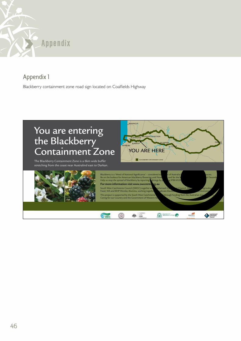
46
Appendix>Appendix 1 Blackberry containment zone road sign located on Coalfields Highway

47
Appendix <Appendix 2 . : Figure 1
Investigation into FloraBase records of Rubus laudatus south of the blackberry buffer zone
Date 12/01/2011
Comp led by DAFWA Geospa ial Information Se vices Group
Horizontal Datum Geocent ic Datum of Aust a ia 1994
Projection Universal Transverse Mercator Zone 50
Vertical Datum Aust a ian Height Datum 1971
DISCLAIMER While a l reasonable care has been taken in thep epara ion of the material in this document he Weste nAust a ian Government and ts o fice s accept no responsib l tyfor any er o s or omissions t may contain whe her caused bynegligence or otherwise or for any loss however causedsustained by any person who relies on itCopyright © Western Australia Agricultural Authority 2011
PERTH 05498929*Rubus laudatus A BergerRosaceaePlant Description Spreading climber 3 m high x 20 cm wide Thorny,increasing with many new stems, freely flowering and early developmentof fruitsVegetation Beside small paperbark swamp in a chain of lakes onroadside Melaleuca cuticularis, Reeds, Grassy weeds, Cyperuscongestus, Pelargonium capitatumSite Description Wetland below 6 M le Hills (from the coast) Waterlapping in the swamp Grey sandFrequency abundantOther Notes Old established network of this plant = ca 40 yearsLocality Esperance Coolgardie Highway, Esperance, State WALat 33° 48' 14 4" S Long 121° 52' 49 4" E (GDA94)Collector C D Turley 27/1099Collection Date 29 October 1999Determinavit D E Symon Date July 2002Origin ESPDuplicates to ESP
Inspection outcomeHeidi McCrea from the Esperance NRM office hasinformed DAFWA that three blackberry infestations arerecorded in the Esperance shire and a l are under activemanagement with the intent to eradicate blackberry fromthe ShireFunding is being supplied by CfoC and activemanagement is being undertaken
Ph (08) 9079 6008admin@esperanceregionalforum org au
Confirmation received to DAFWA 14/10/2010 by AndrewReeves
Figure 1: Locations of Rubus laudatus from FloraBase (PERTH 05498929 and PERTH 04223209)
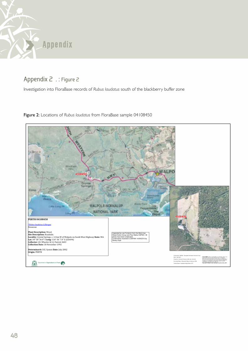
48
Appendix>Appendix 2 . : Figure 2
Investigation into FloraBase records of Rubus laudatus south of the blackberry buffer zone
Inspected by Lee Fontanini from the Manj mupWeed Action Group and Paul Merks DAFWA Allplants have been eradicatedConfirmation received to DAFWA 14/09/2010 bySandy Lloyd
Date 12/01/2011
Comp led by DAFWA Geospatial Information Services G oup
Ho izontal Datum Geocentric Datum of Aust a ia 1994
Projection Universal Transve se Me cator Zone 50
Vertical Datum Australian Height Datum 1971
D SCLAIMER Wh le a l reasonable ca e has been aken in heprepa a ion of the ma erial in this document he WesternAust alian Government and its o fice s accept no respons bi i yfor any e rors or omissions it may contain whe her caused byneg igence or otherwise or for any loss however causedsus ained by any person who elies on itCopy ight © Western Aust alia Agricul ural Au hority 2011
Figure 2: Locations of Rubus laudatus from FloraBase sample 04108450

49
Appendix <Appendix 2 . : Figure 3 Investigation into FloraBase records of Rubus laudatus south of the blackberry buffer zone
Date 12 01/2011
Compiled by DAFWA Geospa ial Information Services G oup
Horizontal Datum Geocentric Datum of Australia 1994
P ojec ion Unive sal Transverse Mercator Zone 50
Ver ical Datum Australian Height Datum 1971
DISCLA MER Wh le a l reasonable ca e has been aken in hepreparation of he material in this document he WesternAus ralian Government and its o fice s accept no respons bi i yfor any errors or omissions it may con ain whether caused byneg igence or otherwise or for any loss however causedsustained by any person who relies on itCopyright © Western Aus ralia Agricul u al Au hority 2011
PERTH 04278321*Rubus laudatus A BergerRosaceaeVegetation In Karri understorey Limited amount of Rubus regrowth fo lowing fire in early 1991Site Description Beside creekOther Notes Abundance small infestationLocality Beside East Brook, adjoining Col ins Block, 0 5 km S of Vasse Highway, 4 5 km ENE ofPemberton State WALat 34° 25' S Long 116° 5' E (GDA94)Collector J Dodd 627Collection Date 17 September 1991Determinavit D E Symon Date July 2002Origin PERTH
Inspected by Jason Dearle from DAFWA All plants havebeen eradicatedConfirmation received to DAFWA 06/12/2010 by AndrewReeves
PERTH 1769340*Rubus laudatus A BergerRosaceaeVegetation In Karri understorey Limited amount of Rubus regrowth following fire inearly 1991Site Description Beside creekOther Notes Abundance small infestationLocality Beside East Brook, adjoining Co lins Block, 0 5 km S of Vasse Highway,4 5 km ENE of Pemberton State WALat 34° 25' S Long 116° 5' E (GDA94)Co lector J Dodd 627Co lection Date 17 September 1991Determinavit D E Symon Date July 2002Origin PERTH
Inspected by Lee Fontanini from the Manjimup Weed Action Groupand Paul Merks DAFWA All plants have been eradicatedConfirmation received to DAFWA 14/09/2010 by Sandy Lloyd
Figure 3: Locations of Rubus laudatus from FloraBase samples 04278321 and 1769340
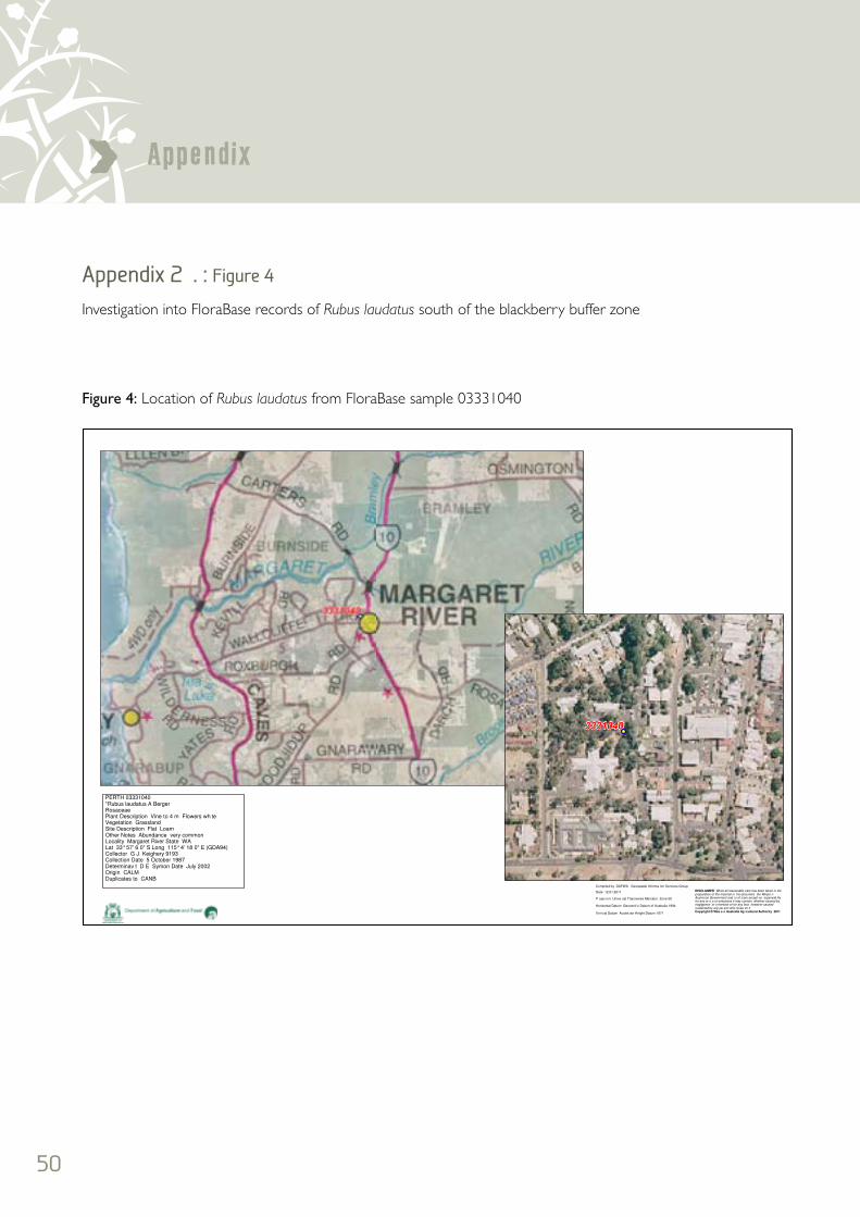
50
Appendix>Appendix 2 . : Figure 4 Investigation into FloraBase records of Rubus laudatus south of the blackberry buffer zone
Date 12 01 2011
Compiled by DAFWA Geospatial Informa ion Services Group
Horizontal Datum Geocent ic Datum of Australia 1994
P ojec ion Unive sal Transverse Mercator Zone 50
Ver ical Datum Austra ian Height Datum 1971
DISCLAIMER While all reasonable care has been taken in thepreparation of the material in his document the Weste nAustra ian Government and i s of icers accept no esponsib lityfor any er o s or omissions it may contain whether caused bynegligence or o herwise or for any loss however causedsustained by any pe son who re ies on itCopyright © Wes e n Australia Ag icultural Authority 2011
PERTH 03331040*Rubus laudatus A BergerRosaceaePlant Description Vine to 4 m Flowers wh teVegetation GrasslandSite Description Flat LoamOther Notes Abundance very commonLocality Margaret River State WALat 33° 57' 6 0" S Long 115° 4' 18 0" E (GDA94)Collector G J Keighery 9193Collection Date 5 October 1987Determinav t D E Symon Date July 2002Origin CALMDuplicates to CANB
Figure 4: Location of Rubus laudatus from FloraBase sample 03331040

51
Appendix <Appendix 2 . : Figure 5
Investigation into FloraBase records of Rubus laudatus south of the blackberry buffer zone
Date 12 01/2011
Compiled by DAFWA Geospa ial Information Services G oup
Horizontal Datum Geocentric Datum of Australia 1994
P ojec ion Unive sal Transverse Mercator Zone 50
Ver ical Datum Australian Height Datum 1971
DISCLA MER Wh le a l reasonable ca e has been aken in hepreparation of he material in this document he WesternAus ralian Government and its o fice s accept no respons bi i yfor any errors or omissions it may con ain whether caused byneg igence or otherwise or for any loss however causedsustained by any person who relies on itCopyright © Western Aus ralia Agricul u al Au hority 2011
PERTH 03331199*Rubus laudatus A BergerRosaceaeLocality Hamelin Bay State WALat 34° 12' 0 0" S Long 115° 0' 59 0" E (GDA94)Collector P Rutherford s nCollection Date November 1975Determinavit D E Symon Date July 2002Origin PERTH
Location check location as 2 5km out into Hamlin bay!
Figure 5: Location of Rubus laudatus from FloraBase sample 03331199
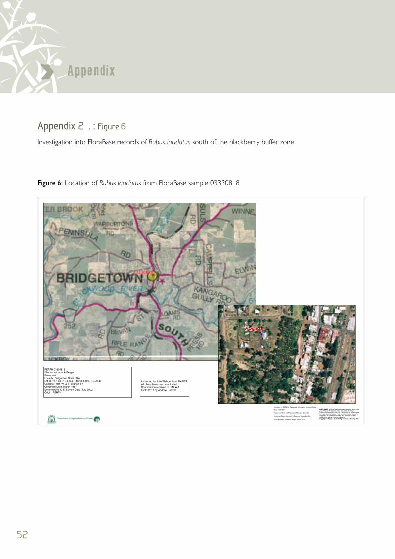
52
Appendix>Appendix 2 . : Figure 6 Investigation into FloraBase records of Rubus laudatus south of the blackberry buffer zone
Date 12 01 2011
Compiled by DAFWA Geospatial Informa ion Services Group
Horizontal Datum Geocent ic Datum of Australia 1994
P ojec ion Unive sal Transverse Mercator Zone 50
Ver ical Datum Austra ian Height Datum 1971
DISCLAIMER While all reasonable care has been taken in thepreparation of the material in his document the Weste nAustra ian Government and i s of icers accept no esponsib lityfor any er o s or omissions it may contain whether caused bynegligence or o herwise or for any loss however causedsustained by any pe son who re ies on itCopyright © Wes e n Australia Ag icultural Authority 2011
PERTH 03330818*Rubus laudatus A BergerRosaceaeLoca ity Bridgetown State WALat 33° 57' 30 0" S Long 116° 8' 6 0" E (GDA94)Collector Ref W & S Branch s nCollection Date March 1967Determinavit D E Symon Date July 2002Origin PERTH
Inspected by Julie Webber from DAFWAAll plants have been eradicatedConfirmation received to DAFWA05/11/2010 by Andrew Reeves
Figure 6: Location of Rubus laudatus from FloraBase sample 03330818
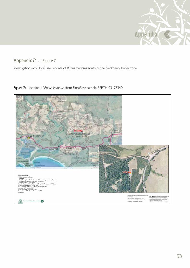
53
Appendix <Appendix 2 . : Figure 7
Investigation into FloraBase records of Rubus laudatus south of the blackberry buffer zone
Date 12 01/2011
Compiled by DAFWA Geospa ial Information Services G oup
Horizontal Datum Geocentric Datum of Australia 1994
P ojec ion Unive sal Transverse Mercator Zone 50
Ver ical Datum Australian Height Datum 1971
DISCLA MER Wh le a l reasonable ca e has been aken in hepreparation of he material in this document he WesternAus ralian Government and its o fice s accept no respons bi i yfor any errors or omissions it may con ain whether caused byneg igence or otherwise or for any loss however causedsustained by any person who relies on itCopyright © Western Aus ralia Agricul u al Au hority 2011
PERTH 03175340*Rubus laudatus A Berger Rosaceae Plant Description Shrub Flowers white Leaves green on both sides Vegetation Roadside in farmland Marri/Karri Site Description Lower slopeLocality Va ley of Giants Road and Dingo Flat Road corner, WalpoleWarren Botanical District State WALat 34° 57' 43 0" S Long 116° 52' 20 0" E (GDA94)Co lector A R Annels 1257Co lection Date 23 October 1990Determinavit D E Symon Date July 2002Origin MJP
Figure 7: Location of Rubus laudatus from FloraBase sample PERTH 03175340
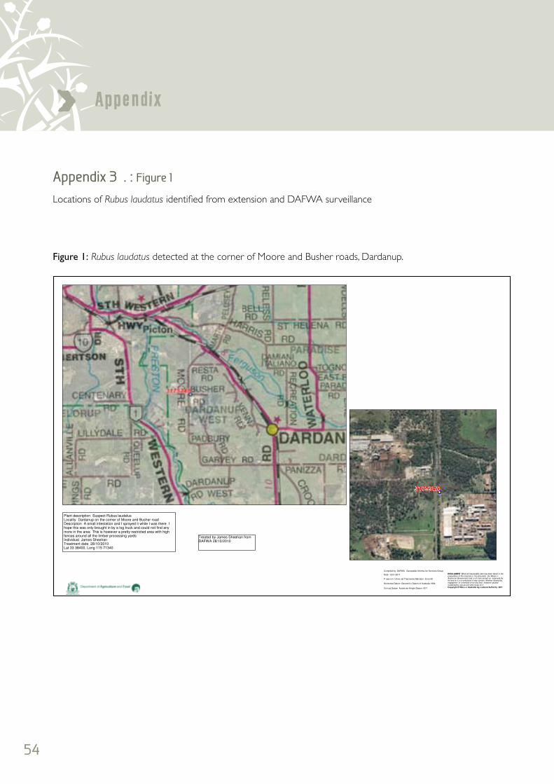
54
Appendix>Appendix 3 . : Figure 1 Locations of Rubus laudatus identified from extension and DAFWA surveillance
Date 12 01 2011
Compiled by DAFWA Geospatial Informa ion Services Group
Horizontal Datum Geocent ic Datum of Australia 1994
P ojec ion Unive sal Transverse Mercator Zone 50
Ver ical Datum Austra ian Height Datum 1971
DISCLAIMER While all reasonable care has been taken in thepreparation of the material in his document the Weste nAustra ian Government and i s of icers accept no esponsib lityfor any er o s or omissions it may contain whether caused bynegligence or o herwise or for any loss however causedsustained by any pe son who re ies on itCopyright © Wes e n Australia Ag icultural Authority 2011
Plant description Suspect Rubus laudatusLocality Dardanup on the corner of Moore and Busher roadDescription A small infestation and I sprayed it while I was there Ihope this was only brought in by a log truck and could not find anymore in the area This is however a pretty restricted area with highfences around all the timber processing yardsIndividual James SheehanTreatment date 28/10/2010Lat 33 38400, Long 115 71340
Treated by James Sheehan fromDAFWA 28/10/2010
Figure 1: Rubus laudatus detected at the corner of Moore and Busher roads, Dardanup.

55
Appendix <Appendix 3 . : Figure 2
Locations of Rubus laudatus identified from extension and DAFWA surveillance
Date 12/01/2011
Compiled by DAFWA Geospatial Information Services G oup
Horizontal Datum Geocentric Datum of Aust a ia 1994
Projec ion Unive sal Transverse Mercator Zone 50
Ver ical Datum Australian Height Datum 1971
D SCLAIMER Wh le a l reasonable ca e has been aken in the
prepa a ion of the ma erial in this document he WesternAust alian Government and its o ficers accept no respons bi i yfor any e rors or omissions it may contain whether caused byneg igence or otherwise or for any loss however causedsustained by any person who elies on it
Copyright © Western Australia Agricultu al Au hority 2011
Plant description Suspect Rubus laudatusLoca ity Donnybrook Shire along the Preston RiverDescription A large infestation treated by DAFWA in 2010 by JamesSheehan at a cost of $2,500 by contractorIndividual James Sheehan and Brad RaynerTreatment date 28/10/2010Lat , LongCRIS property id 1297120
Legend
American
American & European
European
Figure 2: Rubus laudatus treated along the Preston River in the district of Lowden, Donnybrook Shire 2009–10

56
Appendix>Appendix 3 . : Figure 3
Locations of Rubus laudatus identified from extension and DAFWA surveillance
Date 12 01 2011
Compiled by DAFWA Geospatial Informa ion Services Group
Horizontal Datum Geocent ic Datum of Australia 1994
P ojec ion Unive sal Transverse Mercator Zone 50
Ver ical Datum Austra ian Height Datum 1971
DISCLAIMER While all reasonable care has been taken in thepreparation of the material in his document the Weste nAustra ian Government and i s of icers accept no esponsib lityfor any er o s or omissions it may contain whether caused bynegligence or o herwise or for any loss however causedsustained by any pe son who re ies on itCopyright © Wes e n Australia Ag icultural Authority 2011
Plant description Suspect Rubus laudatusLoca ity Tassone Road and South West HighwayDescription An infestation growing along a creekline adjacent tothe roadsideIndividual James Sheehan and Andrew ReevesTreatment date 28/10/2010Lat 33 38400, Long 115 71340CRIS property id
Note: The given Latitude and Longitudewere incorrect and the Point has beenmoved to match description
Figure 3: Rubus laudatus treated along Tassone Road, Donnybrook Shire

57
Appendix <Appendix 3 . : Figure 4 Locations of Rubus laudatus identified from extension and DAFWA surveillance
Date 12 01/2011
Compiled by DAFWA Geospa ial Information Services G oup
Horizontal Datum Geocentric Datum of Australia 1994
P ojec ion Unive sal Transverse Mercator Zone 50
Ver ical Datum Australian Height Datum 1971
DISCLA MER Wh le a l reasonable ca e has been aken in hepreparation of he material in this document he WesternAus ralian Government and its o fice s accept no respons bi i yfor any errors or omissions it may con ain whether caused byneg igence or otherwise or for any loss however causedsustained by any person who relies on itCopyright © Western Aus ralia Agricul u al Au hority 2011
Plant description Suspect Rubus laudatusLocality Trigwell Street DonnybrookDescription An infestation growing along a creekline adjacent to the roadsideIndividual James SheehanTreatment date 08/12/2009Lat 33 58400, Long 115 82345CRIS property id 3199451
Figure 4: Rubus laudatus detected in Donnybrook townsite, Donnybrook Shire

58
Appendix>Appendix 3 . : Figure 5
Locations of Rubus laudatus identified from extension and DAFWA surveillance
Date 12 01 2011
Compiled by DAFWA Geospatial Info ma ion Se vices Group
Horizontal Datum Geocent ic Datum of Australia 1994
P ojec ion Universal Transverse Me cator Zone 50
Ver ical Datum Aust a ian Height Datum 1971
D SCLAIMER Wh le a l reasonable ca e has been taken in theprepa a ion of the material in this document the WesternAust alian Government and its o fice s accept no esponsib lityfor any e rors or omissions it may con ain whether caused byneg igence or otherwise or for any loss however causedsus ained by any person who relies on itCopyright © Western Aus ralia Agricultu al Authority 2011
Legend
Blackberry Present
0 1 2 3 4 5
Kilometers
0 50 100 150
Meters
Figure 5: Rubus laudatus at Jack Mears Park, Collie
In April 2011 this site was considered as a community education site given R. laudatus and R. anglocandicans are growing together at this location.

59
Appendix <Appendix 3 . : Figure 6
Locations of Rubus laudatus identified from extension and DAFWA surveillance
Date 12/01 2011
Comp led by DAFWA Geospatial Information Services G oup
Ho izontal Datum Geocentric Datum of Aust a ia 1994
Projection Universal T ansve se Mercator Zone 50
Ve tical Datum Austra ian Height Datum 1971
DISCLA MER Wh le a l reasonable care has been taken in thepreparation of he material in his document the WesternAus ralian Government and i s officers accept no esponsib lityfor any errors or omissions it may con ain whether caused byneg igence or otherwise or for any loss however causedsustained by any person who relies on itCopyright © Western Australia Agricultural Autho ity 2011
0 1 2 3
Kilometres
0 250 500 750 1000
Metres
Legend
Blackberry Inspection Point
Figure 6: Rubus laudatus treated by contractor in the Newlands district, Donnybrook Shire

60
Appendix>Appendix 4

<Prevention is better than cure.
The long-term benefit of a complete
approach to weed management is that the
waterways and river systems have the
resilience to resist weed establishment.
The SWCC website provides further information: www.swccnrm.org.au

www.swccnrm.org.au
South West Catchments CouncilPO Box 5066 Bunbury Delivery Centre WA 6230Telephone : (08) 9780 6193 Fax: (08) 9780 6198Email: [email protected]


