Brisbane Baylands Project EIR 1 ESA / 206069 Notice of Preparation October 2012 REVISED NOTICE OF PREPARATION of an Environmental Impact Report for the Brisbane Baylands Project City of Brisbane (Previous SCH #2006022136, February 24, 2006; Previous Revised NOP issued December 10, 2010) Notice is hereby given that the City of Brisbane will be the Lead Agency and will prepare a programmatic Environmental Impact Report (EIR) for the Brisbane Baylands Project (“Proposed Project”). The City of Brisbane is requesting comments on the scope and content of this EIR. A previous Notice of Preparation (NOP) was distributed for public review on December 10, 2010. The previous NOP provided a detailed description of the proposed development of the Brisbane Baylands. Distribution of a revised NOP is required due to the addition of a proposed water transfer agreement to the Project. In addition to the development of the Baylands previously described in the December 2010 NOP, the City proposes to acquire a supplemental water supply of 2,400 acre-feet per year (AFY) via a water transfer agreement with the Oakdale Irrigation District (OID) in order to serve the proposed development of the Brisbane Baylands. Written comments on the scope of the EIR may be sent to: John Swiecki, AICP Community Development Director City of Brisbane 50 Park Place, Brisbane, CA 94005 Fax: 415.467.5547 Email: [email protected]Due to the time limits mandated by State law, comments must be received no later than 30 days after receipt of this notice. The review period for this NOP is from October 22, 2012 through November 21, 2012. Project Location The Proposed Project site (“Project Site”), identified as the Brisbane Baylands, is located within the City of Brisbane in the northeast corner of San Mateo County. The Project Site is generally bounded on the north by the City of San Francisco, on the east by Highway 101 (“U.S. 101”), on the west by Bayshore Boulevard, and on the south by Brisbane Lagoon (see Figure 1) A small portion of the Project Site also lies within the City of San Francisco immediately adjacent to the Brisbane city limits.
Transcript
Brisbane Baylands Project EIR 1 ESA / 206069 Notice of Preparation October 2012
REVISED NOTICE OF PREPARATION of an Environmental Impact Report for the Brisbane Baylands Project
City of Brisbane (Previous SCH #2006022136, February 24, 2006;
Previous Revised NOP issued December 10, 2010)
Notice is hereby given that the City of Brisbane will be the Lead Agency and will prepare a programmatic Environmental Impact Report (EIR) for the Brisbane Baylands Project (“Proposed Project”). The City of Brisbane is requesting comments on the scope and content of this EIR.
A previous Notice of Preparation (NOP) was distributed for public review on December 10, 2010. The previous NOP provided a detailed description of the proposed development of the Brisbane Baylands. Distribution of a revised NOP is required due to the addition of a proposed water transfer agreement to the Project. In addition to the development of the Baylands previously described in the December 2010 NOP, the City proposes to acquire a supplemental water supply of 2,400 acre-feet per year (AFY) via a water transfer agreement with the Oakdale Irrigation District (OID) in order to serve the proposed development of the Brisbane Baylands.
Written comments on the scope of the EIR may be sent to:
John Swiecki, AICP Community Development Director City of Brisbane 50 Park Place, Brisbane, CA 94005 Fax: 415.467.5547 Email: [email protected]
Due to the time limits mandated by State law, comments must be received no later than 30 days after receipt of this notice. The review period for this NOP is from October 22, 2012 through November 21, 2012.
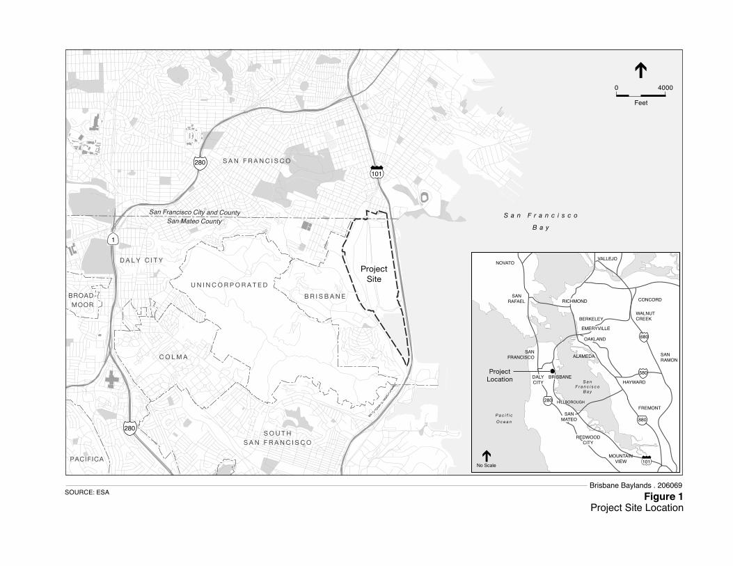
Project Location The Proposed Project site (“Project Site”), identified as the Brisbane Baylands, is located within the City of Brisbane in the northeast corner of San Mateo County. The Project Site is generally bounded on the north by the City of San Francisco, on the east by Highway 101 (“U.S. 101”), on the west by Bayshore Boulevard, and on the south by Brisbane Lagoon (see Figure 1) A small portion of the Project Site also lies within the City of San Francisco immediately adjacent to the Brisbane city limits.
101280
280
1
S A N F R A N C I S C O
D A L Y C I T Y
BROAD-MOOR
PACIFICA
B R I S B A N E
U N I N C O R P O R A T E D
C O L M A
S O U T HS A N F R A N C I S C O
S a n F r a n c i s c o
B a y
ProjectLocation
No Scale
NOVATO
SANRAFAEL
FREMONT
SANRAMON
WALNUTCREEK
CONCORD
ALAMEDA
RICHMOND
SANFRANCISCO
DALYCITY
BERKELEY
EMERYVILLEEMERYVILLE
REDWOODCITY
SANMATEO
OAKLAND
HILLBOROUGH
HAYWARD
VALLEJO
i101
MOUNTAINVIEW
S a nF r a n c i s c o
B a y
P a c i f i c
O c e a n
BRISBANE
680
580
880
280
Figure 1Project Site Location
SOURCE: ESA
0 4000
Feet
San Francisco City and CountySan Mateo County
ProjectSite
Brisbane Baylands . 206069
Notice of Preparation
Brisbane Baylands Project EIR 3 ESA / 206069 Notice of Preparation October 2012
Project Description The “Project” consists of plans for the development of the 733 acre Brisbane Baylands area, and consists of the following components:
• A Concept Plan for the development of the Baylands, as required by the City of Brisbane General Plan prior to development for which four development scenarios will be evaluated in the EIR at an equal level of detail. The four Concept Plan scenarios include the following.
o Developer-Sponsored Plan (DSP). The DSP scenario was proposed by Universal Paragon Corporation (UPC), the primary landowner at the Project Site, and is defined within the Draft Brisbane Baylands Specific Plan (dated February 2011). The DSP includes only the 684 acre portion of the Baylands within the City of Brisbane and excludes the 49-acre Recology site. This Concept Plan scenario proposes approximately 7 million square feet of office/ retail /industrial/ institutional uses, 4,434 residential units, and approximately 169.7 acres of “open space” and 135.6 acres of “lagoon” area. Total new development under this scenario would be approximately 12 million square feet.
o Developer- Sponsored Plan – Entertainment Variant (DSP-V). The DSP-V is also proposed by UPC and defined within the 2011 Draft Brisbane Baylands Specific Plan. The DSP-V encompasses the same 684-acre area as the DSP scenario. It is similar to the DSP in its development intensity and land use pattern, but replaces the retail and office/research and development (R&D) uses proposed under the DSP in the northeast portion of the Project Site with entertainment-oriented uses, including a 17,000- to 20,000-seat sports arena, a 5,500-seat concert theater, a multiple-screen cinema, and more conference/exhibition space and hotel rooms than are proposed under DSP. New development under this scenario also would total approximately 12 million square feet.
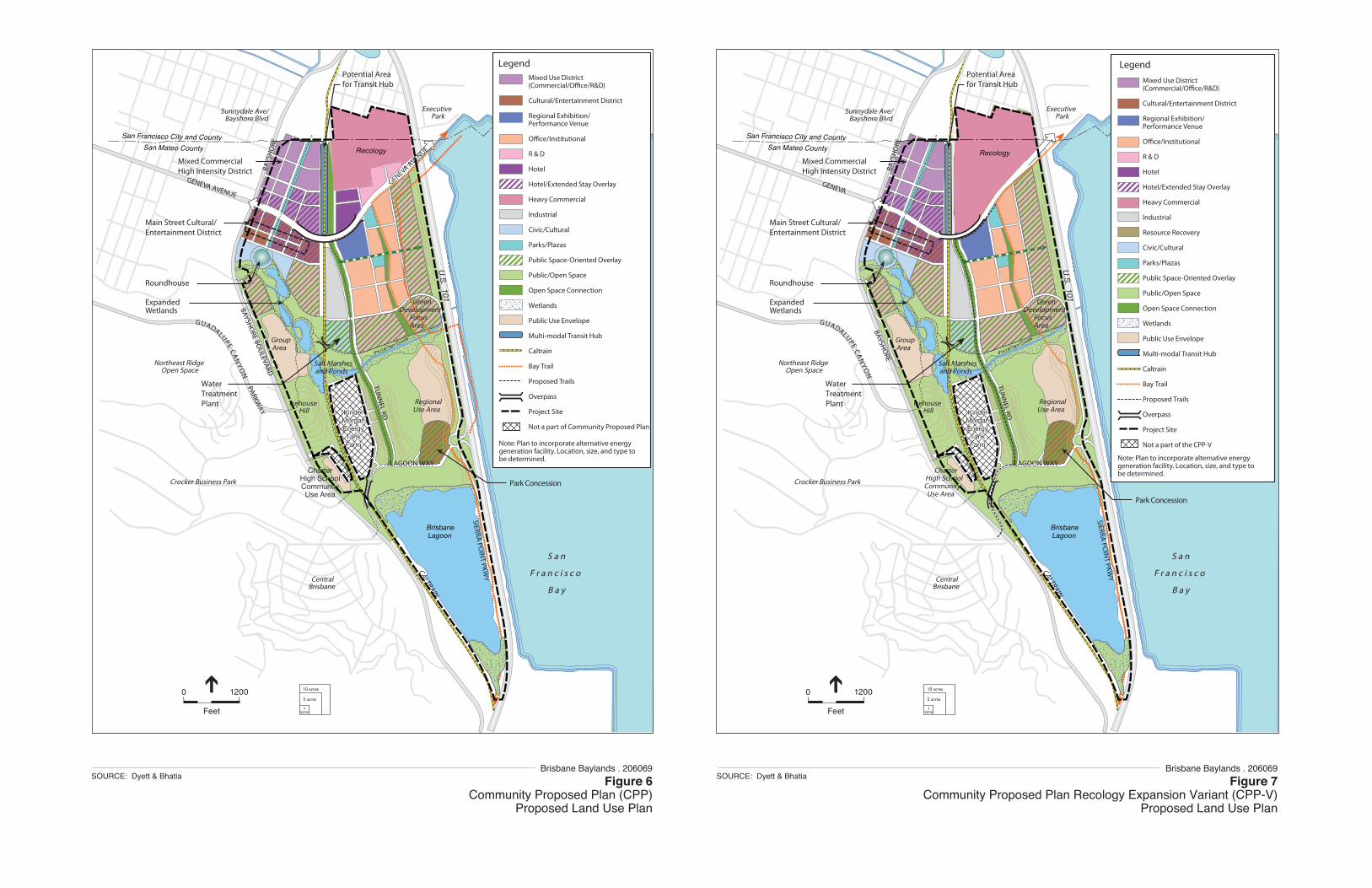
o Community Proposed Plan (CPP). The CPP was developed through extensive community input and designated for inclusion in this EIR by the Brisbane City Council in 2010. The CPP provides for approximately 7.7 million square feet of office, industrial, commercial, and institutional uses concentrated in the northerly portion of the site adjacent to transit, along with approximately 330 acres of open space and the 135.6 acre lagoon. In addition to the 684-acre area included as part of the DSP, the CPP includes the 49-acre Recology site, which spans the cities of Brisbane and San Francisco, encompassing the Beatty Subarea designated in the City of Brisbane General Plan. The CPP does not include residential development.
o Community Proposed Plan – Recology Expansion Variant (CPP-V). The CPP-V differs from the CPP in that it proposes expansion of the existing Recology facility within the northeast portion of the Brisbane Baylands within the City of
Brisbane Baylands Project EIR
Brisbane Baylands Project EIR 4 ESA / 206069 Notice of Preparation October 2012
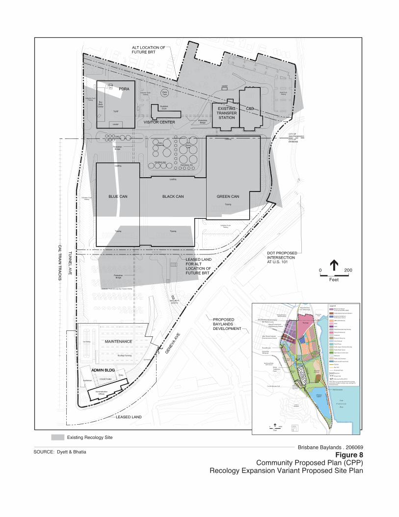
Brisbane. Under the CPP-V, Recology would expand southward from its current boundary, replacing the hotel and R&D uses proposed under the CPP just north of Geneva Avenue and east of Tunnel Road. The current 49-acre Recology site would expand by 24 acres to a total of 73 acres, consolidating existing offsite recycling and corporation yard facilities into one location within the Baylands. The square footage of the developed areas on the Recology site would increase from the existing 260,000 square feet to 1,011,000 square feet. Total new development under this scenario would be approximately 8 million square feet.
• Amendments to the Brisbane General Plan as needed to ensure consistency of the Concept Plan with the provisions of the General Plan. Amendments to the City’s Zoning Ordinance also may be required to ensure its consistency with Concept Plan development standards.
• A Specific Plan submitted to the City by the Universal Paragon Corporation (UPC) detailing development for the two “Developer Sponsored Plan” scenarios. The proposed Draft Brisbane Baylands Specific Plan is part of the Project included with the DSP and DSP-V Concept Plan scenarios.
• Proposed expansion of the existing Recology facility, which is included in the CPP-V Concept Plan scenario only.
• Relocation of existing lumber yards to a different location within the Baylands, which is proposed for each of the Concept Plan scenarios.
• Remediation of hazardous materials contamination within the former railyard and landfill areas of the Project Site, which is proposed for each of the Concept Plan scenarios.
• Importation of water supply for the Project. As noted above, the revised Project description includes the transfer of water to serve the Project Site. The City proposes to acquire a supplemental water supply of 2,400 acre-feet per year (AFY) via a water transfer agreement from the Oakdale Irrigation District (OID) in order to serve the Project Site. The City of Brisbane currently receives water from the SFPUC for its current municipal and industrial uses and also requires a supplemental supply to address the water supply needs for the City. OID and the City of Brisbane have signed a term sheet for the proposed water transfer. It provides for a maximum transfer of up to 2,400 AFY for a 50-year period, with possible renewals for additional 25-year periods. The 2,400 AFY includes 2,000 AFY to serve the proposed Project and 400 AFY to accommodate planned growth within the City of Brisbane as a whole. The water will be transferred from OID to Brisbane pursuant to water supply and conveyance agreements to be executed between OID and Modesto Irrigation District and SFPUC and Brisbane.
Notice of Preparation
Brisbane Baylands Project EIR 5 ESA / 206069 Notice of Preparation October 2012
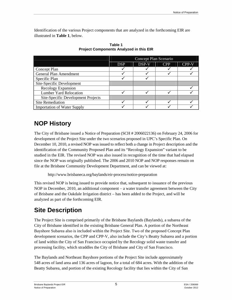
Identification of the various Project components that are analyzed in the forthcoming EIR are illustrated in Table 1, below.
Table 1 Project Components Analyzed in this EIR
Concept Plan Scenario
DSP DSP-V CPP CPP-V Concept Plan General Plan Amendment Specific Plan Site-Specific Development
Recology Expansion Lumber Yard Relocation Site-Specific Development Projects
Site Remediation Importation of Water Supply
NOP History The City of Brisbane issued a Notice of Preparation (SCH # 2006022136) on February 24, 2006 for development of the Project Site under the two scenarios proposed in UPC’s Specific Plan. On December 10, 2010, a revised NOP was issued to reflect both a change in Project description and the identification of the Community Proposed Plan and its “Recology Expansion” variant to be studied in the EIR. The revised NOP was also issued in recognition of the time that had elapsed since the NOP was originally published. The 2006 and 2010 NOP and NOP responses remain on file at the Brisbane Community Development Department, and can be viewed at:
This revised NOP is being issued to provide notice that, subsequent to issuance of the previous NOP in December, 2010, an additional component – a water transfer agreement between the City of Brisbane and the Oakdale Irrigation district – has been added to the Project, and will be analyzed as part of the forthcoming EIR.
Site Description The Project Site is comprised primarily of the Brisbane Baylands (Baylands), a subarea of the City of Brisbane identified in the existing Brisbane General Plan. A portion of the Northeast Bayshore Subarea also is included within the Project Site. Two of the proposed Concept Plan development scenarios, the CPP and CPP-V, also include the City’s Beatty Subarea and a portion of land within the City of San Francisco occupied by the Recology solid waste transfer and processing facility, which straddles the City of Brisbane and City of San Francisco.
The Baylands and Northeast Bayshore portions of the Project Site include approximately 548 acres of land area and 136 acres of lagoon, for a total of 684 acres. With the addition of the Beatty Subarea, and portion of the existing Recology facility that lies within the City of San
Brisbane Baylands Project EIR
Brisbane Baylands Project EIR 6 ESA / 206069 Notice of Preparation October 2012
Francisco, the entire Project Site consists of 597 acres of land area and 136 acres of lagoon, for a total 733 acres.
The Project Site is bisected in the north-south direction by the Caltrain railroad tracks and in the east-west direction by a central drainage channel, which is a part of the Visitacion Creek alignment. The majority of the Project Site is flat or gently sloping toward the Bay, with an elevation range of 10 to 50 feet above mean sea level (msl). A prominent hill (Icehouse Hill), located at the southeastern end of the Project Site, ranges from 25 to 200 feet above msl with steep cuts adjacent to the Caltrain railroad and more gently sloping cuts along Bayshore Boulevard.
The western portion of the Project Site encompasses approximately 228 acres and is bounded on the west by Bayshore Avenue, on the south by Tunnel Avenue, on the east by the Caltrain railroad tracks, and on the north by the City of San Francisco. This portion of the site is dominated by a former railyard area, which was operated by Southern Pacific Railroad and served freight train activity into and out of San Francisco between 1914 and 1960. The majority of this area is vacant with remnant buildings, including the Railroad Roundhouse which is designated as an historic structure on the National Register of Historic Places and the Lazzari Fuel Company Building, now used as a charcoal warehouse. The westerly portion of the site also includes a 261,400 square foot industrial park and a 0.1-acre sewer pump station owned by the Bayshore Sanitary District. This portion of the site also contains a natural feature know as Ice House hill, which represents a segment of the historical bay margin wherein areas of native vegetation types, including coastal scrub and perennial grasslands, are present. A stable for boarding horses is located northerly slope if Ice House Hill.
The eastern portion of the Project Site is the former Brisbane landfill, operated as a municipal landfill from the 1930s to the mid 1960s (See Figure 2). Encompassing 345 acres, this area is generally bounded on the west by the Caltrain railroad tracks, the City and County of San Francisco on the north, U.S. 101 on the east, and Brisbane Lagoon on the south. Uses located within this portion of the Project Site include the Recology solid waste transfer facility, Sierra Point Lumber and Van Arsdale-Harris Lumber, Brisbane Recycling (rock and concrete crushing operation); and Baylands Soils Processing facility The Bayshore Caltrain Station is located at the north end of the Project Site, straddling the existing Caltrain Station.
A number of small interim uses occur within the Project Site including a native plant nursery south of Ice House Hill, a billboard along U.S. 101 near the northerly site boundary, and the use of a small concrete pad near the Roundhouse for the storage and rehabilitation of an historic rail steam engine. The City of Brisbane has also periodically allowed short term temporary uses to occur within the Baylands subarea, subject to the provisions of the Brisbane Municipal Code. Such uses include special event parking for San Francisco 49er home games and for the Grand National Rodeo held at the Cow Palace in Daly City. Existing uses on the Project Site are shown in Figure 3.
Two areas are located within the Project Site boundaries, but are not a part of the proposed Project (see Figure 3). These are the Kinder Morgan Energy Partners Brisbane Terminal (a petroleum
San Francisco City and County
San Mateo County
Brisbane Baylands . 206069Figure 2
Boundaries of Landfill and Remediation Areas
SOURCE: Dyett & Bhatia
Van Arsdale-HarrisLumber Company
Sierra Point Lumber Company
SanFrancisco
Bay
IceHouse
Hill
Roundhouse
Brisbane
Lagoon
Brisbane RecyclingCompany Inc.
Baylands Soil Processing, LLC
Recology
Beatty Rd
Lagoon Rd
Lazzari Fuel Company
Bayshore SanitaryDistrict Pump Station
BayshoreSanitaryDistrictPumpHouse
BrisbaneBayshore
Industrial Park
KinderMorganEnergyTank Farm
KinderMorganEnergyTank Farm
Machinery & Equipment Manufacturing Co.
CalTrainBayshore
StationB
aysh
ore
Blv
d
Geneva Ave
U.S
. 101S
ierra Point P
kwy
San Francisco City and CountySan Mateo County
San Francisco City and CountySan Mateo County
Brisbane Baylands . 206069Figure 3
Existing Project SiteSOURCE: Wallace Roberts & Todd, LLC, 2010
0 1000
Feet
Project Site
Not a part of Proposed Project
Notice of Preparation
Brisbane Baylands Project EIR 9 ESA / 206069 Notice of Preparation October 2012
storage facility), and Machinery and Equipment Company (used processing equipment resale). These uses will not be altered as a result of the Project. Other adjacent land uses include North County Fire Authority Station Number 81 abutting the southwesterly corner of the site, and residential neighborhoods of Visitacion Valley and Little Hollywood to the north and northeast within the City of San Francisco.
Due to underlying groundwater and soils contamination issues associated with historical railroad uses of the site, the westerly portion of the site is under the regulatory oversight of two state agencies. As shown in Figure 2, the former railyard is divided into 2 separate Operable Units (OU). Operable Unit 1 (OU-1) is under the jurisdiction of the State Department of Toxic Substances, and Operable Unit 2 (OU-2) is under the jurisdiction of the Regional Water Quality Control Board. The easterly portion of the site, the former landfill, is under the regulatory jurisdiction of the Regional Water Quality Control Board and San Mateo County Environmental Health Services Agency.
Proposed Land Uses As noted previously, there are four distinct Concept Plan scenarios under consideration. Table 2 below presents a summary of the proposed land uses and a summary of Project Site acreages. Figure 4 and Figure 5 show the Concept Plans for the DSP and DSP-V, respectively; and Figure 6 and Figure 7 show the Concept Plans for the CPP and CPP-V. Figure 8 shows the site plan for the proposed Recology expansion.
TABLE 2 PROPOSED DEVELOPMENT FOR BRISBANE BAYLANDS PROJECT SITE BUILDABLE AREA
Expanded/Rebuilt Resource and Recovery - - - 1,011,000
Total Square Footage 12,238,800 12,191,900 8,145,100 8,215,100 SOURCE: UPC, 2011; Dyett and Bhatia, 2012
a. The CPP will incorporate alternative energy generation within the Project; location, size, and type of facilities will be determined at
a later date. Acreages of other proposed land uses may decrease as a result. b. The buildable area includes all planned development and associated area for streets and infrastructure.
Brisbane Baylands Speci�c Plan 4. Land Use and Community Design68
Note: Plan to incorporate alternative energy generation facility. Location, size, and type to be determined.
Recology
CALTRAIN
GENEVA
BAYSHORE
GUADALUPECA
NY
ON
US 101
Northeast RidgeOpen Space
BAYS
HO
RE
Crocker Business Park
CentralBrisbane
S a n
F r a n c i s c o
B a y
ExecutivePark
Vis i tac ion Creek
Main Street Cultural/Entertainment District
Sunnydale Ave/Bayshore Blvd
ExpandedWetlands
WaterTreatmentPlant
Roundhouse
TUN
NEL RD
IcehouseHill
SIERRA POIN
T PKWY
004200210060 300
FEET
1acre
5 acres
10 acres
DY E T T & B H AT I A Urban and Regional Planners
Mixed CommercialHigh Intensity District
RegionalUse Area
CharterHigh SchoolCommunityUse Area
GroupArea
Salt Marshesand Ponds
Potential Areafor Transit Hub
GreenDevelopment
FocusArea
LAGOON WAY
Park Concession
Mixed Use District(Commercial/O�ce/R&D)
Cultural/Entertainment District
Regional Exhibition/Performance Venue
O�ce/Institutional
R & D
Hotel
Hotel/Extended Stay Overlay
Heavy Commercial
Industrial
Resource Recovery
Civic/Cultural
Parks/Plazas
Public Space-Oriented Overlay
Public/Open Space
Open Space Connection
Wetlands
Public Use Envelope
Multi-modal Transit Hub
Caltrain
Bay Trail
Proposed Trails
Overpass
Project Site
Not a part of the CPP-V
Note: Plan to incorporate alternative energy generation facility. Location, size, and type to be determined.
Legend
Brisbane Lagoon
San Francisco City and County
RecologySan Mateo County
0 1200
Feet
KinderMorganEnergyTankFarm
KinderMorganEnergyTankFarm
Brisbane Lagoon
San Francisco City and CountySan Mateo County
0 1200
Feet
KinderMorganEnergyTankFarm
KinderMorganEnergyTankFarm
Recology
Brisbane Baylands . 206069Figure 6
Community Proposed Plan (CPP)Proposed Land Use Plan
SOURCE: Dyett & BhatiaBrisbane Baylands . 206069
Figure 7Community Proposed Plan Recology Expansion Variant (CPP-V)
Proposed Land Use Plan
SOURCE: Dyett & Bhatia
U.S
. 101
U.S
. 101
AT U.S. 101
Brisbane Baylands . 206069Figure 8
Community Proposed Plan (CPP)Recology Expansion Variant Proposed Site Plan
SOURCE: Dyett & Bhatia
0 200
Feet
Existing Recology Site
Recology
CALTRAIN
GENEVA
BAYSHORE
GUADALUPECA
NY
ON
US 101
Northeast RidgeOpen Space
BAYS
HO
RE
Crocker Business Park
CentralBrisbane
S a n
F r a n c i s c o
B a y
ExecutivePark
Vis i tac ion Creek
Main Street Cultural/Entertainment District
Sunnydale Ave/Bayshore Blvd
ExpandedWetlands
WaterTreatmentPlant
Roundhouse
TUN
NEL RD
IcehouseHill
SIERRA POIN
T PKWY
004200210060 300
FEET
1acre
5 acres
10 acres
DY E T T & B H AT I A Urban and Regional Planners
Mixed CommercialHigh Intensity District
RegionalUse Area
CharterHigh SchoolCommunityUse Area
GroupArea
Salt Marshesand Ponds
Potential Areafor Transit Hub
GreenDevelopment
FocusArea
LAGOON WAY
Park Concession
Mixed Use District(Commercial/O�ce/R&D)
Cultural/Entertainment District
Regional Exhibition/Performance Venue
O�ce/Institutional
R & D
Hotel
Hotel/Extended Stay Overlay
Heavy Commercial
Industrial
Resource Recovery
Civic/Cultural
Parks/Plazas
Public Space-Oriented Overlay
Public/Open Space
Open Space Connection
Wetlands
Public Use Envelope
Multi-modal Transit Hub
Caltrain
Bay Trail
Proposed Trails
Overpass
Project Site
Not a part of the CPP-V
Note: Plan to incorporate alternative energy generation facility. Location, size, and type to be determined.
Legend
Brisbane Lagoon
San Francisco City and CountySan Mateo County
0 1200
Feet
KinderMorganEnergyTankFarm
KinderMorganEnergyTankFarm
Recology
U.S
. 101
Brisbane Baylands Project EIR
Brisbane Baylands Project EIR 14 ESA / 206069 Notice of Preparation October 2012
Project Infrastructure Project infrastructure improvements under each of the four Concept Plan scenarios would include the following general components:
• Circulation improvements, including roadway and streetscape improvements (including the Geneva Avenue extension and access improvement for the Candlestick Point interchange at Harney Way/Alana Way and the Sierra Point interchange at Sierra Point Parkway/Lagoon Way), transit connections, pedestrian and bicycle paths, and parking;
• Park and trail improvements and habitat enhancement;
• Installation of domestic water system, sanitary sewage facilities (including an onsite wastewater treatment facility), a recycled water system, and storm drainage facilities;
• Installation of a electrical and natural gas lines, as well as a communications network to serve onsite development; and
• Installation of solar PV, wind turbines, and electrical and natural gas facilities.
Open Space and Trails The DSP and DSP-V Concept Plan scenarios reserve approximately 170 acres of open space and open areas for wildlife habitat; public parks; landscaped areas; open areas within development sites; and other passive and active recreational uses. The Project Site would be traversed by a network of pedestrian trails, including a new section of the San Francisco Bay Trail.
The CPP and CPP-V Concept Plan scenarios reserve approximately 330 acres for open space, recreation, and public use areas, including a band of expanded wetlands, salt marshes and ponds west and north of the Visitacion creek drainage channel. The CPP and CPP-V also include a network of pedestrian trails, including a new section of the San Francisco Bay Trail. The CPP and CPP-V further propose several proposed commercial recreation opportunities within the larger open space network.
Water Supply Transfer Potable water supply for the proposed Project would come from a water transfer agreement between the City and the Oakdale Irrigation District (OID). The water transfer agreement between the City and OID guarantees the transfer of up to 2,400 acre-feet per year (AFY) without restrictions on permitting from the State Water Resources Control Board for a term of 50 years. The proposed water transfer relies upon existing facilities, and would not require the construction of any new facilities. Diagram 1 below shows the general pathway of the water transfer from OID to Brisbane.
Notice of Preparation
Brisbane Baylands Project EIR 15 ESA / 206069 Notice of Preparation October 2012
Diagram 1 The Brisbane/OID water transfer agreement uses existing facilities and includes no new
diversions from natural streams. No new facilities will be constructed.
OID is located in the northeast portion of the San Joaquin Valley in Stanislaus and San Joaquin Counties. The majority of OID’s water supplies come from pre-1914 surface water rights that enable OID to divert up to 257,074 AFY from the Stanislaus River at Goodwin Dam upstream of the City of Oakdale without restrictions. The proposed transfer would be implemented by OID physically delivering up to 2,400 AFY of water into the Modesto Irrigation District (MID) system, via existing facilities (i.e., released from OID’s Claribel canal system, generally located near Claribel Road south of the City of Riverbank into MID’s South Main Canal). MID would make use of the 2,400 AFY and in turn hold an equivalent amount in storage in New Don Pedro Reservoir, located on the Tuolumne River northeast of La Grange. Through a similar exchange, MID would forego delivery of 2,400 AFY from the San Francisco Public Utilities Commission’s (SPFUC) Hetch Hetchy system, which generally runs from the Sierra Nevada in Yosemite National Park through the Central Valley and the South San Francisco Bay to the City of San Francisco. The SFPUC has a water bank account in New Don Pedro Reservoir (in Tuolumne County), from which MID would credit SFPUC with the annual amount provided by OID to the City of Brisbane, up to the maximum 2,400 AFY. SFPUC would, in turn, deliver up to 2,400 AFY from its regional water supply system to the City of Brisbane using its existing water supply infrastructure and operational plans.
Recommendations for policy, organizational, and facility improvements to accommodate current and future water demands within OID are set forth in a comprehensive Water Resources Plan (WRP) prepared by OID in 2004. A Programmatic Environmental Impact Report (PEIR) was certified and the WRP adopted by the OID Board of Directors on June 19, 2007. The WRP
Brisbane Baylands Project EIR
Brisbane Baylands Project EIR 16 ESA / 206069 Notice of Preparation October 2012
accounts for changes within OID’s service area over the next 20 years, including water demand decreases due to land use changes from agriculture to urban and pasture to orchards, and water supply increases resulting from infrastructure improvements. As such, the WRP anticipates an increase in water supplies made available for transfer or annexation from 30,000 acre-feet to 50,000 acre-feet for firm water transfers, and from 11,000 acre-feet to 17,000 acre-feet for variable water transfers, resulting in a total volume (firm and variable) of available water equal to approximately 67,000 acre-feet by 2030. A “firm water transfer” is defined in the WRP as the quantity of water that would be made available in all water years irrespective of the hydrologic yield of the basin, as is reflected in the water transfer agreement between OID and the City of Brisbane.
In accordance with the WRP, the volume of water OID has committed to transfers to date totals 27,400 acre-feet, including Brisbane and another entity. This amount is approximately 13,600 acre-ft less than the amount that OID has historically transferred and approximately 39,600 acre-ft less than what OID expects to be available for transfer following complete implementation of the WRP. Because only existing diversion rights and existing facilities will be used for the proposed water transfer, the area of impact is limited to the movement of water through existing facilities. Any physical impacts related to the transfer of water within OID’s system are accounted for in the WRP PEIR.
Construction Period Activities Complete construction of any of the four Concept Plan scenarios would occur over an approximately 30-year period. Remediation of contaminated soil and groundwater at the Project Site would occur during the first phase of development, prior to initiation of any infrastructure development or building construction. Under all of the proposed Concept Plans, preparation of the Project Site for development would include the demolition and deconstruction of all non-historic buildings not intended for long-term reuse, site structures (retaining walls, utility structures), streets and pavements, existing utilities, and landscape elements that are incompatible with the proposed land development program and design. The buildings to be demolished or deconstructed are primarily of wood, masonry, and concrete construction and were formerly used for administration, railyard maintenance, and industrial operations. Demolition/deconstruction would occur in phases in conjunction with projected building construction phases and with required environmental remediation and landfill closure. Phasing of such activities would allow the existing utility services, vehicular access areas, and vegetation to remain in place as long as possible in order to reduce disruption to existing uses within the Baylands.
Proposed grading for the former landfill area is based on the large amount of existing fill in the area and the anticipated settlement of the landfill waste and underlying Bay Mud. The estimated amount of settlement that would need to be accommodated is approximately 18 to 30 inches over a 30-year time period. Larger amounts of settlement may require continued maintenance and more frequent repairs, as well as re-grading of site improvements. Based on the anticipated settlement ranges for finished grades between elevations 21 to 26 feet above sea level, a conceptual grading plan was completed for the former landfill area. In order to achieve the conceptual proposed finished grades, grading operations would include approximately 4,475,000 cubic yards of cut, inclusive of the 700,000 cubic yards of soil that have been added to
Notice of Preparation
Brisbane Baylands Project EIR 17 ESA / 206069 Notice of Preparation October 2012
site since 2007, and approximately 3,397,000 cubic yards of fill. This would require approximately 3,730,000 cubic yards of export from the former landfill area, primarily to the westerly railyard portion of the site.
Grading for the former railyard area is dictated by required capping of soil/groundwater contamination, historic structures schedule to remain, extension of the existing drainage channel, and connections to the proposed Geneva Avenue extension over the Caltrain right of way. Similar to the landfill area, the amount of added soil will increase the potential for settlement caused by consolidation of underlying Bay Mud soils. The target amount of settlement to be accommodated by the grading design is approximately 18 to 30 inches over a 30-year period. To achieve the conceptual proposed finished grades for the former railyard area, grading operations would include approximately 54,000 cubic yards of cut and approximately 2,600,000 cubic yards of fill.
Required Approvals Each of the four Concept Plan scenarios would require the following approvals:
City of Brisbane • Approval of a Concept Plan for the Brisbane Baylands
• Adoption of a General Plan Amendment, as needed, to ensure consistency between the Concept Plan and the General Plan;
• Adoption of amendments to the Zoning Ordinance, as needed, to ensure consistency between the specific plan, General Plan, and Zoning Ordinance, and to establish the land use regulations and development standards set forth in the specific plan as the regulatory authority governing future Project Site development;
• Adoption of a Specific Plan; and
• Other subsequent required approvals, including development agreement(s), planned development permits, conditional use permits, design permits, subdivision map approvals, and grading and building permits. These subsequent approvals may also require additional CEQA compliance, as noted below.
Other Agencies • Landfill Closure Permit, Landfill Closure Plan and Post-Closure Maintenance Plan (State
Water Resources Control Board [SWRCB], Bay Area Air Quality Management District [BAAQMD], and CalRecycle/San Mateo County Department of Environmental Health Services Agency.
• Remedial Action Plan and Remedial Design and Implementation Plan (California Department of Toxic Substances Control [DTSC] and San Francisco Bay Regional Water Quality Control Board [RWQCB]).
• Oakdale Irrigation District (OID) and San Francisco Public Utilities Commission (SFPUC) Water Supply and Conveyance Agreements.
• Modesto Irrigation District (MID) Water Exchange Agreement.
Brisbane Baylands Project EIR
Brisbane Baylands Project EIR 18 ESA / 206069 Notice of Preparation October 2012
• Interagency Cooperation Agreements to coordinate and implement roadway and utility improvements:
o City and County of San Francisco: Expansion of the Recology site, roadway and transit facilities improvements, sewer and water supply infrastructure improvements.
o City of Daly City: Public services (fire stations, utility infrastructure, roadways, and intersection improvements.
o San Francisco County Transportation Authority: Transportation corridors and transit facilities improvements.
o San Mateo County: Regional transportation facilities and roadway improvements; regional utility infrastructure improvements.
• San Francisco Bay Conservation and Development Commission (BCDC) Design Review approval and permit for development within the 100-foot shoreline band. The lagoon and Visitacion Creek are both subject to tidal action from the San Francisco Bay. Any development that occurs within the 100-foot shoreline band of these features requires BDCD review.
• Streambed Alteration Agreement (California Department of Fish and Game [CDFG]) and Section 404 permit (United States Army Corps of Engineers [Corps]) for activities in or around Visitacion Creek as part of the closure requirements of the RWQCB.
• Water quality certification, National Pollutant Discharge Elimination System (NPDES) permit, and waste discharge requirement compliance (RWQCB).
• Air quality permits (BAAQMD).
• Incidental Take Permit, if necessary, for special-status species (CDFG).
• State Lands Commission approvals, if necessary. Portions of the Project that occupy filled and unfilled tidelands and submerged lands sold into private ownership by the State Lands Commission, and that remain submerged or subject to tidal action, are subject to a Public Trust easement retained by the state. Any portion of the Project located within the Guadalupe Canal would require a lease from State Lands Commission.
• California Public Utilities Commission approval to modify an existing highway rail crossing or to construct a new crossing.
• Encroachment permits if construction occurs in right-of-way owned by the California Department of Transportation (Caltrans District 4) or the Peninsula Corridor Joint Powers Board (Caltrain).
• City and County of San Francisco design permits and grading and building permits for expansion of the Recology facility.
Notice of Preparation
Brisbane Baylands Project EIR 19 ESA / 206069 Notice of Preparation October 2012
The EIR The EIR will evaluate the major environmental effects of the Project at a program level of analysis. The EIR will frame the nature and magnitude of the expected environmental impacts associated with the Project and identify program mitigation measures to reduce the impacts of the elements as proposed. Where more detailed information is presently available, such as is the case for the Specific Plan proposed for the DSP and DSP-V concept Plan scenarios, proposed expansion of the existing Recology facility, relocation of existing lumberyards within the Baylands, and site remediation, more detailed analysis will be provided in the EIR.
Future discretionary approvals and permits proposed for development within the Baylands will be subject to the provisions of CEQA. Pursuant to CEQA Guidelines Section 15168(c), the City of Brisbane will review future discretionary actions for development within the Baylands to determine the extent to which the analyses contained in the EIR address the impacts of such discretionary actions, whether additional environmental review is required, and what form that that review will take. If additional environmental analysis is determined necessary, the City will use the information in the EIR to support such future environmental review.
Topics In conjunction with the original NOP published in 2006 (SCH # 2006022136), an initial study was prepared which determined that the proposed Project could have a significant effect in regard to: Aesthetics, Air Quality, Biological Resources, Cultural Resources, Geology and Soils, Greenhouse Gas Emissions, Hazards and Hazardous Materials, Hydrology and Water Quality, Land Use and Planning, Noise, Population and Housing, Public Services and Utilities Recreation, and Transportation/Traffic, all of which will be addressed in the forthcoming EIR. The Initial Study further concluded that state-designated Agricultural and Mineral Resources do not occur on the site and therefore potential impacts associated with these topics are less than significant. The 2006 Initial Study is available for review at:
It is also on file at the City of Brisbane Community Development Department.
The list of topics to be evaluated in the forthcoming EIR is the same as that identified in the 2010 NOP. A topic by topic summary follows below:
• Aesthetic Resources: the analysis will discuss the impacts of new development in terms of impacts on scenic vistas, height and massing, views from surrounding areas and the potential for increased light and glare.
• Air Quality: the analysis will discuss the local and regional air quality impacts from Project related construction and demolition, and impacts from new development and Project-related traffic. Impacts on existing and proposed sensitive receptors will also be analyzed, along with potential odor impacts. Micro-impacts of the Project in altering
Brisbane Baylands Project EIR
Brisbane Baylands Project EIR 20 ESA / 206069 Notice of Preparation October 2012
existing air movement patterns (i.e. the creation of “wind tunnels” or similar conditions) will also be evaluated.
• Biological Resources: the analysis will discuss the impacts of construction and demolition activities on nesting birds, the general potential for removal of mature trees, and the potential for new development to result in direct, indirect and/or cumulative impacts on botanical and wildlife habitat, including but not limited to Brisbane Lagoon, Visitacion Creek, Icehouse Hill, and wetlands. Potential offsite impacts associated with the proposed water transfer also will be addressed. Potential wildlife corridor impacts will also be addressed.
• Cultural Resources: the analysis will discuss impacts on known or potential historic buildings and sites, and the potential for construction and demolition activities to disturb archaeological and cultural resources.
• Geology, Soils, and Seismicity: the analysis will discuss the potential for construction and demolition activities to expose soils to erosion, and the potential for site development to expose structures and people to factors including but not limited to seismic risk, liquefaction, and differential settlement.
• Greenhouse Gas Emissions: the analysis will discuss Greenhouse Gas Emissions impacts from Project-related construction and demolition, and impacts from new development and Project-related traffic. It will further address potential climate change adaptation impacts, such as sea level rise, in relation to other topics such as hydrology, utilities, and biological resources.
• Hazardous Materials and Hazards: the analysis will discuss the areas of known and potential soil and groundwater contamination, anticipated remediation required to protect human health and safety based on proposed land uses, status of ongoing cleanup efforts, and the potential for construction and demolition activities to expose workers and residents to hazardous materials.
• Hydrology and Water Quality: the analysis will discuss the potential impacts of the Project in regard to stormwater drainage systems, compliance with water quality standards or waste discharge requirements, groundwater, along with the impacts of potential development within the 100-year flood zone.
• Land Use and Planning Policy: the analysis will discuss the potential for the Project to divide the existing community, alter community character, or conflict with applicable land use policy and plans, including the City of Brisbane General Plan and regional land use initiatives, such as the Sustainable Communities Strategy (SCS) administered by Association of Bay Area Governments (ABAG) and Metropolitan Transportation Commission (MTC).
• Noise: the analysis will discuss the impacts of noise and vibration from construction and demolition activities as well as the potential noise impacts of new activities generated by site development, and impacts of existing noise sources such as Caltrain and U.S. 101 on proposed land uses.
Notice of Preparation
Brisbane Baylands Project EIR 21 ESA / 206069 Notice of Preparation October 2012
• Population and Housing: the analysis will discuss the potential of the Project to directly and/or indirectly induce substantial population growth and related impacts.
• Public Services and Utilities: the analysis will discuss the potential increase in demand for public services, and infrastructure such as, fire and police protection, schools, solid waste, energy, water supply, and wastewater disposal services.
• Recreation: the analysis will discuss the potential increase in the use of existing recreational facilities and the extent to which such increased use may be to the detriment of those facilities, the need to create new recreational facilities, and impacts on existing recreational resources.
• Transportation, Circulation and Parking: the analysis will discuss the impacts of construction traffic and the potential for new development to increase traffic volumes and affect roadway carrying capacity on the area’s roadway and highway system. The analysis will also examine impacts on pedestrian/bicycle activity and transit service, as well as emergency access.
• Sustainability: the analysis will identify Project elements and measures that contribute to the Project’s environmental sustainability
EIR Organization The forthcoming draft EIR will be organized to include the following sections:
• Introduction
• Summary
• Project Description
• Environmental Setting, Impacts, and Mitigation Measures
• Alternatives
• Impact Overview and Growth-Inducing Impacts
• Cumulative Impacts
• Sustainability
• Report Preparers
• Appendices
Alternatives In addition to the Concept Plan scenarios discussed above, the following alternatives will be evaluated in the forthcoming EIR:
• Alternative 1: No Project – No Build. This alternative assumes that no Concept Plan, Specific Plan, or site-specific development of the Project Site is approved, site remediation does not occur, existing uses remain in plan, no imported water supply is provided, and there is no further development on the Baylands.
Brisbane Baylands Project EIR
Brisbane Baylands Project EIR 22 ESA / 206069 Notice of Preparation October 2012
• Alternative 2: No Project – General Plan Buildout. This alternative assumes that none of the proposed Concept Plan scenarios, the proposed Baylands Specific Plan, or site-specific developments projects are approved, and that buildout of the Project Site occurs pursuant to the existing adopted provisions of City of Brisbane 1994 General Plan. This alternative also assumes site remediation is undertaken and that imported water supply is approved to support development under this alternative.
• Alternative 3: Non-Residential Reduced Density Alternative. This alternative incorporates a mix of commercial, office, business park, and institutional uses at a reduced level of development from that proposed by the various Concept Plan scenarios. This alternative also assumes site remediation is undertaken, the lumber yards are relocated, and that imported water supply is approved to support development under this alternative.
• Alternative 4: Mixed Use Reduced Density Alternative. This alternative incorporates a mix of uses similar to the DSP Concept Plan, but at a reduced level of development from that proposed in the DSP Concept Plan. This alternative also assumes site remediation is undertaken, the lumber yards are relocated, and that imported water supply is provided.
• Alternative 5: Renewable Energy Generation Alternative. This alternative is intended to maximize on–site renewable energy generation, including an approximately 100 acre solar farm, small vertical-axis wind turbines, wind turbines placed within development, and rooftop photovoltaic solar. Approximately 90 acres are devoted to research and development, retail/entertainment, and relocated industrial uses, totaling approximately 1 million square feet. This alternative includes the basic public space framework proposed under the CPP and water treatment plant included in the DSP and CPP. This alternative also assumes site remediation is undertaken, the lumberyards are relocated, the Recology facility is expanded, and that imported water supply is provided (See Figure 9).
CALTRAIN
GENEVA
BAYSHORE
GUADALUPECA
NY
ON
US 101
Northeast RidgeOpen Space
BAYS
HO
RE
Crocker Business Park
CentralBrisbane
S a n
F r a n c i s c o
B a y
ExecutivePark
SAN FRA NCISCO COUNTYSAN M ATEO COUNTY
Vis i tac ion Creek
Sunnydale Ave/Bayshore Blvd
L a g o o n
ExpandedWetlands
WaterTreatmentPlant
Roundhouse
ParkConcession
TUN
NEL RD
Park Concession
IcehouseHill
Nor-Cal
KinderMorganEnergy
TankFarm
SIERRA POIN
T PKWY
004200210060 300
FEET
1acre
5 acres
10 acres
DY E T T & B H AT I A Urban and Regional Planners
RegionalUse Area
CommunityUse Area
Day Use/
Open Space
Salt Marshesand Ponds
Caltrain Station
LAGOON WAY
Renewable EnergyResearch Campus
Land Use
Retail District
R&D
Relocated Industrial
Civic/Cultural
Public Use Envelope
Public Space-Oriented Overlay
Public/Open Space
Wetlands
Renewable Energy Use
Wind Energy
Solar Energy
Solar or Other Waste-to-Energy
Water Treatment Plant
Connectivity and Transit
Open Space Connection
Caltrain
T-Line Light Rail
T-Line Light Rail (proposed)
Pedestrian Crossing
Bay Trail
Proposed Trails
Trail Connection
Overpass
6-29-2010
Brisbane Baylands . 206069Figure 9
CEQA Alternative - Renewable Energy Land UseSOURCE: Dyett & Bhatia