12
Revision 4 - Fall, 2005 Phase II RI Sampling Soil Vapor, Surface Drainage Water, and Background Soil November 18, 2005

Revision 4 - Fall, 2005 Phase II RI Sampling Soil Vapor, Surface Drainage Water, and Background Soil
November 18, 2005

CASMALIA SITE REMEDIATION PROJECT Corey Bertelsen Project Manager November 18, 2005 To: Russell Mechem – EPA
Lynda Deschambault – EPA Subject: Revision 4 - Fall, 2005 Phase II RI Sampling Soil Vapor, Surface Drainage Water, and Background Soil As requested by EPA in their November 17, 2005 email, the Casmalia Steering Committee (CSC) has revised an earlier October 24, 2005 memorandum summarizing the Phase II RI Soil Vapor, Surface Water, and Background Soil sampling. This revised memorandum discusses the Phase II RI sampling that was requested by EPA in their September 26, 2005 comments on the Interim Progress Report (IPR) and the additional Background Soil sampling CSC expects to complete this Fall, 2005. The memorandum is formatted to include the same information that we had provided EPA in the revised Final RI/FS Work Plan (dated June 3, 2004) that described the previous Phase I soil vapor, surface drainage water, and background soil sampling. The memorandum summarizes the sampling program, sampling locations, expected analytical program for all samples, and refers back to the applicable SOPs, SAP, and QAPP of the revised Final RI/FS Work Plan. The memorandum does not include the Geophysical Survey work that the CSC is currently performing at the site as the details of this work was previously documented in the Final Geophysical Survey Plan (dated September 6, 2005). EPA previously approved the details of that work which was completed in October. The memorandum also does not include the additional MNA or ground water analytes that EPA requested in their September 26, 2005 comments on the IPR. The CSC has discussed that sampling with EPA and has summarized that sampling via a separate memorandum submitted to EPA. The schedule for the Fall sampling work discussed in this memorandum is listed below:
• Soil vapor work was completed from November 11 through November 15, 2005. • Surface water sampling will occur according to available rain fall. • Background soil sampling is scheduled to begin November 28, 2005 and take less than
one week. Soil Vapor Samples The CSC will collect soil vapor samples at sixteen locations that were requested by EPA in their IPR comments which include three locations to the east of the Liquids Treatment Area, three step out locations on the north and east boundary of the site which are approximately 75 to 100 feet
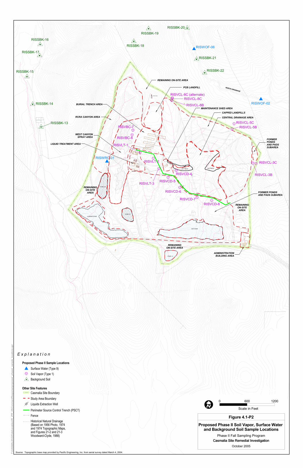
Page 2 outside three previous Phase I soil vapor probes, two locations along the western boundary of the Burial trench Area, and five locations in the Central Drainage Area. EPA had also requested that the CSC sample three deeper probes on the north and east boundary of the site at the same locations as three previous Phase I probes. The CSC noted in a letter dated October 7, 2005 sent to EPA that we wanted to discuss these three locations further with EPA. We have subsequently agreed to include in the proposed sampling. The locations of all sixteen soil vapor sample locations are shown on Figure 4.1-P2 attached to this memorandum. The figures shows two possible locations for RISVCL-08C. As agreed with EPA in the field, we will sample the location which is approximately 75 feet away from the previous RISVCL-08 location. The soil vapor data will be used to complement existing data to address the potential vapor migration from areas of the site where wastes may be present and may be used in the HHRA and ERA to evaluate potential exposures to chemicals in soil gas. The sampling locations shown on Figure 4.1-P2 were selected to incorporate EPA’s September 26, 2005 comments on the IPR (specifically Section III-Appendix C-Comment #1-#4 of the letter). The CSC and representatives for EPA walked the proposed locations in the field on October 10, 2005 to agree on these final locations. The soil vapor samples will be collected using temporary driven probes which will be advanced to a depth of 7.5 feet (the midpoint of the depth range of 5 to 10 feet) using a direct-push probe for all but the three “deep” probe locations. The “deep” soil vapor locations will also be collected using temporary driven probes which will be advanced to a depth of approximately 20 feet using a direct-push probe (or if the probe cannot penetrate to that depth as deep as possible). Soil vapor samples will be collected as detailed in SOP 1-9 of the June 3, 2004 revised Final RI/FS Work Plan which uses the guidelines from the advisory on active soil gas investigations prepared by the DTSC and Los Angeles RWQCB (DTSC and LARWQCB, January 2003). The sample will be collected in SUMMA canisters provided by a certified laboratory and will be analyzed for VOCs using USEPA Method TO-15. The Phase II soil vapor work will adhere to the same laboratory requirements for analytical work for this type of sampling as was required by the June 3, 2004 revised Final RI/FS Work Plan (this can be found in Appendix B QAPP of the Work Plan). The CSC has summarized the soil vapor sampling in Table 4.4-P2 attached to this memorandum. The table does not yet include the survey coordinates for all of the soil vapor locations as they were just recently selected. The CSC will survey the locations and provide all of those coordinates as part of our final reporting of the data. Additional details on soil vapor sampling can also be found in Section A6.5.10 of the SAP (Appendix A) of the June 3, 2005 revised Final RI/FS Work Plan.
Page 3 Surface Water Samples The CSC will collect surface water samples at three locations to supplement existing data. The three locations include two previous or Phase I RI surface water locations (one in the RCRA Canyon or RISWRC-01 and one in the North drainage or RISWOF-02), and a new location further north in the North drainage. The surface water sample locations are shown on Figure 4.1-P2 attached to this memorandum.
Surface water samples will be collected at two time intervals in the North and RCRA Canyon Drainages. The sampling will be conducted during the initial rainy season (October/November) and during the height of the rainy season (March/April), if possible. If the drainages are continuing to run during the summer months they will be sampled at that time also. Note however, that historically these locations have not had any running water to sample in the summer. Surface water samples will be analyzed for full Appendix IX analyses. The sampling locations as shown on Figure 4.1-P2 were chosen after the CSC and representatives for EPA walked the locations in the field on October 10, 2005. Samples will be collected using SOP 3-4 of the June 3, 2005 revised Final RI/FS Work Plan by submerging laboratory provided containers just under the surface of the water until the container is full. The Phase II surface water sampling will adhere to the same laboratory requirements for analytical work as was required by the June 3, 2004 revised Final RI/FS Work Plan for this type of sampling (this can be found in Appendix B QAPP of the Work Plan). The CSC has summarized the planned surface water sampling in Table 4.4-P2 attached to this memorandum. The table does not yet include survey coordinates for the new north drainage locations as it were just recently selected. The CSC will survey the location and provide all of those coordinates as part of our final reporting of the data. Additional details on surface water sampling can also be found in Section A6.5.11 of the SAP (Appendix A) of the June 3, 2005 revised Final RI/FS Work Plan. Background Soil Samples The CSC will collect background soil samples at additional depths at the same ten previous offsite soil locations that we had collected Phase I background soil samples to supplement existing data (locations RISSBK-13 through 22). The background soil sample locations are shown on Figure 4.1-P2 attached to this memorandum. The CSC has elected to gather additional background soil samples to augment the Phase I RI background soil samples we had collected earlier. We are specifically looking to add information to the database regarding herbicides for surface background soils (which were not included in the original sampling suites) and to gather additional background soil inorganic constituent data at different depths so we may evaluate whether different depths have statistically significant variations in inorganic constituents.

Page 4 The sampling locations as shown on Figure 4.1-P2 were chosen prior to Phase I RI activities after the CSC and representatives for EPA walked the locations in the field. Samples will be collected using SOP 1-1 of the June 3, 2005 revised Final RI/FS Work Plan. The Phase II background soils sampled at depths below the surface soil will be analyzed for metals (EPA Method 200.8, 6010B, 6020, and the 7000 series) and will adhere to the same laboratory requirements for this analytical work as was required by the June 3, 2004 revised Final RI/FS Work Plan for this type of sampling (this can be found in Appendix B QAPP of the Work Plan). The surface background soil samples will be analyzed for chlorinated herbicides (EPA Method 8151A) and will also adhere to the same laboratory requirements for this analytical work as was required by the June 3, 2004 revised Final RI/FS Work Plan for this type of sampling (this can be found in Appendix B QAPP of the Work Plan). The background soil samples will be sent to Sequoia Laboratory (Morgan Hill). Phase I soil samples were also analyzed at Sequoia Lab but at their Petaluma location. That lab location has since been converted to a distribution and administration center and the lab functions and equipment transferred to Morgan Hill. The Morgan Hill facility will adhere to all of the same laboratory MDL and QA/QC requirements that the Petaluma facility met. The CSC has summarized the planned background soil sampling in Table 4.4-P2 attached to this memorandum. Additional details on background soil sampling can also be found in Section A6.5.2 of the SAP (Appendix A) of the June 3, 2005 revised Final RI/FS Work Plan. Documentation The CSC will document the Phase II RI data using the same procedures and requirements as were required by the June 3, 2004 revised Final RI/FS Work Plan. The project documentation requirements are specifically discussed in Section 11.2 of the June RI/FS Work Plan. The data from this sampling will be included in the electronic database and copies of that will be provided to EPA. In the case of the soil vapor sampling at the three step out locations, the CSC will make every effort to provide the results of that sampling to EPA within 4 weeks (as was requested in EPA’s September 26th letter). The critical path for being able to meet that request will be the VOC analysis of the summa canisters collected as part of the soil vapor sampling. Field Supervision and Coordination with EPA The CSC expects that the soil vapor work will be performed by GeoSyntec (using the same staff as we used to complete the previous soil vapor sampling). As required, the CSC’s Project Coordinator will provide supervision of GeoSyntec while they are in the field. The CSC expects to collect the surface water samples using current URS site staff (who collected the previous Phase I surface water samples). The CSC expects to collect background soil samples with URS (using the same staff as we had used for the Phase I soil sampling).
Page 5 In all cases we will notify EPA’s on site representative of our plans to conduct the sampling at least 48 hours in advance of beginning the work. In the case of the surface water sampling, since this obviously depends on rain, we may not be able to provide that 48 hours notice. The CSC will coordinate any field work with EPA using the same guidelines that are discussed in Section 11 of the June RI/FS Work Plan which we had established for the Phase I RI work. That coordination specifically includes the requirements to coordinate with EPA as discussed in Section 11.3 of the Work Plan (and in Section A6.1 of the Sampling Analysis Plan or Appendix A of the Work Plan) and to hold daily status meetings as discussed in Section 11.5 of the Work Plan. In addition, the CSC will continue to use the management of change procedures that we had agreed with EPA prior to beginning the Phase I RI work (please see Section 11.7 of the Work Plan). Any change in sampling procedures or analytical reporting that were documented in an approved RICH form for Phase I RI sampling will also apply to the Phase II RI sampling. regards, Corey Bertelsen Casmalia Project Coordinator Attachments Table 4.4-P2 Figure 4.1-P2 Table A.2-P2 cc Jim Dragna – BM
Dave Roberson - ExxonMobil Paul Taylor - ConocoPhillips
Dan Niles – RWQCB Caroline Rudolph – DTSC Mark Wuttig – CH2MHill Casmalia Office San Luis Obispo Office 3401 NTU Road 868 Greystone Place Casmalia, CA 93429 SLO, CA 93401 (805) 934-5951 (805) 784-0803

A
ppro
x.D
efau
lt#
# pe
rB
orin
gSa
mpl
ePe
st/
Mod
Dio
xin/
Phys
ical
Gen
eral
Min
eral
s /
Are
aLo
c'ns
Loc'
nTo
tal
Type
Dep
thD
epth
sM
etal
sVO
CSV
OC
PCB
Her
bTP
H g
,dA
ppx
IX*
Fura
ns(2
)Pr
oper
ties
(3)
EDB
/DB
CP
Cap
ped
Land
fills
Are
aSo
il Va
por S
ampl
ing
31
31
20*
-X
--
--
--
-S
ampl
e ID
Nor
thin
gE
astin
gTy
peG
S E
lev
Wat
er E
lev
RIS
VC
L-3B
5059
8912
3876
6TY
PE
166
760
0R
ISV
CL-
5B50
6733
1238
315
TYP
E1
648
600
RIS
VC
L-8B
5073
5212
3700
3TY
PE
172
568
03
13
17.
5R
ISV
CL-
3CTB
DTB
DTY
PE
1R
ISV
CL-
5CTB
DTB
DTY
PE
1R
ISV
CL-
8CTB
DTB
DTY
PE
1R
CR
A C
anyo
n A
rea
Surf
ace
Wat
er1
11
90
0-
--
--
X-
--
Sam
ple
IDN
orth
ing
Eas
ting
Type
GS
Ele
vW
ater
Ele
vC
onta
ct E
leva
tion
DTW
DTC
RIS
WR
C-1
5057
9812
3555
6TY
PE
946
547
846
0-1
35
Cen
tral
Dra
inag
e A
rea
Soil
Vapo
r Sam
plin
g5
15
17.
5*
-X
--
--
--
-S
ampl
e ID
Nor
thin
gE
astin
gTy
peG
S E
lev
Wat
er E
lev
RIS
VC
D-4
TBD
TBD
TYP
E1
RIS
VC
D-5
TBD
TBD
TYP
E1
RIS
VC
D-6
TBD
TBD
TYP
E1
RIS
VC
D-7
TBD
TBD
TYP
E1
RIS
VC
D-8
TBD
TBD
TYP
E1
Bur
ial T
renc
h A
rea
Soil
Vapo
r Sam
plin
g2
12
17.
5*
-X
--
--
--
-S
ampl
e ID
Nor
thin
gE
astin
gTy
peG
S E
lev
Wat
er E
lev
RIS
VB
C-7
TBD
TBD
TYP
E1
RIS
VB
C-8
TBD
TBD
TYP
E1
Liqu
ids
Trea
tmen
t Are
aSo
il Va
por S
ampl
ing
31
31
7.5
*-
X-
--
--
--
Sam
ple
IDN
orth
ing
Eas
ting
Type
GS
Ele
vW
ater
Ele
vR
ISV
LT-1
TBD
TBD
TYP
E1
RIS
VLT
-2TB
DTB
DTY
PE
1R
ISV
LT-3
TBD
TBD
TYP
E1
Offs
ite A
rea
Surf
ace
Wat
er2
12
9S
urfa
ce0
--
-X
-S
ampl
e ID
Nor
thin
gE
astin
gTy
peG
S E
lev
Wat
er E
lev
Con
tact
Ele
vatio
nD
TWD
TCR
ISW
OF-
250
7384
1238
927
TYP
E9
470
462
458
812
RIS
WO
F-6
TBD
TBD
TYP
E9
Bac
kgro
und
Soils
(1)
103
305
200,
5,10
X (d
epth
soi
ls
only
)-
--
X (s
urfa
ce
soils
onl
y)-
--
-S
ampl
e ID
Nor
thin
gE
astin
gTy
peG
S E
lev
Wat
er E
lev
Con
tact
Ele
vatio
nD
TWD
TCR
ISS
BK
-13
5067
8812
3415
1TY
PE
247
30
448
473
25R
ISS
BK
-14
5072
8312
3401
0TY
PE
248
50
455
485
30R
ISS
BK
-15
5078
8212
3384
4TY
PE
249
50
467
495
28R
ISS
BK
-16
5085
8512
3412
9TY
PE
252
30
490
523
33R
ISS
BK
-17
5083
4512
3411
9TY
PE
269
50
703
695
-8R
ISS
BK
-18
5086
5312
3617
0TY
PE
284
266
074
218
210
0R
ISS
BK
-19
5089
2912
3649
1TY
PE
277
562
067
515
510
0R
ISS
BK
-20
5089
4112
3733
1TY
PE
257
055
555
015
20R
ISS
BK
-21
5082
6312
3753
5TY
PE
256
553
552
730
38R
ISS
BK
-22
5079
6812
3771
3TY
PE
253
852
550
213
36
Sam
ple
Dep
th /
Sam
ple
Col
lect
ion
Not
es:
Ant
icip
ated
dril
ling
met
hods
- Ty
pe 1
Sam
ples
: Dire
ct P
ush
Rig
(1
)M
axim
um B
ackg
roun
d S
ampl
ing
Dep
th to
20
feet
if n
eede
d to
obt
ain
clay
ston
e sa
mpl
eTy
pe 2
Sam
ples
: Man
ual S
ampl
ing
Tool
s S
urfa
ce s
ampl
es a
naly
zed
only
for h
erbi
cide
sTy
pe 3
, 4, 5
, 6 S
ampl
es: D
irect
Pus
h R
ig (d
efau
lt) o
r Hol
low
Ste
m A
uger
Rig
(if n
eces
sary
)Ty
pe 7
Bor
ings
: CP
T R
ig
Tabl
e 4-
4-P2
Soi
l Vap
or, S
urfa
ce W
ater
, and
Bac
kgro
und
Soil
Sam
plin
g Pr
ogra
m S
umm
ary
(rev
10.
24.0
5)
App
roxi
mat
e #
Sam
ples
CSC
S:\_
Pro
j\Cas
mal
ia\D
raft
RI R
epor
t\App
endi
ces\
Apx
Y\R
evis
ion
4 - F
all,
2005
Pha
se II
RI S
ampl
ing\
Tabl
e 4-
4-P
2_re
v10.
24.0
57/
2/20
09Pa
ge 1
of 1
RI/F
S W
ork
Plan

����
����
���
����
����
�� ��
���
����
�����
�����
����
�����
����
����
����
�����
��� �
� ���
�����
���
���
���
���
���
���
������
���
������
���
������
��
��
���
���
���
���
��� ���
������
������
����
��
���
���
���
��
��
���
���
��� ��� ���
������
�
���
���
���
���
���
���
���
���
���
���
���
���
�����
���
���
���
��� ��
�
��� ��
�
���
��
��
��
��
���
���
���
���
���
������
���
���
���
���
������
���
���
���
������������
��
��
���
���
���
������
���
���
���
���
���
��
�� �
���
��
���
���
���
���
���
���
���
���
���
���
���
���
��
��
��
��
��
���
���
���
���
���
���
�����
�
���
�����
�
���
���
���
���
���
���
���
���
���
���
���
���
��� ���
���
��
���
��
��
���
���
���
���
���
���
���
���
���
���
������
���
���
���
���
���
���
���
���
���
���
���
��
��
��
��
��
��
���
���
������
���
���
���
������
������
������
���
��� ���
���
��� ���
���
��
��
��
���
���
���
���
���
���
���
���
���
���
���
���
���
���
���
���
���
���
���
���
���
���
��
��
��
��
���
���
���
���
���
���
���
������
���
������
������
��
�� ��� ���
������
���
���
���
���
���
���
��
��
���
������
���
���
���
��� ���
���
���
���
��
�����
���
������
���
��
���
��� ���
���
���
���
���
���
���
���
���
���
���
���
���
��
��
��
���
���
���
���
������
������
���
���
���
���
���
���
���
���
���
���
�����
��
��
������
���
���
���
���
���
���
���
���
���
���
���
���
���
���
���
��
��
��
���
���
���
���
���
����� ���
������
��
���
��
������
��
���
���
���
���
���
���
���
���
���
���
���
���
���
��
��
��
���
���
���
���
���
���
���
���
���
���
���
���
���
���
���
���
���
���
���
���
���
��
��
��
��
���
���
���
���
���
���
���
���
���
������
���
���
���
���
���
���
���
���
���
��
��
��
��
��
��
��
���
���
���
���
���
���
���
���
���
���
���
���
���
���
���
���
���
���
���
���
���
���
�!"#$�%&
�!"#$�%'�!"#$'
�!"#$&�!"#$(
�!"#$)
�!"#$'��!"#$''
�!"#$'&
�!"#$&�
�!"#$�
��#$*�
�!"#$+
��,#-$'
�!"#$�%(
�!"#$�%)
��#$'� �!"#$'*
�!"#$.
�!"#$�
�!"#$�
�!"#$/
�!"#$�
�!"#$�
��#$/0
��#$/��!"#$1
�!"#$'/
��#$'�0��#$'��
��,#-$&
��#$'�-
�!"#$&&
��#$'�
�!"#$�
�!"#$#
2��0
�!"#$*
��#$'�3
��#$'��
��#$+�
��#$+�
��#$+0
�!"#$4
�!"#$0
�!"#$�
�!"#$�
�!"#$�%1
��#$)�
�!"#$'�
�!"#$'1
�!"#$-
��#$'+
�!"#$') �!"#$�
�!"#$&(
��3$�!"#
�!"#$'+
�!"#$�%�
�%�-�-�$�!"#
�!"#$'(
�
� �
�
�
�
�
�
�
��
�
� �
�
�
��
�
�
�
�
�
��
��
�
��
�
�
�
�
�
�
0,���-��0,���-��
�!"#$4
�!"#$�
�� ��� ����
��������
���������
������������
����������������
��������
��������
����� �
��������
��������
��������
����� �
����� ��
���������
���������
���������
������������� !"#� !$
��������
��������
��������
��������
����������������
����������������
�������
�������
� ���������
�������������� ������������������
���������
���������
����������������� �����������
������������������
� ��� ����������
���������� ������
����� ���������������
�������������������
����������������
�����������������
���������������������
����������������
����������������������������
��������������������������
��������
� ��� �� �!!
�%��!�&#��!! �����������
��'(��&���& !��!(!)&����#*!' &+� &,#
������������������������������������������������������������������ ����!��������
-.�'!�����������(/�&#+�-",+"�(��'(��&���& !��!(!)&����#*!' &+� &,#
�% ,0!"����
����������������� ������������� �������������� ������
������������� ������ ���������������
�������������������������������������� �!"��#���$%������$%���������"���&���#����'�������(�)(�����(�)*���+���),� ��#���--�
'����!���.�����������,�����������"��!�,��
� /�0�����12������������� �3����������� ,��.����������������
�����������������
-$5$�$ $�$�$�$�$�$�$�
�,1"%!2�� ,/,+"�/.&%�0�'!�(�/�/",*&)!)�03�-�%&4&%��#+&#!!"&#+5��#%6�4",(��!"&���'1"*!3�)� !)�7�"%.��5����6


Table A-2Proposed Sampling and Analytical Program
PHASE II OCTOBER 2005Appendix A SAP/FSP
;
Table A.2-P2Fall 2005 Phase II RI Sampling
Temperature 4o Celsius
Comments
Study AreaStation Number Matrix
Sample Number Station Description
Sample Depth (ft)
Sample Type V
OC
s (E
PA
826
0B/5
04.1
)
Poo
r pur
ging
org
anic
com
poun
ds
(EP
A 8
015
Dire
ct In
ject
)
BTE
X (E
PA
802
1B)
TPH
g (E
PA
801
5B)
TPH
d (E
PA
801
5B)
SV
OC
s (E
PA
827
0C)
Org
anoc
hlor
ine
Pes
ticid
es/P
CB
s (E
PA
808
1A/8
082)
Met
als
(EP
A 2
00.8
, 601
0B/6
020
and
7000
Ser
ies)
Mod
ified
App
endi
x IX
* (A
ppen
dix
IX w
ith a
dditi
onal
CO
PC
s le
ss
diox
ins
and
fura
ns) (
e)
App
endi
x IX
(Mod
App
endi
x IX
pl
us a
dditi
onal
CO
PC
s an
d di
oxin
s an
d fu
rans
) (e)
Dio
xins
and
Fur
ans
(EP
A 8
290)
Org
anoc
hlor
ine
Pes
ticid
es o
nly
(E
PA
808
1A)
Chl
orin
ated
Her
bici
des
only
(E
PA
815
1A)
Gen
eral
Min
eral
s (C
atio
ns 6
010B
, TD
S 1
60.1
, Sul
fide
9030
B, A
nion
s 30
0.0
and
Alk
alin
ity S
M 2
320)
Phy
sica
l Pro
perti
es (f
)
Per
chlo
rate
(EP
A 3
14.0
)
Hyd
razi
ne (E
PA
831
5)
Exp
losi
ves
(Nitr
oaro
mat
ics
and
Nitr
osam
ines
) EP
A 8
330
pCB
SA
(LC
/MS
/MS
)
C14
and
Trit
ium
CO
D, B
OD
, and
DO
(EP
A 4
10.4
/405
.1)
Den
sity
, Vis
coci
ty, D
NA
PL-
Wat
er
Inte
rfaci
al T
ensi
on
Soil 3 Encr 2 oz jar 3 Encr 1-16 oz jar or ss-sleeve NA1-16 oz jar or ss-
sleeve NA NA NA NA NA NA NA
Sediment NA NA NA NA 16 oz G 16 oz G 16 oz G 16 oz G 16 oz G NA 16 oz G 16 oz G NA 8 oz G NA NA NA NA NA NA NA
Air SUMMA NA NA NA NA NA NA NA NA NA NA NA NA NA NA NA NA NA NA NA NA
Aqueous3 x 40 mL VOA HCl
3 x 40 mL VOA HCl 3 x 40 mL VOA HCl 2 x 1L G 2 x 1L G 2 x 1L G
0.5L Pl; Nitric Acid
See bottle list in Appendix B, Table B-1
See bottle list in Appendix B, Table B-1 2 x 1L G 2 x 1L G 2 x 1L G
0.5 L Pl HNO3
0.5 L Pl; 1-1L Pl
ZnAcetate/NaOH; 1-1L Pl
NA 0.5L Pl 2x1L G 2x1L G 2x1L G 1-1L Pl; 0.5L Pl1 x 50ml Pl
H2SO4; 1 L G 1 L G
Off-Site Area Background Soils Evaluation a
RISSBK-13 soil surface soil (T4) 0-0.5 primary xRISSBK-13 soil shallow soil (T4) 5-5.5 primary xRISSBK-13 soil shallow soil (T4) 5-5.5 duplicate xRISSBK-13 soil shallow soil (T4) 10-10.5 primary xRISSBK-14 soil surface soil (T4) 0-0.5 primary xRISSBK-14 soil shallow soil (T4) 5-5.5 primary xRISSBK-14 soil shallow soil (T4) 10-10.5 primary xRISSBK-15 soil surface soil (T4) 0-0.5 primary xRISSBK-15 soil shallow soil (T4) 5-5.5 primary xRISSBK-15 soil shallow soil (T4) 10-10.5 primary xRISSBK-16 soil surface soil (T4) 0-0.5 primary xRISSBK-16 soil shallow soil (T4) 5-5.5 primary xRISSBK-16 soil shallow soil (T4) 10-10.5 primary xRISSBK-17 soil surface soil (T4) 0-0.5 primary xRISSBK-17 soil surface soil (T4) 0-0.5 duplicate xRISSBK-17 soil surface soil (T4) 5-5.5 primary xRISSBK-17 soil surface soil (T4) 10-10.5 primary xRISSBK-18 soil surface soil (T4) 0-0.5 primary xRISSBK-18 soil surface soil (T4) 5-5.5 primary xRISSBK-18 soil surface soil (T4) 10-10.5 primary xRISSBK-19 soil surface soil (T4) 0-0.5 primary xRISSBK-19 soil surface soil (T4) 5-5.5 primary xRISSBK-19 soil surface soil (T4) 10-10.5 primary xRISSBK-20 soil surface soil (T4) 0-0.5 primary xRISSBK-20 soil surface soil (T4) 5-5.5 primary xRISSBK-20 soil surface soil (T4) 10-10.5 primary xRISSBK-21 soil surface soil (T4) 0-0.5 primary xRISSBK-21 soil surface soil (T4) 5-5.5 primary xRISSBK-21 soil surface soil (T4) 10-10.5 primary xRISSBK-21 soil surface soil (T4) 10-10.5 duplicate xRISSBK-22 soil surface soil (T4) 0-0.5 primary xRISSBK-22 soil surface soil (T4) 5-5.5 primary xRISSBK-22 soil surface soil (T4) 10-10.5 primary xSurface WaterRISWOF-2 water surface water (T9) 0-0.5 primary x x x x x x xRISWOF-6 water surface water (T9) 0-0.5 primary x x x x x x x
Capped Landfills Area Soil Vapor SamplingRISVCL-3B air soil vapor (T1) 20 primary x RISVCL-5B air soil vapor (T1) 20 primary xRISVCL-8B air soil vapor (T1) 20 primary xRISVCL-3C air soil vapor (T1) 7.5 primary xRISVCL-5C air soil vapor (T1) 7.5 duplicate x RISVCL-5C air soil vapor (T1) 7.5 primary x RISVCL-8C air soil vapor (T1) 7.5 primary x
Central Drainage Area Soil Vapor SamplingRISVCD-4 air soil vapor (T1) 7.5 primary x RISVCD-5 air soil vapor (T1) 7.5 primary xRISVCD-6 air soil vapor (T1) 7.5 primary xRISVCD-7 air soil vapor (T1) 7.5 primary xRISVCD-8 air soil vapor (T1) 7.5 primary x
Burial Trench Area Soil Vapor SamplingRISVBC-7 air soil vapor (T1) 7.5 primary x RISVBC-8 air soil vapor (T1) 7.5 primary x
Liquids Treatment Area Soil Vapor SamplingRISVLT-1 air soil vapor (T1) 7.5 primary x RISVLT-2 air soil vapor (T1) 7.5 primary xRISVLT-3 air soil vapor (T1) 7.5 primary x
RCRA Canyon Surface WaterRISWRC-1 water surface water (T9) 0-0.5 primary x x x x x storm water diversion pipe
a 10-foot samples will be collected at 10 feet or in claystone,whichever is deeper GW Groundwater sample.to a maximum depth of 20-feet bgs. soil Soil sample.
sed Sediment sampleVOCs Volatile organic compounds
G Glass. BTEX Benzene, toluene, ethylbenzene, and xylenesoz Ounce. TPHg Total petroleum hydrocarbons as gasoline.L Liter. TPHd Total petroleum hydrocarbons as diesel.Pl Plastic. SVOCs Semivolatile organic compounds.mL Milliliter. PCBs Polychlorinated biphenyls.HCL Hydrochloric acid. TOC Total organic carbon.
CSC Table_A.2-P2-FINAL10.27.05-CasmaliaOCTOBER 2005 Page 1 of 1
RI/FS Work PlanAppendix A


