12
THE OHIO STATE UNIVERSITY CITY & REGIONAL PLANNING UNDERGRADUATE STUDIO CITY OF REYNOLDSBURG INFRASTRUCTURE ENHANCEMENT PLAN NOVEMBER 2013 O H I O R E Y N O L D S B U R G
| Date post: | 12-Jan-2017 |
| Category: |
Documents |
| Upload: | bryan-townley |
| View: | 193 times |
| Download: | 1 times |

The OhiO STaTe UniverSiTyCiTy & regiOnal Planning
UndergradUaTe STUdiO
CiTy Of reynOldSbUrginfraSTrUCTUre enhanCemenT PlannOvember 2013
OHIO
REYNOLDSBURG
infrastructure enhancement Plan - The Ohio State University Planning Studio 7infrastructure enhancement Plan - The Ohio State University Planning Studio6
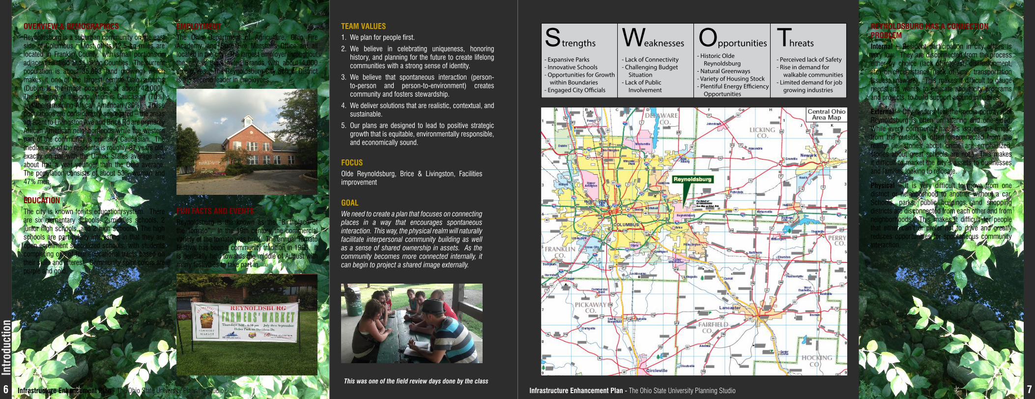
internal – Resident participation in city affairs is very low. They are disconnected from the process either by choice (lack of interest, disillusionment, etc) or circumstance (lack of time, transportation issues, unaware). This makes it difficult to gauge needs and wants, to educate about city programs and projects, to build support around initiatives.
external – City leaders feel the media portrayal of Reynoldsburg is often unflattering and one-sided. While every community has it’s issues, the image from the outside is often disconnected from the reality (ie. stories about crime are emphasized, stories about great schools are not.) This makes it difficult to market the city’s assets to businesses and families looking to relocate.
Physical – It is very difficult to move from one district or neighborhood to another without a car. Schools, parks, public buildings, and shopping districts are disconnected from each other and from neighborhoods. This makes it difficult for people that either can’t or prefer not to drive and greatly reduces opportunities for spontaneous community interaction.
Team valUeS1. We plan for people first.
2. We believe in celebrating uniqueness, honoring history, and planning for the future to create lifelong communities with a strong sense of identity.
3. We believe that spontaneous interaction (person-to-person and person-to-environment) creates community and fosters stewardship.
4. We deliver solutions that are realistic, contextual, and sustainable.
5. Our plans are designed to lead to positive strategic growth that is equitable, environmentally responsible, and economically sound.
fOCUSOlde Reynoldsburg, Brice & Livingston, Facilities improvement
gOalWe need to create a plan that focuses on connecting places in a way that encourages spontaneous interaction. This way, the physical realm will naturally facilitate interpersonal community building as well as a sense of shared ownership in assets. As the community becomes more connected internally, it can begin to project a shared image externally.
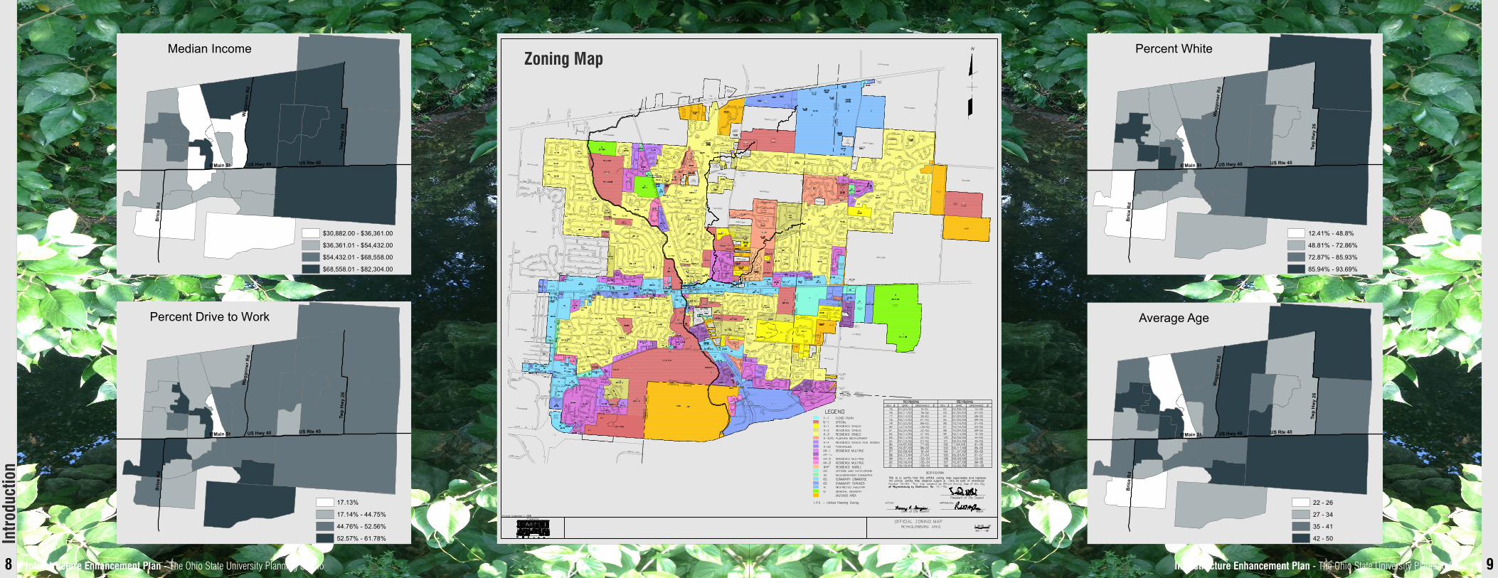
Overview & demOgraPhiCSReynoldsburg is a suburban community on the east side of Columbus. Most of its 12.5 sq miles are located in Franklin County, with small portions in adjacent Fairfield and Licking Counties. The current population is about 35,893 (and growing) which makes it one of the largest central Ohio suburbs (Dublin is the most populous at about 42,000). The majority of the population is Caucasian (70%) and the remaining African American (30%). These populations are considerably segregated – the areas adjacent to Livingston Ave and Brice Rd are primarily African American neighborhoods while the western part of the community is primarily Caucasian. The median age of the residents is roughly 37 years old, exactly on par with the United States average and about half a year younger than the Ohio average. The population consists of about 53% woman and 47% men.
edUCaTiOnThe city is known for its education system. There are six elementary schools, 2 middles schools, 2 junior high schools, and 2 high schools. The high schools are particularly interesting in that they are open enrollment specialized schools, with students completing one of four educational tracts based on their skills and interest. Community spirit colors are purple and gold.
emPlOymenTThe Ohio Department of Agriculture, Ohio Fire Academy, and State Fire Marshalls Office are all located in the city. The largest employer throughout the city is the Limited Brands with about 4,000 employees. The Reynoldsburg City School District is the second leader in employees.
fUn faCTS and evenTSReynoldsburg is the known as the “Birthplace of the Tomato”. In the 19th century the commercial variety of the tomato was bred. The annual Tomato Festival has been a community tradition in 1965. It is generally held towards the middle of August with many festivities to take part in.
This was one of the field review days done by the class
reynOldSbUrg haS a COnneCTiOn PrOblem
intr
oduc
tion
- Expansive Parks- Innovative Schools- Opportunities for Growth within Boundaries- Engaged City O�cials
S- Lack of Connectivity- Challenging Budget Situation- Lack of Public Involvement
Wtrengths eaknesses- Historic Olde Reynoldsburg- Natural Greenways- Variety of Housing Stock- Plentiful Energy E�ciency Opportunities
Opportunities
- Perceived lack of Safety- Rise in demand for walkable communities- Limited demand for job growing industries
Threats
infrastructure enhancement Plan - The Ohio State University Planning Studio 9infrastructure enhancement Plan - The Ohio State University Planning Studio8
Zoning map
E Main St US Hwy 40 US Rte 40
Bric
e R
d
Twp
Hw
y 26
Wag
gone
r Rd
Percent White
12.41% - 48.8%
48.81% - 72.86%
72.87% - 85.93%
85.94% - 93.69%
E Main St US Hwy 40 US Rte 40
Bric
e R
d
Twp
Hw
y 26
Wag
gone
r Rd
Percent Drive to Work
17.13%
17.14% - 44.75%
44.76% - 52.56%
52.57% - 61.78%
E Main St US Hwy 40 US Rte 40
Bric
e R
d
Twp
Hw
y 26
Wag
gone
r Rd
Average Age
22 - 26
27 - 34
35 - 41
42 - 50
E Main St US Hwy 40 US Rte 40B
rice
Rd
Twp
Hw
y 26
Wag
gone
r Rd
Median Income
$30,882.00 - $36,361.00
$36,361.01 - $54,432.00
$54,432.01 - $68,558.00
$68,558.01 - $82,304.00
intr
oduc
tion
10 11
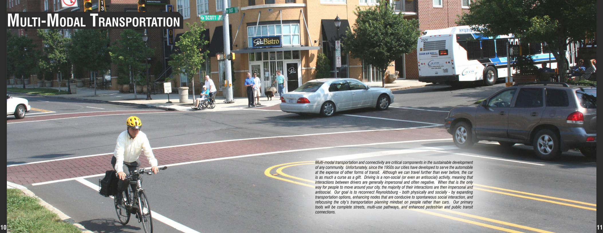
MulTI-Modal TransporTaTIon
Multi-modal transportation and connectivity are critical components in the sustainable development of any community. Unfortunately, since the 1950s our cities have developed to serve the automobile at the expense of other forms of transit. Although we can travel further than ever before, the car is as much a curse as a gift. Driving is a non-social (or even an antisocial) activity, meaning that interactions between drivers are generally impersonal and often negative. When that is the only way for people to move around your city, the majority of their interactions are then impersonal and antisocial. Our goal is to reconnect Reynoldsburg - both physically and socially - by expanding transportation options, enhancing nodes that are conducive to spontaneous social interaction, and refocusing the city’s transportation planning mindset on people rather than cars. Our primary tools will be complete streets, multi-use pathways, and enhanced pedestrian and public transit connections.

infrastructure enhancement Plan - The Ohio State University Planning Studio 13infrastructure enhancement Plan - The Ohio State University Planning Studio12
existing ConditionsWe have developed four main focus areas for our revitalization plan. These four areas include Olde Reynoldsburg, Brice Road, Waggoner Road, and State Route 256, as well as some notes regarding the COTA bus system in the area. We looked at traffic conditions in the area, multi-modal transportation patterns, pedestrian connectivity, and social and economic conditions.
COTa bUS lineS• The city is serviced by seven COTA bus lines (44, 45, 47, 48) that are currently
underutilized
• Other routes (1, 2, 10) connect Reynoldsburg to other municipalities
• Bus lines do not cover the majority of the city
• Bus stops are in poor to fair condition and most do not have pedestrian or bicycle access ways
• Most stops are demarcated by a sign placed in a patch of grass without shelter or lighting
• Improvements must be made in order to ensure effective multi-modal transportation
Olde reynOldSbUrg – main STreeT
briCe rOad
• Opportunity to become important part of Reynoldsburg
• Currently underutilized with an array of vacant businesses and open lots
• Cars traveling at high speeds and a lack of street parking make the area unfriendly for pedestrians and bicyclists
• There are no obvious reasons to stop and enjoy this area, even though it is the historic core of the city
• Automobile dominated, mostly rural type of road
• Lack of connectivity between crossing neighborhoods, parks, and churches is key
• No shoulder room on road edges
• Complete street design in this area is unreasonable
Overall• Non-automobile connectivity is the main issue in our four focus areas
• Multi-use paths exist in the city, but are not well connected
• Lack of livable streets is an issue - most streets are automobile focused and are only used as such
• Reynoldsburg has sidewalks throughout the city, but they need to be better connected. Some areas are absent of sidewalks completely
mul
ti-m
odal
Tra
nspo
rtat
ion
Reynoldsburg Transportation Waggoner Rd. focus area Main St. Focus Area
Brice Rd. focus area SR 256 focus area
waggOner rOad
Sr 256
• Similar to Brice Road
• No shoulder room or sidewalks
• Pedestrian traffic seen walking on grass on side of road, unsafe
• Housing developments and churches only have connection by automobile • Premier commercial district of Reynoldsburg
• Zoned as planned development and multi-family residences
• Opportunity for complete street design to accompany downtown Reynoldsburg as well as a nearby park
• Opportunity for a Reynoldsburg gateway
infrastructure enhancement Plan - The Ohio State University Planning Studio 15infrastructure enhancement Plan - The Ohio State University Planning Studio14
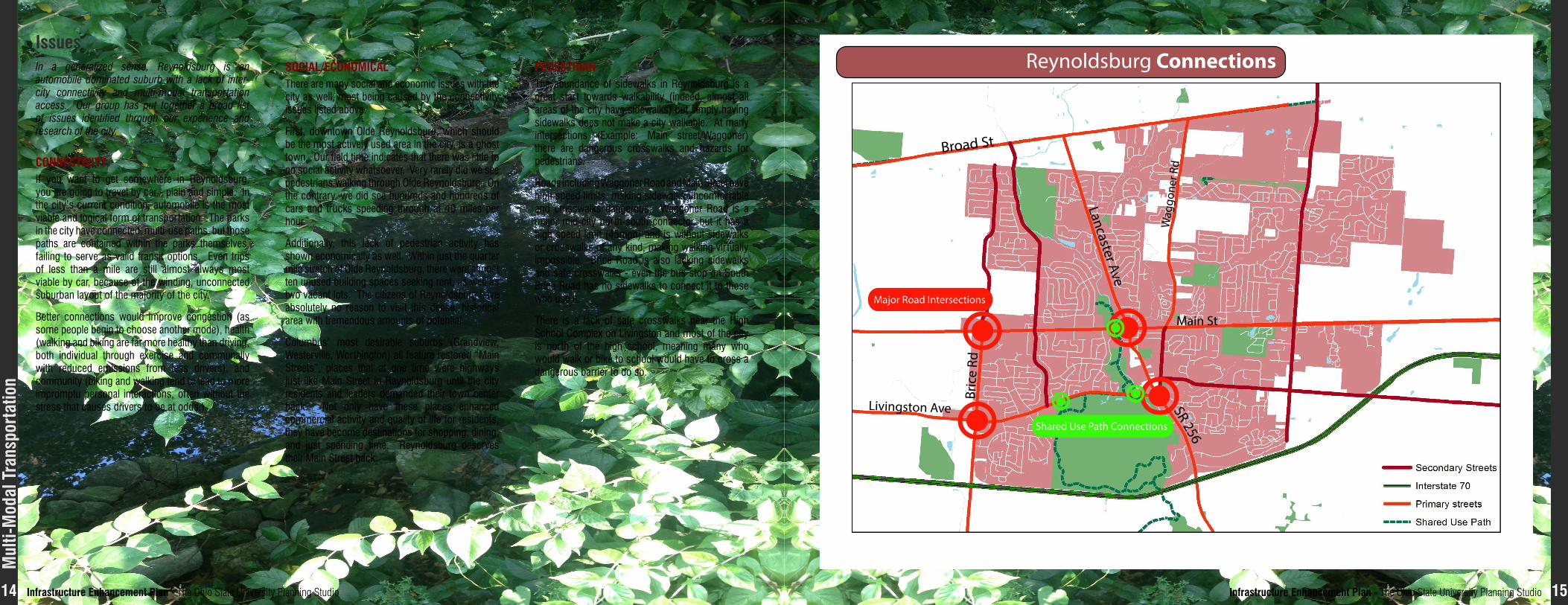
issuesIn a generalized sense, Reynoldsburg is an automobile dominated suburb with a lack of inter-city connectivity and multi-modal transportation access. Our group has put together a broad list of issues identified through our experience and research of the city.
Reynoldsburg Connections
Broad St
Main St
Bric
e Rd
Livingston Ave SR 256
Wag
gone
r Rd
Lancaster Ave
Shared Use Path Connections
Major Road Intersections
COnneCTiviTyIf you want to get somewhere in Reynoldsburg, you are going to travel by car - plain and simple. In the city’s current condition, automobile is the most viable and logical form of transportation. The parks in the city have connected, multi-use paths, but those paths are contained within the parks themselves, failing to serve as valid transit options. Even trips of less than a mile are still almost always most viable by car, because of the winding, unconnected suburban layout of the majority of the city.
Better connections would improve congestion (as some people begin to choose another mode), health (walking and biking are far more healthy than driving, both individual through exercise and communally with reduced emissions from less drivers), and community (biking and walking tend to lead to more impromptu personal interactions, often without the stress that causes drivers to be at odds.)
SOCial/eCOnOmiCalThere are many social and economic issues with the city as well, most being caused by the connectivity issues listed above.
First, downtown Olde Reynoldsburg, which should be the most actively used area in the city, is a ghost town. Our field time indicates that there was little to no social activity whatsoever. Very rarely did we see pedestrians walking through Olde Reynoldsburg. On the contrary, we did see hundreds and hundreds of cars and trucks speeding through at 40 miles per hour.
Additionally, this lack of pedestrian activity has shown economically as well. Within just the quarter mile stretch of Olde Reynoldsburg, there were almost ten unused building spaces seeking rent, as well as two vacant lots. The citizens of Reynoldsburg have absolutely no reason to visit this dense, historical area with tremendous amounts of potential.
Columbus’ most desirable suburbs (Grandview, Westerville, Worthington) all feature restored “Main Streets”, places that at one time were highways just like Main Street in Reynoldsburg until the city residents and leaders demanded their town center back. Not only have these places enhanced commercial activity and quality of life for residents, they have become destinations for shopping, dining, and just spending time. Reynoldsburg deserves their Main Street back.
The abundance of sidewalks in Reynoldsburg is a great start towards walkability (indeed, almost all areas of the city have sidewalks) but simply having sidewalks does not make a city walkable. At many intersections (Example: Main street/Waggoner) there are dangerous crosswalks and hazards for pedestrians.
Roads including Waggoner Road and Main Street have high speed limits, making sidewalks uncomfortable and crosswalks dangerous. Waggoner Road is a major mid-city north-south connector, but it has a high speed limit (45mph) and is without sidewalks or crosswalks of any kind, making walking virtually impossible. Brice Road is also lacking sidewalks and safe crosswalks - even the bus stop on South Brice Road has no sidewalks to connect it to those who use it.
There is a lack of safe crosswalks near the High School Complex on Livingston and most of the city is north of the high school, meaning many who would walk or bike to school would have to cross a dangerous barrier to do so.
PedeSTrian
mul
ti-m
odal
Tra
nspo
rtat
ion

infrastructure enhancement Plan - The Ohio State University Planning Studio 17infrastructure enhancement Plan - The Ohio State University Planning Studio16
PUbliC TranSPOrTaTiOnSeven COTA bus lines run through Reynoldsburg: 1, 2, 10, 44, 45, 47, and 48. The 1, 2, and 10 lines are local routes, connecting Reynoldsburg to other municipalities along the Livingston Ave. corridor, the Main St. corridor, and the Broad St. corridor, respectively. The 44, 45, 47, and 48 lines are express routes which shuttle commuters to Columbus in the morning, and back in the evening. These COTA lines are concentrated in the western half of the city (specifically in southwestern Reynoldsburg), which contains a higher population density. However, the majority of the city is not within a ¼ mile radius of
Bus Route and Stop Locations
Solutions general COnneCTiviTy• Recommend city-wide multi-use paths shown in graphic
to increase inter-city pedestrian and bicycle transportationIncluded in our identified solutions, we hope to incorporate the core values into our plan, and develop complete streets that accommodate all users using all modes of transportation.
Bicycle Infrastructure
Baldwin Road Junior High School
Blacklick Woods Metro Park
Huber Park
JFK Park
Reynoldsburg Senior Center
Police Department
Civic Park
Glen Rest Memorial Estate
Rodebaugh Rd Park Taylor Rd Elementary School
Livingston House
City Hall
Slate Ridge Elementary School
Graham Road Elementary School
Hannah J Ashton Middle School
Old ReynoldsburgUS Post O�ce
French Run Elementary School
Waggoner Rd Junior High School
Rose Hill Elementary School
Columbus Metropolitan Library
Reynoldsburg High School
mul
ti-m
odal
Tra
nspo
rtat
ion
a bus stop.
Again, the eastern half of the city is disconnected from public transportation. Also, north-south public transportation movement in the city is virtually nonexistent because the three main lines, 1, 2, and 10, run on an east-west axis (primarily to serve downtown Columbus commuters). The main public transportation hub in the city is the Reynoldsburg Park and Ride, located in extreme southwest Reynoldsburg. However, the only main bus line it
serves is the 1, with a nearby line 2 bus stop along Brice Rd. The Park and Ride is somewhat secluded, however, behind Brice Rd.’s commercial strip and a multi-family residential neighborhood. The Park and Ride is connected by roadway and sidewalk, but does not connect to any bikeway infrastructure. In addition, some bus stops do not have any shelters or benches, and others are not even connected via sidewalks. Some bus stops are simply signs placed in a patch of grass.
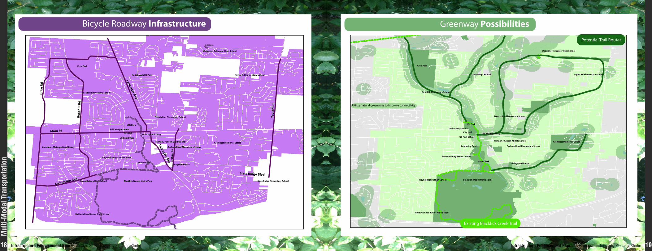
Shared USe bike/PaThwaySReynoldsburg is served by the Blacklick Creek Trail, a shared-use path that connects the city to other municipalities to the southeast and southwest. The path follows the natural greenway of Blacklick Creek, which runs through the heart of the city. The trail also connects several of the city’s main parks, Blacklick Woods Metro Park, Huber Park, and JFK Park. However, other than the Blacklick Creek Trail, Reynoldsburg is seriously lacking in bicycle infrastructure.
The extreme northwest and southwest portions, along with the entire portion of Reynoldsburg east of Blacklick Creek, are not served by bikeway infrastructure, and remain completely disconnected bike-wise. The large Civic Park, just north of JFK Park along Blacklick Creek is not connected.
Upon observation, Reynoldsburg does not have bike lanes on any of its streets, nor is there “Share the Road” signage. This creates a poor environment for cyclists. In addition to these issues, there is a shortage of access ways across Blacklick Creek itself: the only creek crossings occur at Broad St., Main St., and Livingston Ave, all unfriendly to bicyclists.
infrastructure enhancement Plan - The Ohio State University Planning Studio 19infrastructure enhancement Plan - The Ohio State University Planning Studio18
Bicycle Roadway Infrastructure
Reynoldsburg High School
Baldwin Road Junior High School
Blacklick Woods Metro Park
Huber Park
JFK Park
Reynoldsburg Senior Center
US Post O�ce
Police Department
Civic Park
Glen Rest Memorial Estate
Rodebaugh Rd Park
Waggoner Rd Junior High School
French Run Elementary School
Taylor Rd Elementary School
Columbus Metropolitan Library
Slate Ridge Elementary School
Rose Hill Elementary School
Hannah J Ashton Middle School
Graham Road Elementary School
Livingston House
Old ReynoldsburgCity Hall
Livingston Ave
Slate Ridge Blvd
Main St
Lancaster Ave
Lancaster Ave
Bric
e Rd
Rose
hill
Rd
Tayl
or R
d
Gra
ham
Rd
Greenway Possibilities
Existing Blacklick Creek Trail
Utilize natural greenways to improve connectivity
Potential Trail Routes
Reynoldsburg High School
Baldwin Road Junior High School
Blacklick Woods Metro Park
Huber Park
JFK Park
Reynoldsburg Senior Center
Swimming Pools
US Post O�ce
City Hall
Police Department
Old Reynoldsburg
Civic Park
Hannah J Ashton Middle School
Graham Road Elementary School
Glen Rest Memorial Estate
Rodebaugh Rd Park
Rose Hill Elementary School
Waggoner Rd Junior High School
French Run Elementary School
Taylor Rd Elementary School
Livingston House
mul
ti-m
odal
Tra
nspo
rtat
ion
infrastructure enhancement Plan - The Ohio State University Planning Studio 21infrastructure enhancement Plan - The Ohio State University Planning Studio20
main STreeT – Olde reynOldbUrg• Connectivity
– Reduce speed limit to 25mph in Olde Reynoldsburg (between Blacklick Creek and Waggoner Road)
– Street parking only lanes on both edge lanes of the road
– Sharrow lanes on driving lanes (shown in graphic)
– Garden strip median throughout certain parts of Olde Reynoldsburg
– Green/Complete streets improve overall area
• Pedestrian
– Sidewalks at least 15’ wide to allow pedestrians as well as patio allowances for restaurants
– Trees providing shade and separating pedestrians from roadway
– Multi-use pathways connected from Olde Reynoldsburg to parks and all other landmarks of Reynoldsburg (Shown on map) (Ref. Olde Gahanna multi-use pathways)
– Increase visibility and quality of crosswalks, pedestrians first
– Outdoor seating
– “Yield to Pedestrians” sign along crosswalks
• Biking
– Sharrow lanes are safe in 25mph zone, designated bike lanes outside of Olde Reynoldsburg area
• Public Transportation
– Bus stop shelters on Olde Reynoldsburg stops
– Proper signage, safe walkway to and from stop
Current Condition
6 feet of sidewalk space on either side58 feet of total road space
No sharrow lanes or bike lanes
Recommendation 1
Sidewalks widened for pedestrian safetyDesignated “parking only” lane on both sides of road
Sharrow lanes in both directions25mph speed limit
Recommendation 2
Sidewalks widened for pedestrian safetyDesignated “parking only” lane on both sides of road
Designated bike lanes on both sides of road25mph speed limit
Recommendation 3
Maintain current sidewalk widthDesignated bike lanes on both sides of road
Tree medians in parts of road35mph speed limit
mul
ti-m
odal
Tra
nspo
rtat
ion
SPEED LIMIT
25
KEYRed = Designated bike lane
This area is Main Street, crossing Blacklick Creek and entering Olde Reynoldsburg
Bike Lanes on Main Street crossing Blacklick Creek
KEYRed = Designated bike lane
This area is the intersection of Lancaster Avenue andEast Main Street
Bike Lanes at intersection of Lancaster and Main
infrastructure enhancement Plan - The Ohio State University Planning Studio 23infrastructure enhancement Plan - The Ohio State University Planning Studio22
mul
ti-m
odal
Tra
nspo
rtat
ion
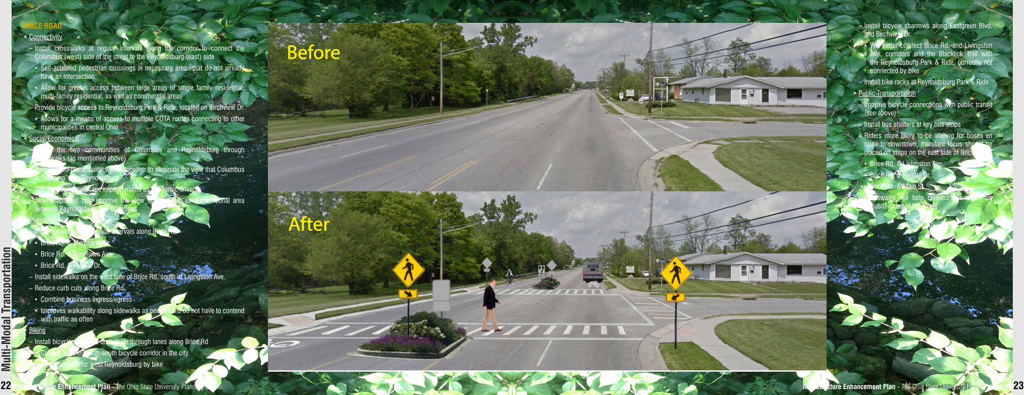
briCe rOad• Connectivity
– Install crosswalks at regular intervals along the corridor to connect the Columbus (west) side of the street to the Reynoldsburg (east) side
▪ Self-actuated pedestrian crossings in necessary areas that do not already have an intersection
▪ Allow for greater access between large areas of single family residential, multi-family residential, as well as commercial areas
– Provide bicycle access to Reynoldsburg Park & Ride, located on Birchview Dr.
▪ Allows for a means of access to multiple COTA routes connecting to other municipalities in central Ohio
• Social/Economical
– Bridge the two communities of Columbus and Reynoldsburg through crosswalks (as mentioned above)
– Help the two municipalities work together to eliminate the view that Columbus is “seeping” into Reynoldsburg
– Use the new streetscape improvements as economic drivers
– Streetscape will help improve the view of Brice Rd. as a transitional area between Reynoldsburg and Columbus
• Pedestrian
– Install crosswalks at regular intervals along Brice Rd.
▪ Brice Rd. & Merchants Dr.
▪ Brice Rd. & Roselawn Ave.
▪ Brice Rd. & Rygate Dr.
– Install sidewalks on the west side of Brice Rd. south of Livingston Ave.
– Reduce curb cuts along Brice Rd.
▪ Combine business ingress/egress
▪ Improves walkability along sidewalks as pedestrians do not have to contend with traffic as often
• Biking
– Install bicycle sharrows on outside through lanes along Brice Rd
▪ Creates another north-south bicycle corridor in the city
▪ Helps connect far west Reynoldsburg by bike
Before
After
– Install bicycle sharrows along Eastgreen Blvd. and Birchview Dr.
▪ Will better connect Brice Rd. and Livingston Ave. corridors and the Blacklick Trail with the Reynoldsburg Park & Ride, currently not connected by bike
– Install bike racks at Reynoldsburg Park & Ride
• Public Transportation
– Improve bicycle connections with public transit (see above)
– Install bus shelters at key bus stops
– Riders more likely to be waiting for buses en route to downtown, therefore focus should be placed on stops on the east side of Brice Rd.
▪ Brice Rd. & Livingston Ave.
▪ Brice Rd. & Rygate Dr.
▪ Brice Rd. & Main St.
– Crosswalks will help connect bus stops on opposite sides of the street
infrastructure enhancement Plan - The Ohio State University Planning Studio 25infrastructure enhancement Plan - The Ohio State University Planning Studio24
mul
ti-m
odal
Tra
nspo
rtat
ion
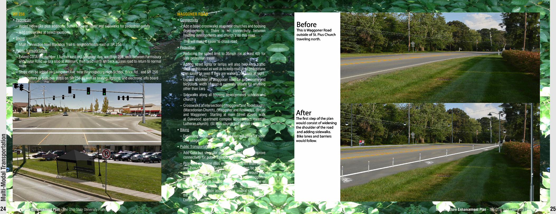
waggOner rOad• Connectivity
– Add in basic crosswalks asap near churches and housing developments – There is no connectivity between housing developments and church’s on this road
– This will make it easier to cross road
• Pedestrian
– Reducing the speed limit to 35mph (or at least 40) for safe pedestrian travel
– Adding street lights or lamps will also help keep traffic safer on this road as well as to keep road lit so pedestrians can easily be seen if they are walking road late at night
– Expand shoulder of Waggoner road for pedestrians and bicyclists, width of road is currently unsafe for anything other than cars
– Sidewalks along all housing developments schools and church’s
– Crosswalks at intersections (Waggoner and Rodebaugh), (Macedonian Church), (Waggoner and Rossway), (Broad and Waggoner) Starting at main Street (Cross walk at Oakwood apartment complex across from messiah Lutheran church), (St Pius church and school center)
• Biking
– Expanding shoulder of Waggoner road will allow for safer bike usage
• Public Transportation
– Add Cota bus stops for pedestrians and overall improve connectivity for public transportation
– Proposed extension (Bus would continue on Main Street and then north onto Taylor (There would then be at least one stop near the limited plaza). Cota line would then travel east on Broad Street and then South onto Waggoner. There would be at least 2 stop on Waggoner. One of them would be near St Pius Church. This would allow public transportation access to the several churches in the area. There could also be a stop near the Messiah Lutheran church.
BeforeThis is Waggoner Road outside of St. Pius Church traveling north.
AfterThe rst step of the plan would consist of widening the shoulder of the road and adding sidewalks. Bike lanes and barriers wwould follow.
Sr 256• Pedestrian
– Widen sidewalks plus additional buffer between street and sidewalks for pedestrian safety
– Add crosswalks at select locations
• Biking
– MUP connection from Blacklick Trail to neighborhoods east of SR 256
• Public Transportation
– Extend COTA line number 1 further east on Livingston Ave, south on 256, east between Farmsbury and Taylor Road up to a stop at Walmart, then head north on back access road to return to normal route
– Stops can be added on Livingston Ave. near Reynoldsburg High School, Brice Rd., and SR 256
– Add shelters to both bus stops on SR 256 as well as seating, lighting, and electronic info board
infrastructure enhancement Plan - The Ohio State University Planning Studio 27infrastructure enhancement Plan - The Ohio State University Planning Studio26
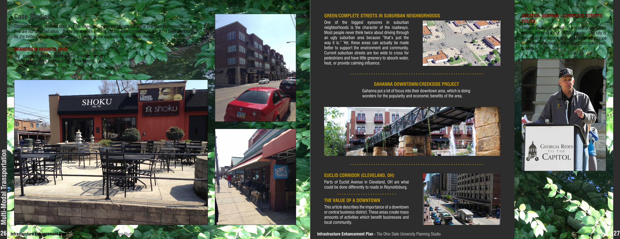
Case StudiesComplete streets, restored Main Streets, bikeways - these are all potential game changers in Reynoldsburg, but they are not untested ideas. Below are a series of case studies from communities that have been transformed for the better by making similar changes. Refer to the appendix for additional details.
grandview heighTS, OhiOThe complete streets development concept is very similar to Grandview Avenue in Grandview Heights, Ohio.
green/COmPleTe STreeTS in SUbUrban neighbOrhOOdSOne of the biggest eyesores in suburban neighborhoods is the character of the roadways. Most people never think twice about driving through an ugly suburban area because “that’s just the way it is.” Yet, these areas can actually be made better to support the environment and community. Current suburban streets are too wide to cross for pedestrians and have little greenery to absorb water, heat, or provide calming influence.
The valUe Of a dOwnTOwnThis article describes the importance of a downtown or central business district. These areas create mass amounts of activities which benefit businesses and local community.
gahanna dOwnTOwn/CreekSide PrOjeCTGahanna put a lot of focus into their downtown area, which is doing wonders for the popularity and economic benefits of the area.
deCaTUr, geOrgia – COmPleTe STreeTS POliCyDecatur, Georgia is a small city just east of downtown Atlanta, home to about 18,000 people. The city is only about four square miles, but has an abundance of children who need safe transportation to and from school.
eUClid COrridOr (Cleveland, Oh)Parts of Euclid Avenue in Cleveland, OH are what could be done differently to roads in Reynoldsburg.
mul
ti-m
odal
Tra
nspo
rtat
ion


